Embed Size (px)
Citation preview

1 | P a g e
ASSESSMENT REPORT SUMMARY AND RECOMMENDATION COVER SHEET
Panel Reference. PPSSTH-20
DA Number 0563/2019
Local Government Area
Shellharbour City Council
Proposed Development
Redevelopment Of Site As An Eco-Tourist Facility Comprising 33 Guest Rooms, A Gym And Spa Area, Restaurant, Lounge Bar, Terrace and Pool Area
Street Address 71 Fig Hill Lane Dunmore NSW 2529, Lot 3 DP 717776,
Applicant / Owner Applicant: Mr G Cirillo
Owner: Alotap Pty & Ltd & David Moodie Pty Limited.
Date of DA Lodgement
16 October 2019
Total number of submissions
41 submissions were received in total.
Regional Development Criteria Schedule 7 of the SEPP (State and Regional Development) 2011
Clause 6 Eco-tourist facilities over $5 million.
The proposed development has a CIV of $15,834.121.
List of all relevant s4.15(1)(a) matters
a. Environmental Planning and Assessment Act 1979;
b. State Environmental Planning Policy– Coastal Management 2018;
c. State Environmental Planning Policy (State and Regional Development) 2011;
d. State Environmental Planning Policy (Infrastructure) 2007;
e. State Environmental Planning Policy– Remediation of Land;
f. Shellharbour Local Environmental Plan 2013;
g. Shellharbour Development Control Plan 2013;
h. Environmental Planning and Assessment Regulation 2000;
i. The likely impacts of the development, including environmental impacts on the natural and built environment and social and economic impacts in the locality;
j. The suitability of the site for the development;
k. Any submissions made in accordance with the EPA Act or EPA Regulation; and
l. The public interest.
List all documents submitted with this
Attachment 1 Draft Refusal Notice
Attachment 2 2.1 Architectural Plans

Planning Panel (Southern) SRPP No. PPSSTH - 20 (DA0563/2019) Address. Lot 3 DP717776, 71 Fig Hill Lane Dunmore NSW 2529
2 | P a g e
report for the Panel’s consideration
2.2 Water Easement Location Plan
2.3 Landscape Plans
2.4 Stormwater Plans and Management Report
2.5 BDAR Report
2.6 BDAR Response Letter
2.7 APZ Tree Removal Plan
2.8 Ecologically Sustainable Development Report
2.9 Vegetation Management Plan
2.10 Site Investigation Report
2.11 Right of Carriageway upgrade plan
2.12 Arboricultural comment on water pipe
alignment
2.13 Draft Plan of Management
2.14 Walking Track Draft Plan of Management
2.15 Wastewater Management Plan
2.16 Waste Management Plan
Attachment 3 SRPP Records of Briefings
Attachment 4 Statement of Environmental Effects and SLEP 2013
Clause 5.13 response
Attachment 5 DRP minutes
Attachment 6 Summary of Submission Matters
Attachment 7 Heritage Information
Attachment 8 Heritage Impact Statement
Attachment 9 Visual Impact Assessment
Attachment 10 Traffic and Parking Impact Assessment
Attachment 11 DP and 88B information
Attachment 12 Shellharbour Development Control Plan 2013
Assessment
Clause 4.6 requests Nil
Summary of key submissions
a. Eco-tourism credentials and definition;
b. Permissibility/characterisation of the development;
c. Scale and density;
d. Impact of the development on the Minnamurra River and surrounding threatened species/environmental value during construction and operation;
e. Historic/existing concerns surrounding unauthorised fill (noted by submitters as ‘toxic fill’);
f. Access to essential services as the site is currently un-serviced for sewerage and water;
g. Noise generation from the overall development with a focus on noise pollution from the bar and restaurant;
h. Insufficient car parking for public and private use and concerns about the capacity of the private laneway (Fig Hill Lane) to deal with the increased traffic generation;
i. Owners Consent required for Fig Hill Lane upgrades;

Planning Panel (Southern) SRPP No. PPSSTH - 20 (DA0563/2019) Address. Lot 3 DP717776, 71 Fig Hill Lane Dunmore NSW 2529
3 | P a g e
j. Biodiversity Stewardship Agreement and interconnection with Eco-tourist facilities;
k. Proximity and impact to local heritage item – Dunmore House and surrounds;
l. Environmental Sustainable Design (ESD); and
m. Bushfire.
Recommendation Refusal
Report prepared by
James Douglas, Senior Development Assessment Officer
Jessica Saunders, Principal Planner
Jasmina Micevski – Manager Planning
Report endorsed by
Grant Meredith, Group Manager City Development
Melissa Boxall, Director Community and Customer
Date of report 25 March 2021

Planning Panel (Southern) SRPP No. PPSSTH - 20 (DA0563/2019) Address. Lot 3 DP717776, 71 Fig Hill Lane Dunmore NSW 2529
4 | P a g e
Summary of s4.15 matters
Have all recommendations in relation to relevant s4.15 matters been summarised in the Executive Summary of the assessment report?
Yes
Legislative clauses requiring consent authority satisfaction
Have relevant clauses in all applicable environmental planning instruments where the consent authority must be satisfied about a particular matter been listed, and relevant recommendations summarized, in the Executive Summary of the assessment report?
e.g. Clause 7 of SEPP 55 - Remediation of Land, Clause 4.6(4) of the relevant LEP
Yes
Clause 4.6 Exceptions to development standards
If a written request for a contravention to a development standard (clause 4.6 of the LEP) has been received, has it been attached to the assessment report?
Not applicable
Special Infrastructure Contributions
Does the DA require Special Infrastructure Contributions conditions (S7.24)?
Note: Certain DAs in the Western Sydney Growth Areas Special Contributions Area may require specific Special Infrastructure Contributions (SIC) conditions
Not applicable
Conditions
Have draft conditions been provided to the applicant for comment?
Note: in order to reduce delays in determinations, the Panel prefer that draft conditions, notwithstanding Council’s recommendation, be provided to the applicant to enable any comments to be considered as part of the assessment report
No
Not applicable – refusal

5 | P a g e
ASSESSMENT REPORT AND RECOMMENDATION
1. EXECUTIVE SUMMARY
1.1 Reason for consideration by the Southern Regional Planning Panel
The application is being referred to the Panel under Clause 20(1) and Schedule 7 Clause 6 - Eco-tourist facilities over $5 million of the State Environmental Planning Policy (State and Regional Development) 2011. The development is classed as Regionally Significant development under the State Environmental Planning Policy (State and Regional Development) 2011 as it has a CIV of $15,834.121.
Part 4 Division 4.2, Section 4.5(b) of the Environmental Planning and Assessment Act 1979 (the Act hereafter) designates the determination authority as the Regional Planning Panel for the area (Southern).
1.2 Proposal
The proposal seeks consent for the redevelopment of the site including the demolition of selected existing structures and the construction of an Eco-Tourist Facility comprising 33 guest rooms across three buildings and including a gym and spa area, restaurant, lounge bar, terrace, back of house building, swimming pool area and associated car parking, infrastructure provision and landscaping works.
The proposal was lodged and identified as Integrated Development pursuant to the Rural Fires Act 1997 as the development is considered a Special Fire Protection Purpose Development and is proposed within an area identified as bush fire prone land.
A 100B authorisation pursuant to the Rural Fires Act 1997 has not been provided by the NSW Rural Fire Service.
1.3 The site
The land is described as Lot 3 DP 717776, being 71 Fig Hill Lane Dunmore.
1.4 Exhibition
The proposal was notified in accordance with the Shellharbour Community Participation Plan 2019 and received a total of 41 unique submissions. The submissions received are further discussed at sections 2.4.3 and 3.8 below.
1.5 Evaluation
S4.15 matters have been considered and the main issues summarised as follows:
- Easement for water provision, right of carriageway and establishment of an
active Biodiversity Stewardship Agreement;
- SLEP 2013 permissibility and consistency with the provisions of clause 5.13;
- Shellharbour Development Control Plan 2013 provisions;
- The likely impacts of the proposal;
- Site suitability; and
- Submissions as discussed at sections 2.4.3 and 3.8 of this report.
1.6 Conclusion
The proposed development has been assessed in accordance with the relevant prescribed matters for consideration as outlined in Section 4.15 of the Environmental Planning and Assessment Act 1979.
Planning Panel (Southern) SRPP No. PPSSTH - 20 (DA0563/2019) Address. Lot 3 DP717776, 71 Fig Hill Lane Dunmore NSW 2529
6 | P a g e
The proposed Eco-tourist facility is permissible with consent in the RU2 and E3 zoned areas of the site. The facility would have been considered to satisfy the requirements of clause 5.13 of the Shellharbour Local Environmental Plan 2013, subject to conditions. The proposed walking tracks are considered permissible within the E2 zoned areas of the site as Environmental Facilities pursuant to the SLEP 2013. The proposal has demonstrated that the development would not meet the clearing threshold requirements under the Biodiversity Conservation Act 2016, based on the current proposal, Asset Protection Zones as recommended by the applicants’ consultant and the existing building locations.
Generally, the proposal is consistent with the relevant Environmental Planning Instruments including the SEPP (Infrastructure) 2007, SEPP No. 55 Remediation of Land and SEPP (Coastal Management) 2018.
It is considered unlikely that the proposal would result in adverse impacts on the character of the area or the amenity of the surrounding area, environment and adjoining properties.
Should the matters that have been identified by the NSW Rural Fire Service have been resolved and a 100B issued, a range of conditions would have been recommended to ensure that any potential impacts are appropriately addressed and managed. This would have included a deferred commencement condition which required the following:
- Establishment and registration of a Biodiversity Stewardship Agreement;
- Obtaining a legal right to undertake works to provide a suitable access to the site from Riverside Drive; and
- Registration of an easement for water provision to the property.
However, at the time of preparing this report, pursuant to clause 4.47 of the Environmental Planning and Assessment Act 1979, the relevant general terms of approval have not been obtained from the RFS and as such, approval cannot be recommended.
1.7 Recommendation
DA0563/2019 be determined by way of refusal, subject to the reasons provided at Attachment 1.

Planning Panel (Southern) SRPP No. PPSSTH - 20 (DA0563/2019) Address. Lot 3 DP717776, 71 Fig Hill Lane Dunmore NSW 2529
7 | P a g e
2. APPLICATION AND SITE OVERVIEW
2.1 Planning Controls
The following planning controls apply to the development:
State Environmental Planning Policies:
SEPP (State and Regional Development) 2011
SEPP No. 55 – Remediation of Land
SEPP (Infrastructure) 2007
SEPP (Coastal Management) 2018
Local Environmental Planning Policies:
Shellharbour Local Environmental Plan (SLEP) 2013
Development Control Plans:
Shellharbour Development Control Plan (SDCP) 2013
Other Polices:
Biodiversity Conservation Act 2016
Local Infrastructure Contributions Plan 2019
2.2. Proposal Details
The proposal seeks consent for the construction of an Eco-tourist facility comprising the following:
Demolition of the existing dilapidated dwelling and selected ancillary structures. The existing structures (approximately 4,000 m2 in floor area) includes an unfinished two-storey dwelling with large basement, swimming pool, gazebo, water tank, selected retaining walls, parts of the concrete driveway and paved footpaths and removal of fill used for site levelling purposes. The demolition will remove the majority of the existing built form with the basement excavation, select retaining walls and driveways and the garage structure to be retained;
Construction of:
Principal Building – comprising two levels above ground and a basement. The principal building includes a split level underground corridor to connect to a satellite building that operates as an operational back of house area, reception and recreational area (discussed below). The different levels of the Principal Building are proposed as follows:
o Basement level comprising a sunken courtyard area with lift, beauty therapy areas, gym, saunas and associated amenities.
o Ground floor level containing a restaurant with bar (indicative 48 person capacity/13 tables + standing bar area), swimming pool, terrace area and six (6) accommodation units.
o First floor level containing eleven (11) accommodation units (notated as ‘upper lodges’).
Clifftop Units – comprised of two separate lodges, known as Lodge A and Lodge B.
o Lodge A is located to the south of the primary building along the existing ridgeline and is proposed with nine (9) accommodation units.

Planning Panel (Southern) SRPP No. PPSSTH - 20 (DA0563/2019) Address. Lot 3 DP717776, 71 Fig Hill Lane Dunmore NSW 2529
8 | P a g e
o Lodge B is located to the south west of the primary building and is proposed with seven (7) accommodation units.
The Clifftop Units are connected to the primary building via a combination of raised and ground level landscaped pathways.
- Satellite building connected to the principal building containing:
o Ground level back of house area with office space, bin storage, meeting rooms which adjoins the loading dock with open walkway access to the ground floor of the principal building.
o Upper level reception/front entrance with open walkway access to the first floor of the principal building.
Car parking area comprising parking for 50 vehicles, elevated drop off zone and turntable with loading docks. The loading dock is positioned along the northern boundary and is cut into the site, below the existing ground level to provide a connection to the existing basement level which is to be retained and utilised as part of the design. The carpark is limited to the northern portion of the site arrayed around the site entrance.
Walking tracks are proposed extending from the north eastern corner of the site and descending to the land adjoining Minnamurra River and associated wetland areas. Educational signage to assist with the guided tours is proposed along the track. The walking track follows an existing formed track which has previously been established at the site, and extends towards the eastern boundary of the site. Refer to plan DWG No. DA012D Walking Track Signs and DWG No. DA.011D Wetland Set Back.
Onsite effluent management in the north eastern corner of the site, with subsurface irrigation area.
Associated tree removal and landscaping works including the construction of footpath/access path works (raised and ground level); and
Drainage and stormwater management works.
Throughout the assessment revised plans were submitted which have resulted in a reduction in the overall height of the structure, removal of the Clifftop Units Block C, removal of the three penthouses and rooftop area from the principal building, reconfiguration of the ground floor of the principal building to add six (6) accommodation Units and a reduction in the bar and restaurant area dimensions and capacity. The current plan set is provided as part of Attachment 2 to this report.
The development is also reliant on the following:
Biodiversity Stewardship Agreement
The Applicant has provided a Letter of Undertaking that commits to proceeding with an application to enter into a Biodiversity Stewardship Agreement for the vegetated area of the subject property. Should the matters raised by the NSW Rural Fire Service have been resolved and a 100B authorisation issued, this matter would have been addressed by way of a recommended deferred commencement condition, requiring that the developer establish the site under a Biodiversity Stewardship Agreement, register the Agreement on Title and ensure that the site is under active management, prior to the issuing of any operational consent. This is further discussed at section 3.1 and was raised during the Planning Panel Briefings as discussed at sections 2.3.5 and 2.3.6 below.
Access to the site from Riverside Drive
The subject site does not have a direct road frontage and is reliant on existing Rights of Carriageway which provide access from the site to Riverside Drive. It is Councils position

Planning Panel (Southern) SRPP No. PPSSTH - 20 (DA0563/2019) Address. Lot 3 DP717776, 71 Fig Hill Lane Dunmore NSW 2529
9 | P a g e
that the terms of these Rights of Carriageway do not allow for the undertaking of upgrade works to provide for the intensification in use resulting from the development. The proposed development would require the existing pavement within Fig Hill Lane be upgraded to a formed access road with a minimum width of 5.5m for the entire length. The applicant has provided a survey of the Rights of Carriageway and identified where works would be required to upgrade the pavement to provide for the expected number of vehicles resulting from this development. No owners consent has been provided for these works. As such, the developer would have been required to obtain the appropriate legal right to undertake works to provide for a suitable access to the site. This is further discussed at section 2.3.2 below. Should the matters raised by the RFS have been resolved, this matter would have been addressed by way of a recommended deferred commencement condition.
Water supply
The subject site does not have an existing reticulated water supply and does not have frontage to a road reserve. As such, an agreement has been reached with the adjoining property being Lot 1 DP219199, 431 Riverside Drive, Dunmore to allow for the provision of an easement for water supply to the development site. The Applicant has prepared a survey and arboricultural report on the indicative location of the service easement as provided at DWG No. A1-D215286_EASE within Attachment 2. This is further discussed at section 3.2.5 below. Should the matters raised by the RFS have been resolved, this matter would have been addressed by way of a recommended deferred commencement condition.
NSW Rural Fire Service – Special Fire Protection Purpose Development
The development was lodged and identified as Integrated Development pursuant to Part 4 clause 4.46 of the Environmental Planning & Assessment (EP&A) Act 1979 as the proposal relates to a tourist and visitor accommodation development which is categorised as a Special Fire Protection Purpose development pursuant to the Rural Fires Act 1997 and Planning for Bushfire Protection 2006. The NSW Rural Fire Service have sought additional information in relation to the proposal, which has not been resolved at the time of preparing this report.
2.3 Subject Site and Locality
2.3.1 Site description
The land is described as Lot 3 DP 717776, being 71 Fig Hill Lane, Dunmore. The site is positioned above the Minnamurra River on the border of Shellharbour and Kiama Local Government Areas, as displayed in Figure 1. The subject site is irregular in shape with no physical or direct frontage to Riverside Drive. Access to the site exists from Riverside Drive via a Right of Carriageway which benefits three properties and is known as Fig Hill Lane.

Planning Panel (Southern) SRPP No. PPSSTH - 20 (DA0563/2019) Address. Lot 3 DP717776, 71 Fig Hill Lane Dunmore NSW 2529
10 | P a g e
Figure 1: Location Plan (GIS Image 29.09.2020)
The Eco-tourist Facility is proposed within in the North West corner of the site. The principal building is proposed generally within the existing built form envelope created by the existing structure shown in Figure 2.
Figure 2: Established site envelope and existing structure
The incomplete, derelict dwelling, commonly and locally known as the ‘Minnamurra Mansion’ shown within Figure 2.The existing built form is prominent when viewed from the surrounding area, particularly when approaching the site from the south via Riverside Drive.
Planning Panel (Southern) SRPP No. PPSSTH - 20 (DA0563/2019) Address. Lot 3 DP717776, 71 Fig Hill Lane Dunmore NSW 2529
11 | P a g e
2.3.2 Restrictions on title
The subject site is affected by the following restrictions:
Easement for Overhead Power Lines 9 Wide
The far north western corner of the site is burdened by a restriction on title for the benefit of Endeavour Energy for the provision of electricity - 9m wide overhead power lines and Low voltage overhead service conductor coming from a pole in the easement to the customer connection point for the existing dwelling/building on the site (item No. 9024581). Refer to further discussion at section 3.2.3.
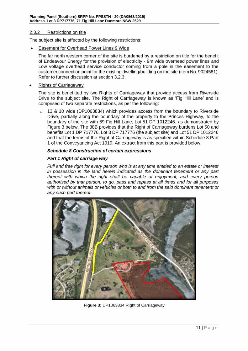
Rights of Carriageway
The site is benefitted by two Rights of Carriageway that provide access from Riverside Drive to the subject site. The Right of Carriageway is known as ‘Fig Hill Lane’ and is comprised of two separate restrictions, as per the following:
o 13 & 10 wide (DP1063834) which provides access from the boundary to Riverside Drive, partially along the boundary of the property to the Princes Highway, to the boundary of the site with 69 Fig Hill Lane, Lot 51 DP 1012246, as demonstrated by Figure 3 below. The 88B provides that the Right of Carriageway burdens Lot 50 and benefits Lot 1 DP 717776, Lot 3 DP 717776 (the subject site) and Lot 51 DP 1012246 and that the terms of the Right of Carriageway is as specified within Schedule 8 Part 1 of the Conveyancing Act 1919. An extract from this part is provided below.
Schedule 8 Construction of certain expressions
Part 1 Right of carriage way
Full and free right for every person who is at any time entitled to an estate or interest in possession in the land herein indicated as the dominant tenement or any part thereof with which the right shall be capable of enjoyment, and every person authorised by that person, to go, pass and repass at all times and for all purposes with or without animals or vehicles or both to and from the said dominant tenement or any such part thereof.
Figure 3: DP1063834 Right of Carriageway
Planning Panel (Southern) SRPP No. PPSSTH - 20 (DA0563/2019) Address. Lot 3 DP717776, 71 Fig Hill Lane Dunmore NSW 2529
12 | P a g e
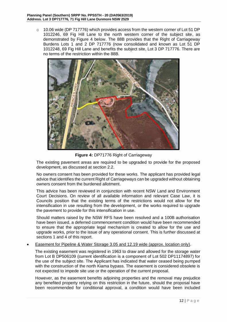
o 10.06 wide (DP 717776) which provides access from the western corner of Lot 51 DP 1012246, 69 Fig Hill Lane to the north western corner of the subject site, as demonstrated by Figure 4 below. The 88B provides that the Right of Carriageway Burdens Lots 1 and 2 DP 717776 (now consolidated and known as Lot 51 DP 1012248, 69 Fig Hill Lane and benefits the subject site, Lot 3 DP 717776. There are no terms of the restriction within the 88B.
Figure 4: DP71776 Right of Carriageway
The existing pavement areas are required to be upgraded to provide for the proposed development, as discussed at section 2.2.
No owners consent has been provided for these works. The applicant has provided legal advice that identifies the current Right of Carriageways can be upgraded without obtaining owners consent from the burdened allotment.
This advice has been reviewed in conjunction with recent NSW Land and Environment Court Decisions. On review of all available information and relevant Case Law, it is Councils position that the existing terms of the restrictions would not allow for the intensification in use resulting from the development, or the works required to upgrade the pavement to provide for this intensification in use.
Should matters raised by the NSW RFS have been resolved and a 100B authorisation have been issued, a deferred commencement condition would have been recommended to ensure that the appropriate legal mechanism is created to allow for the use and upgrade works, prior to the issue of any operational consent. This is further discussed at sections 1 and 4 of this report.
Easement for Pipeline & Water Storage 3.05 and 12.19 wide (approx. location only).
The existing easement was registered in 1963 to draw and allowed for the storage water from Lot B DP506109 (current identification is a component of Lot 502 DP11174897) for the use of the subject site. The Applicant has indicated that water ceased being pumped with the construction of the north Kiama bypass. The easement is considered obsolete is not expected to impede site use or the operation of the current proposal.
However, as the easement benefits adjoining properties and the removal may prejudice any benefited property relying on this restriction in the future, should the proposal have been recommended for conditional approval, a condition would have been included

Planning Panel (Southern) SRPP No. PPSSTH - 20 (DA0563/2019) Address. Lot 3 DP717776, 71 Fig Hill Lane Dunmore NSW 2529
13 | P a g e
requiring that as part of the works, a storage tank with connection to the boundary is constructed generally in accordance with the restriction, beneath the driveway area. The proposal would therefore not result in any adverse impacts on the easement.
The relevant DP and 88B instruments relating to the land is provided at Attachment 11 to this report.
2.3.3 Site constraints
The subject site is affected by the following constraints:
- European and Aboriginal Heritage
- Contamination
- Bushfire Prone Land
- Coastal Zone
- Terrestrial Biodiversity
- Threatened Species
- Fish Habitat
- Acid Sulfate Soils
- Flooding
See discussion throughout the report with regard to each constraint.

Planning Panel (Southern) SRPP No. PPSSTH - 20 (DA0563/2019) Address. Lot 3 DP717776, 71 Fig Hill Lane Dunmore NSW 2529
14 | P a g e
2.3.4 Background
The following table provides a record of the subject site and the existing development.
Development Application No.
Application History
DA0251/1995 Erection of a Rural Dwelling.
Approved 1996
DA0192/2002 Two storey dwelling & Multiple Car Garage
Approved 2003
The existing dilapidated structure that is to be demolished as a component of the current DA.
7.2002.912.2 Amendment Two storey dwelling & Multiple Car Garage
Approved 2006
7.2002.912.3 Amendment Two storey dwelling & Multiple Car Garage including plant rooms for pool & spa lift
Approved 2006
Class 4 Proceedings
Class 4 Judicial Review and Civil Enforcement - NSW LEC 41223 of 2007
Council sought injunction in the Land and Environment Court for unauthorised works under Class 4 proceedings (Environmental Planning and Protection) for clearing and fill within SEPP14 Wetlands (Minnamurra River).
The LEC issued orders requiring:
a. Remedial works for erosion protection and geotechnical stability including but not limited to reshaping of the batters, drainage improvements and reinforcing the top of the bank and soil testing;
b. Fill Removal Works – The lower road, part of the middle road and fill located within the flood plain at the junction of the two roads were to be removed;
c. Vegetation Rehabilitation – Weed removal and planting of native species to restore the endangered communities and
d. Soil and Water Management – both during works and for the long term.
The court order was not acted on due to the Owner of the site declaring bankruptcy.
Any future purchaser, the current Owner, is not liable to comply with the orders.
DA0785/2003 Two Tennis Courts – refused 2005
DA0785/2003 Review of Determination of DA0785/2003 – Refused.

Planning Panel (Southern) SRPP No. PPSSTH - 20 (DA0563/2019) Address. Lot 3 DP717776, 71 Fig Hill Lane Dunmore NSW 2529
15 | P a g e
82a Review Initial determination and reasons for refusal upheld.
7.2003.440.1 Stables – withdrawn 2005
7.2004.328.1
Subdivision – boundary adjustment – refused 2004
7.2006.189.1 Stables, sheds and yards – withdrawn 2006
DA440/2003 & Equestrian Centre and Stables – Refused 2008
DA0010/2007 Equestrian Centre and Stables – Refused 2008
DA0398/2008 Boat Shed – Refused 2008
2.3.5 Southern Regional Planning Panel (SRPP) Briefing One
A briefing with the SRPP was held on the 30th March 2020. The key issues discussed at the briefing are outlined below, with brief comment on how each issue has been addressed;
SLEP Definition and Clause 5.13 – Eco-tourist provisions – demonstrating permissibility, zone consistency, nexus between ancillary and primary uses and design principles.
Comment:
See discussion at section 3.2.5 below. The scale of the ancillary uses has been reduced and conditions would have been recommended to ensure that they are not permitted to operate independently from the Eco-tourist facility, should matters raised by the RFS have been resolved at the time of preparing this report.
SLEP Clause 4.3 – Height departure.
Comment:
Amended plans have been provided which have removed the upper storey from the principal building. The current proposal, architectural plans provided within Attachment 2, do not exceed the 9m height limit for the site. See further discussion at section 3.2.5 below.
BDAR/offsetting.
Comment:
A BDAR was provided as part of the application submission and a further report provided during the assessment clarifying certain matters including the tree removal requirements associated with the proposed Asset Protection Zone (APZ) and offsetting requirements. Based on the current building positioning and APZs recommended, the proposal would not meet the clearing thresholds to require offsetting. See detailed discussion at section 3.1 below and the BDAR and further report within Attachment 2.
Stewardship agreement.
Comment:
See detailed discussion at section 3.1 below. A deferred commencement condition would have been recommended requiring that the Biodiversity Stewardship Agreement be under active management prior to the release of any operational consent, should the matters raised by the RFS have been resolved and a 100B authorisation provided.
APZ’s – issues with access roads and amount of clearing.
Comment:
All access roads are existing or proposed within existing cleared areas of the site. The BDAR and further report have accounted for the vegetation removal required for the proposed development, based on the recommendations by the relevant consultants, and

Planning Panel (Southern) SRPP No. PPSSTH - 20 (DA0563/2019) Address. Lot 3 DP717776, 71 Fig Hill Lane Dunmore NSW 2529
16 | P a g e
are provided within Attachment 2. It is noted that there are outstanding matters in relation to the RFS requirements which may result in changes to the APZ extents and tree removal required. This matter is outstanding at the time of preparing this report.
Car parking/traffic – concerns regarding amount of parking, co-use and bus/coach provisions.
Comment:
See Traffic and Parking Impact Assessment and Plan of Management (PoM) at Attachments 2 and 10. The PoM requires that any access to the site for guided tours are to be coordinated through the facility with visitors arriving via mini bus. There is adequate manoeuvring within the site to provide for turning facilities for mini buses. There is adequate car parking proposed to cater for staff (15 staff parking spaces with a maximum of 15 expected to be on site at any time) and visitors, with 35 spaces remaining to cater for the 31 accommodation rooms proposed.
Visual heritage/heritage study.
Comment:
See discussion at section 3.2.5 below and Heritage Impact Assessment at Attachment 8. The proposal would not have been expected to result in unreasonable impacts on the heritage significance of the subject land or adjoining properties, subject to conditions.
Roof top bar – any precedent and noise pollution potential
Comment:
The rooftop bar has been removed from the proposal, as demonstrated at Attachment 2.
Acoustic report.
Comment:
The Plan of Management provides a number of management controls to ensure that any noise emanating from the site does not result in any unreasonable impacts on adjoining properties or nearby ecological communities. See management actions within the Plan of Management within Attachment 2. Conditions would have been recommended to support and require the implementation of the Plan of Management, should all other matters have been resolved.
Impact on Endangered Ecological Community in terms of effluent disposal and runoff.
Comment:
An amended Wastewater Management Plan has been submitted addressing this concern and is provided within Attachment 2. The system would have been subject to ongoing licencing requirements pursuant to the Local Government Act 1993, and as such, would have been required to be maintained and operate in an accordance with the submitted report in perpetuity.
Terms of Right of Way and obtaining Owners consent.
Comment:
See detailed discussion at section 2.3.2 of this report.
Opportunity for another briefing when Panel returns for other matters.
Comment:
A second briefing was held on 10 September 2020 as discussed at section 2.3.6 below.
Impact on the SEPP 14 wetlands from effluent disposal

Planning Panel (Southern) SRPP No. PPSSTH - 20 (DA0563/2019) Address. Lot 3 DP717776, 71 Fig Hill Lane Dunmore NSW 2529
17 | P a g e
Comment:
An amended Wastewater Management Plan has been submitted addressing this concern and is provided within Attachment 2. Conditions would have been recommended in this regard.
On the heritage dot point - the heritage impact on Dunmore House
Comment:
See discussion at section 3.2.5 below and Heritage Impact Assessment at Attachment 8. The proposal would not have been expected to result in unreasonable impacts on the heritage significance of the subject land or adjoining properties, subject to conditions.
The Record of Briefing can be found at Attachment 3.
2.3.6 Southern Regional Planning Panel Briefing Two
A second briefing with the SRPP was held on 10th September 2020. The key issues discussed at the briefing are outlined below, with brief comment on how each issue has been addressed;
The consistency of the development with the Eco-Tourist Resort definition and provisions under Clause 5.13 of Shellharbour Local Environmental Plan 2013:
o Permissibility
o zone consistency
o nexus between ancillary and primary uses and design principles
o environmental offsets and biodiversity stewardship proposals.
Comment:
See detailed discussion addressing this matter at section 3.2.5 below. The applicants’ response to addressing the provisions of 5.13 of the Shellharbour Local Environmental Plan is also provided within Attachment 4.
The Record of Briefing can be found and discussed within Attachment 3.
2.4 Referrals
2.4.1 Internal Referrals
- Environment
Councils Environment Officers have reviewed and advised that they are satisfied with the recommendations of the submitted eiaustralia Site Investigations Assessments (October 2019), Planning Lab Eco-Tourist Facility Draft Plan of Management (October 2020), Cumberland Ecology Biodiversity Development Assessment Report (October 2019) and Australian Bushfire Protection Planner Pty Ltd Bushfire Protection Assessment (September 2019), subject to conditions. The recommended conditions would have been included as part of any recommendation for approval.
- Community Safety & Crime Prevention Through Environmental Design (CPTED)
Council’s Social Planner has reviewed the submitted documentation and provided a conditionally satisfactory referral response. The recommended conditions would have been included as part of any recommendation for approval.
- Engineering
Councils Development Engineering Officers have reviewed and advised that they are satisfied with the submitted Concept Stormwater Management Report - 171 Fig Hill Lane,

Planning Panel (Southern) SRPP No. PPSSTH - 20 (DA0563/2019) Address. Lot 3 DP717776, 71 Fig Hill Lane Dunmore NSW 2529
18 | P a g e
Dunmore, Water Supply - 171 Fig Hill Lane, Dunmore, Response to RFI - Planning Lab - 171 Fig Hill Lane Dunmore, Concept Stormwater Design Drawings - 171 Fig Hill Lane, Dunmore and the Architectural Plans - 171 Fig Hill Lane, Dunmore, subject to conditions. The recommended conditions would have been included as part of any recommendation for approval.
- Landscaping
Councils Landscape Officer has reviewed the application and provided a conditionally satisfactory referral response. No objection to the proposal was identified, subject to the imposition of a conditions. The recommended conditions would have been included as part of any recommendation for approval.
- Building, Public Health and Food
Councils Environmental Health Officer has reviewed the application with regard to the proposed on site sewerage management system. The Officer has reviewed the revised Wastewater Management Plan dated October 2020 and advised no objections to the development, subject to conditions. This includes a condition requiring that an Activity Approval under the Local Government Act 1993 be sought. The recommended conditions would have been included as part of any recommendation for approval.
- Contributions
Councils Contributions Officer has reviewed the proposal and identified no objection to the proposal subject to the imposition of a condition requiring the payment of contributions prior to the issue of any Construction Certificate. The recommended condition would have been included as part of any recommendation for approval.
- Heritage
Council’s Heritage Advisor has reviewed the submitted Heritage Impact Assessment (HIS) prepared by URBIS dated 20 October 2020 and raised no objection to the development. A satisfactory response has been provided, subject to conditions. The recommended conditions would have been included as part of any recommendation for approval.
- Waste
Council Waste Services Officer has reviewed the application and raised no objection to the submitted Waste Management Plan. In this case, a private waste and recycling collection contractor is considered appropriate to service the site. The recommended conditions would have been included as part of any recommendation for approval.
2.4.2 External Referrals
- NSW Rural Fire Service (RFS) – Integrated Development
The application was referred to the NSW RFS under the Rural Fires Act 1997 as the proposal requires Special Fire Protection authorisation under section 100B as the development is categorised as a special fire protection purpose development and is proposed on land which is mapped as being affected by bushfire hazard.
Additional information was requested by the RFS on four of occasions relating to vegetation mix, what areas had been considered as managed land, the use of short fire run methodologies, slope categories the upgrading of the existing access handle, the building setbacks, management of the land surrounding the buildings, the requirement for an on-site refuge and modelling and construction requirements, modelling inputs and Asset Protection Zones.

Planning Panel (Southern) SRPP No. PPSSTH - 20 (DA0563/2019) Address. Lot 3 DP717776, 71 Fig Hill Lane Dunmore NSW 2529
19 | P a g e
Throughout the assessment additional information has been returned to the RFS on a number of occasions. Most recently, additional information including revised modelling was returned to the RFS, and confirmation has been provided that the additional information remains unsatisfactory, with outstanding concerns regarding the modelling inputs and the proposed refuge building. It is unclear what impact the modelling amendments would have on other aspects of the proposal at this time.
At the time of preparing this report, the RFS have not provided General Terms of Approval as required via clause 4.47 of the Environmental Planning and Assessment Act 1979, and as such, the application is recommended for refusal.
- Endeavour Energy
The proposal was referred to Endeavour Energy pursuant to the ISEPP. General Advice was provided on the 25 November 2019 which raised no objection to the proposal and included documentation to be forwarded to the Applicant. This information would have been included as part of recommended conditions of consent should matters raised by the RFS have been resolved at the time of preparing this report.
- Sydney Water
The proposal was referred to Sydney Water for advice, given the nature of the development and the additional demand that would be put on the system. No information has been received in response to the request for general advice request.
- NSW Health
The proposal was referred to NSW Health for comments for general comment and operation of the proposed restaurant and bar area. No information has been received in response to the request for advice.
- Kiama Council
The proposal was referred to Kiama Council given the proximity of the site to the LGA boundary and the prominence of the existing built form. No information has been received in response to the request for general advice.
- Transport for NSW (TfNSW) (Formally RMS)
The proposal was referred to TfNSW due to the increase in traffic movements which would result. No objection to the development was raised. As part of the response, TfNSW confirmed that that Council was the Road Authority for the proposal in respect to Riverside Drive, Fig Hill Lane and the associated intersection.
- NSW Department of Primary Industries - Fisheries
The subject site is identified as containing Key Fish Habitat and as such, the proposal was referred to DPI Fisheries for advice on whether any additional permits would be required. A response was provided which advised that no additional permits would be required for the proposed development and no conditions would apply.
- Design Review Advisory Panel
The application was considered by Council’s Design Review Advisory Panel (DRP) on 13 December 2019. A copy of the DRP minutes are provided at Attachment 5. The summary and recommendations of the DRP were as follows:
The panel is supportive of the development of this site as an Eco resort. However, further development is required to ensure that the current proposal relates appropriately to this visually and ecologically sensitive environment. Consideration should be given to the following:
A more detailed site analysis, inclusive of view analysis;

Planning Panel (Southern) SRPP No. PPSSTH - 20 (DA0563/2019) Address. Lot 3 DP717776, 71 Fig Hill Lane Dunmore NSW 2529
20 | P a g e
Further analysis/development of primary built form to refine siting and reduce perceived bulk;
Further development of primary built form to include an appropriately sized commercial kitchen;
Further analysis/development of form and siting of accommodation pavilions;
A more detailed level of documentation to be provided to establish an appropriate building aesthetic;
Further development of the projects environmental credentials;
More integration between landscape and architecture; and
More consideration of how the landscape design can address the requirements of SLEP 5.13.
In response to the above, the proposal and design was revised as follows:
An additional site analysis and visual impact assessment was provided and is provided at Attachment 9;
Removal of the roof top terrace, bar and units and replacement with a green roof;
Removal of the 'Clifftop lodges C' and re arrangement the 4 units into the principal building;
Reduction of the terrace/deck in front of the principal building and replacement with landscaped area;
Removal of the lounge area and re arrangement of 6 units within the ground floor level of the principal building;
Extension of the principal building to the South-West to accommodate an extra unit on each floor (Ground and First floor); and
Enlargement of the kitchen area and re arrangement of the restaurant seating area.
The revised design was not re-referred to the DRP as it is considered that the amendments made addressed the concerns raised by the Panel.
2.4.3 Community Consultation
The DA has been exhibited in accordance with Councils Community Participation Plan. An extended notification area was also provided given the proximity of the site to the LGA boundary and prominence of the existing structure in the existing landscape.
The original exhibition was for a period of 21 days, between the 21 November 2019 and 24 December 2019. 26 submissions were received during this period.
Following the submission of additional information and amended plans, the application was renotified for a further 10 days, between the 25 September 2020 and 06 October 2020. 15 submissions were received during this period.
A total of 41 unique submissions were received across both notification periods.
The matters raised are discussed below at section 3.8 and within Attachment 6.

Planning Panel (Southern) SRPP No. PPSSTH - 20 (DA0563/2019) Address. Lot 3 DP717776, 71 Fig Hill Lane Dunmore NSW 2529
21 | P a g e
3 ENVIRONMENTAL PLANNING & ASSESSMENT ACT 1979
In determining a development application, a consent authority is to take into consideration matters referred to in section 4.15(1) of the Act as are of relevance to the development the subject of the application:
3.1 Biodiversity Conservation Act 2016
Section 1.7 of the Environmental Planning and Assessment Act (EP&A Act) 1979 provides that the EP&A Act 1979 has effect subject to the provisions of Part 7 of the Biodiversity Conservation Act 2016 (BC Act).
The following sections of the Biodiversity Conservation Act 2016 are relevant to the subject development:
Part 5 Investment Strategy and private land conservation agreements
Division 2 Biodiversity stewardship agreements
Clause 5.5 provides that any application to enter into a Biodiversity Stewardship Agreement (BSA) is via a voluntary agreement between the Biodiversity Conservation Trust (BCT) on delegation from the Minister and the land owner. This process is separate from the development application process.
The Applicant has provided multiple commitments on the intent to enter into and establish a BSA at the site, including providing a Letter of Undertaking outlining the owners intention and providing a preliminary Biodiversity Stewardship Site Boundary.
The subject site is identified as having sufficient ecological value to be eligible for a BSA pursuant to clause 5.7 of the BC Act 2016 as native vegetation occurring within the subject land includes areas of Illawarra Lowlands Grassy Woodland Threatened Ecological Community (TEC) and Illawarra Subtropical Rainforest TECs, (as identified under the Biodiversity Conservation Act 2016 and Environment Protection and Biodiversity Conservation Act 1999).
The applicant has sought an agreement in relation to this process from the Biodiversity Conservation Trust (BCT), however as this process is voluntary, the BCT have advised that whilst they would have no objections to receiving an application for the site, they are unable to commit or accept an application for a BSA outside the formal application process without the required documentation pursuant to clause 5.8 of the BC Act 2016.
The BSA would integrate with the Eco-tourist facility operation through the maintenance and ongoing management of the identified stewardship site and enhancement and utilisation of the walking tracks between the proposed building footprint and the boundary of the site with the Minnamurra River. The proposed operation of the walking tracks has been outlined within the Eco -tourist Facility - Draft Plan of Management prepared by Planning Lab dated 20 October 2020. The Applicant has prepared revised information that also includes a Walking Track Plan of Management which details operational matters for ongoing maintenance and monitoring of the walking tracks. The information indicates that the walking tracks would be used to provide guided tours of the conservation areas of the Eco-tourist facility, with tours being offered on an as need basis to guests and twice a week for external groups of up to 20 people.
There is adequate detail within the submitted information to support the use of the walking tracks as an extension of the operation of Eco-tourist Facility as they offer an interconnection with the natural environmental and ecological importance of the site through a low impact guided activity. The use of the walking tracks and guided tours would also provide a means to educate the public on the concept of environmental stewardship which is consistent with the objectives of the BC Act and intention of the BSA.

Planning Panel (Southern) SRPP No. PPSSTH - 20 (DA0563/2019) Address. Lot 3 DP717776, 71 Fig Hill Lane Dunmore NSW 2529
22 | P a g e
The BSA is fundamental to demonstrating that the proposal satisfies the provisions of clause 5.13 of the Shellharbour Local Environmental Plan (SLEP) 2013.
In this case, as the Applicant has not established the BSA at the time of preparing this report, should all other matters have been resolved, it would have been recommended that the application be determined by way of deferred commencement requiring that the Biodiversity Stewardship Agreement be in active management prior to the issue of any operational consent. As there are outstanding concerns with regard to the ability of the development to meet the Rural Fire Service requirements outlined within Planning for Bushfire Protection and the relevant Australian Standards, this matter remains outstanding.
Part 7 Biodiversity assessment and approvals under Planning Act
Part 7 of the BC Act relates to Biodiversity assessment and approvals under the EP&A Act where it contains additional requirements with respect to assessments, consents and approvals under this Act.
Based on the information at hand, it appears that an approximate area of 0.28 hectares of Illawarra Lowlands Grassy Woodlands, and 0.17ha of Illawarra Sub-tropical Rainforest would be required to be removed to provide for the proposed building footprint and APZs as recommended by the consultant. The Illawarra Sub-tropical Rainforest is identified as Plant Community Type (PCT) 838: Forest Red Gum – Thin-leaved Stringybark grassy woodland on coastal lowlands, southern Sydney Basin Bioregion; and PCT 1300: Whalebone Tree – Native Quince dry subtropical rainforest on dry fertile slopes, southern Sydney Basin Bioregion.
In this case, a total of 0.45ha of native vegetation would be required to be cleared to provide for the development footprint and the required Asset Protection Zones. The submitted Biodiversity Assessment Report (BDAR) and subsequent response to Councils additional information is provided at Attachment 2 to this report.
The minimum subdivision lot size for the land under SLEP 2013 is 40ha, resulting in an area clearing threshold of 0.5ha or more. As such, the development would not meet the area clearing threshold requirements to require offsetting. It is however noted that this matter remains outstanding due to the RFS matters remaining unresolved, and having the potential to require additional tree removal through increased Asset Protection Zone (APZ) extents.
The site is identified as containing areas of high biodiversity value on the Biodiversity Values Map, as demonstrated by Figure 5 below. The proposed works and vegetation removal works do not encroach into the mapped area, based on the information at hand.

Planning Panel (Southern) SRPP No. PPSSTH - 20 (DA0563/2019) Address. Lot 3 DP717776, 71 Fig Hill Lane Dunmore NSW 2529
23 | P a g e
Figure 5: Biodiversity Values Map – subject site
A test of significance has also been provided and concludes that the development would not be likely to impact on the life cycle of any threatened species, adverse impacts on the local population or composition of the ecological community of any endangered or critically endangered ecological communities, habitat of a threatened species or ecological community or an area of outstanding biodiversity value, subject to conditions and ongoing management. The development proposed would not be considered a key threatened process.
The submitted BDAR identifies that none of the Threatened Ecological Communities (TECs) listed under the Biodiversity Conservation Act 2016 meet the criteria listing for the EPBC Act due to the patch size or canopy percentage cover and calculated integrity score. Councils Environment Officers have reviewed the BDAR and raised no objection to the calculations provided within.
It is proposed by the applicant that the majority of the retained vegetation within the subject property will be protected and managed in perpetuity under a BSA, established under the Biodiversity Conservation Act 2016 (BC Act) as discussed above. A preliminary boundary for the Biodiversity Stewardship Site has been identified and is provided at attachment 2 to this report.
Council’s Environmental Assessment Officer has considered the submitted information and identified no objections to the development, subject to conditions.
The development would therefore not be considered to result in adverse impacts on biodiversity and is consistent with the provisions of the Biodiversity Conservation Act 2016, based on the information at hand. However, the vegetation removal and APZ extents would be required to be reviewed following resolution of matters with the RFS, and as such, this matter remains outstanding.

Planning Panel (Southern) SRPP No. PPSSTH - 20 (DA0563/2019) Address. Lot 3 DP717776, 71 Fig Hill Lane Dunmore NSW 2529
24 | P a g e
3.2 Section 4.15 Evaluation (1) (a)(i) - Environmental Planning Instruments
3.2.1 State Environmental Planning Policy Coastal Management 2018
The development site contains land which is located within the Coastal Wetlands, Wetlands Proximity Area, Coastal Use and Coastal Environment mapped areas, pursuant to the SEPP (Coastal Management) 2018 maps, as indicated below by Figure 6 below.
Figure 6: Coastal management map extract (02.03.2021) and key table
Part 2 Development controls for coastal management areas
Division 1 Coastal wetlands and littoral rainforest areas
Clause 10 Development on certain land within coastal wetlands and littoral rainforest area
Whilst significant areas of the site as within the mapped Coastal Wetlands area as demonstrated by Figures 7 and 8 below, the applicant has demonstrated that none of the proposed works are within this area of the site.

Planning Panel (Southern) SRPP No. PPSSTH - 20 (DA0563/2019) Address. Lot 3 DP717776, 71 Fig Hill Lane Dunmore NSW 2529
25 | P a g e
Figure 7: Coastal Wetlands and Littoral Rainforest Area, and Buffer Areas Map
Figure 8: Wetland Set Back Plan prepared by Nordon Jago dated 22.02.2019.
Conditions would have been recommended in this regard which required that the extent of the Coastal Wetlands area be surveyed and identified by markers, and that the Plan of Management for the walking tracks be updated to require that no access or activities which may result in impacts on this area be permitted. The mapped wetlands area would have been contained within the BSA area as discussed at 3.1 above. The proposal has demonstrated that all works are outside of the Coastal Wetlands Mapped area, and therefore the requirements of Clause 10 do not apply.

Planning Panel (Southern) SRPP No. PPSSTH - 20 (DA0563/2019) Address. Lot 3 DP717776, 71 Fig Hill Lane Dunmore NSW 2529
26 | P a g e
Clause 11 Development on land in proximity to coastal wetlands or littoral rainforest
The Clifftop Units A and walking track areas are positioned within the proximity area for coastal wetlands as indicated within Figure 8 above.
The potential implications for carrying out guided tours and the use of the walking track areas has been discussed with the submitted Updated Walking Track Management Plan prepared by Cumberland Ecology dated 13 January 2021. This Plan is provided within Attachment 2 to this report.
The potential impact of the walking track use within the proximity area coastal wetland has been clearly identified in reference to the expected commercial levels of traffic generated by the proposal which have been identified under the submitted plan of management as guided tours twice a week for up to 20 people. The use of guided tours as the medium for interaction with the coastal areas would ensure an adequate level of supervision to protect the sensitive location. Conditions would have been recommended in this regard.
Division 3 Coastal environment area
Clause 13 Development on land within the coastal environment area
This clause requires that the consent authority is satisfied that the development would not result in adverse impacts to any subclause listed in Clause 13. The development site would be located within an existing and established building envelope with limited earthworks to occur with appropriately functioning infrastructure proposed for the control of stormwater and water quality.
The development has been accompanied with suitable stormwater and waste management plans that address drainage and buffer zones and would be conditioned accordingly for ongoing protection and management.
The development is considered to be designed, sited and managed to avoid adverse impacts on the biophysical, hydrological and ecological environment, coastal environmental values and coastal processes, water quality, marine and native vegetation, fauna and their habitats, headlands and rock platforms, public open space, Aboriginal cultural heritage and the use of the surf zone. Where aspects of the development may result in potential impacts, those impacts could have been minimised and addressed through recommended conditions.
Clause 14 Development on land within the coastal use area
The development is restricted to the existing building envelope that is situated 185m from the Minnamurra River. The development is considered to have been sited to ensure sufficient separation to not interfere with access to the foreshore (access to the waters edge is not proposed or existing), affect public place (site is privately owned), affect the visual amenity/scenic quality or adversely impact aboriginal or environmental heritage.
The proposed development would be unlikely to cause impact on the items mentioned in (i) through (v), and the development has been designed, sited and would be managed to avoid an adverse impact referred to in Clause 14(1)(a). Where aspects of the development may have resulted in potential impacts, those impacts could have been minimised and addressed through recommended conditions of consent.
16 Development in coastal zone generally—coastal management programs to be considered
The subject site is not affected by any coastal hazards as a result of the Shellharbour Coastal Zone Management Plan.
18 Hierarchy of development controls if overlapping
The subject site is located within the overlapping Wetlands Buffer, Coastal and Environment Use areas. There is no inconsistency between the controls as discussed above.

Planning Panel (Southern) SRPP No. PPSSTH - 20 (DA0563/2019) Address. Lot 3 DP717776, 71 Fig Hill Lane Dunmore NSW 2529
27 | P a g e
3.2.2 State Environmental Planning Policy (State and Regional Development) 2011 (SEPP Development)
Schedule 7 Regionally significant development
Clause 6 Eco-tourist facilities over $5 million
The development application lodgment was accompanied by a quantity surveyor’s report which confirms that the proposed development has a capital investment value of more than $5 million. Therefore, as the proposal seeks consent for an Eco-tourist facility, the application is required to be determined by the Southern Regional Planning Panel pursuant to Clause 4.5(b) of the Environmental Planning & Assessment Act, 1979.
3.2.3 State Environmental Planning Policy (Infrastructure) 2007
Division 5 Electricity transmission or distribution networks
Subdivision 2 Development likely to affect an electricity transmission or distribution network
The subject site has existing access to Electrical utilities and is serviced by Endeavour Energy Assets that includes an easement over the site benefitting Endeavour Energy for low voltage overhead power lines and low voltage overhead service conductor coming from a pole in the easement to the customer connection point for the existing dwelling/building on the site (Figure 9).
The proposed development was referred to Endeavour Energy pursuant to Clause 45 of this policy as the proposal is adjacent to an easement for electricity purposes. Endeavour Energy were notified as the electricity supply authority and advice dated 25 November 2019 was issued to be distributed to the Applicant.
Figure 9: Power Pole Location (north west corner).

Planning Panel (Southern) SRPP No. PPSSTH - 20 (DA0563/2019) Address. Lot 3 DP717776, 71 Fig Hill Lane Dunmore NSW 2529
28 | P a g e
As part of the response provided, Endeavour Energy identified that the current electrical servicing and electrical infrastructure may be insufficient to service the proposed development due to the age of the infrastructure and minimal existing loading. The capacity of the existing infrastructure would be required to be investigated by the Applicant through post determination consultation with the service provider as per the received advice. The advice from Endeavour Energy would have been included as part of conditions of consent, should all other matters have been resolved.
Division 17 Roads and traffic
Subdivision 2 Development in or adjacent to road corridors and road reservations
Clause 104 (Traffic-generating development)
The development application was referred to Transport for NSW (TfNSW) for comment in accordance with the requirements of this clause. Initially, the proposal was considered a type of development that meets the size requirements specified in Schedule 3 Column 3 (i.e. Size or capacity—site with access to classified road or to road that connects to classified road (if access within 90m of connection, measured along alignment of connecting road, Riverside Drive and Princes Hwy)) .
TfNSW provided a response on 5 December 2019 advising no objection to the development application in principle. The response advised that as the development does not gain direct access from a classified road and due to the relatively low traffic generation rate it is unlikely to have an impact on the classified road intersection of the Princes Hwy. TfNSW also identified that Riverside Drive is the responsibility of Shellharbour City Council as the local road authority as per the directives and responsibilities contained within the Roads Act 1993.
3.2.4 State Environmental Planning Policy – Remediation of Land
Clause 7 Contamination and remediation to be considered in determining development application
(1) A consent authority must not consent to the carrying out of any development on land unless—
(a) it has considered whether the land is contaminated, and
(b) if the land is contaminated, it is satisfied that the land is suitable in its contaminated state (or will be suitable, after remediation) for the purpose for which the development is proposed to be carried out, and
(c) if the land requires remediation to be made suitable for the purpose for which the development is proposed to be carried out, it is satisfied that the land will be remediated before the land is used for that purpose.
(2) Before determining an application for consent to carry out development that would involve a change of use on any of the land specified in subclause (4), the consent authority must consider a report specifying the findings of a preliminary investigation of the land concerned carried out in accordance with the contaminated land planning guidelines.
(3) The applicant for development consent must carry out the investigation required by subclause (2) and must provide a report on it to the consent authority. The consent authority may require the applicant to carry out, and provide a report on, a detailed investigation (as referred to in the contaminated land planning guidelines) if it considers that the findings of the preliminary investigation warrant such an investigation.
Planning Panel (Southern) SRPP No. PPSSTH - 20 (DA0563/2019) Address. Lot 3 DP717776, 71 Fig Hill Lane Dunmore NSW 2529
29 | P a g e
Consideration has been given to whether the land on which the works are proposed is contaminated. In this regard, an evaluation of the subject site and available information has indicated the following:
Council records do not identify the site as potentially contaminated land;
Council is not aware of any previous investigations about contamination on the land;
The land was the subject of Class 4 proceedings in the Land and Environment Court in relation to unauthorised fill and clearing but the matter did not relate to the importation of contaminated material as defined under the Act;
A potentially contaminating activity has not been previously conducted on the land;
Council is not aware of information concerning contamination impacts on land immediately adjacent to the subject land which could affect the subject land;
There is no land use restriction relating to possible contamination affecting the land; and
There is no obvious visual evidence from a site inspection of any land contamination being present.
A Preliminary Site Investigation including sampling was provided in accordance with section 7(2) of the clause and due to the proposed change of use resulting from the development. The investigation was undertaken by eiaustralia and carried out in October 2019 which also considered the historic use, NSW Land and Environment Court orders and the existing structure. The conclusion from this investigation confirmed evidence of Chromium and Nickel; however the samples taken from the site did not meet the threshold criteria to require remediation works. The site would have therefore been considered to be suitable for the proposed use.
Conditions would have been recommended with regard to unexpected finds, consistent with the recommendations of the submitted eiaustralia report. The report is provided within Attachment 2 to this report.
The Demolition and Construction Management Plan (DCMP) would have been required via a condition and would have been required include procedures for precautionary and stop work action if the disturbance of acid sulphate soils or contaminated soils are encounter during any stage of demolition or construction works. The use of a precautionary condition and adoption into the DCMP would have ensured that any risk to the site, workers or adjoining property is minimised and managed in an appropriate manner.
As such, the land would have been considered suitable for the proposed land use and consistent with the requirements of Clause 7 of this SEPP, should all other matters have beenr resolved.
3.2.5 Shellharbour Local Environmental Plan 2013 (SLEP 2013)
Part 1 Preliminary
Clause 1.4 Definitions
An Eco-tourist Facility is defined as follows:
Eco-tourist facility means a building or place that—
(a) provides temporary or short-term accommodation to visitors on a commercial basis, and
(b) is located in or adjacent to an area with special ecological or cultural features, and
(c) is sensitively designed and located so as to minimise bulk, scale and overall physical footprint and any ecological or visual impact.

Planning Panel (Southern) SRPP No. PPSSTH - 20 (DA0563/2019) Address. Lot 3 DP717776, 71 Fig Hill Lane Dunmore NSW 2529
30 | P a g e
It may include facilities that are used to provide information or education to visitors and to exhibit or display items.
An Environmental facility is defined as follows:
Environmental facility means a building or place that provides for the recreational use or scientific study of natural systems, and includes walking tracks, seating, shelters, board walks, observation decks, bird hides or the like, and associated display structures.
Part 2 Permitted or prohibited development
Clause 2.3 Zone objectives and Land Use Table:
The land contains split zoning comprising part RU2 Rural Landscape, E2 Environmental Conservation and E3 Environmental Management (refer to Figures 10 and 11 below).
Figure 10: SLEP Land Zones for the subject site

Planning Panel (Southern) SRPP No. PPSSTH - 20 (DA0563/2019) Address. Lot 3 DP717776, 71 Fig Hill Lane Dunmore NSW 2529
31 | P a g e
Figure 11: Proposed building and zoning
E2 Environmental Conservation
The objectives of the E2 zone are:
To protect, manage and restore areas of high ecological, scientific, cultural or aesthetic values.
To prevent development that could destroy, damage or otherwise have an adverse effect on those values.
The land use table permits the following development within the E2 zone:
Bee keeping; Environmental facilities; Environmental protection works; Information and education facilities; Oyster aquaculture; Roads; Water reticulation systems.
The majority of the allotment is zoned E2 which consists of land directly bordering Minnamurra River, wetlands and mangrove areas. The walking tracks are located partly within the E2 zoned area of the site and are considered to be consistent with the definition of Environmental Facilities, ancillary to the operation of the Eco-tourist Facility. Works are proposed along the
waking tracks consisting of educational/interpretive signage and ongoing maintenance.
The proposed works are permissible within the RU2 zone with consent and would have operated as an ancillary function to the primary use of the site as an Eco-tourist facility. The proposal would have been considered consistent with the objectives of the E2 zone as the development and associated BSA would provide for the protection, management and restoration of the area which has special ecological, scientific, cultural and aesthetic values.
E3 Environmental Management
The objectives of the E3 zone are:
To protect, manage and restore areas with special ecological, scientific, cultural or aesthetic values.

Planning Panel (Southern) SRPP No. PPSSTH - 20 (DA0563/2019) Address. Lot 3 DP717776, 71 Fig Hill Lane Dunmore NSW 2529
32 | P a g e
To provide for a limited range of development that does not have an adverse effect on those values.
To retain and enhance the visual and scenic qualities of the Illawarra Escarpment
The land use table permits the following development within the E3 zone:
Animal boarding or training establishments; Bed and breakfast accommodation; Building identification signs; Business identification signs; Dual occupancies (attached); Dwelling houses; Eco-tourist facilities; Emergency services facilities; Environmental facilities; Environmental protection works; Extensive agriculture; Farm buildings; Farm stay accommodation; Flood mitigation works; Group homes; Home-based child care; Home businesses; Information and education facilities; Oyster aquaculture; Pond-based aquaculture; Recreation areas; Roads; Tank-based aquaculture; Water reticulation systems.
The E3 zone is positioned between the RU2 and E2 zoned portions of the site. The walking tracks are located partly within the E3 zoned area of the site and considered to be consistent with the definition of Environmental Facilities, ancillary to the operation of the Eco-tourist Facility. Eco-tourist facilities are also permitted with consent in the E3 zone. Works are
proposed along the waking tracks consisting of educational/interpretive signage and ongoing maintenance.
The proposed works would have been considered permissible within the E3 zone with consent and would operate as an ancillary function to the primary use of the site as an Eco-tourist facility. The development would be considered consistent with the E3 zone objectives as it would have provided for a use which respects and facilitates the protection, management and restoration of the area which has special ecological, scientific, cultural and aesthetic values.
RU2 Rural Landscape
The objectives of the RU2 zone are:
To encourage sustainable primary industry production by maintaining and enhancing the natural resource base.
To maintain the rural landscape character of the land.
To provide for a range of compatible land uses, including extensive agriculture.
The land use table permits the following development within the RU2 zone:
Agriculture; Animal boarding or training establishments; Aquaculture; Bed and breakfast accommodation; Boat launching ramps; Boat sheds; Building identification signs; Business identification signs; Cellar door premises; Community facilities; Dairies (restricted); Dual occupancies (attached); Dwelling houses; Eco-tourist facilities; Environmental protection works; Farm buildings; Farm stay accommodation; Flood mitigation works; Home-based child care; Home businesses; Home industries; Jetties; Plant nurseries; Recreation areas; Roads; Roadside stalls; Veterinary hospitals; Water reticulation systems
Eco-tourist facilities are identified on the land use table as being permissible with consent in the RU2 zone. The built form proposed as part of the Eco-tourist Facility is contained within the RU2 portion of the allotment. The Eco-tourist Facility includes the proposed accommodation buildings (Clifftop units), principal building (containing accommodation, restaurant/bar and associated facilities), satellite building, spa building, gym, reception area and associated back of house infrastructure.
The RU2 portion of the site provides a pseudo building envelope within which the facility is positioned. The activities proposed for interconnection with the environmental and natural features (walking track tours) start within the RU2 and transition through the E3 to E2 zones of the site. The proposal would have been considered to be consistent with the objectives of

Planning Panel (Southern) SRPP No. PPSSTH - 20 (DA0563/2019) Address. Lot 3 DP717776, 71 Fig Hill Lane Dunmore NSW 2529
33 | P a g e
the RU2 zone as the development would provide for a compatible use which respects and maintains the rural character of the land.
The proposal would satisfy the first component of the SLEP 2013 definition for ‘Eco-tourist facility’, as the proposed development would provide short-term accommodation through the provision of the accommodation buildings. The buildings would be within an area with special ecological/cultural significance due to proximity of Minnamurra River and existing biodiversity values, which contains threatened flora and fauna species.
The documentation prepared by the Applicant defines individual uses (i.e. restaurant, bar, space, gym, swimming pool and walking tracks etc) as ancillary or incidental to the operation of the site as an Eco-tourist Facility. The intention as expressed by the Applicant is that the additional uses provide the economic funds to maintain the site in a Biodiversity Stewardship Agreement (BSA). The scale of these ancillary uses has been significantly scaled back throughout the assessment due to concerns of the ability for those components to operate independently to the main Eco-tourist facility. A condition would have been recommended to prevent independent operation of facilities to ensure adequate management of the site occurs which is consistent with the intention of protecting the environmental assets, and the definition of Eco-tourist facility.
The walking track would not have been considered to be inconsistent with the relevant zone objectives. The purpose of the use of the existing pathway would be to provide walking tours and opportunities for visual observation of scenic and ecologically valuable areas and demonstrate how a Biodiversity Stewardship Agreement (BSA) operates in practice.
Construction within the walking track area would have been required to be limited to erosion protection works, general maintenance and works associated with the erection of educational signage/boards. The construction works would have been limited as the walking tracks are existing. Conditions would have been recommended with regard to maintenance and monitoring to ensure the use would not result in unreasonable impacts on the surrounding environment, should all other matters have been resolved.
Clause 2.7 Demolition requires development consent
Demolition of the existing dwelling house and ancillary structures is proposed as part of the subject application. Conditions would have been recommended in this regard.
Part 4 Principal development standards
Clause 4.3 – Height of buildings
This clause requires that the maximum height of all proposed buildings must not exceed 9m as required by subclause 4.3 and the associated height of building map area ‘J’ established under the Shellharbour Local Environmental 2013 Plan Height of Building Map (Figure 12).

Planning Panel (Southern) SRPP No. PPSSTH - 20 (DA0563/2019) Address. Lot 3 DP717776, 71 Fig Hill Lane Dunmore NSW 2529
34 | P a g e
Figure 12: SLEP Maximum Height of Buildings plan
The proposed structure would sit below the 9m building height envelope as demonstrated on the Elevation and Section plans provided within Attachment 2. The below Figure 13 displays the existing structure as an overlay to establish the context and profile of the proposed structure. The maximum height of the proposed structure (principal building) is 7.8m (RL47.48), less than the 9m maximum building height development standard for the site.
Figure 13: Southern Elevation – Height Plan of Main Building – Rooftop RL 47.480
Council is satisfied that the proposal would comply with the objective and maximum building height development standard as identified with Clause 4.3.
Cause 4.4 - Floor Space ratio
The site is not subject to a Floor Space Ratio.

Planning Panel (Southern) SRPP No. PPSSTH - 20 (DA0563/2019) Address. Lot 3 DP717776, 71 Fig Hill Lane Dunmore NSW 2529
35 | P a g e
Part 5 Miscellaneous provisions
Clause 5. 10 – Heritage Conservation
The subject site is listed as an item of local significance under the Minnamurra Vegetation Area (item no. I358) and adjoins the Dunmore House Complex (471 Riverside Drive, Dunmore), dry stone wall and trees (item no. I207) contained under SLEP Schedule 5 Environmental Heritage (Figure 14 below). The Applicant has undertaken and submitted a revised Heritage Impact Statement (HIS) as required by part 5 of this clause.
Figure 14: Heritage listing as per SLEP mapping extract (Item I358 is visually represented (green overlay)) which transcends allotment boundaries)
The assessment carried out within the HIS indicates that the proposed development generally has minimal negative impact on the heritage item of Dunmore House or the Minnamurra Vegetation Area and would not detract from, or obscure significant views of, the heritage items.
It should also be noted that the existing structure is not listed under the local heritage provisions. The development is largely concentrated to areas outside the established visual catchment associated with Dunmore House and within an area that is free from native vegetation due to the existing structure and landscaping works. The scenic value associated with the Minnamurra Vegetation Area would have been maintained with a design that provides additional landscaping and minimises impacts on existing native vegetation.
The following is noted which supports the protection of the retention of existing site character, features and preservation of historic context:
The retention of Moreton Bay Figs and dry stone retaining walls as a boundary marker between the subject site and the heritage item;
Introduction of additional native plantings and inclusion of a landscaped roof (principal building);
Protection of sensitive environmental features and ongoing monitoring through BSA and activities proposed onsite; and
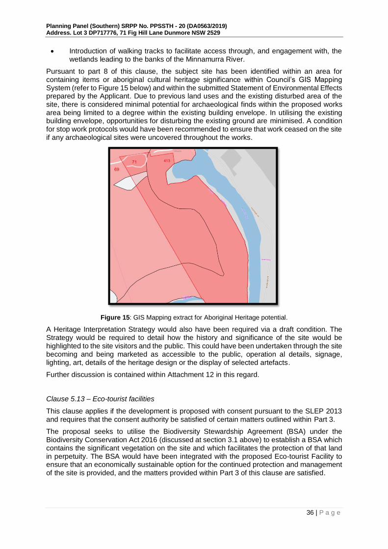
Planning Panel (Southern) SRPP No. PPSSTH - 20 (DA0563/2019) Address. Lot 3 DP717776, 71 Fig Hill Lane Dunmore NSW 2529
36 | P a g e
Introduction of walking tracks to facilitate access through, and engagement with, the wetlands leading to the banks of the Minnamurra River.
Pursuant to part 8 of this clause, the subject site has been identified within an area for containing items or aboriginal cultural heritage significance within Council’s GIS Mapping System (refer to Figure 15 below) and within the submitted Statement of Environmental Effects prepared by the Applicant. Due to previous land uses and the existing disturbed area of the site, there is considered minimal potential for archaeological finds within the proposed works area being limited to a degree within the existing building envelope. In utilising the existing building envelope, opportunities for disturbing the existing ground are minimised. A condition for stop work protocols would have been recommended to ensure that work ceased on the site if any archaeological sites were uncovered throughout the works.
Figure 15: GIS Mapping extract for Aboriginal Heritage potential.
A Heritage Interpretation Strategy would also have been required via a draft condition. The Strategy would be required to detail how the history and significance of the site would be highlighted to the site visitors and the public. This could have been undertaken through the site becoming and being marketed as accessible to the public, operation al details, signage, lighting, art, details of the heritage design or the display of selected artefacts.
Further discussion is contained within Attachment 12 in this regard.
Clause 5.13 – Eco-tourist facilities
This clause applies if the development is proposed with consent pursuant to the SLEP 2013 and requires that the consent authority be satisfied of certain matters outlined within Part 3.
The proposal seeks to utilise the Biodiversity Stewardship Agreement (BSA) under the Biodiversity Conservation Act 2016 (discussed at section 3.1 above) to establish a BSA which contains the significant vegetation on the site and which facilitates the protection of that land in perpetuity. The BSA would have been integrated with the proposed Eco-tourist Facility to ensure that an economically sustainable option for the continued protection and management of the site is provided, and the matters provided within Part 3 of this clause are satisfied.
Planning Panel (Southern) SRPP No. PPSSTH - 20 (DA0563/2019) Address. Lot 3 DP717776, 71 Fig Hill Lane Dunmore NSW 2529
37 | P a g e
An assessment against the relevant provisions of Clause 5.13 is provided below. The applicant has also provided a response which demonstrates how the application could be found to satisfy the provisions of Clause 5.13 which is provided at Attachment 4 to this report.
The objectives of Clause 5.13 are as follows:
(a) to maintain the environmental and cultural values of land on which development for the purposes of eco-tourist facilities is carried out,
(b) to provide for sensitively designed and managed eco-tourist facilities that have minimal impact on the environment both on and off-site.
The development would have been considered to satisfy the objectives of the control as discussed below.
(2) This clause applies if development for the purposes of an eco-tourist facility is permitted with development consent under this Plan.
The development as proposed is permitted with development consent within the RU2 and E3 zoned areas of the site, as discussed at Clause 2.3 above.
(3) The consent authority must not grant consent under this Plan to carry out development for the purposes of an eco-tourist facility unless the consent authority is satisfied that:—
(a) there is a demonstrated connection between the development and the ecological, environmental and cultural values of the site or area, and
The development demonstrates three main elements to support this clause. They are:
the commitment to deliver on the Stewardship site,
the educational and interpretive environmental and cultural interpretive walk
the commitment of vegetation management in perpetuity.
These activities described in detail throughout this report represent the fundamental ‘connection’ between the development and values of the site.
On the basis that the BSA was registered and achieves active management, the walking tours/educational programs were implemented and continued in perpetuity, the connection between the development and the ecological, environmental cultural features of the area would have been considered satisfactory.
The ecological values of the proposal would have protect the local natural environment via the limited built form (construction generally within the existing footprint) and by the registration of the BSA. Confirmation the Applicants intention has been expressed through the following documents provided by the Applicant:
Plan of Management (POM)
Track Management and Maintenance Plan
Vegetation Management Plan (VMP)
Biodiversity Development Assessment Report (BDAR)
The information provided by the Applicant identifies the development connection with the ecological, environmental and culture values of the site while providing a framework for the management and interaction with the site value. Council would therefore have been satisfied that the development has a demonstrated connection with the ecological, environmental and cultural values of the area and therefore satisfies part (a) of the control, should all other matters have been resolved.

Planning Panel (Southern) SRPP No. PPSSTH - 20 (DA0563/2019) Address. Lot 3 DP717776, 71 Fig Hill Lane Dunmore NSW 2529
38 | P a g e
(b) the development will be located, constructed, managed and maintained so as to minimise any impact on, and to conserve, the natural environment, and
As discussed throughout this report, subject to the implementation of the conservation initiatives, together with the design amendments and future maintenance design, the development would not have resulted in any further environmental degradation and would have represented the rehabilitation of a heavily disturbed site. The built form would have been contained to the existing disturbed area of the site.
Council would have been satisfied that the development would have been located and constructed to minimise impacts on, and to conserve, the natural environment. It is also considered that the development would have been constructed, managed and maintained so as to minimise impacts on and conserve the natural environment. Conditions would have been recommended in this regard.
(c) the development will enhance an appreciation of the environmental and cultural values of the site or area, and
The development would have provided opportunities to contribute to the appreciation of the environmental and cultural values by the site by offering interpretive walks and education programs as described above. These aspects of the development are further discussed within the submitted Plan of Management, provided at Attachment 2. Council is satisfied that the development would have enhanced an appreciation of the environmental and cultural values of the site subject to the implementation of the BSA and walking tours as specified.
(d) the development will promote positive environmental outcomes and any impact on watercourses, soil quality, heritage and native flora and fauna will be minimal, and
Council is of the view that the BSA would promote positive environmental outcomes for the site. Draft conditions including a deferred commencement condition would have ensured that the agreement was in place prior to issue of any operational consent.
The Vegetation Management Plan (VMP) aims to protect the vegetation during and after construction activities and importantly, re-establish native vegetation at the site. Furthermore, the VMP requires systematic staged removal and routine control of weed species within the VMP Area, which would assist in enhancing the ecological character of the site. Conditions would have been recommended with regard to the implementation of the VMP works.
From a heritage perspective, the existing structure located on site is visually intrusive on the setting, and curtilage of the heritage item, Dunmore House. Demolition of the existing structure would significantly enhance views from the public domain, along Riverside Drive to the subject heritage item, and facilitate the construction of the subject development which provides a more sympathetic design that is lower in profile and would not unreasonably detract from the Dunmore House heritage item.
Based on the above the development is considered to have been designed with a view to minimising environmental impacts within and in the vicinity of the site.
Council is satisfied that the impacts upon watercourses, soil quality, heritage, and native flora and fauna would be minimal, subject to conditions.
(e) the site will be maintained (or regenerated where necessary) to ensure the continued protection of natural resources and enhancement of the natural environment, and
The perpetual nature of maintaining an active managed BSA and VMP ensures that natural resources will be protected and that long-term opportunities to enhance, protect and conserve the highly sensitive site occur to the currently degraded and unmanaged site.
This development application provides the opportunity to mandate environmental outcomes and enhance the natural environment. Council is satisfied that the site would have been

Planning Panel (Southern) SRPP No. PPSSTH - 20 (DA0563/2019) Address. Lot 3 DP717776, 71 Fig Hill Lane Dunmore NSW 2529
39 | P a g e
maintained to ensure the continued protection of natural recourses and enhancement of the natural environment, subject to conditions.
(f) waste generation during construction and operation will be avoided and that any waste will be appropriately removed, and
The applicant has provided sufficient information on demolition waste streams will be managed during the removal of the existing structures. Conditions would have been recommended via application of a Demolition and Construction Site Environmental Management Plan to include dust suppression, waste disposal, demolition hours and recycling to ensure that the work was carried out in an appropriate manner.
The applicant has provided sufficient information to adequately address how operational waste would be “avoided” and minimised. Council is satisfied that waste generation during demolition and operation would be “avoided” as per the requirements of this clause. Conditions would have been recommended in this regard.
(g) the development will be located to avoid visibility above ridgelines and against escarpments and from watercourses and that any visual intrusion will be minimised through the choice of design, colours, materials and landscaping with local native flora, and
Throughout the assessment the proposal was amended to provide a reduction in the overall height and building footprint of the original design. These changes included the removal of the clifftop units C, reconfiguration of the six (6) ground floor units and reduction of the bar and restaurant area dimensions.
Importantly, the bulk and height of the building has been modified to minimise the visual intrusion against the escarpment. The clifftop units are all single storey and connected to each other through a series of open landscaped pathways. Natural external materials are utilised within the façade of the primary building and clifftop units so that the building recedes into the environment rather than standing out. The amendments to the primary building incorporate a ‘green’ (vegetated) roof that would be partially visible from Riverside Drive which would sit in situ and create an interconnection to the existing ridgeline and adjoining landform. A visual impact assessment was prepared and is provided within Attachment 9. Council would have been satisfied that the proposed location and design of the development minimises visual impact/intrusion through design, use of colours (natural colours proposed) and building materials proposed.
(h) any infrastructure services to the site will be provided without significant modification to the environment, and
Council would have been satisfied that any infrastructure services required to service the site can be provided without significant modification to the environment. Specifically, this relates to wastewater, electricity, general water supply and access. See further discussion throughout this report.
(i) any power and water to the site will, where possible, be provided through the use of passive heating and cooling, renewable energy sources and water efficient design, and
Council would have been satisfied that, where possible, sustainable measures for power and water to the site can be delivered through the use of passive thermal design, efficient lighting, renewable energy sources and water efficient design as indicated within the Ecologically Sustainable Development Report. Conditions would have been recommended in this regard.
(j) the development will not adversely affect the agricultural productivity of adjoining land, and
The proposed development would not be expected to adversely affect the agricultural productivity of adjoining land. Land immediately to the north and west of the subject site is subject to a Major Project Development Application that will see over 1.3 million tonnes of

Planning Panel (Southern) SRPP No. PPSSTH - 20 (DA0563/2019) Address. Lot 3 DP717776, 71 Fig Hill Lane Dunmore NSW 2529
40 | P a g e
natural resource extraction from the two sites. The current site is naturally separated through environmental assets and topography that limit interaction with adjoining property boundaries.
Council would have been satisfied that based on the proposed development and details provided the Eco-tourist Facility will not adversely affect the agricultural productivity of adjoining land as adequate separation from lot boundaries would have been established and ongoing monitoring and management of operational noise and lighting was capable of being conditioned.
(k) the following matters are addressed or provided for in a management strategy for minimising any impact on the natural environment—
(i) measures to remove any threat of serious or irreversible environmental damage,
(ii) the maintenance (or regeneration where necessary) of habitats,
(iii) efficient and minimal energy and water use and waste output,
(iv) mechanisms for monitoring and reviewing the effect of the development on the natural environment,
(v) maintaining improvements on an on-going basis in accordance with relevant ISO 14000 standards relating to management and quality control.
The intent of constructing the Eco-tourist Facility is integrated with the Applicants intention to establish a Biodiversity Stewardship Agreement (BSA) through the Biodiversity Conservation Trust (BCT). The BSA is the mechanism for minimising environmental impact as once the site is under active management and the BSA is registered on the title of the land, the site is directly monitored with oversight from the. The provisions for BCT involvement ensures that the process and establishment of the BSA is by government organisation that provides direction and ongoing requirements be undertaken in accordance with the restriction on title.
The areas outside of the Biodiversity Stewardship would be managed through the provisions of the submitted VMP and Plan of Management (PoM) (refer to Attachment 2) which establish the framework for management actions required to minimise the environmental impact of the development outside of the BSA area.
The proposed design includes sustainable design principals and sustainability standards to offset the development footprint and ecological impact to the immediate surrounding area through both the construction and operational phase. The Applicant has identified that ESD initiatives would be implemented in order to reduce energy demand and associated greenhouse gas emissions, reticulated water consumption, material resources of the project are managed and minimised.
The ESD Report has not been updated to reflect the amended plans but the strategies outlined within the report would have been incorporated into the documentation associated with the provision of a Construction Certificate, should all other matters have been resolved. Further, management during the demolition and construction process would have been managed through appropriate and measures including the adoption of the PoM, VMP and ESD report into the approved documentation.
Council would have therefore been satisfied that sufficient information has been submitted with the development application to demonstrate compliance with the requirements (i) to (v) in this clause, should all other outstanding matters have been resolved.
It is noted that the responses and satisfactory responses to the above matters would be required to be reviewed following resolution of the NSW Rural Fire Service matters.
In conclusion as per the assessment above, it is considered that subject to the establishment of the Biodiversity Stewardship Agreement and imposition of appropriate conditions, the development would have been capable of satisfying the provisions of Clause 5.13 SLEP 2013.

Planning Panel (Southern) SRPP No. PPSSTH - 20 (DA0563/2019) Address. Lot 3 DP717776, 71 Fig Hill Lane Dunmore NSW 2529
41 | P a g e
However, as the matters relating to NSW Rural Fire Service requirements remains unresolved at the time of preparing this report, it is unclear what the impacts of resolving the outstand matters may be.
Part 6 Additional local provisions
Clause 6.1 - Acid Sulphate Soils
The building footprint for the development is not located within an area mapped as containing Acid Sulfate Soils (ASS) as demonstrated by Figure 16 below, however, the remaining lot contains areas mapped as Class 1 and Class 2 potential ASS.
The site was assessed for ASS in the Martens Preliminary Acid Sulfate Soil Assessment. Given the desk top analysis, site elevation, topographic, and geology maps and encountered subsurface conditions, it is expected that the fill/ natural soils / rock profile would not result in the presence of ASS within the proposed building footprint. Further site investigations for an ASS assessment or preparation of an ASS management plan (ASSMP) would not be required in this case.
Figure 16: Acid Sulfate Soils SLEP Map Extract
Clause 6.2 - Earthworks
The proposal would generally utilise the footprint of the existing structures to minimise further extraction or fill works. While the existing cut and extraction levels are substantial, due to works associated with the approved dwelling, the intention to utilise the existing landform substantially minimises the potential impact on the environmental functions and processes, neighbouring uses, cultural or heritage items or features of the surrounding land.
Accordingly, subject to conditions, the proposal would have been consistent with the objectives and provisions of Clause 6.2 and the matters for consideration.

Planning Panel (Southern) SRPP No. PPSSTH - 20 (DA0563/2019) Address. Lot 3 DP717776, 71 Fig Hill Lane Dunmore NSW 2529
42 | P a g e
Clause 6.3 - Flood Planning
The lower areas of the site in close proximity to the Minnamurra River are identified as flood hazard affected. The building envelope and position of the Eco-tourist Facility is located outside of the area identified as being flood liable. Therefore, no conditions for minimum floor levels or structural design to withstand floodwaters are required.
As the walking tracks extend in Flood Liable Land, the management of these tracks would have been required to include provisions for safe evacuation and procedure for flooding events. Such conditions would have been recommended.
Clause 6.4 - Stormwater Management
The proposal would not compromise the objectives of the clause as the development has been designed to maximise the use of water permeable surfaces on the land having regard to the soil characteristics affecting on-site infiltration of water, includes on-site stormwater retention for use as an alternative supply as per the principles of ESD, and avoids any significant adverse impacts of stormwater runoff on adjoining properties, native bushland and receiving waters. Council is satisfied, where relevant, that the matters listed in sub-clause 3 are satisfactorily addressed. Conditions would have been recommended in this regard
Clause 6.5 - Terrestrial biodiversity
The ‘Terrestrial Biodiversity Map’ identifies that part of the site is within the mapped ‘Environmentally Sensitive Land’ as demonstrated by Figure 17 below.
With reference to the matters contained in subclause 3 and 4, the development in its proposed location (including the ancillary infrastructure required) would not have any adverse impact on the ecological value/significance of flora and fauna on the land, adverse impact on the importance of the vegetation on the land to the habitat/survival of native fauna and would not fragment, disturb the biodiversity structure of the land or habitat elements providing connectivity on the land. The development is predominantly designed and sited so as to avoid any significant environmental impact on this area. Conditions would have been recommended as discussed throughout this report with regard to ensuring that the ecologically sensitive areas of the site are appropriately protected and managed. It is noted that the responses to the above matters would be required to be reviewed following resolution of the NSW Rural Fire Service matters.

Planning Panel (Southern) SRPP No. PPSSTH - 20 (DA0563/2019) Address. Lot 3 DP717776, 71 Fig Hill Lane Dunmore NSW 2529
43 | P a g e
Figure 17: Terrestrial Biodiversity Map (Sheet BI)_026)
Clause 6.7 – Airspace operations
The site is not subject to airspace operations.
Clause 6.8 – Development in areas subject to aircraft noise
The site is not within an area subject to aircraft noise or aerodrome operation.
Clause 6.9 – Essential services
This clause requires that development consent not be granted for development unless the consent authority is satisfied that any of the following services that are essential for the development are available, or that adequate arrangements have been made to make them available when required.
Servicing to the subject site are as follows:
a. The supply of water - The Applicant has indicated that access to reticulated water infrastructure can be achieved from Riverside Drive, through 431 Riverside Dunmore. An in principal agreement to the provision of an easement and construction of a water supply has been provided from the owner of 431 Riverside Drive. The pathway of the easement from the road reserve to the development site has been provided plan titled Water Main Path Drawing No. A1-D215286_EASE dated 19.02.2021. Whilst the water pipeline pathway does conflict with the location of several trees, arborists advice has been provided which confirms that construction techniques including under boring can be implemented to ensure that any impacts on trees can be minimised. This information is provided within Attachment 2 to this report. A deferred commencement condition would have been recommended in this regard, should all other matters have been resolved.

Planning Panel (Southern) SRPP No. PPSSTH - 20 (DA0563/2019) Address. Lot 3 DP717776, 71 Fig Hill Lane Dunmore NSW 2529
44 | P a g e
Figure 18: Survey and indicative route for establishment of underground water
infrastructure to service the subject property.
Figure 19: Indicative route for establishment of underground water infrastructure to service the subject property overlaid on site aerial
b. Endeavour Energy as service provider has identified via General Advice was received on the 25 November 2019 that the site is serviced by existing electricity assets. This response would have been provided as part of any conditions of consent.

Planning Panel (Southern) SRPP No. PPSSTH - 20 (DA0563/2019) Address. Lot 3 DP717776, 71 Fig Hill Lane Dunmore NSW 2529
45 | P a g e
c. The subject site is not serviced by a reticulated sewerage system. The Eco-tourist Facility is proposed to be serviced with an onsite sewerage management system that includes tertiary level treatment and subsurface irrigation. The proposed onsite effluent management system has been designed to manage and dispose of the sewage volumes generated by the development operation. The proposed system, design and treatment location has been reviewed by Councils Health Officers and no objections. Conditions would have been recommended in this regard, should all other matters have been resolved.
d. The proposal intends to utilise on-site detention through ecological sustainable design to collect and distribute stormwater. Stormwater runoff from the proposed development is proposed to be conveyed by way of pit and pipe to two infiltration basins through an Onsite Detention System. The infiltration basins are proposed to utilise low flows modulation through unsealed construction to percolate collected water into the surrounding soils with nominated outlet points. The proposed system, design and treatment location has been reviewed by Councils Engineering Officer who raised no objection to the development. Conditions would have been recommended in this regard.
e. Access to the site is provided via the existing Right of Carriageway (Fig Hill Lane) that benefits the subject site. Fig Hill Lane has an established carriageway width of 10 – 13m with variety of finishes. The Applicant has demonstrated that the existing easement is sufficient in dimension to provide a formed carriageway of 5.5m wide within the boundaries of the existing right of carriageway (refer to Attachment 2). This is discussed at section 2.3.2 above.
In summary, the proposed development, would not conflict with the requirements detailed in Clause 6.9.
Clause 6.10 Significant mineral resources
The subject site is not land identified under as a Mineral Resource Area on the Mineral Resource and Transition Areas Map.
3.3 Section 4.15 (1) (a)(ii) – any proposed instrument that is or has been the subject of public consultation under this Act and that has been notified to the consent authority (unless the Planning Secretary has notified the consent authority that the making of the proposed instrument has been deferred indefinitely or has not been approved).
There are no proposed instruments that have been subject to public consultation that would relate to the subject development.
3.4 Section 4.15 (1) (A)(Iii) – any development control plan
The proposal contains minimal departures from the design controls provided with the SDCP 2013 and is generally consistent with the relevant objectives. The complete assessment in response to the Shellharbour Development Control Plan 2013 is provided at Attachment 12 to this report.
Shellharbour Local Infrastructure Contributions Plan 2019
The estimated cost of the development exceeds $10,000,000 the provisions of Environmental Planning and Assessment (Local Infrastructure Contributions – Timing of Payments) Direction 2020 applies. A contribution of $1,891.07, subject to annual indexation, for non-residential contribution would have been required to be paid to Council towards the provision of public

Planning Panel (Southern) SRPP No. PPSSTH - 20 (DA0563/2019) Address. Lot 3 DP717776, 71 Fig Hill Lane Dunmore NSW 2529
46 | P a g e
amenities and public services prior to the issue of the Construction Certificate, should conditional approval have been recommended. This amount has been calculated in accordance with Shellharbour City Council’s Local Infrastructure Contributions Plan 2019 9th Review 14 August 2019.
As the application is recommended to be refused, no contributions would be payable at this time.
3.5 Section 4.15 (1) (a)(iv) - the regulations (to the extent that they prescribe matters for the purposes of this paragraph)
Clause 92 What additional matters must a consent authority take into consideration in determining a development application?
The site is not located within the coastal zone. Demolition is proposed and conditions have been recommended in this regard.
93 Fire safety and other considerations
The subject application does not relate to a change of use. As such, this clause would not apply.
94 Consent authority may require buildings to be upgraded
The subject application does not relate to alterations or additions. As such, this clause would not apply.
3.6 Section 4.15 (1)(b) - the likely impacts of that development, including environmental impacts on both the natural and built environments, and social and economic impacts on the locality
Bulk and Scale
The development as revised complies with the height standard set out in Shellharbour Local Environmental Plan (SLEP) 2013. The revised design has addressed the matters raised within the Design Review Panel recommendations, as well as the Panel briefing items.
The proposal provides a site responsive design that minimises the mass of the structures through utilising existing ground levels predetermined by the existing dwelling structure. The placement of the clifftop lodges and removal of clifftop lodges C from the proposal provides a development which now respects the prominent and sensitive nature of the site through design choices, building placement, appropriate materials and facade treatment.
The use of existing site levels and location of parking, loading docks and back of house structures below and in between the main structures responds to the ridgeline setting and presents an uncluttered profile with a degree of visual interest that disguises operational areas.
The overall built form is distributed across the northern part of the site with adequate separation from property boundaries to ensure the transition between built form and green space maintains a degree of scenic quality that is visually respectful and interconnected without overshadowing or impacting on adjoining development privacy.
The bulk and scale of the proposal would have been considered appropriate and unlikely to result in adverse impacts on the locality.
Operational Impacts
The Applicant has prepared a Plan of Management (PoM) that addresses operational details for the use. The PoM is provided within Attachment 2. The nature of the site and proximity to Minnamurra River have resulted in additional conditions being imposed relating to the

Planning Panel (Southern) SRPP No. PPSSTH - 20 (DA0563/2019) Address. Lot 3 DP717776, 71 Fig Hill Lane Dunmore NSW 2529
47 | P a g e
development operation to ensure the operation of the Eco-tourist Facility minimises potential impacts on the nearby sensitive areas. Conditions would have been recommended in this regard and would have included;
12 month monitoring period to be conducted to ensure operation of the Eco-tourist Facility lighting and noise does not prove detrimental to fauna located onsite and adjoining residential properties;
Plan of Management to be amended to include reference to vehicle ingress and egress;
Amendments to the Walking Track Plan of Management;
The preparation of a Lighting schedule; and
Operating hours to be limited, with deliveries and external use of the swimming pool and terrace area to be managed.
Subject to conditions, Council would have been satisfied that the proposal was capable of operating in a sustainable and respectful manner.
Noise and Lighting Impact
Conditions would have been recommended that require a 12 month monitoring period to ascertain appropriate benchmarks and management responses to noise and lighting. Particular attention would have been required to address the impact of the site operation and approved use in reference to activity noise, resulting noise level criteria, plant noise during operation, lighting levels and spillage. The details of the 12 month monitoring and management response would have required a verification report be prepared and be provided to Council for adoption/approval through Council’s Environmental Team.
Odour Impact
It is not expected that the proposed development would have resulted in an unacceptable odour problem given the separation between the central facilities building, the sites property boundaries and adjoining properties. Conditions would have been recommended which required ongoing monitoring of the system to ensure any impacts were appropriately managed.
Economic Impacts
It is considered that the proposed development would result in a positive economic impact during the construction phase through the creation of demolition/construction jobs. Post construction, additional employment opportunities would also have been created for the local community and wider area, with jobs both on the site and economic benefits for those businesses who provide goods and services to the operator and other business that guests would potentially visit as more tourists are attracted to the area.
Given the proposed development is aiming to target the tourism market, it would have provides additional accommodation options for visitors to the Illawarra area.
There would not have been expected to be adverse economic impacts arising from approval of the proposed development.
Social Impacts and Crime Prevention through Environmental Design (CPTED)
It is considered that the proposed development would result in positive social impacts through allowing people to experience the environmental values of the area generally. Subject to the implementation of mitigation measures as detailed in the Plan of Management and ongoing monitoring of the site any potential social impacts from the proposed development would be minimised through additional casual surveillance of the site created through the operation and presence of the community, staff and customers. The bar/restaurant would be required to obtain the relevant liquor licence prior to serving alcohol. An advisory note would have been included on any consent granted in this regard.

Planning Panel (Southern) SRPP No. PPSSTH - 20 (DA0563/2019) Address. Lot 3 DP717776, 71 Fig Hill Lane Dunmore NSW 2529
48 | P a g e
It is also noted that the redevelopment of the site in terms of social impact and CPTED provisions is desirable. As noted by submitters, the site is currently underutilised and a risk to the public resulting from the unauthorised use and vandalism.
Essential Services
See discussion at section 3.2.5 above. The site either has existing access to, or the proposal has demonstrated how the required essential services would have been provided to the proposed development. Conditions would have been recommended in this regard.
Construction
Conditions of consent would have been recommended in relation to construction impacts such as hours of work, erosion and sedimentation controls, works in the road reserve, excavation and use of any crane, hoist, plant and/or scaffolding.
Adjoining Development adjoins an approved mining extraction area
The subject site is within proximity to the land mapped for significant mineral resources.
The Eco-tourist Facility is located approximately 140 metres from 471 Riverside Drive and 69 Fig Hill Lane which are identified under the Dunmore Lakes Project Modification 2 application which has been approved by the Independent Planning Commission in late 2020. The modification is identified as Stage 5 and provides approval to extract sand from two new extraction areas, known as Stages 5A (to the north) and 5B (to the south) identified within Figure 20. The proposed extraction areas are situated on private property located between the Princes Highway, Riverside Drive and the Minnamurra River, which are to be leased to Boral from the landowner. Stage 5a adjoins 71 Fig Hill Lane with Boral proposing to construct an internal unsealed access road from Riverside Drive around the perimeter of the Stage 5A extraction area to connect to Fig Hill Lane for access for extraction and rehabilitation.

Planning Panel (Southern) SRPP No. PPSSTH - 20 (DA0563/2019) Address. Lot 3 DP717776, 71 Fig Hill Lane Dunmore NSW 2529
49 | P a g e
Figure 20: Stage 5 Extent as proposed under the current modification to DA195-8-2004.
The implications for 71 Fig Hill Lane are minimal as the traffic movement associated with the sand mine extraction and rehabilitation would be managed under the approval with any maintenance work or upgrade works to Fig Hill Lane being managed by Boral as a component of the operation. This would also include any changes to the intersection of Riverside Drive and Fig Hill Lane.
However, should this project not proceed, or the subject development proceed prior to the Boral works to the intersection and Fig Hill Lane, conditions would have been recommended
Eco-tourist DA site

Planning Panel (Southern) SRPP No. PPSSTH - 20 (DA0563/2019) Address. Lot 3 DP717776, 71 Fig Hill Lane Dunmore NSW 2529
50 | P a g e
to ensure that the access to the site was capable of accommodating any increase in traffic resulting from the development.
Flora and Fauna
The most eastern portion of the subject land is mapped as being part of the Illawarra Regional Biodiversity Corridor with the Applicant submitting a Biodiversity Development Report prepared by Cumberland Ecology (dated October 2019) and an additional Ecology Response letter (dated 19 October 2020) which investigated the subject site and development in reference to flora and fauna. These reports are provided within Attachment 2.
The development would not have any adverse impact on the ecological value/significance of flora and fauna on the land, on the importance of the vegetation on the land to the habitat/survival of native fauna and would not be fragmented, the biodiversity structure disturbed or habitat elements providing connectivity on the land. The development has been predominantly designed and sited so as to avoid any significant environmental impact.
The proposed use of walking tracks and ancillary areas, such as the swimming pool and terrace would have been monitored for a 12 month period to minimise any potential impact of noise on the surrounding environment of Flora and Fauna.
Conditions would have been required to be imposed in this regard, including the following;
a. The draft plan of management to be updated to detail walking track maintenance, how guest access to vegetation would be restricted outside of guided tours, specific maintenance works to be conducting to on the walking tracks, mitigation measures for the preservation of vegetation and prevention of additional walking tracks being constructed and overall site management to prevent encroachment from erosion, weeds and other negative impacts;
b. Fauna management to be updated within the Vegetation Management Plan to address the existing dilapidated dwelling demolition and require pre clearing/pre demolition surveys;
c. Imposition of additional monitoring post operation to ensure lighting and noise generation is acceptable and not affecting fauna through revisions of management principals if identified;
d. Ongoing mitigation to occur through the construction stage with ongoing monitoring to occur; and
e. Annual reporting to address potential impacts on fauna and ensure that the management principals and actions as outlined within the Plan of Management are sufficient to minimise impacts.
It is noted that the above matters would be required to be reviewed following resolution of the RFS matters.
3.7 Section 4.15 (1)(c)- the suitability of the site for development
Does the proposal fit in the locality?
The proposal is considered appropriate with regard to the zoning of the site and would not be expected to result in negative impacts on the amenity of the locality or adjoining developments.
Are the site attributes conducive to development?
The subject site is identified as being within a bushfire hazard area and as development for the purpose of an Eco-tourist facility is proposed, the development is required to be considered as a Special Fire Protection Purpose development pursuant to the Rural Fires Act 1997 and Planning for Bushfire Protection, and as Integrated Development pursuant to clause 4.16 of the Environmental Planning and Assessment Act 1979. As a 100B authority has not been

Planning Panel (Southern) SRPP No. PPSSTH - 20 (DA0563/2019) Address. Lot 3 DP717776, 71 Fig Hill Lane Dunmore NSW 2529
51 | P a g e
provided by the Rural Fire Service, Council is unable to present a recommendation for conditional approval. The site attribute of being bushfire prone land, is not conducive to the development as proposed, based on the information at hand.
3.8 Section 4.15 (1)(d) - any submissions made in accordance with the Act or the regulations
The proposal was notified in accordance with the Shellharbour Community Participation Plan 2019 and received a total of 41 submissions, across two exhibition periods.
Following lodgement, the original application was notified between the 22 September and 6 October 2019. Council undertook extensive notification including directly notifying all occupiers of dwellings within a 400m radius of the development site, including residents in the Kiama Council area. Obtaining the addresses of Kiama residents delayed the exhibition of the Development Application as such information was required to be obtained by Kiama Council. 26 submissions were received during this period.
Following the submission of amended plans and additional information, the proposal was re-advertised between the 25 September and 6 October 2020. 14 submissions were received during this period.
In total, 41 unique submissions were received across the two notification periods.
A summary of concerns raised and the number of times that matter was identified is provided within Attachment 6. The primary objections relate to the following:
n. Eco-tourism credentials and definition;
o. Permissibility/characterisation of the development;
p. Scale and density;
q. Impact of the development on the Minnamurra River and surrounding threatened species/environmental value during construction and operation;
r. Historic/existing concerns surrounding unauthorised fill (noted by submitters as ‘toxic fill’);
s. Access to essential services as the site is currently un-serviced for sewerage and water;
t. Noise generation from the overall development with a focus on noise pollution from the bar and restaurant;
u. Insufficient car parking for public and private use and concerns about the capacity of the private laneway (Fig Hill Lane) to deal with the increased traffic generation;
v. Owners Consent required for Fig Hill Lane upgrades;
w. Biodiversity Stewardship Agreement and interconnection with Eco-tourist facilities;
x. Proximity and impact to local heritage item – Dunmore House and surrounds;
y. Environmental Sustainable Design (ESD); and
z. Bushfire.
In response to the above objections, Council makes the following comments:
a. Eco-tourism Credentials and Definition
Concern has been raised about the applicant’s ability to achieve eco-tourism accreditation and the ability of the development - if approved - to meet the criteria for eco-tourism. The eco-

Planning Panel (Southern) SRPP No. PPSSTH - 20 (DA0563/2019) Address. Lot 3 DP717776, 71 Fig Hill Lane Dunmore NSW 2529
52 | P a g e
tourism criteria outlined in a number of the public submissions is the criteria that is endorsed by eco-tourism Australia.
Council in the assessment of this application can only have regard for the definition of ‘eco-tourism facility’ and the associated criteria as contained in the SLEP 2013 and specifically Clause 5.13 as discussed at section 3.2.5 of this report. As such the eco-tourism Australia criteria and definition have no relevance to the matters of consideration under the Environmental Planning and Assessment Act 1979.
Therefore, the applicant’s ability to achieve eco-tourism accreditation from eco-tourism Australia is a matter for the applicant and is not a consideration in Council’s assessment.
b. Permissibility/Characterisation of the Development
Concern has been raised about the permissibility of the ‘Central building/hotel, restaurant and bar’ components of the proposed development and the applicant’s assessment that the use is ancillary to the main use of the site as an ‘Eco-tourist Facility’. Concern has also been raised about how the development has been characterised by the applicant as an Eco-tourist facility when it better fits the definition of ‘hotel or motel accommodation’ under SLEP 2013.
Council has assessed the proposal against the SLEP 2013 and associated criteria with Clause 5.13 and concluded the use is permissible as an Eco-tourist Facility, subject to the conditions as recommended. See discussion at section 3.2.5 above;
c. Scale and Density
Concern has been raised that the development is out of character with the local area and surrounding uses, which are predominantly protected environmental areas, local heritage or land used for agriculture. Council’s assessment concludes that the use is permissible within the zone and the revised design reduces the mass and scale of the development in a manner that achieves a greater degree of suitability to the site and surrounding locality;
d. Flora and Fauna
Concern has been raised regarding the impact that the development would have on flora and fauna within the site and on adjacent sites, specifically the Minnamurra River and associated vegetation. The applicant has submitted a flora and fauna assessment including a Biodiversity Assessment Report (BDAR) and Vegetation Management Plan which have been reviewed by Council’s Environmental Officer. No objection to the proposal has been identified, subject to the imposition of appropriate conditions and implementation of the Biodiversity Stewardship Agreement. As the matters relating to RFS requirements remains unresolved, this matter remains outstanding.
e. Toxic Fill
Concern has been raised about the fill that is present onsite that was utilised in the construction of an authorised road and building that is linked to the works on the existing dilapidated structure currently onsite. The objections refer to the fill as “toxic fill”. As part of the subject application, a preliminary site investigation with sampling was undertaken to test the filled areas of the site. See further discussion within SEPP 55 discussion above. The site would have been considered suitable for the proposed land use.

Planning Panel (Southern) SRPP No. PPSSTH - 20 (DA0563/2019) Address. Lot 3 DP717776, 71 Fig Hill Lane Dunmore NSW 2529
53 | P a g e
f. Essential Services
Concern was raised that the subject site has insufficient access to adequate services as the site does not have access to water or connection to public sewer infrastructure to facilitate and provide adequate servicing for the proposed size of the proposal.
Refer to discussion within sections 3.2.5 and 2.3.2 of this report. Conditions would have been recommended with regard to the provision of a reticulated water supply to the development. An onsite effluent disposal system is proposed and is considered adequate to service the development. Conditions would have been recommended in this regard.
g. Noise and light pollution:
Concern has been raised about noise and light impacts from the development during construction and following occupation, specifically that the proposed development would result in unacceptable level of noise, resulting from the roof top bar, vehicle movements, restaurant and ground floor bar area. Concerns about noise and lighting impacts on wildlife and proximity to residential and heritage list items (Dunmore House) have also been raised.
In response to noise generation concerns, the Applicant has prepared a Plan of Management which includes measures to manage operational noise. In addition, Council would have also required a monitoring period of 12 months to ensure the matters within the PoM and management of the operation minimises any potential noise and light impacts. Conditions would have been recommended in this regard.
Subject to the imposition of the conditions, Council would have been satisfied that noise generation and illumination from the site would have resulted in minimal impacts on surrounding properties, flora and fauna.
h. Insufficient car parking and site access via Fig Hill Lane:
Concern has been raised about the increase in traffic that this development would generate specifically along Riverside Drive and Fig Hill Lane and the ability of the proposed car parking area to adequately service the development. Concern has also been raised about the condition of the roads that services the development site (e.g. narrow, no line marking, steep drop offs) and the impacts this will have on users who are not familiar with the roads during heavy rain, fog and when trees are down.
Council’s Engineering Department have assessed vehicle access and car parking configuration and raised no objection to the design subject to the imposition of conditions. In addition it has been confirmed by the Applicant and Council that upgrades are required to occur along Fig Hill Lane, as discussed at section 2.3.2.
i. Fig Hill Lane Owners Consent for upgrades:
Concern has been raised that no owners consent has been provided by the owners of the land that is burdened by the Right of Carriageway which provides access to the subject site. This is discussed at section 2.3.2 above.
j. Economic profit, Biodiversity Stewardship Agreement and protection of the Environment:
Concern was raised that the proposal lacked connection with the environment, would not protect the natural value of the land, was designed to generate economic profit and that the Biodiversity Stewardship Agreement process would not be conducted.

Planning Panel (Southern) SRPP No. PPSSTH - 20 (DA0563/2019) Address. Lot 3 DP717776, 71 Fig Hill Lane Dunmore NSW 2529
54 | P a g e
The Biodiversity Stewardship Agreement (BSA) implementation would have been required via a deferred commencement condition and as such, would have been required to be in place prior to the release of any operational consent for the development. The BSA would ensure that the environmental value of the land would be protected in perpetuity, as discussed at section 3.1 above.
The Applicant has indicated that the development has been designed to benefit and protect the environment through the income being generated by the operation of the facility.
k. Impact on surrounding heritage items:
The application submission included a Heritage Impact Assessment which makes recommendations for the protection of the local heritage item Dunmore House et al and the Minnamurra Vegetation area. The proposed development has been reviewed by Council’s Heritage Adviser who has not raised an objection to the development. See further discussion at section 3.2.5 above.
l. Environmental Sustainable Design requirements:
Concerns were raised that the current proposal did not contain adequate Environmental Sustainable Design features. Councils notes this matter and in response identifies that the Applicant submitted ESD report has not been updated to match the amended design. However, the recommendations made within the report for the provision and adoption of ESD are present within the design and would have been conditioned to be provided prior to issue of the Construction Certificate.
m. Bushfire Prone Land:
Concerns were raised that the development was proposed within an area which is affected by bushfire hazard. The subject site is identified as Bushfire Prone Land within Councils mapping system. The proposal was referred to the NSW Rural Fire Service under the provision of 100B Integrated Development. The NSW RFS have not provided General Terms of Approval as discussed throughout this report. This matter remains unresolved at the time of preparing this report.
3.9 Section 4.15 (1)(e) - the public interest
The construction and operational stages of the development would have provided employment and economic benefits to the Shellharbour Local Government Area.
The contribution of and the proposed tourism generating development would have brought additional benefit to the community through economic, education and ecological contribution to the Shellharbour region and adjoining lands.
The establishment of the Biodiversity Stewardship Agreement (BSA) would have benefited the public through continued management and protection of the significant environmental value of the site through a sustainable economically viable option. Additional benefits to the community include education and increased awareness through the provision of walking tours which promote the importance of the site from a historical and ecological perspective that would not be available if the site was to be utilised as a private residence. The walking tours would have also promote and provide an avenue for the transference of local and traditional aboriginal knowledge to be passed onto the community. The retention and protection of the sensitive environmental location and species located onsite assists in preserving biodiversity and

Planning Panel (Southern) SRPP No. PPSSTH - 20 (DA0563/2019) Address. Lot 3 DP717776, 71 Fig Hill Lane Dunmore NSW 2529
55 | P a g e
provides a mechanism for collating and sharing data on the status of biodiversity and the effectiveness of conservation actions which can be applied to over regions.
Notwithstanding the above, the site is bush fire prone land, and compliance with the requirements of the Rural Fire Service, Planning for Bushfire Protection and the relevant Australian Standards have not been demonstrated at the time of preparing this report. Despite several opportunities to address the concerns raised by the RFS being provided throughout the assessment period, this matter remains outstanding at the time of preparing this report.
Without the 100B authorisation, Council is unable to provide a recommendation for approval, pursuant with the requirements of the Environmental Planning and Assessment Act 1979.
Whilst the development when considered as whole would have resulted in several public interest benefits, Council is not able, nor in a position to set aside the requests for further information provided by the RFS. It is not considered to be in the public interest for the subject application to proceed whilst the bushfire requirements remain outstanding.

Planning Panel (Southern) SRPP No. PPSSTH - 20 (DA0563/2019) Address. Lot 3 DP717776, 71 Fig Hill Lane Dunmore NSW 2529
56 | P a g e
4. RECOMMENDATION
That Development Application No. 0563/2019 (PPSSTH-20) be determined by way of refusal.
Draft reasons for refusal are provided within Attachment 1.

Planning Panel (Southern) SRPP No. PPSSTH - 20 (DA0563/2019) Address. Lot 3 DP717776, 71 Fig Hill Lane Dunmore NSW 2529
57 | P a g e
5. Attachments
Attachment 1 Draft Refusal Notice
Attachment 2 2.1 Architectural Plans
2.2 Water Easement Location Plan
2.3 Landscape Plans
2.4 Stormwater Plans and Management Report
2.5 BDAR Report
2.6 BDAR Response Letter
2.7 APZ Tree Removal Plan
2.8 Ecologically Sustainable Development Report
2.9 Vegetation Management Plan
2.10 Site Investigation Report
2.11 Right of Carriageway upgrade plan
2.12 Arboricultural comment on water pipe alignment
2.13 Draft Plan of Management
2.14 Walking Track Draft Plan of Management
2.15 Wastewater Management Plan
2.16 Waste Management Plan
Attachment 3 SRPP Records of Briefings
Attachment 4 Statement of Environmental Effects and SLEP 2013 Clause 5.13
response
Attachment 5 DRP minutes
Attachment 6 Summary of Submission Matters
Attachment 7 Heritage Information
Attachment 8 Heritage Impact Statement
Attachment 9 Visual Impact Assessment
Attachment 10 Traffic and Parking Impact Assessment
Attachment 11 DP and 88B information
Attachment 12 Shellharbour Development Control Plan 2013 Assessment
END OF REPORT


![[Executive Summary] An Evaluation of and Recommendation](https://img.dokumen.tips/doc/110x75/622e054c1101235e4a2f89b3/executive-summary-an-evaluation-of-and-recommendation-.jpg)
