Embed Size (px)
Citation preview

Assessment of Landslide HazardsResulting from the February 13, 2001,
El Salvador Earthquake
2001
U.S. Department of the InteriorU.S. Geological Survey
A report to the Government of El Salvador and the U.S. Agency for International Development
By Rex L. Baum, Anthony J. Crone, Demetreo Escobar, Edwin L. Harp,Jon J. Major, Mauricio Martinez, Carlos Pullinger, and Mark E. Smith
Open-File Report 01-119On-line Edition
Assessment of Landslide HazardsResulting from the February 13, 2001,
El Salvador Earthquake

This report is preliminary and has not been reviewed for conformity with U.S. Geological Survey editorialstandards nor with the North American Stratigraphic Code. Any use of trade names in this publication is fordescriptive purposes only and does not imply endorsement by the U.S. Government.
2001
U.S. Department of the InteriorU.S. Geological Survey
A report to the Government of El Salvador and the U.S. Agency for International Development
By1 Rex L. Baum,2 Anthony J. Crone,2 Demetreo Escobar,3 Edwin L. Harp,2
Jon J. Major,2 Mauricio Martinez,4 Carlos Pullinger,5 and Mark E. Smith2
1 Authors listed alphabetically2 U.S. Geological Survey3 Centro de Investigaciones Geotécnicas4 Servicio Meteorológico e Hidrológico Nacional5 affiliated with Ministro de Medio Ambiente y Recurcos Naturales
Open-File Report 01-119On-line Edition
Assessment of Landslide HazardsResulting from the February 13, 2001,
El Salvador Earthquake
Assessment of Landslide HazardsResulting from the February 13, 2001,
El Salvador Earthquake

On February 13, 2001, a magnitude 6.5 earthquakeoccurred about 40 km east-
southeast of the capital city of SanSalvador in central El Salvador andtriggered thousands of landslides inthe area east of Lago de Ilopango.The landslides are concentrated in a2,500-km2 area and are particularlyabundant in areas underlain bythick deposits of poorly consolidat-ed, late Pleistocene and HoloceneTierra Blanca rhyolitic tephras thatwere erupted from Ilopango caldera.Drainages in the tephra deposits aredeeply incised, and steep valleywalls failed during the strong shak-ing. Many drainages are cloggedwith landslide debris that locallyburies the adjacent valley floor. Thefine grain-size of the tephra facili-tates its easy mobilization by rainfallrunoff. The potential for remobilizingthe landslide debris as debris flowsand in floods is significant as thissediment is transported through thedrainage systems during the upcom-ing rainy season.
In addition to thousands of shal-low failures, two very large land-slides occurred that blocked the RíoEl Desagüe and the Río Jiboa. TheRío El Desagüe landslide has anestimated volume of 1.5 million m3,and the Río Jiboa landslide has anestimated volume of 12 million m3.Field studies indicate that cata-strophic draining of the Río ElDesagüe landslide-dammed lakewould pose a minimal flooding haz-ard, whereas catastrophic drainingof the Río Jiboa lake would pose aserious hazard and warrants imme-diate action. Construction of a spill-way across part of the dam couldmoderate the impact of catastrophic
lake draining and the associatedflood.
Two major slope failures on thenorthern side of Volcán San Vicenteoccurred in the upper reaches ofQuebrada Del Muerto and theQuebrada El Blanco. The landslidedebris in the Quebrada Del Muertoconsists dominantly of blocks ofwell-lithified andesite, whereas thedebris in the Quebrada El Blancoconsists of poorly consolidated pyro-clastic sediment. The large blocks oflithified rock in Quebrada DelMuerto are unlikely to be remobi-lized during the rainy season;whereas, the sandy and silty land-slide debris in the channel ofQuebrada El Blanco is susceptibleto remobilization as debris flowsthat could extend into populatedareas on the lower slopes of the vol-cano.
Around the northern and east-ern shore of Lago de Ilopango,earthquake-induced liquefactionand lateral-spreading landslidescaused local damage to homes andother structures; this damage wasmost prevalent in the village of SanAgustín. San Agustín is also poten-tially threatened by floods becauseit is located on the alluvial fan ofthe Quebrada El Chaguite drainagebasin, which contains hundreds oflandslides that have choked numer-ous small channels with volcanictephra. As the easily eroded tephrais transported down the drainagesystem and deposited on the alluvialfan, it could clog the currentlyactive channel with sediment, divertthe stream into a new channel, andpossibly direct flow through SanAgustín, causing more damage anddestruction.
ABSTRACT
1

On February 13, 2001, amoment magnitude (Mw) 6.5earthquake occurred about
40 km east-southeast of SanSalvador, El Salvador, in the areaeast of Lago de Ilopango. The earth-quake triggered thousands of land-slides that are concentrated in anarea of about 2,500 km2 near theearthquake epicenter (figs. 1 and 2).The epicentral area is underlain bythick deposits of late Pleistoceneand Holocene rhyolitic tephra andpyroclastic deposits erupted fromthe Ilopango caldera. The earth-quake shaking triggered thousandsof falls and slides in the steep-sidedvalleys that are incised into thetephra deposits. Most of the failuresare shallow (<10 m thick) and lessthan 1000 m3 in volume, but theyare so highly concentrated andlocally abundant that they coalesceinto nearly continuous failuresalong many canyon walls (fig. 3).
The February 13 earthquake wasthe second major damaging earth-
quake to strike El Salvador in1 month. On January 13, 2001, amoment magnitude (Mw) 7.6 earth-quake occurred at a depth of about39 km, approximately 60 km off thecoast south of the city of Usulután.This major earthquake cause wide-spread damage throughout thecountry, 844 fatalities, 4,723injuries, and triggered a major land-slide in the Las Colinas neighbor-hood of the city of Santa Tecla, awestern suburb of San Salvador.The Las Colinas landslide causedapproximately 500 fatalities as itslid off the north slope of BalsamoRidge and into the Las Colinasneighborhood. The January 13earthquake also caused numerouslandslides throughout the CordilleraBalsamo, which is the highlandregion located south and southwestof San Salvador. Thus, El Salvadorwas still recovering from the January event when the February13 earthquake struck.
The effects and damage from theFebruary 13 earth-quake were morelocalized than theJanuary event, butthey were equallydevastating. Threehundred fifteenfatalities and 3,399injuries are attrib-uted to the Februaryevent. The localizedimpacts of theFebruary earthquakewere related to itsrelatively shallowdepth, only about14 km deep. Thisresulted strongshaking in theimmediate area ofthe earthquake, butthe intensity of theshaking diminishedrapidly with increas-
INTRODUCTION
Pacific Ocean
Guatemala Honduras
Lago deIlopango
Ahuachapan
Acajutla
Sonsonate
Santa AnaChalatenango
El Rosario SantiagoNonualco
Ilobasco
San Vicente
Usulutan La Union
Coatepeque
Cojutepeque
San Miguel
San Salvador
Figure 1. Map of El Salvador showing the approximate area (red rectangle) of abun-dant landslides associated with the February 13, 2001, Mw 6.5 earthquake. Most ofthe landslides were in areas underlain by thick deposits of young rhyolitic tephraerupted from Ilopango caldera, which is now filled by Lago de Ilopango. See figure 2for detailed map of the area.
2

ing distance away from the epicen-ter. The shaking generated thou-sands of shallow landslides in thedeeply dissected terrain surround-ing and east of Lago de Ilopango, ittriggered large landslides in the RíoEl Desagüe and the Río Jiboadrainages, and it caused severalmajor landslides on the north sideof Volcán San Vicente. It also gener-ated local liquefaction and lateral-
spreading landslides in water-satu-rated, young (Holocene) sedimentalong the shores of Lago deIlopango.
Because the landslides are solocally abundant, many valleys ofthe small-order drainages areclogged with landslide debris that, inmany places, has completely buriedvalley floors. During the upcoming
5
1 2
3
4
Figure 2. Detailed mapshowing the area ofabundant landslidesassociated with theFebruary 13, 2001 earthquake (shown asred rectangle in fig. 1).Numbered triangles referto sites discussed in text:
1) Río El Desagüe landslide,
2) Río Jiboa landslide, 3) Quebrada Del Muerto
rock slide, 4) Quebrada El Blanco
debris slides, and 5) San Agustín-Quebrada
El Chaguite area.
Figure 3. Aerial view ofcoalescing falls andslides in rhyolitic tephraeast of Lago de Ilopangocaused by the February13 earthquake. Theabundant fine-grainedlandslide debris in thevalleys may be mobilizedas debris flows duringthe upcoming rainy season.
3

rainy season, this loose landslidedebris will be reworked and possiblyremobilizing as debris flows. Alsolandslide-dammed lakes couldimpound small lakes in the narrowvalleys, and failure of these damscould generate moderate to smallfloods.
The earthquake generated twovery large landslides that blockedthe Río El Desagüe and the RíoJiboa, creating landslide-dammedlakes (fig. 2). At the time of theearthquake, the flow into these lakeswas small because the earthquakeoccurred in the “dry” season; in thesubsequent rainy season, which typ-ically begins in May, the runoff sup-plying water to these lakes willincrease substantially. The landslidedam across the Río El Desagüe hasbeen partially breached by the con-struction of a small spillway, whichcontrols the size and depth of thelake. Increased streamflow will notsignificantly increase the size or vol-ume of this lake. However, the lakebehind the landslide dam on the RíoJiboa continues to fill and will devel-op into a very large lake before itfinally overtops the landslide. Inmid-March 2001, the lake’s volumewas only about 5 percent of its max-imum potential volume of about7 million m3.
The earthquake also triggeredseveral significant landslides on thenorthern slopes of Volcán SanVicente. Prominent slides include alarge rock slide in the upper part ofthe Quebrada Del Muerto andnumerous failures along the steepvalley walls in the upper part of theQuebrada El Blanco drainage (fig. 2).The large rock slide in the QuebradaDel Muerto is located above the vil-lage of Guadalupe and raised con-cern about the threat it posed to thetown. On the north and northeastflank of the volcano, debris slidesoccurred in several deeply incised
gullies. Of these debris slides, thecoalescing slides in the Quebrada ElBlanco drainage was of greatest con-cern because of the possibility thatdebris flows could threaten the townof Tepetitán. This concern is justifiedbecause, in 1934, a debris flow par-tially destroyed the town and causedfour deaths. Part of the town wassubsequently moved, but much ofthe area inundated in 1934 has beenresettled.
Earthquake-induced liquefactionand lateral-spreading landslidescaused localized damage in smallsettlements around the northeasternshore of Lago de Ilopango. Some set-tlements along the lake shore facepotential flooding and debris flows aslarge volumes of landslide debris aretransported downslope through thearea’s drainage systems. Some set-tlements could be threatened bysmall floods resulting from the cata-strophic draining of small lakes thatmay develop in narrow valleysincised in the thick Tierra Blancatephra. The village most at risk fromthese hazards is San Agustín, whichis located on an alluvial-fan delta inthe north-northeastern part of Lagode Ilopango (fig. 2).
This report summarizes our fieldobservations of the most prominentslope failures associated with theFebruary 13 earthquake. At therequest of Salvadoran officials, weoffer possible options to help miti-gate the impacts of hazardous situa-tions. We conducted our field studiesbetween March 13-21, 2001, aboutone month after the February earth-quake. We acknowledge the assis-tance and support of the U.S.Agency for InternationalDevelopment (USAID), and the El Salvadoran Ministro de MedioAmbiente y Recurcos Naturales with-out whose cooperation we would nothave been able to respond to this sit-uation in such a timely manner.
4
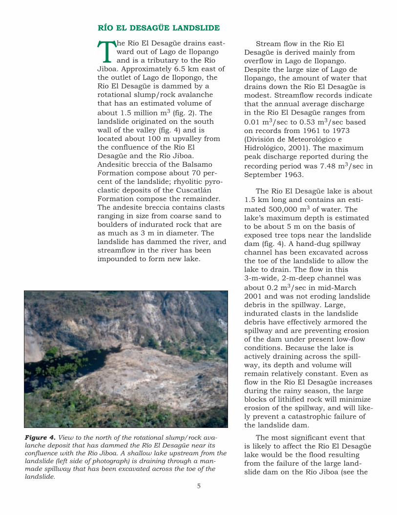
The Río El Desagüe drains east-ward out of Lago de Ilopangoand is a tributary to the Río
Jiboa. Approximately 6.5 km east ofthe outlet of Lago de Ilopongo, theRío El Desagüe is dammed by arotational slump/rock avalanchethat has an estimated volume ofabout 1.5 million m3 (fig. 2). Thelandslide originated on the southwall of the valley (fig. 4) and islocated about 100 m upvalley fromthe confluence of the Río ElDesagüe and the Río Jiboa.Andesitic breccia of the BalsamoFormation compose about 70 per-cent of the landslide; rhyolitic pyro-clastic deposits of the CuscatlánFormation compose the remainder.The andesite breccia contains clastsranging in size from coarse sand toboulders of indurated rock that areas much as 3 m in diameter. Thelandslide has dammed the river, andstreamflow in the river has beenimpounded to form new lake.
Stream flow in the Río ElDesagüe is derived mainly fromoverflow in Lago de Ilopango.Despite the large size of Lago deIlopango, the amount of water thatdrains down the Río El Desagüe ismodest. Streamflow records indicatethat the annual average dischargein the Río El Desagüe ranges from0.01 m3/sec to 0.53 m3/sec basedon records from 1961 to 1973(División de Meteorológico eHidrológico, 2001). The maximumpeak discharge reported during therecording period was 7.48 m3/sec inSeptember 1963.
The Río El Desagüe lake is about1.5 km long and contains an esti-mated 500,000 m3 of water. Thelake’s maximum depth is estimatedto be about 5 m on the basis ofexposed tree tops near the landslidedam (fig. 4). A hand-dug spillwaychannel has been excavated acrossthe toe of the landslide to allow thelake to drain. The flow in this 3-m-wide, 2-m-deep channel wasabout 0.2 m3/sec in mid-March2001 and was not eroding landslidedebris in the spillway. Large,indurated clasts in the landslidedebris have effectively armored thespillway and are preventing erosionof the dam under present low-flowconditions. Because the lake isactively draining across the spill-way, its depth and volume willremain relatively constant. Even asflow in the Río El Desagüe increasesduring the rainy season, the largeblocks of lithified rock will minimizeerosion of the spillway, and will like-ly prevent a catastrophic failure ofthe landslide dam.
The most significant event thatis likely to affect the Río El Desagüelake would be the flood resultingfrom the failure of the large land-slide dam on the Río Jiboa (see the
Figure 4. View to the north of the rotational slump/rock ava-lanche deposit that has dammed the Río El Desagüe near itsconfluence with the Rio Jiboa. A shallow lake upstream from thelandslide (left side of photograph) is draining through a man-made spillway that has been excavated across the toe of thelandslide.
RÍO EL DESAGÜE LANDSLIDE
5

following section for details). A floodcaused by failure of the Río Jiboalandslide dam would flow up the RíoEl Desagüe because of the T-shapedconfiguration of the Río El Desagüe-Río Jiboa confluence (fig. 2). Theflood would flow across the land-slide dam and could have sufficientpower to significantly erode thelandslide dam, which could releasethe water in the Río El Desagüelake. How-ever, the volume of water
in the Río El Desagüe lake is verysmall compared to the volume ofwater that could potentially bereleased by a catastrophic failure ofthe Río Jiboa landslide dam. Waterin the Río El Desagüe lake wouldmake a negligible contribution to aRío Jiboa flood, therefore no furthermitigation measures are needed forthe Río El Desagüe landslide damother than the current spillway.
RÍO JIBOA LANDSLIDE
Approximately 2 km upstreamfrom the confluence of the RíoEl Desagüe and Río Jiboa, a
block slide containing about 12 million m3 of material completelyblocks the Río Jiboa drainage (figs.2 and 5). The Río Jiboa landslidedam consists primarily of rhyolitictephra and pyroclastic debris of theCuscatlán Formation, and most ofthe landslide material is poorly com-pacted and extremely porous. Thelandslide dam is about 700 m long(parallel to the river drainage) andabout 250 m wide (across the val-
ley). A lake has formed on theupstream side of the dam; as ofMarch 15, 2001, the lake was about25 m deep, 400 m long, and was fill-ing at a rate of less than 0.1 m3/sec(<8600 m3/day).
If allowed to fill completely, thelake will have an estimated maxi-mum depth of 60 m, a length ofabout 2 km, and a volume of about7 million m3. Two possible breachpoints exist on the landslide dam(fig. 5); the northern breach pointhas an estimated elevation of about
South Breach Point
North Breach Point
Figure 5. View to the south-west showing the landslidedam on the Río Jiboa. Theimpounded lake behind thelandslide is visible on thelower left. Two possiblepoints are labeled where thereservoir may overtop thelandslide dam, if allowed tobreach naturally.
6
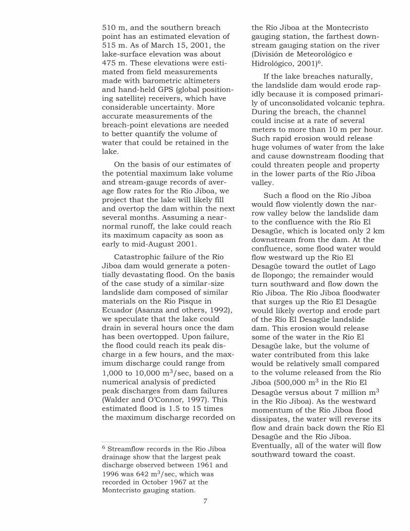
510 m, and the southern breachpoint has an estimated elevation of515 m. As of March 15, 2001, thelake-surface elevation was about475 m. These elevations were esti-mated from field measurementsmade with barometric altimetersand hand-held GPS (global position-ing satellite) receivers, which haveconsiderable uncertainty. Moreaccurate measurements of thebreach-point elevations are neededto better quantify the volume ofwater that could be retained in thelake.
On the basis of our estimates ofthe potential maximum lake volumeand stream-gauge records of aver-age flow rates for the Río Jiboa, weproject that the lake will likely filland overtop the dam within the nextseveral months. Assuming a near-normal runoff, the lake could reachits maximum capacity as soon asearly to mid-August 2001.
Catastrophic failure of the RíoJiboa dam would generate a poten-tially devastating flood. On the basisof the case study of a similar-sizelandslide dam composed of similarmaterials on the Río Pisque inEcuador (Asanza and others, 1992),we speculate that the lake coulddrain in several hours once the damhas been overtopped. Upon failure,the flood could reach its peak dis-charge in a few hours, and the max-imum discharge could range from1,000 to 10,000 m3/sec, based on anumerical analysis of predictedpeak discharges from dam failures(Walder and O’Connor, 1997). Thisestimated flood is 1.5 to 15 timesthe maximum discharge recorded on
the Río Jiboa at the Montecristogauging station, the farthest down-stream gauging station on the river(División de Meteorológico eHidrológico, 2001)6.
If the lake breaches naturally,the landslide dam would erode rap-idly because it is composed primari-ly of unconsolidated volcanic tephra.During the breach, the channelcould incise at a rate of severalmeters to more than 10 m per hour.Such rapid erosion would releasehuge volumes of water from the lakeand cause downstream flooding thatcould threaten people and propertyin the lower parts of the Río Jiboavalley.
Such a flood on the Río Jiboawould flow violently down the nar-row valley below the landslide damto the confluence with the Río ElDesagüe, which is located only 2 kmdownstream from the dam. At theconfluence, some flood water wouldflow westward up the Río ElDesagüe toward the outlet of Lagode Ilopongo; the remainder wouldturn southward and flow down theRío Jiboa. The Río Jiboa floodwaterthat surges up the Río El Desagüewould likely overtop and erode partof the Río El Desagüe landslidedam. This erosion would releasesome of the water in the Río ElDesagüe lake, but the volume ofwater contributed from this lakewould be relatively small comparedto the volume released from the RíoJiboa (500,000 m3 in the Río ElDesagüe versus about 7 million m3
in the Río Jiboa). As the westwardmomentum of the Río Jiboa flooddissipates, the water will reverse itsflow and drain back down the Río ElDesagüe and the Río Jiboa.Eventually, all of the water will flowsouthward toward the coast.
6 Streamflow records in the Rio Jiboadrainage show that the largest peakdischarge observed between 1961 and1996 was 642 m3/sec, which wasrecorded in October 1967 at theMontecristo gauging station.
7

The precise impact of a cata-strophic flood on the lowerreaches of the Río Jiboa are
difficult to accurately assess even ifa detailed flood-modeling study wasconducted. One-dimensional or two-dimensional hydraulic models,which require accurate cross-sectional surveys along the entirestudy reach, would be limited by theuncertainty in the timing and mag-nitude of the flood peak, and theunknown effects on the flood hydro-graph of the water that had flowedup the Río El Desagüe and thenback down the Río Jiboa.
Graphical records from three RíoJiboa gauging stations show thetravel time of natural flood peaksthrough the parts of the valleybelow the landslide dam. The peri-ods of record for these stations varybetween 1961 and 1996. The mostupstream gauge, Río Jiboa at SanRamon, was situated at the site ofthe Río Jiboa landslide, and themost downstream gauge, Río Jiboaat Montecristo, was situated about20 km downstream from the land-slide. The three flood peaks (all lessthan 200 m3/sec) that occurredduring the common period of opera-tion for these gauges (1972-80) trav-eled the 20 km from the landslidedam to the Montecristo gauge in 2-4 hours. Because this section ofthe Río Jiboa is incised into abedrock canyon, the hydrograph ofthe flood shows little attenuationbetween the San Ramon and theMontecristo gauges.
Directly downstream from theMontecristo gauging site, the RíoJiboa valley abruptly widens, and
the river flows onto the broadcoastal plain. In the confined, nar-row bedrock valley, a flood willretain much of its velocity, energy,and erosive power, but in the val-ley’s broad lower reaches, a floodwill spread across the coastal plain,dissipating its energy but inundat-ing large areas of the flood plain. Acatastrophic flood of 1,000 to10,000 m3/sec could inundate mostof the river’s flood plain and wouldtravel downstream faster than thesmaller, natural floods. Such a floodin the lower Río Jiboa valley maycause erosion and scour the abut-ments of the Highway CA-2 bridge,but it will probably pass beneaththis bridge. Such a flood may alsopartially inundate the eastern por-tion of the international airport atComalapa, part of which lies adja-cent to the Rio Jiboa floodplain, butthe potential inundation area is dif-ficult to determine in the low-reliefcoastal plain.
The inundation area of a flood isstrongly influenced by the topogra-phy of the terrain across which theflood flows. Present one-dimensionalhydraulic flood-routing models donot adequately forecast inundationareas on broad flood plains. Two-dimensional hydraulic flood modelsare better suited for such analyses,but they require finely detailed topo-graphic data to constrain the model-ing results. Such detailed topo-graphic data are not readily avail-able from present topographic mapsof the broad, low-relief floodplain ofthe lower Rio Jiboa, so developingthese two-dimensional models is notpossible at the present time.
Effects of Flooding Downstream
8
As stated previously, a naturalbreach from the Río Jiboalandslide dam could quickly
release nearly 7 million m3 of water.A flood generated by such a waterrelease will flow violently throughthe narrow bedrock portions of thevalley at high velocity, allowing littletime to warn and evacuate down-stream inhabitants. Downvalley inthe broader floodplain, the effects ofthe flood are more difficult to esti-mate, but it will likely have detri-mental effects. To minimize theimpact of this flooding, a spillwaycould be excavated through thelandslide debris that would reducethe volume in the impounded lakeand reduce the size and effects ofthe potential flood. A spillway mayalso provide better control on thetiming of the water release.
Our field investigations indicatetwo logical breach points, one alongthe northern margin and one alongthe southern margin of the landslide(fig. 5). The south breach point islocated directly below the headscarpof the landslide, and the northbreach point is at the north edge ofthe landslide mass where it reachesthe roadway between San Ramonand Verapaz. Of these two points,the north point is the most advanta-geous site to excavate a spillway forseveral reasons:
• The north breach point coincideswith an existing roadway, provid-ing relatively easy access for heavyequipment to construct a spillway.
• A spillway on the northern siderequires less excavation. A spill-way on the north would need to beapproximately 50-60 m long ver-sus about 700 m long on thesouth side.
• The northern margin is a saferwork site for excavation. Thesouth margin is directly beneath
the steep (about 70°), 200-m-highheadscarp of the landslide whererock falls are occurring continu-ously. Rockfall from this escarp-ment would be a constant hazardto workers. No such hazard existsat the northern margin.
• At the northern margin, there areactually two breach points, anupstream (eastern) point adjacentto the roadway and a second,downstream point several hundredmeters to the west. When the lakeovertops the upstream breachpoint, the flood waters will initiallyflow into and inundate a large trib-utary valley (Quebrada Seca) of theRío Jiboa, but the downstreambreach point will prevent thesewaters from immediately flowingdown the main Río Jiboa. Thistributary valley will likely fillquickly (perhaps hours to days),but by monitoring this filling, itwill be possible to better gaugewhen the water will cause failureof the downstream breach pointand, therefore, when flood waterswill flow down the main Río Jiboachannel.
A spillway excavated across thelandslide should be as deep as pos-sible given the constraints on timebefore the lake fills, and the avail-able equipment and resources. Thedeeper the spillway, the less waterwill be impounded in the lake. Foreach meter in depth of the spillway,the amount of water in the lake willbe reduced by many tens of thou-sands of cubic meters or more.
As the lake level approaches thespillway elevation, all residents inthe downstream parts of the RíoJiboa and Río El Desagüe drainagesshould warned and evacuated inadvance of a flood. If possible, aneffort should be made to stimulatethe breach during daylight hours to
Possible Mitigation Options
9

help cope with unforeseen situa-tions and emergencies and toassure that the peak flood is com-pleted before dark. This may be pos-sible given the experience from pastcase studies in similar situations(Asanza and others, 1992). Finally,the landslide dam should be moni-tored regularly throughout the rainyseason to constantly assess any sig-nificant changes in the dam’s stabil-ity.
The preceding discussion focuseson possible mitigation measuresrelated to failure of the dam byovertopping. A more difficult prob-lem is to determine the possibility ofa dam failure induced by piping, in
which water from the lake perco-lates through the dam, causes cav-ing and the formation of conduits inthe dam through which the lakewater can drain. As the depth of thereservoir increases, the potential forpiping increases because theimpounded water exerts increasingpressure on the dam. Thus as thereservoir fills, the dam should bechecked regularly for evidence ofsignificant seepage. If seepage devel-ops, then it should be routinelymonitored for changes in the rate ofseeping water, which could be evi-dence of increasing piping anddecreasing stability of the dam.
Landslides triggered by the Mw
6.5 earthquake occurred inseveral deeply incised gullies
on the northern flank of Volcán SanVicente. On the volcano’s north-western flank, a large rock slideoccurred in the upper part of theQuebrada Del Muerto drainage(fig. 2). To the east and lower on thevolcano’s slopes, extensive failuresoccurred along steep valley walls ofthree gullies that are deeply incisedinto coarse unconsolidated deposits.
These valley-wall failures coalescedinto debris slides that filled channelbottoms with loose deposits. Ourfield investigations in this areafocused on the hazard posed byremobilizing this loose debris asdebris flows during the rainy season.Of these three eastern gullies, themost likely to pose a hazard is theQuebrada El Blanco because thetown of Tepetitán is located on thealluvial fan of this drainage.
VOLCÁN SAN VICENTE LANDSLIDES
The Quebrada Del Muerto rockslide has an estimated volumeof about 200,000 m3 and is
composed mainly of large blocks oflithified andesite. The landslide islocated high on the northwest flankof Volcán San Vicente at the head ofQuebrada Del Muerto. The channelof Quebrada Del Muerto is locateddirectly east of the village of
Guadalupe, and because thisdrainage is so close to the village,there is concern that the rock slidemight remobilize as debris flows andendanger the village.
Debris within the rock slideranges in size from sand to largeboulders (fig. 6), but the landslidedebris is dominantly large boulders,some as much as several meters in
Quebrada Del Muerto Rock Slide
10

diameter. Owing to the large size and indurated charac-ter of the rock fragments, it is unlikely that this land-slide debris will be remobilized by rainfall into debrisflows that will threaten downstream settlements or struc-tures. Some of the finer-grained debris (sand and gravelfraction) could be transported downstream, but most ofthe rainfall and surface-water runoff will infiltrate thelandslide debris and cut small runoff channels acrossthe surface. Little of this coarse debris will be mobilizedby flowing water. Therefore, it is unlikely that the town ofGuadalupe will be seriously threatened by debris flowsremobilized from this slide material unless a new largefailure is triggered from the same source area by abnor-mally heavy rainfall.
Lower, on the northern slope ofVolcán San Vicente, numerouscoalescing debris slides were
triggered by the earthquake alongthe 40- to 50-m-deep incised gullyof the Quebrada El Blanco.Unconsolidated pyroclastic anddebris-flow deposits in the steep valley walls failed during the earth-quake and produced numerousdebris slides that are typically 1-3 mthick and have a cumulative volumeof approximately 250,000 m3 (fig. 7).
Debris from these landslides hasclogged the channel bottom withsandy and silty sediment that mayremobilize as debris flows during therainy season. Large flows triggeredin Quebrada El Blanco may extenddown to the broad, shallow slopes ofthe quebrada’s alluvial fan. The
11
Figure 6. View toward the source of the Quebrada Del Muertorock slide on the northwest flank of Volcán San Vicente. Therockslide is composed mainly of well-indurated andesite, whichhas broken into boulder-sized debris. The composition and sizeof fragments in the landslide debris make it unlikely that thematerial will be remobilized as debris flows during the upcom-ing rainy season.
Quebrada El Blanco Debris Slides
small town of Tepetitán is locatedon part of this alluvial fan. About1 km upslope from Tepetitán,drainage in Quebrada El Blanco isconfined to a channel that is incisedseveral meters into older alluvialdeposits. However, closer to thetown, the drainage emerges onto abroad open slope that is cut byshallow channels less than 2 mdeep. This broad open slope is thedepositional surface of previousdebris flows, and the active chan-nels of the fan have routed flowsnear and toward Tepetitán in therecent past. The last debris flowthat reached the town occurred in1934, caused several fatalities, andburied parts of the old village inabout 60 cm of sediment. After the1934 event, most of the town wasrelocated to a higher, safer site, but

away from the town, or northeast-ward toward the town. The channelscould also remain open and guidethe flows toward the town. Prelim-inary debris-flow simulation models(J.J. Major, U.S. Geological Survey,unpublished data) suggest thatdebris flows having volumes inexcess of 100,000 m3 that remain inthe shallow channels could poten-tially reach the town.
over the years, the original site hasbeen resettled.
The shallow nature of the chan-nels and the flat character of thetopography near Tepetitán make itdifficult to determine the precisedirection that debris flows will takeif they occur and emerge from themore deeply incised channelupstream. Shallow channels nearTepetitán could get clogged withdebris and divert flows westward,
12
Figure 7. View to the northwest down the upper reaches of Quebrada El Blanco channel showing coalescingdebris slides from the valley walls. The channel bottom is clogged with landslide debris, and rainfall runoffmay trigger debris flows in these sandy, silty deposits.

The most effective mitigationmeasure for debris-flow haz-ards in the town of Tepetitán
is to construct a sediment checkdam or diversion levee(s), which willredirect small- to moderate-volumeflows. Such structures are usedsuccessfully in debris-flow proneareas of the U.S., such as Cali-fornia, where the sediment basinsare designed to collect the maxi-mum volume of sediment expectedfrom a specific drainage. As thesebasins are filled, the accumulateddebris is removed to assure that thebasin can retain future flows. Suchbasins must be designed to allow
13
water from the flows to pass whileretaining the captured sediment.
Diversion levees are also effectivedevices to mitigate debris-flow haz-ards by diverting flows around andaway from inhabited sites and man-made structures. Such levees arefeasible where ample space is avail-able to deposit the rerouted debrisand where no people or property areat risk in the depositional areas. Ifeither of the above mitigationoptions is considered, thenhydraulic engineers should beengaged to design effective sedimentcatch basins or diversion levees.
Recommendations for Mitigation
stable, elevated site above the youngalluvial fan. The school’s sturdyconstruction allowed it to endurethe strong shaking, and it’s locationabove the young alluvial fan avoideddamage from liquefaction and later-al spreading.
The February 13 earthquakecaused hundreds of small landslidesthroughout the Quebrada ElChaguite drainage basin. Many val-leys in the drainage basin are filledwith loose tephra that will impederunoff during the rainy season andthat could locally form small land-slide-dammed lakes. Catastrophicbreaching of these lakes couldquickly release water that couldproduce small to moderate floods inSan Agustín. Furthermore, the mas-sive quantities of easily erodedtephra in the valleys will be readilytransported downvalley and willlikely cause significant changes inthe hydrodynamics of the Quebrada
The village of San Agustín islocated on the northeasternshore of Lago de Ilopango,
approximately 5.5 km southeast ofSan Martín (fig. 2). The village is sit-uated on the active alluvial fan ofQuebrada El Chaguite. TheQuebrada El Chaguite drains anapproximately 10 km2 area ofdeeply dissected terrain between theSan Agustín and the northern edgeof the Lago de Ilopango caldera rim(fig. 8). During the February 13earthquake, many homes in the vil-lage were severely damaged ordestroyed by strong shaking and/orliquefaction and lateral spreadingcaused by the earthquake. The liq-uefaction and lateral spreads locallyformed fissures and small scarps inthe parts of the village adjacent tothe lake shore. The recently con-structed school in San Agustín suf-fered virtually no damage because ofthe quality of the construction andbecause it is located on a relatively
SAN AGUSTÍN DELTA AND EL CHAGUITE DRAINAGE BASIN

14
divert the flow of water across thealluvial fan, and possibly flood partsof San Agustín (fig. 8).
Two effects of the February 13earthquake caused widespreaddamage in San Agustín: earth-
quake-induced strong shaking, andground failures caused by liquefac-tion and lateral spreading. Damagefrom strong shaking had the great-est impact on poorly constructedbuildings, particularly those builtwith adobe bricks. Liquefactioncaused damage where the groundsurface beneath buildings spreadlaterally.
Liquefaction and lateral spread-ing are common phenomena thatoccur during strong earthquakes.They usually occur in young, water-saturated sediment; much of San
El Chaguite. The abnormally largequantity of sediment being carriedby the quebrada could clog the cur-rent stream channel with sediment,
Figure 8. View tothe north of theQuebrada ElChaguite drainagebasin and the vil-lage of San Agustín(in left foreground).The February 13earthquake causedextensive damagein the village andwidespread land-slides throughoutthe drainage basin.The village of SanAgustín is locatedadjacent to theactive channel ofthe young alluvialfan of the quebra-da.
Direct Effects of the Earthquake in San Agustín
Agustín is built on deposits thathave these characteristics. Duringthe strong, sustained shaking asso-ciated with damaging earthquakes,water in the pores between the sedi-ment grains is pressurized as theseismic waves travel through thedeposits. The pressurized waterreduces the strength of the sedi-ment by pushing the sedimentgrains apart. As a result, the sedi-ment can temporarily behave morelike a fluid than a solid. In thisfluid-like state, the sediment canflow laterally down very gentleslopes (gradients of only a fewdegrees) to form lateral-spreadinglandslides. At the upper end of lat-eral-spreading landslides, scarps
15
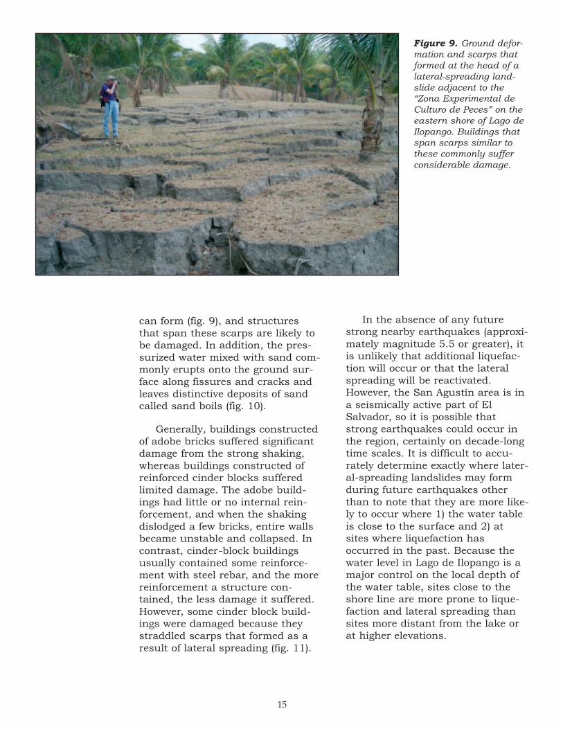
can form (fig. 9), and structuresthat span these scarps are likely tobe damaged. In addition, the pres-surized water mixed with sand com-monly erupts onto the ground sur-face along fissures and cracks andleaves distinctive deposits of sandcalled sand boils (fig. 10).
Generally, buildings constructedof adobe bricks suffered significantdamage from the strong shaking,whereas buildings constructed ofreinforced cinder blocks sufferedlimited damage. The adobe build-ings had little or no internal rein-forcement, and when the shakingdislodged a few bricks, entire wallsbecame unstable and collapsed. Incontrast, cinder-block buildingsusually contained some reinforce-ment with steel rebar, and the morereinforcement a structure con-tained, the less damage it suffered.However, some cinder block build-ings were damaged because theystraddled scarps that formed as aresult of lateral spreading (fig. 11).
In the absence of any futurestrong nearby earthquakes (approxi-mately magnitude 5.5 or greater), itis unlikely that additional liquefac-tion will occur or that the lateralspreading will be reactivated.However, the San Agustín area is ina seismically active part of ElSalvador, so it is possible thatstrong earthquakes could occur inthe region, certainly on decade-longtime scales. It is difficult to accu-rately determine exactly where later-al-spreading landslides may formduring future earthquakes otherthan to note that they are more like-ly to occur where 1) the water tableis close to the surface and 2) atsites where liquefaction hasoccurred in the past. Because thewater level in Lago de Ilopango is amajor control on the local depth ofthe water table, sites close to theshore line are more prone to lique-faction and lateral spreading thansites more distant from the lake orat higher elevations.
Figure 9. Ground defor-mation and scarps thatformed at the head of alateral-spreading land-slide adjacent to the“Zona Experimental deCulturo de Peces” on theeastern shore of Lago deIlopango. Buildings thatspan scarps similar tothese commonly sufferconsiderable damage.

16
Figure 10. Liquefied sand thatflowed to the surface throughcracks and fissures during theFebruary 13 earthquake in SanAgustín. These sand boils formedon the village’s soccer field.
The Quebrada El Chaguite drainage basin, whichincludes the tributary drainages of the Quebrada ElCamalote and the Quebrada Guluchapa, contains
deposits of poorly consolidated Tierra Blanca tephra thatare locally tens of meters thick (fig. 12). The February 13earthquake caused hundreds of landslides in thedrainage basin. Many steep canyon walls collapsed andfilled the adjacent valleys with large amounts of loose,soft debris (fig. 12).
The coming rainy season will mobilize a great deal ofthe sediment in the drainages above San Agustín, andthis mobilized sediment could threaten the village asdebris flows and hyperconcentrated flows (sediment-richfloods). In the narrow valleys, much of the sediment willremain entrained in the flows, but when the flows reachthe alluvial fan, their capacity to transport sediment willbe reduced. As a result, sediment will be deposited inthe active channel (fig. 8) and on the floodplain on thealluvial fan. As this sediment load is deposited, the cur-rent channel may become filled with sediment, and thestream may divert into an new channel. This diversioncould direct the flow into San Agustín and cause wide-spread flooding and destruction.
Figure 11. Damage to a home in SanAgustín from lateral spreading beneaththe structure. Further movement proba-bly not occur again unless the sedimentis severely shaken by another strongearthquake.
Potential Flood Hazards following the Earthquake
17
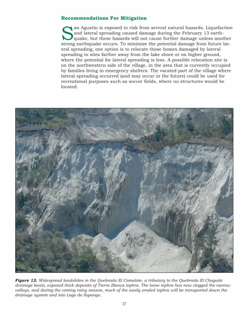
Figure 12. Widespread landslides in the Quebrada El Camalote, a tributary to the Quebrada El Chaguitedrainage basin, exposed thick deposits of Tierra Blanca tephra. The loose tephra has now clogged the narrowvalleys, and during the coming rainy season, much of the easily eroded tephra will be transported down thedrainage system and into Lago de Ilopango.
San Agustín is exposed to risk from several natural hazards. Liquefactionand lateral spreading caused damage during the February 13 earth-quake, but these hazards will not cause further damage unless another
strong earthquake occurs. To minimize the potential damage from future lat-eral spreading, one option is to relocate those homes damaged by lateralspreading to sites farther away from the lake shore or on higher ground,where the potential for lateral spreading is less. A possible relocation site ison the northwestern side of the village, in the area that is currently occupiedby families living in emergency shelters. The vacated part of the village wherelateral spreading occurred (and may occur in the future) could be used forrecreational purposes such as soccer fields, where no structures would belocated.
Recommendations For Mitigation

18
Figure 13. View toward the north of San Agustín and the adjacent stream coursewhere large sediment influxes in the rainy season may cause the stream to changecourse and flow toward the village. A proposed diversion levee would direct the flow tothe east into an ancient stream channel. This diversion would likely damage a road toa nearby finca (coffee plantation), but would reduce the potential of flooding in the village.
RoadRoadDiversion levee
Diversion levee
San AgustinSan Agustin
Flooding during the coming rainyseason poses a more imminentthreat to San Agustín and couldoriginate in two ways. First, smalllakes could form in the sediment-clogged valleys of the Quebrada ElChaguite and tributary drainagebasins, and breaching of these lakescould send the impounded waterrushing down the valley. Becausethe valleys in the upper reaches ofthe drainage basins are so narrow,the volume of water likely to bereleased in these breaching eventswould probably be relatively smalland probably would not cause sub-stantial flooding. The more signifi-cant flood hazard is associated withexcessive sedimentation in the cur-rent stream channel and diversionof the stream flow into a new chan-
nel. If a new channel directed flowinto the town, flood damage couldbe extensive. To prevent this possi-bility, we recommend that a diver-sion levee be constructed in theactive channel immediately upvalleyfrom San Agustín. This levee shouldbe designed to redirect stream flowto the east, away from the village,and into an abandoned channel onthe eastern side of the alluvial fan(fig. 13). The presence of a preexist-ing channel greatly simplifies thediversion process. Streamflowdiverted into this abandoned chan-nel will pass directly into Lago deIlopango. Flow down this aban-doned channel will damage a smallroad that leads to a nearby finca,but construction of a diversion leveewill reduce the flood hazard in thevillage of San Agustín.

19
The February 13, 2001, earth-quake in central El Salvadortriggered thousands of land-
slides in the area between Lago deIlopango and the city of SanVicente. In much of this area,strong ground shaking causedextensive failures on steep walls ofdeeply incised valleys. The areamost heavily affected by landslidesis underlain by thick deposits ofunconsolidated late Pleistocene- andHolocene-age volcanic tephraemplaced during eruptions ofIlopango caldera.
Large landslides blocked twomajor rivers in the area: the Río ElDesagüe and the Río Jiboa. The RíoEl Desagüe landslide has impound-ed a modest-size lake (about500,000 m3), whereas the lakepotentially impounded by the RíoJiboa landslide could contain about7 million m3 of water. Water fromthe Río El Desagüe lake is currentlyflowing over its landslide damthrough a small, man-made spill-way. The Río El Desagüe landslideconsists largely of blocks of indurat-ed andesitic breccia that armorschannels incised into the landslide.These blocks retard the rapidrelease of large amounts of waterfrom the lake. All of the runoff fromthe upper Río Jiboa watershed isfilling the landslide-dammed lake,which as of March 2001, containedonly slightly more than 5 percent ofits maximum potential volume. TheRío Jiboa landslide consists mostlyof easily eroded volcanic tephra andis susceptible to a catastrophic fail-ure when overtopped by water fromthe lake. The resulting flood, whichwould likely occur within the nextseveral months (in the absence ofintervention measures), would flowviolently down the narrow bedrockvalley that extends about 20 kmbelow the dam. Farther down-
SUMMARY AND CONCLUSIONS
stream, the flood would inundatelarge areas of the broad coastalplain and may potentially flood partof the international airport.
Several large failures occurredon the northern slopes of VolcánSan Vicente. A large rock slideoccurred in the upper part ofQuebrada Del Muerto, above thetown of Guadalupe. The rock slideis composed mainly of 1-3 m diame-ter blocks of lithified andesite. Fieldstudies indicate that this landslidedebris in not likely to be remobi-lized, and therefore does not pose aserious hazard to the town. On thenorth-northeastern side of the vol-cano, the Quebrada El Blanco haseroded a deeply incised gully intopyroclastic and debris-flow deposits.Many parts of the steep valley wallsfailed during the earthquake andfilled the adjacent channel withloose debris. This debris will likelybe reworked during the rainy sea-son. If it is remobilized as debrisflows and the flows are of sufficientsize, then they could threaten partsof the small town of Tepetitán,which is located on the alluvial fanof the Quebrada El Blanco.
At several sites along the shoresof Lago de Ilopango, the earthquakecaused liquefaction and lateral-spreading landslides that locallydamages structures, includingmany buildings in the village of SanAgustín.
San Agustín is also exposed to asignificant flooding hazard becauseof its location on the alluvial fan ofQuebrada El Chaguite drainagebasin. Extensive landslidesoccurred in the upper reaches ofthis and tributary drainage basins,and large volumes of loose, easilyeroded sediment are available fortransport during the rainy season.Redistribution of this sediment on
20
REFERENCES CITED
Asanza, M., Plaza-Nieto, G., Yepes,H., Schuster, R.L., andRibadeneira, S., 1992, Landslideblockage of the Pisque River,northern Ecuador, in Bell, D.H.,ed., Landslides, Glissements deterrain, Proceedings of the sixthinternational symposium,Christchurch, New Zealand, 10-14February, 1992: A.A. Balkema,Rotterdam, p. 1229-1234.
División de Meteorológico eHidrológico, 2001, Dirección gen-eral de recursos naturales renov-ables—Anuario Hidrológico 1961-1996 [written communication]:Ministerio de Agricultura yGanadería, El Salvador, C.A.
Walder, J.S. and O’Connor, J.E.,1997, Methods for predicting peakdischarge of floods caused by fail-ure of natural and constructedearthen dams: Water ResourcesResearch, v. 33, p. 2337-2348.
the alluvial fan could divert thestream into a new channel. If thisdiversion directs flow into the vil-lage, then flooding in San Agustínwould cause widespread damageand impose additional hardships onthe citizens.
The February 13 earthquake wasthe second disastrous earthquake tostrike the small country of ElSalvador in one month. Althoughthe effects of this earthquake wererestricted to a relatively small area,the impact of the effects were devas-tating to a country that was alreadytrying to recover from a previousmajor earthquake. Abundant land-
slides triggered by the February 13earthquake filled many drainagechannels with easily transportedlandslide debris that will bereworked and redistributed duringthe next rainy season, which willstart about May 2001. Debris flowsand potentially catastrophic floodspose serious threats that couldcause additional damage and loss oflife if not recognized in advance.However, with advanced awarenessand with the implementation ofappropriate mitigation measures,the effects of debris flows and floodscan be anticipated, and the lossescan be reduced and minimized.


