Embed Size (px)
Citation preview

BERKHAMSTED AND DISTRICT ARCHAEOLOGICAL SOCIETY
ASHRIDGE COLLEGE
INTERIM REPORT 7
Compiled by Vickie Bristow, Graham Juniper & Ken Wallis
February 2015

1
INTERIM REPORT 7
Report on Excavations August & September 2014
Ashridge College
INTRODUCTION
This is the seventh Interim report describing work carried out between the 19th July and the 22nd
August 2014 in grid 14. Because of constraints imposed by personal and the Collegerequirements only fourteen days were actually available for excavation over this period. Thetrenches opened were designed to answer specific questions that had arisen as a result of workundertaken during 2013.
Following the resistivity survey carried out in June 2010 a number of features were highlightedsome of which have been investigated by excavation. Previous reports, BDAS Interim Reportsnumbered 1 to 6, have described what was found following each excavation season and have beenused to plan and interpret successive excavations. During 2012 a linear flint wall was foundaligned roughly north-south. This wall was followed in 2013 and indications of walls in aneasterly direction were found. Due to time restraints these were not investigated but there was astrong possibility of one or more rooms aligned along the eastern side of the north-south wall.Figure 1 shows the position of trenches opened in 2013.
FIGURE 1

2
SECTION 1
Key Objectives
It was decided that for the 2014 excavation season areas adjacent to the 2013 excavations in grid14 would be investigated. In 2013 trench 14A was not able to find a floored surface either side ofthe north-south wall although it did expose a drain, both of which indicated that the area wasoutside rather that within a building. Trench 14C uncovered a large recess in the north-south walland showed that there was a mortared surface with a clear edge and another surface at a slightlylower level to the east of the wall. On the west side of the north-south wall was a large brick builtbuttress. Trench 14B followed the north-south wall with another buttress on the west side.However there were indications that the wall in this trench was slightly different to that in theother trenches, which might indicate some redevelopment of the site.
For the 2014 excavations three trenches were planned each one to continue to investigate thenorth-south wall but each with a specific question relating to the 2013 excavations. The resistivityplots showed that there were possible features within the areas selected for the new trenches.Trench 14D would investigate the possibility of a flint wall abutting the north-south wall andprogressing in an easterly direction. Trench 14E positioned between trenches 14C and 14B wouldinvestigate whether there was a widening of the north-south wall or a possible easterly wallabutting it. Trench 14F was planned to investigate a possible break or confirm the continuity ofthe north-south wall. The position of the planned three trenches are labelled 14D, 14E and 14Fand are shown in figure 2.
FIGURE 2

3
Following the initial excavation of the sectors shown in figure 2 above, further adjoining sectorswere excavated to try to elucidate the significance of the findings.
FIGURE 3
The extensions to each of trenches 14D, 14E and 14F are shown above in figure 3. Trench 14Dwas extended by one further square metre into sector G9. Trench 14E opened a 1 metre strip fromthe bottom of the 2013 trench 14C to the top of trench 14B following the line of the north-southwall, plus sectors E13 to E19 and additionally F13 and F14. Trench 14F was extended to try tounderstand the features that were found in the initial excavated areas. Sectors E25, F25, F26, andF27 were the additional sectors excavated.
Each of the trenches 14D, 14E and 14F is described in the following sections by the supervisor incharge of that trench. To make it easier for the reader to get an overview of the excavations eachtrench has been photographed as near vertical as possible and the resulting photographsamalgamated as a photo-mosaic.

4
SECTION 2
GRID 14 TRENCH 14D
In 2013 a small portion of a flint wall abutted on the east side of the north-south wall wasuncovered but its extent was not investigated. This can be seen in the lower right hand side offigure 1. The resistivity plot indicated that the wall continued for possibly a further 2 metres. Atrench of dimensions 2 x 2 metres was placed over this feature with sectors designated E8, F8, E9and F9 in line with the sector naming convention adopted in 2013. But this was extended by afurther 25 cm into the corresponding sectors alongside to the west, which had been excavated in2013 these were designated D8 & D9. The pieces of Tottenhoe which had been uncovered in2013 and seen covered by the white board in the photograph acted as a guide see figure 1.
FIGURE 1
Figure 2 shows the dimensions and the identification numbering used in trench 14D.
After removing the turf and approximately 10 centimetres of dark soil the top of the flint wallbegan to appear. The uppermost flints were loose but a section of flint wall soon becameapparent. On either side of the wall building debris was encountered and in sectors E8 and F8there were a number of large worked lumps of Tottenhoe. However although considerable carewas taken to remove these lumps whole, they disintegrated as soon as the surrounding debris wasremoved. It was expected that these Tottenhoe lumps might have had carved surfaces. Sectors E9and F9 also followed the west-east wall but the debris along this side was particularly wellcompressed and difficult to remove. There were significant differences between the north andsouth sides of the west-east flint wall.

5
FIGURE 2
Sector E8
After removing the turf and a small amount of dark soil building debris was encountered. Thisconsisted mainly of broken roof tile concentrated to the eastern side of the sector, with pieces ofTottenhoe and red brick towards the western side. As this was removed larger pieces of Tottenhoewere found and a west-east flint wall along the southern edge of the sector was uncovered. It wasthought that the pieces of Tottenhoe may have been shaped, and particular care was taken to cleanaround each piece but they broke into numerous smaller pieces as the surrounding material wasremoved figure 3. However on inspection none of the pieces was found to have any decoration ontheir surfaces although the faces had been shaped into blocks. The sector was excavated downfollowing the northern edge of the west-east wall. Dark soil was removed from between thesurface flints of the wall which were bonded with a yellow-orange mortar, but there was noevidence of plaster on this side of the wall. A layer of thick brown clay was found at a depth of54cm. Some of the building debris was hard against the flint wall and this was not removed seefigures 4 and 5.
Sector F8
After removing the turf and a small amount of dark soil, building debris similar to that in SectorE8 was encountered. The line of the west-east wall continued into this sector but ended abruptlyapproximately 20cm before the eastern extremity of the sector was reached. The building debriscontained a large quantity of yellow-orange mortar. The sector was taken down to 50cm with asmall section alongside the west-east wall down to a maximum depth of 70cm when a layer ofclay was reached. A piece of Tottenhoe was set into the north-eastern corner of the flint wall butdid not have a recognisable shape see figure 6. One large piece of Tottenhoe with a shaped recessrunning along the long edge was found in this sector at a depth of about 29cm see figure 7.

6
FIGURE 3
Figure 3 shows the large pieces of Tottenhoe in sector E8 before trying to remove them.
FIGURE 4
Figure 4 shows a vertical view of sector E8 viewed southwards. The north-south wall is on theright hand side of the photograph.

7
FIGURE 5
Figure 5 shows the face of the flint wall in sector E8 viewed southwards. The north-south wall ison the right hand side of the photograph.
FIGURE 6
Figure 6 shows a vertical view of sector F8 viewed southwards, showing the piece of Tottenhoenext to the vertical scale.

8
FIGURE 7
Figure 7 shows the shaped and carved piece of Tottenhoe.
The drawing shows the suggested position of the piece of shaped and carved Tottenhoe. From thesingle piece found it could not be determined what shape the arch was, but the size of the piecewould suggest that it was from a door rather than from a window. As the other blocks ofTottenhoe found in sector E8 did not have any carving on them it is unlikely that they came fromthe same object. Rather they would more likely have been from a plain wall.
Tottenhoe

9
Sector E9
After removing the turf and a small amount of dark soil, building debris comprising of a hardyellow-cream mortar, chalk and loose flints was encountered. A quantity of loose, smallish piecesof Tottenhoe was found, roughly aligned along the southern edge of the sector. The debris in thissector was particularly firmly compacted. The wall aligned at a slight angle towards the norththroughout the sectors. A thick layer of white plaster up to 2cm thick was found along thesouthern face of the west-east flint wall, the upper portion of which was badly broken. Thewestern edge of the sector towards the north-south flint wall was excavated down toapproximately 32cm when a chalk layer was found. Due to time constraints this sector was notfully excavated over the whole area. Figure 8 shows the sector partly excavated.
FIGURE 8
Sector F9
Immediately underneath the turf and a small amount of dark soil building debris similar to that insector E9 was encountered. Again this was particularly firmly compacted and difficult to remove.The thick layer of white plaster that was found on the flint wall in sector F8 continued along thesouthern face of the flint wall in this sector. A quantity of plaster was found deposited within thebuilding debris as it was excavated see figure 9. Some of this plaster when it became visible wasfound to have a red colouration on parts of the pieces see figure 10.

10
FIGURE 9
Figure 9 shows sector F9 with the west-east wall at the top of the photograph and the partexcavated section below. The layer of white plaster adhering to the flint wall can also be seenalong the line of the wall. The arrows indicate where the pieces of plaster were deposited.
FIGURE 10
Figure 10 shows a close-up of some of the plaster, showing that there were red markings on someof the pieces.

11
FIGURE 11
Figure 11 shows the whole of the four sectors partly excavated.
The resistivity print out indicated that the west-east wall continued in an easterly direction.However, there was a slightly lighter area adjacent to sector F9 which may be due to the wallbeing at a lower level or a possible break due to a doorway. It was decided to excavate a furtherone metre square alongside sector F9 to investigate whether the wall did in fact continue in thatdirection. This was identified as sector G9.
FIGURE 12
Figure 12 shows the extension on trench 14D.
Trench 14D
D8
D9
E8
E9
F8
F9
25cm 1 m 1 m
N
G9
1 m
1 m
1 m

12
The excavated material from sector G9 was similar to that in sector F9. Some loose flints werefound with part of a brick but none of this material was bonded together. A considerable numberof tree roots were encountered. The majority of these were very brittle and were easily brokenwhich indicated that they were from a dead plant. However there were also several moresubstantial roots which were left in situ as they probably emulated from the yew trees which werein close proximity. There was no sign of the wall continuing into this sector. The sector was takendown to 27/28cm on the western side and to a depth of 24cm on the eastern side. Although theresistivity indicated that there may be a break within this sector there was a stronger signal in thenext sector H9. The presence of dead tree roots may indicate that if a tree had been a tree plantedhere it had been removed some time ago leaving just a mass of building debris. As there wasinsufficient time left to excavate the existing sectors it was felt that no further sectors should beopened. Figure 13 shows this sector partly excavated.
FIGURE 13
Sector E13 was excavated in May and June 2013 when an undulating chalk layer was found, butwhich seemed to peter out in the south east corner of the sector. As the chalk was unevenlydistributed and of varying thicknesses its purpose was not established. When sector E9 wasexcavated this year a small area at the south eastern corner was excavated down to approximately32cm when a layer of chalk was seen. As sector E13 had been excavated down to 25 – 30cm itwas felt appropriate to re-excavate this sector to confirm that the levels of chalk in sectors E13and E9 was in fact similar. As the layer of chalk in sector E13 was un-even and some of the chalkhad been removed at some stage, it was not possible to confirm that the levels were exactly thesame but there appeared to be a reasonable correlation between the two levels to indicate that theywere both parts of the same surface. Figure 14 shows sector E13 re-excavated in 2014.

13
FIGURE 14
FIGURE 15
Figure 15 A Photo-mosaic composite of Trench 14D made from corrected near vertical 1m squaresector photos. Due to parallax differences it was not possible to completely align the individualphotos.
E8
F8
E9
F9
G9

14
Summary of trench 14D
This trench was opened to expose a wall that abutted the north-south wall. From the resistivity itwas possible that the easterly wall would extend for several metres. Although the wall was whereit was expected however when excavated this wall extended for less that two metres from thenorth-south wall. A large piece of Tottenhoe, which appeared to be from a door or window frame,was found within the trench see figure 7. Lumps of white plaster some with red colouration wasalso found in the trench see figure 10. This may indicate something of high status with paintedplaster walls and a floor laid on a chalk foundation.
SECTION 3
Grid 14 TRENCH 14E
(Phase 1)
The reason for the excavation of this trench has been briefly outlined in the introduction. In theexcavations of 2012 a flint wall was discovered running north-south. There was some furtherexploration of this feature in the 2013 excavations as described in BDAS Interim Report 6, 2013.The time restraints in the 2013 excavation had not allowed for a thorough exploration of this walland the report recommended further investigation. It was decided that the 2014 season wouldconcentrate primarily on understanding this feature. With this objective as the overall goal, trenchG14E was planned with the intention of filling in the gap between trenches 14B and 14C (whichwere dug in 2013) in order to discover if the wall changed width, material or had any other wallsabutting it. The lack of walls in an east to west direction had limited the understanding of thisfeature and it was intended that further investigation was necessary.
FIGURE 1

15
The trench was positioned over Sectors C17 - E17 and C18 - E18 in line with the sector namingconvention adopted in 2013. This would give a trench of 2 metres (north to south) by 3 metres(east to west), which would cross the north-south wall and expose the area of high resistance insector 18E. This would show if this was a different wall, a corner or a widening of the originalnorth-south wall.
Sector C17
The topsoil was removed to a depth of 8cm all over this metre square. Under this there was alayer of compacted rubble similar to all previous trenches in this area. It was then divided intotwo halves, one to the east and one to the west. The western half was ignored as it was outside thearea of this investigation. The eastern half was excavated through the rubble layer down to adepth of 60cm. The rubble consisted of a mixture of large flints, chalk and lumps of Tottenhoestone. Flint made up a large percentage of this layer. See Figure 2.
FIGURE 2
NSector C18
This sector was nearly identical to sector C17. The details are as follows: the topsoil was removedto a depth of 9cm all over this metre square. Under this there was a layer of compacted rubblesimilar to all previous trenches in this area. It was then divided into two halves, one to the eastand one to the west. The western half was ignored as it was outside the area of this investigation.The eastern half was excavated through the rubble layer down to a depth of 50cm. The rubbleconsisted of a mixture of large flints, chalk and lumps of Tottenhoe stone. Flint made up a largepercentage of this layer. See Figure 3.

16
FIGURE 3
N
Sector D17
The topsoil was removed to a depth of 10cm across the entire sector. The eastern half of thissector exposed a flint wall running north-south just beneath the topsoil see Figure 4. This wallwas excavated down to a depth of 50cm on the western side. At this depth it was clear that thebottom would be still lower but it was decided to stop and level the sector as the wall was leaningat approximately 12-15 degrees to the west at the top and it was feared that it may becomeunstable. The wall was one metre wide and constructed of flint and mortar. The western face wascovered in a layer of plaster or stucco which gave a smooth, pale cream surface to the face of thewall. This could be used either internally or externally as a wall sealant.
The eastern half of this sector was excavated down to a depth of 60cm through material that wasidentical to that of sector C17.

17
FIGURE 4
N
Sector D18
This sector was very similar to D17. The topsoil was found to be 9cm deep. This covered the topof the north-south wall in the eastern half see Figure 5. The face of the wall was uncovered downto a depth of 45cm and again had stucco on the western face. The wall was again one metre wide,of a similar construction and the bottom was not reached. It had the similar approximately 12-15degree lean to the west see Figure 6.
The western half was excavated down to 50cm through the similar fill as in sector C18.
FIGURE 5
N

18
FIGURE 6
N
Sector E17
The topsoil was found to be 10cm deep here. It covered the north-south flint wall in the westernhalf. The wall was uncovered to a depth of 45cm, which was not the bottom. The eastern face wasmade of flint. Very little effort had been made to make the face smooth and no stucco was found.The southern end to this face contained a small number of bricks. This was a possible repair tothe wall. It measured 20cm in height and 45cm long see Figure 7.
The area adjacent to the eastern face was made up of a layer of clay which was found to be 20cmdeep. Beneath this layer was mainly Totternhoe stone rubble which was excavated down to adepth of 45cm. At this depth it appears to stop to the south of the brick repair, but continues to thenorth of the bricks. To the south there was a clay layer, running to the edge of the sector. Thisshows that the bricks were a feature but for an unknown purpose. In the eastern side of this sector,a large piece of stone was found. Very hard and appearing to be squared in shape this stone wasfound directly opposite the brick repair at the point where the clay layer started, this was possiblya type of limestone. It was found at a depth of 20cm to 40cm.

19
FIGURE 7
N
In this sector four floor tiles were discovered. Two triangular shaped, black tiles and two Penndesign, glazed, square floor tiles. Also a small piece of stained glass window lead, a copper pinand some glazed potsherds. This was the largest amount of finds in such a small area. As all ofthese finds were inclusions in the rubble, they were not in situ and apparently were simplydemolition rubbish.
Sector E18
This sector was very similar to E17. The topsoil was 10cm deep. It lay on top of the same north-south wall in the western half. The wall was flint and mortar in construction, but this time the facehad been deliberately made smooth by knapping flints to construct an attractive face. It had nostucco and was excavated to a depth of 40cm. It leaned west at 12-15 degrees and the bottom wasnot found.
The fill to the east of the wall was found to consist of tile and brick rubble down to a depth of20cm. At this point the clay layer, as seen in E17, was found to continue to a depth of 40cm,below this was another rubble layer composed mainly of tile. This was excavated down to 45cm.At this point it was decided that nothing more could be usefully learnt and the excavation in thissector was halted.
In the southeast corner of the sector, at a depth of 30cm, a large piece of carved Tottenhoe stonewas discovered. The pattern of the carving was easy to see and was found to match that of thecarvings found in sectors F14 & F13.
This concluded Phase 1 of Trench G14E.

20
FIGURE 8
N
Grid 14 TRENCH G14E
(Phase 2)
The resistivity survey had shown an area of high resistance in sector E18. It was hoped that uponexcavation this anomaly would prove to be a wall in an easterly direction. As mentioned earlier,the lack of east-west walls has limited our understanding of the north-south wall. The excavationof sector E18 proved that this was not to be the case and no easterly wall was discovered.
It was at this stage that phase 2 was envisaged. The plan was to extend the trench to the south andto the north along the known existing wall. Any easterly walls would then be discovered. Thiswould require the excavation of a 1 metre square to the south (E19) and would join up with trenchG14B which had been excavated in 2013. This would uncover the area of high resistance insector E19. To the north, it would require 2 metres by 1 metre to be excavated (E16 – E15) whichwould join up with trench G14C, also dug in 2013.

21
FIGURE 9
Sector E19
This sector was very similar to the adjacent sector E18. The topsoil was again 10cm which in thewest covered the north-south wall. The face of the wall was again knapped flint; smoothed tolook attractive see Figure 10. The wall appeared to have a join with another north-south wall nearthe north end of this sector. There is a corner (?) or distinct join that gives a vertical step in thewall of about 10cm, at an angle of 30 degrees to the south. This seems to be a deliberate join ofthe two walls; an intermeshing rather than abutting join. The wall leaned at approximately 15-20degrees to the west at the top. Slightly more than it does to the north. Again no bottom was found.It was excavated down to a depth of 40cm, through similar material to E18, which was also foundto consist of tile and brick rubble down to a depth of 20cm. At this point the clay layer, as seen inE17 and E18, was found to continue to a depth of 40cm, below this was another rubble layermade mainly of tile. This was excavated down to 45cm.

22
FIGURE 10
N
Sector E16
The depth of the topsoil was 9cm in this sector. On the western side of the trench it sat on top ofthe north-south wall. The wall was of flint construction with a smooth knapped face. The surfaceof the wall was much more damaged than in other sectors, see Figure 11.
The middle of this sector was found to contain a fill which consisted of a mixture of soil andbroken tile. This extended down to a depth of 40cm, at which point it was decided to stop asnothing more could be usefully learnt. In the mix of this rubble two floor tiles and some stainedglass sherds were discovered. Again not in situ but part of the demolition rubble.
The eastern side contained a large feature. This was also directly under the topsoil and was a layerof complete tiles laid end to end. Under this layer was a layer of chalk 5cm deep. Beneath thiswas a layer of clay, on top of another identical chalk layer, on top of a final tile layer. Thisdeliberate layering was clearly an attempt to construct a flat platform with limited drainage. Thisfeature was on top of the rubble layer found to the middle of this sector. This order of the layersclearly shows that the tile and chalk feature was constructed last. For this reason, it is fair toconclude that this was a late phase (possibly Victorian) garden feature.

23
FIGURE 11
NSector E15
The southern half of this sector was very similar to the adjoining sector E16, the topsoil was alsoat a similar depth of 9cm. On the western side of the trench it again sat on top of the north-southwall. The wall was of a flint construction with a smooth knapped face, similar to E16. The surfaceof the wall was in very good condition and showed how it would have been in sector E16. Theface was excavated down to a depth of 45cm without reaching a bottom see Figure 12. This wasdug through a layer of rubble which consisted mainly of tile down to 20cm and from then on thesame rubble as was found as in sector E16.
The northern half of this sector had an abutting wall which ran east-west and was very narrow,measuring only 25cm wide. Its construction was mainly flint with some inclusions of small piecesof Tottenhoe stone. It was excavated down to a depth of 30cm where upon it stopped. The wallhad no footings and no original faces. Both the north and south sides had been extensively robbedout, leaving only the inner core remaining. This wall butted up to the large north-south wall, butwas not joined.
Sector E14
Topsoil in this sector was again found to be 9cm deep. The majority of this sector was dugthrough rubble. This rubble was a mixture of tile, brick and some pieces of Tottenhoe stone. Thiswas a similar rubble layer to many other sectors, including the adjoining sector E15. In this rubblethere was found some stained glass window lead. This rubble was removed down to 30cm. At thisdepth a mortar layer was exposed. This was interpreted as a possible surface and so excavationdown stopped at this point.
To the west was the north-south wall, as in the other sectors. It had a layer of stucco attached toits face which ran from the north side of the east-west wall in sector E15 to the northern end ofthis sector see Figure 13. This lined up with the gap between the first east-west wall, the possiblewall in sector E13 (See BADAS Interim Report 6, 2013) and the mortar surface at 30cm.

24
FIGURE 12
N
FIGURE 13
N

25
Sector E13
This sector was originally dug in the 2013 season and full details of the findings can be gainedfrom BDAS Interim Report 6, 2013. This year it was decided to re-open this sector in an attemptto better understand what was found in 2013. A chalk layer was found which was interpreted asthe foundation layer of a tiled floor. This chalk would have been laid as a levelling bed for thetiles to be laid upon. The 2013 dig failed to find the extent of this surface in a southerly orwesterly direction. As the southern sector (E14) was excavated in 2014 it became apparent thatthe chalk layer was not present. For this reason it was decided to re-open sector E13 and relocateit again. This would enable a clearer understanding of why it stopped at the edge of sector E13.
Once excavated, the chalk surface was uncovered at a depth of 35cm and covered most of thearea of the sector. To the west the north-south wall again passed through. To the south was along, rectangular hole running from east to west. The chalk surface stopped at this hole see figure14. To the south of the hole, on the north-south wall, was a layer of stucco as described in sectorE14. To the north of this hole, the north-south wall again consisted of a knapped flint surface. Theinterpretation of this was that the hole was all that remained of another west-east wall that had notbeen identified as such and had possibly been removed without being recorded in 2013.
FIGURE 14
N
Sector F14
In this sector the topsoil was found to be 10cm deep. The western side was found to containsimilar constituent rubble as sector E14. This rubble was a mixture of tile, brick and some piecesof Tottenhoe stone, the same as in many other sectors. This was dug to a uniform depth of 30cm.This was similar to the other adjoining sectors. Along the southern side the first east-west wallcontinued from sector E15. Only half of this wall was exposed, the other half being in sector F15which was not excavated due to time restraints. The half that was exposed was in a much bettercondition than in sector E15. It showed that it was a flint wall approximately 30cm to35cm widesee Figure 15.
26
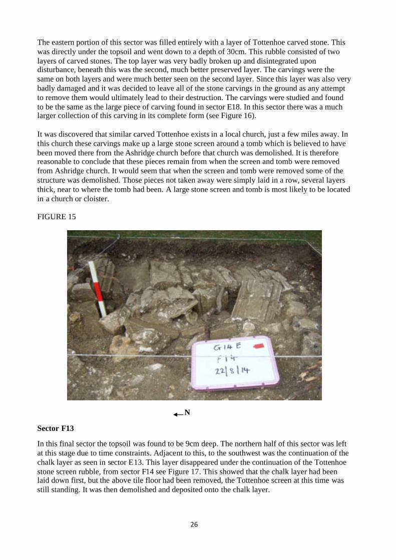
The eastern portion of this sector was filled entirely with a layer of Tottenhoe carved stone. Thiswas directly under the topsoil and went down to a depth of 30cm. This rubble consisted of twolayers of carved stones. The top layer was very badly broken up and disintegrated upondisturbance, beneath this was the second, much better preserved layer. The carvings were thesame on both layers and were much better seen on the second layer. Since this layer was also verybadly damaged and it was decided to leave all of the stone carvings in the ground as any attemptto remove them would ultimately lead to their destruction. The carvings were studied and foundto be the same as the large piece of carving found in sector E18. In this sector there was a muchlarger collection of this carving in its complete form (see Figure 16).
It was discovered that similar carved Tottenhoe exists in a local church, just a few miles away. Inthis church these carvings make up a large stone screen around a tomb which is believed to havebeen moved there from the Ashridge church before that church was demolished. It is thereforereasonable to conclude that these pieces remain from when the screen and tomb were removedfrom Ashridge church. It would seem that when the screen and tomb were removed some of thestructure was demolished. Those pieces not taken away were simply laid in a row, several layersthick, near to where the tomb had been. A large stone screen and tomb is most likely to be locatedin a church or cloister.
FIGURE 15
N
Sector F13
In this final sector the topsoil was found to be 9cm deep. The northern half of this sector was leftat this stage due to time constraints. Adjacent to this, to the southwest was the continuation of thechalk layer as seen in sector E13. This layer disappeared under the continuation of the Tottenhoestone screen rubble, from sector F14 see Figure 17. This showed that the chalk layer had beenlaid down first, but the above tile floor had been removed, the Tottenhoe screen at this time wasstill standing. It was then demolished and deposited onto the chalk layer.

27
FIGURE 16
NThe area adjacent to the hole in sector E13 showed the very faint remains of a wall going east.This was in the form of some large flints and Tottenhoe stones in a linear form. This disappearedunder the Tottenhoe screen rubble to the east. This wall was approximately 25cm high and 25cmwide. Only the core remained. To the south of this wall the rubble was similar to that in the othersectors, a mixture of tile, brick and some pieces of Tottenhoe stone. To the south-east this rubblemix disappeared under the Tottenhoe screen rubble.
FIGURE 17
N

28
F13Tottenhoescreen rubbleEast-Westwall
F14Tottenhoescreen rubbleEast-Westwall
FIGURE 18
E15East-West wallNorth-South wall,no stucco
E16North-South wall,no stuccoVictorian gardenfeature?
E17North -Southwall damagedface,no stucco
E18North-South wallsmooth flint face,no stuccoPart of Tottenhoescreen found here
E19North-South walljoins anotherwall
E13Chalk layerNorth-South wall, nostuccoEast-West wall
Clay floor areawith stucco wallin between twoeast-west walls
E14North-Southwall, with stucco
East-West wall
D17North-Southwall, withstucco
C17No action
D18North-Southwall, withstucco
C18No action
Outside

29
Summary of Trench G14E
This season, it was decided to construct a “photo mosaic” of the trenches with the objective ofbetter understanding and recording the excavation. This was done for Trench G14E as a completemosaic incorporating both phases. This has worked very well and should enable the reader to geta much better view of the trench as a whole and the relationship of each individual sector.
A copy of the photo mosaic for trench G14E is included as Figure 18.
The north to south wall was the same as in 2013 trenches continuing through this year’sexcavation trenches to sector E18. It appears that it joined another wall on the same alignment inE19. The outside of the wall was to the west, the inside to the east. Stucco was found on the someparts of the wall face. In some areas a smooth, knapped flint face, in others a rough flint face wasfound.
Two east-west walls abutting the north-south wall were found in sectors E15 and E13. Thesewalls appear to be a pair with an area of stucco on the vertical faces, a clay floor in between thesetwo walls.
In F13 and F14 there are the remains of a large carved stone screen. As these were so close to thewalled alcove in sectors E15 and E13 that had been uncovered in 2013, it suggests that the alcovecould be where a tomb had been. This strongly suggests that these sectors are in either a sidechapel of the church or the cloister. It is recommended that in the next season (2015) that furtherexcavation of this area is considered. It would be ideal to open sectors G14 & G13 and even F15 -G15. This would give a better understanding of the stone screen and maybe the purpose of thenorth-south wall.

30
SECTION 4
Grid 14 TRENCH 14F
Excavations during 2012 and 2013 had revealed a substantial wall running north-south throughgrids G10 and G14. The main purpose of excavating this trench in 2014 was to investigate an areaof lower resistivity response towards the southern end of grid G14 and establish whether someform of break in the wall occurred at this point.
FIGURE 1
A B C D E F G H J123456789
10111213141516171819202122232425262728293031
The resistivity survey of Grid 14 showing the location of Trench 14F in 2014 and its relationshipto the 2013 Trench 14B.
2014 Trench 14F
2013 Trench 14B

31
FIGURE 2
Trench 14F sectors. Final position.
The turf was initially lifted on a 4m x 3m trench with the one metre squares being designatedsectors C26-C29, D26-D29 and E26-E29, in line with the sector naming convention adopted in2013. Excavation of this area established that the north-south orientated flint wall found in trench2013 G14B continued southwards. A more detailed account of all sectors is given below.
It became clear as the excavation proceeded that features existed on the eastern side of the walland the decision was taken to extend the trench to investigate these. The trench was extendedeastwards by 1 metre, adding sectors F26 & F27. Excavation of these sectors showed featuresextended northwards and a further 1 metre northward extension added sectors E25 & F25.
1m
N
1m1m
1m
1m
1m
1m
1m
1m
C26
C27
C28
C29
D26
D27
D28
D29
E26
E27
E28
E29
E25
F26
F27
F25

32
FIGURE 3
Trench 14F Sector C26.
Sector C26
The turf and dark-brown topsoil was removed to 15cm exposing a compact rubble fill surfacecomprised of fragments of flint, Tottenhoe and occasional fragments of red brick and red tile, in awhite flecked mid-brown soil matrix. In the southeast corner, the corner of a Tottenhoe block wasexposed. A 20cm wide strip along the eastern side of the sector was taken down to 30cm throughthe rubble layer, exposing the base of the Tottenhoe block showing it was sitting on the rubblelayer.
FIGURE 4
Trench 14F Sector C27.

33
Sector C27
The turf and dark-brown topsoil was removed to 15cm exposing a compact rubble fill surfacecomprising of fragments of flint, Tottenhoe and occasional fragments of red brick and red tile, ina white flecked mid-brown soil matrix. Along the eastern side of the sector, the edges ofTottenhoe blocks were exposed. A 20cm wide strip along the eastern side of the sector was takendown to 30cm through the rubble layer, exposing the base of the Tottenhoe blocks showing theywere sitting on the rubble layer.
FIGURE 5
Trench 14F Sector C28.
Sector C28
After removing the turf and exposing the dark-brown topsoil no further activity took place in thissector.
Sector C29
The turf and dark-brown topsoil was removed to 15cm, exposing a compact rubble fill surfacecomprised of fragments of flint, Tottenhoe and occasional fragments of red brick and red tile, in awhite flecked mid-brown soil matrix. This compact rubble fill extended to 35cm depth where itbecame very loose. The lower fill comprised larger fragments of flint and Tottenhoe in anorangey-brown sandy matrix. The western part of the sector was taken down to 40cm and a 30cmwide strip along the eastern edge to 115cm, still in loose fill with no sign of the bottom of the fill.

34
FIGURE 6
Trench 14F Sector C29.
FIGURE 7
Trench 14F Sector D26.
Sector D26
Turf and dark-brown topsoil was removed to 15cm, exposing a compact rubble fill surfacecomprised of fragments of flint, Tottenhoe and occasional fragments of red brick and red tile, in awhite flecked mid-brown soil matrix. The western part of the sector was taken down to 45cm,through compact fill to 30cm and into looser rubble in a sandy mortar matrix. This exposed thenorth end of a Tottenhoe block sitting on the fill. A 40cm strip along the eastern side of the sectorwas taken down to 70cm through loose fill exposing the western side of the north-south flint wall.The wall had a mortared or stucco western face and appeared to be built on the fill.

35
FIGURE 8
Trench 14F Sector D27.
Sector D27
Turf and dark-brown topsoil was removed to 15cm, exposing a compact rubble fill surfacecomprised of fragments of flint, Tottenhoe and occasional fragments of red brick and red tile, in awhite flecked mid-brown soil matrix. This showed the outline of one or more Tottenhoe blocks inthe southwest corner of the sector. The top of the Tottenhoe blocks were exposed and the south-western corner of the sector was taken down to 30cm through the compact fill. This revealed theirregular outline of some of these blocks and the group as a whole, although they did appear tohave been placed and positioned rather than randomly dumped. A 20cm strip along the westernside of the north-south wall was taken down to 65cm through loose fill, exposing the stucco faceof the flint wall.
FIGURE 9
Trench 14F Sector D28.

36
Sector D28
Turf and dark-brown topsoil was removed to 15cm, exposing a compact rubble fill surfacecomprised of fragments of flint, Tottenhoe and occasional fragments of red brick and red tile, in awhite flecked mid-brown soil matrix. The northern 20cm was taken down to 30cm through thecompact fill exposing the irregular southern end of the Tottenhoe blocks. The eastern 20cm stripwas taken down to 65cm, first through the compact fill then the looser fill previously described,exposing the western side of the north-south wall which had areas of facing mortar or stucco.
FIGURE 10
Trench 14F Sector D29.
Sector D29
Turf and dark-brown topsoil was removed to 10cm, exposing a surface of dark-brown soil withrubble. At 30cm this layer gave way to much looser light-brown sandy matrix with rubble of flintand Tottenhoe and voids between the rubble blocks at lower levels. In the eastern part of thesector the loose rubble in sandy matrix was removed to 75cm exposing the stuccoed western faceof the north-south wall and the base of the wall with orangey clay below. The clay dipped awayfrom the wall with the dip increasing westwards, 30cm to the west of the wall the clay was at95cm. The western half of the sector was taken down to 115cm but the base of the loose fill wasnot established.

37
FGIGURE 11
Trench 14F Sector E25.
Sector E25
Turf and dark-brown topsoil was removed exposing a compact rubble fill surface comprised offragments of flint, Tottenhoe and occasional fragments of red brick and red tile, in a white fleckedmid-brown soil matrix. In the western part of the sector this surface was at 10cm but dippedeastwards to 15cm in the eastern part. In the western part of the sector the top of the north-southwall was encountered at 10-20cm with the uneven surface dipping away towards the south-east,the wall composition in this area included a lump of Tottenhoe and two red half bricks. Theeastern part of the sector was taken down to 70cm through compact rubble exposing the easternface of the north-south wall and the northern face of an east-west wall. North of the east-westwall, the face of the north-south wall was stuccoed and the was wall underlain by orange clay. Alarge piece of lead pipe was found in the fill in this area.
FIG 12 Trench 14F Sector E26.
38
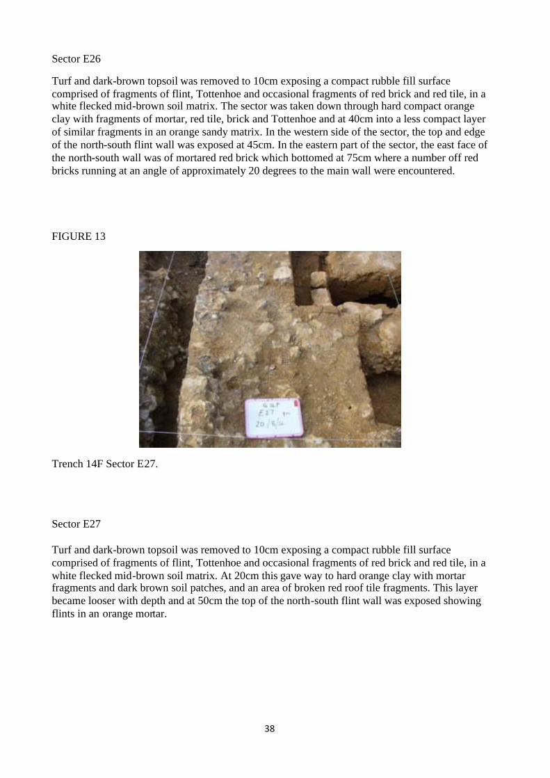
Sector E26
Turf and dark-brown topsoil was removed to 10cm exposing a compact rubble fill surfacecomprised of fragments of flint, Tottenhoe and occasional fragments of red brick and red tile, in awhite flecked mid-brown soil matrix. The sector was taken down through hard compact orangeclay with fragments of mortar, red tile, brick and Tottenhoe and at 40cm into a less compact layerof similar fragments in an orange sandy matrix. In the western side of the sector, the top and edgeof the north-south flint wall was exposed at 45cm. In the eastern part of the sector, the east face ofthe north-south wall was of mortared red brick which bottomed at 75cm where a number off redbricks running at an angle of approximately 20 degrees to the main wall were encountered.
FIGURE 13
Trench 14F Sector E27.
Sector E27
Turf and dark-brown topsoil was removed to 10cm exposing a compact rubble fill surfacecomprised of fragments of flint, Tottenhoe and occasional fragments of red brick and red tile, in awhite flecked mid-brown soil matrix. At 20cm this gave way to hard orange clay with mortarfragments and dark brown soil patches, and an area of broken red roof tile fragments. This layerbecame looser with depth and at 50cm the top of the north-south flint wall was exposed showingflints in an orange mortar.

39
FIGURE 14
Trench 14F Sector E28.
Sector E28
Turf and dark-brown topsoil removed to 5cm exposing surface of fragments of flint, Tottenhoe,red brick and red tile in brown clayey-soil matrix. This was further taken down to 35cm - 40cmthrough rubble in clayey-soil matrix to reveal an uneven top surface of an orange mortared flintwall running north-south.
FIGURE 15
Trench 14F Sector E29.
Sector E29
Turf and dark-brown topsoil removed to 5cm exposing surface of fragments of flint, Tottenhoe,red brick and red tile in brown clayey-soil matrix. This was further taken down to 35cm - 40cmthrough rubble in a clayey-soil matrix to reveal an uneven top surface of orange mortared flint

40
wall running north-south. The western side was taken down to 75cm exposing the stuccoedwestern face of the north-south wall. At the southern end, the wall face was of uneven projectingflints indicating a possible east-west wall running westwards, however no other indication of thiswas seen in either the trench or trench wall.
FIGURE 16
Trench 14F Sector F25.
Sector F25
Turf and dark-brown topsoil removed to 5cm revealing a large tree root surrounded by dark-brown soil with some rubble in the northeast quarter of the sector. In the remainder of the sectorthe dark-brown soil with rubble gave way to a looser fill in a sandy orange matrix. The fill wasremoved to 50cm in the southern part of the sector to reveal a hard surface of brick overlain bymortar with a horizontal red roof tile in place in the southwest corner. The northern half of thesector was taken down to 85cm exposing the northern face of an east-west wall, and an orangeclay base.
FIGURE 17
Trench 14F Sector F26.

41
Sector F26
Turf and dark-brown topsoil was removed to 15cm, exposing a compact rubble fill surfacecomprised of fragments of flint, Tottenhoe and occasional fragments of red brick and red tile, in awhite flecked mid-brown soil matrix. This was taken down to 55cm to reveal a solid orangemortar surface across the north 65cm of the sector, at this point a 40cm+ void appeared in thesouthern part of the sector. Further excavation in the area of the void revealed the northern side ofan east-west wall and the southern edge of a feature which was established as an arch, with a gapof up to 35cm between the two features. Although access was limited, the gap was furtherexcavated through very loose fill and the southwest corner adjacent to the north-south wall wasprobed with an iron spike which appeared to show that the fill went to a depth of at least 1.80mbelow ground level and no indication of a base was found. Underneath the arch was partlyexcavated, allowing measurements and photographs to be taken. One of these photographsappeared to show fill coming in under the arch on the eastern side, and further excavation andcleaning of the eastern side of the trench above the arch confirmed this.
FIGURE 18A
FIGURE 18B

42
FIGURE 18C
Underneath the arch in 14F Sector F26.
Figure 18A looking north: red brick back wall, arch-shape clearly visible, underside lined withred tile. Mortar impression between the east and west red tiles, possibly the impression of amissing brick.
Figure 18B looking northwest: junction of red brick north-south and east-west walls and arch.
Figure 18C looking northeast: loose fill entering from the east, possibly the edge of the arch. Itappeared that there may have been two layers of red tile on the underside of the arch.
FIGURE 19
Trench 14F Sector F27

43
Sector F27
Turf and dark-brown topsoil removed to 5cm exposing surface of rubble in dark-brown soilmatrix. At 35cm this layer gave way to looser rubble in an orange sandy matrix. The southernhalf of the sector was taken down to 90cm exposing the eastern face and base of the north-southwall, and the southern face and base of an east-west wall. Both walls appeared to have been builton orange clay.
Main Features of Trench.
FIGURE 20
Trench 14F Looking north along North-south wall.

44
FIGURE 21
A Photo-mosaic composite of Trench 14F made from corrected near vertical 1m square sectorphotos. Due to parallax differences it was not possible to completely align the individual photos.
‘A’ - The northern end of the north-south wall appeared to have been heightened after the initialflint wall as it contained some red brick and Tottenhoe stone. North of the east-west wall ‘B’ theeast face had stucco. The top of the wall was 10cm below ground level dropping away to thesouth and particularly south-eastwards. North of the brick lined indent at ‘G’ the wall was 70cmwide.
F
E
G
A
B
C
D
N

45
FIGURE 22
Trench 14F north end of the north-south wall.
‘B’ The northern east-west wall measured 55cm wide, with the top 50cm below ground level, andthe base 80cm below ground level. The wall appeared to continue into the eastern face of thetrench. On the north side it was constructed of red brick underlain by red tile, then flint sitting onorange clay, with a Tottenhoe block adjacent to the north-south wall. This block had moved awayfrom then north-south wall leaving a 2-3cm gap. The face of the north-south wall had indicationsthat above the remaining level, the east-west wall had been bonded to the north-south wall, butthe Tottenhoe block extended 5cm north of this mark. The south side of the wall was underneaththe arch ‘C’ and could not be seen directly, however from a photograph taken underneath the archsee Fig 18, it appeared to be constructed of bonded red brick which went to a deeper level than onthe north face. The top surface of the wall was of orange-brown mortar, on the southern side therewas a horizontal roof tile and 1½ thin un-bonded red bricks on edge adjacent to the north-southwall.
FIGURE 23
N-S Wall
2-3cmgap
Clay
Flint
Tottenhoe
Red tile
Red brick
N-S Wall
2-3cmgap
Clay
Flint
Tottenhoe
Red tile
Red brick
North side of east-west wall.
‘C’ The arch, its top 55cm below ground level, 105cm wide east-west, 60cm north-south, 30cmthick in the middle thickening to 35cm at the edges. Built of red brick, two headers thick
North end of north-south wall withstucco eastern face
East-west wallabutting

46
underlain by one, possibly two layers of red tile, see Figure 18, which was overlain by a lightgrey mortar to create a more level surface. The south face of the arch, where there was a gap of25-35cm to the southern east-west wall “D”, was partly mortared. The northern side of the archjoined the northern east-west wall “B”. The eastern edge of the arch appeared to end at the easternedge of the trench. The western end appeared to have dropped slightly. The area under the archwas mostly occupied by loose fill. As the only access to this area was via the 25cm gap onlylimited investigation was possible, however it appeared that there was a void of at least 1.00mbelow the arch.
FIGURE 24
Red brick
Red tileMortared
face
Red brick
Red tileMortared
face
Construction of the arch - looking north.
FIGURE 25
Trench 14F Top of Arch.
‘D’ the southern east-west wall 55cm wide, the top 55cm below ground level. The wall appearedto continue into the east face of the trench. On the southern side the wall was constructed ofmortared Tottenhoe fragments (i.e. irregular shaped partially dressed) and red brick to a depth of80cm below ground level where the wall was underlain by orange clay. On the north side the wallwas of bonded red brick to at least 160cm below ground level with a large Tottenhoe block nearthe top of the wall at the eastern end. There was a crack between the red brick and the block
Looking north: the topof the arch with a 25cmgap and the southerneast-west wall in frontand the northern east-west wall behind.

47
which was not flush with the vertical face of the red brick indicating there may have been somemovement of the wall or block.
FIGURE 26 South side of wall FIGURE 27 North side of wall, eastern end
‘E’ the south end of north-south wall, the top at a variable depth of 35 - 45cm below ground level,being slightly higher on the western side. South of the brick lined indent at “G” the wall was1.00m wide. Constructed of flint and orange mortar with stucco along much of the western face(the short section of the eastern face exposed south of the brick lined indent did not appear tohave stucco, however there was a larger dressed stone block, possibly sandstone, incorporatedinto the wall at this location). The wall was built on orange clay with the base at 80cm belowground level, the clay sloped gently away westward for a distance of 30cm west of the wall, thenmuch more steeply. Where the wall entered the trench side at the southern end, the was a slightindication of a possible wall running west but no further evidence was seen in the trench wall oradjacent fill. The wall continued to the northern end of the brick indent at a similar level andconstruction.
FIGURE 28
Trench 14F South end of north-south wall.
Red brick
Tottenhoe Tottenhoe
Red brickMortar with brick
fragments
Mortar with brickfragments
Crack
Looking east: possibleeast-west wall on thewestern side of thenorth-south wall at thesouthern end

48
‘F’ the area of weathered Tottenhoe blocks and fragments apparently placed rather than randomdumped but irregular in shape. The top of blocks was 15cm below ground level, the bottom 30cmmaximum (the base was variable) underlain by fill.
‘G’ red brick lined indentation in the eastern side of the north-south flint wall, which reduced inwidth to 65cm (north of the indent the wall was 70cm wide, south of the indent 1.00m wide). Thetop of the red bricks forming the indent were 45cm below ground level. The western side of theindent was constructed of seven header bricks with a stucco eastern face underlain by whatappeared to be brick rubble and pieces of horizontal red tile. The eastern face of the north-southwall was 10cm to the east of the rear of the indent, and north of the indent.
FIGURE 29
North-south wall brick lined indent looking west.
The base of the indent at 75cm below ground level appeared to have a line of red bricks runningat an angle of approximately 20 degrees away from the line of the wall, however it was not clearif these were in their original position or had been pushed by the lateral pressure of the arch.

49
FIGURE 30
North-south wall brick lined indent, vertical view.
Note on the fill
There was some variation in the make-up of the fill across the trench.
West of the north-south wall.
The majority of this area comprised 15cm of turf and dark-brown topsoil underlain by 20cm ofcompact rubble fill comprised of fragments of flint, Tottenhoe and occasional fragments of redbrick and red tile, in a white flecked mid-brown soil matrix. At 35cm depth, below the compactfill, there was a much looser fill comprised of larger fragments of flint and Tottenhoe in anorangey-brown sandy matrix and extended to a depth of at least 115cm at the western side of thetrench. An irregularly shaped area of Tottenhoe blocks sitting on fill which had the appearance ofhaving been placed rather than randomly dumped. In the south-western area of the trench the fillwas comprised of dark-brown soil with rubble.
North eastern corner of trench.
This area contained a tree root and was surrounded by an area of dark-brown soil with rubblefragments, presumably as a result of the planting of the tree.
East of the North-south wall.
The fill in this area was more variable in that patches of dark-brown soil and other of orange claywere present. As with the areas west of the wall, a very compact layer was underlain by a lesscompact fill.
Vertical view of thebrick lined indentshowing the angled redbricks at the bottom ofthe indent. The northernpart of the north-southwall can be seen juttingout eastwards
N

50
Summary of Trench G14F
The change in resistivity in this area was not due to a break in the north-south wall, but possiblythe reduction in the wall height or the void below the arch feature. The purpose of the archfeature, the adjacent east-west walls and the brick lined indent is at present unclear. The reasonfor the change in wall width at the southern end of the brick indent is unknown. The north-southwall changes in width from 70cm to 1m at the indent. It is recommended that further excavationof the arch feature be undertaken at a future date.
SECTION 6
CONCLUSIONS
Trench 14D
The aim of this trench was to investigate the postulated wall running eastwards from the north-south wall and to explore its length. The wall only extended for 1.8m although the terminus didnot end sharply as at a doorway but rather that it may have been robbed out. However a furtherone metre extension did not find any evidence of the wall. The southern face of the easterly wallwas plastered and there was a quantity of plaster found in the building debris. The time needed tolift this plaster, some of which was found to have red colouration on one of the faces, wasinsufficient to be completed.
Trench 14E
Positioned between two of the trenches that had been excavated in 2013 this trench was initiallyopened to investigate the north-south wall and to see if there were any easterly walls abutting it.The wall appeared to have different faces with some areas having knapped flints while someareas had stucco over the flints. Two narrow easterly walls were found at the northern end of thetrench with a chalk floor and a pile of carved Tottenhoe was found all of which were probablyassociated together. A number of broken pieces of Tottenhoe fitted together and can be linked toa screen in a local church.
Trench 14F
This trench confirmed the continuation of the north-south wall although there were differences inits width. The wall was continuous and no break was found. An unexpected enigmatic structurewas found built into the north-south wall for which no explanation has yet been found. Also thefill across the trench was variable and some blocks of Tottenhoe appeared to have beendeliberately but randomly placed on the trench fill. Some disturbance in the north east corner ofthe excavation proved to have been from the planting and removal of a tree.
Since the initial aims of the excavation had not been fully met and more questions have beenraised, it is proposed that the trenches be reopened during the next season, and an area alongsideto the east of these trenches be excavated, to try to elucidate more fully the easterly walls and theenigmatic structure in trench 14F. It would also allow the lifting of the painted plaster found intrench 14D and the carved Tottenhoe from trench 14E.

51
SECTION 7
IDENTIFIED FINDS
PAVING TILES
A number of fragments and whole medieval paving tiles were found in this year’s excavations.All have been identified as of the Penn types catalogued by Christopher Hohler and published inRecords of Buckinghamshire.
FIGURE 1
FIGURE 2

52
FIGURE 3
FIGURE 4
The Black Prince liked Berkhamsted Castle as his favoured country retreat and he frequentlyoccupied the castle when he was not on campaign. These two paving tiles are of a high qualitymanufacture, the design being impressed into the clay before the slip was added unlike laterproduction which placed the slip on the surface of the clay. They probably date from around1376

53
when the Black Prince augmented the endowments to the monastery at Ashridge and he becamethe ‘second founder’. Both designs are associated with the Prince and this might also account forwhy one of them was found in Berkhamsted Castle and in St Peter’s church.
FIGURE 5
WINDOW GLASS
FIGURE 6
One piece of glass showed a design which may be part of a floral scheme with flowers or leavesattached to a stem.

54
TOTTENHOE
Apart from flints, bricks and roof tiles the other most prolific material found during theexcavations carried out over the last few years are the many pieces of Tottenhoe stone. Althoughmost of the larger pieces have been found to have plain flat faces, indicating that they werebuilding blocks from the walls, some of the smaller pieces have been shaped. Amongst thesepieces have been small pieces that have come from around windows and doors. A number oflarger pieces were found this year in trench 14D, sector E8, all but one were found to be plainwith only one having been carved and shaped and it is believed to have been part of a door orwindow frame. (See trench 14D above). All of this Tottenhoe could have come from anywhere ina building. However, one particular find of several pieces of Tottenhoe from trench 14E can befitted together to make a significant decoratively carved structure.
FIGURE 7
Figure 7 shows the composite reconstruction of the pieces of Tottenhoe found in trench 14E.
On examination none of these pieces show any sign of weathering such that they may have beenused in some outside position on a building. Therefore it was believed that they must have comefrom some decorative part of a structure within a building.
The current college building is largely faced with Tottenhoe and also has a considerable amountused in the various decorative structures inside. One such area is around the main staircase.Carved Tottenhoe which did not meet the standards required by the master mason would bedumped, so it was important to eliminate any possibility that it may have been a reject fromwithin the current structures. Those areas that were available were examined, photographs takenand comparisons made.

55
FIGURE 8
Figure 8 shows a selection of carved Tottenhoe around the staircase in the current building.
As none of the current building designs fitted the pieces found in the excavation, they must havecome from the earlier monastic building. From further research a perfect match was found.
FIGURE 9

56
Figure 9 shows an exact copy of the composite found in the excavations and is to be found at theeast end of the south aisle in Aldbury church. It shows part of the only parclose, or stone screen,in the Chilterns which surrounds the alter tomb and monument to Sir Robert Whittingham and hisLady. The family lived at Pendley Manor, Tring and before he died, in 1471 Sir RobertWhittingham expressed a wish to be buried at the College of the Bonhommes at Ashridge. Thetomb was removed from Ashridge and brought to Aldbury, with its enclosing screens, in 1575 byEdmund Verney, shortly before the Ashridge church was demolished. The carving is of a verygood quality and fine example of fifteenth century tracery.
FIGURE 10
Figure 10 is a complete section of the parclose or screen.
The current structure in Aldbury church has two sides to the parclose an east-west wall and anorth-south wall, and they show a slightly different form of construct between the two walls. Theother two sides of the parclose are formed by exterior walls of the church. One outside wallparallel to the east-west parclose has a window inserted and the other has a marble monumentcommemorating Sir Richard and Lady Anderson.
The north-south parclose appears to be a complete screen with a solid decorative lower wall withan open arched tracery decoration and a second more complex open tracery decorated friezeabove. This is topped by a solid triangular shaped capping with smaller similar styled extraneousdecoration punctuated along its length. This is seen in figure 11 below.
The east-west screen has a lower solid decorative wall punctuated by a doorway at the extremewestern end, but the tracery is different from that in the other wall. Above this is an open archedtracery decoration truncated in height and surmounted by the lower extraneous decorated cappingsimilar to that on the top of the other wall. This is surmounted by a decorative frieze, identical tothat on the other wall, but truncated just below the arch of the lower section. A capping in asimilar style to the other wall completes the walls of the screen. This is seen in figure 12 below.

57
FIGURE 11
FIGURE 12

58
The floor of the chapel has paving tiles of a type similar to that found at Ashridge. These havebeen laid as they were designed in sets of four and are of the type P143. This is described as threemultifoils unforked springing from the inner of two concentric quadrants with a bird’s head in theouter angle and vestigial squiggle in the inner. Figure 13 shows a section of the flooring aroundthe tomb and the insert shows a whole paving tile found in this year’s excavation.
FIGURE 13
Jeton.
Throughout the later medieval period accounting was conducted using counters on a board orcloth.
Obverse Reverse

59
Calculations using counters on a chequer board was analogous to that performed using beads onan abacus. A series of vertical columns were marked with there respective values, ‘pounds’,‘shillings’ and ‘pence’. Counters were placed in the relative column until that column containedthe maximum number of counters for that value of coin. The ‘pence’ column would have twelvecounters which would then equate to one in the ‘shilling’ column. Twenty shillings would equateto one ‘pound’.
The word exchequer means chessboard and a branch of the Treasury was established for the Kingas the Royal Exchequer. It used a chequer board or cloth on which the revenue accounts werepresented. It may seem a laborious process but it would have been more so using Romannumerals and the Arabic notation had not been introduced.
Jetons were manufactured in England in the 14 th century but production was soon overtaken bythat from France and then by Nuremberg. By the end of the 15th century the Nuremberg Jetonmakers had cornered the English market. There are many makers and from the designs many ofthe makers can be identified. The most common design is the Rose and Orb. The obverseshowing three crowns, alternately with three Fleur-de-lis, arranged around a central rose. Thereverse shows the Imperial orb within a tressure of three arches and three angles.
SECTION 8
FINDS APPENDIX
NUMBER TRENCH SECTOR DESCRIPTION NOTES
1 14E C17 Large piece of brick or tile Possible roof tile2 14E C17 4 Pieces of Tottenhoe Small pieces all shaped3 14E C17 White plaster Lump of thick white
plaster with one smoothface
4 14E C18 2 pieces of glass Painted design5 14E C18 Piece of bone Animal bone6 14F D27 Piece of paving tile Hohler type P367a 14E D18 Paving tile Hohler type P1437b 14E D18 Paving tile Hohler type P1667c 14E D18 Paving tile Unidentified7d 14E D18 Paving tile 2 triangular shaped tiles7e 14E D18 Piece of Paving tile Plain unglazed8 14E D18 2 pieces of pot Brown glazed part of a
base & handle9 14E D17 2 nails10 14E D17 7 pieces of pot Brown glazed similar to
no 8 above11 14E D17 2 pieces of lead12 14E D17 2 metal pins13 14F E27 3 pieces of glass Window glass14 14F E27 1 Piece of plaster One smooth surface
painted white15 14D E8 22 nails

60
NUMBER TRENCH SECTOR DESCRIPTION NOTES16 14D E8 2 pieces of plaster 1 piece with surface
patches of grey on bothsides
17a 14F E28 5 pieces of tile Possible roof tile17b 14F E28 2 pieces of paving tile 1 piece Hohler type
P144 the otherunidentified
18 14F E28 1 Piece of plaster Surface not smooth19 14F E28 1 piece of pot Piece of brown glazed
pot20 14E D18 3 pieces of Tottenhoe 2 pieces shaped21 14E D18 7 pieces of plaster Differing thicknesses
some with a smooth,others with a roughsurfaces
22 14E D18 10 pieces of Tottenhoe23 14E D18 3 pieces of paving tile A very worn glazed tile
the 3 pieces fit togetherbut are not a whole tile
24 14E D18 3 pieces of bone Animal bone25 14E D18 3 pieces of pot Brown glazed similar to
no 8 above26 14E E14 5 pieces of lead Sheet lead27 14E E15 2 pieces of pot Green glazed ware28 14E E15 2 Nails29 14E E16 Quantity of plaster30 14E E16 4 Nails31 14E E19 Piece of paving tile Green glazed surface.
Circular hole. Similarto number 44 below
32 14E E19 6 pieces of pot Brown glazed ware33 14E E19 6 pieces of glass Heavily corroded
window glass34 14F F25 3 pieces of bone Animal bone35 14F D26 1 piece of glass Heavily corroded
window glass36 14F D26 1 piece of bone Animal bone37 14F D26 1 piece of paving tile Possible Hohler type
P9138 14F E26 1 piece of glass Heavily corroded
window glass39 14F E26 1 piece of metal Possibly lead40 14F E26 1 nail41 14F F26 2 pieces of bone Animal bone42 14F F26 1 Tooth43 14F F26 1 piece of metal Piece of iron

61
NUMBER TRENCH SECTOR DESCRIPTION NOTES44 14F D27 Piece of paving tile Green glazed surface.
Circular hole. Similar tonumber 31 above
45 14F D27 Piece of glazed pot Possible green glazedpaving tile
46 14F E27 Small piece of paving tile Unidentified47 14F F27 2 pieces of bone48 14F F27 1 piece of metal Unidentified but non-
magnetic49 14F E28 1 piece of glass50 14F E28 1 piece of metal Possibly a nail51 14F E28 1 piece of pot Green glazed ware52 14F D29 3 pieces of glass Window glass53 14D F9 Quantity of plaster54 14D F9 5 pieces of bone55 14E E18 1 piece of pot Brown glazed ware56 14F F26 1 nail57 14F F26 Piece of lead Window lead58a 14F C29 1 piece of paving tile Hohler type P4158b 14F C29 1 piece of paving tile Hohler type P3558c 14F C29 1 piece of paving tile Plain green glaze58d 14F C29 1 piece of paving tile Unidentified59 14F F25 1 piece of glass Brown bottle glass60 14E E14 1 nail61 14E E14 1 piece of lead Lead rod62 14E E14 1 piece of Tottenhoe Shaped Tottenhoe63 14E E15 Quantity of plaster64 14E E15 Piece of flat glass65 14E E15 1 piece of pot Brown glazed ware66 14E E16 Quantity of plaster67 14E E16 1 Piece of pot Brown glazed ware68 14E E16 2 pieces of bone69 14E E16 2 pieces of lead Window lead70 14E E16 8 nails71 14E E16 Piece of metal72 14D F9 1 piece of pot Brown unglazed73 14D F9 23 nails74 14E E14 Piece of Tottenhoe Shaped Tottenhoe75 14E E14 1 piece of pot Shaped pot with brown
glaze on one face
76 14E E14 Piece of flat round metal Possibly lead77 14D F8 Piece of pot Top of a brown glazed
bottle78 14D F8 10 nails

62
NUMBER TRENCH SECTOR DESCRIPTION NOTES79 14F F27 2 pieces of glass Possibly from a
drinking vessel80 14F E25 1 piece of paving tile Hohler type P16681 14D F8 1 piece of pot Unglazed82 14D F8 2 pieces of lead and 1 nail Window lead83 14E E15 45 nails84 14E E15 23 pieces of bone85 14E E15 6 pieces of pot All different86 14E E15 1 piece of metal Sheet lead87 14D E9 Quantity of plaster88 14D E9 2 nails89a 14F C29 1 piece of paving tile Plain unglazed brown89b 14F C29 1 piece of paving tile Plain green glaze89c 14F C29 1 piece of paving tile Unidentified90 14F C29 1 piece of bone Animal bone91a 14F F26 1 piece of mortar91b 14F F26 2 pieces of mortar92 14F F26 1 piece of glass93 14D F8 24 nails94 14D F8 2 pieces of pot 1 piece a handle95 14D F8 2 pieces of lead 1 piece of window lead
& 1 piece of rod96 14D F8 1 piece of bone97 14D F8 1 piece of metal solid rod of non-ferrous
metal98 14D F8 1 ball Un-known material99 14D F8 Piece of unknown material100 14D F8 1 coin Jetton101 14E E16 Part of a glazed paving tile Plain light brown
glazed paving tile102 14E E16 8 nails103 14E E16 2 pieces of unknown
substance104 14E E16 4 Pieces of bone105 14F F27 2 pieces of lead Window lead106 14F E29 3 pieces of glass Window glass107 14F F25 Piece of metal108 14F F25 Piece of plaster Red painted line along
edge109 14F F25 Circular flat stone110 14F F25 Tooth111 14F F25 Claw112 14F F25 5 pieces of bone113 14E F14 5 pieces of pot Brown glazed ware114 14E F14 1 Piece of plaster

63
NUMBER TRENCH SECTOR DESCRIPTION NOTES115 14F F26 1 Piece of plaster116 14F F26 3 pieces of plaster Dark coloured surface
on wall plaster117 14F F26 2 pieces of glass Window glass118 14F F26 1 piece of mortar Probably wall plaster119 14F F26 1 nail120 14D F9 2 pieces of paving tile Plain green glaze121 14D F9 1 piece of paving tile Green glaze triangular
in shape122 14D F9 1 piece of paving tile Unknown design123 14D F9 1 piece of iron124 14F F25 1 piece of mortar Dark coloured surface
on wall plaster125 14F F25 1 piece of paving tile Green glazed paving
tile126 14F F25 16 teeth Animal teeth127 14F F25 4 Pieces of bone128 14F E25 3 pieces of glass Window glass129 14E E18 1 piece of Tottenhoe Shaped and carved
Tottenhoe130 14D F9 Quantity of plaster131 14E F13 1 piece of pot Part of a handle of
brown glazed ware132 14E F13 1 Piece of plaster133 14E F13 1 piece of paving tile Plain light brown
glazed paving tile134 14F F26 1 piece of paving tile Dark brown glazed
paving tile135 14F F26 1 piece of paving tile Heavily worn dark
green glazed paving tile136 14F F26 1 piece of paving tile Heavily worn dark
green glazed paving tile137 14F F26 1 piece of paving tile Heavily worn dark
green glazed paving tile138 14F F26 1 piece of antler Possible handle made
from antler shaped &decorated
139 14F F26 Large piece of metal Hanging hinge140 14F F26 2 pieces of glass Window glass141 14D F9 Quantity of plaster Red painted line on one
face of some pieces