Embed Size (px)
Citation preview

Are Our Cities Warming Up the Earth?
A Study of the Heat Island Effect

.
At the moment, the urban heat island effect is not seen as an accelerator of global climate change. Rather, it is viewed as more of a local problem. However, with the rapid spread, large growth, and conglomeration of cities – as well as the development of third world countries – the heat island effect will eventually cover a larger area of the earth, causing it to develop into a much more serious factor of climate change.

So, What is the Heat Island Effect?• The heat island effect is a climatic
phenomena in which heat and pollutants located within an area lacking in vegetation create a haze dome that prevents warm air from rising and being cooled at a normal rate. This effect is amplified by variables such as lack of wind, paved streets, tall skyscrapers, and the like – all of which are present in our world’s cities.
• The picture to the right briefly illustrates the heat island effect .
As it is now, How does the Heat Island Effect Contribute To Global Warming?
• Currently, most experts agree that the heat island effect is not a major contributor to global climate change. Instead, it is seen as more of a local problem.
• Unfortunately, as areas become warmer during the summer months, people tend to use more energy in order to beat the heat. The emissions and energy used from refrigeration units as well as air conditioners needed to cool indoor spaces and goods within a heat island city result in the release of heat-trapping greenhouse gases which are largely attributed to global warming.
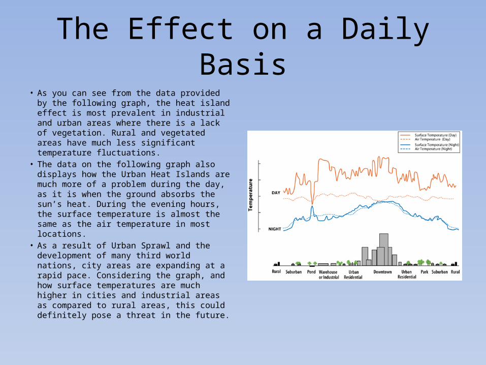
The Effect on a Daily Basis• As you can see from the data provided by the
following graph, the heat island effect is most prevalent in industrial and urban areas where there is a lack of vegetation. Rural and vegetated areas have much less significant temperature fluctuations.
• The data on the following graph also displays how the Urban Heat Islands are much more of a problem during the day, as it is when the ground absorbs the sun’s heat. During the evening hours, the surface temperature is almost the same as the air temperature in most locations.
• As a result of Urban Sprawl and the development of many third world nations, city areas are expanding at a rapid pace. Considering the graph, and how surface temperatures are much higher in cities and industrial areas as compared to rural areas, this could definitely pose a threat in the future.

Cause for Concern: Urban Sprawl• Urban sprawl is the outward spread away from cities and suburbs
to lower density, automobile dependent areas.• Rural areas are sacrificed to build these new areas. By taking away
vegetation that absorbs solar power and adding roads and buildings filled with high thermal inertia asphalt and concrete, heat does not escape as easily and contributes to the heat island effect.
• Not only does urban sprawl contribute to the urban heat island, it creates areas that encourage the use of automobiles because they are usually far away from the place of employment and service. As a result there is an increase in the burning of fossil fuels, which contributes to the emissions that lead to global warming and global climate change.

Case Study: Buffalo• NASA mapped out the city of Buffalo using their Landsat 7 satellite. • This picture shows the densely
populated areas as bright yellow.As you can tell, as the city of Buffalo branches out to itssurround suburbs, there isstill a substantial amount ofbrightly lit areas. This shows thaturban sprawl contributes to theoverall heat island effect.
Image courtesy of NASA Observatories

Urban Development in BRIC Nations and Third World Countries
• The BRIC Nations refer to the four biggest developing countries with large amounts of economic power: Brazil, Russia, India and China.
• As the BRIC nations and third world countries continue to develop, they are building more and more cities at an extraordinary pace. Urbanizing with such speed will only increase the urban heat island effect and turn a localized problem in to a potential worldwide problem.
• A paper written in 1990 describe the heat island effect and its relationship with urbanization in China. Though the paper claims that the overall warming in China was less than the world average, they concede the fact that when comparing the urban and rural areas, the “rural areas” are actually small-medium size cities. Therefore, one thing must be taken in to consideration: if this is compared to a true rural area, the difference in warming will be greater than 0.23 degrees Celsius, and thus proving that the rapid urbanization that China pursued in the later 1970s contributed greatly the heat island effect.

Using Satellite Images to Determine the Effects of Urban Heat Islands
• By launching satellites into space with the capabilities of recording surface and air temperature, we are able to compare and contrast these variables from areas around the globe.
• Furthermore, we can use this temperature data to determine the effects of Urban Heat Islands.
Calculating the Heat Island Effect in New York City Using a Satellite Image

The below image displays 2008 temperature and heat island data from Ohio, West Virginia, and Michigan.
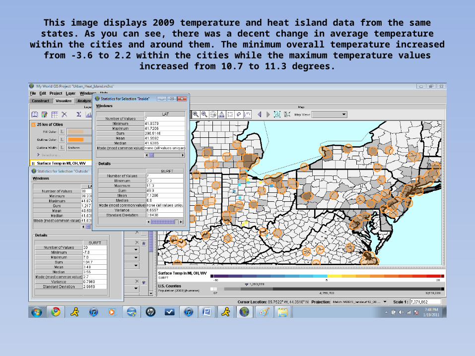
This image displays 2009 temperature and heat island data from the same states. As you can see, there was a decent change in average temperature within the cities and around them. The minimum overall
temperature increased from -3.6 to 2.2 within the cities while the maximum temperature values increased from 10.7 to 11.3 degrees.

What Does All This Mean?
• The data we collected using ImageJ shows us that the heat island effect is expanding. The average temperature change is quite large given that the data sets were collected only one year apart.
• If cities were to expand on a much larger scale, given this data, it is certain that global temperatures would increase tremendously. Thus, we can determine that the expansion of these cities, if vast enough, can contribute greatly to global climate change.

Conclusion
• As demonstrated through our research and satellite data, urban sprawl and rapid expansion of cities has contributed significantly to urban heat island.
• At the moment, urban heat island may be a localized problem. If the two trends continue, however, it is possible that urban heat island will play a pivotal role and serve as a tipping point in global climate change.
Sources• "Basic Information | Heat Island Effect | U.S. EPA." US Environmental Protection Agency. 10 Feb. 2009.
Web. 19 Jan. 2011. <http://www.epa.gov/heatisld/about/index.htm>.• Goddard Space Flight Center, Flat Earth Night, NASA, 19 Oct. 2001.
<http://upload.wikimedia.org/wikipedia/commons/6/61/Flat_earth_night.png>.• EPA, Urban Heat Island Review and Comparison, EPA, 10 Feb. 2009.
<http://www.epa.gov/heatisld/images/UHI_profile-rev-big.gif>.• Ragovin, Jeff. New York City Urban Heat Map, 25 Jan 2006.
<http://www.jeffsweather.com/archives/NEw%20York%20City%20Urban%20Heat%20Map.jpg>.• "Urban Heat Island Effect." GreenMuze : Cool Environmental News, Green Design and Eco-Living Tips From
Around The Globe! 20 Dec. 2010. Web. 19 Jan. 2011. <http://www.greenmuze.com/blogs/eco-geek/3375-urban-heat-.html>.
• "Urban Sprawl: the Big Picture." NASA Science. 11 Oct. 2002. Web. 20 Jan. 2011. <http://science.nasa.gov/science-news/science-at-nasa/2002/11oct_sprawl/>.
• United States EPA. "Urban Sprawl." Almanac of Policy Issues. Aug. 2003. Web. 20 Jan. 2011. <http://www.policyalmanac.org/environment/archive/urban_sprawl.shtml>.
• NASA Landsat 7 Satellite. Buffalo Thermal, NASA, 3 Aug. 2002.<http://www.greenmuze.com/images/stories/photos/blogs/eco-geek/eco410/buffalothermal.jpg>.
• Wang, Wei-Chyung, Zhaomei Zeng, and Thomas R. Karl. "Urban Heat Islands in China."Geophysical Research Letters 17.12 (1990): 2377-380. Informath. Web. 19 Jan. 2011. <http://www.informath.org/apprise/a5620/b23.pdf>.