Embed Size (px)
Citation preview

Chapter 9
Arctic Rivers
John E. BrittainNorwegian Water Resources and Energy
Directorate, PO Box 5091 Majorstua, 0301
Oslo, Norway
Natural History Museum, University of
Oslo, PO Box 1172 Blindern, 0318 Oslo,
Norway
G�ısli M. G�ıslasonInstitute of Biology, University of Iceland,
Askja-Natural Science Building, 101
Reykjav�ık, Iceland
Vasily I. PonomarevInstitute of Biology, Komi Science Centre,
UrD RAS, 167982 Syktyvkar, Komi
Republic, Russia
Jim BogenNorwegian Water Resources and Energy
Directorate, PO Box 5091 Majorstua, 0301
Oslo, Norway
Sturla BrørsDirectorate for Nature Management, 7485
Trondheim, Norway
Arne J. JensenNorwegian Institute for Nature Research,
7485 Trondheim, Norway
Ludmila G. KhokhlovaInstitute of Biology, Komi Science Centre,
UrD RAS, 167982 Syktyvkar, Komi
Republic, Russia
Sergej K. KochanovInstitute of Biology, Komi Science Centre,
UrD RAS, 167982 Syktyvkar, Komi
Republic, Russia
Alexander V. KokovkinInstitute of Social and Economic Problems
of the North, Komi Science Centre, 167982
Syktyvkar, Komi Republic, Russia
Kjetil MelvoldNorwegian Water Resources and Energy
Directorate, PO Box 5091 Majorstua, 0301
Oslo, Norway
Jon S. OlafssonInstitute of Freshwater Fisheries,
Keldnaholt, 112 Reykjav�ık, Iceland
Lars-Evan PetterssonNorwegian Water Resources and Energy
Directorate, PO Box 5091 Majorstua, 0301
Oslo, Norway
Angelina S. SteninaInstitute of Biology, Komi Science Centre,
UrD RAS, 167982 Syktyvkar, Komi
Republic, Russia
9.1. Introduction
9.1.1. Geology
9.1.2. Landscape
9.1.3. Climate
9.1.4. Hydrology
9.1.5. Water Chemistry
9.1.6. Biota
9.2. The Altaelva River
9.2.1. Physiography, Climate and Land Use
9.2.2. Geomorphology, Hydrology and
Biogeochemistry
9.2.3. Biodiversity
9.2.4. Management and Conservation
9.3. The Tana River
9.3.1. Physiography, Climate and Land Use
9.3.2. Geomorphology, Hydrology and
Biogeochemistry
9.3.3. Biodiversity
9.3.4. Management and Conservation
9.4. The Komagelva River
9.4.1. Physiography, Climate and Land Use
9.4.2. Geomorphology, Hydrology and
Biogeochemistry
9.4.3. Biodiversity
9.4.4. Management and Conservation
9.5. The Varzuga River
9.5.1. Physiography, Climate and Land Use
9.5.2. Geomorphology, Hydrology and
Biogeochemistry
9.5.3. Biodiversity
9.5.4. Management and Conservation
9.6. The Onega River
9.6.1. Physiography, Climate and Land Use
9.6.2. Hydrology and Hydrochemistry
Rivers of EuropeCopyright � 2009 by Academic Press. Inc. All rights of reproduction in any form reserved. 337

9.6.3. Biodiversity
9.6.4. Management and Conservation
9.7. The Northern Dvina River
9.7.1. Physiography, Climate and Land Use
9.7.2. Hydrology and Hydrochemistry
9.7.3. Biodiversity
9.7.4. Management and Conservation
9.8. The Mezen River
9.8.1. Physiography, Climate and Land Use
9.8.2. Geomorphology, Hydrology and
Hydrochemistry
9.8.3. Biodiversity
9.8.4. Management and Conservation
9.9. The Pechora River
9.9.1. Physiography, Climate and Land Use
9.9.2. Geomorphology, Hydrology and
Hydrochemistry
9.9.3. Biodiversity
9.9.4. Management and Conservation
9.10. The Geithellna�a River
9.10.1. Physiography, Climate and Land Use
9.10.2. Geomorphology, Hydrology and
Biogeochemistry
9.10.3. Biodiversity
9.11. The Lax�a River
9.11.1. Climate and Land Use
9.11.2. Geomorphology, Hydrology and
Biogeochemistry
9.11.3. Biodiversity
9.11.4. Management and Conservation
9.12. The Vestari J€okuls�a River
9.12.1. Physiography, Climate and Land Use
9.12.2. Geomorphology, Hydrology and
Biogeochemistry
9.12.3. Biodiversity
9.13. The Bayelva River
9.13.1. Physiography, Climate and Land Use
9.13.2. Geomorphology, Hydrology and
Biogeochemistry
9.13.3. Biodiversity
9.13.4. Management and Conservation
Acknowledgements
References
9.1. INTRODUCTION
Arctic regions of the world cover a substantial portion of theEarth’s land mass and constitute one of the major biomes.Although annual precipitation is often low, streams, rivers,lakes and wetlands are particularly common and widespreaddue to low evaporation rates, widespread permafrost, andextensive melt water from snowfields and glaciers. Arcticriver ecosystems (Figure 9.1) increase and decrease in tactwith the Ice Ages and are therefore young in geological
terms. Since the last Ice Age many glacier-fed rivers havebeen replaced by snowmelt and rainfall dominated rivers; achange reflected in channel morphology, water quality andbiota.
Arctic rivers are generally among the most pristineecosystems worldwide. However, they are under increas-ing threat from global and regional anthropogenicimpacts. Although often far removed from centres ofindustrial activity, they are subject to the long-rangetransport of persistent organic pollutants in addition tolocal sources of pollution. For instance, freshwaters innorthern Norway have been severely affected by acidifi-cation as a result of emissions from smelters further east.The poor nutrient status of many arctic ecosystems makesthem particularly vulnerable to uptake of contaminants.Rivers along the northern coastlines of Eurasia are alsokey transport pathways, carrying pollutants from contam-inated land areas, such as those associated with weaponsproduction, out into the continental shelves of the north-ern oceans (AMAP 2004a,b, 2005a). The fish resources ofArctic rivers have been exploited by man for centuries,and catches of migrating salmonids have been importantfor many indigenous peoples. However, the introduc-tion of exotic species and stocking with genetically for-eign strains has been widespread. Recreational fishingis now becoming an important industry in many Arcticrivers.
Climate change is also impacting the Arctic and cur-rent climate change scenarios indicate proportionallygreater impacts at high latitudes (AMAP 2005b). Innon-glacial rivers water, temperatures are expected to rise.In addition, increasing air temperatures may also disruptpermafrost leading to changes in runoff characteristicsand favouring formation of groundwater storages. In con-trast, increased glacier ablation will, at least in the shortterm, result in decreased water temperature and thereforea downstream expansion of the kryal fauna (McGregoret al. 1995).
Arctic areas also contain major water resources that havebeen extensively exploited. The construction of dams andreservoirs for hydropower development has impacted manyarctic rivers (Dynesius & Nilsson 1994), often leading tochanges in water flow and temperature. The constructionof dams also interrupts the river continuum and has beenresponsible, at least in part, for the decline of many migra-tory fish populations. Arctic rivers have also been used fortransport of timber from forested inland areas, resulting indam construction and canalisation. Flood protection mea-sures, although less widespread than elsewhere in Europe,have also been instigated in some arctic rivers where infra-structures are at risk.
The Arctic Circle (66�N 320W) inadequately repre-sents the Arctic region due to the effects of ocean currentsand land mass topography influencing climate. North-western Europe is strongly influenced by the warm watersof the Gulf Stream, making the climate relatively mild in

FIGURE 9.1 Digital elevation model (upper panel) and drainage network (lower panel) of Arctic Rivers.
Chapter | 9 Arctic Rivers 339

winter. Hence, the Arctic is better defined as areas northof the treeline, typically approximating a mean July iso-therm of 10 �C. The Arctic can be divided into the Highand the Low Arctic. The High Arctic typically refers tovarious islands lying within the Arctic Basin, such as theSvalbard archipelago. Deforestation in much of Icelandhas created treeless areas that are often classed as subarc-tic as they possess many characteristics in common withthe true arctic. The subarctic also includes a transitionalzone between the continuous closed canopy woodlands ofthe boreal forest and the treeless arctic tundra. This tran-sitional zone is wide in Eurasia where it can extend for300 km.
9.1.1. Geology
The geology of the European Arctic is varied. Norway’snorthern most area, the county of Finnmark, has a complexgeology. In the south and eastern parts eroded Precambrianbedrocks give rise to gentle slopes and rounded terrainforms. To the northwest, including the Varanger Peninsula,these bedrocks are overlain by sedimentary rocks, whilefurther west hard gabbros characterize an alpine landscape.Glacial deposits are extensive and there are substantialgravel and sand deposits in the main valleys and on theFinnmarksvidda. Further east on the Kola Peninsula thebedrock is dominated by granite and gneiss of the BalticShield, although there are again extensive Quaternarydeposits. The Dvina and Mezen basins are characterizedby Permian, Triassic and Jurassic sandstones overlain byextensive Quaternary deposits. Further east the Pechorabasin, bordered by the Timansky Ridge to the west andthe Urals to the east, is known for its oil, gas and coaldeposits. During the last major glaciation the major riversof northwest Russia were blocked by the continental iceshelves of the Barents Sea, forming a huge inland sea, LakeKomi, which probably had its outlet into the Baltic Sea,although the final emptying of the lake occurred throughthe Pechora valley and the White Sea (Maslenikova &Mangerud 2001).
Iceland is almost entirely of volcanic origin, and itsbedrock is 80–85% basalt lava. The island straddles theMid-Atlantic Ridge, marking the boundary between theNorth American and Eurasian tectonic plates. The activevolcanic zones run through the island from southwest tonortheast giving rise to lava flows, geysers and hotsprings. Glaciers cover approximately 11% of the island(Einarsson 1994; Saemundsson 1979). Svalbard is amountainous archipelago dominated by snow and iceand some 60% is covered by glaciers and icefields. Thegeology is varied, Precambrian, Cambrian and Ordovicianbasement rocks predominating along the west coast and inthe northeast, while much of the archipelago is dominatedby sedimentary rocks, Devonian, Carboniferous–Creta-ceous and Tertiary strata. The latter contains layers of
coal that form the basis of the coal mining industry onSvalbard.
9.1.2. Landscape
Landscape forms are very different throughout the EuropeanArctic. The western parts of Finnmark reach altitudes>1000 m asl and are characterized by deep valleys, steepslopes and glaciers. In contrast, the central parts of Finnmarkand the Kola Peninsula have much more gentle terrain formsand are characterized by thousands of small lakes and pools,birch forest and extensive lichen heaths. Several fjords,Altafjord, Porsangerfjord, Laksefjord, Tanafjord and Varan-gerfjord, cut deep into this plateau-like landscape. To thesoutheast there are large tracts of open pine forest. Theseare the western outliers of the Taiga forests that stretch east-wards in a band across Russia all the way to the Pacific. Outtowards the coast, on the Nordkinnhalvøya and the Varan-gerhalvøya birch forests give way to arctic tundra.
Further east inland there are extensive undulating plainswith amosaic of rivers, lakes and bogs that stretch all thewayto the Urals. Most of the plains are forested, but towards thecoast in the east the forests give way to arctic tundra. Thereare extensive areas of permafrost in the lower part of thePechora basin, notably in the northeast.
About 60% of Iceland is a highland plateau >400 m asl.Coastal lowlands generally extend for only a short distanceinland. Fjords cut deep into the plateau in the west, north andeast, whereas these are extensive lava flats and alluvial plainsin the south (LandmIlingar �Islands 1993). Cultivated land islimited to 1.4% of the island (Uppl�ysingathjonusta landbu-nadarins 1994), while urban areas cover only 0.07%. After1100 years of human activity, birch forest (Betula pubes-cens) now only covers about 1% of the island (Steindorsson1964), although the treeline is around 400 m asl.
9.1.3. Climate
Although located at 69–70�N, the coastal areas of Finnmark,especially in the west, are influenced by the Atlantic, givingrise to milder winters and cool summers. The inner parts ofthe fjords and the inland areas have a much more continentalclimate, with colder winters, warmer summers and lowerprecipitation. Further east the climate gets progressivelycooler as the Atlantic influence decreases and this trendcontinues through the Northern Dvina, Mezen and Pechorabasins. Winters are cold, although summers are warm in themore inland areas to the south.
Iceland, situated at 63�250–66�320N, has a cool temperatemaritime climate and average temperatures of the warmestmonth exceed 10 �C only in the lowlands of the south andwest, while in winter the coastal lowlands have a meantemperature close to 0 �C. Annual precipitation varies from<600 mm in the north to in excess of 4000 mm over thehighest icefields.
PART | I Rivers of Europe340

The Svalbard Archipelago, located between 76 and 80�Nand only 1000 km from the pole, has long winters withseveral months of constant darkness and short summers withmidnight sun. The islands are influenced by the Gulf Streamand low pressure weather systems that track into the NorthAtlantic, and even during winter the western parts can expe-rience periods with rain and temperatures over 0 �C. How-ever, summers are short, even in coastal areas. Snowmelttakes place during May and June and subzero temperaturesusually return in September. During winter, extensive sea iceforms in the fjords and along many coastal areas.
9.1.4. Hydrology
Three main types of running water ecosystems have beenidentified between the permanent snowline and treeline(Steffan 1971; Ward 1994): the kryal, or glacier-melt dom-inated system; the rhithral, or seasonal snowmelt-dominatedsystem; and the krenal, or groundwater-fed system. Snowand ice cover varies significantly over small spatial scales,and different stream and river reaches will display character-istics that reflect the relative proportions of the three princi-pal runoff sources (Brown et al. 2003). In High Arctic areassuch as Svalbard, groundwater is limited by the widespreaddistribution of permafrost, but in areas further south it maybe extensive. The proportion of these three water sourcesexplains much of the spatial and temporal heterogeneity ofbiotic communities in Arctic rivers (Milner et al. 2001).
In Arctic regions there is a close and interactive relation-ship between streams and their catchments. The significanceof these interactions varies with changes in terrestrial vege-tation and the extent of permanent snowfields and glaciers(Power & Power 1995). The input of allochthonous terres-trial plant material to aquatic ecosystems is greatest in sub-arctic areas, but may also be significant above the treelinewhere riparian vegetation, frequently of willows, can beextensive. Rivers in the European Arctic vary considerablyin size, from the large rivers of northern Russia to the mul-titude of small and medium-sized rivers typical of northernScandinavia. The rivers of Iceland and the Svalbard archi-pelago are typically short, but may seasonally display highflows as a result of snow and ice melt. Huge glacial outburstfloods (J€okulhlaup) may occur in glacial rivers, notably inIceland, often completely reforming river channels andtransporting huge amounts of sediments downstream. Sig-nificant freshwater discharges into coastal marine areas arisefrom tundra regions of northern Russia many of these riversalso carry considerable amounts of sediments into estuarineand marine environments.
Icelandic rivers have been divided into three categories(Kjartansson 1945, 1965): glacial rivers with high summerdischarge, extensive sediment transport, high turbidity andunstable substrates (P�alsson & Vigfusson 1991); direct run-off rivers found in catchments with bedrock of low perme-ability, with increasing influence of groundwater in the low-
lands and highest discharge during the spring thaw; andspring-fed rivers, the most common type close to the edgesof the permeable bedrock within the neo-volcanic zone,particularly emerging under edges of post-glacial lava, oftenconnected to fissure systems formed by tectonic movements(Sigurdsson 1990), and characterized by low annual fluctua-tions in discharge and relatively stable river beds.
Many arctic rivers in northern Europe originate in tem-perate and boreal forests and, in contrast to most rivers,environmental conditions, such as water temperature andice conditions often become more severe as they flow north-wards towards the sea. Hydrological regimes are typified bythe contrast between extremely low winter flows and thehigh discharges associated with spring snowmelt and thesummer glacial melt season (Table 9.1, Figures 9.2 and 9.3).
9.1.5. Water Chemistry
The chemistry of European arctic waters varies considerably,depending on geology, although nutrient levels are generallylow throughout the region. The rivers in northern Norwayand the Kola Peninsula that lie on the Baltic Shield have lowlevels of dissolved solids. Further east, several rivers origi-nate in karst areas, giving much higher concentrations. Thesame is true of the rivers on Svalbard that lie on sedimentaryrocks. Icelandic rivers vary in their chemical composition,largely depending on whether they originate from or flowthrough volcanic areas. In volcanic areas total dissolvedsolids (TDS), as well as phosphate and/or nitrate concentra-tions are naturally high.
9.1.6. Biota
Water temperatures in arctic rivers are invariably low and fallwith increasing altitude and latitude, although there are ma-jor differences between kryal and rhithral streams; often asmuch as 10 �C during summer. Low temperatures combinedwith high sediment load and channel instability serve tomake glacier-fed rivers amongst the most inclement of habi-tats for aquatic biota (Brittain &Milner 2001). Snow and iceis a particular feature of arctic rivers, creating unique envi-ronmental conditions that have led to the development ofmany adaptive mechanisms among the biota (F€ureder 1999;Prowse 2000), although winter conditions inevitably causehigh mortality, especially in reaches susceptible to formationof frazil and anchor ice. The lack of nutrients, limitedallochthonous inputs, low temperatures and the long periodof ice and snow cover limits species richness, biomass andproductivity. In general, species richness and ecosystem pro-ductivity decrease with increasing latitude (Castella et al.2001). The extensive glaciation and the isolation of Svalbardand Iceland has also hindered colonisation and thereby lim-ited biodiversity, both of fish and invertebrates (Milner et al.2001; G�ıslason 2005). On Iceland there are only one specieseach of Plecoptera and Ephemeroptera, 11 species of
Chapter | 9 Arctic Rivers 341

TABLE
9.1Generalch
aracterizationoftheArcticRivers
Pech
ora
Meze
nNorthern
Dvina
Onega
Varzu
ga
Komag
elva
Tan
aAltae
lva
Geithellna� a
Lax� a
Vestari-J€ okuls� a
Bay
elva
Meanca
tchmen
telev
ation(m
)161
137
143
135
158
293
330
462
625
436
679
243
Catch
men
tarea
(km
2)
322000
78000
357000
56900
9510
321
16380
7389
187
2385
840
33
Meanan
nual
disch
arge
(km
3)
138.0
27.1
109.0
16.9
2.4
0.3
6.4
3.1
0.6
1.8
0.7
0.04
Meanan
nual
precipitation(cm)
52.8
56.9
59.9
62.9
55.3
64.9
54.0
56.4
138.6
47.8
40.8
74.3
Meanairtemperature
(�C)
�3.5
�0.9
0.9
1.7
�0.5
�0.9
�3.1
�3.8
2.48a
2.2
a�0
.1�6
.3Number
ofec
ologica
lregions
31
21
12
22
11
11
Dominan
t(�
25%)ec
ologica
lregions
51;60
60
60
60
60
44;62
60;62
60;62
38
38
38
5
Landuse
(%ofca
tchmen
t)Urban
0.0
0.0
0.1
0.1
0.0
0.0
0.0
0.0
0.0
0.0
0.0
0.0
Arable
0.1
6.4
7.2
19.4
0.5
0.0
0.0
0.1
0.0
0.0
0.0
0.0
Pasture
0.3
24.8
0.0
11.3
20.2
30.9
26.6
66.7
0.5
1.6
1.0
0.0
Forest
53.1
56.5
90.6
51.9
49.9
0.8
33.1
16.9
3.3
3.9
0.0
0.0
Naturalgrasslan
d42.5
0.0
0.5
0.0
0.0
0.0
22.1
1.4
16.2
34.5
8.0
0.0
Sparse
vegetation&barren
0.5
0.0
0.0
0.0
0.0
51.7
10.2
4.8
68.0
55.7
77.9
52.4
Wetland
1.4
11.9
0.0
14.7
26.2
16.6
6.1
7.8
0.0
0.5
1.0
0.0
Freshwater
bodies
2.1
0.4
1.6
2.6
3.2
0.0
1.9
2.3
0.4
3.8
1.3
0.3
Glacier
0.0
0.0
0.0
0.0
0.0
0.0
0.0
0.0
11.6
0.0
10.8
47.3
Protected
area
(%ofca
tchmen
t)12.2
6.2
5.2
6.1
23.7
93.5
33.0
1.0
0.0
8.4
0.0
0.0
Water
stress
(1–3
)1995
1.0
1.0
1.0
1.0
1.0
1.0
1.0
1.0
1.0
1.0
1.0
1.0
2070
1.0
1.0
1.0
1.0
1.0
1.0
1.0
1.0
1.0
1.0
1.0
1.0
Frag
men
tation(1–3
)2
11
11
11
21
21
1Number
oflargedam
s(>
15m)
20
00
00
01
00
00
Nativefish
species
35
27
34
28
20
417
14
15
10
Non-nativefish
spec
ies
21
64
1b
1b
4c
2b
00
00
Largecities
(>100000)
10
30
00
00
00
00
Human
populationden
sity
(peo
ple/km
2)
20
53
00
02
01
00
Annual
GDP($
per
person)
2928
2929
2873
2929
2929
34076
30710
33981
31325
31325
31325
n.d.
Precipitationan
dmeanan
nual
temperaturesfortheLaxa
andVestari-J€ oku
lsaarebased
ondatafrom
theIcelan
dic
MeterologicalOffice,
Reykjavik.Landuse
forGeithellna� a,
Lax� a
andVestari-J€ oku
ls� abased
oninform
ation
from
G.Gudjonsson,Institute
ofNaturalHistory,Reykjavik.Dataonforestco
verin
Icelan
d:Icelan
dFo
restResearchStationdatabase.
aMeanforwholecatchm
ent.
bOnespeciesisnotreproducing.
cTh
reespeciesareno
treprod
ucing.
Fordataso
urcesan
ddetailedexlan
ationseeChap
ter1.
n.d.:nodata
PART | I Rivers of Europe342

Trichoptera, 4 Simuliidae, 80 species of Chironomidae and 5species of Coleoptera. Of these, only Plecoptera, 5 species ofTrichoptera, all Simulidae species and 41 species of Chiro-nomidae occur in running waters (Tuxen 1938; Peterson1977; G�ıslason 1981; Lillehammer et al. 1986; Hrafnsdottir2005). Svalbard has only a single trichopteran, Apataniazonella, a dubious record of an ephemeropteran and no Ple-coptera (Coulson & Refseth 2004). In the arctic rivers ofmainland Europe the biota becomes progressively more di-verse as one moves eastwards and inland, with the lowestnumber of taxa along the Atlantic coast and the highestdiversity in the continental Russian river catchments suchas the Pechora. Grazers, notably chironomids, but also may-flies and caddisflies, are the dominant functional feedinggroup in alpine and arctic rivers owing to the lack of riparianvegetation, although in the low alpine/arctic the presence ofriparian vegetation alongside the streams gives rise to asignificant allocthonous input that is utilised by shredders,such as stoneflies (Peterson et al. 1995).
In many European Arctic rivers salmonids (e.g. Atlanticsalmon, brown trout, whitefish, grayling and Arctic char) arethe most important fishes, both in terms of the numberof species and in terms of their significance in sport and
commercial fisheries (Figures 9.4 and 9.5). The number offish species is greatest in the large Russian rivers to the eastand least in the islands of Svalbard and Iceland. There are sixfreshwater fish species in Iceland, all occurring in runningwaters: Atlantic salmon (Salmo salar), brown trout (Salmotrutta), Arctic charr (Salvelinus alpinus), the three-spinedstickleback (Gastreosteus aculeatus), European eel (Angu-illa anguilla) and its hybrid with the American eel (A. ros-trata) and the European flounder (Platichthys flesus)(Gudbergsson & Antonsson 1996; Albert et al. 2006; BjarniJonsson, personal communication). Many salmonid fishpopulations undergo upstream migrations into arctic riversfrom the sea which can represent a substantial input of ma-rine derived nutrients to nutrient poor systems (Kline et al.1997; Stockner & Macisaac 1996).
9.2. THE ALTAELVA RIVER
The Altaelva River is the third largest river in northernNorway, and the sixth in Norway. It is a sixth order riverand the catchment covers 7389 km2. The official name of thecatchment is Alta–Kautokeinovassdraget, while the lower
FIGURE 9.2 Annual discharge patterns for selected Arctic rivers: Altaelva (1971–2004), Komagelva (1980–2003), Tana (1911–2004) and Bayelva (1990–2004). The discharge patterns for Komagelva are based on discharge data from the gauging station at Ba
�tsfjord in a neighbouring catchment to the north.
Chapter | 9 Arctic Rivers 343

47 km of the river, as far as Atlantic salmon migrates, iscalled Altaelva. Further upstream, the river is known asKautokeinoelva, but in this context the entire river is calledthe Altaelva River. The river originates near the Finnishborder, flows primarily in a north direction, and empties intothe innermost part of the Alta Fjord (70�N 23�E). The ex-tensive plateau, Finnmarksvidda, at 300–500 m asl forms alarge part of the drainage.
The catchment is within the core area for the Sami peoplein Norway, and hence also a central area for reindeer hus-bandry. Remains of a 10 000 year old culture, called the‘Komsa’ culture, after the initial finds at Alta, are the oldesttraces of ancient people in Norway. It has not been proventhat these people were ancestors of the Sami people (Anon.1994). In Alta,>5000 rock carvings, the oldest dated around4200 BC, have been uncovered in later years (www.alta.museum.no) and are listed on the UNESCO’s World Heri-tage List.
Pre
cipi
tatio
n or
run
off
per
mon
th [m
m]
Pre
cipi
tatio
n or
run
off
per
mon
th [m
m]
Pre
cipi
tatio
n or
run
off
per
mon
th [m
m]
Pre
cipi
tatio
n or
run
off
per
mon
th [m
m]
0
25
50
75
100
125
0
100
200
300
0
25
50
75
100
0
25
50
75
100
125
Northern Dvina
Pechora
Onega
Mezen
J F M A M J J A S O N D
FIGURE 9.3 Seasonal patterns in precipitation and runoff in selectedArctic rivers.
1990 1995 2000
Pechora
Mezen
Vychegda
Fis
h ca
tch
[tons
]F
ish
catc
h [to
ns]
Fis
h ca
tch
[tons
]
0
500
1000
0
100
200
0
250
500
FIGURE 9.5 Annual fish catch between 1990 and 2005 in selected Arcticrivers. Vychegda is a tributary of the N. Dvina.
020406080
100120140160180200
1875
0
5
10
15
20
25
30
35
0
2
4
6
8
10
12
14
1900 1925 1950 20001975
Ann
ual C
atch
(to
ns)
Altaelva
Tana
Komagelva
FIGURE 9.4 Annual catch of anadromous salmonids in selected northernNorwegian rivers.
PART | I Rivers of Europe344

The Altaelva is one of the most important salmon riversin Norway. Written information about the Altaelva salmonexists from the 16th century, when the salmon fishery wasowned by the king. In the middle of the 19th century, Britishpeople introduced sport fishery for salmon, and the river isnow internationally famous for its sport fishery (Eikeset et al.2001). After much controversy, especially with regard to therights of the Sami people and the Altaelva salmon, a hydro-power station was built on the river in 1987. The outlet of thepower station is located at the top of the anadromous reach,47 km from the sea. As a result, the temperature and flowregimes have been somewhat altered downstream, and theAtlantic salmon catches decreased in the area below the damduring the first 10 years of impoundment. However, in lateryears there are indications of recovery.
9.2.1. Physiography, Climate and Land Use
About 30% of the catchment is covered by birch forest withtreeline at 450–500 m asl and the rest by lichen heath, bed-rock, bogs and numerous lakes. Agriculture is concentratedin the lower part of the river and around the communities ofKautokeino and Masi and covers only 0.03% of the catch-ment. About 17 000 people live within the catchment, mostin the communities of Alta (pop. 9000) and Kautokeino (pop.2000). There is little pollution, except some sewage down-stream of Kautokeino (Traaen et al. 1983).
The climate is influenced by the Gulf Stream, especiallynear the coast, with higher temperatures and more precipi-tation than inland areas, which have a more continentalclimate. At Alta, at the river mouth, annual mean precipita-tion is 420 mm, while the upper part of the catchment isamong the driest areas of Norway, with an annual precipita-tion of 360 mm in Kautokeino (Norwegian MeteorologicalInstitute). Most precipitation occurs in summer (June–Sep-tember), especially in inland areas. The mean July tempera-ture is 12.4 �C in Kautokeino and 13.5 �C in Alta. The meanJanuary temperatures are �15.9 and �9.02 �C, respectively.
Finnmark County is the main area for reindeer husbandryin Norway. In theWest Finnmark Reindeer District, of whichthe Alta–Kautokeino drainage is a major part, more than1000 people are involved in reindeer husbandry, and in2003 about 79 000 reindeer were present in this district.Almost the entire catchment, except the lower part of thevalley near the main river, is used for reindeer grazing(Størset et al. 2004). Use of the natural resources, and otherkinds of outdoor recreation, has a long tradition in the areaand includes fishing, hunting, and berry picking, especiallycloudberries.
9.2.2. Geomorphology, Hydrology andBiogeochemistry
The geology of the catchment is varied. The lower part ischaracterized by Eocambrian metamorphosed sedimentaryrocks, especially gneiss near the coast. In the upper part there
are largely crystalline basement Pre-Eocambrian rocks,admixed with some basic rock types, giving circumneutralwaters (Traaen et al. 1983). Much of the inland plateau isoverlain with moraine deposits, while there are substantialglacial and marine deposits near the fjord.
Two main branches of the river, one from northwest andthe other from south, have their confluence 7 km down-stream of Kautokeino. The headwaters of the northwestbranch are �750 m asl. The first 20 km are rather steep(1.8%), but the river levels off on the Finnmarksvidda at�400 m asl. The south branch has its headwaters at�400 m asl in the interior of the plateau. The drainage fromthousands of small lakes and ponds scattered throughout theplateau flows into the Kautokeino River. From the village ofKautokeino to the hydropower dam at Virdnejavri, a distanceof �80 km, the fall is only 35 m. This part of the river ischaracterized by an almost continuous row of lakes, inter-rupted by riffles. The Virdnejavri dam was built across thevalley in the upper part of the largest canyon in northernEurope (Photo 9.1). The outlet of the hydropower station islocated at the limit for anadromous salmonids, 47 km fromthe sea. From here, the river flows rather rapidly to the sea,with an average gradient of <0.2%.
The hydrological regime of the Altaelva River is char-acterized by high flows in early summer (May–June) andlow flows in winter (Figure 9.2). The highest floods alwaysoccur during snowmelt and floods of more than 1000 m3/sare common (Magnell 1998). Rain-caused floods in latesummer or autumn are rare and relatively small. At theoutlet into the fjord (catchment area 7389 km2), the meanannual discharge is 99 m3/s (specific discharge 13.4 L/s/km2). The highest observed floods were in late May 1920and in mid-June 1917 with daily discharges of 1302 and1225 m3/s, respectively. After the hydropower regulationin 1987, the annual flow regime changed, with higherdischarge during winter and slightly lower discharge dur-ing the spring flood.
The main river is covered with ice from November toMay, although 5–7 km of the river downstream of theoutlet of the power station is usually ice-free throughoutmost of the winter. The ice run in spring is now earlier thanbefore regulation. Water temperatures are near zero frommid-November until late April, increasing during May/June, and reaching a maximum of about 14 �C in August.After regulation, water temperatures downstream have de-creased during June and July, but have increased in latesummer and early autumn due to the moderating effect ofthe hydropower reservoir. Just below the power station,temperatures have increased somewhat during winter.The tributary, Eibyelva, entering into the main river inthe lower part of the catchment shows a similar tempera-ture pattern as in the main river, except in the autumn.River waters are characterized by rather high alkalinity(200–400 CaHCO3
� meq/L), and pH is usually above 7.0(Traaen et al. 1983). Nitrate and phosphate concentrationsare low throughout the catchment.
Chapter | 9 Arctic Rivers 345

9.2.3. Biodiversity
In connection with the creation of the hydropower reservoir,there was an increase in the green alga,Microspora amoena,as a result of increased phosphorous concentrations (Ugedalet al. 2005). This effect has now decreased and algal com-munities are now dominated by the green alga Ulothrixzonata and the diatom Didymosphaenia geminata.
In connection with hydropower development, inverte-brates have been thoroughly investigated in the lower partof the river. Densities were rather high for the region, withChironomidae, the predominant group, followed by Ephe-meroptera, Trichoptera and Plecoptera (Bergersen 1989;Ugedal et al. 2005). A correlation between algal biomassand invertebrate density has been shown (Koksvik & Rein-ertsen 2008) and after the initial increase in benthic densitiesas a result of increased algal growth, benthic densities havenow decreased to pre-regulation densities. In total, 16, 21and 18 species of Ephemeroptera, Trichoptera and Plecop-tera, respectively, have been recorded in the lower part of theriver. Baetis rhodani, Ephemerella aurivillii, E. mucronata,Diura nanseni, Leuctra fusca, Rhyacophila nubila and Arc-topsyche lagodensis are the most numerous species (Ugedalet al. 2005; Koksvik & Reinertsen 2008). The stonefly faunaof the catchment is well documented (Lillehammer 1974,1988) and in the upper part of the catchment 27 species havebeen recorded. Asellus aquaticus has been recorded from theupper part of the catchment (Walseng & Huru 1997).
The freshwater snail,Valvata sibirica, classified as rare inthe Norwegian Red List, has been recorded near Kautokeino(Walseng & Huru 1997). The stonefly, Nemoura viki,
considered as rare in the Red List, is known from the Kau-tokeino area (Lillehammer 1972).
There are 14 native fish species in the river (Jensen et al.1997). These species can be divided into two groups basedon their immigration history. Atlantic salmon, brown trout,Arctic char, eel, three-spined stickleback and flounder im-migrated from west and north, through marine waters. Theother group, called the Finnmark species (whitefish, pike,minnow, burbot, perch and nine-spined stickleback), spreadfrom the southeast from the Ancylus Sea in the Baltic areaafter the Ice Age (Huitfeldt-Kaas 1918).
Atlantic salmon is the most important species in theanadromous section of the river (46 km), both economicallyand socially. The organisation of the sport fishery for salmonin this river is distinct. The fishing rights are owned by anorganisation called ‘Alta Laksefiskeri Interessentskap(ALI)’. All people possessing or leasing agricultural landin the Alta valley sufficient to feed at least one cow can bemembers. The profit is divided equally between all membersindependent of property size. The fishing season lasts from 1June to 31 August. Fishing permission is based on a combi-nation of exclusive letting and selling of licenses on a dailyor weekly basis. The number of fishing licenses is limited.Most daily and weekly based licenses are sold through alottery to local people. There is also a sea trout fishery inthe river, with annual catches of 1–2 tons.
The Alta salmon is famous for its large size, with anaverage weight up to 10 kg in some years. Based on theannual catch, the Alta is one of the five best salmon riversin the Arctic region (Figure 9.4). From 1891 to 2003, themean annual recorded catch of anadromous salmonids
PHOTO 9.1 Looking up the famouscanyon on the Altaelva River (Photo: R.Pytte Asvall).
PART | I Rivers of Europe346

(Atlantic salmon, brown trout and Arctic charr) was 7.8 tons.Atlantic salmon comprised 86% of the catch since 1983. Theaverage annual catch from 1974 to 2004 was 15 tons.Females are usually larger than males in the river becausethey stay longer at sea before they return to the river tospawn. Most males return after only 1 year at sea, whilemost females stay 3 years at sea before they mature andreturn to the river. The mean weight of 1-sea-winter (1SW)salmon in the period 1993–1997 was 2.0 kg. For 2SW, 3SWand 4SW fish in the same period, mean weights were 6.5,10.5 and 14.5 kg, respectively (Jensen et al. 1998). Thelargest salmon ever caught weighed 27.1 kg.
Thousands of lakes with good fishing in both summer andwinter are located on the Finnmarksvidda. The main speciesare brown trout, Arctic charr and whitefish.
Grayling was introduced to the river basin from the RiverTana during the 1920s (Berg 1964). Pink salmon are alsooccasionally caught in the river, but reproduction has notbeen documented. This species has penetrated westwardsfrom the Kola Peninsula, Russia, where it has been intro-duced on several occasions since the 1960s (Berg 1977).
Only one amphibian, the common frog, is present in thewatershed.
9.2.4. Management and Conservation
The Altaelva River has been exploited for hydropower since1987, with an annual production of �700 GWh. A 110-mhigh dam was constructed across the main river 5 km down-stream from the original outlet of Lake Virdnejavri, 50 kmfrom the sea. The lake surface has been raised 15 m. Thelength of the reservoir is �18 km, with a total regulationheight of 20 m and a volume of 135 � 106 m3. The powerstation is near the dam, and the outlet at the upper end of thesalmon producing area, 2.5 km downstream of the dam. Thepower station has an upper and a lower inlet, and because ofreservoir stratification, water temperature in the river down-stream can be modified. Just downstream of the dam, in theSautso area, catches of Atlantic salmon have decreased afterregulation, although not in other parts of the river (Ugedal etal. 2005). The regulation scheme is being revised to reducethe effects of temperature and flow changes on ice conditionsand fish. The river has recently been designated a NationalSalmon River, giving the salmon population and its habitatadditional focus in the management of the river.
There are 19 km of flood protection embankments alongthe lower river, many built in connection with hydropowerdevelopment. Recently, work has started to improve thequality and lessen the environmental impact of theseembankments. Above Virdnejavri, the catchment is pro-tected against further exploitation for hydropower by theNational Protection Plan for River Systems (Anon. 1976).Eibyelva and other tributaries from the west below the damare also protected. The outflow into Altafjord is on themonitoring list of river deltas compiled by the Norwegian
Directorate for Nature Management. The delta is an impor-tant transit site for wetland birds (Nordbakke 1983).
The catchment has several plant species with distincteastern distributions, notably the protectedOxytropis deflexa(Pall), not found elsewhere in Europe and represented by anendemic subspecies, O. deflexa norvegica. One of the twopopulations of this endemic subspecies has been reduced bythe damming of the Alta River to form Virdnejavri reservoir(Elvebakk 2006).
9.3. THE TANA RIVER
The sixth order subarctic border river between Norway andFinland, the Tana (Tenojoki in Finnish), has a catchment areaof 16 380 km2, of which 5092 km2 is in Finland (Siirala &Huru 1990). The Tana flows northwards to the Tana Fjord onthe Barents Sea at 70�470N, 28�250E. The name Tana comesfrom the Sami word, Deatnu, meaning ‘big river’, and isactually the name of the river from the junction of the majortributaries K�ar�asjohka and An�arjohka (Inarijoki in Finnish),that drain a large part of the plateau, Finnmarksvidda. Theriver forms the border between Norway and Finland for283 km, but the lowermost 77 km of the river is solely inNorway (Siirala & Huru 1990) and the last 18 km are tidal.Iesj�avri, 390 m asl, the largest lake in the catchment with anarea of �55 km2, drains to the major tributary Iesjohka.
The Tana probably supports one of the largest stocks ofAtlantic salmon in the world (Niemel€a 2004), as well as theworld’s highest annual Atlantic salmon catch at an estimated70 000–250 000 kg (Figure 9.4). The river valleys and aquat-ic habitats are virtually pristine, and the only human impactaffecting the salmon is fishing (Niemel€a 2004). However,long stretches of the main stem have sandy substrate and lowgradient, making them unsuitable for salmon production.Erosion is significant and huge sand banks build up in theriver mouth, providing suitable habitat for up to 30 000 malegoosanders during the moulting period in late summer andautumn (Svenning et al. 2005). The valleys of the Tanaand its tributaries represent a core area for Sami cultureand language. The catchment is sparsely populated (0.5/km2), with a total of �7000 people, of which �5500 livein Norway (www.ssb.no/fob/kommunehefte). Most peoplelive in the villages of Utsjoki, Nuorgam and Karigasniemion the Finnish side, and Karasjok and Tana Bru in Norway.
9.3.1. Physiography, Climate and Land Use
Bedrock in the lower 50 km of the river is little alteredEocambrian sedimentary rocks, while in the greater part ofthe catchment Precambrian rock complexes dominate. Theriver valley and much of the catchment is covered by Qua-ternary Ice Age deposits. Marine sediments, clay and silt,occur largely up to Storfossen (Alakong€as), but reach up to90 m asl at Utsjoki. Glacio-fluvial deposits with coarse sandand gravels dominate upstream, although there are also areas
Chapter | 9 Arctic Rivers 347
with fine glacio-lacustrine sediments (Fergus & R€onk€a2001).
The climate, especially in the southernmost part of thecatchment, is continental, characterized by long winters andrelatively warm summers (Fergus & R€onk€a 2001). The low-est air temperature ever recorded in Norway, �51.4 �C, wasin Karasjok in 1886, while the lowest recorded monthlymean temperature was �27 �C in February 1966, also inKarasjok (Fergus & R€onk€a 2001). There is a climatic gradi-ent from the coast, with long-term January/July mean airtemperatures of �12.2/12.3 and �17.1/13.1 �C at Rustef-jelbma (10 m asl at the river mouth) and Karasjok(169 m asl), respectively (Norwegian Meteorological Insti-tute). The climate is dry with an annual precipitation of 350–450 mm, most falling during summer and especially in in-land areas.
The highest mountains are the Gaissat (�1000 m asl) inthe western part of the catchment, although most of thecatchment lies at 200–400 m asl (Fergus & R€onk€a 2001).Forest and alpine tundra each cover about 40% of the catch-ment and wetlands 10% (Fergus & R€onk€a 2001). The tree-line is 20–30 m asl at the coast increasing to 400 m aslfurther inland. Most of the forest is birch, but along Utsjoki,K�ar�asjohka, An�arjohka and the main stem down to Levajok,open pine forests dominate. A mosaic of wetlands, lichenheaths and birch forest is typical in much of the southwesterncatchment, especially along Iesjohka.
Stone walls to gather and lead wild reindeer towards andover cliffs have been found in or near the river valley (Vorren1958), and have been dated to >4000 years BP (Furset1995). Until the 17th century, the Sami people were almostthe only inhabitants and they administered the fisheriesthemselves (Steinar Pedersen, personal communication).Salmon was a valuable resource, attracting traders fromcountries such as Holland (Pedersen 1986). The presentnational border, at that time between Denmark and Sweden,was drawn up in 1751, but the Sami people continued to fishmore or less as before (Pedersen 1991).
The Sami people of the river valleys developed the no-madic way of reindeer husbandry during the second part ofthe 17th century, probably because of reduced game stocks(Siirala &Huru 1990). Through an annex to the border treatyin 1751, the Sami people in the border area could use landand water resources on both sides of the border, still makingit possible for the people living in, for example Utsjoki, tobring their reindeer to the fjords in summer (Pedersen 2006).In 1852 the border was ‘closed’, creating serious conse-quences for reindeer husbandry and to a lesser extent salmonfishing (Siirala & Huru 1990).
Reindeer husbandry is still important and about 99% ofthe area in the region of Karasjok is used for reindeergrazing (Siirala & Huru 1990), supporting up to �50 000reindeer in winter, spring and autumn (Anon. 2006). Eventhough the general trend has been a reduction in numbers,many people are still full or part-time employed in reindeerhusbandry.
A fishing arrangement closing the entire or part of theriver with birch branches or similar material placed betweenwooden poles, a precursor of the still used ‘barrier’ was inuse in earlier centuries (Pedersen 1986). This required co-operation between the people on both sides of the river, andwas used in the upper part of the main stem and in Iesjohkaand K�ar�asjohka (Pedersen 1986). Those who now have fish-ing rights for nets are allowed to use different types of gearfor salmon fishing, although this is now strictly regulated.
Presently, it is possible to travel by car on both sides ofthemain stem and even to Angeli on the Finnish side of upperAn�arjohka, but roads suitable for cars were not completedalong the main stem until 1979. Earlier the river played amajor role in transportation and peoplewere obliged to go byriver boat in summer and on the river ice in wintertime. Thereis also a track for snowmobiles along the main stem. Theriver was previously used for transportation of timber, main-ly along K�ar�asjohka and An�arjohka.
9.3.2. Geomorphology, Hydrology andBiogeochemistry
The valleys of An�arjohka and the main stem downstreamhave a typical U-shaped formed by Ice Age glaciers. Thevalley floor is 200–300 m lower than the mountain plateauand lichen heaths above. Along the river valley there aresubstantial deposits of gravel and sand, forming eskers, ter-races and deltas (Siirala & Huru 1990). These deposits arethe main source of sediment in the river and most of theirerosion is a result of natural processes (Fergus & R€onk€a2001). Extensive unstable sandbanks are a characteristicfeature of the lower parts of Tana (Eie et al. 1996). AtStorfossen and much of the lower stem, sand underlies thesurface layer while in Utsjoki and Leavvajohka there is moregravel. Transport of suspended material is relatively low andin 1999 a specific sediment yield of 4800 tons/year wasmeasured. However, large amounts of sand are transportedalong the river bottom and also in suspension during majorfloods (Fergus & R€onk€a 2001).
River water quality has been classified as good or verygood in the later years (Traaen 2003), although previouslythe river was significantly polluted with sewage downstreamof Karasjok. After 1993, the situation improved with theinstallation of a new sewage treatment plant. The river hashigh levels of dissolved salts (calcium 2–9 mg/L) due tocalcareous rocks and extensive moraine deposits. The watersare circumneutral with a pH of 6.8–7.6 and conductivity 31–79 mS/cm (Traaen 2003; Johansen et al. 2005). Naturallevels of phosphorus in the Tana are relatively high (4.5–7.5 mg/L in 2002) and contribute to good productivity. Epi-sodes with increased erosion and ensuing high turbidity giveincreased levels of total phosphorous, especially in the lowerreaches (Traaen 2003).
The hydrology of the Tana is characterized by highflows in early summer (May–June) and low flows in winter
PART | I Rivers of Europe348

(Figure 9.2). The highest floods always occur during snow-melt. Rain-induced floods in late summer or autumn are rareand relatively minor. At the outlet into the fjord, the meanannual discharge is 203 m3/s, giving a specific discharge of12.4 L/s/km2. The highest observed floods were in late May1920 and inmid-June 1917with daily discharges of 3844 and3429 m3/s, respectively.
From October to May the river is ice-covered, withwater temperature of 0.1–0.4 �C (Niemel€a 2004). TheTana River has amongst the most spectacular ice runs inthe country (Photo 9.2). Since the uppermost tributariesare to the south and have a more continental climate,maximum temperatures in spring tend to be higher. Thisgives rise to earlier ice melting than in the more coastalareas downstream, sometimes leading to major ice jams innarrow rapids such as around the Storfossen area. The iceruns give rise to substantial erosion and sediment transport(Fergus & R€onk€a 2001). There is often extensive localflooding due to ice jams, especially in the upper reaches.Late ice runs, in late May and early June, give the mostextensive flooding as discharge is usually greater at thattime.
Water temperature is measured at Polmak (50 km fromthe mouth) in the lower part of the river and in the tributaryK�ar�asjohka some 250 km from the mouth. During winter(late October until late April) water temperatures are closeto 0 �C, rising to about 15 �C in summer. Mean water tem-peratures in the Utsjoki area reach 12.9 �C in July. In thetributary streams summer temperatures vary mostly between10 and 15, although some streams are cooler (Johansen et al.2005).
9.3.3. Biodiversity
In general, information about freshwater invertebrates issparse (Walseng & Huru 1997). Johansen (2005) recorded17 mayfly species, 20 stonefly species and 21 caddisfly taxafrom tributary streams. E. aurivillii, Baetis muticus, B. sub-alpinus and B. rhodani were the most widespread mayflies.D. nanseni, Arcynopteryx compacts, Taeniopteryx nebulosa,Protonemura meyeri, Leuctra spp. and Capnia atrawere themost common stoneflies. The stonefly, Nemoura. viki, con-sidered as rare in the Norwegian Red List, is known from theTana catchment (Lillehammer 1972; Johansen 2005).
The pearl mussel was previously widely distributed in theTana, but in 2004 it was only found in a few locations (PaulEric Aspholm, personal communication), probably due toexcess harvesting. Pisidium amnicum recorded nearK�ar�asjohka is classified as rare in the Norwegian Red list(Walseng & Huru 1997). The freshwater snail, Valvata sibir-ica, classified as rare in the Norwegian Red List, has alsobeen recorded from the catchment (Walseng & Huru 1997).The crustacean, Lynceus brachyurus, is recorded fromM�askejohka (Walseng & Huru 1997). The copepod, Hetero-cope borealis, restricted to the county of Finnmark inNorway, is found in pools and tarns in the catchment.Mysis relicta has been recorded from Polmakvatn, south ofTana Bru.
Seventeen native fish species have been recorded in theTana, including the bullhead, which is probably introduced.More than 1200 river km are accessible for anadromous sal-monids (Niemel€a 2004). In addition to the main stem, thereare more than 20 spawning tributaries with distinct salmon
PHOTO 9.2 The Tana River is ice-covered from October to May andexperiences major ice runs in mostyears. (Photo: R. Pytte Asvall).
Chapter | 9 Arctic Rivers 349

strains (Elo et al. 1994; V€ah€a et al. 2007). Tributary streamswith dense riparian vegetation have been shown to be ofmajor importance for food and cover for salmon parr (Johan-sen et al. 2005). During the period 1972–2006 the annualcatch of Atlantic salmon usually varied between 100 and 200metric tons, with a mean of 135 tons. The salmon populationis dominated by grilse and 2-sea-winter fish and the meanweight from 1990 to 1999 was 3.6 kg.
The salmon show diverse life history traits. The freshwa-ter phase is between 2 and 8 years, whereas the marine phasevaries from 1 to 5 years before returning for the first time tospawn (Niemel€a et al. 2000). Many salmon survive spawningat an increasing rate, and since 2000 previous spawners haverepresented up to 25 % of the total spawning stock of multisea winter salmon (Niemel€a et al. 2006). In total, virgin andprevious spawning salmon give rise to nearly 100 smolt andsea age combinations, which is the greatest in any singleriver system throughout the distribution area of Atlanticsalmon (Niemel€a 2004, Jaakko Erkinaro personal communi-cation). According to Berg (1964), there has also been astock of the so-called ‘autumn salmon’ that ascend the riverin autumn but do not spawn until the next season, as in a largeproportion of the salmon in White Sea rivers such as theVarzuga (Jensen et al. 1998; Section 9.5). There are indica-tions that these ‘autumn salmon’ have become rare of late.
Pink salmon have been introduced into the Barents Seaand White Sea basins from the Pacific Ocean since 1956(Bjerknes & Vaag 1980), and they have been recorded inthe catches in Tana each year since the 1970s. Spawning hasnot been documented. Since the 1970s, the bullhead has beenrecorded in the large Finnish tributary Utsjoki (Pihjala et al.1998). It is frequent in areas with low salmon density but isseldom found in areas with a high salmon density (Gabler2000). In 2000, the bullhead was found for the first time inthe main stem of the Tana near the confluence with thetributary Utsjoki (Niemel€a 2004). Despite being on theNorwegian Red List, it has probably been introduced intoUtsjoki.
The viviparous lizard probably has its northern limit inthe river system, but its distribution is not mapped in detail(Siirala & Huru 1990). There is a small population of theharbour seal, registered in the Norwegian Red List as in needof monitoring, in the Tana estuary. In the 1800s, the popula-tion was much larger. Grey seals and harp seals also occur inthe Tana Fjord. The An�arjohka and Lemenjoki NationalParks in the upper catchment are important areas for brownbears. Elk seem to be increasing in number and are commonin the river valleys.
9.3.4. Management and Conservation
The Atlantic salmon is economically the most important fishspecies, and up to 45 000 daily fishing licenses are sold totourists annually. Sea trout, grayling, whitefish and pike arealso economically important. Today salmon are caught by
several methods, such as ‘barriers’, fixed gill nets, drift nets,and rod and line. Barriers consist of a fence made of wood ormetal bars and a gill net which is attached to the outer edge ofthe fence. The nets are set in a hook-like position to drive thefish into a narrow corner. Gill nets and barriers probably takeabout half the catch, rod and line accounting for the otherhalf (Erkinaro et al. 1999). Besides the main stem of the Tanabetween Storfossen and Levajok, Iesjohka and K�ar�asjohkaare known to produce the largest salmon in the river system(Niemel€a 2004). A male salmon weighing 36 kg was caughtbelow Storfossen in 1928, probably a world record for thisspecies (Berg 1964).
The conservation of the salmon stocks of the Tana isbased completely on natural production. The catchment isprotected against hydropower exploitation (Anon. 1976) andthere are no dams or power stations on the river. Further-more, through a bilateral agreement between Norway andFinland, fish stocking is not allowed. The river has recentlybeen designated as a National Salmon River, giving thesalmon population and its habitat additional focus in themanagement of the river. Even if the stocks seem to berelatively healthy, some symptoms of over exploitation havebeen reported (Berg 1964; Niemel€a 2004;Moen unpublisheddata). Some of the weakest tributary stocks seem to be ex-tinct and important tributaries like Iesjohka were found tohave below optimal salmon parr densities in the 1970s(Bjerknes 1978). In 2001, catches were almost at the levelof the mid 1970s, even though low densities of spawningsalmon have been reported in K�ar�asjohka and Iesjohka inseveral years after 2000.
More than 30 km of erosion protection have been builtalong the river by Finnish and Norwegian authorities sincethe mid-1970s, but this is unlikely to be extended in thefuture (Fergus & R€onk€a 2001). Nevertheless, most of theTana is a dynamic system little affected by human impact.The large natural sediment sources and the natural erosionand sedimentation processes remain active and make itunique in Norway and more akin to the large Russian riversfurther to the east. The river mouth (‘Tanamunningen’) is aNature Reserve and a Ramsar site. An unspoilt river estuaryof this size is rare in Europe. The site is particularly impor-tant for the goosander Mergus merganser, with up to 13.5%of the Northwest–Central European population resting thereduring moulting in autumn. In Austertana, on the east side ofthe river mouth, there has been mining for quartzite that isshipped out directly. The discharge of ballast waters fromthese ships represents a potential threat to local biodiversity.
In An�arjohka National Park in the south, and in manyother areas along the river valleys further downstream, rein-deer husbandry is widespread, especially in winter, and therehave been problems with overgrazing in recent years (Anon.2006). There are some cabins associated with reindeer hus-bandry, fishing and hunting. Along some of the tributariesthere are tracks for snowmobile and ATV vehicles, and seaplanes are allowed to land at certain sites. Apart from theseactivities, there is little human impact in the catchment.
PART | I Rivers of Europe350
9.4. THE KOMAGELVA RIVER
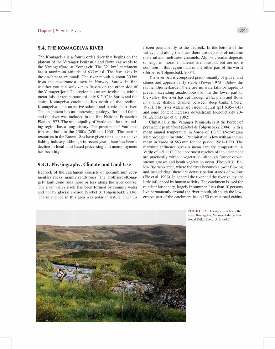
The Komagelva is a fourth order river that begins on theplateau of the Varanger Peninsula and flows eastwards tothe Varangerfjord at KomagvIr. The 321 km2 catchmenthas a maximum altitude of 633 m asl. The few lakes inthe catchment are small. The river mouth is about 30 kmfrom the easternmost town in Norway, Vardø. In fineweather you can see over to Russia on the other side ofthe Varangerfjord. The region has an arctic climate, with amean July air temperature of only 9.2 �C in Vardø and theentire Komagelva catchment lies north of the treeline.Komagelva is an attractive salmon and Arctic charr river.The catchment has an interesting geology, flora and faunaand the river was included in the first National ProtectionPlan in 1973. The municipality of Vardø and the surround-ing region has a long history. The precursor of Vardøhusfort was built in the 1300s (Willoch 1960). The marineresources in the Barents Sea have given rise to an extensivefishing industry, although in recent years there has been adecline in local land-based processing and unemploymenthas been high.
9.4.1. Physiography, Climate and Land Use
Bedrock of the catchment consists of Eocambrium sedi-mentary rocks, mainly sandstones. The Trollfjord–Koma-gelv fault zone runs more or less along the river course.The river valley itself has been formed by running waterand not by glacial erosion (Sørbel & Tolgensbakk 2004).The inland ice in this area was polar in nature and thus
frozen permanently to the bedrock. In the bottom of thevalleys and along the sides there are deposits of morainematerial and meltwater channels. Almost circular depositsor rings of moraine material are unusual, but are morecommon in this region than in any other part of the world(Sørbel & Tolgensbakk 2004).
The river bed is composed predominantly of gravel andstones and appears fairly stable (Power 1973). Below theravine, Bjørneskardet, there are no waterfalls or rapids toprevent ascending anadromous fish. In the lower part ofthe valley, the river has cut through a flat plain and flowsin a wide shallow channel between steep banks (Power1973). The river waters are circumneutral (pH 6.95–7.45)and ionic content increases downstream (conductivity 20–50 mS/cm) (Eie et al. 1982).
Climatically, the Varanger Peninsula is at the border ofpermanent permafrost (Sørbel & Tolgensbakk 2004), with amean annual temperature in Vardø of 1.3 �C (NorwegianMeteorological Institute). Precipitation is lowwith an annualmean in Vardø of 563 mm for the period 1961–1990. Themaritime influence gives a mean January temperature inVardø of �5.1 �C. The uppermost reaches of the catchmentare practically without vegetation, although further down-stream grasses and heath vegetation occur (Photo 9.3). Be-low Bjørneskardet, where the river becomes slower flowingand meandering, there are dense riparian stands of willow(Eie et al. 1996). In general the river and the river valley arelittle influenced by human activity. The catchment is used forreindeer husbandry, largely in summer. Less than 10 personslive permanently around the river mouth, although the low-ermost part of the catchment has �150 recreational cabins.
PHOTO 9.3 The upper reaches of theriver, Komagelva, Varangerhalvøya Na-tional Park. (Photo: A. Bjordal).
Chapter | 9 Arctic Rivers 351

A road open for vehicles reaches about 7 km into the valley,serving anglers and grouse hunters together with cabin own-ers. The road is closed in winter, but there is a snowmobiletrack. In summer, the reindeer herdsmen use ATV vehicles inthe catchment.
9.4.2. Geomorphology, Hydrology andBiogeochemistry
The catchment is susceptible to erosion and frost action isprobably a major source of river sediment. In a nearbycatchment, Julelva, the specific sediment yield was esti-mated at 23 tons/km2/year (Jim Bogen, personal commu-nication). There are no discharge records from Komagelva.However, data from neighbouring rivers show that thehydrological regime in the area is characterized by highflows during snowmelt (mid-May to mid-July) and lowflows in winter. The highest floods always occur duringsnowmelt. The lack of lakes in the Komagelva catchmentusually limits the duration of high flows in spring to about3 weeks (Berg 1964). Rain-induced floods in late summeror autumn are rare and relatively small. At the outlet intothe fjord, the mean annual discharge is calculated at8.3 m3/s (specific discharge 25.8 L/s/km2). The mean low-est annual discharge and the mean annual flood discharge,estimated on data from neighbouring rivers, are 0.7 and66 m3/s, respectively (Figure 9.2).
There are few observations of water temperature fromKomagelva (Eie et al. 1982). However, data from other riversin the area show that from early November to late May thewater temperature remains close to 0 �C, increasing rapidlyto �12–16 �C in July/August. The river is ice covered fromNovember to May and ice runs in spring can be relativelysevere. In some years there may be temporary ice runs duringautumn (Berg 1964).
9.4.3. Biodiversity
In general, the flora and fauna of the Varanger region is ofconsiderable interest because of its location between westernand eastern biogeographical elements. Among the easternplant species typical of the area are Allium schoenoprasumssp. sibiricum,Dianthus superbus,Oxytropis campestris ssp.sordida and Veronica longifola (Anon. 2004). The willowstands along Komagelva are considered of international in-terest (Anon. 2004).
Benthic densities are low above 300 m asl. In the lowerriver below Bjørneskardet, benthic densities are unusuallyhigh for the region, probably due to the high allochtho-nous inputs from dense riparian willow stands. The highbenthic biomass provides the basis for good salmonidproduction. Chironomids and mayflies dominated the ben-thos during July and August, and 8 species of mayfly, 11species of stonefly and 4 species of blackfly have beenrecorded (Eie et al. 1982) The fauna is typical of the
northern and eastern parts of Scandinavia. The small waterbodies along the floodplain of the river have a rich andvaried zooplankton fauna and 18 taxa have been recorded(Eie et al. 1982).
The fish community in the Komagelva consists of thespecies moving in from the west after the Ice Age: Arcticcharr, Atlantic salmon and brown trout, as well as three-and ten-spined sticklebacks (Huitfeldt-Kaas 1918). Theanadromous reach is only 33 km, but relative to its size,the Komagelva is an attractive salmon and sea charr river;giving annual catches of more than 6000 kg salmon in the1970s (Figure 9.4). The river has never been stocked withsalmon or other fish species. After the 1970s, the salmoncatches have been relatively stable at a significantly lowerlevel than before, although the reason for this is un-known. From 1905 to 2003, the mean annual recordedcatch of anadromous salmonids (Atlantic salmon, browntrout and Arctic charr) was 2.5 tons. Since 1983, Atlanticsalmon have constituted 78% of the catch. The salmonpopulation is dominated by grilse and the mean weightfrom 1990 to 1999 was 2.3 kg. They are known to beespecially shy and difficult to catch, probably due to thecrystal clear water and low discharge (Berg 1964). Pinksalmon have been stocked in the Barents Sea and WhiteSea basins from the Pacific Ocean since 1956, and fromyear to year some of these fish reach the Komagelva.They may also have come from some of the Norwegiansalmon rivers where they seem to spawn regularly, suchas the river Neiden on the south side of Varangerfjord.Spawning of pink salmon has not been documented in theKomagelva.
The marshes and wetlands along the river valley areimportant ornithological sites for among others red-neckedphalarope, red-throated diver and whooper swan (Systadet al. 2003). The endangered Arctic fox has one of its lastoutposts on the European mainland in the heart of the Var-anger Peninsula. The wolverine has always been present inthe Varanger Peninsula, but is seen as a constant threat to thereindeer husbandry.
9.4.4. Management and Conservation
The Komagelva was among the first group of Norwegianrivers protected against exploitation for hydropower in1973 (Kontaktutvalget Kraftutbygging – naturvern 1971).Most of the catchment is now included in the recently estab-lished 1804 km2 Varangerhalvøya National Park (Anon.2004). The area is highly pristine, and contains a suite ofdifferent biogeographical regions, special biotopes for pro-tection of plants and animals, river valleys, valuable coastalareas and cultural relics. The shoreline of the Varangerfjordsouth of the river mouth is a nature reserve because of itssand dunes and several ‘eastern’ plant species growing at theextreme western edge of their distribution. In 2003, the Nor-wegian Parliament included Komagelva as one of the
PART | I Rivers of Europe352

‘National Salmon Rivers’, the only one wholly in the Arctic(Anon. 2001).
9.5. THE VARZUGA RIVER
The Varzuga River is on the Arctic Circle in the southern partof the Kola Peninsula in northwest Russia. It flows southeastfrom Varzugskoie Lake and drains into the White Sea. It isone of the largest rivers on the Kola Peninsula with a lengthof 254 km and catchment area of 9510 km2. The primarytributaries are the Pana, Arenga, Serga and Kitsa Rivers(Photo 9.4).
9.5.1. Physiography, Climate and Land Use
Bedrock of the Kola Peninsula is dominated by granite andgneiss of the Baltic Shield, although there are extensiveQuaternary deposits. The catchment area consists of �50%wetlands and�50% forest. It is mainly low gradient marshytundra. The vegetation is dominated by lichen heath, birchtrees and willow scrub. In some locations, primarily on hills,conifers grow. Surface soils are peaty or sandy, but occasion-ally rocky.
The climate is characterized by long winters and coolsummers. The mean annual air temperature in the nearbyUmba village is 0.5 �C, with means of �11.0 �C inJanuary and 14.3 �C in July. Mean annual precipitationis 498 mm, with greatest amounts in summer (Anon.2003). Most of the catchment is unpopulated, but thereare two small villages, Kuzomen and Varzuga, near themouth of the river and 24 km upstream, respectively(Photo 9.4).
9.5.2. Geomorphology, Hydrology andBiogeochemistry
The headwaters are �200 m asl and the river has a meangradient of about 0.8 m/km. In the upper reaches, runs andsmall riffles of 25–40 m predominate. In the middle reaches,large pools are more common, in addition to some majorrapids, being especially frequent in the lower reaches. In theheadwaters, the river is 2–6 m wide, increasing to 20–40 min the upper reaches, 60–150 m in the middle reaches and upto 200 m in the lower reaches. In the lower 20 km, which istidal, the river can be up to 800 m wide. The mean dischargenear the village of Varzuga is 76.5 m3/s. The annual dis-charge regime is characterized by a spring flood, low dis-charge during summer, smaller floods during autumn andlow water levels in winter. The spring flood, lasting for 15–40 days, normally occurs in May and June. The lowest waterlevel during summer is usually observed in July. The riverfreezes in October–November and ice-break occurs in May.Riffles and runs become ice-covered 20–40 days later thanpools, while major rapids freeze only during the most severewinters. Anchor ice may form in riffle reaches. Water tem-perature rises rapidly during May, and increases to a maxi-mum of about 17 �C in July. In general, the waters of theVarzuga have low ionic concentrations due to low dissolutionof crystalline minerals in the catchment, and its water chem-istry has remained essentially unchanged for more than 50years (Ziuganov et al. 1998).
9.5.3. Biodiversity
Twenty native fish species occur in the River Varzuga(Jensen et al. 1997). Atlantic salmon is the predominant fish
PHOTO 9.4 The Varzuga River withVarzuga village in the background.(Photo: B. O. Johnsen).
Chapter | 9 Arctic Rivers 353

species, but brown trout, grayling, whitefish, pike, roach,minnow, perch and three- and nine-spined sticklebacks arealso common. The salmon stock in the Varzuga is one of thelargest in the world, and on average 70 000 spawnersascended the river annually during the last 15 years of the20th century (Kaliuzhin 2003). The Varzuga has two distinctsalmon runs. The summer run fish arrive in June to mid-August and spawn that autumn. In contrast, the autumn runfish arrive from mid-August onwards and continue upstreamuntil ice formation. They do not spawn in the year theyarrive, but wait until the following autumn before spawning(Jensen et al. 1998). Most salmon are grilse (1-sea-winterfish). Introduced pink salmon occasionally enter the river.Pink salmon have been introduced into the Barents Sea andWhite Sea basins from the Pacific Ocean since 1956. Theyare now established in some rivers on the Kola Peninsula andenter other rivers in the region (Berg 1977). The VarzugaRiver has the world’s largest population of freshwaterpearl mussels, estimated to exceed 100 million specimens(Ziuganov et al. 1994).
9.5.4. Management and Conservation
The catchment has not been subject to any major economicdevelopments. However, the salmon population has becomethe target of harvesting, providing an important source ofincome for local communities. Before 1958, nets operated inthe lower reaches were used to fish for salmon. After 1958,the river has been blocked by a barrier fence with a trap(‘Ruz’), which is installed annually at a site located 12 kmupstream from the river mouth. Usually, all ascending fishwere caught for commercial purposes each second day, whileon alternate days they were allowed to migrate freely. From1987 onwards, the fence has been operated every third day orless frequently. From 1961 to 1989, the catch of Atlanticsalmon varied between 33.4 and 161.2 metric tons, and av-eraged 72.5 tons (Jensen et al. 1997). In later years, severalcamps for recreational sport fishery have been established inthe river, mainly practising a catch and release fishery. Re-cent genetic studies (Primmer et al. 2006) indicate that thereis a significant degree of isolation between the salmon popu-lations of individual reaches and tributaries, suggesting thatthe preservation of a number of spawning sites spacedthroughout the tributary system is recommendable for ensur-ing sustainable fishing tourism in the river.
9.6. THE ONEGA RIVER
The Onega catchment is situated in the northern part of theEast European Plain and bounded by the Vetreniy Poyas andAndoma Uplands in the west, and the Onega–Dvina,Ozersk–Lebshina, and Sukhona–Dvina Uplands in the east.The Onega, a fifth order river, originates in Lake Lacha andflows north through the Vozhe–Latchensk and Onega low-lands and discharges into Onega Bay on the White Sea. The
Onega has a catchment area of 56 900 km2 and a river lengthof 416 km. There are more than 3000 lakes within the rivercatchment. The Onega catchment is entirely within theArkhangelsk Region. Over the centuries the river has servedas one of themain trade routes towards theWhite Sea. Beforethe port of Arkhangelsk was built at the mouth of the North-ern Dvina, Onega was the only large port in northern Russia.Thewaters of the Onega catchment are used for domestic andmunicipal services as well as for the timber industry.
9.6.1. Physiography, Climate and Land Use
The relief of the Onega catchment is a result of successiveglaciations, with undulating plains and hilly moraines. In thesouth, the glacial plains are at an altitude of 100–150 m asl.The river flows along an undulating, forested plain and formsa delta where it flows into Onega Bay. Rapids are frequentand in the upper reaches of the river the most difficult rapidsto pass have always been Kargopolski Rapids (388–370 kmfrom the mouth), in the mid-channel the BiryuchevskiRapids (212–190 km from the mouth), and in the lowerreaches the Kokorinski Rapids (25–18 km from the mouth).The spring flood in the upper reaches of the Onega lasts for 3months and discharge remains high during most of the sum-mer. Numerous cold springs discharge into the upper andmiddle reaches of the river, and the groundwater contributionto the Onega is 30–40%, the highest among comparablerivers in the region.
The catchment area has a temperate-continental climatewith short cool summers and long cold winters. The averageannual temperature in the south of the catchment at the townof Kargopol is 1.5 �C, and in the north at the town of Onega itis 1.3 �C. The average temperature of the warmest monthranges from 16.4 �C (Kargopol) to 15.9 �C (Onega). Meantemperatures usually are >0 �C in April, and temperaturesfall <0 �C in the latter part of October. The duration of thefrost-free period at the mouth of the Onega River is onaverage 107 days (Pylnikova 1989). The Onega catchmentbelongs to the zone of high humidity. The annual precipita-tion is about 600 mm, with highest rainfall from July toSeptember. The landscape is usually snow covered from lateOctober until late April, with a normal snow depth of 60–70 cm. The catchment is situated in the podzol soils zone ofthe north and middle Taiga. The primary soils originate fromQuaternary deposits: moraine and top-soil loams, and fluvio-glacial and ancient alluvial sand deposits. The Severo–Onezhsk bauxite deposits are associated with Carboniferouskarst limestones. The catchment is covered with coniferousforest, mainly pine.
9.6.2. Hydrology and Hydrochemistry
Thewidest ranges in water level recorded in the Onega Riverare 3.4 m in the upper reaches, 9.7 m in the mid-channel and6 m in the lower reaches. The largest recorded river
PART | I Rivers of Europe354

discharge was 4930 m3/s, the lowest 82.6 m3/s. The averageannual river discharge at the mouth is 535 m3/s. The meanspecific catchment runoff is 9.8 L/s/km2 (Figure 9.3). As arule, the average discharge of the spring flood is approxi-mately six-fold larger than mean discharge. However, theseasonal unevenness of the flow in the Onega is reducedby its lake source and the karst structure of the river catch-ment. The density of the hydrographic network is 0.39 km/km2. The ice regime of the river is complex, and the OnegaRiver has one of the shortest ice cover periods of the largernorthern rivers on account of rapids. At rapids and ground-water inflows, the ice cover is temporary. Freezing of theOnega River begins at its mouth in the north and spreadsupstream. In the upper reaches of the Onega, ice break usu-ally proceeds quickly and does not cause any problems,although lake ice remains longer. In the mid-channel andlower reaches there are usually two ice runs, the main onefrom the Onega and another from its tributaries.
Water chemistry of the Onega is strongly influenced bythe 90+ highly mineralized springs in the upper reaches. Theproportion of groundwater in the upper reaches of the riveramounts to 40–50%. During winter the mineral content is181–354 mg/L, decreasing during the spring flood and in-creasing again to 225 mg/L during low flows in summer. Atthe river mouth the mineral content is on average 20 mg/Llower. Bicarbonate and calcium are the predominant compo-nents. Up to 25% of the Onega catchment is boggy, resultingin high humic levels and high colour values (60–200�). Theaverage concentration of iron is 0.5 mg/L, but sometimes itexceeds 1.0 mg/L. The content of ammonia nitrogen lieswithin the range 0.04–0.30 mg/L. Oxygen deficiency (downto 49%) occurs during winter, but in summer, the averagesaturation is 70 to 90%. The waters are predominantly alka-line (pH 6.9–7.4) (Filenko 1974; Olenicheva 1990–1991).
9.6.3. Biodiversity
Data on aquatic biodiversity are scarce and fragmentary andto a large extent refer to animal populations.
In the Onega catchment, species of the genera Potamo-geton, Sparganium, Stratiotes,Hydrocharis, Typha, and rare-ly Petasites, have been recorded (Tolmochev 1974–1977;Potokina 1985). The following aquatic species are protected:Subularia aquatica, Lobelia dortmanna, Batrachium dichot-omum, Typha angustifolia, T. latifolia, Spirodela polyrrhiza,Zostera marina and several species of sedge (Andreev 1995).
The planktonic fauna of the Onega includes 72 species,mostly Cladocera, but also Copepoda (Cyclopidae, Cala-noida) and Rotifera (Gordeeva 1983). The composition issimilar to that of the Northern Dvina, the main part consist-ing of widespread species of Bosmina, Chydorus, Mesocy-clops and Euchlanis. The fauna of the upper reaches consistspredominantly of limnophilous species. The average densityof zooplankton is 483 000/m3, giving a biomass of 3.7 g/m3.Due to high current speed and sediment load in the middle
reaches, zooplankton here are mostly bottom-dwelling spe-cies in areas near banks. Zooplankton diversity increases inthe lower reaches due to the slower current.
Sixteen macroinvertebrate groups have been recorded inthe drift (Shubina et al. 1990). Mayflies, blackflies and chir-onomids were the most numerous, although caddisflies werealso an important part of the biomass. The zoobenthos ismainly composed of chironomids, mayflies, stoneflies,blackflies, beetles, molluscs and worms (Gordeeva 1983).In summer, the average density is 968/m2, giving a biomassof 6 g/m2. On sandy-silty substrates, molluscs (Pisidium)make up 70% of the biomass. On clay-sandy substrates thecommunity is characterized by a predominance of chirono-mids and oligochaetes constituting the main part of the bio-mass. The numbers of molluscs is limited by high currentspeed. In the stony bottom community, Cryptochironomus,Pisidium and hydropsychid Trichoptera are frequent.
There are 32 species of fish from 13 families in theOnega, including pink salmon, Atlantic salmon, brown trout,vendace, northern whitefish, powan, inconnu, and grayling(Novoselov 2000). Sterlet, northern whitefish and pink salm-on are among the introduced species. Ten species of amphi-bians and reptiles have been recorded within the limits of theOnega catchment (Kuzmin 1999). The majority of the spe-cies are widely distributed from the headwaters to the rivermouth, but the crested newt is restricted to southern areas ofthe catchment.
There are 182 species of breeding birds in the Onegacatchment within the limits of the Arkhangelsk and Vologdaregions (Dementiev & Gladkov 1951–1954; Ivanov &Shtegman 1978; Sviridova & Zubakina 2000). The songbirds have the greatest number of species, followed by sand-pipers, waterfowl, birds of prey and owls. The majority aremigrating species and only 45 species inhabit the catchmentthroughout the whole year. The avifauna is dominated byspecies widespread in the Palearctic, followed by species ofEuropean and Siberian origin. There are few Arctic species.In the catchment, 52 species of mammals have been recorded(Geptner et al. 1961, 1967; Dinets & Rotshild 1996), with 51species recorded in the southern part of the catchment and 44species in the lower reaches. The southern area forms thenorthern limit for several species of mammals (hedgehog,bat, harvest mouse, common vole, European polecat and roedeer). In contrast, arctic foxes only occur in the northern partduring their autumn–winter migration.
9.6.4. Management and Conservation
The Arkhangelsk Region Red Book (Andreev 1995)includes the fish species inconnu and bullhead. As they areat their northern limit and low in numbers, four amphibians(Anguis fragilis, Lacerta agilis, Natrix natrix and Viperaberus) are also included in the Arkhangelsk Region RedBook. Twenty-one species of birds are included in the RedBook of the Russian Federation. An additional 53 species on
Chapter | 9 Arctic Rivers 355

the decline or at the northern limit are included in the RedBook of the Arkhangelsk Region. Among the introducedmammals are representatives of the American muskrat andAmerican mink, and Far Eastern raccoon dog. At the begin-ning of the 20th century, beaver were reintroduced. Manymammals that are at their northern limits in the catchmentare included into the regional Red Book due to low numbers.The Kenozersky, Vodlozersky and Russian North NationalParks are located in the Onega catchment. The main aim isprotection and promotion of the recreational use of northernmid-taiga forests and a number of historical and culturalsites. In 2005, the Kenozersky National Park was includedin the list of UNESCObiosphere reserves. The KozhozerskiyReserve and seven game preserves are also in the catchment(Yermolin 1991; Kulikov 1995).
9.7. THE NORTHERN DVINA RIVER
The Northern (Severanaya) Dvina, a seventh order river, hasthe largest catchment in Europe and discharges into theArctic Ocean (Photo 9.5). It has the second highest dischargeafter the Pechora. The catchment is located in the northernpart of the East-European Plain. It is bounded in the west bythe Onega–Dvina Plateau and in the east by the Dvina–Mezen Plateau and the Timansky Ridge in the VychegdaRiver catchment, which forms the border with the catchmentof the Pechora River. The southern part the catchment islocated in the high areas of the Northern Ridges that formthe main watershed of the Russian Plain and separates thecatchment from the rivers flowing north from the Volgacatchment. The Northern Dvina catchment comprises357 000 km2, and it is 744 km from the junction of theSukhona and the Yug Rivers to the sea.
The geographical position of the Northern Dvina, with itsproximity to the Volga catchment and its relief, has given it avital role in the history of Russia. The river network andlakes of the catchment’s southern border (including theSukhona River and Kubenskoe Lake) form a part of theNorthern Dvina waterway, constructed in 1825–1828, con-necting the catchments of the White Sea and the CaspianSea. It starts on the Sheksna River near the community ofTopornaya and ends on the Sukhona River at the well-knownZnamenity Lock. The total length of the system is 127 km.The Sukhona River is one of the Russian rivers where peoplehave always tried to improve navigation conditions, and evenin 1278 Russian princes attempted to regulate various diffi-cult bends in the river channel.
9.7.1. Physiography, Climate and Land Use
The relief of the Northern Dvina catchment was formed as aresult of glaciation that caused topography of undulatingsurfaces and hilly moraines. In the south of the catchment(in the Vologda Region), glacial valleys reach around 100–150 m asl. The Dvina–Mezen Plain slopes gently north to-wards the White Sea. The plains are forested and mainlyboggy. In the north, it gradually changes to the Primorskayacoastal plain at 5–75 m asl. In the east and northeast, theMezen–Vychegda plain meets the Northern Ridges at 250–270 m asl. In the northeast, the Timansky Ridge separatesthe catchment from the Pechora catchment. Towards theOnega–Dvina divide is an undulating plain at 100–200 m asl, with hills up to 250 m asl and where the lowerparts are boggy. In the southeast there is a plateau withaltitudes up to 150–200 m asl. The southern part is formedby the Sukhona–Volga watershed, while in the east it
PHOTO 9.5 The Sysola River,Northern Dvina basin, looking down-stream (Photo: V. Ponomarev).
PART | I Rivers of Europe356

stretches along the western slopes of the Northern Ridges. Inthe Timan Range there are karst formations.
The climate of the region is characterized by a low num-ber of sunshine hours in winter due to the influence of thenorthern seas and intensive western movement of air massesfrom the Atlantic. This also leads to changeable weatherthroughout the year. The short, cool summer lasts for 2–3months, with a mean monthly temperature of 16–17 �C, butwith frosts possible in anymonth. Autumn starts during earlySeptember with temperatures down to �2 to �4 �C. Thecommon autumn weather pattern is rainy with frequentthaws (Kobysheva & Narovlyansky 1978). In October, coldarctic winds are followed by a decrease in temperature to�10 to�15 �C. Winter starts in late October and lasts for 5–6months. Themean temperature in January is�20 �C. Snowcover is stable and blizzards frequent. Winter precipitation is110–200 mm, while summer rainfall is 400–500 mm.
The main soil-forming strata in the Northern Dvinacatchment include overburdens of drift clay and blanket clay,fluvio-glacial sediments and fossil alluvial sand sediments.The catchment is located in the area of podzolic soils of thenorthern, sub- and southern taiga. The terrain is mainlycovered with coniferous forests and peat bogs. Sparse tim-berlands are characteristic of the northern taiga, while to thesouth there are large areas of dense, fast growing coniferousforest.
9.7.2. Hydrology and Hydrochemistry
The smaller river valleys are up to 10–50 m deep and severalhundreds metres wide, while the large rivers have a trapezoidvalley profile with a wide flat bed. In the lower reaches of theNorthern Dvina the valleys are shallow with gently slopingsides. The Northern Dvina River is formed by the junction ofthe Yug River (catchment area 35 600 km2) and the SukhonaRiver (50 300 km2), in whose estuary there is the historictown of Veliky Ustug. The Vychegda River (121 000 km2)flows into the Northern Dvina 74 km downstream. TheVychegda River is the largest tributary on the river. Down-stream of the confluence, the Northern Dvina is called the‘Big’ Northern Dvina. Kotlas, at the mouth of the VychegdaRiver, is the second largest city in the Arkhangelskaya Re-gion. It is an important river port and railway junction in theEuropean North of Russia, established in 1899. The hydro-graphic network frequency of the Yug River is 0.72 km/km2,that of the Sukhona is 0.52 km/km2 and that of the Vychegda0.62 km/km2. At 362 km from the mouth, the Vaga River(catchment 44 800 km2) flows into the Northern Dvina fromthe left bank. From here, the river flows through gypsumstrata almost down to the mouth. At 137 km, the right banktributary, the Pinega River (42 000 km2), flows into theNorthern Dvina just upstream of the estuary. The river is600–800 m wide, increasing to 2.0–2.5 km at the estuary.In general, the density of the hydrographic network is0.58 km/km2; and the total length of all waterways in thecatchment is more than 206 000 km.
The river is mainly fed by precipitation and snowmelt(Figure 9.3). Groundwater is insignificant and patchy, al-though in the southeast mineral springs play some role ingroundwater supply. The river carries a high sediment loadthat contributes to forming the vast multi-channel delta.Extensive floodplains with terraces are typical of mosttributaries. There are long reaches with sandbanks, althoughmost rivers, except for the Vychegda, do not meander. Riverwater solute concentrations are usually 200–450 mg/L, butsometimes fall to 100 mg/L. Bicarbonate, calcareous watersdominate. In the Northern Dvina estuary, solute concentra-tions reach 13 000 mg/L due to intrusion of salinewater up tothe Mekhrenga and Kuloy Rivers. In such cases, the concen-tration of chloride can reach 5.6 mg/L and that of sodium upto 3100 mg/L. Water colour varies from 30 to 250�, dichro-mate oxidation is about 13–80 mg/L, but in the estuary it canreach 188 mg/L. Iron concentrations vary widely (130–3570 g/L), as does ammonium (70–2200 mg/L). The watersare saturated in oxygen for most of the year, but duringwinter ice cover values may fall to 12–27%. The pH is inthe region of 6.5–7.8 (Olenicheva 1990–1991; Filenko1974).
9.7.3. Biodiversity
The Northern Dvina phytoplankton is typical of lowlandrivers (Bryzgalo et al. 2002), mainly consisting of diatomsand green algae, with Asterionella and Aulacoseira beingdominant, and Cyclotella and Stephanodiscus occurring insome areas. In warm periods, Anabaena increases in number.In the estuary, phytoplankton includes Fragilaria, Diatoma,Nitzschia, Scenedesmus and Pediastrum. Cyanobacteria arerepresented by species of Microcystis, Anabaena and Mer-ismopedia. Their densities change from 400 to 6 000 000/Laccording to locality and season. At pulp and paper milldischarges the density of algae decreases.
According to Korde (1959), Vychegda River phytoplank-ton includes 110 algal taxa and 13 Cyanobacteria. Mostdiversity and highest densities are in diatoms, followed byCyanobacteria (Anabaena and Aphanizomenon). In somelakes, algal blooms have been recorded. The density of algaevaries from 84 to 503 000/m3. In upstream reaches there are150 taxa with diatoms having the greatest diversity (Getsen& Barinova 1969). The main genera are Epithemia, Cocco-neis, Synedra, Achnanthes, Fragilaria, Diatoma, Gompho-nema, Melosira, Cymbella and Rhoicosphenia. In hillyreaches, Ulothrix, Cladophora, Spirogyra, Oedogoniumand Chantransya are common and stones are often coveredwith the Cyanobacteria, Nostoc.
Characteristic genera for the Northern Dvina catchmentare Potamogeton, Sparganium, Equisetum, Sagittaria, Cer-atophylla and Petasites (Tolmachev 1974–77; Zvereva 1969;Potokina 1985; Vekhov 1990). In the Northern Dvina delta,subject to brackish water, Triglochin, Mertensia and Zanni-chelia occur. The downstream ecosystems have changed due
Chapter | 9 Arctic Rivers 357

to human use of the floodplain (Vekhov 1990, 1993) andUtricularia, Myriophyllum, Potamogeton, Nuphar, andButomus are becoming rare. In enclosed channels Hydro-charis, Stratiotes, Sparganium and Lemna are present, whilein coastal zones Caltha, Alisma, Polygonum, Carex, Equise-tum and Typha are found. In places showing anthropogenicimpacts, Elodea canadensis is often dominant (Postovalova1966; Teteryuk 2003).
The Northern Dvina zooplankton is rich in Bosmina,Chydorus, Mesocyclops and Euchlanis species (Gordeeva1983). Holopedium, Daphnia, Pleuroxus, Podon and Ecto-cyclops are also common. In the area near the estuary, thereare 122 species of macroinvertebrates (Semernoy 1990),including sponges, oligochaetes, leeches, molluscs and chir-onomids. Oligochaetes and chironomids are most diverse,while Isochaetides, Orthocladius and Mollusca are the mostnumerous. Mean zoobenthos density and biomass is 6800/m2 and 11.3 g/m2, respectively. Typical genera among mol-luscs are Planorbis and Valvata, and among Chironomidae,Limnochironomus and Procladius (Yepishin & Yelsukova1990). In polluted areas, Rotifera dominate, in particular,Brachionus (Bryzgalo et al. 2002), while zoobenthos densi-ties increase due to higher numbers of oligochaetes.
In the Vychegda River, zooplankton includes 44 taxa ofRotifera and 31 taxa of Cladocera (Korde 1959). On average,rotifers constitute 96% of numbers. Zooplankton is similar tothat of the Northern Dvina. Densities vary from 10 000 to253 000/m3 (Zvereva 1969). Zoobenthos includes 17 groups,dominated by Chironomidae, and Oligochaeta and molluscsin some areas (Zvereva 1969; Leshko 1998). There are 51species of molluscs, with the genera Anisus, Lymnaea andSphaerium most numerous (Leshko 1998).
The fish fauna includes 41 species from 14 families(Solovkina 1975; Novoselov 2000) such as Atlantic salmon,vendace, powan, inconnu and grayling. As a result of intro-ductions, river fishes also include Danubian bream, asp,spined loach, northern whitefish, zander and pink salmon.In the Northern Dvina, there are 11 species of amphibiansand reptiles (Anufriev & Bobretsov 1996; Kuzmin 1999).Many species are at their northern limit, and Tritutus vul-garis, T. cristatus, A. fragilis, N. natrix and V. berus arecommon only in the southern taiga and sub-taiga zones,while the other species are recorded north towards the estu-ary. The Northern Dvina is the western border for Salaman-drella keyserlingii.
At present, breeding birds in the Northern Dvina catch-ment, including territories from the southern taiga to shrubtundra include 16 orders (Yestafiev et al. 1995, 1999; Svir-idova & Zubakina 2000). The northern border of 88 breedingbird species lies within the catchment. The highest birddiversity, 195 species, is typical of the headwater and mid-reaches. Further north, the avifauna is poorer, and in thelower reaches there are 107 species. There are 56 non-mi-gratory species in the Northern Dvina catchment. In thesouthern and central parts of the Northern Dvina, birds com-mon for the Palaearctic region are most usual, although
species of European and Siberian origin are also typical. Inthe north, birds of Siberian and Arctic origin are common,including waterfowl and sandpipers. In the south, there aremany birds of prey, owls, pigeons, doves, woodpeckers andsong birds. Since the beginning of the 20th century, popula-tions of some 40 species, mainly European or commonPalaearctic species have moved northwards. In contrast, par-tridges have moved south, while they were earlier typical inzones up to the sub-taiga (Kochanov 2001).
There are 56 species of mammals recorded in the North-ern Dvina catchment (Geptner et al. 1961, 1967; Anufriev etal. 1994; Polezhaev et al. 1998). In the southern, middle andpartially in the northern taiga, there are 51 species comparedto 38 species in downstream areas. The borders of the sub-taiga and northern taiga form the limit of species such aswater shrew, hedgehog, polecat, bats, raccoon dog, wild boarand roe deer. Lemming, narrow-headed vole and Arctic foxall inhabit the tundra. In the middle of the 20th century, newspecies were introduced: muskrat, American mink and rac-coon dog, and European beaver were reintroduced.
9.7.4. Management and Conservation
For many centuries, the Northern Dvina has served not onlyas the main waterway of Russia, connecting its centre to theNorth, but also to Europe. At present, the main industries inthe Northern Dvina catchment are timber, wood processing,pulp and paper, mechanical engineering, ferrous metallurgy,light industry and food production.
The macrophytes, Oenanthe aquatica, Nimphoides pel-tatum, Elatine hydropiper,Mertensia maritima, S. aquatica,Nuphar pumila, S. polyrrhiza, Zannichelia pedunculata, T.angustifolia, L. dortmanna, Ranunculus lingua and Eleo-charis quinqueflora are among the protected species(Andreev 1995; Taskaev 1998). Triglochin, Potamogetonand Veronica anagallis-aquatica are classified as vulnerable.
The Pinega Reserve, created in 1974, and 16 reservesaimed at preserving and enhancing rare species and lakeecosystems are in the Northern Dvina catchment (Yermolin1991). In the Komi Republic, there are three specially pro-tected water bodies, six ichthyological reserves in the catch-ments of the Vym, Sysola and Vychegda and complexreserves like the one on Sindor Lake (Taskaev et al. 1996).The fishes, inconnu and bullhead, are listed in the Red Booksof the Arkhangelskaya and the Vologodskaya regions. Due toa limited and sporadic distribution and low numbers, fivespecies of reptiles and amphibians have been included in theRed Books of the Arkhangelsk region and the Komi Repub-lic (Taskaev 1998). Some 22 species of birds are listed in theRed Book of the Russian Federation. Due to low populationsize, around 60 species located in the northern areas arelisted in the Red Books of the Komi Republic, the Arkhan-gelsk Region and the Vologodkaya Region. Many mamma-lian species inhabiting the northern borders of theirdistribution also have small populations and have been en-tered into regional Red Books.
PART | I Rivers of Europe358

9.8. THE MEZEN RIVER
The Mezen, a sixth order river, is one of the longest andlargest in northeast Europe with a length of 966 km andcatchment area of 78 000 km2. It originates at ChetlasskyStone (500 m asl) in the North Timan and enters the MezenBay of the White Sea. The Vashka River is the largest tribu-tary with a length of 605 km and catchment area of21 000 km2. It enters the Mezen 192 km from the estuary(Zhila 1965). Administratively, 400 km of the Mezen is sit-uated in theKomiRepublic (43.5% of the catchment), and therest is within the Nenets National District of the ArchangelskRegion. The main part (75% of the area) of the Vashka Riverflows through the Komi Republic. Themain communities arethe towns of Koslan and Usogork and the 16th century townof Mezen at the estuary (Ilyina & Grakhov 1987).
9.8.1. Physiography, Climate and Land Use
The springs that form the source of the Mezen River aresituated between the bogs near Chetlassky Stone. The riverruns first south and then northwards, flowing along the west-ern slope of Timan Ridge. Much of the catchment is flat,mostly at altitudes of 130–180 m asl. The river catchment isunderlain by Permian, Triassic and Jurassic rocks, and over-lain by Quaternary deposits up to 20 m deep. The soils aremostly podzolic and boggy, although humus soils occur inTiman Ridge area. The Mezen catchment lies mainly withinthe sub-zones of the central and northern taiga, forests con-stituting 87% and bogs 12% of the area.
Frequent changes of air masses characterize the climate inthe Mezen catchment. Proximity to the ocean also has animpact on climate. From south to north, mean annualtemperature decreases from 1.2 �C (Kotlas) to �1.1 �C(Mezen). Throughout most of the catchment, January is thecoldest month, but February is the coldest in the Mezen estu-ary. Mean daily temperature falls to�44 �C during extremelysevere winters on the coast of the White Sea. In contrast, anabsolute maximum temperature of 35 �C has been recorded inJuly. Spring usually starts in early April, while summer beginsin early June. By the end of September, the mean daily tem-perature falls to 5 �C. Winter starts at the end of October andlasts until the beginning of May. Runoff is 50–55% of theannual precipitation of �600 mm. About 200 mm precipita-tion is stored in the snow pack before being released in thespring thaw (Zhila & Alyushinskaya 1972; Anon. 1989).
9.8.2. Geomorphology, Hydrology andHydrochemistry
The Mezen catchment covers a considerable part of north-east European Russia. The mean annual discharge to theWhite Sea is 858 m3/s (Table 9.1, Figure 9.3), which is givesa total yearly freshwater volume of >27 km3. The MezenRiver is a typical northern river, characterized by high flows
during the spring thaw, low flows during summer, inter-rupted by flash floods, as well as by very low winter flows.Widespread karst systems in the Timan Ridge provide muchof the source water for the Mezen River and its tributariesand reduce variation in discharge. In upstream areas, theMezen River is 0.5–1 km wide, but when it turns north itswidth increases to 2–5 km. At the town of Mezan, the river is3–4 km wide. Floodplain terraces, often complex and up to200 m wide, are noticeable along the river valley. In theestuary, water levels have an amplitude up to 7.6 m and theriver is tidal >60 km upstream (Ilyina & Grakhov 1987).
The hydrochemistry of the Mezen system was studiedfrom 1987 to 1990 by Khokhlova (1997). The waters arecharacteristically rich in calcium carbonate, with TDS con-centrations of 2.8–200 mg/L, depending on season. In thetributaries of the Vashka River (Evva River), the concentra-tion of major ions reaches 300 mg/L. There are also in-creased concentrations of sulphates and sodium ions due tounderground karst sources. Rivers of the Mezen catchmentvary in content of organic and inorganic compounds. Colour,permanganate and dichromate values vary between 10 and168�, 3.7–23.0 and 7.6–59.1 mg/L, respectively. Highconcentrations have been recorded for ammonia (up to1.78 mg/L) and iron compounds (up to 0.90 mg/L). Pollu-tants such as phenol (2–28 mg/L) from forestry and copper(2–17 mg/L) from natural sources exceed maximum permis-sible levels in fishery areas.
9.8.3. Biodiversity
Most of the available information on biodiversity is from theupper and middle reaches of the Mezen and some of itstributaries.
A total of 168 diatom taxa have been recorded in non-planktonic communities in theMezenRiver and its tributaries,such as the Vashka, Ertom, Evva and Pozh. Epilithon is abun-dant, with Fragilaria, Achnanthes, Epithemia and Cocconeismost common. Tributaries are rich inMelosira and Gompho-nema and other genera. Cocconeis placentula and Melosiravarians are commonly recorded.Most of the dominant speciesare considered to be indicators of high nutrient content (Ste-nina 1997). Their development is favoured by macrophytespresent in the slow-flowing river and the alkaline waters.
The most common genera in the Mezen River are Pota-mogeton, Sparganium, Sagittaria, Batrachium, Stratiotes andHydrocharis (Tolmachev 1974–1977; Shmidt & Sergienko1984; Leshko 1998). The estuary is rich in Triglochin marti-mum. Potamogeton and Petasites are widespread in slow-flowing reaches with sand-silt substrataMyriophyllum, Eleo-charis, Sagittaria and Uricularia are also present. Aquaticmosses such as Fontinalis and Dichelima cover stony andsilty bottom (Shubina & Zheleznova 2002). River banks arecolonised by Carex, Equisetum, Comarum, Alisma and Buto-mus. Allium, Pinguicula and Aster are found in the moist andstony towpaths and stony headlands (Lashenkova 1970).
Chapter | 9 Arctic Rivers 359

Zooplankton consists of rotifers, cladocerans and cope-pods (Leshko et al. 1990). Numbers and biomass are ex-tremely low, with maximum values of 790/m3 and 0.006g/m2, respectively (Zvereva & Ostroumov 1953). Euricer-cus, Simocephalus, Polyphemus, Scarpholeberis and Acro-peruus dominate the near shore zone and slow-flowingreaches of the river. The zoobenthos includes Hydra, Nema-toda, Oligochaeta, Mollusca, Araneina, Hydracarina, Har-pacticoida, Cladocera, Ostracoda, Copepoda, Collembola,Odonata, Ephemeroptera, Plecoptera, Coleoptera, Trichop-tera, Simuliidae, Chironomidae Heleidae and Diptera (Zver-eva & Ostroumov 1953; Leshko 1996; Leshko et al. 1990;Sidorov et al. 1999). Chironomids are abundant, up to 2300/m2. The biomass in the slow-flowing middle reaches is dom-inated by Mollusca (up to 3.2 g/m2). A study carried out in1997 (Sidorov et al. 1999) showed that Chironomidae andEphemeroptera dominated the biomass in upstream reaches.Chironomidae on stony substrates include 87 taxa (Kuzmina2001), the most common being Orthocladius, Microten-dipes, Thienemanniella, Tanytarsus and Cladotanytarsus.The benthos in the tributaries has a similar composition(Martynov et al. 1997), although Chironomidae are morenumerous; from 1700 to 9700/m2. Coleoptera, Trichopteraand Chironomidae are major contributors to the zoobenthicbiomass. There are 57 species of molluscs (Leshko 1998),the most important are in the genera Cincinna, Anisus andLymnaea. Leeches are widespread, especially the generaPisciola and Helobdella (Lukin 1954).
The fish fauna of the Mezen consists of 28 species from11 families (Solovkina 1975). The most important are thenative species, Atlantic salmon, powan, inconnu and gray-ling, as well as the non-native pink salmon. One reptilianspecies (Lacerta vivvipara) and three amphibians (S. key-serlingii, Rana arvalis, Rana temporaria) are recorded fromthe catchment (Anufriev & Bobretsov 1996; Kuzmin 1999).The fauna of nesting birds is represented by 156 species(Yestafiev et al. 1995, 1999), compared to 30 species win-tering in the region. Bird communities are composed ofwidespread Palearctic taiga species, as well as Siberianand European species. There are 45 mammal species in theMezen catchment (Geptner et al. 1961, 1967; Polezhaevet al. 1998; Anufriev 2004), most of which are widespreadacross the entire catchment.
9.8.4. Management and Conservation
A number of protected areas (zakazniks) have been createdin the Mezen catchment, primarily for protection of thelandscape and bogs/forests (Yermolin 1991; Taskaev et al.1996). In terms of the fishery, the Mezen River and itstributaries is one of the most valuable river catchments inNW Russia. Nymphaea candida, N. pumila, Spirodela poly-rrhiza are protected species (Andreev 1995). The vascularplants, Triglochin maritimum and Sparganium microcarpumas well as the moss,Dichelima falcatum, have decreased due
to anthropogenic impact (Taskaev 1998) and are vulnerable.The fishes, inconnu and bullhead, are listed in the regionalRed Book of the Komi Republic and Archangelsk region(Andreev 1995; Taskaev 1998). The Siberian salamander,S. keyserlingii, is included in the Red Book of the Arch-angelsk region and Komi Republic. This species occurs spo-radically in the middle reaches of the Mezen, mainly in thehigher wetlands.
The natural taiga landscape, plentiful forage and theabsence of human disturbance help to preserve rare andprotected birds. The Red Book of the Russian Federationincludes12 species, while the regional Red Book of the KomiRepublic and Archangelsk region lists an additional 18threatened or decreasing bird species. Naturalized mammalsinclude the muskrat and raccoon dog, while the beaver hasbeen reintroduced. The list of protected mammals includessix species from the northern areas (taiga shrew, Northernbat, Russian flying squirrel, Siberian chipmunk, Europeanmink and badger) in the regional Red Books of the Arch-angelsk region (Andreev 1995) and Komi Republic (Taskaev1998). The Mezen River catchment is little developed eco-nomically, but in the long-term there is potential for forestryand agriculture. Nevertheless, intensive deforestation hascaused impoverishment of zoobenthos in some reaches(Leshko 1996, 1998).
9.9. THE PECHORA RIVER
The Pechora, a 12th order river, has the highest mean dis-charge of European rivers flowing into the Arctic Sea. Itsoccupies the vast Pechora lowlands bordered by the UralMountains in the east and by the Timansky Ridge in the westand southwest, dividing the Pechora from catchments of theNorthern Dvina, Mezen and Volga Rivers. The Pechoracatchment covers 322 000 km2 and the river is 1809 km long(Photo 9.6). The original colonization of the region started inthe Palaeozoic around 300 000 years ago. The earliest ar-chaeological remains are at the Mamontova kurya site in themiddle reaches of the Usa River, the largest right-hand trib-utary of the Pechora. The Finno-Permian tribes, ancestors ofthe present-day Finnish people, appeared in the region in theLate Stone Age (3000–4000 BC). The ancestors of Komipeople, the present-day indigenous people, appeared in thisarea in the first millennium BC. The far northern regions(tundra, forest tundra) were populated by the Ugro-Samodiantribes in the Middle Ages. They engaged in deer hunting,fishing and hunting marine animals (Stolpovsky 1999;Spiridonov 2001).
9.9.1. Physiography, Climate and Land Use
The catchment of the Pechora River is in the northeast partof the East European Plain and also partly in the UralMountains. The catchment is divided into three main or-thographic provinces: the Pechora lowlands, the Timansky
PART | I Rivers of Europe360

Ridge and the Urals. The northeast part of the catchment iswithin the boarders of Bolshezemelskaya tundra which is ahilly plain with numerous moraines and ridges at 200–350 m asl. Between the moraines and ridges are manylakes, mostly of thermokarst origin. The northwest partof the Pechora River is occupied by the Malozemelskayatundra. The Timansky Ridge, with an average altitude ofabout 190 m asl and peaks of around 400 m asl (ChetlasskyKamen at 463 m asl), forms the west and southwest part ofthe catchment (Zhila & Alyushinskaya 1972). The east partof the catchment is formed by the Ural Mountains withmaximum altitudes of 1600–1800 m asl (Gora Naroda1895 m) and small glaciers in the highest parts. The Uralsin the Pechora River catchment are 20–50 km wide in thenorth and 60–100 km wide in the south. The Ural Moun-tains capture the moisture-laden air, giving rise to highflows in the rivers flowing from the western slopes. Themain mountain rivers (Upper Pechora, Ilych, Shugor,Kosyu) flow in broad valleys. The mountains are mainlycomposed of metamorphic and igneous rocks, although asin the Timansky Ridge, karst structures are widely devel-oped in the Ural foothills, influencing the hydrology ofsmaller rivers.
The central part of the Pechora catchment is occupied bythe Pechora Lowlands, a flat area overlain with 100 m ormore moraine material (Rykhter 1966; Efimov & Zaitsev1970). The topsoil of the catchment’s largest part, from60� latitude southwards, is podzol, loam and sand, while intundra areas waterlogged gleysol soils dominate. Vast peatbogs are widely distributed throughout the catchment. Thelargest European wetlands are situated in the catchment: theUsinsky wetland between the Usa and Pechora Rivers andMartosheveksky wetland between the Pechora and MylvaRivers.
The vegetation is mainly coniferous forest, the forestcoverage increasing from 60% in the north to the 90% insouth. In tundra and forest tundra that cover <30% of thecatchment, the forests are thin and trees scattered. About20% of the Pechora catchment is in the permafrost region(Bolshezemelskaya and Malozemelskaya tundra). In the ex-treme northeast, permafrost is continuous, its thicknessreaching 250–300 m. The degree of intermediate permafrostincreases southwestwards. On the left-bank of the PechoraRiver catchment, permafrost is either absent or only found ina few areas (Efimov & Zaitsev 1970).
The large size of the Pechora catchment, both longitudi-nally and latitudinally as well as differences in relief, resultsin considerable climatic heterogeneity. The average annualair temperature is always below zero, decreasing from thesouthwest (�1.0 to �1.3 �C) to the northeast (�3.5 to�5.0 �C). The warmest month is July, the coldest is Januaryor February. The absolute minimum temperature has beenrecorded in the Urals (�55 �C) and in the southern part of thecatchment (�54 �C). The absolute maximum for the mainpart of the catchment is 34–35 �C, in the northern part 31–33 �C. The earliest daily average air temperature above 0 �Cis in the southern part of the catchment (14–18 April), thelatest in the Polar Urals (28 May). In autumn, the average airtemperature falls below 0 �C in southern parts of the catch-ment between 10 and 15 October, and in the north and in themountains between 1 and 10 October. The average durationof the period with above 0 �C temperature varies from thesouth to the northeast from 160–180 days to 125–150 days(Anon. 1989).
The highest annual rainfall occurs on the slopes of theUrals (800–1000 mm), increasing with altitude (Kemmerikh1961; Taskaev 1997). In the lowlands, precipitationincreases from north to south, from 550 to 700 mm. About
PHOTO 9.6 Valley of the PechoraRiver, middle section (Photo: V. Pono-marev).
Chapter | 9 Arctic Rivers 361

30–35% of the annual precipitation falls in winter, with aminimum in February and a maximum in October. The av-erage date for snow cover is 7–10October in the north, 28–30September in the Polar Urals and 5–13 October in the rest ofthe region. The snow cover remains for about 190 days in thesouthwest and 230 days in the extreme northeast. Snowmeltstarts in the middle of May in the southwest and at thebeginning of June in the northeast (Anon. 1989).
The oldest settlements in the catchment, including thecommunities of Pustozersk, Ust’-Tsylma and Izhma, werefounded between the end of the 15th century and the middleof the 16th century. Until the 1930s, economic activity in thePechora catchment was restricted to agriculture, deer ranch-ing, logging, hunting and fishing.Whenmajor coalfields werediscovered in the northern part of the Usa River catchment atthe beginning of 1930s, the coal-mining industry was devel-oped (Chernov 1989). In the coal mining areas, the cities ofVorkuta and Inta were founded, together with associated in-dustries. At the same time, the first oilfield (1932) and gasfield (1935) were discovered and industrial developmentstarted in the Timano–Pechorsky oil and gas bearing provincein the Izhma River catchment. The most intensive develop-ment took place in the 1970s, based on the discovery of majoroil and gas fields in the Bolshesemelskaya tundra, and Ukhtaand Sosnogorsk in the Izhma catchment received new impe-tus for their development. In addition, new centres developed,including Naryan–Mar at the mouth of the Pechora River,Usinsk at the mouth of the Usa River and Vuktyl on the rightbank of the middle Pechora River. At present, the energyindustry plays a leading role in the regional economy. Thereare large thermal plants operating in Pechora, Vorkuta andInta using local raw materials. The main railway in thePechora region was built in the 1940s and connected thecentral Russian cities with the cities of the Komi Republic.A system of oil and gas pipelines was also developed. Moretraditional branches of the economy, the timber industry,agriculture and fishing, deer ranching and shipping developedsimultaneously with these other industries.
9.9.2. Geomorphology, Hydrology andHydrochemistry
The Pechora River originates from a small spring near themountain of Pechor-Ya-Talyakh-Sekhal (‘The mountainwhich gave birth to the Pechora River’) in the northern Uralsat 897 m asl. In the Urals, the Pechora is a typical mountainriver with rapid flowing waters and stony substrates. Themontane character of the Pechora continues until its conflu-ence with the Ilych. Afterwards, and down to the estuary, it isa typical plains river. In the mountains, it flows west; then asit emerges from the mountains, it turns north. The Pechorathen crosses the subzones of the middle and northern taiga,where forest cover is 85%, and bogs and wetlands comprise10% of the area. Below the confluence with the Usa River,the Pechora turns west. Below the confluencewith the Izhma
River, the Pechora again turns north and flows in this direc-tion until it reaches the sea. In the area from the Usa conflu-ence and to the estuary, the left tributaries are typical taigaplains rivers, while the right tributaries originate in the Bol-shezemelskaya tundra region. This part of the Pechora iscalled the Low Pechora (Stolpovsky 1999; Ilyina &Grakhov1987).
In montane and submontane parts of the catchment, theriver flows in a narrow valley with steep sides. Lower down,from Rkm 1643, the river valley extends up to several kilo-metres forming vast floodplains covered with forests andmeadows. In some places there are multiple channels, butwhen crossing hilly terrain it flows in narrow twisting val-leys. Below the Usa confluence, the volume of water isalmost doubled, and thewatercourse is 2 kmwide, with largenumbers of channels and islands and floodplains of severalkilometres in some places. At 130 km from the estuary, theriver splits into two arms that down-river form the 45 kmwide delta. The lower reaches of the Pechora are character-ized by channel instability, wide floodplains and vast areascovered with shifting sand. The river is tidal up to 140 kmfrom the sea (Stolpovsky 1999). The Pechora network con-sists of 34 570 streams and 62 140 lakes. The average streamfrequency in the catchment is 0.48 km/km2, varying from0.20 in the karst areas (Timansky Ridge) to 1.0 km/km2 inother regions. The total length of all streams in the catchmentis 155 800 km, although 99% of the rivers are <50 km inlength. There are 20 rivers >200 km in length.
The largest lowland tributaries of the Pechora are:
* SevernayaMylva – left bank tributary, enters the Pechoraat Rkm 1360 from the estuary; 213 km in length, catch-ment area 5970 km2, average altitude 174 m asl. In thecatchment, forest coverage is 92%, wetlands cover 6%.The valley is 2–5 kmwide, with a floodplain�1 km. Theaverage slope is 0.00036 ppm.
* Kozhva – left tributary, enters the Pechora at Rkm 868;194 km in length, catchment area 9560 km2. Forestcoverage 95%, wetlands 4%; valley width 3–6 km,floodplain 1.0–1.5 km; average slope 0.00025 ppm.
* Izhma – the largest left bank tributary rises from theeastern slopes of the Timansky Ridge and enters thePechora at Rkm 455. River length 531 km, catchmentarea 31 000 km2, mean altitude 141 m asl, average slope0.00044 ppm. The river valley consists of several ter-races; the width increasing from 2 to 12 km towards theconfluence. The floodplain is discontinuous, 0.2–2.0 kmin width. The catchment area is 90% forest and 6%wetland.
* Tsylma – the second largest left bank lowland tributarythat rises on the eastern slopes of the Timansky Ridgeand enters the Pechora River at Rkm 415. The riverlength is 374 km, catchment area 21 500 km2, averagealtitude137 m asl, and average slope 0.00040 ppm. Thevalley consists of several terraces, broadest towards theconfluence. The floodplain width is 0.2–3.0 km. The
PART | I Rivers of Europe362

catchment is 73% forest and 14% wetlands, while in thenorth forest-tundra and tundra landscapes are prevalent.
* Sula – the lowest large left bank tributary of the Pechora,originating from Sul’skoye Lake situated in the NorthenTiman. The river catchment is almost completely situ-ated in the Nenets Autonomous Area within the Malo-zemellskaya tundra region. It runs into the Pechora atRkm 41. The river length is 353 km, catchment area10 400 km2, average altitude 92 m asl and average slope0.00069 ppm. Forest covers 40% of the catchment, while55% is tundra. The river valley is indistinct, reaching10 km in width. The downstream floodplain is up to 2–5 km wide.
All the major right bank tributaries from the westernslope of the Ural Mountains until the Usa River flow intothe Pechora.
* Ilych – originates from a swamp in the Tima-Iz foothills(593 m asl) and flows into the Pechora at Rkm 1400 fromthe estuary. The river length is 411 km, and catchmentarea equals 16 000 km2. The upper reaches are betweenspurs of the Ydjydparma with maximum altitudes of1195 m asl (Kozhymis) and 1096 m asl (Listovka). Nearthe catchment of the Pechora headwaters the river turnssharply west and crosses the mountains at the confluence.The average slope is 0.00058 ppm and the average alti-tude is 274 m asl. The major part of the catchment is hillyand 91% is covered in forest, much of which is boggy inthe lowlands. The Ilych valley varies in width from 2 to5 km, and the floodplain in middle and lower reaches isfrom 0.6–1.0 to 4–6 km wide. The larger part of the Ilychcatchment is in the Pechoro-Ilychsky Nature Reserve.
* Shugor – originates in the slopes of the Yaruta Mountainsat 720 m asl, and flows into the Pechora at Rkm 1037.The river length is 300 km, watershed area 9660 km2,and average slope 0.0024 ppm. The highest mountains inthe catchment are Tel’posoz (1617 m asl), Khoriaz(1326 m asl) and Pedy (1001 m asl). The upper reachesflow from the south to the north; near the Pedy Moun-tains it turns sharply west. The upper reaches are char-acterized by high gradient and rapid flows and there aremany rapids. After turning west, it is split into severalminor channels in some places. Here the river flows in abroad (up to 10 km) mostly forest-covered valley; thefloodplain is discontinuous. The Shugor River is pro-tected as a part of the National Park ‘Yugyd Va’.
* Usa – the largest right bank tributary of the Pechora risesat the junction of the Malaya and Bolshaya Usa, flowingfrom the Polar Ural spurs and runs into the Pechora atRkm 754. The river length is 565 km, catchment93 600 km2, and the average river gradient decreasesdownstream from 0.0048 to 0.0011 ppm. The left bankUsa tributaries are mostly mountain rivers. The largestare the Lemva (9650 km2), the Kosyu (14 800 km2) andthe Bolshaya Synya Rivers (4040 km2). The highest peakof the Urals, Gora Narod (1895 m asl) is in the catchment
of the Kosyu River. The right bank tributaries rise in theBolshezemelskaya tundra region. The largest are theVorkuta (4550 km2), the Bolshaya Rogovaya(7290 km2), the Adz’va (10 600 km2) and the KolvaRivers (18 100 km2). The tundra rivers originate in areasof permafrost, whose thickness reaches 250–300 m(Cherny 1970). The forests in the Usa catchment cover�10% of its area. The remainder is tundra, forest tundra,alpine areas and wetlands.
The typical discharge regime of the Pechora and itstributaries include a high spring flood, with 60–68% of an-nual runoff in most rivers, low winter flows (5–7% of annualrunoff) and a summer–autumn low flow period interruptedby relatively high rainwater floods (25–30% of annual run-off). The discharge pattern of rivers draining permafrostareas is rather different, with 71–80% of annual runoff oc-curring in the spring, only 1–3% during winter and 20–25%in the summer–autumn season. A more even discharge pat-tern is typical of karst rivers. A unimodal spring flood peak istypical of the lowland rivers of the Pechora catchment, incontrast to the mountain rivers where there are normallyseveral peaks. The mean date for the onset and terminationof the spring flood varies. In the south it begins around 15April and ends around 31 May. In the north, the flood startson about 15 May and ends on 1 July. Maximum water levelsand discharge are recorded in most rivers during the period20 May–5 June, although in mountane and tundra rivers thepeak is 10–15 days later. Ice jams occur during the highwater period in large and minor rivers as well as in thePechora estuary that lead to water level rises of 1–3 m andflooding of adjacent areas (Zhila & Alyushinskaya 1972;Taskaev 1997). For most lowland rivers, the maximum spe-cific runoff values are 70–120 l/s/km2, and for mountainrivers 300–400 L/s/km2.
There are many gauging stations on the Pechora and itstributaries, between 66 and 75 have been in operation overthe last 30 years, and 45 stations have representative data(Filippova 1985, Figure 9.3). The duration of the low waterperiod decreases northeast from 120 days in Timan to 60days in the subpolar Ural and Bolshezemelskaya tundra(Kokovkin 1988). In this period, groundwaters are the mainwater source. Typical winter runoff values vary from 3.5 to4.0 L/s/km2 in the southern and central part of the Pechoracatchment and the Urals to 0.1–0.2 L/s/km2 in the centralpart of the Bolshezemelskaya tundra (Kokovkin 1988) Thewinter low water period is 150–180 days in the southern partof the Pechora basin and 200–220 days at its northeast edge.The rivers are covered with ice 60–110 cm thick and smalltundra rivers freeze to the bottom (Kokovkin 1997).
The surface water chemistry and mineralization of thewaters of the Pechora catchment vary considerably both withseason and region (Vlasova 1988; Khokhlova 1994a). Dur-ing winter, the chemistry is strongly influenced by the com-position of the groundwater as this is the only water source.The general chemical characteristics for all rivers of theregion include low mineralization of river waters in the
Chapter | 9 Arctic Rivers 363

spring floods (30–50 mg/L), summer and winter low-waterperiods (to 100–200 mg/L), predominance of bicarbonateand calcium ions, low water hardness during the wholeyear, high iron concentrations in most Taiga rivers (up to2.2 mg/L), relatively high concentrations of phosphorousand nitrogen, as well as phenols, low iodide and fluorideconcentrations, and pH varies between 6.0 and 8.0 duringthe year (Zhila & Alyushinskaya 1972; Vlasova 1988).
The sources of right bank tributaries of the Pechora(Ilych, Podcherem, Shugor, upper Usa) are on the westernslopes of the Urals. They have low mineralization levels (inthe low water period <100 mg/L), favourable oxygen levels(�100% saturation), and circum-neutral pH. Organic sub-stances and nutrients are quite low. The right bank down-stream tributaries of the Pechora River (Laya, Shapkina), aswell as the Usa tributaries (Bolshaya Rogovaya, Adz’va,Kolva), flow through permafrost areas. Here mineral contentis up to 250 in summer and 450 mg/L in winter, and even upto 1000 mg/L in the Vorkuta and Seida Rivers (Khokhlova1994b). Higher levels of mineralization lead to an increasingshare of sulphate and sodium ions. Boggy areas increase theconcentrations of humic substances.
The Pechora left bank tributaries (Velyu, Kozhva) and theIzhma right tributaries (Verkhny Odes, Nizhny Odes, Ayuva)crossing the Pechora lowlands also have moderate minerali-zation (73–100 mg/L), and a favourable oxygen regime. How-ever, they have more humic substances and colour reaches140� or more, permanganate values 20 mg/L and dichromate80 mg/L. Ammoniumnitrogen concentrations are also greaterhere (up to 1.8 mg/L) as well as iron compounds (up to1.7 mg/L) (Vlasova 1988; Leshko & Khokhlova 2003). Theleft bank Timan tributaries of the Izhma (Sedyu, Ukhta,Kedva) are characterized by high water mineralization levels(up to 600 mg/L), with increased sulphate ions, and in theUkhta also chloride (Kuchina 1955). TDS in the PechoraRiver vary from 15.2 (spring) to 630.6 mg/L (winter). Thelevel of mineralization is relatively high in the sectionTroitsko–Pechorsk–Vyktyl, where it is dominated by calciumand bicarbonate ions. The Pechora River lies between theright and left tributaries level in terms of organic and biogenicsubstances. In the forest and swamps areas, as well as in theestuary, water colour increases up to 48�, permanganate up to19.3 and dichromate up to 44 mg/L. Ammonium nitrogenconcentrations vary from 0.14 to 1.83 mg/L and iron from0.16 to 0.61 mg/L. During the open water period oxygenationis near saturation. In winter, however, there is lack of oxygen(21–59%), especially in downstream reaches. The pH variesfrom 6.1 to 7.9, but is mostly close to neutral.
9.9.3. Biodiversity
Research on the biota of the Pechora River has taken placeover a long period and there is considerable information onthe biodiversity of the river and its catchment (Zvereva 1969;Taskaev 1997; Ponomarev et al. 2004a,b).
In the montane areas of the upper Pechora River benthicalgae are characterized by a diversity of diatoms (204 taxa),dominated by Cymbella, Achnanthes, Hannaea andNitzschia (Stenina 2005). In tributary streams, the rheophilictaxa, Diatoma, Meridion, Didymosphenia, Gomphonemaand Fragilaria occur. Filamentous red, green, yellow–greenalgae and Cyanobacteria are also common on stony sub-strates. In the river, its tributaries and floodplain lakes ofthe Middle and Lower Pechora there are more than 700 algaland cyanobacterial species (Chernov 1953; Getsen 1973;Shubina 1986; Patova & Stenina 2004); diatoms, green algaeand Cyanobacteria are particularly diverse. In the phyto-plankton, the predominant taxa are the diatoms, Aulacoseira,Asterionella, Melosira, Fragilaria and Nitzschia as well asthe Cyanobacteria Aphanizomenon and Anabaena (Getsen1971; Yenikeeva 1983). Mass algal and cyanobacterialblooms have been recorded in the river delta (Stenina et al.2000; Stenina & Khokhlova 2004).
In spite of high currents, the upstream areas of thePechora are characterized by rich aquatic vegetation on ac-count of stable bottom conditions. The main components arePetasites and aquatic mosses (Zvereva 1969; Shubina &Shubin 2002). In the reaches where water velocities arelow, Sparganium, Potamogeton, Scirpus, Hippuris andCaltha thrive, in addition to horsetails and sedges (Zvereva1969; Teteryuk 2004). The Middle Pechora is characterizedby high diversity and abundance of macrophytes due to deepsilty substrate (Zvereva 1971a). Batrachium, Butomus,Cicuta and Alisma grow near the river banks and aquaticmosses on the stony bottoms. The Lower Pechora is poorin macrophytes because of unstable channels, although in-dividual stands of Potamogeton, Hydrocharis and Myrio-phyllum are present. Most macrophytes are concentrated inthe backwaters and floodplain lakes (Zvereva 1969; Vekhov& Kuliev 1986). The banks of small shallow streams in thePechora catchment are often colonised by sedges and wil-lows, and 69 macrophyte species have been recorded fromsuch streams (Rebristaya 1977; Teteryuk 2004).
Zooplankton of the Upper Pechora is low in diversity anddensity (Tyutyunik 1983; Baranovskaya 1991; Shubina1997; Fefilova 2002; Bogdanova 2004; Shubina 2004) dueto high water velocity and stony substrata. Zooplankton isrestricted to bank areas where low numbers of Biapertura,Acroperus,Alonella and Euchlanis are present.When streamvelocities slow andmacrophytes develop, the fauna becomesmore diverse especially near the banks (77 species andforms). The key groups are Rotatoria, Cladocera, Copepoda,with Bosmina, Chydorus, Ceriodaphnia, Euchlanis, Sidaand Eucyclops predominating. The Middle Pechora is char-acterized by higher zooplankton diversity (93 taxa) andabundance (Baranovskaya 1971). The most favourable areasare the floodplain lakes, where Bosmina, Chydorus, Euchla-nis and Cyclops juveniles dominate. The average density inthe Upper andMiddle Pechora varies from 200 to 33 200/m3,and biomass varies from 0.05 mg/m3 to 91.0 mg/m3. Thezooplankton community is heterogeneous, depending on
PART | I Rivers of Europe364

the part of the Pechora watercourse and the flow (Zvereva1969, 1971b; Shubina 2004). In the Lower Pechora, densitiesare up to 86 000/m3 and biomass up to 12.7 g/m3, withCopepoda and Cladocera dominant.
Zoobenthos of the Pechora River catchment consists ofmany taxa, (Shubina 2004), the montane streams being es-pecially rich in species. In the Upper Pechora, aquatic insectsare numerous with Trichoptera, Ephemeroptera, Plecopteraand Diptera predominant (Shubina 1997; Shubina & Shubin2002). Stony substrata and river banks are rich in molluscs,leeches, caddisflies, chironomids and other invertebrates.Zoobenthos of the Middle Pechora is dominated by chirono-mids, oligochaetes, benthic crustaceans, nematodes andmayflies (Zvereva 1969; Shubina 1997). The most devel-oped invertebrate communities are found on stable stonysubstrata and macrophytes. The communities of the LowerPechora and floodplain biotopes are most diverse in siltyareas, where chironomids, oligochaetes and nematodes dom-inate (Zvereva 1969; Shubina 2004). Zoobenthos densitiesrange from 100 to 26 900/m2 in different river sections, andbiomass from 0.02 to 11.7 g/m2 (Shubina 1997; Shubina &Shubin 2002; Shubina 2004). A total of 55 molluscs specieshave been recorded from the Pechora (Leshko 1998), thegenera Lymnaea and Anisus being dominant.
The Pechora River is traditionally of great significance interms of fisheries (Figure 9.5). A total of 33 fish species in 15families form relatively sustainable populations, several un-dertaking migrations within the Pechora River and itstributaries (Ponomarev et al. 2004a,b). Siberian sturgeon,flounder, pink salmon and the taimen are also occasionallyrecorded in the Pechora River. The special value of thePechora River fish population is a result of the dominantsalmonids. These include migratory species (pink salmon,Atlantic salmon and pollan), semi-migratory species thatnever migrate to sea or even to the main channel of thePechora or its main tributaries (vendace, powan, inconnuand smelt) and common non-migratory species that live onlyin one local region of the catchment (Arctic charr, broadwhitefish, northern whitefish, grayling and Arctic grayling).Practically all European salmonids (12 species) are knownfrom the river. Sterlet and pink salmon are non-native speciesin the Pechora River.
One reptile and four amphibian species have beenrecorded in the Pechora catchment (Anufriev & Bobretsov1996; Kuzmin 1999). Of these, four species are widespreadin the catchment, while the European common toad is re-stricted to the plains of middle taiga. The fauna of nestingbirds in the Pechora catchment contains representatives of 15orders (Morozov 1987, 1989; Morozov & Kuliyev 1990;Yestafiev et al. 1995, 1999). Within the upper and middlereaches there are 171 nesting bird species. In the lowerreaches, species diversity decreases, with 104 species in 8orders found, and 40 species spend the winter in the region.The bird fauna is diverse and many species, including black-throated accentor, lanceolate warbler, yellow-browed war-bler, black-throated thrush, Siberian rubythroat, red-flanked
bluetail, white’s thrush, and Indian tree pipit are at the limitsof their European range. Since the end of the 19th century,the range of >30 bird species has extended northwards(Kochanov 2001; Yestafiev 2005).
There are 54 mammal species in the Pechora catchment(Geptner et al. 1961, 1967; Anufriev et al. 1994; Polezhaevet al. 1998; Bobretsov et al. 2004). Within the southern andmiddle part of the northern taiga there are 48 species, com-pared to only 26 species in the downstream reaches. Theupper catchment forms the northern limit for bats, fieldvoles, roe deer; and the middle and northern taiga form thenorthern limit for water shrew, pigmy shrew, raccoon dogand wild boar. In contrast, lemmings and arctic foxes inhabitthe tundra areas. In the northern and subpolar Urals moun-tains, there are several colonies of the northern pika, Ocho-tona hyperborean. The western limit for the sable lies withinthe catchment. In the middle of the 20th century the muskratwas introduced and the non-native American mink and rac-coon dog colonised the area from the south. At the beginningof the 20th century, beaver were reintroduced. The roe deerhas not been recorded since the middle of the last century.
9.9.4. Management and Conservation
The western slope of the Ural Mountains from the IlychRiver to the Kozhim River (the Kosyu catchment) is a partof the Yugyd Va National Park. Recreational activities arebeing developed in the Park. In recent years the water qualityof the Pechora River has been negatively affected, either as aresult of insufficient waste-water treatment or due to indus-trial accidents. The continued development of the extensiveenergy resources of the region poses a continuing challengefor management, as well as being a potential threat to thepristine nature of much of the catchment. The macrophytes,Ranunculus pallasii and E. quinqueflora, are protected (Tas-kaev 1998). N. candida, N. tetragona, T. maritimum, Pota-mogeton filiformis, Ranunculus hyperboreus, R. pygmaeusand V. anagallis-aquatica are registered in the Pechora Rivercatchment as potentially endangered species affected byanthropogenic activities (Tolmachev 1974–1977). Zoo-benthic species diversity has also been reduced due to an-thropogenic activities (Leshko & Khokhlova 1999).
The fishes, Arctic grayling, Arctic charr, inconnu, taimenand bullhead are listed in the regional Red Books of the KomiRepublic and Arkhanglesk region. In recent years negativechanges in salmon species populations connected to anthro-pogenic impacts, such as industrial, agricultural and house-hold pollution as well as poaching have been registered. Theonly species among the reptiles and amphibians in the RedBook of the Arkhangelsk region (Andreev 1995) and theKomi Republic (Taskaev 1998) is Salamandrella keyserlin-gii, a widespread species, but uncommon and present in lownumbers. A total of 14 bird species are listed in the Red Bookof the Russian Federation (white-billed diver, lesser white-fronted goose, Berwick’s swan, osprey, spotted eagle, golden
Chapter | 9 Arctic Rivers 365

eagle, white-tailed eagle, gyr falcon, peregrine falcon, oys-tercatcher, curlew, ivory gull, eagle owl and great greyshrike). An additional 39 species, which are declining innumbers or at the limits of their range north, are listed inthe regional Red Books of the Komi Republic and Arkhan-gelsk region. Numerous species within the northern bordersof the catchment are low in numbers and are listed in theseregional Red Books. The American mink has attracted agreat deal of attention with regard to endangered species.It has spread north and an increase in numbers threatensmany native species.
The Pechoro-Ilychsky Biosphere Nature Reserve,founded in 1930, is at the confluence of the Pechora andIlych Rivers (Bobretsov et al. 2004). In 1994, the nearbyYugyd Va National Park, situated on the western slope ofthe Urals, was created. The main objective is to undertakeresearch and protect the typical and unique flora and fauna oftaiga-montane ecosystems of the region (Anufriev 2000;Ponomarev 2001). The nature reserve and National parkare incorporated into the UNESCO Nature Heritage list.The Pechora Delta forms part of the Nenets State NatureReserve founded in 1997, and boarders on the NenetskyState Nature Sanctuary founded in 1985. The key activityof these protected areas is the protection and study of endan-gered animal and plant species in the typical ecosystems ofthe eastern European tundra and the Barents Sea coastalwaters. In addition, there are nine fish sanctuaries and fouraquatic nature reserves in the Pechora catchment (Taskaevet al. 1996).
9.10. THE GEITHELLNA�A RIVER
9.10.1. Physiography, Climate and Land Use
The Geithellna�a is a third order direct runoff river in easternIceland at 64�350N, 14�450W. The catchment is character-ized by Tertiary bedrock (Johannesson&SImundsson 1998).As a runoff river, it collects water from the highlands east-northeast of the Vatnaj€okull Ice Sheet and flows along a25 km long and narrow valley Geithellnadalur, excavatedduring the last Ice Age. The majority of the water in thehighlands comes from a small icecap east of Vatnaj€okull,the Thorisj€okull.
The mean air temperature in the upper reaches is 1.1 �Cand at sea level 3.9 �C. The coldest month in the highlandcatchment is February with a mean temperature of �7.8 �C,while at sea level it is �0.1 �C in January. The warmestmonth is July in the highland catchment with mean temper-ature 7.8 �C and August at sea level with mean temperature9.1 �C. Precipitation data are only available for the lowerreaches, averaging 1312 mm, with May being the driestmonth and October the wettest. Only 54.5% of the totalcatchment is covered with vegetation, with 2% coverage inthe upper reaches and 11% in the middle reaches. Agricul-tural land is limited and covers only about 0.5% of the lowerreaches, although the area of farm land was much greater
prior to the 20th century. Today, only six people live on afarm in the lower reaches, giving a population density here of0.03 persons/km2.
9.10.2. Geomorphology, Hydrology andBiogeochemistry
The river partly originates from a glacier and runs down a U-shaped valley formed during the last Ice Age. The size of thecatchment is 187 km2 (Adalsteinsson & G�ıslason 1998). TheTertiary bedrock is impermeable and most runoff flows di-rectly into the river along the bottom of the valley. Dischargevaries from day to day depending on precipitation, especiallyduring autumn, as well as seasonally. Discharge is greatest inspring, summer and autumn, with discharge of 30–50 m3/s,while winter discharge ranges from 5 to 15 m3/s. There isalso variation in annual mean discharge, from 10 m3/s in1971 to 25 m3/s in 1976, reflecting annual precipitation.Conductivity is low, between 17 and 30 mS/cm, lowest inthe upper reaches and highest in the lower reaches. pH variesfrom 7.4 in the upper reaches to 8.0 in the lower reaches.Nutrients are low as the river is on an ancient bedrockformation (>10 million years old). In September 1995PO4-P was 11.2–15.8 mg/L in all reaches and total N was62.6 mg/L, 47.0 mg/L and 4.0 mg/L in upper, middle andlower reaches, respecitively. NO3 was by far the highestconstituent, 55.9 mg/L, 40.7 mg/L and 40.0 mg/L in the up-per, middle and lower reaches, respectively.
9.10.3. Biodiversity
Chironomids are most abundant of all invertebrates(L�arusdottir et al. 2000), with densities ranging from 8000to 36 000 /m2, with lowest numbers in the upper reaches. Theproportion of Chironomidae larvae in the benthos varieslittle, between 97.5% in the upper reaches to 99.9% in themiddle and lower reaches. The blackfly, Simulium vittatum,has been recorded in window traps in all reaches. The num-ber of chironomid species in window traps (Jonsson et al.1986) was 12, 15 and 16 in the upper, middle and lowerreaches, respectively. They all belonged to Diamesa andOrthocladiinae, except a single specimen of Tanytarsus gra-cilentus recorded in the upper reaches (Olafsson et al. 2002).Although no catch statistics are available for fish, Arcticcharr (S. alpinus) have been caught in the river by electro-fishing.
9.11. THE LAX�A RIVER
The River Lax�a is a third order river. It drains LakeM�yvatn and flows 58 km northwards to the sea. M�yvatnis located in the northeastern part of Iceland at around65�350N, 17�000W and 277 m asl. It is fed by many coldand warm springs containing high levels of phosphorous
PART | I Rivers of Europe366

and nitrogen. Subsided lava and a lava dam form the basinof lake M�yvatn, and lava also partially forms the bed ofthe Lax�a. Both Lake M�yvatn and the Lax�a have beenextensively studied (Photo 9.7).
9.11.1. Climate and Land Use
The climate of Iceland is oceanic, but inland, especially inthe northeast, it is more continental in character (Einars-son 1979). The annual mean air temperature is 1.7 �C atM�yvatn, 2.3 �C in the middle reaches of the Lax�a and2.6 �C at sea level. The average temperature for July,the warmest month, is highest at Lake M�yvatn, 10.4 �C,compared to 10.1 �C in the middle reaches of the Lax�aand 9.9 �C at sea level (Icelandic Meteorological Office).
During the coldest month, January, the mean temperatureat M�yvatn is �4.4 �C, in the middle reaches �3.2 �C ofthe Lax�a and �2.7 at sea level. The M�yvatn area is in thepart of Iceland with the lowest precipitation (Einarsson1979), largely due to being in the rain shadow of theVatnaj€okull Ice Sheet. The average annual precipitationat Lake M�yvatn is 435 mm, but increases to 563 mm atsea level. At M�yvatn, the lowest precipitation is in Mayand highest in October, but at sea level it is lowest inApril and highest in June. The human population is main-ly restricted to the area around Lake M�yvatn, with a smallvillage on the north shore of the lake. Farms are alsolocated on the shores of M�yvatn and on the shores ofLake GrInavatn, in the lower reaches of the tributaryRiver Kr�aka and along the banks of the Lax�a. The popu-lation density at the upper reaches of the Lax�a is
PHOTO 9.7 (a) The Bruarfossar waterfalls in the RiverLax�a in 1912 (Photo: W.H. Lamblon, District Museum,Husavik). (b) The Bruarfossar waterfalls in the River Lax�a2006. Power plants were built here during the period 1939to 1973 (see text) (Photo: G. Gudbergsson).
Chapter | 9 Arctic Rivers 367
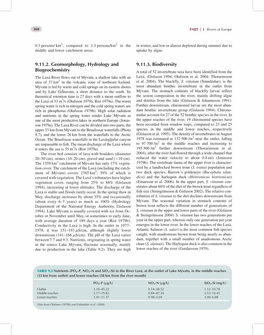
0.3 persons/ km2, compared to 1.3 persons/km2 in themiddle and lower catchment areas.
9.11.2. Geomorphology, Hydrology andBiogeochemistry
The Lax�a River flows out of M�yvatn, a shallow lake with anarea of 37 km2 in the volcanic zone of northeast Iceland.M�yvatn is fed by warm and cold springs on its eastern shoresand by Lake GrInavatn, a short distance to the south. Itstheoretical retention time is 27 days with a mean outflow tothe Lax�a of 33 m3/s (Olafsson 1979a; Rist 1979a). The warmspring water is rich in nitrogen and the cold spring waters arerich in phosphorus (Olafsson 1979b). High solar radiationand nutrients in the spring water render Lake M�yvatn asone of the most productive lakes in northern Europe (Jonas-son 1979a). The Lax�a River can be divided into two parts, theupper 33 km fromM�yvatn to the Bruafossar waterfalls (Photo9.7), and the lower 26 km from the waterfalls to the ArcticOcean. The Bruafossar waterfalls in the Lax�argljufur canyonare impassable to fish. The mean discharge of the Lax�a whereit enters the sea is 55 m3/s (Rist 1979a).
The river bed consists of lava with boulders (diameter20–50 cm), stones (10–20 cm), gravel and sand (<10 cm).The 1359 km2 catchment of M�yvatn has only 17% vegeta-tion cover. The catchment of the Lax�a (including the catch-ment of M�yvatn) covers 2385 km2, 39% of which iscovered with vegetation. The Lax�a’s tributaries have highervegetation cover, ranging from 25% to 88% (G�ıslason1994), increasing at lower altitudes. The discharge of theLax�a is stable and floods rarely occur. In the spring thaw inMay, discharge increases by about 35% and occasionally(about every 6–7 years) as much as 100% (HydrologyDepartment of the National Energy Authority, G�ıslason1994). Lake M�yvatn is usually covered with ice from Oc-tober or November until May, or sometimes to early June,with average duration of 189 days a year (Rist 1979b).Conductivity in the Lax�a is high. In the outlet in 1977–1978, it was 151–193 mS/cm, although slightly lowerdownstream (141–166 mS/cm). The pH of the Lax�a variesbetween 7.7 and 9.3. Nutrients, originating in spring waterin the source Lake M�yvatn, fluctuate seasonally, mainlydue to production in the lake (Table 9.2). They are high
in winter, and low or almost depleted during summer due touptake by algae.
9.11.3. Biodiversity
A total of 52 invertebrate taxa have been identified from theLax�a, (G�ıslason 1994; Olafsson et al. 2004; Thorarinssonet al. 2004). The blackfly, S. vittatum (Simuliidae), is themost abundant benthic invertebrate in the outlet fromM�yvatn. The stomach contents of blackfly larvae reflectthe seston composition in the river, mainly drifting algaeand detritus from the lake (G�ıslason & Johannsson 1991).Further downstream, chironomid larvae are the most abun-dant benthic invertebrate group (G�ıslason 1994). Chirono-midae account for 27 of the 52 benthic species in the river. Inthe upper reaches of the river, 19 chironomid species havebeen recorded from window traps, compared to 23 and 25species in the middle and lower reaches, respectively(G�ıslason et al. 1995). The density of invertebrates in August1978 was estimated at 132 500 /m2 near the outlet, fallingto 97 700 /m2 in the middle reaches and increasing to195 500 /m2 further downstream (Thorarinsson et al.2004), after the river had flowed through a wide channel thatreduced the water velocity to about 0.4 m/s (Jonasson1979b). The vertebrate fauna of the upper river is character-ized by a landlocked brown trout (S. trutta) population andtwo duck species, Barrow’s goldeneye (Bucephala islan-dica) and the harlequin duck (Histrionicus histrionicus)(Einarsson et al. 2006). In the upper part, S. vittatum con-stitutes about 60% of the diet of the brown trout regardless offish size (Steingr�ımsson & G�ıslason 2002). The relative con-tribution of S. vittatum to the diet declines downstream fromM�yvatn. The seasonal variation in stomach contents ofbrown trout reflects the different number of generations ofS. vittatum in the upper and lower parts of the river (G�ıslason& Steingr�ımsson 2004). S. vittatum has two generations peryear in the upper part, whereas only one generation per yearemerges in the lower river. In the lower reaches of the Lax�a,Atlantic Salmon (S. salar) is the most common fish speciescaught, with anadromous brown trout being nearly as abun-dant, together with a small number of anadromous Arcticcharr (S. alpinus). The Harlequin duck is also common in thelower reaches of the river (Gardarsson 1979).
TABLE 9.2 Nutrients (PO4-P, NO3-N and SiO2-Si) in the River Lax�a, at the outlet of Lake M�yvatn, in the middle reaches
(33 km from outlet) and lower reaches (58 km from the river mouth)
PO4-P (mg/L) NO3-N (mg/L) SiO2-Si (mg/L)
Outlet 3.10–45.22 0.14–38.52 1.12–10.78Middle reaches 2.17–19.82 0.84–47.34 2.53–10.45Lower reaches 3.41–11.37 0.98–5.04 3.00–6.88
Data from Olafsson (1979b) and Eir�ıksdottir et al. (2008).
PART | I Rivers of Europe368

9.11.4. Management and Conservation
In 1939, a power station (5 MW) was built by the town ofAkureyri on the Lax�a 30 km downstream from LakeM�yvatn. It uses the upper part of the 39 m high Bruarwaterfalls. A dam diverts the water to the station’s intake,but there is no storage reservoir above the dam. Anotherpower station (9 MW) became operational in 1953, anduses the lower part of the waterfalls, with a head of29 m. There is also a small dam to divert the water to theintake of the station. Construction of a third power stationbegan in 1970 and was intended to be 25 MW. It was to usethe same inflow as the initial station, but be hidden insidethe mountain, and with a 56 m high dam on the river thatwould have inundated about 15 km of the valley. This ledto a dispute between farmers and environmentalists, on theone side, and the Akureyri Power Company and the gov-ernment on the other. The dispute ended up with a settle-ment that lead to a 13.5 MW power station below theexisting dam for the initial power station and using thesame head of water.
Limnological research on lake M�yvatn and the Lax�a(Jonasson 1979a) gave rise to the legislation embodied inthe M�yvatn and Lax�a Conservation Act (1974), coveringthe entire Lake M�yvatn catchment and the Lax�a with200 m buffer zones on each bank. In accordance withthe Act, the M�yvatn Research Station was established in1974 on the banks of the M�yvatn. The station has formedthe basis for further research on the lake and the Lax�a. In1977, M�yvatn-Lax�a was the first wetland in Iceland to bedesignated on the Ramsar list (Convention on Wetlands ofInternational Importance especially as waterfowl habitat)for its diverse biota and wealth of waterfowl (G�ıslason1998). The size of the designated area is 200 km2 andcovers lake M�yvatn and the Lax�a, all wetlands in thecatchment and a large area around lake M�yvatn, and a200-m buffer zone on each side of the Lax�a (http://www.ramsar.org/profile/profiles_iceland.htm). In 2004, the pro-tected area was reduced by revision of the M�yvatn andLax�a Conservation Act, from the whole catchment of lakeM�yvatn to a 200 m zone along the banks of Lake M�yvatnand adjacent wetlands, a total of 153 km2. There areplans, not yet put into force, to significantly increase thisprotected area.
9.12. THE VESTARI J €OKULS�A RIVER
The Vestari J€okuls�a is a typical glacier-fed river. It is a fourthorder river that originates from the glacier, S�atuj€okull, anoutlet glacier from the Hofsj€okull Ice Sheet at an altitude of860 m asl in northern Iceland. The middle section is locatedat 65�160N, 19�050W. It was well studied in the late 1990sunder the auspices of a cooperative European project onglacier-fed rivers (Brittain & Milner 2001; G�ıslason et al.2001).
9.12.1. Physiography, Climate and Land Use
The Vestari J€okuls�a flows north across the central highlandplateau and reaches the lowlands about 40 km from the glaciersnout. The mean annual temperature for the upper reaches is�2.1 �C (Icelandic Meteorological Office), and mean month-ly temperatures from June to September are above 0 �C. Thewarmest month is July with a mean temperature of 7.1 �C andJanuary the coldest with a mean of �8.3 �C. Temperaturesincrease downstream and in the lower reaches the mean an-nual temperature is 2.8 �C, the mean July temperature is10.1 �C and themean January temperature is�2.6 �C.Annualprecipitation varies from 380 mm in the lowlands to 727 mmin the upper reaches, with May being the driest month.
The river runs through a barren catchment with little orno vegetation cover in the upper reaches. In the middlereaches vegetation cover is about 4% and in the lowerreaches 93%, with an overall vegetation cover of 48%(G�ıslason et al. 2001, Photo 9.8). There is no forest inthe area. There are small patches of vegetated land in theupper and lower reaches, notably near the spring-fed trib-utary, Midhlutar�a, that is used as summer pasture forsheep. The lower parts of the catchment serve as pasturefor sheep and cattle. Cultivated land is restricted to thelower reaches and its cover is <1%. Human settlement isalso limited to the lower reaches where the populationdensity is about 0.05 individuals/km2. There are no forestsand only small wetlands are found around Vestari J€okuls�aand its tributaries.
9.12.2. Geomorphology, Hydrology andBiogeochemistry
The Vestari J€okuls�a originates as three main branches (east-ern, middle and western branch) from the northwest outletglacier, S�atuj€okull, part of the Hofsj€okull Ice Sheet. A hya-loclastite mountain ridge separates the eastern branch fromthe others. A fissure zone assumed to be connected with acentral volcano below the glacier (Bj€ornsson 1988; Sigurds-son 1990) cuts through the area. The river flows with agradient of 5–10 for most of the way from the glacier tothe lowlands, except between the edge of the highland pla-teau and the lowlands, where its slope increases to around 20.The glacier catchment area of the river is 90 km2 comparedto the 820 km2 at the lowest gauging station in the lowlandvalley, 45 km away from the glacier. The annual averagedischarge (1971–1997) at the lowest sampling site of theriver is 21.4 m3/s (Gauging station no. 145, National EnergyAuthority in Iceland, Hydrological Survey).
TDS, deduced from conductivity, indicate that themiddle branch is fed by meltwater originating directlyor interacting with the assumed volcanic area, as its min-eral content is already high (>50 mS/cm) in July, whilethe other branches have conductivity as low as 10 mS/cm(G�ıslason et al. 2000). The eastern branch, close to the
Chapter | 9 Arctic Rivers 369

glacier, was dominated by clear meltwater in July 1997,but in September the same year all branches were highlyturbid. The conductivity in the eastern branch remainedlow, while the conductivity in other branches was higher(>40 mS/cm), which indicates that the glacial meltwaterwas mixed with geothermal water. In mid-winter, theVestari J€okuls�a is mainly spring fed and at the uppergauging station summer discharge decreases from 30–40 m3/s to <1 m3/s in winter. In the lower reaches thedischarge is typically 15 m3/s in winter and 35–50 m3/sin summer. At such discharges, TDS commonly vary be-tween 65 and 80 mg/l, which corresponds to 90–120 mS/cm (Adalsteinsson et al. 2000), similar to that estimatedas the groundwater component late in the summer season.
The conductivity varied from 8 mS/cm at the glaciersnout to 113 mS/cm in the lower reaches, while pH was6.0–6.7 near the glacier snout, 7.2–7.4 in the middle reachesand 7.7–7.8 in the lower reaches (G�ıslason et al. 2000).Nutrients were low in all reaches, highest in onset of winterand lowest in mid-summer. They were higher in a branchfrom the glacier with geothermal influence than other glacieroutlets (Table 9.3). Total N was varied, but NO3 was low, 0–1.0 mg/L in upper and middle reaches and 0–5.9 mg/L in
lower reaches. Nwas also present as NO2 andNH4, ammoniavalues being higher
Suspended solids vary considerably with season andbetween branches. Close to the junction of the branches,22.5 km from the glacier, suspended solids vary between100 and 1200 mg/L. Suspended solids subsequently de-crease to 85 mg/L in the lowlands (G�ıslason et al. 2001).During summer, chlorophyll a increases from 0.1 mg/m2
at the glacier snout to 1.6 mg /m2 1.4 km from the glacier,declining again to 0.1 mg/m2 at 7.5 km from the glacierand increasing again downstream to 0.16 mg/m2. Thesechanges are associated with decreasing proportion of gla-cial melt water that was �50% in the uppermost reachesof the river and only 20% 42 km downstream, whentributaries and groundwater have entered the river (Adal-steinsson et al. 2000). Channel stability, expressed by thePfankuch index, declines downstream from 55 to 21–35,indicating greater channel stability at increasing distancedownstream. Maximum water temperatures recorded overthe summer increase downstream, from around 0 �C at theglacier snout to approximately 12–14 �C 4.5 km down-stream. Higher values, up to 17.3 �C, were recorded insome of the tributaries.
PHOTO 9.8 The River Vestari-J€okuls�a near its confluence with the tri-buatary Hofs�a, seen from termial mor-aines from the end of the last Ice Age(Photo: G.M. G�ıslason).
TABLE9.3 Nutrients (PO4-P, NO3-N and SiO2-Si) in the River Vestari-J€okuls�a, in upper reaches (close to glacier snout), the
middle ranges (22 km from glacier) and lower reaches (45 km from the glacier) (unpublished data)
PO4-P (mg/L) Total N (mg/L) SiO2-Si (mg/L)
Upper reaches 0–2.8 7.7–18.4 1.39–4.5Upper reaches with geothermal influence 0–22.1 7.0–30.5 2.9–5.5Middle reaches 0–17.7 7.0–31.0 7.1–11.5Lower reaches 0–35.6 6.4–40.6 11.2–17.2
PART | I Rivers of Europe370

9.12.3. Biodiversity
There is considerable seasonal and annual variation in thedensity of major macroinvertebrate groups in the VestariJ€okuls�a. Density and composition change significantly alongthe downstream gradient, with higher densities and diversi-ties with increasing distance from the glacier margin. Chir-onomidae are the dominating taxon at all sampling sites(Olafsson et al. 2000). In the upper reaches, nine chironomidspecies were recorded in window traps: of those, three wereDiamesa, five Orthocladiinae (Chaetocladius, Cricotopus,Eukiefferiella andMetriocnemus) and one Simuliidae (Simu-lium vittatum). In the middle reaches, 6 chironomid specieswere found and in the lower reaches 12 species. All thespecies belonged to Diamesa and Orthocladiinae. S. vitta-tum, presumably originating from non-glacial streams, wasalso recorded in the middle and lower reaches (G�ıslason et al.2001).The density of chironomid larvae increased signifi-cantly downstream, from 29 to 5877/m2 (upstream anddownstream, respectively). The upstream chironomidassemblages are dominated by the genus Diamesa, whereasOrthocladiinae and Tanytarsini dominated lowland reaches(Olafsson et al. 2000; G�ıslason et al. 2001).
The only fish species found in the main Vestari J€okuls�a isArctic charr. These are generally small-sized individuals andtheir size at sexualmaturity is<15 cm. Atlantic salmon werecaught in small numbers (2–23 annually) from 1974 to 1982in the tributary Hofs�a. This was during a period when salmonwere commonly released into rivers to increase the salmonrun. At least one of the tributaries, the River Svart�a, confluentwith the Vestari J€okuls�a 45 km from the sea, has always beenknown for its good salmon run.
9.13. THE BAYELVA RIVER
Bayelva, otherwise known as the Red River because of thehigh levels of coloured glacial sediment, is located at 79�N,12�E, in the Kongsfjord on the western part of the island ofSpitsbergen. The catchment area is 33 km2, of which 55% isglaciated (Brittain & Milner 2001). The highest point of thecatchment is 742 m asl. Themain sources of Bayelva are twosmall polythermal glaciers, Austre Brøggerbreen (11.7 km2)and Vestre Brøggebreen (5.3 km2) (Photo 9.9).
9.13.1. Physiography, Climate and Land Use
The bedrock is sedimentary: limestone, shale and sandstone.The upper parts of the catchment are dominated by glacier,bare rocks and extensive recent moraine material, whiletundra vegetation has become established in some areas nearthe fjord. The landscape is alpine with both cirque glaciersand large valley glaciers, some of which reach the sea. Thescientific station of Ny-A
�lesund, the world’s northernmost
permanent settlement, on the Kongsfjord, 2 km to the east ofthe catchment, has an annual mean air temperature of�6.3 �C and a July mean of 4.9 �C. Precipitation is low withan annual mean of 385 mm recorded in Ny-A
�lesund, al-
though calculations adjusted for the increase in precipitationwith altitude indicate a mean annual precipitation for theBayelva catchment of 890 mm (Killingtveit et al. 2003).
There is no permanent habitation within the catchment.There is a small recreational cabin near the gauging stationthat is located 600 m from the outflow into the fjord. Coalmining was carried out in to the area up until the early 1960s,
PHOTO 9.9 Bayelva and the sourceglaciers, Austre and Vestre Brøggebreen(Photo: J. E. Brittain).
Chapter | 9 Arctic Rivers 371

but is now abandoned. In the Bayelva catchment there areonly small vestiges of this activity in the form of tracks,timber and small excavations. Today the catchment is usedfor research carried out from Ny-A
�lesund. A small lake in
the catchment, Tvillingvatn, is used as the water supply forNy-A
�lesund. A small airstrip is located on the eastern edge
of the catchment.
9.13.2. Geomorphology, Hydrology andBiogeochemistry
Most meltwaters leave the glacier via large lateral channelsto which fine sediments are supplied by mass wasting of ice-cored moraines at about 100 m asl (Hodson et al. 1998). Thechannels from these two glaciers converge after about 1 kmand the river then flows a further 2 km down to the fjord,alternating between single and braided channels as it breaksthough recent terminal moraines. As is typical of glacier-fedrivers, the substrate is unstable (Castella et al. 2001). Thereare two main tributaries, Tvillingvassbekken andMørebekken, both of which carry little sediment. Tvilling-vassbekken flows out of a small shallow lake Tvillingvatn(area 0.35 km2; maximum depth 6.3 m), while the waters ofMørebekken are filtered through extensive terminal mor-aines. Normally, there is no runoff in Bayelva from earlyOctober until the end of May. Snowmelt, and glacial melt-water later, leads to intense flows in June, July and August.Due to rainfall, high floods can occur during late summer andearly autumn. In some years, runoff has occurred in lateautumn and early winter as a result of the intrusion of At-lantic air into the Arctic Basin.
At the gauging station in Bayelva, the world’s north-ernmost permanent facility, the mean annual discharge is1.12 m3/s (specific discharge 36.2 L/s/km2). The highest ob-served flood was in mid-September 1990 with a daily dis-charge of 32 m3/s. The annual water balance for the wholeBayelva catchment has been estimated for the period 1990–2001 by Killingtveit et al. (2003), based on a wide range ofdata, both from the Bayelva catchment and other catchments
on Svalbard. The following mean annual estimates werecalculated: precipitation 890 mm (summer 277 mm; winter597 mm), evaporation 37 mm, runoff as a result of negativeglacial mass balance 245 mm and runoff 1050 mm. Thisgives an error term of 31 mm. The Bayelva freezes to thestream bed each winter from September/October to end ofMay. From mid/late June to late August the river is free ofice. The water temperature is low and normally does notexceed 4 �C. The temperature maximum occurs in early Julyand freeze up starts some time in September.
The sediment load in the Bayelva is delivered by thepolythermal glaciers Austre and Vestre Brøggerbreen as wellas eroded material from moraine areas surrounding the gla-ciers. The total annual suspended load during the period ofmeasurement (1989–2001) shows large year-to-year varia-tion (Photo 9.6). The highest load on record was 23 000 tonsin 1990, due to a huge flood in September that year. Exhaus-tion effects meant that sediment transport did not reach thesame level until some years later. The mean specific sedi-ment yield of the glacier and the moraine area has beenestimated at 586 tons/km2/year (Bogen & Bønsnes 2003).The sediment concentrations are also subject to large sea-sonal variations. Late in the summer season when the runofforiginates from glacial meltwater, the mean suspended sed-iment concentrations are often about 100–300 mg/L. Thehuge flood in September 1990 gave a concentration of4000 mg/L. Rainwater floods inAugust and September oftengive rise to high sediment loads.
From 1920 to 1930, Lake Tvillingvatn received ground-water from a sandstone aquifer underlying the lake. Recentwater balance studies indicate that that there is no longer anygroundwater flow of that type (Haldorsen et al. 2002). Pre-vious melting of the permafrost along the glacial front ofBrøggerbreen as a result of large amounts of meltwater and asteep hydraulic gradient may have been halted as the glacierretreated and exposed the glacial forelands to renewed per-mafrost. The river waters are circumneutral. Calcium andmagnesium are the major cations, while bicarbonate concen-trations are relatively high in relation to other anions.Conductivity is typically 40–80 mS/cm (Lods-Crozet et al.
0
10
20
30
40
50
0
5000
10000
15000
20000
25000
1990 1995 2000
Sediment transportWater Discharge
Wat
er D
isch
arge
(m
ill m
/yr)
3
Sed
imen
t tra
nspo
rt (
tons
/yr)
FIGURE 9.6 Annual sediment transport (suspended load)and mean water discharge in Bayelva.
PART | I Rivers of Europe372

2001). The major controls on hydrochemistry in the catch-ment include snowpack solute elution, rapid alteration ofminerals via surface reactions and slow, incongruent sili-cate dissolution (Hodson et al. 2002). The importance ofchemical weathering increases downstream. The restrictedsub-glacial weathering, because of the largely cold-basedthermal regime of the glaciers, means that the proglacialareas are the most important zones of solute acquisition bymeltwaters, causing significant enrichment of major ions,silica and dissolved CO2 within only a short distance fromthe ice margin (Hodson et al. 2002).
9.13.3. Biodiversity
The geographical isolation of the Svalbard archipelago limitsthe available species pool (Milner et al. 2001; Coulson &Refseth 2004). Water temperatures are low and the substrateis unstable, giving a benthic fauna low in numbers and poor inspecies, and composed almost exclusively of chironomids(Diamesinae and Orthocladiinae) and oligochaetes (Castellaet al. 2001; Lods-Crozet et al. 2001, 2007). Periphyton is themain food source and chlorophyll a concentrations may reachvalues over 10 mg/m2 in the shallow waters of the down-stream reaches during the period of continuous daylight(Lods-Crozet et al. 2001). Arctic charr occur throughoutmuch of Svalbard (Klementsen et al. 2003; Svenning & Gul-lestad 2002), but not in the Bayelva river system as there areno accessible lakes to maintain a population during winter.
9.13.4. Management and Conservation
While the catchment is not included in any of the designatedNational Parks, there are strict environmental regulationsgoverning the whole of Svalbard. Owing to its accessibilityand infrastructure, the area around Ny-A
�lesund is a centre
for international Arctic research over a wide range of dis-ciplines (www.kingsbay.no).
Acknowledgements
Randi Pytte Asvall kindly provided information on ice con-dition in the Altaelva River. We wish to acknowledge thehelp of Eero Niemel€a for providing information on the Tanasalmon fishery and Steinar Pedersen for his input to thesocial history of the Tana River. Tharan Fergus has alsoprovided information on sediment characteristics of the TanaRiver. We are indebdted to Trausti Jonsson, Icelandic Mete-orological Office for providing weather data for all Icelandiccatchment areas and Bj€orn Traustason for compiling the dataon forest cover of Icelandic catchments. The HydrologicalService of the National Energy Authority provided digitalmaps of catchment areas of the Icelandic rivers. Thanks alsoto Dr. �Arni Einarsson, M�yvatn Research Station, for readingand commenting on parts of the manuscript.
REFERENCES
Adalsteinsson, H., and G�ıslason, G.M. 1998. �Ahrif landrInna �atta �a l�ıf �ı
straumv€otnum. (In Icelandic, English summary) (Terrestrial influence
on the biota in Icelandic rivers). N�atturufraedingurinn 68: 97–112.
Adalsteinsson, H., G�ıslason, G.M., G�ıslason, S.R., and Snorrason, A. 2000.
Physical and chemical characteristics of glacial rivers in Iceland, with
particular reference to the RiverW-J€okuls�a, North Iceland.Verhandlun-
gen der Internationale Vereinigung f€ur Theoretische und Angewandte
Limnologie 27: 735–739.
Albert, V., Jonsson, B., and Bernatchez, L. 2006. Natural hybrids in Atlantic
eels (Anguilla anguilla, A. rostrata): evidence for successful reproduc-
tion and fluctuating abundance in space and time. Molecular Ecology
15: 1903–1916.
AMAP. 2004a. AMAPAssessment 2002: Radioactivity in the Arctic. Arctic
Monitoring and Assessment Programme (AMAP), Oslo, Norway. xi
+100 pp.
AMAP. 2004b. AMAP Assessment 2002: Persistent Organic Pollutants in
the Arctic. Arctic Monitoring and Assessment Programme (AMAP),
Oslo, Norway. xvi+310 pp.
AMAP. 2005a. AMAPAssessment 2002: HeavyMetals in the Arctic. Arctic
Monitoring and Assessment Programme (AMAP), Oslo, Norway. xvi
+265 pp.
AMAP. 2005b. Arctic Climate Impact Assessment (ACIA) – Scientific
Report. Arctic Monitoring and Assessment Programme. http://www.
acia.uaf.edu/pages/scientific.html.
Andreev, V.A. (ed.). 1995. Arkhangelsk Oblast Red Book. Rare and pro-
tected plant and animal species. Arkhangelsk.
Anon. 1976. Verneplan for vassdrag. NOU 1976:15 Industridepartementet.
150 pp.
Anon. 1989. Scientific-applied reference book on climate of the USSR.
Series 3. Long-term data. Parts 1–6. 1. Arkhangelsk and Vologda
oblasts, Komi ASSR. Book 1. Hydrometeoizdat, Leningrad.
Anon. 1994. Bruk av land og vann i Finnmark i historisk perspektiv. Norges
offentlige utredninger. NOU 1994: 21.
Anon. 2001.De enkelte nasjonale laksevassdrag og laksefjorder. Vedlegg til
høringsnotat. Norwegian Ministry of the Environment. 111 pp.
Anon. 2003. Ecoregional Climate Change and Biodiversity Decline: Kola
Ecoregion. WWF Russia, Moscow. 25 pp.
Anon. 2004. Verneforslag og konsekvensutredning for Varangerhalvøya
nasjonalpark. Office of the Finnmark County Governor. 101 pp.
Anon. 2006. Ressursregnskap for reindriftsnIringen for reindriftsa�ret 1.
april 2004 – 31. mars 2005. Reindriftsforvaltningen.
Anufriev, V.V. (Ed.), 2000. The land of pristine forests: Pechoro-Ilychsky
nature reserve. Syktyvkar.
Anufriev, V.V. 2004. Land mammals. In: Animate nature of the Nenets
autonomous okrug. Naryan-Mar. pp. 59–68.
Anufriev, V.V., and Bobretsov, A.V. 1996. Amphibia and reptiles. Nauka, St.
Petersburg, Fauna of the European North-East of Russia, IV.
Anufriev, V.V., Bobretsov, A.V., Voylochnikov, A.A., Neyfeld, N.D.,
Kudryavtseva, E.N., Kupriyanova, I.F., Petrov, A.N., Polezhaev, N.M.,
Pystin, A.N., Sokolsy, S.M., Soloviev, V.A., Turieva, V.V., and Yushkov,
V.F. 1994. Mammals, Insectivora, Cheiroptera, Lagomorpha, Rodentia.
Nauka, St. Petersburg, Fauna of the European North-East of Russia. II, I.
Baranovskaya, V.K. 1971. Zooplankton of the middle Pechora River. In:
Biology of the northern rivers in oldlake lowlands. Syktyvkar. Proceed-
ings of the Komi branch of the Academy of Science of the USSR 22, pp.
35–43.
Baranovskaya, V.K. 1991. Zooplankton of the Pechora River. In: Biological
researches in Pechora-Ilychsky nature reserve. Syktyvkar. Proceedings
of the Ural Branch of the Russian Academy of Science 116, pp. 40–45.
Chapter | 9 Arctic Rivers 373

Berg, M. 1964. Nord-Norske lakseelver. Johan Grundt Tanum Forlag, Oslo,
300 pp.
Berg, M. 1977. Pink salmon, Oncorhynchus gorbuscha (Walbaum) in
Norway. Institute of Freshwater Research. Drottningholm 56: 12–17.
Bergersen, R. 1989. Zoobenthos and food of Atlantic salmon (Salmo salar
L.) fry in the Alta River, North Norway. Nordic Journal of Freshwater
Research 65: 99–115.
Bjerknes, V. 1978. Undersøkelse av fiskebestanden i Iesjohka, Tanavassdra-
get. Direktoratet for vilt- og ferskvannsfisk, Fiskerikonsulenten i Finn-
mark. Rapport 2/78 29 pp. (In Norwegian).
Bjerknes, V., and Vaag, A.B. 1980. Migration and capture of pink salmon,
Onchorynchus gorbuschaWalbaum in Finnmark, North Norway. Jour-
nal of Fish Biology 16: 291–297.
Bj€ornsson, H. 1988. Hydrology of ice caps in volcanic regions. Societas
Scientarium Islandica, 45. University of Iceland, Reykjav�ık, 139 pp.
Bobretsov, A.V., Neyfeld, N.D., Sokolsky, S.M., Teplov, V.V., and Teplova,
V.P. 2004.Mammals of the Pechoro-Ilychsky Reserve. Komi Publishing
House, Syktyvkar.
Bogdanova, E.N. 2004. Zooplankton.Water Ecosystems Bioresources of the
Polar Ural, Ural Branch of the Russian Academy of Science, Ekaterin-
burg, pp. 57–89.
Bogen, J., and Bønsnes, T. 2003. Erosion and sediment transport in High
Arctic rivers, Svalbard. Polar Research 22: 175–189.
Brittain, J.E., and Milner, A.M. 2001. Ecology of glacier-fed rivers: current
status and concepts. Freshwater Biology 46: 1571–1578.
Brown, L.E., Hannah, D.M., and Milner, A.M. 2003. Alpine stream habitat
classification: an alternative approach incorporating the role of dynamic
water source contributions. Arctic, Antarctic and Alpine Research 35:
313–322.
Bryzgalo, V.A., Ivanov, V.V., and Nechayeva, S.A. 2002. Ecological condi-
tion of the Northern Dvina river low streams and mouth and its changes
caused by anthropogenic influence. Arctic and Antarctic Problems. 73,
Hydrometeoizdat, St. Petersburg, pp. 135–152.
Castella, E., Adalstinsson, H., Brittain, J.E., Gislason, G.M., Lehmann, A.,
Lencioni, V., Lods-Crozet, B., Maiolini, B., Milner, A.M., Olafsson, J.
S., Saltveit, S.J., and Snook, D.L. 2001. Macrobenthic invertebrate
richness and composition along a latitudinal gradient of European gla-
cier-fed streams. Freshwater Biology 46: 1811–1831.
Chernov, V.K. 1953. Data on algae of the Pechora River and its basin’s water
reservoirs. Fishes and Fishery of the Middle and Lower Streams of the
Pechora river, Publishing House of the AS USSR, Moskow-Leningrad,
pp. 218–225.
Chernov, G.A. 1989. Highlights on the PECHORA Coalfields Discovery.
Komi Pubishing House, Syktyvkar.
Cherny, V.G. (ed.), 1970. USSR hydrogeology. XLII. Komi ASSR and
Nenets national okrug of the Arkhangelsk oblast. Nedra, Moskow.
Coulson, S.J., and Refseth., D. 2004. The terrestrial and freshwater inverte-
brate fauna of Svalabdr (and Jan Mayen). In Prestrud, P, H. Strøm, and
H.V. Goldman (eds). A catalogue of the terrestrial and marine animals
of Svalbard. Norwegian Polar Institute Skrifter 20, pp. 57–122.
Dementiev, G.P. and Gladkov, N.A. (eds). 1951/1954. Birds of the Soviet
Union, Sovetskaya nauka, Moskow, pp. 1–6.
Dinets, V., and Rotshild, Ye. 1996. Wild animals. Encyclopedia of Russian
Nature. Moscow, 344 pp.
Dynesius, M., and Nilsson, C. 1994. Fragmentation and flow regulation of
river systems in the northern third of the world. Science 266: 753–762.
Efimov, A.I., and Zaitsev., I.K. (eds.) 1970.Hydrogeology of the USSR. XVI.
“Nedra”, Moscow.
Eie, J.A., Brittain, J.E., and Huru, H. 1982. Naturvitenskapelige interesser
knyttet til vann og vassdrag pa�Varangerhalvøya. Rapport Kontaktut-
valget for vassdragsreguleringer, Universitetet i Oslo. Rapport 34, 64
pp.
Eie, J.A., Faugli, P.E., Aabel, J. 1996. Elver og vann. Vern av norske vass-
drag. Norwegian Water Resources and Energy Directorate, Grøndahl
og Dreyers Forlag, Oslo, 286 pp.
Eikeset, K.R., Heitmann, K., Nielsen, J.P. 2001. I storlaksens rike. Historien
om Altaelva og Alta Laksefiskeri Interessentskap. Alta Laksefiskeri
Interessentskap, Alta, Norway, 507 pp.
Einarsson, M. 1979. Climatic conditions of the LakeM�yvatn area.Oikos 32:
29–37.
Einarsson, T. 1994. Geology of Iceland: Rocks and Landscape. Mal og
Menning, Reykjav�ık, 309 pp.
Einarsson, �A., Gardarsson, A., G�ıslason, G.M., and Gudbergsson, G. 2006.
Populations of ducks and trout of the River Lax�a, Iceland, in relation to
variation in food resources. Hydrobiologia 567: 183–194.
Eir�ıksdottir, E., G�ıslason, S.R., Elefsen, S.O., Hardardottir, J., Hreinsson,
E.€O., Torssander, P., Sveinbj€ornsdottir, �A.E. 2008. Efnasamsetning,
rennsli og aurburur�ı utfalli M�yvatns [In Icelandic: Chemistry, discharge
and total solids in the M�yvatn lake outlet]. M�yvatn Research Station.
Report No. 7, Sktutustadir. 53 pp.
Elo, K., Vuorinen, J., and Niemel€a, E. 1994. Genetic resources of Atlantic
salmon (Salmo salar L.) in the Teno and N€a€at€am€o Rivers, northernmost
Europe. Hereditas 120: 19–28.
Elvebakk, A. 2006. Status for populasjonen av masimjelt (Oxytropis deflexa
ssp. norvegica) i Virdneguoika – September 2006. Rapport to Statkraft,
8 pp.
Erkinaro, J., �kland, F., Moen, K., and Niemel€a, E. 1999. Return migration
of the Atlantic salmon in the Tana River: distribution and exploitation of
radiotagged multi-sea-winter salmon. Boreal Environment Research 4:
115–124.
Fefilova, E.B. 2002. Harpacticoida of Timan and Ural water reservoirs. In:
Water organisms in natural and transformed ecosystems in the European
North-East of Russia. Syktyvkar. Proceedings of the Ural Branch of the
Russian Academy of Science 170, pp. 51–62.
Fergus, T., and R€onk€a, E. (eds.) 2001. Erosjon og sedimenttransport i
Tanaelva. Delrapport 1 fra prosjektet: Bevaring av Tanaelva som en
lakseelv i naturtilstand. Norges vassdrags- og energidirektorat, Fylkes-
mannen i Finnmark, Lapplandmiljøsenter.NVE Rapport 4/2001, 99 pp.
Filenko, R.A. 1974.Hydrologic Zoning of the North in the European Part of
Russia. Publishing House of Leningrad State University, Leningrad.
Filippova, L.G. (ed). 1985. State water cadastre. Longstanding data on
surface waters regimen and resources (1985). 1. RSFSR. 9. The Pechora
River basin, Hydrometeoizdat, Obninsk.
F€ureder, L. 1999. High alpine streams: cold habitats for insect larvae. In:
Margesin, R., Schinner, F. (eds). Cold Adapted Organisms. Ecology,
Physiology, Enzymology and Molecular Biology, Springer Verlag,
Berlin, pp. 181–196.
Furset, O.J. 1995.Fangstgroper i Karasjok kommune. Rapport fra forskning-
sutgraving 3. juli – 4. august 1995. Arkeologiseksjonen, Institutt for
samfunnsvitenskap, Universitetet i Tromsø. 39 pp.
Gabler, H.M. 2000. Feeding ecology and resource partitioning in Atlantic
salmon parr (Salmo salar L.) and freshwater sculpins (Cottus gobio L.
and C. poecilopus Heckel) in sub-Arctic rivers. Doctoral thesis, Uni-
versity of Tromsø.
Gardarsson, A. 1979. Waterfowl populations of Lake M�yvatn and recent
changes in numbers and food habits. Oikos 32: 250–270.
Geptner, V.G., Nasimovich, A. A., Bannikov, A. G. 1961. Mammals of the
USSR I Moscow.
Geptner, V.G., Naumov, N.P., Yurgenson, P.B., Sludsky, A.A., Chirkova, A.
F., and Bannikov, A.G. 1967. Mammals of the USSR. II Moscow.
PART | I Rivers of Europe374

Getsen, M.V. 1971. Algal flora of the water reservoirs in the middle Pechora
River valley. In: Biology of northern rivers in the oldlake lowlands.
Syktyvkar. Proceedings of the Komi branch of the AS USSR 22: 16–26.
Getsen, M.V. 1973. The Pechora River Basin Algae and Their Distribution.
Nauka, Leningrad.
Getsen, M.V., and Barinova, S.P. 1969. Algae of the stony biofouling in the
upper streams of the Vychegda river. Abstract of XIII session of the
Academic Council, Petrozavodsk: 53–55.
G�ıslason, G.M. 1981. Distribution and habitat preferences of Icelandic
Trichoptera. In: Moretti, G.P. (ed.) Proceedings of the 3rd international
Symposium on Trichoptera, Series Entomologica 20, 99–109.
G�ıslason, G.M. 1994. River management in cold regions: a case study of the
River Lax�a, North Iceland. In: Calow, P., Petts, G.E. (eds). Rivers
Handbook, Blackwell Scientific Publications, Oxford, pp. 464–483.
G�ıslason, G.M. 1998. Ramsar �a �Islandi – Althjodlegur samningur um votle-
ndi sem hefur althjodlegt gildi, einkum fyrir fuglal�ıf. (English summa-
ry: The Ramsar Sites in Iceland. The Procedure of the Convention on
Welands of International Importance especially as a Waterfowl Habi-
tat). In: Olafsson, J.S. (ed). �Islenskt Votlandi, Univeristy of Iceland
Press, Reykjav�ık, pp. 247–251.
G�ıslason, G.M. 2005. Origin of freshwater fauna of the North-Atlantic
islands: present distribution in relation to climate and possible migra-
tion routes. Verhandlungen der internationalen Vereinigung f€ur theo-
rietische und angewandte Limnologie 29: 198–203.
G�ıslason, G.M., and Johannsson, V. 1991. Effects of food and temperature on
the life cycle of Simulium vittatum Zett. (Diptera: Simuliidae) in the
River Lax�a, N-Iceland. Verhandlungen der Internationale Vereinigung
f€ur Theoretische und Angewandte Limnologie 24: 2912–2916.
G�ıslason, G.M., and Steingr�ımsson, S. 2004. Seasonal and spatial variation
in the diet of brown trout (Salmo trutta L.) in the subarctic River Lax�a,
North-East Iceland. Aquatic Ecology 38: 263–270.
G�ıslason, G.M., Hrafnsdottir, T., and Gararsson, A. 1995. Flight periods of
midges (Chironomidae and Simuliidae) in the River Lax�a, N-Iceland.
In: Cranston, P. (ed). Chironomids: From Genes to Ecosystems, CSIRO
Publications, Melbourne, pp. 133–154.
G�ıslason, G.M., Olafsson, J.S., and Adalsteinsson, H. 2000. Life in glacial
and alpine rivers in Central Iceland in relation to physical and chemical
parameters. Nordic Hydrology 31: 411–422.
G�ıslason, G.M., Adalsteinsson, H., Hansen, I., Olafssson, J.S., and Svavars-
dottir, K. 2001. Longitudinal changes inmacroinvertebrate assemblages
along a glacial river system in central Iceland. Freshwater Biology 46:
1737–1751.
Gordeeva, L.I. (ed). 1983. Modern status and quality of the Onega river
waters and its basins’ water reservoirs,Karelia branch of the ASUSSR,
Petrozavodsk.
Gudbergsson, G., and Antonsson, T. 1996. Fiskar �ı �am og v€otnum. Land-
vernd, Reykjav�ık, 191 pp. [In Icelandic: Fish in rivers and lakes].
Haldorsen, S., Heim, M., Lefauconnier, B., Pettersson, L.E., Røros, M., and
Sandsbra�ten, K. 2002. The water balance of an arctic lake and its
dependence on climate chage: Tvillingvatnet in Ny-A�lesund, Svalbard.
Norsk Geografisk Tidsskrift 56: 146–151.
Hodson, A.J., Gurnell, A.M., Tranter, M., Bogen, J., Hagen, J.O., and Clark,
M. 1998. Suspended sediment yield and transfer processes in a small
high-Arctic glacier basin, Svalbard.Hydrological Processes 12: 73–86.
Hodson, A.J., Tranter, M., Gurnell, A.M., Clark, M., and Hagen, J.O. 2002.
The hydrochemistry of Bayelva, a high Arctic proglacial stream in
Svalbard. Journal of Hydrology 257: 91–114.
Hrafnsdottir, T. 2005. Diptera 2 (Chironomidae). The Zoology of Iceland 3:
1–169.
Huitfeldt-Kaas, H. 1918. Ferskvandsfiskenes utbredelse og indvandring i
Norge, med et tillIg om krebsen. Centraltrykkeriet, Kristiania, 106 pp.
Ilyina, L.L., and Grakhov, A.K. 1987.Rivers of the North. Hydrometeoizdat,
Leningrad.
Ivanov, A.I., and Shtegman, B.K. 1978. Short key book of the USSR birds
(Key books on fauna of the USSA. 115). Proceedings of Zoological
Institute of the AS of USSR, Leningrad.
Jensen, A.J., Zubchenko, A., Hvidsten, N.A., Johnsen, B.O., Kashin, E.,
Kuzmin, O., and NIsje, T.F. 1997. A comparative study of life histories
of Atlantic salmon in two Norwegian and two Russian rivers. NINA-
NIKU Project Report 7, pp. 1–44.
Jensen, A.J., Zubchenko, A., Hvidsten, N.A., Johnsen, B.O., Kashinand, E.,
and NIsje, T.F. 1998. A five year study of Atlantic salmon in two Nor-
wegian and two Russian rivers. NINA-NIKU Project Report 8, pp. 1–38.
Johannesson, H., and SImundsson, K. 1998. Geological Map of Iceland
1:500 000. Institute of Natural history and Geodetic Institute of Iceland,
Reykjav�ık.
Johansen, M. 2005. Juvenile salmon and aquatic invertebrates in northern
Norway. Doctoral thesis, University of Tromsø. 120 pp.
Johansen, M., Elliott, J.M., and Klemetsen, A. 2005. A comparative study of
juvenile salmon density in 20 streams throughout a very large river
system in northern Norway. Ecology of Freshwater Fish 14: 96–110.
Jonasson, P.M. (ed.) 1979a. Ecology of eutrophic, subarctic Lake M�yvatn
and the River Lax�a. Oikos 32, pp. 1–306.
Jonasson, P.M. 1979b. The River Lax�a ecosystem, Iceland. Oikos 32:
306–308.
Jonsson, E., Gardarsson, A., and G�ıslason, G.M. 1986. A new window trap
used in the assessment of the flight periods of Chironomidae and Simu-
liidae (Diptera). Freshwater Biology 16: 711–719.
Kaliuzhin, S.M. 2003. The Atlantic Salmon of the White Sea Basin: Pro-
blems of Reproduction and Fisheries. PetroPress, Petrozavodsk, Russia.
Kemmerikh, A.O. 1961.Hydrography of the Northern, Sub-Polar and Polar
Ural. Publishing House of the AS USSR, Moscow.
Khokhlova, L.G. 1994a. Estimation of surface waters condition in the
Pechora River basin. Proceedings of the International Congress,Mos-
cow 1, pp. 312–320.
Khokhlova, L. 1994b. Water chemistry of the rivers of the tundra zone.
Extended Abstract International Conferenec Columbus, USA: 144–
145,BPRC Miscellaneous Ser. M-334.
Khokhlova, L.G. 1997. Modern status of the Mezen river basin water-
courses. In: North ecosystem transformation in the intensive wood
cuttings zones. Syktyvkar. Proceedings of the Ural Branch of the Rus-
sian Academy of Science; 154, pp. 100–117.
Killingtveit, A�., Pettersson, L.E., and Sand, K. 2003. Water balance inves-
tigations in Svalbard. Polar Research 22: 161–174.
Kjartansson, G. 1945. Islenskar fallvatnstegundir. NatturufrIdinurinn
15113–145, [In Icelandic: Icelandic River Types].
Kjartansson, G. 1965. Geologiske betingelser for islandske flodtyper. Geo-
grafiske Tidskrifter 64: 174–187.
Klementsen, A., Amundsen, P.A., Dempson, J.B., Jonsson, B., Jonsson, N.,
O’Connell, M.F., and Mortensen, E. 2003. Atlantic salmon Salmo salar
L., brown trout Salmo truttaL. and Arctic charr, Salvelinus alpinus (L.):
a review of aspects of their life histories.Ecology of Freshwater Fish 12:
1–59.
Kline, T. C., Jr., Goering, J.J., and Piorkowki, R.J. 1997. The effect of salmon
carcasses on Alaskan freshwaters. In: Milner, A.M. and M.W. Oswood
(eds.). Freshwaters of Alaska. Ecological Studies 119, Springer, pp.
179–204.
Kobysheva, N.V., and Narovlyansky, G.Y. 1978.Climatologic Processing of
Meteorological Information. Hydrometeoizdat, Leningrad.
Kochanov, S.K. 2001. Fauna and birds population changes in the European
North-East of Russia in the 20th Century. Abstract of the International
Conference, Kazan,, pp. 328–329.
Chapter | 9 Arctic Rivers 375

Kokovkin, A.V. 1988. Calculation of summer-autumn mean water charac-
teristics in the rivers of the European North-East. Syktyvkar.
Kokovkin, A.V. 1997. Average long-term annual water yield of the rivers.
Hydrology and Climate Atlas of the Komi Republic, DiK, Moskow,
pp. 102.
Koksvik, J.I., and Reinertsen, H. 2008. Changes in the macroalgae and
bottom fauna in thewinter period in the regulatedAlta River in Northern
Norway. River Research and Applications 24: 720–731.
Kontaktutvalget Kraftutbygging – naturvern 1971. Rapport om vassdrag
som bør vernes mot kraftutbygging. Bergen. 203 pp. Passed by Parlia-
ment (Verneplan I) in 1973.
Korde, N.V. 1959. Quantitative plankton of the Vychegda river. Proceedings
of the Komi branch of the all-unionGeographical Society, Syktyvkar, 5,
pp. 111–120.
Kuchina, E.S. 1955. Chemistry of the surface waters. Productive Forces of
the Komi ASSR. II. 2, Publishing house of the AS USSR, Moscow,
pp. 38–153.
Kulikov, V.S. (ed). 1995. Natural and Cultural Heritage of the National
Park “Vodlozersky”, Karelia Branch of the AS USSR, Petrozavodsk.
Kuzmin, S.L. 1999. Amphibia of the former USSR. Moscow.
Kuzmina, Y. 2001. Chironomida (Diptera) of the European North-Eastern
Part of Russia. Bull. of the Institute of Biology. Proceedings of Ural
Branch of the Russian Academy of Science 12,, 3–6.
LandmIlingar �Islands. 1993. �Island. Grodurmynd (vegetation map). Land-
mIlingar �Islands, Reykjav�ık.
L�arusdottir, G., Adalsteinsson, H., Olafsson, J.S., and G�ıslason, G.M. 2000.
River ecosystems in Iceland: catchment characteristics and river com-
munities. Verhandlungen der Internationale Vereinigung f€ur Theore-
tische und Angewandte Limnologie 27: 1607–1610.
Lashenkova, A.N. 1970. Brief article on flora of the upperMezen river basin.
Proceedings of the Komi branch of the Geographical Society of USSR 2,
3 (13), pp. 66–68.
Leshko, Y.V. 1996. Modern status of the hydrobiological regimen of the
Mezen river water basin’ water reservoirs. Ecological aspects of the
species diversity conservation in the European North-East of Russia.
Syktyvkar. Proceedings of the Ural Branch of the Russian Academy of
Science; 148, pp. 97–106.
Leshko, Y.V. 1998. Molluscs Nauka, St. Petersburg. Fauna of the European
North-East of Russia. Y,1.
Leshko, Y.V., and Khokhlova, L.G. 1999. Hydrobiological characteristics of
the lower Pechora in the anthropogenic influenced environment. Pro-
ceedings of the II (XXV) International Confertence, Petrozavodsk,,
pp. 343–345.
Leshko, Y.V., and Khokhlova, L.G. 2003. Anthropogenic transformation of
benthic invertebrate communities in the Izhma river basin. Proceedings
of the XI International Symposium on Bioindicators, Syktyvkar,,
pp. 236–246.
Leshko, Y.V., Martynov, V.G., Baranovskaya, V.K. 1990. Hydrobiology
of the Mezen River basin’ water reservoirs in anthropogenic influ-
enced environment. Abstract Symposium on Atlantic salmon, Syk-
tyvkar: 84.
Lillehammer, A. 1972. A new species of the genus Nemoura (Plecoptera)
from Finnmark, North Norway. Norsk entomologisk tidsskrift 19:
161–163.
Lillehammer, A. 1974. Norwegian stoneflies. II. Distribution and relation-
ship to the environment. Norsk entomologisk Tidsskrift 21: 195–250.
Lillehammer, A. 1988. Stoneflies of Fennoscandia and Denmark. Fauna
Entomologica Scandinavica 21, 165 pp.
Lillehammer, A., Johannsson, M., and G�ıslason, G.M. 1986. Studies on
Capnia vidua Klap�alek (Capniidae, Plecoptera) populations in Iceland.
Fauna norvegica Series B 33: 93–97.
Lods-Crozet, B., Lencioni, V., Brittain, J.E., Marziali, L., and Rossaro, B.
2007. Constrasting chironomid assemblages in two high Arctic streams
on Svalbard. Fundamental and Applied Limnology 170: 211–222.
Lods-Crozet, B., Lencioni, V., Olafsson, J., Snook, D., Velle, G., Brittain, J.
E., Castella, E., and Rossaro, B. 2001. Chironomid (Diptera: Chirono-
midae) communities in six European glacier-fed streams. Freshwater
Biology 46: 1791–1809.
Lukin, E.I. 1954. On Hirudinea fauna in the Komi ASSR. Proceedings of the
Komi branch of the all-union Geographical Society of the USSR 2,,
pp. 61–68.
Magnell, J.P. 1998. Manøvreringens innvirkning pa�hydrologien. In: NIsje,
T.F. (ed.). Altalaksen. Kultur, kraftutbygging og livsmiljø. Alta kom-
mune, Norway. pp. 56–63.
Martynov, V.G., Leshko, Y.V., and Larin, V.B. 1997. Hydrobiology of the
salmon rivers of Timan in concentrated forest cuttings environment. In:
Northern ecosystems transformation in the area of intensive wood cut-
tings. Syktyvkar. Proceedings of the Ural Branch of the Russian Acad-
emy of Science; 154, pp. 127–136.
Maslenikova, O., and Mangerud, J. 2001. Where was the outlet of the ice-
dammed Lake Komi, Northern Russia? Global and Planetary Change
31: 337–345.
McGregor, G., Petts, G.E., Gurnell, A.M., and Milner, A.M. 1995. Sensitiv-
ity of alpine stream ecosystems to climatic change and human impacts.
Aquatic Conservation 5: 233–247.
Milner, A.M., Brittain, J.E., Castella, E., and Petts, G.E. 2001. Trends of
macroinvertebrate community structure in glacier-fed rivers in relation
to environmental conditions: a synthesis. Freshwater Biology 46:
1833–1847.
Morozov, V.V. 1987. Data on avifauna of the east of Bolshezemelskaya
tundra. Ornithology 22: 186–189.
Morozov V.V. 1989. Birds of the Polar Ural western macroslope. Distribu-
tion and birds fauna of the Urals. Sverdlovsk, pp. 69–72.
Morozov, V.V., and Kuliyev, A.N. 1990. Data on Yugor peninsular and Pay-
Hoya ridge flora studies. Botanical Journal 75: 1603–1610.
Niemel€a, E. 2004. Variation in the yearly and seasonal abundance of juve-
nile Atlantic salmon in a long-term monitoring programme. Methodol-
ogy, status of stocks and reference points. Doctoral thesis, University of
Oulu, Finland.
Niemel€a, E., M€akinen, T.S., Moen, K., Hassinen, E., Erkinaro, J., L€ansman,
M., and Julkunen, M. 2000. Age, sex ratio and timing of the catch of
kelts and ascending Atlantic salmon in the subarctic River Teno. Jour-
nal of Fish Biology 56: 974–985.
Niemel€a, E., Erkinaro, J., Julkunen, M., Hassinen, E., L€ansman, M., and
Brørs, S. 2006. Temporal variation in abundance, return rate and life
histories of previously spawned Atlantic salmon in a large subarctic
river. Journal of Fish Biology 68: 1–19.
Nordbakke, R. 1983. Altaelvas deltaomra�de. Lappmeisen 9: 6–9.
Norwegian Meteorological Institute. www.met.no.
Novoselov, A.P. 2000. Modern state of fish communities in the European
Earth-North water bodies. Moscow.
Olafsson, J. 1979a. Physical characteristics of LakeM�yvatn and River Lax�a.
Oikos 32: 38–66.
Olafsson, J. 1979b. The chemistry of Lake M�yvatn and River Lax�a. Oikos
32: 82–112.
Olafsson, J.S., G�ıslason, G.M., and Aalsteinsson, H. 2000. Chironomids of
glacial and non-glacial rivers in Iceland: a comparative study. Verhan-
dlungen der Internationale Vereinigung f€ur Theoretische und Ange-
wandte Limnologie 27: 720–726.
Olafsson, J.S., Adalsteinsson, H., Gislason, G.M., Hansen, I., and Hrafns-
dottir, T. 2002. Spatial heterogeneity in lotic chironomids and simuliids
in relation to catchment characteristics in Iceland. Verhandlungen der
PART | I Rivers of Europe376

Internationale Vereinigung f€ur Theoretische und Angewandte Limnolo-
gie 28: 157–163.
Olafsson, J.S., Einarsson, �A., G�ıslason, G.M., and Kolbeinsson, Y. 2004.
Samhengi botngerarog botnd�yra�ı Lax�a�ı S. ingeyjars�yslu. L�ıffrIistofnun
H�askolans. Report no. 72, 35 pp.
Olenicheva, A.V. (ed.). 1990–1991. State water cadastre. Annual data on
surface waters quality (1989, 1990). 1 (28) RSFSR., 9. The Pechora
river basin. 8 (23). Hydrometeoizdat, Archangelsk.
P�alsson, S., and Vigfusson, G. 1991. Nidurst€odur svifaursmIlinga 1963–
1990 [In Icelandic: Data on suspended material]. Orkustofnun, OSV-
7405. 29 pp.
Patova, E.N., and Stenina, A.S. 2004. Algae. In: Ponomarev, V., Munster-
man, M., Leummens, H. (eds). The Pechora River Basin, IB-KSC-
RIZA, Syktyvkar-Lelystad, pp. 47–52.
Pedersen, S. 1986. Laksen, allmuen og staten. Fiskerett og forvaltning i
Tanavassdraget før 1888. Dieut No. 2, 1986. 207 pp.
Pedersen, S. 1991. Laksen – Tanadalens fremste ressurs. In: Laks, sjøørret og
sjørøye i Nord-Norge. Ottar, Tromsø Museum, 2-1991, pp. 58–62.
Pedersen, S. 2006. Lappekodisillen i nord 1751–1859. – Fra grenseavtale og
sikring av samenes rettigheter til grensesperring og samisk ulykke.
Doctoral thesis, University of Tromsø, 406 pp.
Peterson, B.V. 1977. The black flies of Iceland (Diptera: Simuliidae). Ca-
nadian Entomologist 109: 449–472.
Peterson, R.C., G�ıslason, G.M., and Vought, L.B.M. 1995. Rivers of the
Nordic Countries. Chapter 10. pp. 295–341.Cushing, C.E. Cummins, K.
W. and Minshall, G.W. editors. River and Stream Ecosystems. Ecosys-
tems of the World Vol. 22 Elsevier Press, Amsterdam.
Pihjala, O., Niemel€a, E., and Erkinaro, J. 1998. Introduction and dispersal of
the bullhead, Cottus gobio L., in a subarctic river in northern Finland.
Fisheries Management and Ecology 5: 139–146.
Polezhaev, N.M., Potelov, V.A., Petrov, A.N., Pystin, A.N., Neyfeld, N.D.,
Sokolsky, S.M., and Tyurnin, B.N. 1998. Mammals. Cetacea, Carniv-
ora, Pinnipedia, Artiodactyla. Fauna of the European North-East of
Russia, Nauka, St. Petersburg, II, 2.
Ponomarev, V.I. (ed.) 2001. National park “Yugyd va”. Design. Information,
Cartography, Moscow.
Ponomarev, V., Loskutova, O., Khokhlova, L. and Leummens, H. 2004a.
The Pechora river: a natural-functioning river ecosystem, or needs for
restoration? 3rd European conference on River restoration. Zagreb,
Croatia, 17–21 May 2004, pp. 383–392.
Ponomarev, V. Munsterman, M. and Leummens, H. (eds). 2004b. The
Pechora River Basin, IB-KSC-RIZA, Syktyvkar-Lelystad, pp. 183.
Postovalova, G.G. 1966. On Elodea canadensis Michx. Habitats in the
Arkhangelsk oblast. Botanical Journal 51(3): 408–409.
Potokina, E.K. 1985. On distribution of some higher water plants species in
the European North of the USSR. Proceedings of Leningrad State
University 3. Biology. 4, 24, pp. 90–103.
Power, G. 1973. Estimates of age, growth, standing crop and production of
salmonids in some north Norwegian rivers and streams. Institute of
Freshwater Research Drottningholm 53: 78–111.
Power, G., and Power, M. 1995. Ecotones and fluvial regimes in arctic lotic
environments. Hydrobiologia 303: 111–124.
Primmer, C.R., Veselov, A.J., Zubchenko, A., Poututkin, A., Bakhmet, I.,
and Koskinen, M.T. 2006. Isolation by distance within a river system:
genetic population structuring of Atlantic salmon, Salmo salar, in
tributaries of the Varzuga River in northwest Russia.Molecular Ecology
15: 653–666.
Prowse, T.D. 2000.River-IceEcology. Environment Canada, Saskatoon, 64 pp.
Pylnikova, Z.N. (ed.) 1989. Scientific-applied reference book on climate of
the USSR. Series 3. Long-term data. Parts 1–6. 1. Arkhangelsk and
Vologda oblasts, Komi ASSR. Book 1. Hydrometeoizdat, Leningrad.
Rebristaya, O.V. 1977. Flora of the East of Bolshezemelskaya Tundra.
Nauka, Leningrad.
Rist, S. 1979a. The hydrology of the River Lax�a. Oikos 32: 271–280.
Rist, S. 1979b.Water level fluctuations and ice cover of LakeM�yvatn.Oikos
32: 67–81.
Rykhter, G.D. (ed.) 1966. North of the European part of USSR. Nauka,
Moskow. In Savelieva, E.A. (ed.) 1997. Archeology of the Komi Repub-
lic. DiK, Moskow.
Saemundsson, K. 1979. Outline of the geology of Iceland. J€okull 29: 7–28.
Semernoy, V.P. 1990. Bottom biocenoses of the wellhead territory of the
Northern Dvina river in the Arkhangelsk pulp-and-paper plant waste
waters discharge areas. Abstract of XIII session of the Academic Coun-
cil, Syktyvkar, 34 pp.
Shmidt, V.M., Sergienko, V.G. 1984. Data on White Sea-Mezen specific
floras studies. 1. Systematic composition. Proceedings of the Leningrad
State University 3. Biology 2, 21, pp. 43–48.
Shubina, V.N. 1986.Hydrobiology of the salmon river of the Northern Ural.
Nauka, Leningrad.
Shubina, V.N. 1997. Invertebrates. Level of knowledge on nature resources
of the Komi Republic, Syktyvkar, pp. 78–91.
Shubina, V. 2004. Aquatic invertebrates. In: Ponomarev, V., Munsterman,
M. (eds). The Pechora River Basin, IB-KSC-RIZA, Syktyvkar-Lelys-
tad, pp. 61–71.
Shubina, V.N., and Shubin Y.P. 2002. Benthos of the Pechora river upper
streams (Northern Ural) and its significance for fish food. In: Water
organisms in natural and transformed ecosystems of the European
North-East. Syktyvkar. Proceedings of the Ural Branch of the Russian
Academy of Science; 170, pp. 34–50.
Shubina, T.P., and Zheleznova, G.V. 2002. Cormophyte Mosses of the Plain
Part of Middle Taiga in the European North-East. Ural Branch of the
Russian Academy of Science, Ekaterinburg.
Shubina, V.N., Loskutova, O.A., and Kulida, S.V. 1990. Daily dynamics of
bottom invertebrates drift in the Onega River (Arkhangelsk oblast).
Abstract of the Symposium on Atlantic Salmon, Syktyvkar 87.
Sidorov, G.P., Shubina, V.N., and Rogovtsova, E.K. 1999. Fauna of inverte-
brates and fishes in the stony-pebble and sandy grounds in the Mezen
river upper streams. Proceedings of the II (XXV) International Confer-
ence, Petrozavodsk,, pp. 173–175.
Sigurdsson, F. 1990. Groundwater from glacial areas in Iceland. J€okull 29:
7–28.
Siirala, M. and Huru, H. (eds.), 1990. Flerbruksplan for Tanavassdraget/
Multiuse plan for River Teno. Norsk-finsk grensevassdragskommisjon /
Norwegian-Finnish Border River Commission, Office of the Finnmark
County Governor, Report No. 34, 91 pp.
Solovkina, L.N. 1975. Fish Resources of the Komi ASSR. Komi Book Pub-
lishers, Syktyvkar.
Sørbel, L. and Tolgensbakk, J. 2004. Landformer og løsmateriale pa�Var-
angerhalvøya – en beskrivelse til arbeidet med Varangerhalvøya nasjo-
nalpark. Office of the Finnmark County Governor, Report No. 2-2004.
20 pp.
Spiridonov, Y.A. (ed). 2001. Atlas of the Komi Republic, DiK, Moskow.
Steffan, A.W. 1971. Chironomid (Diptera) biocoenoses in Scandinavian
glacier brooks. Canadian Entomologist 103: 477–486.
Steindorsson, S. 1964.Grodur a Islandi. [In Icelandic: Vegetation in Iceland
A] AB, Reykjav�ık. 186 pp.
Steingr�ımsson, S., and G�ıslason, G.M. 2002. Body size, diet and growth of
landlocked brown trout, Salmo trutta, in the subarctic river Lax�a, North-
East Iceland. Environmental Biology of Fishes 63: 417–426.
Stenina, A.S. 1997. Diatoms in the Mezen River water ecosystems as indi-
cators of eutrophic environmental conditions. Transformation of eco-
systems of the North in the intensive wood cuttings area. Syktyvkar.
Chapter | 9 Arctic Rivers 377

Proceedings of the Ural Branch of the Russian Academy of Science;
154: 118–126.
Stenina, A.S. 2005. First data on diatoms composition in the Pechora river
upper streams. (Pechoro-Ilychsky Nature Reserve). Proceedings of the
Pechoro-Ilychsky Nature Reserve,Syktyvkar, 14, pp. 237–242.
Stenina, A.S., and Khokhlova, L.G. 2004. Chemical composition peculiar-
ities of waters and plankton complexes of Bacillariophyta in the
Pechora river delta. Proceedings of the 6th International Congress,
Moscow, I, pp. 95–96.
Stenina, A.S., Patova, E.N., and Noordhuis, R. 2000. Phytoplankton. In: van
Eerden, M.R. (ed). Pechora Delta. Structure and dynamics of the
Pechora Delta ecosystems (1995–1999), Lelystad, Netherlands, 99–
113, 289–308.
Stockner, J.G., and Macisaac, E.A. 1996. British Columbia Lake Enrich-
ment Programme: two decades of habitat enhancement for sockeye
salmon. Regulated Rivers: Research and Management 12: 547–561.
Stolpovsky, P.M. (ed). 1999. Komi Republik: Encyclopaedia 2, Komi Pub-
lishing House, Syktyvkar.
Størset, L., Rikardsen, A., Ugedal, O., Dahl-Hansen, G.A., Magnussen, K.,
Sandbra�ten, K. and Gaut, A. 2004. EUs rammedirektiv for vann. Kar-
akterisering av vannomra�der i Nord-Norge. Altavassdraget og Altafjor-
den. Sweco Grøner-rapport SG 562711B. 133 pp.
Svenning, M., Fagermo, S.E., Barrett, R.T., Borgstrøm, R., Vader, W., Ped-
ersen, T., and Sandring, S. 2005. Goosander predation and its potential
impact on Atlantic salmon smolts in the River Tana estuary, northern
Norway. Journal of Fish Biology 66: 924–937.
Svenning, M.A., and Gullestad, N. 2002. Adaptations to stochastic environ-
mental variations: the effects of seasonal temperatures on the migratory
window of Svalbard Arctic charr. Environmental Biology of Fishes 64:
165–174.
Sviridova T.V., and Zubakina, V.A. (eds.) 2000. Key ornithological territo-
ries of the Russia. Vol. 1. Key ornithological territories of the interna-
tional significance in the European Russia. Union of the Russia birds
protection, Moscow. 702 pp.
Systad, G.H., �ien, I.J. and Nilsen, S.�. 2003. Zoologisk kartlegging innen-
for utvalgte omra�der pa
�Varangerhalvøya, Finnmark. Office of the
Finnmark County Governor, Report No. 11-2003. 35 pp.
Taskaev, A.I. (ed.) 1997. Level of knowledge of the Komi republic natural
resources. Syktyvkar.
Taskaev, A.I. (ed.) 1998. Komi Republic Red Book, Moskow; Syktyvkar.
Taskaev A.I., Gladkov, V.P., Degteva, S.V., and Alekseeva, R.N. 1996.
Specially protected nature territories system in the Komi Republic
Syktyvkar.
Teteryuk, B.Y. 2003. Syntaxonomy of water vegetation of the Vychegda
river basin. Abstract of III (XXYI) International Conference Syktyvkar:
88,.
Teteryuk, B. 2004. Macrophytes. In: Ponomarev, V., Munsterman, M.,
Leummens, H. (eds). The Pechora River Basin, IB-KSC-RIZA, Syk-
tyvkar-Lelystad, pp. 53–59.
Thorarinsson, T.L., Einarsson, �A., Olafsson, J.S., and G�ıslason, J.S. 2004.
Kortlagning Lax�ar�ı Suur-ingeyjars�yslu. K€onnun ger�ı �agust og septem-
ber 1978. 1978 [In Icelandic:Mapping of the riverbed of the River Lax�a.
An assment carried out in August and September 1978]. L�ıffrIistofnun
H�askolans. Report no. 71, 49 pp.
Tolmochev, A.I. (ed). 1974/1977. Flora of the North-Eastern Part of USSR,
Nauka, Leningrad, pp. 1–4.
Traaen, T. S. 2003. Overva�king av Tanavassdraget. A
�rsrapport for 2002.
NIVA-4758-2003. 25 pp.
Traaen, T., Asvall, R.P., Brettum, P., Heggberget, T.G., Huru, H., Jensen, A.
J., Johannessen,M., Kaasa, H., Lien, L., Lillehammer, A., Lindstrøm, E.
A., Mjelde, M., Rørslett B., and Aagaard, K. 1983. Basisundersøkelser i
Alta-Kautokeinovassdraget 1980–1982. Hovedrapport. NIVA-Rapport
No. 0-80002-16. ISBN 82-577-0594-2. 117 pp.
Tuxen, S.L. 1938. Plecoptera and Ephemeroptera. The Zoology of Iceland 3:
1–4.
Tyutyunik, A.P. 1983. Zooplankton of the Pechora river upper stream.Water
reservoirs of the Pechora and Vychegda rivers. Syktyvkar. Proceedings
of the Komi branch of the AS USSR; 57: 15–20.
Ugedal, O., Thorstad, E.B., NIsje, T.F., Reinertsen, H.R., Koksvik, J.I.,
Saksga�rd, L., Hvidsten, N.A., Blom, H.H., Fiske, P., and Jensen, A.J.
2005. Biologiske undersøkelser i Altaelva 2004. NINA Rapport 43:
1–97.
Uppl�ysingathjonusta landbunadarins. 1994. Hagt€olur landbunadarins [In
Icelandic: Icelandic Agricultural Statistics]. Upplysingathjonusta land-
bunadarins, Reykjav�ık.
V€ah€a, J.-P., Erkinaro, J., Niemel€a, E., and Primmer, C.R. 2007. Life-history
and habitat features influence the within-river genetic structure of At-
lantic salmon. Molecular Ecology 16: 2638–2654.
Vekhov, N.V. 1990. Ecological monitoring of the Northern Dvina river low
streams ecosystems based on higher hydro- and hydatophytes condition.
Abstract of the XIII session of the Academic Council. Syktyvkar, 7 pp.
Vekhov, N.V. 1993. Hydro- and hydatophytes of the cultivated floodplain
landscapes of Arkhangelsk outskirts. Botanical Journal 78: 97–103.
Vekhov, N.V., and Kuliev, A.N. 1986. Hydrophilous plants spreading in the
Northern Timan, Malozemelskaya tundra and in the west of Bolsheze-
melskaya tundra. Botanical Journal 71(9): 1241–1248.
Vlasova, T.A. 1988. Main rivers hydrochemistry. Syktyvkar.
Vorren, �. 1958. Samisk villreinfangst i eldre tid.Ottar, TromsøMuseum 17: 42.
Walseng, B. and Huru, H. 1997. Ferskvannsinvertebrater i Finnmark, med
vekt pa�sjeldne og truete arter. NINA Oppdragsmelding 456. 60 pp.
Ward, J.V. 1994. Ecology of alpine streams. Freshwater Biology 32:
277–294.
Willoch, G.I. (ed). 1960. Vardøhus festning 650 a�r, Jubileumsskrift, Land-
strykkeriet AS, Oslo, 180 pp.
Yenikeeva, T.V. 1983. Assessment the Pechora river saprobity by phyto-
plankton. Water reservoirs of the Pechora and Vychegda rivers. Syk-
tyvkar. Proceedings of the Komi branch of the AS USSR; 57, pp.5–9.
Yepishin, N.B., and Yelsukova R.R. 1990. White-fish food composition in
the Northern Dvina river mouth area. Abstract of XIII session of the
Academic Council, Syktyvkar: 47.
Yermolin, B.V. 1991. Protected nature fund of the Arkhangelsk oblast.
Socio-Ecological Problems of the European North, Geographical So-
ciety of the USSR, Arkhangelsk Branch, Arkhangelsk, pp. 163–174.
Yestafiev, A.A. 2005. Zonal distribution of the birds in the European North-
East of Russia. Mechanisms of the zonal distribution of animals in the
European North-East of Russia. Syktyvkar, pp. 32–41.
Yestafiev, A.A., Voronin, R.N., Mineev, Y.N., Kochanov, S.K., and Besh-
karev, A.B. 1995. Birds. Non-Passerine. Fauna of the European North-
East of Russia, Nauka, St. Petersburg, I, 1. 325 pp.
Yestafiev, A.A.,Mineev, Y.N., Kochanov, S.K., Anufriev, V.V., Demetriades,
K.K., and Neyfeld, N.D. 1999. Birds. Non-passerine. Fauna of the
European North-East of Russia, Nauka, St. Petersburg, I, 2. 290 pp.
Zhila, I.M. (ed). 1965. SurfaceWaters Resources of the USSR: Hydrological
study. 3. Northern Lands, Hydrometeoizdat, Leningrad.
Zhila, I.M. and Alyushinskaya, N.M. (eds). 1972. Resources of the Surface
Waters in the USSR: 3. Northern Land, Hydrometeoizdat, Leningrad.
Ziuganov, V.V., Zotin, A.A., Nezlin, L.P., Tretiakov, V.A. 1994. The fresh-
water pearl mussels and their relationship with salmonid fish. VNIRO
Publishing House, Moscow, 104 pp.
Ziuganov, V.V., Beletsky, V.V., Neves, R.J., Tretiakov, V.A., Mikhno, I.V.,
and Kaliuzhin, S.M. 1998. The Recreational Fishery for Atlantic Salm-
on and the Ecology of Salmon and Pearl Mussels in the Varzuga River,
PART | I Rivers of Europe378

Northwest Russia. Virginia Technical Publishers, Blacksburg, Virginia,
ISBN 5-85382-126-1.
Zvereva, O.S. 1969. Biological peculiarities of the main rivers in the Komi
Republic. Nauka, Leningrad.
Zvereva O.S. 1971a. Composition and distribution of higher water plants in
the middle Pechora river basin. In: Biology of the northern rivers in
oldlake lowlands. Syktyvkar. Proceedings of the Komi branch of the AS
USSR 22, pp. 27–34.
Zvereva, O.S. 1971b. General characteristics of the middle Pechora and its
left tributaries benthos in connectionwith hydrography peculiarities. In:
Biology of the northern rivers in oldlake lowlands. Syktyvkar. Proceed-
ings of the Komi branch of the AS USSR 22: 44–58.
Zvereva, O.S., and Ostroumov, N.A. 1953. Fauna of the water reservoirs.
Productive forces of the Komi ASSR. III, 2, Komi Branch of the AS
USSR, Syktyvkar, pp. 107–141.
RELEVANT WEBSITES
www.seNorge.no Snow, weather, water and climate in Norway
www.hve.no Hydrology and watercourse management
http://www.hi.is/HI/Stofn/Myvatn/engframe.htm Web site on Lake M�yvatn
and the River Lax�a, Iceland
http://www.polarenvironment.no Polar Environment Centre, Tromsø, Nor-
way
http://www.environment.no State of the Environment Norway
http://www.bafg.de/servlet/is/2491/?lang=en Arctic runoff database
http://www.acia.uaf.edu/ Arctic Climate Impact Assessment
http://www.amap.no/ Arctic Monitoring and Assessment Programme
http://www.arctic.noaa.gov/detect/land-river.shtml A Near-Real Arctic
Change Indicator Website
Chapter | 9 Arctic Rivers 379