Embed Size (px)
Citation preview

Aquatic ecosystems toolkit
MODULE 4: Aquatic ecosystem delineation and description
guidelines
i

Published byDepartment of Sustainability, Environment, Water, Population and CommunitiesAuthors/endorsementAquatic Ecosystems Task GroupEndorsed by the Standing Council on Environment and Water, 2012. © Commonwealth of Australia 2012This work is copyright. You may download, display, print and reproduce this material in unaltered form only (retaining this notice) for your personal, non-commercial use or use within your organisation. Apart from any use as permitted under the Copyright Act 1968 (Cwlth), all other rights are reserved. Requests and enquiries concerning reproduction and rights should be addressed to Department of Sustainability, Environment, Water, Population and Communities, Public Affairs, GPO Box 787 Canberra ACT 2601 or email <[email protected]>.DisclaimerThe views and opinions expressed in this publication are those of the authors and do not necessarily reflect those of the Australian Government or the Minister for Sustainability, Environment, Water, Population and Communities.While reasonable efforts have been made to ensure that the contents of this publication are factually correct, the Commonwealth does not accept responsibility for the accuracy or completeness of the contents, and shall not be liable for any loss or damage that may be occasioned directly or indirectly through the use of, or reliance on, the contents of this publication.CitationThe Aquatic Ecosystems Toolkit is a series of documents to guide the identification of high ecological value aquatic ecosystems. The modules in the series are:
Module 1: Aquatic Ecosystems Toolkit Guidance PaperModule 2: Interim Australian National Aquatic Ecosystem (ANAE) Classification FrameworkModule 3: Guidelines for Identifying High Ecological Value Aquatic Ecosystems (HEVAE)Module 4: Aquatic Ecosystem Delineation and Description GuidelinesModule 5: Integrated Ecological Condition Assessment (IECA) FrameworkNational Guidelines for the Mapping of Wetlands (Aquatic Ecosystems) in Australia
This document is Module 4 and should be cited as:Aquatic Ecosystems Task Group (2012). Aquatic Ecosystems Toolkit. Module 4: Aquatic Ecosystem
Delineation and Description Guidelines. Australian Government Department of Sustainability, Environment, Water, Population and Communities, Canberra.
For citation purposes the PDF version of this document is considered the official version. The PDF version is available from:<http://www.environment.gov.au/water/publications/environmental/ecosystems/ae-toolkit-mod-4.html>AcknowledgementsThe Aquatic Ecosystems Toolkit was developed by the Aquatic Ecosystems Task Group with the assistance of the governments of the Commonwealth, states and territories, and several contributing consultants. For a full list of acknowledgements refer to section 6 of Module 1: Aquatic Ecosystems Toolkit Guidance Paper.
ii

Table of contentsList of figures..................................................................................................................... iii
Abbreviations ................................................................................................................... iv
1 Introduction...............................................................................................................1
1.1 Definitions........................................................................................................12 Guiding principles for delineating and describing aquatic ecosystems.....................3
2.1 ............................................................................................................Overview.........................................................................................................................3
2.2 A generalised delineated aquatic ecosystem...................................................32.3 Components and processes.............................................................................52.4 Scale................................................................................................................52.5 .....................................................................................Expert knowledge input
.........................................................................................................................63 Workflow for delineating and describing aquatic ecosystems...................................7
4 Glossary..................................................................................................................12
5 References..............................................................................................................15
Appendix A ........Consistency between the Aquatic Ecosystems Description guidance and Ramsar Ecological Character Description guidance.......................................16
Appendix B .....Examples of ecological components and processes of aquatic ecosystems (DEWHA 2008)...............................................................................................18
Appendix C . .Checklist for completing the aquatic ecosystem delineation and description workflow.........................................................................................................20
Appendix D.......................Aquatic ecosystem delineation and description record template.......................................................................................................................21
List of figuresFigure 1 Potential process for implementing the Aquatic Ecosystems Toolkit within
an adaptive management framework (inner and outer circles), highlighting Module 4..........................................................................................................1
Figure 2 Generalised concept of delineating aquatic ecosystems..................................4
Figure 3 Steps for delineating and describing aquatic ecosystems................................8
iii

Abbreviations AETG Aquatic Ecosystems Task Group
ANAE (Interim) Australian National Aquatic Ecosystems (Classification Framework)
ECD Ecological Character Description
EFZ Ecological Focal Zone
HEVAE High Ecological Value Aquatic Ecosystems
IECA Integrated Ecological Condition Assessment
NRM Natural Resource Management
NWI National Water Initiative
ZoI Zone of Influence
iv

1 IntroductionIn response to requirements of the National Water Initiative (NWI), the Aquatic Ecosystems Task Group (AETG) has overseen the development of the Aquatic Ecosystems Toolkit. The toolkit provides practical tools developed to provide guidance on identifying high ecological value aquatic ecosystems (HEVAE), and mapping, classifying, delineating, describing and determining condition of aquatic ecosystems in a nationally consistent manner. The tools are also based on, and enhance, existing jurisdictional tools. Information on the toolkit including the drivers, its potential use, and history of the toolkit development are detailed in Module 1 of this series, the Aquatic Ecosystems Toolkit Guidance Paper.
This document is Module 4 Aquatic Ecosystem Delineation and Description Guidelines. It provides a set of steps to guide users through the process of delineating and describing aquatic ecosystems. Many factors will influence the manner in which the methods are implemented, including the purpose of the exercise, the amount of data readily available, and the resources (timeframe, money and skills) available. To cater for a spectrum of users and data availability, this document is a guideline rather than prescriptive methods.
These guidelines are designed for application to aquatic ecosystems that have been identified as having high ecological value. They are compatible with systems that already exist in some states and will enable consistency between jurisdictions.
This module has been developed concurrently with Module 3: Guidelines for identifying High Ecological Value Aquatic Ecosystems (HEVAE) and can be applied in conjunction with that module or any other of the toolkit modules. Alternatively, it can be used independently, as a process on its own. In an adaptive management context, Module 4 may be applied as part of the ‘planning’ phase (Figure 1 see page 2).
1.1 DefinitionsAquatic EcosystemsNo single definition of aquatic ecosystems exists, however, for the purposes of identifying High Ecological Value Aquatic Ecosystems, the AETG has defined ‘aquatic ecosystems’, as those that are:
dependent on flows, or periodic or sustained inundation/waterlogging for their ecological integrity e.g. wetlands, rivers, karst and other groundwater-dependent ecosystems, saltmarshes, estuaries and areas of marine water the depth of which at low tide does not exceed 6 metres.
Depending on the purpose of the assessment, the inclusion of artificial waterbodies (e.g. sewage treatment ponds, canals, impoundments) may be appropriate if they are considered to provide significant ecological value (for example, through the criteria-application process), although their importance may be weighted differently.
1

Figure 1 Potential process for implementing the Aquatic Ecosystems Toolkit within an adaptive management framework (inner and outer circles), highlighting Module 4
2

2 Guiding principles for delineating and describing aquatic ecosystems
2.1 OverviewThe delineation of an aquatic ecosystem is the process of spatial identification, mapping and recording of the site; description documents the critical components and processes that underpin the ecosystem values of the site, and develops conceptual model(s) and identifies threats.
Understanding the ecological character of an aquatic ecosystem is an important step which will subsequently allow for appropriate delineation. It is also a precursor to implementing the Integrated Ecological Condition Assessment (IECA) Framework (Module 5) and developing management options. As for Module 3, the focus in this delineation and description process is on ecological values only, as social and economic issues are outside the scope of the toolkit. However, if such latter values are identified for the site, the concepts and principles in the guideline could still be applied to them.
The delineation and description module builds on the concepts developed in Western Australia’s Guideline for the Determination of Wetland Buffer Requirements (Western Australian Planning Commission 2005), the Queensland Wetland Buffer Planning Guideline (DERM 2011) and the National Framework and Guidance for Describing the Ecological Character of Ramsar Wetlands (DEWHA 2008). These documents provide similar principles for identifying values and threats, and defining core elements and focal zones. The delineation guidelines have been developed and trialled as part of the overall Aquatic Ecosystems Toolkit development; the description guidance is consistent with the Ramsar Ecological Character Description (ECD) Guidelines (DEWHA 2008).
An ECD as described in the Ramsar Guidelines (DEWHA 2008) is not required for the description process. Developing a Ramsar ECD is a difficult, rigorous and time-intensive process, and involves particular steps that are beyond the scope of the Aquatic Ecosystems Toolkit (e.g. identifying and describing benefits and services, setting limits of acceptable change, and identifying monitoring needs). However, consistency with the Ramsar Guidelines will allow the information gathered in the aquatic ecosystem description phase to be the starting point for a Ramsar ECD if required. Appendix A highlights the elements of the aquatic ecosystem description guidance within the Ramsar ECD workflow.
2.2 A generalised delineated aquatic ecosystemMost aquatic ecosystems interact, and are linked with surrounding non-aquatic landforms and processes. Understanding and describing the spatial arrangements and interactions is an essential part of delineation and description. In this section, terminology is presented for a systematic approach to describing connectivity and the links between aquatic ecosystems and the surrounding landscape (biotic and abiotic).
Central to this guidance is the concept of a delineated aquatic ecosystem as a nested set of zones of different sizes and complexities (Figure 2). An underpinning principle of delineation is to understand connectivity and linkages between aquatic ecosystems and the surrounding biotic and abiotic environment.
3
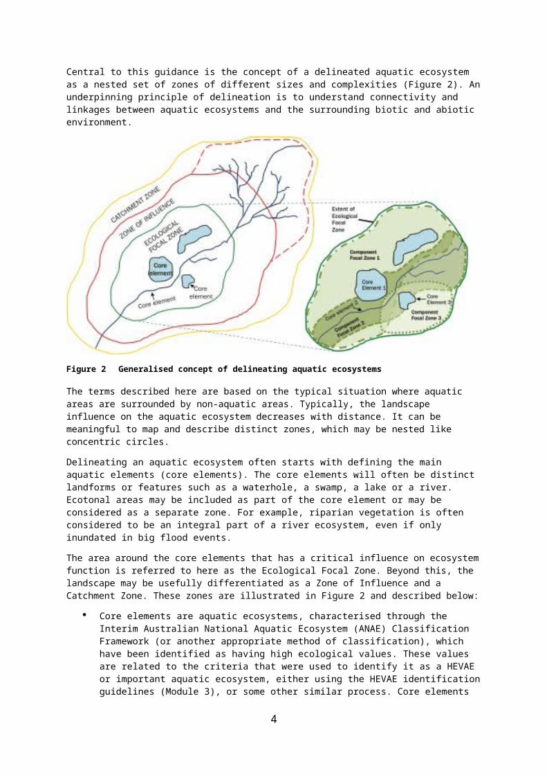
Figure 2 Generalised concept of delineating aquatic ecosystems
The terms described here are based on the typical situation where aquatic areas are surrounded by non-aquatic areas. Typically, the landscape influence on the aquatic ecosystem decreases with distance. It can be meaningful to map and describe distinct zones, which may be nested like concentric circles.
Delineating an aquatic ecosystem often starts with defining the main aquatic elements (core elements). The core elements will often be distinct landforms or features such as a waterhole, a swamp, a lake or a river. Ecotonal areas may be included as part of the core element or may be considered as a separate zone. For example, riparian vegetation is often considered to be an integral part of a river ecosystem, even if only inundated in big flood events.
The area around the core elements that has a critical influence on ecosystem function is referred to here as the Ecological Focal Zone. Beyond this, the landscape may be usefully differentiated as a Zone of Influence and a Catchment Zone. These zones are illustrated in Figure 2 and described below:
Core elements are aquatic ecosystems, characterised through the Interim Australian National Aquatic Ecosystem (ANAE) Classification Framework (or another appropriate method of classification), which have been identified as having high ecological values. These values are related to the criteria that were used to identify it as a HEVAE or important aquatic ecosystem, either using the HEVAE identification guidelines (Module 3), or some other similar process. Core elements may be connected in multiple ways, for example through hydrological connectivity, nutrient and carbon fluxes, vegetation corridors, habitat connectivity. Connectivity is an important consideration in identifying and defining the Ecological Focal Zone.
Ecological Focal Zones (EFZ) comprise the core elements, either singly or as an aggregation of aquatic ecosystems, which contain the key ecological values and functions, plus the surrounding area (this may be non-aquatic) that directly supports and/or connects them. The EFZ does not identify the area required to protect the aquatic ecosystem from threats or impacts. There may be multiple values for which a site has been identified, in which case the determination of the
4

overall EFZ is approached iteratively and a focal zone is determined for each value. Connectivity is an important consideration in identifying and defining the EFZ. The EFZ of the whole aquatic ecosystem is the sum of the component focal zones plus any other area deemed necessary to maintain the values and functional processes for the system (Figure 2).
The Zone of Influence (ZoI) is the area surrounding the EFZ in which pressures and management actions could impact on the state and/or condition of the aquatic ecosystem; it is related to the overall purpose for which the aquatic ecosystems are being considered e.g. water planning, control of invasive species. Similarly to the EFZ, the identification of the ZoI is iterative, may change depending on the purpose e.g. weed management, erosion control, river regulation, and may need to be considered separately for each management situation.
The Catchment Zone is the wider, surface-water catchment of the EFZ in which best-practice principles may be applied to alleviate pressures and impacts. In some cases, the catchment zone might be the same as the ZoI. There may even be instances when the ZoI extends beyond the catchment zone depending on the threat e.g. wind-borne invasive weeds.
Whilst the identification of the ZoI and the catchment zone is not within the scope of this module, in the process of developing conceptual models and identifying threats to aquatic ecosystems, the description process will take account of and may help to characterise the ZoI and the catchment zone.
2.3 Components and processesEcosystem components are the physical, chemical and biological parts of an aquatic ecosystem, from large to small scale e.g. habitat, birds, fish, genes. Ecosystem processes are the dynamic forces (physical, chemical and biological) occurring naturally within an ecosystem e.g. breeding, nesting, recruiting, flow regime. Processes and values may be grouped or sub-divided in various ways. For example, some processes, such as the sub-components of hydrology (e.g. frequency, duration of inundation, patterns in rainfall, rates and salinity of groundwater discharge etc.), may also be considered components.
An aquatic ecosystem has numerous components and processes contributing to the ecological character of that site. Critical components and processes are those that are identified through the process of identifying HEVAE (Module 3), or similar, as contributing to the high ecological value of the aquatic ecosystem and, if they were to change, could change the ecosystem’s ecological character and value. Initially, the ability to identify critical components and processes may not be easy, but the development of conceptual models may assist to consolidate this information. Appendix B lists examples of ecological components and processes of aquatic ecosystems (DEWHA 2008).
2.4 ScaleAquatic ecosystems may be delineated at various levels, varying in size from a single waterbody to a complex of multiple waterbodies or an entire catchment e.g. core element/EFZ, aquatic ecosystem complex, sub-catchment, catchment. Aquatic ecosystem planning and management, and existing inventories are highly variable in scale and detail throughout Australia, therefore a flexible approach to the delineation process is necessary. Advantages are that it is possible to have an aquatic ecosystem identified at a fine scale embedded within an aquatic ecosystem identified at a broad scale, enabling ecosystems to be viewed at multiple scales for different purposes and perspectives.
5
Systematic mapping and classification is important for correctly identifying and delineating important aquatic ecosystems. There is value in documenting existing knowledge about important aquatic ecosystems even when there are significant knowledge gaps, including mapping.
The scale and level of detail required to delineate an aquatic ecosystem will also depend on the purpose of the assessment. If an aquatic ecosystem is to be Ramsar-listed in the future, it may need to be delineated and mapped in more detail and at a finer scale. It is not expected that such detail would be required in every situation, and it may in some cases be sufficient to define a broad area as an aquatic ecosystem without a detailed assessment of the spatial layout within that area.
It is important that the delineation is appropriate for the purpose for which the site is being identified. When the area becomes too large for the purpose of the assessment, or the area becomes part of an aquatic ecosystem that should be defined and delineated separately at the same spatial scale (see Case Study 3: Tasmania, in this toolkit).
2.5 Expert knowledge inputWhilst the delineation and description of an aquatic ecosystem may be undertaken by anyone with spatial/ecological skills, it is important that, wherever possible, the process incorporates expert knowledge from scientific disciplines with relevant local knowledge and experience in the area of interest. This can take the form of expert reference panels that advise at particular stages of the process. Expert opinion should be used to select and guide the application of data, and to provide supplementary knowledge where data is limited.
Alternatively, experts can be engaged individually. This is less preferable as there is much to be gained by discussion within an expert panel, but is sometimes the only option given competing schedules and workloads.
Expert information can also be drawn from the literature during the assessment process, to supplement data and expert engagement as appropriate. Experts are able to interpret key points from the scientific literature and assist in making sure that relevant publications are considered in the delineation and description process.
Early engagement of experts is recommended, allowing time to ‘educate’ them on the intricacies of the delineation and description process as well as the methods used to identify the aquatic ecosystems of interest. If Module 3 Guidelines for Identifying HEVAE has been implemented before undertaking a delineation and description process, the same experts should not automatically be engaged for the delineation and description process. While there may be some overlap, it is important to seek experts with an intimate knowledge of the aquatic ecosystems undergoing delineation and description.
6

3 Workflow for delineating and describing aquatic ecosystems
In many instances, an aquatic ecosystem will have been identified as having high ecological value through a systematic process, such as the one recommended in Module 3 of the toolkit (Guidelines for Identifying High Ecological Value Aquatic Ecosystems (HEVAE)). Even though it is not necessary to have identified your ecosystem of interest by using Module 3, some of the inputs into the delineation process will have been completed as part of that process.
The relevant groundwork steps of Module 3 that may have been undertaken are: identification of the purpose of the assessment aquatic ecosystem core element classification and mapping.
Once a site of interest has been identified, either as a specific aquatic ecosystem or as an area that potentially contains an important aquatic ecosystem or HEVAE, the next phase is to delineate the site and describe its ecological character.
Sometimes the output of a ‘top-down’ process to identify HEVAE, guided by Module 3, may only be a list of assessment units (e.g. sub-catchments) which score highly against the HEVAE criteria. In such cases the next step will be to determine the values of individual aquatic ecosystems or groups of aquatic ecosystems within the sub-catchment. It is possible that the data that gave the sub-catchment (or other assessment unit) a high score, are associated with distinct aquatic ecosystems that are both geographically and hydrologically separated. The decision about how to group distinct ecosystems or core elements for the purpose of determining relative value can be part of the delineation and description process.
Delineation and description are treated together because much of the preliminary work to identify the aquatic ecosystems’ core elements and their ecological values and functions is common to both tasks. The main tasks in delineating and describing aquatic ecosystems are to:
identify the ecological values, and critical components and processes of the aquatic ecosystem and confirm their existence through ground-truthing or more intensive desktop assessment
identify and map core elements and ecological focal zones determine the geographical boundary of the aquatic ecosystem develop conceptual model/s and identify threats.
A series of steps have been developed to guide the user through the process of delineating and describing an aquatic ecosystem (Figure 3). Reference is made in the following steps to a series of case studies that illustrate the process of identifying HEVAE. These case studies are part of the toolkit (Aquatic Ecosystems Task Group 2012a; 2012b; 2012c). Appendix C is a checklist to follow throughout the process, and Appendix D is a template to record the details of the delineated and described aquatic ecosystem.
Although some of the description steps are based on the Ramsar ECD guidelines (DEWHA 2008) and reference should be made to the relevant sections of those guidelines, it should be noted that the detailed cataloguing and/or the full Ramsar process for identifying critical components and processes is not required for the application of Module 4.
7

Steps 3 to 6 can be iterative to ensure that identified values, critical components and processes, and EFZs are consistent with the conceptual models and identified threats.
Figure 3 Steps for delineating and describing aquatic ecosystems
In the following descriptive steps, the term ‘HEVAE’ is used to refer to any aquatic ecosystem that has been identified through either the use of Module 3 or any other suitable process to identify important aquatic ecosystems.
Step 1 Identify/review values, aquatic ecosystem classification, and components and processes for the high ecological value aquatic ecosystems or assessment units.
Ecological values are those values that led to the area of interest (assessment unit or aquatic ecosystem) being identified as a HEVAE or other important aquatic ecosystem
8

and they should be recorded. Note that it is beyond the scope of the Aquatic Ecosystem Toolkit to identify social or economic values, although this could be undertaken as supplementary work if required and the values incorporated into the assessment.
If the HEVAE was identified through application of the HEVAE criteria, much of this information will have been collated during the implementation of Module 3 (Guidelines for Identifying HEVAE). However, it is advisable to review those outputs to ensure that all relevant information has been sourced. If Step 6 of Module 3 (Validating identified HEVAE) has not yet been applied, part of the current review process can also include confirmation of the values either through ground-truthing or a more extensive desktop assessment (see Case Study 3: Tasmania). There may be additional values that were not picked up through the application of the broad assessment process because of a paucity or patchiness of data. These can be identified and recorded later on in the process, during Step 2.
It is presumed that mapping and classification of the site has been undertaken. If not, that process will have to be done using either the Interim ANAE Classification Framework (Module 2) or a comparable method. Although use of the ANAE is not essential, there is benefit in using the framework as it assists with establishing the EFZ and ZoI by identifying landscape functions and ecosystem drivers.
The task of identifying components and processes for the description should also commence. Most of these will be related to the ecological values for which the HEVAE was identified. More effort will be applied to this task in Step 3. The expert panel should participate in this review.
Step 2 Identify the core elementsThe core elements are those aquatic ecosystems associated with the values or criteria identified in Module 3, and reviewed in Step 1 above. This can be done by experts considering the values, and components and processes for each core element or, alternatively, by referring back to the previously collected data. Additional values that were not picked up through the application of the broad assessment process because of a paucity or patchiness of data can be identified either by expert input or by reference to the literature in this step. All information should be recorded to support the decision-making process, particularly if the links between core elements are tenuous.
Core elements that are found to be connected to other nearby core elements could be grouped as an aggregate or complex for the purpose of delineating and describing as an aquatic ecosystem. The size of the aggregate should be considered in relation to the purpose of the delineation or the area encroaches into what would be considered a separate complex when viewed at the same spatial scale.
Where detailed mapping of the core elements have not been undertaken this task should occur at this stage. The National Guidelines for the Mapping of Wetlands (Aquatic Ecosystems) in Australia provide the minimum standard for data quality required to support the inclusion of spatial data within a national wetland inventory. Refer to Module 1 for more information.
Step 3 Identify and summarise the critical components and processesOf the suite of components and processes identified in Step 1, those that are critical to determining or influencing the ecological character of the aquatic ecosystem should be identified and reasons for their selection summarised. This information can be sourced from the literature and/or relevant experts.
Although it is based on the Ramsar ECD guidelines (DEWHA 2008) and reference should be made to the relevant sections of those guidelines, it should be emphasised that the
9

detailed cataloguing and/or the full Ramsar process for identifying critical components and processes is not required (Appendix A).
For sites that include a complex array of aquatic ecosystem types, it may be useful to address the components and processes for each type.
Descriptions of ecological character should be linked to the values identified in the HEVAE assessment (or similar), as well as considering any values identified by experts. The values to be considered are those identified through the application of the criteria, which define ecological character, and not the HEVAE criteria themselves.
Descriptions should be prepared using current data and knowledge of critical components, processes and values, to reflect the ecological character of HEVAE at the time they are identified. The description should also include a description of the natural variability of the ecological components of the HEVAE.
Step 4 Identify the ecological focal zones (EFZ) for each value and delineate the overall EFZ
Using quantitative data (where available), ecological theory and expert opinion, identify what is needed to support the values in terms of connectivity and ecosystem function. Guidance on identifying EFZs is listed below:
When compiling an EFZ, the delineation process should consider connectivity between core elements (hydrological, ecological) and connectivity through functional linkage e.g. waterbirds feeding at one site and breeding at another. This should include infrequent but significant processes that support the values identified, such as large flooding events.
Development of EFZs can be iterative in that separate focal zones for different values are identified and mapped. The overall EFZ is the sum of the component focal zones, determined by overlaying all critical component focal zones and identifying the largest area needed to support all ecological values (Figure 2). An individual component EFZ might encompass all others, in which case the overall EFZ would equal the EFZ for that value (see Case Study 1: Lake Eyre Basin (Lake Galilee)).
When assessment units, as opposed to detailed aquatic ecosystem mapping are used to identify potential HEVAE, aggregations of core elements may extend beyond the boundaries of the identified assessment units into or across adjacent assessment units.
Aquatic ecosystems may be comprised of disjunct EFZs e.g. birds may feed in one area but breed in another (the distance between disjunct areas should reflect the requirements of the ecological value concerned). The use of disjunct EFZs does not hinder the delineation process, but needs to relate to values and be justified (Case Study 1: Lake Eyre Basin, particularly section 2.2 on Lake Galilee).
Grouping of core elements and EFZs within a site should be stopped when the area reaches a size that is considered too large for the stated purpose, or the area encroaches into what would be considered a separate HEVAE when viewed at the same spatial scale.
The size of the EFZ may also be limited by physical features, including topography, physical barriers or human activities such as urban development or farming.
Ecological values and associated EFZs that weren’t identified through the criteria
10

application can be included in the delineation process based on expert opinion. These decisions should be documented to capture the actual value and justification for its inclusion.
Step 5 Identify/develop conceptual modelsConceptual models aid in understanding the relationships between the critical chemical, physical and biological components and processes of the aquatic ecosystem.
Consideration should be given only to those critical components and processes that most strongly determine the ecological character of the site.
Conceptual models may be visual, depicted as drawings or as a flow chart, or textual descriptions of the ecosystem elements, or a combination of both.
Where one over-arching conceptual model is too complex to develop and understand, a number of conceptual models of a system may be developed, each focusing on different critical components and processes.
Step 6 Identify threatsThis is an additional step that can be included in the process, if it is relevant to the purpose of the delineation/description.
The focus in identifying threats should also be on critical components and processes identified as most strongly influencing the ecological character of the aquatic ecosystem.
Information on actual or likely threats or threatening activities, potential impacts on the critical components and processes, the likelihood of occurrence (low, medium, high/certain) and the timing of the threat (immediate, medium or long term) should be provided.
OutputsIt is essential that a full record of the approach used to delineate and describe aquatic ecosystems be maintained through both a report and a metadata statement. Examples of reporting the delineation process are provided in the case studies; and a record sheet template is in Appendix D. Additionally, any spatial output should be maintained along with supporting documentation.
11

4 GlossaryThe following terms and their definitions are specifically for the purposes of the Aquatic Ecosystems Toolkit.
Abiotic features
Non-living chemical and physical factors in the environment.
Aggregation Delineation: a grouping together or clustering of core elements to form a single entity. Similarly a number of entities may be grouped to form a single higher-level spatial unit. Aggregation may be used to combine core elements of high and low value into a collective unit in which the combined ecological value is greater that the individual parts, or if, for management purposes, it makes sense to group a number of core elements to form a single ‘Ecological Focal Zone’ or higher level spatial entity. Aggregation should be stopped when the collective area does not make sense for practical management.Statistical: the grouping of data combined from several measurements that provide information on a broader level than the level at which the detailed data was collected.
Aquatic ecosystems
Ecosystems that depend on flows, or periodic or sustained inundation/waterlogging for their ecological integrity (e.g. wetlands, rivers, karst and other groundwater-dependent ecosystems, saltmarshes and estuaries) but do not generally include marine waters (defined as areas of marine water the depth of which at low tide exceeds 6 metres, but to be interpreted by jurisdictions). For the purpose of the Aquatic Ecosystems Toolkit, aquatic ecosystems may also include artificial waterbodies such as sewage treatment ponds, canals and impoundments.
Assessment unit
The spatial unit at which the attributes and criteria for identifying HEVAE are applied. Refer to Module 3.
CFEV The Conservation of Freshwater Ecosystem Values Framework in Tasmania<www.dpiw.tas.gov.au/inter.nsf/ThemeNodes/CGRM-7JH6CM?open>.
Components The physical, chemical and biological parts of an aquatic ecosystem e.g. habitat, species, genes etc.
Condition The state or health of individual animals or plants, communities or ecosystems. Condition indicators can be physical-chemical or biological and represent the condition of the ecosystem. They may also be surrogates for pressures and stressors acting within the ecosystem.
Connectivity Environmental connectivity consists of links between water-dependent ecosystems that allow migration, colonisation and reproduction of species. These connections also enable nutrients and carbon to be transported throughout the system to support the healthy functioning and biodiversity of rivers, floodplains and wetlands. Hydrologic and ecological links are
12

between upstream and downstream sections of river (longitudinal connectivity) and between rivers and their floodplains (lateral connectivity).
Core element An aquatic ecosystem (e.g. a lake or river) that is considered to be related to one or more of the values as identified through the application of an assessment process (e.g. HEVAE criteria).
Delineation Delineation is the spatial identification, mapping and recording of an identified ecosystem, including its core elements and ecological focal zones.
Ecological character
Ecological character is the combination of the ecosystem components, processes and benefits/services that characterise an identified ecosystem at a given point in time.
Ecological description
An ecological description documents the critical components and processes that underpin the ecological values of the site.
Ecological Character Description (ECD)
A systematic method of documenting ecological character. Ramsar guidelines for undertaking an ECD are available in the National Framework and Guidance for Describing the Ecological Character of Australia’s Ramsar Wetlands. Module 2 of the National Guidelines for Ramsar Wetlands—Implementing the Ramsar Convention in Australia.(DEWHA 2008).<http://www.environment.gov.au/water/publications/environmental/wetlands/module-2-framework.html>
Ecological Focal Zone (EFZ)
Equates to the boundary of the aquatic ecosystem, and is the area that maintains and supports the values of that ecosystem in terms of function and connectivity, including terrestrial parts. This may be a single core element or aggregate of core elements, plus the surrounding supporting areas related to the values.
Ecological value
Ecological value is the perceived importance of an ecosystem, which is underpinned by the biotic and/or abiotic components and processes that characterise that ecosystem. In the Aquatic Ecosystems Toolkit, ecological values are those identified as important through application of the criteria and identification of critical components and processes in describing the ecological character of the ecosystem (or another comparable process).
Ecosystem An ecosystem is a dynamic combination of plant, animal and micro-organism communities and their non-living environment (e.g. soil, water and the climatic regime) interacting as a functional unit. Examples of types of ecosystems include forests, wetlands, grasslands and tundra (Natural Resource Management Ministerial Council 2010).
Ecosystem function
Activities or actions which occur naturally in ecosystems as a product of the interactions between the ecosystem structure and processes e.g. floodwater
13

control, nutrient, sediment and contaminant retention, food web support, shoreline stabilisation and erosion controls, storm protection, and stabilisation of local climatic conditions, particularly rainfall and temperature.
Ecosystem services
Benefits that people receive or obtain from an ecosystem (Ramsar Convention (2005), Resolution IX.1 Annex A). The components of ecosystem services (MEA 2005) include:Provisioning services such as food, fuel and fresh water.Regulating services are the benefits obtained from the regulation of ecosystem processes such as climate regulation, water regulation and natural hazard regulation.Cultural services are the benefits people obtain through spiritual enrichment, recreation, education and aesthetics.Supporting services are the services necessary for the production of all other ecosystem services such as water cycling, nutrient cycling and habitat for biota. These services will generally have an indirect benefit to humans or a direct benefit in the long term.
Habitat The environment where an organism or ecological community exists and grows for all or part of its life.
High Ecological Value Aquatic Ecosystems (HEVAE)
For the purposes of the toolkit, HEVAE are sites, comprising one or more aquatic ecosystems, that are considered to be of high ecological value as determined by a consistent and objective process such as that provided by Module 3: Guidelines for Identifying High Ecological Value Aquatic Ecosystems (HEVAE).
HEVAE criteria The HEVAE criteria are the five core biophysical characteristics that have been agreed by the Aquatic Ecosystems Task Group as appropriate for the identification of HEVAE: diversity, distinctiveness, vital habitat, naturalness and representativeness. Refer to Module 3 for more information.
Pressure Activities and processes which act on the environment and bring about environmental change.
Processes Are the dynamic forces within an ecosystem. They include all processes that occur between organisms and within and between populations and communities, including interactions with the non-living environment that result in existing ecosystems and that bring about changes in ecosystems over time.
Ramsar Convention
Convention on Wetlands of International Importance especially as Waterfowl Habitat. Ramsar (Iran), 2 February 1971. UN Treaty Series No. 14583. As amended by the Paris Protocol, 3 December 1982, and Regina Amendments, 28 May 1987. The abbreviated names ‘Convention on Wetlands (Ramsar, Iran, 1981)’ or ‘Ramsar Convention’ are used more commonly.
14

The Ramsar Convention, is an intergovernmental treaty that embodies the commitments of its member countries to maintain the ecological character of their Wetlands of International Importance and to plan for the ‘wise use’, or sustainable use, of all of the wetlands in their territories.Based on information found at http://www.ramsar.org.
Surface water Includes water in a watercourse, lake or wetland, and any water flowing over or lying on the land after having precipitated naturally or after having risen to the surface naturally from underground.
Zone of Influence (ZoI)
The area surrounding the Ecological Focal Zone in which pressures and management actions might impact on the state and/or condition of the ecosystem. These may be spatially or temporally variable depending on which influences are being considered.
5 ReferencesAquatic Ecosystems Task Group (2012a). Aquatic Ecosystems Toolkit. Case Study 1: Lake Eyre Basin. Department of Sustainability, Environment, Water Population and Communities, Canberra.
Aquatic Ecosystems Task Group (2012b). Aquatic Ecosystems Toolkit. Case Study 2: Northern Australia. Department of Sustainability, Environment, Water, Population and Communities, Canberra.
Aquatic Ecosystems Task Group (2012c). Aquatic Ecosystems Toolkit. Case Study 3: Tasmania. Department of Sustainability, Environment, Water Population and Communities, Canberra.
DEWHA (2008). National Framework and Guidance for Describing the Ecological Character of Australia’s Ramsar Wetlands. Module 2 of the National Guidelines for Ramsar Wetlands—Implementing the Ramsar Convention in Australia. Australian Government Department of the Environment, Water, Heritage and the Arts, Canberra.
DERM (2011). Queensland Wetland Buffer Planning Guideline. Queensland Department of Environment and Resource Management, Brisbane, verified June 2012, <http://wetlandinfo.derm.qld.gov.au/wetlands/ManagementTools/Guidelines/bufferguidelines.html>.
Isbell, R.F. (2002). The Australian Soil Classification (revised 1st edn). CSIRO Publishing, Melbourne.
McDonald, R.C., Isbell, R.F., Speight, J.G., Walker, J., and Hopkins, M.S. (1990). (Eds). Australian soil and land survey: field handbook (2nd edn). Inkata Press, Melbourne.
Natural Resource Management Ministerial Council (NRMMC) (2010). Australia’s Biodiversity Conservation Strategy 2010–2030. Australian Government Department of Sustainability, Environment, Water, Population and Communities, Canberra.
Western Australian Planning Commission (2005). Guideline for the Determination of Wetland Buffer Requirements for Public Comment (Draft). Western Australian Planning Commission, verified June 2012, <www.planning.wa.gov.au/dop_pub_pdf/Wetland_Text.pdf>
15

16

Appendix A Consistency between the Aquatic Ecosystems Description guidance and Ramsar Ecological Character Description guidanceText in grey are those components of the Ramsar ECD guidance that are NOT undertaken in an HEVAE Description.
1. Introduction to the descriptionSite details, purpose of the description and relevant legislation
2. Describe the siteSite location, climate, maps and images, tenure, wetland criteria and types
3. Identify and describe the critical components, processes and services3.1 Identify all possible components, processes and benefits3.2 Of these, identify the critical components, processes and benefits responsible for determining the ecological character of the site3.3 Describe each of the critical components, processes and benefits
4. Develop a conceptual model for the wetlandDepict the critical components and processes of the wetland (e.g. hydrology,
biogeochemical processes, biota and vegetation, and their relationships)
5. Set limits of acceptable changeDetermine limits of acceptable change for critical components, processes and services of
6. Identify threats to the ecological character of the siteUse information from Steps 3–5 and other information to identify the actual or likely
7. Describe changes to ecological characterDescribe any changes to the ecological character of the site since the time of listing;
include information on the current condition of the site
8. Summarise the knowledge gapsUse information from Steps 3–7 to identify the knowledge gaps
9. Identify site-monitoring needsUse information from steps 3–8 to identify monitoring needs
10. Identify communication and education messagesIdentify any communication and education messages highlighted during the development
of the description
11. Compile the description of ecological character
12. Prepare or update the Ramsar Information SheetSubmit as a companion document to the ecological charter description
17

18

Appendix B Examples of ecological components and processes of aquatic ecosystems (DEWHA 2008)
COMPONENT EXAMPLES
Physical form • Area of the wetland• Wetland form (e.g. depth, shape and bathymetry—the study of
underwater depth)
Wetland soils • Site and soil profile characterisation (e.g. using the Australian Soil and Land Survey Field Handbook, McDonald et al. 1990).
• Soil profile classification (e.g. Isbell 2002)—most profiles should fall into the Hydrosol Soil Order and classification to the Sub-Order or Great Group level will be sufficient in most cases.
• Soil physical properties (e.g. structure, texture, consistency and profile)
• Soil chemical properties (e.g. organic content, nutrients, sulfides, acid neutralising capacity, salts and pH)
• Soil biological properties (e.g. soil organisms such as bacteria and fungi, invertebrates—shellfish, mites and worms)
Physicochemical water
• Nutrients (e.g. nitrogen, phosphorus)• Electrical conductivity• Cations and anions• Turbidity• Temperature• Dissolved oxygen• pH• Nutrient cycling• Light attenuation
Biota • Wetland plants• Vertebrate fauna (e.g. fish, amphibians, reptiles, waterbirds,
mammals)• Phytoplankton, including diatoms• Aquatic macroinvertebrates
PROCESS TYPE EXAMPLES
Climate* • Precipitation• Temperature• Evaporation• Wind
19

• Water source• Soils• Sedimentation• Erosion
Geomorphology* • Topography/morphology• Connectivity of surface waters
Hydrology* • Water balance (water flowing in, water flowing out)• Groundwater infiltration and seepage• Surface–groundwater interactions• Tidal regime• Inundation regime (volume, frequency, duration, height and
seasonality, or timing, of inundation)
Energy and nutrient dynamics
• Primary production• Nutrient cycling (nitrogen, phosphorus)• Carbon cycling• Decomposition• Oxidation–reduction
Processes that maintain animal and plant populations
• Reproduction• Regeneration• Dispersal• Migration• Pollination
Species interactions • Competition• Predation• Succession• Herbivory• Diseases and pathogens
Physical processes • Stratification• Mixing• Sedimentation• Erosion• Evaporation• Infiltration
*For some ecosystems these processes may be viewed as components or broken down into their components.
20

Appendix C Checklist for completing the aquatic ecosystem delineation and description workflowAquatic ecosystem name:Preliminary activities
Criteria application (or other assessment process) completedPurpose for delineation and scale defined Area of interest identified (assessment unit or aquatic ecosystem core elements)Relevant data and information sources compiled (maps, imagery, reports)Expert reference panel identified and engaged
Delineation and description process
Values/functions identified and cross-checked (both criteria related and those from experts)*Aquatic ecosystem types within area of interest identified and mappedCore elements identified for each value/function and mappedEcological focal zone identified for each value/function and mappedOverall ecological focal zone delineated and cross-checked to ensure it captures all the values and functions/processesConceptual models developedThreats to the ecological character of the site identified and documentedDocumentation and metadata completed
Aquatic ecosystem documentation processKnowledge gaps identifiedStakeholder consultation undertakenMetadata completedSpatial layers completedAquatic ecosystem assessment report completed
* Expert panels should be used to verify results of output assessment process and add in any additional values that exist but were not identified through the criteria application.
21

Appendix D Aquatic ecosystem delineation and description record template(See case studies for examples of completed templates.)
AQUATIC ECOSYSTEM DELINEATION AND DESCRIPTION RECORD SHEET
Name of aquatic ecosystem
Date of delineation
Purpose for delineation e.g. water planning, NRS
Scale Provide description about scale at which you are working.
Experts involved Name, contact details, discipline
Datasets used Listing of datasets used—include information on scale, currency, quality/confidence rating and any custodianship information.
Gaps/limitations Summary of data and information gaps or limitations encountered during the delineation process.
Ecosystem description Provide information on the big-picture scale including overall system description, locality, major systems (rivers, lakes etc.), area.
Ecosystem types List dominant types and identify classification used e.g. ANAE.
Land use
Land tenure
HEVAE criteria met Criteria 1 DiversityCriteria 2 DistinctivenessCriteria 3 Vital HabitatCriteria 4 NaturalnessCriteria 5 Representativeness
Other criteria, e.g. CFEV, Ramsar, project specific.
Summary of values Criteria related:
22

Identified by experts:A summary of what values made the area score highly.
Description/justification Description/justification of decision process for determining Ecological Focal Zone. Identify source material (either from literature and/or expert opinion) for each value. Provide information on data quality/confidence.
Presence in other listing RamsarWorld Heritage AreasNational Heritage PlacesFlywaysEPBC threatened speciesEPBC ecological communities etc.
References References (and links if available) and other related processes and documents e.g. water resource plan, wild rivers etc., conceptual models etc.
23