Embed Size (px)
Citation preview

AQA A Revision Guide – The Restless Earth
1. Why do we get volcanoes and earthquakes? It is all to do with PLATE TECTONICS. This is a relatively new theory (only
really been around for 100 years and been universally accepted for the last
40-50 years) and it looks at the structure of the Earth and examines how
vast areas of rock or PLATES can move. To understand this theory you need
to have an idea of the structure of the Earth. The diagram on the right shows
this. The crust floats on the semi-molten rocks of the Mantle. The high
temperatures in the Mantle result in convection currents that enable the
crust to move.
2. Is the Crust just one piece? NO! It is split up into a series of
PLATES which fit together like a giant
jigsaw. The map on the left shows this-
note the underlying land masses in
blue. You can see that we are on the
Eurasian plate!
3. Are all these plates made of the
same material?
No! Some are made of continental
crust and some are made of oceanic crust. It is important to understand this as this will help you understand what
happens at the different plate boundaries. This table summarises the differences:
4. So what happens when the plates meet?
It depends! As I have already said it is determined by the type of crust involved, but also in terms of the direction in
which the plates are moving. The different types of plate boundary are discussed on the next page.
TIP: AT THIS POINT GO TO THE ‘s-cool’ SITE http://s-cool.co.uk/gcse/geography/tectonics/plate-boundaries.html
Data /
Type Oceanic crust Continental crust
Crust
depth shallow, 5 - 12 km
deeper, average 40km, 75km beneath young
mountain range
Age Young rocks, less than 200 Million years old Older, generally over 1500 Million years
Density 3.0 x 10³ Kg m-3 DENSE! 2.6 x 10³ Kg m-3 NOT AS DENSE AS OCEANIC
CRUST!
Rock
type,
geology
Mainly basalt Range of granites with thin covering of
sedimentary rocks
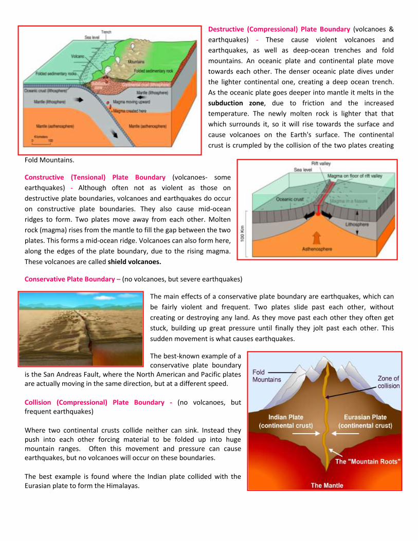
Destructive (Compressional) Plate Boundary (volcanoes &
earthquakes) - These cause violent volcanoes and
earthquakes, as well as deep-ocean trenches and fold
mountains. An oceanic plate and continental plate move
towards each other. The denser oceanic plate dives under
the lighter continental one, creating a deep ocean trench.
As the oceanic plate goes deeper into mantle it melts in the
subduction zone, due to friction and the increased
temperature. The newly molten rock is lighter that that
which surrounds it, so it will rise towards the surface and
cause volcanoes on the Earth's surface. The continental
crust is crumpled by the collision of the two plates creating
Fold Mountains.
Constructive (Tensional) Plate Boundary (volcanoes- some
earthquakes) - Although often not as violent as those on
destructive plate boundaries, volcanoes and earthquakes do occur
on constructive plate boundaries. They also cause mid-ocean
ridges to form. Two plates move away from each other. Molten
rock (magma) rises from the mantle to fill the gap between the two
plates. This forms a mid-ocean ridge. Volcanoes can also form here,
along the edges of the plate boundary, due to the rising magma.
These volcanoes are called shield volcanoes.
Conservative Plate Boundary – (no volcanoes, but severe earthquakes)
The main effects of a conservative plate boundary are earthquakes, which can
be fairly violent and frequent. Two plates slide past each other, without
creating or destroying any land. As they move past each other they often get
stuck, building up great pressure until finally they jolt past each other. This
sudden movement is what causes earthquakes.
The best-known example of a conservative plate boundary
is the San Andreas Fault, where the North American and Pacific plates are actually moving in the same direction, but at a different speed.
Collision (Compressional) Plate Boundary - (no volcanoes, but frequent earthquakes)
Where two continental crusts collide neither can sink. Instead they push into each other forcing material to be folded up into huge mountain ranges. Often this movement and pressure can cause earthquakes, but no volcanoes will occur on these boundaries.
The best example is found where the Indian plate collided with the Eurasian plate to form the Himalayas.
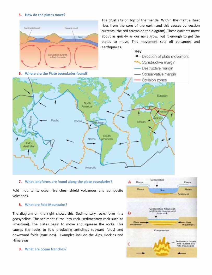
5. How do the plates move?
The crust sits on top of the mantle. Within the mantle, heat
rises from the core of the earth and this causes convection
currents (the red arrows on the diagram). These currents move
about as quickly as our nails grow, but it enough to get the
plates to move. This movement sets off volcanoes and
earthquakes.
6. Where are the Plate boundaries found?
7. What landforms are found along the plate boundaries?
Fold mountains, ocean trenches, shield volcanoes and composite
volcanoes.
8. What are Fold Mountains?
The diagram on the right shows this. Sedimentary rocks form in a
geosyncline. The sediment turns into rock (sedimentary rock such as
limestone). The plates begin to move and squeeze the rocks. This
causes the rocks to fold producing anticlines (upward folds) and
downward folds (synclines). Examples include the Alps, Rockies and
Himalayas.
9. What are ocean trenches?
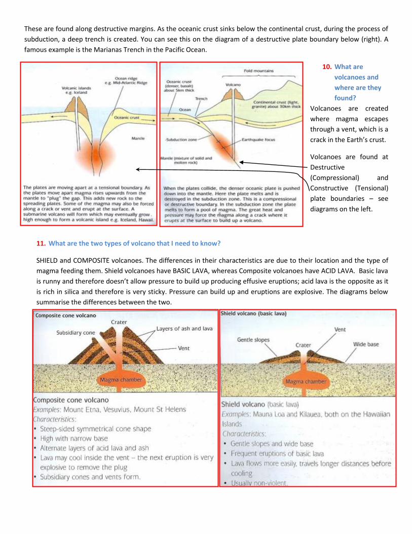
These are found along destructive margins. As the oceanic crust sinks below the continental crust, during the process of
subduction, a deep trench is created. You can see this on the diagram of a destructive plate boundary below (right). A
famous example is the Marianas Trench in the Pacific Ocean.
10. What are
volcanoes and
where are they
found?
Volcanoes are created
where magma escapes
through a vent, which is a
crack in the Earth’s crust.
Volcanoes are found at
Destructive
(Compressional) and
Constructive (Tensional)
plate boundaries – see
diagrams on the left.
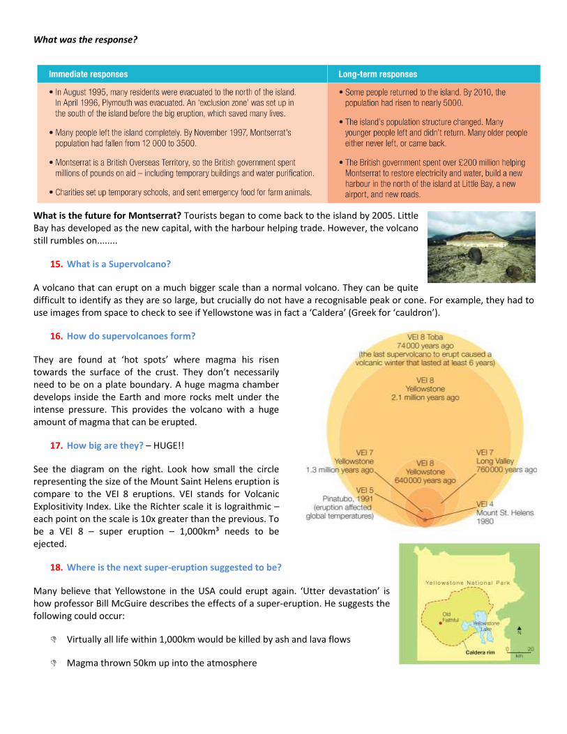
11. What are the two types of volcano that I need to know?
SHIELD and COMPOSITE volcanoes. The differences in their characteristics are due to their location and the type of
magma feeding them. Shield volcanoes have BASIC LAVA, whereas Composite volcanoes have ACID LAVA. Basic lava
is runny and therefore doesn’t allow pressure to build up producing effusive eruptions; acid lava is the opposite as it
is rich in silica and therefore is very sticky. Pressure can build up and eruptions are explosive. The diagrams below
summarise the differences between the two.

12. Using landforms at plate boundaries: Fold Mountain case study – Alps (see your
A3 sheet)
Where: Mountains along the borders of France/Italy/Switzerland/Austria
Why: The collision between the African plate and the Eurasian plate. Limestone
sediments formed in the Geosyncline were folded up into the peaks of the Alps.
When: The last 60 million years. However, Glaciation in the last 100,000 years has
sculpted the landscape further with frost-shattered peaks and deep U-shaped valleys.
How has the landscape been used (how have people adapted to the landscape)?:
Farming, Hydroelectric Power, Tourism. The valleys are used for roads and railways. A
more detailed discussion is provided below:
Human use Details and how people have adapted
Tourism Winter Sports – glaciated valleys have produced steep slopes. The height has enabled a long snow
season. Resorts such as La Plagne (see Glaciation revision guide) and Chamonix have profited from
this.
Summer Sports – Hiking, mountain biking, abseiling etc. Warm temperatures ideal for this. The
Montenvers train taking people to the Mer De Glace near Chamonix is an example of this.
Hydroelectric
Power
The steep/deep U shaped valleys created by glaciation provide perfect conditions for the
constructed of reservoirs. Power is created by the release of the water. This has enabled industry to
set up in the valley floor.
Farming Pastoral (animals) on the valley slides. These animals are placed on the High Alp (saeter) during the
summer months and then moved down the slopes in the winter. This is called ‘transhumance’. Dairy
farming is crucial; pipes send milk down the mountainside in summer to the dairies. Soils are deep
and fertile in the valley floor, so arable (crop) farming is done.
13. What are the volcanic threats?
These can be split into primary and secondary effects. In fact, the same can be said for the effects
of earthquakes
1. Primary effects- i.e. things that happen directly as a result of the eruption in the short term.
Things like:
The volcanic blast- power of the blast can blow things over- this happened at Mount Saint Helens, where all the trees near the volcano were flattened.
Building destroyed by fires
Livestock and crops destroyed
Pyroclastic flows - occur where the ash cloud that has been ejected into the air loses its ability to stay suspended and comes falling back to earth. This resultant clouds of searing hot ash and gases (often 600°C) rush down the sides of the mountain (often in valleys) at great speeds.

Lava flows - Lava clearly is a hazard due to its ability to destroy most things in its path. However, lava flows can be diverted (Heimaey, 1973 in Iceland) and people are normally able to get out of the way!
Volcanic Bombs- large boulders and stones (pumice) that is hurled out of the volcano during an eruption
2. Secondary effects- i.e. things that happen as a result of the eruption. These may not be instantaneous and the
effects may actually be felt in the much longer term
• Lahars/Mudlfows - Mudflows and lahars are closely associated with volcanic activity. Rain brings soot and ash back to the ground, which becomes a heavily saturated mudflow when combined with melted snow and ice (perhaps from the peak of the volcano). The sediment that is picked up turns into the hazardous mudflow.
• Changes in climate • Food/ water supply disrupted • Homelessness • Businesses forced to close and realted unemployment • Insurance claims
14. Case Studies of Volcanic Eruption: Montserrat
Montserrat is an island is situated in the Caribbean and 12 miles long x 7 miles wide. Much of the population is poor and relies on farming. Before the eruption of 1995, over 12,000 people lived on the island but less than 5,000 do today.
The volcano (Soufriere Hills) was formed as a result of the subduction of the Atlantic plate under the Caribbean plate – a destructive plate boundary.
The Soufriere Hills volcano started erupting in 1995 for the first time in 350 years. However, the big eruption came in June 1997. It caused:
Huge pyroclastic flows over 500⁰C – 3 main ones came down ‘Mosquito Gut’. The final one killed farmers who thought they were safe
50% of Montserrat uninhabitable
Infrastructure destroyed (airport etc)
19 died and many fled the island
Farms and houses abandoned. The capital, Plymouth, was destroyed and abandoned.
Montserrat’s economy was devastated (lack of tourists did not help)
What was the response?
What is the future for Montserrat? Tourists began to come back to the island by 2005. Little Bay has developed as the new capital, with the harbour helping trade. However, the volcano still rumbles on........
15. What is a Supervolcano?
A volcano that can erupt on a much bigger scale than a normal volcano. They can be quite difficult to identify as they are so large, but crucially do not have a recognisable peak or cone. For example, they had to use images from space to check to see if Yellowstone was in fact a ‘Caldera’ (Greek for ‘cauldron’).
16. How do supervolcanoes form?
They are found at ‘hot spots’ where magma his risen towards the surface of the crust. They don’t necessarily need to be on a plate boundary. A huge magma chamber develops inside the Earth and more rocks melt under the intense pressure. This provides the volcano with a huge amount of magma that can be erupted.
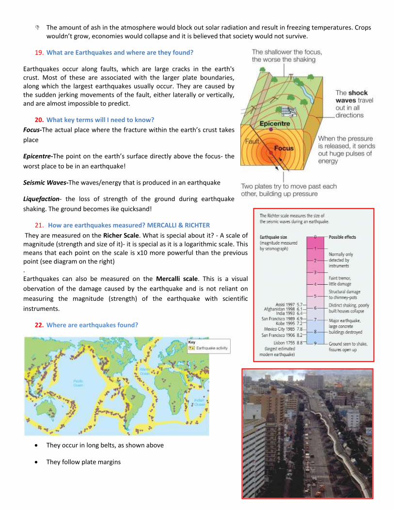
17. How big are they? – HUGE!!
See the diagram on the right. Look how small the circle representing the size of the Mount Saint Helens eruption is compare to the VEI 8 eruptions. VEI stands for Volcanic Explositivity Index. Like the Richter scale it is lograithmic – each point on the scale is 10x greater than the previous. To be a VEI 8 – super eruption – 1,000km³ needs to be ejected.
18. Where is the next super-eruption suggested to be?
Many believe that Yellowstone in the USA could erupt again. ‘Utter devastation’ is how professor Bill McGuire describes the effects of a super-eruption. He suggests the following could occur:
Virtually all life within 1,000km would be killed by ash and lava flows
Magma thrown 50km up into the atmosphere
The amount of ash in the atmosphere would block out solar radiation and result in freezing temperatures. Crops wouldn’t grow, economies would collapse and it is believed that society would not survive.
19. What are Earthquakes and where are they found?
Earthquakes occur along faults, which are large cracks in the earth's crust. Most of these are associated with the larger plate boundaries, along which the largest earthquakes usually occur. They are caused by the sudden jerking movements of the fault, either laterally or vertically, and are almost impossible to predict.
20. What key terms will I need to know?
Focus-The actual place where the fracture within the earth’s crust takes
place
Epicentre-The point on the earth’s surface directly above the focus- the
worst place to be in an earthquake!
Seismic Waves-The waves/energy that is produced in an earthquake
Liquefaction- the loss of strength of the ground during earthquake
shaking. The ground becomes ike quicksand!
21. How are earthquakes measured? MERCALLI & RICHTER
They are measured on the Richer Scale. What is special about it? - A scale of magnitude (strength and size of it)- it is special as it is a logarithmic scale. This means that each point on the scale is x10 more powerful than the previous point (see diagram on the right) . Earthquakes can also be measured on the Mercalli scale. This is a visual
obervation of the damage caused by the earthquake and is not reliant on
measuring the magnitude (strength) of the earthquake with scientific
instruments.
22. Where are earthquakes found?
They occur in long belts, as shown above
They follow plate margins

However, some are found away from plate boundaries – minor fault lines are responsible for these
23. What are the effects of Earthquakes?
Primary effects – (All occur due to the shaking of the ground) include: 1. buildings collapsing 2. roads and bridges being destroyed 3. railway lines being buckled
Secondary effects - are the subsequent effects of the earthquake, and can be even more devastating then the
primary ones.
o Fires: usually from ruptured gas lines. This was the main cause of death and damage after the San Francisco earthquake in 1906.
o Tsunami: They can travel very quickly across entire oceans, before engulfing land 1000's of miles away. I’m sure you all witnessed the footage of the Indian Ocean Tsunami on 26/12/2004.
o Landslides can often be triggered by earthquakes, causing huge amounts of material to be moved very quickly. This is actually what occurred just before the volcanic eruption on Mt. St. Helens. They are most likely to occur where the land is steep, saturated or weak.
o Diseases can spread very quickly in the unsanitary conditions often left behind by massive earthquakes. Water becomes contaminated very quickly, and in Less Economically Developed Countries (LEDCs) especially; access for the medical services can be badly hampered by the damage caused by the quake. The most common diseases to be associated with earthquakes are therefore water-borne ones like cholera and typhoid.
24. Earthquake 1: LEDC – Haiti
When: 12/1/2010
Where: Haiti, with the capital Port-au-Prince hit very badly. Epicentre
13km underground, 25km from port-Au-Prince.
Why: Destructive plate boundary where the Atlantic plate subducts the
Caribbean plate (same as Montserrat), but the earthquake was actually
along a fault line cause by this pressure. In fact, the earthquake was a strike-slip event, which is like what happens at a
Conservative margin.
What were the effects?:
Haiti Primary Haiti Secondary
220,000 killed (approx)
Port damaged, roads blocked
8 hospital collapsed or damaged
200,000 houses damaged and about 1.3 million people displaced
2 million without food and water
Looting – police force collapsed
Damage to port and road prevented medical supplies being distributed effectively
Disease in tented camps. Mass graves as people were left on the streets
Power cuts
What was the response?:
Short term: The port was destroyed and the airport couldn’t cope. Supplies
weren’t distributed effectively. American engineers tried to clear the worst
of the debris in the port so that ships could unload the aid. The USA also sent
10,000 troops and £100 million in aid. Bottled water and purification tablets
were provided.
Longer-term response: Rebuild homes to a better standard. Rebuild port.
Still reliant on overseas aid.
25. Earthquake 2: A richer country – Chile (some have
studied Kobe – read on!!)
Chile is not the richest, but it is more affluent than Haiti. When
hit by an 8.8 earthquake its impact was far less than the 7.0 at
Haiti.
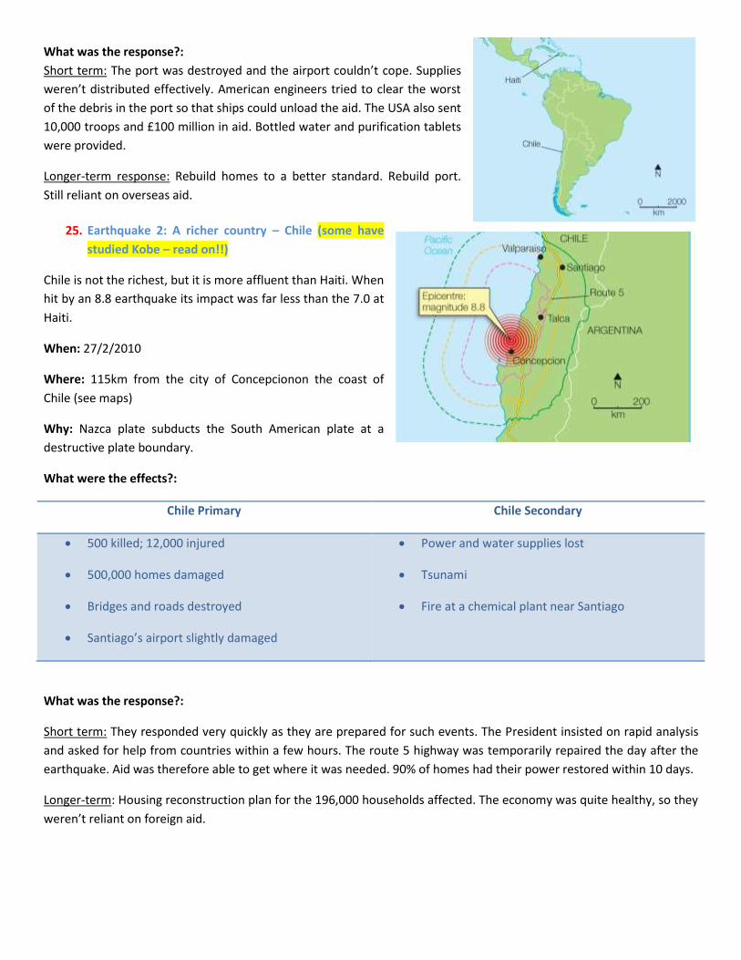
When: 27/2/2010
Where: 115km from the city of Concepcionon the coast of
Chile (see maps)
Why: Nazca plate subducts the South American plate at a
destructive plate boundary.
What were the effects?:
Chile Primary Chile Secondary
500 killed; 12,000 injured
500,000 homes damaged
Bridges and roads destroyed
Santiago’s airport slightly damaged
Power and water supplies lost
Tsunami
Fire at a chemical plant near Santiago
What was the response?:
Short term: They responded very quickly as they are prepared for such events. The President insisted on rapid analysis
and asked for help from countries within a few hours. The route 5 highway was temporarily repaired the day after the
earthquake. Aid was therefore able to get where it was needed. 90% of homes had their power restored within 10 days.
Longer-term: Housing reconstruction plan for the 196,000 households affected. The economy was quite healthy, so they
weren’t reliant on foreign aid.
Some students have studies Kobe (MB’s classes)
Notes provided below:
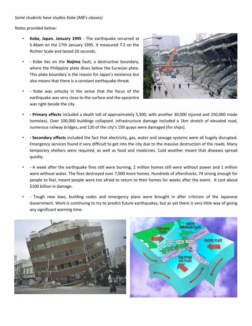
• Kobe, Japan. January 1995 - The earthquake occurred at
5.46am on the 17th January 1995. It measured 7.2 on the
Richter Scale and lasted 20 seconds.
• - Kobe lies on the Nojima fault, a destructive boundary,
where the Philippine plate dives below the Eurasian plate.
This plate boundary is the reason for Japan’s existence but
also means that there is a constant earthquake threat.
• - Kobe was unlucky in the sense that the focus of the
earthquake was very close to the surface and the epicentre
was right beside the city.
• - Primary effects included a death toll of approximately 5,500, with another 30,000 injured and 250,000 made
homeless. Over 100,000 buildings collapsed. Infrastructure damage included a 1km stretch of elevated road,
numerous railway bridges, and 120 of the city’s 150 quays were damaged (for ships).
• - Secondary effects included the fact that electricity, gas, water and sewage systems were all hugely disrupted.
Emergency services found it very difficult to get into the city due to the massive destruction of the roads. Many
temporary shelters were required, as well as food and medicines. Cold weather meant that diseases spread
quickly.
• - A week after the earthquake fires still were burning, 2 million homes still were without power and 1 million
were without water. The fires destroyed over 7,000 more homes. Hundreds of aftershocks, 74 strong enough for
people to feel, meant people were too afraid to return to their homes for weeks after the event. It cost about
$100 billion in damage.
• - Tough new laws, building codes and emergency plans were brought in after criticism of the Japanese
Government. Work is continuing to try to predict future earthquakes, but as yet there is very little way of giving
any significant warning time.
26. Why were the impacts/ response different between the two earthquakes? Yellow highlighted stuff relates to
Kobe
PREDICTION, PREPARATION and the ability to ACT.
Prediction is a realistic proposition for volcanoes, but not so for earthquakes. You can work out roughly where they
could happen but no more. You have already seen that Chile (and Japan-Kobe) was far better at dealing with their
earthquake when it happened than Haiti, but why was this?
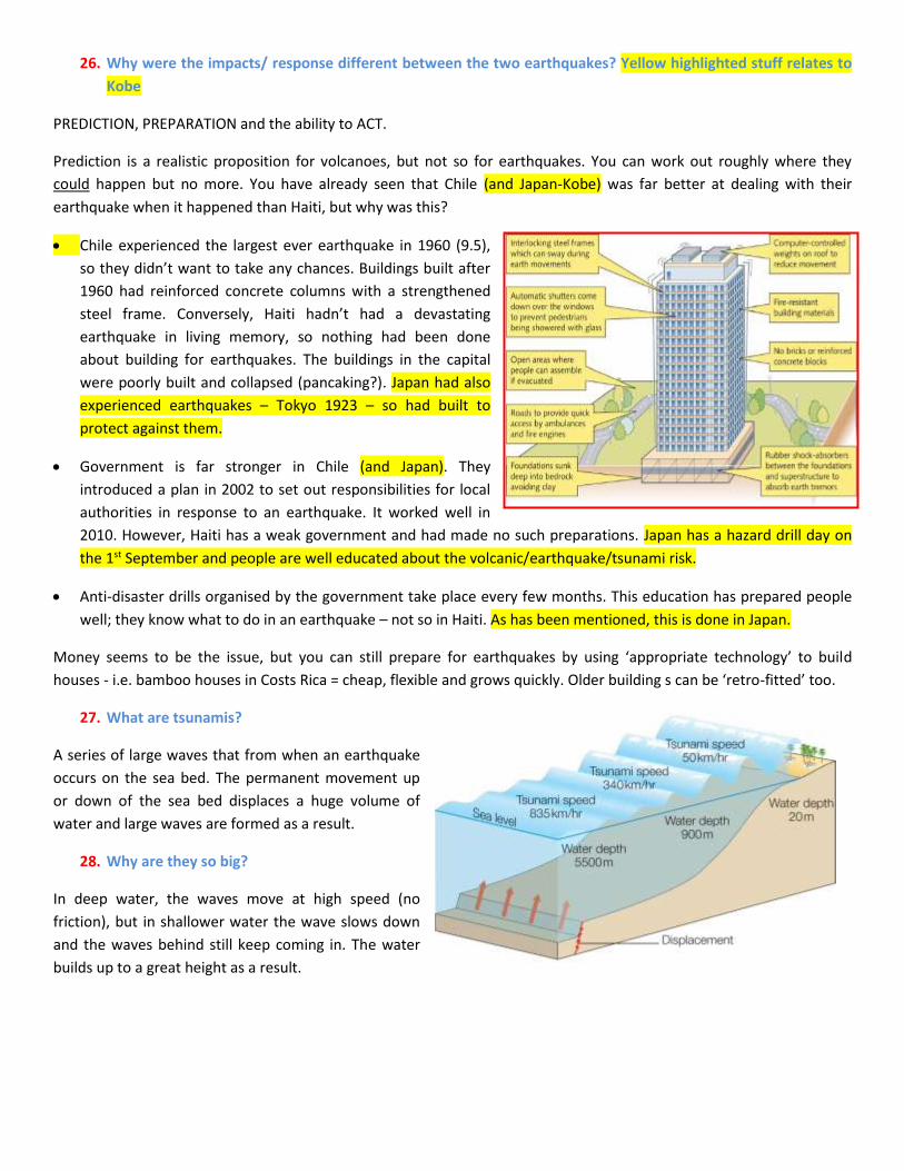
Chile experienced the largest ever earthquake in 1960 (9.5),
so they didn’t want to take any chances. Buildings built after
1960 had reinforced concrete columns with a strengthened
steel frame. Conversely, Haiti hadn’t had a devastating
earthquake in living memory, so nothing had been done
about building for earthquakes. The buildings in the capital
were poorly built and collapsed (pancaking?). Japan had also
experienced earthquakes – Tokyo 1923 – so had built to
protect against them.
Government is far stronger in Chile (and Japan). They
introduced a plan in 2002 to set out responsibilities for local
authorities in response to an earthquake. It worked well in
2010. However, Haiti has a weak government and had made no such preparations. Japan has a hazard drill day on
the 1st September and people are well educated about the volcanic/earthquake/tsunami risk.
Anti-disaster drills organised by the government take place every few months. This education has prepared people
well; they know what to do in an earthquake – not so in Haiti. As has been mentioned, this is done in Japan.
Money seems to be the issue, but you can still prepare for earthquakes by using ‘appropriate technology’ to build
houses - i.e. bamboo houses in Costs Rica = cheap, flexible and grows quickly. Older building s can be ‘retro-fitted’ too.
27. What are tsunamis?
A series of large waves that from when an earthquake
occurs on the sea bed. The permanent movement up
or down of the sea bed displaces a huge volume of
water and large waves are formed as a result.
28. Why are they so big?
In deep water, the waves move at high speed (no
friction), but in shallower water the wave slows down
and the waves behind still keep coming in. The water
builds up to a great height as a result.
29. Case Study: Boxing Day Tsunami, Indian Ocean.
When: 26/12/2004
Why: Subduction of Indo-Australian plate under Eurasian plate.
9.3 earthquake.
Impacts:
70% of coastal population in Indonesia missing
400,000 people lost jobs in Sri Lanka due to loss of
tourism and fishing boats
Thailand’s tourist industry suffered greatly. 1,700 foreign
holiday makers died
In India, arable land was destroyed by the salt water
About 290,000 people died in total
What was the response?:
Clean water, food, tents and plastic sheeting arrived as aid
$7 billion donated worldwide for the affected countries
£330 million donated by people of the UK
UN World Food Programme provided food aid for more than 1.3 million people
What can/was be done in the long term to protect people from a similar event?
A Tsunami warning system was installed in the Indian Ocean; warnings
are sent to each country and these are relayed on radio, TV and email.
Warning bells/loudspeakers on mosques will also provide warnings.
However, there are natural ways of providing protection through
allowing mangroves to develop. These mangrove swamps absorb wave
power, but many have been cleared to make room for hotels. The
restoration of these will provide some protection.
END OF SECTION