Embed Size (px)
Citation preview


Caribbean Sea Hurricanes
China Sea Typhoons
Bay of Bengal
Cyclones
Northern Australia
Willy willies


1.Warm, humid surface air and an unstable atmosphere Latent heat release during condensation is the driving energy for tropical storm
intensification.
2. Warm ocean surface waters (Temperature > 26.5°C [80°F]). This is the "fuel" for hurricanes.
Depth of warm water > 60 m (200 ft)
As cyclone develops, winds churn up water, bringing up water from below the ocean surface. If this water is too cold, hurricanes cannot develop.
3. Pre-existing large-scale surface convergence and/or upper-level divergence Created by a convection thunderstorm which developed over west Africa and moving
out over the Atlantic.
4. Must be further than 4° Latitude away from the Equator In order to get winds to rotate counterclockwise around an area of low pressure, there
must be a Coriolis effect. The Coriolis force at the equator is zero and gets larger as one moves toward the poles.
5. Absence of strong vertical wind shear Wind shear inhibits deep convection, essentially ripping tropical storms apart.
Generally, tropical storms are best able to strengthen when the rising warm air near the center of the storm goes straight up. Wind shear can cause the updrafts to bend over, which is not favorable for the storm to strengthen.

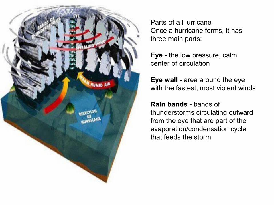
Parts of a HurricaneOnce a hurricane forms, it has three main parts:
Eye - the low pressure, calm center of circulation
Eye wall - area around the eye with the fastest, most violent winds
Rain bands - bands of thunderstorms circulating outward from the eye that are part of the evaporation/condensation cycle that feeds the storm

Below, are the most common components of a hurricane.
Eye--Is the center of circulation, and area of lowest pressure within a hurricane. Within the eye of a hurricane, you will encounter clear skies and calm winds. However, don't let that fool you because once the eye passes your area, the other side of the storm will arrive, and the stormy weather will continue.
Eye Wall--Is the narrow area of intense thunderstorms that surround the eye of a hurricane. In this region, you will encounter the most ferocious portion of the storm with the highest winds it can muster.
Central Dense Overcast--Or, CDO, as it is commonly known as, is the mass of embedded clouds that make up the inner portion of the hurricane. This contains the eye wall, and the eye itself. The classic hurricane contains a symmetrical CDO, which means that it is perfectly circular and round on all sides.
Outflow--This is the outer fringe of a hurricane that serves as a very important element in hurricane development. That is because the outflow represents all the energy being released by the hurricane. A powerful hurricane always as good outflow

It can take anywhere from hours to several days for a thunderstorm to develop into a hurricane.
Although the whole process of hurricane formation is not entirely understood, three events must happen for hurricanes to form:
A continuing evaporation-condensation cycle of warm, humid ocean air.
A patterns of wind characterized by converging winds at the surface,resulting from air pulled in to replace warm rising air.
A strong, uniform-speed winds at higher altitudes, allowing air to rise and not sheared off.
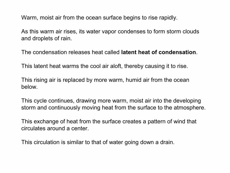
Warm, moist air from the ocean surface begins to rise rapidly.
As this warm air rises, its water vapor condenses to form storm clouds and droplets of rain.
The condensation releases heat called latent heat of condensation.
This latent heat warms the cool air aloft, thereby causing it to rise.
This rising air is replaced by more warm, humid air from the ocean below.
This cycle continues, drawing more warm, moist air into the developing storm and continuously moving heat from the surface to the atmosphere.
This exchange of heat from the surface creates a pattern of wind that circulates around a center.
This circulation is similar to that of water going down a drain.

The air in the eye of the hurricane is at low pressure, and is calm. As the eye passes over, the winds may drop altogether, and a small circle of clear sky may be visible overhead for a short period of time. This lull ends when torrential rains fall around the eye, and raging winds, drawn in from hot air spiral up the wall of the eye. These hot rising winds circulate at speeds of 50 km/h (30 mph). The strongest winds, with gusts of up to 360 km/h (225 mph) are found beneath the eye wall, immediately outside the eye.

Below, are some of the common effects from a hurricane.Storm surge and tidal flooding--This is the most devastating and notable effect from a hurricane. Storm surge is the rising wall of water the comes ashore with a landfalling hurricane, and is responsible for 90 percent of all hurricane related deaths.
High Winds--This is the most important effect of a hurricane since it determines how powerful the storm is, and how much storm surge and damage it can cause. Winds in a hurricane can reach up to 200 mph.
Tornadoes--This is probably the least thought of effect of a hurricane, but they do occur. Tornadoes occur in a hurricane as a result of the tremendous energy and instability created when a hurricane makes landfall. Most tornadoes that occur in hurricanes are only minimal in strength.
Heavy rain and flooding--This is the effect of a hurricane that is completely taken for granted. After hurricanes make landfall, and their winds abate, the tremendous amounts of rainfall become a major factor, and can cause significant flooding as with Hurricane Floyd last year.

•Hurricanes bring with them huge amounts of rain. A big hurricane can dump dozens of inches of rain in just a day or two, much of it inland. That amount of rain can create inland flooding that can totally devastate a large area around the hurricane's center.
Many communities and small towns in eastern North Carolina found themselves afloat following Hurricane Floyd's massive rainfall and the ensuing floods. Streams and waterways were already swollen from Hurricane Dennis, which struck eastern North Carolina (twice) just weeks before Hurricane Floyd.

High sustained winds cause structural damage. These winds can also roll cars, blow over trees and erode beaches (both by blowing sand and by blowing the waves into the beach). The prevailing winds of a hurricane push a wall of water, called a storm surge, in front of it. If the storm surge happens to synchronize with a high tide, it causes beach erosion and significant inland flooding.
Hurricanes often cause severe structural damage. This building, in the U.S. Virgin Islands, was leveled.

Storm SurgeA storm surge is a rise in the ocean as the result of strong winds from a hurricane or other intense storm. This ocean water crashes onto the land in a powerful surge. The storm surge combined with the heavy rain that comes with the hurricane can cause dangerous flooding in low-lying coastal areas, especially when a storm surge coincides with a high tide. This flooding can be the most dangerous part of a hurricane, potentially causing many deaths. The height of the storm surge is the difference between the level of the ocean and the level that would have occurred normally. A storm surge is usually estimated by subtracting the regular high tide level from the observed storm tide - it can be 15 feet tall or more in a very strong storm. For example, in 1985, Hurricane Opal (a Category 3 storm) caused storm surges up to 24 feet, causing flood damage along the Florida coastline near Fort Walton Beach.

Ocean-front property is particularly susceptible to damage from hurricane storm surges, when ocean waves are very high and strong because of the strength of the hurricane's winds

Once a hurricane forms, it is rated on the Saffir-Simpson Hurricane Scale. There are five categories in this rating system.

The National Weather Service has many tools to watch hurricanes. Satellites, ships and buoys, airplanes radiosondes, and radar are to name a few. They also have a computer model to help forecast a storms strength.
Satellites collect information about the land, biosphere, atmosphere and the oceans. Human activity are speed up changes by increasing the carbon dioxide levels.
Scientists are still trying to decide the cause and effect of the changes to the climate conditions.
Forecasters can estimateLocationSize Movement Intensity of the storm tell about it's surrounding environment Two types of warningsHurricane Watch-will hit in the next 36 hours Hurricane Warning- will hit into he next 24 hours A warning is more important than a watch.
A warning is more important than a watch. The aftermath of Hurricane Camille. Large ships were no match for Camille.Gulfport, Mississippi (1969) Satellites can measure:Reflected radiation Cloud pictures Land surface temperature Sea surface temperature Winds from cloud motions Size of clouds Rainfall
Usually people know that a hurricane is coming so they have time to prepare for it. Here are some tips to try:
Keep listening to the weather reports Make a plan Make a first aid supply kit Store water and food Protect windows Remove outside antennas Shut off all water, electricity and gas Stay indoors during the storm


The Hurricane Hunters are members of the 53rd Weather Reconnaissance Squadron/403rd Wing, based at Keesler Air Force Base in Biloxi, Mississippi. Since 1944, the U.S. Department of Defense (which oversees the U.S. military) has been the only organization to fly into tropical storms and hurricanes. Since 1965, the Hurricane Hunters team has used the C-130 Hercules, a very sturdy turboprop plane. The only difference between this plane and the cargo version is the specialized, highly sensitive weather equipment installed on the WC-130. The team can cover up to five storm missions per day, anywhere from the mid-Atlantic to Hawaii.
Efforts in storm modification go as far back as the late 1940s when Dr. Irwin Langmuir began exploring the idea of using ice crystals to weaken storms such as hurricanes. In 1947, he organized a team of scientists from General Electric, and brought his idea to fruition with Project Cirrus.
The highlight of this effort occurred on October 13, 1947 when Langmuir and his team had a Navy plane fly into a hurricane off the coast of Georgia, and drop a payload of dry ice into it.
The hope of using dry ice was to release energy from the storm's inner core. and thus weaken the hurricane itself. It was originally considered a success.
After the cloud seeding had taken place, the hurricane suddenly changed direction, and made landfall near the coastal city of Savannah, Georgia.
However, about a decade later, a scientist named Mook recognized that the storm's sudden change in direction was not caused by the seeding, but rather the upper level steering winds in the vicinity of the hurricane.