Embed Size (px)
Citation preview

308 Plant Disease / Vol. 83 No. 4
Merritt R. Nelson, Thomas V. Orum, and Ramon Jaime-GarciaUniversity of Arizona, Tucson
Athar NadeemCentral Cotton Research Institute, Multan, Punjab, Pakistan
Applications of Geographic Information Systems and Geostatistics
in Plant Disease Epidemiology and Management
Information management will be a keyto improving farm practices in the comingdecades. It makes sense to organize farminformation in spatial databases becauseagricultural systems are inherently spatial.Biological and physical aspects of agri-cultural systems create spatial heterogene-ity, and as a result, patchiness is the rule inthe occurrence and distribution of plantpathogens and disease (3). Plant diseasemanagement practices can be improved byputting epidemiological information in thesame format as other farm information usinga geographic information system (GIS). AGIS is a computer system capable of assem-bling, storing, manipulating, and displayingdata referenced by geographic coordinates(45). GIS can now be installed on any recentmodel desktop computer (e.g., a Pentiumpersonal computer with at least 32 MB ofRAM is adequate for most applications) anddoes not require an in-depth understandingof the statistical and mathematical basis ofthe technology. The large commercial pushtoward precision farming is based on com-bining GIS with sophisticated hardware forgeographically referenced yield data andvariable rate applications of fertilizers andother farm chemicals.
GIS can be adapted to any size opera-tion, and data can be incorporated at anyscale from a single field to an agriculturalregion. Many problems should be studiedat more than one scale. Part of the art ofGIS database development is to decidewhat scale to use and which kinds of in-
formation to include at each scale. Theability of government institutions, the na-tion’s agricultural colleges and experimentstations, and private enterprise to providespatially referenced information will openthe way to farmers, pest control advisors,extension workers, and others to evaluateplant disease problems in a spatial context.New tools, including global positioningsystems (GPS) and geostatistics, are avail-able to use in connection with GIS. Whilethese tools can be used at any scale, ourefforts have been at the regional scale ingenerally arid irrigated agricultural areas.We focus on spatial relationships of land-scape features that interact with the prog-ress of an epidemic to refine cultural man-agement strategies for plant diseasecontrol. Examples from this work will beused to illustrate the application of GPS,GIS, and geostatistics following a generalintroduction to the technologies.
GPSGPS receivers determine location and
are among the most important tools forspatially referencing agriculture data. GPSdepends on a system of navigation satel-lites operated by the U.S. Department ofDefense (the NAVSTAR system). Thesesatellites broadcast signals containing timeand position information. GPS receivers onthe ground collect the satellite signals anddetermine position in a spherical coordinatesystem such as latitude and longitude or aplanar coordinate system such as the Uni-versal Transverse Mercator system commonon terrestrial maps. An advantage of a planarcoordinate system is that one can calculatedistance and direction in a two-dimensionalEuclidean system. Such calculations arerequired for geostatistical analyses. Eleva-tion can be added if three-dimensional spa-tial considerations are important. GIS utili-ties are available to translate from onecoordinate system to another.
At unannounced times, the Departmentof Defense degrades the freely availablesignal broadcast by GPS satellites accord-ing to a practice known as selective avail-ability (SA). SA is important to the GPSuser because both the precision and theaccuracy of GPS readings are reducedunless corrections are made. Accuracy is“the closeness of a measured or computedvalue to its true value”; precision is “thecloseness of repeated measurements of thesame quantity” (43). Without adapters,corrections cannot be made on the inex-pensive handheld GPS units, so these de-vices cannot be depended on for horizontalaccuracy better than 100 m and verticalaccuracy better than 156 m. The accuracyspecifications represent two standard de-viations of distance from the actual an-tenna position to a set of position estimatesmade under a specified set of satellite con-ditions (see http://www.utexas.edu/depts/grg/gcraft/notes/gps/gps.html). In practice,accuracy can be in the range of 15 to 25 m,because the signal is not always degraded.Differential GPS (DGPS) is used to im-prove accuracy to about 2 m. To achievethis accuracy, data from a receiver at aknown position (base station) is combinedwith data from a receiver at the desiredposition (rover or remote station) to correctfor SA and other sources of error. Precisionfarming equipment, such as yield monitorsand variable rate applicators, depends onDGPS. DGPS can increase the cost andcomputer complication involved in ob-taining point coordinates, so inexpensivehandheld devices are preferable whenDGPS accuracy is not required.
The regional applications described inthis article are done with inexpensivehandheld GPS units, because the interpre-tation of spatial patterns spanning morethan 100 km does not require an accuracyof better than 100 m for point coordinates.Even in smaller areas where greater accu-
Dr. Nelson’s address is: Department of PlantPathology, Forbes 204, University of Arizona,Tucson 85721; E-mail: [email protected]
*The e-Xtra logo indicates the html abstract availableon APSnet contains a link to supplemental material.
Publication no. D-1999-0121-01F© 1999 The American Phytopathological Society
e-Xtra

Plant Disease / April 1999 309
racy is desired, a combination of tools cansubstitute for DGPS. Hand-drawn maps orUSDA Farm Services Agency maps arefrequently available. Handheld GPS unitscan be used to obtain coordinates of land-marks such as road intersections or irriga-tion wells, which can then be used as refer-ence points to digitize the hand-drawndetailed map for display with other layersreferenced to the same coordinate system.Similarly, greater precision can beachieved by staking out rectangular gridsin a small area and then using a handheldGPS unit to relate the location of the gridas a whole to a wider area.
Between 1990 and 1994, we used mapswith a spatially referenced grid, instead ofGPS, to obtain coordinates for samplelocations (33). We switched to GPS be-cause it is easier to obtain the coordinateinformation from GPS than from a mapunless you are intimately familiar with anarea. Until about 1994, GPS units were tooexpensive for most projects. The rapidgrowth in availability and affordability ofhandheld GPS units is due in part to themass market for navigation applications bysmall boat owners. Most mass-producedGPS units are designed for nautical appli-cations and for the outdoorsman. Thus,most sources of handheld GPS units aremarine or outdoor supply businesses.
GISGIS relates the data collected by GPS to
other sources of geo-referenced informa-tion. GIS has the ability to integrate layersof spatial information and to uncover pos-sible relationships that would not otherwisebe obvious (16–18). The process of trans-forming one layer of spatial information tomatch a second layer is called registration(45). When a broad collection of data isregistered to the same coordinate system,the possibilities for sharing data and crea-tively analyzing the spatial relationships
increase dramatically. GIS applications foragriculture are developing rapidly andinclude generic commercial packages suchas ArcView (ESRI, Redlands, CA) orMapInfo Desktop (MapInfo Corp., Troy,NY) as well as more specific applicationsderived from these packages (e.g., Site-Specific Technology Development Group,Inc., Stillwater, OK [ArcView] and RedHen Systems, Fort Collins, CO [MapInfo]).As with other types of computer software,compatibility between competing systemscan be a problem, but data transfer proto-cols and generic data formats have beendeveloped to work around this problem.
There are two main forms of GIS data:vector and raster. Most GIS software cannow handle both forms. In vector data sets,map features such as points, lines, andpolygons are organized and manipulated ina database. In raster data sets, the data areorganized as a matrix of numerical valuesand referenced spatially by row and col-umn position. Header information or anassociated computer file contains the spa-tial information that relates the rows andcolumns of the matrix to the GIS coordi-nate system. USGS digital elevation modeldata sets, satellite images, and some imagefiles produced by scanners are examples ofraster data sets.
GIS has been applied in agriculture forthe spatial analysis of insect pests (2,7,12,13,28,39,42,44), weeds (26,29,38,54),and plant diseases (33,35,36). Weltzien(50–53) introduced the term “Geophyto-pathology” to describe studies of spatialpatterns of plant diseases, the causal under-standing of these patterns, and the geo-graphic aspects of disease control. He gavea detailed description of the use of maps toillustrate the spread of plant diseases overregional or even continental scales andclassified the types of maps that can beused for these purposes (52). However,quantitative regional assessment requires
analysis of large spatial databases. Withdevelopment of powerful computers andbetter software, GIS is the appropriatetechnology to manage such spatial data (48).
A recent article on precision farming inthe trade magazine California Farmerexpressed concern about the accuracy ofagricultural maps and that farmers could bemisled by the “captivating, brightly col-ored images” produced by GIS (47). Usersof GIS data can be misled because thedegree of detail reported by the system canexceed the precision of the source data.Some GIS specialists suggest using“visualization,” such as fading from colorto gray with decreasing confidence, tocommunicate a sense of qualification tousers of data (10,17). Since many userswill depend on automated commercialsoftware packages, the incorporation ofeasy-to-use tools for the display of uncer-tainty should be a goal of both consumersand producers of these products. Perhapsthe best check on the validity of GIS mapsis common sense. Although it might seemobvious, it is important to say that the userof a GIS analysis should always comparethe conclusions with their general knowl-edge of the problem and recheck the meth-odology and data if there is a major vari-ance with expectation.
GeostatisticsGeostatistics focuses on the analysis of
spatially distributed variables and the pre-diction or estimation of values at unsam-pled locations. Cressie categorizes spatialanalysis into three broad types: geostatisti-cal, lattice, and point (8). He describesgeostatistics as a statistical model appro-priate for estimates across continuous areas(characterized as processes with a continu-ous spatial index). Trend surface and in-verse distant weighting methods of inter-polation preceded geostatistics, but geo-statistical considerations, implicitly or
Table 1. World Wide Web sites about global positioning systems (GPS), geographic information systems (GIS), and geostatistics. Links to thesesites and others can be found at http://ag.arizona.edu/PLP/GIS/gis.html
Category Site title Uniform resource locator
GIS Geographic Information Systems http://www.usgs.gov/research/gis/title.htmlThe Geographic Information Systems FAQ! http://www.census.gov/geo/gis/faq-index.htmlGeographic Information Science http://ncgia.ucsb.edu/research/ucgis/main.htmlat the University of California,Santa Barbara
GIS User Assistance http://www.lib.berkeley.edu/UCBGIS/gisusers.htmlGIS WWW Resource List http://www.geo.ed.ac.uk/home/giswww.html
GIS data EROS Data Center, Sioux Falls, SD http://edcwww.cr.usgs.gov/National Biological Information Infrastructure http://www.nbii.gov/
GPS Global Positioning System Overview http://www.utexas.edu/depts/grg/gcraft/notes/gps/gps.htmlMap datum National Geodetic Survey http://www.ngs.noaa.gov/
Frequently Asked QuestionsGeostatistics AI-Geostatistics http://curie.ei.jrc.it/ai-geostats.htm
Geostatistics Frequently Asked Questions http://curie.ei.jrc.it/faq/index.htmlWhat is Geostatistics? http://www.u.arizona.edu/~donaldm/whatis.htmlGeostatistical Links http://www.intera.com/link/lnkstat.htmlStanford Center For Reservoir Forecasting http://ekofisk.stanford.edu/SCRF.html

310 Plant Disease / Vol. 83 No. 4
explicitly, underlie most attempts to createsurface maps based on point samples orobservations. A surface map is a map withan area shaded in a color or gray scalekeyed to a variable. As with summary sta-tistics (averages, medians, standard devia-tions) in nonspatial data analysis, whendone well, surface maps allow the viewerto grasp the larger picture without beingdistracted by the noise and scatter of pointdata. Regional surface maps are appropri-ate when a variable (pathogen propaguledensity, disease incidence, insect vectorabundance, etc.) exhibits positive spatialautocorrelation beyond the boundary of asingle field. Spatial autocorrelation is thecorrelation of a variable with itself (auto)
at various separation distances and direc-tions (spatial). If adjacent fields are highlydissimilar with abrupt differences definedby field boundaries, surface maps that areinterpolated without field boundary con-siderations can be misleading. Sometimesthe absolute value of a variable is less im-portant than whether it is above or below abiologically critical value. If a variable,such as pathogen propagule density, isuniformly above such a threshold, a sur-face map will not be helpful unless theuniformity is in contrast to patchiness atanother place or time.
There are a number of excellent intro-ductions to geostatistics (22,24,31,41) aswell as an outstanding World Wide Web
site and active list service that is friendly tothose just beginning with the subject(Table 1). Geostatistics have been used inplant pathology to analyze the spatial dis-tribution of plant disease epidemics,mainly at plot or field scales (4,21,25,27,46,49). They have also been used in aregional risk assessment program for themanagement of plant virus diseases inMexico (33). The difficulties of spatio-temporal analyses were explored in a geo-statistical study of the development ofcabbage downy mildew epidemics (46).Inoculum patterns at very small scales,such as along plant roots (9), have alsobeen quantified using geostatistics.
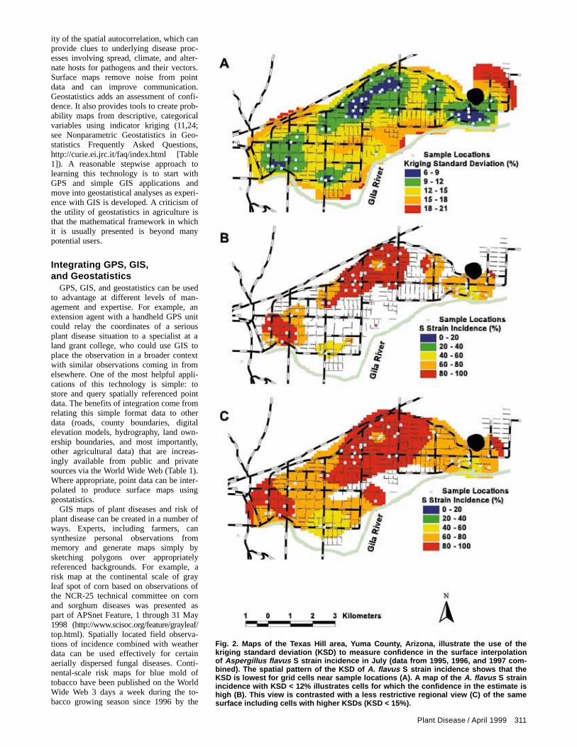
A geostatistical analysis can be brokendown into four phases: (i) exploratory dataanalysis; (ii) modeling of the spatial auto-correlation (characteristics of the spatialcontinuity); (iii) estimating at unsampledlocations across a surface (surface maps);and (iv) evaluation of the reliability of theestimates. Isaaks and Srivastava (22) pro-vide an easy-to-read explanation of geo-statistics. In geostatistics, spatial autocor-relation is usually examined by variogramestimation and modeling. Procedures todevelop experimental variograms and to fitmodel variograms are presented in severalsources (8,11,22,24,31,37). The modelvariogram is incorporated into a procedurefor surface interpolation known as“kriging” (22) (Table 1, Geostatistics). Anadvantage of kriging is that there are twooutcomes, a surface map of the variableand a surface map of the kriging standarddeviation (KSD), which provides a relativemeasure of confidence in the estimates.This combination is discussed later in thepaper in an application involving a regionalstudy of Aspergillus flavus strain composi-tion.
The most sophisticated geostatisticaltool is stochastic conditional simulation.This tool and its potential in crop protec-tion have been explained in a regionalstudy of corn rootworm in northwesternIowa (40). Maps show where a minimum-loss strategy recommends the use of aninsecticide for two different costs of theinsecticide. The analysis can take intoaccount not only the cost of acquiring andapplying the insecticide but also an esti-mate of the environmental cost of applica-tions (40). Because of the technical diffi-culties, few farmers, extension advisors, orregulators will apply stochastic conditionalsimulation in the near future. One mighthope, however, that over time, conditionalsimulation will be incorporated into soft-ware extending geostatistics to plant dis-ease situations.
Simple GIS maps of observed valuesoverlaid on landmarks such as roads, riv-ers, towns, and district boundaries aresometimes sufficient to characterize a dis-ease or pest problem. This can be donewithout geostatistics. Geostatistics adds theability to model the range and directional-
Fig. 1. (A) Location of Texas Hill in Yuma County, Arizona. (B) Map of Texas Hill datashowing the simplest application of a geographic information system (GIS): data arelinked to spatially referenced points so that the points can be overlaid on other mapthemes such as roads, field boundaries, and rivers. The inset shows data that arelinked to one of the points.
Plant Disease / April 1999 311
ity of the spatial autocorrelation, which canprovide clues to underlying disease proc-esses involving spread, climate, and alter-nate hosts for pathogens and their vectors.Surface maps remove noise from pointdata and can improve communication.Geostatistics adds an assessment of confi-dence. It also provides tools to create prob-ability maps from descriptive, categoricalvariables using indicator kriging (11,24;see Nonparametric Geostatistics in Geo-statistics Frequently Asked Questions,http://curie.ei.jrc.it/faq/index.html [Table1]). A reasonable stepwise approach tolearning this technology is to start withGPS and simple GIS applications andmove into geostatistical analyses as experi-ence with GIS is developed. A criticism ofthe utility of geostatistics in agriculture isthat the mathematical framework in whichit is usually presented is beyond manypotential users.
Integrating GPS, GIS,and Geostatistics
GPS, GIS, and geostatistics can be usedto advantage at different levels of man-agement and expertise. For example, anextension agent with a handheld GPS unitcould relay the coordinates of a seriousplant disease situation to a specialist at aland grant college, who could use GIS toplace the observation in a broader contextwith similar observations coming in fromelsewhere. One of the most helpful appli-cations of this technology is simple: tostore and query spatially referenced pointdata. The benefits of integration come fromrelating this simple format data to otherdata (roads, county boundaries, digitalelevation models, hydrography, land own-ership boundaries, and most importantly,other agricultural data) that are increas-ingly available from public and privatesources via the World Wide Web (Table 1).Where appropriate, point data can be inter-polated to produce surface maps usinggeostatistics.
GIS maps of plant diseases and risk ofplant disease can be created in a number ofways. Experts, including farmers, cansynthesize personal observations frommemory and generate maps simply bysketching polygons over appropriatelyreferenced backgrounds. For example, arisk map at the continental scale of grayleaf spot of corn based on observations ofthe NCR-25 technical committee on cornand sorghum diseases was presented aspart of APSnet Feature, 1 through 31 May1998 (http://www.scisoc.org/feature/grayleaf/top.html). Spatially located field observa-tions of incidence combined with weatherdata can be used effectively for certainaerially dispersed fungal diseases. Conti-nental-scale risk maps for blue mold oftobacco have been published on the WorldWide Web 3 days a week during the to-bacco growing season since 1996 by the
Fig. 2. Maps of the Texas Hill area, Yuma County, Arizona, illustrate the use of thekriging standard deviation (KSD) to measure confidence in the surface interpolationof Aspergillus flavus S strain incidence in July (data from 1995, 1996, and 1997 com-bined). The spatial pattern of the KSD of A. flavus S strain incidence shows that theKSD is lowest for grid cells near sample locations (A). A map of the A. flavus S strainincidence with KSD < 12% illustrates cells for which the confidence in the estimate ishigh (B). This view is contrasted with a less restrictive regional view (C) of the samesurface including cells with higher KSDs (KSD < 15%).

312 Plant Disease / Vol. 83 No. 4
North American Blue Mold Forecast Cen-ter at North Carolina State University(http://www.ces.ncsu.edu/depts/pp/bluemold/). GIS risk assessment maps based onkriging of field observations were part of atomato virus management program at theregional scale in the Del Fuerte Valley,Sinaloa, Mexico (33), discussed below. Wepredict that plant disease risk maps at avariety of scales will become increasinglyavailable and helpful. Through an iterativeprocess of comparing spatial data on riskwith observed incidence, our understand-ing of the spatial and temporal aspects ofdisease processes should improve alongwith our ability to produce maps useful tofarmers.
ApplicationsAspergillus flavus, Yuma County, Ari-
zona. A series of examples will illustratesome of the ways in which GIS and geo-statistics can be applied in an agriculturalsetting. In Figure 1, soil structure andchemistry information is linked to a pointtheme that is displayed as an overlay withfield boundaries (polygon features) androads (linear features) in the Texas Hillpart of eastern Yuma County, Arizona. Thepoints are color-coded according to thepercent total sand in the soil. This isstrictly a GIS illustration (no geostatistics).The important differences between GIS inthis example and a hand-drawn map are thelinkage of data to points and the use of acoordinate system. The x and y coordinates(determined from GPS readings in con-junction with digitized Farm ServicesAgency maps) are in the UTM coordinatesystem, which allows the points to beoverlaid on similarly referenced polygonand linear features. Simple maps of ob-served values overlaid on spatial referencessuch as roads and district boundaries aresometimes sufficient to characterize a dis-ease or pest problem.
The point data on soil chemistry in theTexas Hill area of Yuma County are part ofa study of A. flavus strain composition(36). A. flavus frequently produces afla-toxins, carcinogens that can contaminatecottonseed and other important seed cropssuch as peanuts, corn, and nuts. The toxinsare highly regulated in order to reduce theirlevel in the human food supply. A. flavusisolates can be divided into two strainsbased on sclerotial size (S strain [small]and L strain [large]) (5). The S strain iso-lates are very toxigenic. As part of a man-agement program to control aflatoxin usingnaturally occurring atoxigenic strains (6),spatial patterns of the highly toxigenic Sstrain are being investigated. Understand-ing shifts in S strain incidence patterns inuntreated areas will help in the interpreta-tion of shifts observed in areas treated withatoxigenic L strain isolates. The twopatches of lowest S strain incidence (Fig.2B and C) are near the Gila River. This
Fig. 3. Representative field symptoms of virus diseases on tomato in the Del FuerteValley, Sinaloa, Mexico.

Plant Disease / April 1999 313
coincidence, which is being investigatedfurther, illustrates the GIS technique ofoverlaying one feature (the river) on an-other (S strain incidence) to uncover possi-ble relationships that would not otherwisebe obvious. The maps (Fig. 2) illustrate theuse of the kriging standard deviation(KSD) to show relative confidence in sur-face maps of S strain incidence. A map ofthe KSD (Fig. 2A) shows, as one wouldexpect with a spatially autocorrelated vari-able, that the KSD is lowest near the sam-
ple points. We have more confidence in theestimates where the KSD < 12% (Fig. 2B)than in estimates where the KSD is be-tween 12 and 15% (area in Fig. 2C thatwas added to the area in Fig. 2B). Com-paring such maps helps emphasize thatestimates based on point sampling are notof equal value across a surface.
Tomato virus management in the DelFuerte Valley, Sinaloa, Mexico. A re-gional plan for tomato virus disease man-agement was implemented with the support
of the tomato processing industry in theDel Fuerte Valley in Sinaloa, Mexico(1,33). The plan involved a risk assessmentprocedure and mitigation of risk based onobservations of virus hazards immediatelysurrounding fields at the time of transplant.Mitigation of risk involved either destroy-ing alternate host plants near fields orchanging the time and location of planting.Observations of virus disease symptoms(Fig. 3) in fields were made each year from1991 through 1996. GIS displays show that
Fig. 4. A sequence of maps of the Del Fuerte Valley in Sinaloa, Mexico (A) showing the regional pattern of tomato virus diseaseincidence from the 1990-91 through the 1995-96 growing seasons (B to G) and tomato pinworm moth trap counts in the spring of1995 (H to J). The average virus incidence was computed by the geostatistical technique of kriging point data of symptoms in morethan 50 fields each year. There was a recurring pattern of higher virus incidence immediately east of Los Mochis, while the east-southeast part of the region was consistently lower in incidence. No data were taken in the east-southeast after the 1993-94 seasonbecause of the pattern of low incidence. The spatial patterns of tomato pinworm moths derived by kriging data from 110 pheromonetraps in January, February, and March of 1995 show a pattern of lower counts in the east-southeast similar to the virus incidencepattern. The authors thank Ruben Felix-Gastelum and Rodolfo Trinidad-Acosta for the virus incidence data and Saul Alarcón for t hetomato pinworm data.

314 Plant Disease / Vol. 83 No. 4
there were recurring regional patterns (Fig.4). Regardless of the overall virus inci-dence level, the highest incidence occurredeach year east of Los Mochis. Displays ofthe patterns were used to encourage cul-tural management efforts in the areas ofhighest risk and incidence. We believe theencouragement of cooperation is a majorvalue of GIS in a regional disease man-agement program. Using GIS displays toavoid planting processing tomatoes in ar-eas with a high risk of virus disease waspart of an integrated pest managementstrategy that eliminated the use of pesti-cides for the control of insect vectors oftomato virus diseases by one producer (1).To complement the virus data, a study oftomato pinworm adults was conductedusing a grid of 110 pheromone traps placedthroughout the region. Pinworms werecollected and counted every 14 days from
November 1994 through April 1995. Thespatial pattern of tomato pinworm adults(Fig. 4) was very similar to patterns of thevirus risk and incidence. The higher-inci-dence areas contain a higher density ofpotato, tomato, and pepper fields than thelower-incidence areas. An abundance ofalternate host plants during the summeroff-growing season in unplowed tomatofields and among weeds along irrigationditches and roadsides in certain areas of thevalley was also identified as a source of thecommon pattern. The evidence helped putpressure on the irrigation district to controlweeds along ditches and to establish plow-down requirements for tomato fields en-forced by deposits tied to water contracts.
Late blight of tomatoes and potatoes,Del Fuerte Valley. Geostatistics and GISwere also used to analyze the spatial pat-terns of genotypes of Phytophthora in-
festans (Mont.) de Bary and their relation-ship to late blight disease (Fig. 5) in themixed tomato and potato production area(23). Population genetic studies of P. in-festans have intensified worldwide follow-ing the appearance of the A2 mating typeand metalaxyl insensitive isolates of thepathogen outside central Mexico in the1970s (14,15,19). The development ofcellulose acetate techniques for rapid al-lozyme analyses (20) have created theopportunity to obtain enough data to char-acterize the pathogen spatially and incor-porate this information into managementprograms at the scale of an agriculturalregion such as the Del Fuerte Valley. Mapsdisplaying the probabilities of occurrenceof mating types and genotypes of P. in-festans and of disease severity on a regionalscale were prepared (R. Jaime-Garcia,unpublished data). Probability maps of theGPI allozyme genotypes illustrate the results(Fig. 6). The probability of occurrence ofallozyme genotypes was estimated byindicator kriging. Indicator variables can beused for nonnumerical data, such as thepresence or absence of a particular genotype,to generate probability maps by kriging.
The maps of the probability of occur-rence of P. infestans allozyme genotypesfor the Del Fuerte Valley show that theepidemics of late blight are largely domi-nated by only one genotype each year (Fig.6). This indicates strong clonal reproduc-tion of the pathogen in the area. However,some other genotypes do occur in lowfrequencies and in restricted areas. Mostgenotype variables showed spatial autocor-relation in a range of 13,000 to 20,000 m ina valley that is 70,000 by 150,000 m. Thissuggests a restricted spread of some geno-types that can be visualized with the helpof the probability maps generated by krig-ing (Fig. 6). The idea of creating pathogengenotype probability maps is new, and itsapplicability in a plant disease manage-ment system has not been tested commer-cially. We think it might be useful whereenvironmental, worker safety, and eco-nomic concerns lead farmers to weigh avariety of new factors, including pathogengenotype, in the selection of plant diseasecontrol measures. For example, somegenotypes have differential reactions tohost or cultivar and to fungicides used forcontrol of the disease. This type of infor-mation might be used to improve manage-ment practices. In the study of late blightin the Del Fuerte Valley, we found differ-ential reactions to the fungicide metalaxyland differential aggressiveness to tomatoand potato among the genotypes of P.infestans, and these differences showedspatial continuity. Genotypes that weresensitive to metalaxyl or that were non-aggressive to either tomato or potato werefound restricted to certain areas of thevalley.
Cotton leaf curl disease, Punjab,Pakistan. A project with the same objec-
Fig. 5. Symptoms of late blight disease on tomato in the Del Fuerte Valley, Sinaloa,Mexico.

Plant Disease / April 1999 315
tives as the Del Fuerte Valley tomato virusproject is underway with cotton leaf curlvirus in Pakistan in a much larger agricul-tural region (over 400 km) than the DelFuerte Valley. Cotton leaf curl has devas-tated cotton production in the Punjabprovince of Pakistan since it was first rec-ognized as a major problem in 1991. Thefirst report of cotton leaf curl in SindhProvince, southwest of Punjab, was in1996, providing evidence that the affectedarea has been expanding. The cause of thedisease is at least two whitefly-transmittedgeminiviruses collectively named cottonleaf curl virus. Analysis of DNA sequencesindicates that the cotton leaf crumplegeminivirus of the southwestern UnitedStates is not closely related to the cottonleaf curl geminiviruses of Pakistan (32).The symptoms and economic impacts ofcotton leaf curl in Pakistan (Fig. 7A) aremuch more severe than those of cotton leafcrumple in the United States (Fig. 7B).Because cotton is a major export crop andsource of foreign exchange for Pakistan,the impact of the disease on the economy
has been serious. A GIS database on inci-dence was established in 1996 using hand-held GPS units to determine the coordi-nates of locations where incidence wasassessed. Maps of Pakistan including majorroads and district boundaries were digitizedusing handheld GPS coordinates taken atroad intersections as reference points to putthe digitized maps in the same coordinatesystem as the field observations.
Recent DNA analyses of virus collec-tions from cotton plants exhibiting leaf curlsymptoms suggest that the genetic compo-sition of these viruses is very diverse (C.Fauquet, Scripps Institute, La Jolla, CA,personal communication). To the extentthat GPS coordinates of tissue samples arerecorded, probability maps of genetic vari-ants of the virus characterized by DNAanalysis can be created following the ex-ample of the late blight work in Sinaloa,Mexico. Such work is underway in Paki-stan, and it is hoped that probability mapscan help researchers evaluate the relation-ship of the genetic variants to disease prog-ress and severity.
The project includes a spatial analysis oflandscape characteristics associated withthe risk of leaf curl disease. The Universityof Arizona, Tucson, and the Central CottonResearch Institute, Multan, Punjab, Paki-stan, are analyzing landscape data from229 locations referenced by GPS through-out Punjab and collected by the PestWarning and Quality Control of PesticidesDepartment of the Punjab Department ofAgriculture. Landscape data include thepresence of alternate hosts, length of com-mon watercourses, and virus hazards alongcommon watercourses, roadways, farm-houses, and gardens. As an example ofepidemiologically important factors, thepresence of cotton resprouting from theprevious season (called here “sproutingcotton”) is a good indication of a mecha-nism for the virus to have overwintered.The additional presence of alternate hostsfor the whitefly and the virus adds risk thatthe virus will be present in the new crop.These factors are shown graphically (Fig.8) with point maps and a probability sur-face map as an illustration of the possibili-
Fig. 6. Probability of occurrence of the Phytophthora infestans glucose-6-phosphate isomerase (GPI) loci 100/100 (A, E, and I), 100/111(B, F, and J), 100/122 (C, G, and K), and 111/122 (D, H, and L) in the Del Fuerte Valley, Sinaloa, Mexico, during the seasons of 1994-95 (A,B, C, and D), 1995-96 (E, F, G, and H), and 1996-97 (I, J, K, and L). This illustrates the use of indicator kriging to create surface maps ofthe probability of occurrence of a categorical variable (the presence of particular genotypes).

316 Plant Disease / Vol. 83 No. 4
ties for generating risk maps based onlandscape observations. The geostatisticalapproach in this example is possible forcategorical variables that have values at thesame locations. An alternative approach,useful when categorical variables are fromdifferent locations within the same region,is to generate surface maps for each vari-able by indicator kriging and then use GISoverlays to combine the surfaces. Thecomparison of spatial patterns of risk andincidence of leaf curl in Pakistan will helpfocus the cultural management effortsneeded to complement ongoing efforts tobreed for resistance to the disease.
Cotton leaf crumple disease, Arizona.During 1992, populations of whitefly, Be-misia tabaci, were monitored with datacollected weekly from over 900 trapsacross Arizona at a scale of hundreds ofkilometers (34). At the same time, the
presence or absence of symptoms of cottonleaf crumple disease was recorded at alltrap locations. The virus disease washighly restricted spatially, with no apparentrelationship to the abundance of whiteflieson a regional scale. The data on whitefliesand cotton leaf curl in the Pakistan projectdiscussed above also indicate there is noobvious relationship between the overallabundance of the whitefly vector and theincidence of leaf curl disease. Early andunusually damaging infections of leafcrumple of cotton in Arizona may resultfrom proximity of a cotton field to a goodwhitefly host, such as spring cantaloupes,and a virus host. The spatial relationshipbetween hosts for vectors, alternate hostsfor the virus, and the crop can be veryimportant at the scale of a few kilometers.A geostatistical study of localized migra-tion of whiteflies from a cantaloupe field
showed that dispersal was largely winddirected and that whitefly distribution fol-lowing dispersal was patchy up to 2.7 kmfrom the field (2). The conclusion fromwork both in Arizona and in Pakistan isthat beyond a good overall cultural man-agement program for whitefly suppression,the chief focus for virus control should beaction at the local level to reduce alternatehosts of the virus. The results of such ac-tivity can then be monitored regionally todetect hot spots for future intensified ef-forts.
Summary and ConclusionsDespite our enthusiasm for this technol-
ogy, we are not proposing that it is a solu-tion to all plant disease management prob-lems or that it is appropriate for everyoperation. A critical assessment of thetechnology can be summarized in terms ofthe practical, the theoretical, and the per-sonal. Practically, the biggest drawback isthe cost associated with the time needed tolearn the software and to acquire the data.Research is needed on cost/benefit analy-ses of GIS applications in agriculture. GISis of little practical value when a spatialpattern is uniform except perhaps in con-trast to nonuniform patterns. On the otherextreme, if the change in pattern is fasterthan data can be acquired, spatially refer-enced data might be skewed and mislead-ing. There are theoretical limitations to theuse of geostatistics, because the geostatis-tical model in which spatial analyses leadto surface maps does not always apply.Also, certain assumptions (30) may not beappropriate in some cases. A geostatisticalanalysis does not need to be a part of everyspatial analysis or GIS. There is, we be-lieve, a personal subjective component tothe suitability of this technology in plantdisease management. It is our informalobservation that some people are moreinclined than others to frame problemsspatially. We suspect benefits from thecommunication possibilities of the tech-nology will vary with individuals.
The current most successful applicationsof this technology involve teamwork. Agood combination is a team that includesan experienced field person, an experi-enced computer user with some back-ground in statistics, and a patient data entryperson. Such a combination is not alwaysavailable and is rare in a single individual.Larger farms, younger farmers, and better-funded extension programs are more likelyto apply these tools. A characteristic ofagricultural GIS is that it strongly favorsoperations that have computer resourcesand skills. On the other hand, it may not bepractical to avoid a resource that is alreadyin wide use in government and industry,including the agricultural industry.
We believe that the integration of GIS,GPS, and geostatistics provides a tool forthe refined analysis of traditional and con-
Fig. 7. Symptoms of cotton leaf curl disease in Pakistan (A) compared with symptomsof cotton leaf crumple disease in Arizona (B).

Plant Disease / April 1999 317
temporary biological/ecological informa-tion on plant diseases. It will aid practitio-ners in the design of disease managementin IPM programs, particularly on a re-gional scale. It will also provide a way ofanalyzing and communicating results ofregional programs on a continuing basis.The availability of software capable ofproducing attractive maps provides anopportunity to visually communicate plantdisease situations to a variety of audiences.We feel a major benefit of this technologyis derived from a combination of manyimages, not just a single image (e.g., Figs.4, 6, and 8). Such output can be used bydecisionmakers to stimulate coordinatedaction allowing available resources to befocused on the most significant problems.GIS and geostatistics are particularly use-ful in identifying recurring patterns ofplant disease, as well as other problemssuch as insect and weed infestations. The
association of environmental factors, land-scape features, and cropping patterns withthe recurrence of disease or other problemscan be readily communicated to key man-agers and decisionmakers.
Literature Cited 1. Bolkan, H. A., and Reinert, W. R. 1994. De-
veloping and implementing IPM strategies toassist farmers: An industry approach. PlantDis. 78:545-550.
2. Byrne, D. N., Rathman, R. J., Orum, T. V.,and Palumbo, J. C. 1996. Localized migrationand dispersal by the sweet potato whitefly,Bemisia tabaci. Oecologia 105:320-328.
3. Campbell, C. L., and Madden, L. V. 1990.Introduction to Plant Disease Epidemiology.John Wiley & Sons, New York.
4. Chellemi, D. O., Rohrbach, K. G., Yost, R. S.,and Sonoda, R. M. 1988. Analysis of the spa-tial pattern of plant pathogens and diseasedplants using geostatistics. Phytopathology78:221-226.
5. Cotty, P. J. 1989. Virulence and cultural char-
acteristics of two Aspergillus flavus strainspathogenic on cotton. Phytopathology 79:808-814.
6. Cotty, P. J. 1994. Influence of field applica-tion of an atoxigenic strain of Aspergillus fla-vus on the populations of A. flavus infectingcotton bolls and on the aflatoxin content ofcottonseed. Phytopathology 84:1270-1277.
7. Coulson, R. N. 1992. Intelligent geographicinformation systems and integrated pest man-agement. Crop Prot. 11:507-516.
8. Cressie, N. A. C. 1993. Statistics for SpatialData. John Wiley & Sons, New York.
9. Dandurand, L. M., Knudsen, G. R., andSchotzko, D. J. 1995. Quantification of Py-thium ultimum var. sporangiiferum zoosporeencystment patterns using geostatistics. Phy-topathology 85:186-190.
10. Davis, T. J., and Keller, C. P. 1997. Modelinguncertainty in natural resource analysis usingfuzzy sets and Monte Carlo simulation: Slopestability prediction. Int. J. Geogr. Inf. Sci.11:409-434.
11. Deutsch, C. V., and Journel, A. G. 1992.GSLIB Geostatistical Software Library andUser’s Guide. Oxford University, New York.
Fig. 8. An illustration of the use of indicator kriging to produce probability maps of virus hazards from categorical data on land-scape features. Preseason observations around cotton fields in the spring of 1997 recorded the presence of sprouting cotton over-wintering from the previous season (A) and the presence of alternate hosts of cotton leaf curl virus and/or its vector (Bemisia tab-aci) (B). Indicator kriging was used on a combined variable (both sprouting cotton and alternate hosts present) to produce theprobability map (C). The data are from a cotton growing area (dark green) in Punjab, Pakistan (D).

318 Plant Disease / Vol. 83 No. 4
12. Everitt, J. H., Escobar, D. E., Summy, K. R.,Alaniz, M. A., and Davis, M. R. 1996. Usingspatial information technologies for detectingand mapping whitefly and harvester ant in-festations in South Texas. Southwest. Ento-mol. 21:421-432.
13. Everitt, J. H., Escobar, D. E., Summy, K. R.,and Davis, M. R. 1994. Using airborne video,global positioning system, and geographicalinformation system technologies for detectingand mapping citrus blackfly infestations.Southwest. Entomol. 19:129-138.
14. Fry, W. E., Goodwin, S. B., Dyer, A. T., Ma-tuszak, J. M., Drenth, A., Tooley, P. W.,Sujkowski, L. S., Koh, Y. J., Cohen, B. A.,Spielman, L. J., Deahl, K. L., Inglis, D. A.,and Sandlan, K. P. 1993. Historical and recentmigrations of Phytophthora infestans: Chro-nology, pathways, and implications. PlantDis. 77:653-661.
15. Fry, W. E., Goodwin, S. B., Matuszak, J. M.,Spielman, L. J., and Drenth, A. 1992. Popula-tion genetics and intercontinental migrationsof Phytophthora infestans. Annu. Rev. Phyto-pathol. 30:107-129.
16. Goodchild, M. F. 1993. The state of GIS forenvironmental problem-solving. Pages 8-15in: Environmental Modeling with GIS. M. F.Goodchild, B. O. Parks, and L. T. Steyaerteds. Oxford University, New York.
17. Goodchild, M. F. 1997. Geographic Informa-tion Systems. Pages 60-83 in: Ten GeographicIdeas that Changed the World. S. Hanson, ed.Rutgers University, New Brunswick, NJ.
18. Goodchild, M. F., Parks, B. O., and Steyaert,L. T., eds. 1993. Environmental Modelingwith GIS. Oxford University, New York.
19. Goodwin, S. B., Cohen, B. A., and Fry, W. E.1994. Panglobal distribution of a single line-age of the Irish potato famine fungus. Proc.Natl. Acad. Sci. USA 91:11591-11595.
20. Goodwin, S. B., Schneider, R. E., and Fry, W.E. 1995. Use of cellulose-acetate electropho-resis for rapid identification of allozymegenotypes of Phytophthora infestans. PlantDis. 79:1181-1185.
21. Gottwald, T. R., Avinent, L., Llácer, G., Her-moso de Mendoza, A., and Cambra, M. 1995.Analysis of the spatial spread of sharka (plumpox virus) in apricot and peach orchards ineastern Spain. Plant Dis. 79:266-278.
22. Isaaks, E. H., and Srivastava, R. M. 1989. AnIntroduction to Applied Geostatistics. OxfordUniversity, New York.
23. Jaime-G., R., Trinidad-C., R., Felix-G., R.,Nelson, M. R., and Orum, T. V. 1996. Spatialand temporal pattern of Phytophthora in-festans genotypes in the Del Fuerte Valley,Sinaloa, Mexico. (Abstr.) Phytopathology86:S84.
24. Journel, A. G. 1989. Fundamentals of Geo-statistics in Five Lessons. American Geo-physical Union, Washington, DC.
25. Larkin, R. P., Gumpertz, M. L., and Ristaino,J. B. 1995. Geostatistical analysis of Phy-tophthora epidemic development in commer-cial bell pepper fields. Phytopathology85:191-203.
26. Lass, L. W., and Callihan, R. H. 1993. GPSand GIS for weed surveys and management.Weed Technol. 7:249-254.
27. Lecoustre, R., Fargette, D., Fauquet, C., andde Reffye, P. 1989. Analysis and mapping ofthe spatial spread of African cassava mosaicvirus using geostatistics and the kriging tech-nique. Phytopathology 79:913-920.
28. Liebhold, A. M., Rossi, R. E., and Kemp, W.P. 1993. Geostatistics and geographic infor-mation systems in applied insect ecology.Annu. Rev. Entomol. 38:303-327.
29. Mitchell, K. M., Pike, D. R., and Mitasova, H.1996. Using a geographic information system(GIS) for herbicide management. Weed Tech-
Merritt R. Nelson
Dr. Nelson is professor and head ofthe Department of Plant Pathology,University of Arizona. He received hisB.S. degree in plant pathology fromthe University of California, Berkeley,in 1955, and his Ph.D. from the Uni-versity of Wisconsin in 1958. Hejoined the faculty of the University ofArizona in 1958, becoming head ofthe Department of Plant Pathology in1976. His interests generally lie in thearea of plant disease epidemiologyand specifically in virus diseases ofcotton and vegetables. His currentinterests include the application ofGIS and geostatistics to the analysisof plant disease epidemics and de-sign of management programs.
Thomas V. Orum
Mr. Orum is research specialist, prin-cipal, in the Department of Plant Pa-thology, University of Arizona. Hereceived his B.A. degree in mathe-matics from Yale University in 1971and his M.S. degree in agronomy andplant genetics from the University ofArizona in 1977. He has held variousresearch positions within theDepartment of Plant Pathology, Uni-versity of Arizona, since that time.His interests include the ecology anddiseases of native desert plants. Cur-rently, he is working in the area ofacquisition, management, and analy-sis of plant disease data using GISand geostatistics. He has applied thistechnology to insect population stud-ies and migration as well as to fungaland virus diseases of cotton, vegeta-bles, and native desert plant species.
Ramon Jaime-Garcia
Dr. Jaime received Ingeniero Agro-nomo from the Universidad de So-nora, Mexico, in 1983, his M.S. fromthe Colegio Postgraduados in Mon-tecillo, Mexico, in 1988, and his Ph.D.from the University of Arizona in1998. His interests are in the mildewsof grape, virus diseases of vegetablecrops, and fungal blights of potatoesand tomatoes. His minor, as a Ph.D.student, was in spatial analysis, forwhich he took courses in GIS, remotesensing, and geostatistics. He ispresently interested in the applicationof GIS and geostatistics to plant dis-ease epidemiology and management.
Athar Nadeem
Dr. Nadeem is cotton virologist at theCentral Cotton Research Institute(CCRI) in Multan, Pakistan. He re-ceived his B.S. degree from the Uni-versity of Agriculture, Faisalabad,Pakistan, in 1975, his M.S. degree inplant pathology from the University ofArizona in 1991, and his Ph.D. de-gree from the University of Arizona in1995. His interest is in the manage-ment of virus diseases of cotton,particularly the geminivirus, cottonleaf curl. He is using GIS and geo-statistics to analyze the leaf curl epi-demic and design management stra-tegies. In addition, he is charac-terizing variants of leaf curl collec-tions.

Plant Disease / April 1999 319
nol. 10:856-864. 30. Myers, D. E. 1989. To be or not to
be...stationary: That is the question. Math.Geol. 21:347-362.
31. Myers, D. E. 1991. Interpolation and estima-tion with spatially located data. Chemomet-rics Intelligent Lab. Syst. 11:209-228.
32. Nadeem, A., Weng, Z., Nelson, M. R., andXiong, Z. 1997. Cotton leaf crumple virus andcotton leaf curl virus are two distantly relatedgeminiviruses. Mol. Plant Pathol. On-line,publication/1997/0612nadeem.
33. Nelson, M. R., Felix-Gastelum, R., Orum, T.V., Stowell, L. J., and Myers, D. E. 1994.Geographic information systems and geosta-tistics in the design and validation of regionalplant virus management programs. Phytopa-thology 84:898-905.
34. Nelson, M. R., Orum, T. V., Byrne, D. N.,Osama, E. L., Antilla, L., and Staten, R. 1993.Preliminary investigation of sweet potatowhitefly population dynamics across Arizona.Pages 197-205 in: Cotton Report 1993. J. Sil-vertooth, ed. Agricultural Experiment Stationand Cooperative Extension Service, Collegeof Agriculture, University of Arizona,Tucson.
35. Nutter, F. W., Jr., Wegulo, S. N., and Martin-son, C. A. 1995. Use of geographic informa-tion systems to generate disease prevalence,incidence, and severity maps for seed cornproduction in 1992. (Abstr.) Phytopathology85:1173.
36. Orum, T. V., Bigelow, D. M., Nelson, M. R.,Howell, D. R., and Cotty, P. J. 1997. Spatialand temporal patterns of Aspergillus flavusstrain composition and propagule density inYuma County, Arizona, soils. Plant Dis.
81:911-916. 37. Pannatier, Y. 1996. Variowin. Software for
Spatial Data Analysis in 2D. Springer-Verlag,New York.
38. Prather, T. S., and Callihan, R. H. 1993. Weederadication using geographic informationsystems. Weed Technol. 7:265-269.
39. Robinson, T. P. 1995. Geographic informationsystems and remotely sensed data fordetermining the seasonal distribution ofhabitats of migrant insect pests. Pages335-352 in: Insect Migration: TrackingResources through Space and Time. V. A.Drake and A. G. Gatehouse, eds. Cam-bridge University, Cambridge.
40. Rossi, R. E., Borth, P. W., and Tollefson, J. J.1993. Stochastic simulations for characteriz-ing ecological spatial patterns and appraisingrisk. Ecol. Appl. 3:719-735.
41. Rossi, R. E., Mulla, D. J., Journel, A. G., andFranz, E. H. 1992. Geostatistical tools formodeling and interpreting ecological spatialdependence. Ecol. Monogr. 62:277-314.
42. Seem, R. C. 1993. Geographic informationsystems for localized pest predictions. Bull.OEPP (Organisation Europeenne et Mediter-raneenne Pour la Protection des Plantes)23:639-646.
43. Sokal, R. R., and Rohlf, F. J. 1981. Biometry.W. H. Freeman & Co., New York.
44. Song, Y. H., and Heong, K. L. 1993. Use ofgeographical information systems in analyz-ing large area distribution and dispersal ofrice insects in South Korea. Korean J. Appl.Entomol. 32:307-316.
45. Star, J., and Estes, J. 1990. Geographic Infor-mation Systems: An Introduction. PrenticeHall, Englewood Cliffs, NJ.
46. Stein, A., Kocks, C. G., Zadoks, J. C., Frink-ing, H. D., Ruissen, M. A., and Myers, D. E.1994. A geostatistical analysis of the spatio-temporal development of the downy mildewepidemics in cabbage. Phytopathology84:1227-1239.
47. Stout, C. B. 1998. In search of meaningfulmaps, ag maps can help you find valuable in-formation stored in the soil, but you need theright skills and tools to make them pay. Calif.Farmer 77:23,33.
48. Teng, P. S., and Yang, X. B. 1993. Biologicalimpact and risk assessment in plant pathol-ogy. Annu. Rev. Phytopathol. 31:495-521.
49. Webster, R., and Boag, B. 1992. Geostatisticalanalysis of cyst nematodes in soil. J. Soil Sci.43:583-595.
50. Weltzien, H. C. 1967. Geopathologie derpflanzen. Z. Pflanzenkrankh. (Pflanzenpa-thol.) Pflanzenschutz 74:175-189.
51. Weltzien, H. C. 1972. Geophytopathology.Annu. Rev. Phytopathol. 10:277-298.
52. Weltzien, H. C. 1978. Geophytopathology.Pages 339-360 in: Plant Disease: An AdvanceTreatise. Vol. 2, How Disease Develops inPopulations. J. G. Horsfall and E. A. Cowling,eds. Academic Press, New York.
53. Weltzien, H. C. 1988. Use of geophytopa-thological information. Pages 237-242 in:Experimental Techniques in Plant DiseaseEpidemiology. J. Kranz and J. Rotem, eds.Springer-Verlag, New York.
54. Wilson, J. P., Inskeep, W. P., Rubright, P. R.,Cooksey, D., Jacobsen, J. S., and Snyder, R.D. 1993. Coupling geographic informationsystems and models for weed control andgroundwater protection. Weed Technol.7:255-264.