Embed Size (px)
Citation preview
APPLICATION OF GEOGRAPHIC INFORMATION
SYSTEM IN PROPERTY VALUATION
Thesis
Presented by
STEPHEN WAKABA GATHERU
F56/69748/2013
Supervised by
DR. DAVID NYIKA
School of Engineering
Department of Geospatial And Space Engineering
University of Nairobi
BACKGROUND OF THE STUDY • Property valuation is the process of estimating property value
for a certain purpose, at a certain time based on the
property’s characteristics taking into account all factors that
can affect property value.
• In countries with personal ownership of real property, civil
law protects the status of real property in real-estate markets
and estate agents work in the market of buying and selling
real estate.
• This study will help identify these parcels of land and prepare
a database of parcels of land and their attributes using
Hedonic pricing method of valuation.
• Hedonic pricing model was suitable because it incorporates
most of the attributes a property possesses.
2 Thesis Presentation
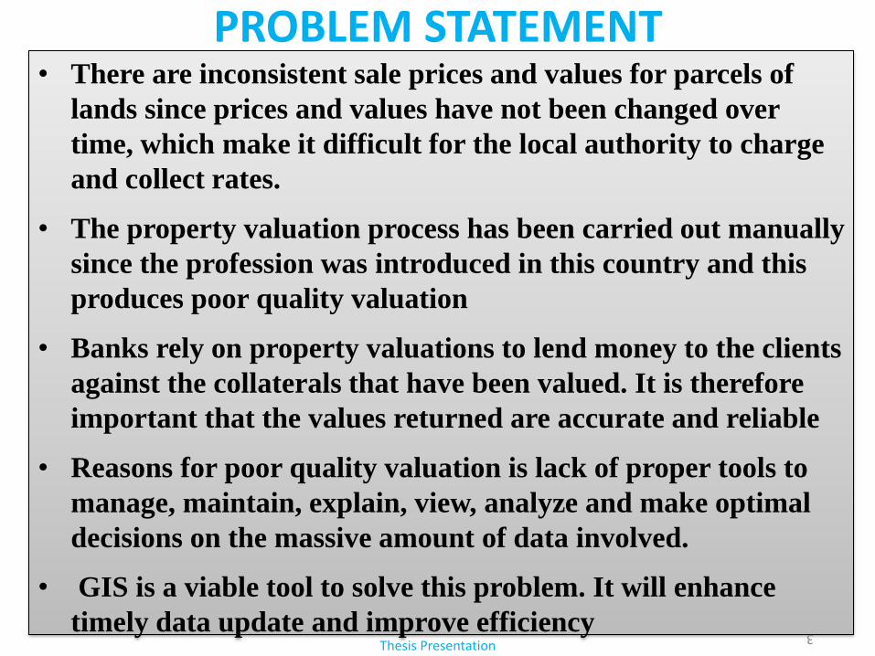
PROBLEM STATEMENT • There are inconsistent sale prices and values for parcels of
lands since prices and values have not been changed over
time, which make it difficult for the local authority to charge
and collect rates.
• The property valuation process has been carried out manually
since the profession was introduced in this country and this
produces poor quality valuation
• Banks rely on property valuations to lend money to the clients
against the collaterals that have been valued. It is therefore
important that the values returned are accurate and reliable
• Reasons for poor quality valuation is lack of proper tools to
manage, maintain, explain, view, analyze and make optimal
decisions on the massive amount of data involved.
• GIS is a viable tool to solve this problem. It will enhance
timely data update and improve efficiency
3
Thesis Presentation
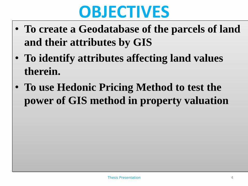
OBJECTIVES • To create a Geodatabase of the parcels of land
and their attributes by GIS
• To identify attributes affecting land values
therein.
• To use Hedonic Pricing Method to test the
power of GIS method in property valuation
4 Thesis Presentation
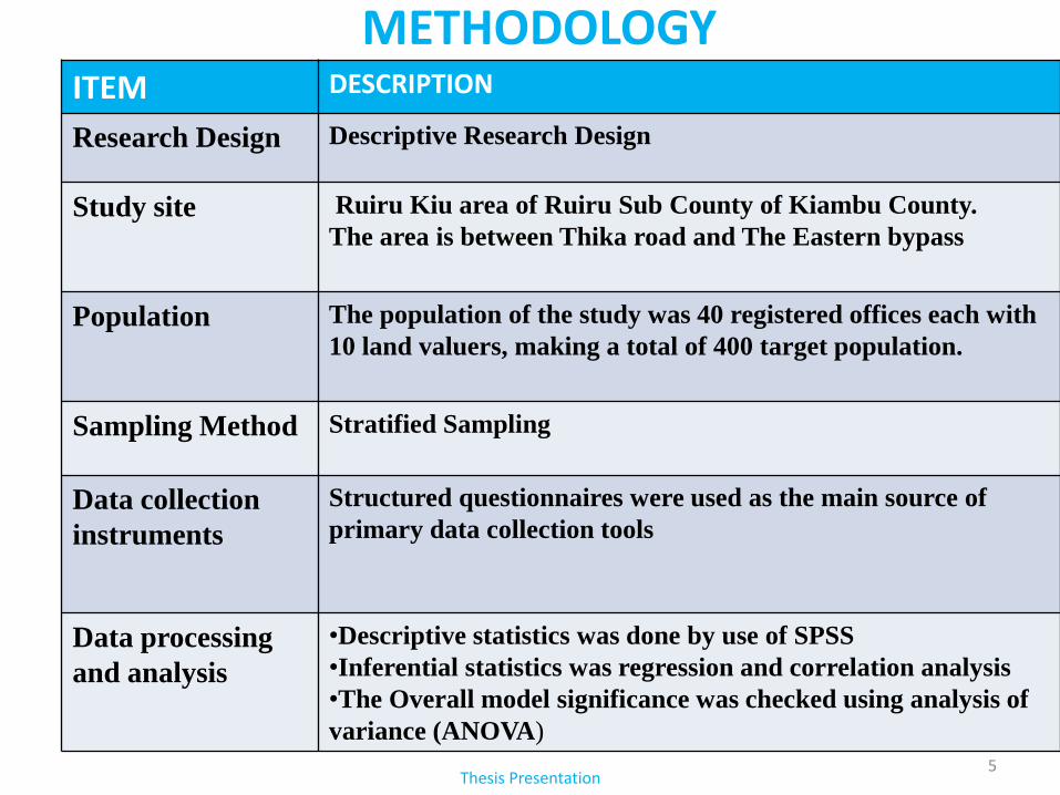
METHODOLOGY ITEM DESCRIPTION
Research Design Descriptive Research Design
Study site Ruiru Kiu area of Ruiru Sub County of Kiambu County.
The area is between Thika road and The Eastern bypass
Population
The population of the study was 40 registered offices each with
10 land valuers, making a total of 400 target population.
Sampling Method Stratified Sampling
Data collection
instruments
Structured questionnaires were used as the main source of
primary data collection tools
Data processing
and analysis
•Descriptive statistics was done by use of SPSS
•Inferential statistics was regression and correlation analysis
•The Overall model significance was checked using analysis of
variance (ANOVA)
5 Thesis Presentation
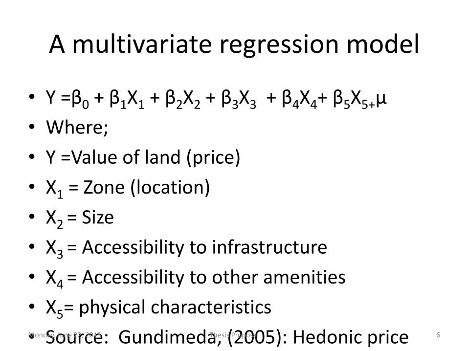
A multivariate regression model
• Y =β0 + β1X1 + β2X2 + β3X3 + β4X4+ β5X5+µ
• Where;
• Y =Value of land (price)
• X1 = Zone (location)
• X2 = Size
• X3 = Accessibility to infrastructure
• X4 = Accessibility to other amenities
• X5= physical characteristics
• Source: Gundimeda, (2005): Hedonic price Monday, June 22, 2015 Thesis Proposal 6
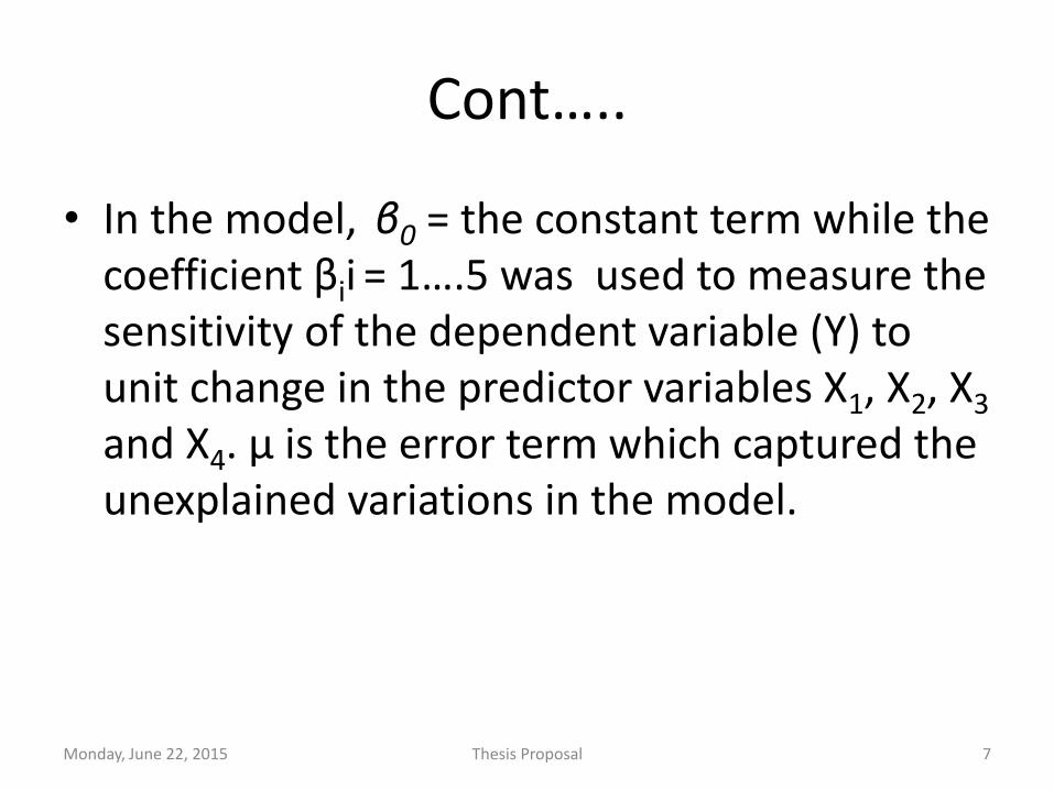
Cont…..
• In the model, β0 = the constant term while the coefficient βii = 1….5 was used to measure the sensitivity of the dependent variable (Y) to unit change in the predictor variables X1, X2, X3 and X4. µ is the error term which captured the unexplained variations in the model.
Monday, June 22, 2015 Thesis Proposal 7
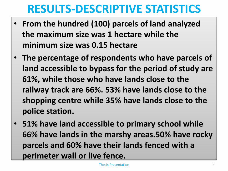
RESULTS-DESCRIPTIVE STATISTICS
Thesis Presentation 8
• From the hundred (100) parcels of land analyzed the maximum size was 1 hectare while the minimum size was 0.15 hectare
• The percentage of respondents who have parcels of land accessible to bypass for the period of study are 61%, while those who have lands close to the railway track are 66%. 53% have lands close to the shopping centre while 35% have lands close to the police station.
• 51% have land accessible to primary school while 66% have lands in the marshy areas.50% have rocky parcels and 60% have their lands fenced with a perimeter wall or live fence.
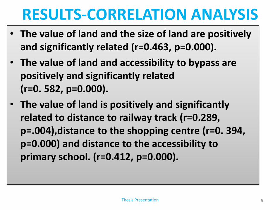
RESULTS-CORRELATION ANALYSIS
Thesis Presentation 9
• The value of land and the size of land are positively and significantly related (r=0.463, p=0.000).
• The value of land and accessibility to bypass are positively and significantly related (r=0. 582, p=0.000).
• The value of land is positively and significantly related to distance to railway track (r=0.289, p=.004),distance to the shopping centre (r=0. 394, p=0.000) and distance to the accessibility to primary school. (r=0.412, p=0.000).
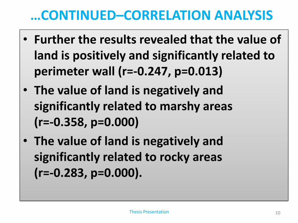
…CONTINUED–CORRELATION ANALYSIS
Thesis Presentation 10
• Further the results revealed that the value of land is positively and significantly related to perimeter wall (r=-0.247, p=0.013)
• The value of land is negatively and significantly related to marshy areas (r=-0.358, p=0.000)
• The value of land is negatively and significantly related to rocky areas (r=-0.283, p=0.000).
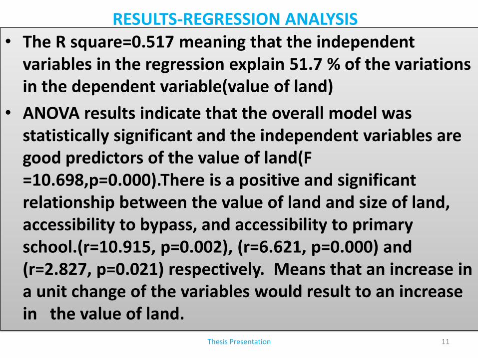
RESULTS-REGRESSION ANALYSIS
Thesis Presentation 11
• The R square=0.517 meaning that the independent variables in the regression explain 51.7 % of the variations in the dependent variable(value of land)
• ANOVA results indicate that the overall model was statistically significant and the independent variables are good predictors of the value of land(F =10.698,p=0.000).There is a positive and significant relationship between the value of land and size of land, accessibility to bypass, and accessibility to primary school.(r=10.915, p=0.002), (r=6.621, p=0.000) and (r=2.827, p=0.021) respectively. Means that an increase in a unit change of the variables would result to an increase in the value of land.
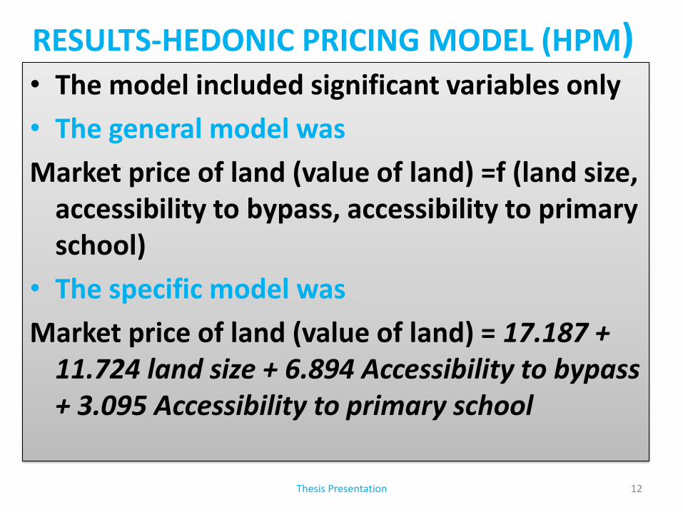
RESULTS-HEDONIC PRICING MODEL (HPM) • The model included significant variables only
• The general model was
Market price of land (value of land) =f (land size, accessibility to bypass, accessibility to primary school)
• The specific model was
Market price of land (value of land) = 17.187 + 11.724 land size + 6.894 Accessibility to bypass + 3.095 Accessibility to primary school
Thesis Presentation 12
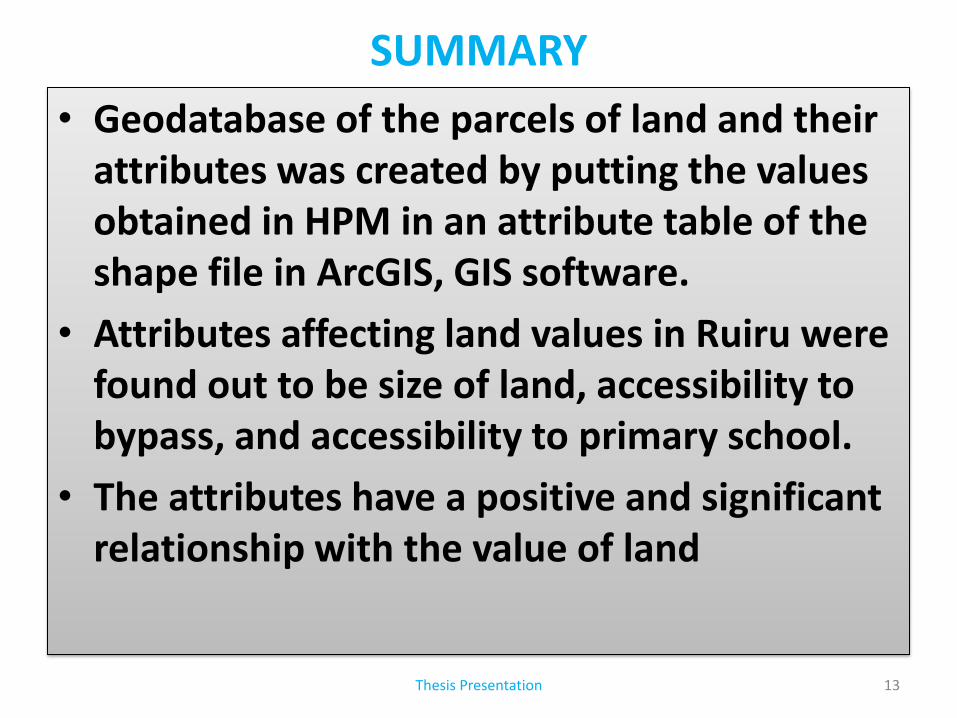
SUMMARY
• Geodatabase of the parcels of land and their
attributes was created by putting the values obtained in HPM in an attribute table of the shape file in ArcGIS, GIS software.
• Attributes affecting land values in Ruiru were found out to be size of land, accessibility to bypass, and accessibility to primary school.
• The attributes have a positive and significant relationship with the value of land
Thesis Presentation 13
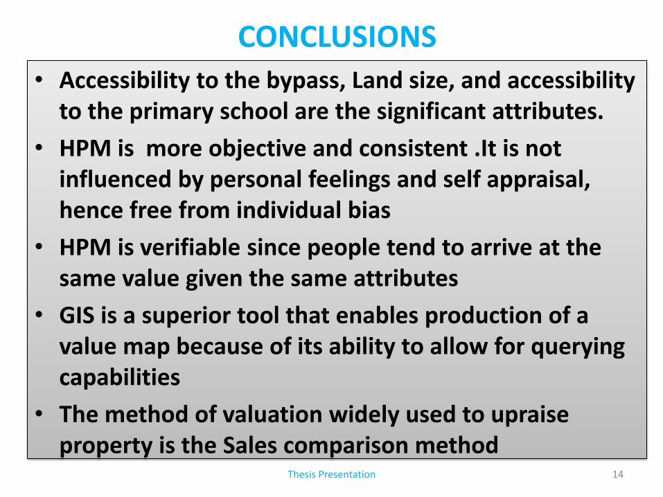
CONCLUSIONS • Accessibility to the bypass, Land size, and accessibility
to the primary school are the significant attributes.
• HPM is more objective and consistent .It is not influenced by personal feelings and self appraisal, hence free from individual bias
• HPM is verifiable since people tend to arrive at the same value given the same attributes
• GIS is a superior tool that enables production of a value map because of its ability to allow for querying capabilities
• The method of valuation widely used to upraise property is the Sales comparison method
Thesis Presentation 14
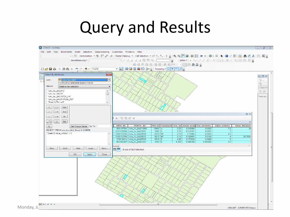
Query and Results
Monday, June 22, 2015 Thesis Proposal 15
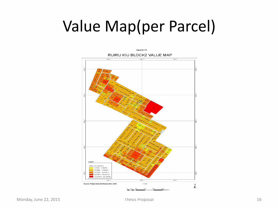
Value Map(per Parcel)
Monday, June 22, 2015 Thesis Proposal 16
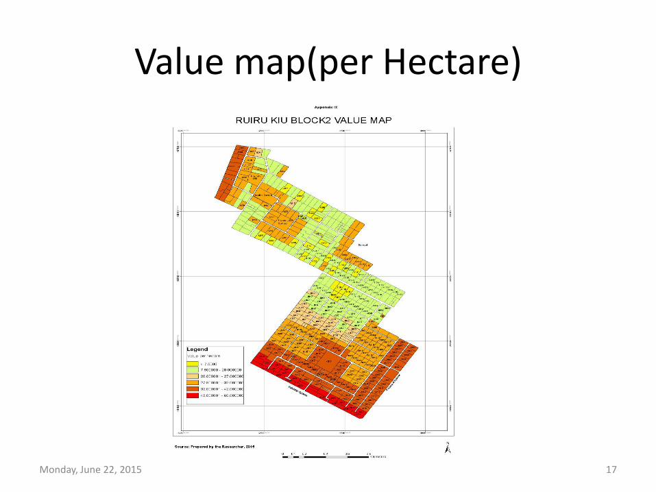
Value map(per Hectare)
Monday, June 22, 2015 Thesis Proposal 17
RECOMMENDATIONS • HRM should be used in Valuation of Property
because of its ability to quantify scientifically the factors affecting Property values
• A centralized data bank be created capturing sales data and property characteristics
• Use of GIS in property valuation should be encouraged and introduced to all valuers because it will fasten decision making
• This method of valuation should be applied in other areas other than Ruiru
Thesis Presentation 18
THANK YOU ALL !
Thesis Presentation 19