Embed Size (px)
Citation preview

Application of drone technologies in
quantifying stranded Sargassum
Joseph WeekesHazel A. Oxenford, Kimberly Baldwin
39th AMLC Scientific MeetingEnvironmental variability in the wider Caribbean and the ecological, social and economic consequences.
Punta Cana, Dominican Republic, 20-24 May 2019
Rena
ta G
oodr
idge
Jose
ph W
eeke
s
Haze
l Oxe
nfor
d
Jose
ph W
eeke
s

Background• Massive influxes of sargassum since 2011• New normal requiring adaptation and
management • Lack of standard monitoring guidelines to
determine how much, when and where sargassum is stranding
Jose
ph W
eeke
s
Rena
ta G
oodr
idge
Kim
berly
Bal
dwin
Trin
idad
& T
obag
o Gu
ardi
an O
nlin
e

Project Aim To assess the applicability of using drone technology together with GIS analysis to:
• Detect • Map • Quantify
Sargassum seaweed beach strandings
Rena
ta G
oodr
idge

Study Area
• Walkers Long Pond beach, NE coast of Barbados
• 2 km stretch of coastline
• 200 ha of beach area
• Located outside designated ‘no-fly areas’
• Not cleaned of sargassum
Walkers Long Pond

Methods • Flew drone over pre-selected area of
beach (every 2 weeks June-Sept 2018)
• Used conventional quadrat survey simultaneously
• Quadrat method used to:• Ground-truth drone images
(spectral signatures)• Provide independent estimate of
sargassum cover and volume• Provide volume to wet-weight and dry-
weight conversions• Species composition
Haze
l Oxe
nfor
d

• DJI Inspire I and Phantom 4 Pro drones• DroneDeploy© software • Flight parameters same for each survey:
• Flight altitude (90 m)• Path overlap (front 85%, side 75%)• Area covered (same flight plan)
• Flight times (15-20 min)• Flight speed (14-16 m/sec)• Number of images (approx. 400)• Automated processing time for
orthomosaic image (approx. 1 hr)
DJI Inspire I
Methods: Drone surveys
Phantom 4 Pro

Methods: Drone surveys
Supervised classification
Fresh goldenOld
golden
Old dry
Estimating volume
Mapping cover• ArcMap © GIS software • Supervised classification (using MLC tool)• Trained MLC algorithm using 2 steps
• By eye • By known quadrats (small subset)
• Checked accuracy using quadrats (all)• Calculated cover of each sargassum class
(using Zonal Geometry tool)Estimating volume• DroneDeploy© software• Using ‘Volume’ and ‘Stock pile analysis’ tools• Drew polygons around sargassum classes
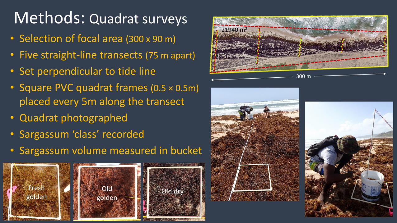
Methods: Quadrat surveys • Selection of focal area (300 x 90 m)
• Five straight-line transects (75 m apart)
• Set perpendicular to tide line• Square PVC quadrat frames (0.5 × 0.5m)
placed every 5m along the transect• Quadrat photographed • Sargassum ‘class’ recorded• Sargassum volume measured in bucket
Fresh golden
Old golden
Old dry
300 m
21940 m2

Methods: Quadrat surveys
• Full bucket of fresh sargassum collected• 1 kg sub-sample sorted into species• Dried at 76oC for 24 hr and re-weighed• Quadrat photographs processed using
CPCe software to determine exact area of sargassum cover (cm2)
• Quadrat mean cover extrapolated to focal area
S. natans VIIIS. fluitans III
Jose
ph W
eeke
s

June 22 2018
August 9 2018
September 20 2018
Results: Drone surveys Orthomosiac images
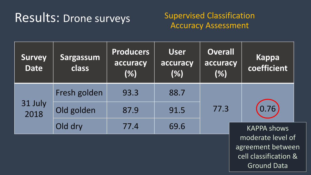
Supervised Classification Accuracy Assessment
Survey Date
Sargassum class
Producers accuracy
(%)
User accuracy
(%)
Overall accuracy
(%)
Kappa coefficient
31 July 2018
Fresh golden 93.3 88.7
77.3 0.76Old golden 87.9 91.5
Old dry 77.4 69.6
Results: Drone surveys
KAPPA shows moderate level of
agreement between cell classification &
Ground Data

Results: Drone surveys
Processed image showing map of cover by sargassum ‘classes’
22 June 2018
Sargassum class
Cover (m2)
Cover(%)
Fresh golden 2,231 10.2
Old golden 7,364 33.6
Old dry 9,470 43.2
All 19,065 86.922 June 2018
Mapping Cover

Sargassum area cover by drone method versus cover by transect method
Results: Comparison
Sargassum class
DroneCover (m2)
QuadratCover(m2)
Fresh golden 2,231 2,361
Old golden 7,364 4,073
Old dry 9,470 9,091
All 19,065 15,53322 June 2018 All surveys
Mapping Cover
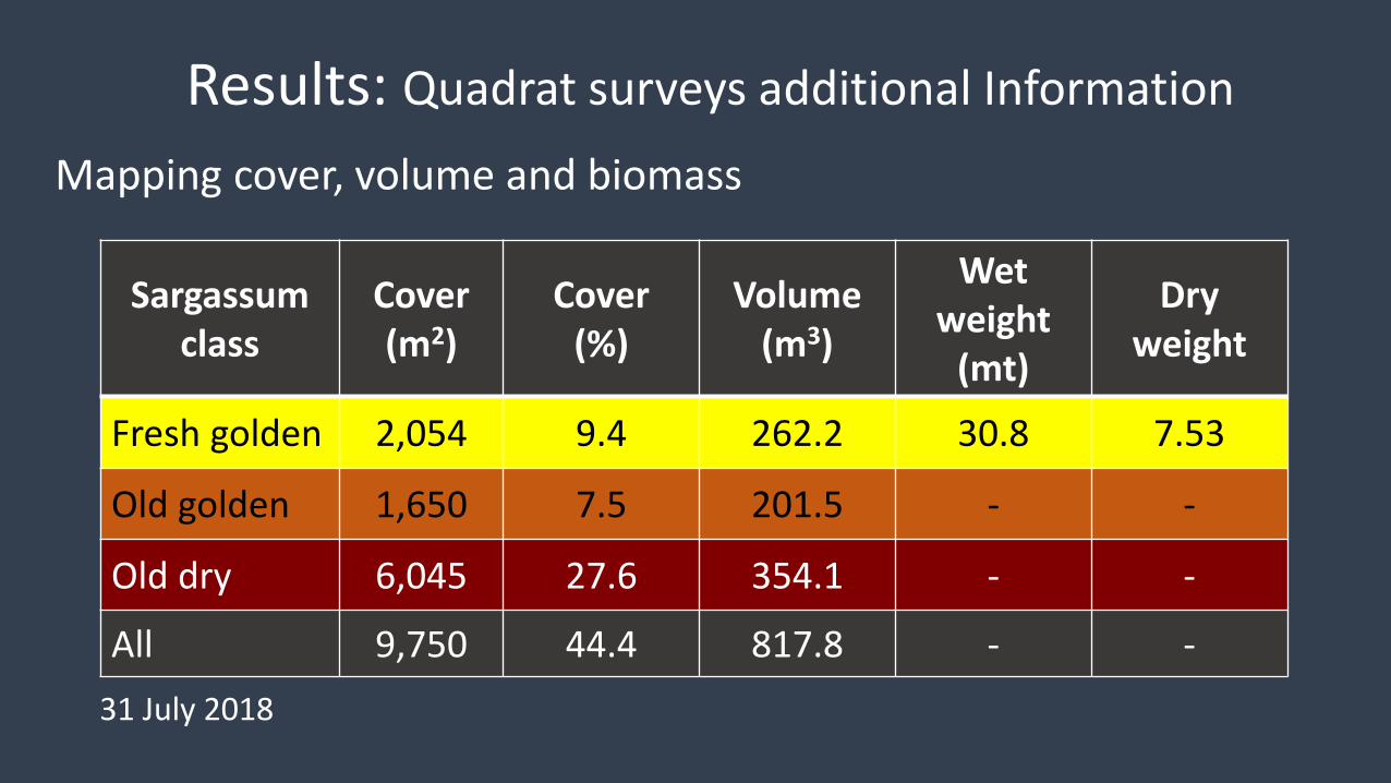
Results: Quadrat surveys additional Information
Sargassum class
Cover (m2)
Cover(%)
Volume (m3)
Wet weight
(mt)
Dry weight
Fresh golden 2,054 9.4 262.2 30.8 7.53
Old golden 1,650 7.5 201.5 - -
Old dry 6,045 27.6 354.1 - -
All 9,750 44.4 817.8 - -
Mapping cover, volume and biomass
31 July 2018

Results: Quadrat surveys additional Information
Species Composition
S. fluitans S. natans
VIII
31-Jul
S. fluitans
S. natans I
S. natans VIII
9-Aug
S. fluitans S. natans I
31-Aug
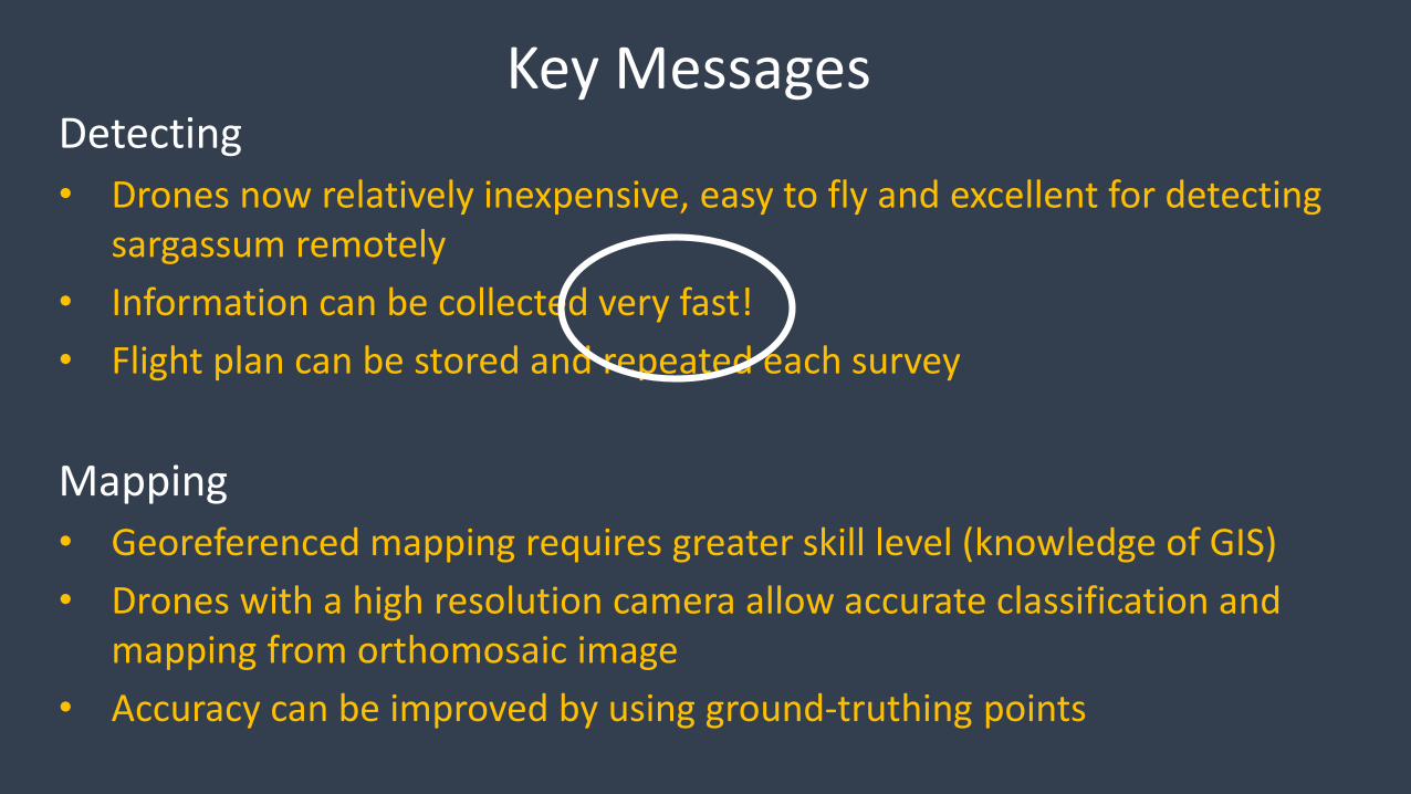
Key Messages Detecting• Drones now relatively inexpensive, easy to fly and excellent for detecting
sargassum remotely• Information can be collected very fast!• Flight plan can be stored and repeated each survey
Mapping• Georeferenced mapping requires greater skill level (knowledge of GIS)• Drones with a high resolution camera allow accurate classification and
mapping from orthomosaic image• Accuracy can be improved by using ground-truthing points

Key Messages Quantification• Quantifying sargassum from images requires GIS skills• Surface area can be calculated from orthomosaic image for each class• Volume of sargassum could not be measured due to changing beach profile
Value added• Some in situ sampling can add significant value
• Ground truthing identification of sargassum classes• Volume (recommend using replicate quadrats for fresh golden
sargassum only)• Wet to dry weight conversions and species composition

Thank you to our volunteers!
Renata GoodridgeAnnabel CoxCarla DanielsLeisl Brewster
Charleen Charles