Embed Size (px)
Citation preview
AAppppeennddiixx DD EEDDRR RRaaddiiuuss MMaapp RReeppoorrtt

FORM-STD-ALV
®kcehCoeG htiw tropeR ™paM suidaR RDE ehTmetsyS ®kcehCdleiF RDE eht gnisu deraperP
440 Wheelers Farms RoadMilford, CT 06461Toll Free: 800.352.0050www.edrnet.com
Sportsmans Park735 S. West St.Naperville, IL 60540
Inquiry Number: 2991930.2sMarch 07, 2011

SECTION PAGE
Executive Summary ES1
Overview Map 2
Detail Map 3
Map Findings Summary 4
Map Findings 7
Orphan Summary 18
Government Records Searched/Data Currency Tracking GR-1
GEOCHECK ADDENDUM
Physical Setting Source Addendum A-1
Physical Setting Source Summary A-2
Physical Setting SSURGO Soil Map A-5
Physical Setting Source Map A-11
Physical Setting Source Map Findings A-13
Physical Setting Source Records Searched A-47
TC2991930.2s Page 1
Thank you for your business.Please contact EDR at 1-800-352-0050
with any questions or comments.
Disclaimer - Copyright and Trademark Notice
The EDR FieldCheck System enables EDR’s customers to make certain online modifications to the maps and text contained in®EDR Radius Map Reports. As a result, the maps and text contained in this Report may have been so modified. EDR has not takenany action to verify any such modifications, and this report and the findings set forth herein must be read in light of this fact. The EDRFieldCheck System accesses user-modified records from previously submitted reports. Any user-modified record from a previous reportthat is plotted outside the search radius of this report may not be included in this report.
This Report contains certain information obtained from a variety of public and other sources reasonably available to Environmental DataResources, Inc. It cannot be concluded from this Report that coverage information for the target and surrounding properties does not exist fromother sources. NO WARRANTY EXPRESSED OR IMPLIED, IS MADE WHATSOEVER IN CONNECTION WITH THIS REPORT. ENVIRONMENTALDATA RESOURCES, INC. SPECIFICALLY DISCLAIMS THE MAKING OF ANY SUCH WARRANTIES, INCLUDING WITHOUT LIMITATION,MERCHANTABILITY OR FITNESS FOR A PARTICULAR USE OR PURPOSE. ALL RISK IS ASSUMED BY THE USER. IN NO EVENT SHALLENVIRONMENTAL DATA RESOURCES, INC. BE LIABLE TO ANYONE, WHETHER ARISING OUT OF ERRORS OR OMISSIONS, NEGLIGENCE,ACCIDENT OR ANY OTHER CAUSE, FOR ANY LOSS OF DAMAGE, INCLUDING, WITHOUT LIMITATION, SPECIAL, INCIDENTAL,CONSEQUENTIAL, OR EXEMPLARY DAMAGES. ANY LIABILITY ON THE PART OF ENVIRONMENTAL DATA RESOURCES, INC. IS STRICTLYLIMITED TO A REFUND OF THE AMOUNT PAID FOR THIS REPORT. Purchaser accepts this Report "AS IS". Any analyses, estimates, ratings,environmental risk levels or risk codes provided in this Report are provided for illustrative purposes only, and are not intended to provide, norshould they be interpreted as providing any facts regarding, or prediction or forecast of, any environmental risk for any property. Only a Phase IEnvironmental Site Assessment performed by an environmental professional can provide information regarding the environmental risk for anyproperty. Additionally, the information provided in this Report is not to be construed as legal advice.
Copyright 2011 by Environmental Data Resources, Inc. All rights reserved. Reproduction in any media or format, in wholeor in part, of any report or map of Environmental Data Resources, Inc., or its affiliates, is prohibited without prior written permission.
EDR and its logos (including Sanborn and Sanborn Map) are trademarks of Environmental Data Resources, Inc. or its affiliates. All othertrademarks used herein are the property of their respective owners.
TABLE OF CONTENTS

EXECUTIVE SUMMARY
TC2991930.2s EXECUTIVE SUMMARY 1
A search of the environmental records was conducted by Environmental Data Resources, Inc. (EDR). SHAWENVIRONMENTAL & INFRASTRUCTURE used the EDR FieldCheck System to review and/or revise the results ofthis search, based on independent data verification by SHAW ENVIRONMENTAL & INFRASTRUCTURE. Thereport was designed to assist parties seeking to meet the search requirements of EPA’s Standards andPractices for All Appropriate Inquiries (40 CFR Part 312), the ASTM Standard Practice forEnvironmental Site Assessments (E 1527-05) or custom requirements developed for the evaluation ofenvironmental risk associated with a parcel of real estate.
TARGET PROPERTY INFORMATION
ADDRESS
735 S. WEST ST.NAPERVILLE, IL 60540
COORDINATES
41.762500 - 41˚ 45’ 45.0’’Latitude (North): 88.158100 - 88˚ 9’ 29.2’’Longitude (West): Zone 16Universal Tranverse Mercator: 403729.7UTM X (Meters): 4623842.5UTM Y (Meters): 701 ft. above sea levelElevation:
USGS TOPOGRAPHIC MAP ASSOCIATED WITH TARGET PROPERTY
41088-G2 NAPERVILLE, ILTarget Property Map:1998Most Recent Revision:
41088-F2 NORMANTOWN, ILSouth Map:1993Most Recent Revision:
AERIAL PHOTOGRAPHY IN THIS REPORT
2005, 2006, 2007Portions of Photo from:USDASource:
TARGET PROPERTY SEARCH RESULTS
The target property was not listed in any of the databases searched by EDR.
DATABASES WITH NO MAPPED SITES
No sites were identified in following databases.
STANDARD ENVIRONMENTAL RECORDS
Federal NPL site list
NPL National Priority List

EXECUTIVE SUMMARY
TC2991930.2s EXECUTIVE SUMMARY 2
Proposed NPL Proposed National Priority List SitesNPL LIENS Federal Superfund Liens
Federal Delisted NPL site list
Delisted NPL National Priority List Deletions
Federal CERCLIS list
FEDERAL FACILITY Federal Facility Site Information listing
Federal CERCLIS NFRAP site List
CERC-NFRAP CERCLIS No Further Remedial Action Planned
Federal RCRA CORRACTS facilities list
CORRACTS Corrective Action Report
Federal RCRA non-CORRACTS TSD facilities list
RCRA-TSDF RCRA - Treatment, Storage and Disposal
Federal RCRA generators list
RCRA-LQG RCRA - Large Quantity GeneratorsRCRA-SQG RCRA - Small Quantity GeneratorsRCRA-CESQG RCRA - Conditionally Exempt Small Quantity Generator
Federal institutional controls / engineering controls registries
US ENG CONTROLS Engineering Controls Sites ListUS INST CONTROL Sites with Institutional Controls
Federal ERNS list
ERNS Emergency Response Notification System
State- and tribal - equivalent NPL
CAT Category List
State- and tribal - equivalent CERCLIS
SHWS State Oversight List
State and tribal landfill and/or solid waste disposal site lists
SWF/LF Available Disposal for Solid Waste in Illinois - Solid Waste Landfills Subject to State SurchargeLF SPECIAL WASTE Special Waste Site ListCCDD Clean Construction or Demolition Debris
State and tribal leaking storage tank lists
LUST TRUST Underground Storage Tank Fund Payment Priority List

EXECUTIVE SUMMARY
TC2991930.2s EXECUTIVE SUMMARY 3
INDIAN LUST Leaking Underground Storage Tanks on Indian Land
State and tribal registered storage tank lists
INDIAN UST Underground Storage Tanks on Indian LandFEMA UST Underground Storage Tank Listing
State and tribal institutional control / engineering control registries
ENG CONTROLS Sites with Engineering ControlsINST CONTROL Institutional Controls
State and tribal voluntary cleanup sites
INDIAN VCP Voluntary Cleanup Priority Listing
State and tribal Brownfields sites
BROWNFIELDS Municipal Brownfields Redevelopment Grant Program Project Descriptions
ADDITIONAL ENVIRONMENTAL RECORDS
Local Brownfield lists
US BROWNFIELDS A Listing of Brownfields Sites
Local Lists of Landfill / Solid Waste Disposal Sites
DEBRIS REGION 9 Torres Martinez Reservation Illegal Dump Site LocationsODI Open Dump InventoryINDIAN ODI Report on the Status of Open Dumps on Indian Lands
Local Lists of Hazardous waste / Contaminated Sites
US CDL Clandestine Drug LabsCDL Meth Drug Lab Site ListingUS HIST CDL National Clandestine Laboratory Register
Local Land Records
LIENS 2 CERCLA Lien InformationLUCIS Land Use Control Information System
Records of Emergency Release Reports
HMIRS Hazardous Materials Information Reporting SystemSPILLS State spills
Other Ascertainable Records
RCRA-NonGen RCRA - Non GeneratorsDOT OPS Incident and Accident DataDOD Department of Defense SitesFUDS Formerly Used Defense Sites
EXECUTIVE SUMMARY
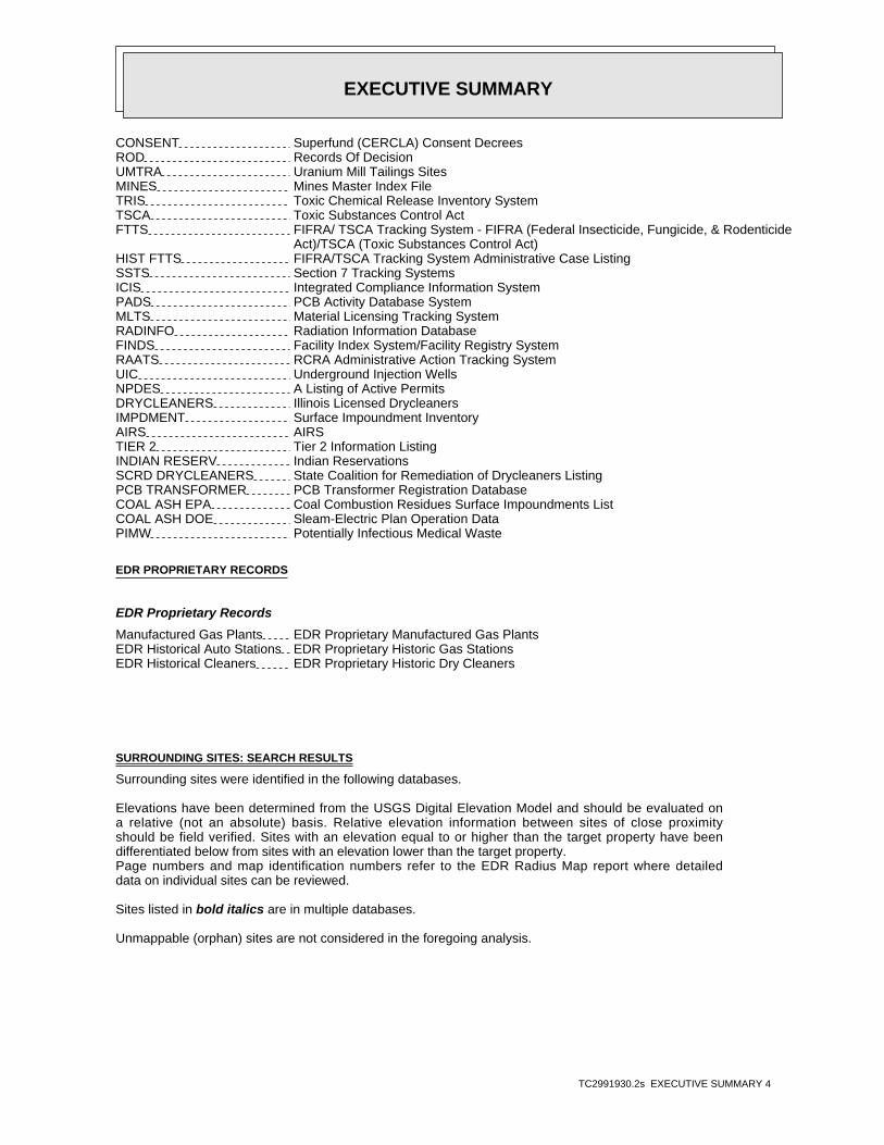
TC2991930.2s EXECUTIVE SUMMARY 4
CONSENT Superfund (CERCLA) Consent DecreesROD Records Of DecisionUMTRA Uranium Mill Tailings SitesMINES Mines Master Index FileTRIS Toxic Chemical Release Inventory SystemTSCA Toxic Substances Control ActFTTS FIFRA/ TSCA Tracking System - FIFRA (Federal Insecticide, Fungicide, & Rodenticide Act)/TSCA (Toxic Substances Control Act)HIST FTTS FIFRA/TSCA Tracking System Administrative Case ListingSSTS Section 7 Tracking SystemsICIS Integrated Compliance Information SystemPADS PCB Activity Database SystemMLTS Material Licensing Tracking SystemRADINFO Radiation Information DatabaseFINDS Facility Index System/Facility Registry SystemRAATS RCRA Administrative Action Tracking SystemUIC Underground Injection WellsNPDES A Listing of Active PermitsDRYCLEANERS Illinois Licensed DrycleanersIMPDMENT Surface Impoundment InventoryAIRS AIRSTIER 2 Tier 2 Information ListingINDIAN RESERV Indian ReservationsSCRD DRYCLEANERS State Coalition for Remediation of Drycleaners ListingPCB TRANSFORMER PCB Transformer Registration DatabaseCOAL ASH EPA Coal Combustion Residues Surface Impoundments ListCOAL ASH DOE Sleam-Electric Plan Operation DataPIMW Potentially Infectious Medical Waste
EDR PROPRIETARY RECORDS
EDR Proprietary Records
Manufactured Gas Plants EDR Proprietary Manufactured Gas PlantsEDR Historical Auto Stations EDR Proprietary Historic Gas StationsEDR Historical Cleaners EDR Proprietary Historic Dry Cleaners
SURROUNDING SITES: SEARCH RESULTS
Surrounding sites were identified in the following databases.
Elevations have been determined from the USGS Digital Elevation Model and should be evaluated ona relative (not an absolute) basis. Relative elevation information between sites of close proximityshould be field verified. Sites with an elevation equal to or higher than the target property have beendifferentiated below from sites with an elevation lower than the target property.Page numbers and map identification numbers refer to the EDR Radius Map report where detaileddata on individual sites can be reviewed.
Sites listed in bold italics are in multiple databases.
Unmappable (orphan) sites are not considered in the foregoing analysis.

EXECUTIVE SUMMARY
TC2991930.2s EXECUTIVE SUMMARY 5
STANDARD ENVIRONMENTAL RECORDS
Federal CERCLIS list
CERCLIS: The Comprehensive Environmental Response, Compensation and Liability Information Systemcontains data on potentially hazardous waste sites that have been reported to the USEPA by states,municipalities, private companies and private persons, pursuant to Section 103 of the ComprehensiveEnvironmental Response, Compensation and Liability Act (CERCLA). CERCLIS contains sites which are eitherproposed to or on the National Priorities List (NPL) and sites which are in the screening and assessment phasefor possible inclusion on the NPL.
An online review and analysis by SHAW ENVIRONMENTAL & INFRASTRUCTURE of the CERCLIS list, as provided by EDR, and dated 11/30/2010 has revealed that there is 1 CERCLIS site within approximately 0.5 miles of the target property.
PageMap IDDirection / Distance Address Equal/Higher Elevation ____________________ ________ ___________________ _____ _____
NAPERVILLE SPORTSMAN’S PARK WEST STREET AT MARTIN A E 0 - 1/8 (0.007 mi.) A2 7
State and tribal landfill and/or solid waste disposal site lists
IL NIPC: NIPC is an inventory of active and inactive solid waste disposal sites, based on state,local government and historical archive data. Included are numerous sites that previously had never beenidentified largely because, prior to 1971, there was no obligation to register such sites. The data come fromthe Northeastern Illinois Planning Commission’s Solid Waste Landfill Inventory.
An online review and analysis by SHAW ENVIRONMENTAL & INFRASTRUCTURE of the IL NIPC list, as provided by EDR, and dated 08/01/1988 has revealed that there is 1 IL NIPC site within approximately 0.5 miles of the target property.
PageMap IDDirection / Distance Address Lower Elevation ____________________ ________ ___________________ _____ _____
NAPERVILLE MUNICIPAL ENE 1/4 - 1/2 (0.423 mi.) D11 14
State and tribal leaking storage tank lists
LUST: The Leaking Underground Storage Tank Incident Reports contain an inventory of reportedleaking underground storage tank incidents. The data come from the Illinois Environmental Protection Agency’sLUST Incident Report.
An online review and analysis by SHAW ENVIRONMENTAL & INFRASTRUCTURE of the LUST list, as provided by EDR, and dated 01/21/2011 has revealed that there are 10 LUST sites within approximately 0.5 miles of the target property.
PageMap IDDirection / Distance Address Equal/Higher Elevation ____________________ ________ ___________________ _____ _____
NAPERVILLE PARK DIST. 421 MARTIN ST. E 0 - 1/8 (0.092 mi.) C6 11NFA/NFR Letter: 07/15/1994
PageMap IDDirection / Distance Address Lower Elevation ____________________ ________ ___________________ _____ _____
LINDEN OAKS HOSPITAL 852 WEST ST. E 0 - 1/8 (0.008 mi.) B3 9NFA/NFR Letter: 12/13/1994

EXECUTIVE SUMMARY
TC2991930.2s EXECUTIVE SUMMARY 6
PageMap IDDirection / Distance Address Lower Elevation ____________________ ________ ___________________ _____ _____
CHARTER MEDICAL 852 WEST ST. E 0 - 1/8 (0.008 mi.) B5 10NFA/NFR Letter: 05/03/2000
NAPERVILLE C.U.S.D. #203 251 WEST HILLSIDE RD. ENE 1/4 - 1/2 (0.262 mi.) 9 13NFA/NFR Letter: 02/16/1996
NAPERVILLE MUNICIPAL CTR. 237 AURORA AVE. ENE 1/4 - 1/2 (0.387 mi.) D10 14 NAPERVILLE, CITY OF 305 WEST JACKSON NE 1/4 - 1/2 (0.429 mi.) 12 14 EDWARD HOSPITAL 801 SOUTH WASHINGTON E 1/4 - 1/2 (0.430 mi.) 13 15 EDWARDS HOSPITAL 801 SOUTH WASHINGTON ST E 1/4 - 1/2 (0.468 mi.) 14 15
NFA/NFR Letter: 04/21/2000
AMOCO OIL CO. #5484 702 SOUTH WASHINGTON ENE 1/4 - 1/2 (0.492 mi.) E15 16NFA/NFR Letter: 04/18/2002
BP PRODUCTS NORTH AMERICA, INC 702 SOUTH WASHINGTON ST ENE 1/4 - 1/2 (0.492 mi.) E16 16NFA/NFR Letter: 07/22/2010
State and tribal registered storage tank lists
UST: The Underground Storage Tank database contains registered USTs. USTs are regulated underSubtitle I of the Resource Conservation and Recovery Act (RCRA). The data come from the Illinois State FireMarshal’s STC Facility List.
An online review and analysis by SHAW ENVIRONMENTAL & INFRASTRUCTURE of the UST list, as provided by EDR, and dated 02/03/2011 has revealed that there are 3 UST sites within approximately 0.25 miles of the target property.
PageMap IDDirection / Distance Address Equal/Higher Elevation ____________________ ________ ___________________ _____ _____
NAPERVILLE PARK DIST 421 W MARTIN E 0 - 1/8 (0.092 mi.) C7 11 NAPERVILLE CENTRAL HIGH SCHOOL 440 WEST AURORA AVENUE NE 0 - 1/8 (0.120 mi.) 8 12
PageMap IDDirection / Distance Address Lower Elevation ____________________ ________ ___________________ _____ _____
LINDEN OAKS HOSPITAL 852 WEST STREET E 0 - 1/8 (0.008 mi.) B4 10
State and tribal voluntary cleanup sites
SRP: Illinois Environmental Protection Agency, Site Remediation Program Database
An online review and analysis by SHAW ENVIRONMENTAL & INFRASTRUCTURE of the SRP list, as provided by EDR, and dated 01/22/2011 has revealed that there is 1 SRP site within approximately 0.5 miles of the target property.
PageMap IDDirection / Distance Address Equal/Higher Elevation ____________________ ________ ___________________ _____ _____
NAPERVILLE SPORTSMAN’S PARK 7402 SOUTH WEST STREET 0 - 1/8 (0.000 mi.) A1 7

EXECUTIVE SUMMARY
TC2991930.2s EXECUTIVE SUMMARY 7
Due to poor or inadequate address information, the following sites were not mapped. Count: 20 records.
Site Name Database(s)____________ ____________
NAPERVILLE PUBLIC WELL #8 SHWSGREEN VALLEY LANDFILL CERC-NFRAPGOOD CHOICE CLEANERS DRYCLEANERSHERITAGE CLEANERS DRYCLEANERSNAPERVILLE C.U.S.D. #203 LUSTBP PRODUCTS NORTH AMERICA LUSTWHITE EAGLE GOLF CLUB LUSTNAPERVILLE RSM #3 USTNAPERVILE RSM #1 Q21140 USTSAM’S CLUB #8143 USTISTHA M08 MAINTENANCE GARAGE USTAMOCO OIL COMPANY USTBUCKY’S EXPRESS #533 USTSAMS CLUB 8143 RCRA-SQG, FINDSNAPERVILLE PARK DISTRICT RCRA-NonGenK FIVE CONSTRUCTION CORP RCRA-CESQGNAPERVILLE ELEMENTARY SCHOOL RCRA-CESQGWAL-MART 1401 RCRA-CESQG, FINDSNAPERVILLE PARK DIST/T STANTON FINDSNAPERVILLE PARK DISTRICT FINDS

EDR Inc.EDR Inc.EDR Inc.EDR Inc.EDR Inc.EDR Inc.EDR Inc.EDR Inc.EDR Inc.EDR Inc.EDR Inc.EDR Inc.EDR Inc.EDR Inc.EDR Inc.EDR Inc.EDR Inc.EDR Inc.EDR Inc.EDR Inc.EDR Inc.EDR Inc.EDR Inc.EDR Inc.EDR Inc.EDR Inc.EDR Inc.EDR Inc.EDR Inc.EDR Inc.EDR Inc.EDR Inc.EDR Inc.EDR Inc.EDR Inc.EDR Inc.EDR Inc.EDR Inc.EDR Inc.EDR Inc.
720
72
0
72
0
720
7 2 0
68
0
68
0
6 8 06 8 0
68 0
8 0
68
0
6 8 0
68
0
6 8 06
80
68
0
6 8 0 6 8 0
68
068
0

EDR Inc.EDR Inc.EDR Inc.EDR Inc.EDR Inc.EDR Inc.EDR Inc.EDR Inc.EDR Inc.EDR Inc.EDR Inc.EDR Inc.EDR Inc.EDR Inc.EDR Inc.EDR Inc.EDR Inc.EDR Inc.EDR Inc.EDR Inc.EDR Inc.EDR Inc.EDR Inc.EDR Inc.EDR Inc.EDR Inc.EDR Inc.EDR Inc.EDR Inc.EDR Inc.EDR Inc.EDR Inc.EDR Inc.EDR Inc.EDR Inc.EDR Inc.EDR Inc.EDR Inc.EDR Inc.EDR Inc.
68
0
680
680
6

MAP FINDINGS SUMMARY
SearchTarget Distance Total
Database Property (Miles) < 1/8 1/8 - 1/4 1/4 - 1/2 1/2 - 1 > 1 Plotted
STANDARD ENVIRONMENTAL RECORDS
Federal NPL site list
0 NR 0 0 0 0 1.000NPL 0 NR 0 0 0 0 1.000Proposed NPL 0 NR NR NR NR NR TPNPL LIENS
Federal Delisted NPL site list
0 NR 0 0 0 0 1.000Delisted NPL
Federal CERCLIS list
1 NR NR 0 0 1 0.500CERCLIS 0 NR 0 0 0 0 1.000FEDERAL FACILITY
Federal CERCLIS NFRAP site List
0 NR NR 0 0 0 0.500CERC-NFRAP
Federal RCRA CORRACTS facilities list
0 NR 0 0 0 0 1.000CORRACTS
Federal RCRA non-CORRACTS TSD facilities list
0 NR NR 0 0 0 0.500RCRA-TSDF
Federal RCRA generators list
0 NR NR NR 0 0 0.250RCRA-LQG 0 NR NR NR 0 0 0.250RCRA-SQG 0 NR NR NR 0 0 0.250RCRA-CESQG
Federal institutional controls /engineering controls registries
0 NR NR 0 0 0 0.500US ENG CONTROLS 0 NR NR 0 0 0 0.500US INST CONTROL
Federal ERNS list
0 NR NR NR NR NR TPERNS
State- and tribal - equivalent NPL
0 NR 0 0 0 0 1.000CAT
State- and tribal - equivalent CERCLIS
0 NR 0 0 0 0 1.000SHWS
State and tribal landfill and/orsolid waste disposal site lists
0 NR NR 0 0 0 0.500SWF/LF 0 NR NR 0 0 0 0.500LF SPECIAL WASTE 1 NR NR 1 0 0 0.500IL NIPC 0 NR NR 0 0 0 0.500CCDD
State and tribal leaking storage tank lists
10 NR NR 7 0 3 0.500LUST
TC2991930.2s Page 4
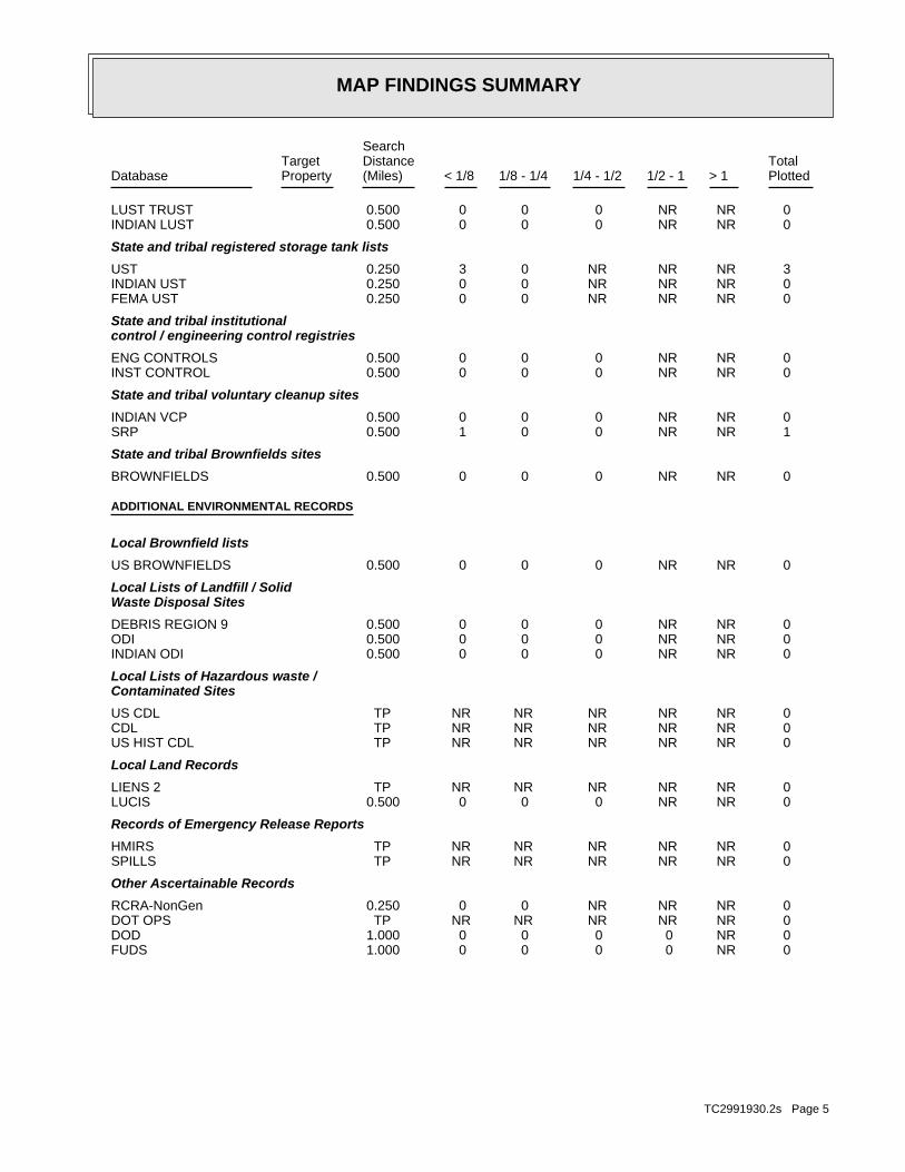
MAP FINDINGS SUMMARY
SearchTarget Distance Total
Database Property (Miles) < 1/8 1/8 - 1/4 1/4 - 1/2 1/2 - 1 > 1 Plotted
0 NR NR 0 0 0 0.500LUST TRUST 0 NR NR 0 0 0 0.500INDIAN LUST
State and tribal registered storage tank lists
3 NR NR NR 0 3 0.250UST 0 NR NR NR 0 0 0.250INDIAN UST 0 NR NR NR 0 0 0.250FEMA UST
State and tribal institutionalcontrol / engineering control registries
0 NR NR 0 0 0 0.500ENG CONTROLS 0 NR NR 0 0 0 0.500INST CONTROL
State and tribal voluntary cleanup sites
0 NR NR 0 0 0 0.500INDIAN VCP 1 NR NR 0 0 1 0.500SRP
State and tribal Brownfields sites
0 NR NR 0 0 0 0.500BROWNFIELDS
ADDITIONAL ENVIRONMENTAL RECORDS
Local Brownfield lists
0 NR NR 0 0 0 0.500US BROWNFIELDS
Local Lists of Landfill / SolidWaste Disposal Sites
0 NR NR 0 0 0 0.500DEBRIS REGION 9 0 NR NR 0 0 0 0.500ODI 0 NR NR 0 0 0 0.500INDIAN ODI
Local Lists of Hazardous waste /Contaminated Sites
0 NR NR NR NR NR TPUS CDL 0 NR NR NR NR NR TPCDL 0 NR NR NR NR NR TPUS HIST CDL
Local Land Records
0 NR NR NR NR NR TPLIENS 2 0 NR NR 0 0 0 0.500LUCIS
Records of Emergency Release Reports
0 NR NR NR NR NR TPHMIRS 0 NR NR NR NR NR TPSPILLS
Other Ascertainable Records
0 NR NR NR 0 0 0.250RCRA-NonGen 0 NR NR NR NR NR TPDOT OPS 0 NR 0 0 0 0 1.000DOD 0 NR 0 0 0 0 1.000FUDS
TC2991930.2s Page 5

MAP FINDINGS SUMMARY
SearchTarget Distance Total
Database Property (Miles) < 1/8 1/8 - 1/4 1/4 - 1/2 1/2 - 1 > 1 Plotted
0 NR 0 0 0 0 1.000CONSENT 0 NR 0 0 0 0 1.000ROD 0 NR NR 0 0 0 0.500UMTRA 0 NR NR NR 0 0 0.250MINES 0 NR NR NR NR NR TPTRIS 0 NR NR NR NR NR TPTSCA 0 NR NR NR NR NR TPFTTS 0 NR NR NR NR NR TPHIST FTTS 0 NR NR NR NR NR TPSSTS 0 NR NR NR NR NR TPICIS 0 NR NR NR NR NR TPPADS 0 NR NR NR NR NR TPMLTS 0 NR NR NR NR NR TPRADINFO 0 NR NR NR NR NR TPFINDS 0 NR NR NR NR NR TPRAATS 0 NR NR NR NR NR TPUIC 0 NR NR NR NR NR TPNPDES 0 NR NR NR 0 0 0.250DRYCLEANERS 0 NR NR 0 0 0 0.500IMPDMENT 0 NR NR NR NR NR TPAIRS 0 NR NR NR NR NR TPTIER 2 0 NR 0 0 0 0 1.000INDIAN RESERV 0 NR NR 0 0 0 0.500SCRD DRYCLEANERS 0 NR NR NR NR NR TPPCB TRANSFORMER 0 NR NR 0 0 0 0.500COAL ASH EPA 0 NR NR NR NR NR TPCOAL ASH DOE 0 NR NR NR 0 0 0.250PIMW
EDR PROPRIETARY RECORDS
EDR Proprietary Records
0 NR 0 0 0 0 1.000Manufactured Gas Plants 0 NR NR NR 0 0 0.250EDR Historical Auto Stations 0 NR NR NR 0 0 0.250EDR Historical Cleaners
NOTES:
TP = Target Property
NR = Not Requested at this Search Distance
Sites may be listed in more than one database
TC2991930.2s Page 6

MAP FINDINGSMap IDDirection
EDR ID NumberDistanceEPA ID NumberDatabase(s)SiteElevation
53.39Acres: FalseWorker Caution: Not reportedBarrier: Not reportedInstitutional Controls: FocusedComprehensive/Focused: ResidentialSite Type: 12/11/1998NFR Letter Date Recorded: 10/29/1998NFR Letter: Naperville Sportsmans ParkSite Name: 0434670024Illinois EPA: Naperville, IL 60540-5275Remediation Applicant City,St,Zip: Not reportedRemediation Applicant Address 2: 320 West Jackson AvenueRemediation Applicant Address: Naperville Park DistrictRemediation Applicant Company: Exec. Director Joseph SchultzRemediation Applicant Name: Exec. DirectorRemediation Applicant Title: Naperville Park DistrictRemediation Applicant Co: 10/29/1998No Further Remediation Letter Dt: 53.39Total Acres: FalseActive: 12/11/1998NFR Recorded: Not reportedSec. 4 Letter Date: NAProj Mgr Assigned: (630) 505-5722Consultant Phone: Naperville, IL 60566-0353Consultant City,St,Zip: P.O. Box 353Consultant Address2: 1950 North Washington StreetConsultant Address: Packer Engineering, Inc.Consultant Company: Robert A. RussellPoint Of Contact: 09/05/1995Date Enrolled: (630) 357-9000Contact Phone: Naperville, IL 605405275Contact City,St,Zip: Not reportedContact Address2: 320 West Jackson AvenueContact Address: Glen EkeyContact Name: 41.7624Latitude: -88.16021Longitude: Not reportedUS EPA Id: 0434670024IL EPA Id:
SRP:
Site 1 of 2 in cluster A1 ft.
Relative:Higher
Actual:701 ft.
< 1/8 NAPERVILLE, IL 605407402 SOUTH WEST STREET N/A
A1 SRPNAPERVILLE SPORTSMAN’S PARK S104491836
13Congressional District: NAPERVILLE SPORTSMAN’S PAShort Name: DUPAGEFacility County: ILSFN0507817EPA ID: 0507817Site ID:
CERCLIS:
37 ft. Site 2 of 2 in cluster A0.007 mi.
Relative:Higher
Actual:702 ft.
< 1/8 NAPERVILLE, IL 60540East FINDSWEST STREET AT MARTIN AVENUE ILSFN0507817A2 CERCLISNAPERVILLE SPORTSMAN’S PARK 1001491753
TC2991930.2s Page 7

MAP FINDINGSMap IDDirection
EDR ID NumberDistanceEPA ID NumberDatabase(s)SiteElevation
Not reportedPlanning Status: State, Fund FinancedPrimary Responsibility: SITEWIDEOperable Unit: Higher priority for further assessmentPriority Level: 10/31/2000Date Completed: 07/06/1999Date Started: PRELIMINARY ASSESSMENTAction: 001Action Code:
Not reportedAction Anomaly: Not reportedUrgency Indicator: Not reportedPlanning Status: EPA Fund-FinancedPrimary Responsibility: SITEWIDEOperable Unit: Not reportedPriority Level: 11/11/1998Date Completed: Not reportedDate Started: DISCOVERYAction: 001Action Code:
CERCLIS Assessment History:
Not reportedSite Description: Not reportedAlias Comments:
[email protected] Email: Site Assessment Manager (SAM)Contact Title: (312) 353-4685Contact Tel: Nita LeftridgeContact Name: 5273694.00000Contact ID:
CERCLIS Site Contact Name(s):
Not reportedSite FUDS Flag: Not reportedAlias EPA ID: Not reportedCC Concurrence FY: Not reportedCC Concurrence Date: 17043Site Fips Code: 20001031Non NPL Status Date: ESI Start NeededNon NPL Status: Not reportedRResp Fed Agency Code: Not reportedRBRAC Code: Not reportedDMNSN Unit Code: Not on the NPLNPL Status: Not reportedSite Settings Code: Not reportedClassification: 05EPA Region: Not reportedRST Code: Not reportedParent ID: Not reportedNFRAP Flag: SSite Init By Prog: Not reportedUSGS Quadrangle: Not reportedRCRA ID: Not reportedSite Orphan Flag: Not reportedDMNSN Number: Not a Federal FacilityFederal Facility: Not reportedUSGC Hydro Unit: Not reportedSMSA Number: B5B8IFMS ID:
NAPERVILLE SPORTSMAN’S PARK (Continued) 1001491753
TC2991930.2s Page 8

MAP FINDINGSMap IDDirection
EDR ID NumberDistanceEPA ID NumberDatabase(s)SiteElevation
and financial information.including an inventory of sites, planned and actual site activities,system contains information on all aspects of hazardous waste sites,to support management in all phases of the Superfund program. TheLiability Information System) is the Superfund database that is usedCERCLIS (Comprehensive Environmental Response, Compensation, and Environmental Interest/Information System
110009284327Registry ID:
FINDS:
Not reportedAction Anomaly: Not reportedUrgency Indicator: Not reportedPlanning Status: State, Fund FinancedPrimary Responsibility: SITEWIDEOperable Unit: Higher priority for further assessmentPriority Level: 10/31/2000Date Completed: 07/06/1999Date Started: INTEGRATED ASSESSMENTAction: 001Action Code:
Not reportedAction Anomaly: Not reportedUrgency Indicator: Not reportedPlanning Status: State, Fund FinancedPrimary Responsibility: SITEWIDEOperable Unit: Higher priority for further assessmentPriority Level: 10/31/2000Date Completed: 07/06/1999Date Started: SITE INSPECTIONAction: 001Action Code:
Not reportedAction Anomaly: Not reportedUrgency Indicator:
NAPERVILLE SPORTSMAN’S PARK (Continued) 1001491753
Naperville, IL 60540PRP City,St,Zip: 852 West St.PRP Address: Patrick O’BrienPRP Contact: Linden Oaks HospitalPRP Name: Not reportedEmail: Not reportedProject Manager Phone: SteinheimerProject Manager: 01/13/1992IEMA Date: DeiselProduct: 0434675168IL EPA Id: 920104Incident Num:
LUST:
42 ft. Site 1 of 3 in cluster B0.008 mi.
Relative:Lower
Actual:700 ft.
< 1/8 NAPERVILLE, IL 60540East 852 WEST ST. N/AB3 LUSTLINDEN OAKS HOSPITAL S104997035
TC2991930.2s Page 9

MAP FINDINGSMap IDDirection
EDR ID NumberDistanceEPA ID NumberDatabase(s)SiteElevation
Not reportedNFR Date Recorded: 12/13/1994NFA/NFR Letter: Not reportedSection 57.5(g) Letter: 02/26/199245 Report Received: 01/30/199220 Report Received: Not reportedNon LUST Determination Letter: 731Section 57.5(g) Letter: Not reportedSite Classification: Not reportedPRP Phone:
LINDEN OAKS HOSPITAL (Continued) S104997035
NoFee Due: Not reportedSelf Service Permit Expire Date: Not reportedSelf Service Permit Inspection Date: 12/31/2001Green Tag Expire Date: 12/12/1998Green Tag Issue Date: Not reportedGreen Tag Decal: Not reportedInstall Date: Not reportedRed Tag Issue Date: Abandoned in placeTank Status: 9/6/1991OSFM First Notify Date: Not reportedLast Used Date: Diesel FuelTank Substance: 2000Tank Capacity: 1Tank Number:
Naperville, IL 60540Owner City,St,Zip: 852 West StreetOwner Address: U0029503Owner Id: Naperville Psychatric VenturesOwner Name: NoneFacility Type: ClosedFacility Status: 2028550Facility ID:
UST:
42 ft. Site 2 of 3 in cluster B0.008 mi.
Relative:Lower
Actual:700 ft.
< 1/8 NAPERVILLE, IL 60540East 852 WEST STREET N/AB4 USTLINDEN OAKS HOSPITAL U003669388
Joseph ZaehlerPRP Contact: Charter MedicalPRP Name: Not reportedEmail: (217) 782-6762Project Manager Phone: SalchProject Manager: 04/23/1999IEMA Date: DeiselProduct: 0434675168IL EPA Id: 991005Incident Num:
LUST:
42 ft. Site 3 of 3 in cluster B0.008 mi.
Relative:Lower
Actual:700 ft.
< 1/8 NAPERVILLE, IL 60540East 852 WEST ST. N/AB5 LUSTCHARTER MEDICAL S104529661
TC2991930.2s Page 10
MAP FINDINGSMap IDDirection
EDR ID NumberDistanceEPA ID NumberDatabase(s)SiteElevation
08/29/2000NFR Date Recorded: 05/03/2000NFA/NFR Letter: Not reportedSection 57.5(g) Letter: Not reported45 Report Received: Not reported20 Report Received: Not reportedNon LUST Determination Letter: 732Section 57.5(g) Letter: Not reportedSite Classification: 6303055500PRP Phone: Naperville, IL 60540PRP City,St,Zip: 852 West St.PRP Address:
CHARTER MEDICAL (Continued) S104529661
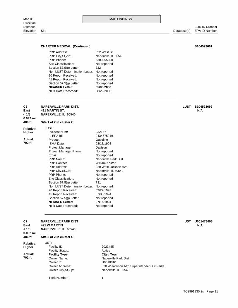
Not reportedNFR Date Recorded: 07/15/1994NFA/NFR Letter: Not reportedSection 57.5(g) Letter: 07/05/199445 Report Received: 09/27/199320 Report Received: Not reportedNon LUST Determination Letter: 731Section 57.5(g) Letter: Not reportedSite Classification: Not reportedPRP Phone: Naperville, IL 60540PRP City,St,Zip: 320 West Jackson Ave.PRP Address: William KosterPRP Contact: Naperville Park Dist.PRP Name: Not reportedEmail: Not reportedProject Manager Phone: DavisonProject Manager: 08/13/1993IEMA Date: GasolineProduct: 0434675219IL EPA Id: 932167Incident Num:
LUST:
486 ft. Site 1 of 2 in cluster C0.092 mi.
Relative:Higher
Actual:702 ft.
< 1/8 NAPERVILLE, IL 60540East 421 MARTIN ST. N/AC6 LUSTNAPERVILLE PARK DIST. S104523699
1Tank Number:
Naperville, IL 60540Owner City,St,Zip: 320 W Jackson Attn Superintendent Of ParksOwner Address: U0010810Owner Id: Naperville Park DistOwner Name: City / TownFacility Type: ActiveFacility Status: 2023485Facility ID:
UST:
486 ft. Site 2 of 2 in cluster C0.092 mi.
Relative:Higher
Actual:702 ft.
< 1/8 NAPERVILLE, IL 60540East 421 W MARTIN N/AC7 USTNAPERVILLE PARK DIST U001473698
TC2991930.2s Page 11

MAP FINDINGSMap IDDirection
EDR ID NumberDistanceEPA ID NumberDatabase(s)SiteElevation
Not reportedFee Due: Not reportedSelf Service Permit Expire Date: Not reportedSelf Service Permit Inspection Date: 12/31/2012Green Tag Expire Date: 1/28/2010Green Tag Issue Date: L006918Green Tag Decal: Not reportedInstall Date: Not reportedRed Tag Issue Date: Exempt from registrationTank Status: 4/2/1986OSFM First Notify Date: 2/1/1986Last Used Date: EmptyTank Substance: 2000Tank Capacity: 3Tank Number:
NoFee Due: Not reportedSelf Service Permit Expire Date: Not reportedSelf Service Permit Inspection Date: 12/31/2012Green Tag Expire Date: 1/28/2010Green Tag Issue Date: L006918Green Tag Decal: Not reportedInstall Date: Not reportedRed Tag Issue Date: Currently in useTank Status: 4/2/1986OSFM First Notify Date: Not reportedLast Used Date: GasolineTank Substance: 2000Tank Capacity: 2Tank Number:
NoFee Due: Not reportedSelf Service Permit Expire Date: Not reportedSelf Service Permit Inspection Date: 12/31/2012Green Tag Expire Date: 1/28/2010Green Tag Issue Date: L006918Green Tag Decal: Not reportedInstall Date: Not reportedRed Tag Issue Date: Currently in useTank Status: 4/2/1986OSFM First Notify Date: Not reportedLast Used Date: Diesel FuelTank Substance: 1000Tank Capacity:
NAPERVILLE PARK DIST (Continued) U001473698
U0024249Owner Id: Naperville School District 203Owner Name: NoneFacility Type: ExemptFacility Status: 2044278Facility ID:
UST:
633 ft.0.120 mi.
Relative:Higher
Actual:701 ft.
< 1/8 NAPERVILLE, IL 60540NE 440 WEST AURORA AVENUE N/A8 USTNAPERVILLE CENTRAL HIGH SCHOOL U004128371
TC2991930.2s Page 12

MAP FINDINGSMap IDDirection
EDR ID NumberDistanceEPA ID NumberDatabase(s)SiteElevation
Not reportedFee Due: Not reportedSelf Service Permit Expire Date: Not reportedSelf Service Permit Inspection Date: Not reportedGreen Tag Expire Date: Not reportedGreen Tag Issue Date: Not reportedGreen Tag Decal: Not reportedInstall Date: Not reportedRed Tag Issue Date: Exempt from registrationTank Status: 5/5/2009OSFM First Notify Date: 12/31/1973Last Used Date: Heating OilTank Substance: 10000Tank Capacity: 2Tank Number:
Not reportedFee Due: Not reportedSelf Service Permit Expire Date: Not reportedSelf Service Permit Inspection Date: Not reportedGreen Tag Expire Date: Not reportedGreen Tag Issue Date: Not reportedGreen Tag Decal: Not reportedInstall Date: Not reportedRed Tag Issue Date: Exempt from registrationTank Status: 5/5/2009OSFM First Notify Date: 12/31/1973Last Used Date: Heating OilTank Substance: 10000Tank Capacity: 1Tank Number:
Naperville, IL 605406605Owner City,St,Zip: 251 West Hillside RoadOwner Address:
NAPERVILLE CENTRAL HIGH SCHOOL (Continued) U004128371
12/04/199545 Report Received: 11/13/199520 Report Received: Not reportedNon LUST Determination Letter: 732Section 57.5(g) Letter: Not reportedSite Classification: Not reportedPRP Phone: Naperville, IL 60540PRP City,St,Zip: 251 West Hillside Rd.PRP Address: Mike NowlanPRP Contact: Naperville School Dist. #203PRP Name: [email protected]: (217) 524-4647Project Manager Phone: WellerProject Manager: 10/16/1995IEMA Date: GasolineProduct: 0434670012IL EPA Id: 952138Incident Num:
LUST:
1386 ft.0.262 mi.
Relative:Lower
Actual:698 ft.
1/4-1/2 NAPERVILLE, IL 60540ENE 251 WEST HILLSIDE RD. N/A9 LUSTNAPERVILLE C.U.S.D. #203 S104522361
TC2991930.2s Page 13

MAP FINDINGSMap IDDirection
EDR ID NumberDistanceEPA ID NumberDatabase(s)SiteElevation
Not reportedNFR Date Recorded: 02/16/1996NFA/NFR Letter: Not reportedSection 57.5(g) Letter:
NAPERVILLE C.U.S.D. #203 (Continued) S104522361
Not reportedNFR Date Recorded: Not reportedNFA/NFR Letter: Not reportedSection 57.5(g) Letter: Not reported45 Report Received: Not reported20 Report Received: Not reportedNon LUST Determination Letter: 731Section 57.5(g) Letter: Not reportedSite Classification: Not reportedPRP Phone: Not reportedPRP City,St,Zip: Not reportedPRP Address: Not reportedPRP Contact: City of NapervillePRP Name: Not reportedEmail: Not reportedProject Manager Phone: NOT ASSIGNEDProject Manager: 02/15/1989IEMA Date: Not reportedProduct: 0434675065IL EPA Id: 890252Incident Num:
LUST:
2044 ft. Site 1 of 2 in cluster D0.387 mi.
Relative:Lower
Actual:682 ft.
1/4-1/2 NAPERVILLE, IL 60566ENE 237 AURORA AVE. N/AD10 LUSTNAPERVILLE MUNICIPAL CTR. S100054152
2236 ft. Site 2 of 2 in cluster D0.423 mi.
Relative:Lower
Actual:680 ft.
1/4-1/2 NAPERVILLE, IL ENE N/AD11 IL NIPCNAPERVILLE MUNICIPAL S100790484
Not reportedEmail: Not reportedProject Manager Phone: NOT ASSIGNEDProject Manager: 12/11/1990IEMA Date: Uset OilProduct: 0434675113IL EPA Id: 903631Incident Num:
LUST:
2266 ft.0.429 mi.
Relative:Lower
Actual:675 ft.
1/4-1/2 NAPERVILLE, IL 60540NE 305 WEST JACKSON N/A12 LUSTNAPERVILLE, CITY OF S104526379
TC2991930.2s Page 14

MAP FINDINGSMap IDDirection
EDR ID NumberDistanceEPA ID NumberDatabase(s)SiteElevation
Not reportedNFR Date Recorded: Not reportedNFA/NFR Letter: Not reportedSection 57.5(g) Letter: Not reported45 Report Received: Not reported20 Report Received: Not reportedNon LUST Determination Letter: 731Section 57.5(g) Letter: Not reportedSite Classification: Not reportedPRP Phone: Naperville, IL 60540PRP City,St,Zip: 175 West JacksonPRP Address: Not reportedPRP Contact: Fred BlomquistPRP Name:
NAPERVILLE, CITY OF (Continued) S104526379
Not reportedNFR Date Recorded: Not reportedNFA/NFR Letter: Not reportedSection 57.5(g) Letter: 11/01/199345 Report Received: 03/17/199320 Report Received: 3/9/1995Non LUST Determination Letter: 731Section 57.5(g) Letter: Not reportedSite Classification: Not reportedPRP Phone: Naperville, IL 60566PRP City,St,Zip: 801 South WashingtonPRP Address: John PenkasPRP Contact: Edward HospitalPRP Name: Not reportedEmail: Not reportedProject Manager Phone: DavisonProject Manager: 02/26/1993IEMA Date: Fuel OilProduct: 0434675070IL EPA Id: 930495Incident Num:
LUST:
2269 ft.0.430 mi.
Relative:Lower
Actual:693 ft.
1/4-1/2 NAPERVILLE, IL 60566East 801 SOUTH WASHINGTON N/A13 LUSTEDWARD HOSPITAL S104524087
[email protected]: (217) 785-0231Project Manager Phone: GaydoshProject Manager: 02/24/1999IEMA Date: Gasoline, DeiselProduct: 0434675070IL EPA Id: 990450Incident Num:
LUST:
2469 ft.0.468 mi.
Relative:Lower
Actual:693 ft.
1/4-1/2 NAPERVILLE, IL 60566East 801 SOUTH WASHINGTON ST. N/A14 LUSTEDWARDS HOSPITAL S104529480
TC2991930.2s Page 15

MAP FINDINGSMap IDDirection
EDR ID NumberDistanceEPA ID NumberDatabase(s)SiteElevation
05/26/2000NFR Date Recorded: 04/21/2000NFA/NFR Letter: Not reportedSection 57.5(g) Letter: 01/10/200045 Report Received: 03/22/199920 Report Received: Not reportedNon LUST Determination Letter: 732Section 57.5(g) Letter: Not reportedSite Classification: 6303550450PRP Phone: Naperville, IL 60566PRP City,St,Zip: 801 South Washington St.PRP Address: Wally TarasewiczPRP Contact: Edwards HospitalPRP Name:
EDWARDS HOSPITAL (Continued) S104529480
05/10/2002NFR Date Recorded: 04/18/2002NFA/NFR Letter: Not reportedSection 57.5(g) Letter: 05/16/199545 Report Received: 04/10/199520 Report Received: Not reportedNon LUST Determination Letter: 732Section 57.5(g) Letter: Not reportedSite Classification: Not reportedPRP Phone: Warrenville, IL 60555PRP City,St,Zip: 28100 Torch Pkwy., 6-SPRP Address: Lyle BrucePRP Contact: Amoco Oil Co.PRP Name: [email protected]: (217) 524-3312Project Manager Phone: HeatonProject Manager: 03/28/1995IEMA Date: GasolineProduct: 0434675146IL EPA Id: 950616Incident Num:
LUST:
2600 ft. Site 1 of 2 in cluster E0.492 mi.
Relative:Lower
Actual:673 ft.
1/4-1/2 NAPERVILLE, IL 60540ENE 702 SOUTH WASHINGTON N/AE15 LUSTAMOCO OIL CO. #5484 S104522631
[email protected]: (217) 524-1288Project Manager Phone: BloomeProject Manager: 10/15/2003IEMA Date: Uset OilProduct: 0434675146IL EPA Id: 20031508Incident Num:
LUST:
2600 ft. Site 2 of 2 in cluster E0.492 mi.
Relative:Lower
Actual:673 ft.
1/4-1/2 NAPERVILLE, IL 60540ENE 702 SOUTH WASHINGTON STREET N/AE16 LUSTBP PRODUCTS NORTH AMERICA, INC. S106058468
TC2991930.2s Page 16

MAP FINDINGSMap IDDirection
EDR ID NumberDistanceEPA ID NumberDatabase(s)SiteElevation
08/26/2010NFR Date Recorded: 07/22/2010NFA/NFR Letter: Not reportedSection 57.5(g) Letter: 11/25/200345 Report Received: 11/05/200320 Report Received: Not reportedNon LUST Determination Letter: P.A.Section 57.5(g) Letter: Not reportedSite Classification: 6308367139PRP Phone: Warrenville, IL 60555PRP City,St,Zip: 28100 Torch Parkway, 2SPRP Address: Harold PrimackPRP Contact: BP Products North America, Inc.PRP Name:
BP PRODUCTS NORTH AMERICA, INC. (Continued) S106058468
TC2991930.2s Page 17

TC2991930.2s Page 18
NAPERVILLE S109027371 WHITE EAGLE GOLF CLUB 3704 WHITE EAGLE DRIVE 60540 LUSTNAPERVILLE 1007879598 NAPERVILLE PARK DISTRICT WEBER RD 60540 RCRA-NonGenNAPERVILLE 1004695822 SAMS CLUB 8143 808 S RTE 59 60540 RCRA-SQG, FINDSNAPERVILLE U004128270 BUCKY’S EXPRESS #533 1290 SOUTH ROUTE 59 60540 USTNAPERVILLE 1004698206 WAL-MART 1401 776 SOUTH ROUTE 59 60540 RCRA-CESQG, FINDSNAPERVILLE U004128249 AMOCO OIL COMPANY US ROUTE 34 & RIVER ROAD 60540 USTNAPERVILLE S106655905 BP PRODUCTS NORTH AMERICA 1303 PLAINFIELD ROAD 60540 LUSTNAPERVILLE U004128064 ISTHA M08 MAINTENANCE GARAGE NAPERVILLE ROAD & I-88 EAST WEST TOLLWAY, MILE POST 127.5 60540 USTNAPERVILLE S110335683 HERITAGE CLEANERS 1212 SOUTH NAPER BOULEVARD 60540 DRYCLEANERSNAPERVILLE S110335674 GOOD CHOICE CLEANERS 1295 SOUTH NAPER BOULEVARD 60540 DRYCLEANERSNAPERVILLE 1008142912 NAPERVILLE PARK DISTRICT 421 MARTIN ST 60540 FINDSNAPERVILLE U003877592 SAM’S CLUB #8143 808 S HWY 59 60540 USTNAPERVILLE 1002885734 GREEN VALLEY LANDFILL 9S610 GREEN ROAD 60540 CERC-NFRAPNAPERVILLE 1008134875 NAPERVILLE PARK DIST/T STANTON GENESEE DR 60540 FINDSNAPERVILLE 1007569997 NAPERVILLE ELEMENTARY SCHOOL 39 EAGLE ST 60540 RCRA-CESQGNAPERVILLE S107926335 NAPERVILLE PUBLIC WELL #8 CLYDE & 75TH ST 60540 SHWSNAPERVILLE 1004696560 K FIVE CONSTRUCTION CORP 29W255 N AURORA RD 60540 RCRA-CESQGNAPERVILLE S109550390 NAPERVILLE C.U.S.D. #203 440 WEST AURORA STREET 60540 LUSTNAPERVILLE U003972204 NAPERVILE RSM #1 Q21140 5 SOUTH 455 SCOTTS DRIVE 60540 USTNAPERVILLE U003972203 NAPERVILLE RSM #3 8 SOUTH 455 WEHRLI ROAD 60540 UST
Count: 20 records ORPHAN SUMMARY
City EDR ID Site Name Site Address Zip Database(s)

To maintain currency of the following federal and state databases, EDR contacts the appropriate governmental agencyon a monthly or quarterly basis, as required.
Number of Days to Update: Provides confirmation that EDR is reporting records that have been updated within 90 daysfrom the date the government agency made the information available to the public.
STANDARD ENVIRONMENTAL RECORDS
Federal NPL site list
NPL: National Priority ListNational Priorities List (Superfund). The NPL is a subset of CERCLIS and identifies over 1,200 sites for prioritycleanup under the Superfund Program. NPL sites may encompass relatively large areas. As such, EDR provides polygoncoverage for over 1,000 NPL site boundaries produced by EPA’s Environmental Photographic Interpretation Center(EPIC) and regional EPA offices.
Date of Government Version: 12/31/2010Date Data Arrived at EDR: 01/13/2011Date Made Active in Reports: 01/28/2011Number of Days to Update: 15
Source: EPATelephone: N/ALast EDR Contact: 01/13/2011Next Scheduled EDR Contact: 04/25/2011Data Release Frequency: Quarterly
NPL Site Boundaries
Sources:
EPA’s Environmental Photographic Interpretation Center (EPIC)Telephone: 202-564-7333
EPA Region 1 EPA Region 6Telephone 617-918-1143 Telephone: 214-655-6659
EPA Region 3 EPA Region 7Telephone 215-814-5418 Telephone: 913-551-7247
EPA Region 4 EPA Region 8Telephone 404-562-8033 Telephone: 303-312-6774
EPA Region 5 EPA Region 9Telephone 312-886-6686 Telephone: 415-947-4246
EPA Region 10Telephone 206-553-8665
Proposed NPL: Proposed National Priority List SitesA site that has been proposed for listing on the National Priorities List through the issuance of a proposed rulein the Federal Register. EPA then accepts public comments on the site, responds to the comments, and places onthe NPL those sites that continue to meet the requirements for listing.
Date of Government Version: 12/31/2010Date Data Arrived at EDR: 01/13/2011Date Made Active in Reports: 01/28/2011Number of Days to Update: 15
Source: EPATelephone: N/ALast EDR Contact: 01/13/2011Next Scheduled EDR Contact: 04/25/2011Data Release Frequency: Quarterly
NPL LIENS: Federal Superfund LiensFederal Superfund Liens. Under the authority granted the USEPA by CERCLA of 1980, the USEPA has the authorityto file liens against real property in order to recover remedial action expenditures or when the property ownerreceived notification of potential liability. USEPA compiles a listing of filed notices of Superfund Liens.
Date of Government Version: 10/15/1991Date Data Arrived at EDR: 02/02/1994Date Made Active in Reports: 03/30/1994Number of Days to Update: 56
Source: EPATelephone: 202-564-4267Last EDR Contact: 02/14/2011Next Scheduled EDR Contact: 05/30/2011Data Release Frequency: No Update Planned
TC2991930.2s Page GR-1
GOVERNMENT RECORDS SEARCHED / DATA CURRENCY TRACKING

Federal Delisted NPL site list
DELISTED NPL: National Priority List DeletionsThe National Oil and Hazardous Substances Pollution Contingency Plan (NCP) establishes the criteria that theEPA uses to delete sites from the NPL. In accordance with 40 CFR 300.425.(e), sites may be deleted from theNPL where no further response is appropriate.
Date of Government Version: 12/31/2010Date Data Arrived at EDR: 01/13/2011Date Made Active in Reports: 01/28/2011Number of Days to Update: 15
Source: EPATelephone: N/ALast EDR Contact: 01/13/2011Next Scheduled EDR Contact: 04/25/2011Data Release Frequency: Quarterly
Federal CERCLIS list
CERCLIS: Comprehensive Environmental Response, Compensation, and Liability Information SystemCERCLIS contains data on potentially hazardous waste sites that have been reported to the USEPA by states, municipalities,private companies and private persons, pursuant to Section 103 of the Comprehensive Environmental Response, Compensation,and Liability Act (CERCLA). CERCLIS contains sites which are either proposed to or on the National PrioritiesList (NPL) and sites which are in the screening and assessment phase for possible inclusion on the NPL.
Date of Government Version: 11/30/2010Date Data Arrived at EDR: 12/30/2010Date Made Active in Reports: 02/25/2011Number of Days to Update: 57
Source: EPATelephone: 703-412-9810Last EDR Contact: 03/01/2011Next Scheduled EDR Contact: 06/13/2011Data Release Frequency: Quarterly
FEDERAL FACILITY: Federal Facility Site Information listingA listing of National Priority List (NPL) and Base Realignment and Closure (BRAC) sites found in the ComprehensiveEnvironmental Response, Compensation and Liability Information System (CERCLIS) Database where EPAa??s FederalFacilities Restoration and Reuse Office is involved in cleanup activities.
Date of Government Version: 12/10/2010Date Data Arrived at EDR: 01/11/2011Date Made Active in Reports: 02/16/2011Number of Days to Update: 36
Source: Environmental Protection AgencyTelephone: 703-603-8704Last EDR Contact: 01/11/2011Next Scheduled EDR Contact: 04/25/2011Data Release Frequency: Varies
Federal CERCLIS NFRAP site List
CERCLIS-NFRAP: CERCLIS No Further Remedial Action PlannedArchived sites are sites that have been removed and archived from the inventory of CERCLIS sites. Archived statusindicates that, to the best of EPA’s knowledge, assessment at a site has been completed and that EPA has determinedno further steps will be taken to list this site on the National Priorities List (NPL), unless information indicatesthis decision was not appropriate or other considerations require a recommendation for listing at a later time.This decision does not necessarily mean that there is no hazard associated with a given site; it only means that,based upon available information, the location is not judged to be a potential NPL site.
Date of Government Version: 10/28/2010Date Data Arrived at EDR: 12/01/2010Date Made Active in Reports: 02/25/2011Number of Days to Update: 86
Source: EPATelephone: 703-412-9810Last EDR Contact: 03/01/2011Next Scheduled EDR Contact: 06/13/2011Data Release Frequency: Quarterly
Federal RCRA CORRACTS facilities list
CORRACTS: Corrective Action ReportCORRACTS identifies hazardous waste handlers with RCRA corrective action activity.
TC2991930.2s Page GR-2
GOVERNMENT RECORDS SEARCHED / DATA CURRENCY TRACKING

Date of Government Version: 05/25/2010Date Data Arrived at EDR: 06/02/2010Date Made Active in Reports: 10/04/2010Number of Days to Update: 124
Source: EPATelephone: 800-424-9346Last EDR Contact: 02/14/2011Next Scheduled EDR Contact: 05/30/2011Data Release Frequency: Quarterly
Federal RCRA non-CORRACTS TSD facilities list
RCRA-TSDF: RCRA - Treatment, Storage and DisposalRCRAInfo is EPA’s comprehensive information system, providing access to data supporting the Resource Conservationand Recovery Act (RCRA) of 1976 and the Hazardous and Solid Waste Amendments (HSWA) of 1984. The databaseincludes selective information on sites which generate, transport, store, treat and/or dispose of hazardous wasteas defined by the Resource Conservation and Recovery Act (RCRA). Transporters are individuals or entities thatmove hazardous waste from the generator offsite to a facility that can recycle, treat, store, or dispose of thewaste. TSDFs treat, store, or dispose of the waste.
Date of Government Version: 02/17/2010Date Data Arrived at EDR: 02/19/2010Date Made Active in Reports: 05/17/2010Number of Days to Update: 87
Source: Environmental Protection AgencyTelephone: 312-886-6186Last EDR Contact: 01/06/2011Next Scheduled EDR Contact: 04/18/2011Data Release Frequency: Quarterly
Federal RCRA generators list
RCRA-LQG: RCRA - Large Quantity GeneratorsRCRAInfo is EPA’s comprehensive information system, providing access to data supporting the Resource Conservationand Recovery Act (RCRA) of 1976 and the Hazardous and Solid Waste Amendments (HSWA) of 1984. The databaseincludes selective information on sites which generate, transport, store, treat and/or dispose of hazardous wasteas defined by the Resource Conservation and Recovery Act (RCRA). Large quantity generators (LQGs) generateover 1,000 kilograms (kg) of hazardous waste, or over 1 kg of acutely hazardous waste per month.
Date of Government Version: 02/17/2010Date Data Arrived at EDR: 02/19/2010Date Made Active in Reports: 05/17/2010Number of Days to Update: 87
Source: Environmental Protection AgencyTelephone: 312-886-6186Last EDR Contact: 01/06/2011Next Scheduled EDR Contact: 04/18/2011Data Release Frequency: Quarterly
RCRA-SQG: RCRA - Small Quantity GeneratorsRCRAInfo is EPA’s comprehensive information system, providing access to data supporting the Resource Conservationand Recovery Act (RCRA) of 1976 and the Hazardous and Solid Waste Amendments (HSWA) of 1984. The databaseincludes selective information on sites which generate, transport, store, treat and/or dispose of hazardous wasteas defined by the Resource Conservation and Recovery Act (RCRA). Small quantity generators (SQGs) generatebetween 100 kg and 1,000 kg of hazardous waste per month.
Date of Government Version: 02/17/2010Date Data Arrived at EDR: 02/19/2010Date Made Active in Reports: 05/17/2010Number of Days to Update: 87
Source: Environmental Protection AgencyTelephone: 312-886-6186Last EDR Contact: 01/06/2011Next Scheduled EDR Contact: 04/18/2011Data Release Frequency: Quarterly
RCRA-CESQG: RCRA - Conditionally Exempt Small Quantity GeneratorsRCRAInfo is EPA’s comprehensive information system, providing access to data supporting the Resource Conservationand Recovery Act (RCRA) of 1976 and the Hazardous and Solid Waste Amendments (HSWA) of 1984. The databaseincludes selective information on sites which generate, transport, store, treat and/or dispose of hazardous wasteas defined by the Resource Conservation and Recovery Act (RCRA). Conditionally exempt small quantity generators(CESQGs) generate less than 100 kg of hazardous waste, or less than 1 kg of acutely hazardous waste per month.
Date of Government Version: 02/17/2010Date Data Arrived at EDR: 02/19/2010Date Made Active in Reports: 05/17/2010Number of Days to Update: 87
Source: Environmental Protection AgencyTelephone: 312-886-6186Last EDR Contact: 01/06/2011Next Scheduled EDR Contact: 04/18/2011Data Release Frequency: Varies
TC2991930.2s Page GR-3
GOVERNMENT RECORDS SEARCHED / DATA CURRENCY TRACKING

Federal institutional controls / engineering controls registries
US ENG CONTROLS: Engineering Controls Sites ListA listing of sites with engineering controls in place. Engineering controls include various forms of caps, buildingfoundations, liners, and treatment methods to create pathway elimination for regulated substances to enter environmentalmedia or effect human health.
Date of Government Version: 01/05/2011Date Data Arrived at EDR: 01/14/2011Date Made Active in Reports: 01/28/2011Number of Days to Update: 14
Source: Environmental Protection AgencyTelephone: 703-603-0695Last EDR Contact: 12/10/2010Next Scheduled EDR Contact: 03/28/2011Data Release Frequency: Varies
US INST CONTROL: Sites with Institutional ControlsA listing of sites with institutional controls in place. Institutional controls include administrative measures,such as groundwater use restrictions, construction restrictions, property use restrictions, and post remediationcare requirements intended to prevent exposure to contaminants remaining on site. Deed restrictions are generallyrequired as part of the institutional controls.
Date of Government Version: 01/05/2011Date Data Arrived at EDR: 01/14/2011Date Made Active in Reports: 01/28/2011Number of Days to Update: 14
Source: Environmental Protection AgencyTelephone: 703-603-0695Last EDR Contact: 12/10/2010Next Scheduled EDR Contact: 03/28/2011Data Release Frequency: Varies
Federal ERNS list
ERNS: Emergency Response Notification SystemEmergency Response Notification System. ERNS records and stores information on reported releases of oil and hazardoussubstances.
Date of Government Version: 07/09/2010Date Data Arrived at EDR: 07/09/2010Date Made Active in Reports: 08/17/2010Number of Days to Update: 39
Source: National Response Center, United States Coast GuardTelephone: 202-267-2180Last EDR Contact: 01/07/2011Next Scheduled EDR Contact: 04/18/2011Data Release Frequency: Annually
State- and tribal - equivalent NPL
CAT: Category ListSites on this list are: Notice of Response Action, NPL, Pre/proposed NPL, Completed Remedial Action, Site RemediationProgram, Federal Facilities, and Cleanup Started and/or Completed Sites.
Date of Government Version: 06/01/1997Date Data Arrived at EDR: 07/07/1997Date Made Active in Reports: 08/14/1997Number of Days to Update: 38
Source: Illinois EPATelephone: N/ALast EDR Contact: 02/26/2001Next Scheduled EDR Contact: N/AData Release Frequency: No Update Planned
State- and tribal - equivalent CERCLIS
SHWS: State Oversight ListState Hazardous Waste Sites. State hazardous waste site records are the states’ equivalent to CERCLIS. These sitesmay or may not already be listed on the federal CERCLIS list. Priority sites planned for cleanup using state funds(state equivalent of Superfund) are identified along with sites where cleanup will be paid for by potentiallyresponsible parties. Available information varies by state.
Date of Government Version: 11/29/2010Date Data Arrived at EDR: 12/09/2010Date Made Active in Reports: 12/17/2010Number of Days to Update: 8
Source: Illinois Environmental Protection AgencyTelephone: 217-524-4826Last EDR Contact: 01/31/2011Next Scheduled EDR Contact: 05/16/2011Data Release Frequency: Semi-Annually
TC2991930.2s Page GR-4
GOVERNMENT RECORDS SEARCHED / DATA CURRENCY TRACKING

State and tribal landfill and/or solid waste disposal site lists
LF WMRC: Waste Management & Research Center Landfill DatabaseThe Waste Management & Research Center Landfill Database includes records from the Department of Public Health,Department of Mines & Minerals, Illinois Environmental Protection Agency, State Geological Survey, NortheasternIllinois Planning Commission and Pollution Control Board.
Date of Government Version: 12/31/2001Date Data Arrived at EDR: 10/06/2006Date Made Active in Reports: 11/06/2006Number of Days to Update: 31
Source: Department of Natural ResourcesTelephone: 217-333-8940Last EDR Contact: 09/18/2009Next Scheduled EDR Contact: 12/28/2009Data Release Frequency: No Update Planned
SWF/LF: Available Disposal for Solid Waste in Illinois - Solid Waste Landfills Subject to State SurchargeSolid Waste Facilities/Landfill Sites. SWF/LF type records typically contain an inventory of solid waste disposalfacilities or landfills in a particular state. Depending on the state, these may be active or inactive facilitiesor open dumps that failed to meet RCRA Subtitle D Section 4004 criteria for solid waste landfills or disposalsites.
Date of Government Version: 12/31/2008Date Data Arrived at EDR: 03/02/2010Date Made Active in Reports: 04/07/2010Number of Days to Update: 36
Source: Illinois Environmental Protection AgencyTelephone: 217-785-8604Last EDR Contact: 02/04/2011Next Scheduled EDR Contact: 05/16/2011Data Release Frequency: Annually
LF SPECIAL WASTE: Special Waste Site ListThese landfills, as of January 1, 1990, accept non-hazardous special waste pursuant to the Illinois EPA Non-HazardousSpecial Waste Definition. List A includes landfills that may receive any non-hazardous waste, Non-Regional PollutionControl Facilities are so noted. List B includes landfills designed to receive specific non-hazardous wastes.List B landfills are designated as a Regional Pollution Control Facility by RPCF, or Non-Regional Pollution ControlFacility by Non-RPCF.
Date of Government Version: 01/01/1990Date Data Arrived at EDR: 06/17/2009Date Made Active in Reports: 07/15/2009Number of Days to Update: 28
Source: Illinois EPATelephone: 217-782-9288Last EDR Contact: 06/10/2009Next Scheduled EDR Contact: N/AData Release Frequency: No Update Planned
IL NIPC: Solid Waste Landfill InventorySolid Waste Landfill Inventory. NIPC is an inventory of active and inactive solid waste disposal sites, basedon state, local government and historical archive data. Included are numerous sites which previously had neverbeen identified largely because there was no obligation to register such sites prior to 1971.
Date of Government Version: 08/01/1988Date Data Arrived at EDR: 08/01/1994Date Made Active in Reports: 08/12/1994Number of Days to Update: 11
Source: Northeastern Illinois Planning CommissionTelephone: 312-454-0400Last EDR Contact: 05/23/2006Next Scheduled EDR Contact: N/AData Release Frequency: No Update Planned
CCDD: Clean Construction or Demolition DebrisConstruction and demolition (C and D) debris is nonhazardous, uncontaminated material resulting from construction,remodeling, repair, or demolition of utilities, structures, and roads.
Date of Government Version: 01/10/2011Date Data Arrived at EDR: 02/03/2011Date Made Active in Reports: 02/17/2011Number of Days to Update: 14
Source: Illinois EPATelephone: 217-524-3300Last EDR Contact: 01/31/2011Next Scheduled EDR Contact: 05/16/2011Data Release Frequency: Varies
State and tribal leaking storage tank lists
TC2991930.2s Page GR-5
GOVERNMENT RECORDS SEARCHED / DATA CURRENCY TRACKING

LUST: Leaking Underground Storage Tank SitesLeaking Underground Storage Tank Incident Reports. LUST records contain an inventory of reported leaking undergroundstorage tank incidents. Not all states maintain these records, and the information stored varies by state.
Date of Government Version: 01/21/2011Date Data Arrived at EDR: 02/01/2011Date Made Active in Reports: 02/17/2011Number of Days to Update: 16
Source: Illinois Environmental Protection AgencyTelephone: 217-782-6762Last EDR Contact: 02/01/2011Next Scheduled EDR Contact: 05/16/2011Data Release Frequency: Semi-Annually
LUST TRUST: Underground Storage Tank Fund Payment Prioirty ListIn case sufficient funds are not available in the Underground Storage Tank Fund, requests for payment are enteredon the Payment Priority List by "queue date" order. As required by the Environmental Protection Act, the queuedate is the date that a complete request for partial or final payment was received by the Agency. The queue dateis "officially" confirmed at the end of the payment review process when a Final Decision Letter is sent to thesite owner.
Date of Government Version: 01/14/2011Date Data Arrived at EDR: 02/01/2011Date Made Active in Reports: 02/17/2011Number of Days to Update: 16
Source: Illinois EPATelephone: 217-782-6762Last EDR Contact: 02/01/2011Next Scheduled EDR Contact: 05/16/2011Data Release Frequency: Varies
INDIAN LUST R9: Leaking Underground Storage Tanks on Indian LandLUSTs on Indian land in Arizona, California, New Mexico and Nevada
Date of Government Version: 11/19/2010Date Data Arrived at EDR: 11/19/2010Date Made Active in Reports: 01/28/2011Number of Days to Update: 70
Source: Environmental Protection AgencyTelephone: 415-972-3372Last EDR Contact: 01/31/2011Next Scheduled EDR Contact: 05/16/2011Data Release Frequency: Quarterly
INDIAN LUST R4: Leaking Underground Storage Tanks on Indian LandLUSTs on Indian land in Florida, Mississippi and North Carolina.
Date of Government Version: 08/27/2010Date Data Arrived at EDR: 08/30/2010Date Made Active in Reports: 10/04/2010Number of Days to Update: 35
Source: EPA Region 4Telephone: 404-562-8677Last EDR Contact: 02/16/2011Next Scheduled EDR Contact: 05/16/2011Data Release Frequency: Semi-Annually
INDIAN LUST R10: Leaking Underground Storage Tanks on Indian LandLUSTs on Indian land in Alaska, Idaho, Oregon and Washington.
Date of Government Version: 11/12/2010Date Data Arrived at EDR: 11/12/2010Date Made Active in Reports: 01/28/2011Number of Days to Update: 77
Source: EPA Region 10Telephone: 206-553-2857Last EDR Contact: 01/31/2011Next Scheduled EDR Contact: 05/16/2011Data Release Frequency: Quarterly
INDIAN LUST R1: Leaking Underground Storage Tanks on Indian LandA listing of leaking underground storage tank locations on Indian Land.
Date of Government Version: 09/01/2010Date Data Arrived at EDR: 11/05/2010Date Made Active in Reports: 01/28/2011Number of Days to Update: 84
Source: EPA Region 1Telephone: 617-918-1313Last EDR Contact: 02/03/2011Next Scheduled EDR Contact: 05/16/2011Data Release Frequency: Varies
TC2991930.2s Page GR-6
GOVERNMENT RECORDS SEARCHED / DATA CURRENCY TRACKING

INDIAN LUST R6: Leaking Underground Storage Tanks on Indian LandLUSTs on Indian land in New Mexico and Oklahoma.
Date of Government Version: 11/04/2010Date Data Arrived at EDR: 11/05/2010Date Made Active in Reports: 01/28/2011Number of Days to Update: 84
Source: EPA Region 6Telephone: 214-665-6597Last EDR Contact: 01/31/2011Next Scheduled EDR Contact: 05/16/2011Data Release Frequency: Varies
INDIAN LUST R7: Leaking Underground Storage Tanks on Indian LandLUSTs on Indian land in Iowa, Kansas, and Nebraska
Date of Government Version: 11/04/2009Date Data Arrived at EDR: 05/04/2010Date Made Active in Reports: 07/07/2010Number of Days to Update: 64
Source: EPA Region 7Telephone: 913-551-7003Last EDR Contact: 05/04/2010Next Scheduled EDR Contact: 05/16/2011Data Release Frequency: Varies
INDIAN LUST R8: Leaking Underground Storage Tanks on Indian LandLUSTs on Indian land in Colorado, Montana, North Dakota, South Dakota, Utah and Wyoming.
Date of Government Version: 11/16/2010Date Data Arrived at EDR: 11/19/2010Date Made Active in Reports: 01/28/2011Number of Days to Update: 70
Source: EPA Region 8Telephone: 303-312-6271Last EDR Contact: 01/31/2011Next Scheduled EDR Contact: 05/16/2011Data Release Frequency: Quarterly
State and tribal registered storage tank lists
UST: Underground Storage Tank Facility ListRegistered Underground Storage Tanks. UST’s are regulated under Subtitle I of the Resource Conservation and RecoveryAct (RCRA) and must be registered with the state department responsible for administering the UST program. Availableinformation varies by state program.
Date of Government Version: 02/03/2011Date Data Arrived at EDR: 02/04/2011Date Made Active in Reports: 02/17/2011Number of Days to Update: 13
Source: Illinois State Fire MarshalTelephone: 217-785-0969Last EDR Contact: 02/04/2011Next Scheduled EDR Contact: 05/16/2011Data Release Frequency: Quarterly
INDIAN UST R4: Underground Storage Tanks on Indian LandThe Indian Underground Storage Tank (UST) database provides information about underground storage tanks on Indianland in EPA Region 4 (Alabama, Florida, Georgia, Kentucky, Mississippi, North Carolina, South Carolina, Tennesseeand Tribal Nations)
Date of Government Version: 08/27/2010Date Data Arrived at EDR: 08/30/2010Date Made Active in Reports: 10/04/2010Number of Days to Update: 35
Source: EPA Region 4Telephone: 404-562-9424Last EDR Contact: 02/16/2011Next Scheduled EDR Contact: 05/16/2011Data Release Frequency: Semi-Annually
INDIAN UST R9: Underground Storage Tanks on Indian LandThe Indian Underground Storage Tank (UST) database provides information about underground storage tanks on Indianland in EPA Region 9 (Arizona, California, Hawaii, Nevada, the Pacific Islands, and Tribal Nations).
Date of Government Version: 11/19/2010Date Data Arrived at EDR: 11/19/2010Date Made Active in Reports: 01/28/2011Number of Days to Update: 70
Source: EPA Region 9Telephone: 415-972-3368Last EDR Contact: 01/31/2011Next Scheduled EDR Contact: 05/16/2011Data Release Frequency: Quarterly
TC2991930.2s Page GR-7
GOVERNMENT RECORDS SEARCHED / DATA CURRENCY TRACKING
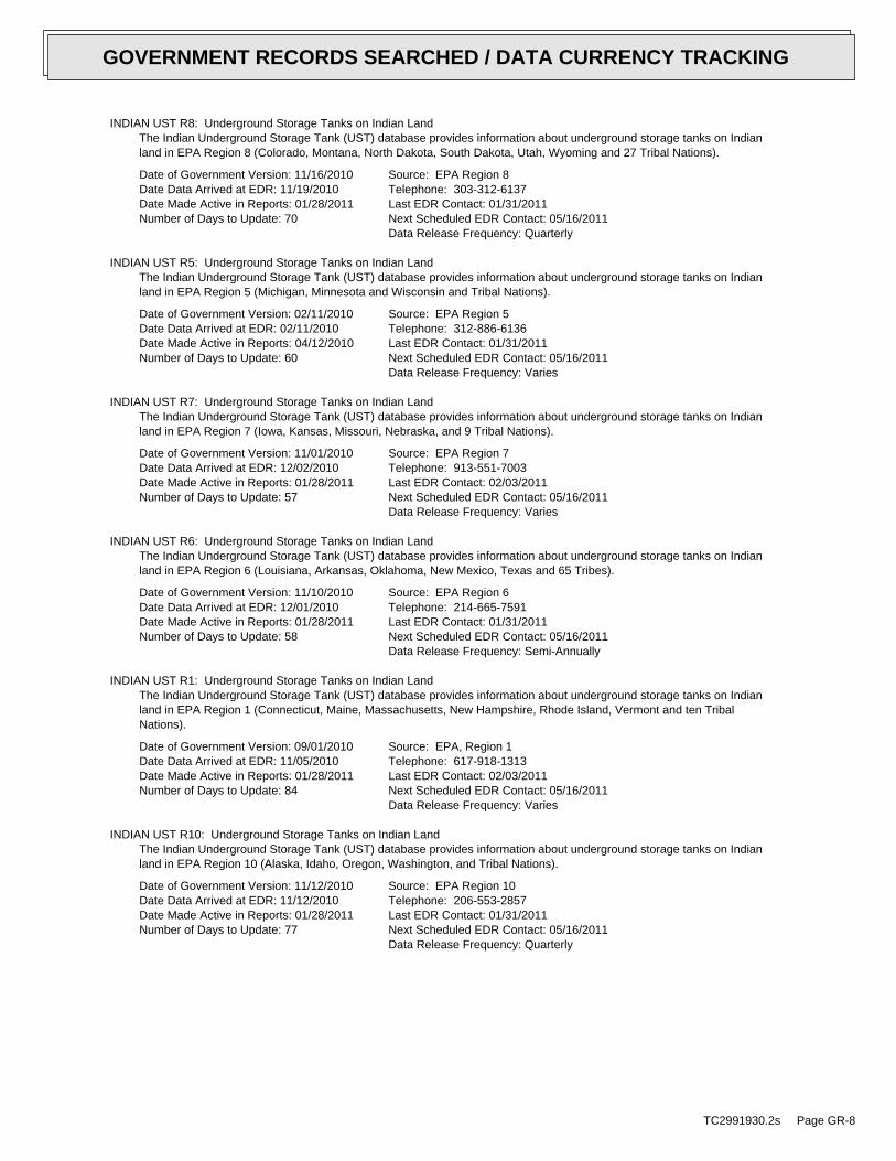
INDIAN UST R8: Underground Storage Tanks on Indian LandThe Indian Underground Storage Tank (UST) database provides information about underground storage tanks on Indianland in EPA Region 8 (Colorado, Montana, North Dakota, South Dakota, Utah, Wyoming and 27 Tribal Nations).
Date of Government Version: 11/16/2010Date Data Arrived at EDR: 11/19/2010Date Made Active in Reports: 01/28/2011Number of Days to Update: 70
Source: EPA Region 8Telephone: 303-312-6137Last EDR Contact: 01/31/2011Next Scheduled EDR Contact: 05/16/2011Data Release Frequency: Quarterly
INDIAN UST R5: Underground Storage Tanks on Indian LandThe Indian Underground Storage Tank (UST) database provides information about underground storage tanks on Indianland in EPA Region 5 (Michigan, Minnesota and Wisconsin and Tribal Nations).
Date of Government Version: 02/11/2010Date Data Arrived at EDR: 02/11/2010Date Made Active in Reports: 04/12/2010Number of Days to Update: 60
Source: EPA Region 5Telephone: 312-886-6136Last EDR Contact: 01/31/2011Next Scheduled EDR Contact: 05/16/2011Data Release Frequency: Varies
INDIAN UST R7: Underground Storage Tanks on Indian LandThe Indian Underground Storage Tank (UST) database provides information about underground storage tanks on Indianland in EPA Region 7 (Iowa, Kansas, Missouri, Nebraska, and 9 Tribal Nations).
Date of Government Version: 11/01/2010Date Data Arrived at EDR: 12/02/2010Date Made Active in Reports: 01/28/2011Number of Days to Update: 57
Source: EPA Region 7Telephone: 913-551-7003Last EDR Contact: 02/03/2011Next Scheduled EDR Contact: 05/16/2011Data Release Frequency: Varies
INDIAN UST R6: Underground Storage Tanks on Indian LandThe Indian Underground Storage Tank (UST) database provides information about underground storage tanks on Indianland in EPA Region 6 (Louisiana, Arkansas, Oklahoma, New Mexico, Texas and 65 Tribes).
Date of Government Version: 11/10/2010Date Data Arrived at EDR: 12/01/2010Date Made Active in Reports: 01/28/2011Number of Days to Update: 58
Source: EPA Region 6Telephone: 214-665-7591Last EDR Contact: 01/31/2011Next Scheduled EDR Contact: 05/16/2011Data Release Frequency: Semi-Annually
INDIAN UST R1: Underground Storage Tanks on Indian LandThe Indian Underground Storage Tank (UST) database provides information about underground storage tanks on Indianland in EPA Region 1 (Connecticut, Maine, Massachusetts, New Hampshire, Rhode Island, Vermont and ten TribalNations).
Date of Government Version: 09/01/2010Date Data Arrived at EDR: 11/05/2010Date Made Active in Reports: 01/28/2011Number of Days to Update: 84
Source: EPA, Region 1Telephone: 617-918-1313Last EDR Contact: 02/03/2011Next Scheduled EDR Contact: 05/16/2011Data Release Frequency: Varies
INDIAN UST R10: Underground Storage Tanks on Indian LandThe Indian Underground Storage Tank (UST) database provides information about underground storage tanks on Indianland in EPA Region 10 (Alaska, Idaho, Oregon, Washington, and Tribal Nations).
Date of Government Version: 11/12/2010Date Data Arrived at EDR: 11/12/2010Date Made Active in Reports: 01/28/2011Number of Days to Update: 77
Source: EPA Region 10Telephone: 206-553-2857Last EDR Contact: 01/31/2011Next Scheduled EDR Contact: 05/16/2011Data Release Frequency: Quarterly
TC2991930.2s Page GR-8
GOVERNMENT RECORDS SEARCHED / DATA CURRENCY TRACKING

FEMA UST: Underground Storage Tank ListingA listing of all FEMA owned underground storage tanks.
Date of Government Version: 01/01/2010Date Data Arrived at EDR: 02/16/2010Date Made Active in Reports: 04/12/2010Number of Days to Update: 55
Source: FEMATelephone: 202-646-5797Last EDR Contact: 01/17/2011Next Scheduled EDR Contact: 05/02/2011Data Release Frequency: Varies
State and tribal institutional control / engineering control registries
ENG CONTROLS: Sites with Engineering ControlsSites using of engineered barriers (e.g., asphalt or concrete paving).
Date of Government Version: 01/22/2011Date Data Arrived at EDR: 01/25/2011Date Made Active in Reports: 02/17/2011Number of Days to Update: 23
Source: Illinois Environmental Protection AgencyTelephone: 217-782-6761Last EDR Contact: 01/25/2011Next Scheduled EDR Contact: 05/09/2011Data Release Frequency: Quarterly
Inst Control: Institutional ControlsLegal or administrative restrictions on land use and/or other activities (e.g., groundwater use restrictions)which effectively limit exposure to contamination may be employed as alternatives to removal or treatment of contamination.
Date of Government Version: 01/22/2011Date Data Arrived at EDR: 01/25/2011Date Made Active in Reports: 02/17/2011Number of Days to Update: 23
Source: Illinois Environmental Protection AgencyTelephone: 217-782-6761Last EDR Contact: 01/25/2011Next Scheduled EDR Contact: 05/09/2011Data Release Frequency: Quarterly
State and tribal voluntary cleanup sites
INDIAN VCP R1: Voluntary Cleanup Priority ListingA listing of voluntary cleanup priority sites located on Indian Land located in Region 1.
Date of Government Version: 04/02/2008Date Data Arrived at EDR: 04/22/2008Date Made Active in Reports: 05/19/2008Number of Days to Update: 27
Source: EPA, Region 1Telephone: 617-918-1102Last EDR Contact: 01/05/2010Next Scheduled EDR Contact: 04/18/2011Data Release Frequency: Varies
INDIAN VCP R7: Voluntary Cleanup Priority LisitngA listing of voluntary cleanup priority sites located on Indian Land located in Region 7.
Date of Government Version: 03/20/2008Date Data Arrived at EDR: 04/22/2008Date Made Active in Reports: 05/19/2008Number of Days to Update: 27
Source: EPA, Region 7Telephone: 913-551-7365Last EDR Contact: 04/20/2009Next Scheduled EDR Contact: 07/20/2009Data Release Frequency: Varies
SRP: Site Remediation Program DatabaseThe database identifies the status of all voluntary remediation projects administered through the pre-notice sitecleanup program (1989 to 1995) and the site remediation program (1996 to the present).
Date of Government Version: 01/22/2011Date Data Arrived at EDR: 01/25/2011Date Made Active in Reports: 02/17/2011Number of Days to Update: 23
Source: Illinois Environmental Protection AgencyTelephone: 217-785-9407Last EDR Contact: 01/25/2011Next Scheduled EDR Contact: 05/09/2011Data Release Frequency: Semi-Annually
State and tribal Brownfields sites
TC2991930.2s Page GR-9
GOVERNMENT RECORDS SEARCHED / DATA CURRENCY TRACKING

BROWNFIELDS: Municipal Brownfields Redevelopment Grant Program Project DescriptionsThe Illinois Municipal Brownfields Redevelopment Grant Program (MBRGP) offers grants worth a maximum of $240,000each to municipalities to assist in site investigation activities, development of cleanup objectives, and performanceof cleanup activities. Brownfields are abandoned or underused industrial and/or commercial properties that arecontaminated (or thought to be contaminated) and have an active potential for redevelopment.
Date of Government Version: 08/31/2010Date Data Arrived at EDR: 09/01/2010Date Made Active in Reports: 09/17/2010Number of Days to Update: 16
Source: Illinois Environmental Protection AgencyTelephone: 217-785-3486Last EDR Contact: 02/14/2011Next Scheduled EDR Contact: 05/16/2011Data Release Frequency: Varies
BROWNFIELDS: Redevelopment Assessment DatabaseThe Office of Site Evaluations Redevelopment Assessment database identifies the status of all properties withinthe State in which the Illinois EPA’s Office of Site Evaluation has conducted a municipal Brownfield RedevelopmentAssessment.
Date of Government Version: 01/31/2011Date Data Arrived at EDR: 02/01/2011Date Made Active in Reports: 02/17/2011Number of Days to Update: 16
Source: Illinois Environmental Protection AgencyTelephone: 217-524-1658Last EDR Contact: 02/01/2011Next Scheduled EDR Contact: 05/16/2011Data Release Frequency: Varies
ADDITIONAL ENVIRONMENTAL RECORDS
Local Brownfield lists
US BROWNFIELDS: A Listing of Brownfields SitesIncluded in the listing are brownfields properties addresses by Cooperative Agreement Recipients and brownfieldsproperties addressed by Targeted Brownfields Assessments. Targeted Brownfields Assessments-EPA’s Targeted BrownfieldsAssessments (TBA) program is designed to help states, tribes, and municipalities--especially those without EPABrownfields Assessment Demonstration Pilots--minimize the uncertainties of contamination often associated withbrownfields. Under the TBA program, EPA provides funding and/or technical assistance for environmental assessmentsat brownfields sites throughout the country. Targeted Brownfields Assessments supplement and work with other effortsunder EPA’s Brownfields Initiative to promote cleanup and redevelopment of brownfields. Cooperative AgreementRecipients-States, political subdivisions, territories, and Indian tribes become Brownfields Cleanup RevolvingLoan Fund (BCRLF) cooperative agreement recipients when they enter into BCRLF cooperative agreements with theU.S. EPA. EPA selects BCRLF cooperative agreement recipients based on a proposal and application process. BCRLFcooperative agreement recipients must use EPA funds provided through BCRLF cooperative agreement for specifiedbrownfields-related cleanup activities.
Date of Government Version: 06/24/2010Date Data Arrived at EDR: 06/25/2010Date Made Active in Reports: 08/17/2010Number of Days to Update: 53
Source: Environmental Protection AgencyTelephone: 202-566-2777Last EDR Contact: 12/30/2010Next Scheduled EDR Contact: 04/11/2011Data Release Frequency: Semi-Annually
Local Lists of Landfill / Solid Waste Disposal Sites
ODI: Open Dump InventoryAn open dump is defined as a disposal facility that does not comply with one or more of the Part 257 or Part 258Subtitle D Criteria.
Date of Government Version: 06/30/1985Date Data Arrived at EDR: 08/09/2004Date Made Active in Reports: 09/17/2004Number of Days to Update: 39
Source: Environmental Protection AgencyTelephone: 800-424-9346Last EDR Contact: 06/09/2004Next Scheduled EDR Contact: N/AData Release Frequency: No Update Planned
TC2991930.2s Page GR-10
GOVERNMENT RECORDS SEARCHED / DATA CURRENCY TRACKING

DEBRIS REGION 9: Torres Martinez Reservation Illegal Dump Site LocationsA listing of illegal dump sites location on the Torres Martinez Indian Reservation located in eastern RiversideCounty and northern Imperial County, California.
Date of Government Version: 01/12/2009Date Data Arrived at EDR: 05/07/2009Date Made Active in Reports: 09/21/2009Number of Days to Update: 137
Source: EPA, Region 9Telephone: 415-947-4219Last EDR Contact: 12/22/2010Next Scheduled EDR Contact: 04/11/2011Data Release Frequency: No Update Planned
INDIAN ODI: Report on the Status of Open Dumps on Indian LandsLocation of open dumps on Indian land.
Date of Government Version: 12/31/1998Date Data Arrived at EDR: 12/03/2007Date Made Active in Reports: 01/24/2008Number of Days to Update: 52
Source: Environmental Protection AgencyTelephone: 703-308-8245Last EDR Contact: 02/08/2011Next Scheduled EDR Contact: 05/23/2011Data Release Frequency: Varies
Local Lists of Hazardous waste / Contaminated Sites
US CDL: Clandestine Drug LabsA listing of clandestine drug lab locations. The U.S. Department of Justice ("the Department") provides thisweb site as a public service. It contains addresses of some locations where law enforcement agencies reportedthey found chemicals or other items that indicated the presence of either clandestine drug laboratories or dumpsites.In most cases, the source of the entries is not the Department, and the Department has not verified the entryand does not guarantee its accuracy. Members of the public must verify the accuracy of all entries by, for example,contacting local law enforcement and local health departments.
Date of Government Version: 12/03/2010Date Data Arrived at EDR: 12/30/2010Date Made Active in Reports: 02/16/2011Number of Days to Update: 48
Source: Drug Enforcement AdministrationTelephone: 202-307-1000Last EDR Contact: 12/08/2010Next Scheduled EDR Contact: 03/21/2011Data Release Frequency: Quarterly
CDL: Meth Drug Lab Site ListingA listing of clandestine/meth drug lab locations.
Date of Government Version: 01/20/2011Date Data Arrived at EDR: 01/21/2011Date Made Active in Reports: 02/17/2011Number of Days to Update: 27
Source: Department of Public HealthTelephone: 217-782-5750Last EDR Contact: 01/17/2011Next Scheduled EDR Contact: 05/02/2011Data Release Frequency: Varies
US HIST CDL: National Clandestine Laboratory RegisterA listing of clandestine drug lab locations. The U.S. Department of Justice ("the Department") provides thisweb site as a public service. It contains addresses of some locations where law enforcement agencies reportedthey found chemicals or other items that indicated the presence of either clandestine drug laboratories or dumpsites.In most cases, the source of the entries is not the Department, and the Department has not verified the entryand does not guarantee its accuracy. Members of the public must verify the accuracy of all entries by, for example,contacting local law enforcement and local health departments.
Date of Government Version: 09/01/2007Date Data Arrived at EDR: 11/19/2008Date Made Active in Reports: 03/30/2009Number of Days to Update: 131
Source: Drug Enforcement AdministrationTelephone: 202-307-1000Last EDR Contact: 03/23/2009Next Scheduled EDR Contact: 06/22/2009Data Release Frequency: No Update Planned
Local Land Records
TC2991930.2s Page GR-11
GOVERNMENT RECORDS SEARCHED / DATA CURRENCY TRACKING

LIENS 2: CERCLA Lien InformationA Federal CERCLA (’Superfund’) lien can exist by operation of law at any site or property at which EPA has spentSuperfund monies. These monies are spent to investigate and address releases and threatened releases of contamination.CERCLIS provides information as to the identity of these sites and properties.
Date of Government Version: 11/09/2010Date Data Arrived at EDR: 11/16/2010Date Made Active in Reports: 02/16/2011Number of Days to Update: 92
Source: Environmental Protection AgencyTelephone: 202-564-6023Last EDR Contact: 01/31/2011Next Scheduled EDR Contact: 05/16/2011Data Release Frequency: Varies
LUCIS: Land Use Control Information SystemLUCIS contains records of land use control information pertaining to the former Navy Base Realignment and Closureproperties.
Date of Government Version: 12/09/2005Date Data Arrived at EDR: 12/11/2006Date Made Active in Reports: 01/11/2007Number of Days to Update: 31
Source: Department of the NavyTelephone: 843-820-7326Last EDR Contact: 02/22/2011Next Scheduled EDR Contact: 06/06/2011Data Release Frequency: Varies
Records of Emergency Release Reports
HMIRS: Hazardous Materials Information Reporting SystemHazardous Materials Incident Report System. HMIRS contains hazardous material spill incidents reported to DOT.
Date of Government Version: 12/31/2010Date Data Arrived at EDR: 01/05/2011Date Made Active in Reports: 02/25/2011Number of Days to Update: 51
Source: U.S. Department of TransportationTelephone: 202-366-4555Last EDR Contact: 01/05/2011Next Scheduled EDR Contact: 04/18/2011Data Release Frequency: Annually
SPILLS: State spillsA listing of incidents reported to the Office of Emergency Response.
Date of Government Version: 01/18/2011Date Data Arrived at EDR: 01/21/2011Date Made Active in Reports: 02/17/2011Number of Days to Update: 27
Source: Illinois EPATelephone: 217-558-1677Last EDR Contact: 01/17/2011Next Scheduled EDR Contact: 05/02/2011Data Release Frequency: Varies
Other Ascertainable Records
RCRA-NonGen: RCRA - Non GeneratorsRCRAInfo is EPA’s comprehensive information system, providing access to data supporting the Resource Conservationand Recovery Act (RCRA) of 1976 and the Hazardous and Solid Waste Amendments (HSWA) of 1984. The databaseincludes selective information on sites which generate, transport, store, treat and/or dispose of hazardous wasteas defined by the Resource Conservation and Recovery Act (RCRA). Non-Generators do not presently generate hazardouswaste.
Date of Government Version: 02/17/2010Date Data Arrived at EDR: 02/19/2010Date Made Active in Reports: 05/17/2010Number of Days to Update: 87
Source: Environmental Protection AgencyTelephone: 312-886-6186Last EDR Contact: 01/06/2011Next Scheduled EDR Contact: 04/18/2011Data Release Frequency: Varies
DOT OPS: Incident and Accident DataDepartment of Transporation, Office of Pipeline Safety Incident and Accident data.
TC2991930.2s Page GR-12
GOVERNMENT RECORDS SEARCHED / DATA CURRENCY TRACKING

Date of Government Version: 10/13/2010Date Data Arrived at EDR: 12/10/2010Date Made Active in Reports: 02/25/2011Number of Days to Update: 77
Source: Department of Transporation, Office of Pipeline SafetyTelephone: 202-366-4595Last EDR Contact: 02/11/2011Next Scheduled EDR Contact: 05/23/2011Data Release Frequency: Varies
DOD: Department of Defense SitesThis data set consists of federally owned or administered lands, administered by the Department of Defense, thathave any area equal to or greater than 640 acres of the United States, Puerto Rico, and the U.S. Virgin Islands.
Date of Government Version: 12/31/2005Date Data Arrived at EDR: 11/10/2006Date Made Active in Reports: 01/11/2007Number of Days to Update: 62
Source: USGSTelephone: 703-692-8801Last EDR Contact: 01/21/2011Next Scheduled EDR Contact: 05/02/2011Data Release Frequency: Semi-Annually
FUDS: Formerly Used Defense SitesThe listing includes locations of Formerly Used Defense Sites properties where the US Army Corps of Engineersis actively working or will take necessary cleanup actions.
Date of Government Version: 12/31/2009Date Data Arrived at EDR: 08/12/2010Date Made Active in Reports: 12/02/2010Number of Days to Update: 112
Source: U.S. Army Corps of EngineersTelephone: 202-528-4285Last EDR Contact: 12/13/2010Next Scheduled EDR Contact: 03/28/2011Data Release Frequency: Varies
CONSENT: Superfund (CERCLA) Consent DecreesMajor legal settlements that establish responsibility and standards for cleanup at NPL (Superfund) sites. Releasedperiodically by United States District Courts after settlement by parties to litigation matters.
Date of Government Version: 10/01/2010Date Data Arrived at EDR: 10/29/2010Date Made Active in Reports: 01/28/2011Number of Days to Update: 91
Source: Department of Justice, Consent Decree LibraryTelephone: VariesLast EDR Contact: 01/03/2011Next Scheduled EDR Contact: 04/18/2011Data Release Frequency: Varies
ROD: Records Of DecisionRecord of Decision. ROD documents mandate a permanent remedy at an NPL (Superfund) site containing technicaland health information to aid in the cleanup.
Date of Government Version: 12/31/2010Date Data Arrived at EDR: 02/03/2011Date Made Active in Reports: 02/25/2011Number of Days to Update: 22
Source: EPATelephone: 703-416-0223Last EDR Contact: 02/03/2011Next Scheduled EDR Contact: 03/28/2011Data Release Frequency: Annually
UMTRA: Uranium Mill Tailings SitesUranium ore was mined by private companies for federal government use in national defense programs. When the millsshut down, large piles of the sand-like material (mill tailings) remain after uranium has been extracted fromthe ore. Levels of human exposure to radioactive materials from the piles are low; however, in some cases tailingswere used as construction materials before the potential health hazards of the tailings were recognized.
Date of Government Version: 09/14/2010Date Data Arrived at EDR: 10/21/2010Date Made Active in Reports: 01/28/2011Number of Days to Update: 99
Source: Department of EnergyTelephone: 505-845-0011Last EDR Contact: 03/04/2011Next Scheduled EDR Contact: 06/13/2011Data Release Frequency: Varies
MINES: Mines Master Index FileContains all mine identification numbers issued for mines active or opened since 1971. The data also includesviolation information.
TC2991930.2s Page GR-13
GOVERNMENT RECORDS SEARCHED / DATA CURRENCY TRACKING

Date of Government Version: 08/04/2010Date Data Arrived at EDR: 09/09/2010Date Made Active in Reports: 12/02/2010Number of Days to Update: 84
Source: Department of Labor, Mine Safety and Health AdministrationTelephone: 303-231-5959Last EDR Contact: 12/29/2010Next Scheduled EDR Contact: 03/21/2011Data Release Frequency: Semi-Annually
TRIS: Toxic Chemical Release Inventory SystemToxic Release Inventory System. TRIS identifies facilities which release toxic chemicals to the air, water andland in reportable quantities under SARA Title III Section 313.
Date of Government Version: 12/31/2008Date Data Arrived at EDR: 01/13/2010Date Made Active in Reports: 02/18/2010Number of Days to Update: 36
Source: EPATelephone: 202-566-0250Last EDR Contact: 03/01/2011Next Scheduled EDR Contact: 06/13/2011Data Release Frequency: Annually
TSCA: Toxic Substances Control ActToxic Substances Control Act. TSCA identifies manufacturers and importers of chemical substances included on theTSCA Chemical Substance Inventory list. It includes data on the production volume of these substances by plantsite.
Date of Government Version: 12/31/2006Date Data Arrived at EDR: 09/29/2010Date Made Active in Reports: 12/02/2010Number of Days to Update: 64
Source: EPATelephone: 202-260-5521Last EDR Contact: 12/29/2010Next Scheduled EDR Contact: 04/11/2011Data Release Frequency: Every 4 Years
FTTS: FIFRA/ TSCA Tracking System - FIFRA (Federal Insecticide, Fungicide, & Rodenticide Act)/TSCA (Toxic Substances Control Act)FTTS tracks administrative cases and pesticide enforcement actions and compliance activities related to FIFRA,TSCA and EPCRA (Emergency Planning and Community Right-to-Know Act). To maintain currency, EDR contacts theAgency on a quarterly basis.
Date of Government Version: 04/09/2009Date Data Arrived at EDR: 04/16/2009Date Made Active in Reports: 05/11/2009Number of Days to Update: 25
Source: EPA/Office of Prevention, Pesticides and Toxic SubstancesTelephone: 202-566-1667Last EDR Contact: 02/28/2011Next Scheduled EDR Contact: 06/13/2011Data Release Frequency: Quarterly
FTTS INSP: FIFRA/ TSCA Tracking System - FIFRA (Federal Insecticide, Fungicide, & Rodenticide Act)/TSCA (Toxic Substances Control Act)A listing of FIFRA/TSCA Tracking System (FTTS) inspections and enforcements.
Date of Government Version: 04/09/2009Date Data Arrived at EDR: 04/16/2009Date Made Active in Reports: 05/11/2009Number of Days to Update: 25
Source: EPATelephone: 202-566-1667Last EDR Contact: 02/28/2011Next Scheduled EDR Contact: 06/13/2011Data Release Frequency: Quarterly
HIST FTTS: FIFRA/TSCA Tracking System Administrative Case ListingA complete administrative case listing from the FIFRA/TSCA Tracking System (FTTS) for all ten EPA regions. Theinformation was obtained from the National Compliance Database (NCDB). NCDB supports the implementation of FIFRA(Federal Insecticide, Fungicide, and Rodenticide Act) and TSCA (Toxic Substances Control Act). Some EPA regionsare now closing out records. Because of that, and the fact that some EPA regions are not providing EPA Headquarterswith updated records, it was decided to create a HIST FTTS database. It included records that may not be includedin the newer FTTS database updates. This database is no longer updated.
Date of Government Version: 10/19/2006Date Data Arrived at EDR: 03/01/2007Date Made Active in Reports: 04/10/2007Number of Days to Update: 40
Source: Environmental Protection AgencyTelephone: 202-564-2501Last EDR Contact: 12/17/2007Next Scheduled EDR Contact: 03/17/2008Data Release Frequency: No Update Planned
TC2991930.2s Page GR-14
GOVERNMENT RECORDS SEARCHED / DATA CURRENCY TRACKING

HIST FTTS INSP: FIFRA/TSCA Tracking System Inspection & Enforcement Case ListingA complete inspection and enforcement case listing from the FIFRA/TSCA Tracking System (FTTS) for all ten EPAregions. The information was obtained from the National Compliance Database (NCDB). NCDB supports the implementationof FIFRA (Federal Insecticide, Fungicide, and Rodenticide Act) and TSCA (Toxic Substances Control Act). SomeEPA regions are now closing out records. Because of that, and the fact that some EPA regions are not providingEPA Headquarters with updated records, it was decided to create a HIST FTTS database. It included records thatmay not be included in the newer FTTS database updates. This database is no longer updated.
Date of Government Version: 10/19/2006Date Data Arrived at EDR: 03/01/2007Date Made Active in Reports: 04/10/2007Number of Days to Update: 40
Source: Environmental Protection AgencyTelephone: 202-564-2501Last EDR Contact: 12/17/2008Next Scheduled EDR Contact: 03/17/2008Data Release Frequency: No Update Planned
SSTS: Section 7 Tracking SystemsSection 7 of the Federal Insecticide, Fungicide and Rodenticide Act, as amended (92 Stat. 829) requires allregistered pesticide-producing establishments to submit a report to the Environmental Protection Agency by March1st each year. Each establishment must report the types and amounts of pesticides, active ingredients and devicesbeing produced, and those having been produced and sold or distributed in the past year.
Date of Government Version: 12/31/2009Date Data Arrived at EDR: 12/10/2010Date Made Active in Reports: 02/25/2011Number of Days to Update: 77
Source: EPATelephone: 202-564-4203Last EDR Contact: 01/31/2011Next Scheduled EDR Contact: 05/16/2011Data Release Frequency: Annually
ICIS: Integrated Compliance Information SystemThe Integrated Compliance Information System (ICIS) supports the information needs of the national enforcementand compliance program as well as the unique needs of the National Pollutant Discharge Elimination System (NPDES)program.
Date of Government Version: 04/24/2010Date Data Arrived at EDR: 04/29/2010Date Made Active in Reports: 05/17/2010Number of Days to Update: 18
Source: Environmental Protection AgencyTelephone: 202-564-5088Last EDR Contact: 12/23/2010Next Scheduled EDR Contact: 04/11/2011Data Release Frequency: Quarterly
PADS: PCB Activity Database SystemPCB Activity Database. PADS Identifies generators, transporters, commercial storers and/or brokers and disposersof PCB’s who are required to notify the EPA of such activities.
Date of Government Version: 11/01/2010Date Data Arrived at EDR: 11/10/2010Date Made Active in Reports: 02/16/2011Number of Days to Update: 98
Source: EPATelephone: 202-566-0500Last EDR Contact: 01/21/2011Next Scheduled EDR Contact: 05/02/2011Data Release Frequency: Annually
MLTS: Material Licensing Tracking SystemMLTS is maintained by the Nuclear Regulatory Commission and contains a list of approximately 8,100 sites whichpossess or use radioactive materials and which are subject to NRC licensing requirements. To maintain currency,EDR contacts the Agency on a quarterly basis.
Date of Government Version: 03/18/2010Date Data Arrived at EDR: 04/06/2010Date Made Active in Reports: 05/27/2010Number of Days to Update: 51
Source: Nuclear Regulatory CommissionTelephone: 301-415-7169Last EDR Contact: 12/13/2010Next Scheduled EDR Contact: 03/28/2011Data Release Frequency: Quarterly
RADINFO: Radiation Information DatabaseThe Radiation Information Database (RADINFO) contains information about facilities that are regulated by U.S.Environmental Protection Agency (EPA) regulations for radiation and radioactivity.
TC2991930.2s Page GR-15
GOVERNMENT RECORDS SEARCHED / DATA CURRENCY TRACKING

Date of Government Version: 01/11/2011Date Data Arrived at EDR: 01/13/2011Date Made Active in Reports: 02/16/2011Number of Days to Update: 34
Source: Environmental Protection AgencyTelephone: 202-343-9775Last EDR Contact: 01/13/2011Next Scheduled EDR Contact: 04/25/2011Data Release Frequency: Quarterly
FINDS: Facility Index System/Facility Registry SystemFacility Index System. FINDS contains both facility information and ’pointers’ to other sources that contain moredetail. EDR includes the following FINDS databases in this report: PCS (Permit Compliance System), AIRS (AerometricInformation Retrieval System), DOCKET (Enforcement Docket used to manage and track information on civil judicialenforcement cases for all environmental statutes), FURS (Federal Underground Injection Control), C-DOCKET (CriminalDocket System used to track criminal enforcement actions for all environmental statutes), FFIS (Federal FacilitiesInformation System), STATE (State Environmental Laws and Statutes), and PADS (PCB Activity Data System).
Date of Government Version: 04/14/2010Date Data Arrived at EDR: 04/16/2010Date Made Active in Reports: 05/27/2010Number of Days to Update: 41
Source: EPATelephone: (312) 353-2000Last EDR Contact: 12/10/2010Next Scheduled EDR Contact: 03/28/2011Data Release Frequency: Quarterly
RAATS: RCRA Administrative Action Tracking SystemRCRA Administration Action Tracking System. RAATS contains records based on enforcement actions issued under RCRApertaining to major violators and includes administrative and civil actions brought by the EPA. For administrationactions after September 30, 1995, data entry in the RAATS database was discontinued. EPA will retain a copy ofthe database for historical records. It was necessary to terminate RAATS because a decrease in agency resourcesmade it impossible to continue to update the information contained in the database.
Date of Government Version: 04/17/1995Date Data Arrived at EDR: 07/03/1995Date Made Active in Reports: 08/07/1995Number of Days to Update: 35
Source: EPATelephone: 202-564-4104Last EDR Contact: 06/02/2008Next Scheduled EDR Contact: 09/01/2008Data Release Frequency: No Update Planned
BRS: Biennial Reporting SystemThe Biennial Reporting System is a national system administered by the EPA that collects data on the generationand management of hazardous waste. BRS captures detailed data from two groups: Large Quantity Generators (LQG)and Treatment, Storage, and Disposal Facilities.
Date of Government Version: 12/31/2007Date Data Arrived at EDR: 02/25/2010Date Made Active in Reports: 05/12/2010Number of Days to Update: 76
Source: EPA/NTISTelephone: 800-424-9346Last EDR Contact: 03/01/2011Next Scheduled EDR Contact: 06/13/2011Data Release Frequency: Biennially
UIC: Underground Injection WellsInjection wells are used for disposal of fluids by "injection" into the subsurface. The construction of injectionwells range from very technical designs with twenty-four hour monitoring to simply a hole dug in the ground tocontrol runoff. As a result of this diversity, the UIC Program divides injection wells into five different classes.
Date of Government Version: 09/10/2010Date Data Arrived at EDR: 09/16/2010Date Made Active in Reports: 10/25/2010Number of Days to Update: 39
Source: Illinois EPATelephone: 217-782-9878Last EDR Contact: 02/28/2011Next Scheduled EDR Contact: 06/13/2011Data Release Frequency: Varies
NPDES: A Listing of Active PermitsA listing of facilities currently active in the state. The types of permits are public, private, federal and state.
Date of Government Version: 01/12/2011Date Data Arrived at EDR: 01/14/2011Date Made Active in Reports: 03/03/2011Number of Days to Update: 48
Source: Illinois EPATelephone: 217-782-0610Last EDR Contact: 01/10/2011Next Scheduled EDR Contact: 04/25/2011Data Release Frequency: Varies
TC2991930.2s Page GR-16
GOVERNMENT RECORDS SEARCHED / DATA CURRENCY TRACKING
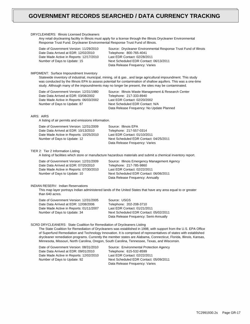
DRYCLEANERS: Illinois Licensed DrycleanersAny retail drycleaning facility in Illinois must apply for a license through the Illinois Drycleaner EnvironmentalResponse Trust Fund. Drycleaner Environmental Response Trust Fund of Illinois.
Date of Government Version: 11/29/2010Date Data Arrived at EDR: 12/02/2010Date Made Active in Reports: 12/17/2010Number of Days to Update: 15
Source: Drycleaner Environmental Response Trust Fund of IllinoisTelephone: 800-765-4041Last EDR Contact: 02/28/2011Next Scheduled EDR Contact: 06/13/2011Data Release Frequency: Varies
IMPDMENT: Surface Impoundment InventoryStatewide inventory of industrial, municipal, mining, oil & gas , and large agricultural impoundment. This studywas conducted by the Illinois EPA to assess potentail for contamination of shallow aquifers. This was a one-timestudy. Although many of the impoundments may no longer be present, the sites may be contaminated.
Date of Government Version: 12/31/1980Date Data Arrived at EDR: 03/08/2002Date Made Active in Reports: 06/03/2002Number of Days to Update: 87
Source: Illinois Waste Management & Research CenterTelephone: 217-333-8940Last EDR Contact: 02/20/2002Next Scheduled EDR Contact: N/AData Release Frequency: No Update Planned
AIRS: AIRSA listing of air permits and emissions information.
Date of Government Version: 12/31/2009Date Data Arrived at EDR: 10/13/2010Date Made Active in Reports: 10/25/2010Number of Days to Update: 12
Source: Illinois EPATelephone: 217-557-0314Last EDR Contact: 01/10/2011Next Scheduled EDR Contact: 04/25/2011Data Release Frequency: Varies
TIER 2: Tier 2 Information ListingA listing of facilities which store or manufacture hazardous materials and submit a chemical inventory report.
Date of Government Version: 12/31/2009Date Data Arrived at EDR: 07/20/2010Date Made Active in Reports: 07/30/2010Number of Days to Update: 10
Source: Illinois Emergency Management AgencyTelephone: 217-785-9860Last EDR Contact: 02/22/2011Next Scheduled EDR Contact: 06/06/2011Data Release Frequency: Annually
INDIAN RESERV: Indian ReservationsThis map layer portrays Indian administered lands of the United States that have any area equal to or greaterthan 640 acres.
Date of Government Version: 12/31/2005Date Data Arrived at EDR: 12/08/2006Date Made Active in Reports: 01/11/2007Number of Days to Update: 34
Source: USGSTelephone: 202-208-3710Last EDR Contact: 01/21/2011Next Scheduled EDR Contact: 05/02/2011Data Release Frequency: Semi-Annually
SCRD DRYCLEANERS: State Coalition for Remediation of Drycleaners ListingThe State Coalition for Remediation of Drycleaners was established in 1998, with support from the U.S. EPA Officeof Superfund Remediation and Technology Innovation. It is comprised of representatives of states with establisheddrycleaner remediation programs. Currently the member states are Alabama, Connecticut, Florida, Illinois, Kansas,Minnesota, Missouri, North Carolina, Oregon, South Carolina, Tennessee, Texas, and Wisconsin.
Date of Government Version: 08/31/2010Date Data Arrived at EDR: 09/01/2010Date Made Active in Reports: 12/02/2010Number of Days to Update: 92
Source: Environmental Protection AgencyTelephone: 615-532-8599Last EDR Contact: 02/22/2011Next Scheduled EDR Contact: 05/09/2011Data Release Frequency: Varies
TC2991930.2s Page GR-17
GOVERNMENT RECORDS SEARCHED / DATA CURRENCY TRACKING

PIMW: Potentially Infectious Medical WastePotentially Infectious Medical Waste (PIMW) is waste generated in connection with the diagnosis, treatment (i.e.,provision of medical services), or immunization of human beings or animals; research pertaining to the provisionof medical services; or the provision or testing of biologicals.
Date of Government Version: 12/29/2010Date Data Arrived at EDR: 01/05/2011Date Made Active in Reports: 02/17/2011Number of Days to Update: 43
Source: Illinois EPATelephone: 217-524-3289Last EDR Contact: 12/29/2010Next Scheduled EDR Contact: 04/11/2011Data Release Frequency: Varies
COAL ASH DOE: Sleam-Electric Plan Operation DataA listing of power plants that store ash in surface ponds.
Date of Government Version: 12/31/2005Date Data Arrived at EDR: 08/07/2009Date Made Active in Reports: 10/22/2009Number of Days to Update: 76
Source: Department of EnergyTelephone: 202-586-8719Last EDR Contact: 01/18/2011Next Scheduled EDR Contact: 05/02/2011Data Release Frequency: Varies
COAL ASH EPA: Coal Combustion Residues Surface Impoundments ListA listing of coal combustion residues surface impoundments with high hazard potential ratings.
Date of Government Version: 11/09/2009Date Data Arrived at EDR: 12/18/2009Date Made Active in Reports: 02/10/2010Number of Days to Update: 54
Source: Environmental Protection AgencyTelephone: N/ALast EDR Contact: 12/21/2010Next Scheduled EDR Contact: 03/28/2011Data Release Frequency: Varies
PCB TRANSFORMER: PCB Transformer Registration DatabaseThe database of PCB transformer registrations that includes all PCB registration submittals.
Date of Government Version: 01/01/2008Date Data Arrived at EDR: 02/18/2009Date Made Active in Reports: 05/29/2009Number of Days to Update: 100
Source: Environmental Protection AgencyTelephone: 202-566-0517Last EDR Contact: 02/04/2011Next Scheduled EDR Contact: 05/16/2011Data Release Frequency: Varies
FEDLAND: Federal and Indian LandsFederally and Indian administrated lands of the United States. Lands included are administrated by: Army Corpsof Engineers, Bureau of Reclamation, National Wild and Scenic River, National Wildlife Refuge, Public Domain Land,Wilderness, Wilderness Study Area, Wildlife Management Area, Bureau of Indian Affairs, Bureau of Land Management,Department of Justice, Forest Service, Fish and Wildlife Service, National Park Service.
Date of Government Version: 12/31/2005Date Data Arrived at EDR: 02/06/2006Date Made Active in Reports: 01/11/2007Number of Days to Update: 339
Source: U.S. Geological SurveyTelephone: 888-275-8747Last EDR Contact: 01/21/2011Next Scheduled EDR Contact: 05/02/2011Data Release Frequency: N/A
EDR PROPRIETARY RECORDS
EDR Proprietary Records
Manufactured Gas Plants: EDR Proprietary Manufactured Gas PlantsThe EDR Proprietary Manufactured Gas Plant Database includes records of coal gas plants (manufactured gas plants)compiled by EDR’s researchers. Manufactured gas sites were used in the United States from the 1800’s to 1950’sto produce a gas that could be distributed and used as fuel. These plants used whale oil, rosin, coal, or a mixtureof coal, oil, and water that also produced a significant amount of waste. Many of the byproducts of the gas production,such as coal tar (oily waste containing volatile and non-volatile chemicals), sludges, oils and other compoundsare potentially hazardous to human health and the environment. The byproduct from this process was frequentlydisposed of directly at the plant site and can remain or spread slowly, serving as a continuous source of soiland groundwater contamination.
TC2991930.2s Page GR-18
GOVERNMENT RECORDS SEARCHED / DATA CURRENCY TRACKING

Date of Government Version: N/ADate Data Arrived at EDR: N/ADate Made Active in Reports: N/ANumber of Days to Update: N/A
Source: EDR, Inc.Telephone: N/ALast EDR Contact: N/ANext Scheduled EDR Contact: N/AData Release Frequency: No Update Planned
EDR Historical Auto Stations: EDR Proprietary Historic Gas StationsEDR has searched selected national collections of business directories and has collected listings of potentialgas station/filling station/service station sites that were available to EDR researchers. EDR’s review was limitedto those categories of sources that might, in EDR’s opinion, include gas station/filling station/service stationestablishments. The categories reviewed included, but were not limited to gas, gas station, gasoline station,filling station, auto, automobile repair, auto service station, service station, etc.
Date of Government Version: N/ADate Data Arrived at EDR: N/ADate Made Active in Reports: N/ANumber of Days to Update: N/A
Source: EDR, Inc.Telephone: N/ALast EDR Contact: N/ANext Scheduled EDR Contact: N/AData Release Frequency: Varies
EDR Historical Cleaners: EDR Proprietary Historic Dry CleanersEDR has searched selected national collections of business directories and has collected listings of potentialdry cleaner sites that were available to EDR researchers. EDR’s review was limited to those categories of sourcesthat might, in EDR’s opinion, include dry cleaning establishments. The categories reviewed included, but werenot limited to dry cleaners, cleaners, laundry, laundromat, cleaning/laundry, wash & dry etc.
Date of Government Version: N/ADate Data Arrived at EDR: N/ADate Made Active in Reports: N/ANumber of Days to Update: N/A
Source: EDR, Inc.Telephone: N/ALast EDR Contact: N/ANext Scheduled EDR Contact: N/AData Release Frequency: Varies
OTHER DATABASE(S)
Depending on the geographic area covered by this report, the data provided in these specialty databases may or may not becomplete. For example, the existence of wetlands information data in a specific report does not mean that all wetlands in thearea covered by the report are included. Moreover, the absence of any reported wetlands information does not necessarilymean that wetlands do not exist in the area covered by the report.
CT MANIFEST: Hazardous Waste Manifest DataFacility and manifest data. Manifest is a document that lists and tracks hazardous waste from the generator throughtransporters to a tsd facility.
Date of Government Version: 12/31/2007Date Data Arrived at EDR: 08/26/2009Date Made Active in Reports: 09/11/2009Number of Days to Update: 16
Source: Department of Environmental ProtectionTelephone: 860-424-3375Last EDR Contact: 02/25/2011Next Scheduled EDR Contact: 06/06/2011Data Release Frequency: Annually
NJ MANIFEST: Manifest InformationHazardous waste manifest information.
Date of Government Version: 12/31/2009Date Data Arrived at EDR: 07/22/2010Date Made Active in Reports: 08/26/2010Number of Days to Update: 35
Source: Department of Environmental ProtectionTelephone: N/ALast EDR Contact: 01/21/2011Next Scheduled EDR Contact: 05/02/2011Data Release Frequency: Annually
TC2991930.2s Page GR-19
GOVERNMENT RECORDS SEARCHED / DATA CURRENCY TRACKING

NY MANIFEST: Facility and Manifest DataManifest is a document that lists and tracks hazardous waste from the generator through transporters to a TSDfacility.
Date of Government Version: 12/31/2010Date Data Arrived at EDR: 02/09/2011Date Made Active in Reports: 03/04/2011Number of Days to Update: 23
Source: Department of Environmental ConservationTelephone: 518-402-8651Last EDR Contact: 02/09/2011Next Scheduled EDR Contact: 05/23/2011Data Release Frequency: Annually
PA MANIFEST: Manifest InformationHazardous waste manifest information.
Date of Government Version: 12/31/2008Date Data Arrived at EDR: 12/01/2009Date Made Active in Reports: 12/14/2009Number of Days to Update: 13
Source: Department of Environmental ProtectionTelephone: 717-783-8990Last EDR Contact: 02/18/2011Next Scheduled EDR Contact: 06/06/2011Data Release Frequency: Annually
RI MANIFEST: Manifest informationHazardous waste manifest information
Date of Government Version: 12/31/2009Date Data Arrived at EDR: 07/19/2010Date Made Active in Reports: 08/26/2010Number of Days to Update: 38
Source: Department of Environmental ManagementTelephone: 401-222-2797Last EDR Contact: 02/28/2011Next Scheduled EDR Contact: 06/13/2011Data Release Frequency: Annually
WI MANIFEST: Manifest InformationHazardous waste manifest information.
Date of Government Version: 12/31/2009Date Data Arrived at EDR: 07/06/2010Date Made Active in Reports: 07/26/2010Number of Days to Update: 20
Source: Department of Natural ResourcesTelephone: N/ALast EDR Contact: 12/16/2010Next Scheduled EDR Contact: 04/04/2011Data Release Frequency: Annually
Oil/Gas Pipelines: This data was obtained by EDR from the USGS in 1994. It is referred to by USGS as GeoData Digital Line Graphsfrom 1:100,000-Scale Maps. It was extracted from the transportation category including some oil, but primarilygas pipelines.
Electric Power Transmission Line DataSource: Rextag Strategies Corp.Telephone: (281) 769-2247U.S. Electric Transmission and Power Plants Systems Digital GIS Data
Sensitive Receptors: There are individuals deemed sensitive receptors due to their fragile immune systems and special sensitivityto environmental discharges. These sensitive receptors typically include the elderly, the sick, and children. While the location of allsensitive receptors cannot be determined, EDR indicates those buildings and facilities - schools, daycares, hospitals, medical centers,and nursing homes - where individuals who are sensitive receptors are likely to be located.
AHA Hospitals:Source: American Hospital Association, Inc.Telephone: 312-280-5991The database includes a listing of hospitals based on the American Hospital Association’s annual survey of hospitals.
Medical Centers: Provider of Services ListingSource: Centers for Medicare & Medicaid ServicesTelephone: 410-786-3000A listing of hospitals with Medicare provider number, produced by Centers of Medicare & Medicaid Services,a federal agency within the U.S. Department of Health and Human Services.
Nursing HomesSource: National Institutes of HealthTelephone: 301-594-6248Information on Medicare and Medicaid certified nursing homes in the United States.
TC2991930.2s Page GR-20
GOVERNMENT RECORDS SEARCHED / DATA CURRENCY TRACKING

Public SchoolsSource: National Center for Education StatisticsTelephone: 202-502-7300The National Center for Education Statistics’ primary database on elementaryand secondary public education in the United States. It is a comprehensive, annual, national statisticaldatabase of all public elementary and secondary schools and school districts, which contains data that arecomparable across all states.
Private SchoolsSource: National Center for Education StatisticsTelephone: 202-502-7300The National Center for Education Statistics’ primary database on private school locations in the United States.
Daycare Centers: Homes & Centers ListingSource: Department of Children & Family ServicesTelephone: 312-814-4150
Flood Zone Data: This data, available in select counties across the country, was obtained by EDR in 2003 & 2009 from the FederalEmergency Management Agency (FEMA). Data depicts 100-year and 500-year flood zones as defined by FEMA.
NWI: National Wetlands Inventory. This data, available in select counties across the country, was obtained by EDRin 2002 and 2005 from the U.S. Fish and Wildlife Service.
Scanned Digital USGS 7.5’ Topographic Map (DRG)Source: United States Geologic SurveyA digital raster graphic (DRG) is a scanned image of a U.S. Geological Survey topographic map. The map imagesare made by scanning published paper maps on high-resolution scanners. The raster imageis georeferenced and fit to the Universal Transverse Mercator (UTM) projection.
STREET AND ADDRESS INFORMATION
© 2010 Tele Atlas North America, Inc. All rights reserved. This material is proprietary and the subject of copyright protectionand other intellectual property rights owned by or licensed to Tele Atlas North America, Inc. The use of this material is subjectto the terms of a license agreement. You will be held liable for any unauthorized copying or disclosure of this material.
TC2991930.2s Page GR-21
GOVERNMENT RECORDS SEARCHED / DATA CURRENCY TRACKING

TC2991930.2s Page A-1
geologic strata.of the soil, and nearby wells. Groundwater flow velocity is generally impacted by the nature of theGroundwater flow direction may be impacted by surface topography, hydrology, hydrogeology, characteristics
2. Groundwater flow velocity. 1. Groundwater flow direction, and
Assessment of the impact of contaminant migration generally has two principle investigative components:
forming an opinion about the impact of potential contaminant migration.EDR’s GeoCheck Physical Setting Source Addendum is provided to assist the environmental professional in
1993Most Recent Revision:41088-F2 NORMANTOWN, ILSouth Map:
1998Most Recent Revision:41088-G2 NAPERVILLE, ILTarget Property Map:
USGS TOPOGRAPHIC MAP
701 ft. above sea levelElevation:4623842.5UTM Y (Meters): 403729.7UTM X (Meters): Zone 16Universal Tranverse Mercator: 88.1581 - 88˚ 9’ 29.1’’Longitude (West): 41.76250 - 41˚ 45’ 45.0’’Latitude (North):
TARGET PROPERTY COORDINATES
NAPERVILLE, IL 60540735 S. WEST ST.SPORTSMANS PARK
TARGET PROPERTY ADDRESS
GEOCHECK - PHYSICAL SETTING SOURCE ADDENDUM®

TC2991930.2s Page A-2
should be field verified.on a relative (not an absolute) basis. Relative elevation information between sites of close proximitySource: Topography has been determined from the USGS 7.5’ Digital Elevation Model and should be evaluated
SURROUNDING TOPOGRAPHY: ELEVATION PROFILES
Ele
vatio
n (f
t)E
leva
tion
(ft)
TP
TP0 1/2 1 Miles
✩Target Property Elevation: 701 ft.
North South
West East
692
700
700
700
701
700
700
700
701
701
703
707
705
693670
683
695
700
703690
699
700
700
699
701
704
702
700
701
701
701
690
690 661
666
672
686
700
General SEGeneral Topographic Gradient:TARGET PROPERTY TOPOGRAPHY
should contamination exist on the target property, what downgradient sites might be impacted.assist the environmental professional in forming an opinion about the impact of nearby contaminated properties or,Surface topography may be indicative of the direction of surficial groundwater flow. This information can be used toTOPOGRAPHIC INFORMATION
collected on nearby properties, and regional groundwater flow information (from deep aquifers).sources of information, such as surface topographic information, hydrologic information, hydrogeologic datausing site-specific well data. If such data is not reasonably ascertainable, it may be necessary to rely on otherGroundwater flow direction for a particular site is best determined by a qualified environmental professionalGROUNDWATER FLOW DIRECTION INFORMATION
GEOCHECK - PHYSICAL SETTING SOURCE SUMMARY®

TC2991930.2s Page A-3
Not Reported
GENERAL DIRECTIONLOCATIONGROUNDWATER FLOWFROM TPMAP ID
hydrogeologically, and the depth to water table.authorities at select sites and has extracted the date of the report, groundwater flow direction as determinedflow at specific points. EDR has reviewed reports submitted by environmental professionals to regulatoryEDR has developed the AQUIFLOW Information System to provide data on the general direction of groundwater
AQUIFLOW®
Search Radius: 1.000 Mile.
Not found Status:1.25 miles Search Radius:
Site-Specific Hydrogeological Data*:
* ©1996 Site−specific hydrogeological data gathered by CERCLIS Alerts, Inc., Bainbridge Island, WA. All rights reserved. All of the information and opinions presented are those of the cited EPA report(s), which were completed undera Comprehensive Environmental Response Compensation and Liability Information System (CERCLIS) investigation.
contamination exist on the target property, what downgradient sites might be impacted.environmental professional in forming an opinion about the impact of nearby contaminated properties or, shouldof groundwater flow direction in the immediate area. Such hydrogeologic information can be used to assist theHydrogeologic information obtained by installation of wells on a specific site can often be an indicatorHYDROGEOLOGIC INFORMATION
YES - refer to the Overview Map and Detail MapNAPERVILLE
NATIONAL WETLAND INVENTORYNWI ElectronicData CoverageNWI Quad at Target Property
1702130017C - FEMA Q3 Flood data1702130016C - FEMA Q3 Flood data1701970055B - FEMA Q3 Flood data1701970050B - FEMA Q3 Flood data1702130013C - FEMA Q3 Flood dataAdditional Panels in search area:
1702130012C - FEMA Q3 Flood dataFlood Plain Panel at Target Property:
YES - refer to the Overview Map and Detail MapDUPAGE, IL
FEMA FLOOD ZONEFEMA FloodElectronic DataTarget Property County
and bodies of water).Refer to the Physical Setting Source Map following this summary for hydrologic information (major waterways
contamination exist on the target property, what downgradient sites might be impacted.the environmental professional in forming an opinion about the impact of nearby contaminated properties or, shouldSurface water can act as a hydrologic barrier to groundwater flow. Such hydrologic information can be used to assistHYDROLOGIC INFORMATION
GEOCHECK - PHYSICAL SETTING SOURCE SUMMARY®

TC2991930.2s Page A-4
Map, USGS Digital Data Series DDS - 11 (1994).of the Conterminous U.S. at 1:2,500,000 Scale - a digital representation of the 1974 P.B. King and H.M. BeikmanGeologic Age and Rock Stratigraphic Unit Source: P.G. Schruben, R.E. Arndt and W.J. Bawiec, Geology
ROCK STRATIGRAPHIC UNIT GEOLOGIC AGE IDENTIFICATION
Stratifed SequenceCategory:PaleozoicEra:SilurianSystem:Middle Silurian (Niagoaran)Series:S2Code: (decoded above as Era, System & Series)
at which contaminant migration may be occurring.Geologic information can be used by the environmental professional in forming an opinion about the relative speedGEOLOGIC INFORMATION IN GENERAL AREA OF TARGET PROPERTY
move more quickly through sandy-gravelly types of soils than silty-clayey types of soils.characteristics data collected on nearby properties and regional soil information. In general, contaminant plumesto rely on other sources of information, including geologic age identification, rock stratigraphic unit and soilusing site specific geologic and soil strata data. If such data are not reasonably ascertainable, it may be necessaryGroundwater flow velocity information for a particular site is best determined by a qualified environmental professionalGROUNDWATER FLOW VELOCITY INFORMATION
GEOCHECK - PHYSICAL SETTING SOURCE SUMMARY®

EDR Inc.EDR Inc.EDR Inc.EDR Inc.EDR Inc.EDR Inc.EDR Inc.EDR Inc.EDR Inc.EDR Inc.EDR Inc.EDR Inc.EDR Inc.EDR Inc.EDR Inc.EDR Inc.EDR Inc.EDR Inc.EDR Inc.EDR Inc.EDR Inc.EDR Inc.EDR Inc.EDR Inc.EDR Inc.EDR Inc.EDR Inc.EDR Inc.EDR Inc.EDR Inc.EDR Inc.EDR Inc.EDR Inc.EDR Inc.EDR Inc.EDR Inc.EDR Inc.EDR Inc.EDR Inc.EDR Inc.
3
1
2
3
1
4
24
1
4
3
0 1/16 1/8 1/4 Miles

TC2991930.2s Page A-6
Min: 7.4Max: 8.4
Min: 0.42Max: 1.41
50%), Lean Claylimit less thanClays (liquidSOILS, Silts andFINE-GRAINED
Soils.200), Clayeypassing No.than 35 pct.Materials (moreSilt-Claysilty clay loam40 inches16 inches 4
Min: 7.4Max: 8.4
Min: 0.42Max: 1.41
50%), Lean Claylimit less thanClays (liquidSOILS, Silts andFINE-GRAINED
Soils.200), Clayeypassing No.than 35 pct.Materials (moreSilt-Claysilt loam 5 inches 0 inches 3
Min: 7.4Max: 8.4
Min: 0.42Max: 1.41
50%), Lean Claylimit less thanClays (liquidSOILS, Silts andFINE-GRAINED
Soils.200), Clayeypassing No.than 35 pct.Materials (moreSilt-Claysilty clay loam11 inches 5 inches 2
Min: 7.4Max: 8.4
Min: 0.42Max: 1.41
50%), Lean Claylimit less thanClays (liquidSOILS, Silts andFINE-GRAINED
Soils.200), Clayeypassing No.than 35 pct.Materials (moreSilt-Claysilty clay16 inches11 inches 1
Soil Layer Information
Boundary Classification Saturatedhydraulicconductivitymicro m/sec
Layer Upper Lower Soil Texture Class AASHTO Group Unified Soil Soil Reaction(pH)
> 41 inchesDepth to Watertable Min:
> 0 inchesDepth to Bedrock Min:
HighCorrosion Potential - Uncoated Steel:
Hydric Status: Not hydric
Somewhat poorly drainedSoil Drainage Class:
movement of water, or soils with moderately fine or fine textures.Class C - Slow infiltration rates. Soils with layers impeding downwardHydrologic Group:
silty claySoil Surface Texture:
ElliottSoil Component Name:
Soil Map ID: 1
in a landscape. The following information is based on Soil Conservation Service SSURGO data.for privately owned lands in the United States. A soil map in a soil survey is a representation of soil patternsSurvey (NCSS) and is responsible for collecting, storing, maintaining and distributing soil survey informationThe U.S. Department of Agriculture’s (USDA) Soil Conservation Service (SCS) leads the National Cooperative Soil
DOMINANT SOIL COMPOSITION IN GENERAL AREA OF TARGET PROPERTY
GEOCHECK - PHYSICAL SETTING SOURCE SUMMARY®

TC2991930.2s Page A-7
Min: 6.6Max: 8.4
Min: 4.23Max: 42.34
50%), Lean Claylimit less thanClays (liquidSOILS, Silts andFINE-GRAINED
Soils.200), Clayeypassing No.than 35 pct.Materials (moreSilt-Claysilty clay loam42 inches14 inches 2
Min: 6.6Max: 8.4
Min: 4.23Max: 42.34
50%), Lean Claylimit less thanClays (liquidSOILS, Silts andFINE-GRAINED
Soils.200), Clayeypassing No.than 35 pct.Materials (moreSilt-Claysilty clay loam14 inches 0 inches 1
Soil Layer Information
Boundary Classification Saturatedhydraulicconductivitymicro m/sec
Layer Upper Lower Soil Texture Class AASHTO Group Unified Soil Soil Reaction(pH)
> 15 inchesDepth to Watertable Min:
> 0 inchesDepth to Bedrock Min:
HighCorrosion Potential - Uncoated Steel:
Hydric Status: All hydric
Poorly drainedSoil Drainage Class:
textures.moderately well and well drained soils with moderately coarseClass B - Moderate infiltration rates. Deep and moderately deep,Hydrologic Group:
silty clay loamSoil Surface Texture:
DrummerSoil Component Name:
Soil Map ID: 2
Min: 7.4Max: 8.4
Min: 0.42Max: 1.41
50%), Lean Claylimit less thanClays (liquidSOILS, Silts andFINE-GRAINED
Soils.200), Clayeypassing No.than 35 pct.Materials (moreSilt-Claysilty clay loam59 inches40 inches 5
Soil Layer Information
Boundary Classification Saturatedhydraulicconductivitymicro m/sec
Layer Upper Lower Soil Texture Class AASHTO Group Unified Soil Soil Reaction(pH)
GEOCHECK - PHYSICAL SETTING SOURCE SUMMARY®

TC2991930.2s Page A-8
Min: 7.9Max: 8.4
Min: 0.42Max: 1.41
50%), Lean Claylimit less thanClays (liquidSOILS, Silts andFINE-GRAINED
Soils.200), Clayeypassing No.than 35 pct.Materials (moreSilt-Claysilty clay loam48 inches29 inches 1
Soil Layer Information
Boundary Classification Saturatedhydraulicconductivitymicro m/sec
Layer Upper Lower Soil Texture Class AASHTO Group Unified Soil Soil Reaction(pH)
> 84 inchesDepth to Watertable Min:
> 0 inchesDepth to Bedrock Min:
HighCorrosion Potential - Uncoated Steel:
Hydric Status: Not hydric
Moderately well drainedSoil Drainage Class:
movement of water, or soils with moderately fine or fine textures.Class C - Slow infiltration rates. Soils with layers impeding downwardHydrologic Group:
silty clay loamSoil Surface Texture:
VarnaSoil Component Name:
Soil Map ID: 3
Min: 6.6Max: 8.4
Min: 4.23Max: 42.34
50%), Lean Claylimit less thanClays (liquidSOILS, Silts andFINE-GRAINED
Soils.200), Clayeypassing No.than 35 pct.Materials (moreSilt-Clay
silty clay loamloamy sand tostratified59 inches50 inches 4
Min: 6.6Max: 8.4
Min: 4.23Max: 42.34
50%), Lean Claylimit less thanClays (liquidSOILS, Silts andFINE-GRAINED
Soils.200), Clayeypassing No.than 35 pct.Materials (moreSilt-Clayloam50 inches42 inches 3
Soil Layer Information
Boundary Classification Saturatedhydraulicconductivitymicro m/sec
Layer Upper Lower Soil Texture Class AASHTO Group Unified Soil Soil Reaction(pH)
GEOCHECK - PHYSICAL SETTING SOURCE SUMMARY®

TC2991930.2s Page A-9
No Layer Information available.
> 0 inchesDepth to Watertable Min:
> 0 inchesDepth to Bedrock Min:
Not ReportedCorrosion Potential - Uncoated Steel:
Hydric Status: Not hydricSoil Drainage Class:
movement of water, or soils with moderately fine or fine textures.Class C - Slow infiltration rates. Soils with layers impeding downwardHydrologic Group:
silty clay loamSoil Surface Texture:
WaterSoil Component Name:
Soil Map ID: 4
Min: 7.9Max: 8.4
Min: 0.42Max: 1.41
50%), Lean Claylimit less thanClays (liquidSOILS, Silts andFINE-GRAINED
Soils.200), Clayeypassing No.than 35 pct.Materials (moreSilt-Claysilty clay loam59 inches48 inches 4
Min: 7.9Max: 8.4
Min: 0.42Max: 1.41
50%), Lean Claylimit less thanClays (liquidSOILS, Silts andFINE-GRAINED
Soils.200), Clayeypassing No.than 35 pct.Materials (moreSilt-Claysilty clay29 inches11 inches 3
Min: 7.9Max: 8.4
Min: 0.42Max: 1.41
50%), Lean Claylimit less thanClays (liquidSOILS, Silts andFINE-GRAINED
Soils.200), Clayeypassing No.than 35 pct.Materials (moreSilt-Claysilt loam11 inches 0 inches 2
Soil Layer Information
Boundary Classification Saturatedhydraulicconductivitymicro m/sec
Layer Upper Lower Soil Texture Class AASHTO Group Unified Soil Soil Reaction(pH)
GEOCHECK - PHYSICAL SETTING SOURCE SUMMARY®

TC2991930.2s Page A-10
1/4 - 1/2 Mile WestILSG10000196261 D171/4 - 1/2 Mile WSWILSG10000195967 161/4 - 1/2 Mile SWILSG10000195844 151/4 - 1/2 Mile SouthILSG10000195681 141/4 - 1/2 Mile WestILSG10000196349 B131/4 - 1/2 Mile WSWILSG10000196084 C121/4 - 1/2 Mile WSWILSG10000196083 C111/4 - 1/2 Mile WSWILSG10000196082 C101/4 - 1/2 Mile WestILSG10000196268 B91/4 - 1/2 Mile NWILSG10000196471 80 - 1/8 Mile EastP13061 A70 - 1/8 Mile EastP13063 A60 - 1/8 Mile EastP13057 A50 - 1/8 Mile EastP13062 A40 - 1/8 Mile EastP13060 A30 - 1/8 Mile EastP13059 A20 - 1/8 Mile EastP13058 A1
STATE DATABASE WELL INFORMATION
LOCATIONFROM TPWELL IDMAP ID
Note: PWS System location is not always the same as well location.
No PWS System Found
FEDERAL FRDS PUBLIC WATER SUPPLY SYSTEM INFORMATION
LOCATIONFROM TPWELL IDMAP ID
1/2 - 1 Mile WNWUSGS2383325 K491/2 - 1 Mile WNWUSGS2383324 K471/2 - 1 Mile NEUSGS2383337 461/2 - 1 Mile NNEUSGS2383339 J44
FEDERAL USGS WELL INFORMATION
LOCATIONFROM TPWELL IDMAP ID
1.000State DatabaseNearest PWS within 1 mileFederal FRDS PWS1.000Federal USGS
WELL SEARCH DISTANCE INFORMATION
SEARCH DISTANCE (miles)DATABASE
opinion about the impact of contaminant migration on nearby drinking water wells.professional in assessing sources that may impact ground water flow direction, and in forming anEDR Local/Regional Water Agency records provide water well information to assist the environmental
LOCAL / REGIONAL WATER AGENCY RECORDS
GEOCHECK - PHYSICAL SETTING SOURCE SUMMARY®

TC2991930.2s Page A-11
1/2 - 1 Mile WestP13056 L601/2 - 1 Mile ESEP14405 591/2 - 1 Mile ESEILSG10000195796 581/2 - 1 Mile WestILSG10000196255 L571/2 - 1 Mile WestILSG10000196254 L561/2 - 1 Mile WNWP13055 551/2 - 1 Mile NNEILEP10000005371 J541/2 - 1 Mile NNEILSG10000197185 J531/2 - 1 Mile NNEILSG10000197195 J521/2 - 1 Mile WNWILSG10000196638 K511/2 - 1 Mile WNWILEP10000005328 K501/2 - 1 Mile NNEILSG10000197175 J481/2 - 1 Mile NNEILSG10000197150 J451/2 - 1 Mile NorthILSG10000197236 I431/2 - 1 Mile NorthILSG10000197235 I421/2 - 1 Mile NorthILSG10000197234 I411/2 - 1 Mile NNEILSG10000197149 H401/2 - 1 Mile SWILSG10000195500 391/2 - 1 Mile WNWP13054 381/2 - 1 Mile NNEILSG10000197094 H371/2 - 1 Mile NNEILSG10000197093 H361/2 - 1 Mile NWILSG10000196785 351/2 - 1 Mile WestP13053 341/2 - 1 Mile NorthILSG10000197066 331/2 - 1 Mile WestILSG10000196257 321/2 - 1 Mile WSWP13064 G311/2 - 1 Mile ENEILSG10000196503 301/4 - 1/2 Mile NWILSG10000196719 291/4 - 1/2 Mile WestILSG10000196121 F281/4 - 1/2 Mile WSWILSG10000195856 G271/4 - 1/2 Mile SWILSG10000195680 261/4 - 1/2 Mile WestP13065 D251/4 - 1/2 Mile WSWILSG10000196076 F241/4 - 1/2 Mile WSWILSG10000196075 F231/4 - 1/2 Mile WSWILSG10000196077 F221/4 - 1/2 Mile ENEILSG10000196412 E211/4 - 1/2 Mile ENEILSG10000196411 E201/4 - 1/2 Mile ENEILSG10000196410 E191/4 - 1/2 Mile SWILSG10000195828 18
STATE DATABASE WELL INFORMATION
LOCATIONFROM TPWELL IDMAP ID
GEOCHECK - PHYSICAL SETTING SOURCE SUMMARY®

EDR Inc.EDR Inc.EDR Inc.EDR Inc.EDR Inc.EDR Inc.EDR Inc.EDR Inc.EDR Inc.EDR Inc.EDR Inc.EDR Inc.EDR Inc.EDR Inc.EDR Inc.EDR Inc.EDR Inc.EDR Inc.EDR Inc.EDR Inc.EDR Inc.EDR Inc.EDR Inc.EDR Inc.EDR Inc.EDR Inc.EDR Inc.EDR Inc.EDR Inc.EDR Inc.EDR Inc.EDR Inc.EDR Inc.EDR Inc.EDR Inc.EDR Inc.EDR Inc.EDR Inc.EDR Inc.EDR Inc.
720
72
0
72
0
720
7 2 0
7 2 0
68
0
68
0
6 8 06 8 0
68 0
6
8 0
68
0
6 8 0
68
0
6 8 06
80
68
0
6 8 0 6 8 0
68
068
0IL

TC2991930.2s Page A-13
MEADOW EQUIPMENTDriller:AffidavitRecord Type:
--Well Type:DomesticWell Use:Not ReportedPlot Location:24Section:09ERange:38NTownship:DUPAGECounty:043County Code:--Aquifer Type:67Depth (in feet):03/23/1988Date Drilled:Not ReportedPermit:
HELEN WITTRYOwner:IL Private Water Wells SurveyInfo Source:
Not ReportedSecond ID:175942Well ID:
A3East0 - 1/8 MileHigher
P13060IL WELLS
DUPAGE PUMPDriller:Affidavit,Indicates comment in owner’s field something unusualRecord Type:
--Well Type:DomesticWell Use:Not ReportedPlot Location:24Section:09ERange:38NTownship:DUPAGECounty:043County Code:BedrockAquifer Type:200Depth (in feet):10/22/1987Date Drilled:Not ReportedPermit:
MR JANISCOWSKI LOT 5(DISC USE)Owner:IL Private Water Wells SurveyInfo Source:
Not ReportedSecond ID:175939Well ID:
A2East0 - 1/8 MileHigher
P13059IL WELLS
ARNTDriller:Construction Report,GeologyRecord Type:
--Well Type:DomesticWell Use:Not ReportedPlot Location:24Section:09ERange:38NTownship:DUPAGECounty:043County Code:BedrockAquifer Type:87Depth (in feet):00/00/0000Date Drilled:Not ReportedPermit:
MR LIPSCOMBOwner:IL Private Water Wells SurveyInfo Source:
Not ReportedSecond ID:174942Well ID:
A1East0 - 1/8 MileHigher
P13058IL WELLS
Map IDDirectionDistanceElevation EDR ID NumberDatabase
GEOCHECK - PHYSICAL SETTING SOURCE MAP FINDINGS®

TC2991930.2s Page A-14
K K WELLDriller:unusualConstruction Report,Geology,Indicates comment in owner’s field somethingRecord Type:
--Well Type:DomesticWell Use:Not ReportedPlot Location:24Section:09ERange:38NTownship:DUPAGECounty:043County Code:BedrockAquifer Type:150Depth (in feet):06/25/1971Date Drilled:013163Permit:
JOHN VERTUNO LOT 2Owner:IL Private Water Wells SurveyInfo Source:
Not ReportedSecond ID:181853Well ID:
A6East0 - 1/8 MileHigher
P13063IL WELLS
PEARCEDriller:unusualConstruction Report,Geology,Indicates comment in owner’s field somethingRecord Type:
--Well Type:DomesticWell Use:Not ReportedPlot Location:24Section:09ERange:38NTownship:DUPAGECounty:043County Code:BedrockAquifer Type:100Depth (in feet):00/00/1959Date Drilled:AS98Permit:
WM BENDER LOT 17Owner:IL Private Water Wells SurveyInfo Source:
Not ReportedSecond ID:174941Well ID:
A5East0 - 1/8 MileHigher
P13057IL WELLS
K & K WELL DRILLINGDriller:Affidavit,Indicates comment in owner’s field something unusualRecord Type:
--Well Type:DomesticWell Use:Not ReportedPlot Location:24Section:09ERange:38NTownship:DUPAGECounty:043County Code:BedrockAquifer Type:200Depth (in feet):03/06/1981Date Drilled:Not ReportedPermit:
JAMES POLIVKA(DISCONTINUED USEOwner:IL Private Water Wells SurveyInfo Source:
Not ReportedSecond ID:181852Well ID:
A4East0 - 1/8 MileHigher
P13062IL WELLS
Map IDDirectionDistanceElevation EDR ID NumberDatabase
GEOCHECK - PHYSICAL SETTING SOURCE MAP FINDINGS®

TC2991930.2s Page A-15
80Wfmfrom:limestoneWformation:200Total dept:Not ReportedElevref:0Elevation:Water WellStatus:Weirich, William TheodoreCompany na:1Farm num:Moser BuildersFarm name:ERdir:9Rng:NTdir:38Twp:24Section:
41.763084Latitude:-88.163688Longitude:120433089900Api number:
B9West1/4 - 1/2 MileHigher
ILSG10000196268IL WELLS
ILSG10000196471Site id:30Pumpgpm:160Wfmto:60Wfmfrom:rockWformation:160Total dept:Not ReportedElevref:0Elevation:Water WellStatus:Dietzman, Gerald E.Company na:Not ReportedFarm num:McKeown Classic Homes / MorrisFarm name:ERdir:9Rng:NTdir:38Twp:24Section:
41.764917Latitude:-88.162317Longitude:120433182700Api number:
8NW1/4 - 1/2 MileHigher
ILSG10000196471IL WELLS
WILLIAM BRETZKEDriller:Construction Report,GeologyRecord Type:
--Well Type:DomesticWell Use:Not ReportedPlot Location:24Section:09ERange:38NTownship:DUPAGECounty:043County Code:UnconsolidatedAquifer Type:26Depth (in feet):00/00/1949Date Drilled:Not ReportedPermit:
E J HARIS JROwner:IL Private Water Wells SurveyInfo Source:
Not ReportedSecond ID:181740Well ID:
A7East0 - 1/8 MileHigher
P13061IL WELLS
Map IDDirectionDistanceElevation EDR ID NumberDatabase
GEOCHECK - PHYSICAL SETTING SOURCE MAP FINDINGS®

TC2991930.2s Page A-16
27Wfmfrom:limestoneWformation:140Total dept:Not ReportedElevref:0Elevation:Water WellStatus:Donald N. ClearyCompany na:Not ReportedFarm num:Rubino, DanFarm name:ERdir:9Rng:NTdir:38Twp:24Section:
41.761265Latitude:-88.163757Longitude:120433080800Api number:
C12WSW1/4 - 1/2 MileHigher
ILSG10000196084IL WELLS
ILSG10000196083Site id:0Pumpgpm:85Wfmto:51Wfmfrom:limestoneWformation:85Total dept:Not ReportedElevref:0Elevation:Water WellStatus:Fykes, Charles N.Company na:Not ReportedFarm num:Bennett, BradleyFarm name:ERdir:9Rng:NTdir:38Twp:24Section:
41.761265Latitude:-88.163757Longitude:120432986200Api number:
C11WSW1/4 - 1/2 MileHigher
ILSG10000196083IL WELLS
ILSG10000196082Site id:20Pumpgpm:160Wfmto:150Wfmfrom:yellow rock, 64’Wformation:160Total dept:Not ReportedElevref:0Elevation:Water WellStatus:Moore, John V.Company na:Not ReportedFarm num:Patap, Mary & RichardFarm name:ERdir:9Rng:NTdir:38Twp:24Section:
41.761265Latitude:-88.163757Longitude:120433051700Api number:
C10WSW1/4 - 1/2 MileHigher
ILSG10000196082IL WELLS
ILSG10000196268Site id:20Pumpgpm:200Wfmto:
GEOCHECK - PHYSICAL SETTING SOURCE MAP FINDINGS®

TC2991930.2s Page A-17
40Wfmfrom:rockWformation:160Total dept:Not ReportedElevref:0Elevation:Water WellStatus:K & K Well Drilling, IncCompany na:Not ReportedFarm num:Walega, ThomasFarm name:ERdir:9Rng:NTdir:38Twp:24Section:
41.75925Latitude:-88.16305Longitude:120433182800Api number:
15SW1/4 - 1/2 MileHigher
ILSG10000195844IL WELLS
ILSG10000195681Site id:172Pumpgpm:0Wfmto:0Wfmfrom:dolomiteWformation:265Total dept:Not ReportedElevref:702Elevation:Water WellStatus:Neely, Larry C.Company na:12Farm num:Naperville, City ofFarm name:ERdir:9Rng:NTdir:38Twp:24Section:
41.757622Latitude:-88.157919Longitude:120433146300Api number:
14South1/4 - 1/2 MileHigher
ILSG10000195681IL WELLS
ILSG10000196349Site id:30Pumpgpm:160Wfmto:33Wfmfrom:rockWformation:160Total dept:Not ReportedElevref:695Elevation:Water WellStatus:Dietzman, Gerald E.Company na:Not ReportedFarm num:McKeown Classic HomesFarm name:ERdir:9Rng:NTdir:38Twp:24Section:
41.763317Latitude:-88.1645Longitude:120433178700Api number:
B13West1/4 - 1/2 MileHigher
ILSG10000196349IL WELLS
ILSG10000196084Site id:30Pumpgpm:140Wfmto:
GEOCHECK - PHYSICAL SETTING SOURCE MAP FINDINGS®

TC2991930.2s Page A-18
60Wfmfrom:grey limeWformation:160Total dept:Not ReportedElevref:691Elevation:Water WellStatus:Knierim, WilliamCompany na:Not ReportedFarm num:McKeown Classic HomesFarm name:ERdir:9Rng:NTdir:38Twp:24Section:
41.759083Latitude:-88.164833Longitude:120433173600Api number:
18SW1/4 - 1/2 MileHigher
ILSG10000195828IL WELLS
ILSG10000196261Site id:0Pumpgpm:0Wfmto:0Wfmfrom:Not ReportedWformation:135Total dept:Not ReportedElevref:0Elevation:Water WellStatus:Fykes Charles & PumpCompany na:1Farm num:Ehrart VirginiaFarm name:ERdir:9Rng:NTdir:38Twp:24Section:
41.763039Latitude:-88.166145Longitude:120432525200Api number:
D17West1/4 - 1/2 MileHigher
ILSG10000196261IL WELLS
ILSG10000195967Site id:0Pumpgpm:0Wfmto:0Wfmfrom:Not ReportedWformation:87Total dept:Ground levelElevref:702Elevation:Water WellStatus:Randa Wm JCompany na:Not ReportedFarm num:LipscombFarm name:ERdir:9Rng:NTdir:38Twp:24Section:
41.760331Latitude:-88.165023Longitude:120430011200Api number:
16WSW1/4 - 1/2 MileHigher
ILSG10000195967IL WELLS
ILSG10000195844Site id:30Pumpgpm:160Wfmto:
GEOCHECK - PHYSICAL SETTING SOURCE MAP FINDINGS®

TC2991930.2s Page A-19
0Wfmfrom:Not ReportedWformation:36Total dept:Not ReportedElevref:0Elevation:Engineering TestStatus:Layne WesternCompany na:5Farm num:Edward Hospital Addn.Farm name:ERdir:9Rng:NTdir:38Twp:24Section:
41.764249Latitude:-88.150156Longitude:120433028600Api number:
E21ENE1/4 - 1/2 MileLower
ILSG10000196412IL WELLS
ILSG10000196411Site id:0Pumpgpm:0Wfmto:0Wfmfrom:Not ReportedWformation:41Total dept:Not ReportedElevref:0Elevation:Engineering TestStatus:Layne WesternCompany na:2Farm num:Edward Hospital Addn.Farm name:ERdir:9Rng:NTdir:38Twp:24Section:
41.764249Latitude:-88.150156Longitude:120433028500Api number:
E20ENE1/4 - 1/2 MileLower
ILSG10000196411IL WELLS
ILSG10000196410Site id:0Pumpgpm:0Wfmto:0Wfmfrom:Not ReportedWformation:40Total dept:Not ReportedElevref:0Elevation:Engineering TestStatus:Layne WesternCompany na:1Farm num:Edward Hospital Addn.Farm name:ERdir:9Rng:NTdir:38Twp:24Section:
41.764249Latitude:-88.150156Longitude:120433028400Api number:
E19ENE1/4 - 1/2 MileLower
ILSG10000196410IL WELLS
ILSG10000195828Site id:10Pumpgpm:150Wfmto:
GEOCHECK - PHYSICAL SETTING SOURCE MAP FINDINGS®

TC2991930.2s Page A-20
55Wfmfrom:limestoneWformation:145Total dept:Not ReportedElevref:0Elevation:Water WellStatus:Weirich, William TheodoreCompany na:1Farm num:Phillips, LeslieFarm name:ERdir:9Rng:NTdir:38Twp:24Section:
41.761218Latitude:-88.166221Longitude:120433146400Api number:
F24WSW1/4 - 1/2 MileHigher
ILSG10000196076IL WELLS
ILSG10000196075Site id:15Pumpgpm:140Wfmto:94Wfmfrom:limestoneWformation:140Total dept:Not ReportedElevref:0Elevation:Water WellStatus:Senffner, KeithCompany na:Not ReportedFarm num:Frederickson, DaleFarm name:ERdir:9Rng:NTdir:38Twp:24Section:
41.761218Latitude:-88.166221Longitude:120433081300Api number:
F23WSW1/4 - 1/2 MileHigher
ILSG10000196075IL WELLS
ILSG10000196077Site id:20Pumpgpm:180Wfmto:44Wfmfrom:limestoneWformation:180Total dept:Not ReportedElevref:700Elevation:Water WellStatus:Weirich, William TheodoreCompany na:Not ReportedFarm num:Ashton Builders / Noll, MarcFarm name:ERdir:9Rng:NTdir:38Twp:24Section:
41.761219Latitude:-88.166218Longitude:120433179000Api number:
F22WSW1/4 - 1/2 MileHigher
ILSG10000196077IL WELLS
ILSG10000196412Site id:0Pumpgpm:0Wfmto:
GEOCHECK - PHYSICAL SETTING SOURCE MAP FINDINGS®

TC2991930.2s Page A-21
38Wfmfrom:limestoneWformation:160Total dept:Not ReportedElevref:0Elevation:Water WellStatus:Sisson, EdwardCompany na:Not ReportedFarm num:Wittry, HelenFarm name:ERdir:9Rng:NTdir:38Twp:24Section:
41.759396Latitude:-88.166293Longitude:120432812900Api number:
G27WSW1/4 - 1/2 MileHigher
ILSG10000195856IL WELLS
ILSG10000195680Site id:0Pumpgpm:200Wfmto:60Wfmfrom:rockWformation:200Total dept:Not ReportedElevref:0Elevation:Water WellStatus:Dietzman, Gerald E.Company na:Not ReportedFarm num:Kuhn, Thomas#2Farm name:ERdir:9Rng:NTdir:38Twp:24Section:
41.757622Latitude:-88.163891Longitude:120432975200Api number:
26SW1/4 - 1/2 MileHigher
ILSG10000195680IL WELLS
FYKESDriller:unusualConstruction Report,Geology,Indicates comment in owner’s field somethingRecord Type:
--Well Type:DomesticWell Use:8EPlot Location:24Section:09ERange:38NTownship:DUPAGECounty:043County Code:BedrockAquifer Type:135Depth (in feet):07/21/1977Date Drilled:063283Permit:
VIRGINIA EHRART LOT 33Owner:IL Private Water Wells SurveyInfo Source:
Not ReportedSecond ID:181854Well ID:
D25West1/4 - 1/2 MileHigher
P13065IL WELLS
ILSG10000196076Site id:0Pumpgpm:145Wfmto:
GEOCHECK - PHYSICAL SETTING SOURCE MAP FINDINGS®

TC2991930.2s Page A-22
0Wfmfrom:Not ReportedWformation:24Total dept:Not ReportedElevref:204Elevation:Engineering TestStatus:IL Department of TransportationCompany na:B-1Farm num:Hillside Rd over W Branch DupageFarm name:ERdir:9Rng:NTdir:38Twp:24Section:
41.76518Latitude:-88.148916Longitude:120433140500Api number:
30ENE1/2 - 1 MileLower
ILSG10000196503IL WELLS
ILSG10000196719Site id:0Pumpgpm:0Wfmto:0Wfmfrom:Not ReportedWformation:150Total dept:Not ReportedElevref:0Elevation:Water WellStatus:K & K Well DrillingCompany na:Not ReportedFarm num:Vertuno JohnFarm name:ERdir:9Rng:NTdir:38Twp:24Section:
41.76761Latitude:-88.164737Longitude:120430213400Api number:
29NW1/4 - 1/2 MileHigher
ILSG10000196719IL WELLS
ILSG10000196121Site id:0Pumpgpm:0Wfmto:0Wfmfrom:Not ReportedWformation:100Total dept:Ground levelElevref:700Elevation:Water WellStatus:Pearce JimCompany na:1Farm num:Bender WmFarm name:ERdir:9Rng:NTdir:38Twp:24Section:
41.761486Latitude:-88.167346Longitude:120430026500Api number:
F28West1/4 - 1/2 MileHigher
ILSG10000196121IL WELLS
ILSG10000195856Site id:0Pumpgpm:160Wfmto:
GEOCHECK - PHYSICAL SETTING SOURCE MAP FINDINGS®
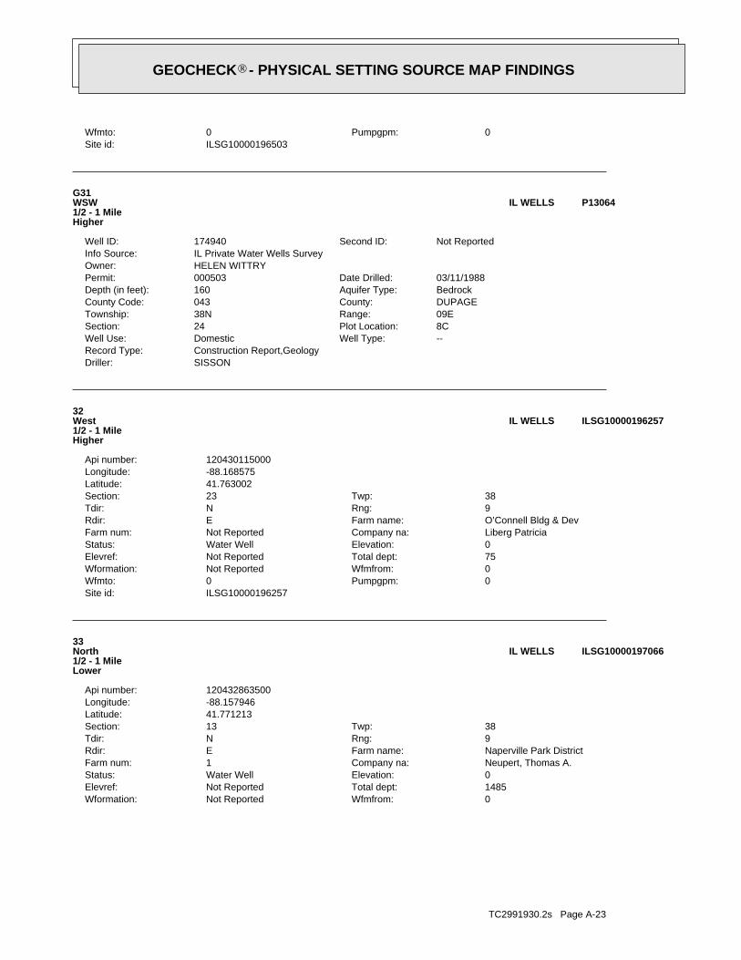
TC2991930.2s Page A-23
0Wfmfrom:Not ReportedWformation:1485Total dept:Not ReportedElevref:0Elevation:Water WellStatus:Neupert, Thomas A.Company na:1Farm num:Naperville Park DistrictFarm name:ERdir:9Rng:NTdir:38Twp:13Section:
41.771213Latitude:-88.157946Longitude:120432863500Api number:
33North1/2 - 1 MileLower
ILSG10000197066IL WELLS
ILSG10000196257Site id:0Pumpgpm:0Wfmto:0Wfmfrom:Not ReportedWformation:75Total dept:Not ReportedElevref:0Elevation:Water WellStatus:Liberg PatriciaCompany na:Not ReportedFarm num:O’Connell Bldg & DevFarm name:ERdir:9Rng:NTdir:38Twp:23Section:
41.763002Latitude:-88.168575Longitude:120430115000Api number:
32West1/2 - 1 MileHigher
ILSG10000196257IL WELLS
SISSONDriller:Construction Report,GeologyRecord Type:
--Well Type:DomesticWell Use:8CPlot Location:24Section:09ERange:38NTownship:DUPAGECounty:043County Code:BedrockAquifer Type:160Depth (in feet):03/11/1988Date Drilled:000503Permit:
HELEN WITTRYOwner:IL Private Water Wells SurveyInfo Source:
Not ReportedSecond ID:174940Well ID:
G31WSW1/2 - 1 MileHigher
P13064IL WELLS
ILSG10000196503Site id:0Pumpgpm:0Wfmto:
GEOCHECK - PHYSICAL SETTING SOURCE MAP FINDINGS®
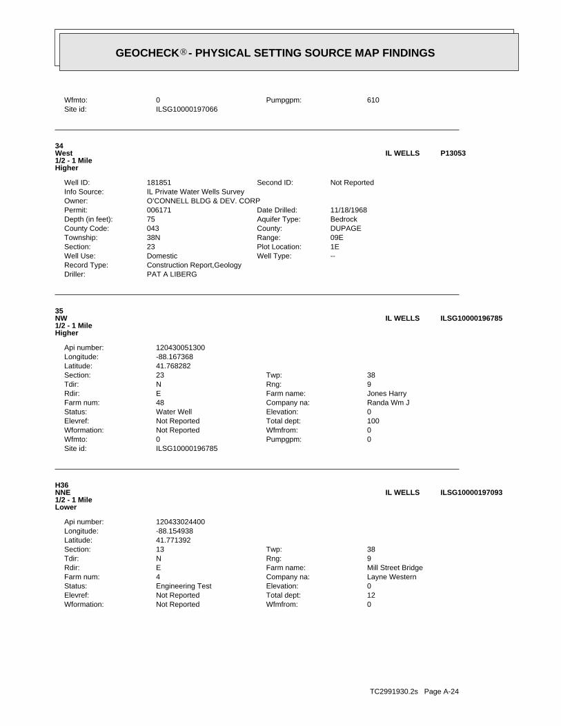
TC2991930.2s Page A-24
0Wfmfrom:Not ReportedWformation:12Total dept:Not ReportedElevref:0Elevation:Engineering TestStatus:Layne WesternCompany na:4Farm num:Mill Street BridgeFarm name:ERdir:9Rng:NTdir:38Twp:13Section:
41.771392Latitude:-88.154938Longitude:120433024400Api number:
H36NNE1/2 - 1 MileLower
ILSG10000197093IL WELLS
ILSG10000196785Site id:0Pumpgpm:0Wfmto:0Wfmfrom:Not ReportedWformation:100Total dept:Not ReportedElevref:0Elevation:Water WellStatus:Randa Wm JCompany na:48Farm num:Jones HarryFarm name:ERdir:9Rng:NTdir:38Twp:23Section:
41.768282Latitude:-88.167368Longitude:120430051300Api number:
35NW1/2 - 1 MileHigher
ILSG10000196785IL WELLS
PAT A LIBERGDriller:Construction Report,GeologyRecord Type:
--Well Type:DomesticWell Use:1EPlot Location:23Section:09ERange:38NTownship:DUPAGECounty:043County Code:BedrockAquifer Type:75Depth (in feet):11/18/1968Date Drilled:006171Permit:
O’CONNELL BLDG & DEV. CORPOwner:IL Private Water Wells SurveyInfo Source:
Not ReportedSecond ID:181851Well ID:
34West1/2 - 1 MileHigher
P13053IL WELLS
ILSG10000197066Site id:610Pumpgpm:0Wfmto:
GEOCHECK - PHYSICAL SETTING SOURCE MAP FINDINGS®

TC2991930.2s Page A-25
0Wfmfrom:Not ReportedWformation:71Total dept:Not ReportedElevref:0Elevation:Water WellStatus:Breitzke, WilliamCompany na:Not ReportedFarm num:Hariss E JFarm name:ERdir:9Rng:NTdir:38Twp:24Section:
41.755991Latitude:-88.16721Longitude:120430160700Api number:
39SW1/2 - 1 MileHigher
ILSG10000195500IL WELLS
MEADOW EQUIPDriller:Construction Report,GeologyRecord Type:
--Well Type:Non-communityWell Use:1FPlot Location:23Section:09ERange:38NTownship:DUPAGECounty:043County Code:BedrockAquifer Type:240Depth (in feet):01/08/1992Date Drilled:H91-0356Permit:
CITY OF NAPERVILLEOwner:IL Private Water Wells SurveyInfo Source:
Not ReportedSecond ID:243410Well ID:
38WNW1/2 - 1 MileHigher
P13054IL WELLS
ILSG10000197094Site id:0Pumpgpm:0Wfmto:0Wfmfrom:Not ReportedWformation:17Total dept:Not ReportedElevref:0Elevation:Engineering TestStatus:Layne WesternCompany na:5Farm num:Mill Street BridgeFarm name:ERdir:9Rng:NTdir:38Twp:13Section:
41.771392Latitude:-88.154938Longitude:120433024500Api number:
H37NNE1/2 - 1 MileLower
ILSG10000197094IL WELLS
ILSG10000197093Site id:0Pumpgpm:0Wfmto:
GEOCHECK - PHYSICAL SETTING SOURCE MAP FINDINGS®

TC2991930.2s Page A-26
0Wfmfrom:Not ReportedWformation:65Total dept:Not ReportedElevref:0Elevation:Water WellStatus:Miller H HCompany na:Not ReportedFarm num:Heise Herman JrFarm name:ERdir:9Rng:NTdir:38Twp:13Section:
41.773061Latitude:-88.159847Longitude:120430158600Api number:
I42North1/2 - 1 MileLower
ILSG10000197235IL WELLS
ILSG10000197234Site id:0Pumpgpm:0Wfmto:0Wfmfrom:Not ReportedWformation:60Total dept:Ground levelElevref:700Elevation:Water WellStatus:Miller H HCompany na:Not ReportedFarm num:Manes CFarm name:ERdir:9Rng:NTdir:38Twp:13Section:
41.773061Latitude:-88.159847Longitude:120430158700Api number:
I41North1/2 - 1 MileLower
ILSG10000197234IL WELLS
ILSG10000197149Site id:172Pumpgpm:0Wfmto:0Wfmfrom:Not ReportedWformation:278Total dept:Not ReportedElevref:0Elevation:Water WellStatus:Layne-Western Co.Company na:Not ReportedFarm num:Naperville Park District #1Farm name:ERdir:9Rng:NTdir:38Twp:13Section:
41.772025Latitude:-88.155084Longitude:120432969500Api number:
H40NNE1/2 - 1 MileLower
ILSG10000197149IL WELLS
ILSG10000195500Site id:0Pumpgpm:0Wfmto:
GEOCHECK - PHYSICAL SETTING SOURCE MAP FINDINGS®

TC2991930.2s Page A-27
1Ground water data count:1905-01-01Ground water data end date:Ground water data begin date: 1905-01-011Water quality data count:1915-06-00Water quality data end date:1915-06-00Water quality data begin date:0Peak flow data count:0000-00-00Peak flow data end date:0000-00-00Peak flow data begin date:0Daily flow data count:0000-00-00Daily flow data end date:0000-00-00Daily flow data begin date:0Real time data flag:
441706600Project number:Not ReportedSource of depth data:
1425Hole depth:Not ReportedWell depth:Not ReportedAquifer:Not ReportedAquifer Type:Single well, other than collector or Ranney typeType of ground water site:NLocal standard time flag:
CSTMean greenwich time offset:Not ReportedDate inventoried:1905Date construction:Ground-water other than SpringSite type:
Valley flatTopographic:Des Plaines. Illinois, Wisconsin. Area = 1440 sq.mi.Hydrologic:National Geodetic Vertical Datum of 1929Altitude datum:5Altitude accuracy:Interpolated from topographic mapAltitude method:675.00Altitude:
24000Map scale:NAPERVILLELocation map:NWSESES13 T 38N R 9E 3Land net:USCountry:043County:17State:17District:NAD83Dec latlong datum:NAD27Latlong datum:FCoor accr:MCoor meth:-88.15090008Dec lon:41.77197419Dec lat:0880903Longitude:USGS2383339EDR Site id:414619Latitude:
38N 9E-13.2b1Site name:414619088090301Site no:USGSAgency cd:
J44NNE1/2 - 1 MileLower
USGS2383339FED USGS
ILSG10000197236Site id:0Pumpgpm:0Wfmto:0Wfmfrom:Not ReportedWformation:65Total dept:Not ReportedElevref:0Elevation:Water WellStatus:Miller Harry HCompany na:Not ReportedFarm num:Heise Carl CFarm name:ERdir:9Rng:NTdir:38Twp:13Section:
41.773061Latitude:-88.159847Longitude:120430158500Api number:
I43North1/2 - 1 MileLower
ILSG10000197236IL WELLS
ILSG10000197235Site id:0Pumpgpm:0Wfmto:
GEOCHECK - PHYSICAL SETTING SOURCE MAP FINDINGS®

TC2991930.2s Page A-28
0000-00-00Peak flow data end date:0000-00-00Peak flow data begin date:0Daily flow data count:0000-00-00Daily flow data end date:0000-00-00Daily flow data begin date:0Real time data flag:
441706600Project number:other government (other than USGS)Source of depth data:
1445Hole depth:1445Well depth:Not ReportedAquifer:Not ReportedAquifer Type:Single well, other than collector or Ranney typeType of ground water site:NLocal standard time flag:
CSTMean greenwich time offset:Not ReportedDate inventoried:19580103Date construction:Ground-water other than SpringSite type:
Not ReportedTopographic:Lower Fox. Illinois. Area = 1090 sq.mi.Hydrologic:National Geodetic Vertical Datum of 1929Altitude datum:5Altitude accuracy:Interpolated from topographic mapAltitude method:680.00Altitude:
24000Map scale:NAPERVILLELocation map:NWSESES13 T 38N R 9E 3Land net:USCountry:043County:17State:17District:NAD83Dec latlong datum:NAD27Latlong datum:SCoor accr:MCoor meth:-88.14951113Dec lon:41.77141865Dec lat:880858Longitude:USGS2383337EDR Site id:414617Latitude:
38N 9E-13.2b2Site name:414617088085801Site no:USGSAgency cd:
46NE1/2 - 1 MileLower
USGS2383337FED USGS
ILSG10000197150Site id:0Pumpgpm:0Wfmto:0Wfmfrom:Not ReportedWformation:1425Total dept:Ground levelElevref:673Elevation:Water WellStatus:Naperville Water WorCompany na:Not ReportedFarm num:NapervilleFarm name:ERdir:9Rng:NTdir:38Twp:13Section:
41.772034Latitude:-88.150923Longitude:120430146700Api number:
J45NNE1/2 - 1 MileLower
ILSG10000197150IL WELLS
1905-01-01 45.00
DateFeet belowSurface
Feet toSealevel
-------------------------------------------------
Ground-water levels, Number of Measurements: 1
GEOCHECK - PHYSICAL SETTING SOURCE MAP FINDINGS®

TC2991930.2s Page A-29
1966-05 9 1965-03-30 71972-05 35 1967 221974-01-16 40 1973-08 301974-08-08 24 1974-01-21 351975-08-22 30 1975-01-20 231979-09-20 41 1977-12 32.5
DateFeet belowSurface
Feet toSealevel
-------------------------------------------------Date
Feet belowSurface
Feet toSealevel
-------------------------------------------------
Ground-water levels, Number of Measurements: 15
15Ground water data count:1979-09-20Ground water data end date:Ground water data begin date: 1956-07-001Water quality data count:1985-07-30Water quality data end date:1985-07-30Water quality data begin date:0Peak flow data count:0000-00-00Peak flow data end date:0000-00-00Peak flow data begin date:0Daily flow data count:0000-00-00Daily flow data end date:0000-00-00Daily flow data begin date:0Real time data flag:
441706200Project number:other government (other than USGS)Source of depth data:
210Hole depth:210Well depth:SILURIAN SYSTEMAquifer:Not ReportedAquifer Type:Single well, other than collector or Ranney typeType of ground water site:NLocal standard time flag:
CSTMean greenwich time offset:Not ReportedDate inventoried:195607Date construction:Ground-water other than SpringSite type:
Flat surfaceTopographic:Des Plaines. Illinois, Wisconsin. Area = 1440 sq.mi.Hydrologic:National Geodetic Vertical Datum of 1929Altitude datum:5Altitude accuracy:Interpolated from topographic mapAltitude method:700Altitude:
24000Map scale:NAPERVILLELocation map:SWNENES23 T 38N R 9E 3Land net:USCountry:043County:17State:17District:NAD83Dec latlong datum:NAD27Latlong datum:FCoor accr:MCoor meth:-88.17173391Dec lon:41.76669635Dec lat:0881018Longitude:USGS2383324EDR Site id:414600Latitude:
38N 9E-23.2g1Site name:414600088101801Site no:USGSAgency cd:
K47WNW1/2 - 1 MileLower
USGS2383324FED USGS
1958-01-03 370.00
DateFeet belowSurface
Feet toSealevel
-------------------------------------------------
Ground-water levels, Number of Measurements: 1
1Ground water data count:1958-01-03Ground water data end date:Ground water data begin date: 1958-01-0317Water quality data count:1988-02-04Water quality data end date:1958-01-00Water quality data begin date:0Peak flow data count:
GEOCHECK - PHYSICAL SETTING SOURCE MAP FINDINGS®

TC2991930.2s Page A-30
0000-00-00Peak flow data end date:0000-00-00Peak flow data begin date:0Daily flow data count:0000-00-00Daily flow data end date:0000-00-00Daily flow data begin date:0Real time data flag:
441706200Project number:other government (other than USGS)Source of depth data:
250Hole depth:250Well depth:SILURIAN SYSTEMAquifer:Not ReportedAquifer Type:Single well, other than collector or Ranney typeType of ground water site:NLocal standard time flag:
CSTMean greenwich time offset:Not ReportedDate inventoried:196602Date construction:Ground-water other than SpringSite type:
Flat surfaceTopographic:Des Plaines. Illinois, Wisconsin. Area = 1440 sq.mi.Hydrologic:National Geodetic Vertical Datum of 1929Altitude datum:5Altitude accuracy:Interpolated from topographic mapAltitude method:683Altitude:
24000Map scale:NAPERVILLELocation map:NENWNES14 T 38N R 9E 3Land net:USCountry:043County:17State:17District:NAD83Dec latlong datum:NAD27Latlong datum:FCoor accr:MCoor meth:-88.17173392Dec lon:41.76697412Dec lat:0881018Longitude:USGS2383325EDR Site id:414601Latitude:
38N 9E-14.3h1Site name:414601088101801Site no:USGSAgency cd:
K49WNW1/2 - 1 MileLower
USGS2383325FED USGS
ILSG10000197175Site id:0Pumpgpm:0Wfmto:0Wfmfrom:Not ReportedWformation:200Total dept:Not ReportedElevref:0Elevation:Water WellStatus:Dupage PumpCompany na:Not ReportedFarm num:NapervilleFarm name:ERdir:9Rng:NTdir:38Twp:13Section:
41.772357Latitude:-88.151273Longitude:120432399900Api number:
J48NNE1/2 - 1 MileLower
ILSG10000197175IL WELLS
1956-07 111962-12 10 1958-06-14 5
DateFeet belowSurface
Feet toSealevel
-------------------------------------------------Date
Feet belowSurface
Feet toSealevel
-------------------------------------------------
Ground-water levels, continued.
GEOCHECK - PHYSICAL SETTING SOURCE MAP FINDINGS®

TC2991930.2s Page A-31
0Wfmfrom:Not ReportedWformation:210Total dept:Ground levelElevref:659Elevation:Water WellStatus:Miller, J. P. Art. WellCompany na:Not ReportedFarm num:Lawnmeadow WaterFarm name:ERdir:9Rng:NTdir:38Twp:23Section:
41.766661Latitude:-88.172153Longitude:120430022900Api number:
K51WNW1/2 - 1 MileLower
ILSG10000196638IL WELLS
ILEP10000005328Site id:12/30/1899Updt ts:Not ReportedSection:Not ReportedRange:Not ReportedTownship:Not ReportedMeridian:
0Long dec d:0Lat dec de:0Pop cnt:
Not ReportedB name:Not ReportedFed type c:Not ReportedStatus cd:Not ReportedPrn cnty:Not ReportedFips cd:Not ReportedZip code:Not ReportedState code:Not ReportedCity name:
Not ReportedAddr two t:Not ReportedAddr one t:Not ReportedFacility n:Not ReportedFac name:0Cwswell merg are:
120430022900Api:IL0434670Sys number:WL21116Sdwis well:APws status:
3360747Y coord:3360747X coord:0Amb well:5661W aquifer:210W d depth:0W min setb:
UW policy:B2W suscept:BW status:NAPERVILLEW cws name:0434670W cws num:21116Well id:
K50WNW1/2 - 1 MileLower
ILEP10000005328IL WELLS
1966-02-17 61979-09-20 11 1973-07-30 8
DateFeet belowSurface
Feet toSealevel
-------------------------------------------------Date
Feet belowSurface
Feet toSealevel
-------------------------------------------------
Ground-water levels, Number of Measurements: 3
3Ground water data count:1979-09-20Ground water data end date:Ground water data begin date: 1966-02-171Water quality data count:1985-07-31Water quality data end date:1985-07-31Water quality data begin date:0Peak flow data count:
GEOCHECK - PHYSICAL SETTING SOURCE MAP FINDINGS®
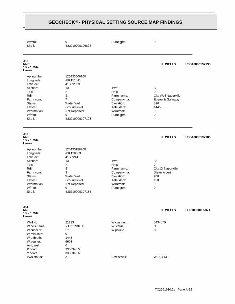
TC2991930.2s Page A-32
WL21113Sdwis well:APws status:3366343.5Y coord:3366343.5X coord:0Amb well:6693W aquifer:1445W d depth:0W min setb:
CW policy:B2W suscept:BW status:NAPERVILLEW cws name:0434670W cws num:21113Well id:
J54NNE1/2 - 1 MileLower
ILEP10000005371IL WELLS
ILSG10000197185Site id:0Pumpgpm:0Wfmto:0Wfmfrom:Not ReportedWformation:130Total dept:Ground levelElevref:700Elevation:Water WellStatus:Dieter AlbertCompany na:3Farm num:City Of NapervilleFarm name:ERdir:9Rng:NTdir:38Twp:13Section:
41.77244Latitude:-88.150569Longitude:120430158800Api number:
J53NNE1/2 - 1 MileLower
ILSG10000197185IL WELLS
ILSG10000197195Site id:0Pumpgpm:0Wfmto:0Wfmfrom:Not ReportedWformation:1445Total dept:Ground levelElevref:690Elevation:Water WellStatus:Egerer & GallowayCompany na:7Farm num:City Well NapervilleFarm name:ERdir:9Rng:NTdir:38Twp:13Section:
41.772583Latitude:-88.151011Longitude:120430006100Api number:
J52NNE1/2 - 1 MileLower
ILSG10000197195IL WELLS
ILSG10000196638Site id:0Pumpgpm:0Wfmto:
GEOCHECK - PHYSICAL SETTING SOURCE MAP FINDINGS®

TC2991930.2s Page A-33
L57West1/2 - 1 MileLower
ILSG10000196255IL WELLS
ILSG10000196254Site id:0Pumpgpm:180Wfmto:54Wfmfrom:limestoneWformation:180Total dept:Not ReportedElevref:0Elevation:Water WellStatus:Liberg, Thomas P.Company na:Not ReportedFarm num:Buxtin, MelFarm name:ERdir:9Rng:NTdir:38Twp:23Section:
41.762935Latitude:-88.175786Longitude:120432906100Api number:
L56West1/2 - 1 MileLower
ILSG10000196254IL WELLS
J P MILLER ART WELLDriller:Construction Report,Geology,Chemical AnalysisRecord Type:
--Well Type:DomesticWell Use:3GPlot Location:23Section:09ERange:38NTownship:DUPAGECounty:043County Code:BedrockAquifer Type:210Depth (in feet):07/21/1956Date Drilled:Not ReportedPermit:
MEADOW CONSTRUCTION COOwner:IL Private Water Wells SurveyInfo Source:
Not ReportedSecond ID:181739Well ID:
55WNW1/2 - 1 MileLower
P13055IL WELLS
ILEP10000005371Site id:12/30/1899Updt ts:Not ReportedSection:Not ReportedRange:Not ReportedTownship:Not ReportedMeridian:
0Long dec d:0Lat dec de:0Pop cnt:
Not ReportedB name:Not ReportedFed type c:Not ReportedStatus cd:Not ReportedPrn cnty:Not ReportedFips cd:Not ReportedZip code:Not ReportedState code:Not ReportedCity name:
Not ReportedAddr two t:Not ReportedAddr one t:Not ReportedFacility n:Not ReportedFac name:0Cwswell merg are:
120430006100Api:IL0434670Sys number:
GEOCHECK - PHYSICAL SETTING SOURCE MAP FINDINGS®

TC2991930.2s Page A-34
L60West1/2 - 1 MileLower
P13056IL WELLS
Not ReportedDriller:Construction Report,GeologyRecord Type:
--Well Type:DomesticWell Use:6APlot Location:19Section:10ERange:38NTownship:DUPAGECounty:043County Code:BedrockAquifer Type:100Depth (in feet):00/00/1890Date Drilled:Not ReportedPermit:
MATILDA ORYOwner:IL Private Water Wells SurveyInfo Source:
Not ReportedSecond ID:183023Well ID:
59ESE1/2 - 1 MileLower
P14405IL WELLS
ILSG10000195796Site id:0Pumpgpm:0Wfmto:0Wfmfrom:Not ReportedWformation:100Total dept:Not ReportedElevref:0Elevation:Water WellStatus:Feuerborn, RayCompany na:Not ReportedFarm num:Sewage Treat PlantFarm name:ERdir:10Rng:NTdir:38Twp:19Section:
41.758854Latitude:-88.140551Longitude:120430164800Api number:
58ESE1/2 - 1 MileLower
ILSG10000195796IL WELLS
ILSG10000196255Site id:0Pumpgpm:180Wfmto:54Wfmfrom:limestoneWformation:180Total dept:Not ReportedElevref:0Elevation:Water WellStatus:Liberg, Thomas P.Company na:Not ReportedFarm num:Buxtin, MelFarm name:ERdir:9Rng:NTdir:38Twp:23Section:
41.762935Latitude:-88.175786Longitude:120432902200Api number:
GEOCHECK - PHYSICAL SETTING SOURCE MAP FINDINGS®

TC2991930.2s Page A-35
LIBERGDriller:Construction Report,GeologyRecord Type:
--Well Type:DomesticWell Use:4EPlot Location:23Section:09ERange:38NTownship:DUPAGECounty:043County Code:BedrockAquifer Type:180Depth (in feet):05/08/1991Date Drilled:019746Permit:
MEL BUXTIN #91-039Owner:IL Private Water Wells SurveyInfo Source:
Not ReportedSecond ID:227880Well ID:
GEOCHECK - PHYSICAL SETTING SOURCE MAP FINDINGS®

TC2991930.2s Page A-36
6054014.8605401.3605402.8605404.9605406.1605400.3605402.3605402.5605400.3605404.1605401.1605402.3605405.1605402.96054010.8605408.1605401.1605406.5605400.4605400.5605408.8605400605400.6605406.46054011.9605402.3605400.8605401.4605402605400.6605407605404.4605402.9605405.5605405605401.7605401.96054010.4605404.3605405.3605405.9605403.3605400.3605402.5605408.9605400.860540
___________ResultZipcode
Radon Test Results
State Database: IL Radon
AREA RADON INFORMATION
GEOCHECK - PHYSICAL SETTING SOURCE MAP FINDINGSRADON
®

TC2991930.2s Page A-37
605403.5605400.5605402605406605406605400.56054014.6605403.46054012.8605401.4605407.3605404.5605400.96054016054010.3605401.8605405.4605404.4605400605404605404605401.7605403605400.4605403.2605400.9605401.4605401.56054028.9605401.5605404605401.1605401.4605404.9605402605403.9605404.6605400.7605406.7605407605403.3605407.4605404.2605400.6605401.2605402.6605404.2605401605400.6605405.5605403605401.7605405.2605405.1605401.9605401.8
AREA RADON INFORMATION
GEOCHECK - PHYSICAL SETTING SOURCE MAP FINDINGSRADON
®

TC2991930.2s Page A-38
605400.4605401.4605402.7605403605402.7605400.9605401.9605401.86054015605400.36054012605400.5605400.2605403.1605401.76054018.3605407.9605402.8605401.1605401.6605400.4605402.6605401.3605403.4605400.3605403.1605407.3605402.760540166054017.5605402.5605401.9605401.6605402.6605401.2605402.8605402.6605402.1605403.3605408.4605405.4605401.9605402.1605406.4605402.8605404.1605405605400.1605401605404.3605402.6605407.5605403.2605406.3605407.6605402.3
AREA RADON INFORMATION
GEOCHECK - PHYSICAL SETTING SOURCE MAP FINDINGSRADON
®

TC2991930.2s Page A-39
605400605405.3605402.7605405.8605407.8605400.5605400.1605400.7605401.2605401.2605400.6605403.4605405.3605403.8605401.1605407.1605404.9605402.3605401.2605408.26054016054018.26054016.5605400.4605403.4605403.9605405.1605400.9605402.3605404.3605400.3605401.6605405.1605402.5605400.4605400.5605403.5605403.5605400.56054006054012.4605401.2605404.3605408.3605406.2605401.26054026054011.2605407.2605402.6605402.2605403605401.8605402.5605402.46054019.3
AREA RADON INFORMATION
GEOCHECK - PHYSICAL SETTING SOURCE MAP FINDINGSRADON
®

TC2991930.2s Page A-40
605407.2605405.8605400.5605405.1605407.9605405.7605401.3605400.7605400.8605402605401.5605400.8605400.5605404.6605401.3605403.5605406605400.9605407.6605402.6605405.6605405.9605405.66054012.26054010.5605401.9605401.3605405.6605401605402.76054016.7605404605403605403.3605400.36054022.9605402.7605407.4605406.4605400.86054011.7605409.9605401.8605401.7605403.6605400.46054012.7605402.7605405.1605400.36054014.6605401.5605402.2605401.6605402.5605405.2
AREA RADON INFORMATION
GEOCHECK - PHYSICAL SETTING SOURCE MAP FINDINGSRADON
®
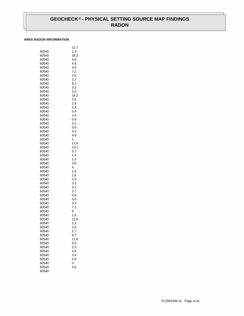
TC2991930.2s Page A-41
605405.6605400605404.6605403.4605404.8605402.3605405.56054012.8605408.7605402.7605402.6605402.36054012.6605401.9605406605407.1605403.3605400.6605400.8605402.7605403.2605403.1605400.4605402.6605401.6605404605403.8605401.5605401.4605405.76054013.16054017.6605401605404.9605405.5605400.6605405.1605400.6605402.6605400.4605402.8605402.9605402.66054014.2605403.3605403.2605408.1605403.2605402.6605407.1605403.6605404.5605404.96054028.3605401.46054012.7
AREA RADON INFORMATION
GEOCHECK - PHYSICAL SETTING SOURCE MAP FINDINGSRADON
®

TC2991930.2s Page A-42
605407.4605406.1605402.8605400.9605400.3605400605406.6605402605403.9605400.9605400.8605402.1605404.4605406.4605404.3605403.1605403.2605400.6605400.460540-0.9605404.2605401.26054013.4605403.7605400.6605408.6605400605402.8605401.4605405.3605400.3605403.3605406.8605402.5605404.8605407.2605400.6605406.5605403.7605406.6605403.8605401.3605403.1605400.4605400605401.5605408.1605402.8605402.7605409.9605406.7605401.5605403.5605402.96054012.7605405.9
AREA RADON INFORMATION
GEOCHECK - PHYSICAL SETTING SOURCE MAP FINDINGSRADON
®

TC2991930.2s Page A-43
605402.2605405.3605400.8605400.8605403.1605400.5605400.9605407.1605401.9605400.6605406.46054014.1605408.7605404.4605402.7605403.56054011.3605400.6605409.8605401.1605400.4605403.6605402.1605406.56054018.4605400.5605406.2605400.6605406.6605402605409.8605402.5605402.16054011.7605405.1605407.6605401.9605401.6605404.3605402.4605401.36054010.3605400.6605400.9605403.4605404.1605401.8605404.6605400.6605406.8605405.3605407.8605404.86054010.96054011.6605403.3
AREA RADON INFORMATION
GEOCHECK - PHYSICAL SETTING SOURCE MAP FINDINGSRADON
®

TC2991930.2s Page A-44
605400.5605408.8605404.1605404.5605401.2605407.5605406.7605404605408.9605402605406.6605401605401.7605402.4605405.8605402.5605402605402.7605403.36054011.7605401605401605400.66054011605408.7605403.26054017.5605403.1605400.5605407.3605402.5605404.66054016.9605406.1605408.5605405.2605400605405.6605401.1605405.8605402.9605405.1605402.6605404.4605406.2605401.3605403.36054010.1605404.1605408605400.8605401.3605401.5605400.3605402.5605404.4
AREA RADON INFORMATION
GEOCHECK - PHYSICAL SETTING SOURCE MAP FINDINGSRADON
®

TC2991930.2s Page A-45
605403605404.1605400.1605403.1605404.4605400.5605401.2605407.3605402.1605401.1605402.6605407.5605401.16054011605403.1605402.9605406605402605407.96054017.3605405.3605404.1605400.7605401.8605400.36054021605400.4605402.4605408.6605402.6605404.8605407.1605407.1605402.2605407.2605401.6605402.4605403.2605403.4605400.4605402.560540136054012.2605402.3605401.6605404.1605404.3605409.8605404.2605401.86054013.5605400.1605402.8605405.2605401.9605402.8
AREA RADON INFORMATION
GEOCHECK - PHYSICAL SETTING SOURCE MAP FINDINGSRADON
®

TC2991930.2s Page A-46
0%0%100%2.800 pCi/LBasementNot ReportedNot ReportedNot ReportedNot ReportedLiving Area - 2nd FloorNot ReportedNot ReportedNot ReportedNot ReportedLiving Area - 1st Floor
% >20 pCi/L% 4-20 pCi/L% <4 pCi/LAverage ActivityArea
Number of sites tested: 3
Federal Area Radon Information for Zip Code: 60540
: Zone 3 indoor average level < 2 pCi/L. : Zone 2 indoor average level >= 2 pCi/L and <= 4 pCi/L. Note: Zone 1 indoor average level > 4 pCi/L.
Federal EPA Radon Zone for DUPAGE County: 2
7.9605401605400.5605401.6605402.1605403.5605401.36054015605403.2
AREA RADON INFORMATION
GEOCHECK - PHYSICAL SETTING SOURCE MAP FINDINGSRADON
®

TOPOGRAPHIC INFORMATION
USGS 7.5’ Digital Elevation Model (DEM)Source: United States Geologic SurveyEDR acquired the USGS 7.5’ Digital Elevation Model in 2002 and updated it in 2006. The 7.5 minute DEM correspondsto the USGS 1:24,000- and 1:25,000-scale topographic quadrangle maps. The DEM provides elevation datawith consistent elevation units and projection.
Scanned Digital USGS 7.5’ Topographic Map (DRG)Source: United States Geologic SurveyA digital raster graphic (DRG) is a scanned image of a U.S. Geological Survey topographic map. The map imagesare made by scanning published paper maps on high-resolution scanners. The raster imageis georeferenced and fit to the Universal Transverse Mercator (UTM) projection.
HYDROLOGIC INFORMATION
Flood Zone Data: This data, available in select counties across the country, was obtained by EDR in 2003 & 2009 from the FederalEmergency Management Agency (FEMA). Data depicts 100-year and 500-year flood zones as defined by FEMA.
NWI: National Wetlands Inventory. This data, available in select counties across the country, was obtained by EDRin 2002 and 2005 from the U.S. Fish and Wildlife Service.
HYDROGEOLOGIC INFORMATION
AQUIFLOW Information SystemR
Source: EDR proprietary database of groundwater flow informationEDR has developed the AQUIFLOW Information System (AIS) to provide data on the general direction of groundwater
flow at specific points. EDR has reviewed reports submitted to regulatory authorities at select sites and hasextracted the date of the report, hydrogeologically determined groundwater flow direction and depth to water tableinformation.
GEOLOGIC INFORMATION
Geologic Age and Rock Stratigraphic UnitSource: P.G. Schruben, R.E. Arndt and W.J. Bawiec, Geology of the Conterminous U.S. at 1:2,500,000 Scale - A digitalrepresentation of the 1974 P.B. King and H.M. Beikman Map, USGS Digital Data Series DDS - 11 (1994).
STATSGO: State Soil Geographic DatabaseSource: Department of Agriculture, Natural Resources Conservation ServicesThe U.S. Department of Agriculture’s (USDA) Natural Resources Conservation Service (NRCS) leads the nationalConservation Soil Survey (NCSS) and is responsible for collecting, storing, maintaining and distributing soilsurvey information for privately owned lands in the United States. A soil map in a soil survey is a representationof soil patterns in a landscape. Soil maps for STATSGO are compiled by generalizing more detailed (SSURGO)soil survey maps.
SSURGO: Soil Survey Geographic DatabaseSource: Department of Agriculture, Natural Resources Conservation Services (NRCS)Telephone: 800-672-5559SSURGO is the most detailed level of mapping done by the Natural Resources Conservation Services, mappingscales generally range from 1:12,000 to 1:63,360. Field mapping methods using national standards are used toconstruct the soil maps in the Soil Survey Geographic (SSURGO) database. SSURGO digitizing duplicates theoriginal soil survey maps. This level of mapping is designed for use by landowners, townships and countynatural resource planning and management.
TC2991930.2s Page A-47
PHYSICAL SETTING SOURCE RECORDS SEARCHED

LOCAL / REGIONAL WATER AGENCY RECORDS
FEDERAL WATER WELLS
PWS: Public Water SystemsSource: EPA/Office of Drinking WaterTelephone: 202-564-3750Public Water System data from the Federal Reporting Data System. A PWS is any water system which provides water to at
least 25 people for at least 60 days annually. PWSs provide water from wells, rivers and other sources.
PWS ENF: Public Water Systems Violation and Enforcement DataSource: EPA/Office of Drinking WaterTelephone: 202-564-3750Violation and Enforcement data for Public Water Systems from the Safe Drinking Water Information System (SDWIS) after
August 1995. Prior to August 1995, the data came from the Federal Reporting Data System (FRDS).
USGS Water Wells: USGS National Water Inventory System (NWIS)This database contains descriptive information on sites where the USGS collects or has collected data on surfacewater and/or groundwater. The groundwater data includes information on wells, springs, and other sources of groundwater.
STATE RECORDS
Water Well RecordsSource: Illinois Geological SurveyTelephone: 217-333-4747
Illinois Private Well Database and PICS (Public, Industrial, Commercial Survey)Source: Illinois State Water SurveyTelephone: 217-333-9043
Water Well Location InformationSource: Illinois Environmental Protection AgencyTelephone: 217-782-0810
OTHER STATE DATABASE INFORMATION
RADON
State Database: IL RadonSource: Department of Nuclear SafetyTelephone: 217-785-9958County Radon Results
Area Radon InformationSource: USGSTelephone: 703-356-4020The National Radon Database has been developed by the U.S. Environmental Protection Agency(USEPA) and is a compilation of the EPA/State Residential Radon Survey and the National Residential Radon Survey.The study covers the years 1986 - 1992. Where necessary data has been supplemented by information collected atprivate sources such as universities and research institutions.
EPA Radon ZonesSource: EPATelephone: 703-356-4020Sections 307 & 309 of IRAA directed EPA to list and identify areas of U.S. with the potential for elevated indoorradon levels.
OTHER
Airport Landing Facilities: Private and public use landing facilitiesSource: Federal Aviation Administration, 800-457-6656
Epicenters: World earthquake epicenters, Richter 5 or greaterSource: Department of Commerce, National Oceanic and Atmospheric Administration
TC2991930.2s Page A-48
PHYSICAL SETTING SOURCE RECORDS SEARCHED

STREET AND ADDRESS INFORMATION
© 2010 Tele Atlas North America, Inc. All rights reserved. This material is proprietary and the subject of copyright protectionand other intellectual property rights owned by or licensed to Tele Atlas North America, Inc. The use of this material is subjectto the terms of a license agreement. You will be held liable for any unauthorized copying or disclosure of this material.
TC2991930.2s Page A-49
PHYSICAL SETTING SOURCE RECORDS SEARCHED