Embed Size (px)
Citation preview

This profile and the data therein should not be used in place of focussed assessments and information provided by local monitoring and research institutions.
Appendix B – Region 8
Country and regional profiles of volcanic hazard and risk:
Japan, Taiwan and Marianas
S.K. Brown1, R.S.J. Sparks1, K. Mee2, C. Vye-Brown2, E.Ilyinskaya2, S.F. Jenkins1, S.C. Loughlin2*
1University of Bristol, UK; 2British Geological Survey, UK, * Full contributor list available in Appendix B Full Download
This download comprises the profiles for Region 8: Japan, Taiwan and Marianas only. For the full
report and all regions see Appendix B Full Download. Page numbers reflect position in the full report.
The following countries are profiled here:
Region 8 Japan, Taiwan, Marianas Pg.399
Japan 407
Taiwan 417
USA – Marianas Islands 423
Brown, S.K., Sparks, R.S.J., Mee, K., Vye-Brown, C., Ilyinskaya, E., Jenkins, S.F., and Loughlin, S.C. (2015) Country and regional profiles of volcanic hazard and risk. In: S.C. Loughlin, R.S.J. Sparks, S.K. Brown, S.F. Jenkins & C. Vye-Brown (eds) Global Volcanic Hazards and Risk, Cambridge: Cambridge University Press.

This profile and the data therein should not be used in place of focussed assessments and information provided by local monitoring and research institutions.
Region 8: Japan, Taiwan, Marianas
Figure 8.1 The distribution of Holocene volcanoes through the Melanesia and Australia region. The capital cities of the constituent countries are shown.
Description
Region 8: Japan, Taiwan and the Marianas comprises volcanoes through the main Japanese arc, the
Izu Islands, Marianas Islands and the Ryuku Islands. Taiwan is considered here, separately to China.
Three countries are represented here. All are included in this regional discussion and individual
country profiles are provided.

400
Country Number of volcanoes
Japan 114 Taiwan 8 USA – Marianas 21
Table 8.1 The countries represented in this region and the number of volcanoes. Volcanoes located on the borders between countries are included in the profiles of all countries involved. Note that countries may be represented in more than one region, as overseas territories may be widespread.
143 volcanoes are located in Japan, Taiwan and the Marianas. Most of these volcanoes are in Japan.
Although at the junction of a number of plates, volcanism in this region can broadly be described as
related to the subduction of the Pacific Plate beneath the Eurasian Plate.
A large number (26) of submarine volcanoes are located in this region, along the Izu-Marianas arc.
Subaerial volcanoes vary in form throughout the region, though most (64) are stratovolcanoes and
complex volcanoes. The rock type through this region is dominantly andesitic, though ranges from
basaltic to rhyolitic.
A range of activity styles and magnitudes are recorded through the Holocene, with eruptions of VEI 0
to 7. About 75% of eruptions here have been small, at VEI 0 to 2, however 117 eruptions (over 10%)
have been large explosive VEI ≥4 events. These VEI ≥4 eruptions have largely been restricted to
Japan, with just three in the Marianas Islands. The largest Holocene eruption in this region was the
VEI 7 eruption of the Akahoya tephra from Kikai, in about 4350 BC. This eruption produced
pyroclastic flows that travelled 100 km across the sea and produced widespread ash fall, devastating
southern and central Kyushu.
Seventy-seven volcanoes have historical records of 874 eruptions, 97% of which were dated through
direct observations. The large number of geological age (pre-1500 AD) eruptions reflects a relatively
detailed Holocene record achieved through significant tephrochronological studies. 6% of historical
events have produced pyroclastic flows and 8% have resulted in lahars. A further 8% have produced
lava flows.
About 9% of historical eruptions (77) have resulted in loss of life. Most volcanoes have a small
proximal population, largely reflecting the number of submarine volcanoes. About a quarter of
volcanoes have a high local population. The risk levels reflect the varying population size and
assigned hazard scores. Eleven volcanoes here are classed at Risk Level III (24% of classified
volcanoes), reflecting large population sizes and frequent and/or large explosive eruptions. All Risk
Level III volcanoes are in Japan.
Monitoring and research groups are active in Japan, Taiwan and the Marianas Islands, with
monitoring focussed on the volcanoes of higher risk.
Volcano Facts
Number of Holocene volcanoes 143
Number of Pleistocene volcanoes with M≥4 eruptions 91
Number of volcanoes generating pyroclastic flows 52 (160 eruptions)
401
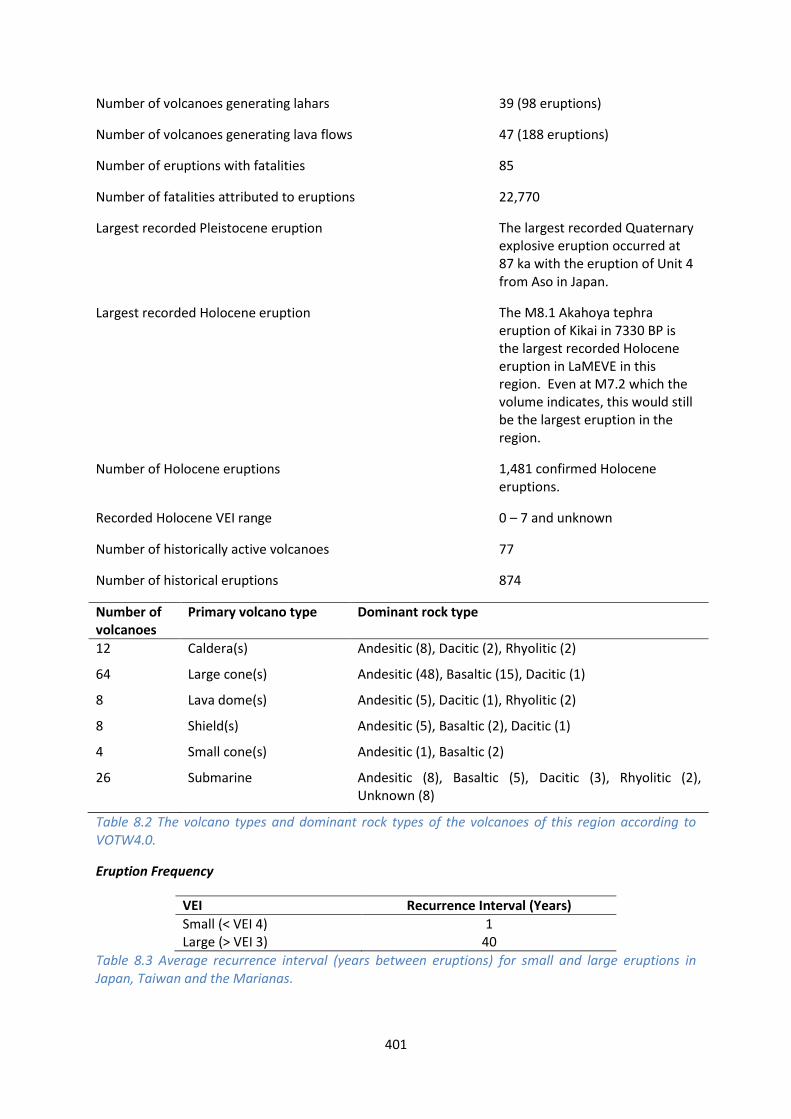
Number of volcanoes generating lahars 39 (98 eruptions)
Number of volcanoes generating lava flows 47 (188 eruptions)
Number of eruptions with fatalities 85
Number of fatalities attributed to eruptions 22,770
Largest recorded Pleistocene eruption The largest recorded Quaternary explosive eruption occurred at 87 ka with the eruption of Unit 4 from Aso in Japan.
Largest recorded Holocene eruption The M8.1 Akahoya tephra eruption of Kikai in 7330 BP is the largest recorded Holocene eruption in LaMEVE in this region. Even at M7.2 which the volume indicates, this would still be the largest eruption in the region.
Number of Holocene eruptions 1,481 confirmed Holocene eruptions.
Recorded Holocene VEI range 0 – 7 and unknown
Number of historically active volcanoes 77
Number of historical eruptions 874
Number of volcanoes
Primary volcano type Dominant rock type
12 Caldera(s) Andesitic (8), Dacitic (2), Rhyolitic (2)
64 Large cone(s) Andesitic (48), Basaltic (15), Dacitic (1)
8 Lava dome(s) Andesitic (5), Dacitic (1), Rhyolitic (2)
8 Shield(s) Andesitic (5), Basaltic (2), Dacitic (1)
4 Small cone(s) Andesitic (1), Basaltic (2)
26 Submarine Andesitic (8), Basaltic (5), Dacitic (3), Rhyolitic (2), Unknown (8)
Table 8.2 The volcano types and dominant rock types of the volcanoes of this region according to VOTW4.0.
Eruption Frequency
VEI Recurrence Interval (Years)
Small (< VEI 4) 1 Large (> VEI 3) 40
Table 8.3 Average recurrence interval (years between eruptions) for small and large eruptions in Japan, Taiwan and the Marianas.

402
The eruption record indicates that on average small to moderate sized eruptions of VEI <4 occur in
this region with an average recurrence interval (ARI) of about a year, whilst the ARI for large
eruptions is longer, at about 40 years.
Eruption Size
Eruptions are recorded through the Japan, Taiwan and Marianas region of VEI 0 to 7, representing a
range of eruption styles from gentle effusive events to very large explosive eruptions. VEI 2 events
dominate the record, with about 50% of all Holocene eruptions classed as such. Just over 10% of
eruptions here are explosive at VEI ≥4.
Figure 8.2 Percentage of eruptions in this region recorded at each VEI level; the number of eruptions is also shown. The percentage is of total eruptions with recorded VEI. A further 326 eruptions were recorded with unknown VEI.
Socio-Economic Facts
Total population (2011) 150,587,372
Gross Domestic Product (GDP) per capita (2005 PPP $) 30,660 (Japan)
Gross National Income (GNI) per capita (2005 PPP $) 32,545 (Japan)
Human Development Index (HDI) (2012) 0.912 (Very High, Japan)
Population Exposure
Number (percentage) of people living within 10 km of a Holocene volcano
1,234,976 (0.82 %)
Number (percentage) of people living within 30 km of a Holocene 17,144,484 (11.39 %)
403
volcano
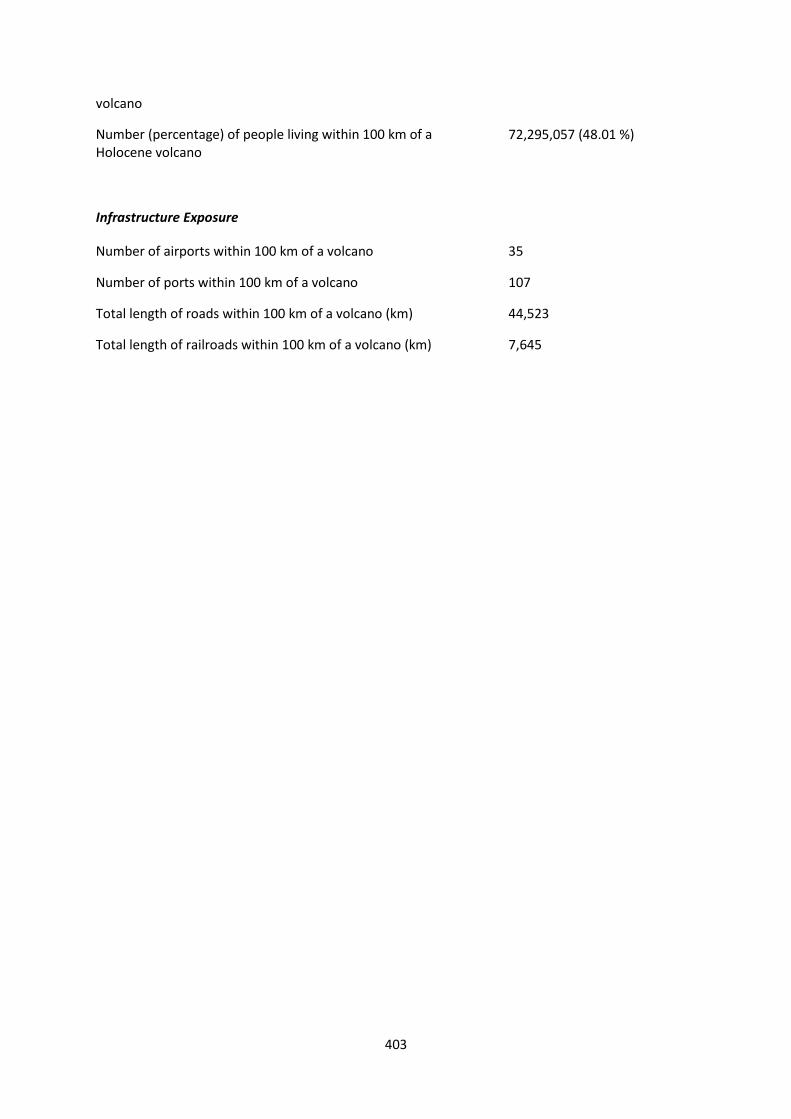
Number (percentage) of people living within 100 km of a Holocene volcano
72,295,057 (48.01 %)
Infrastructure Exposure
Number of airports within 100 km of a volcano 35
Number of ports within 100 km of a volcano 107
Total length of roads within 100 km of a volcano (km) 44,523
Total length of railroads within 100 km of a volcano (km) 7,645
404
CLA
SSIF
IED
Hazard
III Pagan; Anatahan Aogashima
Tokachidake; Rausudake
Hakusan; Niigata-Yakeyama; Towada; Hachijojima; Mashu
Fujisan; Hokkaido-Komagatake; Toya (Usu)
Aira; Unzendake; Shikotsu
Hazard II
Suwanosejima; Kuchinoerabujima; Kikai
Kirishimayama; Yakedake; Kurikomayama; Chokaisan; Akita-Komagatake; Akita-Yakeyama; Iwakisan
Ibusuki Volcanic Field; Asamayama; Kusatsu-Shiranesan; Bandaisan; Zaozan
Hazard I Farallon de Pajaros
Io-Torishima; Myojinsho; Izu-Torishima; Ioto; Fukutoku-Oka-no-Ba; Shiretoko-Iozan
Miyakejima; Akan
Nikko-Shiranesan; Nasudake; Azumayama; Hakkodasan
Asosan; Izu-Oshima
UN
CLA
SSIF
IED
U – HHR
Sumisujima; Nishinoshima; Kaitoku Seamount; Minami-Hiyoshi; Fukujin; Kasuga; Ahyi; Supply Reef; Asuncion; Agrigan; Guguan; South Sarigan Seamount
Submarine Volcano NNE of Iriomotejima; Yokoate-jima; Nakanoshima; Kita-Ioto; Kita-Fukutokutai; Oshima-Oshima; Ruby; NW Rota-1
Esan; Taisetsuzan; Maruyama; Unnamed (281030)
Ontakesan; Midagahara; Hiuchigatake
Kujusan; Adatarayama; Iwatesan; Osorezan; Kuttara; Kueishantao
Izu-Tobu
U- HR Alamagan Kuchinoshima; Mikurajima
Megata; Niijima; Kozushima; Rishirizan
Abu; Sanbesan; Norikuradake; Numazawa; Hachimantai; Toshima; Niseko; Yoteizan; Kussharo
Fukue; Yokodake; Myokosan; Nantai; Omanago Group; Takaharayama; Naruko
Yonemaru-Sumiyoshiike; Yufu-Tsurumi; Hakoneyama; Harunasan
Tatun Group
U- NHHR
Sofugan; Suiyo Seamount; Mokuyo Seamount; Sarigan; Doyo Seamount; Kaikata Seamount; Unnamed; Nikko; Minami Kasuga; NW Eifuku; Daikoku; Tenchozan; Unnamed (281010); Unnamed (281011); Zengyu; Unnamed (284138); Unnamed (284139); Maug Islands; Zealandia Bank
Akuseki-jima; Kogaja-jima; Kurose Hole; Kita-Bayonnaise; Unnamed (281020); East Diamante; Esmeralda Bank; Forecast Seamount; Seamount X
Shikaribetsu Group
Oki-Dogo; Washiba-Kumonotaira; Unnamed (281040)
Shiga; Akagisan; Hijiori
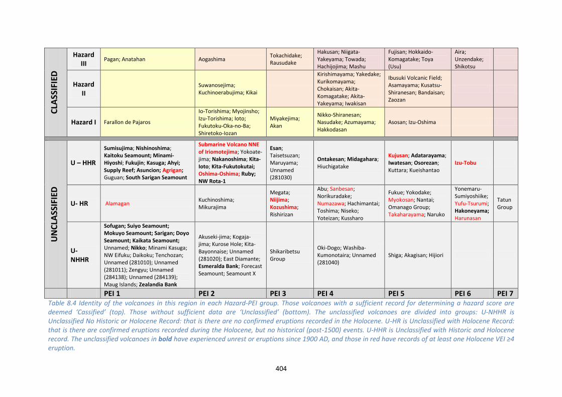
PEI 1 PEI 2 PEI 3 PEI 4 PEI 5 PEI 6 PEI 7 Table 8.4 Identity of the volcanoes in this region in each Hazard-PEI group. Those volcanoes with a sufficient record for determining a hazard score are deemed ‘Cassified’ (top). Those without sufficient data are ‘Unclassified’ (bottom). The unclassified volcanoes are divided into groups: U-NHHR is Unclassified No Historic or Holocene Record: that is there are no confirmed eruptions recorded in the Holocene. U-HR is Unclassified with Holocene Record: that is there are confirmed eruptions recorded during the Holocene, but no historical (post-1500) events. U-HHR is Unclassified with Historic and Holocene record. The unclassified volcanoes in bold have experienced unrest or eruptions since 1900 AD, and those in red have records of at least one Holocene VEI ≥4 eruption.

405
Population Exposure Index
Number of Volcanoes Population Exposure Index
1 7 8 6
26 5 31 4 13 3 29 2 35 1
Table 8.5 The number of volcanoes in Japan, Taiwan and the Marianas classed in each PEI category.
Risk Levels
Number of Volcanoes Risk Level
11 III 17 II 18 I 97 Unclassified
Table 8.6 The number of volcanoes in the Japan, Taiwan and Marianas region classified at each Risk Level.
Figure 8.3 Distribution of the classified volcanoes of this region across Hazard and Population Exposure Index levels. The warming of the background colours illustrates increasing Risk levels from Risk Level I - III.

406
Regional Monitoring Capacity
Figure 8.4 The monitoring and risk levels of the historically active volcanoes in Taiwan. Monitoring Level 1 indicates no known dedicated ground-based monitoring; Monitoring Level 2 indicates that some ground-based monitoring systems are in place including ≤3 seismic stations; Monitoring Level 3 indicates the presence of a dedicated ground-based monitoring network, including ≥4 seismometers.

This profile and the data therein should not be used in place of focussed assessments and information provided by local monitoring and research institutions.
Japan
Description
Figure 8.5 Distribution of volcanoes. The capital and largest cities in Japan are shown.
130 Holocene volcanoes are listed in Volcanoes of the World 4.0 as located throughout the islands of
Japan. The subduction of the Pacific Plate beneath the Eurasian and Philippine Plates has given rise
to extensive volcanism, with a range of volcano types. Subaerial volcanism is dominated by andesitic
stratovolcanoes, complexes and calderas, and extensive submarine volcanism occurs throughout the
Izu-Ogasawara and Ryuku Islands.
The current listing of volcanoes in VOTW4.0 differs from that of the Geological Survey of Japan and
Japan Meteorological Agency (JMA), who consider 110 volcanoes to have had Holocene activity. The
most recent activity at the remaining volcanoes is considered to have been Pleistocene in age. Some
408
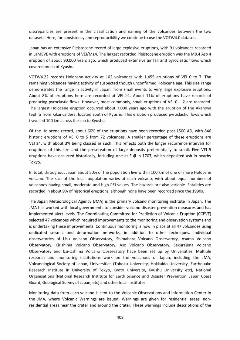
discrepancies are present in the classification and naming of the volcanoes between the two
datasets. Here, for consistency and reproducibility we continue to use the VOTW4.0 dataset.
Japan has an extensive Pleistocene record of large explosive eruptions, with 91 volcanoes recorded
in LaMEVE with eruptions of VEI/M≥4. The largest recorded Pleistocene eruption was the M8.4 Aso 4
eruption of about 90,000 years ago, which produced extensive air fall and pyroclastic flows which
covered much of Kyushu.
VOTW4.22 records Holocene activity at 102 volcanoes with 1,455 eruptions of VEI 0 to 7. The
remaining volcanoes having activity of suspected though unconfirmed Holocene age. This size range
demonstrates the range in activity in Japan, from small events to very large explosive eruptions.
About 8% of eruptions here are recorded at VEI ≥4. About 11% of eruptions have records of
producing pyroclastic flows. However, most commonly, small eruptions of VEI 0 – 2 are recorded.
The largest Holocene eruption occurred about 7,000 years ago with the eruption of the Akahoya
tephra from Kikai caldera, located south of Kyushu. This eruption produced pyroclastic flows which
travelled 100 km across the sea to Kyushu.
Of the Holocene record, about 60% of the eruptions have been recorded post-1500 AD, with 846
historic eruptions of VEI 0 to 5 from 72 volcanoes. A smaller percentage of these eruptions are
VEI ≥4, with about 3% being classed as such. This reflects both the longer recurrence intervals for
eruptions of this size and the preservation of large deposits preferentially to small. Five VEI 5
eruptions have occurred historically, including one at Fuji in 1707, which deposited ash in nearby
Tokyo.
In total, throughout Japan about 50% of the population live within 100 km of one or more Holocene
volcano. The size of the local population varies at each volcano, with about equal numbers of
volcanoes having small, moderate and high PEI values. The hazards are also variable. Fatalities are
recorded in about 9% of historical eruptions, although none have been recorded since the 1990s.
The Japan Meteorological Agency (JMA) is the primary volcano monitoring institute in Japan. The
JMA has worked with local governments to consider volcano disaster prevention measures and has
implemented alert levels. The Coordinating Committee for Prediction of Volcanic Eruption (CCPVE)
selected 47 volcanoes which required improvements to the monitoring and observation systems and
is undertaking these improvements. Continuous monitoring is now in place at all 47 volcanoes using
dedicated seismic and deformation networks, in addition to other techniques. Individual
observatories of Usu Volcano Observatory, Shimabara Volcano Observatory, Asama Volcano
Observatory, Kirishima Volcano Observatory, Aso Volcano Observatory, Sakurajima Volcano
Observatory and Izu-Oshima Volcano Observatory have been set up by Universities. Multiple
research and monitoring institutions work on the volcanoes of Japan, including the JMA,
Volcanological Society of Japan, Universities (Tohoku University, Hokkaido University, Earthquake
Research Institute in University of Tokyo, Kyoto University, Kyushu University etc), National
Organisations (National Research Institute for Earth Science and Disaster Prevention, Japan Coast
Guard, Geological Survey of Japan, etc) and other local institutes.
Monitoring data from each volcano is sent to the Volcanic Observations and Information Center in
the JMA, where Volcanic Warnings are issued. Warnings are given for residential areas, non-
residential areas near the crater and around the crater. These warnings include descriptions of the

409
observed monitoring data and activity. Warnings are provided to the Japan Coast Guard, the
Ministry of Land, Infrastructure, Transport and Tourism, the media, emergency services, the NTT
(Nippon Telegraph and Telephone Corporation), prefectural offices and the public. Volcanic Alert
Levels of 1 to 5 are given with clear descriptions of appropriate action to take. These Levels and the
warnings given depend on the level of activity and the area affected. The regional VAAC is also
notified when appropriate.
See also:
Japan Meteorological Agency Volcanic Warnings:
/www.data.jma.go.jp/svd/vois/data/tokyo/STOCK/kaisetsu/English/level.html
National Research Institute for Earth Science and Disaster Prevention: www.bosai.go.jp/e/
National Catalogue of the Active Volcanoes in Japan, 4th Edition (JMA):
www.data.jma.go.jp/svd/vois/data/tokyo/STOCK/souran_eng/menu.htm
GSJ Quaternary volcano database: gbank.gsj.jp/volcano/Quat_Vol/volcano_list.html
Volcano Facts
Number of Holocene volcanoes 130
Number of Pleistocene volcanoes with M≥4 eruptions 95
Number of volcanoes generating pyroclastic flows 51
Number of volcanoes generating lahars 39
Number of volcanoes generating lava flows 42
Number of fatalities caused by volcanic eruptions ?>22,770
Tectonic setting Subduction zone
Largest recorded Pleistocene eruption The M8.4 eruption 4 of Aso, which occurred about 90,000 years ago.
Largest recorded Holocene eruption The eruption of the Akahoya tephra from Kikai volcano at 7330 BP is recorded as M8.1. The volume of this event indicates that the magnitude should be recalculated at M7.2, however this still would be classed as the largest eruption in Japan in the Holocene.
Number of Holocene eruptions 1,455 confirmed eruptions.
Recorded Holocene VEI range 0 -7 and unknown
410
Number of historically active volcanoes 72
Number of historical eruptions 846
Number of volcanoes
Primary volcano type Dominant rock type
13 Caldera(s) Andesitic (9), Dacitic (2), Rhyolitic (2)
77 Large cone(s) Andesitic (57), Basaltic (17), Dacitic (1), Unknown (2)
7 Lava dome(s) Andesitic (4), Dacitic (1), Rhyolitic (2)
8 Shield(s) Andesitic (5), Basaltic (2), Dacitic (1)
4 Small cone(s) Andesitic (1), Basaltic (2)
21 Submarine Andesitic (8), Basaltic (5), Dacitic (3), Rhyolitic (2), Unknown (3)
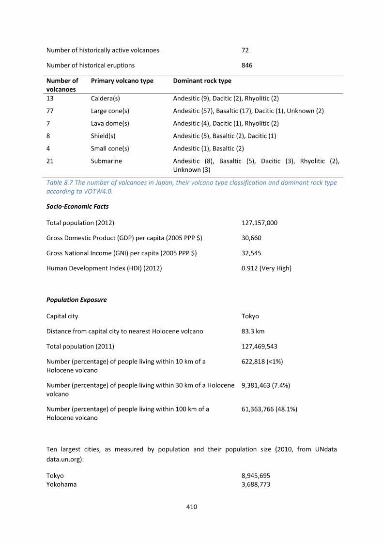
Table 8.7 The number of volcanoes in Japan, their volcano type classification and dominant rock type according to VOTW4.0.
Socio-Economic Facts
Total population (2012) 127,157,000
Gross Domestic Product (GDP) per capita (2005 PPP $) 30,660
Gross National Income (GNI) per capita (2005 PPP $) 32,545
Human Development Index (HDI) (2012) 0.912 (Very High)
Population Exposure
Capital city Tokyo
Distance from capital city to nearest Holocene volcano 83.3 km
Total population (2011) 127,469,543
Number (percentage) of people living within 10 km of a Holocene volcano
622,818 (<1%)
Number (percentage) of people living within 30 km of a Holocene volcano
9,381,463 (7.4%)
Number (percentage) of people living within 100 km of a Holocene volcano
61,363,766 (48.1%)
Ten largest cities, as measured by population and their population size (2010, from UNdata
data.un.org):
Tokyo 8,945,695 Yokohama 3,688,773
411
Osaka 2,665,314 Nagoya 2,263,894 Sapporo 1,913,545 Kobe 1,544,200 Kyoto 1,474,015 Fukuoka 1,463,743 Kawasaki 1,425,512 Saitama 1,222,434
Infrastructure Exposure
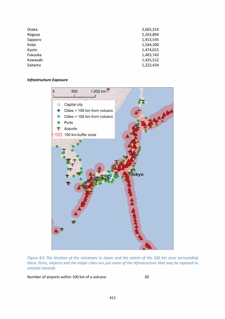
Figure 8.6 The location of the volcanoes in Japan and the extent of the 100 km zone surrounding them. Ports, airports and the major cities are just some of the infrastructure that may be exposed to volcanic hazards.
Number of airports within 100 km of a volcano 30

412
Number of ports within 100 km of a volcano 99
Total length of roads within 100 km of a volcano (km) 41,982
Total length of railroads within 100 km of a volcano (km) 7,097
Holocene volcanoes are distributed throughout Japan, placing large parts of the country within
100 km of these volcanoes. Many of the largest cities in Japan, including the capital, Tokyo, lie within
100 km of one or more volcanoes. This means that most of the critical infrastructure is exposed,
including nearly 100 ports, 30 airports including international airports, and a very extensive road and
rail network linking the islands.
Hazard, Uncertainty and Exposure Assessments
There are varying levels of data available in the eruption records of Japan’s volcanoes. About 40% of
the volcanoes here have enough data in their records to permit the calculation of the hazard, and
these volcanoes are classified across all three hazard levels, with approximately equal numbers of
volcanoes in each level.
Over 60% of the volcanoes have large uncertainties associated with the classification of the Hazard
level due to incomplete or sparse eruption records, and these are therefore unclassified. Indeed,
about a third of the unclassified volcanoes have no records of confirmed eruptions during the
Holocene, though of these, six have had episodes of apparent unrest since 1900 AD suggestive of
active systems. A further third of the unclassified volcanoes have Holocene records of eruptions
before 1500 AD, and the remaining third have had historical activity, including 15 volcanoes with
eruptions since 1900 AD. Twelve of the unclassified volcanoes have Holocene records of large
magnitude, VEI ≥4 eruptions.
The PEI ranges from low to high, with approximately equal numbers of low PEI, moderate PEI and
high PEI volcanoes. Some of the volcanoes with the highest hazard also have the highest PEI. The
classified volcanoes categorise in all three risk levels, with 11 classed at Risk Level III. Sakurajima
(Aira), with the highest Hazard level in Japan also has a very high local population, with over 110,000
living within 10 km, making this a Risk Level III volcano.
Table 8.8 (next page): Identity of Japan’s volcanoes in each Hazard-PEI group. Those volcanoes with a sufficient record for determining a hazard score are deemed ‘Classified’ (top). Those without sufficient data are ‘Unclassified’ (bottom). The unclassified volcanoes are divided into groups: U-NHHR is Unclassified No Historic or Holocene Record: that is there are no confirmed eruptions recorded in the Holocene. U-HR is Unclassified with Holocene Record: that is there are confirmed eruptions recorded during the Holocene, but no historical (post-1500) events. U-HHR is Unclassified with Historic and Holocene record. The unclassified volcanoes in bold have experienced unrest or eruptions since 1900 AD, and those in red have records of at least one Holocene VEI ≥4 eruption.

413
CLA
SSIF
IED
Hazard
III Aogashima
Tokachidake; Rausudake
Hakusan; Niigata-Yakeyama; Towada; Hachijojima; Mashu
Fujisan; Hokkaido-Komagatake; Toya (Usu)
Aira; Unzendake; Shikotsu
Hazard II Suwanosejima; Kuchinoerabujima; Kikai; Chachadake [Tiatia]; Etorofu-Yakeyama [Grozny Group]
Kirishimayama; Yakedake; Kurikomayama; Chokaisan; Akita-Komagatake; Akita-Yakeyama; Iwakisan
Ibusuki Volcanic Field; Asamayama; Kusatsu-Shiranesan; Bandaisan; Zaozan
Hazard I
Io-Torishima; Myojinsho; Izu-Torishima; Ioto; Fukutoku-Oka-no-Ba; Shiretoko-Iozan; Moyorodake [Medvezhia]
Miyakejima; Akan
Nikko-Shiranesan; Nasudake; Azumayama; Hakkodasan
Asosan; Izu-Oshima
UN
CLA
SSIF
IED
U – HHR
Sumisujima; Nishinoshima; Kaitoku Seamount; Minami-Hiyoshi; Fukujin; Kasuga
Submarine Volcano NNE of Iriomotejima; Yokoate-jima; Nakanoshima; Kita-Ioto; Kita-Fukutokutai; Oshima-Oshima; Tomariyama [Golovnin]; Raususan [Mendeleev]; Etorofu-Atosanupuri [Atosanupuri]; Sashiusudake [Baransky]; Chirippusan [Chirip]
Esan; Taisetsuzan; Maruyama
Ontakesan; Midagahara; Hiuchigatake
Kujusan; Adatarayama; Iwatesan; Osorezan; Kuttara
Izu-Tobu
U- HR Kuchinoshima; Mikurajima; Moekeshiwan [Lvinaya Past]
Megata; Niijima; Kozushima; Rishirizan
Abu; Sanbesan; Norikuradake; Numazawa; Hachimantai; Toshima; Niseko; Yoteizan; Kussharo
Fukue; Yokodake; Myokosan; Nantai; Omanago Group; Takaharayama; Naruko
Yonemaru-Sumiyoshiike; Yufu-Tsurumi; Hakoneyama; Harunasan
U- NHHR
Sofugan; Suiyo Seamount; Mokuyo Seamount; Doyo Seamount; Kaikata Seamount; Unnamed; Nikko; Minami Kasuga; NW Eifuku; Daikoku; Tenchozan; Odamoisan [Tebenkov]
Akuseki-jima; Kogaja-jima; Kurose Hole; Kita-Bayonnaise; Ruruidake [Smirnov]; Berutarubesan [Berutarube]; Nishihitokappuyama [Bogatyr Ridge]; Unnamed (290061); Rucharuyama [Golets-Tornyi Group]; Rakkibetsudake [Demon]
Shikaribetsu Group
Oki-Dogo; Washiba-Kumonotaira
Shiga; Akagisan; Hijiori
PEI 1 PEI 2 PEI 3 PEI 4 PEI 5 PEI 6 PEI 7

414
Volcano Population Exposure Index Risk Level
Aira 6 III Unzendake 6 III Shikotsu 6 III Fujisan 5 III Hokkaido-Komagatake 5 III Toya 5 III Ibusuki Volcanic Field 5 II Asosan 5 II Asamayama 5 II Kusatsu-Shiranesan 5 II Bandaisan 5 II Zaozan 5 II Izu-Oshima 5 II Hakusan 4 III Niigata-Yakeyama 4 III Towada 4 III Hachijojima 4 III Mashu 4 III Kirishimayama 4 II Yakedake 4 II Kurikomayama 4 II Chokaisan 4 II Akita-Komagatake 4 II Akita-Yakeyama 4 II Iwakisan 4 II Nikko-Shiranesan 4 I Nasudake 4 I Azumayama 4 I Hakkodasan 4 I Tokachidake 3 II Rausudake 3 II Miyakejima 3 I Akan 3 I Aogashima 2 II Chachadake [Tiatia] 2 I Etorofu-Yakeyama [Grozny Group] 2 I Fukutoku-Oka-no-Ba 2 I Io-Torishima 2 I Ioto 2 I Izu-Torishima 2 I Kuchinoerabujima 2 I Kikai 2 I Moyorodake [Medvezhia] 2 I Myojinsho 2 I Shiretoko-Iozan 2 I Suwanosejima 2 I
Table 8.9 Classified volcanoes ordered by descending Population Exposure Index (PEI). Risk levels determined through the combination of the Hazard Level and PEI are given. Risk Level I – 15 volcanoes; Risk Level II – 17 volcanoes; Risk Level III – 11 volcanoes.
415
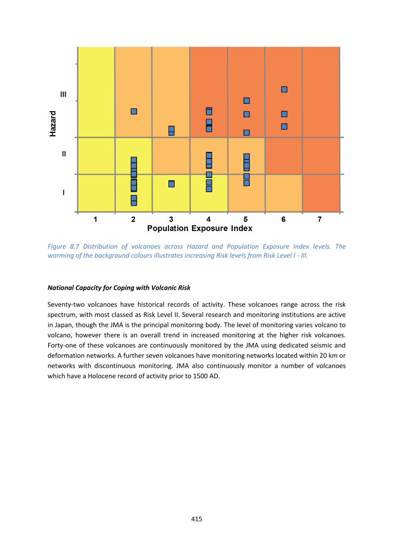
Figure 8.7 Distribution of volcanoes across Hazard and Population Exposure Index levels. The warming of the background colours illustrates increasing Risk levels from Risk Level I - III.
National Capacity for Coping with Volcanic Risk
Seventy-two volcanoes have historical records of activity. These volcanoes range across the risk
spectrum, with most classed as Risk Level II. Several research and monitoring institutions are active
in Japan, though the JMA is the principal monitoring body. The level of monitoring varies volcano to
volcano, however there is an overall trend in increased monitoring at the higher risk volcanoes.
Forty-one of these volcanoes are continuously monitored by the JMA using dedicated seismic and
deformation networks. A further seven volcanoes have monitoring networks located within 20 km or
networks with discontinuous monitoring. JMA also continuously monitor a number of volcanoes
which have a Holocene record of activity prior to 1500 AD.

416
Figure 8.8 The monitoring and risk levels of the historically active volcanoes in Japan. Monitoring Level 1 indicates no known dedicated ground-based monitoring; Monitoring Level 2 indicates that some ground-based monitoring systems are in place including ≤3 seismic stations; Monitoring Level 3 indicates the presence of a dedicated ground-based monitoring network, including ≥4 seismometers.
N.B. The volcanoes on the Kunashir and Iturup Islands are also discussed in the separate Region 9:
Kuril Islands profile.

This profile and the data therein should not be used in place of focussed assessments and information provided by local monitoring and research institutions.
Taiwan
Description
Figure 8.9 Location of Taiwan’s volcanoes, the capital and largest cities. A zone extending 200 km beyond the country's borders shows other volcanoes whose eruptions may directly affect Taiwan.
Eight Holocene volcanoes are located in Taiwan: the Tatun Group volcano on mainland Taiwan;
Kueishantao and another three volcanoes near the north-east coast; and one volcano off the south-
east coast. Volcanism here is due to the subduction of the Philippine Plate under the Eurasian Plate.
The Tatun Group is a complex of dominantly andesitic lava domes. Kueishantao is also dominantly
andesitic, and is the only stratovolcano in Taiwan. The other six Holocene volcanoes are submarine
of unknown composition.
Of the eight Holocene volcanoes, only three have confirmed Holocene records of eruptions, the
remaining are suspected of having Holocene age activity. Tatun Group has a dated VEI 1 eruption of
4100 BC, whilst Kueishantao and an unnamed submarine volcano have historical records of
eruptions in 1785 and 1853 respectively. The largest recorded eruption was the VEI 2 eruption in
1853.

418
Although most of Taiwan’s volcanoes are located offshore, a considerable percentage of the
population resides in areas proximal to Taiwan’s Holocene volcanoes. This is due to the location of
the Tatun Group, situated within 10 km of the capital, Taipei.
The sparse Holocene eruption record in Taiwan means that assessment of hazard here is associated
with large uncertainties, and focussed research is required to more fully understand the eruptive
histories, particularly of the subaerial features. Indeed, in response to this need the Taiwan Volcano
Observatory (TVO) was founded and became operational in October 2011. The TVO has primary
responsibility for the Tatun Group volcano, where the observatory is situated, and Kueishantao.
Monitoring is undertaken at both these volcanoes, with an extensive multi-system network of
dedicated instrumentation and research at Tatun Group.
The TVO is supported by the Ministry of Science and Technology and is funded by the Taiwan
government. At present risk assessments are being developed and the TVO participate in managing
and mitigating the risks.
See also:
Taiwan Volcano Observatory – Tatun, tec.earth.sinica.edu.tw/TVO/free.php?link=sciedu/knowvol
Volcano Facts
Number of Holocene volcanoes 6 with 2 unconfirmed
Number of Pleistocene volcanoes with M≥4 eruptions -
Number of volcanoes generating pyroclastic flows -
Number of volcanoes generating lahars -
Number of volcanoes generating lava flows 1
Number of fatalities caused by volcanic eruptions -
Tectonic setting Subduction zone (6), Rift zone (1)
Largest recorded Pleistocene eruption -
Largest recorded Holocene eruption The VEI 2 eruption of an unnamed volcano in 1853.
Number of Holocene eruptions 3 confirmed eruptions. 5 uncertain eruptions, 1 discredited.
Recorded Holocene VEI range 0 – 2
Number of historically active volcanoes 2
Number of historical eruptions 2
419
Number of volcanoes
Primary volcano type Dominant rock type
1 Large cone(s) Andesitic (1)
1 Lava dome(s) Andesitic (1)
6 Submarine Unknown (6)
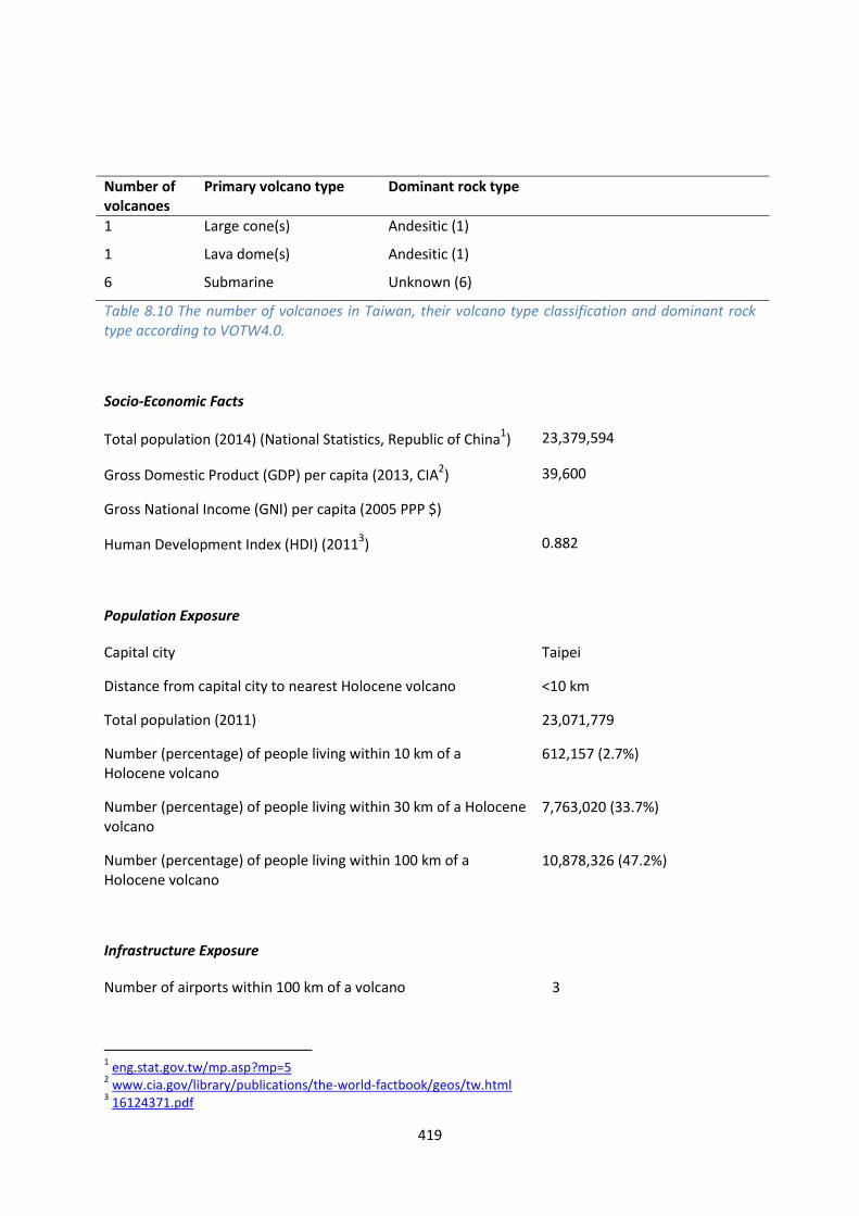
Table 8.10 The number of volcanoes in Taiwan, their volcano type classification and dominant rock type according to VOTW4.0.
Socio-Economic Facts
Total population (2014) (National Statistics, Republic of China1) 23,379,594
Gross Domestic Product (GDP) per capita (2013, CIA2) 39,600
Gross National Income (GNI) per capita (2005 PPP $)
Human Development Index (HDI) (20113) 0.882
Population Exposure
Capital city Taipei
Distance from capital city to nearest Holocene volcano <10 km
Total population (2011) 23,071,779
Number (percentage) of people living within 10 km of a Holocene volcano
612,157 (2.7%)
Number (percentage) of people living within 30 km of a Holocene volcano
7,763,020 (33.7%)
Number (percentage) of people living within 100 km of a Holocene volcano
10,878,326 (47.2%)
Infrastructure Exposure
Number of airports within 100 km of a volcano 3
1 eng.stat.gov.tw/mp.asp?mp=5
2 www.cia.gov/library/publications/the-world-factbook/geos/tw.html
3 16124371.pdf

420
Number of ports within 100 km of a volcano 4
Total length of roads within 100 km of a volcano (km) 2,415
Total length of railroads within 100 km of a volcano (km) 548
Figure 8.10 The location of Taiwan’s volcanoes and the extent of the 100 km zone surrounding them. Ports, airports and the major cities are just some of the infrastructure that may be exposed to volcanic hazards.
The volcanoes in Taiwan are concentrated in the north, where the capital Taipei lies within 100 km.
Indeed it is less than 10 km from Taipei to the Tatun Group volcano. Other large cities and
considerable infrastructure are exposed in the north, including airports and ports. Large cities in the
south are also within 100 km of an unnamed volcano off the coast of Taiwan. An extensive road and
rail network is exposed to volcanic hazards.
Hazard, Uncertainty and Exposure Assessments
The eruption records for the volcanoes in Taiwan are sparse and this prevents hazard assessment
without significant associated uncertainties. The volcanoes here are therefore unclassified. Indeed,
of the eight volcanoes, just three have a Holocene eruption record each with just one eruption. Both
an unnamed volcano and Kueishantao have erupted historically, whilst the last recorded eruption of
Tatun Group was in 4100 BC.
The PEI ranges from low to very high in Taiwan. No volcanoes are classified by risk level due to the
absence of a hazard classification, however the high local population around the Tatun Group makes
this a PEI 7 volcano, which indicates high risk.

421
CLA
SSIF
IED
Hazard III
Hazard II
Hazard I
UN
CLA
SSIF
IED
U – HHR
Unnamed (281030)
Kueishantao
U- HR Tatun Group
U- NHHR
Unnamed (281010); Unnamed (281011); Zengyu
Unnamed (281020)
Unnamed (281040)
PEI 1 PEI 2 PEI 3 PEI 4 PEI 5 PEI 6 PEI 7 Table 8.11 Identity of Taiwan’s volcanoes in each Hazard-PEI group. Those volcanoes with a sufficient record for determining a hazard score are deemed ‘Classified’ (top). Those without sufficient data are ‘Unclassified’ (bottom). The unclassified volcanoes are divided into groups: U-NHHR is Unclassified No Historic or Holocene Record: that is there are no confirmed eruptions recorded in the Holocene. U-HR is Unclassified with Holocene Record: that is there are confirmed eruptions recorded during the Holocene, but no historical (post-1500) events. U-HHR is Unclassified with Historic and Holocene record. The unclassified volcanoes in bold have experienced unrest or eruptions since 1900 AD, and those in red have records of at least one Holocene VEI ≥4 eruption.National Capacity for Coping with Volcanic Risk
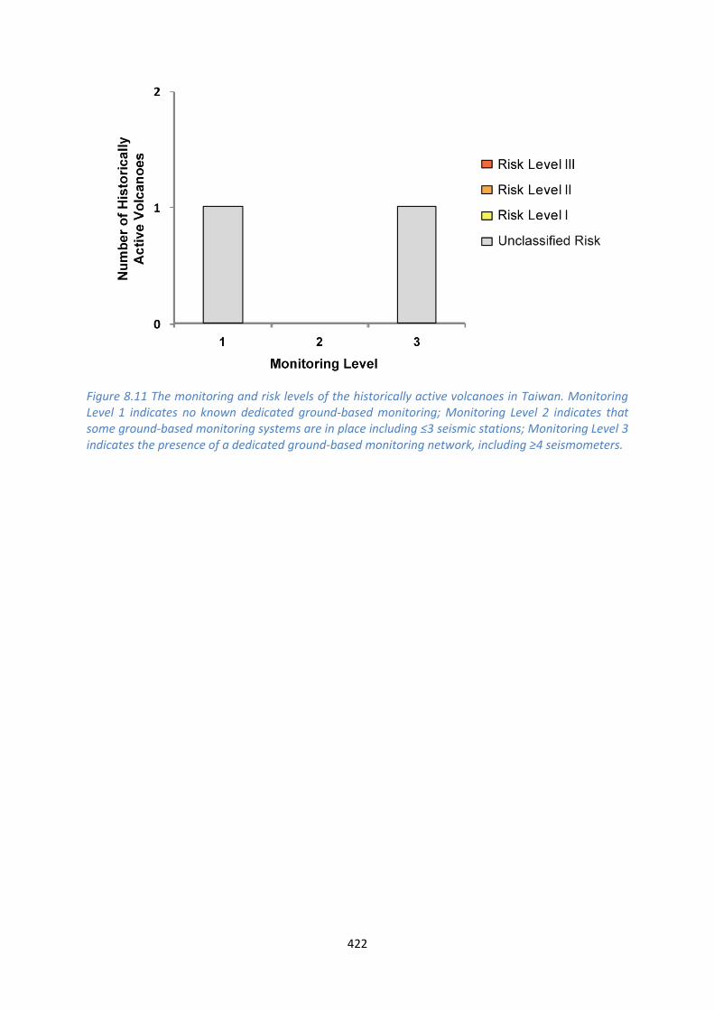
Two volcanoes have historical activity: an unnamed submarine volcano and Kueishantao. The Taiwan
Volcano Observatory principally monitors Tatun Group (active in the Holocene) and Kueishantao.
The location of the Tatun Group volcano with a large proximal population and the dominance of
monitoring activities here indicates that monitoring resources are focussed on volcanoes of highest
risk.
422
Figure 8.11 The monitoring and risk levels of the historically active volcanoes in Taiwan. Monitoring Level 1 indicates no known dedicated ground-based monitoring; Monitoring Level 2 indicates that some ground-based monitoring systems are in place including ≤3 seismic stations; Monitoring Level 3 indicates the presence of a dedicated ground-based monitoring network, including ≥4 seismometers.

This profile and the data therein should not be used in place of focussed assessments and information provided by local monitoring and research institutions.
USA – Mariana Islands
For further USA profiles see Region 4 for American Samoa, Region 11 for Alaska, Region 12 for the
contiguous states, Region 13 for Hawaii.
Description
Figure 8.12 Location of the Marianas Island volcanoes, the capital and largest cities. A zone extending 200 km beyond the country's borders shows other volcanoes whose eruptions may directly affect the Marianas Islands.
Twenty-one Holocene volcanoes are located in the Marianas Islands, located at the southern end of
the Izu-Marianas arc. Volcanism here is due to the subduction of the Pacific Plate beneath the
Philippine plate, producing the ocean island arc. Eleven volcanoes are submarine, while all subaerial

424
volcanoes are stratovolcanoes. Basaltic to dacitic rock types are present, with basalts and andesites
being most common.
Fifty-two confirmed Holocene eruptions are recorded in the Marianas, of VEI 0 to 4, indicating a
range of activity from mild to large explosive events. Of these, forty-nine are recorded historically, all
but one since 1800, demonstrating that the geological record is sparse and that activity here prior to
this time is poorly understood. Pyroclastic flows are recorded in four historical eruptions (8% of
events).
The population of the Marianas is sparse, with the biggest settlements being restricted to the largest
islands to the east of the volcanic chain. The population within 30 km of the Holocene volcanoes is
therefore just 1, however extending the radii to 100 km encompasses the whole population of the
Marianas. Evacuations have been called during eruptions of Agrigan, Pagan and South Sarigan
Seamount as recently as 2010. The 2010 eruption of South Sarigan Seamount produced an eruption
column to 12km above the surface.
The CNMI (Commonwealth of the Northern Mariana Islands) Emergency Management Office, the
Southern Methodist University and the Alaska and Hawaii Volcano observatories of the U.S.
Geological Survey have been collaborating to establish monitoring networks in the Mariana Islands
and to assess the volcanic hazards. Telemetered seismic stations are located on the historically
active Anatahan and Pagan volcanoes and the Holocene Sarigan volcano, and infrasound arrays are
used to detect explosive activity at the other Mariana Island volcanoes. Satellite monitoring is also
undertaken.
See also:
Hawaii Volcano Observatory: hvo.wr.usgs.gov/volcanowatch/archive/2003/03_09_18.html
USGS Volcano Hazards Program: volcanoes.usgs.gov/vhp/observatories.php
USGS Northern Mariana Islands: volcanoes.usgs.gov/nmi/activity/
Volcano Facts
Number of Holocene volcanoes 21
Number of Pleistocene volcanoes with M≥4 eruptions -
Number of volcanoes generating pyroclastic flows 3
Number of volcanoes generating lahars 1
Number of volcanoes generating lava flows 6
Number of fatalities caused by volcanic eruptions -
Tectonic setting Subduction zone
Largest recorded Pleistocene eruption -
425
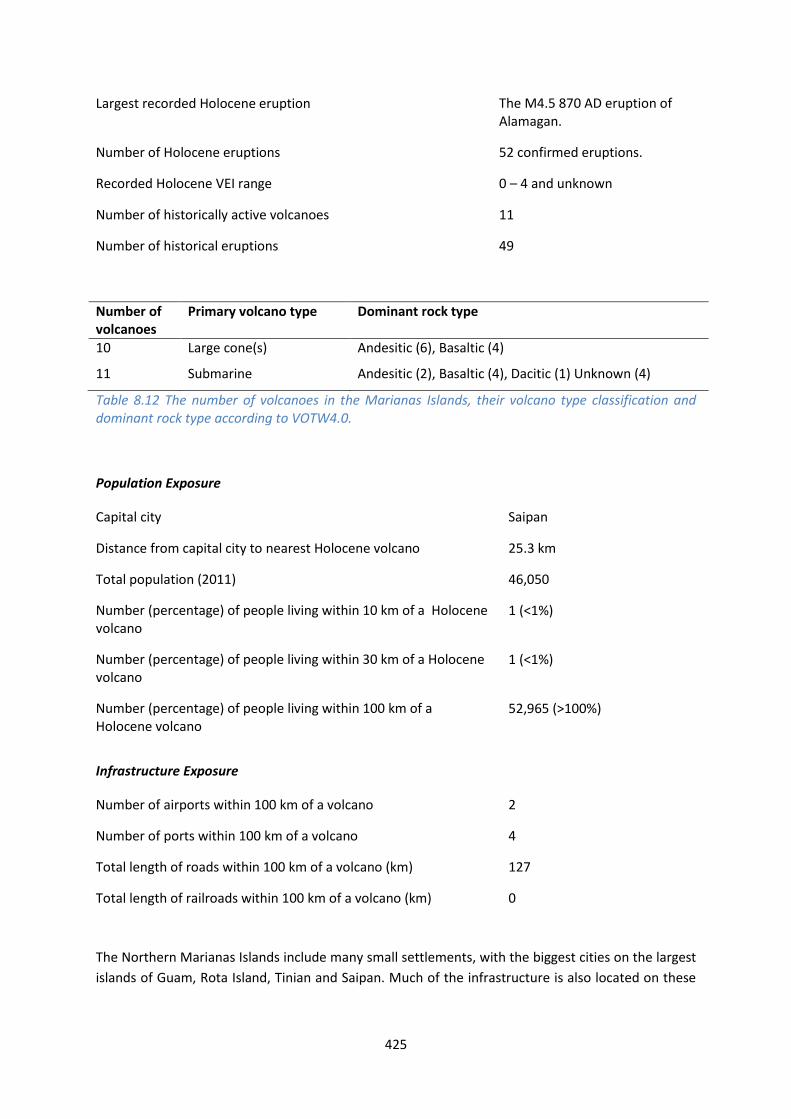
Largest recorded Holocene eruption The M4.5 870 AD eruption of Alamagan.
Number of Holocene eruptions 52 confirmed eruptions.
Recorded Holocene VEI range 0 – 4 and unknown
Number of historically active volcanoes 11
Number of historical eruptions 49
Number of volcanoes
Primary volcano type Dominant rock type
10 Large cone(s) Andesitic (6), Basaltic (4)
11 Submarine Andesitic (2), Basaltic (4), Dacitic (1) Unknown (4)
Table 8.12 The number of volcanoes in the Marianas Islands, their volcano type classification and dominant rock type according to VOTW4.0.
Population Exposure
Capital city Saipan
Distance from capital city to nearest Holocene volcano 25.3 km
Total population (2011) 46,050
Number (percentage) of people living within 10 km of a Holocene volcano
1 (<1%)
Number (percentage) of people living within 30 km of a Holocene volcano
1 (<1%)
Number (percentage) of people living within 100 km of a Holocene volcano
52,965 (>100%)
Infrastructure Exposure
Number of airports within 100 km of a volcano 2
Number of ports within 100 km of a volcano 4
Total length of roads within 100 km of a volcano (km) 127
Total length of railroads within 100 km of a volcano (km) 0
The Northern Marianas Islands include many small settlements, with the biggest cities on the largest
islands of Guam, Rota Island, Tinian and Saipan. Much of the infrastructure is also located on these

426
islands, including four ports and two airports. These largest islands lie within 100 km of the
volcanoes which are displaced to the west.
Figure 8.13 The location of CNMI’s volcanoes and the extent of the 100 km zone surrounding them. Ports, airports and the major cities are just some of the infrastructure that may be exposed to volcanic hazards.
Hazard, Uncertainty and Exposure Assessments
There are varying levels of data available in the eruption records of the volcanoes of the Marianas
Islands. Indeed, out of 21 volcanoes, just three have sufficiently extensive and detailed records to
have their hazard levels classified. These volcanoes, Pagan, Anatahan and Farallon de Pajaros, have

427
records of 40 confirmed Holocene eruptions, most of which also have an attributed size. All but one
of these eruptions occurred since the 1600s. With no eruptions over VEI 2, Farallon de Pajaros is
classified at Hazard Level I, whilst Anatahan and Pagan, with records of VEI 3 and 4 eruptions
respectively, are ranked at Hazard Level III. These three volcanoes are classified at Risk Level I, with
no local populations.
With the exception of these three volcanoes, all others are unclassified. Nine volcanoes have no
Holocene eruption record, though three, Zealandia Bank, Sarigan and Esmeralda Bank, have
experienced unrest since 1900 AD. Eight unclassified volcanoes have records of historical eruptions,
including eruptions since 1900 at seven volcanoes.
With low proximal populations in the Marianas, including no population within 30 km at any of the
volcanoes, the PEI is low at 1 and 2.
CLA
SSIF
IED
Hazard III
Pagan; Anatahan
Hazard II
Hazard I
Farallon de Pajaros
UN
CLA
SSIF
IED
U – HHR
Ahyi; Supply Reef; Asuncion; Agrigan; Guguan; South Sarigan Seamount
Ruby; NW Rota-1
U- HR Alamagan
U- NHHR
Unnamed (284138); Unnamed (284139); Maug Islands; Zealandia Bank; Sarigan
East Diamante; Esmeralda Bank; Forecast Seamount; Seamount X
PEI 1 PEI 2 PEI 3 PEI 4 PEI 5 PEI 6 PEI 7 Table 8.13 Identity of the Marianas Islands’ volcanoes in each Hazard-PEI group. Those volcanoes with a sufficient record for determining a hazard score are deemed ‘Classified’ (top). Those without sufficient data are ‘Unclassified’ (bottom). The unclassified volcanoes are divided into groups: U-NHHR is Unclassified No Historic or Holocene Record: that is there are no confirmed eruptions recorded in the Holocene. U-HR is Unclassified with Holocene Record: that is there are confirmed eruptions recorded during the Holocene, but no historical (post-1500) events. U-HHR is Unclassified with Historic and Holocene record. The unclassified volcanoes in bold have experienced unrest or eruptions since 1900 AD, and those in red have records of at least one Holocene VEI ≥4 eruption.

428
Volcano Population Exposure Index Risk Level
Anatahan 1 I Farallon de Pajaros 1 I Pagan 1 I
Table 8.14 Classified volcanoes of Mariana Islands ordered by descending Population Exposure Index (PEI). Risk levels determined through the combination of the Hazard Level and PEI are given. Risk Level I – 3 volcanoes; Risk Level II – 0 volcanoes; Risk Level III – 0 volcanoes.
Figure 8.14 Distribution of the Marianas Islands’ classified volcanoes across Hazard and Population Exposure Index levels. The warming of the background colours illustrates increasing Risk levels from Risk Level I - III.
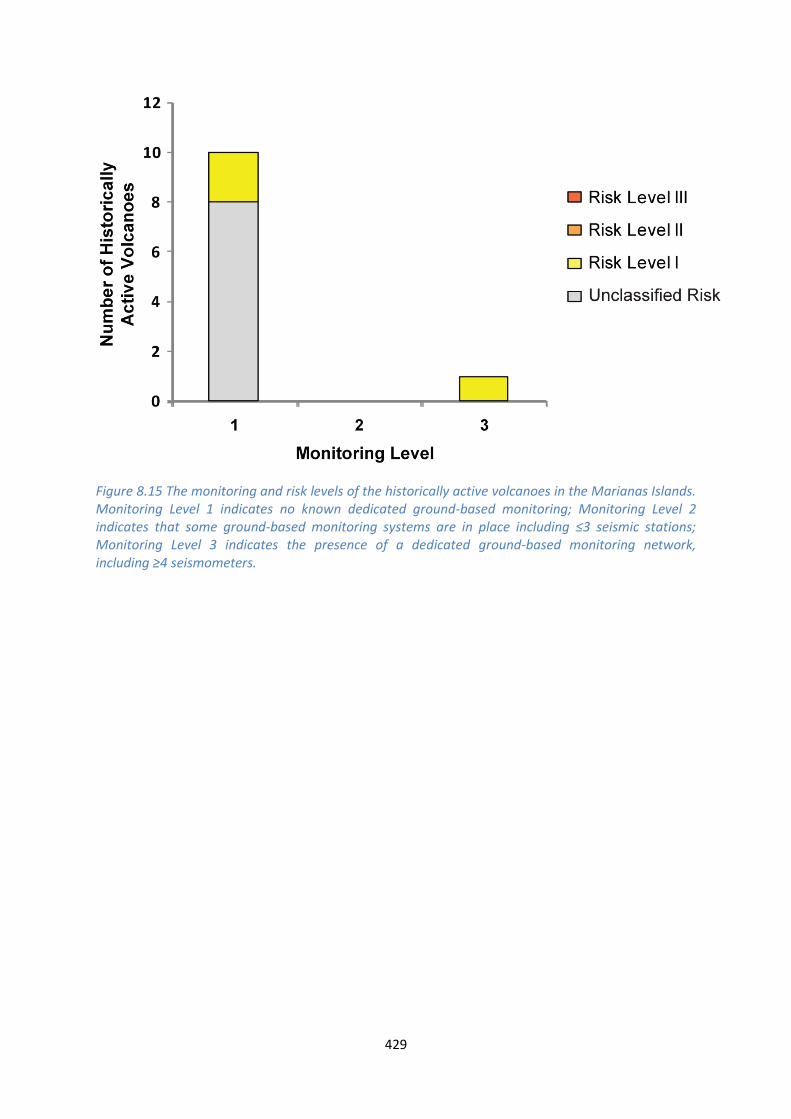
National Capacity for Coping with Volcanic Risk
The monitoring of the Marianas Island volcanoes is the responsibility of the Alaska Volcano
Observatory. The USGS Northern Marianas Duty Scientist is a position that rotates between the
Alaska and Hawaii Volcano Observatories. The Risk Level I Anatahan and Pagan volcanoes have
dedicated seismic monitoring in place, as does the Holocene age Sarigan. Infrasound arrays are used
for detection of activity at other volcanoes here.
429
Figure 8.15 The monitoring and risk levels of the historically active volcanoes in the Marianas Islands. Monitoring Level 1 indicates no known dedicated ground-based monitoring; Monitoring Level 2 indicates that some ground-based monitoring systems are in place including ≤3 seismic stations; Monitoring Level 3 indicates the presence of a dedicated ground-based monitoring network, including ≥4 seismometers.


