Embed Size (px)
Citation preview
This profile and the data therein should not be used in place of focussed assessments and information provided by local monitoring and research institutions.
Appendix B – Region 2
Country and regional profiles of volcanic hazard and risk:
Africa and Red Sea
S.K. Brown1, R.S.J. Sparks1, K. Mee2, C. Vye-Brown2, E.Ilyinskaya2, S.F. Jenkins1, S.C. Loughlin2*
1University of Bristol, UK; 2British Geological Survey, UK, * Full contributor list available in Appendix B Full Download
This download comprises the profiles for Region 2: Africa and Red Sea only. For the full report and all
regions see Appendix B Full Download. Page numbers reflect position in the full report. The following
countries are profiled here:
Region 2 Africa and Red Sea Pg.90
Algeria 98
Cameroon 103
Chad 109
Democratic Republic of Congo 114
Djibouti 121
Equatorial Guinea 127
Eritrea 133
Ethiopia 139
Kenya 147
Libya 154
Mali 159
Niger 164
Nigeria 169
Rwanda 174
Sao Tome and Principe 180
Sudan 185
Tanzania 191
Uganda 198
Brown, S.K., Sparks, R.S.J., Mee, K., Vye-Brown, C., Ilyinskaya, E., Jenkins, S.F., and Loughlin, S.C. (2015) Country and regional profiles of volcanic hazard and risk. In: S.C. Loughlin, R.S.J. Sparks, S.K. Brown, S.F. Jenkins & C. Vye-Brown (eds) Global Volcanic Hazards and Risk, Cambridge: Cambridge University Press.

This profile and the data therein should not be used in place of focussed assessments and information provided by local monitoring and research institutions.
Region 2: Africa and Red Sea
Figure 2.1 The distribution of Holocene volcanoes through the Africa and Red Sea region. The capital cities of the constituent countries are shown.
Description
Of all the regions of world we have the least historic and geologic information about Africa’s 152
volcanoes. In part this is a result of limited historic records of past eruptions but also a result of
limited past and present research in Africa by contrast with other areas of the world. Africa as a
region has the highest percentage of volcanoes that are undated but known to be Holocene. Given
highly variable data availability and uncertainty it is likely that volcanic hazards from African
volcanoes are underestimated in both frequency and magnitude and the impact only loosely
constrained.
Many of Africa’s volcanoes are located in the East African Rift where the African, Arabian and
Somalian plates of the Earth’s crust are moving apart and new crust is being formed. This dynamic
movement has resulted in a dense concentration of large volcanic complexes and low-lying rift
volcanoes formed from multiple elongate fissures in a series of lines down the Red Sea and the East
African Rift. Approximately 10% of the world’s volcanoes lie in continental rifts (Siebert et al., 2010)
91
mostly in the East African Rift (EAR) System. The contrasting styles of effusive eruptions and
explosive eruptions of many of the past eruptions from these volcanoes result in a different series of
hazards for each setting.
Population and infrastructure exposure to volcanic hazards is high and rapidly expanding with
growth of the population and increasing investment, notably in the geothermal energy field.
With one exception in the Democratic Republic of Congo, there are no dedicated volcano monitoring
institutions or networks in Africa. Whilst some areas have seismometers that could be used in the
event of eruption there is no systematic monitoring of magmatic activity that may be used to detect
changing base levels which may precede an eruption.
Strategic research to target data gaps, increased access to satellite-based monitoring for
observatories and responsible in-country institutions, and local capacity building will make a
significant difference to support future volcanic hazard and risk assessments as well as planning and
response in Africa and the Red Sea.
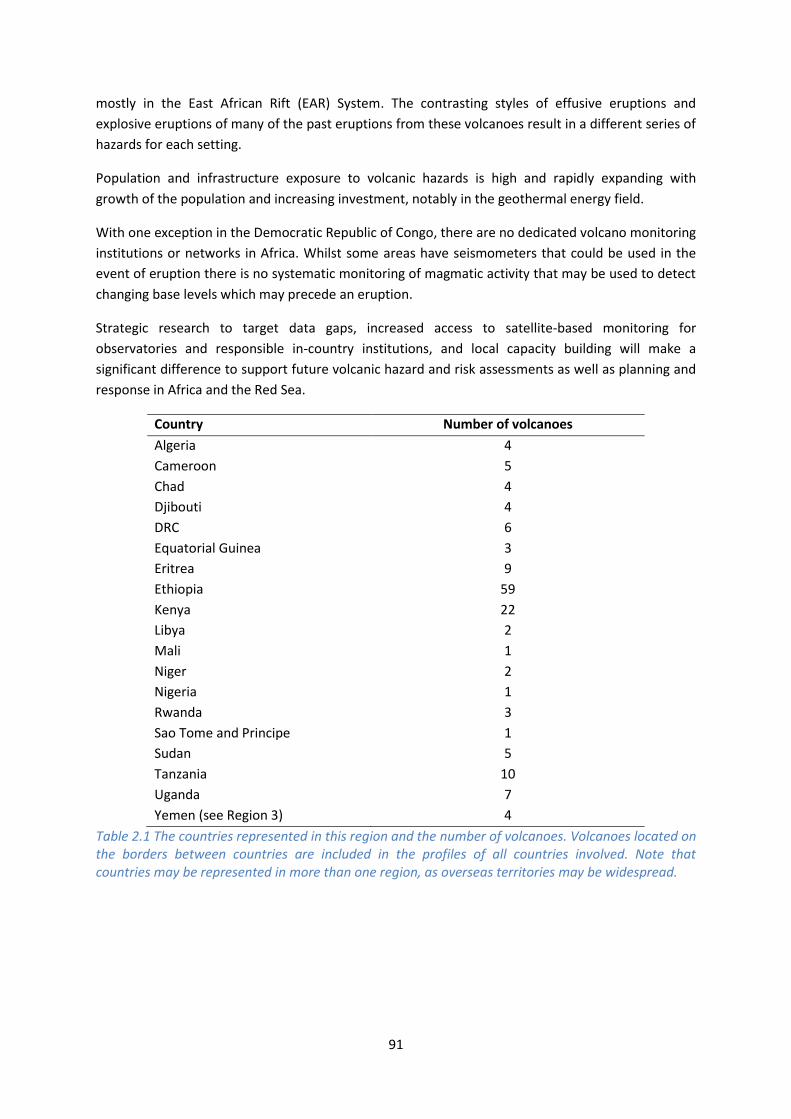
Country Number of volcanoes
Algeria 4
Cameroon 5
Chad 4
Djibouti 4
DRC 6
Equatorial Guinea 3
Eritrea 9
Ethiopia 59
Kenya 22
Libya 2
Mali 1
Niger 2
Nigeria 1
Rwanda 3
Sao Tome and Principe 1
Sudan 5
Tanzania 10
Uganda 7
Yemen (see Region 3) 4
Table 2.1 The countries represented in this region and the number of volcanoes. Volcanoes located on the borders between countries are included in the profiles of all countries involved. Note that countries may be represented in more than one region, as overseas territories may be widespread.

92
Volcano facts
Number of Holocene volcanoes 141
Number of Pleistocene volcanoes with M≥4 eruptions 18
Number of volcanoes generating pyroclastic flows 9
Number of volcanoes generating lahars 5
Number of volcanoes generating lava flows 111
Number of eruptions with fatalities 11
Number of fatalities attributed to eruptions 2,276
Largest recorded Pleistocene eruption The largest recorded Quaternary eruption in region 2 occurred at 1 Ma, with the M8 Awasa caldera formation at the Corbetti Caldera in Ethiopia.
Largest recorded Holocene eruption The Caldera 2 eruption of Menengai, Kenya, at 8985 BP is the largest recorded Holocene eruption in this region, at M6.8.
Number of Holocene eruptions 196 confirmed eruptions
Recorded Holocene VEI range 0 – 6 and unknown
Number of historically active volcanoes 30
Number of historical eruptions 149
Number of
volcanoes
Primary volcano type Dominant rock type
8 Caldera(s) Basaltic (2), Rhyolitic (4), Trachytic/Andesitic (2)
1 Hydrothermal field Unknown (1)
50 Large cone(s) Andesitic (2), Basaltic (17), Foiditic (3), Phonolitic (2),
Rhyolitic (18), Trachytic/Andesitic (8)
2 Lava dome(s) Phonolitic (1), Rhyolitic (1)
30 Shield(s) Basaltic (23), Phonolitic (1), Trachytic/Andesitic (6)
59 Small cone(s) Andesitic (1), Basaltic (44), Foiditic (7), Phonolitic (1),
Rhyolitic (3), Unknown (3)
Table 2.2 The volcano types and dominant rock types of the volcanoes of this region according to VOTW4.0.

93
Eruption Frequency
VEI Recurrence Interval (Years)
Small (< VEI 4) 1
Large (> VEI 3) 1000
Table 2.3 Average recurrence interval (years between eruptions) for small and large eruptions in Africa and the Red Sea.
The eruption record indicates that on average small to moderate sized eruptions of VEI <4 occurs in
this region with an average recurrence interval (ARI) of about a year, whilst the ARI for large
eruptions is much longer, at about 1000 years.
Eruption Size
Eruptions of VEI 0 to 6 are recorded through the Africa and Red Sea region, representing a range of
eruption styles, from gentle effusive events to large explosive eruptions (Figure 2.2). VEI 0 to 2
eruptions dominate the record, making up about 80% of eruptions. Nearly 8% of eruptions in this
region are VEI ≥4.
Figure 2.2 Percentage of eruptions in this region recorded at each VEI level; number of eruptions is also shown. The percentage is of total eruptions with recorded VEI. A further 41 eruptions were recorded with unknown VEI.

94
Socio-Economic Facts
Total population (2011) 653,926,812
Gross Domestic Product (GDP) per capita (2005 PPP $) 329 – 32,026
(Mean 4,457)
Gross National Income (GNI) per capita (2005 PPP $) 319 – 21,715
(Mean 3,826)
Human Development Index (HDI) (2012) 0.304 – 0.769 (Low to High: Mean 0.470 Low)
Population Exposure
Number (percentage) of people living within 10 km of a Holocene volcano
4,089,632 (0.63 %)
Number (percentage) of people living within 30 km of a Holocene volcano
27,606,598 (4.22 %)
Number (percentage) of people living within 100 km of a Holocene volcano
123,172,684 (18.84 %)
Infrastructure Exposure
Number of airports within 100 km of a volcano 20
Number of ports within 100 km of a volcano 19
Total length of roads within 100 km of a volcano (km) 18,589
Total length of railroads within 100 km of a volcano 2,192

95
Hazard, Exposure and Uncertainty Assessments C
LASS
IFIE
D Hazard
III
Meidob Volcanic Field
Hazard II
Lengai, Ol Doinyo
Hazard I Tair, Jebel at; Barrier, The Erta Ale Nyamuragira; Nyiragongo; Cameroon
UN
CLA
SSIF
IED
U – HHR
Zubair Group; Dallol; Dalaffilla; Dubbi; Nabro; Alayta; Manda Hararo; Manda-Inakir; South Island; Emuruangogolak
Dabbahu; Ardoukôba; Dama Ali
Fentale; Chyulu Hills
Kone; Tullu Moje; Olkaria; Longonot; Meru; Kyejo; Santa Isabel
Visoke
U- HR Namarunu; Bayuda V.F. Silali; Paka Marra, Jebel Alutu; Rungwe Menengai; Fort Portal; Karisimbi
Ngozi
U- NHHR
Hanish; Gada Ale; Alu; Borale Ale; Ale Bagu; Hayli Gubbi; Mallahle; Sork Ale; Asavyo; Mat Ala; Tat Ali; Borawli; Kurub; Mousa Alli; Gufa; Assab V.F.; Gabillema; Yangudi; North Island; Central Island; San Carlos; San Joaquin; Todra V.F.; Tin Zaouatene V.F.; In Ezzane V.F.; Tahalra V.F.; Atakor V.F.; Manzaz V.F.; Haruj; Wau-en-Namus; Tôh, Tarso; Toussidé, Tarso; Voon, Tarso; Koussi, Emi
Zukur; Alid; Afderà; Dabbayra; Manda Gargori; Ayelu; Adwa; Hertali; Mega Basalt Field; Segererua Plateau
Jalua; Ma Alalta; Groppo; Liado Hayk; Dofen; Korath Range; Marsabit; Korosi; Ol Kokwe; Suswa; Kilimanjaro; Unnamed; Sao Tome; Kutum V.F.
Borawli; Beru; Boset-Bericha; Bora-Bericcio; Tepi; Chiracha; Unnamed; Homa Mountain; Eburru, Ol Doinyo; Igwisi Hills; SW Usangu Basin; May-ya-moto; Manengouba; Ngaoundere Plateau; Biu Plateau; Umm Arafieb, Jebel
Unnamed; Gedamsa; Unnamed; East Zway; O'a Caldera; Tosa Sucha; Nyambeni Hills; Elmenteita Badlands; Kyatwa; Bunyaruguru; Katunga; Muhavura; Tshibinda; Tombel Graben; Oku V.F.
Bishoftu V.F.; Unnamed; Sodore; Butajiri-Silti Field; Corbetti Caldera; Bilate River Field; Hobicha Caldera; Izumbwe-Mpoli; Katwe-Kikorongo; Bufumbira
PEI 1 PEI 2 PEI 3 PEI 4 PEI 5 PEI 6 PEI 7 Table 2.4 Identity of the volcanoes in this region in each Hazard-PEI group. Those volcanoes with a sufficient record for determining a hazard score are deemed ‘classified’ (top). Those without sufficient data are ‘Unclassified’ (bottom). The unclassified volcanoes are divided into groups: U-NHHR is Unclassified No Historic or Holocene Record: that is there are no confirmed eruptions recorded in the Holocene. U-HR is Unclassified with Holocene Record: that is there are confirmed eruptions recorded during the Holocene, but no historical (post-1500) events. U-HHR is Unclassified with Historic and Holocene record. The unclassified volcanoes in bold have experienced unrest or eruptions since 1900 AD, and those in red have records of at least one Holocene VEI ≥4 eruption. Note: V.F. is an abbreviation for Volcanic Field.

96
Population Exposure Index
Number of Volcanoes Population Exposure Index
11 7
19 6
28 5
17 4
18 3
48 2
0 1
Table 2.5 The number of volcanoes in Africa and the Red Sea classed in each PEI category.
Risk Levels
Number of Volcanoes Risk Level
0 III
5 II
3 I
133 Unclassified
Table 2.6 The number of volcanoes in the Africa and Red Sea region classified at each Risk Level.
Figure 2.3 Distribution of the classified volcanoes of this region across Hazard and Population Exposure Index levels. The warming of the background colours illustrates increasing Risk levels from Risk Level I - III.

97
Regional Monitoring Capacity
Figure 2.4 The monitoring and risk levels of the historically active volcanoes in Africa and the Red Sea. Monitoring Level 1 indicates no known dedicated ground-based monitoring; Monitoring Level 2 indicates that some ground-based monitoring systems are in place including ≤3 seismic stations; Monitoring Level 3 indicates the presence of a dedicated ground-based monitoring network, including ≥4 seismometers.

This profile and the data therein should not be used in place of focussed assessments and information provided by local monitoring and research institutions.
Algeria
Description
Four volcanoes are located in southern Algeria and on the border with neighbouring Niger. These
volcanoes are related to intra-plate processes which have dominantly led to the formation of
volcanic fields, scoria and pyroclastic cones, with a dominantly basaltic composition.
No Holocene eruptions are recorded at any volcano in Algeria, however all have activity of suspected
Holocene age. Historical unrest has been recognised at the Atakor Volcanic Field, with mild
seismicity and fumaroles.
These volcanoes are remote, with the most populous cities in Algeria being concentrated in the
north of the country. Only a small local population of about 10,000 resides within 30 km of one or
more of these volcanoes, rising to about 120,000 at 100 km. This represents less than 1% of Algeria’s
population.
Given the absence of detailed eruptive histories at Algeria’s volcanoes, the assessment of hazard
here is associated with large uncertainties. Further research is required to better constrain the age
and size of Holocene eruptions.
Figure 2.5 Location of Algeria's volcanoes, the capital and largest cities. A zone extending 200 km beyond the country's borders shows other volcanoes whose eruptions may directly affect Algeria.

99
Volcano Facts
Number of Holocene volcanoes 4, inclusive of one on the border with Niger
Number of Pleistocene volcanoes with M≥4 eruptions -
Number of volcanoes generating pyroclastic flows -
Number of volcanoes generating lahars -
Number of volcanoes generating lava flows -
Number of fatalities caused by volcanic eruptions -
Tectonic setting Intra-plate
Largest recorded Pleistocene eruption -
Largest recorded Holocene eruption -
Number of Holocene eruptions -
Recorded Holocene VEI range -
Number of historically active volcanoes -
Number of historical eruptions -
Number of
volcanoes
Primary volcano type Dominant rock type
4 Small cone(s) Basaltic (4)
Table 2.7 The number of volcanoes in Algeria, their volcano type classification and dominant rock type according to VOTW4.0.
Socio-Economic Facts
Total population (2012) 38,406,000
Gross Domestic Product (GDP) per capita (2005 PPP $) 7,643
Gross National Income (GNI) per capita (2005 PPP $) 7,418
Human Development Index (HDI) (2012) 0.713 (High)

100
Population Exposure
Capital city Algiers
Distance from capital city to nearest Holocene volcano 603.2 km
Total population (2011) 34,994,937
Number (percentage) of people living within 10 km of a Holocene volcano
425 (<1%)
Number (percentage) of people living within 30 km of a Holocene volcano
10,320 (<1%)
Number (percentage) of people living within 100 km of a Holocene volcano
122,840 (<1%)
Ten largest cities, as measured by population and their population size:
Algiers 1,977,663
Oran 645,984
Constantine 450,097
Batna 280,798
Annaba 206,570
Sidi-Bel-Abbes 191,769
Bejaia 164,103
Skikda 162,702
Medea 147,707
Bechar 143,382
Infrastructure Exposure
Number of airports within 100 km of a volcano 1
Number of ports within 100 km of a volcano 0
Total length of roads within 100 km of a volcano (km) 335
Total length of railroads within 100 km of a volcano (km) 0
The largest cities in Algeria are mainly concentrated in the north of the country, including the capital
Algiers, away from the volcanoes. Being inland volcanoes, no ports are located within 100 km of the
volcanoes. One airport is located within 100 km: the Aguenar-Hadj Bey Akhamok international
airport, between the Tahalra and Atakor Volcanic Fields.

101
Figure 2.6 The location of Algeria's volcanoes and the extent of the 100 km zone surrounding them. Ports, airports and the major cities are just some of the infrastructure that may be exposed to volcanic hazards.
Hazard, Uncertainty and Exposure Assessments
There are no confirmed eruptions at any of Algeria’s volcanoes during the Holocene. The absence of
a thorough eruptive history means that the hazard levels cannot be determined for these volcanoes,
and hence risk levels are also unclassified. All of Algeria’s volcanoes have a low PEI of 2. No post-
1900 AD unrest is recorded at Algeria’s volcanoes.

102
CLA
SSIF
IED
Hazard III
Hazard II
Hazard I
UN
CLA
SSIF
IED
U – HHR
U- HR
U- NHHR
In Ezzane Volcanic Field; Tahalra Volcanic Field; Atakor Volcanic Field; Manzaz Volcanic Field
PEI 1 PEI 2 PEI 3 PEI 4 PEI 5 PEI 6 PEI 7 Table 2.8 Identity of Algeria’s volcanoes in each Hazard-PEI group. Those volcanoes with a sufficient record for determining a hazard score are deemed ‘classified’ (top). Those without sufficient data are ‘Unclassified’ (bottom). The unclassified volcanoes are divided into groups: U-NHHR is Unclassified No Historic or Holocene Record: that is there are no confirmed eruptions recorded in the Holocene. U-HR is Unclassified with Holocene Record: that is there are confirmed eruptions recorded during the Holocene, but no historical (post-1500) events. U-HHR is Unclassified with Historic and Holocene record. The unclassified volcanoes in bold have experienced unrest or eruptions since 1900 AD, and those in red have records of at least one Holocene VEI ≥4 eruption.
National Capacity for Coping with Volcanic Risk
No volcanoes in Algeria have recorded historical eruptions and no information is available at the
time of the writing of this report to indicate that regular ground-based monitoring is undertaken at
any Holocene volcanoes in Algeria.

This profile and the data therein should not be used in place of focussed assessments and information provided by local monitoring and research institutions.
Cameroon
Description
Figure 2.7 Location of Cameroon’s volcanoes, the capital and largest cities. A zone extending 200 km beyond the country's borders shows other volcanoes whose eruptions may directly affect Cameroon.
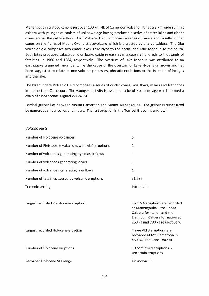
Cameroon has five Holocene volcanoes: Cameroon, Manengouba, Ngaoundere Palteau, Oku
Volcanic Field and Tombel Graben. Cameroon, Manengouba and Oku Volcanic Field are basaltic to
trachybasaltic stratovolcanoes, while Ngaoundere Palteau is a trachybasaltic volcanic field and
Tombel Graben is a trachybasaltic cinder cone. Only Cameroon is known to have been historically
active.
Cameroon volcano is a basaltic to trachybasaltic stratovolcano with a height of 4095 m, located near
the Atlantic coast in western Cameroon. Numerous parasitic cinder cones occur on its flanks and the
surrounding lowlands. Historical activity was first observed in the 5th Century, and numerous
explosive and effusive eruptions have occurred from both summit and flanks vents since. In 1922, a
lava flow from a vent on the SW flank reached the coast, 14 km away. The last known eruption was
in 2000.
104
Manengouba stratovolcano is just over 100 km NE of Cameroon volcano. It has a 3 km wide summit
caldera with younger volcanism of unknown age having produced a series of crater lakes and cinder
cones across the caldera floor. Oku Volcanic Field comprises a series of maars and basaltic cinder
cones on the flanks of Mount Oku, a stratovolcano which is dissected by a large caldera. The Oku
volcanic field comprises two crater lakes: Lake Nyos to the north; and Lake Monoun to the south.
Both lakes produced catastrophic carbon-dioxide release events causing hundreds to thousands of
fatalities, in 1986 and 1984, respectively. The overturn of Lake Monoun was attributed to an
earthquake triggered landslide, while the cause of the overturn of Lake Nyos is unknown and has
been suggested to relate to non-volcanic processes, phreatic explosions or the injection of hot gas
into the lake.
The Ngaoundere Volcanic Field comprises a series of cinder cones, lava flows, maars and tuff cones
in the north of Cameroon. The youngest activity is assumed to be of Holocene age which formed a
chain of cinder cones aligned WNW-ESE.
Tombel graben lies between Mount Cameroon and Mount Manengouba. The graben is punctuated
by numerous cinder cones and maars. The last eruption in the Tombel Graben is unknown.
Volcano Facts
Number of Holocene volcanoes 5
Number of Pleistocene volcanoes with M≥4 eruptions 1
Number of volcanoes generating pyroclastic flows -
Number of volcanoes generating lahars 1
Number of volcanoes generating lava flows 1
Number of fatalities caused by volcanic eruptions ?1,737
Tectonic setting Intra-plate
Largest recorded Pleistocene eruption Two M4 eruptions are recorded at Manengouba – the Eboga Caldera formation and the Elengoum Caldera formation at 250 ka and 700 ka respectively.
Largest recorded Holocene eruption Three VEI 3 eruptions are recorded at Mt. Cameroon in 450 BC, 1650 and 1807 AD.
Number of Holocene eruptions 19 confirmed eruptions. 2 uncertain eruptions
Recorded Holocene VEI range Unknown – 3

105
Number of historically active volcanoes 1
Number of historical eruptions 18
Number of
volcanoes
Primary volcano type Dominant rock type
3 Large cone(s) Basaltic (3)
2 Small cone(s) Basaltic (2)
Table 2.9 The number of volcanoes in Cameroon, their volcano type classification and dominant rock type according to VOTW4.0.
Socio-Economic Facts
Total population (2012) 21,779,000
Gross Domestic Product (GDP) per capita (2005 PPP $) 2,090
Gross National Income (GNI) per capita (2005 PPP $) 2,114
Human Development Index (HDI) (2012) 0.495 (Low)
Population Exposure
Capital city Yaoundé
Distance from capital city to nearest Holocene volcano 227.3 km
Total population (2011) 19,711,291
Number (percentage) of people living within 10 km of a Holocene volcano
185,716 (<1%)
Number (percentage) of people living within 30 km of a Holocene volcano
1,842,101 (9.4%)
Number (percentage) of people living within 100 km of a Holocene volcano
9,046,134 (45.9%)
Ten largest cities, as measured by population and their population size:
Douala 1,338,082
Yaounde 1,299,369
Garoua 436,899
Bamenda 393,835
Maroua 319,941
Bafoussam 290,768
Ngaoundere 231,357
Bertoua 218,111
Ebolowa 87,875
Buea <50,000

106
Infrastructure Exposure
Number of airports within 100 km of a volcano 6
Number of ports within 100 km of a volcano 5
Total length of roads within 100 km of a volcano (km) 2,446
Total length of railroads within 100 km of a volcano (km) 187
Five of the largest cities in Cameroon are located within 100 km of the volcanoes, although the
capital Yaoundé lies further east. The proximity of these large population centres to the volcanoes
also places critical infrastructure within 100 km distance of the volcanoes, including six airports and
nearly 2,500 km of roads. With Mt Cameroon and Tobel Graben located near the coast, five ports
are situated within 100 km distance.
Figure 2.8 The location of Cameroon’s volcanoes and the extent of the 100 km zone surrounding them. Ports, airports and the major cities are just some of the infrastructure that may be exposed to volcanic hazards.

107
Hazard, Uncertainty and Exposure Assessments
Of Cameroon’s volcanoes, only Mt. Cameroon has a sufficiently detailed eruptive history to
determine the hazard level, with 19 confirmed Holocene eruptions, 18 of which have a known VEI
most commonly at VEI 2. The Hazard Level here is I.
The PEI at all five volcanoes in Cameroon is high, at PEI 5 – 6. The PEI 5 and Hazard Level I of Mt.
Cameroon indicates a Risk Level of II.
The remaining volcanoes have no confirmed Holocene eruptions on record. Unrest has been
recorded at Oku Volcanic Field since 1900 AD, with the catastrophic gas releases from Lake Monoun
and Lake Nyos. The Lake Nyos overturn may have resulted from phreatic explosions or the injection
of hot gases.
CLA
SSIF
IED
Hazard III
Hazard II
Hazard I
Cameroon
UN
CLA
SSIF
IED
U – HHR
U- HR
U- NHHR
Manengouba; Ngaoundere Plateau
Tombel Graben; Oku Volcanic Field
PEI 1 PEI 2 PEI 3 PEI 4 PEI 5 PEI 6 PEI 7 Table 2.10 Identity of Cameroon’s volcanoes in each Hazard-PEI group. Those volcanoes with a sufficient record for determining a hazard score are deemed ‘classified’ (top). Those without sufficient data are ‘Unclassified’(bottom). The unclassified volcanoes are divided into groups: U-NHHR is Unclassified No Historic or Holocene Record: that is there are no confirmed eruptions recorded in the Holocene. U-HR is Unclassified with Holocene Record: that is there are confirmed eruptions recorded during the Holocene, but no historical (post-1500) events. U-HHR is Unclassified with Historic and Holocene record. The unclassified volcanoes in bold have experienced unrest or eruptions since 1900 AD, and those in red have records of at least one Holocene VEI ≥4 eruption.
Volcano Population Exposure Index Risk Level
Cameroon 5 II
Table 2.11 Classified volcanoes of Cameroon ordered by descending Population Exposure Index (PEI). Risk levels determined through the combination of the Hazard Level and PEI are given. Risk Level I – 0 volcanoes; Risk Level II – 1 volcano; Risk Level III – 0 volcanoes.

108
Figure 2.9 Distribution of Cameroon’s classified volcanoes across Hazard and Population Exposure Index levels. The warming of the background colours illustrates increasing Risk levels from Risk Level I - III.
National Capacity for Coping with Volcanic Risk
Just one volcano, the Risk Level II Mt. Cameroon, has historical eruption records in this country. No
information is available at the time of the writing of this report to indicate that regular ground-based
monitoring is undertaken at any of the volcanoes in Cameroon.
Figure 2.10 The monitoring and risk levels of the historically active volcanoes in Cameroon. Monitoring Level 1 indicates no known dedicated ground-based monitoring; Monitoring Level 2 indicates that some ground-based monitoring systems are in place including ≤3 seismic stations; Monitoring Level 3 indicates the presence of a dedicated ground-based monitoring network, including ≥4 seismometers.

This profile and the data therein should not be used in place of focussed assessments and information provided by local monitoring and research institutions.
Chad
Description
Figure 2.11 Location of Chad’s volcanoes, the capital and largest cities. A zone extending 200 km beyond the country's borders shows other volcanoes whose eruptions may directly affect Chad.
Four volcanoes are located in the Tibesti Mountains in the north of Chad. These volcanoes are
related to intra-plate processes.
No Holocene eruptions are recorded at any volcano in Chad, however they all have activity of
suspected Holocene age. Since 1900 AD, unrest in the form of thermal springs and steam blasts have
been recorded at Tarso Voon and Emi Koussi.

110
One explosive Pleistocene eruption of M4 is recorded at Emi Koussi, 1.32 million years ago. Many
lava flows and cones are distributed across the volcanoes.
Only a small population of about 15,000 live within 100 km of these remote volcanoes; less than 1%
of Chad’s population.
Volcano Facts
Number of Holocene volcanoes 4
Number of Pleistocene volcanoes with M≥4 eruptions 1
Number of volcanoes generating pyroclastic flows -
Number of volcanoes generating lahars -
Number of volcanoes generating lava flows -
Number of fatalities caused by volcanic eruptions -
Tectonic setting Intra-plate
Largest recorded Pleistocene eruption The M4 Era Kohor caldera formation (Koussi III) of Emi Koussi at 1.32 Ma
Largest recorded Holocene eruption -
Number of Holocene eruptions -
Recorded Holocene VEI range -
Number of historically active volcanoes -
Number of historical eruptions -
Number of
volcanoes
Primary volcano type Dominant rock type
1 Caldera(s) Trachytic/Andesitic (1)
2 Large cone(s) Trachytic/Andesitic (2)
1 Small cone(s) Basaltic (1)
Table 2.12 The number of volcanoes in Chad, their volcano type classification and dominant rock type according to VOTW4.0.
Socio-Economic Facts
Total population (2012) 12,502,000
Gross Domestic Product (GDP) per capita (2005 PPP $) 1,343
Gross National Income (GNI) per capita (2005 PPP $) 1,258

111
Human Development Index (HDI) (2012) 0.340 (Low)
Population Exposure
Capital city N’Djamena
Distance from capital city to nearest Holocene volcano 365.6 km
Total population (2011) 10,758,945
Number (percentage) of people living within 10 km of a Holocene volcano
18 (<1%)
Number (percentage) of people living within 30 km of a Holocene volcano
555 (<1%)
Number (percentage) of people living within 100 km of a Holocene volcano
15,190 (<1%)
Ten largest cities, as measured by population and their population size:
Ndjamena 721,081
Moundou 135,167
Sarh 102,528
Abeche 74,188
Am Timan 28,885
Bongor 27,770
Mongo 27,763
Doba 24,336
Ati 24,074
Lai 19,382
Infrastructure Exposure
Number of airports within 100 km of a volcano 0
Number of ports within 100 km of a volcano 0
Total length of roads within 100 km of a volcano (km) 310
Total length of railroads within 100 km of a volcano (km) 0
The largest cities in Chad are concentrated in the south of the country, including the capital
N’Djamena, away from the volcanoes in the north. Being inland volcanoes, no ports are located
within 100 km. The volcanoes of Chad are remote and as such no airports and only a small system of
roads are found within 100 km.

112
Figure 2.12 The location of Chad’s volcanoes and the extent of the 100 km zone surrounding them. Ports, airports and the major cities are just some of the infrastructure that may be exposed to volcanic hazards.
Hazard, Uncertainty and Exposure Assessments
No volcanoes in Chad have a confirmed Holocene record of eruptions. This absence of thorough
eruptive histories means that the hazard levels cannot be determined and these volcanoes are
therefore unclassified in both hazard and risk. However, the PEI at all four of Chad’s volcanoes is low
at PEI 2 indicative of reasonably small local populations who would be at risk to activity from these
volcanoes.

113
CLA
SSIF
IED
Hazard III
Hazard II
Hazard I
UN
CLA
SSIF
IED
U – HHR
U- HR
U- NHHR
Tôh, Tarso; Toussidé, Tarso; Voon, Tarso; Koussi, Emi
PEI 1 PEI 2 PEI 3 PEI 4 PEI 5 PEI 6 PEI 7 Table 2.13 Identity of Chad’s volcanoes in each Hazard-PEI group. Those volcanoes with a sufficient record for determining a hazard score are deemed ‘classified’ (top). Those without sufficient data are ‘Unclassified’ (bottom). The unclassified volcanoes are divided into groups: U-NHHR is Unclassified No Historic or Holocene Record: that is there are no confirmed eruptions recorded in the Holocene. U-HR is Unclassified with Holocene Record: that is there are confirmed eruptions recorded during the Holocene, but no historical (post-1500) events. U-HHR is Unclassified with Historic and Holocene record. The unclassified volcanoes in bold have experienced unrest or eruptions since 1900 AD, and those in red have records of at least one Holocene VEI ≥4 eruption.
National Capacity for Coping with Volcanic Risk
No volcanoes in Chad have recorded historical eruptions and no information is available at the time
of the writing of this report to indicate that regular ground-based monitoring is undertaken at any
Holocene volcanoes in Chad.

This profile and the data therein should not be used in place of focussed assessments and information provided by local monitoring and research institutions.
Democratic Republic of Congo
Description
Figure 2.13 Location of the volcanoes of the Democratic Republic of Congo, the capital and largest cities. A zone extending 200 km beyond the country's borders shows other volcanoes whose eruptions may directly affect the DRC.
The Democratic Republic of Congo (DRC) has four Holocene volcanoes: May-ya-moto, Nyamuragira;
Nyiragongo and Tshibinda; plus two on the border with Rwanda: Karisimbi and Visoke. All of the
active volcanoes are in the east of DRC lying along or just west of the Virunga Mountain Range.
Three of the volcanoes are stratovolcanoes: Karisimbi, Visoke and Nyiragongo; while Nyamuragira is
a shield volcano, Tshibinda is a cinder cone and May-ya-moto is a hydrothermal field.
Of them, three have had historical eruptions: Nyamuragira, Nyiragongo and Visoke; Karisimbi’s last
known eruption was in 8050 BC, and the last eruptions of Tshibinda and May-ya-moto are unknown.

115
Karisimbi is the highest of the Virunga Range, and is on the border with Rwanda. It comprises a
trachy-basaltic stratovolcano with a 2 km wide caldera SE of the summit and a c.1.2 km wide crater
south of the summit. The caldera is filled with lava flows and two explosion craters are apparent. A
broad plain comprising lava flows and a chain of parasitic cones extends SW to the shores of Lake
Kivu in DRC. The youngest eruptions of Karisimbi volcano formed parasitic vents east of the summit,
which fed lava flows that travelled up to 12 km to the east. The last known eruption of Karisimbi
was 8050 BC.
Visoke is a symmetrical stratovolcano with a 450 m wide crater lake, also on the border with
Rwanda. It lies 6.5 km to the NE of Karisimbi along the Virunga Range. The last known eruption
occurred in 1957 forming two small cones on the northern flank of Visoke, 11 km from the summit.
There is only one previous known historic eruption in 1891. Numerous cinder cones lie along a NE-
SW trending fissure zone NE of Visoke.
Nyamuragira is a broad shield volcano comprising high-potassium basaltic lava flows covering an
area of c.1500 km2 with a volume of c.500 km3. Historical activity has been recorded in the 2 km
wide summit caldera, and from fissures and cinder cones on its flanks. Some lava flows travelled
distances of more than 30 km. A lava lake in the summit crater drained in 1938 during a major flank
eruption. The last known eruption was in 2011-12 on the NW flank.
Nyiragongo is a large foiditic stratovolcano with an active lava lake in its 1.2 km wide summit crater.
Numerous parasitic cones are situated along radial fissures east of the summit. There are also cones
along a NE-SW zone extending to Lake Kivu. Foiditic lavas are extremely fluid and can travel long
distances. In 1977 the lava lake drained resulting in fast-moving lava flows that overwhelmed
villages killing at least 70 people. In 2002 a 13 km long fissure opened on the southern flank of
Nyiragongo, and lava flows reached the city of Goma. About 147 people died from asphyxiation by
carbon dioxide, explosion of fuel stations and buildings collapsing. The lava lake is active at the time
of writing this report.
The Goma Volcano Observatory is responsible for the monitoring of the historically active volcanoes,
and has had dedicated ground-based systems at Nyamuragira and Nyiragongo. Due to recent unrest
in the region these systems have been decommissioned and the observatory is reliant on near to
real-time satellite based monitoring which is being provided by EVOSS. There is no current
knowledge of ground-based monitoring of Visoke volcano.
Volcano Facts
Number of Holocene volcanoes 6, inclusive of two on the border with Rwanda
Number of Pleistocene volcanoes with M≥4 eruptions -
Number of volcanoes generating pyroclastic flows -
Number of volcanoes generating lahars -
Number of volcanoes generating lava flows 4

116
Number of fatalities caused by volcanic eruptions 318?
Tectonic setting Rift zone
Largest recorded Pleistocene eruption -
Largest recorded Holocene eruption 8 VEI 3 eruptions are recorded at Nyamuragira from 1907 AD to 1996 AD
Number of Holocene eruptions 67 confirmed eruptions. 2 uncertain eruptions
Recorded Holocene VEI range 0 – 3 and unknown
Number of historically active volcanoes 3
Number of historical eruptions 66
Number of
volcanoes
Primary volcano type Dominant rock type
1 Hydrothermal field Unknown (1)
3 Large cone(s) Andesitic (1), Basaltic (1), Foiditic (1)
1 Shield(s) Basaltic (1)
1 Small cone(s) Basaltic (1)
Table 2.14 The number of volcanoes in the DRC, their volcano type classification and dominant rock type according to VOTW4.0.
Socio-Economic Facts
Total population (2012) 65,606,000
Gross Domestic Product (GDP) per capita (2005 PPP $) 329
Gross National Income (GNI) per capita (2005 PPP $) 319
Human Development Index (HDI) (2012) 0.304 (Low)
Population Exposure
Capital city Kinshasa
Distance from capital city to nearest Holocene volcano 1090.3 km
Number (percentage) of people living within 10 km of a Holocene volcano
158,902 (<1%)

117
Number (percentage) of people living within 30 km of a Holocene volcano
2,029,394 (~3%)
Number (percentage) of people living within 100 km of a Holocene volcano
8,298,794 (~12%)
Ten largest cities, as measured by population and their population size:
Kinshasa 7,785,965
Lumumbashi 1,373,770
Goma 1,000,000
Mbuji-Mayi 874,761
Bukavu 806,940
Kisangani 539,158
Kananga 463,546
Mbandaka 184,185
Matadi 180,109
Bandundu 118,211
Infrastructure Exposure
Number of airports within 100 km of a volcano 2
Number of ports within 100 km of a volcano 2
Total length of roads within 100 km of a volcano (km) 745
Total length of railroads within 100 km of a volcano (km) 0
The volcanoes in the DRC are located in the east of the country, distal to the coast, the capital,
Kinshasa, and the major infrastructure centres of Lumumbashi in the south-east and Kisangani in the
north-east. Several airports lie within 100 km of the volcanoes, including those over the border of
Rwanda and Uganda.

118
Figure 2.14 The location of the volcanoes of the Democratic Republic of Congo and the extent of the 100 km zone surrounding them. Ports, airports and the major cities are just some of the infrastructure that may be exposed to volcanic hazards.
Hazard, Uncertainty and Exposure Assessments
Of the volcanoes in the Democratic Republic of the Congo, only Nyamuragira and Nyiragongo have
sufficient eruption records to determine the hazard levels without significant uncertainties. These
two volcanoes have records of 64 confirmed Holocene eruptions (all post-1500 AD), many of which
are assigned a VEI. With frequent lava effusions and VEIs almost always being of 1 and 2, these
volcanoes are classed at Hazard Level I.
The remaining volcanoes are unclassified, with too few eruptions of known size confirmed in the
Holocene record, and indeed no confirmed Holocene eruptions at either May-ya-moto or Tshibinda.
Karasimbi has a Holocene record, whilst Visoke erupted as recently as 1957.
The PEI at all volcanoes in the DRC is high, indicating large proximal populations and Risk Levels of II
to III, dependent on the hazard.

119
CLA
SSIF
IED
Hazard III
Hazard II
Hazard I
Nyamuragira; Nyiragongo
UN
CLA
SSIF
IED
U – HHR
Visoke
U- HR Karisimbi
U- NHHR
May-ya-moto Tshibinda
PEI 1
PEI 2 PEI 3 PEI 4 PEI 5 PEI 6 PEI 7
Table 2.15 Identity of DRC’s volcanoes in each Hazard-PEI group. Those volcanoes with a sufficient record for determining a hazard score are deemed ‘classified’ (top). Those without sufficient data are ‘Unclassified’ (bottom). The unclassified volcanoes are divided into groups: U-NHHR is Unclassified No Historic or Holocene Record: that is there are no confirmed eruptions recorded in the Holocene. U-HR is Unclassified with Holocene Record: that is there are confirmed eruptions recorded during the Holocene, but no historical (post-1500) events. U-HHR is Unclassified with Historic and Holocene record. The unclassified volcanoes in bold have experienced unrest or eruptions since 1900 AD, and those in red have records of at least one Holocene VEI ≥4 eruption.
Volcano Population Exposure Index Risk Level
Nyamuragira 5 II
Nyiragongo 5 II
Table 2.16 Classified volcanoes of the DRC ordered by descending Population Exposure Index (PEI). Risk levels determined through the combination of the Hazard Level and PEI are given. Risk Level I – 0 volcanoes; Risk Level II – 2 volcanoes; Risk Level III – 0 volcanoes.

120
Figure 2.15 Distribution of the DRC’s classified volcanoes across Hazard and Population Exposure Index levels. The warming of the background colours illustrates increasing Risk levels from Risk Level I - III.
National Capacity for Coping with Volcanic Risk
Three volcanoes in the DRC have records of historic activity. The Goma Volcano Observatory is
responsible for the monitoring of these volcanoes, and has dedicated ground-based systems at
Nyamuragira and Nyiragongo (both Risk Level II). Currently there is no information to indicate that
dedicated ground-based monitoring is undertaken at Visoke.
Figure 2.16 The monitoring and risk levels of the historically active volcanoes in the DRC. Monitoring Level 1 indicates no known dedicated ground-based monitoring; Monitoring Level 2 indicates that some ground-based monitoring systems are in place including ≤3 seismic stations; Monitoring Level 3 indicates the presence of a dedicated ground-based monitoring network, including ≥4 seismometers.

This profile and the data therein should not be used in place of focussed assessments and information provided by local monitoring and research institutions.
Djibouti
Description
Figure 2.17 Location of Djibouti’s volcanoes, the capital and largest cities. A zone extending 200 km beyond the country's borders shows other volcanoes whose eruptions may directly affect Djibouti.
Djibouti has one Holocene volcano: Ardoukôba. Ardoukôba comprises a series of fissures within the
Ardoukôba Rift in central Djibuti. The Rift extends 12 km NW from the Red Sea, and contains
numerous basaltic cinder and spatter cones.
The most recent lavas are thought to have erupted during the past 3000 years. The last known
eruption from the Ardoukôba fissure was in 1978 during which lava flows erupted from a cinder
cone near the Red Sea.
122
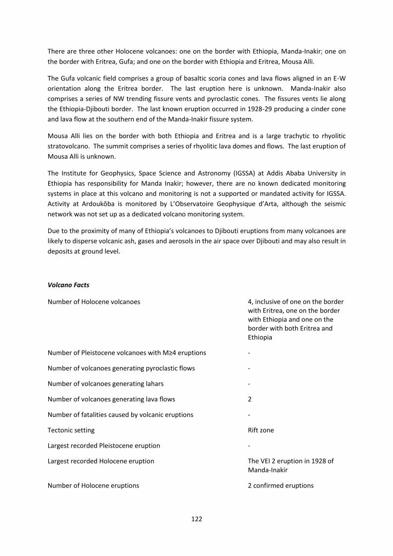
There are three other Holocene volcanoes: one on the border with Ethiopia, Manda-Inakir; one on
the border with Eritrea, Gufa; and one on the border with Ethiopia and Eritrea, Mousa Alli.
The Gufa volcanic field comprises a group of basaltic scoria cones and lava flows aligned in an E-W
orientation along the Eritrea border. The last eruption here is unknown. Manda-Inakir also
comprises a series of NW trending fissure vents and pyroclastic cones. The fissures vents lie along
the Ethiopia-Djibouti border. The last known eruption occurred in 1928-29 producing a cinder cone
and lava flow at the southern end of the Manda-Inakir fissure system.
Mousa Alli lies on the border with both Ethiopia and Eritrea and is a large trachytic to rhyolitic
stratovolcano. The summit comprises a series of rhyolitic lava domes and flows. The last eruption of
Mousa Alli is unknown.
The Institute for Geophysics, Space Science and Astronomy (IGSSA) at Addis Ababa University in
Ethiopia has responsibility for Manda Inakir; however, there are no known dedicated monitoring
systems in place at this volcano and monitoring is not a supported or mandated activity for IGSSA.
Activity at Ardoukôba is monitored by L’Observatoire Geophysique d’Arta, although the seismic
network was not set up as a dedicated volcano monitoring system.
Due to the proximity of many of Ethiopia’s volcanoes to Djibouti eruptions from many volcanoes are
likely to disperse volcanic ash, gases and aerosols in the air space over Djibouti and may also result in
deposits at ground level.
Volcano Facts
Number of Holocene volcanoes 4, inclusive of one on the border with Eritrea, one on the border with Ethiopia and one on the border with both Eritrea and Ethiopia
Number of Pleistocene volcanoes with M≥4 eruptions -
Number of volcanoes generating pyroclastic flows -
Number of volcanoes generating lahars -
Number of volcanoes generating lava flows 2
Number of fatalities caused by volcanic eruptions -
Tectonic setting Rift zone
Largest recorded Pleistocene eruption -
Largest recorded Holocene eruption The VEI 2 eruption in 1928 of Manda-Inakir
Number of Holocene eruptions 2 confirmed eruptions

123
Recorded Holocene VEI range 1 – 2
Number of historically active volcanoes 2
Number of historical eruptions 2
Number of
volcanoes
Primary volcano type Dominant rock type
1 Large cone(s) Rhyolitic (1)
3 Small cone(s) Basaltic (3)
Table 2.17 The number of volcanoes in Djibouti, their volcano type classification and dominant rock type according to VOTW4.0.
Socio-Economic Facts
Total population (2012) 862,000
Gross Domestic Product (GDP) per capita (2005 PPP $) 2,087
Gross National Income (GNI) per capita (2005 PPP $) 2,350
Human Development Index (HDI) (2012) 0.445 (Low)
Population Exposure
Capital city Djibouti
Distance from capital city to nearest Holocene volcano 74.1 km
Total population (2011) 757,074
Number (percentage) of people living within 10 km of a Holocene volcano
5,137 (<1%)
Number (percentage) of people living within 30 km of a Holocene volcano
46,125 (6.1%)
Number (percentage) of people living within 100 km of a Holocene volcano
845,134 (>100%)
Largest cities, as measured by population and their population size:
Djibouti 623,891 Ali Sabieh 40,074 Tadjoura 22,193 Obock 17,776 Dikhil 12,043

124
Infrastructure Exposure
Figure 2.18 The location of Djibouti’s volcanoes and the extent of the 100 km zone surrounding them. Ports, airports and the major cities are just some of the infrastructure that may be exposed to volcanic hazards.
Number of airports within 100 km of a volcano 1
Number of ports within 100 km of a volcano 3
Total length of roads within 100 km of a volcano (km) 455
Total length of railroads within 100 km of a volcano (km) 0
Being a small country, measuring no more than 300 km across, almost the whole country is situated
within 100 km of either the central Ardoukôba volcano, those volcanoes on the borders with the
neighbouring countries or indeed Ethiopian volcanoes. As such, almost all the critical infrastructure
within Djibouti is exposed to the volcanic hazard, including the capital, Djibouti and the international
airport located here.
Hazard, Uncertainty and Exposure Assessments

125
The volcanoes in Djibouti have sparse eruption records, with just one Holocene eruption recorded at
both Ardoukôba and Manda-Inakir. The absence of a thorough eruptive history means that the
hazard levels cannot be calculated without significant uncertainties and therefore both hazard and
risk are unclassified at Djibouti’s volcanoes.
The PEI in Djibouti ranges from low to moderate at PEI 2 – 3. The highest PEI is at Ardoukôba, with
over 560,000 living within 100 km.
CLA
SSIF
IED
Hazard III
Hazard II
Hazard I
UN
CLA
SSIF
IED
U – HHR
Manda-Inakir
Ardoukôba
U- HR
U- NHHR
Mousa Alli; Gufa
PEI 1 PEI 2 PEI 3 PEI 4 PEI 5 PEI 6 PEI 7 Table 2.18 Identity of Djibouti’s volcanoes in each Hazard-PEI group. Those volcanoes with a sufficient record for determining a hazard score are deemed ‘classified’ (top). Those without sufficient data are ‘Unclassified’ (bottom). The unclassified volcanoes are divided into groups: U-NHHR is Unclassified No Historic or Holocene Record: that is there are no confirmed eruptions recorded in the Holocene. U-HR is Unclassified with Holocene Record: that is there are confirmed eruptions recorded during the Holocene, but no historical (post-1500) events. U-HHR is Unclassified with Historic and Holocene record. The unclassified volcanoes in bold have experienced unrest or eruptions since 1900 AD, and those in red have records of at least one Holocene VEI ≥4 eruption.
National Capacity for Coping with Volcanic Risk
A regional network of 15 seismometers is located near the volcano Ardoukouba, run by
L’Observatoire Geophysique d’Arta. This is not dedicated to volcano monitoring but is described as
having sufficient stations to detect small magnitude events in the Asal Rift in which Ardoukouba sits.
The Ethiopia Geophysical Observatory has responsibility for Manda Inakir, however there are no
known dedicated monitoring systems in place at this volcano.

126
Figure 2.19 The monitoring and risk levels of the historically active volcanoes in Djibouti. Monitoring Level 1 indicates no known dedicated ground-based monitoring; Monitoring Level 2 indicates that some ground-based monitoring systems are in place including ≤3 seismic stations; Monitoring Level 3 indicates the presence of a dedicated ground-based monitoring network, including ≥4 seismometers.

This profile and the data therein should not be used in place of focussed assessments and information provided by local monitoring and research institutions.
Equatorial Guinea
Description
Figure 2.20 Location of Equatorial Guinea’s volcanoes, the capital and largest cities. A zone extending 200 km beyond the country's borders shows other volcanoes whose eruptions may directly affect Equatorial Guinea.
Three Holocene volcanoes are located on the island of Bioko, north-west of mainland Equatorial
Guinea. Volcanism here is related to intra-plate processes, which has produced the three basaltic
shield volcanoes.
Of the three Holocene volcanoes, only Santa Isabel has a Holocene record of eruptions. The other
two have activity of suspected Holocene age. The three eruptions of Santa Isabel were recorded in
1898, 1903 and 1923 from vents on the south-east flanks of the volcano. The size and activity style
of these events is unknown. Further research is required to better understand this active volcano,

128
which lies within 20 km of the capital, Malabo, and to more fully understand the volcanic hazards at
Equatorial Guinea’s other volcanoes.
Nearly 120,000 people live within 30 km of Santa Isabel, with a small population proximal to the San
Carlos and San Joaquin volcanoes. The whole population of Bioko island resides within 100 km of the
volcanoes.
Volcano Facts
Number of Holocene volcanoes 3
Number of Pleistocene volcanoes with M≥4 eruptions -
Number of volcanoes generating pyroclastic flows -
Number of volcanoes generating lahars -
Number of volcanoes generating lava flows -
Number of fatalities caused by volcanic eruptions -
Tectonic setting Intra-plate
Largest recorded Pleistocene eruption -
Largest recorded Holocene eruption All eruptions are of unknown VEI
Number of Holocene eruptions 3 confirmed eruptions
Recorded Holocene VEI range Unknown
Number of historically active volcanoes 1
Number of historical eruptions 3
Number of
volcanoes
Primary volcano type Dominant rock type
3 Shield(s) Basaltic
Table 2.19 The number of volcanoes in Equatorial Guinea, their volcano type classification and dominant rock type according to VOTW4.0.
Socio-Economic Facts
Total population (2012) 739,000
Gross Domestic Product (GDP) per capita (2005 PPP $) 32,026
Gross National Income (GNI) per capita (2005 PPP $) 21,715
129
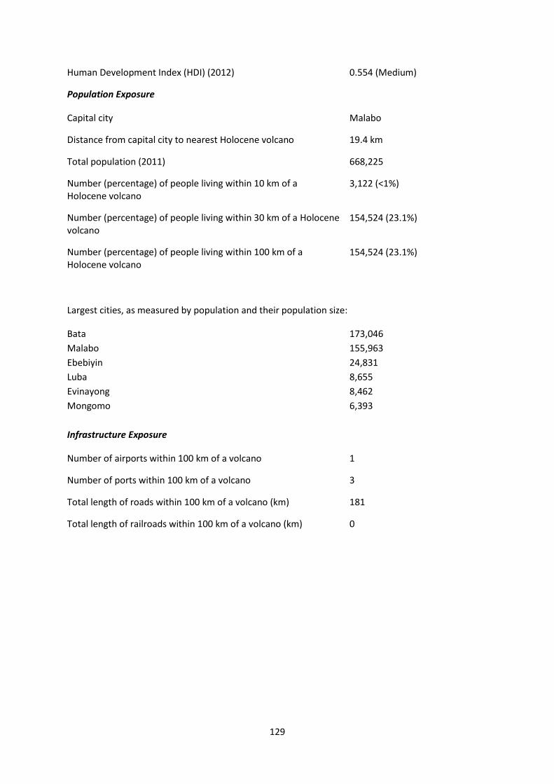
Human Development Index (HDI) (2012) 0.554 (Medium)
Population Exposure
Capital city Malabo
Distance from capital city to nearest Holocene volcano 19.4 km
Total population (2011) 668,225
Number (percentage) of people living within 10 km of a Holocene volcano
3,122 (<1%)
Number (percentage) of people living within 30 km of a Holocene volcano
154,524 (23.1%)
Number (percentage) of people living within 100 km of a Holocene volcano
154,524 (23.1%)
Largest cities, as measured by population and their population size:
Bata 173,046
Malabo 155,963
Ebebiyin 24,831
Luba 8,655
Evinayong 8,462
Mongomo 6,393
Infrastructure Exposure
Number of airports within 100 km of a volcano 1
Number of ports within 100 km of a volcano 3
Total length of roads within 100 km of a volcano (km) 181
Total length of railroads within 100 km of a volcano (km) 0

130
Figure 2.21 The location of Equatorial Guinea’s volcanoes and the extent of the 100 km zone surrounding them. Ports, airports and the major cities are just some of the infrastructure that may be exposed to volcanic hazards.
There are no volcanoes located in the mainland region of Equatorial Guinea. Although bordered by
Cameroon to the north, none of mainland Equatorial Guinea is within 100 km of a volcano. The three
Holocene volcanoes are situated on an island measuring less than 100 km across, placing the
entirety of the island and its population and infrastructure close to the volcanoes. Being within 40
km of the mainland, the 100 km radius of the volcanoes of Equatorial Guinea also affects the coastal
region of southwest Cameroon. A number of ports and oil rigs are located within 100 km, as are two
airports and the capital, Malabo.
Hazard, Uncertainty and Exposure Assessments
Only Santa Isabel in Equatorial Guinea has a record of confirmed Holocene eruptions, with eruptions
in the late 1800s and early 1900s. Determination of Hazard Level cannot be undertaken without
significant uncertainties at any of the volcanoes here, including Santa Isabel, due to the sparse
eruption records meaning both hazard and risk are unclassified.

131
A low PEI of 2 at San Carlos and San Joaquin indicates small local populations here. With a high PEI of
5 at Santa Isabel, including nearly 100,000 people within 10 km, this volcano has a much larger
population at risk and Risk Levels of II to III are indicated, dependent on the hazard.
CLA
SSIF
IED
Hazard III
Hazard II
Hazard I
UN
CLA
SSIF
IED
U – HHR
Santa Isabel
U- HR
U- NHHR
San Carlos; San Joaquin
PEI 1 PEI 2 PEI 3 PEI 4 PEI 5 PEI 6 PEI 7 Table 2.20 Identity of Equatorial Guinea’s volcanoes in each Hazard-PEI group. Those volcanoes with a sufficient record for determining a hazard score are deemed ‘classified’ (top). Those without sufficient data are ‘Unclassified’ (bottom). The unclassified volcanoes are divided into groups: U-NHHR is Unclassified No Historic or Holocene Record: that is there are no confirmed eruptions recorded in the Holocene. U-HR is Unclassified with Holocene Record: that is there are confirmed eruptions recorded during the Holocene, but no historical (post-1500) events. U-HHR is Unclassified with Historic and Holocene record. The unclassified volcanoes in bold have experienced unrest or eruptions since 1900 AD, and those in red have records of at least one Holocene VEI ≥4 eruption.
National Capacity for Coping with Volcanic Risk
Only Santa Isabel volcano in Equatorial Guinea has a historic record of eruptions. At the time of the
writing of this report, no information is available to indicate that regular ground-based monitoring is
undertaken Santa Isabel or the other two Holocene volcanoes here.

132
Figure 2.22 The monitoring and risk levels of the historically active volcanoes in Equatorial Guinea. Monitoring Level 1 indicates no known dedicated ground-based monitoring; Monitoring Level 2 indicates that some ground-based monitoring systems are in place including ≤3 seismic stations; Monitoring Level 3 indicates the presence of a dedicated ground-based monitoring network, including ≥4 seismometers.

This profile and the data therein should not be used in place of focussed assessments and information provided by local monitoring and research institutions.
Eritrea
Description
Figure 2.23 Location of Eritrea’s volcanoes, the capital and largest cities. A zone extending 200 km beyond the country's borders shows other volcanoes whose eruptions may directly affect Eritrea.
Eritrea has five Holocene volcanoes: Alid, Assab Volcanic Field, Dubbi, Jalua and Nabro; plus one on
the border with Djibouti: Gufa; two on the border with Ethiopia: Sork Ale and Mallahle; and one on
the border with both Ethiopia and Djibouti: Mousa Ali. The majority are stratovolcanoes with
compositions ranging from basaltic to rhyolitic.
Volcanism at Eritrea’s volcanoes is expressed as both effusive and explosive, producing lava flows
and pyroclastic deposits. Only Nabro and Dubbi are known to have erupted in historical times.

134
Dubbi volcano’s last two eruptions were from fissure systems that extended NW-SE and NNE-SSW.
The last eruption in 1861 resulted in ash fall more than 300 km away, and lava flows that travelled
22 km. Two villages were destroyed and more than 100 people were killed. The exact cause of the
fatalities is unclear but may have been pyroclastic flows and impacts from the eruption are reported
in neighbouring Ethiopia. This is the largest reported historical eruption in Africa and a cold summer
in 1862 in the Northern Hemisphere has been attributed to the sulphates released by the eruption.
Nabro is a trachytic to trachy-andesitic stratovolcano and is the highest in the Danakil depression of
northern Ethiopia and Eritrea. Nabro is truncated by nested calderas, 8 and 5 km wide. Situated on
the Ethiopia – Eritrea border, the area is remote and sparsely populated. The last eruption of Nabro
in 2011 caused 32 fatalities, displaced >5000 people and disrupted regional aviation including the
cancellation of a number of flights in June 2011. The eruption produced lava flows as well as ash and
gas plumes with a high release of sulphur dioxide. Previous eruptions from Nabro have neither been
dated nor subject to any detailed petrological study, despite a prominent caldera and associated
ignimbrites. The regional seismic network detected a brief period of heightened seismicity before
the eruption, but the volcano itself had no monitoring programme.
Volcano Facts
Number of Holocene volcanoes 9, inclusive of one on the border with Djibouti, two on the border with Ethiopia and one on the border with both Ethiopia and Djibouti
Number of Pleistocene volcanoes with M≥4 eruptions 1
Number of volcanoes generating pyroclastic flows -
Number of volcanoes generating lahars -
Number of volcanoes generating lava flows 2
Number of fatalities caused by volcanic eruptions 137
Tectonic setting Rift zone
Largest recorded Pleistocene eruption The M5.5 Rhyolite pumice (Alid Crater) eruption of Alid at 15.2 ka.
Largest recorded Holocene eruption The VEI 4 2011 AD eruption of Nabro.
Number of Holocene eruptions 3 confirmed eruptions. 2 uncertain eruptions.
Recorded Holocene VEI range 2 – 4
Number of historically active volcanoes 2

135
Number of historical eruptions 2
Number of
volcanoes
Primary volcano type Dominant rock type
7 Large cone(s) Basaltic (3), Rhyolitic (2), Trachytic / Andesitic (2)
2 Small cone(s) Basaltic (2)
Table 2.22 The number of volcanoes in Eritrea, their volcano type classification and dominant rock type according to VOTW4.0.
Socio-Economic Facts
Total population (2012) 6,153,000
Gross Domestic Product (GDP) per capita (2005 PPP $) 516
Gross National Income (GNI) per capita (2005 PPP $) 531
Human Development Index (HDI) (2012) 0.351 (Low)
Population Exposure
Capital city Asmara
Distance from capital city to nearest Holocene volcano 100.7 km
Total population (2011) 5,939,484
Number (percentage) of people living within 10 km of a Holocene volcano
22,180 (<1%)
Number (percentage) of people living within 30 km of a Holocene volcano
71,018 (1.2%)
Number (percentage) of people living within 100 km of a Holocene volcano
2,183,817 (36.8%)
Largest cities, as measured by population and their population size:
Asmara 563,930
Infrastructure Exposure
Number of airports within 100 km of a volcano 0
Number of ports within 100 km of a volcano 2
Total length of roads within 100 km of a volcano (km) 445

136
Total length of railroads within 100 km of a volcano (km) 0
Figure 2.24 The location of Eritrea’s volcanoes and the extent of the 100 km zone surrounding them. Ports, airports and the major cities are just some of the infrastructure that may be exposed to volcanic hazards.
The volcanoes of Eritrea are largely situated in the south of the country, on the borders of Ethiopia
and Djibouti. The strip of Eritrean land here is less than 100 km across and therefore the 100 km of
the volcanoes here encompasses areas of its neighbouring countries and the Red Sea. As such, two
ports are within the 100 km radius of the volcanoes. The capital Asmara lies about 100 km from Jalua
volcano, as does the infrastructure here including the Asmara International Airport.
Hazard, Uncertainty and Exposure Assessments
The Hazard Level cannot be determined without significant uncertainties for any volcanoes in Eritrea
due to the sparse eruptive histories with too few eruptions of a known size. Of the nine volcanoes,
only Dubbi and Nabro have confirmed Holocene eruptions, and both these had historical events of
VEI 3 and 4 respectively. With the hazard unclassified, the risk is also unclassified here. However, the
PEI ranges from low to moderate.

137
C
LASS
IFIE
D Hazard
III
Hazard II
Hazard I
UN
CLA
SSIF
IED
U – HHR
Dubbi; Nabro
U- HR
U- NHHR
Mallahle; Sork Ale; Mousa Alli; Gufa; Assab Volcanic Field
Alid Jalua
PEI 1 PEI 2 PEI 3 PEI 4 PEI 5 PEI 6 PEI 7 Table 2.23 Identity of Eritrea’s volcanoes in each Hazard-PEI group. Those volcanoes with a sufficient record for determining a hazard score are deemed ‘classified’ (top). Those without sufficient data are ‘Unclassified’ (bottom). The unclassified volcanoes are divided into groups: U-NHHR is Unclassified No Historic or Holocene Record: that is there are no confirmed eruptions recorded in the Holocene. U-HR is Unclassified with Holocene Record: that is there are confirmed eruptions recorded during the Holocene, but no historical (post-1500) events. U-HHR is Unclassified with Historic and Holocene record. The unclassified volcanoes in bold have experienced unrest or eruptions since 1900 AD, and those in red have records of at least one Holocene VEI ≥4 eruption.
National Capacity for Coping with Volcanic Risk
Two volcanoes have historical eruption records in Eritrea: Dubbi and Nabro. No information is
available at the time of the writing of this report to indicate that regular ground-based monitoring is
undertaken at any of the volcanoes in Eritrea.

138
Figure 2.25 The monitoring and risk levels of the historically active volcanoes in Eritrea. Monitoring Level 1 indicates no known dedicated ground-based monitoring; Monitoring Level 2 indicates that some ground-based monitoring systems are in place including ≤3 seismic stations; Monitoring Level 3 indicates the presence of a dedicated ground-based monitoring network, including ≥4 seismometers.

This profile and the data therein should not be used in place of focussed assessments and information provided by local monitoring and research institutions.
Ethiopia
Description
Figure 2.26 Location of Ethiopia’s volcanoes, the capital and largest cities. A zone extending 200 km beyond the country's borders shows other volcanoes whose eruptions may directly affect Ethiopia.
Fifty-nine Holocene volcanoes are known in Ethiopia. These form two distinct lines of volcanoes
which can be seen within the East African rift. The first is the Main Ethiopian Rift, a northeast
trending line that bisects the middle of the country, stretching from the Korath Range in the
southwest to the Djibouti border in the northeast. The second line is oriented north northwest
nearer the border with Eritrea and consists of a series of smaller lines of volcanoes in the area of the
Afar Depression.

140
Like other countries in the East African Rift, Ethiopia has a high ratio of effusive to explosive volcano
types, with thirty-one of the former and thirty-four of the latter. The single most common edifice
type is the stratovolcano. However, each of the effusive volcano types may include a group of many
volcanic vents spread along a line of fissures that may be tens of kilometres long.
Only seven of Ethiopia’s volcanoes are currently known to have produced pyroclastic flows and none
have triggered lahars. Lava flows are common, occurring at fifty-six of the volcanoes. The great
prevalence of lava flows compared to other hazardous flows in Ethiopia reduces the relative hazard
extent and impacts although the high incidence of volcanic gases and aerosols being released from
such effusive eruptions adds a further hazardous element.
Seven of the country’s ten most populous cities are more than 30 km from their nearest volcano.
Ethiopia’s numerous rural communities mean that twenty-five volcanoes have over 100,000 people
living with a 30 km radius of their summit and 46.5% of the total population of Ethiopia lives within
100km of a volcano. The remote and sparsely populated area of the Ethiopian border near Nabro
volcano still resulted in 32 fatalities and displacement of over 5000 people from the area. Rapid
population growth and increasing investment in geothermal energy in the Main Ethiopian Rift mean
that the exposure to volcanic hazards is rapidly increasing in Ethiopia and similar eruptions in the
densely populated Main Ethiopian Rift will have considerable humanitarian and economic costs.
The distance of the country’s main population centres from volcanoes and frequency of lava flows
compared to other hazardous flows is reflected in the historic fatalities record; just three eruptions
have records as reporting loss of life, with a combined total of 163 casualties. The greatest fatalities
occurred in response to the Dubbi eruption from Eritrea in 1861.
The volcanic record is particularly poor in Ethiopia and there is no explicit eruptive history for forty-
nine of Ethiopia’s volcanoes. As such, under-reporting may downplay the level of hazard posed both
in the past and at present.
Volcano Facts
Number of Holocene volcanoes 59, inclusive of two on the border with Eritrea, one on the border with Djibouti, one on the border with Kenya and one on the border with both Eritrea and Djibouti.
Number of Pleistocene volcanoes with M≥4 eruptions 4
Number of volcanoes generating pyroclastic flows -
Number of volcanoes generating lahars -
Number of volcanoes generating lava flows 9
Number of fatalities caused by volcanic eruptions >65?

141
Tectonic setting 5 intra-plate, 54 rift zone
Largest recorded Pleistocene eruption The M8 Awasa caldera formation at Corbetti caldera at 1 Ma
Largest recorded Holocene eruption The largest recorded Holocene eruption in Ethiopia occurred with the Caldera forming eruption at Fentale at 8 ka, at a magnitude of 5.5
Number of Holocene eruptions 19 confirmed eruptions. 6 uncertain eruptions, 1 discredited eruption
Recorded Holocene VEI range 0 – 3 and unknown
Number of historically active volcanoes 11
Number of historical eruptions 17
Number of
volcanoes
Primary volcano type Dominant rock type
5 Caldera(s) Basaltic (1), Rhyolitic (4)
21 Large cone(s) Basaltic (6), Rhyolitic (14), Trachytic / Andesitic (1)
1 Lava dome(s) Rhyolitic
11 Shield(s) Basaltic (11)
21 Small cone(s) Basaltic (16), Rhyolitic (2), Unknown (3)
Table 2.24 The number of volcanoes in Ethiopia, their volcano type classification and dominant rock type according to VOTW4.0.
Socio-Economic Facts
Total population (2012) 92,256,000
Gross Domestic Product (GDP) per capita (2005 PPP $) 979
Gross National Income (GNI) per capita (2005 PPP $) 1,017
Human Development Index (HDI) (2012) 0.396 (Low)
Population Exposure
Capital city Addis Ababa
Distance from capital city to nearest Holocene volcano 41.5 km
142
Total population (2011) 90,873,739
Number (percentage) of people living within 10 km of a Holocene volcano
1,479,965 (1.6%)
Number (percentage) of people living within 30 km of a Holocene volcano
11,127,909 (12.3%)
Number (percentage) of people living within 100 km of a Holocene volcano
42,247,222 (46.5%)
The largest cities, as measured by population and their population size (from Statistical Agency of
Ethiopia):
Addis Ababa 3.1 million
Mek'ele 286,000
Dire Dawa 269,000
Gonder 265,000
Awasa 225,000
Jima 155,000
Dese 153,000
Jigiga 152,000
Shashemene 129,000
Harar 112,000
Arba Minch 107,000
Infrastructure Exposure
Number of airports within 100 km of a volcano 1
Number of ports within 100 km of a volcano 1
Total length of roads within 100 km of a volcano (km) 3,910
Total length of railroads within 100 km of a volcano (km) 0
The volcanoes of Ethiopia stretch right across the country through the Eastern Rift Valley, including
volcanoes on the borders with Eritrea, Djibouti and Kenya. With 59 volcanoes located here, a large
part of the country lies within 100 km of these sites, including many major cities and the capital,
Addis Ababa. Many roads lie within 100 km. The Addis Ababa Bole International Airport is affected,
as is much of southern Djibouti and a port here.

143
Figure 2.27 The location of Ethiopia’s volcanoes and the extent of the 100 km zone surrounding them. Ports, airports and the major cities are just some of the infrastructure that may be exposed to volcanic hazards.
Hazard, Uncertainty and Exposure Assessments
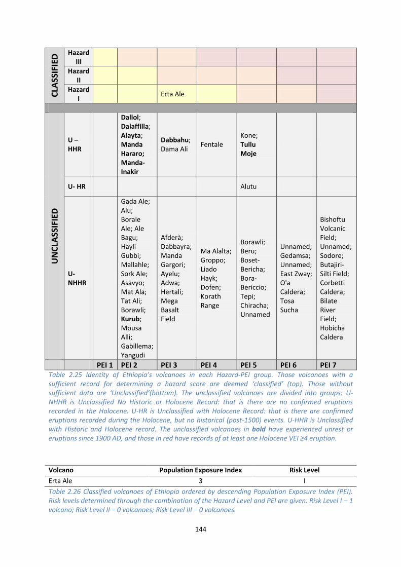
Of the 59 volcanoes in Ethiopia, just one, Erta Ale, has sufficient a record for calculation of a Hazard
Level. Erta Ale has four eruptions recorded since 1900 AD, inclusive of the ongoing eruption which
began in 1967. Activity at this volcano is dominantly effusive, and hence a Hazard Level of I is
derived.
Hazard levels would be associated with high degrees of uncertainty at all other volcanoes in Ethiopia
due to their sparse or incomplete eruption records. Ten of these unclassified volcanoes have records
of historical eruptions (post-1500 AD), seven of which have experienced eruptions since 1900 AD. 47
volcanoes have no confirmed Holocene eruptions. These volcanoes are unclassified.
The PEI ranges from low to very high in Ethiopia, with most volcanoes classed at high PEIs of 5 to 7.
With a moderate PEI of 3 at Erta Ale, this volcano is classed at Risk Level I. All other volcanoes are
unclassified.
144
CLA
SSIF
IED
Hazard III
Hazard II
Hazard I
Erta Ale
UN
CLA
SSIF
IED
U – HHR
Dallol; Dalaffilla; Alayta; Manda Hararo; Manda-Inakir
Dabbahu; Dama Ali
Fentale Kone; Tullu Moje
U- HR Alutu
U- NHHR
Gada Ale; Alu; Borale Ale; Ale Bagu; Hayli Gubbi; Mallahle; Sork Ale; Asavyo; Mat Ala; Tat Ali; Borawli; Kurub; Mousa Alli; Gabillema; Yangudi
Afderà; Dabbayra; Manda Gargori; Ayelu; Adwa; Hertali; Mega Basalt Field
Ma Alalta; Groppo; Liado Hayk; Dofen; Korath Range
Borawli; Beru; Boset-Bericha; Bora-Bericcio; Tepi; Chiracha; Unnamed
Unnamed; Gedamsa; Unnamed; East Zway; O'a Caldera; Tosa Sucha
Bishoftu Volcanic Field; Unnamed; Sodore; Butajiri-Silti Field; Corbetti Caldera; Bilate River Field; Hobicha Caldera
PEI 1 PEI 2 PEI 3 PEI 4 PEI 5 PEI 6 PEI 7 Table 2.25 Identity of Ethiopia’s volcanoes in each Hazard-PEI group. Those volcanoes with a sufficient record for determining a hazard score are deemed ‘classified’ (top). Those without sufficient data are ‘Unclassified’(bottom). The unclassified volcanoes are divided into groups: U-NHHR is Unclassified No Historic or Holocene Record: that is there are no confirmed eruptions recorded in the Holocene. U-HR is Unclassified with Holocene Record: that is there are confirmed eruptions recorded during the Holocene, but no historical (post-1500) events. U-HHR is Unclassified with Historic and Holocene record. The unclassified volcanoes in bold have experienced unrest or eruptions since 1900 AD, and those in red have records of at least one Holocene VEI ≥4 eruption.
Volcano Population Exposure Index Risk Level
Erta Ale 3 I
Table 2.26 Classified volcanoes of Ethiopia ordered by descending Population Exposure Index (PEI). Risk levels determined through the combination of the Hazard Level and PEI are given. Risk Level I – 1 volcano; Risk Level II – 0 volcanoes; Risk Level III – 0 volcanoes.

145
Figure 2.28 Distribution of Ethiopia’s classified volcanoes across Hazard and Population Exposure Index levels. The warming of the background colours illustrates increasing Risk levels from Risk Level I - III.
National Capacity for Coping with Volcanic Risk
The Institute of Geophysics, Space Science and Astronomy (IGSSA) of the Addis Ababa University
(AAU) is responsible for the monitoring of volcanoes in Ethiopia. Eleven volcanoes here have
historical records of activity. Of these, only Erta Ale has a classified risk level. No information is
available at the time of the writing of this report to indicate that regular dedicated ground-based
monitoring is in place at any of these volcanoes.

146
Figure 2.29 The monitoring and risk levels of the historically active volcanoes in Ethiopia. Monitoring Level 1 indicates no known dedicated ground-based monitoring; Monitoring Level 2 indicates that some ground-based monitoring systems are in place including ≤3 seismic stations; Monitoring Level 3 indicates the presence of a dedicated ground-based monitoring network, including ≥4 seismometers.

This profile and the data therein should not be used in place of focussed assessments and information provided by local monitoring and research institutions.
Kenya
Description
Figure 2.30 Location of Kenya’s volcanoes, the capital and largest cities. A zone extending 200 km beyond the country's borders shows other volcanoes whose eruptions may directly affect Kenya.
Kenya has 21 Holocene volcanoes plus one on the border with Ethiopia, the Mega Basalt Field. The
majority lie along the Rift Valley in a roughly N-S orientation, while five of them (Segererua Plateau,
Marsabit, Nyambeni Hills and Chyulu Hills) lie to the east and one (Homa Mountain) lies to the west
of the Rift Valley. Eleven of the volcanoes are basaltic to trachytic shield volcanoes, while the others
comprise stratovolcanoes, pyroclastic cones, tuff cones, pumice cones and a volcanic field. Only two
are felsic in composition: the rhyolitic Ol Doinyo Eburru volcanic complex, along the Rift Valley, south
of Nakuru; and the Olkaria pumice cone, approximately 29 km SE of Ol Doinyo Eburru.

148
Only six of the volcanoes have recorded historical eruptions. The last known eruptions of these are:
Olkaria in 1770; Chyulu Hills in 1855; Longonot in 1863; South Island in 1888; Emuruangogolak in
1919; and The Barrier in 1921.
Olikaria is a felsic volcanic complex comprising up to 80 individual centres within an 11 km wide
caldera formed c.20,000 years ago that produced welded ignimbrites. The youngest known eruption
was in 1770, producing a pumice cone and a lava flow that travelled c.5 km to SW. Olkaria is a large
(50 km2) high-temperature geothermal field.
The Chyulu Hills volcanic field is c.150 km east of the Rift Valley in southern Kenya, and comprises
several hundred small cones and lava flows, including numerous recent cinder cones. The Holocene
cones are found in the SE of the volcanic field. The most recent eruptions occurred in the
mid-19th Century from two cinder cones, Shaitani and Chainu.
Longonot is a trachytic stratovolcano located in the Gregory Rift, SE of Lake Naivasha. Longonot
comprises a 8×12 km caldera, formed c.21,000 years ago, within which sits a large central cone.
According to Masai records, the last known eruption occurred from a satellite cone on the NE flank
of the volcano in the 19th Century.
South Island is the largest and southernmost of the three volcanic islands in Lake Turkana in
northern Kenya. The island comprises basaltic lava flows that erupted from a 11 km long N-S
trending fissure, and a tuff cone. The last known eruption was in 1888, when eruption from a scoria
cone was observed.
Emuruangogolak is a broad shield volcano in the Gregory Rift Valley. A 5 km wide summit caldera
formed c.38,000 years ago. Trachytic and basaltic lava flows have since erupted on the northern and
southern flanks, and within the caldera. Parasitic cones also erupted along rift-parallel faults that
intersected the volcano. The last know eruption occurred in 1910, producing a trachytic lava flow.
Active fumaroles occur along NNE trending fissures within the caldera and along the lower NW
flanks.
The Barrier is the most recently active of Kenya’s volcanoes, with its last known eruption recorded in
1921, which produced basaltic lava flows. The Barrier volcanic complex comprises four overlapping
shield volcanoes. The youngest one lies over the axis of the East African Rift. Early Holocene scoria
cones and lava flows erupted on the youngest volcano’s southern and northern flanks.
Shompole (also Shombole) volcano lies on the border with Tanzania, at the northern end of Lake
Natron. No Holocene activity is recorded at this volcano, however recent increased seismicity has
been recorded in the area. A temporary seismic network has been installed to monitor this activity.
Volcano Facts
Number of Holocene volcanoes 22, inclusive of one on the border with Ethiopia
Number of Pleistocene volcanoes with M≥4 eruptions 8

149
Number of volcanoes generating pyroclastic flows 3
Number of volcanoes generating lahars 1
Number of volcanoes generating lava flows 5
Number of fatalities caused by volcanic eruptions -
Tectonic setting Rift-zone
Largest recorded Pleistocene eruption The M6.8 eruption of Menengai at 12,345 BP with the Ruplax Tuff eruption.
Largest recorded Holocene eruption The M6.8 Caldera 2 eruption of Menengai is the largest recorded eruption in Kenya during the Holocene, occurring at 8985 BP.
Number of Holocene eruptions 34 confirmed eruptions; 3 uncertain eruptions
Recorded Holocene VEI range 0 – 6 and unknown
Number of historically active volcanoes 6
Number of historical eruptions 12
Number of
volcanoes
Primary volcano type Dominant rock type
4 Large cone(s) Basaltic (1), Foiditic (1), Rhyolitic (1), Trachytic / Andesitic
(1)
11 Shield(s) Basaltic (4), Phonolitic (1), Trachytic / Andesitic (6)
7 Small cone(s) Andesitic (1), Basaltic (5), Rhyolitic (1)
Table 2.27 The number of volcanoes in Kenya, their volcano type classification and dominant rock type according to VOTW4.0.
Socio-Economic Facts
Total population (2012) 43,323,000
Gross Domestic Product (GDP) per capita (2005 PPP $) 1,507
Gross National Income (GNI) per capita (2005 PPP $) 1,541
Human Development Index (HDI) (2012) 0.519 (Low)

150
Population Exposure
Capital city Nairobi
Distance from capital city to nearest Holocene volcano 53.3 km
Total population (2011) 41,943,504
Number (percentage) of people living within 10 km of a Holocene volcano
568,572 (1.4%)
Number (percentage) of people living within 30 km of a Holocene volcano
3,968,357 (9.5%)
Number (percentage) of people living within 100 km of a Holocene volcano
29,950,855 (71.4%)
Largest cities, as measured by population and their population size:
Nairobi 2,750,547
Mombasa 799,668
Nakuru 259,903
Kisumu 216,479
Kakamega 63,426
Nyeri 51,084
Wajir 45,771
Embu 34,922
Infrastructure Exposure
Number of airports within 100 km of a volcano 3
Number of ports within 100 km of a volcano 0
Total length of roads within 100 km of a volcano (km) 3,395
Total length of railroads within 100 km of a volcano (km) 763
Many of Kenya’s volcanoes are located in the Rift Valley stretching roughly north to south across the
country, whilst others are located east and west of this and on the border with Ethiopia. The number
of volcanoes here means that a large portion of the country lies within 100 km of a volcano,
including five of the largest cities in Kenya and the capital, Nairobi. As such, much of the critical
infrastucture here is within 100 km of the volcanoes, inclusive of three airports and an extensive
road and rail network. Being located inland, the volcanoes are distal to the ports on the Kenya
coastline, though Homa Mountain lies on the shore of Lake Victoria. Areas of Ethiopia, Tanzania and
Uganda lie within 100 km of the Kenyan volcanoes.

151
Figure 2.31 The location of Kenya’s volcanoes and the extent of the 100 km zone surrounding them. Ports, airports and the major cities are just some of the infrastructure that may be exposed to volcanic hazards.
Hazard, Uncertainty and Exposure Assessments
With the exception of The Barrier, all volcanoes in Kenya have eruption records which are too sparse
to use to determine a Hazard Level without significant uncertainties. These are therefore
unclassified in both hazard and risk. Of these unclassified volcanoes, twelve have no confirmed
Holocene eruptions. Five have historical (post-1500 AD) eruptions, including a 1910 eruption at
Emuruangogolak. The Barrier has an extensive Holocene and historical record of eruptions of a
known size, and the hazard is therefore calculated. The low explosivity of this volcano in part results
in the assignment of Hazard Level I.
PEI ranges from low to high in Kenya, with most volcanoes categorised at moderate and high PEIs.

152
CLA
SSIF
IED
Hazard III
Hazard II
Hazard I
The Barrier
UN
CLA
SSIF
IED
U – HHR
South Island; Emuruangogolak
Chyulu Hills
Olkaria; Longonot
U- HR Namarunu Silali; Paka
Menengai
U- NHHR
North Island; Central Island
Mega Basalt Field; Segererua Plateau
Marsabit; Korosi; Ol Kokwe; Suswa
Homa Mountain; Eburru, Ol Doinyo
Nyambeni Hills; Elmenteita Badlands
PEI 1
PEI 2 PEI 3 PEI 4 PEI 5 PEI 6 PEI 7
Table 2.28 Identity of Kenya’s volcanoes in each Hazard-PEI group. Those volcanoes with a sufficient record for determining a hazard score are deemed ‘classified’ (top). Those without sufficient data are ‘Unclassified’ (bottom). The unclassified volcanoes are divided into groups: U-NHHR is Unclassified No Historic or Holocene Record: that is there are no confirmed eruptions recorded in the Holocene. U-HR is Unclassified with Holocene Record: that is there are confirmed eruptions recorded during the Holocene, but no historical (post-1500) events. U-HHR is Unclassified with Historic and Holocene record. The unclassified volcanoes in bold have experienced unrest or eruptions since 1900 AD, and those in red have records of at least one Holocene VEI ≥4 eruption.
Volcano Population Exposure Index Risk Level
Barrier, The 2 I
Table 2.29 Classified volcanoes of Kenya ordered by descending Population Exposure Index (PEI). Risk levels determined through the combination of the Hazard Level and PEI are given. Risk Level I – 1 volcano; Risk Level II – 0 volcanoes; Risk Level III – 0 volcanoes.

153
Figure 2.32 Distribution of Kenya’s classified volcanoes across Hazard and Population Exposure Index levels. The warming of the background colours illustrates increasing Risk levels from Risk Level I - III.
National Capacity for Coping with Volcanic Risk
Six volcanoes have historical eruption records in Kenya. No information is available at the time of
the writing of this report to indicate that regular ground-based monitoring is undertaken at any of
the volcanoes in Kenya.
Figure 2.33 The monitoring and risk levels of the historically active volcanoes in Kenya. Monitoring Level 1 indicates no known dedicated ground-based monitoring; Monitoring Level 2 indicates that some ground-based monitoring systems are in place including ≤3 seismic stations; Monitoring Level 3 indicates the presence of a dedicated ground-based monitoring network, including ≥4 seismometers.

This profile and the data therein should not be used in place of focussed assessments and information provided by local monitoring and research institutions.
Libya
Description
Figure 2.34 Location of Libya’s volcanoes, the capital and largest cities. A zone extending 200 km beyond the country's borders shows other volcanoes whose eruptions may directly affect Libya.
Two Holocene volcanoes are located in the centre of Libya. These volcanoes are related to intra-
plate processes.
The Haruj volcano is a basaltic volcanic field comprising numerous basaltic scoria cones, lava flows
and explosion craters. The Wau-en-Namus volcano comprises a caldera and post-caldera basaltic
scoria cone. Neither volcanoes have a record of Holocene eruptions, but both are considered to have
had Holocene activity.

155
Both Libyan volcanoes are remote with fewer than 100 people living within 30 km of these
volcanoes. Just over 2,000 people live within the 100 km radii. Assessment of hazard at these
volcanoes is poorly constrained due to the absence of a detailed eruptive history.
Volcano Facts
Number of Holocene volcanoes 2
Number of Pleistocene volcanoes with M≥4 eruptions -
Number of volcanoes generating pyroclastic flows -
Number of volcanoes generating lahars -
Number of volcanoes generating lava flows -
Number of fatalities caused by volcanic eruptions -
Tectonic setting Intra-plate
Largest recorded Pleistocene eruption -
Largest recorded Holocene eruption -
Number of Holocene eruptions -
Recorded Holocene VEI range -
Number of historically active volcanoes -
Number of historical eruptions -
Number of
volcanoes
Primary volcano type Dominant rock type
1 Caldera(s) Basaltic (1)
1 Small cone(s) Basaltic (1)
Table 2.30 The number of volcanoes in Libya, their volcano type classification and dominant rock type according to VOTW4.0.
Socio-Economic Facts
Total population (2012) 6,175,000
Gross Domestic Product (GDP) per capita (2005 PPP $) 15,361
Gross National Income (GNI) per capita (2005 PPP $) 13,765
Human Development Index (HDI) (2012) 0.769 (High)
Population Exposure
Capital city Tripoli
Distance from capital city to nearest Holocene volcano 444.2 km

156
Total population (2011) 6,597,960
Number (percentage) of people living within 10 km of a Holocene volcano
2 (<1%)
Number (percentage) of people living within 30 km of a Holocene volcano
98 (<1%)
Number (percentage) of people living within 100 km of a Holocene volcano
2,193 (<1%)
Ten largest cities, as measured by population and their population size:
Benghazi 650,629
Misratah 386,120
Al Khums 201,943
Ajdabiya 134,358
Darnah 78,782
Murzuq 43,732
Az Zawiyah 4,917
Ghadamis <50,000
Gharyan <50,000
Sabha <50,000
Infrastructure Exposure
Number of airports within 100 km of a volcano 0
Number of ports within 100 km of a volcano 0
Total length of roads within 100 km of a volcano (km) 248
Total length of railroads within 100 km of a volcano (km) 0
Haruj and Wau-en-Namus volcanoes are located in central Libya. Being inland volcanoes, none of the
ports along the northern coastline lie within 100 km. Many of the largest cities, including the capital
Tripoli are concentrated along the coast, and as such are distal to the volcanoes. Indeed, no large
settlements or infrastructure are located within 100 km of these remote volcanoes.

157
Figure 2.35 The location of Libya’s volcanoes and the extent of the 100 km zone surrounding them. Ports, airports and the major cities are just some of the infrastructure that may be exposed to volcanic hazards.
Hazard, Uncertainty and Exposure Assessments
Neither of the volcanoes in Libya have confirmed Holocene eruptions. Without a comprehensive
eruptive history, the hazard cannot be calculated and these volcanoes are therefore unclassified in
both hazard and risk. The PEI at Libya’s volcanoes is low, at PEI 2.

158
CLA
SSIF
IED
Hazard III
Hazard II
Hazard I
UN
CLA
SSIF
IED
U – HHR
U- HR
U- NHHR
Haruj; Wau-en-Namus
PEI 1 PEI 2 PEI 3 PEI 4 PEI 5 PEI 6 PEI 7 Table 2.31 Identity of Libya’s volcanoes in each Hazard-PEI group. Those volcanoes with a sufficient record for determining a hazard score are deemed ‘classified’ (top). Those without sufficient data are ‘Unclassified’ (bottom). The unclassified volcanoes are divided into groups: U-NHHR is Unclassified No Historic or Holocene Record: that is there are no confirmed eruptions recorded in the Holocene. U-HR is Unclassified with Holocene Record: that is there are confirmed eruptions recorded during the Holocene, but no historical (post-1500) events. U-HHR is Unclassified with Historic and Holocene record. The unclassified volcanoes in bold have experienced unrest or eruptions since 1900 AD, and those in red have records of at least one Holocene VEI ≥4 eruption.
National Capacity for Coping with Volcanic Risk
No volcanoes in Libya have recorded historical eruptions and no information is available at the time
of the writing of this report to indicate that regular ground-based monitoring is undertaken at any
Holocene volcanoes in Libya.

This profile and the data therein should not be used in place of focussed assessments and information provided by local monitoring and research institutions.
Mali
Description
One Holocene volcano is identified in Mali, located close to the border with Algeria and Niger. This
volcano is related to intra-plate hot spot processes.
The Tin Zaouatene Volcanic Field is a small, basaltic volcanic field. No eruptions are recorded in the
Holocene, however Holocene activity is suspected.
Only a very small population live within 100 km of this volcano, as much of the infrastructure and
population in Mali is located in the south of the country, distal to this volcano, and therefore
minimal risk is indicated here. However, the hazard is poorly constrained with the absence of an
eruptive history. The 100 km radius of this volcano extends beyond the borders into Algeria.
Figure 2.36 Location of Mali’s volcanoes, the capital and largest cities. A zone extending 200 km beyond the country's borders shows other volcanoes whose eruptions may directly affect Mali.

160
Volcano Facts
Number of Holocene volcanoes 1
Number of Pleistocene volcanoes with M≥4 eruptions -
Number of volcanoes generating pyroclastic flows -
Number of volcanoes generating lahars -
Number of volcanoes generating lava flows -
Number of fatalities caused by volcanic eruptions -
Tectonic setting Intra-plate
Largest recorded Pleistocene eruption -
Largest recorded Holocene eruption -
Number of Holocene eruptions -
Recorded Holocene VEI range -
Number of historically active volcanoes -
Number of historical eruptions -
Number of
volcanoes
Primary volcano type Dominant rock type
1 Small cone(s) Basaltic (1)
Table 2.321 The number of volcanoes in Mali, their volcano type classification and dominant rock type according to VOTW4.0.
Socio-Economic Facts
Total population (2012) 14,850,000
Gross Domestic Product (GDP) per capita (2005 PPP $) 964
Gross National Income (GNI) per capita (2005 PPP $) 853
Human Development Index (HDI) (2012) 0.344 (Low)
Population Exposure
Capital city Bamako
Distance from capital city to nearest Holocene volcano 1404.2 km
Total population (2011) 14,159,904
Number (percentage) of people living within 10 km of a Holocene volcano
101 (<1%)
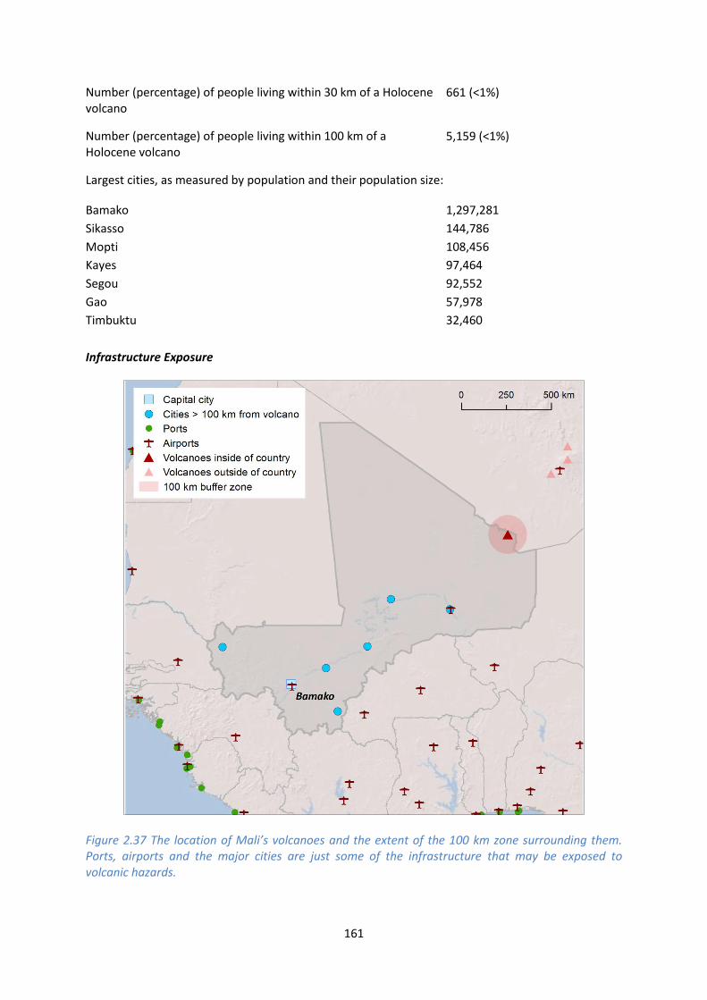
161
Number (percentage) of people living within 30 km of a Holocene volcano
661 (<1%)
Number (percentage) of people living within 100 km of a Holocene volcano
5,159 (<1%)
Largest cities, as measured by population and their population size:
Bamako 1,297,281
Sikasso 144,786
Mopti 108,456
Kayes 97,464
Segou 92,552
Gao 57,978
Timbuktu 32,460
Infrastructure Exposure
Figure 2.37 The location of Mali’s volcanoes and the extent of the 100 km zone surrounding them. Ports, airports and the major cities are just some of the infrastructure that may be exposed to volcanic hazards.

162
Number of airports within 100 km of a volcano 0
Number of ports within 100 km of a volcano 0
Total length of roads within 100 km of a volcano (km) 0
Total length of railroads within 100 km of a volcano (km) 0
Much of the infrastructure and population of Mali is located in the south of the country, with the
Sahara desert making up much of northern Mali. As such, with the Tin Zaouatene Volcanic Field lying
in the north on the border with Algeria, much of the critical infrastructure of Mali, including the
largest cities and the capital, Bamako, lie distal to the volcano.
Hazard, Uncertainty and Exposure Assessments
The Tin Zaouatene Volcanic Field has no confirmed Holocene eruptions recorded in VOTW4.22. The
absence of a detailed eruption history means that the hazard level cannot be calculated and
therefore this volcano is unclassified in both hazard and risk. There is a small population living within
100 km of the Tin Zaouatene Volcanic Field, categorising this volcano at PEI 2.
CLA
SSIF
IED
Hazard III
Hazard II
Hazard I
UN
CLA
SSIF
IED
U – HHR
U- HR
U- NHHR
Tin Zaouatene Volcanic Field
PEI 1 PEI 2 PEI 3 PEI 4 PEI 5 PEI 6 PEI 7 Table 2.33 Identity of Mali’s volcanoes in each Hazard-PEI group. Those volcanoes with a sufficient record for determining a hazard score are deemed ‘classified’ (top). Those without sufficient data are ‘Unclassified’ (bottom). The unclassified volcanoes are divided into groups: U-NHHR is Unclassified No Historic or Holocene Record: that is there are no confirmed eruptions recorded in the Holocene. U-HR is Unclassified with Holocene Record: that is there are confirmed eruptions recorded during the Holocene, but no historical (post-1500) events. U-HHR is Unclassified with Historic and Holocene record. The unclassified volcanoes in bold have experienced unrest or eruptions since 1900 AD, and those in red have records of at least one Holocene VEI ≥4 eruption.

163
National Capacity for Coping with Volcanic Risk
No volcanoes in Mali have recorded historical eruptions and no information is available at the time
of the writing of this report to indicate that regular ground-based monitoring is undertaken at any
Holocene volcanoes in Mali.

This profile and the data therein should not be used in place of focussed assessments and information provided by local monitoring and research institutions.
Niger
Description
Two Holocene volcanoes are located in Niger. The Todra Volcanic Field is located in central Niger
whilst the In Ezzane Volcanic Field lies on the border with Algeria. Both these volcanoes are related
to intra-plate processes.
Both volcanic systems comprise small cones of basaltic composition; extensive lava flows surround
the Todra cones. No Holocene eruptions are recorded at either volcanoes, however Holocene
activity is suspected.
Only a very small population lives within 30 km of these volcanoes, however, the city of Agadez of
over 128,000, lies within 100 km of the Todra Volcanic Field. The assessment of hazard is poorly
constrained due to the absence of a detailed eruptive history.
Figure 2.38 Location of Niger’s volcanoes, the capital and largest cities. A zone extending 200 km beyond the country's borders shows other volcanoes whose eruptions may directly affect Niger.
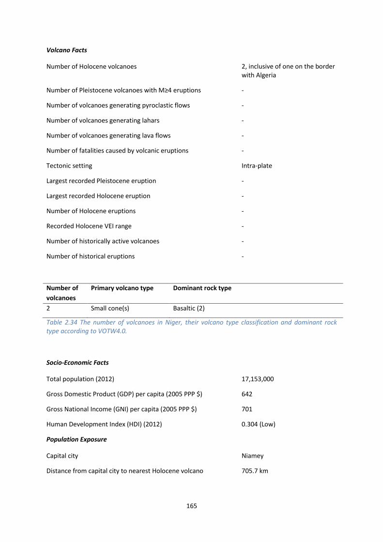
165
Volcano Facts
Number of Holocene volcanoes 2, inclusive of one on the border with Algeria
Number of Pleistocene volcanoes with M≥4 eruptions -
Number of volcanoes generating pyroclastic flows -
Number of volcanoes generating lahars -
Number of volcanoes generating lava flows -
Number of fatalities caused by volcanic eruptions -
Tectonic setting Intra-plate
Largest recorded Pleistocene eruption -
Largest recorded Holocene eruption -
Number of Holocene eruptions -
Recorded Holocene VEI range -
Number of historically active volcanoes -
Number of historical eruptions -
Number of
volcanoes
Primary volcano type Dominant rock type
2 Small cone(s) Basaltic (2)
Table 2.34 The number of volcanoes in Niger, their volcano type classification and dominant rock type according to VOTW4.0.
Socio-Economic Facts
Total population (2012) 17,153,000
Gross Domestic Product (GDP) per capita (2005 PPP $) 642
Gross National Income (GNI) per capita (2005 PPP $) 701
Human Development Index (HDI) (2012) 0.304 (Low)
Population Exposure
Capital city Niamey
Distance from capital city to nearest Holocene volcano 705.7 km

166
Total population (2011) 16,468,886
Number (percentage) of people living within 10 km of a Holocene volcano
87 (<1%)
Number (percentage) of people living within 30 km of a Holocene volcano
1,704 (<1%)
Number (percentage) of people living within 100 km of a Holocene volcano
199,595 (1.2%)
Largest cities, as measured by population and their population size:
Niamey 774,235
Zinder 191,424
Maradi 163,487
Agadez 128,324
Tahoua 80,425
Dosso 49,750
Diffa 27,948
Infrastructure Exposure
Number of airports within 100 km of a volcano 0
Number of ports within 100 km of a volcano 0
Total length of roads within 100 km of a volcano (km) 114
Total length of railroads within 100 km of a volcano (km) 0
Much of the population and infrastructure in Niger is located in the south-west, away from the
centrally located Todra Volcanic Field. However, the largest city in northern Niger, Agadez, lies
within 100 km of this volcanic field.

167
Figure 2.39 The location of Niger’s volcanoes and the extent of the 100 km zone surrounding them. Ports, airports and the major cities are just some of the infrastructure that may be exposed to volcanic hazards.
Hazard, Uncertainty and Exposure Assessments
Neither the Todra Volcanic Field or the In Ezzane Volcanic Field have confirmed Holocene eruptions.
This absence of a comprehensive eruption history means that the hazard level cannot be calculated
and both the hazard and risk at these volcanoes are therefore unclassified.
The population within 30 km at both Niger volcanoes is small, growing to nearly 150,000 at the 100
km radius at the Todra Volcanic Field. The small proximal population categorises these volcanoes at
PEI 2.

168
CLA
SSIF
IED
Hazard III
Hazard II
Hazard I
UN
CLA
SSIF
IED
U – HHR
U- HR
U- NHHR
Todra Volcanic Field; In Ezzane Volcanic Field
PEI 1 PEI 2 PEI 3 PEI 4 PEI 5 PEI 6 PEI 7 Table 2.35 Identity of Niger’s volcanoes in each Hazard-PEI group. Those volcanoes with a sufficient record for determining a hazard score are deemed ‘classified’ (top). Those without sufficient data are ‘Unclassified’ (bottom). The unclassified volcanoes are divided into groups: U-NHHR is Unclassified No Historic or Holocene Record: that is there are no confirmed eruptions recorded in the Holocene. U-HR is Unclassified with Holocene Record: that is there are confirmed eruptions recorded during the Holocene, but no historical (post-1500) events. U-HHR is Unclassified with Historic and Holocene record. The unclassified volcanoes in bold have experienced unrest or eruptions since 1900 AD, and those in red have records of at least one Holocene VEI ≥4 eruption.
National Capacity for Coping with Volcanic Risk
No volcanoes in Niger have recorded historical eruptions and no information is available at the time
of the writing of this report to indicate that regular ground-based monitoring is undertaken at any
Holocene volcanoes in Niger.

This profile and the data therein should not be used in place of focussed assessments and information provided by local monitoring and research institutions.
Nigeria
Description
Figure 2.40 Location of Nigeria’s volcanoes, the capital and largest cities. A zone extending 200 km beyond the country's borders shows other volcanoes whose eruptions may directly affect Nigeria.
One Holocene volcano is located in Nigeria, in the north-east of the country. The Biu Plateau is
related to intra-plate processes and comprises a number of basaltic cinder cones and lava flows. No
Holocene eruptions are recorded, however Holocene activity is suspected here.
None of the largest cities in Nigeria lie within 100 km of Biu Plateau, however, over 60,000 people
live within 10 km of this volcano, rising to over 2 million within 100 km. Further population is
exposed in the south-east of the country, as the 100 km radii of volcanoes in Cameroon extend a
short distance into Nigeria.

170
The absence of a detailed eruptive history means hazard assessment here is poorly constrained and
a risk level cannot be assigned, however there is a large proximal population who would be at risk
from eruptive activity.
Volcano Facts
Number of Holocene volcanoes 1
Number of Pleistocene volcanoes with M≥4 eruptions -
Number of volcanoes generating pyroclastic flows -
Number of volcanoes generating lahars -
Number of volcanoes generating lava flows -
Number of fatalities caused by volcanic eruptions -
Tectonic setting Intra-plate
Largest recorded Pleistocene eruption -
Largest recorded Holocene eruption -
Number of Holocene eruptions -
Recorded Holocene VEI range -
Number of historically active volcanoes -
Number of historical eruptions -
Number of
volcanoes
Primary volcano type Dominant rock type
1 Small cone(s) Basaltic (1)
Table 2.36 The number of volcanoes in Nigeria, their volcano type classification and dominant rock type according to VOTW4.0.
Socio-Economic Facts
Total population (2012) 168,815,000
Gross Domestic Product (GDP) per capita (2005 PPP $) 2,221
Gross National Income (GNI) per capita (2005 PPP $) 2,102
Human Development Index (HDI) (2012) 0.471 (Low)

171
Population Exposure
Capital city Abuja
Distance from capital city to nearest Holocene volcano 462.6 km
Total population (2011) 165,822,569
Number (percentage) of people living within 10 km of a Holocene volcano
19,975 (<1%)
Number (percentage) of people living within 30 km of a Holocene volcano
236,766 (<1%)
Number (percentage) of people living within 100 km of a Holocene volcano
3,623,354 (2.2%)
Ten largest cities, as measured by population and their population size:
Lagos 9,000,000
Kano 3,626,068
Ibadan 3,565,108
Kaduna 1,582,102
Port Harcourt 1,148,665
Benin City 1,125,058
Maiduguri 1,112,449
Jos 816,824
Ilorin 814,192
Enugu 688,862
Infrastructure Exposure
Number of airports within 100 km of a volcano 0
Number of ports within 100 km of a volcano 0
Total length of roads within 100 km of a volcano (km) 835
Total length of railroads within 100 km of a volcano (km) 216
The Biu Plateau volcano in north-eastern Nigeria is distal to the largest cities in Nigeria, including the
capital, Abuja, which lies nearly 500 km away. Being an inland volcano, the ports and oilrigs along
the southern coastline of the country are distal to this volcano and in fact lie closer to the volcanoes
of Cameroon. Whilst no airports or ports are described within 100 km of the Biu Plateau, a road and
rail network is affected and multiple towns are located within 100 km.

172
Figure 2.41 The location of Nigeria’s volcanoes and the extent of the 100 km zone surrounding them. Ports, airports and the major cities are just some of the infrastructure that may be exposed to volcanic hazards.
Hazard, Uncertainty and Exposure Assessments
The Biu Plateau volcano in Nigeria has no confirmed Holocene eruptions. Without a comprehensive
eruption history, an assessment of hazard cannot be undertaken and this volcano is unclassified in
both hazard and risk.
The local population is quite large, with over 60,000 living within 10 km of this volcano and over 2
million within 100 km. The Biu Plateau is therefore categorised with a high PEI of 5.

173
CLA
SSIF
IED
Hazard III
Hazard II
Hazard I
UN
CLA
SSIF
IED
U – HHR
U- HR
U- NHHR
Biu Plateau
PEI 1 PEI 2 PEI 3 PEI 4 PEI 5 PEI 6 PEI 7 Table 2.37 Identity of Nigeria’s volcanoes in each Hazard-PEI group. Those volcanoes with a sufficient record for determining a hazard score are deemed ‘classified’(top). Those without sufficient data are ‘Unclassified’ (bottom). The unclassified volcanoes are divided into groups: U-NHHR is Unclassified No Historic or Holocene Record: that is there are no confirmed eruptions recorded in the Holocene. U-HR is Unclassified with Holocene Record: that is there are confirmed eruptions recorded during the Holocene, but no historical (post-1500) events. U-HHR is Unclassified with Historic and Holocene record. The unclassified volcanoes in bold have experienced unrest or eruptions since 1900 AD, and those in red have records of at least one Holocene VEI ≥4 eruption.
National Capacity for Coping with Volcanic Risk
No volcanoes in Nigeria have recorded historical eruptions and no information is available at the
time of the writing of this report to indicate that regular ground-based monitoring is undertaken at
any Holocene volcanoes in Nigeria.

This profile and the data therein should not be used in place of focussed assessments and information provided by local monitoring and research institutions.
Rwanda
Description
Figure 2.42 Location of Rwanda’s volcanoes, the capital and largest cities. A zone extending 200 km beyond the country's borders shows other volcanoes whose eruptions may directly affect Rwanda.
Rwanda has three Holocene volcanoes: Karisimbi and Visoke which are on the border with the
Democratic Republic of Congo (DRC), and Muhavura which is on the border with Uganda. All three
are trachy-basaltic to trachy-andesitic stratovolcanoes belonging to the Virunga Range in the East
Africa Rift Valley.
Muhavura is at the NE end of the Virunga Range, and is characterised by basanitic to trachyandesitic
lavas. It has a 40 m wide lake in its summit crater. The last eruption of Muhavura is unknown;
however, a small parasitic crater has been recently active.
175
Karisimbi is the highest of the Virunga Range, and is the southernmost of the Rwandan volcanoes. It
comprises a trachy-basaltic stratovolcano with a 2 km wide caldera SE of the summit and a c.1.2 km
wide crater south of the summit. The caldera is filled with lava flows and two explosion craters are
apparent. A broad plain comprising lava flows and a chain of parasitic cones extends SW to the
shores of Lake Kivo in DRC. The youngest eruptions of Karisimbi volcano formed parasitic vents east
of the summit, which fed lava flows that travelled up to 12 km to the east. The last known eruption
of Karisimbi was 8050 BC.
Visoke is a symmetrical stratovolcano with a 450 m wide crater lake. It lies 6.5 km to the NE of
Karisimbi along the Virunga Range. The last known eruption occurred in 1957 forming two small
cones on the northern flank of Visoke, 11 km from the summit. There is only one previous known
historic eruption in 1891. Numerous cinder cones lie along a NE-SW trending fissure zone NE of
Visoke.
Volcano Facts
Number of Holocene volcanoes 3, inclusive of two on the border with the DRC and one on the border with Uganda
Number of Pleistocene volcanoes with M≥4 eruptions -
Number of volcanoes generating pyroclastic flows -
Number of volcanoes generating lahars -
Number of volcanoes generating lava flows 2
Number of fatalities caused by volcanic eruptions 50?
Tectonic setting Rift zone
Largest recorded Pleistocene eruption -
Largest recorded Holocene eruption The VEI 1 eruption of Visoke in 1957.
Number of Holocene eruptions 3 confirmed eruption
Recorded Holocene VEI range 1 and unknown
Number of historically active volcanoes 1
Number of historical eruptions 2
Number of
volcanoes
Primary volcano type Dominant rock type
3 Large cone(s) Andesitic (1), Basaltic (2)
Table 2.38 The number of volcanoes in Rwanda, their volcano type classification and dominant rock type according to VOTW4.0.

176
Socio-Economic Facts
Total population (2012) 11,507,000
Gross Domestic Product (GDP) per capita (2005 PPP $) 1,097
Gross National Income (GNI) per capita (2005 PPP $) 1,147
Human Development Index (HDI) (2012) 0.434 (Low)
Population Exposure
Capital city Kigali
Distance from capital city to nearest Holocene volcano 76.5 km
Total population (2011) 11,370,425
Number (percentage) of people living within 10 km of a Holocene volcano
275,793 (2.4%)
Number (percentage) of people living within 30 km of a Holocene volcano
1,935,583 (17%)
Number (percentage) of people living within 100 km of a Holocene volcano
8,808,864 (77.5%)
Ten largest cities, as measured by population and their population size:
Kigali 745,261
Butare 89,600
Gitarama 87,613
Ruhengeri 86,685
Gisenyi 83,623
Byumba 70,593
Cyangugu 63,883
Kibuye 48,024
Kibungo 46,240
Gikongoro <50,000
Infrastructure Exposure
Number of airports within 100 km of a volcano 2
Number of ports within 100 km of a volcano 0
Total length of roads within 100 km of a volcano (km) 768
Total length of railroads within 100 km of a volcano (km) 0

177
The volcanoes of Rwanda are located on the borders with Uganda and the DRC. Being only a small
country, measuring less than 300 km across, much of the country lies within 100 km of these
volcanoes, including several of the largest cities and the capital, Kigali. This places critical
infrastructure within this radius, including the Kigali International Airport and an extensive road
network. The radii of these border volcanoes also affect the DRC and Uganda.
Figure 2.43 The location of Rwanda’s volcanoes and the extent of the 100 km zone surrounding them. Ports, airports and the major cities are just some of the infrastructure that may be exposed to volcanic hazards.
Hazard, Uncertainty and Exposure Assessments
All three volcanoes in Rwanda have a high degree of uncertainty associated with the classification of
the Hazard Index due to the absence of extensive eruption histories. These volcanoes are therefore
unclassified. Of the three volcanoes, only Visoke has a historical record of eruptions, with eruptions

178
as recently as 1957. Karisimbi has a Holocene eruption record, but Muhavura has no confirmed
Holocene eruptions.
There is a large local population at all three volcanoes on Rwanda’s borders, with over 80,000 within
10 km at Karisimbi and Visoke, and nearly 200,000 within 10 km of Muhavura. This categorises these
volcanoes at a high PEI of 6. These high local populations indicate Risk Levels of II to III would be
applicable dependent on the hazard.
CLA
SSIF
IED
Hazard III
Hazard II
Hazard I
UN
CLA
SSIF
IED
U – HHR
Visoke
U- HR Karisimbi
U- NHHR
Muhavura
PEI 1 PEI 2 PEI 3 PEI 4 PEI 5 PEI 6 PEI 7 Table 2.392 Identity of Rwanda’s volcanoes in each Hazard-PEI group. Those volcanoes with a sufficient record for determining a hazard score are deemed ‘classified’ (top). Those without sufficient data are ‘Unclassified’ (bottom). The unclassified volcanoes are divided into groups: U-NHHR is Unclassified No Historic or Holocene Record: that is there are no confirmed eruptions recorded in the Holocene. U-HR is Unclassified with Holocene Record: that is there are confirmed eruptions recorded during the Holocene, but no historical (post-1500) events. U-HHR is Unclassified with Historic and Holocene record. The unclassified volcanoes in bold have experienced unrest or eruptions since 1900 AD, and those in red have records of at least one Holocene VEI ≥4 eruption.
National Capacity for Coping with Volcanic Risk
Just Visoke on the border with the DRC has records of historical activity. In the DRC the Goma
Volcano Observatory would have responsibility for this volcano, though at the time of the writing of
this report no information is available to indicate that regular dedicated ground-based monitoring is
undertaken at this unclassified volcano.

179
Figure 2.44 The monitoring and risk levels of the historically active volcanoes in Rwanda. Monitoring Level 1 indicates no known dedicated ground-based monitoring; Monitoring Level 2 indicates that some ground-based monitoring systems are in place including ≤3 seismic stations; Monitoring Level 3 indicates the presence of a dedicated ground-based monitoring network, including ≥4 seismometers.

This profile and the data therein should not be used in place of focussed assessments and information provided by local monitoring and research institutions.
Sao Tome and Principe
Description
One Holocene volcano is located in the country of Sao Tome and Principe. Sao Tome volcano is
located on the island of the same name, the largest island in the country. This volcano is a basaltic
shield, related to intra-plate processes.
No Holocene eruptions are recorded, however activity of a Holocene age is suspected. The absence
of a detailed eruptive history means that assessment of hazard here has large associated
uncertainties.
Sao Tome island measures abound 50 km across, with only a small population located on the
Principe islands distal to Sao Tome, therefore nearly 100% of the population of Sao Tome and
Principe lies within 100 km of the Sao Tome volcano.
Figure 2.45 Location of Sao Tome and Principe’s volcanoes, the capital and largest cities. A zone extending 200 km beyond the country's borders shows other volcanoes whose eruptions may directly affect Sao Tome.

181
Volcano Facts
Number of Holocene volcanoes 1
Number of Pleistocene volcanoes with M≥4 eruptions -
Number of volcanoes generating pyroclastic flows -
Number of volcanoes generating lahars -
Number of volcanoes generating lava flows -
Number of fatalities caused by volcanic eruptions -
Tectonic setting Intra-plate
Largest recorded Pleistocene eruption -
Largest recorded Holocene eruption -
Number of Holocene eruptions -
Recorded Holocene VEI range -
Number of historically active volcanoes -
Number of historical eruptions -
Number of
volcanoes
Primary volcano type Dominant rock type
1 Shield(s) Basaltic (1)
Table 2.40 The number of volcanoes in Sao Tome and Principe, their volcano type classification and dominant rock type according to VOTW4.0.
Socio-Economic Facts
Total population (2012) 189,000
Gross Domestic Product (GDP) per capita (2005 PPP $) 1,805
Gross National Income (GNI) per capita (2005 PPP $) 1,864
Human Development Index (HDI) (2012) 0.525 (Low)
Population Exposure
Capital city Sᾶo Tomé
Distance from capital city to nearest Holocene volcano 24.4 km

182
Total population (2011) 179,506
Number (percentage) of people living within 10 km of a Holocene volcano
7,887 (4.4%)
Number (percentage) of people living within 30 km of a Holocene volcano
175,005 (97.5%)
Number (percentage) of people living within 100 km of a Holocene volcano
175,005 (97.5%)
Largest cities, as measured by population and their population size:
Sao Tome 53,300
Santo Antonio 12,529
Infrastructure Exposure
Figure 2.46 The location of Sao Tome and Principe’s volcanoes and the extent of the 100 km zone surrounding them. Ports, airports and the major cities are just some of the infrastructure that may be exposed to volcanic hazards.

183
Number of airports within 100 km of a volcano 2
Number of ports within 100 km of a volcano 2
Total length of roads within 100 km of a volcano (km) 0
Total length of railroads within 100 km of a volcano (km) 0
The island Sao Tome, the largest island in Sao Tome and Principe is a volcanic island, comprising the
large shield volcano Sao Tome. Being a small island, all infrastructure lies in its entirety within the
100 km radius and hence is exposed. The 100 km radius does not extend to the other islands of this
country.
Hazard, Uncertainty and Exposure Assessments
The Sao Tome volcano has no confirmed eruptions recorded in the Holocene. This absence of a
comprehensive eruptive history means that the hazard cannot be calculated and Sao Tome is
therefore unclassified in both hazard and risk. The PEI at Sao Tome is classed as moderate, at PEI 4.
CLA
SSIF
IED
Hazard III
Hazard II
Hazard I
UN
CLA
SSIF
IED
U – HHR
U- HR
U- NHHR
Sao Tome
PEI 1 PEI 2 PEI 3 PEI 4 PEI 5 PEI 6 PEI 7 Table 2.41 Identity of Sao Tome and Principe’s volcanoes in each Hazard-PEI group. Those volcanoes with a sufficient record for determining a hazard score are deemed ‘classified’(top). Those without sufficient data are ‘Unclassified’ (bottom). The unclassified volcanoes are divided into groups: U-NHHR is Unclassified No Historic or Holocene Record: that is there are no confirmed eruptions recorded in the Holocene. U-HR is Unclassified with Holocene Record: that is there are confirmed eruptions recorded during the Holocene, but no historical (post-1500) events. U-HHR is Unclassified with Historic and Holocene record. The unclassified volcanoes in bold have experienced unrest or eruptions since 1900 AD, and those in red have records of at least one Holocene VEI ≥4 eruption.

184
National Capacity for Coping with Volcanic Risk
No volcanoes in Sao Tome and Principe have recorded historical eruptions and no information is
available at the time of the writing of this report to indicate that regular ground-based monitoring is
undertaken at any Holocene volcanoes in Sao Tome and Principe.
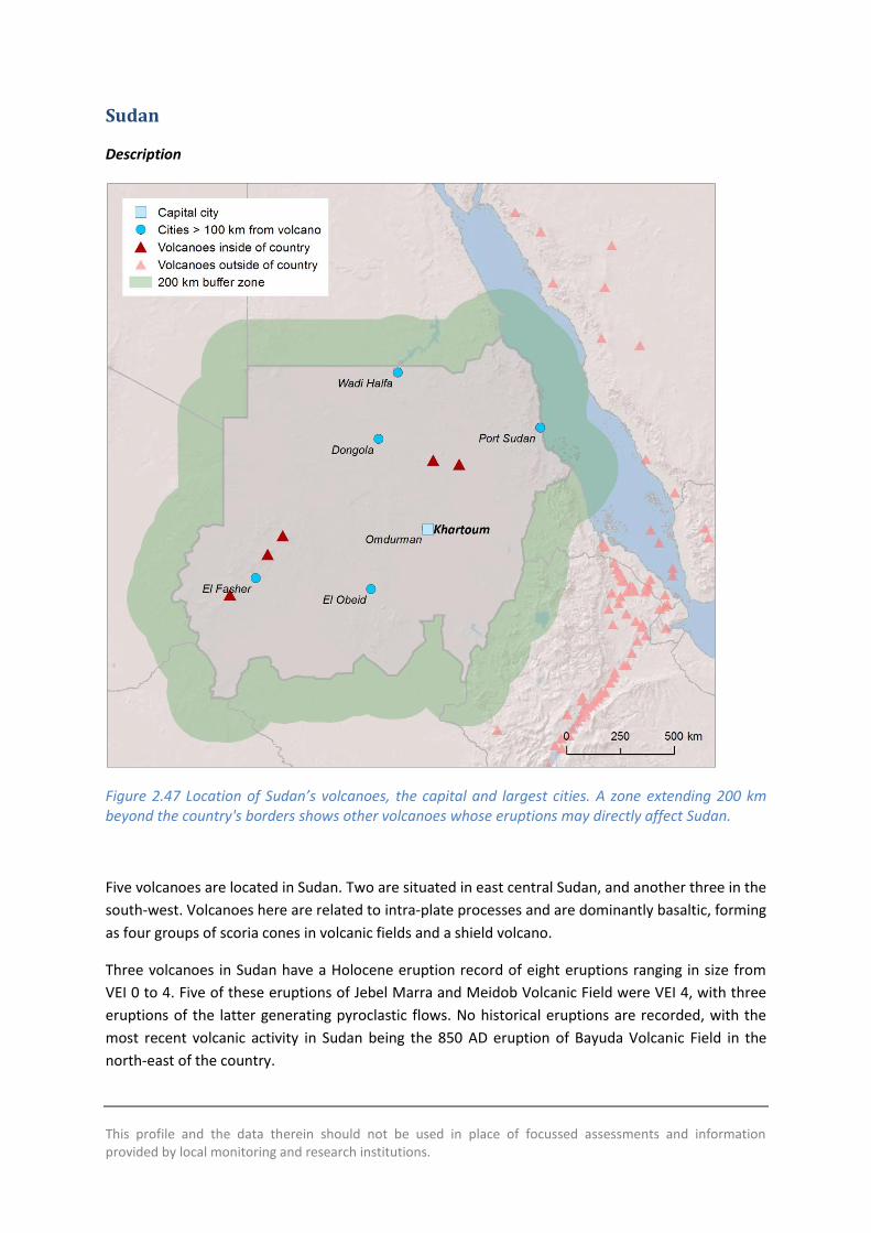
This profile and the data therein should not be used in place of focussed assessments and information provided by local monitoring and research institutions.
Sudan
Description
Figure 2.47 Location of Sudan’s volcanoes, the capital and largest cities. A zone extending 200 km beyond the country's borders shows other volcanoes whose eruptions may directly affect Sudan.
Five volcanoes are located in Sudan. Two are situated in east central Sudan, and another three in the
south-west. Volcanoes here are related to intra-plate processes and are dominantly basaltic, forming
as four groups of scoria cones in volcanic fields and a shield volcano.
Three volcanoes in Sudan have a Holocene eruption record of eight eruptions ranging in size from
VEI 0 to 4. Five of these eruptions of Jebel Marra and Meidob Volcanic Field were VEI 4, with three
eruptions of the latter generating pyroclastic flows. No historical eruptions are recorded, with the
most recent volcanic activity in Sudan being the 850 AD eruption of Bayuda Volcanic Field in the
north-east of the country.

186
Although the capital, Khartoum, and the most populous cities in Sudan are distal to the volcanoes,
numerous small settlements lie within 100 km of one or more Holocene volcano, in which over 2.5
million people reside.
The eruption histories are poorly constrained at all but the Meidob Volcanic Field, making
assessment of hazard here difficult. Focussed research is required to better understand the ages and
sizes of eruptions in Sudan.
Volcano Facts
Number of Holocene volcanoes 5
Number of Pleistocene volcanoes with M≥4 eruptions -
Number of volcanoes generating pyroclastic flows 1
Number of volcanoes generating lahars -
Number of volcanoes generating lava flows 2
Number of fatalities caused by volcanic eruptions -
Tectonic setting Intra-plate
Largest recorded Pleistocene eruption -
Largest recorded Holocene eruption The M6.7 eruption of Jebel Marra. This eruption formed the Deriba Caldera and occurred at 3950 BP.
Number of Holocene eruptions 8 confirmed eruptions
Recorded Holocene VEI range 0 – 4
Number of historically active volcanoes -
Number of historical eruptions -
Number of
volcanoes
Primary volcano type Dominant rock type
1 Shield(s) Basaltic (1)
4 Small cone(s) Basaltic (4)
Table 2.42 The number of volcanoes in Sudan, their volcano type classification and dominant rock type according to VOTW4.0.

187
Socio-Economic Facts
Total population (2012) 37,320,000
Gross Domestic Product (GDP) per capita (2005 PPP $) 1,878
Gross National Income (GNI) per capita (2005 PPP $) 1,848
Human Development Index (HDI) (2012) 0.414 (Low)
Population Exposure
Capital city Khartoum
Distance from capital city to nearest Holocene volcano 305.6 km
Total population (2011) 35,604,595
Number (percentage) of people living within 10 km of a Holocene volcano
11,752 (<1%)
Number (percentage) of people living within 30 km of a Holocene volcano
314,097 (<1%)
Number (percentage) of people living within 100 km of a Holocene volcano
2,527,778 (7.1%)
Largest cities, as measured by population and their population size:
Khartoum 1,974,647 Omdurman 1,200,000 Port Sudan 489,725 El Obeid 393,311 El Fasher 252,609 Wadi Halfa <50,000 Dongola <50,000
Infrastructure Exposure
Number of airports within 100 km of a volcano 0
Number of ports within 100 km of a volcano 0
Total length of roads within 100 km of a volcano (km) 1,456
Total length of railroads within 100 km of a volcano (km) 252
The Sudanese volcanoes are located inland, away from the ports on the north-eastern coastline of
the Red Sea. None of the largest cities are situated within 100 km of the volcanoes, and the capital,

188
Khartoum, lies over 300 km away. An extensive road and rail network is proximal to the volcanoes,
and numerous cities lie within 100 km of the volcanoes, including settlements along the River Nile
which runs around the Bayuda Volcanic Field.
Figure 2.48 The location of Sudan’s volcanoes and the extent of the 100 km zone surrounding them. Ports, airports and the major cities are just some of the infrastructure that may be exposed to volcanic hazards.
Hazard, Uncertainty and Exposure Assessments
All but one volcano in Sudan, the Meidob Volcanic Field, have large uncertainties associated with the
calculation of the Hazard Level and these are therefore unclassified. Of these four unclassified
volcanoes, two, Kutum Volcanic Field and Jebel Umm Arafieb have no confirmed Holocene
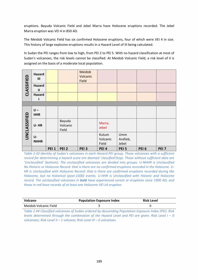
189
eruptions. Bayuda Volcanic Field and Jebel Marra have Holocene eruptions recorded. The Jebel
Marra eruption was VEI 4 in 850 AD.
The Meidob Volcanic Field has six confirmed Holocene eruptions, four of which were VEI 4 in size.
This history of large explosive eruptions results in a Hazard Level of III being calculated.
In Sudan the PEI ranges from low to high, from PEI 2 to PEI 5. With no hazard classification at most of
Sudan’s volcanoes, the risk levels cannot be classified. At Meidob Volcanic Field, a risk level of II is
assigned on the basis of a moderate local population.
CLA
SSIF
IED
Hazard III
Meidob Volcanic Field
Hazard II
Hazard I
UN
CLA
SSIF
IED
U – HHR
U- HR Bayuda Volcanic Field
Marra, Jebel
U- NHHR
Kutum Volcanic Field
Umm Arafieb, Jebel
PEI 1 PEI 2 PEI 3 PEI 4 PEI 5 PEI 6 PEI 7 Table 2.43 Identity of Sudan’s volcanoes in each Hazard-PEI group. Those volcanoes with a sufficient record for determining a hazard score are deemed ‘classified’(top). Those without sufficient data are ‘Unclassified’ (bottom). The unclassified volcanoes are divided into groups: U-NHHR is Unclassified No Historic or Holocene Record: that is there are no confirmed eruptions recorded in the Holocene. U-HR is Unclassified with Holocene Record: that is there are confirmed eruptions recorded during the Holocene, but no historical (post-1500) events. U-HHR is Unclassified with Historic and Holocene record. The unclassified volcanoes in bold have experienced unrest or eruptions since 1900 AD, and those in red have records of at least one Holocene VEI ≥4 eruption.
Volcano Population Exposure Index Risk Level
Meidob Volcanic Field 3 II
Table 2.44 Classified volcanoes of Sudan ordered by descending Population Exposure Index (PEI). Risk levels determined through the combination of the Hazard Level and PEI are given. Risk Level I – 0 volcanoes; Risk Level II – 1 volcano; Risk Level III – 0 volcanoes.
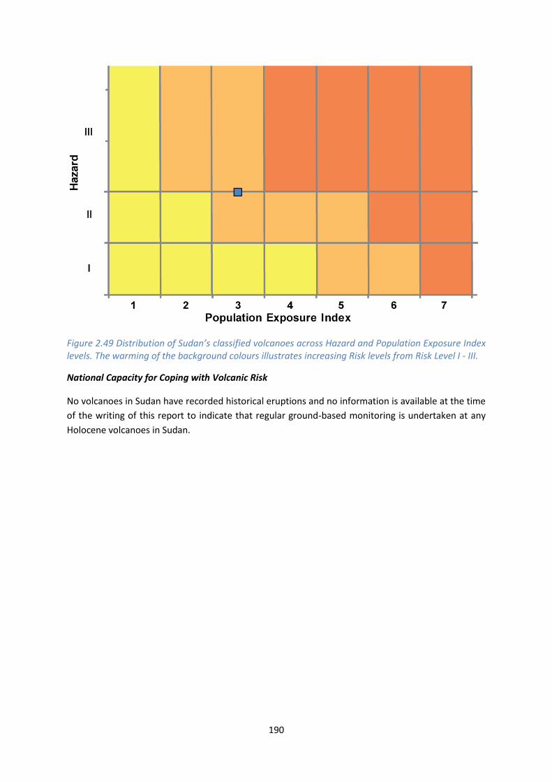
190
Figure 2.49 Distribution of Sudan’s classified volcanoes across Hazard and Population Exposure Index levels. The warming of the background colours illustrates increasing Risk levels from Risk Level I - III.
National Capacity for Coping with Volcanic Risk
No volcanoes in Sudan have recorded historical eruptions and no information is available at the time
of the writing of this report to indicate that regular ground-based monitoring is undertaken at any
Holocene volcanoes in Sudan.

This profile and the data therein should not be used in place of focussed assessments and information provided by local monitoring and research institutions.
Tanzania
Description
There are ten Holocene volcanoes in Tanzania. These form two clusters in the northern and southern
parts of the country marking the southern portion of the East African Rift Valley. The northern
volcanoes are Mt Kilimanjaro, Mt Meru and Ol Doinyo Lengai, while the southern volcanoes are
clustered around Rungwe Volcanic Province. Of Tanzania’s Holocene volcanoes, only the carbonatite
volcano of Ol Doinyo Lengai is known to be currently active. However, at the time of writing, the
lack of volcano monitoring in proximity to any of these volcanoes means that any state of unrest is
unreported and the potential for an eruption may be underestimated.
Figure 2.50 Location of Tanzania’s volcanoes, the capital and largest cities. A zone extending 200 km beyond the country's borders shows other volcanoes whose eruptions may directly affect Tanzania.

192
The majority of Tanzania’s Holocene volcanoes are explosive in nature, with effusive lava dome
growth and lava flows. The three northern volcanoes (Mt Meru, Mt Kilimanjaro and Ol Doinyo
Lengai), and Mt Rungwe and Mt Kyejo in the south, are stratovolcanoes characterised by pyroclastic
cones and lava domes. Mt Kilimanjaro and Mt Meru also have craters resulting from edifice
collapse. Three of the southern volcanoes (Igwisi Hills, Izumbwe-Mpoli and an unnamed volcano)
are pyroclastic and tuff cones. Mt Ngozi is a shield volcano with a summit caldera. Only SW Usangu
Basin is entirely effusive, characterised by lava dome growth.
Although Tanzania’s largest cities are situated more than 30 km from the volcanic centres, the
prevalence of numerous rural communities in Tanzania mean that seven of the Holocene volcanic
centres have more than 100,000 people living within a 30 km radius. Of these, two have more than
300,000 people within a 10 km radius (Source: Smithsonian Institute GVP 2013).
There is no record of fatalities as a result of volcanic activity although there are reports of injuries
and loss of livestock associated with the 2007 eruption of Ol Doinyo Lengai. The Disaster
Management Unit (DMU) of Tanzania wrote a report to the Prime Minister’s Office in response to
this eruption, recommending a series of restrictions on access, regulation of official local guides, first
aid stations and shelters be implemented on Ol Doinyo Lengai. At the time of writing those
recommendations have yet to be actioned. The lack of fatalities known as a result of past eruptions
may be due to recording and epistemic uncertainty that requires consideration when analysing the
impact of past eruptions.
Volcano Facts
Number of Holocene volcanoes 10
Number of Pleistocene volcanoes with M≥4 eruptions 3
Number of volcanoes generating pyroclastic flows 2
Number of volcanoes generating lahars 2
Number of volcanoes generating lava flows 3
Number of fatalities caused by volcanic eruptions ?15
Tectonic setting Rift zone
Largest recorded Pleistocene eruption The M5.9 eruption of the Kitulo pumice with caldera formation at Ngozi at 10.2 ka.
Largest recorded Holocene eruption The M5 eruption of the Rungwe pumice from Rungwe at 4 ka.
Number of Holocene eruptions 33 confirmed eruptions. 1 uncertain eruption and 2 discredited.

193
Recorded Holocene VEI range 0 – 5 and unknown
Number of historically active volcanoes 3
Number of historical eruptions 23
Number of
volcanoes
Primary volcano type Dominant rock type
1 Caldera(s) Trachytic / Andesitic (1)
5 Large cone(s) Foiditic (1), Phonolitic (2), Trachytic / Andesitic (2)
1 Lava dome(s) Phonolitic (1)
3 Small cone(s) Basaltic (1), Foiditic (2)
Table 2.45 The number of volcanoes in Tanzania, their volcano type classification and dominant rock type according to VOTW4.0.
Socio-Economic Facts
Total population (2012) 47,911,000
Gross Domestic Product (GDP) per capita (2005 PPP $) 1,334
Gross National Income (GNI) per capita (2005 PPP $) 1,383
Human Development Index (HDI) (2012) 0.476 (Low)
Population Exposure
Capital city Dodoma
Distance from capital city to nearest Holocene volcano 343.4 km
Total population (2011) 42,746,620
Number (percentage) of people living within 10 km of a Holocene volcano
532,918 (1.3%)
Number (percentage) of people living within 30 km of a Holocene volcano
2,604,862 (6.1%)
Number (percentage) of people living within 100 km of a Holocene volcano
6,997,614 (16.4%)
Ten largest cities, as measured by population and their population size:
Dar es Salaam 2,698,652
Mwanza 436,801

194
Zanzibar 403,658
Arusha 341,136
Mbeya 291,649
Morogoro 250,902
Tanga 224,876
Dodoma 180,541
Kigoma 164,268
Moshi 156,959
Infrastructure Exposure
Number of airports within 100 km of a volcano 1
Number of ports within 100 km of a volcano 0
Total length of roads within 100 km of a volcano (km) 1,273
Total length of railroads within 100 km of a volcano (km) 734
The volcanoes of Tanzania are located in three areas, south near the border with Malawi and
Zambia, north on the border with Kenya and in the west. Being inland volcanoes, these are located
away from the ports along the eastern coastline of Tanzania. They also lie over 300 km away from
the capital, Dodoma, however several of the largest cities in Tanzania are situated within 100 km of
these volcanoes. The location of these cities close to the volcanoes means that considerable
infrastructure is exposed to the volcanic hazard, including an extensive road and rail network. The
100 km radii surrounding the volcanoes extends into Kenya and Malawi, and affects the Karonga
Airport across the border in Malawi.

195
Figure 2.51 The location of Tanzania’s volcanoes and the extent of the 100 km zone surrounding them. Ports, airports and the major cities are just some of the infrastructure that may be exposed to volcanic hazards.
Hazard, Uncertainty and Exposure Assessments
All but one volcano in Tanzania have considerable uncertainties associated with the classification of
the hazard levels, and these are therefore unclassified. Of these unclassified volcanoes, five have no
confirmed Holocene eruptions; two have Holocene activity records and Meru and Kyejo have historic
activity as recently as 1910. Meru, Rungwe and Ngozi have Holocene records of large magnitude
eruptions of VEI ≥4.

196
Ol Doinyo Lengai has 23 Holocene eruptions recorded in VOTW4.22, with most of these recorded
historically. All historical eruptions at this volcano are of a known size, with activity commonly being
effusive to moderately explosive. This volcano is therefore classified at Hazard Level II.
The PEI in Tanzania ranges from moderate to very high, at PEIs of 3 to 7. Most volcanoes are classed
as PEI 5, with a high proximal population. Ngozi has the largest population in Tanzania living within
10 km, with over 450,000 people in this radius, whilst Kilimanjaro has the largest population within
100 km at over 2.6 million. At a hazard level of II and PEI of 3, Ol Doinyo Lengai is classified at Risk
Level II.
CLA
SSIF
IED
Hazard III
Hazard II
Ol Doinyo Lengai
Hazard I
UN
CLA
SSIF
IED
U – HHR
Meru; Kyejo
U- HR Rungwe Ngozi
U- NHHR
Kilimanjaro; Unnamed
Igwisi Hills; SW Usangu Basin
Izumbwe-Mpoli
PEI 1 PEI 2 PEI 3 PEI 4 PEI 5 PEI 6 PEI 7 Table 2.46 Identity of Tanzania’s volcanoes in each Hazard-PEI group. Those volcanoes with a sufficient record for determining a hazard score are deemed ‘classified’ (top). Those without sufficient data are ‘Unclassified’ (bottom). The unclassified volcanoes are divided into groups: U-NHHR is Unclassified No Historic or Holocene Record: that is there are no confirmed eruptions recorded in the Holocene. U-HR is Unclassified with Holocene Record: that is there are confirmed eruptions recorded during the Holocene, but no historical (post-1500) events. U-HHR is Unclassified with Historic and Holocene record. The unclassified volcanoes in bold have experienced unrest or eruptions since 1900 AD, and those in red have records of at least one Holocene VEI ≥4 eruption.
Volcano Population Exposure Index Risk Level
Ol Doinyo Lengai 3 II
Table 2.47 Classified volcanoes of Tanzania ordered by descending Population Exposure Index (PEI). risk levels determined through the combination of the Hazard Level and PEI are given. Risk Level I – 0 volcanoes; Risk Level II – 1 volcano; Risk Level III – 0 volcanoes.

197
Figure 2.52 Distribution of Tanzania’s classified volcanoes across Hazard and Population Exposure Index levels. The warming of the background colours illustrates increasing Risk levels from Risk Level I - III.
National Capacity for Coping with Volcanic Risk
Three volcanoes have been historically active in Tanzania. The Geological Survey of Tanzania is
responsible for these volcanoes, and have operated a system of temporary seismics at the Risk Level
II Ol Doinyo Lengai. Meru and Kyejo do not currently have a dedicated ground-based monitoring
system.
Figure 2.53 The monitoring and risk levels of the historically active volcanoes in Tanzania. Monitoring Level 1 indicates no known dedicated ground-based monitoring; Monitoring Level 2 indicates that some ground-based monitoring systems are in place including ≤3 seismic stations; Monitoring Level 3 indicates the presence of a dedicated ground-based monitoring network, including ≥4 seismometers.

This profile and the data therein should not be used in place of focussed assessments and information provided by local monitoring and research institutions.
Uganda
Description
Figure 2.54 Location of Uganda’s volcanoes, the capital and largest cities. A zone extending 200 km beyond the country's borders shows other volcanoes whose eruptions may directly affect Uganda.
Seven Holocene volcanoes are located in the south-west of Uganda and on the border with Rwanda.
These volcanoes are the product of rift zone volcanism, which has formed dominantly Foiditic tuff
cones and one basaltic stratovolcano – Muhavura.
Two Holocene eruptions are recorded at the Fort Portal tuff cones in 2120 and 2750 BC. The size of
these eruptions is unknown though ash deposits have been identified. No historical eruptions are
recorded in Uganda, however historical activity may have occurred at Fort Portal.

199
Uganda’s volcanoes are largely located near the borders with Rwanda and the Democratic Republic
of Congo, so eruptions here may affect these countries. Multiple volcanoes in these neighbouring
countries and Kenya are located within 200 km of Uganda.
Large proximal populations exist at all of Uganda’s volcanoes. Nearly 450,000 live within 10 km of
Katwe-Kikorongo, and over 240,000 at Fort Portal. All have over 4 million within 100 km.
The absence of detailed eruptive histories at Uganda’s volcanoes makes assessment of hazard
difficult, with large associated uncertainties. Further research is required to more fully understand
the past activity.
Volcano Facts
Number of Holocene volcanoes 7, inclusive of one on the border with Rwanda
Number of Pleistocene volcanoes with M≥4 eruptions -
Number of volcanoes generating pyroclastic flows -
Number of volcanoes generating lahars -
Number of volcanoes generating lava flows -
Number of fatalities caused by volcanic eruptions -
Tectonic setting Rift zone
Largest recorded Pleistocene eruption -
Largest recorded Holocene eruption Two eruptions with unknown VEI at Fort Portal.
Number of Holocene eruptions 2 confirmed eruptions
Recorded Holocene VEI range Unknown
Number of historically active volcanoes -
Number of historical eruptions -
Number of
volcanoes
Primary volcano type Dominant rock type
1 Large cone(s) Basaltic (1)
6 Small cone(s) Foiditic (5), Phonolitic (1)
Table 2.48 The number of volcanoes in Uganda, their volcano type classification and dominant rock type according to VOTW4.0.

200
Socio-Economic Facts
Total population (2012) 36,484,000
Gross Domestic Product (GDP) per capita (2005 PPP $) 1,188
Gross National Income (GNI) per capita (2005 PPP $) 1,168
Human Development Index (HDI) (2012) 0.456 (Low)
Population Exposure
Capital city Kampala
Distance from capital city to nearest Holocene volcano 227.2 km
Total population (2011) 34,612,250
Number (percentage) of people living within 10 km of a Holocene volcano
817,080 (2.4%)
Number (percentage) of people living within 30 km of a Holocene volcano
3,087,519 (8.9%)
Number (percentage) of people living within 100 km of a Holocene volcano
7,968,612 (23%)
Ten largest cities, as measured by population and their population size:
Kampala 1,353,189
Gulu 146,858
Jinja 93,061
Mbale 76,493
Masaka 65,373
Arua 55,585
Fort Portal 42,670
Bombo <50,000
Moroto <50,000
Mbarara <50,000
Infrastructure Exposure
Number of airports within 100 km of a volcano 0
Number of ports within 100 km of a volcano 0
Total length of roads within 100 km of a volcano (km) 1,278
Total length of railroads within 100 km of a volcano (km) 0
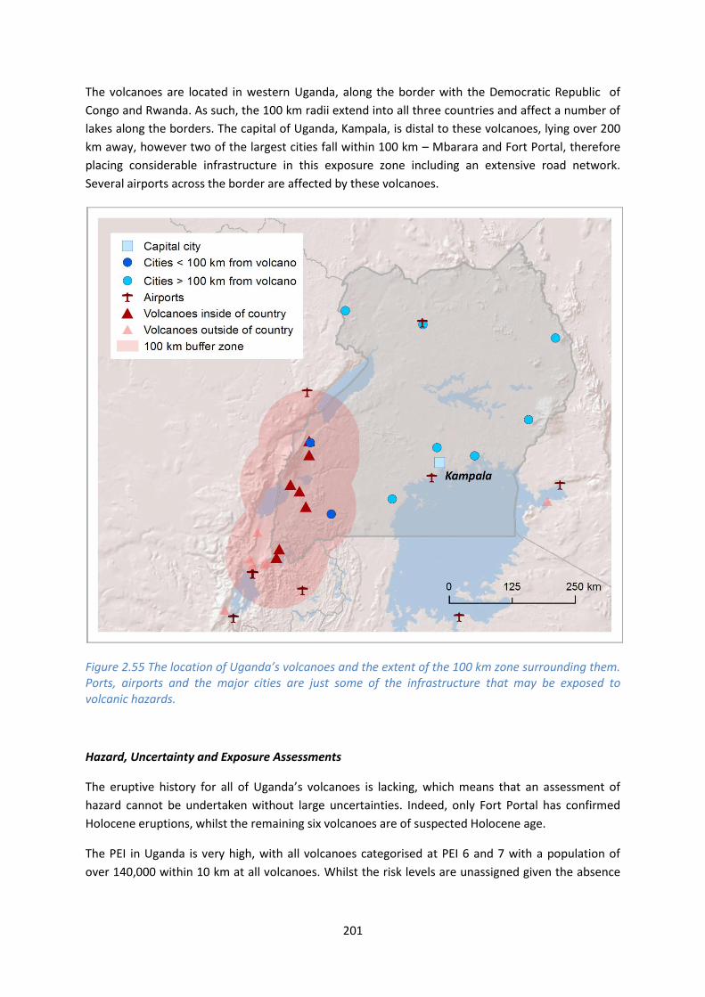
201
The volcanoes are located in western Uganda, along the border with the Democratic Republic of
Congo and Rwanda. As such, the 100 km radii extend into all three countries and affect a number of
lakes along the borders. The capital of Uganda, Kampala, is distal to these volcanoes, lying over 200
km away, however two of the largest cities fall within 100 km – Mbarara and Fort Portal, therefore
placing considerable infrastructure in this exposure zone including an extensive road network.
Several airports across the border are affected by these volcanoes.
Figure 2.55 The location of Uganda’s volcanoes and the extent of the 100 km zone surrounding them. Ports, airports and the major cities are just some of the infrastructure that may be exposed to volcanic hazards.
Hazard, Uncertainty and Exposure Assessments
The eruptive history for all of Uganda’s volcanoes is lacking, which means that an assessment of
hazard cannot be undertaken without large uncertainties. Indeed, only Fort Portal has confirmed
Holocene eruptions, whilst the remaining six volcanoes are of suspected Holocene age.
The PEI in Uganda is very high, with all volcanoes categorised at PEI 6 and 7 with a population of
over 140,000 within 10 km at all volcanoes. Whilst the risk levels are unassigned given the absence

202
of hazard data, these high local populations indicate that the risk would be categorised at Risk Level
II or III at all of Uganda’s volcanoes. C
LASS
IFIE
D Hazard
III
Hazard II
Hazard I
UN
CLA
SSIF
IED
U – HHR
U- HR Fort Portal
U- NHHR
Kyatwa; Bunyaruguru; Katunga; Muhavura
Katwe-Kikorongo; Bufumbira
PEI 1
PEI 2 PEI 3 PEI 4 PEI 5 PEI 6 PEI 7
Table 2.49 Identity of Uganda’s volcanoes in each Hazard-PEI group. Those volcanoes with a sufficient record for determining a hazard score are deemed ‘classified’ (top). Those without sufficient data are ‘Unclassified’ (bottom). The unclassified volcanoes are divided into groups: U-NHHR is Unclassified No Historic or Holocene Record: that is there are no confirmed eruptions recorded in the Holocene. U-HR is Unclassified with Holocene Record: that is there are confirmed eruptions recorded during the Holocene, but no historical (post-1500) events. U-HHR is Unclassified with Historic and Holocene record. The unclassified volcanoes in bold have experienced unrest or eruptions since 1900 AD, and those in red have records of at least one Holocene VEI ≥4 eruption.
National Capacity for Coping with Volcanic Risk
No volcanoes in Uganda have recorded historical eruptions and no information is available at the
time of the writing of this report to indicate that regular ground-based monitoring is undertaken at
any Holocene volcanoes in Uganda.