Embed Size (px)
Citation preview

Area Traffic Management Guidelines City of Ottawa Draft Final Report Appendix A
Appendix A. TRAFFIC MANAGEMENT (VOLUMES)
McCormick Rankin Corporation A-1 September 17, 2003

Area Traffic Management Guidelines City of Ottawa Draft Final Report Appendix A
Traffic Management (Volumes)
DIRECTIONAL CLOSURE (AKA: partial closure, one-way closure, half closures, “semi-diverter”)
Description: A directional closure is a curb extension or vertical barrier extending to approximately the centreline of a roadway, effectively obstructing (prohibiting) one direction of travel on two-way streets.
Directional closures are often used in staggered sets or in conjunction with others measures to make travel through neighbourhoods with grid pattern streets circuitous. Two directional closures placed across from one another at any intersection is known as a semi-diverter.
Bicycles can be permitted to travel through a directional closure in both directions. In some cases, gaps or contra-flow bike lanes are used to provide bicycle access.
Purpose: To reduce or eliminate through traffic
Application: Local Streets at intersections with collectors / arterials
Type of Problem (Addresses): Primary Secondary Volume Vehicle Conflicts Ped. Enviro/Safety Bike Enviro/Safety
Cost Approx. $5 000 and up
Local Examples: Various locations in the Glebe community (Bronson shown)
Advantages Disadvantages Reduction in vehicle volume on closed roadway Enhanced pedestrian environment of intersecting street by reduction in crossing distances and
Restricts access for residents and other local street users May divert significant traffic volumes to adjacent
McCormick Rankin Corporation A-2 September 17, 2003
potential conflicts with vehicles
streets Can impact transit routes
Design and Program Guidelines/Warrants: Canadian Guide to Neighbourhood Traffic Calming, Transportation Association of Canada, Ottawa, Canada, December 1998.

Area Traffic Management Guidelines City of Ottawa Draft Final Report Appendix A
McCormick Rankin Corporation A-3 August 17, 2003
Traffic Management (Volumes)
FULL CLOSURE (AKA: cul-de-sacs, dead ends)
Description: A full closure consists of a barrier extending across the street to close the street to through vehicle traffic. Barriers can take the form of a curb, landscaping, walls, gates, bollards or any other obstruction that may deter vehicle passage. Closures can be located mid-block or at intersections (creating a “T” intersection).
Pedestrian access is usually maintained and bicycle traffic may be accommodated through gaps in the obstruction.
Emergency vehicle access can be accommodated by constructing removable sections or bollards
Purpose: To eliminate through traffic.
Application: Local streets
Type of Problem (Addresses): Primary Secondary Volume Bicycle Enviro/Safety Vehicle Conflicts Ped Enviro/Safety
Cost Approx. $10 000 and up
Local Examples:
Rochester at Wellington - intersection (shown) Daly at Waller Spruce between Champagne and Booth - mid-block
Advantages Disadvantages Eliminates all through traffic along a street For closures at intersections, can enhance the pedestrian environment of intersecting street by eliminating road crossing and potential conflicts with vehicles Local reduction in traffic noise
Restricts access for residents and other local street users May divert significant volume of traffic to parallel street without traffic calming measures Large vehicles may not be able to turn around Maintenance level of service will decrease Can impact transit routes Restricts emergency vehicle access
Design and Program Guidelines/Warrants: Canadian Guide to Neighbourhood Traffic Calming, Transportation Association of Canada, Ottawa, Canada, December 1998.

Area Traffic Management Guidelines City of Ottawa Draft Final Report Appendix A
McCormick Rankin Corporation A-4 August 17, 2003
Traffic Management (Volumes)
DIVERTERS (AKA diagonal diverters, full diverters, diagonal road closure)
Description: A diverter is a raised barrier placed diagonally across a four-way intersection that forces traffic to turn preventing it from continuing straight through the intersection.
Emergency vehicle access can be accommodated by constructing removable sections or bollards. Pedestrian access is usually maintained and bicycle traffic may be accommodated through gaps in the obstruction.
Diverters often include landscaped areas. A truncated diagonal diverters is a diverter with one end open to allow some turning movements.
Purpose: Obstructs and redirects through traffic.
Application: Local streets
Type of Problem (Addresses): Primary Secondary Volume Bicycle Enviro/Safety Vehicle Conflicts Ped. Enviro/Safety
Cost Approx. $10 000 and up
Local Examples: Otterson Drive at Blanchard Crescent
Advantages Disadvantages
Reduction in vehicle volume on roadway Enhanced pedestrian environment by reduction in potential conflicts with vehicles and potential landscaped area.
Restricts access for residents and other local street users May divert significant traffic volumes to adjacent streets Can impact transit routes
Design and Program Guidelines/Warrants: Canadian Guide to Neighbourhood Traffic Calming, Transportation Association of Canada, Ottawa, Canada, December 1998.

Area Traffic Management Guidelines City of Ottawa Draft Final Report Appendix A
McCormick Rankin Corporation A-5 August 17, 2003
Traffic Management (Volumes)
FORCED TURN ISLAND (AKA intersection channelization, pork chops, right turn islands)
Description: Forced turn islands consist of raised islands located at an intersection to obstruct specific traffic movements and physically direct traffic through an intersection.
Intersection channelization can improve pedestrian crossing comfort and safety by reducing crossing distances and by providing a refuge.
Bicycles can be permitted to make all movements including those motor vehicles are prevented from making. Gaps in channelization islands may be used to accommodate cyclists.
Emergency vehicles can circumvent the islands.
Purpose: Obstruct through traffic along a street by prohibiting specific movements at an intersection.
Application: Local streets at intersections with collector / arterials
Type of Problem (Addresses): Primary Secondary Volume Bike Enviro/Safety Vehicle Conflicts Ped Enviro/Safety
Cost Approx. $3 000 to $5 000
Local Examples: Chatelain at Merivale
Advantages Disadvantages
Reduction in vehicle volume on roadway Can restrict entrance and/or exit from neighbourhood Can block selective vehicle movements Enhanced pedestrian safety and comfort by reduction in crossing distances and provision of a refuge.
Restricts access for residents and other local street users May divert traffic to adjacent streets Some non-compliance Can impact transit routes
Design and Program Guidelines/Warrants: Context specific

Area Traffic Management Guidelines City of Ottawa Draft Final Report Appendix A
McCormick Rankin Corporation A-6 August 17, 2003
Traffic Management (Volumes)
RIGHT-IN/RIGHT-OUT ISLAND
Description: A variation of the forced turn island, the right-in/right-out island is a raised triangular island at an intersection approach that obstructs left turns and through movements to and from the intersecting street. The effectiveness of this measure can be increased when used with other measures on an area-wide basis.
Bicycles can be permitted to make all movements including those motor vehicles are prevented from making. Gaps in channelization islands may be used to accommodate cyclists.
Purpose: Reduce through traffic
Application: Local Streets and some collector streets
Type of Problem (Addresses): Primary Secondary Volume Vehicle conflicts Ped. Enviro/Safety Bike. Enviro/Safety
Cost Approx. $5 000
Local Examples:
Kirkwood/Merivale area Besserer at King Edward Moodie/Richmond Road
Advantages Disadvantages Reduction in vehicle volume on roadway Can restrict entrance and/or exit from neighbourhood Can block selective vehicle movements
Restricts access for residents and other local street users May divert significant volume of traffic to parallel street without traffic calming measures Some non-compliance Need no left turn signage on main street approaches Can impact transit routes Can impact cyclists
Design and Program Guidelines/Warrants: Canadian Guide to Neighbourhood Traffic Calming, Transportation Association of Canada, Ottawa, Canada, December 1998.

Area Traffic Management Guidelines City of Ottawa Draft Final Report Appendix A
McCormick Rankin Corporation A-7 August 17, 2003
Traffic Management (Volumes)
MEDIAN BARRIERS (AKA median diverters, island diverters)
Description: A median barrier consists of an elevated median located on the centreline of a two-way roadway through an intersection, which prevents left turns and through movements to and from intersecting roadways.
Pedestrian access is usually maintained and bicycle traffic may be accommodated through gaps in the obstruction (with or without pedestrian/cyclists signals). A median barrier can create a refuge for pedestrians and cyclists, enabling them to cross one direction of travel at time. A median can be enhanced by landscaping, if widths permit.
Purpose: Obstruct through traffic
Application: Collector or Arterial Streets at intersections with local streets
Type of Problem (Addresses): Primary Volume Ped Enviro/Safety Bicycle Enviro/Safety Vehicle Conflicts
Cost Approx. $500 per metre
Local Examples:
Chatelain at Kirkwood Chartrand Avenue / Duford Drive (south intersection)
Advantages Disadvantages Reduction in vehicle volume on local roadway May enhance pedestrian safety and comfort if designed to reduce crossing distances and to provide a refuge and potential landscaped area.
Restricts access for residents and other local street users May divert traffic to adjacent streets Can impact adjacent parking if restricted width of roadway Increased maintenance Can impact transit routes Can impact cyclists
Design and Program Guidelines/Warrants: Canadian Guide to Neighbourhood Traffic Calming, Transportation Association of Canada, Ottawa, Canada, December 1998.

Area Traffic Management Guidelines City of Ottawa Draft Final Report Appendix A
McCormick Rankin Corporation A-8 August 17, 2003
Traffic Management (Volumes)
TURN AND MOVEMENT PROHIBITIONS
Description: Turn and movement prohibitions are intended to prevent non-local traffic from using a specific street. They are used to indicate to drivers that they are not permitted to turn right or left or continue through depending on the situation. Prohibitions may be employed at all times of the day, certain days of the week, or restricted to certain hours.
Purpose: Prevent non-local traffic from using a street
Application: Local and some collector streets
Type of Problem (Addresses): Primary Secondary Volume Vehicle conflicts Ped. Enviro/Safety Bike Enviro/Safety
Cost Approx. $250 per sign (typically more than one sign is required)
Local Examples:
Navaho at Baseline Road Centrepointe Drive at Baseline Road
Advantages Disadvantages Reduction in vehicle volume on roadway Can restrict entrance and/or exit from neighbourhood Can block selective vehicle movements and/or movements at certain times of the day Emergency and transit vehicles, and cyclists can be easily exempted from the prohibitions
Restricts access for residents and other local street users May divert traffic to adjacent streets without traffic calming measures Higher potential violation rates than with physical measures, greater need for enforcement Can impact pedestrian traffic if crossing movement on intersecting street is not considered Can impact cycling traffic if desired movement is inaccessible due to signal timing (even if the movement is permitted)
Design and Program Guidelines/Warrants: As per City practice

Area Traffic Management Guidelines City of Ottawa Draft Final Report Appendix A
McCormick Rankin Corporation A-9 August 17, 2003
Traffic Management (Volumes)
ONE-WAY STREET
Description: This measure results in conversion of a two-way street to one-way operation preventing through traffic in one direction. Cyclist traffic can be accommodated on adjacent street or with contra flow bicycle lane.
Purpose: Discourage through traffic.
Application: Local and some collector streets
Type of Problem (Addresses): Primary Secondary Volume Vehicle conflict
Cost Approx. $250 per sign, may require signal modifications
Local Examples: Metcalfe south of Pretoria
Advantages Disadvantages Eliminates traffic in one direction (may increase traffic in remaining direction) May reduce traffic volume Can enhance pedestrian environment by eliminating need for left turn pockets, thereby reducing crossing distances
May divert traffic to adjacent streets Restricts access for residents and other local street users Can result in higher operating speeds Results in increased travel distances and therefore additional traffic on the network Can impact transit routes Can impact cyclist traffic
Design and Program Guidelines/Warrants: As per City practice

Area Traffic Management Guidelines City of Ottawa Draft Final Report Appendix A
McCormick Rankin Corporation A-10 August 17, 2003
Traffic Management (Volumes)
ARTERIAL ROAD MODIFICATION
Description: Arterial road modifications can be considered when deficiencies or bottlenecks along an arterial are causing through traffic to divert to local or collector streets. For example, insufficient left turn storage capacity and associated delays on an arterial street may prompt drivers to avoid a signal by using adjacent local streets. Adding additional storage capacity on the arterial street may address through traffic issues on the local streets.
Purpose: Reduce through traffic
Application: Arterial and collector streets
Type of Problem (Addresses): Primary Secondary Volume Vehicle conflicts Ped. Enviro/Safety Bike Enviro/Safety
Local Examples:
Hunt Club (between Merivale Road & Woodroffe Avenue) resolved Woodfield / Medhurst issues Double left on Vanier Parkway at Beechwood resolved some through traffic in New Edinburgh. Airport Parkway Ramps at Hunt Club reduced traffic on Flannery
Cost Can vary significantly
Advantages Disadvantages May avoid the need for local street measures Can enhance overall efficiency of the transportation system Can eliminate through traffic
Arterial road modifications are often expensive Cost can be prohibitive if undertaken only as an area traffic management initiative
Design and Program Guidelines/Warrants: As per City practice

Area Traffic Management Guidelines City of Ottawa Draft Final Report Appendix B
Appendix B. TRAFFIC MANAGEMENT (SPEED AND BEHAVIOUR)
McCormick Rankin Corporation B-1 August 17, 2003

Area Traffic Management Guidelines City of Ottawa Draft Final Report Appendix B
Traffic Management (Speed and Behaviour)
SPEED ZONING
Description: A speed zone identifies the maximum legal speed on a street. Typical applications include combinations with school area or playground signs.
Purpose: To establish an appropriate travel speeds on a section of roadway.
Application: Local streets and some collector streets
Type of Problem (Addresses): Primary Speed Ped. Enviro/Safety
Cost Approx. $250 per sign + enforcement cost
Local Examples: St. Laurent south north of Walkley
Advantages Disadvantages
Can reduce speeds along specific sections of road
Requires regular police enforcement
Design and Program Guidelines/Warrants: As per City policy
McCormick Rankin Corporation B-2 August 17, 2003

Area Traffic Management Guidelines City of Ottawa Draft Final Report Appendix B
Traffic Management (Speed and Behaviour)
ONE-WAY TO TWO-WAY STREET CONVERSION
Description: This measure results in the conversion of a one-way street to traffic circulation in both directions. Traffic, in some cases, can be slowed due to increased “friction” with opposing traffic, and increased turning movements, particularly left turns, that slow traffic by momentarily blocking a through lane if no turn lane is provided.
Purpose: To reduce speeds
Application: Local street, collector street, and arterial street
Type of Problem (Addresses): Primary Secondary Speed Volume Ped. Enviro/Safety
Cost Varies significantly
Local Examples:
Advantages Disadvantages May reduce traffic speed May reduce traffic volume as a result of slower travel speeds and delay related to left turn movements Increased access Can enhance pedestrian environment by slowing traffic Reduced travel distances and therefore reduced traffic on network. Can improve access for cylists
Increased vehicle conflicts Can increase vehicle and pedestrian conflicts through increased turning movements May divert traffic to adjacent streets as a result of slower travel speeds and delay related to left turn movements Significant change in traffic operations
Design and Program Guidelines/Warrants: Context specific
McCormick Rankin Corporation B-3 August 17, 2003
Area Traffic Management Guidelines City of Ottawa Draft Final Report Appendix B
McCormick Rankin Corporation B-4 September 17, 2003
Traffic Management (Speed and Behaviour)
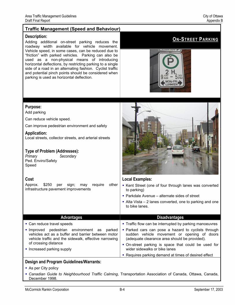
ON-STREET PARKING
Description: Adding additional on-street parking reduces the roadway width available for vehicle movement. Vehicle speed, in some cases, can be reduced due to “friction” with parked vehicles. Parking can also be used as a non-physical means of introducing horizontal deflections, by restricting parking to a single side of a road in an alternating fashion. Cyclist traffic and potential pinch points should be considered when parking is used as horizontal deflection.
Purpose: Add parking
Can reduce vehicle speed.
Can improve pedestrian environment and safety
Application: Local streets, collector streets, and arterial streets
Type of Problem (Addresses): Primary Secondary Ped. Enviro/Safety Speed
Cost Approx. $250 per sign; may require other infrastructure pavement improvements
Local Examples:
Kent Street (one of four through lanes was converted to parking) Parkdale Avenue – alternate sides of street Alta Vista – 2 lanes converted, one to parking and one to bike lanes.
Advantages Disadvantages
Can reduce travel speeds Improved pedestrian environment as parked vehicles act as a buffer and barrier between motor vehicle traffic and the sidewalk, effective narrowing of crossing distance Increased parking supply
Traffic flow can be interrupted by parking manoeuvres Parked cars can pose a hazard to cyclists through sudden vehicle movement or opening of doors (adequate clearance area should be provided). On-street parking is space that could be used for wider sidewalks or bike lanes Requires parking demand at times of desired effect
Design and Program Guidelines/Warrants:
As per City policy Canadian Guide to Neighbourhood Traffic Calming, Transportation Association of Canada, Ottawa, Canada, December 1998.

Area Traffic Management Guidelines City of Ottawa Draft Final Report Appendix B
McCormick Rankin Corporation B-5 September 17, 2003
Traffic Management (Speed and Behaviour)
PAVEMENT MARKINGS
Description: Pavement markings can be used to visually narrow a roadway. Offset edge lines, on both sides of the street, can keep vehicles from “wandering” across wide lanes, may reduce speeds, and can discourage passing on the right. Lane striping in the centre portion of the street may guide vehicles to a narrow section next to the curb. They can also provide a greater buffer area between vehicles and pedestrians and adjacent properties.
Purpose: Restrict motor vehicle traffic to more limited portion of the roadway
Application: Local streets, collector street, arterial streets
Type of Problem (Addresses): Primary Secondary Driver Behaviour Ped. Enviro/Safety
Bike Enviro/Safety
Speed
Cost Approx. $5 per metre
Local Examples:
McClellan Road (Arlington Woods). Longfields Drive (Barrhaven) Bridlewood Drive (Bridlewood)
Advantages Disadvantages
Inexpensive implementation May be implemented quickly No impact on emergency response Can enhance pedestrian environment by providing additional buffer area
Increased maintenance cost May be interpreted as a bicycle lane or parking area May be ineffective during winter conditions
Design and Program Guidelines/Warrants: Context specific

Area Traffic Management Guidelines City of Ottawa Draft Final Report Appendix B
McCormick Rankin Corporation B-6 September 17, 2003
Traffic Management (Speed and Behaviour)
NARROWING OF STREETS
Description: This measure physically reduces the number and/or width of travel lanes available on the roadway, reducing the curb-to-curb width along the length of the street. In some cases, trteavel lanes may be reduced while maintaining turn lanes at intersections. Another common example is the conversion, on collector or arterial streets, of a four lane two-way section to one lane in each direction with a centre turn lane. Depending on the situation, these conversions can maintain similar volumes of traffic while reducing speeds and conflicts.
Purpose: Reduce conflicts (in case of four lane conversion to two lane and continuous left turn lane)
Enhance pedestrian environment and safety
Application: Local streets, collector streets, and some arterial streets
Type of Problem (Addresses): Primary Secondary Conflicts Ped. Enviro/Safety Bicycle Enviro/Safety Speed
Cost Varies
Local Examples:
Piccadilly at Byron Wellington Kent Wilbrod Street west of King Edward Avenue
Advantages Disadvantages Can enhance local access Can enhance pedestrian and bicycle environment Can reduce conflicts (in case of four lane conversion to two lane and continuous left turn lane) Can reduce speeds
Can be expensive if done as a retrofit due to utility relocations Perceived or actual reduction in roadway capacity can be controversial Can result in increased delay and travel times
Design and Program Guidelines/Warrants: Context specific

Area Traffic Management Guidelines City of Ottawa Draft Final Report Appendix B
McCormick Rankin Corporation B-7 September 17, 2003
Traffic Management (Speed)
REALIGNED INTERSECTION
Description: A realigned intersection is a change in alignment of an existing T-intersection with straight approaches to one with curving streets that meet at right angles. They result in former through movements becoming turning movements.
Purpose: Reduce speed Reduce vehicle conflicts
Application: Local streets and some collector streets
Type of Problem (Addresses): Primary Secondary Speed Volume Vehicle Conflicts
Cost Approx: $10 000 and up
Local Examples:
Johnson at Zaidan Huron at Island Park (north of Carling)
Advantages Disadvantages Can reduce speed Can reduce conflicts One of few options for T-intersections
Curb realignment can be costly Additional right of way may be required
Design and Program Guidelines/Warrants: Context specific

Area Traffic Management Guidelines City of Ottawa Draft Final Report Appendix C
Appendix C. PHYSICAL MEASURES (TRAFFIC CALMING)
McCormick Rankin Corporation C-1 September 17, 2003

Area Traffic Management Guidelines City of Ottawa Draft Final Report Appendix C
PHYSICAL MEASURES (TRAFFIC CALMING)
SPEED HUMPS/TABLE (AKA undulations, flat topped speed hump, trapezoidal humps)
Description: A speed hump is a raised portion of the roadway, which vertically deflects both the wheels and frame of a traversing vehicle.
Speed Tables are flat-topped speeds humps. The long flat area of the speed table results in a higher design speed than speed humps. The angle of approach can be designed to be bicycle friendly.
Purpose: Reduce vehicle speeds
Application: Local streets and some collector streets
Type of Problem (Addresses): Primary Secondary Speed Volume Ped Enviro/Safety
Cost Approx. $3 000 (hump)
$10 000 (table)
Local Examples:
Riverdale Des Epinettes Churchill (north of Richmond Road) Lyon
Advantages Disadvantages Reduces vehicle speeds
Some traffic may be diverted to adjacent streets Can delay emergency vehicles Can be relatively costly due to current Environmental Assessment (EA) requirements Can be very uncomfortable to vehicle occupants with certain disabilities
Design and Program Guidelines/Warrants: Canadian Guide to Neighbourhood Traffic Calming, Transportation Association of Canada, Ottawa, Canada, December 1998.
TAB
LE
HU
MP
McCormick Rankin Corporation C-2 September 17, 2003

Area Traffic Management Guidelines City of Ottawa Draft Final Report Appendix C
McCormick Rankin Corporation C-3 September 17, 2003
PHYSICAL MEASURES (TRAFFIC CALMING)
RAISED CROSSWALKS
Description: Raised crosswalks are speed tables that are marked as crosswalks. The flat surface of the speed table can be constructed with a brick of other textured material. The angle of approach can be designed to be bicycle friendly.
Purpose: Reduce vehicle speed
Improve pedestrian visibility
Reduce pedestrian-vehicle conflicts
Application: Local streets and some collector streets
Type of Problem (Addresses): Primary Secondary Speed Vehicle conflicts Ped. Enviro/Safety Volume
Cost Approx. $10 000
Local Examples:
Kirkwood at Byron Des Epinettes at Yves Richer Park
Advantages Disadvantages Reduction in vehicle speeds Enhanced pedestrian comfort and safety when used in conjunction with crosswalks
Some traffic may be diverted to adjacent streets Can be relatively costly due to current Environmental Assessment (EA) requirements Can be very uncomfortable to vehicle occupants with certain disabilities
Design and Program Guidelines/Warrants: Canadian Guide to Neighbourhood Traffic Calming, Transportation Association of Canada, Ottawa, Canada, December 1998.
Area Traffic Management Guidelines City of Ottawa Draft Final Report Appendix C
McCormick Rankin Corporation C-4 September 17, 2003
PHYSICAL MEASURES (TRAFFIC CALMING)
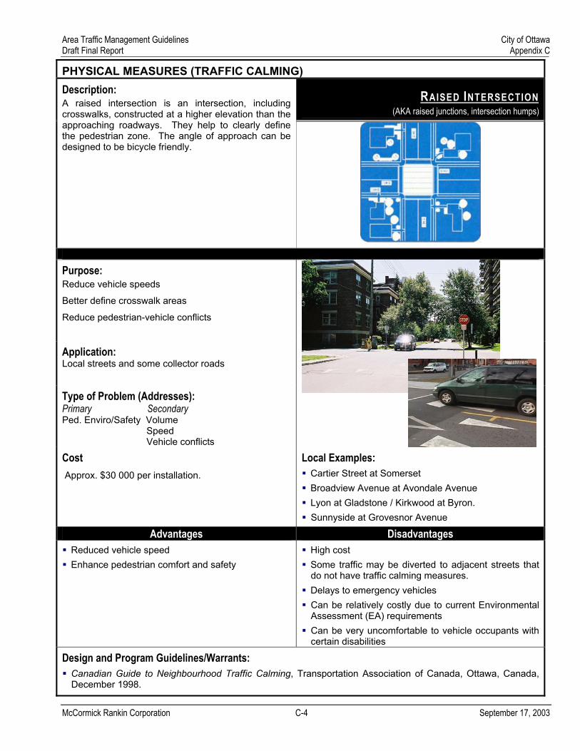
RAISED INTERSECTION (AKA raised junctions, intersection humps)
Description: A raised intersection is an intersection, including crosswalks, constructed at a higher elevation than the approaching roadways. They help to clearly define the pedestrian zone. The angle of approach can be designed to be bicycle friendly.
Purpose: Reduce vehicle speeds
Better define crosswalk areas
Reduce pedestrian-vehicle conflicts
Application: Local streets and some collector roads
Type of Problem (Addresses): Primary Secondary Ped. Enviro/Safety Volume Speed Vehicle conflicts
Cost Approx. $30 000 per installation.
Local Examples:
Cartier Street at Somerset Broadview Avenue at Avondale Avenue Lyon at Gladstone / Kirkwood at Byron. Sunnyside at Grovesnor Avenue
Advantages Disadvantages Reduced vehicle speed Enhance pedestrian comfort and safety
High cost Some traffic may be diverted to adjacent streets that do not have traffic calming measures. Delays to emergency vehicles Can be relatively costly due to current Environmental Assessment (EA) requirements Can be very uncomfortable to vehicle occupants with certain disabilities
Design and Program Guidelines/Warrants: Canadian Guide to Neighbourhood Traffic Calming, Transportation Association of Canada, Ottawa, Canada, December 1998.

Area Traffic Management Guidelines City of Ottawa Draft Final Report Appendix C
McCormick Rankin Corporation C-5 September 17, 2003
PHYSICAL MEASURES (TRAFFIC CALMING)
TRAFFIC CIRCLE (MINI) (AKA raised junctions, intersection humps)
Description: A traffic circle is a raised island located in the centre of an intersection around which traffic must circulate. They are sometimes landscaped in the centre. The outer ring is usually mountable so large vehicles can navigate the otherwise small curb radii. Traffic circles are generally located within the existing paved area of the intersection. They can effectively reduce speeds and volumes if used in series.
Purpose: Reduce vehicle speeds
Reduce vehicle-vehicle conflicts at intersections.
Application: Local streets and some collector streets
Type of Problem (Addresses): Primary Secondary Speed Volume Vehicle conflicts
Cost Approx: $10 000
Local Examples: Lenester Avenue at Hare Avenue
Advantages Disadvantages
Reduces vehicle speed Reduces vehicles conflicts Landscaped island can enhance streetscape
Comparatively expensive measures Can direct vehicles into unmarked crosswalk area on narrower streets Cyclists may feel "squeezed" by motor vehicles trying to pass at a traffic circle. Can restrict access for large vehicles Can slow emergency vehicles Some traffic may be diverted to adjacent streets that do not have traffic calming measures Maintenance more difficult, especially snow removal Can be relatively costly due to current Environmental Assessment (EA) requirements
Design and Program Guidelines/Warrants: Canadian Guide to Neighbourhood Traffic Calming, Transportation Association of Canada, Ottawa, Canada, December 1998.

Area Traffic Management Guidelines City of Ottawa Draft Final Report Appendix C
McCormick Rankin Corporation C-6 September 17, 2003
PHYSICAL MEASURES (TRAFFIC CALMING)
CHICANES (AKA deviations, serpentines, reversing curves)
Description: A chicane is a series mid-block curb extensions or islands on alternating sides of a roadway that narrow the roadway and require drivers to follow an S-shaped path. They can be used on one-way or two-way streets and can be single lane or two-lane configurations.
Purpose: Discourage through traffic
Reduce vehicle speeds
Application: Local streets and some collector streets
Type of Problem (Addresses): Primary Secondary Speed Volume
Cost Varies $10 000 to $50 000
Local Examples:
Kirkwood (north of the Queensway) Chapel (north of Mann) –lateral shift Parkdale (south of Queensway)
Advantages Disadvantages Can reduce vehicle speed, volume, and conflicts. Landscaped chicane can enhance streetscape
Comparatively expensive measure Can be relatively costly due to current Environmental Assessment (EA) requirements Some traffic may be diverted to adjacent streets that do not have traffic management measures. May require removal on on-street parking Increased street maintenance requirements Cyclists may be “squeezed” by motor vehicle traffic at deflection points
Design and Program Guidelines/Warrants: Canadian Guide to Neighbourhood Traffic Calming, Transportation Association of Canada, Ottawa, Canada, December 1998.

Area Traffic Management Guidelines City of Ottawa Draft Final Report Appendix D
Appendix D. PHYSICAL MEASURES (OTHER)
McCormick Rankin Corporation D-1 September 17, 2003

Area Traffic Management Guidelines City of Ottawa Draft Final Report Appendix D
McCormick Rankin Corporation D-2 September 17, 2003
PHYSICAL MEASURES (OTHER)
INTERSECTION NARROWINGS (AKA curb extensions, neckdowns, nubs, bulbouts)
Description: Intersection narrowings are curb extensions at intersections that reduce roadway width curb to curb. The curb can be extended from one or both sides depending on the objective. They effectiveness of an intersection narrowing can be increased when used in conjunction with speed humps, raised crosswalks, raised intersections, textured crosswalks, landscaping, or curb radii reductions.
Purpose: Reduce crossing distance for pedestrians
Increase pedestrian visibility
Prevent parking close to intersection
Reduce vehicle speeds
Application: Local Streets, collector streets, and some arterial
Type of Problem (Addresses): Primary Secondary Ped. Enviro/Safety Speeds
Cost Approx. $7 000 each or higher if drainage modifications are required.
Local Examples: Many examples throughout the central area of the city
Advantages Disadvantages Reduced pedestrian crossing distances, extended pedestrian environment, and potential for enhanced landscaping and street amenities Some reduction in vehicle speeds Helps define parking areas
Reduces potential pavement area for cyclists May require removal of on-street parking Can impact manoeuvrability of large vehicles resulting in intrusion into other travel lanes or mounting the curb (with associated pedestrian and maintenance issues) Additional maintenance cost particularly snow removalCyclists may be “squeezed” by motor vehicle traffic at deflection points
Design and Program Guidelines/Warrants: Canadian Guide to Neighbourhood Traffic Calming, Transportation Association of Canada, Ottawa, Canada, December 1998.

Area Traffic Management Guidelines City of Ottawa Draft Final Report Appendix D
McCormick Rankin Corporation D-3 September 17, 2003
PHYSICAL MEASURES (OTHER)
MID-BLOCK NARROWINGS (AKA chokers, pinch points, mid-block bulbouts)
Description: Mid-block narrowings are curb extension at mid-block that reduce the roadway width curb to curb at that location. Extensions of the curb can be from either or both sides of the street, and can leave the street cross section with two narrow lanes or with a single lane.
Purpose: Reduce vehicle speeds
Application: Local Streets, collector streets, and some arterial
Type of Problem (Addresses): Primary Secondary Ped. Enviro/Safety Speed
Cost Approx. $20 000 for both sides.
Local Examples:
Flora near Bronson Clifton Road near Scott and Richmond Road (one lane)
Advantages Disadvantages
Reduced pedestrian crossing distances, extended pedestrian environment, and potential for enhanced landscaping and street amenities. May reduce speeds Provide buffer for sidewalk Help define parking areas Discourages vehicles from passing on the right
Reduces potential pavement area for cyclists May require removal of on-street parking Additional maintenance cost particularly snow removal
Design and Program Guidelines/Warrants: Canadian Guide to Neighbourhood Traffic Calming, Transportation Association of Canada, Ottawa, Canada, December 1998.

Area Traffic Management Guidelines City of Ottawa Draft Final Report Appendix D
McCormick Rankin Corporation D-4 September 17, 2003
PHYSICAL MEASURES (OTHER)
CENTRE ISLAND NARROWINGS (MEDIAN) (AKA Raised median island, midblock mediates, median slow points,
median chokers)
Description: A centre island narrowing is an elevated median constructed on the centreline of a two-way roadway to reduce the overall width of the adjacent travel lanes. If required, bicycle lanes can be included to prevent motorists from intruding into the path of cyclists.
Purpose: Reduce vehicle speeds
Reduce pedestrian-vehicle conflict
Application: Local streets, collector streets, arterial streets
Type of Problem (Addresses): Primary Secondary Ped. Enviro/Safety Speed
Cost Approx. $5 000 and up
Local Examples
Laperriere at Kirkwood Castlefrank at Katimavik Brittania at Howe Flannery at Brookfield ($150 000)
Advantages Disadvantages
Reduced vehicle speeds Can serve as pedestrian refuge Can accommodate landscaping
May require removal of on-street parking May restrict access Increased maintenance cost May reduce potential pavement area for cyclists
Design and Program Guidelines/Warrants: Canadian Guide to Neighbourhood Traffic Calming, Transportation Association of Canada, Ottawa, Canada, December 1998.
Area Traffic Management Guidelines City of Ottawa Draft Final Report Appendix D
McCormick Rankin Corporation D-5 September 17, 2003
PHYSICAL MEASURES (OTHER)
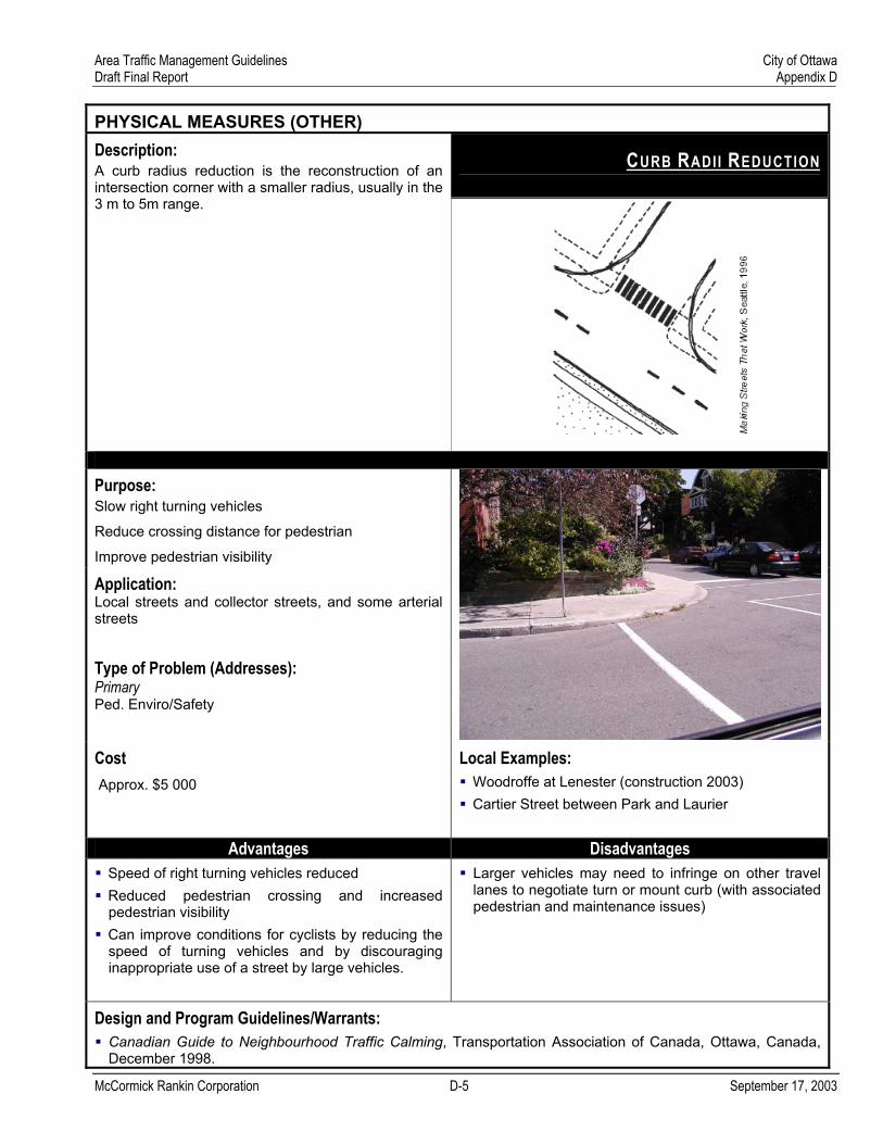
CURB RADII REDUCTION
Description: A curb radius reduction is the reconstruction of an intersection corner with a smaller radius, usually in the 3 m to 5m range.
Purpose: Slow right turning vehicles
Reduce crossing distance for pedestrian
Improve pedestrian visibility
Application: Local streets and collector streets, and some arterial streets
Type of Problem (Addresses): Primary Ped. Enviro/Safety
Cost Approx. $5 000
Local Examples:
Woodroffe at Lenester (construction 2003) Cartier Street between Park and Laurier
Advantages Disadvantages
Speed of right turning vehicles reduced Reduced pedestrian crossing and increased pedestrian visibility Can improve conditions for cyclists by reducing the speed of turning vehicles and by discouraging inappropriate use of a street by large vehicles.
Larger vehicles may need to infringe on other travel lanes to negotiate turn or mount curb (with associated pedestrian and maintenance issues)
Design and Program Guidelines/Warrants: Canadian Guide to Neighbourhood Traffic Calming, Transportation Association of Canada, Ottawa, Canada, December 1998.

Area Traffic Management Guidelines City of Ottawa Draft Final Report Appendix D
McCormick Rankin Corporation D-6 September 17, 2003
PHYSICAL MEASURES (OTHER)
LATERAL SHIFT
Description: A lateral shift, similar to a chicane, is a curb extension that shifts the roadway horizontally without returning to the original centreline.
Purpose: Reduce speed
Application: Local street, collector street
Type of Problem (Addresses): Primary Secondary Speed
Behaviour
Cost Approx. $7 000 each or higher if drainage modifications are required.
Local Examples:
Chapel north of Mann Sandy Hill Neighbourhood
Advantages Disadvantages Can slow traffic on higher volume streets Maintains access for large vehicles
May impact on-street parking May cause driver confusion
Design and Program Guidelines/Warrants: Context specific

Area Traffic Management Guidelines City of Ottawa Draft Final Report Appendix E
Appendix E. TRANSPORTATION DEMAND MANAGEMENT
McCormick Rankin Corporation E-1 September 17, 2003

Area Traffic Management Guidelines City of Ottawa Draft Final Report Appendix E
TRANSPORTATION DEMAND MANAGEMENT
NEIGHBOURHOOD-BASED TDM TOOLKIT
Description: Transportation Demand Management (TDM) measures improve people’s travel options and encourage personal travel choices that benefit individuals and their communities. This is accomplished by reducing the number of motor vehicle trips people make, and supporting increased reliance on walking, biking, carpooling or using transit as a means of getting around. The City is developing new approaches to TDM that extend beyond trip-end and employer-based programs and reach households at the neighbourhood level. It is these new programs that show the most promise for assisting in addressing neighbourhood traffic issues.
The City is considering development of a neighbourhood-based TDM toolkit to guide staff, consultants and community groups in considering TDM either as an integral part of area traffic management processes, or independently.
Purpose: Reduce motor vehicle trips
Educate public on travel options and traffic issues
Application: Local street, collector streets, arterial streets
Type of Problem (Addresses): Primary Secondary Volume Ped Enviro/Safety
Bike Enviro/Safety
Cost Varies
Local Examples: Under development
Advantages Disadvantages Can be used as a precursor to other measures Can reduce motor vehicle trips as a whole Can be used to educate public on neighbourhood traffic issues
Usually requires sustained effort
Design and Program Guidelines/Warrants: As per City program
McCormick Rankin Corporation E-2 September 17, 2003

Area Traffic Management Guidelines City of Ottawa Draft Final Report Appendix F
Appendix F. EDUCATION AND ENFORCEMENT
McCormick Rankin Corporation F-1 September 17, 2003

Area Traffic Management Guidelines City of Ottawa Draft Final Report Appendix F
EDUCATION AND ENFORCEMENT
NEIGHBOURHOOD SPEED WATCH
Description: A neighbourhood speed watch program consists of a partnership between the City and the concerned neighbourhood to educate drivers to slow down and exercise caution when using neighbourhood streets. It can also help the residents better understand the nature and extent of local speeding issues.
Drivers are made aware of their travel speed through the use of speed display boards. A speed display board typically consists of a mobile display board and radar unit. It alerts drivers by displaying their travel speed and the posted speed limit. The City may lend the equipment to volunteer residents and trains them in its use.
The device can be effective as a precursor to enforcement by identifying locations where there is a problem.
Purpose: Educate drivers on excessive speed
Educate residents on nature of speed issues
Application: Local street, collector streets
Type of Problem (Addresses): Primary Secondary Behaviour Vehicle conflicts Speed Ped Enviro/Safety
Bike Enviro/Safety
Cost Varies
Local Examples: N/A (temporary use)
Advantages Disadvantages Reduction in vehicle speed on roadway Can be used as a precursor to other measures Can be used to educate public on nature of speed issue
Usually requires sustained or periodic enforcement effort Effect on speed reduction is usually fleeting unless combined with other measures
Design and Program Guidelines/Warrants: As per City program
McCormick Rankin Corporation F-2 September 17, 2003

Area Traffic Management Guidelines City of Ottawa Draft Final Report Appendix F
EDUCATION AND ENFORCEMENT
SAFETY AND EDUCATION CAMPAIGNS
Description: Safety campaigns are usually directed at a specific target group of road users and are designed to change their behaviour. They are likely to be most successful in the self-contained suburban communities, where most of the problems are caused by internally generated traffic.
Specific campaigns, programs or initiatives may require community participation and support.
Purpose: Educate road users
Application: Local streets, collector streets, arterial streets
Type of Problem (Addresses): Primary Secondary Behaviour Speed
Cost $0 to $50 000
Local Examples:
Ongoing programs Share the road Rear end collision prevention initiative Community-based aggressive driver awareness and prevention program
Advantages Disadvantages Can be a low cost measure that may address specific local issues May avert the need for physical measures
To be effective requires identifiable target group Usually requires sustained effort
Design and Program Guidelines/Warrants: As per City program
McCormick Rankin Corporation F-3 September 17, 2003
Area Traffic Management Guidelines City of Ottawa Draft Final Report Appendix F
McCormick Rankin Corporation F-4 September 17, 2003
TARGETED ENFORCEMENT
TARGETED ENFORCEMENT
Description: Targeted enforcement as a traffic management measure that includes stepped up enforcement of speed limits and other traffic laws such as failure to yield to pedestrians. Visible and targeted enforcement can be very effective deterrent and is an important first step in addressing neighbourhood traffic issues.
Purpose: To reduce traffic speed and increase safety
Application: Local streets, collector streets, arterial streets
Type of Problem (Addresses): Primary Secondary Speed Volume (for restricted turn violations)
Behaviour
Ped Enviro/Safety
Bike Enviro/Safety
Local Examples: Ongoing throughout city
Cost Varies
Advantages Disadvantages
May avert the need for physical measures Can be done immediately and can be effective Flexible; can be tailored to suit needs
Usually requires sustained effort May be difficult to provide enforcement to the extent and with the frequency that residents desire.
Design and Program Guidelines/Warrants: As per City policy

Area Traffic Management Guidelines City of Ottawa Draft Final Report Appendix G
Appendix G. STREET ENVIRONMENT
McCormick Rankin Corporation G-1 September 17, 2003

Area Traffic Management Guidelines City of Ottawa Draft Final Report Appendix G
STREET ENVIRONMENT
STREETSCAPING
Description: Streetscaping incorporates a number of potential elements including landscaping and pedestrian amenities such as benches and lighting. Streetscaping can slow traffic and enhance the pedestrian environment. Street trees can effectively narrow the perceived roadway width and reduces the forward field of view often resulting in reduced speeds. Alternating the type of tree used at intersection can serve as a visual cue to drivers that an intersection is approaching. Amenities, such as lighting can also alter driver behaviour. Pedestrian scale lighting is a cue to the nature of the street and also reduces the forward field of view.
Purpose: Enhance pedestrian environment
Alert driver to context of roadway
Reduce speeds
Application: Local streets, collector streets, arterial streets
Type of Problem (Addresses): Primary Secondary Ped. Enviro/Safety Speed Behaviour
Cost Varies significantly
Local Examples:
Ottawa parkways Island Park Drive
Advantages Disadvantages
May reduce speeds Positive aesthetic effect
Possible increased maintenance cost Can create sight distance issues if not done correctly Can be impacted by salt spray Vegetation may interfere with roadway illumination
Design and Program Guidelines/Warrants: Context specific
McCormick Rankin Corporation G-2 September 17, 2003

Area Traffic Management Guidelines City of Ottawa Draft Final Report Appendix G
McCormick Rankin Corporation G-3 September 17, 2003
STREET ENVIRONMENT
GATEWAYS
Description: Gateways include decorative signing and/or landscaping to visually identify the entrance to neighbourhoods or commercial areas. This measure alerts drivers to the nature of the area and is intended to make the area appear as a destination rather than a through route. Cyclist access should be considered in the design of a gateway.
Purpose: Alter driver to context of roadway Reduce volumes Reduce speeds Application: Local streets, collector streets, arterial streets
Type of Problem (Addresses): Primary Secondary Speed Behaviour Cost Approx. $5 000 but can be much higher depending on local circumstances.
Local Examples:
Castlebrook Lane at Centrepointe Drive Flannery and Brookfield Preston at Carling Orleans at Innes (arterial)
Advantages Disadvantages May reduce speed Positive aesthetic effect
Can be expensive Possible increased maintenance cost
Design and Program Guidelines/Warrants: Context specific

Area Traffic Management Guidelines City of Ottawa Draft Final Report Appendix G
McCormick Rankin Corporation G-4 September 17, 2003
STREET ENVIRONMENT
TEXTURED CROSSWALK
Description: A textured crosswalk is a crosswalk incorporating a textured and/or patterned surface that contrasts with the adjacent roadway and sidewalk.
Purpose: To indicate pedestrian crossing to approaching traffic
To better define the crossing location for pedestrians
Application: Local streets, collector streets, arterial streets
Type of Problem (Addresses): Primary Secondary Ped. Enviro/Safety Driver Behaviour
Cost Approx. $3 000 to $7 000 but can be much higher depending on local circumstances.
Local Examples:
Rochester and Primrose Cumberland at Watters - imprinted asphalt McArthur at Vanier Parkway
Advantages Disadvantages Reinforces pedestrian priority and may reduce conflicts as a result Enhanced appearance of street
May have maintenance issues depending on base, surface material, and vehicle loads Imprinted asphalt texture can wear rapidly in high heat conditions Uneven surfaces can pose a tripping hazard Can complicate installation of loop detectors
Design and Program Guidelines/Warrants: Canadian Guide to Neighbourhood Traffic Calming, Transportation Association of Canada, Ottawa, Canada, December 1998.

Area Traffic Management Guidelines City of Ottawa Draft Final Report Appendix G
McCormick Rankin Corporation G-5 September 17, 2003
STREET ENVIRONMENT
TEXTURED SURFACES
Description: Textured and coloured pavement includes the use of stamped pavement or alternate paving materials to create an uneven surface the length of the road. Materials include cobblestone, bricks and textured concrete.
Purpose: To designate special area
Application: Local streets, collector streets, and some arterial streets
Type of Problem (Addresses): Primary Secondary Ped. Enviro/Safety Driver Behaviour
Speed
Cost: Approx. $10 000 but can be much higher depending on local circumstances.
Local Examples: Primrose at Rochester
Advantages Disadvantages Can reduce vehicle speeds over an extended length Can have positive aesthetic value
Can be expensive Can result in increased noise May have maintenance issues depending on base, surface material, and vehicle loads Uneven surfaces can pose a tripping hazard Imprinted asphalt texture can wear rapidly in high heat conditions
Design and Program Guidelines/Warrants: Context specific

Area Traffic Management Guidelines City of Ottawa Draft Final Report Appendix G
McCormick Rankin Corporation G-6 September 17, 2003
STREET ENVIRONMENT
SIDEWALKS
Description: Sidewalks may be added on roads where there are reported pedestrian/vehicle conflicts. It should be noted that these measures reduce conflicts through separation of the modes, rather than by calming or reducing traffic.
Purpose: Reduce Vehicle / Pedestrian conflicts
Application: Local streets, collector streets, arterial streets
Type of Problem (Addresses): Primary Ped. Enviro/Safety
Cost Approx. $350 per metre
Local Examples:
Brittania Road (looking toward Carling) Main at St. Paul University
Advantages Disadvantages Can reduce vehicle / pedestrian conflicts
Cyclists may use sidewalk if cyclist needs are not adequately addressed
Design and Program Guidelines/Warrants: As per City standards
Area Traffic Management Guidelines City of Ottawa Draft Final Report Appendix G
McCormick Rankin Corporation G-7 September 17, 2003
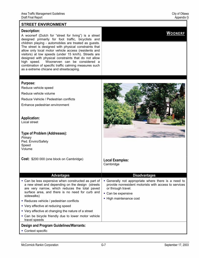
STREET ENVIRONMENT
WOONERF
Description: A woonerf (Dutch for “street for living”) is a street designed primarily for foot traffic, bicyclists and children playing - automobiles are treated as guests. The street is designed with physical constraints that allow only local motor vehicle access (residents and visitors) at low speeds (under 15 km/h). Streets are designed with physical constraints that do not allow high speed. Woonerven can be considered a combination of specific traffic calming measures such as a extreme chicane and streetscaping.
Purpose: Reduce vehicle speed
Reduce vehicle volume
Reduce Vehicle / Pedestrian conflicts
Enhance pedestrian environment
Application: Local street
Type of Problem (Addresses): Primary Ped. Enviro/Safety Speed Volume
Cost: $200 000 (one block on Cambridge)
Local Examples: Cambridge
Advantages Disadvantages Can be less expensive when constructed as part of a new street and depending on the design (streets are very narrow, which reduces the total paved surface area, and there is no need for curb and sidewalks) Reduces vehicle / pedestrian conflicts Very effective at reducing speed Very effective at changing the nature of a street Can be bicycle friendly due to lower motor vehicle travel speeds
Generally not appropriate where there is a need to provide nonresident motorists with access to services or through travel. Can be expensive High maintenance cost
Design and Program Guidelines/Warrants: Context specific

Area Traffic Management Guidelines City of Ottawa Draft Final Report Appendix H
Appendix H. TRAFFIC CONTROL
McCormick Rankin Corporation H-1 September 17, 2003

Area Traffic Management Guidelines City of Ottawa Draft Final Report Appendix H
TRAFFIC CONTROL
STOP SIGNS
Description: Stop signs are used for right of way control. Warrants for stop signs are provided in the Ontario Traffic Manual and City policy.
Purpose: Reduce conflicts at intersections
Application: Local and some collector streets based on warrants
Type of Problem (Addresses): Primary Secondary Vehicle conflicts Volume Ped. Enviro/Safety Bike Enviro/Safety
Cost Approx. $250 per sign
Local Examples Widely used
Advantages Disadvantages
Relatively low cost option Warranted stops can reduce vehicle conflicts.
Unwarranted stops signs typically result in compliance problems and in some cases can result in higher speeds Increased noise levels associated with braking and acceleration Misuse can lead to disrespect for stop signs in generalReduce cycling benefit of side streets
Design and Program Guidelines/Warrants: As per City warrants
McCormick Rankin Corporation H-2 September 17, 2003

Area Traffic Management Guidelines City of Ottawa Draft Final Report Appendix H
McCormick Rankin Corporation H-1 September 17, 2003
TRAFFIC CONTROL
MODERN ROUNDABOUTS
Description: Modern roundabouts are similar to mini traffic circles with traffic circulating around a centre island. Roundabouts are used at higher volume intersections to control competing movements. They are larger than traffic circles and have splitter islands to channel approaching traffic to the right. Roundabouts can substitute for traffic signals or all-way stops in certain situations, can reduce vehicle conflicts, and are most effective with moderate, directionally balanced volumes of traffic.
Purpose: Reduce vehicle conflicts
Application: Arterial and collector streets
Type of Problem (Addresses): Primary Secondary Vehicle conflicts Speeds
Cost Varies: $100 000 and up
Local Examples:
Sussex Drive at Rideau Gate Waterbridge at Cresthaven, Barrhaven
Advantages Disadvantages Reduces vehicle conflicts Reduction in vehicle speeds Can serve as a “gateway”
Requires relatively large land area compared to a typical signalized intersection May require removal of on-street parking Additional maintenance cost, particularly snow removal Potential for greater pedestrian crossing distances Cyclists may be “squeezed” by motor vehicle traffic at deflection points
Design and Program Guidelines/Warrants: To be developed