Embed Size (px)
Citation preview

Appendix 7 – Places to Live
September 2008
Ap
pe
nd
ix 7
– Pla
ces to
Live

Appendix 71
This map is reproduced from Ordnance Survey material with the permission of Ordnance Survey on behalf of the Controller of Her Majesty’s Stationery Office © Crown copyright. Unauthorised reproduction infringes Crown copyright and may lead to prosecution or civil proceedings. Basingstoke & Deane Borough Council, licence number LA100019356, (2009). Imagery copyright Digital Millennium Map Partnership 2009.
Appendix 7 Design and Sustainability SPD
Places to Live
Contents Page
1.0 Introduction 3
1.1 What is Urban Design? 3
1.2 The Purpose of the Document 4
1.3 Raising Design Quality 6
1.4 How to use this Guide 7
Part One
2.0 Outlining the Principles 8
2.1 Objectives of Urban Design 8
2.2 Physical Attributes of Urban Design 9
3.0 The Need for a Vision 11
3.1 Creating a Vision 11
3.2 Checklist for Creating the Vision 12
Part Two
4.0 Local Context: The Starting Point 13
4.1 Physical Context 13
4.2 Social Context 14
4.3 Local Character 15
4.4 Landscape Context 17
4.5 Policy Context 17
4.6 Site Appraisal 18
4.7 Design and Access Statements 19
4.8 Checklist for Local Context 20

Appendix 7 2
This map is reproduced from Ordnance Survey material with the permission of Ordnance Survey on behalf of the Controller of Her Majesty’s Stationery Office © Crown copyright. Unauthorised reproduction infringes Crown copyright and may lead to prosecution or civil proceedings. Basingstoke & Deane Borough Council, licence number LA100019356, (2009). Imagery copyright Digital Millennium Map Partnership 2009.
Appendix 73
This map is reproduced from Ordnance Survey material with the permission of Ordnance Survey on behalf of the Controller of Her Majesty’s Stationery Office © Crown copyright. Unauthorised reproduction infringes Crown copyright and may lead to prosecution or civil proceedings. Basingstoke & Deane Borough Council, licence number LA100019356, (2009). Imagery copyright Digital Millennium Map Partnership 2009.
5.0 Applying Design Principles to the Site 21
5.1 Identifying the Structure 21
5.2 Establishing Routes and Connections 23
5.3 Creating a Grid of Routes and Blocks 24
5.4 Giving Form to the Blocks 25
5.5 Arranging the Buildings 29
5.6 Townscape 33
5.7 Creating Spaces 36
5.8 Accommodating Transport Requirements 40
5.9 Accommodating Parking 43
5.10 Architectural Detailing 50
5.11 Landscaping 52
5.12 Resource and Energy Efficiency 55
5.13 Checklist for Applying Design Principles to the Site 56
6. Glossary 57
7. References 59
The Ordnance Survey mapping included within this document is provided by Basingstoke and Deane Borough Council under licence from the Ordnance Survey in order to fulfil its public function in acting as a Planning authority. Persons viewing this mapping should contact Ordnance Survey copyright for advice where they wish to licence Ordnance Survey mapping for their own use.
This map is reproduced from Ordnance Survey material with the permission of Ordnance Survey on behalf of the Controller of Her Majesty’s Stationery Office © Crown copyright. Unauthorised reproduction infringes Crown copyright and may load to prosecution or civil proceedings. Basingstoke & Deane Borough Council, licence number LA100019356, (2009).
2
This map is reproduced from Ordnance Survey material with the permission of Ordnance Survey on behalf of the Controller of Her Majesty’s Stationery Office © Crown copyright. Unauthorised reproduction infringes Crown copyright and may lead to prosecution or civil proceedings. Basingstoke & Deane Borough Council, licence number LA100019356, (2009). Imagery copyright Digital Millennium Map Partnership 2009.
Appendix 73
This map is reproduced from Ordnance Survey material with the permission of Ordnance Survey on behalf of the Controller of Her Majesty’s Stationery Office © Crown copyright. Unauthorised reproduction infringes Crown copyright and may lead to prosecution or civil proceedings. Basingstoke & Deane Borough Council, licence number LA100019356, (2009). Imagery copyright Digital Millennium Map Partnership 2009.
1. Introduction
1.1 What is Urban Design?
1.1.1 Urban Design can be defined as;
“…a collaborative and multi-disciplinary process of shaping the physical setting for life in cities; town and villages; the art of making places; design in a urban context. Urban design involves the design of buildings, groups of buildings, spaces and landscapes…”1
Urban Design has an integral place in planning policy. Government 1.1.2 guidance1 promotes he creation of more sustainable high quality residential environments. It recognises that urban design principles and practices are important in creating better, more ‘liveable’ places.
“Urban design is a key to creating sustainable developments”2
Importance of good design is heavily embedded in national planning policy. 1.1.3 One of the key principles in Planning Policy Statement 1 is as follows:
Planning policies should promote high quality inclusive design in the layout of new developments and individual buildings in terms of function and impact, not just for the short term but over the lifetime of the development. Design which fails to take the opportunities available for improving the character and quality of an area should not be accepted.3’
1.1.4 This document is based on publications written by the Government, CABE (Commission of Architecture and the Built Environment), and academic texts including:
By Design: Urban Design in the Planning System. DETR/CABE (2000) •
Better Places to Live. DETR/CABE (2001) •
Urban Design Compendium. English Partnerships/The Housing •Corporation (2001)
Responsive Environments, Bentley et al (1985).•

Appendix 7 4
This map is reproduced from Ordnance Survey material with the permission of Ordnance Survey on behalf of the Controller of Her Majesty’s Stationery Office © Crown copyright. Unauthorised reproduction infringes Crown copyright and may lead to prosecution or civil proceedings. Basingstoke & Deane Borough Council, licence number LA100019356, (2009). Imagery copyright Digital Millennium Map Partnership 2009.
Appendix 75
This map is reproduced from Ordnance Survey material with the permission of Ordnance Survey on behalf of the Controller of Her Majesty’s Stationery Office © Crown copyright. Unauthorised reproduction infringes Crown copyright and may lead to prosecution or civil proceedings. Basingstoke & Deane Borough Council, licence number LA100019356, (2009). Imagery copyright Digital Millennium Map Partnership 2009.
1.2 The Purpose of the Document
“High quality and inclusive design should be the aim of all those involved in the development process”4
1.2.1 “Places to Live” was originally written in 2002, with the aim of inspiring and encouraging more sustainable communities through the application of urban design principles to new residential development. Following public consultation, this document has been updated and adopted as an appendix to the Design and Sustainability Supplementary Planning Document.
1.2.2 Basingstoke and Deane has many attractive places in which to live. However, some housing developments built in the Borough in the recent decades contribute little to local character or distinctiveness. These developments could be anywhere in the country and are often criticised as having no ‘sense of place’.
“Where previously we created places, we now build housing estates” 5
Loop and cul-de-sac development, which has characterised recent
development in Basingstoke and many other towns.
1.2.3 These developments resulted in a fragmentation of traditional structures (see 5.1). Activities that once existed close to houses became segregated into single use zones, resulting in people travelling greater distances to shops and schools. Important buildings and public spaces have become hidden away behind landscape mounds and the backs of houses. Highways became segregated from the design of the places they serve, and buildings were designed in isolation, failing to enclose spaces and routes. This ‘disconnected’ structure can inhibit the development of communities6.

4
This map is reproduced from Ordnance Survey material with the permission of Ordnance Survey on behalf of the Controller of Her Majesty’s Stationery Office © Crown copyright. Unauthorised reproduction infringes Crown copyright and may lead to prosecution or civil proceedings. Basingstoke & Deane Borough Council, licence number LA100019356, (2009). Imagery copyright Digital Millennium Map Partnership 2009.
Appendix 75
This map is reproduced from Ordnance Survey material with the permission of Ordnance Survey on behalf of the Controller of Her Majesty’s Stationery Office © Crown copyright. Unauthorised reproduction infringes Crown copyright and may lead to prosecution or civil proceedings. Basingstoke & Deane Borough Council, licence number LA100019356, (2009). Imagery copyright Digital Millennium Map Partnership 2009.
1.2.4 ‘Placeless’ suburban estates, wherever they are built, do little to diminish public opposition to new housing development. Confidence that new development can improve our towns and villages has declined, which has resulted in much new housing being designed in isolation. It is disconnected from its surroundings, as if keeping new houses out of sight is the best that can be hoped for.
1.2.5 Housing development is not deliberately ‘placeless’. To a large extent, this is the result of the pressures on, and ‘standardised’ responses to, the complex process of house building.
“At present too many of the people who create new housing layouts concentrate only on meeting their own priorities…. Good design comes from achieving a balanced response to all of the factors influencing a housing scheme”7
1.2.6 We all help to ‘make places’. The decisions and operations of a wide range of agencies impact on how places look and work. For example, inflexible attitudes towards investment can frustrate mixed-use buildings and neighbourhoods. Concentrating social housing, to ease property management, can discourage social integration. The need to accommodate large refuse vehicles, and additional recycling bins, also influences the appearance of streets and houses.
1.2.7 Among the many agencies at work, the attitudes and decisions of engineers, house builders and planners have, and will continue to have, the greatest influence.
“The most significant obstacles to lifting the quality of (housing) layouts are:rigid interpretation of highway standards;•developers’ reliance on standard house types; and•rigid dimensional planning standards”• 8

Appendix 7 6
This map is reproduced from Ordnance Survey material with the permission of Ordnance Survey on behalf of the Controller of Her Majesty’s Stationery Office © Crown copyright. Unauthorised reproduction infringes Crown copyright and may lead to prosecution or civil proceedings. Basingstoke & Deane Borough Council, licence number LA100019356, (2009). Imagery copyright Digital Millennium Map Partnership 2009.
Appendix 77
This map is reproduced from Ordnance Survey material with the permission of Ordnance Survey on behalf of the Controller of Her Majesty’s Stationery Office © Crown copyright. Unauthorised reproduction infringes Crown copyright and may lead to prosecution or civil proceedings. Basingstoke & Deane Borough Council, licence number LA100019356, (2009). Imagery copyright Digital Millennium Map Partnership 2009.
1.3 Raising Design Quality
1.3.1 If we are to encourage more integrated, sustainable and locally distinctive development, we can no longer afford the luxury of taking isolated decisions or applying ‘standards’ rigidly. The practice of engineering highway layouts, in advance of the layout of buildings and spaces, must end. Pressures to maximise the total number of units on a site often produces housing layouts which are too compact and overly-urbanised. And seeking to apply the same standards, in the same way, on every site must be tempered with the knowledge that standards alone do not produce quality.
“places which have stood the test of time are those where traffic and other activities have been successfully integrated and where the buildings and spaces, and needs of people, not just their vehicles, shape an area ”9
1.3.2 The quality of residential environments can only be improved by a ‘collaborative’ approach. This will ensure that all issues are dealt with in an integrated way.
1.3.3 It is important that collaboration and integration in the planning and design process are begun at the earliest possible stage. Unlike superficial approaches to ‘design’, urban design principles cannot be ‘added-on’ as an after-thought. Unless they are considered from the outset, their ability to help create successful places will be severely constrained.
1.3.4 This document aims to inspire, encourage and support more sustainable communities, through the application of urban design to new residential development.
“Where people live has a major effect on their life. If where they live is well-planned, well-designed and well-managed, their quality of life is likely to be a great deal better… ”10
1.3.5 The Council’s expectations are set out for all those involved in the process of planning, building and maintaining new residential and mixed use areas in Basingstoke and Deane. This includes landowners, developers, house builders, housing associations, and the many public and private agencies whose actions and operations influence the way towns and villages look and work.
1.3.6 This document is not a manual of ‘standards’ to be applied blindly, nor is it a substitute for using skilled designers. Its purpose is to re-focus everyone’s attention on building ‘places to live’.

6
This map is reproduced from Ordnance Survey material with the permission of Ordnance Survey on behalf of the Controller of Her Majesty’s Stationery Office © Crown copyright. Unauthorised reproduction infringes Crown copyright and may lead to prosecution or civil proceedings. Basingstoke & Deane Borough Council, licence number LA100019356, (2009). Imagery copyright Digital Millennium Map Partnership 2009.
Appendix 77
This map is reproduced from Ordnance Survey material with the permission of Ordnance Survey on behalf of the Controller of Her Majesty’s Stationery Office © Crown copyright. Unauthorised reproduction infringes Crown copyright and may lead to prosecution or civil proceedings. Basingstoke & Deane Borough Council, licence number LA100019356, (2009). Imagery copyright Digital Millennium Map Partnership 2009.
1.4 How to use this guide
1.4.1 This guide is set out in two parts:
Part One
Outlining the principles - an overview of the urban design principles and •the importance they have in residential development. Importance of the local context - stresses the need to understand and •respond to the context for new development so that it adds to the value and quality of its surroundings. The need for a vision - emphasises the value of a clear vision for the •type of place being created and the need for a collaborative and flexible approach to help achieve it.
Part Two
1.4.2 Part Two sets out the key stages in designing a residential scheme using urban design principles:
Identifying the type structure for the site;•Establishing routes and connections through the site;•Creating a grid of routes and development blocks;• Giving form to the development block, and the value of perimeter •blocks; Arranging the buildings within the block, particularly in terms of creating •a positive and continuous frontage; Defining the townscape in terms of landmark, marker and terminal •buildings; Creating successful spaces, both in terms of public open space and •private amenity areas. Accommodating transport requirements in terms of highway design and •car parking; andDetailing the space, in terms of architectural and landscape detailing•
1.4.3 For further information on this document, or for any design advice, please contact the Urban Design Team on 01256 845492.

Appendix 7 8
This map is reproduced from Ordnance Survey material with the permission of Ordnance Survey on behalf of the Controller of Her Majesty’s Stationery Office © Crown copyright. Unauthorised reproduction infringes Crown copyright and may lead to prosecution or civil proceedings. Basingstoke & Deane Borough Council, licence number LA100019356, (2009). Imagery copyright Digital Millennium Map Partnership 2009.
Appendix 79
This map is reproduced from Ordnance Survey material with the permission of Ordnance Survey on behalf of the Controller of Her Majesty’s Stationery Office © Crown copyright. Unauthorised reproduction infringes Crown copyright and may lead to prosecution or civil proceedings. Basingstoke & Deane Borough Council, licence number LA100019356, (2009). Imagery copyright Digital Millennium Map Partnership 2009.
Part One
2. Outlining the Principles
2.1 Objectives of Urban Design
2.1.1 Successful streets, spaces, villages and towns tend to have key characteristics in common. These factors have been analysed11 to produce the following principles and objectives of good urban design (as outlined in the DETR and CABE in the document By Design: Urban Design in the Planning System – Towards Better Practice):
Ease of movement (Permeability)2.1.2 A development that is easy to get to and offers a choice in the number of
accessible routes to, from and within the site itself creates a more ‘permeable’ layout. Permeability is fundamental to achieving a better place and is a basic concept that should be achieved in all development types. A permeable layout is one that creates well-connected routes and takes into full account all modes of movement, including pedestrians, bicycles, and public transport, and the car12. Encouraging alternative means of transport creates a more sustainable development.
Diversity2.1.3 A permeable place must be attractive and should give the users choice in the
experiences available. A place that is diverse in its provision of uses, and gives variety of building form, will meet the demands for the widest range of users13.
Legibility2.1.4 The degree to which places are navigable and clear to ‘read’ often determines
how well the available routes are used, thereby determining the success of a place. A legible place with easily recognisable routes, landmarks and features will help orientate and direct the user of place.
Quality of the Public Realm2.1.5 Public spaces and routes that are attractive, safe, uncluttered and work
effectively for all have a significant role in creating a successful development14. The detailing of these areas is important to create a useable space, and one that residents can develop a sense of ownership and responsibility for.
Continuity and Enclosure2.1.6 The relationship between buildings and the street is key in creating a
successful development. Buildings used to define the private and public realm also create continuity along the street frontage and enclose private spaces. Windows and entrances to the buildings along the front façade will create natural surveillance and activity in the public realm.

8
This map is reproduced from Ordnance Survey material with the permission of Ordnance Survey on behalf of the Controller of Her Majesty’s Stationery Office © Crown copyright. Unauthorised reproduction infringes Crown copyright and may lead to prosecution or civil proceedings. Basingstoke & Deane Borough Council, licence number LA100019356, (2009). Imagery copyright Digital Millennium Map Partnership 2009.
Appendix 79
This map is reproduced from Ordnance Survey material with the permission of Ordnance Survey on behalf of the Controller of Her Majesty’s Stationery Office © Crown copyright. Unauthorised reproduction infringes Crown copyright and may lead to prosecution or civil proceedings. Basingstoke & Deane Borough Council, licence number LA100019356, (2009). Imagery copyright Digital Millennium Map Partnership 2009.
Character2.1.7 A place with its own identity, which is based on the prevailing local character,
contributes towards creating a successful place. Cues should be taken from the local context, which includes landscaping, architectural detailing and materials15.
Adaptability2.1.8 The most successful places can adapt easily to changing environmental,
social and economic climates. Places and buildings should be designed to be flexible and able to accommodate change over time16.
2.1.9 All these urban design principles overlap, are mutually reinforcing, and can be summarised in other ways17. However, whichever way these principles are expressed, they set clear objectives against which development can be assessed.
2.2 Physical Attributes of Urban Design
2.2.1 The form of buildings, structures and spaces is the physical expression of these urban design principles. The following points have been identified by the DETR18 as the physical expressions of good urban design:
Layout2.2.2 Urban structure: the framework of routes & spaces that connect locally and
more widely, and the way developments, routes and open spaces relate to one another
Urban grain: the pattern of the arrangement of street blocks, plots and their buildings in a settlement.
Landscape2.2.3 The character and appearance of land, including its shape, form, ecology,
natural features, colours and elements, and the way these components combine.
Density and Mix2.2.4 The amount of development on a given piece of land and the range of uses.
Density influences the intensity of development, and in combination with the mix of uses can affect a place’s vitality and viability.
Scale2.2.5 Height: the size of the building in relation to its surroundings, or the size of
parts of a building or its details, particularly in relation to the size of a person. Height determines the impact of development on views, vistas and skylines
Massing: the combined effect of the arrangement, volume and shape of a building or group of buildings in relation to other buildings & spaces

Appendix 7 10
This map is reproduced from Ordnance Survey material with the permission of Ordnance Survey on behalf of the Controller of Her Majesty’s Stationery Office © Crown copyright. Unauthorised reproduction infringes Crown copyright and may lead to prosecution or civil proceedings. Basingstoke & Deane Borough Council, licence number LA100019356, (2009). Imagery copyright Digital Millennium Map Partnership 2009.
Appendix 711
This map is reproduced from Ordnance Survey material with the permission of Ordnance Survey on behalf of the Controller of Her Majesty’s Stationery Office © Crown copyright. Unauthorised reproduction infringes Crown copyright and may lead to prosecution or civil proceedings. Basingstoke & Deane Borough Council, licence number LA100019356, (2009). Imagery copyright Digital Millennium Map Partnership 2009.
Appearance2.2.6 Details: the craftsmanship, building techniques, decoration, styles and lighting of a building or structure
Materials: the texture, colour, pattern and durability of materials, and how they are used.

10
This map is reproduced from Ordnance Survey material with the permission of Ordnance Survey on behalf of the Controller of Her Majesty’s Stationery Office © Crown copyright. Unauthorised reproduction infringes Crown copyright and may lead to prosecution or civil proceedings. Basingstoke & Deane Borough Council, licence number LA100019356, (2009). Imagery copyright Digital Millennium Map Partnership 2009.
Appendix 711
This map is reproduced from Ordnance Survey material with the permission of Ordnance Survey on behalf of the Controller of Her Majesty’s Stationery Office © Crown copyright. Unauthorised reproduction infringes Crown copyright and may lead to prosecution or civil proceedings. Basingstoke & Deane Borough Council, licence number LA100019356, (2009). Imagery copyright Digital Millennium Map Partnership 2009.
3. The Need for a Vision
3.1 Creating a Vision
“A clearly expressed vision is invaluable in improving design”19
3.1.1 Many successful recent larger developments have had a guiding vision from the outset, frequently based on how successful ‘places’ are structured and whether the local context of the site has been established and the site appropriately appraised. Another common feature of such schemes is an explicit commitment from the landowner, or principal developer, to establishing and implementing an overall vision for the character of the new development.
3.1.2 The vision can sum up what kind of place is being created, by illustrating how new development will connect, and add to, its setting, in terms of the structure of connected spaces, main movement routes, density, mixed uses, landscape design and character areas. Text can set out the aspirations and aims, but graphics are often better.
3.1.3 Sometimes referred to as a ‘Concept Statement’20, a realistic and achievable vision is essential to structure early discussion. This allows the developer and Borough Council to discuss how proposals can be evolved from the context and policy. It provides more certainty for all involved in the place-making process.
3.1.4 In creating the vision for a place, consultation with the local community can help to ensure that proposals reflect community aspirations. It will also encourage local people to take a stake in decisions.
3.1.5 A vision of the kind of place that is being created can only come from an appreciation of the site’s wider context.
Urban design framework – a vision for a new residential development21
© Crown copyright, LA100019356, (2009).

Appendix 7 12
This map is reproduced from Ordnance Survey material with the permission of Ordnance Survey on behalf of the Controller of Her Majesty’s Stationery Office © Crown copyright. Unauthorised reproduction infringes Crown copyright and may lead to prosecution or civil proceedings. Basingstoke & Deane Borough Council, licence number LA100019356, (2009). Imagery copyright Digital Millennium Map Partnership 2009.
Appendix 713
This map is reproduced from Ordnance Survey material with the permission of Ordnance Survey on behalf of the Controller of Her Majesty’s Stationery Office © Crown copyright. Unauthorised reproduction infringes Crown copyright and may lead to prosecution or civil proceedings. Basingstoke & Deane Borough Council, licence number LA100019356, (2009). Imagery copyright Digital Millennium Map Partnership 2009.
3.2 Checklist for Creating the Vision
What is the guiding vision for the type of ‘place’ that will be created?• Has the applicant discussed the initial concepts with the Local Planning •Authority? Have standards been applied flexibly so as to achieve a ‘sense of •place’?Have local people been involved in the preparation of the proposals?•

12
This map is reproduced from Ordnance Survey material with the permission of Ordnance Survey on behalf of the Controller of Her Majesty’s Stationery Office © Crown copyright. Unauthorised reproduction infringes Crown copyright and may lead to prosecution or civil proceedings. Basingstoke & Deane Borough Council, licence number LA100019356, (2009). Imagery copyright Digital Millennium Map Partnership 2009.
Appendix 713
This map is reproduced from Ordnance Survey material with the permission of Ordnance Survey on behalf of the Controller of Her Majesty’s Stationery Office © Crown copyright. Unauthorised reproduction infringes Crown copyright and may lead to prosecution or civil proceedings. Basingstoke & Deane Borough Council, licence number LA100019356, (2009). Imagery copyright Digital Millennium Map Partnership 2009.
Part Two
4. Local Context: The Starting Point
“There is one factor that, I believe, is too often forgotten in the development equation – the local context”22
4.0.1 The importance of understanding, and responding to, the context is a fundamental message of urban design guidance. Context can be referred to by different names (locality23, site appraisal24, development setting25). In many cases in the past it has too often been confined to external appearance. But it is more than this26.
“A thorough appreciation of the overall site context is the starting point for designing a distinct place.”27
4.0.2 This will identify how a site ‘fits’ within, and can be linked, to its surroundings in terms of its built, natural, and social context28.
4.1 Physical Context
4.1.1 It is important to establish the relationship of the site to the existing service provision and infrastructure - this will ensure that a new development positively responds to the surrounding area. A good starting point is to examine the area within ten minutes’ (about 800m) walking distance of the site. An analysis of the physical context should include:
Location of local facilities•Analysis of public transport nodes•Assessment of key routes for pedestrians and cyclists.•
4.1.2 The analysis should help to establish an evidence based approach to identifying appropriate linkages with the surrounding area (see 5.2).
Physical Context Analysis
© Crown copyright, LA100019356, (2009).
Appendix 7 14
This map is reproduced from Ordnance Survey material with the permission of Ordnance Survey on behalf of the Controller of Her Majesty’s Stationery Office © Crown copyright. Unauthorised reproduction infringes Crown copyright and may lead to prosecution or civil proceedings. Basingstoke & Deane Borough Council, licence number LA100019356, (2009). Imagery copyright Digital Millennium Map Partnership 2009.
Appendix 715
This map is reproduced from Ordnance Survey material with the permission of Ordnance Survey on behalf of the Controller of Her Majesty’s Stationery Office © Crown copyright. Unauthorised reproduction infringes Crown copyright and may lead to prosecution or civil proceedings. Basingstoke & Deane Borough Council, licence number LA100019356, (2009). Imagery copyright Digital Millennium Map Partnership 2009.
4.2 Social Context
4.2.1 The type of development provided should reflect the social context of the area. New housing areas should not be treated as if they are stand-alone development, to be segregated from the surrounding built-up area. They should be regarded in terms of how they can positively add and link to the wider community, by providing access to new facilities or a wider mix of accommodation.
4.2.2 Affordable housing should be loosely dispersed and integrated throughout a scheme to avoid social division.
4.2.3 Mixed tenure and the community benefits of mixed communities are promoted by national policy. They can:
Generate a balanced demand for community facilities;• Provide opportunities for ‘lifetime communities’ where people can move •home without leaving a neighbourhood;Prevent ‘ghettos’ of ‘consumer groups’; and • Improve surveillance with the increased presence of residents •throughout the day.
4.2.4 The Council’s Supplementary Planning Document (SPD) on Housing Mix and Lifetime Mobility Standards is designed to promote a greater mix of dwelling sizes that reflects local needs. This SPD supports the ‘Housing Mix Policy’ within the Local Plan 1996-2011, which was adopted in July 2006.

14
This map is reproduced from Ordnance Survey material with the permission of Ordnance Survey on behalf of the Controller of Her Majesty’s Stationery Office © Crown copyright. Unauthorised reproduction infringes Crown copyright and may lead to prosecution or civil proceedings. Basingstoke & Deane Borough Council, licence number LA100019356, (2009). Imagery copyright Digital Millennium Map Partnership 2009.
Appendix 715
This map is reproduced from Ordnance Survey material with the permission of Ordnance Survey on behalf of the Controller of Her Majesty’s Stationery Office © Crown copyright. Unauthorised reproduction infringes Crown copyright and may lead to prosecution or civil proceedings. Basingstoke & Deane Borough Council, licence number LA100019356, (2009). Imagery copyright Digital Millennium Map Partnership 2009.
4.3 Local Character
4.3.1 A site must have consideration towards the character of the local area. The built context should be reflected in some way within a new development. Ensuring that these local built contextual characteristics are reconsidered in new development improves orientation between places, and helps foster a sense of local identity.
“Design which is inappropriate in its context, or which fails to take the opportunities available for improving the character and quality of an area and the way it functions, should not be accepted.”29
4.3.2 The Urban Character Study for Basingstoke recognises that a number of local features contribute towards local character. These include:
Land use of the local area•House type•Style of architecture and building detailing•Building materials•Articulation of elevations•Urban grain and plot size•Gaps between buildings•Building lines•General layout•Degree of enclosure to the public realm•Provision of open space•Degree and detailing of landscaping•

Appendix 7 16
This map is reproduced from Ordnance Survey material with the permission of Ordnance Survey on behalf of the Controller of Her Majesty’s Stationery Office © Crown copyright. Unauthorised reproduction infringes Crown copyright and may lead to prosecution or civil proceedings. Basingstoke & Deane Borough Council, licence number LA100019356, (2009). Imagery copyright Digital Millennium Map Partnership 2009.
Appendix 717
This map is reproduced from Ordnance Survey material with the permission of Ordnance Survey on behalf of the Controller of Her Majesty’s Stationery Office © Crown copyright. Unauthorised reproduction infringes Crown copyright and may lead to prosecution or civil proceedings. Basingstoke & Deane Borough Council, licence number LA100019356, (2009). Imagery copyright Digital Millennium Map Partnership 2009.
4.3.3 A new development should reflect some of the positive local characteristics, whether it be the form of the landscaping or the materials of the buildings. It is important to note that this does not mean that an identical development should be built - often, an existing neighbourhood may have few locally distinctive qualities, or represent a past mistake in terms of its layout or architectural style. Rather, new development should pick selective features, or interpret existing features, in the most appropriate way. For example, a completely different style of architecture may be appropriate when the buildings include a selection of similar materials used in the locality. By these means, it should still be possible to enhance existing features and to strengthen the existing character of the area.
4.3.4 Although Planning Policy Statement 3: Housing states that higher than average densities can be achieved in suitable locations that offer good access to public transport and local facilities, this document is clear that achieving greater densities should not be at the expense of the character of the area. Density is only one planning consideration, and one which, without reference to other factors, cannot by itself ensure that a particular development is well-designed and appropriate to its context.
Stone block work incorporated into the front elevation of these houses echoes materials used in the adjacent Listed Building (far right).
Materials used in the houses complement those used in the main building (left)

16
This map is reproduced from Ordnance Survey material with the permission of Ordnance Survey on behalf of the Controller of Her Majesty’s Stationery Office © Crown copyright. Unauthorised reproduction infringes Crown copyright and may lead to prosecution or civil proceedings. Basingstoke & Deane Borough Council, licence number LA100019356, (2009). Imagery copyright Digital Millennium Map Partnership 2009.
Appendix 717
This map is reproduced from Ordnance Survey material with the permission of Ordnance Survey on behalf of the Controller of Her Majesty’s Stationery Office © Crown copyright. Unauthorised reproduction infringes Crown copyright and may lead to prosecution or civil proceedings. Basingstoke & Deane Borough Council, licence number LA100019356, (2009). Imagery copyright Digital Millennium Map Partnership 2009.
4.4 Landscape Context
4.4.1 New development must respond to the natural landscape, both within and around the site. A clear appreciation the local landscaping features should therefore be established at an early stage. These include:
Levels and topography of the site;•Established patterns of fields or gardens;•Individual or groups of trees and hedgerows;•Water features, courses and means of drainage.•
4.4.2 A development should retain natural landscape features where possible, to produce a scheme which is sensitive to the visual and ecological issues of the area. Existing trees and hedgerows can create focal points within a scheme, and give a development a more established character.
4.5 Policy Context
4.5.1 The following documents provide information and guidance relevant to the wider design context of sites within the Borough:
The Borough Landscape Assessment 2001• 30 provides an overview of broad landscape and townscape character areas. This forms part of the evidence base for the Landscape and Biodiversity SPD. The Countryside Design Summary• 31 provides more detailed character assessment within the rural areas, and sets out a series of design principles. This document is referred to as part of the evidence base for both the Design and Sustainability Supplementary Planning Document (SPD), and the Landscape and Biodiversity SPD. Conservation Area Character Appraisals have been produced for 44 •Conservation Areas in the Borough. This forms part of the evidence base for the Design and Sustainability SPD. Village Design Statements are produced by local communities •and adopted by the Council. They describe the natural and man-made features that contribute to the distinctive character of those villages across and set out design guidelines for development. These statements form part of the evidence base for the Design and Sustainability SPD. The Basingstoke Urban Characterisation Study identifies the defined •character or identity of different areas within Basingstoke Town. The document emphasises the key factors which contribute towards these ‘character areas’, making it distinct from the surrounding residential areas. The study also forms part of the evidence base for the Design and Sustainability SPD.
4.5.2 Copies of these documents can be downloaded from the Council’s webpage www.basingstoke.gov.uk.

Appendix 7 18
This map is reproduced from Ordnance Survey material with the permission of Ordnance Survey on behalf of the Controller of Her Majesty’s Stationery Office © Crown copyright. Unauthorised reproduction infringes Crown copyright and may lead to prosecution or civil proceedings. Basingstoke & Deane Borough Council, licence number LA100019356, (2009). Imagery copyright Digital Millennium Map Partnership 2009.
Appendix 719
This map is reproduced from Ordnance Survey material with the permission of Ordnance Survey on behalf of the Controller of Her Majesty’s Stationery Office © Crown copyright. Unauthorised reproduction infringes Crown copyright and may lead to prosecution or civil proceedings. Basingstoke & Deane Borough Council, licence number LA100019356, (2009). Imagery copyright Digital Millennium Map Partnership 2009.
4.6 Site Appraisal
4.6.1 Using the contextual appraisals, it is necessary to consider the opportunities and constraints of a site. This will help inform the next stage of the design process. A site appraisal usually consists of a plan showing the following:
History of the site and its surroundings;•Potential and existing desire lines through the site;• Routes to and around the site, and potential access points for both the •disabled and able bodied;Heritage assets and other structures to be retained;•Landscape features;• Opportunities for views out of the site, consideration of views into the •site;Sun path and the orientation of buildings around the site; •Building heights and building lines;•Neighbouring uses;•‘Hostile’ edges, such as railway lines; and ‘backs’ of buildings;•Existing underground and overhead services. •
Example of a Site Analysis© Crown copyright, LA100019356, (2009).

18
This map is reproduced from Ordnance Survey material with the permission of Ordnance Survey on behalf of the Controller of Her Majesty’s Stationery Office © Crown copyright. Unauthorised reproduction infringes Crown copyright and may lead to prosecution or civil proceedings. Basingstoke & Deane Borough Council, licence number LA100019356, (2009). Imagery copyright Digital Millennium Map Partnership 2009.
Appendix 719
This map is reproduced from Ordnance Survey material with the permission of Ordnance Survey on behalf of the Controller of Her Majesty’s Stationery Office © Crown copyright. Unauthorised reproduction infringes Crown copyright and may lead to prosecution or civil proceedings. Basingstoke & Deane Borough Council, licence number LA100019356, (2009). Imagery copyright Digital Millennium Map Partnership 2009.
4.7 Design and Access Statement
4.7.1 Design and Access Statements are now a statutory requirement for most planning applications. Design and Access statements are becoming an increasingly important tool in illustrating how the applicants have created a design concept from a site analysis and identified the underlying design principles.
“(Statements) will help provide high quality development, better-informed negotiation and decision-making, and more certainty for everyone”32
4.7.2 It is essential that the site appraisal (see 4.6) is included in the Design and Access Statement, to show how the proposals have evolved. They should also show how the overall vision for a new housing development is to be translated, through good design, into the creation of distinctive places.
4.7.3 The Borough Council has produced two free advisory leaflets on Design and Access Statements, one for householder applications, and one for non-householder applications - these are available to view on the council’s website.
4.7.4 The length and detail of the Design Statement should reflect the scale and nature of the proposals. All design statements should contain:
Site analysis and evaluationSite appraisal plans showing constraints and opportunities. • Analysis of the wider area showing local facilities, movement routes, •and the design context. Photographic surveys of the site and surrounding area• .
Identifying the design principlesPresentation of the development objectives, including design principles. •Plans to show how the scheme has been developed. • Illustrations of the type of place(s) that has(have) inspired the •development.
Presenting the design solutionArtist’s impressions.•Perspective views. •Photomontages of the proposed scheme on site.•Schedule of proposed materials.•
4.7.5 Applicants should be aware that significant and sensitive schemes may be
referred to the North-East Hampshire Architects’ Panel for comment, and schemes of more than local importance may be referred to The Commission for Architecture and the Built Environment (CABE) for comment.

Appendix 7 20
This map is reproduced from Ordnance Survey material with the permission of Ordnance Survey on behalf of the Controller of Her Majesty’s Stationery Office © Crown copyright. Unauthorised reproduction infringes Crown copyright and may lead to prosecution or civil proceedings. Basingstoke & Deane Borough Council, licence number LA100019356, (2009). Imagery copyright Digital Millennium Map Partnership 2009.
Appendix 721
This map is reproduced from Ordnance Survey material with the permission of Ordnance Survey on behalf of the Controller of Her Majesty’s Stationery Office © Crown copyright. Unauthorised reproduction infringes Crown copyright and may lead to prosecution or civil proceedings. Basingstoke & Deane Borough Council, licence number LA100019356, (2009). Imagery copyright Digital Millennium Map Partnership 2009.
4.8 Checklist for Local Context
Have the existing movement routes, desire lines and connections to •surrounding areas, local facilities, been considered? How does the development respond positively to its local context in •terms of the built context? Have the essential site features, such as heritage assets been retained •and incorporated? Has consideration been given to the natural landscape features of the •site, in terms of their existence, protection, retention or enhancement? Has the site’s integration into the wider community been considered •and have the social benefits of providing a mix of accommodation or facilities been explored? Where affordable housing is to be provided, has it been integrated into •the overall the development approach and has the Council’s Housing Officer and Housing Association partner been involved in the design process from the earliest opportunity?Have you reviewed the relevant adopted and advisory documents?•What is the guiding vision for the type of ‘place’ that will be created?• Has the applicant discussed the initial concepts with the Local Planning •Authority?Have local people been involved in the preparation of the proposals? • Is the contextual analysis, design principles, precedents and the vision •clearly demonstrated in the Design and Access Statement?

20
This map is reproduced from Ordnance Survey material with the permission of Ordnance Survey on behalf of the Controller of Her Majesty’s Stationery Office © Crown copyright. Unauthorised reproduction infringes Crown copyright and may lead to prosecution or civil proceedings. Basingstoke & Deane Borough Council, licence number LA100019356, (2009). Imagery copyright Digital Millennium Map Partnership 2009.
Appendix 721
This map is reproduced from Ordnance Survey material with the permission of Ordnance Survey on behalf of the Controller of Her Majesty’s Stationery Office © Crown copyright. Unauthorised reproduction infringes Crown copyright and may lead to prosecution or civil proceedings. Basingstoke & Deane Borough Council, licence number LA100019356, (2009). Imagery copyright Digital Millennium Map Partnership 2009.
5. Applying Design Principles to the Site
5.0.1 The design of a site can involve the following stages:
Identify the type of structure for a development1) Create connections and links with the existing road and pedestrian network2) Form a grid of routes and blocks3) Establish the form of development blocks around the routes4) Arrange the buildings within the block5) Define the townscape6) Create public and private spaces7) Design vehicular and pedestrian routes8) Determine architectural style and detailing9) Detail the landscaping10) Consider resource and energy efficiency11)
5.1 Identifying the Structure
5.1.1 There are two traditional ways of organising buildings and spaces:
a • rural structure, where buildings stand within, and are dominated by, and orientated around the natural landscape, and; an • urban structure, whereby buildings enclose and define spaces and routes.
Rural Structure
5.1.2 Many of the Borough’s villages are based on a rural structure. These settlements are set in the countryside, with landscape features forming distinctive focal points. For example, streams and ponds have an important role in contributing towards the character of Sherborne St John. A village green is the focal point to villages such as Silchester, and woodlands create a green setting to areas such as Ellisfield.
5.1.3 It is important that new development respects these features. Village Design Statements provide further information on the individual character of these rural settlements.
Rural Structure

Appendix 7 22
This map is reproduced from Ordnance Survey material with the permission of Ordnance Survey on behalf of the Controller of Her Majesty’s Stationery Office © Crown copyright. Unauthorised reproduction infringes Crown copyright and may lead to prosecution or civil proceedings. Basingstoke & Deane Borough Council, licence number LA100019356, (2009). Imagery copyright Digital Millennium Map Partnership 2009.
Appendix 723
This map is reproduced from Ordnance Survey material with the permission of Ordnance Survey on behalf of the Controller of Her Majesty’s Stationery Office © Crown copyright. Unauthorised reproduction infringes Crown copyright and may lead to prosecution or civil proceedings. Basingstoke & Deane Borough Council, licence number LA100019356, (2009). Imagery copyright Digital Millennium Map Partnership 2009.
Urban Structure5.1.4 An urban structure does not imply ‘urbanisation’, nor does it solely relate to
the centre of Basingstoke. It refers to the spatial structure of settlements; the way in which buildings, routes and spaces have been, and can be, arranged to help create successful places.
“The term urban structure refers to the pattern or arrangement of development blocks, streets, buildings, open space and landscape…. it applies equally to the centre and to the suburb…. to the city, the town and the village.”33
5.1.5 An urban structure can therefore be appropriate to parts of villages. The physical difference between towns and villages, in terms of built form, is sometimes more related to the scale of development rather than its structure. The centre of Kingsclere or Overton, for example, exhibit similar characteristics to the ‘Top of the Town’ in Basingstoke.
Urban Structure
5.1.6 This does not mean that villages are, or should become, like towns. However, it is clear that in order to achieve the most efficient use of land as promoted in PPS3; it is the urban structure that will be the most appropriate framework in many areas for new housing in the Borough.
5.1.7 However, one of the underlying problems with recent housing development is that it is based on neither a rural nor an urban structure. This results in buildings which are detached from their surroundings and do not successfully enclose the surrounding spaces as a good urban structure should. However, they are also too close to each other to allow the landscape to dominate or even to assimilate into their landscape setting. The result is an unsatisfactory ‘suburban’ structure34.

22
This map is reproduced from Ordnance Survey material with the permission of Ordnance Survey on behalf of the Controller of Her Majesty’s Stationery Office © Crown copyright. Unauthorised reproduction infringes Crown copyright and may lead to prosecution or civil proceedings. Basingstoke & Deane Borough Council, licence number LA100019356, (2009). Imagery copyright Digital Millennium Map Partnership 2009.
Appendix 723
This map is reproduced from Ordnance Survey material with the permission of Ordnance Survey on behalf of the Controller of Her Majesty’s Stationery Office © Crown copyright. Unauthorised reproduction infringes Crown copyright and may lead to prosecution or civil proceedings. Basingstoke & Deane Borough Council, licence number LA100019356, (2009). Imagery copyright Digital Millennium Map Partnership 2009.
5.2 Establishing Routes and Connections
5.2.1 A successful urban structure comprises a connected network of:
Routes (dynamic space: streets, paths, roads etc)•Focal spaces (static space: squares and greens, etc)•Green corridors.•
Routes as connections5.2.2 The starting point in designing a successful scheme is to establish the routes
through the site. To create a permeable layout, it is necessary to maximise the number of connections with the settlement as a whole and the immediate local surroundings35. These connections should be based on:
Connections with routes, public transport and local facilities beyond the •site.Desire lines running through the site.•
An assessment of the wider area should indicate key movement patterns and desire lines. It should then be possible to form a structure based on these routes36.
Focal Spaces5.2.3 Focal spaces tend to be located at the junctions of routes. The most important
focal points traditionally accommodated public spaces and/or buildings that are of significance to the community.
Landscape Network5.2.4 The structure of a scheme should not just relate to the man-made connections.
Consideration should also be had towards creating green links to the existing landscape structure. A strong landscaping network with these ‘green corridors’ creates opportunities to strengthen the biodiversity of a scheme, creating new habitats for wildlife. Green corridors are not necessarily strips of space – they could include linear parks, woodland, allotments, or playing fields (see 5.7).
Example of a landscape network37

Appendix 7 24
This map is reproduced from Ordnance Survey material with the permission of Ordnance Survey on behalf of the Controller of Her Majesty’s Stationery Office © Crown copyright. Unauthorised reproduction infringes Crown copyright and may lead to prosecution or civil proceedings. Basingstoke & Deane Borough Council, licence number LA100019356, (2009). Imagery copyright Digital Millennium Map Partnership 2009.
Appendix 725
This map is reproduced from Ordnance Survey material with the permission of Ordnance Survey on behalf of the Controller of Her Majesty’s Stationery Office © Crown copyright. Unauthorised reproduction infringes Crown copyright and may lead to prosecution or civil proceedings. Basingstoke & Deane Borough Council, licence number LA100019356, (2009). Imagery copyright Digital Millennium Map Partnership 2009.
5.3 Creating a Grid of Routes and Blocks
5.3.1 Identifying the connection network of routes, focal spaces and green corridors should establish a ‘grid’ of linkages, which will become streets and spaces.
Deformed Grid5.3.2 Grids can take a variety of forms38. A deformed grid, which maximises both
free movement and the need to manage traffic, is the ideal arrangement for residential areas39. A permeable layout will promote walking and cycling, as it will reduce distances to local facilities, and can therefore help to reduce dependence on cars.
The deformed grid structure (left) offers a more direct route from A to B, plus a choice of routes.40
“Layouts based on networks rather than extensive cul-de-sac systems are those most likely to encourage pedestrian movement and cycling.”41
5.3.3 The remaining space between the network grid can become either development blocks or open space.
“The block structure works in terms of providing direct and convenient routes for movement, in making efficient use of land and in providing a tried and tested framework around which a quality place can be crafted”42

24
This map is reproduced from Ordnance Survey material with the permission of Ordnance Survey on behalf of the Controller of Her Majesty’s Stationery Office © Crown copyright. Unauthorised reproduction infringes Crown copyright and may lead to prosecution or civil proceedings. Basingstoke & Deane Borough Council, licence number LA100019356, (2009). Imagery copyright Digital Millennium Map Partnership 2009.
Appendix 725
This map is reproduced from Ordnance Survey material with the permission of Ordnance Survey on behalf of the Controller of Her Majesty’s Stationery Office © Crown copyright. Unauthorised reproduction infringes Crown copyright and may lead to prosecution or civil proceedings. Basingstoke & Deane Borough Council, licence number LA100019356, (2009). Imagery copyright Digital Millennium Map Partnership 2009.
Size of Development Block5.3.4 The size of blocks within the grid will have a significant influence on the
character and the permeability of new layout43. Their size must reconcile:
the efficient use of land, with the need to maximise pedestrian •movement; high levels of access and controlled traffic speeds, with the avoidance •of ‘rat-running’; andthe spatial requirements of different uses within the block. •
5.3.5 The Urban Design Compendium sets an optimum grid spacing of between 80-100m to create a permeable layout and, in most circumstances, to meet the needs of both pedestrians and vehicles. A grid spacing of 50-70m provides an optimum circulation network for a central area, with more intensive pedestrian activity.
5.4 Giving Form to the Blocks
5.4.1 The manner in which buildings are positioned within the block should reinforce the structure of connected streets and spaces.
Perimeter Blocks5.4.2 A perimeter block is where each of the frontages of a block has public
and active face, generally creating a continuous frontage along the street. Perimeter blocks have several advantages, including:
Clearly defining the public and private realm with built frontage.•
A clear definition between public and private space44

Appendix 7 26
This map is reproduced from Ordnance Survey material with the permission of Ordnance Survey on behalf of the Controller of Her Majesty’s Stationery Office © Crown copyright. Unauthorised reproduction infringes Crown copyright and may lead to prosecution or civil proceedings. Basingstoke & Deane Borough Council, licence number LA100019356, (2009). Imagery copyright Digital Millennium Map Partnership 2009.
Appendix 727
This map is reproduced from Ordnance Survey material with the permission of Ordnance Survey on behalf of the Controller of Her Majesty’s Stationery Office © Crown copyright. Unauthorised reproduction infringes Crown copyright and may lead to prosecution or civil proceedings. Basingstoke & Deane Borough Council, licence number LA100019356, (2009). Imagery copyright Digital Millennium Map Partnership 2009.
Ensuring that private gardens (or the backs of houses) are inaccessible • from the public realm, making them less vulnerable to intruders.
Ensuring that rear boundaries are masked from public view.•
Radburn layout with rear boundaries abutting the highway is not encouraged.
Their ability to accommodate most forms of development, including •non-residential and open space.
A range of building types and densities 45

26
This map is reproduced from Ordnance Survey material with the permission of Ordnance Survey on behalf of the Controller of Her Majesty’s Stationery Office © Crown copyright. Unauthorised reproduction infringes Crown copyright and may lead to prosecution or civil proceedings. Basingstoke & Deane Borough Council, licence number LA100019356, (2009). Imagery copyright Digital Millennium Map Partnership 2009.
Appendix 727
This map is reproduced from Ordnance Survey material with the permission of Ordnance Survey on behalf of the Controller of Her Majesty’s Stationery Office © Crown copyright. Unauthorised reproduction infringes Crown copyright and may lead to prosecution or civil proceedings. Basingstoke & Deane Borough Council, licence number LA100019356, (2009). Imagery copyright Digital Millennium Map Partnership 2009.
Concentrating activity in public spaces and ensure that windows and •doors face onto the street and provide surveillance.
An award winning new housing layout based on a connected layout46
Variations in the Block5.4.3 Variations in the layout of the perimeter block can create quieter areas within a
development. This can be achieved arranging houses around mews streets or courtyards within the main block.
Variations of the perimeter block
Apartment building and terraced houses integrated together within a perimeter block

Appendix 7 28
This map is reproduced from Ordnance Survey material with the permission of Ordnance Survey on behalf of the Controller of Her Majesty’s Stationery Office © Crown copyright. Unauthorised reproduction infringes Crown copyright and may lead to prosecution or civil proceedings. Basingstoke & Deane Borough Council, licence number LA100019356, (2009). Imagery copyright Digital Millennium Map Partnership 2009.
Appendix 729
This map is reproduced from Ordnance Survey material with the permission of Ordnance Survey on behalf of the Controller of Her Majesty’s Stationery Office © Crown copyright. Unauthorised reproduction infringes Crown copyright and may lead to prosecution or civil proceedings. Basingstoke & Deane Borough Council, licence number LA100019356, (2009). Imagery copyright Digital Millennium Map Partnership 2009.
Culs-de-Sac
5.4.4 Culs-de-sac can have the benefit of preserving amenity and creating quiet public areas. These too can be incorporated in a permeable grid through the:
Creating of pedestrian and cycle only links; and•
Development of small residential ‘courts’ off the connected streets, •which do not require service and emergency vehicles to enter and turn.
5.4.5 In some cases it is recognised that cul-de-sac are the only way to access some back land or infill sites. It is important that backland development is considered comprehensively, and still considers the urban design principles. A larger area of land or removal of an existing building can, in some circumstances, result in a more successful design.

28
This map is reproduced from Ordnance Survey material with the permission of Ordnance Survey on behalf of the Controller of Her Majesty’s Stationery Office © Crown copyright. Unauthorised reproduction infringes Crown copyright and may lead to prosecution or civil proceedings. Basingstoke & Deane Borough Council, licence number LA100019356, (2009). Imagery copyright Digital Millennium Map Partnership 2009.
Appendix 729
This map is reproduced from Ordnance Survey material with the permission of Ordnance Survey on behalf of the Controller of Her Majesty’s Stationery Office © Crown copyright. Unauthorised reproduction infringes Crown copyright and may lead to prosecution or civil proceedings. Basingstoke & Deane Borough Council, licence number LA100019356, (2009). Imagery copyright Digital Millennium Map Partnership 2009.
5.5 Arranging the Buildings
“In order to reinforce visual character, define spaces and promote pedestrian movement, most public spaces should be faced by the fronts of buildings and their entrances, not by a predominance of flank elevations or side or rear boundaries. This will contribute to security by enabling informal supervision by residents of public spaces. ”47
Building frontages5.5.1 Buildings must be arranged to create an active and, where possible,
continuous frontage to the public realm.
5.5.2 An active frontage on a building encourages natural surveillance over the street. Entrances on the front elevation encourage more activity to be visible in the public realm. Entrances should be clearly visible, convenient and easy to access.
5.5.3 The advantage of a continuous frontage is that it encloses the public realm, separates the public from private space, and creates an efficient use of land. Wide-fronted, shallow house plans, which are two rooms deep, lend themselves to the creation of continuous frontages. This allows daylight and natural ventilation to reach all rooms. Small houses with deep, narrow-fronted plans work well as continuous frontages, although special consideration may be required to ensure that there are adequate levels of natural daylight and ventilation in the internal spaces.
New Continuous Frontage Development

Appendix 7 30
This map is reproduced from Ordnance Survey material with the permission of Ordnance Survey on behalf of the Controller of Her Majesty’s Stationery Office © Crown copyright. Unauthorised reproduction infringes Crown copyright and may lead to prosecution or civil proceedings. Basingstoke & Deane Borough Council, licence number LA100019356, (2009). Imagery copyright Digital Millennium Map Partnership 2009.
Appendix 731
This map is reproduced from Ordnance Survey material with the permission of Ordnance Survey on behalf of the Controller of Her Majesty’s Stationery Office © Crown copyright. Unauthorised reproduction infringes Crown copyright and may lead to prosecution or civil proceedings. Basingstoke & Deane Borough Council, licence number LA100019356, (2009). Imagery copyright Digital Millennium Map Partnership 2009.
5.5.4 However, a continuous frontage may not be suitable for all areas in the Borough. New development must respect the existing pattern of development and the spatial characteristics of the area. Where this is the case, all buildings should still be aligned to face the street, and clearly define the public realm. Where there are breaks in a building frontage, appropriate means of boundary treatment such as brick walls can be used to tie the buildings together, screen private areas, and secure gardens.
A Continuous Frontage: Where a carriage arch provides access to further
houses and a rear parking court.
Prominent side elevations should include windows to allow surveillance over
the public realm.
Use of brick walls alongside the public realm

30
This map is reproduced from Ordnance Survey material with the permission of Ordnance Survey on behalf of the Controller of Her Majesty’s Stationery Office © Crown copyright. Unauthorised reproduction infringes Crown copyright and may lead to prosecution or civil proceedings. Basingstoke & Deane Borough Council, licence number LA100019356, (2009). Imagery copyright Digital Millennium Map Partnership 2009.
Appendix 731
This map is reproduced from Ordnance Survey material with the permission of Ordnance Survey on behalf of the Controller of Her Majesty’s Stationery Office © Crown copyright. Unauthorised reproduction infringes Crown copyright and may lead to prosecution or civil proceedings. Basingstoke & Deane Borough Council, licence number LA100019356, (2009). Imagery copyright Digital Millennium Map Partnership 2009.
Enclosing Streets and Spaces5.5.5 The enclosure of public areas by a continuous frontage should emphasise
the human scale. An enclosed public realm will create a comfortable living environment, encourage walking and cycling, and reinforce design speeds.
“At the scale of the settlement, we respond best to places which have strong boundaries, where the shape of the space can be clearly perceived. They are easily identifiable, and make us feel secure and comfortable”48
5.5.6 A balance should be achieved between the width of a space or street, the height of the buildings that contain it and the activities that take place within it. There are no hard and fast rules about the level of enclosure required. However, for local residential streets, it is suggested49 that, to achieve successful containment, a height-to-width ratio for the street of between 1:1 and 1:2.5 is required, while for a formal square, the ratio should be around 1:4.
5.5.7 Secondary enclosure can be provided to large spaces or wide streets by the integration of landscape design, and the use of trees and hedges.
Mew 1:1 Ratio1) Generally effective 1:2.52) RatioMaximum squares 1:4 Ratio3) Secondary enclosure by tree canopy. 4)

Appendix 7 32
This map is reproduced from Ordnance Survey material with the permission of Ordnance Survey on behalf of the Controller of Her Majesty’s Stationery Office © Crown copyright. Unauthorised reproduction infringes Crown copyright and may lead to prosecution or civil proceedings. Basingstoke & Deane Borough Council, licence number LA100019356, (2009). Imagery copyright Digital Millennium Map Partnership 2009.
Appendix 733
This map is reproduced from Ordnance Survey material with the permission of Ordnance Survey on behalf of the Controller of Her Majesty’s Stationery Office © Crown copyright. Unauthorised reproduction infringes Crown copyright and may lead to prosecution or civil proceedings. Basingstoke & Deane Borough Council, licence number LA100019356, (2009). Imagery copyright Digital Millennium Map Partnership 2009.
5.5.8 The degree of enclosure can be used to reinforce the status of spaces and streets. More important spaces and routes should be wider, and bounded by taller buildings, to maintain enclosure ratios50. Marginal increases in height along a street, narrowings and set backs, can also add interest and variety.
A street enclosed by the height of buildings.
5.5.9 Where buildings are sited closer to the footway, a buffer strip may be required to secure privacy between the public realm and private rooms. Special consideration should also be had towards the location of car parking and bin and bike storage. A very modest set back of one metre or so can be sufficient to accommodate such storage, and provide privacy to front rooms.
Bin storage incorporated into the overall design of the house
Variations in set backs51.

32
This map is reproduced from Ordnance Survey material with the permission of Ordnance Survey on behalf of the Controller of Her Majesty’s Stationery Office © Crown copyright. Unauthorised reproduction infringes Crown copyright and may lead to prosecution or civil proceedings. Basingstoke & Deane Borough Council, licence number LA100019356, (2009). Imagery copyright Digital Millennium Map Partnership 2009.
Appendix 733
This map is reproduced from Ordnance Survey material with the permission of Ordnance Survey on behalf of the Controller of Her Majesty’s Stationery Office © Crown copyright. Unauthorised reproduction infringes Crown copyright and may lead to prosecution or civil proceedings. Basingstoke & Deane Borough Council, licence number LA100019356, (2009). Imagery copyright Digital Millennium Map Partnership 2009.
5.6 Townscape
Corner Buildings5.6.1 Corners are important features within a development block, as they have two
public frontages and also denote the end of a block. Corner buildings need to be designed to have a positive frontage onto both edges. Amenity space may be best placed to the side, although the boundary treatment along the street elevation should be carefully detailed. The prominence of corner buildings often lends the buildings to be marker buildings.
5.6.2 The Urban Design Compendium52 identifies a number of ways in which a building can successfully turn a corner:
Example of corner building

Appendix 7 34
This map is reproduced from Ordnance Survey material with the permission of Ordnance Survey on behalf of the Controller of Her Majesty’s Stationery Office © Crown copyright. Unauthorised reproduction infringes Crown copyright and may lead to prosecution or civil proceedings. Basingstoke & Deane Borough Council, licence number LA100019356, (2009). Imagery copyright Digital Millennium Map Partnership 2009.
Appendix 735
This map is reproduced from Ordnance Survey material with the permission of Ordnance Survey on behalf of the Controller of Her Majesty’s Stationery Office © Crown copyright. Unauthorised reproduction infringes Crown copyright and may lead to prosecution or civil proceedings. Basingstoke & Deane Borough Council, licence number LA100019356, (2009). Imagery copyright Digital Millennium Map Partnership 2009.
Townscape Variety5.6.3 Variations in the townscape create opportunities to create visual interest,
and can also improve legibility by acting as markers at important locations. There are three main types of building which create townscape variety, each performing a different role in improving legibility within a town:
Landmark Building – buildings which are visible both within the site and •the surrounding area, and aid wider-scale orientation.
Marker Buildings – buildings which are visually distinct from the •surrounding buildings, and aid orientation in the local context.
34
This map is reproduced from Ordnance Survey material with the permission of Ordnance Survey on behalf of the Controller of Her Majesty’s Stationery Office © Crown copyright. Unauthorised reproduction infringes Crown copyright and may lead to prosecution or civil proceedings. Basingstoke & Deane Borough Council, licence number LA100019356, (2009). Imagery copyright Digital Millennium Map Partnership 2009.
Appendix 735
This map is reproduced from Ordnance Survey material with the permission of Ordnance Survey on behalf of the Controller of Her Majesty’s Stationery Office © Crown copyright. Unauthorised reproduction infringes Crown copyright and may lead to prosecution or civil proceedings. Basingstoke & Deane Borough Council, licence number LA100019356, (2009). Imagery copyright Digital Millennium Map Partnership 2009.
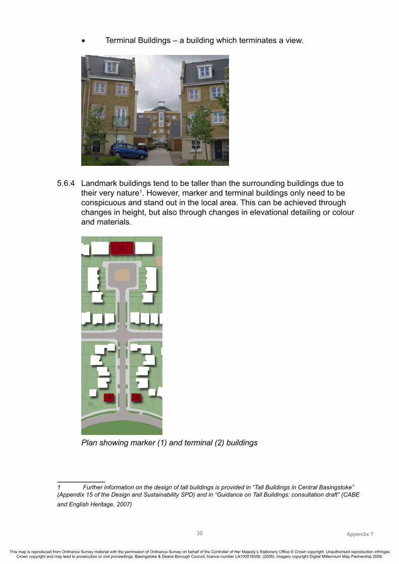
Terminal Buildings – a building which terminates a view.•
5.6.4 Landmark buildings tend to be taller than the surrounding buildings due to their very nature1. However, marker and terminal buildings only need to be conspicuous and stand out in the local area. This can be achieved through changes in height, but also through changes in elevational detailing or colour and materials.
Plan showing marker (1) and terminal (2) buildings
1 Further information on the design of tall buildings is provided in “Tall Buildings in Central Basingstoke” (Appendix 15 of the Design and Sustainability SPD) and in “Guidance on Tall Buildings: consultation draft” (CABE and English Heritage, 2007)

Appendix 7 36
This map is reproduced from Ordnance Survey material with the permission of Ordnance Survey on behalf of the Controller of Her Majesty’s Stationery Office © Crown copyright. Unauthorised reproduction infringes Crown copyright and may lead to prosecution or civil proceedings. Basingstoke & Deane Borough Council, licence number LA100019356, (2009). Imagery copyright Digital Millennium Map Partnership 2009.
Appendix 737
This map is reproduced from Ordnance Survey material with the permission of Ordnance Survey on behalf of the Controller of Her Majesty’s Stationery Office © Crown copyright. Unauthorised reproduction infringes Crown copyright and may lead to prosecution or civil proceedings. Basingstoke & Deane Borough Council, licence number LA100019356, (2009). Imagery copyright Digital Millennium Map Partnership 2009.
5.7 Creating Spaces
Public Open Space5.7.1 Attractive areas of open space are key to successful places. A traditional and
often successful urban structure comprises a connected network of spaces.
5.7.2 The public realm is important and all public spaces should be treated as ‘places’. They should not be hidden out of site behind houses.
“In order to reinforce character, define spaces and promote pedestrian movement, most public space should be faced by the fronts of buildings and their entrances, not be a predominance of flank elevations or side or rear boundaries. This will contribute to security be enabling informal supervision by residents of public spaces”53
Buildings should have a positive relationship with open space, and front onto the
space to make it a ‘place’.
Example of how buildings can positively relate to public open space

36
This map is reproduced from Ordnance Survey material with the permission of Ordnance Survey on behalf of the Controller of Her Majesty’s Stationery Office © Crown copyright. Unauthorised reproduction infringes Crown copyright and may lead to prosecution or civil proceedings. Basingstoke & Deane Borough Council, licence number LA100019356, (2009). Imagery copyright Digital Millennium Map Partnership 2009.
Appendix 737
This map is reproduced from Ordnance Survey material with the permission of Ordnance Survey on behalf of the Controller of Her Majesty’s Stationery Office © Crown copyright. Unauthorised reproduction infringes Crown copyright and may lead to prosecution or civil proceedings. Basingstoke & Deane Borough Council, licence number LA100019356, (2009). Imagery copyright Digital Millennium Map Partnership 2009.
Plan and section of buildings relating positively to public space.
5.7.3 The design of public open spaces, including consideration of their future maintenance and management should be considered at the outset.

Appendix 7 38
This map is reproduced from Ordnance Survey material with the permission of Ordnance Survey on behalf of the Controller of Her Majesty’s Stationery Office © Crown copyright. Unauthorised reproduction infringes Crown copyright and may lead to prosecution or civil proceedings. Basingstoke & Deane Borough Council, licence number LA100019356, (2009). Imagery copyright Digital Millennium Map Partnership 2009.
Appendix 739
This map is reproduced from Ordnance Survey material with the permission of Ordnance Survey on behalf of the Controller of Her Majesty’s Stationery Office © Crown copyright. Unauthorised reproduction infringes Crown copyright and may lead to prosecution or civil proceedings. Basingstoke & Deane Borough Council, licence number LA100019356, (2009). Imagery copyright Digital Millennium Map Partnership 2009.
Private Space5.7.4 It is important that private amenity space is clearly defined from the public
realm. Perimeter blocks are successful in achieving this, as the building frontage itself defines the private from the public realm (see 5.4).
5.7.5 It is important that the layout of private garden areas takes into account orientation. North-facing gardens may need to be longer, in order to ensure that an unshaded area of garden is available.

38
This map is reproduced from Ordnance Survey material with the permission of Ordnance Survey on behalf of the Controller of Her Majesty’s Stationery Office © Crown copyright. Unauthorised reproduction infringes Crown copyright and may lead to prosecution or civil proceedings. Basingstoke & Deane Borough Council, licence number LA100019356, (2009). Imagery copyright Digital Millennium Map Partnership 2009.
Appendix 739
This map is reproduced from Ordnance Survey material with the permission of Ordnance Survey on behalf of the Controller of Her Majesty’s Stationery Office © Crown copyright. Unauthorised reproduction infringes Crown copyright and may lead to prosecution or civil proceedings. Basingstoke & Deane Borough Council, licence number LA100019356, (2009). Imagery copyright Digital Millennium Map Partnership 2009.
Communal Space5.7.6 Higher density schemes often contain communal or shared amenity spaces.
These areas are not public, but neither are they fully private.
5.7.7 In order for these spaces to be successful, their layout and design must separate them visually and physically from the public realm. As these spaces are shared, careful attention should be paid to their design detail and the use of high quality and robust materials.
5.7.8 Where communal space is provided to the rear of buildings, the privacy of ground floor units must not be prejudiced. This could be achieved by providing small private gardens as a buffer to the communal area, or arranging internal rooms to control aspect.
This area of communal space has a water feature acting as a privacy buffer
between the space and the ground floor apartments.
Maintaining the privacy of ground floor units from communal space.

Appendix 7 40
This map is reproduced from Ordnance Survey material with the permission of Ordnance Survey on behalf of the Controller of Her Majesty’s Stationery Office © Crown copyright. Unauthorised reproduction infringes Crown copyright and may lead to prosecution or civil proceedings. Basingstoke & Deane Borough Council, licence number LA100019356, (2009). Imagery copyright Digital Millennium Map Partnership 2009.
Appendix 741
This map is reproduced from Ordnance Survey material with the permission of Ordnance Survey on behalf of the Controller of Her Majesty’s Stationery Office © Crown copyright. Unauthorised reproduction infringes Crown copyright and may lead to prosecution or civil proceedings. Basingstoke & Deane Borough Council, licence number LA100019356, (2009). Imagery copyright Digital Millennium Map Partnership 2009.
5.8 Accommodating Transport Requirements
“It is all too easy, however, for movement to seem an end in itself, shaping a development to the exclusion of other factors. This is particularly detrimental when one form of movement is given priority above others, as happens when a road layout designed largely to the requirements of vehicular traffic is allowed to dictate the whole character of a development. ”
Highway Design5.8.1 The highway makes up a large proportion of the public realm, and improving
the design of streets will have a significant role in improving the quality of the built environment. Whilst it is important to be aware of the potential for the residential street design to influence travel choice, it is easy to overlook the primary role of streets – they are places for living. Public life is concentrated in them – they are places for interacting, playing and relaxing, not just the sole preserve of vehicles.
“The place function is essentially what distinguishes a street from a road. The sense of place is fundamental to a richer and more fulfilling environment. It comes largely from creating a strong relationship between the street and the buildings and spaces that frame it.”
5.8.2 One of the fundamental messages in the Government’s “Manual for Streets” is that all residential streets should be designed as places and should be accessible to all, regardless of traffic volumes. To facilitate this, the design of new residential roads should discourage driving at speeds greater than 20mph.

40
This map is reproduced from Ordnance Survey material with the permission of Ordnance Survey on behalf of the Controller of Her Majesty’s Stationery Office © Crown copyright. Unauthorised reproduction infringes Crown copyright and may lead to prosecution or civil proceedings. Basingstoke & Deane Borough Council, licence number LA100019356, (2009). Imagery copyright Digital Millennium Map Partnership 2009.
Appendix 741
This map is reproduced from Ordnance Survey material with the permission of Ordnance Survey on behalf of the Controller of Her Majesty’s Stationery Office © Crown copyright. Unauthorised reproduction infringes Crown copyright and may lead to prosecution or civil proceedings. Basingstoke & Deane Borough Council, licence number LA100019356, (2009). Imagery copyright Digital Millennium Map Partnership 2009.
5.8.3 It is now being recognised that, subject to highways safety audits, more sustainable and attractive places can be created by:
Dispersing traffic safely and at slow speeds• Minimising the need for traffic-dominated roads within residential •neighbourhoods
5.8.4 Dispersing traffic can be achieved by creating a more permeable layout, with drivers being offered more choice of possible routes. The design of the street can also encourage drivers to reduce their speed by:
Enclosing the street with building frontages •Tight bends, frequent junctions and visual narrowings• Reducing the visual dominance of the road, with it becoming ‘lost’ in the •overall design and treatment of the spaceRaised tables as continuation of footways at crossings and junctions•
Change in surface materials and planted traffic island gives pedestrians the
priority over vehicles
Shared surface for cars, pedestrians and cyclists

Appendix 7 42
This map is reproduced from Ordnance Survey material with the permission of Ordnance Survey on behalf of the Controller of Her Majesty’s Stationery Office © Crown copyright. Unauthorised reproduction infringes Crown copyright and may lead to prosecution or civil proceedings. Basingstoke & Deane Borough Council, licence number LA100019356, (2009). Imagery copyright Digital Millennium Map Partnership 2009.
Appendix 743
This map is reproduced from Ordnance Survey material with the permission of Ordnance Survey on behalf of the Controller of Her Majesty’s Stationery Office © Crown copyright. Unauthorised reproduction infringes Crown copyright and may lead to prosecution or civil proceedings. Basingstoke & Deane Borough Council, licence number LA100019356, (2009). Imagery copyright Digital Millennium Map Partnership 2009.
Shared surface
5.8.5 Buildings, landscaping, surfacing and junction design can therefore all contribute towards reducing vehicle speed and making the development more pedestrian-friendly.
5.8.6 However, all designs for the highway are subject to agreement with the Highways Development Control Team. Tracking will also be required to ensure that the road can accommodate refuse and emergency vehicles. For detailed guidance on the design of residential streets, please consult the Government’s ‘Manual for Streets’, Hampshire County Council’s ‘Movement Access Streets and Spaces’ and the Appendix on Waste and Recycling, included as part of the Design and Sustainability SPD.
Traffic calming through the placement of buildings - buildings, not the road,
define this new street.
5.8.7 Designing places to provide access for all requires careful consideration of pavement widths and gradients, crossing points, parking areas, and accesses to front doors. For further details on these matters, consult the adopted ‘Designing for Accessibility Guide’.
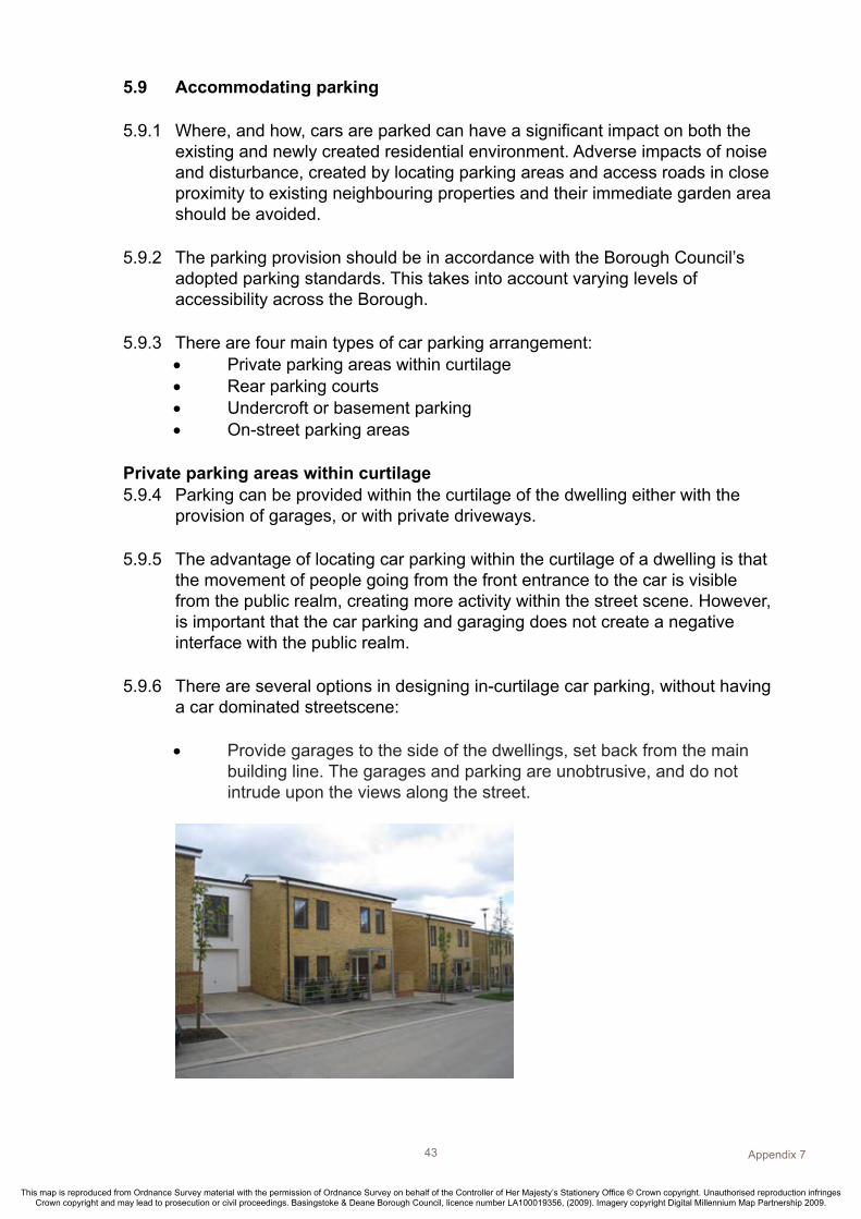
42
This map is reproduced from Ordnance Survey material with the permission of Ordnance Survey on behalf of the Controller of Her Majesty’s Stationery Office © Crown copyright. Unauthorised reproduction infringes Crown copyright and may lead to prosecution or civil proceedings. Basingstoke & Deane Borough Council, licence number LA100019356, (2009). Imagery copyright Digital Millennium Map Partnership 2009.
Appendix 743
This map is reproduced from Ordnance Survey material with the permission of Ordnance Survey on behalf of the Controller of Her Majesty’s Stationery Office © Crown copyright. Unauthorised reproduction infringes Crown copyright and may lead to prosecution or civil proceedings. Basingstoke & Deane Borough Council, licence number LA100019356, (2009). Imagery copyright Digital Millennium Map Partnership 2009.
5.9 Accommodating parking 5.9.1 Where, and how, cars are parked can have a significant impact on both the
existing and newly created residential environment. Adverse impacts of noise and disturbance, created by locating parking areas and access roads in close proximity to existing neighbouring properties and their immediate garden area should be avoided.
5.9.2 The parking provision should be in accordance with the Borough Council’s adopted parking standards. This takes into account varying levels of accessibility across the Borough.
5.9.3 There are four main types of car parking arrangement:Private parking areas within curtilage•Rear parking courts•Undercroft or basement parking•On-street parking areas•
Private parking areas within curtilage5.9.4 Parking can be provided within the curtilage of the dwelling either with the
provision of garages, or with private driveways.
5.9.5 The advantage of locating car parking within the curtilage of a dwelling is that the movement of people going from the front entrance to the car is visible from the public realm, creating more activity within the street scene. However, is important that the car parking and garaging does not create a negative interface with the public realm.
5.9.6 There are several options in designing in-curtilage car parking, without having a car dominated streetscene:
Provide garages to the side of the dwellings, set back from the main •building line. The garages and parking are unobtrusive, and do not intrude upon the views along the street.

Appendix 7 44
This map is reproduced from Ordnance Survey material with the permission of Ordnance Survey on behalf of the Controller of Her Majesty’s Stationery Office © Crown copyright. Unauthorised reproduction infringes Crown copyright and may lead to prosecution or civil proceedings. Basingstoke & Deane Borough Council, licence number LA100019356, (2009). Imagery copyright Digital Millennium Map Partnership 2009.
Appendix 745
This map is reproduced from Ordnance Survey material with the permission of Ordnance Survey on behalf of the Controller of Her Majesty’s Stationery Office © Crown copyright. Unauthorised reproduction infringes Crown copyright and may lead to prosecution or civil proceedings. Basingstoke & Deane Borough Council, licence number LA100019356, (2009). Imagery copyright Digital Millennium Map Partnership 2009.
Provide parking bays in recesses along the main building frontage. •Parking does not dominate the street scene, and the building still has a positive frontage.
Project porches beyond the main building, so the active part of the •building is a visible feature within the streetscene. The garages and parking areas become less dominant.
(photo courtesy of CABE website)
On-site car parking is softened by hedging strips between dwellings. •Low walls and trees can also achieve a similar effect.

44
This map is reproduced from Ordnance Survey material with the permission of Ordnance Survey on behalf of the Controller of Her Majesty’s Stationery Office © Crown copyright. Unauthorised reproduction infringes Crown copyright and may lead to prosecution or civil proceedings. Basingstoke & Deane Borough Council, licence number LA100019356, (2009). Imagery copyright Digital Millennium Map Partnership 2009.
Appendix 745
This map is reproduced from Ordnance Survey material with the permission of Ordnance Survey on behalf of the Controller of Her Majesty’s Stationery Office © Crown copyright. Unauthorised reproduction infringes Crown copyright and may lead to prosecution or civil proceedings. Basingstoke & Deane Borough Council, licence number LA100019356, (2009). Imagery copyright Digital Millennium Map Partnership 2009.
Rear Parking Courts5.9.7 Government guidance illustrates how successful courtyard parking areas can
be designed from lessons learnt in the past 54. These areas should be clearly related to and overlooked by the dwellings they serve. They should also have a controlled access, through a break in the continuous street frontage or under a carriage arch. Parking courts should be separated from gardens by robust and attractive brick walls. These provide privacy and security for the private garden areas.
5.9.8 There are two ways to design parking courts:
As private places, with a single way in/out that is obviously overlooked •from dwellings. This removes the ‘excuse’ for intruders to enter the courts and increases the ‘right’ of residents to challenge strangers. However, this approach requires parking courts to be fairly small, serving no more than five or six houses.
Parking court designed as a private area.

Appendix 7 46
This map is reproduced from Ordnance Survey material with the permission of Ordnance Survey on behalf of the Controller of Her Majesty’s Stationery Office © Crown copyright. Unauthorised reproduction infringes Crown copyright and may lead to prosecution or civil proceedings. Basingstoke & Deane Borough Council, licence number LA100019356, (2009). Imagery copyright Digital Millennium Map Partnership 2009.
Appendix 747
This map is reproduced from Ordnance Survey material with the permission of Ordnance Survey on behalf of the Controller of Her Majesty’s Stationery Office © Crown copyright. Unauthorised reproduction infringes Crown copyright and may lead to prosecution or civil proceedings. Basingstoke & Deane Borough Council, licence number LA100019356, (2009). Imagery copyright Digital Millennium Map Partnership 2009.
As • semi-public places, with pedestrian routes passing through, and dwellings within the court overlooking the parked cars and pedestrian routes. This approach demands extremely careful attention to design and materials to avoid these areas appearing functional and car dominated.
Parking courts designed as semi-public places.
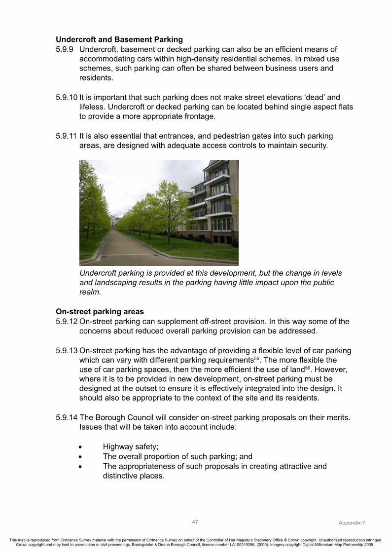
46
This map is reproduced from Ordnance Survey material with the permission of Ordnance Survey on behalf of the Controller of Her Majesty’s Stationery Office © Crown copyright. Unauthorised reproduction infringes Crown copyright and may lead to prosecution or civil proceedings. Basingstoke & Deane Borough Council, licence number LA100019356, (2009). Imagery copyright Digital Millennium Map Partnership 2009.
Appendix 747
This map is reproduced from Ordnance Survey material with the permission of Ordnance Survey on behalf of the Controller of Her Majesty’s Stationery Office © Crown copyright. Unauthorised reproduction infringes Crown copyright and may lead to prosecution or civil proceedings. Basingstoke & Deane Borough Council, licence number LA100019356, (2009). Imagery copyright Digital Millennium Map Partnership 2009.
Undercroft and Basement Parking5.9.9 Undercroft, basement or decked parking can also be an efficient means of
accommodating cars within high-density residential schemes. In mixed use schemes, such parking can often be shared between business users and residents.
5.9.10 It is important that such parking does not make street elevations ‘dead’ and lifeless. Undercroft or decked parking can be located behind single aspect flats to provide a more appropriate frontage.
5.9.11 It is also essential that entrances, and pedestrian gates into such parking areas, are designed with adequate access controls to maintain security.
Undercroft parking is provided at this development, but the change in levels
and landscaping results in the parking having little impact upon the public realm.
On-street parking areas 5.9.12 On-street parking can supplement off-street provision. In this way some of the
concerns about reduced overall parking provision can be addressed.
5.9.13 On-street parking has the advantage of providing a flexible level of car parking which can vary with different parking requirements55. The more flexible the use of car parking spaces, then the more efficient the use of land56. However, where it is to be provided in new development, on-street parking must be designed at the outset to ensure it is effectively integrated into the design. It should also be appropriate to the context of the site and its residents.
5.9.14 The Borough Council will consider on-street parking proposals on their merits. Issues that will be taken into account include:
Highway safety;•The overall proportion of such parking; and • The appropriateness of such proposals in creating attractive and •distinctive places.

Appendix 7 48
This map is reproduced from Ordnance Survey material with the permission of Ordnance Survey on behalf of the Controller of Her Majesty’s Stationery Office © Crown copyright. Unauthorised reproduction infringes Crown copyright and may lead to prosecution or civil proceedings. Basingstoke & Deane Borough Council, licence number LA100019356, (2009). Imagery copyright Digital Millennium Map Partnership 2009.
Appendix 749
This map is reproduced from Ordnance Survey material with the permission of Ordnance Survey on behalf of the Controller of Her Majesty’s Stationery Office © Crown copyright. Unauthorised reproduction infringes Crown copyright and may lead to prosecution or civil proceedings. Basingstoke & Deane Borough Council, licence number LA100019356, (2009). Imagery copyright Digital Millennium Map Partnership 2009.
On-street parking can be integrated into the design of public spaces with low
traffic speeds
5.9.15 On-street parking has often provided for the ‘visitor’ element in residential developments. It can be accommodated in public squares and spaces that are enclosed and overlooked by built frontages. These spaces should be part of the urban structure and can be designed to restrain vehicle speeds.

48
This map is reproduced from Ordnance Survey material with the permission of Ordnance Survey on behalf of the Controller of Her Majesty’s Stationery Office © Crown copyright. Unauthorised reproduction infringes Crown copyright and may lead to prosecution or civil proceedings. Basingstoke & Deane Borough Council, licence number LA100019356, (2009). Imagery copyright Digital Millennium Map Partnership 2009.
Appendix 749
This map is reproduced from Ordnance Survey material with the permission of Ordnance Survey on behalf of the Controller of Her Majesty’s Stationery Office © Crown copyright. Unauthorised reproduction infringes Crown copyright and may lead to prosecution or civil proceedings. Basingstoke & Deane Borough Council, licence number LA100019356, (2009). Imagery copyright Digital Millennium Map Partnership 2009.
Cycle parking5.9.16 The quality and location of cycle parking should encourage this mode of travel.
Formal public spaces are ideal locations for shared and visitor cycle parking, because they are accessible, overlooked and well-lit.
5.9.17 Borough Council guidelines require domestic garages to have minimum dimensions of 6 x 3 metres, which is sufficient to accommodate a car and a cycle.
5.9.18 Where there are no garages, cycle storage could be provided in back gardens if there is a safe and secure means of rear access. Alternatively, cycle provision could be built into the design of front elevations, along with bin storage – provided this does not detract from the attractiveness of the building or the street.
A cycle storage area that is an integral feature within a semi-private
car parking court
Services5.9.19 Once a network of spaces and routes has been established, then the highway
network, utility services, soakaways, etc can be plumbed-in and threaded through. Drainage systems, in particular Sustainable Urban Drainage Systems (SUD’s), enable the drainage system to deal with any excess surface water from a proposed development within the development itself and should be planned in at the outset of the design stage.
5.9.20 Higher urban densities require that services and drainage be integrated at the outset. This is because there will be less ‘left over’ space into which they can be easily laid. The same spatial structure will have to accommodate not only traffic, cyclists and pedestrians, but also underground services. The installation of shared service trenches/ducts may minimise future disruption as new services are introduced.

Appendix 7 50
This map is reproduced from Ordnance Survey material with the permission of Ordnance Survey on behalf of the Controller of Her Majesty’s Stationery Office © Crown copyright. Unauthorised reproduction infringes Crown copyright and may lead to prosecution or civil proceedings. Basingstoke & Deane Borough Council, licence number LA100019356, (2009). Imagery copyright Digital Millennium Map Partnership 2009.
Appendix 751
This map is reproduced from Ordnance Survey material with the permission of Ordnance Survey on behalf of the Controller of Her Majesty’s Stationery Office © Crown copyright. Unauthorised reproduction infringes Crown copyright and may lead to prosecution or civil proceedings. Basingstoke & Deane Borough Council, licence number LA100019356, (2009). Imagery copyright Digital Millennium Map Partnership 2009.
5.10 Architectural Detailing
5.10.1 This guidance does not seek to impose a particular architectural style. Urban design is concerned with achieving a structure based on the site context, within which most architectural styles can be accommodated.
5.10.2 Where buildings enclose the public realm, architectural styles should emphasise the human scale. This can be achieved through careful detailing, particularly at ground floor levels.
“However well planned and structured, a disappointing scheme is likely to result if it is not well executed at the level of detail”57
5.10.3 It is important to take an integrated approach to the detailed design of buildings and landscaping, in order to create distinctive places. The perimeter block form of development allows detailing to be concentrated in the public realm, where it will have most effect.
5.10.4 Buildings should generally take cues from the architectural traditions of the locality – the design context. These cues will relate to building form and materials, rather than style, such as:
Proportion and scale;•Materials and construction methods;•Shape of roofs;•Fenestration; and•The degree of consistency and variation. •
5.10.5 The Countryside Design Summary, Conservation Area Appraisals, and Village Design Statements provide guidance on the use of traditional materials and locally distinctive details.

50
This map is reproduced from Ordnance Survey material with the permission of Ordnance Survey on behalf of the Controller of Her Majesty’s Stationery Office © Crown copyright. Unauthorised reproduction infringes Crown copyright and may lead to prosecution or civil proceedings. Basingstoke & Deane Borough Council, licence number LA100019356, (2009). Imagery copyright Digital Millennium Map Partnership 2009.
Appendix 751
This map is reproduced from Ordnance Survey material with the permission of Ordnance Survey on behalf of the Controller of Her Majesty’s Stationery Office © Crown copyright. Unauthorised reproduction infringes Crown copyright and may lead to prosecution or civil proceedings. Basingstoke & Deane Borough Council, licence number LA100019356, (2009). Imagery copyright Digital Millennium Map Partnership 2009.
5.10.6 The Countryside Design Summary provides Borough-wide guidance on vernacular building materials for residential development. Some of the defining characteristics of domestic north-east Hampshire domestic buildings include:
Steeply pitched gabled or half-hipped roofs of at least 40• o, with predominantly plain tiles or slates, and small dormers, where provided; Restrained eaves (just enough to carry the gutter). Verges are •traditionally flush, not boxed, with the roof tiles ‘mucked in’ (tiles sealed to the gable with mortar); and Elevations of orange/red multi- coloured stock bricks, some tile •hanging, render or timber weather boarding, shallow- arched heads to windows; simple porches or hoods to entrance doors.
5.10.7 It is recognised that traditional materials and design ideas can be used in modern ways. New materials and construction techniques can be used to reflect traditional styles.
5.10.8 In detailing, it is important to consider the roles the buildings play within the neighbourhood. Most buildings will be ‘everyday’ or background buildings, but there will be some that perform a ‘townscape’ function, such as a landmark or terminal building at the end of vistas. In these areas, a different design approach is often required.

Appendix 7 52
This map is reproduced from Ordnance Survey material with the permission of Ordnance Survey on behalf of the Controller of Her Majesty’s Stationery Office © Crown copyright. Unauthorised reproduction infringes Crown copyright and may lead to prosecution or civil proceedings. Basingstoke & Deane Borough Council, licence number LA100019356, (2009). Imagery copyright Digital Millennium Map Partnership 2009.
Appendix 753
This map is reproduced from Ordnance Survey material with the permission of Ordnance Survey on behalf of the Controller of Her Majesty’s Stationery Office © Crown copyright. Unauthorised reproduction infringes Crown copyright and may lead to prosecution or civil proceedings. Basingstoke & Deane Borough Council, licence number LA100019356, (2009). Imagery copyright Digital Millennium Map Partnership 2009.
5.10.9 Detailed building design issues that should be considered:
Where concrete tiles are used, they should be ‘plain’. Large format •interlocking tiles produce heavy horizontal edges across roofs and are not characteristic of the Hampshire region; Large format roof tiles used on porches, above bays, and other ground •floor elements look clumsy and out-of-scale. In these locations, plain and ‘baby’ ridge tiles produce a more visually satisfactory solution that is in scale with the building; Windows that are recessed cast a shadow, and emphasise the opening •in the elevation; In masonry buildings, excessively large windows can made the •structure appear weak and imbalanced. On the public fronts of buildings, consider grouping two smaller windows, rather than a single picture window, to provide natural light; Mark building entrances with a porch that is an integral part of the •building, not ‘stuck on’; Other than for collection, refuse and recycling wheelie-bins need a •space that stores them out of public sight and off the public highway; Locate meter cupboards on side elevations, or set into the ground. •Where they must be placed on the front elevation, integrate them with a building element (porch or bin store), and use dark colours to reduce the visual impact; Soil pipes and flues should be kept off elevations that are seen, or •‘climbable’, from the public realm; Garage doors that are recessed, not flush, and painted a dark colour, •reduce their visual impact within the street scene.
5.11 Landscaping
5.11.1 Buildings can create the structure of public space, but it is the quality of surfacing, street furniture, lighting, security and the use of planting that can transform it into a successful place.
5.11.2 The landscape framework for new development may require not only the appropriate treatment of public open spaces, squares and streets. It may also need structural planting on the periphery or within the site.

52
This map is reproduced from Ordnance Survey material with the permission of Ordnance Survey on behalf of the Controller of Her Majesty’s Stationery Office © Crown copyright. Unauthorised reproduction infringes Crown copyright and may lead to prosecution or civil proceedings. Basingstoke & Deane Borough Council, licence number LA100019356, (2009). Imagery copyright Digital Millennium Map Partnership 2009.
Appendix 753
This map is reproduced from Ordnance Survey material with the permission of Ordnance Survey on behalf of the Controller of Her Majesty’s Stationery Office © Crown copyright. Unauthorised reproduction infringes Crown copyright and may lead to prosecution or civil proceedings. Basingstoke & Deane Borough Council, licence number LA100019356, (2009). Imagery copyright Digital Millennium Map Partnership 2009.
5.11.3 Successful and attractive spaces, with appropriate soft landscaping, are an essential foil within residential development. However, quality hard landscaping for small public squares and spaces will also be an essential component within many such schemes.
5.11.4 Landscape proposals in residential developments should consider: Layout design should aim to provide an optimum area of usable open •space. Odd-shaped and isolated landscaped spaces that are of little amenity value, and difficult and expensive to maintain should be avoided. The suitability and durability of planting, such as the ultimate height and •form, should be considered in relation to adjacent buildings, roads and footpaths. Tree species should be chosen and positioned in a way which will not •cause nuisance, such as shading, root disturbance, falling fruit, physical damage from branches, etc. In structural planting areas, native species should predominate (consult the •Hampshire County Council leaflet ‘Conserving Landscape Character’ for further details). A condition survey should be carried out for all trees on, or adjacent to, the •site. There is adopted supplementary planning guidance58 on trees and development, which must be consulted where new building is likely to affect trees. Planting should not obstruct natural surveillance. Where ‘defensible’ •planting is provided, it should not prejudice wider public safety by, for instance, locating quick-growing, thorned species abutting public footpaths. Adoption agencies and statutory undertakers should avoid clutter in the •public realm. They should mount signs and lighting on buildings, and set inspection boxes against building edges not free standing in the pavement. A limited palette of materials should be used to achieve a cohesive design •to public places. A balance should be struck between the technical and aesthetic requirements of the various materials. Public spaces should be accessible to • all. Therefore, pavement gradients, crossings and potential obstructions should be considered. The Council has adopted good practice guidance regarding ‘designing for accessibility’59. This should be consulted for further details. Shelter, seating, lighting and planting should support the role of public •spaces, and be integrated with the overall character of the development.

Appendix 7 54
This map is reproduced from Ordnance Survey material with the permission of Ordnance Survey on behalf of the Controller of Her Majesty’s Stationery Office © Crown copyright. Unauthorised reproduction infringes Crown copyright and may lead to prosecution or civil proceedings. Basingstoke & Deane Borough Council, licence number LA100019356, (2009). Imagery copyright Digital Millennium Map Partnership 2009.
Appendix 755
This map is reproduced from Ordnance Survey material with the permission of Ordnance Survey on behalf of the Controller of Her Majesty’s Stationery Office © Crown copyright. Unauthorised reproduction infringes Crown copyright and may lead to prosecution or civil proceedings. Basingstoke & Deane Borough Council, licence number LA100019356, (2009). Imagery copyright Digital Millennium Map Partnership 2009.
Tree pits and amenity strips should be large enough to allow planting to •grow and survive;
The design of footpaths should take into account existing and likely desire •lines, and should seek to minimise walking times for pedestrians. Street lighting should aid pedestrians and cyclists, not just vehicles. Placing •buildings closer to the road will allow the use of building-mounted lanterns where the necessary wayleaves are granted. Adoption agencies should recognise the need for lighting columns and lanterns to contribute to the character of the place that is being created. They should not seek to apply ‘standardised’ equipment in every location. Where boundary treatments are visible from the public realm, they should •be of a high quality finish, and provide a clear definition between public and private space. They should avoid projecting further forward of the main building.

54
This map is reproduced from Ordnance Survey material with the permission of Ordnance Survey on behalf of the Controller of Her Majesty’s Stationery Office © Crown copyright. Unauthorised reproduction infringes Crown copyright and may lead to prosecution or civil proceedings. Basingstoke & Deane Borough Council, licence number LA100019356, (2009). Imagery copyright Digital Millennium Map Partnership 2009.
Appendix 755
This map is reproduced from Ordnance Survey material with the permission of Ordnance Survey on behalf of the Controller of Her Majesty’s Stationery Office © Crown copyright. Unauthorised reproduction infringes Crown copyright and may lead to prosecution or civil proceedings. Basingstoke & Deane Borough Council, licence number LA100019356, (2009). Imagery copyright Digital Millennium Map Partnership 2009.
5.12 Resource and Energy Efficiency
5.12.1 The structure of new development will have a significant impact on energy efficiency, transport modes and environmental impact. Building orientation and design can help achieve sustainable objectives, but this should not be at the expense of good urban design. Consideration should be given to:
Maximising solar gain to living areas;•Minimising heat loss;•Using alternative energy sources such as photo voltaic panels;•Maximising the use of natural lighting and ventilation;•Reducing the amount of waste entering the environment during construction •and use;Recycling grey water;•Reducing the use of CFCs in the buildings;•Sourcing locally produced renewable materials where possible; and •incorporating design measures that reduce crime.
5.12.2 Higher density housing will need to ensure that minimum acoustic insulation standards between properties is achieved, if not exceeded, if the development is to be successful in the long-term.
Appendix 7 56
This map is reproduced from Ordnance Survey material with the permission of Ordnance Survey on behalf of the Controller of Her Majesty’s Stationery Office © Crown copyright. Unauthorised reproduction infringes Crown copyright and may lead to prosecution or civil proceedings. Basingstoke & Deane Borough Council, licence number LA100019356, (2009). Imagery copyright Digital Millennium Map Partnership 2009.
Appendix 757
This map is reproduced from Ordnance Survey material with the permission of Ordnance Survey on behalf of the Controller of Her Majesty’s Stationery Office © Crown copyright. Unauthorised reproduction infringes Crown copyright and may lead to prosecution or civil proceedings. Basingstoke & Deane Borough Council, licence number LA100019356, (2009). Imagery copyright Digital Millennium Map Partnership 2009.
5.13 Checklist for Applying Design Principles to the Site
Do buildings enclose public areas and define public from private space?•Do buildings ‘front’ public spaces, streets and roads, even where direct access •cannot be taken?Is the extent of rear garden boundaries abutting public areas minimised?•Are public spaces subject to natural surveillance from adjacent buildings?•Do buildings, particularly at street corners, help navigation?•Is access to private / communal areas secure and controlled?•Where provided, do ‘pavilion’ buildings contribute positively to the public •realm?Is there sufficient outdoor amenity space for residents’ use?•Has privacy been achieved through design, not just physical separation?•Does the parking provision reflect the character and accessibility of the site?•Are parking areas designed to be safe, secure and attractive?•Is there sufficient, secure and conveniently located cycle storage?•Does the detailing of buildings contribute to the character of the area and •reflect their role in the neighbourhood?Does the building design reflect characteristics of north-east Hampshire •domestic architecture?Is open space useful and maintainable?•Is the planting appropriate and sustainable?•Is hard and soft landscaping part of an integrated scheme?•Has a balance been struck between the technical and aesthetic characteristics •of the surfacing materials?Does the design and alignment of footpaths and cycle ways take into account •existing and potential desire lines?Has the opportunity been taken to minimise clutter within the public realm?•

56
This map is reproduced from Ordnance Survey material with the permission of Ordnance Survey on behalf of the Controller of Her Majesty’s Stationery Office © Crown copyright. Unauthorised reproduction infringes Crown copyright and may lead to prosecution or civil proceedings. Basingstoke & Deane Borough Council, licence number LA100019356, (2009). Imagery copyright Digital Millennium Map Partnership 2009.
Appendix 757
This map is reproduced from Ordnance Survey material with the permission of Ordnance Survey on behalf of the Controller of Her Majesty’s Stationery Office © Crown copyright. Unauthorised reproduction infringes Crown copyright and may lead to prosecution or civil proceedings. Basingstoke & Deane Borough Council, licence number LA100019356, (2009). Imagery copyright Digital Millennium Map Partnership 2009.
6. Glossary
Backs – The private side of properties, usually behind buildings, such as reargardens or service yards.
Barrier block – Use of development to screen private areas from noise.
Carriage arches – A break in a continuous frontage, which is bridged by a building toprovide rear access for vehicles.
Continuous frontage – Buildings facing onto and overlooking public areas that arejoined to each other, or linked by short stretches of brick wall.
Cranked buildings – A slight change of direction in a continuous frontage.
Curtilage – The area of land associated with a dwelling. Often called the ‘plot’.
Deformed grid – A term used for a connected network of streets and spaces that isnot regular.
Design and Access Statement – Information used to support the planningapplications
Enclosure – The definition of a street or space through an appropriate relationshipbetween the width of the space and heights of buildings. Often expressed as a ratio.
Eaves – the lowest part, and any overhang, of a sloping roof.
Fenestration – The pattern and proportion of windows.
Fronts – The public face of buildings, often with the main entrances.
Frontage –the length of a building or site in contact with a road, street or publicspace
Gable – the triangular part of a wall where it meets a pitched roof.
Landmark – A memorable building or structure, which helps people to orientthemselves within an area.
Legibility – A measure of how easy it is to ‘read’ an area and to find one’s wayaround it.
Navigation – Finding your way around an area using landmarks to orientate yourself.
Perimeter block – A block of continuous frontage development that defines thepublic realm and encloses private backs within it.
Appendix 7 58
This map is reproduced from Ordnance Survey material with the permission of Ordnance Survey on behalf of the Controller of Her Majesty’s Stationery Office © Crown copyright. Unauthorised reproduction infringes Crown copyright and may lead to prosecution or civil proceedings. Basingstoke & Deane Borough Council, licence number LA100019356, (2009). Imagery copyright Digital Millennium Map Partnership 2009.
Appendix 759
This map is reproduced from Ordnance Survey material with the permission of Ordnance Survey on behalf of the Controller of Her Majesty’s Stationery Office © Crown copyright. Unauthorised reproduction infringes Crown copyright and may lead to prosecution or civil proceedings. Basingstoke & Deane Borough Council, licence number LA100019356, (2009). Imagery copyright Digital Millennium Map Partnership 2009.
Public realm – Outdoor public areas that are freely accessible, including streets,open space, play areas, etc, and those contiguous private areas that can be seen,but not accessed, such as front gardens.
Secondary enclosure – The definition of a street or space through the use ofelements other than buildings, such as trees, street furniture and landscaping.
Terminal building – A strategically placed building at the end of a vista to provideenclosure and to limit forward visibility.
Tracking – The process by which buildings are arranged first to create spaces andstreets, and then the engineering needs of vehicles accommodated within them.
Verges – In buildings, where roof tiles meet a gable wall. In the highway, the edge ofa carriageway and/or footway.
Vision – A graphical or textual device to communicate the type of place that is to becreated.

58
This map is reproduced from Ordnance Survey material with the permission of Ordnance Survey on behalf of the Controller of Her Majesty’s Stationery Office © Crown copyright. Unauthorised reproduction infringes Crown copyright and may lead to prosecution or civil proceedings. Basingstoke & Deane Borough Council, licence number LA100019356, (2009). Imagery copyright Digital Millennium Map Partnership 2009.
Appendix 759
This map is reproduced from Ordnance Survey material with the permission of Ordnance Survey on behalf of the Controller of Her Majesty’s Stationery Office © Crown copyright. Unauthorised reproduction infringes Crown copyright and may lead to prosecution or civil proceedings. Basingstoke & Deane Borough Council, licence number LA100019356, (2009). Imagery copyright Digital Millennium Map Partnership 2009.
7. References
1 “Planning Policy Statement 3: Housing”, Department for Communities and Local Government, Nov 2006 DETR, March 2000, para 9
2 “By Design: Urban Design in the Planning System”, DETR/CABE May 2000, p.8
3 “Planning Policy Statement 1: Delivering Sustainable Development”, Department for Communities and Local Government, 2005, para.13
4 “Planning Policy Statement 1: Delivering Sustainable Development”, ibid, para 13
5 “Places for Living”, Birmingham City Council, 2001
6 “Urban Villages”, Urban Villages Forum, 1992
7 “Housing Layouts – Lifting the Quality”, Housing Builders Federation, DETR, Planning Officers Society, 1998, p.2
8 “Housing Layouts – Lifting the Quality”, ibid, p.26
9 “Better Places to Live”, ibid, p.24
10 “Better Places to Live”, ibid p.5
11 “By Design”, ibid, p.5
12 “Urban Design Compendium”, English Partnerships and the Housing Corporation, August 2000. p.13
13 “Responsive Environments”, Bentley et al, Architectural Press, 1985 p.10
14 “By Design: Better Places to Live”, ibid, p.23
15 “By Design: Better Places to Live”, ibid, p.19
16 “Responsive Environments”, ibid, p.10
17 See “Urban Design Compendium” and “Responsive Environments”
18 “By Design: Better Places to Live”, ibid, p.16
19 “Planning and Design”, Planning Officers Society, (Circ 528/99), p.15
20 see “Housing Layouts – lifting the quality”, ibid, p.26 and PPG1, ibid para A4.
21 From “North of Popley Way Basingstoke: Development and Design Brief”, May 2001
22 see “Housing Layouts – lifting the quality”, ibid, preface by Nick Raynsford MP
23 “Kent Design”, Kent Association of Local Authorities, 2000
24 “The Essex Design Guide”, Essex Planning Officers Association, 1997
25 “Planning and Architecture Guide”, Guinness Trust Group, 1996
26 “Places Streets and Movement; a companion guide to Design Bulletin 32”, DETR, 1998, pp.40-45
27 “Urban Design Compendium”, ibid, p.19
28 “Better Places to Live”, ibid, p.16

Appendix 7 60
This map is reproduced from Ordnance Survey material with the permission of Ordnance Survey on behalf of the Controller of Her Majesty’s Stationery Office © Crown copyright. Unauthorised reproduction infringes Crown copyright and may lead to prosecution or civil proceedings. Basingstoke & Deane Borough Council, licence number LA100019356, (2009). Imagery copyright Digital Millennium Map Partnership 2009.
Appendix 761
This map is reproduced from Ordnance Survey material with the permission of Ordnance Survey on behalf of the Controller of Her Majesty’s Stationery Office © Crown copyright. Unauthorised reproduction infringes Crown copyright and may lead to prosecution or civil proceedings. Basingstoke & Deane Borough Council, licence number LA100019356, (2009). Imagery copyright Digital Millennium Map Partnership 2009.
29 “Planning Policy Statement 3: Housing”, DCLG, 2006 para.13
30 “Basingstoke and Deane Landscape Assessment 2001”, BDBC, 2001
31 “Countryside Design Summary”, BDBC, 2002
32 “Design and Access Statements – Guidance for Applicants and Agents – Householder Applications” and “Design and Access Statements – Guidance for Applicants and Agents – Non-Householder Applications” BDBC 2006
33 “Urban Design Compendium”, ibid, p.33
34 “The Essex Design Guide”, ibid, p.6
35 “Urban Design Compendium”, ibid, p.36
36 “Responsive Environments”, ibid, p.16
37 From “Urban Design Compendium”, ibid, p.57
38 “Better Places to Live”, ibid
39 “The Essex Design Guide”, ibid, p.11
40 from “Better Places to Live: By Design”, ibid, p.25
41 “Movement Access Streets and Spaces”, Hampshire County Council, August 2001, p 27
42 “Better Places to Live”, ibid, p.40
43 see “By Design: Better Places to Live”, ibid, p.45 and “Responsive Environments”, ibid, p.20
44 “Urban Design Compendium”, ibid, p.64
45 “Responsive Environments”, ibid, p.14
46 Manston Road, Sturminster Newton, Housing Design Awards, 2001, winner ‘Greenfield Award’
47 “The Essex Design Guide”, ibid, p.22
48 “Planning and Architecture”, ibid, p.10
49 “Planning and Architecture”, ibid, p.11
50 see “Better Places to Live”, ibid, p.49
51 from “Responsive Environments”, ibid, p.103
52 From “Urban Design Compendium”, ibid, p.94
53 “The Essex Design Guide”, ibid, p.22
54 “Better Places to Live”, p.57
55 See “Car Parking: what works where”, English Partnerships, May 2006
56 “Manual for Streets”, ibid p108
57 “Better Places to Live”, p.72
58 “Trees and Development”, BDBC, September 2001
59 “Designing for Accessibility: an essential guide for public buildings”, BDBC, April 2006

60
This map is reproduced from Ordnance Survey material with the permission of Ordnance Survey on behalf of the Controller of Her Majesty’s Stationery Office © Crown copyright. Unauthorised reproduction infringes Crown copyright and may lead to prosecution or civil proceedings. Basingstoke & Deane Borough Council, licence number LA100019356, (2009). Imagery copyright Digital Millennium Map Partnership 2009.
Appendix 761
This map is reproduced from Ordnance Survey material with the permission of Ordnance Survey on behalf of the Controller of Her Majesty’s Stationery Office © Crown copyright. Unauthorised reproduction infringes Crown copyright and may lead to prosecution or civil proceedings. Basingstoke & Deane Borough Council, licence number LA100019356, (2009). Imagery copyright Digital Millennium Map Partnership 2009.
The Ordnance Survey mapping included within this document is provided by Basingstoke and Deane Borough Council under licence from the Ordnance Survey in order to fulfil its public function in acting as a Planning authority. Persons viewing this mapping should contact Ordnance Survey copyright for advice where they wish to licence Ordnance Survey mapping for their own use.