Embed Size (px)
Citation preview
Appendix 2 – Development Permit Area Guidelines City of Port Moody Official Community Plan Bylaw No. 2955 139
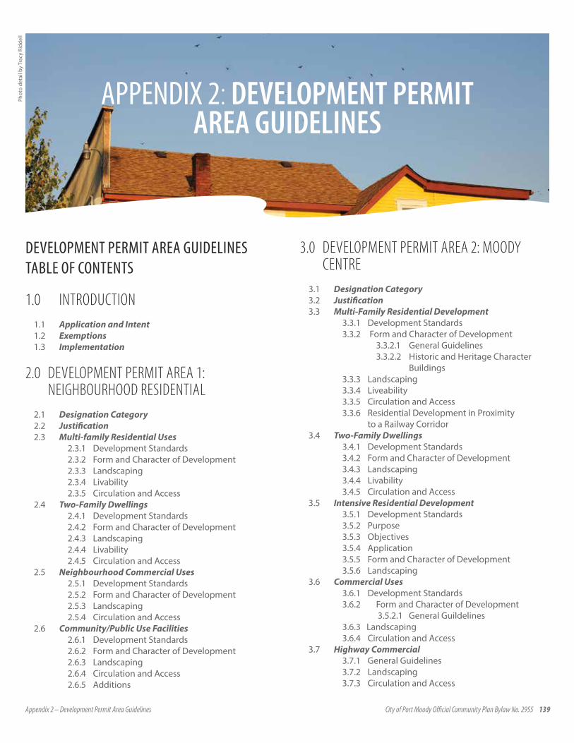
APPENDIX 2: DEVELOPMENT PERMIT AREA GUIDELINES
Phot
o de
tail
by T
racy
Rid
dell
DEVELOPMENT PERMIT AREA GUIDELINESTABLE OF CONTENTS
1.0 INTRODUCTION1.1 Application and Intent1.2 Exemptions1.3 Implementation
2.0 DEVELOPMENT PERMIT AREA 1: NEIGHBOURHOOD RESIDENTIAL
2.1 Designation Category2.2 Justification2.3 Multi-family Residential Uses
2.3.1 Development Standards2.3.2 Form and Character of Development2.3.3 Landscaping2.3.4 Livability2.3.5 Circulation and Access
2.4 Two-Family Dwellings2.4.1 Development Standards2.4.2 Form and Character of Development2.4.3 Landscaping2.4.4 Livability2.4.5 Circulation and Access
2.5 Neighbourhood Commercial Uses2.5.1 Development Standards2.5.2 Form and Character of Development2.5.3 Landscaping2.5.4 Circulation and Access
2.6 Community/Public Use Facilities2.6.1 Development Standards2.6.2 Form and Character of Development2.6.3 Landscaping2.6.4 Circulation and Access2.6.5 Additions
3.0 DEVELOPMENT PERMIT AREA 2: MOODY CENTRE
3.1 Designation Category3.2 Justification3.3 Multi-Family Residential Development
3.3.1 Development Standards3.3.2 Form and Character of Development
3.3.2.1 General Guidelines3.3.2.2 Historic and Heritage Character
Buildings3.3.3 Landscaping3.3.4 Liveability3.3.5 Circulation and Access3.3.6 Residential Development in Proximity
to a Railway Corridor3.4 Two-Family Dwellings
3.4.1 Development Standards3.4.2 Form and Character of Development3.4.3 Landscaping3.4.4 Livability3.4.5 Circulation and Access
3.5 Intensive Residential Development3.5.1 Development Standards3.5.2 Purpose3.5.3 Objectives3.5.4 Application3.5.5 Form and Character of Development3.5.6 Landscaping
3.6 Commercial Uses3.6.1 Development Standards3.6.2 Form and Character of Development
3.5.2.1 General Guildelines3.6.3 Landscaping3.6.4 Circulation and Access
3.7 Highway Commercial3.7.1 General Guidelines3.7.2 Landscaping3.7.3 Circulation and Access

140 Appendix 2 – Development Permit Area Guidelines City of Port Moody Official Community Plan Bylaw No. 2955
3.8 Adaptive Commercial3.8.1 Form and Character of Development
3.8.1.1 General Guidelines3.8.1.2 Historic and Heritage Character
Buildings3.8.2 Landscaping3.8.3 Circulation and Access
3.9 Mixed Use Commercial and Residential Buildings3.9.1 Residential Development in Proximity
to a Railway Corridor3.10 Community/Public Use Facilities
3.10.1 Development Standards3.10.2 Form and Character of Development3.10.3 Landscaping3.10.4 Circulation and Access3.10.5 Additions
3.11 Industrial Uses3.11.1 Development Standards3.11.2 Form and Character of Development3.11.3 Landscaping3.11.4 Circulation and Access
4.0 DEVELOPMENT PERMIT AREA 3: INLET CENTRE
4.1 Designation Category4.2 Justification4.3 Multi-Family Residential Uses
4.3.1 Development Standards4.3.2 Form and Character of Development4.3.3 Landscaping4.3.4 Livability4.3.5 Circulation and Access4.3.6 Residential Development in Proximity
to a Railway Corridor4.4 Commercial Uses
4.4.1 Development Standards4.4.2 Form and Character of Development4.4.3 Landscaping4.4.4 Circulation and Access
4.5 Mixed Use Residential and Commercial Buildings4.5.1 Residential Development in Proximity
to a Railway Corridor4.6 Community/Public Use Facilities
4.6.1 Development Standards4.6.2 Form and Character of Development4.6.3 Landscaping4.6.4 Circulation and Access4.6.5 Additions
4.7 Site Specific Guidelines4.7.1 Newport Village4.7.2 Suter Brook Site4.7.3 Klahanie Site
5.0 DEVELOPMENT PERMIT AREA 4: ENVIRONMENTALLY SENSITIVE AREAS
5.1 Designation Category5.2 Justification5.3 Guidelines
5.3.1 Landscape Scale Management and Wildlife Corridors
5.3.2 Watershed Management5.3.3 Forest Ecosystems5.3.4 Watercourses and Riparian Zones5.3.5 Lakes and Freshwater Wetlands5.3.6 Intertidal and Subtidal Marine Ecosystems5.3.7 Rock Bluffs5.3.8 Species At Risk
6.0 DEVELOPMENT PERMIT AREA 5: HAZARDOUS LANDS
6.1 Designation Category6.2 Justification6.3 Application6.4 Exemptions6.5 Requirement for Additional Information6.6 Guidelines
6.6.1 Earthquake Hazards6.6.2 Flood and Debris Flow Hazard6.6.3 Steep Slopes
7.0 DEVELOPMENT PERMIT AREA 7: DETACHED ACCESSORY DWELLING UNIT INTENSIVE RESIDENTIAL DEVELOPMENT
7.1 Purpose of Designation Category7.1.1 Development Standards7.1.2 Purpose7.1.3 Objectives7.1.4 Application7.1.5 Form and Character of Development7.1.6 Landscaping
MAPS:1. Development Permit Areas2. Sub-Areas of Development Permit Area 2:
Moody Centre3. Development Permit Area 4: Environmentally
Sensitive Areas4. Development Permit Area 5: Hazardous Lands5. Development Permit Area 5: Steep Slopes

Appendix 2 – Development Permit Area Guidelines City of Port Moody Official Community Plan Bylaw No. 2955 141
1.0 INTRODUCTION
1.1 APPLICATION AND INTENTGeneral Authority for Development Permit Areas
Under sections 919.1 and 920 of the Local Government Act, an official community plan may designate development permits areas for or one or more of the following purposes:
• protection of the natural environment, its ecosystems and biological diversity;
• protection of development from hazardous conditions;• protection of farming;• revitalization of an area in which a commercial use
is permitted;• establishment of objectives for the form and character of
intensive residential development;• establishment of objectives for the form and character
of commercial, industrial or multi-family residential development;
• in relation to an area in a resort region, establishment of objectives for the form and character of development in the resort region;
• establishment of objectives to promote energy conservation;• establishment of objectives to promote water conservation;• establishment of objectives to promote the reduction of
greenhouse gas emissions.
Designations and Locations
The following areas of the City are hereby designated as development permit areas:
a. as identified on the attached Schedule 1:
Development Permit Area 1: Neighbourhood Residential (“DPA 1”);Development Permit Area 2: Moody Centre (“DPA 2”);Development Permit Area 3: Inlet Centre (“DPA 3”);
b. as identified on the attached Schedule 3:
Development Permit Area 4: Environmentally Sensitive Areas (“DPA4”); and
c. as identified on the attached Schedules 4 and 5:
Development Permit Area 5: Hazardous Lands and Steep Slopes (“DPA 5”).
All new multi-family, commercial, industrial, mixed use and community/public use related developments within these designated development permit areas require compliance with the relevant development permit guidelines prior to the issuance of a development permit.
Major renovations to existing buildings (e.g. restoration or reconfiguration of a building’s total façade) also require compliance with DPA guidelines with the exception of building siting and for those items which cannot be reasonably achieved due to the structure and fundamental design of the building.
1.2 EXEMPTIONSWhere a site is located in a designated development permit area, a development permit is not required where:
a. only internal alterations are made to buildings or structuresb. minor renovations involve only partial changes to the
exterior of a building, for example:
• repairs or repainting of the building exterior or roof• repair or replacement of windows and doors provided their
location is not altered• small building additions of 46.5 m² (500 sq. ft.) or less• replacement or addition of canopies/awnings.
In such cases, conformity with the guidelines is still required with respect to colours, landscaping and signage.
c. an accessory building of 46.5 m² (500 sq. ft.) or less is proposed provided that the design and exterior finishing of the accessory building is in keeping with the character of the principal building
d. ecological restoration and enhancement projects undertaken or authorized by the City of Port Moody
More specific exemptions related to areas within the Environmentally Sensitive and Hazardous Lands Development Permit Areas are included in Sections 5.0 and 6.0 respectively.
1.3 IMPLEMENTATIONMinor alterations to an approved Development Permit, which do not change the intent of the guidelines, may be permitted without an amendment of the Development Permit, subject to the approval of the Director of Planning and Development Services.
142 Appendix 2 – Development Permit Area Guidelines City of Port Moody Official Community Plan Bylaw No. 2955
2.0. DEVELOPMENT PERMIT AREA 1: NEIGHBOURHOOD RESIDENTIAL
2.1 PURPOSE OF DESIGNATION CATEGORYPursuant to subsection 919.1(f ) of the Local Government Act, the purpose of this designation is to establish objectives for the form and character of commercial, industrial or multi-family residential development.
2.2 JUSTIFICATIONMuch of the developable land in the City is devoted to residential neighbourhoods comprised of a range of single and multi-family housing, as well as small-scale commercial uses, and community facilities such as schools, churches and public recreation facilities. Although these neighbourhoods differ in age, character, and rate of development, there are a number of common objectives for all neighbourhoods of Port Moody.
These common objectives are:
• to ensure that developments are compatible in scale, form and character with existing development, or with the desired future development plans for the particular neighbourhood
• to encourage developments to preserve and enhance the special natural, historical or aesthetic features which help define the identity of the area
• to provide ease of access for all Port Moody residents, regardless of physical capabilities
• to ensure that, where necessary, the design of development creates a suitable transition between adjacent differing land uses or residential densities
• to ensure that multi-family development is designed so as to provide the features and amenities suitable for the needs of residents expected to reside in these developments.
These objectives provide the basis for a set of design guidelines to be applied to all multi-family residential, commercial, and community/public uses within DPA 1. As shown in Schedule 1, DPA 1 includes all the existing and planned residential neighbourhoods in the City, except for several residential areas within Moody Centre (which fall within DPA 2), Inlet Centre (DPA 3) and those areas under the jurisdiction of the North Shore Development Authorization (NSDA). It is intended that the areas lying within DPA 1 remain or are developed predominantly for residential use. In addition to residential development, complementary land uses traditionally found in local residential neighbourhoods will appear in these areas.
2.3 MULTI-FAMILY RESIDENTIAL USES
2.3.1 DEVELOPMENT STANDARDS
Specific standards for development have been established in the City of Port Moody Zoning and Subdivision Bylaws, and through other pertinent development controls. Reference should be made to City bylaws in all cases.
2.3.2 FORM AND CHARACTER OF DEVELOPMENT
(a) Building materials
Building materials should be residential in character, including materials for siding, roofs, and other external details. Exterior materials which are considered acceptable include wood, standard dimension brick, stone, smooth finish stucco with wood highlights, and siding which simulates a wood appearance.
Materials such as reflective glass, metal sheeting and fiberglass are not acceptable.
Roof materials should be limited to wood shingles, architectural asphalt shingles, similar in colour to wood, or other materials which accomplish the same objectives of colour and texture. Terra cotta or clay may be used as a roof material in smaller residential developments, where it can be demonstrated that the roof style is compatible with the building and also with the character of the area for which it is proposed.
Concrete block of any type is not to be used as a primary exterior building material, although it is acceptable for build-ing foundations and retaining walls when it is finished with stucco (or another suitable finishing material), or when textured concrete blocks are used. Lock blocks are not acceptable under any circumstances.
Exposed concrete foundation and retaining walls should be finished with:
• brick• paint• sandblasting• applied stucco• reveals• exposed aggregate finish, and/or • camouflaged with adequate landscaping.
(b) Building colours
Building colours should reflect the common colour palette of the surrounding area. Traditional tones such as muted tones of green, brown, gray, beige, sepia, ochre and yellow are encouraged. Bright, acid, or strong primary colours are not acceptable. The number of exterior building colours on any one building should be limited to no more than three (3). Additional colours should be used only as accents or trim.
Appendix 2 – Development Permit Area Guidelines City of Port Moody Official Community Plan Bylaw No. 2955 143
Where a number of buildings comprise a single development, any variation in colour among the buildings should contribute to an integrated appearance for the development.
Other site improvements such as accessory buildings, fencing, signage, and railings should be compatible with the colour scheme of the site’s principal building(s).
(c) Compatible elevations
Any building elevations which are visible from an adjacent public roadway should have their building face remain compatible with the front elevation. This includes foundations, building walls, roof materials and roof lines.
(d) Rooflines
Buildings with a pitched roofline will have a minimum slope of 5 in 12. The pitched roof should extend for the full length of the building, and may include false mansards or parapets. Flat rooflines should be embellished with accents, cornices/dentils, decorative bands, or special treatment of eaves in order to relieve the visual monotony of a flat roofline.
Larger residential buildings should achieve a varied roofline which complements surrounding rooflines and any natural backdrop, and be designed so as to break up massing blocks into individual components by means of, for example, hipped and gable roof forms, mansards, and turrets.
(e) Facades
Building faces should provide visual interest by means of articulation of surfaces, fenestration, vertical elements, changes in material/colours, and creative design of balconies.
(f) Bird friendly design
Light pollution reduction techniques should be used to reduce light trespass from buildings and sites and its impact on the nocturnal environment. Examples of such techniques include the installation of lighting which projects downward thereby reducing spill lighting; treating glass with a visual marker to reduce glass reflection; and employing bird friendly site ventilation grates. For a comprehensive listing of bird friendly design guidelines, please see City of Toronto Green Development Standard, Bird Friendly Design Guidelines, March 2007.
(g) Incorporating natural systems
Where possible, buildings should be designed to incorporate natural systems in place of mechanical equipment e.g. sunlight and wind patterns could be used to improve internal illumination and ventilation for occupants while reducing energy consumption. Existing vegetation should be preserved and landscape features incorporated to moderate temperature extremes and maintain or enhance the natural drainage pattern.
(h) Children’s play area
Residential developments which include family-oriented housing are encouraged to provide an outdoor play area on-site for children. This area should be located so that it receives surveillance from several units, and where possible is a safe distance from areas of vehicle parking or circulation, or where this is not possible, fenced.
Children’s play areas should be designed so as to provide:
• seating for supervising adults• play activity equipment• for separation of play areas for pre-school and older children,
if possible.
(h) Parking areas
Where required off-street parking is provided at grade, it should be located to the rear of the building(s), wherever possible, and preferably enclosed within a structure. Surface parking may not be accommodated between the property line and the front face of the building where a pedestrian environment is intended. When it is necessary that surface parking be located along a pedestrian walkway, or roadway, it should be adequately screened by solid fencing or landscaping, or a combination of the two.
(i) Surface parking
Surface parking areas should be paved, appropriately marked, and drained. The use of a variety of paving materials is encouraged for internal roadways and pedestrian pathways. Large expanses of pavement using a single paving material are to be avoided, and to this end, will require landscaping and/or other treatment (e.g., pavers, stamped concrete, concrete bands). Materials and treatments such as grasscrete and paving stones are encouraged to increase permeability and reduce the impact of surface parking.
(j) Screening of utility/garbage areas
Garbage/recycling containers, utility boxes, fans, vents and unenclosed outdoor storage areas should be located at the rear of buildings and screened from public view. This can be accomplished by a solid or lattice wood fence which features landscaping along its perimeter.
(k) Fencing
Any fencing on site should be wood, standard dimension brick, ornamental metal work, or a combination of these materials. Chain-link fencing is not generally acceptable as perimeter fencing for any residential site. However, residential sites abutting a public pathway, ravine, or greenbelt area may use chain-link perimeter fencing, or bollard fencing, when such fencing is appropriately coloured, and of a design that is compatible with a residential context.

144 Appendix 2 – Development Permit Area Guidelines City of Port Moody Official Community Plan Bylaw No. 2955
During a construction phase, any chain-link fencing used should be camouflaged with wood panels if the construction period is to exceed six (6) months.
(l) Transition areas
Multi-family residential developments abutting single-family houses should strive to achieve a “soft edge” transition between the two uses, where it is anticipated that the single-family housing will remain over time. This can be accomplished by a variety of means such as rooflines, building heights, and building materials.
(m) Design repetition
The foregoing guidelines are intended, in part, to ensure visual interest and diversity along the block fronts in multi-family residential areas. To this same end, designs for multi-family residential buildings which demonstrate identical or fundamentally similar building elevations should not appear within two (2) standard-size blocks of one another within this DPA. To be different means to demonstrate a significant change in features such as roof slopes, size and location of windows and doors, colours and finish materials. A change of colours or materials alone, or reversing the plan layout, is not sufficient.
2.3.3 LANDSCAPING
(a) Natural landscape areas
Residential development which occurs adjacent, or in proximity, to areas of natural landscape should reflect a combination of both natural and urban treatments. Wherever possible, pockets of natural landscaping reflecting the vegetation heritage of the area should be maintained or installed in appropriate locations so as to provide visual relief in the surrounding built environment. Compliance with the City’s Naturescape Policy is required. (b) Landscape groundcovers
Areas of a multi-family site not developed with hard surfaces should be landscaped with solid landscaping of ground covers, shrubs and similar planting. Extensive use of mulches, gravel, artificial turf or other similar types of soft materials as the primary ground cover is not acceptable.
(c) Interplanting for expanses of paved areas
Areas of a multi-family site which are paved should have clusters of trees and/or other landscaping installed or use alternate materials such as stamped concrete or unit pavers, in order to break the image of any extensive hard surface. Such landscaping is required for large outdoor parking areas, or paved outdoor recreation/amenity areas.
(d) Conservation of mature vegetation
The retention of mature vegetation on site is encouraged for all new development and redevelopment. Where retention cannot be achieved, replanting with appropriate tree species and other vegetation will be required. All plantings will be of a quality and specifications acceptable to the City.
(e) Buffering
Landscaped screening should be provided between all multi-family development and adjacent single-family houses which share a common property line.
(f) Landscape screening and fencing
All residential areas should be screened with landscaping, fencing, berming, or a combination thereof, from arterial roads and other major transportation corridors. The screening will be designed to restrict traffic noise and prevent vehicle headlight intrusion into residential units, as well as to prevent visual intrusion from passing vehicles.
(g) Amenities
All common outdoor areas on-site should be landscaped and provided with seating.
(h) Landscaping materials
Where wood is used for landscaping, squared or rounded timber ties of a minimum dimension of 4 x 4 inches in size should be used.
(i) Signage
Signage should be structurally integrated into the design of buildings. The location of signage should be shown at the time of the Development Permit application. Signage design submitted later for municipal review should clearly demonstrate all signage as being architecturally compatible with the building(s), and with the surrounding area for which it is proposed.
Building and site signage should be of a type which is compatible with a residential area. Indirect illumination of signs is acceptable, but the signage should be softly lit, and integrated into the overall design of the building and site.
Free-standing signage will be limited to a height of approximately 1.8m (6 ft.). The base of the sign should be surrounded by landscaping such as grass, shrubs or flowers.
2.3.4 LIVABILITY
(a) Siting
All buildings should be located or configured so as to:
Appendix 2 – Development Permit Area Guidelines City of Port Moody Official Community Plan Bylaw No. 2955 145
• maximize natural light penetration into dwelling units and corridors/stairwells
• minimize shadow impacts upon adjacent sites and upon common outdoor areas of the subject site
• create or maintain view corridors from the subject site• maintain a spatial separation that maximizes privacy for all
dwelling units on the site.
(b) Balconies/Decks
All multi-family dwelling units should be provided with private outdoor space in the form of decks, patios, and/or balconies. Wherever possible, balconies should be a minimum dimension of 1.8m (6 ft.) by 2.4m (8 ft.). Ground-level private outdoor areas should exceed this minimum, wherever possible.
Screening by means of fencing, landscaping, or both, will be provided between ground-level private outdoor spaces.
Balconies sharing a common flank will be provided with a separation of some screening material which provides each balcony with visual privacy.
(c) Dwelling unit entranceways
Outdoor private entrances to multi-family townhouse units should be screened/landscaped in a way that will provide privacy while still allowing sufficient visibility for security considerations.
Within a development, privacy conflicts are to be reduced by means of careful orientation of windows and balconies, and the use of privacy screening to prevent unnecessary visual intrusion.
(d) Bicycle Storage
Appropriately located secured storage areas for bicycles are encouraged.
(e) Lighting
Lighting of walkways and common entrances on-site will be sufficient to provide residents and visitors with a sense of personal safety and ease.
(f) Crime prevention
Guidelines for Crime Prevention Through Environmental Design (CPTED) should be followed.
2.3.5 CIRCULATION AND ACCESS
(a) Treatment of internal circulation routes
Surface materials and landscaping are to be used for both vehicular and pedestrian circulation on-site in such a manner that entranceways to the site, and important site elements are highlighted, and that public circulation areas are clearly differentiated from private and semi-private areas.
(b) Universal accessibility
Wherever possible, all common areas of a multi-family development site are to be accessible to persons with physical disabilities. To this end, all site furnishings such as lighting, bollards, signage, guardrails and seating are to be located so as to not impede easy passage for persons in a wheelchair or persons who are visually impaired.
(c) Access to natural amenity areas
Wherever development occurs adjacent to a public greenbelt, ravine, watercourse or other natural amenity, a pathway or other means of access from the subject site to these areas should be provided. Bollard fencing should be used to delineate the public green areas from private development.
(d) Lighting
On site lighting of walkways, parking lots, common areas, and public entranceways should be accomplished by means of lamp standards or light bollards which contribute to a consistency in design character throughout the site, and with the adjacent public street lighting, wherever possible.
Site lighting shall be of a design which prevents “light-spill” onto adjacent properties, and into the bedroom areas of dwelling units on the site.
(e) Vehicular access
Vehicular access to underground parking, loading, and service areas should be provided from the rear. If this is not possible, any entrance from the street should minimize interruption to pedestrian movement, and to the building face on the street.
(f) Pedestrian pathways
Interference between pedestrian movement and vehicle access should be minimized. Wherever pedestrian pathways on site intersect with areas of vehicular access to parking, the pedestrian right-of-way will be emphasized by means of painted road lines, raised pavers or some such other design feature intended to alert motorists to the pedestrian crossing.
2.4 TWO-FAMILY DWELLINGS
2.4.1 DEVELOPMENT STANDARDS
Specific standards for development have been established in the City of Port Moody zoning and subdivision bylaws, and through other pertinent development controls. Reference should be made to City bylaws in all cases.

146 Appendix 2 – Development Permit Area Guidelines City of Port Moody Official Community Plan Bylaw No. 2955
2.4.2 FORM AND CHARACTER OF DEVELOPMENT
(a) Building character
New two-family dwellings/duplexes should respect the character of surrounding residential uses in terms of their siting, design, scale, massing and height. Side-by-side dwelling units should be individuated as much as possible and take the form of separate units rather than a single monolithic structure. “Mirror image” facades are discouraged. For up/down or front to back forms this appearance may vary, though the scale, massing and height should also take into account the neighbourhood’s character.
(b) Unit configuration
Side-by-side, mid-block two-family developments can be broken up by articulating/offsetting the front elevations. Two-family dwellings on corner lots should be designed so that they address both frontages equally, i.e. the entrance to one unit fronts onto the primary street, with the second unit fronting the flanking street.
Front to back two-family dwelling units should be staggered so as to provide some visibility from the fronting street, and to provide a greater opportunity for usable private outdoor space than just the linear spaces along each side of the units.
(c) Building form, materials and detailing
Building materials should be residential in character. Acceptable materials include, wood, standard dimension brick, stone, hardiplank siding and shingles which simulate a wood appearance. The use of two or three types of cladding material, architectural detailing and or accent colours should be considered, particularly on street fronting elevations. Architectural elements and detailing should be carried around to the side elevations.
Colours can also help to differentiate one unit from another, though the number of colours should be limited to no more than three (3) and be in keeping with the common colour palette of the surrounding area. Additional colours should be used only as accents or trim.
As an architectural feature, particularly for windows visible from the street, incorporate wooden or high quality vinyl windows with muntins and mullions. Similarly, the appearance of front doors should be of a quality appropriate for a street facing elevation.
Roof materials should be limited to wood shingles, architectural asphalt shingles, similar in colour to wood, or other materials which accomplish the same objectives of colour and texture.
Natural gas fireplaces should have the gas flue encased in a chimney structure that extends beyond the roof lines.
Exposed concrete foundations should be kept to a minimum and where present should be finished with brick, paint, sandblasting, exposed aggregate finish, and/or screened with adequate landscaping.
(d) Massing
The portion of the development fronting the street should be a maximum of two storeys. Where third storeys are proposed they should be setback from the second storey and/or enclosed within the roof structure.
(e) Site topography
The integration of a development into the natural topography of the site is a key element in ensuring it fits into its immediate surroundings. Duplex developments are encouraged to step the buildings and units harmoniously with the natural grade of the site.
(f) Roof structures
Sensitively varying the roof structure between the two units is encouraged in order to highlight unit individuality and break up its massing, though care should be taken to ensure that roof lines are not too “busy”. The roofline can also be broken up by incorporating dormers, gables and architectural detailing. Deep roof overhangs should also be incorporated where appropriate. Monolithic roof structures which span both units are strongly discouraged.
2.4.3 LANDSCAPING
(a) Conservation of mature vegetation
The retention of mature vegetation on site is encouraged for all new development and redevelopment. Where retention cannot be achieved, replanting and with appropriate tree species and other vegetation will be required. All plantings will be of a quality and specifications acceptable to the City.
(b) Soft landscaping
Strategies to maximize stormwater retention, including the use of permeable surfaces, minimum building footprints and rain barrels are encouraged. To achieve this, the total area of impermeable surfaces, including the building envelope, should not exceed 50% of the total lot area. For the front yard a minimum of 65% of the area should be in the form of soft landscaping.
Landscaping should include a variety of species appropriate to their setting, to include trees, ground covers, shrubs and similar plantings. Adherence to the City’s Naturescape Guidelines is strongly encouraged. Other acceptable landscaping materials include sod, river rock, wood chips and bark mulch. The use of landscaping to delineate the garden areas of the two units is also encouraged.
Appendix 2 – Development Permit Area Guidelines City of Port Moody Official Community Plan Bylaw No. 2955 147
(c) Retaining walls
The need for retaining walls should be minimized as far as possible through the design of the project. Where required, the height of retaining walls should ideally be limited to under 0.9 metres (3 ft.). On steeper lots, the lot should be gradually terraced with a number of retaining walls. Allan Block is the preferred material for retaining walls. Where wood is used for landscaping, squared timber ties of a minimum dimension of 4 x 4 inches should be used. Where possible, retaining walls should include landscaping directly in front of them to mitigate their visual impact.
2.4.4 LIVABILITY
(a) Entrances, porches and verandahs
Front doors should be the dominant feature facing the street, with front porches and verandahs encouraged as a means of encouraging neighbour interaction. Front porches, where included, should have a minimum width of 2.0 metres (6.5 ft.) and be limited to a single storey in height. Verandahs and porches should having a minimum 1.5 metre (5.0 ft.) depth and also include wooden or metal railings and balustrades, as appropriate.
Ground level private outdoor spaces are preferred to balconies and decks to maximize access to privacy and light for adjacent properties.
2.4.5 CIRCULATION AND ACCESS
(a) Parking and driveways
All parking should be located within the rear yard, for properties that have lane access or a street that functions as a lane. Where hard surfaces are required for driveways, pervious surfaces, such as permeable concrete and pavers are encouraged. The width of the driveways should be minimized as far as possible in order to limit the amount of hard landscaping on a lot.
(b) Garages
Garages located in the rear yard should be treated to similar design standards as the principal building, in terms of design, detailing, materials and colour schemes. Garages and other accessory buildings should be located as close to the rear yard property line as setbacks permit, in order to maximize usable open space and privacy for both units.
On properties with no lane access, garages should be located to the side of units, closest to the property lines, and recessed a minimum of 2.0 metres (6.5 ft.) behind the front facade. Garage entrances should not occupy more than 50% of the width of the front facade. Double car garages are not permitted facing the front facade unless they are of a tandem form. Garages, particularly those that front a street should include glazing in the upper panels of the doors.
2.5 NEIGHBOURHOOD COMMERCIAL USES
2.5.1 DEVELOPMENT STANDARDS
Specific standards for development have been established in the City of Port Moody zoning and subdivision bylaws, and through other pertinent development controls. Reference should be made to City bylaws in all cases.
2.5.2 FORM AND CHARACTER OF DEVELOPMENT
Within established and new residential neighbourhoods, the “corner store” is an accepted small-scale commercial use intended to serve the local neighbourhood. Traditionally, these stores have appeared as small, free-standing, one-storey structures on corner lots often not larger than the standard residential lot size in the area. For the most part, these have been convenience grocery stores.
Over the past decade, residents increasingly have come to expect a wider range of commercial services available within their neighbourhood. Video stores, specialty food shops (bakeries, delis), and coffee bars/pubs are examples of local commercial uses which locate in residential areas. Small-scale office commercial uses for copying/fax services, medical offices, vet services, lawyers’/insurance offices and the like have also appeared in residential neighbourhoods, usually in “mini-mall” settings.
The following guidelines are not neighbourhood-specific. The intent of these design guidelines is to ensure that retail, office commercial and mixed use commercial/residential uses occurring within residential areas remain small-scale, are of a design character which is compatible with the surrounding residential uses, and minimizes impacts upon adjacent properties.
(a) Building character and siting
On corner sites, both street-facing facades should be fully developed as front elevations.
Commercial buildings should strive to ensure that existing views enjoyed by adjacent developments are not unduly compromised by their siting, massing or orientation. Freestanding commercial buildings should be sited so as to be as accessible as possible from public sidewalks.
(b) Streetscape
Commercial uses occurring within a “mini-mall” setting are encouraged to provide for as much individuation among the storefronts as possible, by means of changes in colours, facade, textures, and design of windows and doorways.
Where outdoor seating areas for cafes and restaurants occur, the design of seating, awnings, guardrails, etc. should be compatible with the design of the building.
148 Appendix 2 – Development Permit Area Guidelines City of Port Moody Official Community Plan Bylaw No. 2955
Where two or more storeys occur in a commercial building, the massing of the building should respect the scale of adjacent residential buildings in order to minimize over-shadowing and visual intrusion onto adjacent residential properties.
(c) Parking/loading areas
No parking/loading area is to be located within the required front yard of the site.
(d) Garbage/recycling areas
All garbage/recycling areas should be located at the rear of the site, or in a location that is not in public view from the fronting street.
(e) Rear walls
Building walls abutting a lane that is shared with residential buildings should be finished so as to appear attractive to neighbouring developments.
(f) Building materials
Building finish materials which are acceptable for commercial and mixed use buildings in this area are:
• stucco of smooth or pebble finish• standard-dimension brick• horizontal clapboard or channel siding of wood or a material
similar in appearance.
Exposed concrete block and giant brick are not acceptable as building material.
(g) Building colours
Building colours should generally be limited to one colour, except for accent and trim. A range of colours in traditional tones is acceptable: brown, gray, pale blue, pale yellow, pale green, ochre, and white. Bright, fluorescent tones or strong primary colours are not acceptable.
Contrasting colours in bold or geometric designs are not acceptable.
(h) Rooflines
Single or two-storey freestanding commercial buildings having a flat or shed roof should use a decorative shaped roofline, such as false mansards or parapets. The building silhouette should reflect the style of surrounding residential buildings, wherever possible.
(i) Gas station storage
Where above-ground storage of tanks occurs on gas station sites, the tanks (containing propane, chemicals, etc.) must be screened with lattice/solid fencing and landscaping.
(j) Transition Areas
Neighbourhood commercial development abutting residential uses should strive to achieve a “soft edge” transition between the two uses, where it is anticipated that the residential use will remain over time. This can be accomplished by a variety of means such as rooflines, building heights and building materials.
2.5.3 LANDSCAPING
(a) Perimeter landscaping
The required front and sideyard setbacks should be landscaped to provide a compatible appearance with the lawned/landscaped areas of surrounding residential yards or properties.
Required setbacks adjacent to public thoroughfares should be landscaped to provide the commercial building with a “green border” to the public view.
Landscaping should be provided along rear lanes, provided that plantings are kept clear of the lane right-of-way, and that site security is not compromised.
Landscaped screening should be provided between all commercial development and adjacent residential properties.
(b) Retention of mature vegetation
The retention of mature vegetation on site is encouraged for all new development and redevelopment. Where retention cannot be achieved, replanting with appropriate tree species and other vegetation will be required. All plantings will be of a quality and specifications acceptable to the City.
Compliance with the City’s Naturescape Policy is required.
(c) Landscape groundcovers
Areas of the commercial site not developed with hard surfaces should be landscaped with solid landscaping of ground covers, shrubs, and similar planting. Extensive use of mulches, gravel, artificial turf, or other similar types of soft materials as the primary groundcover is not acceptable.
(d) Signage
Commercial signage should be compatible with the design of the building. Signage should be structurally integrated into the design of buildings rather than added at a later date. Signage not shown at the time of the Development Permit application would likely not be considered acceptable, unless it can be clearly demonstrated as architecturally compatible with the building.

Appendix 2 – Development Permit Area Guidelines City of Port Moody Official Community Plan Bylaw No. 2955 149
Signage options include:
• painted letters upon windows, walls and canopies• painted wood or metal signs, mounted flush to walls/windows,
or projecting perpendicularly from the building• illuminated signage only if indirectly illuminated. The following are not acceptable in this DPA:
• backlit acrylic signs• banners or pennants.
All signage is to conform to the regulations of the City’s Sign Bylaw.
(e) Amenities
Wherever outdoor seating for use by customers is provided, such seating should be located away from areas of parking, loading, or ingress/egress.
(f) Pedestrian weather protection
Continuous weather protection in the form of canopies or awnings should be provided along storefronts. Canopies/awnings may be of a variety of materials, soft or hard, but must be of durable quality and well-integrated with the overall design of the building.
Weather protection over the commercial entrance to the building should be provided.
(g) Lighting
All building and site lighting will be located, and of a design, so as to prevent light-spill onto adjacent properties.
(h) Crime prevention
Guidelines for Crime Prevention Through Environmental Design (CPTED) should be followed.
2.5.4 CIRCULATION AND ACCESS
(a) Pedestrian walkways
Sidewalks should be located adjacent to building storefronts. Unrelieved asphalt is not desirable for pedestrian walkways. Where large areas of pedestrian walkways occur, use of stamped concrete, banding, or unit pavers is encouraged. Interference between pedestrian movement and vehicle access should be minimized. Wherever pedestrian walkways on-site intersect with areas of vehicular access to parking, or points of ingress/egress, the pedestrian right-of-way should be emphasized by means of painted road lines, raised pavers, or some such other design feature intended to alert motorists to the pedestrian crossing.
(b) Universal accessibility
Wherever possible, all public areas of the site should be accessible to persons with physical disabilities (e.g. people in wheelchairs, visually impaired).
(c) Parking areas
For commercial buildings which include residential units, required on-site parking areas serving the commercial and residential uses in the building should be separate, and clearly delineated by site signage and pavement markings. Where spatial separation is not possible, the use of signage, pavement markings and landscaping should be used to differentiate those areas intended for commercial customers from those intended for residents/visitors.
(d) Entranceways
The ground-level entranceway for upper-storey residential units having an upper corridor in commercial buildings should be clearly separated from any ground-level commercial entrances. On corner sites, side-street residential entries are encouraged. The ground-level entranceway for the upper storey residential units should feature weather protection for the area of the security callboard.
2.6 COMMUNITY/PUBLIC USE FACILITIES
2.6.1 DEVELOPMENT STANDARDS
Specific standards for development have been established in the City of Port Moody’s zoning and subdivision bylaws, and through other pertinent development controls. Reference should be made to City specific bylaws in all cases.
2.6.2 FORM AND CHARACTER OF DEVELOPMENT
This DPA contains a number of decentralized community and public use facilities which serve their local neighbourhood. Schools are the most prevalent of these, but other small-scale community facilities such as churches or daycare centres also appear throughout the residential neighbourhoods. It is important to ensure that the design and siting of these community facilities be exemplary because within residential neighbourhoods, they need to be of a scale and design which minimizes the impact upon the surrounding residential areas.
Public use facilities should meet the following criteria with respect to building character and siting:
(a) Building character and siting
On corner sites, both street-facing facades should be fully developed as front elevations.

150 Appendix 2 – Development Permit Area Guidelines City of Port Moody Official Community Plan Bylaw No. 2955
(b) Compatibility of scale and form Where possible, public use buildings should be of a height and scale which is compatible with surrounding residential buildings.
(c) Parking areas
All required off-street parking should be located preferably at the rear of the site, or in a location not wholly visible from the fronting street, and on all sites parking/loading areas are not to be located with the required frontyard setback.
(d) Building materials
Building finishing materials should reflect the residential nature of the site context. Acceptable exterior materials include:
• wood• building materials• standard dimension brick• stone• smooth stucco finish• siding which simulates a wood appearance.
Materials not acceptable are concrete block of any type, reflective glass, and metal sheeting (except as a roofing material).
(e) Building colours
Building colours should generally be limited to one primary colour, building colours with a second colour for accent and trim. Traditional tones which are acceptable are muted tones of blue, green, yellow, brown, gray, ochre, and white. Contrasting colours in bold or geometric design are not acceptable.
(f) Open space linkages
Outdoor activity areas on site should be located so as to minimize impacts of noise and visual intrusion upon neighbouring residential open space linkages properties. Where courtyards, common green spaces or children’s play areas exist or are proposed in residential developments adjacent to public open space, linkages are encouraged.
(g) Views
Siting, massing and orientation of buildings should strive to ensure that existing views enjoyed by adjacent residential properties are not unduly compromised.
(h) Garbage/recycling areas
Garbage/recycling areas on site should be located at the rear of the site, and be adequately screened by fencing, or landscaping, or both.
(i) Transition Areas
Community/Public Use development abutting residential uses should strive to achieve a “soft edge” transition between the two uses, where it is anticipated that the residential use will remain over time. This can be accomplished by a variety of means such as rooflines, building heights, building materials and landscaping.
(m) City of the Arts
Given Port Moody’s designation as “City of the Arts” there is an expectation that a building’s design and/or landscaping will incorporate unique features that promote and enhance this designation.
2.6.3 LANDSCAPING (a) Screening and interplanting of parking areas
Parking and loading areas visible from a street, lane or adjacent residential development should be screened with substantial landscaping.
Large expanses of paved-over areas should feature inter-planting with trees or shrubs, or a combination of these two, or use of alternate paving materials such as stamped concrete or unit pavers, in order to break up the image of large areas of asphalt.
(b) Retention of mature vegetation
Wherever possible, new development or redevelopment should retain the mature vegetation on site. Where retention cannot be achieved, replanting with appropriate tree species and other vegetation will be required. All plantings will be of a quality and specifications acceptable to the City. Compliance with the City’s Naturescape Policy is required.
All front yards are to be landscaped. Landscaped areas fronting onto major streets should use trees wherever possible.
(c) Fencing
Where solid fencing is used, landscaped screening should be used in addition, in order to break up the image of a wall of fencing.
Where required for reasons of security, chain-link fencing should be appropriately coloured, and of a design that is compatible with a residential context.
Standard uncoloured chain-link fencing is acceptable only for schoolyards and certain recreation facilities.

Appendix 2 – Development Permit Area Guidelines City of Port Moody Official Community Plan Bylaw No. 2955 151
(d) Landscape groundcovers
Areas of the site not developed with hard surfaces should be landscaped with solid landscaping of lawn, ground covers, shrubs, and similar plantings. Extensive use of mulches, gravel, artificial turf, or other soft fill materials for these areas is not acceptable.
(e) Signage
Signage for community/public use buildings should be compatible with the design of the building(s). The location of signage should be indicated at the time of the Development Permit application. Signage design submitted later for municipal review should clearly demonstrate all signage as being architecturally compatible with the building(s), and with the surrounding area for which it is proposed.
Sign options include:
• lettering painted directly upon windows, walls or canopies• painted or carved wood mounted flush to walls or windows,
or projecting from the building(s)• illuminated signage, only if indirectly illuminated• freestanding signs of a height that meets Sign Bylaw requirements.
The following are not acceptable in this DPA:
• backlit acrylic signs• banners or pennants.
All signage is to conform to the regulations of the City’s Sign Bylaw.
(f) Amenities
Wherever possible, seating should be provided near the public entrance(s) to the building, and in other public areas.
Where developments are proposed adjacent to transit stops, this should be considered in the location of walkways and public seating for the community/public use development.
(g) Pedestrian Weather Protection
If located at or near the fronting property line on a pedestrian-oriented street, the community/public use building should provide for continuous weather-protection for pedestrians along all the building faces that abut pedestrian walkways. This protection may occur in a variety of materials but it must be durable, and compatible with the building design.
(h) Lighting
All site lighting will be of a design, and so located, so as to prevent light-spill onto adjoining properties.
2.6.4 CIRCULATION AND ACCESS
(a) Treatment of internal circulation routes
Surface materials and landscaping are to be used for both vehicular and pedestrian circulation on-site in such a manner that entranceways to the site, and important site elements are highlighted, and that public circulation areas are clearly differentiated from semi-public areas.
(b) Universal accessibility
Wherever possible, all public areas of the site should be accessible to persons with physical disabilities. To this end, all site furnishings such as lighting, bollards, signage, guardrails, seating and trashcans should be located so as to not impede easy passage for persons in a wheelchair or persons who are visually impaired.
(c) Parking/loading areas
All required off-street parking spaces provided at surface should be paved, curbed, drained, and appropriately marked with painted lines, or with unit pavers. They must also be landscaped, as described in the foregoing guidelines. All required off-street loading spaces should be located at the rear of the property. Except for schools and large recreation facilities, vehicular access to parking, loading, and service areas should be provided from the rear. Where this is not possible, any vehicular entrance from the street should minimize interruption to pedestrian movement. Wherever pedestrian pathways intersect with areas of vehicular movement, the pedestrian right-of-way will be emphasized by means of painted road lines, raised pavers, or some such other design feature intended to alert motorists to the pedestrian crossing.
(d) Security
Orientation/configuration of buildings should maximize surveillance of sidewalks, building entrances, circulation routes, and parking areas, for reasons of security and public safety. Guidelines for Crime Prevention Through Environmental Design (CPTED) should be followed.
2.6.5 ADDITIONS With respect to school sites, additions in the form of portables should be sited and landscaped according to guidelines for community/public use buildings contained herein, Sections 2.6.2 through 2.6.4.

152 Appendix 2 – Development Permit Area Guidelines City of Port Moody Official Community Plan Bylaw No. 2955
3.0 DEVELOPMENT PERMIT AREA 2: MOODY CENTRE
3.1 PURPOSE OF DESIGNATION CATEGORYPursuant to subsection 919.1(f ) of the Local Government Act, the purpose of this designation is to establish objectives for the form and character of commercial, industrial, intensive residential, or multi-family residential development.
3.2 JUSTIFICATIONDescription of Heritage Value and Heritage Character
Moody Centre is the historic core of the City, with much of its early development related to the completion of the first transcontinental railroad in 1885. The early commercial core along Clarke Street, located near the junction of the railway and working waterfront, developed at a time when Port Moody was growing rapidly as a mill town. The heritage value of the Clarke Street commercial area is associated with its development as an early twentieth century small resource industry town in the pre-automobile era. A number of significant commercial, residential and institutional buildings have survived in Moody Centre, many of them typical of a working mill town with modest vernacular architecture. The heritage character of the Clarke Street commercial core is defined by its pedestrian orientation and unified streetscape consisting of one and two storey wood frame commercial buildings built close to the street frontage.
In response to the emergence of the automobile, St. Johns Street, one block south of the Clarke Street commercial core, later developed as a service corridor and throughway linking Port Moody with the Lower Mainland. The buildings on St. Johns Street were constructed to higher densities and were larger in scale to service the greater traffic volume. Residential neighbourhoods were developed adjacent to the downtown and were based on the imposition of a regular grid system on irregular topography and the development of houses on spacious lots with rear lane access. Houses were typically of wood frame construction, modest in form and scale and often included the use of pitched roofs, porches and verandas, wood siding and wood sash windows.
Vision for Development in Moody Centre
The City wishes to reflect this history in the future development of Moody Centre in order to preserve and enhance the neighbourhood’s heritage character and to provide for continuity between the community’s past and future. Much of the commercial activity in Moody Centre has traditionally been comprised of highway commercial uses. The community has
expressed a desire to create a more complete community within Moody Centre to serve the daily needs of residents in this area, reduce reliance on vehicle use and enhance its pedestrian environment.
Moody Centre is regarded as an area where significant economic growth is possible. In order to encourage this growth, the area needs the ability to attract new residents and businesses by striking a balance between preservation of its heritage character and natural environment, and the facilitation of new development that meets future demand for housing and commercial services.
With the presence of the Evergreen Rapid Transit Line through Moody Centre, the area is anticipated to evolve into a walkable, mixed use village with local serving shops and services and a mix of housing types concentrated near local transit hubs.
Objectives of the Moody Centre Development Permit Area
Given the diverse character of Moody Centre, the objectives of this Development Permit Area designation are:
• to retain the single family character of residential properties when associated with Adaptive Commercial uses
• to ensure that commercial development contributes to the economic revitalization of the area and the creation of a more complete community, as well as remaining sensitive to the residential component in mixed-use buildings
• to ensure that multi-family development respects the character of surrounding low density residential uses through siting, design and exterior finishings
• to discourage single storey commercial development along St. Johns Street to reduce the commercial “strip” image of the street
• to create a distinctive, pedestrian-friendly residential, shopping, office and cultural district that serves the needs of local residents but also attracts visitors from around the region
• to integrate transit-oriented development principles as part of the redevelopment of Moody Centre, particularly in those areas within a 400 to 800 metre radius of transit stations
• to encourage a variety of building forms and architectural diversity while still providing for an overall cohesive neighbourhood.
3.3 MULTI-FAMILY RESIDENTIAL DEVELOPMENT
3.3.1 DEVELOPMENT STANDARDS
Specific standards for development have been established in the City of Port Moody zoning and subdivision bylaws and through other pertinent development controls. Reference should be made to City bylaws in all cases.
Appendix 2 – Development Permit Area Guidelines City of Port Moody Official Community Plan Bylaw No. 2955 153
3.3.2 FORM AND CHARACTER OF DEVELOPMENT
3.3.2.1 GENERAL GUIDELINES
All design guidelines pertaining to the form and character of multi-family residential development in DPA1 apply to multi-family residential development in DPA2, as follows:
(a) Building Materials
(i) Low-rise Development
Building materials should be residential in character, including materials for siding, roofs, and other external details. Exterior materials which are considered acceptable include wood, standard dimension brick, stone, smooth finish stucco with wood highlights, and siding which simulates a wood appearance, and, in certain circumstances, painted concrete when done to a high quality of design and finish. Materials such as reflective glass, metal sheeting, and fiberglass are not acceptable. Roof materials for low-rise development should be limited to wood shingles, architectural asphalt shingles similar in colour to wood, or other materials which accomplish the same objectives of colour and texture. Along St. Johns Street and within the Moody Centre TOD area where a more urban form of development is encouraged, building materials for multi-family low-rise development should be consistent with section (ii) below. (ii) Mid-rise and High-rise Development
Building materials for mid-rise and high-rise development exceeding four storeys in height should be of a quality befitting a town centre, including materials for roofs, balconies, and accent details. Exterior materials considered acceptable include painted concrete done to a high quality of design and finish, stucco, metal panels, brick, and glass. Where pitched roofs occur in high-rise developments, roof materials such as metal and glass are encouraged.
(b) Building Foundations
Concrete block of any type is not to be used as a primary exterior building material, although it is acceptable for building foundations and retaining walls when it is finished with stucco (or another suitable finishing material), or when textured concrete blocks are used. Lock blocks are not acceptable under any circumstances. Exposed concrete foundation and retaining walls should be finished with:
• brick• paint• sandblasting• applied stucco• reveals• exposed aggregate finish and/or camouflaged with adequate
landscaping
(c) Building Form
Towers must display interesting articulation and fenestration in order to create a quality design facade. Towers of identical design are not permitted, except in cases where it can be clearly demonstrated that this is required for symmetry as part of the overall image of the development. Where low-, mid-, and high-rise buildings comprise a single development, the siting and design and building materials [notwithstanding Guidelines (a) and (b)] must ensure that the form and character of the buildings contribute to an overall integrated appearance of the development.
(d) Building Colours
Building colours should reflect the common colour palette of the surrounding area. Traditional tones such as muted tones of green, brown, grey, beige, sepia, ochre, and yellow are encouraged. Bright, fluorescent or strong primary colours are not acceptable. These colour guidelines apply to any accessory or detail features appearing on concrete high-rise buildings. The number of exterior building colours on any one building should be limited to no more than three (3). Additional colours should be used only as accents or trim. Where a number of buildings comprise a single development, any variation in colour among the buildings should contribute to an integrated appearance for the development. Other site improvements such as accessory buildings, fencing, signage, and railings should be compatible with the colour scheme of the site’s principal building(s).
(e) Compatible Elevations
Any building elevations which are visible from an adjacent public roadway should have their building face remain compatible with the front elevation. This includes foundations, building walls, roof materials, and roof lines.
(f) Human Scale
Both low-rise and high-rise buildings should provide for a level of detail and quality that results in a comfortable and interesting street level experience. Upper storeys should be set back from the street face to provide a comfortable pedestrian scale street edge.
(g) Facades
Building faces should provide visual interest by means of articulation of surfaces, fenestration, and/or vertical elements to break up the horizontal scale of the building and delineate individual units, changes in material/colours, and creative design of balconies. Entrances to ground-oriented units should be easily identifiable and include front doors that face the street.
(h) Rooflines
All buildings in low-rise developments should have a pitched roofline, with a minimum slope of 5 in 12. The pitched roof should extend for the full length of the building, and may include false mansards or parapets. For mid and high rises, the

154 Appendix 2 – Development Permit Area Guidelines City of Port Moody Official Community Plan Bylaw No. 2955
roof shape should incorporate covers for mechanical functions which are architecturally integrated with the design of the building. All larger residential buildings should achieve a varied roofline which complements surrounding rooflines and any natural backdrop, and be designed so as to break up massing blocks into individual components by means of, for example, hipped and gable roof forms, mansards, and turrets.
(i) Bird-Friendly Design
Light pollution reduction techniques should be used to reduce light trespass from buildings and sites and its impact on the nocturnal environment. Examples of such techniques include the installation of lighting which projects downward thereby reducing spill lighting; treating glass with a visual marker to reduce glass reflection; and employing bird friendly site ventilation grates. For a comprehensive listing of bird friendly design guidelines, please see City of Toronto Green Development Standard, Bird Friendly Design Guidelines, March 2007.
(j) Incorporating Natural Systems
Where possible, buildings should be designed to incorporate natural systems in place of mechanical equipment (e.g. sunlight and wind patterns could be used to improve internal illumination and ventilation for occupants while reducing energy consumption). Existing vegetation should be preserved and landscape features incorporated to moderate temperature extremes and maintain or enhance the natural drainage pattern.
(k) Children’s Play Area
Residential developments which include family-oriented housing are encouraged to provide an outdoor play area on-site for children. This area should be located so that it receives surveillance from several units, and where possible is a safe distance from areas of vehicle parking or circulation, or where this is not possible, fenced. Children’s play areas should be designed so as to provide:
• seating for supervising adults• play activity equipment• separation of play areas for pre-school and older children,
if possible
(l) Parking Areas – Location
Where required off-street parking is provided at grade, it should be located to the rear of the building(s), wherever possible, and preferably enclosed within a structure. Within the Moody Centre TOD Area, required off-street parking should be underground. Pedestrian pathways and vehicle access should be clearly separated. Surface parking may not be accommodated between the property line and the front face of the building where a pedestrian environment is intended. Exposed surface parking is discouraged. When it is necessary that surface parking be located along a pedestrian walkway, or roadway, it should be adequately screened by solid fencing or landscaping, or a combination of the two.
(m) Parking Areas – Materials
Surface parking areas should be paved, appropriately marked, and drained. The use of a variety of paving materials is encouraged for internal roadways and pedestrian pathways. Large expanses of pavement using a single paving material are to be avoided, and to this end, will require landscaping and/or other treatment, (e.g., pavers, stamped concrete, or concrete bands). Materials and treatments such as grasscrete and paving stones are encouraged to increase permeability and reduce the volume of stormwater runoff.
(n) Screening of Utility/Garbage Areas
Garbage/recycling containers, utility boxes, fans, vents, and unenclosed outdoor storage areas should be located at the rear of buildings and screened from public view. This can be accomplished by a solid or lattice wood fence which features landscaping along its perimeter. All roof-mounted mechanical, electrical, and external communication equipment, such as satellite dishes and microwave towers, shall be screened from public view and architecturally integrated into the building design. Every effort should be made to eliminate existing utility poles and overhead wiring as part of new development.
(o) Fencing
Any fencing on-site should be wood, standard dimension brick, ornamental metal work, or a combination of these materials. Chain-link fencing is not generally acceptable as perimeter fencing for fencing any residential site. However, residential sites abutting a public pathway or public park/green area may use chain-link perimeter fencing, or bollard fencing, when such fencing is coloured, and of a design that is compatible with a residential context. During a construction phase, any perimeter chain-link fencing used should be camouflaged with wood panels if the construction period is to exceed six (6) months.
(p) Transition Areas
Multi-family residential developments abutting single-family houses should strive to achieve a “soft edge” transition between the two uses, where it is anticipated that the single-family housing will remain over time. This can be accomplished by a variety of means such as rooflines, building heights, building materials, and landscaping. Where appropriate, consideration should be given to activating or enhancing secondary streets such as St. Andrews, Spring, and Hope Streets through building orientation, landscaping, and opportunities for direct pedestrian access.
(q) Design Repetition
The foregoing guidelines are intended, in part, to ensure visual interest and diversity along the blockfronts in multi-family residential areas. To this same end, designs for multi-family residential buildings which demonstrate identical or fundamentally similar building elevations cannot be repeated within this DPA, unless it can be demonstrated that such repetition on one site is required
Appendix 2 – Development Permit Area Guidelines City of Port Moody Official Community Plan Bylaw No. 2955 155
for symmetry as part of the overall image of the development. To be different means to demonstrate a significant change in features such as roof slopes, size, and location of windows and doors, colours and finish materials. A change of colours or materials alone, or reversing the plan layout, is not sufficient.
(r) City of the Arts
Given Port Moody’s designation as “City of the Arts” there is an expectation that a building’s design and/or landscaping will incorporate unique features that promote and enhance this designation.
(s) Views
For new development, view corridors to Burrard Inlet and the North Shore will be identified and buildings sited to minimize impacts.
On-site landscaping should be located so as to prevent blocking of any view corridors available to the upper storey dwelling units when plantings are mature.
3.3.2.2 HISTORIC AND HERITAGE CHARACTER BUILDINGS
Moody Centre Heritage Conservation Area
Portions of Moody Centre have been identified by the community as having special heritage value and heritage character. Council has designated a portion of Moody Centre as a Heritage Conservation Area to provide for the long term protection of its community heritage resources. The Heritage Conservation Area (HCA) are contained within the broader Development Permit Area for Moody Centre and includes the core heritage area west of Kyle Street consisting of multi-family residential, historic commercial, and adaptive commercial uses. The boundaries of the Moody Centre HCA is shown on Map 3. The Moody Centre HCA contains a concentration of heritage buildings, including four designated properties and 18 properties listed on the heritage register. Exterior alterations to these legally protected heritage properties are subject to the Standards and Guidelines for the Conservation of Historic Places (Parks Canada 2003).
The remaining properties in the HCA are considered to be non-heritage but still significant because they contribute to the overall character of the Moody Centre core historic area. For this reason, Design Guidelines have been prepared to guide exterior alterations and new construction for the non-heritage properties within the Moody Centre HCA. These Guidelines have been developed to preserve the character of Moody Centre by managing change – not preventing it. The Guidelines recommend that existing non-heritage buildings be renovated in a way that is consistent with their era of construction and context; it is not intended that inappropriate ornamentation be applied to to non-heritage buildings to achieve a “heritage look”.
The Moody Centre Heritage Conservation Area Guidelines are included as Appendix 4 in this Official Community Plan document. If there are inconsistencies between the HCA Design Guidelines and the Development Permit Area 2 Design Guidelines relating to the non-heritage properties within the Heritage Conservation Area, the HCA Design Guidelines shall prevail.
Permit Requirements for Heritage Properties
Owners of heritage and non-heritage properties within the Moody Centre Heritage Conservation Area must first obtain a Heritage Alteration Permit before undertaking the following:
• Subdivision of property• Addition or alteration to the exterior of a building• Construction of a new building• Demolition of a building.
Heritage Alteration Permits are not required for interior renovations, exterior building maintenance and repair or for landscaping.
Moody Centre Heritage Character Area
A Heritage Character Area has also been identified encompassing a larger area surrounding the core HCA which includes multi-family, commercial and mixed use commercial/residential uses. Both the Heritage Conservation Area and Heritage Character Area for portions of Moody Centre are illustrated on Map 3. Design Guidelines for development of properties within the Heritage Character Area are contained throughout section 3 of the DPA 2 Guidelines.
Portions of Moody Centre outside the Heritage Conservation Area and the Heritage Character Area contain some heritage character buildings, most of which have not been formally identified as heritage sites by either the municipality or the Province. However, they are important to address in any design guidelines for the area because they present important opportunities for the preservation of heritage character in Port Moody, and for ensuring the complementary integration of new development within this area.
(a) New Development
In addition to the preservation of heritage character buildings, the City encourages new and infill development to achieve a form and character which is compatible with the style, era and character of historic buildings. With respect to new multi-family residential development or infill buildings in the Heritage Character Area, the following design criteria apply:
(i) SetbacksThe compatibility of setbacks with existing conditions on the blockfront.

156 Appendix 2 – Development Permit Area Guidelines City of Port Moody Official Community Plan Bylaw No. 2955
(ii) AdditionsThe use of historically accurate add-on structures as the principal means of making an addition to existing historical buildings, while protecting their heritage value. The addition should be physically and visually compatible with, subordinate to and distinguishable from the historic building.
(iii) Building FormExcept for major new community/public use buildings where complexity of form may be require the form of a new building in infill development should echo the simplicity/complexity of other heritage character building forms on the street.
(iv) Building Height TransitionsBuilding height transitions shall be used to ensure compatibility between multi-storey buildings and lower intensity development on adjacent properties.
(v) RooflinesRoof forms for new residential buildings can vary, but should relate to neighbouring historic buildings in terms of type, roof pitch, level of complexity, and materials.
(vi) Building FaceNew building faces should be compatible with historic buildings with respect to the ratio of solid (wall) to voids (windows and doors). On residential buildings, most windows should have a vertical proportion (being taller than they are wide).
(vii) Heritage Character FeaturesNew development should be compatible with the style, era and character of surrounding historic buildings.
(viii) LightingThe use of lighting fixtures which are understated and compatible with the heritage design and quality of the surrounding area is encouraged. In residential areas, lighting should be restricted to porch lights for private outdoor areas, and security lighting to illuminate pedestrian pathways and parking areas, both of which should be of a design so as to prevent light-spill onto adjacent properties.
(ix) Crime PreventionGuidelines for Crime Prevention Through Environmental Design should be followed.
(x) Accessory StructuresAccessory Structures should be compatibile with the principal building.
(xi) Utility elementsUtility elements such as wires, utility poles, antennae, vents, fans, and exterior heat exchangers should be placed in unobtrusive locations on site or screened with landscaping, or fencing, or both.
(xii) SignageSignage materials and colours should be compatible with surrounding historic buildings. Residential signs can be freestanding signs placed perpendicular to the house in the front yard, or small projecting/flat signs attached to the wall at the first floor. Backlit acrylic signs are not appropriate.
(xiii) Spacing of BuildingsThe siting of new buildings should reflect the existing spacing of buildings along the blockfront.
(xiv) ParkingSurface parking should be limited to driveways which occur to the side and rear of the building.
(xiii) FencingNew/infill development should incorporate fencelines/walls when adjacent to historic properties with fencelines/walls, and the fencing should be of compatible materials and colours. Chain link fences are not acceptable.
(b) Restoration of Buildings
Owners of properties containing historic buildings or heritage character buildings are encouraged to evaluate the architectural value of each structure prior to any major renovation or addition, to changes to the site layout of the property, or to any building improvements which will alter the facade of the building. Owners are encouraged to research their properties by consulting historic photographs or archival records before undertaking any work. In addition, owners should consider ways to improve the energy performance of their properties without destroying heritage character defining elements.
Any facade change is encouraged to remain in keeping with the architectural traditions found on the site. Specifically, this may be accomplished by:
• returning the exterior of the building to its original condition• making renovations which are sympathetic to historical
styles• making improvements which maintain architectural styling
of the building and provide for its longevity.
3.3.3 LANDSCAPING
(a) Natural Landscape Areas
Residential development which occurs adjacent, or in proximity, to areas of natural landscape should reflect a combination of both natural and urban treatments. Wherever possible, pockets of natural landscaping reflecting the vegetation heritage of the area should be maintained or installed in appropriate locations so as to provide visual relief in the surrounding built environment. Compliance with the City’s Naturescape Policy is required.

Appendix 2 – Development Permit Area Guidelines City of Port Moody Official Community Plan Bylaw No. 2955 157
(b) Landscape Groundcovers
Areas of a multi-family site not developed with hard surfaces should be landscaped with solid landscaping of ground covers, shrubs and similar planting. Extensive use of mulches, gravel, artificial turf or other similar types of soft materials as the primary ground cover is not acceptable.
(c) Interplanting for Expanses of Paved Areas
Areas of a multi-family site which are paved should have clusters of trees and/or other landscaping or alternate paving materials such as stamped concrete, banding, or pavers, installed in order to break the image of any extensive asphalt surface. Such landscaping is required for large outdoor parking areas, or for paved outdoor recreation/amenity areas.
Plantings in parking areas should be provided with ornamental guardrails in order to prevent damage from vehicles.
(d) Conservation of Mature Vegetation
The retention of mature vegetation on site is encouraged for all new development and redevelopment. Where retention cannot be achieved, replanting with appropriate tree species and other vegetation will be required. All plantings will be of a quality and specifications acceptable to the City.
(e) Landscape Screening/Buffering
Landscaped screening should be provided between all multi-family development and adjacent single-family areas, as well as between any residential area adjacent to commercial or mixed-use buildings in the Historic and Mixed Use Commercial and Residential Areas.
All residential areas should be screened with landscaping, fencing, berming, or a combination thereof, from arterial roads and other major transportation corridors. The screening will be designed so as to restrict noise and prevent vehicle headlight intrusion into residential units, as well as to prevent visual intrusion from passing vehicles.
(f) Amenities
All common outdoor areas on-site should be landscaped, and provided with seating.
(g) Landscaping Materials
Where wood is used for landscaping, squared or rounded timber ties of a minimum dimension of 4 x 4 inches in size should be used.
(h) Signage
Signage should be structurally integrated into the design of buildings. The location of signage should be shown at the time of the Development Permit application. Signage design submitted later for municipal review should clearly demonstrate all signage as being architecturally compatible with the building(s), and with the surrounding area in which it is proposed.
Building and site signage should be of a type which is compatible with a residential area. Indirect illumination of signs is acceptable, but the signage should be softly lit, and integrated into the overall design of the building and site.
Free-standing signage will be limited to a height of approximately 1.8m (6 ft.) from grade. The base of the sign should be surrounded by landscaping such as grass, shrubs or flowers. Artificial turf and chain link fencing are not acceptable as part of the landscaping.
3.3.4 LIVABILITY
(a) Siting
All buildings should be located or configured so as to:
• maximize natural light penetration into dwelling units and corridors/stairwells
• minimize shadow impacts upon adjacent sites and upon common outdoor areas of the subject site
• retain or create view corridors from the subject site, wherever possible
• maintain a spatial separation that maximizes privacy for all dwelling units on the site.
(b) Balconies/Decks
All multi-family dwelling units should be provided with private outdoor space in the form of decks, patios, and balconies. Balconies should be a minimum dimension of 1.8m (6 ft.) by 2.4m (8 ft.). Ground-level private outdoor areas should exceed this minimum, wherever possible.
Balconies for multi-family units which occur in a building intended to accommodate families with young children will be of a material and design which provide safe outdoor space for young children.
Screening by means of fencing, landscaping, or both, will be provided between ground-level private outdoor spaces. Balconies sharing a common flank will be provided with a separation of some screening material which provides each balcony with visual privacy.
Balconies/decks will be configured so as to minimize visual intrusion or shadowing from adjacent commercial/mixed-use buildings.

158 Appendix 2 – Development Permit Area Guidelines City of Port Moody Official Community Plan Bylaw No. 2955
(c) Screening of Entrances
Outdoor private entrances to multi-family townhouse units will be screened/landscaped in a way that will provide privacy while still allowing sufficient visibility for security considerations.
(d) Bicycle Storage
Appropriately located secured storage for bicycles is encouraged.
(e) Lighting
Lighting of walkways and common entrances on-site will be sufficient to provide residents and visitors with a sense of personal safety and ease.
(f) Crime Prevention
Guidelines for Crime Prevention Through Environmental Design (CPTED) should be followed.
3.3.5 CIRCULATION AND ACCESS
(a) Treatment of Internal Circulation Routes
Surface materials and landscaping are to be used for both vehicular and pedestrian circulation on-site in such a manner that entranceways to the site, and important site elements are highlighted, and that public circulation areas are clearly differentiated from private and semi-private areas.
(b) Universal Accessibility
Wherever possible, all common areas of a multi-family development site are to be accessible to persons with physical disabilities. To this end, all site furnishings such as lighting, bollards, signage, guardrails and seating are to be located so as to not impede easy passage for persons in a wheelchair or persons who are visually impaired.
(c) Access to Natural Amenity Areas
Wherever development occurs adjacent to a public greenbelt, ravine, watercourse or other natural amenity, a pathway or other means of access from the subject site to these areas should be provided.
(d) Lighting
Lighting on site of walkways, parking lots, common areas, and public entranceways should be accomplished by means of lamp standards or light bollards which contribute to a consistency in design character throughout the site, and with the adjacent public street lighting, wherever possible.
Site lighting shall be of a design which prevents “light-spill” onto adjacent properties, and into the bedroom areas of dwelling units on the site.
(e) Vehicular Access
Vehicular access to underground parking, loading, and service areas should be provided from the rear. If this is not possible, any entrance from the street should minimize interruption to pedestrian movement, and to the building face on the street.
(f) Pedestrian Pathways
Interference between pedestrian movement/pathways and vehicle access should be minimized. Wherever pedestrian pathways on site intersect with areas of vehicular access to parking, the pedestrian right-of-way will be emphasized by means of painted road lines, raised pavers or some such other design feature intended to alert motorists to the pedestrian crossing.
3.3.6 RESIDENTIAL DEVELOPMENT IN PROXIMITY TO A RAILWAY CORRIDOR
When designing or assessing new residential development in proximity to a railway corridor, the following principles for mitigation design should be considered:
• Standard mitigation measures such as appropriate setbacks, acoustical and/or security fencing, berms, foundation isolation and sound and vibration attenuation measures
• In instances where standard mitigation measures are not viable, alternative development solutions may be considered to achieve the same objectives
• All mitigation measures should be designed to the highest possible urban design standards.
(a) Noise Mitigation
For new residential development in proximity to a railway corridor, a noise impact study prepared by a qualified acoustic consultant will be required to assess the impact of all noise sources affecting the proposed development and to determine the appropriate layout, design and required control measures.
The Canadian Transport Agency (CTA) report, Railway Noise Measurement and Reporting Methodology (2011) should be consulted for guidance and recommended content and format of a noise impact study for these affected areas.
(b) Siting
Careful consideration of the location and orientation of buildings can minimize exposure of sensitive spaces to railway noise. Site design should take into consideration the location of the rail corridor, existing sound levels, topography and nearby buildings. Noise barriers, acoustic shielding from other structures, and the use of appropriate windows, doors, ventilation and façade materials can all minimize the acoustic impacts of railway operations.
Appendix 2 – Development Permit Area Guidelines City of Port Moody Official Community Plan Bylaw No. 2955 159
(c) Noise Barriers
Noise barriers must be constructed adjoining or parallel to the railway right-of-way. They must be constructed without holes or gaps and should be made of a durable material with sufficient mass to limit noise transmission to accepted standards. Masonry, concrete, or other specialist construction is preferred in order to achieve a minimum noise reduction combined with longevity.
Consideration should be given to limiting the visual impact of noise barriers in order to maintain a high level of urban design in all new developments, and to discourage vandalism. This can be accomplished by incorporating public art into the design of the barrier, or through the planting of trees and shrubs on the side of the barrier facing the development, particularly where it is exposed to regular sunlight.
Alternatively, the barrier itself may be constructed as a living wall, which also has the benefit of providing additional noise attenuation.
(d) Podiums
Outdoor rail noise can be substantially reduced by building residential apartments on top of a podium or commercial building space. If the residential tower is set back, then the podium acts to provide increased distance from the railway corridor, thus reducing the noise from the corridor and providing extra shielding to the lower apartments.
(e) Balconies
Providing enclosed balconies can be an effective means of reducing noise entering a building. Where enclosed balconies are used, acoustic louvres and a fan to move air into and out of the balcony space should be considered to address ventilation requirements.
(f) Vegetation
Vegetation such as trees and shrubs can be used to create the perception of reduced noise levels. Vegetation is also valuable for improving the aesthetics of noise barriers and for reducing the potential for visual intrusion from railway operations.
(g) Walls
In order to reduce the transmission of noise into the building, it is recommended that masonry or concrete construction or another form of heavy wall be used for buildings in close proximity to railway corridors. This will aid in controlling the sound-induced vibration of the walls that rattles windows, pictures, and loose items on shelving.
(h) Windows
Careful consideration should be given to the effects of windows on the acoustic performance of any building façade in
proximity to a railway corridor. The Sound Transmission Class (STC) rating system which compares the noise reduction that different windows provide should be consulted. Reducing the size of windows (i.e. use of punched windows instead of a window wall or curtain wall) should be considered.
(i) Doors
In order to ensure proper acoustic insulation of doors, heavy, thick and/or dense materials should be used in the construction of the door. Windows within doors should be considered as they exhibit a higher acoustic performance than the balance of the door material. Sliding patio doors should be treated as windows when assessing attenuation performance.
(j) Vibration Mitigation
For new residential development in proximity to a railway corridor, a vibration impact study prepared by a qualified acoustic or vibration consultant will be required. The report should include details of the assessment methods, summarize the results and recommend required vibration control measures given the particular conditions of the development site in question.
(k) Safety Barriers
Setbacks and berms should typically be provided together in order to afford a maximum level of mitigation. Where a standard berm and setback are not technically or practically feasible, due for example to site conditions or constraints, then a Development Viability Assessment should be undertaken to evaluate the conditions specific to the site, determine its suitability for development, and suggest alternative safety measures such as crash walls or crash berms.
3.4 TWO-FAMILY DWELLINGS
3.4.1 DEVELOPMENT STANDARDS
Specific standards for development have been established in the City of Port Moody zoning and subdivision bylaws, and through other pertinent development controls. Reference should be made to City bylaws in all cases.
3.4.2 FORM AND CHARACTER OF DEVELOPMENT
(a) Building character
New two-family dwellings/duplexes should respect the character of surrounding residential uses in terms of their siting, design, scale, massing and height. Side-by-side dwelling units should be individuated as much as possible and take the form of separate units rather than a single monolithic structure. “Mirror image” facades are discouraged. For up/down or front to back forms this appearance may vary, though the scale, massing and height should also take into account the neighbourhood’s character.

160 Appendix 2 – Development Permit Area Guidelines City of Port Moody Official Community Plan Bylaw No. 2955
(b) Unit configuration
Side-by-side, mid-block two-family developments can be broken up by articulating/offsetting the front elevations. Two-family dwellings on corner lots should be designed so that they address both frontages equally, i.e. the entrance to one unit fronts onto the primary street, with the second unit fronting the flanking street.
Front to back two-family dwelling units should be staggered so as to provide some visibility from the fronting street, and to provide a greater opportunity for usable private outdoor space than just the linear spaces along each side of the units.
(c) Building form, materials and detailing
Building materials should be residential in character. Acceptable materials include, wood, standard dimension brick, stone, hardiplank siding and shingles which simulate a wood appearance. The use of two or three types of cladding material, architectural detailing and or accent colours should be considered, particularly on street fronting elevations. Architectural elements and detailing should be carried around to the side elevations.
Colours can also help to differentiate one unit from another, though the number of colours should be limited to no more than three (3) and be in keeping with the common colour palette of the surrounding area. Additional colours should be used only as accents or trim.
As an architectural feature, particularly for windows visible from the street, incorporate wooden or high quality vinyl windows with muntins and mullions. Similarly, the appearance of front doors should be of a quality appropriate for a street facing elevation.
Roof materials should be limited to wood shingles, architectural asphalt shingles, similar in colour to wood, or other materials which accomplish the same objectives of colour and texture.
Natural gas fireplaces should have the gas flue encased in a chimney structure that extends beyond the roof lines.
Exposed concrete foundations should be kept to a minimum and where present should be finished with brick, paint, sandblasting, exposed aggregate finish, and/or screened with adequate landscaping.
(d) Massing
The portion of the development fronting the street should be a maximum of two storeys. Where third storeys are proposed they should be setback from the second storey and/or enclosed within the roof structure.
(e) Site topography
The integration of a development into the natural topography of the site is a key element in ensuring it fits into its immediate
surroundings. Duplex developments are encouraged to step the buildings and units harmoniously with the natural grade of the site.
(f) Roof structures
Sensitively varying the roof structure between the two units is encouraged in order to highlight unit individuality and break up its massing, though care should be taken to ensure that roof lines are not too “busy”. The roofline can also be broken up by incorporating dormers, gables and architectural detailing. Deep roof overhangs should also be incorporated where appropriate. Monolithic roof structures which span both units are strongly discouraged.
3.4.3 LANDSCAPING
(a) Natural Landscape Areas
Residential development which occurs adjacent, or in proximity, to areas of natural landscape should reflect a combination of both natural and urban treatments. Wherever possible, pockets of natural landscaping reflecting the vegetation heritage of the area should be maintained or installed in appropriate locations so as to provide visual relief in the surrounding built environment. Compliance with the City’s Naturescape Policy is required.
(b) Landscape Groundcovers
Areas of a multi-family site not developed with hard surfaces should be landscaped with solid landscaping of ground covers, shrubs, and similar planting. Extensive use of mulches, gravel, artificial turf, or other similar types of soft materials as the primary ground cover is not acceptable.
(c) Interplanting for Expanses of Paved Areas
Areas of a multi-family site which are paved should have clusters of trees and/or other landscaping or alternate paving materials such as stamped concrete, banding, or pavers, installed in order to break the image of any extensive asphalt surface. Such landscaping is required for large outdoor parking areas, or for paved outdoor recreation/amenity areas. Plantings in parking areas should be provided with ornamental guardrails in order to prevent damage from vehicles.
(d) Conservation of Mature Vegetation
The retention of mature vegetation on-site is encouraged for all new development and redevelopment. Where retention cannot be achieved, replanting with appropriate tree species and other vegetation will be required. All plantings will be of a quality and specifications acceptable to the City.
(e) Landscape Screening/Buffering
Landscaped screening should be provided between all multi-family development and adjacent single-family areas, as well as between

Appendix 2 – Development Permit Area Guidelines City of Port Moody Official Community Plan Bylaw No. 2955 161
any residential area adjacent to commercial or mixed-use buildings in the Historic and Mixed Use Commercial and Residential Areas.
All residential areas should be screened with landscaping, fencing, berming, or a combination thereof, from arterial roads and other major transportation corridors. The screening will be designed so as to restrict noise and prevent vehicle headlight intrusion into residential units, as well as to prevent visual intrusion from passing vehicles.
(f) Amenities
All common outdoor areas on-site should be landscaped, and provided with seating. Opportunities for the development of publicly accessible plazas and open spaces are encouraged.
(g) Landscaping Materials
Where wood is used for landscaping, squared or rounded timber ties of a minimum dimension of 4 x 4 inches in size should be used.
(h) Signage
Signage should be structurally integrated into the design of buildings. The location of signage should be shown at the time of the Development Permit application. Signage design submitted later for municipal review should clearly demonstrate all signage as being architecturally compatible with the building(s), and with the surrounding area in which it is proposed. Signage shall be limited to routered or sand-blasted wood, canopy signage, neon tubing, etched glass, painted wood, metal letters on a building facade, or a combination of the above or similar images. Murals and artwork are desirable elements to be included within this area where it can be demonstrated that they fit into the overall design image of the development. Building and site signage should be of a type which is compatible with a residential area. Indirect illumination of signs is acceptable, but the signage should be softly lit, and integrated into the overall design of the building and site. Free-standing signage will be limited to a height of approximately 1.8m (6ft) from grade. The base of the sign should be surrounded by landscaping such as grass, shrubs, or flowers. Artificial turf and chain link fencing are not acceptable as part of the landscaping.
(i) Weather Protection
All pedestrian areas adjacent to a building should be provided with continuous weather protection, wherever possible. In order to provide a pedestrian environment within the area, overhead weather protection may be required between buildings.
(j) Street Furniture
Street furniture emphasizing the pedestrian orientation intended in this DPA will be provided. This would include bicycle racks, public seating, garbage/recycling containers, information kiosks, water fountains, and lighting bollards.
3.4.4 LIVABILITY
(a) Entrances, porches and verandahs
Front doors should be the dominant feature facing the street, with front porches and verandahs encouraged as a means of encouraging neighbour interaction. Front porches, where included, should have a minimum width of 2.0 metres (6.5 ft.) and be limited to a single storey in height. Verandahs and porches should having a minimum 1.5 metre (5.0 ft.) depth and also include wooden or metal railings and balustrades, as appropriate.
Ground level private outdoor spaces are preferred to balconies and decks to maximize access to privacy and light for adjacent properties.
3.4.5 CIRCULATION AND ACCESS
(a) Treatment of Internal Circulation Routes
Surface materials and landscaping are to be used for both vehicular and pedestrian circulation on-site in such a manner that entranceways to the site and important site elements are highlighted, and that public circulation areas are clearly differentiated from private and semi-private areas. Surface treatment shall contribute to a sense of pedestrian system conformity.
(b) Universal Accessibility
Wherever possible, all common areas of a multi-family development site are to be accessible to persons with physical disabilities. To this end, all site furnishings such as lighting, bollards, signage, guardrails, and seating are to be located so as to not impede easy passage for persons in a wheelchair or persons who are visually impaired.
(c) Access to Natural Amenity Areas
Wherever development occurs adjacent to a public greenbelt, ravine, watercourse, or other natural amenity, a pathway or other means of access from the subject site to these areas should be provided.
(d) Lighting
Lighting on-site of walkways, parking lots, common areas, and public entranceways should be accomplished by means of lamp standards or light bollards which contribute to a consistency in design character throughout the site, and with the adjacent public street lighting, wherever possible. Site lighting shall be of a design which prevents “light-spill” onto adjacent properties, and into the bedroom areas of dwelling units on the site.
162 Appendix 2 – Development Permit Area Guidelines City of Port Moody Official Community Plan Bylaw No. 2955
(e) Vehicular Access
Vehicular access to underground parking, loading, and service areas should be provided from the rear. If this is not possible, any entrance from the street should minimize interruption to pedestrian movement, and to the building face on the street.
(f) Pedestrian Pathways
Interference between pedestrian movement/pathways and vehicle access should be minimized. Wherever pedestrian pathways on site intersect with areas of vehicular access to parking, the pedestrian right-of-way will be emphasized by means of painted road lines, raised pavers or some such other design feature intended to alert motorists to the pedestrian crossing.
(g) Access to Adjoining Sites
Pedestrian and vehicular access between adjoining sites shall be encouraged.
3.5 INTENSIVE RESIDENTIAL DEVELOPMENT
3.5.1 DEVELOPMENT STANDARDS
Specific standards for development have been established in the City of Port Moody zoning and subdivision bylaws and through other pertinent development controls. Reference should be made to City bylaws in all cases.
3.5.2 PURPOSE
The purpose of the Moody Centre Intensive Residential DPA Guidelines is to guide the form and character of intensive residential development on RS1-S zoned parcels in the Moody Centre Heritage Character Area. Prior to construction of new principal buildings or additions, an owner of a property located within DPA 2 must apply to the City for a development permit.
Residential infill and the creation of small lots will lead to the sensitive densification of the existing residential character area in Moody Centre. Infill may occur incrementally on a lot-by-lot basis, often involving heritage properties, or those with potential for heritage retention, and within close proximity to existing buildings. Infill housing may include new construction of single detached dwellings on subdivided property on lots larger than 300m2 (3230ft2) with the intent to increase housing choices and affordability within neighbourhoods.
3.5.3 OBJECTIVES
The City’s OCP has a vision of creating a complete community that includes increasing density and the diversity of housing across the City while protecting heritage and maintaining a small town feel.
The objectives of these guidelines is to:
• provide guidance for the continued use of Moody Centre’s historical large lot residential configuration in a modern context that will accommodate small-scale residential infill development
• manage the general character of development, including siting and form, landscaping, and the exterior design and finish of buildings and structures
• reinforce the traditional character of Port Moody’s historical residential areas
• create a vibrant street presence• support sustainable design• protect heritage buildings through additions to the City’s
Heritage Register and/or heritage designation bylaws• integrate new infill development with the existing character
neighbourhood• provide new housing forms that are affordable and
appropriate to the needs of different groups and demographics
• support growth through small, adaptive, and gradual change;• increase the quantity of detached dwelling lots while
providing other options• meet changing needs, wants, and values of existing and future
residents throughout the life cycle (e.g. the need for ground-oriented housing for families with children, the desire for smaller houses and yards for seniors, couples, empty nesters, or singles)
• make optimal use of neighbourhood infrastructure (i.e. schools, water, and sewer).
3.5.4 APPLICATION
Intensive residential development requires careful application and design to ensure that new development respects the character of the neighbourhood and adjacent properties while also creating an attractive, livable environment. These guidelines apply to:
• small-lot residential development under the RS1-S zone• retention of heritage buildings• conservation of neighbourhood character and streetscape• new forms of infill development.
3.5.5 FORM AND CHARACTER OF DEVELOPMENT
(a) Site Planning
The natural site conditions of slope, landform, hydrology, and other characteristics should be assessed, and housing should be designed to fit with these features.
Existing mature vegetation and other natural features should be retained where feasible as part of the site layout. Arborist reports and site plans are required to confirm the siting and health of trees, and replacement trees are required in accordance with the City’s Tree Protection Bylaw.

Appendix 2 – Development Permit Area Guidelines City of Port Moody Official Community Plan Bylaw No. 2955 163
(b) Siting
Buildings should be oriented to maximize passive solar design opportunities, and minimize overlooking of adjacent residential properties though building heights, careful placement of windows, balconies/decks, and landscape screening.
Privacy of and sunlight into neighbouring backyards should be respected.
The principal dwelling should be sited close to the minimum front yard setback line to allow for more internal open space.
(c) Architectural Style and Details
Varied appearances that reflect the character of the surrounding neighbourhood should be used.
A scale that is sensitive to surrounding homes should be maintained.
Building design, materials, colours, and landscaping that reflect elements found in the surrounding residential area should be used. This includes elements such as pitched roofs and detailed trim work.
Articulation of building facades, particularly facing the street, with bay windows, recessed porches, overhangs, and roof canopies is encouraged. Street front porches or verandas are suggested as architectural features to define entryways and as usable outdoor space.
Visual variety should be provided along streetscapes by varying individual unit designs.
(d) Colour
Building colour palettes that are cohesive and sensitive to surrounding residential buildings are encouraged. Older character homes often have painted wood surfaces – siding or shingles, using muted colour schemes with one or two stronger accent colours on trim elements.
(e) Building Materials
Durable, high quality materials should be used.
(f) Openings (Windows and Doors)
A clearly defined main entrance should be provided for each principal building that faces a public road.
Building entrances should be clearly defined through the use of lighting, architectural details, colour, paving texture/materials, landscaping, or other similar features.
Entryways should be clearly visible from the fronting street.
Windows should be architecturally compatible with the building style and materials.
Window surfaces should be recessed from the face of the building wall. Acceptable alternatives to recessed windows include the use of prominent window trim as highlights, or projecting sills and/or lintels.
(g) Roof Design: Form and Materials
Pitched roofs are the predominant traditional roof design for residential buildings in Moody Centre; alternative roof design may be considered when effectively integrated into an overall building design that complements the surrounding neighbourhood.
(h) Accessibility and Connectivity
A maximum area of parking for a single driveway/parking pad must not exceed 2.6m by 5.6m. The use of non-permeable materials is discouraged but will be considered with the inclusion of intermittent soft landscaping.
Principal building entrances should be connected to the public sidewalk or street edge with safe, accessible, hard surface, permeable walkways.
3.5.6 LANDSCAPING
Site planning and design should be guided by the identification and preservation of existing trees, and natural features. Retention of mature trees and vegetation is strongly encouraged where feasible.
On-site landscaping should create a streetscape that is green and welcoming and includes a combination of shrubs, perennials, trees, and grassed areas. New landscaping should respect neighbouring property views, sunlight, and privacy.
The design and materials used in fences should complement the principal building design. Fences that are adjacent to the street or located in the established front yard should be somewhat transparent (i.e. picket type fence) and should be in combination with landscaping along the street edge. Solid board, concrete block, and chain-link fencing is not permitted in the established front yard area.
All landscape materials must be Naturescape compliant. The use of native, drought tolerant plants is preferred.
Landscape groundcover plants should be used, as opposed to mulch, gravel, or rocks.
Integrated rain water management features should be used (i.e. permeable pavers, pervious asphalt/concrete, reinforced paving/grass) to increase site permeability.

164 Appendix 2 – Development Permit Area Guidelines City of Port Moody Official Community Plan Bylaw No. 2955
3.6 COMMERCIAL USES
3.6.1 DEVELOPMENT STANDARDS
Specific standards for development have been established in the City of Port Moody zoning and subdivision bylaws and through other pertinent development controls. Reference should be made to City bylaws in all cases.
3.6.2 FORM AND CHARACTER OF DEVELOPMENT
3.6.2.1 GENERAL GUIDELINES
The historic downtown core of Port Moody, primarily located adjacent to the waterfront along Clarke and St. Johns Streets, is included within the Moody Centre Heritage Conservation Area (HCA). The form and character of commercial development for properties within the HCA, as identified on Map 3, shall adhere to the Design Guidelines for the Moody Centre Heritage Conservation Area included as Appendix 4 of this document.
Guidelines in this subsection (3.5.2.1) apply to all new commercial development outside of the Heritage Conservation Area of Moody Centre.
New commercial development will meet the following general guidelines:
• provide opportunities for multi-family residential uses within mixed use buildings
• contribute to the economic revitalization of this area• provide opportunities for retail and office uses which serve a
City-wide and regional catchment area• maximize opportunities for public enjoyment of the area’s
natural amenities and views• maintain the environmental integrity of the area• provide for a diverse and visually interesting streetscape which
will attract visitors and tourists as well as local shoppers• encourage a pedestrian environment• demonstrate sensitive and exemplary design and landscaping• where renovation of heritage commercial buildings occurs,
retain the heritage features of the site and of the external building(s).
The form and character of commercial development in the Moody Centre TOD Area will differ significantly from that in the Historic Commercial Area in that it will occur in mixed use buildings accommodating high-density residential or office uses. The following guidelines set out how these general guidelines will be met.
New commercial development outside of the TOD Area will also meet the following general guidelines:
• ensure building design is compatible with and yet distinct from the heritage character of the adjacent area
• maintain the appearance of small-scale, retail frontage that is compatible with the surrounding area.
(a) Siting
All commercial buildings should be located at or near the front property line (and along the flanking property line, if applicable). Only if the building features a continuous portico, arcade, boardwalk, or public seating area along its frontage would a building setback from the public thoroughfare generally be considered acceptable. Building setbacks should be compatible with existing conditions on the blockfront. For the Moody Centre TOD Area, the intention is to provide an urban streetscape image within this area which facilitates the creation of a desired pedestrian environment. Upper storeys should be set back from the street edge to provide a comfortable pedestrian scale. All required parking should be underground.
(b) Spacing of New Buildings
The siting of new buildings should reflect the existing spacing of buildings along the blockfront.
(c) Building Form
Except for major new community/public use buildings where complexity of form may be required, the form of a new building in infill development should echo the simplicity/complexity of other building forms on the street.
(d) Street Wall
Streetscape variety that encourages a pedestrian orientation is encouraged. Buildings at key intersections should be designed to highlight the corner. Design treatments could include setbacks at the corner and accentuated entrances. Mid-block breaks in the street wall are encouraged to allow for sunlight, views, and a feeling of openness, as well as to provide access to interior courtyards, public plazas, pedestrian linkages, and opportunities for sidewalk cafes, restaurant seating, and other commercial activities.
(e) Building Face
New building faces should be compatible with historic buildings with respect to the ratio of solid (wall) to voids (windows and doors). Retail frontages should be transparent and reinforce the scale of a walking, shopping street. Ground floor glass storefronts should generally have more horizontal proportions than upper-storey windows.
(f) Small Store Frontages
The creation of small store frontages is encouraged. For larger commercial buildings, variations in the design, colour, and/or texture of the building will be required. Long continuous wall fronts should be varied and articulated and feature numerous
Appendix 2 – Development Permit Area Guidelines City of Port Moody Official Community Plan Bylaw No. 2955 165
entranceways in order to simulate a series of store frontages, and add visual variety, distinctiveness, and human scale. Projecting elements such as awnings, canopies, and arcades that protect pedestrians from the weather are effective means of integrating the building with adjoining pedestrian areas, adding 3-dimensional interest to the facades, and enhancing the sense of entry into a building. Clear or translucent materials for building overhangs are encouraged where appropriate to provide shelter while maintaining natural light on the sidewalk. If required off-street parking is provided at grade, then it is to be located at the rear of the site. Surface parking will not be accommodated between the front face of the building and the front property line, where a pedestrian environment is intended. Underground parking is encouraged.
(g) Fenestration
Fenestration along the face of the building should provide variety and interest to the facade by offering a variety of sizes and shapes for windows and openings, and by providing differing shapes and sizes of windows between storeys. Window openings above the ground floor should be intermittent, and not occur continuously across the face of the building. Ground level windows can extend the full face of the building, but reflective glass at ground level is not acceptable. Windows that are recessed or protrude from the frontal plane of the building are encouraged. Ground levels of commercial buildings on the front and flanking streets should be transparent for the main part, up to a minimum height of 3m (10 feet) to maximize visibility between streets, sidewalks, and buildings.
(h) Entranceways
Ground-level entranceways to all retail and office-commercial buildings should be designed so as to provide visual interest and diversity along the street level, as well as to adequately signal pedestrians and passing motorists of the entrance location.
This can be achieved by the following:
• a small-scale entrance in relation to the total storefront width• the use of recession, hoods, or framing, or distinctive materials
for the door(s) to provide for individuation along the block front and must be compatible with the overall style of the commercial building.
Door details of any commercial use should be pedestrian in scale, and should include wood trims, wide metal detailing, mullions, and accent columns. Simple line metal details are not acceptable in this area.
(i) Design Repetition
The foregoing guidelines are intended to ensure visual interest and diversity along the block fronts within commercial areas. To this end, designs for commercial buildings which demonstrate identical or fundamentally similar building elevations should not appear within two (2) standard-size blocks of one another.
To be different means to demonstrate a significant change in features such as roof slopes, size, and location of windows and doors; colours; and finish materials. A change of colours or materials alone, or reversing the plan layout, is not sufficient.
(j) Building Height Transitions
Building height transitions shall be used to ensure compatibility between multi storey buildings and lower intensity development on adjacent properties. Buildings should be articulated and sculpted to provide a creative and sensitive transition in scale to neighbouring uses. Where appropriate, consideration should be given to activating or enhancing secondary streets such as St. Andrews and Spring Streets through building orientation, landscaping, and opportunities for direct pedestrian access.
(k) Rooflines
False fronts and other artificial rooflines that are not an integral component of the architectural design should be avoided. Rooflines should be compatible with existing conditions on the blockfront. Gable, mansard, and hipped roofs and dormers, facing either the front or flanking street are permitted. All buildings having a pitched roofline or parapet should have a minimum slope of 5 in 12.
(l) Building Materials
A single primary building material should be used for any building facade visible from the street. Contrasting accent materials are acceptable. The types of materials which reflect a traditional image include:
• horizontal clapboard• channel siding (wood comparable) with a narrow dimension• smooth-finish stucco• split-granite • traditional molded or pressed brick.
Exposed concrete block and giant brick is not acceptable as primary building materials along the ground plane (first two storeys). Any exposed concrete used for foundations or retaining walls must be treated with:
• brick• paint• sandblasting• applied stucco• reveals• aggregate finish • and/or camouflaged with adequate landscaping.
Roof materials for low-rise development should be limited to wood shingles, architectural asphalt shingles similar in colour to wood, or other materials which accomplish the same objectives of colour and texture.
166 Appendix 2 – Development Permit Area Guidelines City of Port Moody Official Community Plan Bylaw No. 2955
(m) Building Colours
For smaller commercial buildings, building colours should generally be limited to one colour except for accent or trim. For commercial developments with larger street frontage, the use of several colours is encouraged in order to break up the frontages. A range of colours within a traditional palette is acceptable. These colours would include ochre, brown, grey, pale blue, green, yellow, and white. Bright primary colours or fluorescent tones are not acceptable. Mural paintings, graffiti, stenciling, and bold painted geometric designs on walls visible from the street are discouraged. Mural paintings will only be considered where it can be clearly demonstrated that they fit into the heritage theme of the area. Contrast trim should be used to outline windows, doors, parapet and gable edges, and other similar building details. Canopies and awnings should be incorporated into and be compatible with the design and overall colour scheme of the building.
(n) Lighting
The use of lighting fixtures which are understated and compatible with the heritage design and quality of the surrounding area is encouraged. Lighting for heritage character buildings should be restricted to sensitively located floodlights or light bollards which highlight signage or pedestrian walkways, and security lighting which prevents light-spill onto adjacent properties. Site lighting of buildings, walkways, parking lots, common areas, and all other areas where lighting is required should be of a type and standard which:
• maintains compatibility with the heritage character of the Heritage Character Area;
• orients lighting to maximize lighting efficiency and eliminate blind spots or dead zones; and
• prevents “light-spill” onto adjoining properties.
Site lighting should conform to the established City standards for this area.
(o) Crime Prevention
Guidelines for Crime Prevention Through Environment Design should be followed.
(p) Accessory Structure
Accessory structures should be compatible with the principal building.
(q) Utility Elements
Utility elements such as wires, utility poles, antennae, vents, fans, and exterior heat exchangers should be placed in unobtrusive locations on-site or screened with landscaping or fencing, or both. Every effort should be made to eliminate existing utility poles and overhead wiring as part of new development.
(r) Signage
Signage materials and colours should be compatible with building design elements. Commercial signs or signs for commercial buildings that are not set back from the street can be flat wall signs located above the storefront; small projecting signs; window signs; or lettering on awnings/canopies. Commercial signs for buildings set back from the street are similar to residential signs. Roof signs, large projecting signs, and flashing/strobe signs are not acceptable. Internally illuminated plastic signs will only be considered acceptable where it may be clearly demonstrated that they are compatible with the building design, and also do not appear out of character with adjacent developments. Free standing signs are not acceptable. All signs are required to be in conformity with the City’s Sign Bylaw. In new developments, sign location, type, and materials will be formalized as part of the Development Permit process.
(s) City of the Arts
Given Port Moody’s designation as “City of the Arts” there is an expectation that a building’s design and/or landscaping will incorporate unique features that promote and enhance this designation.
(t) Diversity of Frontages
Wherever possible, store frontage of retail commercial buildings should remain relatively small in order to contribute to the diversity and interest along the street front for pedestrians. This is particularly desirable when the commercial space appears on the ground level of a high-rise residential building. Visual monotony along the building face will be avoided by means of variations in the design, colour, and/or texture of the facade, as well as the provision of numerous entrances in larger frontage buildings.
3.6.3 LANDSCAPING
(a) Landscape Groundcovers
Areas of the site not developed with hard surfaces should be landscaped with solid landscaping of lawn, ground covers, shrubs, and similar plantings. Extensive use of mulches, gravel, artificial turf, or other soft fill materials as a primary ground cover is not acceptable. Compliance with the City’s Naturescape Policy is required. Where wood is used for landscaping, squared timber ties of a minimum dimension of 4 x 4 inches in size should be used.
(b) Screening of Utility/Garbage Areas
Garbage/recycling containers, utility boxes, fans, vents, and unenclosed outdoor storage areas should be screened from public view and located for convenient access by service vehicles. This can be achieved by means of a solid wood fence or landscaped screen, or both. All roof mounted mechanical, electrical, and external communication equipment, such as satellite dishes and microwave towers, shall be screened from public view and architecturally integrated into the building design.
Appendix 2 – Development Permit Area Guidelines City of Port Moody Official Community Plan Bylaw No. 2955 167
(c) Perimeter Fencing
Chain-link perimeter fencing is generally not acceptable. However, any commercial site abutting a public walkway, or a public park/ green area may use chain-link fencing that it is appropriately coloured, and of a design compatible with an urban commercial context. During construction phases, any perimeter chain-link fencing should be camouflaged with wood panels if the construction phase is expected to last longer than six (6) months. New/infill development should incorporate fence lines/walls when adjacent to historic properties with fence lines/walls, and the fencing should be of compatible materials and colours. Chain-link fences are not acceptable.
(d) Parking Areas
Exposed surface parking is discouraged. When it is necessary to locate at-grade parking adjacent to a walkway or a roadway, the parking area should be adequately screened or landscaped, or a combination of the two. Surface parking areas should be paved, appropriately marked, and drained. Large expanses of paved-over areas using a single paving material are to be avoided. To this end, such areas should have clusters of trees and/or other landscaping installed at intervals in order to break up the image of any extensive hard/paved surface. Trees/shrubs so planted should be protected by decorative guardrails in order to prevent damage from vehicles.
(e) Use of Both Natural and Contrived Landscape Treatments
Landscaping in this area should reflect a combination of both natural and urban treatments. Pockets of natural landscaping reflecting the vegetation heritage of this area should be installed in appropriate locations as accent to the surrounding built environment. Urban landscape treatment will include formal street planting and landscaping that is conducive to this type of environment.
3.6.4 CIRCULATION AND ACCESS
(a) Pedestrian Weather Protection
Both public and private pedestrian ways should be provided with weather protection. This protection may occur in a variety of materials, but it must be durable and compatible with the building design. Canopies may be sloped or rounded, and should occur along the entire width or length of the building where that building face lies adjacent to a public walkway.
(b) Treatment of Pedestrian Surfaces
Surface materials and landscaping are to be used for on-site pedestrian circulation in such a manner that important site features are highlighted, and that public circulation areas are clearly differentiated from semi-public areas. All pedestrian surfaces should be surfaced in concrete or in pavers, with accents, decorative paving stones, or patterned (stamped) or exposed aggregate concrete for cross-walks, common seating areas,
natural breaks, transition areas, and specific accesses. This surface treatment should create a sense of integrated pedestrian circulation throughout the area.
(c) Universal Accessibility
Wherever possible, all outdoor public areas of the commercial site are to be accessible to persons with physical disabilities. To this end, all site furnishings such as lighting, bollards, signage, guardrails, and seating are to be located so as to not impede easy passage for persons in a wheelchair, or persons who are visually impaired.
(d) Interconnections
Interconnections for pedestrians are encouraged including mid-block linkages between sidewalks, gathering spaces, plazas, bike paths, parks, greenways, and other destinations.
(e) Spring Street
Within the section of Spring Street between Queens and Moody Streets, vehicle access is intended to be limited to local traffic only and new parkade access is discouraged. Within the section of Spring Street between Moody Street and Electronic Avenue, pedestrian and/or bicycle use is encouraged and intended to take prominence over restricted vehicle traffic.
(f) Access to Adjacent Sites
Each development should provide pedestrian and vehicular access to adjoining sites so that they can mutually serve one another rather than depend upon external public roads.
(g) Accessibility to Public Areas
All pedestrian areas and parking areas serving public amenities should be available for public use on a continuous 24-hour basis.
(h) Vehicular Access
Vehicular access to underground parking, or to loading or service areas should be provided from the rear of the site. If this is not possible, any vehicular entrance from the street should minimize interruption to pedestrian movement, and to the building face along the street. A continuous retail frontage should not be interrupted by driveways.
(i) Pedestrian Pathways
Wherever pedestrian pathways on-site intersect with areas of vehicular access to the site or to parking areas, the pedestrian right-of-way will be emphasized by means of painted road lines, raised pavers, or some such other design feature intended to alert motorists to the pedestrian crossing. Pedestrian access to a commercial site should be coordinated with the location of existing, or proposed, transit and bus stops.

168 Appendix 2 – Development Permit Area Guidelines City of Port Moody Official Community Plan Bylaw No. 2955
(j) Public Plazas and Open Space
Opportunities for the development of publicly accessible plazas and open spaces are encouraged. Outdoor pedestrian spaces should incorporate high quality varied paving materials and pervious surfaces as well as appropriate outdoor furniture elements, such as seating, public art, drought tolerant plantings, trash receptacles, bike racks, and fountains. Projects should consider integrating plazas and open spaces into a comprehensive open space network to connect uses on the site and adjacent properties.
3.7 HIGHWAY COMMERCIAL
3.7.1. GENERAL GUIDELINES
Highway Commercial uses typically require sites that abut major roads, and are large enough to accommodate on-site parking that is easily visible and accessible to drive-by traffic.
Because these uses lie along the City’s “main street” (which is also a Provincial Highway), it is critical that development or redevelopment occurs in a manner that is sensitive to the high-visibility profile of this area, and prevents it from assuming the more negative image of an “auto-strip”.
The following design guidelines relate to Highway Commercial uses along St. John’s Street. Where applicable, guidelines from section 3.5 Commercial uses can be applied to new Highway Commercial uses buildings.
(a) Building Elevations
All building elevations which are visible from a street or public area should have an elevation which is similar to the front facade of the building. Monotonous building faces along any elevation subject to public view are not acceptable. Diversity can be achieved by means of articulation of building surfaces, or changes in material/colours.
(b) Building Frontage
Buildings are encouraged to have their footprint siting constructed near the fronting property line.
(c) Siting
All off-street loading spaces should be located at the rear of the property.
(d) Parking
Surface parking should be discouraged. Where suface parking areas are required, all surface parking areas should be paved curbed, drained, and appropriately marked with painted lines. The use of rain gardens and permeable pavers is encouraged. Surface parking areas must also be landscaped, as described later in this section.
(e) Storage
All material storage is to be kept at the rear of the property, and should be enclosed in most circumstances.
(f) Building Materials
A single primary building finish material should be used for any building facade visible from a street or public area. Contrasting accent materials are acceptable.
Acceptable building finish materials are:
• smooth-finish or “pebble-finish” stucco• brick• split-granite; and • traditional molded or pressed brick.
Exposed concrete block is not acceptable in this DPA, unless it is painted or rough-textured, and even then other materials should be used to soften the facade. Any exposed concrete used for foundations or retaining walls must be treated with:
• brick• paint• sandblasting• applied stucco• reveals • and/or camouflaged with adequate landscaping.
Roofing materials acceptable for sloped roofs visible from the street are textured or corrugated metal, and clay/terra cotta tiles, if compatible with the overall building character, and the character of the surrounding area.
(g) Building Colours
Building colours should generally be limited to one colour, except for building colours accent or trim which are required. A range of colours within a muted-tone palette is acceptable: these colours would include ochre, brown, gray, pale blue, pale yellow, sienna, brick-red, and white.
Accent/trim colours used for windows, doors, rooflines and other similar building details should not clash with the primary building colour.
(h) Rooflines
Buildings having flat or shed roofs are encouraged to provide parapets or rooflines, false mansards along street-fronting elevations.
The use of false mansards and parapets is encouraged wherever machinery on a single storey might be visible from a public road or walkway.
Appendix 2 – Development Permit Area Guidelines City of Port Moody Official Community Plan Bylaw No. 2955 169
(i) Fenestration
Where office commercial space occurs above the ground-floor level, the fenestration of upper storeys should feature fenestration which provides the office areas with plenty of natural light.
(j) Screening
Garbage/recycling containers, utility boxes, fans, vents and unenclosed screening of utility/garbage areas outdoor storage areas should be screened from public view. This can be accomplished by solid or lattice wood fencing, or landscaping, or a combination of the two.
(k) Storage
Where above-ground storage of tanks occurs on gas station sites, the gas station storage tanks (containing propane, chemicals, etc.) must be screened with lattice/solid fencing and landscaping.
(l) Signage
All signage on site should be compatible with the design and colours of the principal building, and should be structurally integrated into the signage design of buildings. The location of signage should be shown at the time of the Development Permit application. Signage design submitted later for municipal review should clearly demonstrate all signage as being architecturally compatible with the building(s). All signage is to conform to the regulations of the City’s Sign Bylaw.
3.7.2 LANDSCAPING
(a) Parking Areas
Surface parking/loading areas on the site should feature a continuous landscaping for parking areas landscape border which is comprised of ground covers, shrubs, trees, or a combination of these. Extensive surfacing of the landscape border with bark mulch, gravel, other similar loose materials, or artificial turf, is not acceptable.
Large expanses of paved-over areas on site should feature interplanting with trees and/or other landscaping in order to break up the image of any extensive asphalt surface. Such plantings should be protected by decorative guard rails in order to prevent damage from vehicles.
(b) Retention
The retention of mature vegetation on site is encouraged for all new conservation of mature vegetation development and redevelopment. Where retention cannot be achieved, replanting with appropriate tree species and other vegetation will be required. All plantings will be of a quality and specifications acceptable to the City.
(c) Weather Protection Continuous weather protection in the form of canopies or awnings should be provided along the storefront. Canopies/awnings may be of a variety of materials, soft or hard, but must be durable and well-integrated with the overall design of the building.
(d) Lighting
All lighting of the site and of buildings should be located, and of a type, so as to prevent “light-spill” onto adjoining properties.Lighting for the parking areas should be decorative, and not strictly utilitarian.
(e) Amenity Areas
Wherever possible, the provision of outdoor seating for use by customers amenities is encouraged. Such seating should be located away from areas of parking, loading, or ingress/egress.
Banners and pennants are not acceptable signage, except as specified by the Sign Bylaw.
Where freestanding signs are used, the base of the sign should be surrounded by landscaping. Artificial turf or chain link fencing surrounding the sign base are not acceptable.
Signage options encouraged include:
• painted letters upon windows, walls and canopies• painted metal or wood signs, mounted flush to walls or
windows, or projecting from the building• neon tubes mounted on walls, in windows, or projecting
from the building• backlit acrylic type signs, appearing as a box or as individually
mounted letters or individually - shaped signs. These may be projecting or fascia mounted.
(f) Site Furnishings
All site furnishings such as benches, bollards, trash containers and kiosks are to be compatible with the overall design of the building(s).
(g) Fencing
The use of chain link fencing is discouraged in Highway Commercial zones, but when it is required for security reasons, it shall occur at the rear of the building only.
3.7.3 CIRCULATION AND ACCESS
(a) Surfaces
Surface materials and landscaping are to be used for both vehicular and pedestrian circulation on-site in such a manner than entranceways to the site are highlighted, and that public circulation areas are clearly delineated.
170 Appendix 2 – Development Permit Area Guidelines City of Port Moody Official Community Plan Bylaw No. 2955
(b) Pedestrian Access
Sidewalks should be located adjacent to building storefronts, to provide separation from the parking area.
Wherever pedestrian walkways on site intersect with areas of vehicular access to parking, the pedestrian right-of-way should be emphasized by means of painted roadlines, raised pavers, or some such other design feature intended to alert motorists to the pedestrian crossing.
(c) Universal Accessibility
Wherever possible, all public areas of the site should be wheelchair accessible. To this end, all site furnishings such as lighting, bollards, signage, seating, guardrails, and trashcans are to be located so as to not impede easy passage for persons in a wheelchair or persons who are visually impaired.
3.8 ADAPTIVE COMMERCIAL
3.8.1 FORM AND CHARACTER OF DEVELOPMENT
3.8.1.1 GENERAL GUIDELINES
The intent of the Adaptive Commercial zones is to allow for the conversion of residential buildings to specified commercial uses. It is intended that minimal exterior alterations will be made to the existing buildings and that the grounds of the site will largely be preserved.
(a) Maintaining Building Character
Building improvements, additions, renovations, and new construction building should, in its design, siting and landscaping, retain the character of the existing building on the site. The external appearance of the building must remain low-density residential.
(b) Parking Areas: Use of Pavers
All surface parking areas should be located at the rear of the lot, and must be properly drained. The use of permeable surface treatments and unit pavers are encouraged to increase permeability and reduce the volume of stormwater runoff.
Pedestrian walkways must be hard-surfaced, and use of decorative materials is encouraged. Unrelieved asphalt is not an acceptable material for walkways.
(c) Building Colours
Building colours should be those traditionally used in residential areas: ochre, gray, brown, sepia and muted tones of green, yellow and blue are acceptable. Bright, fluorescent or strong primary colours are not acceptable.
(d) Building Materials
Building materials should be residential in character, including materials for siding, roofs, and other external details. Exterior materials which are considered acceptable include wood, traditional dimension brick, stone, smooth finish stucco, and siding which simulates a wood appearance.
Materials which are not acceptable include reflective glass, metal sheeting, fiberglass, and plexiglass bubbles.
Roof materials should be limited to steel, vinyl, wood shingles, architectural asphalt shingles, similar in colour to wood, or other materials which accomplish the same objectives of colour and texture.
Exposed concrete block of any type is not to be used as a primary exterior building material, although it is acceptable for building foundations and retaining walls when it is sandblasted, painted, finished with stucco (or other finishing material), or when textured concrete blocks are used. Lock-blocks are not acceptable under any circumstances.
(e) Residential Compatibility
Building faces should provide visual interest by means of articulation of surfaces, use of verandahs or porches, fenestration, and creative use of building materials to provide texture. The fronting face of the building should have the appearance of a residential building. Any outdoor storage of goods or products, or accessory workshops on site, should occur in structures which appear as small sheds or a garage.
3.8.1.2 HISTORIC AND HERITAGE CHARACTER BUILDINGS
Because commercial uses in the Adaptive Commercial zones are required to maintain the exterior facade and character of residential buildings, design guidelines for heritage character buildings accommodating Adaptive Commercial uses are the same as the guidelines for residential buildings, which appear in Section 3.3.2.2 of DPA 2.
3.8.2 LANDSCAPING
(a) Conservation of Mature Vegetation
The retention of mature vegetation on site is encouraged. Where retention cannot be achieved, replanting with appropriate tree species and other vegetation will be required. All plantings will be of a quality and specifications acceptable to the City. Compliance with the City’s Naturescape Policy is required.
Appendix 2 – Development Permit Area Guidelines City of Port Moody Official Community Plan Bylaw No. 2955 171
(b) Screening
Landscaped screening should be provided between all Adaptive Commercial development and any adjacent residential sites.
(c) Landscape Groundcovers
Areas of the site not developed with hard surfaces should be landscaped with solid landscaping of ground covers, shrubs and similar planting. Extensive use of mulches, gravel, artificial turf, or other similar types of soft materials as the primary groundcover is not acceptable. Compliance with the City’s Naturescape Policy is required.
(d) Signage
Commercial signage should be limited to materials which appear on the principal building of the site. All signage, if illuminated, should be indirectly illuminated. Backlit signage is not acceptable unless it can be clearly demonstrated to be compatible with the building design and also not appear out of character with adjacent developments. Illuminated signage must not create light-spill onto adjoining properties.
All signage is to conform to the regulations of the City’s Sign Bylaw.
(e) Lighting
Lighting of the site and buildings should be located, and of the type, so as to prevent light-spill onto adjacent properties.
Lighting design should be of a heritage character.
(f) Crime Prevention
Guidelines for Crime Prevention Through Environmental Design (CPTED) should be followed.
3.8.3 CIRCULATION AND ACCESS
(a) Pedestrian Walkways
Wherever vehicular access to the site intersects a pedestrian pathway or sidewalk, the pedestrian right-of-way should be emphasized by means of painted road lines, raised pavers, or some such other design feature intended to alert motorists to the pedestrian crossing.
(b) Universal accessibility
Wherever possible, all public areas of the site are to be accessible to persons with physical disabilities. To this end, all site furnishings such as lighting, bollards, signage, guardrails and benches are to be located so as to not impede easy passage for persons in a wheelchair or persons who are visually impaired.
3.9 MIXED-USE COMMERCIAL AND RESIDENTIAL BUILDINGS
Mixed-use buildings refer to buildings which accommodate residential units above commercial uses. In the Heritage Character Area, as well as in other designated mixed use areas within DPA 2, such mixed buildings are encouraged as a means of increasing residential densities so as to stimulate commercial redevelopment, improve the area, and facilitate the development of neighbourhood-serving businesses. All guidelines pertaining to commercial buildings are applicable to mixed use buildings in this area. The following guidelines are provided as additional design criteria for mixed use buildings. These additional criteria are intended to enhance the livability of residential units which occur above commercial uses in mid and high-rise buildings.
(a) Siting
The siting and configuration of the building will be such that it provides, wherever possible, for the following:
• provision/protection of view corridors for upper-storey dwelling units
• minimizing adverse impacts from building shadows onto surrounding public spaces and residential units
• adequate penetration of natural light into dwelling units, and into any outdoor common open space (e.g. courtyards)
• adequate protection of visual privacy for the dwelling units from the commercial activities below, and from adjacent dwellings
• avoidance of sleeping areas of dwelling units directly overlooking commercial loading or garbage/recycling areas
• clear transitions between public, semi-public, and private space.
(b) Building Form
As with wholly commercial buildings, the intention is to provide a street facade along the block front that is two or more storeys in height but which still maintains a comfortable pedestrian scale. Therefore, when residential units occur above commercial uses, the upper storeys should be kept pulled to the front, while allowing for adequate balcony/deck space for each unit. Buildings should be designed with setbacks, articulation, and materials that minimize massing in order to break down the scale of buildings to a pedestrian level and provide visual interest from the street. Towers of identical design are not permitted, except in cases where it can be clearly demonstrated that this is required for symmetry as part of the overall image of the development. Tower forms should be slim and well separated, with distinct base, middle, and top elements. Where low-rise, mid-rise, and high-rise buildings comprise a single development, the siting, design, and building materials must ensure that the form and character of the buildings contribute to an overall integrated appearance of the development.
172 Appendix 2 – Development Permit Area Guidelines City of Port Moody Official Community Plan Bylaw No. 2955
(c) Balconies/Decks
Private outdoor space for each residential unit will be provided by means of balconies/decks which do not protrude beyond the frontal plane of the commercial ground-floor. All residential units should be provided with private outdoor space. Wherever possible, balconies should be a minimum dimension of 1.8m (6ft) by 2.4m (8ft). Balconies visible from the street level should be of a design and material which screen balcony activities/ contents from view.
(d) Entranceways
The ground-level entranceway for upper-storey residential units should be clearly separated from any ground level commercial entrances. On corner sites, side street residential entries are encouraged. The ground-level entranceway for the upper storeys should feature weather protection, or a small lobby, or both. Where a security callboard is required, the callboard should be of a height and so located that it can be easily used by a person in a wheelchair.
(e) Light-spill Mitigation
Site and building lighting should be sensitively located and designed so as to prevent intrusion of commercial or parking area lighting into dwelling units.
(f) Views
For new development, view corridors to Burrard Inlet and the North Shore will be identified and buildings sited to minimize impacts. On-site landscaping should be located so as to prevent blocking of any view corridors available to the upper storey dwelling units when plantings are mature.
(g) Parking Areas
Exposed surface parking is discouraged. Where required off-street parking is provided at grade, then it should be located to the rear of the building(s), wherever possible, and preferably enclosed within a structure. Surface parking may not be accommodated between the property line and the front face of the building where a pedestrian environment is intended. Interference between pedestrian movement/pathways and vehicle access should be minimized. When it is necessary that surface parking be located along a pedestrian walkway, or roadway, it should be adequately screened by solid fencing or landscaping, or a combination of the two.
(h) Noise Mitigation
An acoustic analysis is required as part of the municipal review process for residential uses which occur in the same building as commercial uses. The City will require noise mitigation measures (e.g., unit layout, triple glazing, fresh-air ventilation systems) as are necessary to have the residential units meet the noise standards for habitable areas set out by Canada Mortgage and Housing.
(i) Plazas and Open Space
Publicly accessible plazas and open spaces are encouraged in mixed use developments. Outdoor pedestrian spaces should incorporate high quality varied paving materials and pervious surfaces, as well as appropriate outdoor furniture elements, such as seating, public art, drought tolerant plantings, garbage/recycling receptacles, bike racks, and fountains. Projects should consider integrating plazas and open spaces into a comprehensive open space network to connect uses on the site and adjacent properties.
(j) Integration of Landmark Features
Consideration should be given to the integration of landmark features as part of larger mixed use developments. These features could be incorporated into the building form, landscaping, streetscape, or public gathering spaces, or at key intersections within Moody Centre.
(k) Transition Areas
Mixed use commercial and residential development abutting lower density residential uses should strive to achieve a “soft edge” transition between the two uses, where it is anticipated that the residential use will remain over time. This can be accomplished by a variety of means such as rooflines, building heights, and building materials. Where appropriate, consideration should be given to activating or enhancing secondary streets such as St. Andrews, St. George, and Spring Streets through building orientation, landscaping, and opportunities for direct pedestrian access.
(l) Street Wall
Mid-block breaks in the street wall are encouraged to allow for sunlight, views, and a feeling of openness as well as to provide access to interior courtyards, public plazas, pedestrian linkages, and opportunities for sidewalk cafes, restaurant seating, and other commercial activities. Buildings at key intersections should be designed to highlight the corner. Design treatments could include setbacks at the corner and accentuated entrances.

Appendix 2 – Development Permit Area Guidelines City of Port Moody Official Community Plan Bylaw No. 2955 173
(m) Interconnections
Interconnections for pedestrians are encouraged including mid-block linkages between sidewalks, gathering spaces, plazas, bike paths, parks, greenways, and other destinations.
(n) City of the Arts
Given Port Moody’s designation as “City of the Arts” there is an expectation that a building’s design and/or landscaping will incorporate unique features that promote and enhance this designation.
(o) Spring Street
Within the section of Spring Street between Queens and Moody Streets, vehicle access is intended to be limited to local traffic only and new parkade access is discouraged. Within the section of Spring Street between Moody Street and Electronic Avenue, pedestrian and/or bicycle use is encouraged and intended to take prominence over restricted vehicle traffic.
(p) Utility Elements
Utility elements such as wires, utility poles, antennae, vents, fans, and exterior heat exchangers, should be placed in unobstrusive locations on-site or screened with landscaping or fencing, or both. Every effort should be made to eliminate existing utility poles and overhead wiring as part of new development.
3.9.1 RESIDENTIAL DEVELOPMENT IN PROXIMITY TO A RAILWAY CORRIDOR
When designing or assessing new residential development in proximity to a railway corridor, the following principles for mitigation design should be considered:
• Standard mitigation measures such as appropriate setbacks, acoustical and/or security fencing, berms, foundation isolation and sound and vibration attenuation measures
• In instances where standard mitigation measures are not viable, alternative development solutions may be considered to achieve the same objectives
• All mitigation measures should be designed to the highest possible urban design standards.
(a) Noise Mitigations
For new residential development in proximity to a railway corridor, a noise impact study prepared by a qualified acoustic consultant will be required to assess the impact of all noise sources affecting the proposed development and to determine the appropriate layout, design and required control measures.
The Canadian Transport Agency (CTA) report, Railway Noise Measurement and Reporting Methodology (2011) should be consulted for guidance and recommended content and format of a noise impact study for these affected areas.
(b) Siting
Careful consideration of the location and orientation of buildings can minimize exposure of sensitive spaces to railway noise. Site design should take into consideration the location of the rail corridor, existing sound levels, topography, and nearby buildings. Noise barriers, acoustic shielding from other structures, and the use of appropriate windows, doors, ventilation, and façade materials can all minimize the acoustic impacts of railway operations.
(c) Noise Barriers
Noise barriers must be constructed adjoining or parallel to the railway right of way. They must be constructed without holes or gaps and should be made of a durable material with sufficient mass to limit noise transmission to accepted standards. Masonry, concrete, or other specialist construction is preferred in order to achieve a minimum nose reduction combined with longevity.
Consideration should be given to limiting the visual impact of noise barriers in order to maintain a high level of urban design in all new developments, and to discourage vandalism. This can be accomplished by incorporating public art into the design of the barrier, or through the planting of trees and shrubs on the side of the barrier facing the development, particularly where it is exposed to regular sunlight. Alternatively, the barrier itself may be construction as a living wall, which also has the benefit of providing additional noise attenuation.
(d) Podiums
Outdoor rail noise can be substantially reduced by building residential apartments on top of a podium commercial building space. If the residential tower is set back, then the podium acts to provide increase distance from the railway corridor, thus reducing the noise from the corridor and providing extra shielding to the lower apartments.
(e) Balconies
Providing enclosed balconies can be an effective means of reducing noise entering a building. Where enclosed balconies are used, acoustic louvres and a fan to move air into and out of the balcony space should be considered to address ventilation requirements.
174 Appendix 2 – Development Permit Area Guidelines City of Port Moody Official Community Plan Bylaw No. 2955
(f) Vegetation
Vegetation such as trees and shrubs can be used to create the perception of reduced noise levels. Vegetation is also valuable for improving the aesthetics of noise barriers and for reducing the potential for visual intrusion from railway operations.
(g) Walls
In order to reduce the transmission of noise into the building, it is recommended that masonry or concrete construction or another form of heavy wall be used for buildings in close proximity to railway corridors. This will aid in controlling the sound-induced vibration of the walls that rattles windows, pictures, and loose items on shelving.
(h) Windows
Careful consideration should be given to the effects of windows on the acoustic performance of any building façade in proximity to a railway corridor. The Sounds Transmission Class (STC) rating system which compares the noise reduction that different windows provide should be consulted. Reducing the size of windows (i.e. use of punched windows instead of a window wall or curtain wall) should be considered.
(i) Doors
In order to ensure proper acoustic insulation of doors, heavy thick and/or dense materials should be used in the construction of the door. Windows within doors should be considered as they exhibit a higher acoustic performance than the balance of the door material. Sliding patio doors should be treated as windows as assessing attenuation performance.
(j) Vibration Mitigation
For new residential development in proximity to a railway corridor, a vibration impact study prepared by a qualified acoustic or vibration consultant will be required. The report should include details of the assessment methods, summarize the results and recommend required vibration control measures given the particular conditions of the development site in question.
(k) Safety Barriers
Setbacks and berms should typically be provided together in order to afford a maximum level of mitigation. Where a standard berm and setback are not technically or practically feasible, due for example to site conditions or constraints, then a Development Viability Assessment should be undertaken to evaluate the conditions specific to the site, determine its suitability for development, and suggest alternative safety measures such as crash walls or crash berms.
3.10 COMMUNITY/PUBLIC USE FACILITIES
3.10.1 DEVELOPMENT STANDARDS
Specific standards for development have been as established in the City of Port Moody’s zoning and subdivision bylaws, and through other pertinent development controls. Reference should be made to City bylaws in all cases.
3.10.2 FORM AND CHARACTER OF DEVELOPMENT
Because of its central location, DPA 2 contains a number of community and public use facilities, some of which serve not only a neighbourhood but a City-wide function.
It is important to ensure that the design and siting of these community facilities be exemplary because:
• some facilities occupy relatively large sites in prominent locations in DPA 2;
• they contribute significantly to the “public face” of the City as seen by visitors and tourists;
• when located in residential neighbourhoods, they need to be of a scale and design which creates minimal impact upon the surrounding residential area.
As set out in the following guidelines, the specific design requirements for Community/Public Use facilities depend upon their location within DPA 2.
(a) Within the Mixed Use – Moody Centre Area
Where they occur within the Mixed Use – Moody Centre Area, Community/Public Use facilities should follow, by and large, the relevant guidelines for commercial buildings. Exceptions or changes to certain historic commercial guidelines may be acceptable in the case of certain large-scale institutional uses.
(b) Within the Heritage Character Area
Where they occur within the Heritage Character Area, but outside of the Heritage Conservation Area, Community/Public Use facilities should follow the guidelines applicable to multi-family development within the Heritage Character Area.
3.10.3 LANDSCAPING
(a) Parking Areas
Parking and loading areas visible from a street, lane or adjacent residential development should be screened with substantial landscaping.

Appendix 2 – Development Permit Area Guidelines City of Port Moody Official Community Plan Bylaw No. 2955 175
Large expanses of paved-over areas should feature inter-planting with trees or shrubs, or a combination of these two, in order to break up the image of large areas of asphalt. Such plantings should be protected by decorative guard rails in order to prevent damage from vehicles.
Materials and treatments such as grasscrete, paving stones and other permeable surface treatments are encouraged to increase permeability and reduce the volume of stormwater runoff.
(b) Retention of Mature Vegetation
The retention of mature vegetation on site is encouraged for all new development or redevelopment. Where retention cannot be achieved, replanting with appropriate tree species and other vegetation will be required. All plantings will be mature and of a quality and specifications acceptable to the City.
Landscaped areas fronting onto major streets should use trees wherever possible.
(c) Fencing
Solid fencing is not acceptable as an alternative to a landscaped screen, but may be used in addition to landscaped screening, where appropriate.
Chain-link fencing is generally not acceptable as screening or as perimeter fencing, except for schoolyards and certain recreation facilities. However, any Community/Public Use facility which abuts a public walkway or park space may use chain-link fencing or bollard fencing which is appropriately coloured, and of a design compatible with an urban downtown context.
(d) Landscape Groundcovers
Areas of the site not developed with hard surfaces should be landscaped with lawn, ground covers, shrubs, and similar plantings. Extensive use of mulches, gravel, other soft fill materials or artificial turf is not acceptable. Compliance with the City’s Naturescape Policy is required.
(e) Signage
If located within the Heritage Character Area, the building site should feature signage which complies with the guideline for signage which applies to commercial buildings within that subarea of DPA 2.
If located within the Heritage Character Area, but outside of the Heritage Conservation Area, the building site should feature signage which complies with the guideline for signage which applies to multi-family development within the Heritage Character Area.
All signage is to conform to regulations of the City’s Sign Bylaw.
(f) Amenities
Wherever possible, public seating should be provided near the public entrance to the building, or along the fronting property line.
(g) Plazas and Public Open Space
Publicly accessible plazas and open spaces are encouraged within community and public use developments. Outdoor pedestrian spaces should incorporate high quality varied paving materials and pervious surfaces as well as appropriate outdoor furniture elements, such as seating, public art, drought tolerant plantings, garbage/recycling receptacles, bike racks and fountains. Projects should consider integrating plazas and open spaces into a comprehensive open space network to connect uses on the site and adjacent properties.
(h) Pedestrian Weather Protection
If located at or near the fronting property line on a pedestrian-oriented street, the Community/Public Use building should provide for continuous weather-protection for pedestrians along all the building faces that abut pedestrian walkways. This protection may occur in a variety of materials but it must be durable, and compatible with the building design.
(i) Lighting
All site lighting will be of a design, and so located, so as to prevent light-spill onto adjoining properties.
If located within the Heritage Character Area, the Community/Public Use facility should feature lighting which is of a heritage character.
3.10.4 CIRCULATION AND ACCESS
(a) Treatment of Internal Circulation Routes
Surface materials and landscaping are to be used for both vehicular and pedestrian circulation on-site in such a manner that entranceways to the site, and important site elements are highlighted, and that public circulation areas are clearly differentiated from semi-public areas.
(b) Universal Accessibility
Wherever possible, all public areas of the site should be accessible to persons with physical disabilities. To this end, all site furnishings such as lighting, bollards, signage, guardrails, seating and trashcans should be located so as to not impede easy passage for persons in a wheelchair or persons who are visually impaired.
(c) Parking/Loading areas
All required off-street parking/loading spaces should be located at the rear of the property.

176 Appendix 2 – Development Permit Area Guidelines City of Port Moody Official Community Plan Bylaw No. 2955
All required off-street parking spaces provided at surface should be paved, curbed, drained, and appropriately marked with painted lines. They must also be landscaped, as described earlier in the previous section.
Vehicular access to parking, loading, and service areas should be provided from the lane. Where this is not possible, any vehicular entrance from the street should minimize interruption to pedestrian movement.
(d) Security
Orientation/configuration of buildings should maximize surveillance of sidewalks, building entrances, circulation routes, and parking areas.
(e) Crime Prevention
Guidelines for Crime Prevention Through Environmental Design (CPTED) should be followed.
3.10.5 ADDITIONS
With respect to school sites, additions in the form of portables should be sited and landscaped according to guidelines for community use buildings contained herein, Sections 3.9.2 through 3.9.5.
3.11 INDUSTRIAL USES
3.11.1 DEVELOPMENT STANDARDS
Specific standards for development have been as established in the City of Port Moody zoning and subdivision bylaws and through other pertinent development controls. Reference should be made to City bylaws in all cases.
3.11.2 FORM AND CHARACTER OF DEVELOPMENT
Within this DPA lie a number of light and heavy industrial uses which have been longtime business residents of the City. Some occupy large, relatively high-profile sites, and are expected to remain in their present locations for the foreseeable future.
Smaller-scale, light-industrial uses are found predominantly along Clarke, Spring and Murray Streets where a variety of manufacturing, storage, and industrial research firms are based. The buildings tend to be one or two storeys, with small sideyards and on-site parking appearing at the front of the property. These areas present a street face which is akin to highway commercial blockfronts, and the intention of the guidelines here is to provide for some continuity in scale and massing along the street front, as well as to improve the appearance of the area with landscaping and fencing, whenever possible.
On Spring and Clarke Streets, these industrial sites lie in proximity to commercial uses. Industrial uses along Murray Street lie across the road from the Museum, and from future expansion of the Rocky Point Park lands, and so will likely become increasingly visible to visitors and tourists. For these reasons, these guidelines are intended to help provide a less harsh “edge” between industrial uses and other adjacent uses.
(a) Integrated Site Design
All buildings, structures, expansions and additions on industrial lots should maintain a coordinated appearance with respect to:
• site layout and relationship between buildings and open space• compatibility of building materials and colours• efficient use of the internal circulation system• design compatibility with surrounding developments,
if applicable.
(b) Front Yard Setbacks
All light industrial or high technology buildings should be located at or near the front property line (and along the flanking property line, if applicable). Only if the building features a continuous portico, arcade, sidewalk, or public seating area along its frontage would a building setback from the public thoroughfare generally be considered acceptable.
If required off-street parking is provided at grade, then it is to be located at the rear of the site where lane access is provided or where access can be accommodated from a flanking street. Surface parking will not be accommodated between the front face of the building and the front property line, where a pedestrian environment in intended.
(c) Building Character
Monotonous building facades should be avoided by means of incorporating articulation, vertical elements, and colour or material changes, wherever possible.
Buildings accommodating work areas occupied by employees are encouraged to be designed/oriented so as to capture as much natural light in the work areas as possible.
(d) Storage and Garbage/Recycling Areas
Storage of materials and goods should be screened from public view by means of an opaque/translucent screen or wood fencing which has an optimum height of 2m (6.6 ft).
Even when the storage area is out of public view, if the materials being stored are vulnerable to weather conditions which may create fugitive odours or dust, enclosure is encouraged.
Appendix 2 – Development Permit Area Guidelines City of Port Moody Official Community Plan Bylaw No. 2955 177
In the light industrial use zones, storage areas, where permitted, should be located at the rear of the property and appropriately screened.
Garbage/recycling areas on all industrial lots should be located out of public view, or be fully enclosed on all sides with opaque/translucent screening, or wood panels, or a combination of the two.
(e) Screening
Where an industrial lot being redeveloped or developed abuts a zoning district which permits residential, commercial or institutional use, such development should feature screening by means of a solid fence.
(f) Parking Areas
On industrial sites where overnight parking of trucks and other service vehicles occurs, this parking should be at the rear, wherever possible.
All parking areas should be hard-surfaced, adequately drained, and parking spaces appropriately marked by means of surface paint or signage. Materials such as grasscrete, paving stones and other permeable surface treatments are encouraged to increase permeability and reduce the volume of stormwater runoff.
(g) Employee Amenities
Industrial properties are encouraged to provide small outdoor amenity areas for employees, for use during work breaks. These areas are to be located so as to receive natural light, and be away from heavy noise, traffic, or fumes/odor emissions on-site.
(h) Auxiliary Commercial Space
Where wholesaling/retailing activities occur on an industrial site, they should occur in auxiliary office/warehousing space which is located near the main public entrance to the site, and public entrances are to be visible to fronting public roads wherever possible.
(i) Security
Buildings, siting, landscaping, and internal circulation routes should be configured so as to maximize opportunities for surveillance of public and semi-private areas of the site. Guidelines for Crime Prevention Through Environmental Design (CPTED) should be followed.
(j) View Protection
Wherever possible, waterfront industrial properties should protect view corridors to the waterfront from public roads by means of siting and orientation of buildings, and of storage areas.
(k) Building Colours/Materials
All exterior walls should be painted. Bright, fluorescent, or strong colours colours are not acceptable. Where rough-textured concrete block is used as a primary building material, other materials should be used to soften the facade. This may be achieved by use of brick or wood for example, as accent materials. In this case, painting of the rough-textured concrete block will likely not be required.
(l) Weather Protection
Fronting and flanking elevations should feature canopies/awnings over doorways, and continuously along the building frontage, wherever possible.
3.11.3 LANDSCAPING
(a) Screening of Parking Areas
On-site parking areas for truck fleets, employees or customers/visitors which are visible from a public road or from an adjacent residential development should be landscaped so as to provide screening.
Landscaping at the front should separate the site from the public sidewalk.
Interplanting of parking areas featuring large expanses of unbroken pavement is encouraged where possible. This planting should include shrubs or trees, or a combination of the two.
(b) Screening from Public Roads
Any property line of an industrial site abutting a public road should feature landscaped front yards which are planted and maintained with any combination of trees, shrubs, ornamental plants or groundcover. Landscaped areas facing onto major streets will use trees wherever possible.
(c) Perimeter Fencing
Where chain-link fencing is required, it should generally occur only at the side and rear of the property.
(d) Retention of Mature Vegetation
The retention of mature vegetation on site is encouraged for all new development and redevelopment. Where retention cannot be achieved, replanting with appropriate tree species and other vegetation will be required. All plantings will be of a quality and specifications acceptable to the City, and will appear on a landscape plan for the site submitted at the time of the architectural drawings.
178 Appendix 2 – Development Permit Area Guidelines City of Port Moody Official Community Plan Bylaw No. 2955
(e) Landscape Groundcovers
Areas of the site which occur near the general office, employee amenity areas, or public areas, which are not developed with hard surfaces, should be landscaped with groundcovers, shrubs or ornamental plants. Extensive use of mulches, gravel or other similar type of soft materials should be softened by use of landscape plantings. Compliance with the City’s Naturescape Policy is required.
(f) Lighting
Site lighting should be of a design, and so located, so as to prevent light- spill onto adjoining properties.
(g) Signage
For all industrial development, signage will be designed so as to be compatible with the character of the primary building(s), and, if illuminated, to prevent light-spill onto adjoining properties. Signage should be structurally integrated into the design of buildings. The location of signage should be shown at the time of the Development Permit application. Signage design submitted later for municipal review should clearly demonstrate all signage as being architecturally compatible with the building(s).
Free standing signs should feature a curbed, landscaped area at their base.
Banners and pennants are not acceptable signage for any industrial property, except as specified by the Sign Bylaw.
Signage options encouraged in industrial areas include:
• painted letters upon windows, walls and canopies• painted metal or wood signs, mounted flush to walls or
windows or projecting from the building• neon tubes mounted on walls, in windows, or projecting
from the building• backlit acrylic type signs, which are compatible with the
building design.
Along Murray and Clarke Streets, site/building signage is encouraged to remain compatible with the style and scale of signage for other industrial lots along the blockfront.
Signage on all industrial properties is to conform to the regulations of the City’s Sign Bylaw.
3.11.4 CIRCULATION AND ACCESS
(a) Sidewalks
All pedestrian walkways used by employees or the public are to be hard-surfaced.
(b) Pedestrian Pathways
Sidewalks should be provided between employee/customer parking areas and office or retail space on site.
Wherever pedestrian walkways on site intersect with areas of vehicular access to the site or to parking areas, the pedestrian right-of-way should be emphasized by means of painted roadlines, raised pavers, signage, or some such other device intended to alert vehicle drivers to the pedestrian crossing.
(c) Security Lighting
All pedestrian areas on-site should be provided with sufficient lighting in order to permit easy surveillance and safe use by pedestrians at night.
(d) Vehicular Access to Site
Vehicular access to industrial properties along Murray and Clarke Streets should be designed so as to permit easy and safe ingress and egress. Because of traffic volumes along these streets, industrial property owners should ensure that clear visibility of the vehicular entrance to the property is not obstructed by landscaping, signage, or other site activities in order to permit vehicles quick and safe turning from and onto the fronting or flanking streets.
The industrial site should, wherever possible, provide sufficient area for trucks/vehicles to manoeuvre so as to minimize the probability of vehicles being forced to back out onto Murray and Clarke Streets.
(e) Universal Accessibility
Wherever possible, all public areas of the site should be accessible by persons with physical disabilities.
4.0 DEVELOPMENT PERMIT AREA 3: INLET CENTRE
4.1 PURPOSE OF DESIGNATION CATEGORYPursuant to subsection 919.1(f) of the Local Government Act, the purpose of this designation is to establish objectives for the form and character of commercial, industrial or multi-family residential development.
4.2 JUSTIFICATIONThis area of the City is a major focus of commercial, institutional, and higher density residential development. Due to its location near the head of Burrard Inlet at the City’s eastern boundary, the area provides a critical linkage between the more established south shore and the newer north shore neighbourhoods.
Appendix 2 – Development Permit Area Guidelines City of Port Moody Official Community Plan Bylaw No. 2955 179
Major public services exist in this developing area including Eagle Ridge Hospital, the Recreation Complex, a fire hall, City Hall/Community Theatre and Library complex, and other community amenities in Inlet Centre.
DPA 3 has experienced considerable growth and development in recent years, with the completion of Newport Village, ongoing development at the Klahanie and Suter Brook areas, and the expansion of the Recreation Complex. The area will continue to see development. The overall objective for DPA 3 is to create an environment of mixed land uses of high-quality design, which will contribute to the creation of a cohesive, identifiable, accessible town centre with a strong pedestrian orientation.
Because of the size and complexity of some of the developments anticipated within DPA 3, these developments must be consistent with both the general design criteria contained herein, and site specific design guidelines established by the developer at the time of rezoning.
4.3 MULTI-FAMILY RESIDENTIAL USES
4.3.1 DEVELOPMENT STANDARDS
Specific standards for development have been established in the City of Port Moody zoning and subdivision bylaws and through other pertinent development controls. Reference should be made to City bylaws in all cases.
4.3.2 FORM AND CHARACTER OF DEVELOPMENT
(a) Building materials
(i) Low-rise development
Building materials for low-rise development should be residential in character, including materials for siding, roofs, and other external details. Exterior materials which are considered acceptable include wood, standard dimension brick, stone, smooth finish stucco with wood highlights, and siding which simulates a wood appearance, and, in certain circumstances, painted concrete when done to a high quality of design and finish.
Roof materials for low-rise development should be limited to wood shingles, architectural asphalt shingles, similar in colour to wood, or other materials which accomplish the same objectives of colour and texture. Terra cotta or clay may be used as a roof material if it can be demonstrated that the roof style is compatible with the building and surrounding area for which it is proposed.
(ii) Mid-Rise and High-rise development Buildings materials for mid-rise and high-rise development exceeding four storeys in height should be of a quality befitting a town centre, including materials for roofs, balconies, and accent details. Exterior materials considered acceptable include painted concrete done to a high quality of design and finish, stucco, metal panels, brick, and glass.
Where pitched roofs occur in high-rise developments, roof materials such as metal and glass are encouraged.
(b) Building foundations
Exposed concrete block is acceptable for building foundations and retaining walls when it is finished with stucco (or another suitable finishing material), or when textured concrete blocks are used. Lock blocks are not acceptable under any circumstances.
Exposed concrete foundation and retaining walls should be finished with:
• brick• paint• sandblasting• applied stucco• reveal, and/or• camouflaged with adequate landscaping.
(c) Building form
Towers must display interesting articulation and fenestration in order to create a quality design facade befitting a town centre. Towers of identical design are not permitted, except in cases where it can be clearly demonstrated that this is required for symmetry as part of the overall image of the development.
Where low-rise and high-rise buildings comprise a single development, the siting and design and building materials [notwithstanding Guidelines (a) and (b)] must ensure that the form and character of the buildings contribute to an overall integrated appearance of the development.
(d) Building colours
Colours of buildings in lowrise development should generally reflect the common colour palette of the surrounding area. Traditional tones such as muted tones of green, brown, gray, beige, sepia, ochre and yellow are encouraged. Bright, fluorescent, or strong primary colours are not acceptable. These colour guidelines apply to any accessory or detail features appearing on concrete high-rise buildings.
180 Appendix 2 – Development Permit Area Guidelines City of Port Moody Official Community Plan Bylaw No. 2955
The number of exterior building colours on any one building should be limited to no more than three (3). Additional colours should be used only as accents or trim.
Among a number of buildings in a single development, variations on a colour theme are acceptable if these variations contribute to the overall integrated appearance of the development design.
Other site improvements such as accessory buildings, fencing, signage, and railings should be compatible with the materials and colour scheme of the site’s principal building(s).
(e) Compatible elevations
Any building elevations which are visible from an adjacent public roadway should have their building face remain compatible with the front elevation. This includes foundations, building walls, roof materials and roof lines.
(f) Human scale
Both low-rise and high-rise buildings should provide for a level of detail and quality that results in a comfortable and interesting street level experience. Upper storeys should be set back from the street face to provide a comfortable pedestrian scale street edge.
(g) Rooflines
All buildings in low-rise development should have a pitched roofline, with a minimum slope of 5 in 12. The pitched roof should extend for the full length of the building, and may include false mansards or parapets.
For high-rises, the roofshape should incorporate covers for mechanical functions which are architecturally integrated with the design of the building.
All larger residential buildings should achieve a varied roofline which complements surrounding rooflines and any natural backdrop, and be designed so as to break up massing blocks into individual components by means of, for example, hipped and gable roof forms, mansards, and turrets.
(h) Facades
Building faces should provide visual interest by means of articulation of surfaces, fenestration, vertical elements, changes in material/colours, and creative design of balconies.
(i) Children’s play area
Residential developments which include family-oriented housing are encouraged to provide an outdoor play area on-site for children. This area should be located so that it receives surveillance from several units, and where possible is a safe
distance from areas of vehicle parking or circulation, or where this is not possible, fenced.
Children’s play areas should be designed so as to provide:
• seating for supervising adults• play activity equipment• for separation of play areas for pre-school and older children,
if possible.
(j) Parking areas
With the exception of some visitor parking spaces, required off-street parking should be underground, or enclosed within a structure. Surface parking may not be accommodated between the property line and the front face of the building where a pedestrian environment is intended.
Pedestrian pathways and vehicle access should be clearly separated. When it is necessary that surface parking be located along a pedestrian walkway, or roadway, it should be adequately screened by fencing or landscaping, or a combination of the two.
Surface parking areas must be paved, appropriately marked, and drained. The use of a variety of surface materials is encouraged for internal roadways and pedestrian pathways. Large expanses of pavement using a single paving material are to be avoided, and to this end, will require landscaping and/or other treatment (e.g., pavers or concrete bands). Materials and treatments such as grasscrete and paving stones are encouraged to increase permeability and reduce the impact of surface parking.
(k) Screening of utility/garbage areas
When not enclosed in a parking structure, garbage/recycling containers, utility boxes, fans, vents and unenclosed outdoor storage areas should be located at the rear of buildings and screened from public view. This can be accomplished by a screen that complements the colour and materials of the site’s principle building and features landscaping along its perimeter.
Every effort should be made to eliminate existing utility poles and overhead wiring as part of new development.
(l) Fencing
Any fencing on site should be wood, standard dimension brick, concrete, ornamental metal work, or a combination of these materials.
Chain-link fencing is not generally acceptable as perimeter or internal fencing for any residential site. However, wherever a residential site abuts a public walkway, greenbelt or other public amenity area, chain-link fencing is acceptable if it is appropriately coloured and of a design and quality befitting a town centre.
Appendix 2 – Development Permit Area Guidelines City of Port Moody Official Community Plan Bylaw No. 2955 181
During a construction phase, any exterior perimeter of chain-link fencing should be camouflaged with wood panels if the construction period is to exceed six (6) months.
(m) Transition areas
Multi-family residential developments abutting residential developments of differing density/form should strive to achieve a “soft edge” transition between the two sites. This can be accomplished by a variety of means such as attention to siting, rooflines, building heights, and building materials.
(n) Design repetition
The foregoing guidelines are intended, in part, to ensure visual interest and diversity along the blockfronts in multi-family residential areas. To this same end, designs for multi-family residential buildings which demonstrate identical or fundamentally similar building elevations cannot be repeated within this DPA, unless it can be demonstrated that such repetition on one site is required for symmetry as part of the overall image of the development.
To be different means to demonstrate a significant change in features such as roof slopes, size and location of windows and doors, colours and finish materials. A change of colours or materials alone, or reversing the plan layout, is not sufficient.
(o) City of the Arts
Given Port Moody’s designation as “City of the Arts” there is an expectation that a building’s design and/or landscaping will incorporate unique features that promote and enhance this designation.
(p) Views
For new development, view corridors to Burrard Inlet and the North Shore will be identified and buildings sited to minimize impacts.
On site landscaping should be located so as to prevent blocking of any view corridors available to the upper storey dwelling units when plantings are mature.
4.3.3 LANDSCAPING
(a) Natural landscape areas
Residential development which occurs adjacent to or in proximity to areas of natural landscape should reflect a combination of both natural and urban treatments. Wherever possible, pockets of natural landscaping reflecting the vegetation heritage of the area should be maintained or installed in appropriate locations so as to provide visual relief in the surrounding built environment.
(b) Landscape groundcovers
Areas of a multi-family site not developed with hard surfaces should be landscaped with solid landscaping of ground covers, shrubs and similar planting. Use of mulches, gravel, artificial turf or other similar types of soft materials for ground cover is not acceptable. Compliance with the City’s Naturescape Policy is required.
(c) Interplanting for expanses of paved areas
Areas of a multi-family site which are paved should have clusters of trees and/or other landscaping or alternate surface materials such as stamped concrete, pavers, or banding installed in order to break the image of any extensive hard surface. Such landscaping is required for large outdoor parking areas, or paved outdoor recreation/amenity areas.
(d) Conservation of mature vegetation
The retention of mature vegetation on site is encouraged for all new development and redevelopment. Where retention cannot be achieved, replanting with appropriate tree species and other vegetation will be required. All plantings will be of a quality and specifications acceptable to the City, and will be indicated on a landscape concept plan submitted at the time of the architectural drawings.
(e) Buffering
Landscaped screening should be provided between all multi-family development and adjacent commercial or community/public use sites.
All residential areas should be screened with landscaping, fencing, berming, or a combination thereof, from arterial roads and other major transportation corridors. The screening will be designed to restrict traffic noise and prevent vehicle headlight intrusion into residential units, as well as to prevent visual intrusion from passing vehicles.
(f) Amenities
All common outdoor areas on-site should be landscaped, and provided with seating. Opportunities for the development of publicly accessible plazas and open spaces are encouraged.
(g) Landscaping materials
Where wood is used for landscaping, squared or rounded timber ties of a minimum dimension of 4 x 4 inches in size should be used.
182 Appendix 2 – Development Permit Area Guidelines City of Port Moody Official Community Plan Bylaw No. 2955
(h) Signage
Building signage should be structurally integrated into the design of buildings. The location of signage should be shown at the time of the Development Permit application. The design of signage submitted at a later date for municipal review will demonstrate that the signage is architecturally compatible with the building and with the surrounding area for which it is proposed.
Signage shall be limited to routered or sand-blasted wood, canopy signage, neon tubing, etched glass, painted wood, metal letters on a building facade, or a combination of the above or similar images. Murals and artwork are desirable elements to be included within this area where it can be demonstrated that they fit into the overall design image of the development.
Building and site signage should be of a type which is compatible with a residential area. Indirect illumination of signs is acceptable, but the signage should be softly lit, and integrated into the overall design of the building and site.
Free-standing signage will be limited to a height of approximately 1.8m (6 ft.) from grade. The base of the sign should be surrounded by landscaping such as grass, shrubs or flowers. Artificial turf and chain link fencing surrounding the sign base are not acceptable.
(i) Weather protection
All pedestrian areas adjacent to a building should be provided with continuous weather protection, wherever possible. In order to provide a pedestrian environment within the area, overhead weather protection may be required between buildings.
(j) Street furniture
Street furniture emphasizing the pedestrian orientation intended in this DPA will be provided. This would include bicycle racks, public seating, garbage/recycling containers, information kiosks, water fountains, and lighting bollards.
4.3.4 LIVABILITY
(a) Siting
All buildings should be located or configured so as to:
• maximize natural light penetration into dwelling units and corridors/stairwells
• minimize shadow impacts upon adjacent sites and upon common outdoor areas of the subject site
• create or maintain view corridors from the subject site, wherever possible
• provide a pedestrian scale street edge by stepping back upper storeys
• maintain a spatial separation that maximizes privacy for all dwelling units on the site.
(b) Balconies/decks
All multi-family dwelling units should be provided with private outdoor space in the form of decks, patios, and/or balconies. Wherever possible, balconies should be a minimum dimension of 1.8m (6 ft.) by 2.4m (8 ft.). Ground-level private outdoor areas should exceed this minimum, wherever possible.
Balconies for multi-family units which occur in a building intended to accommodate families with young children will be of a material and design which provide safe outdoor space for young children.
Screening by means of fencing, landscaping, or both, will be provided between ground-level private outdoor spaces. Balconies sharing a common flank will be provided with a separation of some screening material which provides each balcony with visual privacy.
(c) Dwelling unit entranceways
Outdoor private entrances to multi-family townhouse units should be screened/landscaped in a way that will provide privacy while still allowing sufficient visibility for security considerations.
Within a development, privacy conflicts are to be reduced by means of careful orientation of windows and balconies, and the use of privacy screening to prevent visual intrusion.
(d) Bicycle storage
Appropriately located secured storage areas for bicycles are encouraged.
(e) Lighting
Lighting of walkways and common entrances on-site will be sufficient to provide residents and visitors with a sense of personal safety and ease.
All site lighting should be in conformity with the lighting requirements established by the City for this area, and the North Shore Development Area, as specified in the Subdivision Servicing Bylaw. Alternate lamp standards may be considered, if they support the creation of a unique, pedestrian-oriented environment.
(f) Crime prevention
Guidelines for Crime Prevention Through Environmental Design (CPTED) should be followed.
Appendix 2 – Development Permit Area Guidelines City of Port Moody Official Community Plan Bylaw No. 2955 183
4.3.5 CIRCULATION AND ACCESS
(a) Treatment of internal circulation routes
Surface materials and landscaping are to be used for both vehicular and pedestrian circulation in such a manner that entranceways to the site and other important site features are highlighted and that public circulation areas are clearly differentiated from private and semi-private areas. Surface treatment shall contribute to a sense of pedestrian system conformity.
(b) Universal accessibility
Wherever possible, all common areas of a multi-family development site are to be accessible by persons with physical disabilities. To this end, all site furnishings such as lighting, bollards, signage, guardrails and seating are to be located so as to not impede easy passage for persons in a wheelchair or persons who are visually impaired.
(c) Access to natural amenity areas
Wherever development occurs adjacent to a public greenbelt, ravine, watercourse or other natural amenity, a pathway or other means of access from the subject site to these areas should be provided.
(d) Lighting
Lighting on site of walkways, parking lots, common areas, and public entranceways should be accomplished by means of lamp standards or light bollards which contribute to a consistency in design character throughout the site, and with the adjacent public street lighting, wherever possible.
Site lighting shall be of a design which prevents “light-spill” onto adjacent properties, and into the bedroom areas of dwelling units on the site.
(e) Vehicular access
Vehicular access to underground parking, loading, and service areas should be provided from the lane. If this is not possible, any entrance from the street should minimize interruption to pedestrian movement, and to the building face on the street.
(f) Pedestrian pathways
Wherever pedestrian pathways on site intersect with areas of vehicular access to parking, the pedestrian right-of-way will be emphasized by means of painted road lines, raised pavers or some such other design feature intended to alert motorists to the pedestrian crossing.
(g) Access to adjoining sites
Pedestrian and vehicular access between adjoining sites shall be encouraged.
4.3.6 RESIDENTIAL DEVELOPMENT IN PROXIMITY TO A RAILWAY CORRIDOR
When designing or assessing new residential development in proximity to a railway corridor, the following principles for mitigation design should be considered:
• Standard mitigation measures such as appropriate setbacks, acoustical and/or security fencing, berms, foundation isolation and sound and vibration attenuation measures
• In instances where standard mitigation measures are not viable, alternative development solutions may be considered to achieve the same objectives
• All mitigation measures should be designed to the highest possible urban design standards.
(a) Noise Mitigation
For new residential development in proximity to a railway corridor, a noise impact study prepared by a qualified acoustic consultant will be required to assess the impact of all noise sources affecting the proposed development and to determine the appropriate layout, design and required control measures.
The Canadian Transport Agency (CTA) report, Railway Noise Measurement and Reporting Methodology (2011) should be consulted for guidance and recommended content and format of a noise impact study for these affected areas.
(b) Siting
Careful consideration of the location and orientation of buildings can minimize exposure of sensitive spaces to railway noise. Site design should take into consideration the location of the rail corridor, existing sound levels, topography and nearby buildings. Noise barriers, acoustic shielding from other structures, and the use of appropriate windows, doors, ventilation and façade materials can all minimize the acoustic impacts of railway operations.
(c) Noise Barriers
Noise barriers must be constructed adjoining or parallel to the railway right-of-way. They must be constructed without holes or gaps and should be made of a durable material with sufficient mass to limit noise transmission to accepted standards. Masonry, concrete, or other specialist construction is preferred in order to achieve a minimum noise reduction combined with longevity.
184 Appendix 2 – Development Permit Area Guidelines City of Port Moody Official Community Plan Bylaw No. 2955
Consideration should be given to limiting the visual impact of noise barriers in order to maintain a high level of urban design in all new developments, and to discourage vandalism. This can be accomplished by incorporating public art into the design of the barrier, or through the planting of trees and shrubs on the side of the barrier facing the development, particularly where it is exposed to regular sunlight.
Alternatively, the barrier itself may be constructed as a living wall, which also has the benefit of providing additional noise attenuation.
(d) Podiums
Outdoor rail noise can be substantially reduced by building residential apartments on top of a podium or commercial building space. If the residential tower is set back, then the podium acts to provide increased distance from the railway corridor, thus reducing the noise from the corridor and providing extra shielding to the lower apartments.
(e) Balconies
Providing enclosed balconies can be an effective means of reducing noise entering a building. Where enclosed balconies are used, acoustic louvres and a fan to move air into and out of the balcony space should be considered to address ventilation requirements.
(f) Vegetation
Vegetation such as trees and shrubs can be used to create the perception of reduced noise levels. Vegetation is also valuable for improving the aesthetics of noise barriers and for reducing the potential for visual intrusion from railway operations.
(g) Walls
In order to reduce the transmission of noise into the building, it is recommended that masonry or concrete construction or another form of heavy wall be used for buildings in close proximity to railway corridors. This will aid in controlling the sound-induced vibration of the walls that rattles windows, pictures, and loose items on shelving.
(h) Windows
Careful consideration should be given to the effects of windows on the acoustic performance of any building façade in proximity to a railway corridor. The Sound Transmission Class (STC) rating system which compares the noise reduction that different windows provide should be consulted. Reducing the size of windows (i.e. use of punched windows instead of a window wall or curtain wall) should be considered.
(i) Doors
In order to ensure proper acoustic insulation of doors, heavy, thick and/or dense materials should be used in the construction of the door. Windows within doors should be considered as they exhibit a higher acoustic performance than the balance of the door material. Sliding patio doors should be treated as windows when assessing attenuation performance.
(j) Vibration Mitigation
For new residential development in proximity to a railway corridor, a vibration impact study prepared by a qualified acoustic or vibration consultant will be required. The report should include details of the assessment methods, summarize the results and recommend required vibration control measures given the particular conditions of the development site in question.
(k) Safety Barriers
Setbacks and berms should typically be provided together in order to afford a maximum level of mitigation. Where a standard berm and setback are not technically or practically feasible, due for example to site conditions or constraints, then a Development Viability Assessment should be undertaken to evaluate the conditions specific to the site, determine its suitability for development, and suggest alternative safety measures such as crash walls or crash berms.
4.4 COMMERCIAL USES
4.4.1 DEVELOPMENT STANDARDS
Specific standards for development have been established in the City of Port Moody zoning and subdivision bylaws and through other pertinent development controls. Reference should be made to City bylaws in all cases.
4.4.2 FORM AND CHARACTER OF DEVELOPMENT
The form and character of commercial development in Inlet Centre will differ significantly from that in the Historic Commercial Area in that much of the new commercial space in this DPA will occur in mixed use buildings accommodating high-density residential or office uses. Within Inlet Centre, it is intended that the form and character of commercial development meet the following criteria:
• encourage a pedestrian environment• provide for a diverse and visually interesting streetscape
with a continuous retail frontage which will attract visitors and tourists as well as local shoppers
• provide opportunities for multi-family residential uses within mixed use buildings

Appendix 2 – Development Permit Area Guidelines City of Port Moody Official Community Plan Bylaw No. 2955 185
• provide opportunities for retail and office commercial uses which serve a City-wide and even regional catchment area
• maximize opportunities for the public enjoyment of the area’s natural amenities and views
• maintain the environmental integrity of the area• demonstrate sensitive and exemplary design and
landscaping which is befitting of a town centre.
(a) Siting
All commercial buildings should be located at or near the front property line (and along the flanking property line, if applicable), or adjacent to an on-site public thoroughfare. Only if the building features a continuous portico, arcade, boardwalk, public seating area, or other significant public amenity along its frontage, would a building setback from the public thoroughfare be considered acceptable.
The intention is to provide an urban streetscape image within this area which facilitates the creation of a desired pedestrian environment. Upper storeys should be set back from the street edge to provide a comfortable pedestrian scale. Developments which provide extensive surface parking along their roadway or circulation system frontage would not be considered supportive of the objective for this area.
All required parking should occur underground, wherever possible.
If required off-street parking is provided at grade, then it should be located at the rear of the site. Surface parking will generally not be accommodated between the front face of the building and the front property line or the fronting road, an area where a pedestrian environment is intended.
(b) Building materials
A single primary building material should be used for any building facade visible from a road or pedestrian pathway. Contrasting accent materials are acceptable. The types of materials which will be considered include:
• concrete • traditional molded or pressed brick• smooth-finish or pebble stucco• split-granite• horizontal clapboard• channel siding (wood or comparable) with a narrow
dimension• in certain circumstances, painted concrete when done
to a high quality of design and finish.
Exposed concrete block and giant brick are not acceptable as a primary building material along the groundplane (first two storeys). Any exposed concrete used for commercial buildings, or for foundations or retaining walls must be treated with:
• brick• paint• sandblasting• applied stucco• reveals• aggregate finish, and/or• camouflaged with adequate landscaping.
Roof materials for low-rise development should be limited to wood shingles, architectural asphalt shingles, similar in colour to wood, or other materials which accomplish the same objectives of colour and texture. Terra cotta or clay may be used as a roof material if it can be demonstrated that the roof style is compatible with the building and surrounding area for which it is proposed.
(c) Building colours
Building colours should generally be limited to one colour except for accent or trim. A range of colours within a traditional palette is acceptable: these colours would include ochre, brown, gray, white, and pastel tones of blue, green, and yellow. Bright primary colours or fluorescent tones are not acceptable.
Mural paintings, sgraffito, stenciling, and bold painted geometric designs on walls visible from the street are discouraged, except for buildings whose architectural style demonstrates the need for such embellishments.
Contrast trim should be used to outline windows, doors, parapet and gable edges, and other similar building details.
Canopy/awning colours should be compatible with the colour scheme of the building.
(d) Continuity of elevations
All free-standing commercial buildings or those occurring within an outdoor mall setting should possess a street face that is, or appears, higher than a typical flat-roofed structure. The desired height of several storeys may be achieved by the use of false fronts, decorative rooflines, or other facade treatment which achieves the same effect. Where buildings have an elevation on two property lines which are visible from a street, the “false-front” design feature should continue along both visible frontages.
All free-standing commercial buildings should feature rooflines which have a pitched roof silhouette. Gable, mansard and hipped roofs facing either the front or flanking street are encouraged. Pitched roofs should have a minimum slope of 5 in 12.
186 Appendix 2 – Development Permit Area Guidelines City of Port Moody Official Community Plan Bylaw No. 2955
All commercial buildings occurring within an outdoor mall setting should attempt to present an individuated roofline, wherever possible. If this is not possible, the continuous roofline along the length of the mall should include some roofline features which break up the image of one flat, continuous roofline.
(e) Diversity of frontages
Wherever possible, store frontage of retail commercial buildings should remain relatively small in order to contribute to the diversity and interest along the street front for pedestrians. This is particularly desirable when the commercial space appears on the ground level of a high-rise residential building.
Visual monotony along the building face will be avoided by means of variations in the design, colour, and/or texture of the facade, as well as the provision of numerous entrances in larger frontage buildings.
(f) Fenestration
Fenestration along the face of the building should provide variety and interest to the facade by offering a variety of sizes and shapes for and windows openings, and by providing differing shapes and sizes of windows between storeys. Generally, front facade windows should be decorated more elaborately than the utilitarian windows on secondary elevations.
Ground levels of commercial buildings should be transparent for the main part, up to a minimum height of 3 m (10 ft) to maximize visibility between streets, sidewalks and buildings.
Window openings above the ground floor should be intermittent, and not occur continuously across the face of the building. Ground level windows can extend the full face of the building, but reflective glass at ground level is not acceptable. Arched or circular windows as an accent feature are acceptable at any level of the building. Similarly, windows which are recessed or protrude from the frontal plane of the building are encouraged.
(g) Entranceways
Ground-level entranceways to all retail and office-commercial buildings should be designed so as to provide visual interest and diversity along the street level, as well as to adequately signal pedestrians and passing motorists of the entrance location.
This can be achieved by the following:
• a small-scale entrance in relation to the total storefront width• the use of recession, decorative cornices, hoods, framing,
or distinctive materials for the door(s) to provide for individuation along the streetscape
• compatibility with the overall style of the commercial or mixed-use building.
Door details of any commercial use should be pedestrian in scale, and should include wood trims, wide metal detailing, mullions, and accent columns. Simple line metal details are not acceptable in this area.
(h) Design repetition
The foregoing guidelines are intended to ensure visual interest and diversity along the blockfronts within Inlet Centre. To this end, designs for commercial buildings which demonstrate identical or fundamentally similar building elevations cannot be repeated within this DPA, unless it can be demonstrated that such repetition on one site is required for symmetry as part of the overall image of the development.
To be different means to demonstrate a significant change in features such as roof slopes, size and location of windows and doors, colours and finish materials. A change of colours or materials alone, or reversing the plan layout, is not sufficient.
(i) Gas station storage areas
Where above-ground storage tanks occur on gas station sites, the tanks (storing propane or chemicals, for example) must be screened with solid/lattice fencework and landscaping.
(j) City of the Arts
Given Port Moody’s designation as “City of the Arts” there is an expectation that a building’s design and/or landscaping will incorporate unique features that promote and enhance this designation.
4.4.3 LANDSCAPING
(a) Use of both natural and contrived landscape treatments
Landscaping in this area should reflect a combination of both natural and urban treatments. Pockets of natural landscaping reflecting the vegetation heritage of this area should be installed in appropriate locations as accent to the surrounding built environment. Urban landscape treatment will include formal street planting and landscaping that is conducive to this type of environment.

Appendix 2 – Development Permit Area Guidelines City of Port Moody Official Community Plan Bylaw No. 2955 187
(b) Parking areas
Where required off-street parking is provided on site at grade, this parking area should be concealed from view by solid fencing or landscaping, or a combination of the two.
Surface parking areas must be paved, appropriately marked, and drained. Large expanses of paved-over areas using a single paving material are to be avoided. To this end, such areas should have clusters of trees and/or other landscaping or alternate surfacing materials such as pavers or banding, installed at intervals in order to break up the image of any extensive hard/paved surface. Trees/shrubs so planted should be protected by decorative guardrails in order to prevent damage from vehicles.
Materials such as grasscrete and paving stones are encouraged to increase permeability and reduce the impact of parking.
(c) Perimeter landscaping
The perimeter of any commercial site abutting roadways should be landscaped so that a grass verge is provided behind the sidewalk and continuous street trees should be planted.
(d) Site lighting
All site lighting is to be in conformity with the lighting requirements established by the City for this area and the North Shore Development Area, as specified in the Subdivision Servicing Bylaw. Alternative lamp standards which support the creation of a unique, pedestrian-oriented environment may be considered.
Any lighting used on the site must be located, and of a design, so as to avoid light-spill onto adjoining properties.
(e) Signage
Building signage should be structurally integrated into the design of building(s). The location of signage will be shown at the time of the Development Permit application. The design of signage submitted for municipal review at a later date will demonstrate the signage as being architecturally compatible with the building(s), and with the surrounding area for which it is proposed.
Signage should be limited to routered or sandblasted wood, canopy signage, neon tubing, etched glass, painted wood, metal letters on a building facade, or a combination of these. Murals and artwork may be desirable elements of a building’s design, but are not considered to be “signage”, and will be considered on a case-by-case basis where they fit into the overall design image of the development.
In new commercial development, wall mounted signs should be flush mounted or recessed into the building.
Free-standing signs are not acceptable, except for road entrances to commercial developments where one freestanding sign provides a directory for the commercial tenants of the mall. Such signage must be of high quality design compatible with the overall development.
Banners and pennants are not acceptable as signage, except as permitted by the City’s Sign Bylaw.
All signs within Inlet Centre are required to be in conformity with the City’s Sign Bylaw.
(f) Landscape groundcovers
Areas of the site not developed with hard surfaces should be landscaped in a manner which promotes the image of being part of an urban commercial area, achieved by solid landscaping of groundcovers, shrubs and similar planting. Use of mulches, gravel, other similar type of soft or loose materials, or artificial turf, is not acceptable. Compliance with the City’s Naturescape Policy is required.
(g) Garbage/recycling
When not enclosed in a parking structure, garbage/recycling containers, utility boxes, fans, vents, and unenclosed outdoor storage areas should be located at the rear of the building and be screened from public view. This can be achieved by means of a solid wood fence, or landscaped screen, or both.
(h) Perimeter fencing
Chain-link fencing is not acceptable, except during construction phases, at which time the exterior perimeter of the chain-link fencing should be camouflaged with wood panels if the construction phase is expected to last longer than six (6) months.
(i) Crime prevention
Guidelines for Crime Prevention Through Environmental Design (CPTED) should be followed.
4.4.4 CIRCULATION AND ACCESS
(a) Pedestrian surfaces
All pedestrian surfaces should be surfaced in concrete or in pavers, with accents, decorative paving stones or patterned (stamped) or exposed aggregate concrete for cross-walks, common seating areas, natural breaks, transition areas, and specific accesses. This surface treatment should create a sense of integrated pedestrian circulation throughout the area.

188 Appendix 2 – Development Permit Area Guidelines City of Port Moody Official Community Plan Bylaw No. 2955
(b) Access to adjacent sites
Each development should provide pedestrian and vehicular access to adjoining sites so that they can mutually serve one another rather than depend upon external public roads.
(c) Accessibility to public areas
All pedestrian areas and parking areas serving public amenities should be available for public use on a continuous 24-hour basis.
(d) Pedestrian weather protection
Both public and private pedestrian ways should be provided with weather protection. This protection may occur in a variety of materials, but it must be durable, and compatible with the building design. Canopies may be sloped or rounded, and should occur along the entire width or length of the building where that building face lies adjacent to a public walkway.
(e) Vehicular access
Vehicular access to underground parking, or to loading or service areas should be provided from the rear of the site. If this is not possible, any vehicular entrance from the street should minimize interruption to pedestrian movement, and to the building face along the street. A continuous retail frontage should not be interrupted by driveways.
(f) Pedestrian pathways
Wherever pedestrian pathways on site intersect with areas of vehicular access to the site, or to parking areas, the pedestrian right-of-way will be emphasized by means of painted road lines, raised pavers, or some such other design feature intended to alert motorists to the pedestrian crossing.
Pedestrian access to a commercial site should be coordinated with the location of existing, or proposed, transit and bus stops.
(g) Universal accessibility
Wherever possible, all outdoor public areas of the commercial site are to be accessible to persons with physical disabilities. To this end, all site furnishings such as lighting, bollards, signage, guardrails and seating are to be located so as to not impede easy passage for persons in a wheelchair, or persons who are visually impaired.
(h) Public plazas and open space
Opportunities for the development of publicly accessible plazas and open spaces are encouraged. Outdoor pedestrian spaces should incorporate high quality varied paving materials and pervious surfaces as well as appropriate outdoor furniture
elements, such as seating, public art, drought tolerant plantings, trash receptacles, bike racks and fountains. Projects should consider integrating plazas and open spaces into a comprehensive open space network to connect uses on the site and adjacent properties.
4.5 MIXED USE RESIDENTIAL AND COMMERCIAL BUILDINGSMixed use buildings refer to buildings which accommodate residential units above commercial uses.
All guidelines pertaining to commercial buildings in the Inlet Centre (Sections 4.4.2 through 4.4.4 are applicable to mixed use buildings throughout this DPA. The following guidelines are provided as additional design criteria for these mixed use buildings. They are intended to enhance the livability of the residential units which occur above commercial uses in either low-, mid- or high-rise buildings.
(a) Siting
The siting and configuration of the building will be such that it provides, wherever possible, for the following:
(i) provision/protection of view corridors for upper-storey residential units.
(ii) adequate penetration of natural light into the dwelling units and into any outdoor common open space (e.g. courtyards).
(iii) adequate protection of visual privacy for the dwelling units from the commercial activities below, and from adjacent development.
(iv) avoidance of sleeping areas of dwelling units directly overlooking commercial loading or garbage/recycling areas.
(v) minimizing adverse impacts from building shadows onto surrounding public spaces and residential units.
(vi) clear transitions between public, semi-public and private space.
(b) Building form
Building should be designed with setbacks, articulation and materials that minimize massing in order to break down the scale of building to a pedestrian level and provide visual interest from the street. Towers of identical design are not permitted, except in cases where it can be clearly demonstrated that this is required for symmetry as part of the overall image of the development.
Towers should be slim and well separated, with distinct base, middle and top elements. Where low-rise, mid-rise and high-rise buildings comprise a single development, the siting

Appendix 2 – Development Permit Area Guidelines City of Port Moody Official Community Plan Bylaw No. 2955 189
and design and building materials must ensure that the form and character of the buildings contribute to an overall inte-grated appearance of the development.
(c) Balconies/Decks
Private outdoor space for each residential unit will be provided by means of balconies/decks which do not protrude beyond the frontal plane of the commercial ground-floor.
All multi-family dwelling units should be provided with private outdoor space in the form of decks, patios, and/or balconies. Wherever possible, balconies should be a minimum dimension of 1.8m (6 ft.) by 2.4m (8 ft.).
Balconies with high visibility from the street level should be of a design and material which screen balcony activities/contents from view.
(d) Entranceways
The ground level entranceway for upper-storey residential units should be separated from any ground level commercial entrances. On corner sites, side-street residential entries are encouraged.
The ground-level entranceway for the upper storeys should feature weather protection, or a small lobby, or both. Where a security callboard is required, the callboard should be of a height and so located that it can be easily used by a person in a wheelchair.
(e) Light-spill mitigation
Site and building lighting should be sensitively located and designed so as to prevent intrusion of commercial or parking area lighting into dwelling units.
(f) Views
For new development, view corridors to Burrard Inlet and the North Shore will be identified and buildings sited to minimize impacts.
On site landscaping should be located so as to prevent blocking of any view corridors available to the upper storey dwelling units when plantings are mature.
(g) Parking areas
Exposed surface parking is discouraged. Where required off-street parking is provided at grade, then it should be located to the rear of the building(s), wherever possible, and preferably enclosed within an underground structure. Surface parking will generally not be accommodated between the property line and the front face of the building where a pedestrian environment is intended.
Interference between pedestrian movement/pathways and vehicle access should be minimized. When it is necessary that surface parking be located along a pedestrian walkway, or roadway, it should be adequately screened by solid fencing or landscaping, or a combination of the two.
(h) Noise mitigation
An acoustic analysis is required as part of the municipal review process for residential uses which occur in the same building as commercial uses. The City will require noise mitigation measures (e.g. unit layout, triple glazing, fresh-air ventilation systems) as are necessary to have the residential units meet the noise standards for habitable areas set out by Canada Mortgage and Housing.
(i) Plazas and open space
Publicly accessible plazas and open spaces are encouraged in mixed use developments. Outdoor pedestrian spaces should incorporate high quality varied paving materials and pervious surfaces as well as appropriate outdoor furniture elements, such as seating, public art, drought tolerant plantings, gar-bage/recycling receptacles, bike racks and fountains. Projects should consider integrating plazas and open spaces into a comprehensive open space network to connect uses on the site and adjacent properties.
(j) Integration of landmark features
Consideration should be given to the integration of landmark features as part of larger mixed use developments. These features could be incorporated into the building form, landscaping, streetscape, public gathering spaces or at key intersections within Inlet Centre.
(k) Transition areas
Mixed use commercial and residential development abutting lower density residential uses should strive to achieve a “soft edge” transition between the two uses, where it is anticipated that the residential use will remain over time. This can be accomplished by a variety of means such as rooflines, building heights, building materials and landscaping.
190 Appendix 2 – Development Permit Area Guidelines City of Port Moody Official Community Plan Bylaw No. 2955
(l) Street wall
Mid block breaks in the street wall are encouraged to allow for sunlight, views and a feeling of openness as well as to provide access to interior courtyards, public plazas, pedestrian linkages and opportunities for sidewalk cafes, restaurant seating and other commercial activities.
Buildings at key intersections should be designed to highlight the corner. Design treatments could include setbacks at the corner and accentuated entrances.
(m) Interconnections
Interconnections for pedestrian are encouraged including mid-block linkages between sidewalks, gathering spaces, plazas, bike paths, parks, greenways and other destinations.
(n) City of the Arts
Given Port Moody’s designation as “City of the Arts” there is an expectation that a building’s design and/or landscaping will incorporate unique features that promote and enhance this designation.
(o) Utility elements
Utility elements such as wires, utility poles, antennae, vents, fans, exterior heat exchangers, should be placed in unobstrusive locations on site or screened with landscaping, or fencing, or both.
Every effort should be made to eliminate existing utility poles and overhead wiring as part of new development.
4.5.1 RESIDENTIAL DEVELOPMENT IN PROXIMITY TO A RAILWAY CORRIDOR
When designing or assessing new residential development in proximity to a railway corridor, the following principles for mitigation design should be considered:
• Standard mitigation measures such as appropriate setbacks, acoustical and/or security fencing, berms, foundation isolation and sound and vibration attenuation measures;
• In instances where standard mitigation measures are not viable, alternative development solutions may be considered to achieve the same objectives; and,
• All mitigation measures should be designed to the highest possible urban design standards.
(a) Noise Mitigation
For new residential development in proximity to a railway corridor, a noise impact study prepared by a qualified acoustic consultant will be required to assess the impact of all noise
sources affecting the proposed development and to determine the appropriate layout, design and required control measures.
The Canadian Transport Agency (CTA) report, Railway Noise Measurement and Reporting Methodology (2011) should be consulted for guidance and recommended content and format of a noise impact study for these affected areas.
(b) Siting
Careful consideration of the location and orientation of buildings can minimize exposure of sensitive spaces to railway noise. Site design should take into consideration the location of the rail corridor, existing sound levels, topography and nearby buildings. Noise barriers, acoustic shielding from other structures, and the use of appropriate windows, doors, ventilation and façade materials can all minimize the acoustic impacts of railway operations.
(c) Noise Barriers
Noise barriers must be constructed adjoining or parallel to the railway right-of-way. They must be constructed without holes or gaps and should be made of a durable material with sufficient mass to limit noise transmission to accepted standards. Masonry, concrete, or other specialist construction is preferred in order to achieve a minimum noise reduction combined with longevity.
Consideration should be given to limiting the visual impact of noise barriers in order to maintain a high level of urban design in all new developments, and to discourage vandalism. This can be accomplished by incorporating public art into the design of the barrier, or through the planting of trees and shrubs on the side of the barrier facing the development, particularly where it is exposed to regular sunlight.
Alternatively, the barrier itself may be constructed as a living wall, which also has the benefit of providing additional noise attenuation.
(d) Podiums
Outdoor rail noise can be substantially reduced by building residential apartments on top of a podium or commercial building space. If the residential tower is set back, then the podium acts to provide increased distance from the railway corridor, thus reducing the noise from the corridor and providing extra shielding to the lower apartments.
(e) Balconies
Providing enclosed balconies can be an effective means of reducing noise entering a building. Where enclosed balconies are used, acoustic louvres and a fan to move air into and out of the balcony space should be considered to address ventilation requirements.

Appendix 2 – Development Permit Area Guidelines City of Port Moody Official Community Plan Bylaw No. 2955 191
(f) Vegetation
Vegetation such as trees and shrubs can be used to create the perception of reduced noise levels. Vegetation is also valuable for improving the aesthetics of noise barriers and for reducing the potential for visual intrusion from railway operations.
(g) Walls
In order to reduce the transmission of noise into the building, it is recommended that masonry or concrete construction or another form of heavy wall be used for buildings in close proximity to railway corridors. This will aid in controlling the sound-induced vibration of the walls that rattles windows, pictures, and loose items on shelving.
(h) Windows
Careful consideration should be given to the effects of windows on the acoustic performance of any building façade in proximity to a railway corridor. The Sound Transmission Class (STC) rating system which compares the noise reduction that different windows provide should be consulted. Reducing the size of windows (i.e. use of punched windows instead of a window wall or curtain wall) should be considered.
(i) Doors
In order to ensure proper acoustic insulation of doors, heavy, thick and/or dense materials should be used in the construction of the door. Windows within doors should be considered as they exhibit a higher acoustic performance than the balance of the door material. Sliding patio doors should be treated as windows when assessing attenuation performance.
(j) Vibration Mitigation
For new residential development in proximity to a railway corridor, a vibration impact study prepared by a qualified acoustic or vibration consultant will be required. The report should include details of the assessment methods, summarize the results and recommend required vibration control measures given the particular conditions of the development site in question.
(k) Safety Barriers
Setbacks and berms should typically be provided together in order to afford a maximum level of mitigation. Where a standard berm and setback are not technically or practically feasible, due for example to site conditions or constraints, then a Development Viability Assessment should be undertaken to evaluate the conditions specific to the site, determine its suitability for development, and suggest alternative safety measures such as crash walls or crash berms.
4.6 COMMUNITY/PUBLIC USE FACILITIES
4.6.1 DEVELOPMENT STANDARDS
Specific standards for development have been established in the City of Port Moody zoning and subdivision bylaws and through other pertinent development controls. Reference should be made to City bylaws in all cases.
4.6.2 FORM AND CHARACTER OF DEVELOPMENT
Inlet Centre will contain a number of major community/public use buildings which serve a City-wide function. It is important to ensure that the design and siting of these community facilities be exemplary because:
• some facilities do, and will, occupy relatively large sites in prominent and central locations of Town Centre;
• they contribute significantly to the “public face” of the City as seen by visitors and tourists;
• when occurring within a residential context, community facilities need to be of a scale and design which creates minimal impact upon the surrounding residential uses.
(a) Building character and siting – on commercial streets
Where a commercial, pedestrian-oriented streetfront exists, community/public use facilities should meet the following criteria with respect to building character and siting:
(i) building faces should be oriented to respect the established street grid.
(ii) on corner sites, both street-facing facades should be fully developed as front elevations.
(iii) buildings should be two or more storeys in height, or should feature false mansards, parapets, or other architectural features which will maintain the height of the street wall.
(iv) building mass should occur close to the street edge, particularly the first two storeys.
(v) monotonous building facades should be avoided by the incorporation of variety, articulation, fenestration, vertical elements, and colour/texture changes to add interest.
(vi) where pedestrian-oriented commercial storefronts directly abut each side of the community/public use site, the public use site will be developed so as to provide opportunity for a continuum of any weather protection, landscaping, street furnishings, or public seating areas which the adjacent commercial or mixed-use properties have provided.
(vii) all surface parking areas and loading areas should be located at the rear of the property.

192 Appendix 2 – Development Permit Area Guidelines City of Port Moody Official Community Plan Bylaw No. 2955
(b) Building character and siting – in residential areas
Where a residential context exists, community/public use facilities should meet the following criteria with respect to building character and siting:
(i) building faces should be oriented to respect the established street grid.
(ii) on corner sites, both street-facing facades should be fully developed as front elevations.
(iii) except for schools and recreation facilities, community/public use buildings should be of a height and scale which is compatible with surrounding residential buildings.
(iv) all required off-street parking should be located at the rear of the site, or in a location not wholly visible from the fronting street.
(v) building finishing materials and colours should reflect the nature of the site context. Acceptable exterior materials include:• wood• standard dimension brick• smooth stucco finish• siding which simulates a wood appearance.
Materials not acceptable are concrete block of any type, reflective glass and metal sheeting. Building colours should generally be limited to one primary colour, with a second colour for accent and trim. Traditional tones which are acceptable are muted tones of blue, green, yellow, brown, gray, ochre, and white;
(vi) outdoor activity areas on site should be located so as to minimize impacts of noise and visual intrusion upon neighbouring residential properties.
(vii) wherever appropriate, setbacks to upper floors may be required in order to maintain the appearance of a low-rise facade along the residential block front.
(viii) siting, massing and orientation of buildings must ensure that existing views enjoyed by adjacent residential properties are not unduly compromised.
(ix) where courtyards, common green spaces or children’s play areas exist in adjacent residential developments, new community/public-use developments are encouraged to link their open space with adjacent public open space.
(x) garbage/recycling areas on site should be located at the rear of the site, and be adequately screened by fencing, or landscaping, or both.
(c) Transition areas
Community/Public Use development abutting residential uses should strive to achieve a “soft edge” transition between the two uses, where it is anticipated that the residential use will remain over time. This can be accomplished by a variety of means such as rooflines, building heights, building materials and landscaping.
(d) City of the Arts
Given Port Moody’s designation as “City of the Arts” there is an expectation that a building’s design and/or landscaping will incorporate unique features that promote and enhance this designation.
4.6.3 LANDSCAPING
(a) Parking areasParking and loading areas visible from a street, lane or adjacent residential development should be screened with substantial landscaping.
Large expanses of paved-over areas should feature inter-planting with trees or shrubs, or a combination of these two, in order to break up the image of large areas of asphalt. Such plantings should be protected by decorative guard rails in order to prevent damage from vehicles.
(b) Retention of mature vegetation
Wherever possible, new development or redevelopment should retain the mature vegetation on site, or provide replanting with appropriate tree species and other vegetation. All plantings will be of a quality and specifications acceptable to the City, and indicated on a landscape concept plan submitted at the time of the architectural drawings.
Landscaped areas fronting onto major streets should use trees wherever possible.
(c) Fencing
Solid fencing is not acceptable as an alternative to a landscaped screen, but may be used in addition to landscaped screening, where appropriate.
Chain-link fencing is not generally acceptable as screening or as perimeter fencing, except for schoolyards and certain recreation facilities. Where a community/public use site occurs adjacent to a public walkway, or other public amenity area, chain-link fencing is acceptable for reasons of security, but it should be appropriately coloured and of a design compatible with the surrounding area.
(d) Landscape groundcovers
Areas of the site not developed with hard surfaces should be landscaped with lawn, ground covers, shrubs, and similar plantings. Use of mulches, gravel, other soft fill materials, or artificial turf, are not acceptable. Compliance with the City’s Naturescape Policy is required.

Appendix 2 – Development Permit Area Guidelines City of Port Moody Official Community Plan Bylaw No. 2955 193
(e) Signage
Building signage should be structurally integrated into the design of buildings. The location of signage will be shown at the time of the Development Permit application. The design of signage submitted for municipal review at a later date will demonstrate the signage as being architecturally compatible with the building(s), and with the surrounding area for which it is proposed.
Signage shall be limited to routered or sand-blasted wood, canopy signage, neon tubing, etched glass, painted wood, metal letters on a building facade, or a combination of the above or similar images. Murals and artwork are desirable elements to be included within this area where it can be demonstrated that they fit into the overall design image of the development.
(f) Amenities
Wherever possible, public seating should be provided near the public entrance to the building, or along the fronting property line.
(g) Plazas and public open space
Opportunities for the development of publicly accessible plazas and open spaces are encouraged. Outdoor pedestrian spaces should incorporate high quality varied paving materials and pervious surfaces as well as appropriate outdoor furniture elements, such as seating, public art, drought tolerant plantings, trash receptacles, bike racks and fountains. Projects should consider integrating plazas and open spaces into a comprehensive open space network to connect uses on the site and adjacent properties.
(h) Pedestrian weather protection
If located at or near the fronting property line on a pedestrian-oriented street, the community/public-use building should provide for continuous weather-protection for pedestrians along all the building faces that abut pedestrian walkways. Overhead protection may also be required between buildings. This protection may occur in a variety of materials but it must be durable, and compatible with the building design.
(i) Lighting
All site lighting will be of a design, and so located, so as to prevent light- spill onto adjoining properties.
All site lighting shall be in conformity with the lighting requirements established by the City for this area and the North Shore Development Area, as specified in the Subdivision Servicing Bylaw. Alternative lamp standards may be considered which support the creation of a unique, pedestrian oriented environment.
(j) Perimeter landscaping
The perimeter of each site abutting a roadway should be landscaped so that a grass verge is provided behind the sidewalk and continuous street trees shall be planted.
4.6.4 CIRCULATION AND ACCESS
(a) Pedestrian surfaces
Pedestrian areas are to be hard-surfaced in materials other than unrelieved asphalt. Wherever possible, roadways and pedestrian areas throughout the site are to be surfaced with a variety of paving materials rather than a homogenous material such as asphalt.
This includes sidewalks, crosswalks, or common areas and all other access areas. Surface treatment shall contribute to a sense of pedestrian system conformity.
(b) Universal accessibility
Wherever possible, all public areas of the site should be accessible to persons with physical disabilities. To this end, all site furnishings such as lighting, bollards, signage, guardrails, seating and trashcans should be located so as to not impede easy passage for persons in a wheelchair or persons who are visually impaired.
(c) Parking/loading areas
All required off-street parking and loading spaces should be located at the rear of the property and, in most, cases will be underground.
All required off-street parking spaces provided at surface should be paved, curbed, drained, and appropriately marked with painted lines. They must also be landscaped, as described in the previous section.
Vehicular access to parking, loading, and service areas should be provided from the lane. Where this is not possible, any vehicular entrance from the street should minimize interruption to pedestrian movement.
(d) Security
Orientation/configuration of buildings should maximize surveillance of sidewalks, building entrances, circulation routes, and parking areas. Guidelines for Crime Prevention Through Environmental Design (CPTED) should be followed.
(e) Access to adjoining sites
Pedestrian and vehicular access between adjoining sites shall be encouraged.

194 Appendix 2 – Development Permit Area Guidelines City of Port Moody Official Community Plan Bylaw No. 2955
(f) Accessibility of public access
All pedestrian areas and parking areas for public amenities shall be available for public use on a 24 hour basis.
4.6.5 ADDITIONS
With respect to school sites, additions in the form of portables should be sited and landscaped according to guidelines for community use buildings contained herein, Sections 4.6.2 through 4.6.3.
4.7 SITE SPECIFIC GUIDELINES
4.7.1 NEWPORT VILLAGE
4.7.1.1 FORM AND CHARACTER OF DEVELOPMENT
(a) Introduction and General Guidelines
Newport Village is bounded by Ungless Way, Guildford Way and Ioco Road is to contain the major commercial focus within the Inlet Centre area at the head of Burrard Inlet. Significant multi-family residential and office development shall be encouraged, while, at the same time, retail commercial will emphasize smaller units in order to increase vitality and pedestrian usage. Overall design of development will integrate these various uses into a unique and distinctive site.
Vehicle and pedestrian usage shall, wherever possible, be separated. Pedestrian interconnections shall be oriented towards the existing and planned recreation facilities within the civic recreation area and towards transit facilities serving the site.
In order to create a unique project identity, various types of amenity usable by the public shall be encouraged, e.g. plaza areas, public market, amenity features, fountains, adequate seating, and areas of lawn and landscaping.
The treatment of the site, at the intersection of Guildford Way and Ioco Road, is considered to be very important as one of the major entranceways to the City’s north shore development area. Major entries to the site off Ioco Road and Ungless Way shall be formed by wide streets with landscaped/areas, treed boulevards and special paving treatment.
(b) Conceptual Drawings and General Guidelines
Newport Village has been developed in general accordance with the drawings within Attachment “B” until 2001. With amendment of the overall Newport Village plan in 2001, revised plans have been drafted and included within Schedule “C.” The shaded buildings in Phases 1, 2.1, 3, 4 and 5.1 as shown on
Schedule “A” are subject to the original drawings in Schedule “B” and the buildings and site development in Phases A to D is to be guided by the drawings within Schedule “C.”
The character of development shall emphasize shapes and materials that are designed to fit in with Port Moody’s westcoast heritage and historical setting. Particular attention shall be paid to street furniture, street lighting, landscape, entryway elements and integration of these into building design to produce an integrated composition.
The development shall consist of four major components:
1. Residential 2. Office Commercial 3. Retail Commercial 4. Public Amenities and Open Space
The centre and heart of the development will be a Market Square which will be accessed by cars and pedestrians via a street connecting across Ioco Road to the proposed Civic Plaza to align with the access to Eagle Ridge Hospital at Ungless Way. The Market Square will form a retail precinct at the street level along with two sections of flanking street. By integrating residential above the retail greater urban vitality will be encouraged. A village atmosphere will be engendered with both pedestrian and automobile activity.
The Market Square core will be surrounded by residential neighbourhoods formed by the end of the street connecting to Ungless Way and by two semi-public courtyards providing open green space.
A single office tower adjacent to both the existing shopping centre and the proposed City Hall precinct will form a transitional anchor pivoting these two areas and the proposed Port Moody Village Centre.
Definitive transitions will be made from public to semi-public to private space by the use of landscaping, changes in level, gates and other features.
A consistent design vocabulary is to be used throughout the development integrating all elements of architectural facade, roofs, landscape, paving and street furniture. This should be reflected in the scale, consisting of small elements with any large forms broken down to smaller human-scale components; and also in the style which should provide classical proportions and reflect an urban character.
The residential component of the development shall be placed mainly towards the east side of the site to take advantage of the westerly face of the natural, west-facing bank at this location, so that the residential area may overlook the balance of the site and take advantage of the fine westerly view of
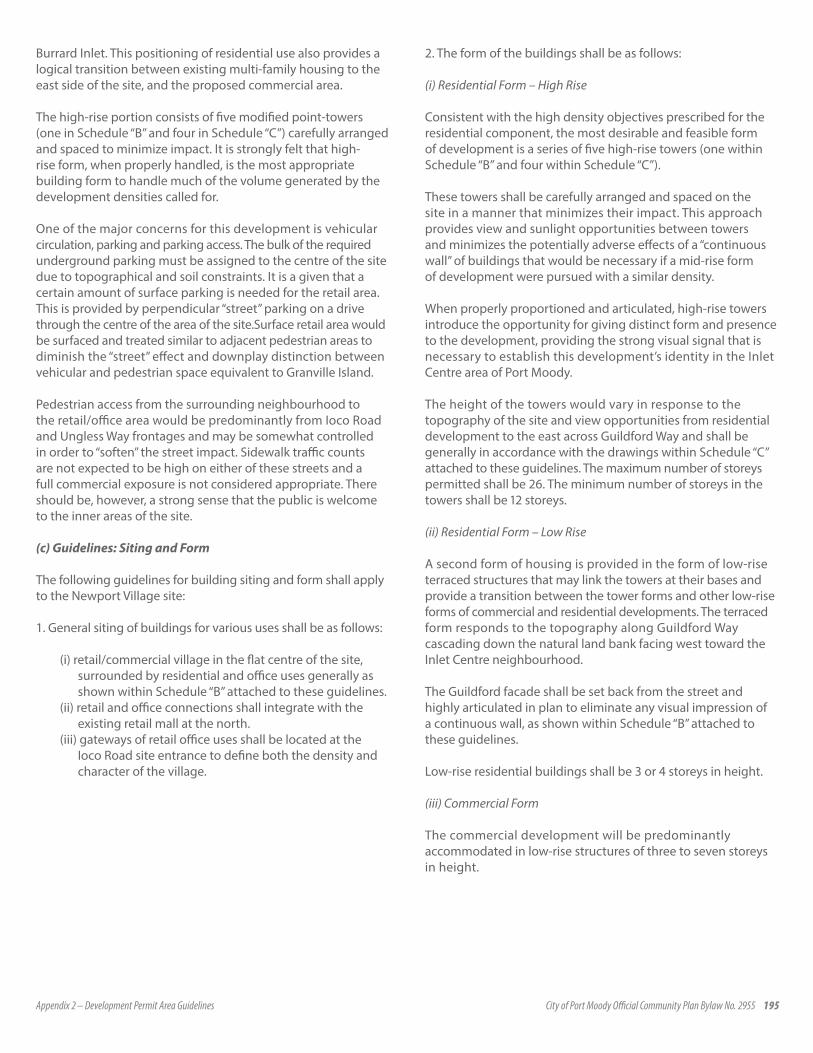
Appendix 2 – Development Permit Area Guidelines City of Port Moody Official Community Plan Bylaw No. 2955 195
Burrard Inlet. This positioning of residential use also provides a logical transition between existing multi-family housing to the east side of the site, and the proposed commercial area.
The high-rise portion consists of five modified point-towers (one in Schedule “B” and four in Schedule “C”) carefully arranged and spaced to minimize impact. It is strongly felt that high-rise form, when properly handled, is the most appropriate building form to handle much of the volume generated by the development densities called for.
One of the major concerns for this development is vehicular circulation, parking and parking access. The bulk of the required underground parking must be assigned to the centre of the site due to topographical and soil constraints. It is a given that a certain amount of surface parking is needed for the retail area. This is provided by perpendicular “street” parking on a drive through the centre of the area of the site.Surface retail area would be surfaced and treated similar to adjacent pedestrian areas to diminish the “street” effect and downplay distinction between vehicular and pedestrian space equivalent to Granville Island.
Pedestrian access from the surrounding neighbourhood to the retail/office area would be predominantly from Ioco Road and Ungless Way frontages and may be somewhat controlled in order to “soften” the street impact. Sidewalk traffic counts are not expected to be high on either of these streets and a full commercial exposure is not considered appropriate. There should be, however, a strong sense that the public is welcome to the inner areas of the site.
(c) Guidelines: Siting and Form
The following guidelines for building siting and form shall apply to the Newport Village site:
1. General siting of buildings for various uses shall be as follows:
(i) retail/commercial village in the flat centre of the site, surrounded by residential and office uses generally as shown within Schedule “B” attached to these guidelines.
(ii) retail and office connections shall integrate with the existing retail mall at the north.
(iii) gateways of retail office uses shall be located at the Ioco Road site entrance to define both the density and character of the village.
2. The form of the buildings shall be as follows:
(i) Residential Form – High Rise
Consistent with the high density objectives prescribed for the residential component, the most desirable and feasible form of development is a series of five high-rise towers (one within Schedule “B” and four within Schedule “C”).
These towers shall be carefully arranged and spaced on the site in a manner that minimizes their impact. This approach provides view and sunlight opportunities between towers and minimizes the potentially adverse effects of a “continuous wall” of buildings that would be necessary if a mid-rise form of development were pursued with a similar density.
When properly proportioned and articulated, high-rise towers introduce the opportunity for giving distinct form and presence to the development, providing the strong visual signal that is necessary to establish this development’s identity in the Inlet Centre area of Port Moody.
The height of the towers would vary in response to the topography of the site and view opportunities from residential development to the east across Guildford Way and shall be generally in accordance with the drawings within Schedule “C” attached to these guidelines. The maximum number of storeys permitted shall be 26. The minimum number of storeys in the towers shall be 12 storeys.
(ii) Residential Form – Low Rise
A second form of housing is provided in the form of low-rise terraced structures that may link the towers at their bases and provide a transition between the tower forms and other low-rise forms of commercial and residential developments. The terraced form responds to the topography along Guildford Way cascading down the natural land bank facing west toward the Inlet Centre neighbourhood.
The Guildford facade shall be set back from the street and highly articulated in plan to eliminate any visual impression of a continuous wall, as shown within Schedule “B” attached to these guidelines.
Low-rise residential buildings shall be 3 or 4 storeys in height.
(iii) Commercial Form
The commercial development will be predominantly accommodated in low-rise structures of three to seven storeys in height.

196 Appendix 2 – Development Permit Area Guidelines City of Port Moody Official Community Plan Bylaw No. 2955
The retail component relates to the existing retail development at the corner of Ioco Road and Ungless Way in order to shield the backside of the shopping centre with new buildings and landscaping.
This lower building form for commercial development responds to the need to respect view and sun potential for the residential forms on the eastern edge of the development, and will provide an animated village scale of building elements in relation to pedestrian circulation.
The office component will be located in one building of five to seven storeys located in proximity to the existing shopping centre, adjacent to Ioco Road.
3. The form and siting of buildings shall be generally in accordance with the cross-sections and elevations shown on the drawings within Schedule “B” and Schedule “C” attached to these guidelines.
(d) Guidelines: Design Elements
1. Tower Elements
• Towers to step back with decreasing floor plates at upper levels.• Lower 4 to 6 floors to integrate with adjacent low rise using
similar materials, proportions and elements, where applicable.• Massive elements terminating the tops of the towers are to be
avoided. Use of small scale elements and proportions repeated from the lower facades to achieve interest and integration.
• Each of the three corner towers should be different, providing complexity and diversity, creating visual anchors at the corners of the site.
• The two towers along Guildford Way, flanking the Market Square shall be lower in height and symmetrical, framing the Square and forecourt, and providing a strong, unifying focus.
2. Street Facade Along Guildford and Ungless Ways
• Facades the Ungless and Guildford Ways shall be generally as shown in drawings attached to Schedule “C.”
• Create landscaped and treed buffer to the street and the existing development to the south-east along Guildford Way.
• Use repeating small scale elements to unify the facades and to provide a soft, human scale where possible, on the ground floors of buildings.
3. Inlet Centre Entry Zone Along Ioco Road
• The intersection at mid-block should provide a fitting introduction to the City Hall and civic plaza. Extend and repeat planting and hard landscaping elements from the City Hall to the intersection and from the intersection to the proposed Market Square. Ensure that detailed intersection design conveys the quality and character of the City Centre and the City Hall.
• Ensure good sight-lines to City Hall and the squares, leading the eye into the civic and urban squares. No visual obstructions are to be placed along the cross street including no large median planting. No large planting is to be placed within the angles of the Village Green triangle on either side of Ioco Road. Increase the spacing of any tree planting on the south side of the cross street to dilute the screening effect of the connection.
• Provide a termination for the Village Green on Ioco Road.• This area should act as a landmark/reference point for the
whole area. Ensure that the proposed office tower is about 3 or 4 storeys higher than the building immediately to the east thereby emphasizing the intersection. Buildings on both sides of the intersection (east and west) should be similar in height, materials, detailing and profile, with the highest building elements on both sides of the intersection occurring close to Ioco Road and the building profiles stepping back from these points.
• Provide good vehicular and pedestrian links between the component areas of the Civic Plaza and the Market Square. Provide four lanes east/west across the intersection. Provide clearly marked pedestrian cross walks with compatible paving, lighting and traffic lights. Provide left turning lanes on Ioco Road. Provide generous sidewalk. Provide special sidewalk paving, landscaping and street furniture.
• Harmonize with general landscape concept.• Accommodate transit drop-off functions.
4. “Retail Streets”
• Provide village ambiance with retail at ground level and residential above. Retail should be diverse with storefronts and signage.
• Provide covered continuous arcade with private outdoor terraces above.
• Provide pedestrian link to the existing shopping centre.• Provide street trees and parallel parking.
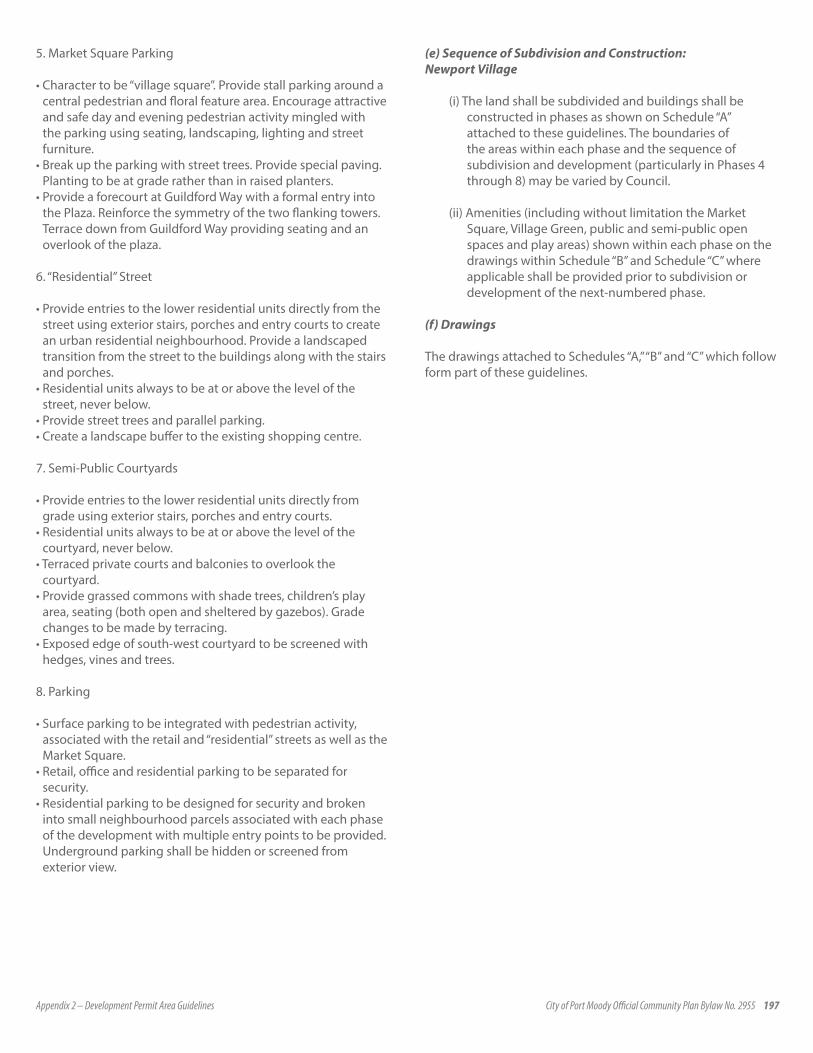
Appendix 2 – Development Permit Area Guidelines City of Port Moody Official Community Plan Bylaw No. 2955 197
5. Market Square Parking
• Character to be “village square”. Provide stall parking around a central pedestrian and floral feature area. Encourage attractive and safe day and evening pedestrian activity mingled with the parking using seating, landscaping, lighting and street furniture.
• Break up the parking with street trees. Provide special paving. Planting to be at grade rather than in raised planters.
• Provide a forecourt at Guildford Way with a formal entry into the Plaza. Reinforce the symmetry of the two flanking towers. Terrace down from Guildford Way providing seating and an overlook of the plaza.
6. “Residential” Street
• Provide entries to the lower residential units directly from the street using exterior stairs, porches and entry courts to create an urban residential neighbourhood. Provide a landscaped transition from the street to the buildings along with the stairs and porches.
• Residential units always to be at or above the level of the street, never below.
• Provide street trees and parallel parking.• Create a landscape buffer to the existing shopping centre. 7. Semi-Public Courtyards
• Provide entries to the lower residential units directly from grade using exterior stairs, porches and entry courts.
• Residential units always to be at or above the level of the courtyard, never below.
• Terraced private courts and balconies to overlook the courtyard.
• Provide grassed commons with shade trees, children’s play area, seating (both open and sheltered by gazebos). Grade changes to be made by terracing.
• Exposed edge of south-west courtyard to be screened with hedges, vines and trees.
8. Parking
• Surface parking to be integrated with pedestrian activity, associated with the retail and “residential” streets as well as the Market Square.
• Retail, office and residential parking to be separated for security.
• Residential parking to be designed for security and broken into small neighbourhood parcels associated with each phase of the development with multiple entry points to be provided. Underground parking shall be hidden or screened from exterior view.
(e) Sequence of Subdivision and Construction: Newport Village
(i) The land shall be subdivided and buildings shall be constructed in phases as shown on Schedule “A” attached to these guidelines. The boundaries of the areas within each phase and the sequence of subdivision and development (particularly in Phases 4 through 8) may be varied by Council.
(ii) Amenities (including without limitation the Market Square, Village Green, public and semi-public open spaces and play areas) shown within each phase on the drawings within Schedule “B” and Schedule “C” where applicable shall be provided prior to subdivision or development of the next-numbered phase.
(f) Drawings
The drawings attached to Schedules “A,” “B” and “C” which follow form part of these guidelines.

198 Appendix 2 – Development Permit Area Guidelines City of Port Moody Official Community Plan Bylaw No. 2955
FIGURE 1 Schedule A
Key plan of Newport Village showing existing development within Schedule “B” and proposed development within Schedule “C”
Existing development shown in Schedule “B”
Proposed development shown in Schedule “C”
FIGURE 2 Schedule B
Key plan of Newport Village showing general form and character of existing development within Phases 1, 2.1, 3, 4 and 5.1
NOTE: Only portions of the following plans as shown on Schedule “A” are applicable.

Appendix 2 – Development Permit Area Guidelines City of Port Moody Official Community Plan Bylaw No. 2955 199
FIGURE 3
FIGURE 4 Schedule C: Plans showing general form and character of the proposed development within phases A to D
FIGURE 5
SUMMARY OF REMAINING DEVELOPMENT IN PHASES A TO D SHOWN ON SCHEDULE “C”
52
Phase B ..............143 Units (22 storeys)Formerly Phase 2.2
Phase C ..............143 Units (22 storeys)Formerly Phase 5.2
Phase D ..............134 Units (26 storeys)Formerly Phase 6
Phase A ..............125 Units (23 storey tower & 3 storey townhouse)
Formerly Phase 7
Total ....................545 units(distribution of units by phase may vary) Total area above grade 780000 S.F.
Remaining units ..355 units(either completed or unchanged)
Grand Total..........900 Units
Note: The unit counts and �oor areas for each of the phases areapproximate and are provided for illustrative purposes. The exactnumber of units within each phase may vary somewhat, but will bewithin the context of the design guidelines and cannot exceed the900-unit maximum density set out in the TC1 (Town Centre) zoneunder the City of Port Moody Zoning Bylaw.
Summary of Remaining Development in Phases A to D shown on Schedule “C”
NEWPORT VILLAGE PROPOSED ZONING
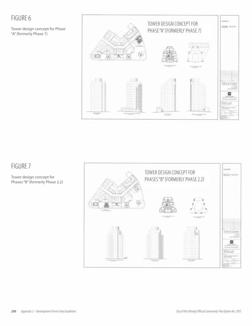
200 Appendix 2 – Development Permit Area Guidelines City of Port Moody Official Community Plan Bylaw No. 2955
FIGURE 6Tower design concept for Phase “A” (formerly Phase 7)
TOWER DESIGN CONCEPT FOR PHASE “A” (FORMERLY PHASE 7)
FIGURE 7Tower design concept for Phases “B” (formerly Phase 2.2)
TOWER DESIGN CONCEPT FOR PHASES “B” (FORMERLY PHASE 2.2)
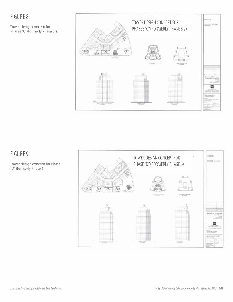
Appendix 2 – Development Permit Area Guidelines City of Port Moody Official Community Plan Bylaw No. 2955 201
FIGURE 8Tower design concept for Phases “C” (formerly Phase 5.2)
TOWER DESIGN CONCEPT FOR PHASES “C” (FORMERLY PHASE 5.2)
FIGURE 9Tower design concept for Phase “D” (formerly Phase 6)
TOWER DESIGN CONCEPT FOR PHASE “D” (FORMERLY PHASE 6)

202 Appendix 2 – Development Permit Area Guidelines City of Port Moody Official Community Plan Bylaw No. 2955
FIGURE 10
FIGURE 11

Appendix 2 – Development Permit Area Guidelines City of Port Moody Official Community Plan Bylaw No. 2955 203
FIGURE 12

204 Appendix 2 – Development Permit Area Guidelines City of Port Moody Official Community Plan Bylaw No. 2955
4.7.2 SUTER BROOK
A. INTRODUCTION AND GENERAL GUIDELINESThese site specific guidelines have been developed for the Suter Brook site and supplement the City’s Development Permit Area 3 Guidelines.
1. General Site Description
The Suter Brook community is central to Development Permit Area 3 of Port Moody’s Inlet Centre. Situated at the southwest corner of Ioco Road and Murray Street and at the base of the surrounding hills, the 8.93 hectare (22 acre) site encompasses Suter Brook as it flows off the Chines escarpment to the south on its route to Shoreline Park to the north and Burrard Inlet beyond. Suter Brook itself is the focus and greatest asset of this community.
2. Master Plan Overview
The Master Plan for Suter Brook includes:
(a) a conceptual overall site plan (Fig. 1), which outlines building locations and their use;
(b) a conceptual parcel plan (Fig. 2), which separates the Suter Brook site into development parcels and is derived for the land use contract (the “Land Use Contract”) governing the Suter Brook site; and
(c) the design philosophy and major objectives for the development of this site, which are described in detail below. At the core of the vision for Suter Brook is the enhancement and preservation of the Suter Brook stream and adjoining riparian habitat area. The residential and commercial uses and built forms of the new community are to respect this important resource while also achieving a high quality of design, materials and construction.
The development of the Suter Brook site is intended to complement the adjacent Inlet Centre areas, providing up to 1,250 housing units. A retail and office component, as well as a public plaza and public square, will provide an important community focus and the primary public gathering place for the site.
FIGURE 1
FIGURE 2

Appendix 2 – Development Permit Area Guidelines City of Port Moody Official Community Plan Bylaw No. 2955 205
The community will include a diversity of buildings and open spaces, and provide opportunities for meeting the housing needs of a variety of residents, while respecting the Suter Brook Greenway environment. By incorporating a significant commercial component, the community will augment the vibrancy of Port Moody’s Inlet Centre and provide significant local employment and business opportunities.
3. Community Components
The Suter Brook community consists of three major components:
• the Suter Brook Greenway, including two linkages across the Greenway and a trail at its outside edge;
• the Village Plaza; and• three distinct residential neighbourhoods.
The following is a general outline of these community components. Refer to Sections C, D and E of these design guidelines for details of these various components.
Suter Brook Greenway: The Greenway, which contains Suter Brook, is set aside as a protected environmental area incorporating a pedestrian loop trail system along a portion of its length, signage and interest points emphasizing the ecological importance of Suter Brook as a fish bearing stream, bird, animal and plant habitat. A central bridge will be constructed providing for vehicle, bicycle and pedestrian traffic to cross Suter Brook.
Village Plaza: A plaza central to the entire Suter Brook community serves as a gathering place for the community, a location for community cultural and other events and a primary point of entry to the Suter Brook trail system.
Neighbourhoods: Three neighbourhoods (Fig. 3), have been established to complement and respect the Greenway; each with a distinct yet compatible building and landscape character. Two of these neighbourhoods are purely residential while a large portion of the site east of Suter Brook will incorporate residential uses with retail/commercial amenities and businesses, such as a major grocer, a pub,
office space, as well as the Village Plaza and Village Square. The character and guidelines applicable to each neighbourhood are set out in Section E.4. Role of Design Guidelines
These guidelines are intended to outline development controls that will guide developers of individual parcels in achieving the following general objectives:
• ensure the long term preservation and enhancement of the Suter Brook Greenway;
• establish the distribution and compatibility of land uses, development parcels, built form, and provision of public spaces and facilities;
• establish consistent performance standards for the character and construction of buildings and open spaces for which the community will be recognized;
• provide a framework for the orderly build out of development parcels over time; and
FIGURE 3
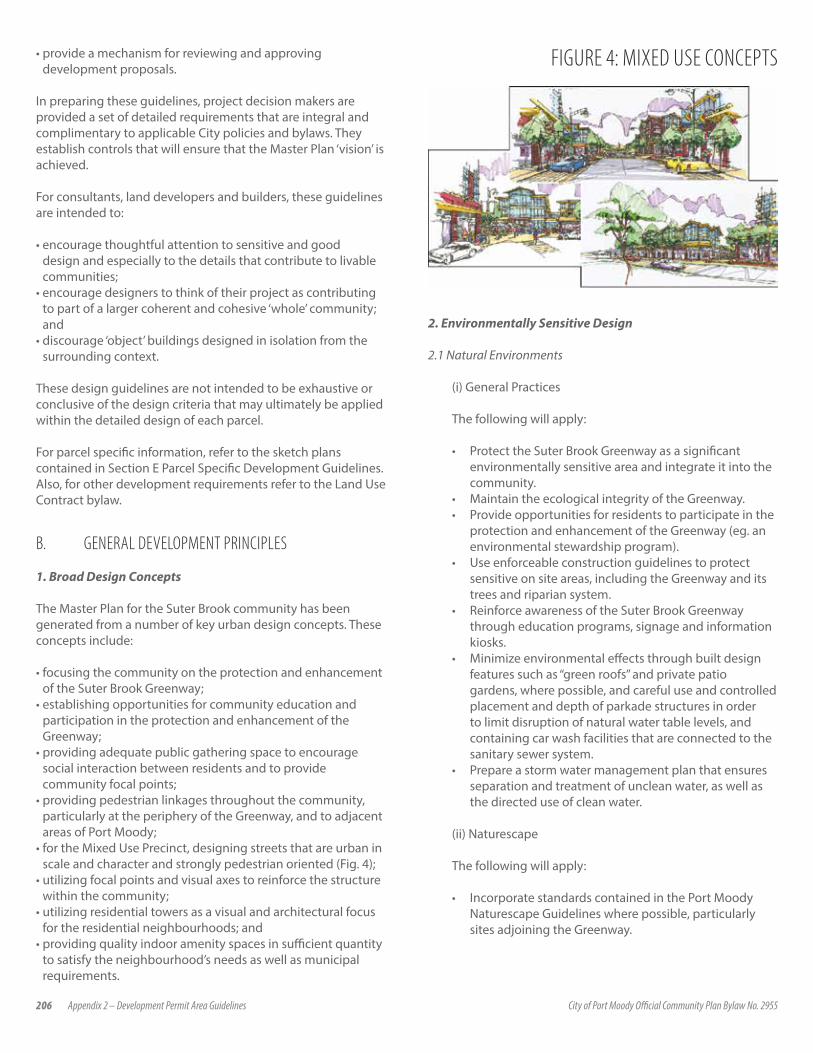
206 Appendix 2 – Development Permit Area Guidelines City of Port Moody Official Community Plan Bylaw No. 2955
• provide a mechanism for reviewing and approving development proposals.
In preparing these guidelines, project decision makers are provided a set of detailed requirements that are integral and complimentary to applicable City policies and bylaws. They establish controls that will ensure that the Master Plan ‘vision’ is achieved.
For consultants, land developers and builders, these guidelines are intended to:
• encourage thoughtful attention to sensitive and good design and especially to the details that contribute to livable communities;
• encourage designers to think of their project as contributing to part of a larger coherent and cohesive ‘whole’ community; and
• discourage ‘object’ buildings designed in isolation from the surrounding context.
These design guidelines are not intended to be exhaustive or conclusive of the design criteria that may ultimately be applied within the detailed design of each parcel.
For parcel specific information, refer to the sketch plans contained in Section E Parcel Specific Development Guidelines. Also, for other development requirements refer to the Land Use Contract bylaw.
B. GENERAL DEVELOPMENT PRINCIPLES
1. Broad Design Concepts
The Master Plan for the Suter Brook community has been generated from a number of key urban design concepts. These concepts include:
• focusing the community on the protection and enhancement of the Suter Brook Greenway;
• establishing opportunities for community education and participation in the protection and enhancement of the Greenway;
• providing adequate public gathering space to encourage social interaction between residents and to provide community focal points;
• providing pedestrian linkages throughout the community, particularly at the periphery of the Greenway, and to adjacent areas of Port Moody;
• for the Mixed Use Precinct, designing streets that are urban in scale and character and strongly pedestrian oriented (Fig. 4);
• utilizing focal points and visual axes to reinforce the structure within the community;
• utilizing residential towers as a visual and architectural focus for the residential neighbourhoods; and
• providing quality indoor amenity spaces in sufficient quantity to satisfy the neighbourhood’s needs as well as municipal requirements.
FIGURE 4: MIXED USE CONCEPTS
2. Environmentally Sensitive Design
2.1 Natural Environments
(i) General Practices
The following will apply:
• Protect the Suter Brook Greenway as a significant environmentally sensitive area and integrate it into the community.
• Maintain the ecological integrity of the Greenway.• Provide opportunities for residents to participate in the
protection and enhancement of the Greenway (eg. an environmental stewardship program).
• Use enforceable construction guidelines to protect sensitive on site areas, including the Greenway and its trees and riparian system.
• Reinforce awareness of the Suter Brook Greenway through education programs, signage and information kiosks.
• Minimize environmental effects through built design features such as “green roofs” and private patio gardens, where possible, and careful use and controlled placement and depth of parkade structures in order to limit disruption of natural water table levels, and containing car wash facilities that are connected to the sanitary sewer system.
• Prepare a storm water management plan that ensures separation and treatment of unclean water, as well as the directed use of clean water.
(ii) Naturescape
The following will apply:
• Incorporate standards contained in the Port Moody Naturescape Guidelines where possible, particularly sites adjoining the Greenway.

Appendix 2 – Development Permit Area Guidelines City of Port Moody Official Community Plan Bylaw No. 2955 207
• Ensure careful placement of Naturescape planting along the Suter Brook Greenway to discourage public access to sensitive riparian areas.
• Create or improve wildlife habitats with the use of native plant material and plant massing.
• Ensure a visual integration of the residential building rear yards with the natural Suter Brook Greenway.
• Promote the use of indigenous plants in private landscaping.
2.2 Built Environments
The following will apply:
• Create compact forms of development leading to a more efficient use of land and infrastructure.
• Integrate land uses including significant employment generating activity.
• Provide shopping and entertainment opportunities on site, within easy walking distance.
• Provide varied choice of housing types, costs and lifestyles.
2.3 Social Environments
The following will apply:
• Create public open spaces that promote activity and social interaction.
• Provide a diversity of recreational opportunities and facilities.
• Provide safe pedestrian and cycle friendly streets.• Encourage businesses that promote a vibrant urban
character and interaction between residents and encourage visits from members of the community outside Suter Brook.
3. Gateways & Focal PointsEntries to the community are designed to create a sense of arrival and identity, while focal points are intended to provide neighbourhood identity. (Fig.5)
4. Livability
In addition to previously mentioned principles, a number of factors further contribute to the overall livability and enjoyment of the community. General conditions include:
• street corners with tree plantings and benches to create interest and community interaction;
• accessibility to public areas including Greenway trails, the Village Plaza and Village Square and the commercial precinct;
• parking for people with disabilities both on-street and in underground parking facilities in proximity to elevators or movators; and
FIGURE 5
• maximize natural light penetration into dwelling units and corridors/stairwells.
4.1 Private Views
Views will be maximized from units on to public spaces such as the Greenway and the Village Plaza, on to internal courtyard areas where applicable and on to the Inlet and mountains to the north and northwest. (Fig.6). The Greenway, Village Plaza, and Village Square are the primary focuses for the views into and within the community.
4.2 Safety
The following will apply:
• Define street edges with residential units that have either at grade access or, for mixed-use buildings, windows facing the street over commercial space at grade, to provide ‘eyes on the street’ for pedestrian safety.
• Incorporate traffic calming measures.
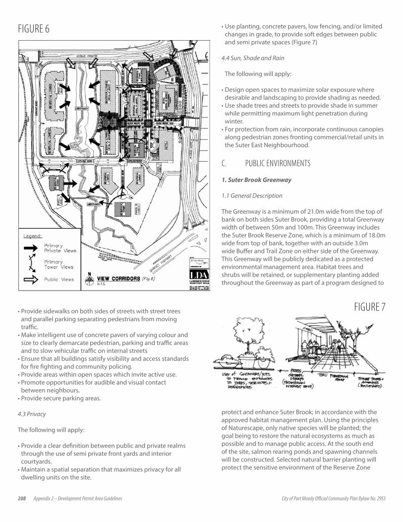
208 Appendix 2 – Development Permit Area Guidelines City of Port Moody Official Community Plan Bylaw No. 2955
• Provide sidewalks on both sides of streets with street trees and parallel parking separating pedestrians from moving traffic.
• Make intelligent use of concrete pavers of varying colour and size to clearly demarcate pedestrian, parking and traffic areas and to slow vehicular traffic on internal streets
• Ensure that all buildings satisfy visibility and access standards for fire fighting and community policing.
• Provide areas within open spaces which invite active use.• Promote opportunities for audible and visual contact
between neighbours.• Provide secure parking areas.
4.3 Privacy
The following will apply:
• Provide a clear definition between public and private realms through the use of semi private front yards and interior courtyards.
• Maintain a spatial separation that maximizes privacy for all dwelling units on the site.
FIGURE 6
FIGURE 7
• Use planting, concrete pavers, low fencing, and/or limited changes in grade, to provide soft edges between public and semi private spaces (Figure 7)
4.4 Sun, Shade and Rain
The following will apply:
• Design open spaces to maximize solar exposure where desirable and landscaping to provide shading as needed.
• Use shade trees and streets to provide shade in summer while permitting maximum light penetration during winter.
• For protection from rain, incorporate continuous canopies along pedestrian zones fronting commercial/retail units in the Suter East Neighbourhood.
C. PUBLIC ENVIRONMENTS
1. Suter Brook Greenway
1.1 General Description
The Greenway is a minimum of 21.0m wide from the top of bank on both sides Suter Brook, providing a total Greenway width of between 50m and 100m. This Greenway includes the Suter Brook Reserve Zone, which is a minimum of 18.0m wide from top of bank, together with an outside 3.0m wide Buffer and Trail Zone on either side of the Greenway. This Greenway will be publicly dedicated as a protected environmental management area. Habitat trees and shrubs will be retained, or supplementary planting added throughout the Greenway as part of a program designed to
protect and enhance Suter Brook; in accordance with the approved habitat management plan. Using the principles of Naturescape, only native species will be planted; the goal being to restore the natural ecosystems as much as possible and to manage public access. At the south end of the site, salmon rearing ponds and spawning channels will be constructed. Selected natural barrier planting will protect the sensitive environment of the Reserve Zone

Appendix 2 – Development Permit Area Guidelines City of Port Moody Official Community Plan Bylaw No. 2955 209
from direct access, in accordance with an approved controlled access management plan. Educational information detailing the ecological importance of Suter Brook as a salmon stream and wildlife habitat, together with community information such as trail maps, will be provided. Interpretive signs and kiosks will serve as gateways which link the on-site Greenway trail system to the City’s broader Shoreline Park trail system.
1.2 Trails and Bridges
The Greenway trail system consists of two primary loop trails; one between Murray Street and the Village Plaza and central bridge, and a second between the central bridge and a wooden pedestrian crossing within the southern portion of the site.
A central bridge will be constructed to allow vehicle, bicycle and pedestrian traffic to cross Suter Brook. The central bridge incorporates sidewalks widened to 3.0m which will provide view points to the stream and places for seating and interpretive information while maintaining an unobstructed pedestrian sidewalk. Wider than standard travel lanes across the bridge provide for the safe passage of cyclists.
1.3 Environmental ProtectionHabitat protection and enhancement of the Suter Brook Greenway will be ensured by an Environmental Assessment Report, a Construction Monitoring Plan and a Storm Water Management Plan. Each development phase must comply with all requirements and standards of these approved plans.
2. Village Plaza
The Village Plaza is a publicly accessible plaza which will be central to the community and directly adjacent to the Greenway (Fig.8). As the western terminus of the main entry road (Suter Brook Way) off Ioco Road, the Village Plaza will provide views to the Suter Brook and provide an ideal location for the placement of public art.
The Village Plaza has the following attributes:
• it is a public amenity space open for the enjoyment of not only the residents of Suter Brook, but the Port Moody community as a whole;
• it will have a combination of hard and soft landscaping;• this will be the main stage where people will gather, cafes will
have outdoor seating, and community events will occur;• public benches with backs provide a comfortable location to
rest or enjoy the activities taking place in the Plaza;• at-grade commercial space in the buildings to the north and
south of the plaza to possibly house cafes and restaurants with patios bordering the plaza;
• trail entrances to the Suter Brook Greenway trail system and transitional green space;
• sun orientation and shadow impacts will be taken into consideration in designing the Village Plaza;
• a raised “stage” area could be added for use during local music festivals, community days and the like; and
• public art will be installed to provide interest and a central focal point.
3. Village Square
The Village Square is the main plaza for the commercial precinct. It will reflect a European style, which alludes to open, primarily paved nature of the plaza, and how it is defined and enclosed by the buildings. This European style plaza provides a central point for pedestrians orienting themselves within the village and a transition for those entering from Murray & Ioco.
Some trees and fixed features are present around the edge, and the paving patterns are rich and interesting, but primarily the space is open to allow for a variety of uses. It can be used for events, café eating, or simply open to allow for free movement. A central feature will provide an important landmark for the plaza while outdoor seating will create a social hub in the midst of commercial activity.
4. The Corner of Murray Street & Ioco Road
The corner of Murray and Ioco will be an important focal point and pedestrian gateway for the Suter Brook community. It is the threshold for pedestrians coming into the area, and a visual focal point for drivers. The connection to the existing Newport Village will be a strong one, embracing and inviting the established community into the new village. Paving patterns direct people beyond this point up Ioco, or along Murray into
FIGURE 8: CONCEPTUAL VILLAGE PLAZA PLAN
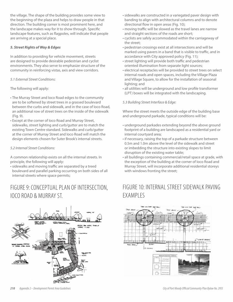
210 Appendix 2 – Development Permit Area Guidelines City of Port Moody Official Community Plan Bylaw No. 2955
the village. The shape of the building provides some view to the beginning of the plaza and helps to draw people in that direction. The building corner is most prominent here, and the landscape makes way for it to show through. Specific landscape features, such as flagpoles, will indicate that people are arriving at a special place.
5. Street Rights of Way & Edges
In addition to providing for vehicle movement, streets are designed to provide desirable pedestrian and cyclist environments. They also serve to emphasize structure of the community in reinforcing vistas, axis and view corridors.
5.1 External Street Conditions:
The following will apply:
• The Murray Street and Ioco Road edges to the community are to be softened by street trees in a grassed boulevard between the curbs and sidewalk, and in the case of Ioco Road, an additional row of street trees on the inside of the sidewalk (Fig. 9).
• Except at the corner of Ioco Road and Murray Street, sidewalks, street lighting and curb/gutter are to match the existing Town Centre standard. Sidewalks and curb/gutter at the corner of Murray Street and Ioco Road will match the design elements chosen for Suter Brook’s internal streets.
5.2 Internal Street Conditions:
A common relationship exists on all the internal streets. In principle, the following will apply:• sidewalks and moving traffic are separated by a treed
boulevard and parallel parking occurring on both sides of all internal streets where space permits;
FIGURE 9: CONCEPTUAL PLAN OF INTERSECTION, IOCO ROAD & MURRAY ST.
FIGURE 10: INTERNAL STREET SIDEWALK PAVING EXAMPLES
• sidewalks are constructed in a variegated paver design with banding to align with architectural columns and to denote directional flow in open areas (Fig. 10);
• moving traffic will be slowed as the travel lanes are narrow and straight sections of the roads are short;
• cyclists are safely accommodated within the carriageway of the street;
• pedestrian crossings exist at all intersections and will be marked using pavers in a band that is visible to traffic, and in accordance with City approved policy (Fig. 11);
• street lighting will provide both traffic and pedestrian oriented illumination from separate light sources;
• electrical receptacles will be provided to street trees on select internal roads and open spaces, including the Village Plaza and Village Square, to allow for the installation of seasonal lighting; and
• all utilities will be underground and low profile transformer (LPT) boxes will be integrated with the landscaping.
5.3 Building Street Interface & Edge:
Where the street meets the outside edge of the building base and underground parkade, typical conditions will be:
• underground parkades extending beyond the above ground footprint of a building are landscaped as a residential yard or internal courtyard area;
• if necessary, raising the top of a parkade structure between 0.5m and 1.0m above the level of the sidewalk and street or imbedding the structure into existing slopes to limit disruption of the existing water table;
• all buildings containing commercial/retail space at grade, with the exception of the building at the corner of Ioco Road and Murray Street, will incorporate additional residential storeys with windows fronting the street;
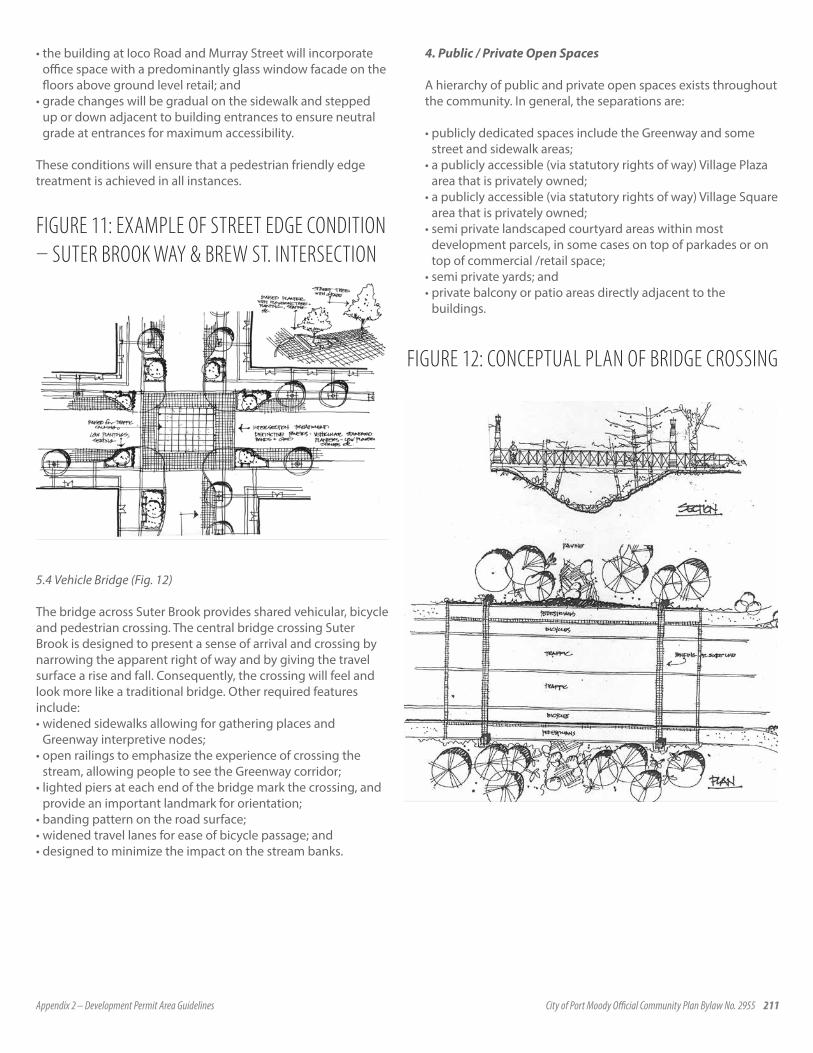
Appendix 2 – Development Permit Area Guidelines City of Port Moody Official Community Plan Bylaw No. 2955 211
• the building at Ioco Road and Murray Street will incorporate office space with a predominantly glass window facade on the floors above ground level retail; and
• grade changes will be gradual on the sidewalk and stepped up or down adjacent to building entrances to ensure neutral grade at entrances for maximum accessibility.
These conditions will ensure that a pedestrian friendly edge treatment is achieved in all instances.
5.4 Vehicle Bridge (Fig. 12)
The bridge across Suter Brook provides shared vehicular, bicycle and pedestrian crossing. The central bridge crossing Suter Brook is designed to present a sense of arrival and crossing by narrowing the apparent right of way and by giving the travel surface a rise and fall. Consequently, the crossing will feel and look more like a traditional bridge. Other required features include:• widened sidewalks allowing for gathering places and
Greenway interpretive nodes;• open railings to emphasize the experience of crossing the
stream, allowing people to see the Greenway corridor;• lighted piers at each end of the bridge mark the crossing, and
provide an important landmark for orientation;• banding pattern on the road surface;• widened travel lanes for ease of bicycle passage; and• designed to minimize the impact on the stream banks.
4. Public / Private Open Spaces
A hierarchy of public and private open spaces exists throughout the community. In general, the separations are:
• publicly dedicated spaces include the Greenway and some street and sidewalk areas;
• a publicly accessible (via statutory rights of way) Village Plaza area that is privately owned;
• a publicly accessible (via statutory rights of way) Village Square area that is privately owned;
• semi private landscaped courtyard areas within most development parcels, in some cases on top of parkades or on top of commercial /retail space;
• semi private yards; and• private balcony or patio areas directly adjacent to the
buildings.
FIGURE 12: CONCEPTUAL PLAN OF BRIDGE CROSSING
FIGURE 11: EXAMPLE OF STREET EDGE CONDITION – SUTER BROOK WAY & BREW ST. INTERSECTION

212 Appendix 2 – Development Permit Area Guidelines City of Port Moody Official Community Plan Bylaw No. 2955
5.Streetscape
Suter Brook will consistently employ streetscaping fixtures throughout all parcels and at the intersection of Ioco Road and Murray Street to give the entire community common aesthetic elements. Examples of these elements are as follows:
• street trees along boulevards (Fig. 13);• lighting to be coordinated with style, colour and base of other
appointments;• a Domus type luminaire with pedestrian and street scale
lighting;• light fixtures to have banner and hanging basket support (Fig.
14);• bollards to match base of light fixture; and• seating to be Francis Andrew Centennial style type series 22-3
with series 31-2 receptacle or equivalent (Fig 15).
Streetscape elements will be consistent with, or complement, the streetscape elements found throughout Inlet Centre.
6. Public Art
Public art at Suter Brook will help to enrich the pedestrian space, particularly in the Village Plaza and Village Square. Locally designed art will be encouraged that speaks to the place, and adds a rich level of detail. The art will help to create pedestrian scale landmarks for use by residents, animating the plazas and making the space unique.
FIGURE 13: EXAMPLES OF INTERNAL STREETS & STREET TREE FEATURES
FIGURE 14: EXAMPLES OF LIGHTING & BOLLARDS
FIGURE 15: EXAMPLES OF TRASH RECEPTACLES, BENCHES, BOLLARDS & BICYCLE RACKS OR EQUIVALENT
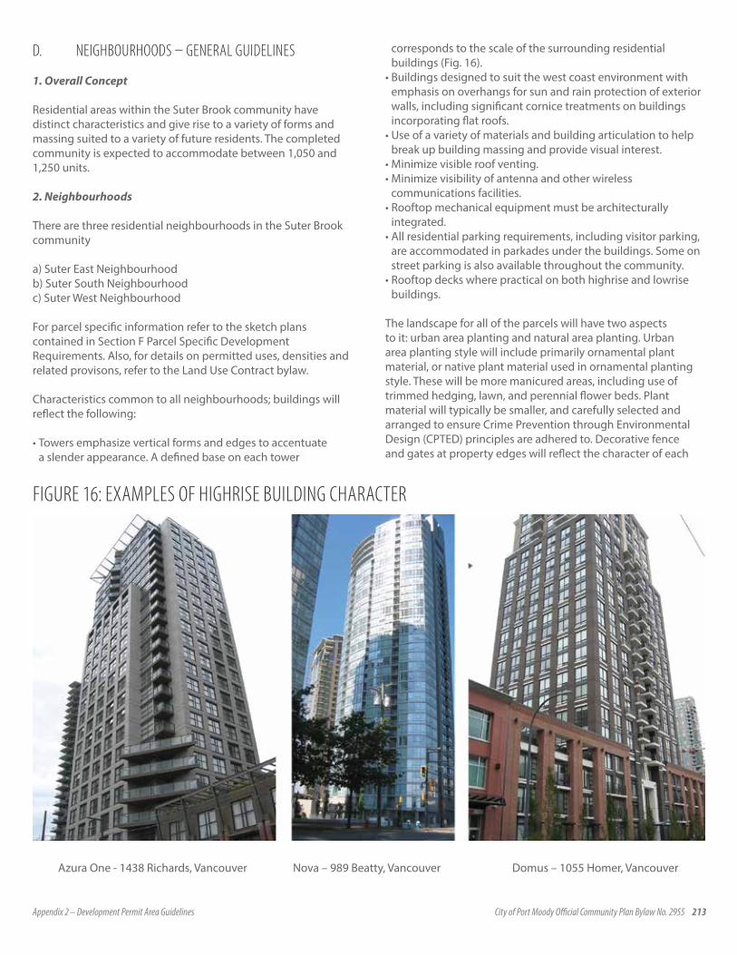
Appendix 2 – Development Permit Area Guidelines City of Port Moody Official Community Plan Bylaw No. 2955 213
D. NEIGHBOURHOODS – GENERAL GUIDELINES
1. Overall Concept
Residential areas within the Suter Brook community have distinct characteristics and give rise to a variety of forms and massing suited to a variety of future residents. The completed community is expected to accommodate between 1,050 and 1,250 units.
2. Neighbourhoods
There are three residential neighbourhoods in the Suter Brook community
a) Suter East Neighbourhoodb) Suter South Neighbourhoodc) Suter West Neighbourhood
For parcel specific information refer to the sketch plans contained in Section F Parcel Specific Development Requirements. Also, for details on permitted uses, densities and related provisons, refer to the Land Use Contract bylaw.
Characteristics common to all neighbourhoods; buildings will reflect the following:
• Towers emphasize vertical forms and edges to accentuate a slender appearance. A defined base on each tower
corresponds to the scale of the surrounding residential buildings (Fig. 16).
• Buildings designed to suit the west coast environment with emphasis on overhangs for sun and rain protection of exterior walls, including significant cornice treatments on buildings incorporating flat roofs.
• Use of a variety of materials and building articulation to help break up building massing and provide visual interest.
• Minimize visible roof venting. • Minimize visibility of antenna and other wireless
communications facilities.• Rooftop mechanical equipment must be architecturally
integrated.• All residential parking requirements, including visitor parking,
are accommodated in parkades under the buildings. Some on street parking is also available throughout the community.
• Rooftop decks where practical on both highrise and lowrise buildings.
The landscape for all of the parcels will have two aspects to it: urban area planting and natural area planting. Urban area planting style will include primarily ornamental plant material, or native plant material used in ornamental planting style. These will be more manicured areas, including use of trimmed hedging, lawn, and perennial flower beds. Plant material will typically be smaller, and carefully selected and arranged to ensure Crime Prevention through Environmental Design (CPTED) principles are adhered to. Decorative fence and gates at property edges will reflect the character of each
FIGURE 16: EXAMPLES OF HIGHRISE BUILDING CHARACTER
Azura One - 1438 Richards, Vancouver Nova – 989 Beatty, Vancouver Domus – 1055 Homer, Vancouver
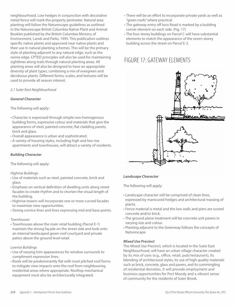
214 Appendix 2 – Development Permit Area Guidelines City of Port Moody Official Community Plan Bylaw No. 2955
neighbourhood. Low hedges in conjunction with decorative metal fence will mark the property perimeter. Natural area planting will follow the Naturescape guidelines as outlined in the Naturescape British Columbia Native Plant and Animal Booklet published by the British Columbia Ministry of Environment, Lands and Parks, 1995. This publication outlines specific native plants and approved near native plants and their use in natural planting schemes. This will be the primary style of planting adjacent to any natural edge, such as the ravine edge. CPTED principles will also be used for maintaining sightlines along trails through natural planting areas. All planting areas will also be designed to have an appropriate diversity of plant types, combining a mix of evergreen and deciduous plants. Different forms, scales, and textures will be used to provide all season interest.
2.1 Suter East Neighbourhood
General Character
The following will apply:
• Character is expressed through simple non-homogenous building forms, expressive colour and materials that give the appearance of steel, painted concrete, flat cladding panels, brick and glass.
• Overall appearance is urban and sophisticated.• A variety of housing styles, including high and low rise
apartments and townhouses, will attract a variety of residents.
Building Character
The following will apply:
Highrise Buildings• Use of materials such as steel, painted concrete, brick and
glass.• Emphasis on vertical definition of dwelling units along street
facades to create rhythm and to shorten the visual length of the building.
• Highrise towers will incorporate one or more curved facades to maximize view opportunities.
• Strong cornice lines and lines expressing mid and base points.
Townhouses• Townhouses above the main retail building (Parcel E-1)
maintain the strong façade on the street side and look onto an internal landscaped green roof courtyard and private patios above the ground level retail.
Lowrise Buildings• Use of varying trim appearances for window surrounds to
compliment expression lines.• Roofs will be predominantly flat with inset pitched roof forms
to mitigate view impacts onto the roof from neighbouring residential areas where appropriate. Rooftop mechanical equipment must also be architecturally integrated.
• There will be an effort to incorporate private yards as well as “green roofs” where practical.
• The gateway entry off Ioco Road is marked by a building corner element on each side. (Fig. 17)
• The four storey buildings on Parcel C will have substantial elements to match the appearance of the seven storey building across the street on Parcel E-3.
FIGURE 17: GATEWAY ELEMENTS
Landscape Character
The following will apply:
• Landscape character will be comprised of clean lines, expressed by manicured hedges and architectural massing of plants.
• Fence material is metal and the low walls and piers are scored concrete and/or brick.
• The ground plane treatment will be concrete unit pavers in varying size and colour.
• Planting adjacent to the Greenway follows the concepts of Naturescape.
Mixed Use PrecinctThe Mixed Use Precinct, which is located in the Suter East Neighbourhood, will have an urban village character created by its mix of uses (e.g., office, retail, pub/restaurant), its blending of architectural styles, its use of high quality materials such as brick, concrete, glass and pavers, and its commingling of residential densities. It will provide employment and business opportunities for Port Moody and a vibrant sense of community for the residents of Suter Brook.

Appendix 2 – Development Permit Area Guidelines City of Port Moody Official Community Plan Bylaw No. 2955 215
a) Urban Design
The following will apply:
• avoid a cookie-cutter look and feel by employing a variety of complementary materials and architectural styles;
• include predominantly flat roofs with architecturally integrated parapets and cornices;
• provide for a diverse and visually interesting streetscape with a continuous retail frontage which will attract visitors and tourists as well as local shoppers;
• provide continuous weather protection for pedestrians along the retail and other appropriate frontages;
• integrate residential units above the main floor retail to reinforce the sense of an urban village while providing a prominent complementary building facade to frame the space; and
• treat the corner of Ioco Road and Murray Street such that the angled office/retail building is a feature and pedestrian traffic is naturally drawn into the Commercial Precinct through the strategic use of high-quality landscaping and pavers. The corner itself should not be the feature but should operate to draw pedestrians into Suter Brook, including through incorporation of public art.
b) Retail
The retail component of the Mixed Use Precinct will:
• provide local services, financial services, a major grocer, a pub and licensee liquor retailer and specialty retail and food outlets to promote customer activity throughout the day and evening;
• utilize the ground floor of the office building for retail at grade fronting onto the Village Square open space provided at the terminus of the main internal commercial street;
• encourage retail spaces to “spill out” onto the Village Plaza and other open spaces in the form of informal and flexible patio spaces;
• accommodate retail in generally narrow frontages to permit a larger number of tenants to give greater diversity and customer activity; and
• have predominantly transparent glass in retail frontages (Fig.18).
c) Signage
The following will apply:
• building signage will be structurally integrated into the design of the buildings;
• opportunities for a big screen television will be explored;• signage will not dominate the building facades; and• the location and details of the signage will be reviewed
and approved by the municipality to demonstrate that the signage is architecturally compatible with the building and surrounding area prior to development approval for Parcel C or Parcel E.
d) Office
Office Space will:
• primarily be provided in the floors above ground level in the building at corner of Ioco Road and Murray Street;
• be the focus of the Murray Street and Ioco Road corner, with a primarily glass façade and potential for a curved wall element.;
• use a central lobby in the building shared by office tenants and the residents of townhouses over the neighbouring major commercial building; and
• require service access at the back of the building via the main commercial retail loading access off Ioco.
e) Additional Office Space This building will:
• be architecturally consistent with the design employed in the Suter East Neighbourhood and will use high quality building materials such as brick, steel and glass (Fig. 19);
f ) Parking & Loading
The following will apply:
• Customer parking required to support the retail and office components will be provided in an underground parking garage, which will also support much of the parking requirements of the residential component of the Commercial Precinct.
• Retail customers will access grade level retail from parking level via a movator or elevator. A movator will be located adjacent to the entry to the major grocer.
FIGURE 18: EXAMPLE OF RETAIL/GROCER WITH RESIDENTIAL ABOVE

216 Appendix 2 – Development Permit Area Guidelines City of Port Moody Official Community Plan Bylaw No. 2955
• On street parallel parking will also be provided on both sides of all internal roads where space and grades permit and will help meet typical daily needs for success of the retail.
• Parking for the office component will be provided within a separate secured area of the underground parkade on Parcel E.
• Loading and unloading for both major retail and office needs will be provided from a loading access off Ioco Road behind and between the retail/office building and the major commercial building. This loading bay will be landscaped on top, gated and landscaped around its entrance to be made as inconspicuous as possible from Ioco Road (Fig. 20).
• Short term service parking and loading/unloading will be provided at grade adjacent to the retail units.
• Accessible parking for people with disabilities will be incorporated both on street and in the underground parking facilities in proximity to elevators or a movator.
• Use will be made of coloured stamped concrete or similar hard surfacing to define loading areas, along with such measures as down cast lighted bollards, landscaping, and screening as appropriate.
2.2 Suter South Neighbourhood
General Character
The following will apply:
• The neighbourhood character is expressed through building forms with natural colours and materials that give the appearance of wood, brick, stone and slate.
• Extensive use of materials such as brick and stone on facades and walls of the tower base and low rise buildings.
• Distinct from other neighborhoods in both materials and color scheme.
• The neighbourhood suggests the sensibility of a private enclave with a single entry approach and landscaped auto court.
• The relationship to the “Irly Bird” site to the east will be taken into consideration in designing road access and setting grades of buildings and other structures.
FIGURE 19: EXAMPLE OF OFFICE / MIXED USE BUILDING
FIGURE 20: ELEVATION OF LOADING BAY ON MURRAY & IOCO
Building Character
The following will apply:
Lowrise Buildings
• Lowrise buildings to show simple pitched roof forms throughout with straight eave lines and inset gables.
• Lowrise buildings may incorporate some townhouses.• Balconies are a combination of recessed and exposed and may
partially extend beyond the face of the building.• Extensive use of matching detail trim on lintels and sills,
columns and gables. Highrise Building
• The tower above the base should be concrete in a complementary colour to the base with window wall and “punched” windows.
• Vertical elements should be emphasized by use of the building elements and colour.
• The tower design is symmetrical on the north south axis to reinforce its position as a central vista, but is not necessarily symmetrical on all facades.
• The tower will be stepped in on its upper storeys. (Fig. 16)
Landscape Character
The following will apply:
• Entry to the neighbourhood defined with stone piers and walls identifying the enclave.
• Heavily landscaped with trees, hedges and planting to separate Suter South Neighbourhood from the commercial precinct.
• Garden trellis, formal bench groupings and water spray pools are used as feature elements.
• Unit pavers used as auto court paving material to reinforce an upscale and formal nature of the landscape.
• Planting adjacent to the Greenway following the concepts of Naturescape.
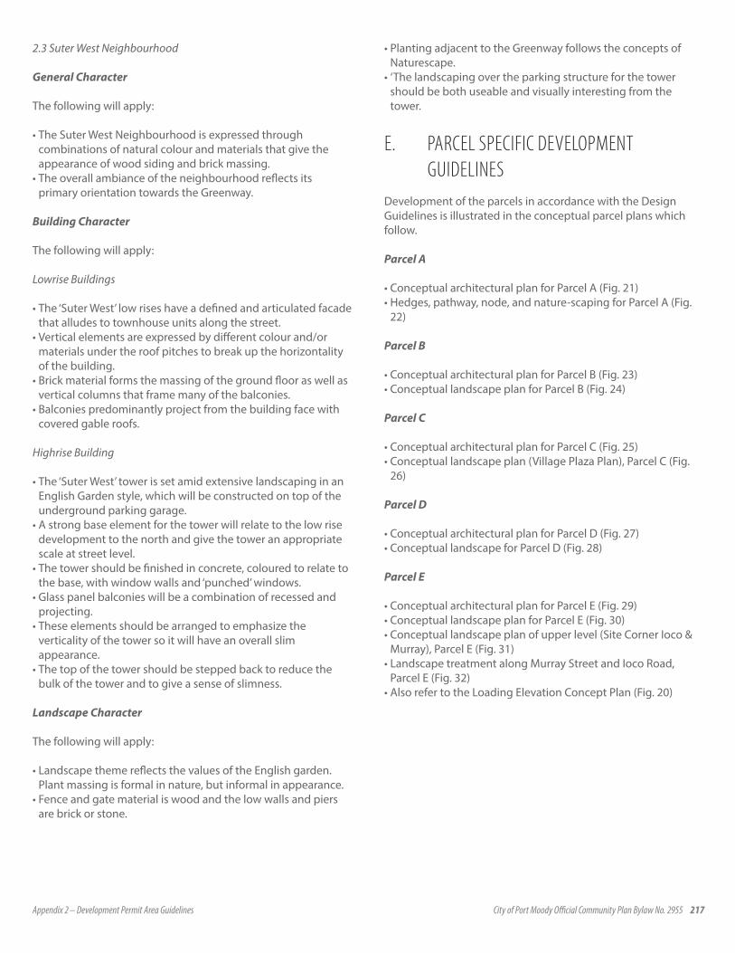
Appendix 2 – Development Permit Area Guidelines City of Port Moody Official Community Plan Bylaw No. 2955 217
2.3 Suter West Neighbourhood
General Character
The following will apply:
• The Suter West Neighbourhood is expressed through combinations of natural colour and materials that give the appearance of wood siding and brick massing.
• The overall ambiance of the neighbourhood reflects its primary orientation towards the Greenway.
Building Character
The following will apply:
Lowrise Buildings
• The ‘Suter West’ low rises have a defined and articulated facade that alludes to townhouse units along the street.
• Vertical elements are expressed by different colour and/or materials under the roof pitches to break up the horizontality of the building.
• Brick material forms the massing of the ground floor as well as vertical columns that frame many of the balconies.
• Balconies predominantly project from the building face with covered gable roofs.
Highrise Building
• The ‘Suter West’ tower is set amid extensive landscaping in an English Garden style, which will be constructed on top of the underground parking garage.
• A strong base element for the tower will relate to the low rise development to the north and give the tower an appropriate scale at street level.
• The tower should be finished in concrete, coloured to relate to the base, with window walls and ‘punched’ windows.
• Glass panel balconies will be a combination of recessed and projecting.
• These elements should be arranged to emphasize the verticality of the tower so it will have an overall slim appearance.
• The top of the tower should be stepped back to reduce the bulk of the tower and to give a sense of slimness.
Landscape Character
The following will apply:
• Landscape theme reflects the values of the English garden. Plant massing is formal in nature, but informal in appearance.
• Fence and gate material is wood and the low walls and piers are brick or stone.
• Planting adjacent to the Greenway follows the concepts of Naturescape.
• ‘The landscaping over the parking structure for the tower should be both useable and visually interesting from the tower.
E. PARCEL SPECIFIC DEVELOPMENT GUIDELINESDevelopment of the parcels in accordance with the Design Guidelines is illustrated in the conceptual parcel plans which follow.
Parcel A
• Conceptual architectural plan for Parcel A (Fig. 21)• Hedges, pathway, node, and nature-scaping for Parcel A (Fig.
22)
Parcel B
• Conceptual architectural plan for Parcel B (Fig. 23)• Conceptual landscape plan for Parcel B (Fig. 24)
Parcel C
• Conceptual architectural plan for Parcel C (Fig. 25)• Conceptual landscape plan (Village Plaza Plan), Parcel C (Fig.
26)
Parcel D
• Conceptual architectural plan for Parcel D (Fig. 27)• Conceptual landscape for Parcel D (Fig. 28)
Parcel E
• Conceptual architectural plan for Parcel E (Fig. 29) • Conceptual landscape plan for Parcel E (Fig. 30)• Conceptual landscape plan of upper level (Site Corner Ioco &
Murray), Parcel E (Fig. 31)• Landscape treatment along Murray Street and Ioco Road,
Parcel E (Fig. 32)• Also refer to the Loading Elevation Concept Plan (Fig. 20)
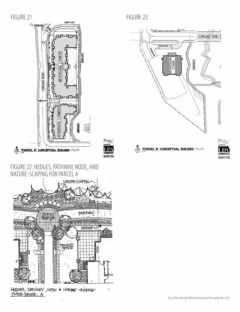
218 Appendix 2 – Development Permit Area Guidelines City of Port Moody Official Community Plan Bylaw No. 2955
FIGURE 21
FIGURE 22: HEDGES, PATHWAY, NODE, AND NATURE-SCAPING FOR PARCEL A
FIGURE 23

Appendix 2 – Development Permit Area Guidelines City of Port Moody Official Community Plan Bylaw No. 2955 219
FIGURE 24: CONCEPTUAL LANDSCAPE PLAN FOR PARCEL B
FIGURE 25 FIGURE 26: CONCEPTUAL LANDSCAPE PLAN (VILLAGE PLAZA PLAN), PARCEL C
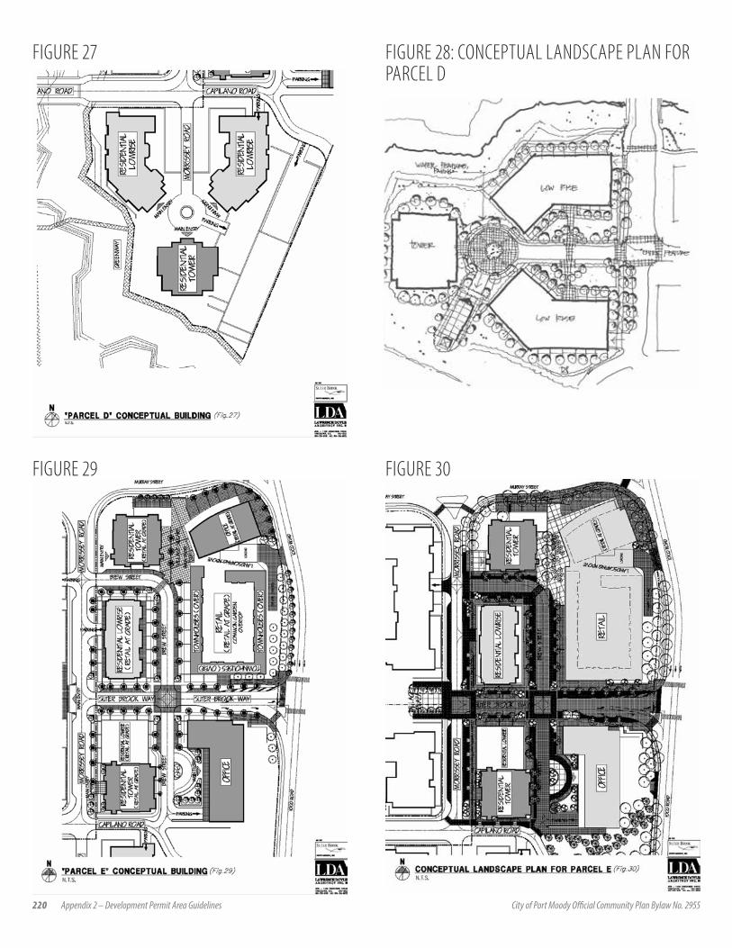
220 Appendix 2 – Development Permit Area Guidelines City of Port Moody Official Community Plan Bylaw No. 2955
FIGURE 27 FIGURE 28: CONCEPTUAL LANDSCAPE PLAN FOR PARCEL D
FIGURE 29 FIGURE 30
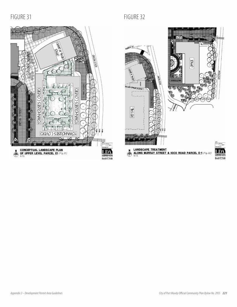
Appendix 2 – Development Permit Area Guidelines City of Port Moody Official Community Plan Bylaw No. 2955 221
FIGURE 31 FIGURE 32

222 Appendix 2 – Development Permit Area Guidelines City of Port Moody Official Community Plan Bylaw No. 2955
4.7.3 KLAHANIE DESIGN GUIDELINES
Prepared by Ramsay Worden Architects and Phillips Wouri Long Landscape Architects for Polygon Klahanie Development Ltd.
1.0 INTRODUCTION
1.1 INTENT OF GUIDELINES
The intent of these guidelines is to guide future development of the former IPSCO Inc. site (hereafter referred to as Klahanie) in general accordance with the Port Moody Official Community Plan and the CD-28 Zoning By-law. The guidelines will allow for variances to the CD-28 By-law and subdivision By-law through the Development Permit process. The guidelines will also facilitate the coordinated development of an identifiable, mixed-density, pedestrian-oriented residential development that is sympathetic to the surrounding community and environmental context while reinforcing the City’s vision for a vibrant Port Moody Inlet Centre.
A consistent design theme is to be used throughout the development integrating all architectural and landscape elements. An additional component throughout Klahanie will be the incorporation of public art. A policy and direction for this element will be determined in consultation with City Staff.
The design guidelines outline both general and specific requirements for achieving the desired character and form of development for Klahanie and are organized according to the following general categories:
• Street Network• Public Realm• Landscape• Building Form and Character
It is worth emphasizing that while the guidelines are separated into the above four categories, they are to be seen as an integrated and mutually supporting set of strategies. For example, achieving the desired village character is dependent upon (among other things) the creation of a fine-grained
network of streets and paths as well as the creation of a positive relationship between buildings, streets, and open spaces. It is anticipated that these guidelines be applied comprehensively to the site and involve coordination between various departments, agencies and specialists involved in developing the site as development proceeds.
2.0 DESIGN GUIDELINES
2.1 STREET NETWORK
An integrated road network will facilitate efficient local traffic flow on a primary Main Street and a series of private neighbourhood streets. Trees, sidewalks, on-street parking, traffic calming and building setbacks will define the majority of street edges and provide a pleasant envelope for local vehicular, bicycle and pedestrian traffic.
2.1.1 Hierarchy
The hierarchy of streets is designed to suit the specific travel functions of each street type and to maximize interconnectivity through the site. Local through-traffic is accommodated on the Main Street spine, which connects to Murray Street at the west and north edges of the site. A secondary public street will provide access to the Suterbrook site via Main Street at the Neighbourhood Square. A local (private) street network, consisting of the Private Loop and secondary townhouse access roads, provides access to the townhouse area north of Main Street.
2.1.2 Street Profiles
Murray StreetMurray Street upgrades will be consistent with the requirements of the Development Agreement regarding dimensions and landscaping. See additional notes on the landscape treatment in Section 2.3.3 Edges.
Murray StreetMain StreetSuterbrook ConnectorPrivate StreetsTownhouse Areas
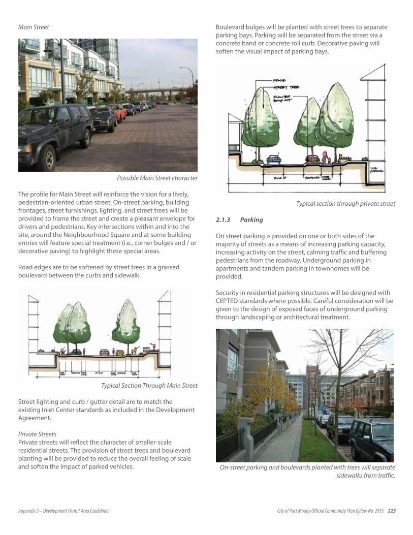
Appendix 2 – Development Permit Area Guidelines City of Port Moody Official Community Plan Bylaw No. 2955 223
Main Street
Possible Main Street character
The profile for Main Street will reinforce the vision for a lively, pedestrian-oriented urban street. On-street parking, building frontages, street furnishings, lighting, and street trees will be provided to frame the street and create a pleasant envelope for drivers and pedestrians. Key intersections within and into the site, around the Neighbourhood Square and at some building entries will feature special treatment (i.e., corner bulges and / or decorative paving) to highlight these special areas.
Road edges are to be softened by street trees in a grassed boulevard between the curbs and sidewalk.
Typical Section Through Main Street
Street lighting and curb / gutter detail are to match the existing Inlet Center standards as included in the Development Agreement.
Private StreetsPrivate streets will reflect the character of smaller-scale residential streets. The provision of street trees and boulevard planting will be provided to reduce the overall feeling of scale and soften the impact of parked vehicles.
Boulevard bulges will be planted with street trees to separate parking bays. Parking will be separated from the street via a concrete band or concrete roll curb. Decorative paving will soften the visual impact of parking bays.
Typical section through private street
2.1.3 Parking
On street parking is provided on one or both sides of the majority of streets as a means of increasing parking capacity, increasing activity on the street, calming traffic and buffering pedestrians from the roadway. Underground parking in apartments and tandem parking in townhomes will be provided.
Security in residential parking structures will be designed with CEPTED standards where possible. Careful consideration will be given to the design of exposed faces of underground parking through landscaping or architectural treatment.
On-street parking and boulevards planted with trees will separate sidewalks from traffic.
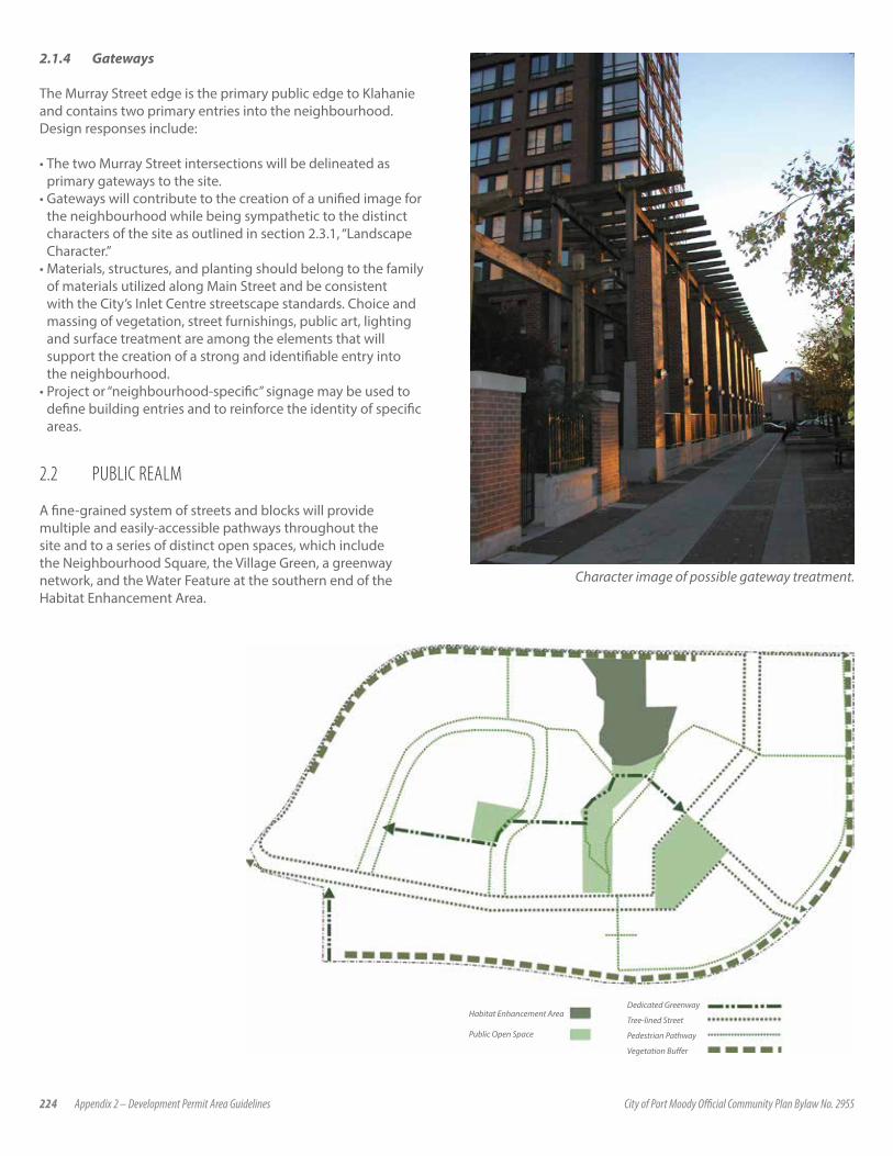
224 Appendix 2 – Development Permit Area Guidelines City of Port Moody Official Community Plan Bylaw No. 2955
2.1.4 Gateways
The Murray Street edge is the primary public edge to Klahanie and contains two primary entries into the neighbourhood. Design responses include:
• The two Murray Street intersections will be delineated as primary gateways to the site.
• Gateways will contribute to the creation of a unified image for the neighbourhood while being sympathetic to the distinct characters of the site as outlined in section 2.3.1, “Landscape Character.”
• Materials, structures, and planting should belong to the family of materials utilized along Main Street and be consistent with the City’s Inlet Centre streetscape standards. Choice and massing of vegetation, street furnishings, public art, lighting and surface treatment are among the elements that will support the creation of a strong and identifiable entry into the neighbourhood.
• Project or “neighbourhood-specific” signage may be used to define building entries and to reinforce the identity of specific areas.
2.2 PUBLIC REALM
A fine-grained system of streets and blocks will provide multiple and easily-accessible pathways throughout the site and to a series of distinct open spaces, which include the Neighbourhood Square, the Village Green, a greenway network, and the Water Feature at the southern end of the Habitat Enhancement Area.
Dedicated Greenway
Tree-lined Street
Pedestrian Pathway
Vegetation Buffer
Habitat Enhancement Area
Public Open Space
Character image of possible gateway treatment.
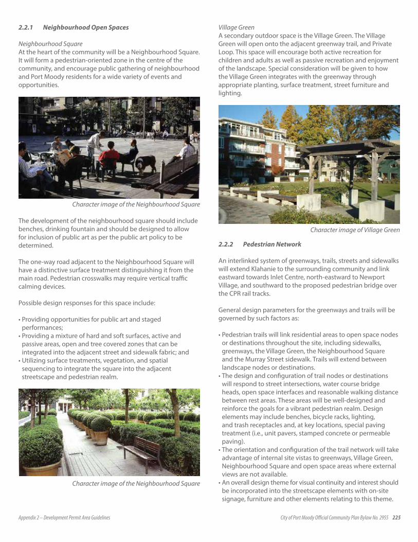
Appendix 2 – Development Permit Area Guidelines City of Port Moody Official Community Plan Bylaw No. 2955 225
2.2.1 Neighbourhood Open Spaces
Neighbourhood SquareAt the heart of the community will be a Neighbourhood Square. It will form a pedestrian-oriented zone in the centre of the community, and encourage public gathering of neighbourhood and Port Moody residents for a wide variety of events and opportunities.
Character image of the Neighbourhood Square
The development of the neighbourhood square should include benches, drinking fountain and should be designed to allow for inclusion of public art as per the public art policy to be determined.
The one-way road adjacent to the Neighbourhood Square will have a distinctive surface treatment distinguishing it from the main road. Pedestrian crosswalks may require vertical traffic calming devices.
Possible design responses for this space include:
• Providing opportunities for public art and staged performances;
• Providing a mixture of hard and soft surfaces, active and passive areas, open and tree covered zones that can be integrated into the adjacent street and sidewalk fabric; and
• Utilizing surface treatments, vegetation, and spatial sequencing to integrate the square into the adjacent streetscape and pedestrian realm.
Character image of the Neighbourhood Square
Village GreenA secondary outdoor space is the Village Green. The Village Green will open onto the adjacent greenway trail, and Private Loop. This space will encourage both active recreation for children and adults as well as passive recreation and enjoyment of the landscape. Special consideration will be given to how the Village Green integrates with the greenway through appropriate planting, surface treatment, street furniture and lighting.
Character image of Village Green
2.2.2 Pedestrian Network
An interlinked system of greenways, trails, streets and sidewalks will extend Klahanie to the surrounding community and link eastward towards Inlet Centre, north-eastward to Newport Village, and southward to the proposed pedestrian bridge over the CPR rail tracks.
General design parameters for the greenways and trails will be governed by such factors as:
• Pedestrian trails will link residential areas to open space nodes or destinations throughout the site, including sidewalks, greenways, the Village Green, the Neighbourhood Square and the Murray Street sidewalk. Trails will extend between landscape nodes or destinations.
• The design and configuration of trail nodes or destinations will respond to street intersections, water course bridge heads, open space interfaces and reasonable walking distance between rest areas. These areas will be well-designed and reinforce the goals for a vibrant pedestrian realm. Design elements may include benches, bicycle racks, lighting, and trash receptacles and, at key locations, special paving treatment (i.e., unit pavers, stamped concrete or permeable paving).
• The orientation and configuration of the trail network will take advantage of internal site vistas to greenways, Village Green, Neighbourhood Square and open space areas where external views are not available.
• An overall design theme for visual continuity and interest should be incorporated into the streetscape elements with on-site signage, furniture and other elements relating to this theme.

226 Appendix 2 – Development Permit Area Guidelines City of Port Moody Official Community Plan Bylaw No. 2955
2.2.3 Surface Materials and Structures
Surface materials will be chosen for their durability, ease of maintenance, accessibility, compatibility with stormwater management goals, and visual appeal. Some decorative paving materials will be used in the design of special areas, including the Neighbourhood Square, pedestrian and vehicular ways, pedestrian crossings, corner nodes and greenway / trail nodes. Repetition of surface material types is encouraged to enhance legibility of the public realm and to develop an overall cohesive image and identity for Klahanie. Consideration will be given to the use of pervious surface materials for pathways and sidewalks to permit the infiltration of stormwater.
Unit pavers allow infiltration of rain water
The use of continuous, impenetrable fencing is discouraged. Where used, vegetation and grading should screen solid walls / fences. Wood, stone and metal materials for fences that are sympathetic to building colors and materials are encouraged. The use of fences, other than those to separate private yards, will be limited or provided where needed for sound attenuation and security of incompatible non-residential uses and roads.
2.3 LANDSCAPE 2.3.1 Landscape Character
The overall landscape character will respond to the natural setting and strong sense of place evident in the neighbouring Pigeon Cove and Burrard Inlet. Two distinct but complementary landscape characters are emphasized.
The first character draws on the existing pioneer forest growth and vegetation on north and east periphery of the site. This existing condition provides the basis for the landscape character around the Habitat Enhancement Area, the Murray Street edge, the CPR ROW and the main Water Feature. The focus of this landscape treatment will be to provide a good integration to Shoreline Park across Murray Street and the Habitat Enhancement Area. Appropriate species selection, height, hierarchy, massing and configuration of vegetation will support this character. As per Naturescape principles, native vegetation or a site-appropriate alternative will be selected in order to enhance habitat value and promote biodiversity on the site.
The second character exemplifies the attributes of a vibrant urban neighbourhood. Key urban components of the Klahanie plan that reflect this character include the Neighbourhood Square, residential greenways, streets and residential parcels. Strategies for reinforcing this character include: using strong but simple forms and lines to delineate spaces; incorporating structures and materials that share similar design expression, color palette and materials to the surrounding architecture; and using vegetation to enrich spatial experience and enhance biodiversity.
Character image showing urban landscape treatment of an apart-ment area.

Appendix 2 – Development Permit Area Guidelines City of Port Moody Official Community Plan Bylaw No. 2955 227
Example of townhouse fronting on a constructed wetland
2.3.2 Site Grading
Landform will be used whenever possible to create natural site relief and interest and to respond to the need to delineate site edges and / or create visual buffers.
Landscape grading will be coordinated with the Stormwater Management Measures outlined in an approved Stormwater Management Plan. Where possible every effort should be made to encourage natural groundwater discharge into the water feature and HEA.
2.3.3 Edges
• Along Murray Street, consideration should be given to berming and mounding of landscape areas that have been disturbed to maximize potential for a residential buffer. The retention of existing vegetation should be maximized for acoustic and visual screening, particularly adjacent to townhouses.
• Berming along Main Street for acoustic and visual buffering should be designed so as not to completely block buildings from Murray Street, especially towards the eastern 1/3 of the Murray Street frontage where the creation of a more urban streetscape is desired.
• Where it interfaces with the Habitat Enhancement Area, the Murray Street edge should be designed to complement the character of the Habitat Enhancement Area and enhance the character of the public realm at neighbourhood entries.
• Edge treatment along the CPR ROW will address the need for acoustic and visual screening while incorporating, where possible, the retention and enhancement of existing vegetation.
• Landscape treatment of the greenway edges adjacent to townhouse and apartment areas will reinforce a village character. Landscape edges at Greenways will be consistent with diagrams found in the Development Agreement. The treatment of Greenways between different phases of the development will incorporate CPTED principles to ensure pedestrian safety.
• A variety of sound attenuation and screening strategies may be employed at the southern edge of the site along the CPR ROW. These may include the site sections found in the Development Agreement as well as additional strategies employing building walls, fences, berming, and vegetation. The design of this edge will be consistent with CPR Guidelines and will require the input of an acoustic consultant.
Image of townhouse edge and greenway that supports a village character.
2.3.4 Water Feature
The Water Feature is an important ecological component. Located at the south edge of the Habitat Enhancement Area, the feature will enhance the riparian area for biofiltration and infiltration. This amenity will improve water quality, contribute to groundwater recharge, and enhance fish habitat downstream of the site.
• Landscape treatment for the Water Feature and Greenway will ensure a continuous and uninterrupted trail system that links into the site and to surrounding locations, habitat enhancement being a prime consideration.
• Bridge crossings will ensure east-west connections to the Greenway and the pedestrian system.
• Naturescape principles will reinforce the existing planting palette and ensure a transition between the Water Feature and Habitat Enhancement Area planting.
• Interpretive signage consistent with the overall design theme, will be provided proximate to the Water Feature.
2.3.5 Sustainable Landscape Practices
Landscape practices are to complement and support the CD-28 Zoning and an approved Stormwater Management Plan.
• Preference should be given to permeable surfaces (i.e., unit pavers or crushed stone) for paths, patios, and pedestrian areas to allow water to infiltrate.
• Landscapes should be designed for low requirements for watering, energy used for maintenance and herbicide and pesticide use.
• Wherever possible, landscape development on private and public parcels will follow Naturescape Principles.
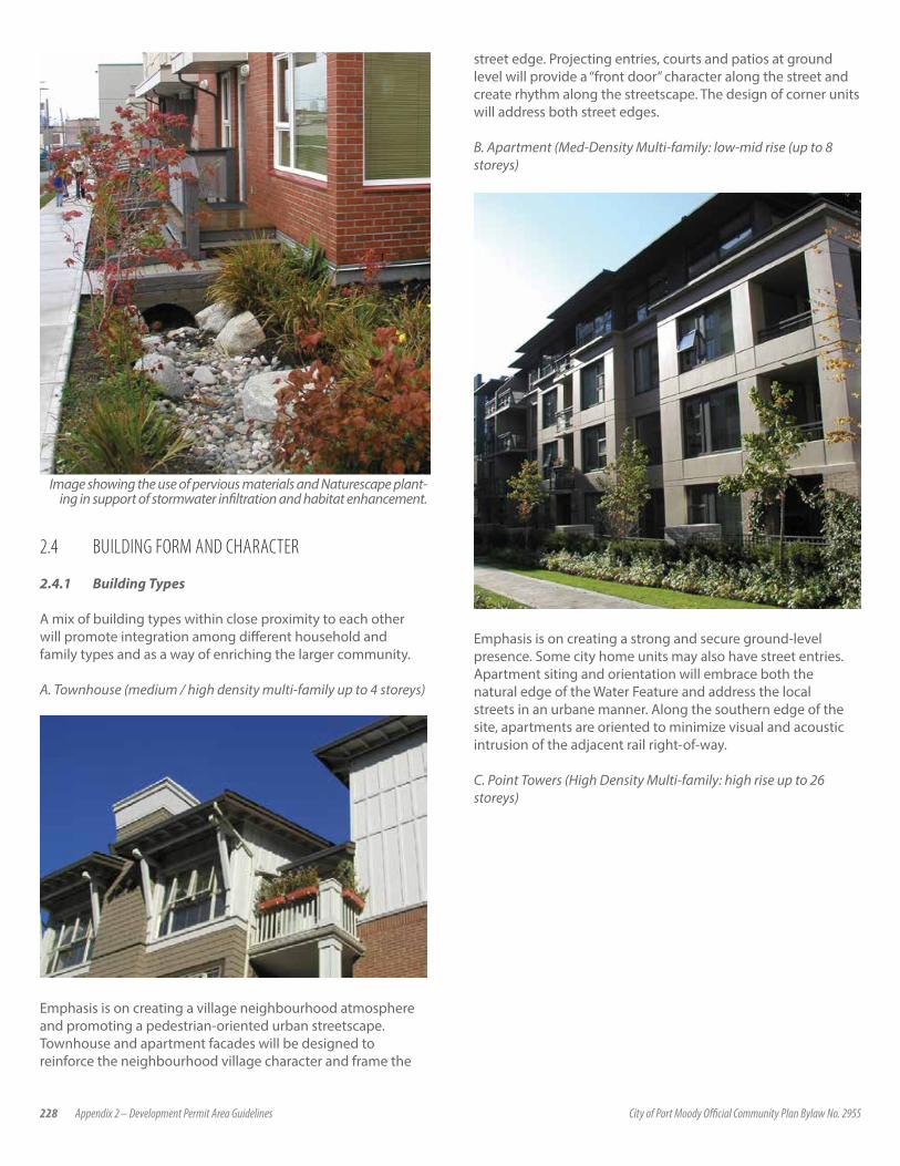
228 Appendix 2 – Development Permit Area Guidelines City of Port Moody Official Community Plan Bylaw No. 2955
Image showing the use of pervious materials and Naturescape plant-ing in support of stormwater infiltration and habitat enhancement.
2.4 BUILDING FORM AND CHARACTER
2.4.1 Building Types
A mix of building types within close proximity to each other will promote integration among different household and family types and as a way of enriching the larger community.
A. Townhouse (medium / high density multi-family up to 4 storeys)
Emphasis is on creating a village neighbourhood atmosphere and promoting a pedestrian-oriented urban streetscape. Townhouse and apartment facades will be designed to reinforce the neighbourhood village character and frame the
street edge. Projecting entries, courts and patios at ground level will provide a “front door” character along the street and create rhythm along the streetscape. The design of corner units will address both street edges.
B. Apartment (Med-Density Multi-family: low-mid rise (up to 8 storeys)
Emphasis is on creating a strong and secure ground-level presence. Some city home units may also have street entries. Apartment siting and orientation will embrace both the natural edge of the Water Feature and address the local streets in an urbane manner. Along the southern edge of the site, apartments are oriented to minimize visual and acoustic intrusion of the adjacent rail right-of-way.
C. Point Towers (High Density Multi-family: high rise up to 26 storeys)
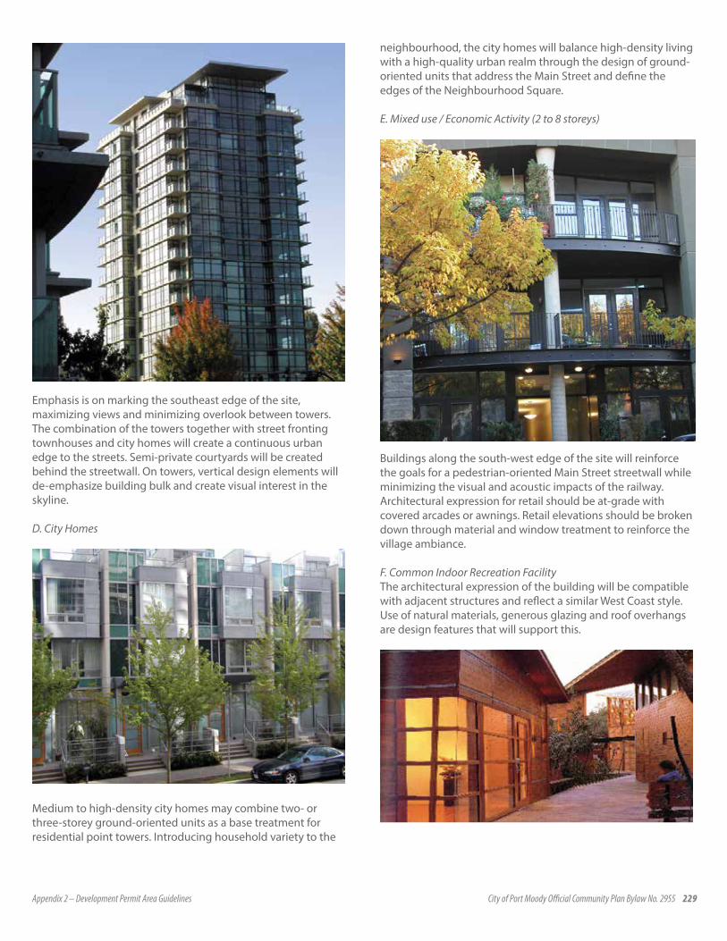
Appendix 2 – Development Permit Area Guidelines City of Port Moody Official Community Plan Bylaw No. 2955 229
Emphasis is on marking the southeast edge of the site, maximizing views and minimizing overlook between towers. The combination of the towers together with street fronting townhouses and city homes will create a continuous urban edge to the streets. Semi-private courtyards will be created behind the streetwall. On towers, vertical design elements will de-emphasize building bulk and create visual interest in the skyline.
D. City Homes
Medium to high-density city homes may combine two- or three-storey ground-oriented units as a base treatment for residential point towers. Introducing household variety to the
neighbourhood, the city homes will balance high-density living with a high-quality urban realm through the design of ground-oriented units that address the Main Street and define the edges of the Neighbourhood Square.
E. Mixed use / Economic Activity (2 to 8 storeys)
Buildings along the south-west edge of the site will reinforce the goals for a pedestrian-oriented Main Street streetwall while minimizing the visual and acoustic impacts of the railway. Architectural expression for retail should be at-grade with covered arcades or awnings. Retail elevations should be broken down through material and window treatment to reinforce the village ambiance.
F. Common Indoor Recreation Facility The architectural expression of the building will be compatible with adjacent structures and reflect a similar West Coast style. Use of natural materials, generous glazing and roof overhangs are design features that will support this.

230 Appendix 2 – Development Permit Area Guidelines City of Port Moody Official Community Plan Bylaw No. 2955
2.4.2 Siting and Orientation
Siting and orientation goals reflect the desire to create a village neighbourhood with strong visual and physical connections to open space networks and pedestrian-oriented streets. Access to views, links to natural areas and the pedestrian trail system, minimizing overshadowing and effectively buffering adjacent land uses feature strongly in this strategy.
2.4.3 Architectural Character
Within the context of a diverse composition of housing types is a desire for a unified and coherent architectural character, expressive of a Regional West Coast vernacular. The essential elements of this character are outlined below and on the facing page:
1. Massing and ArticulationThe west coast character is based on a strong horizontal expression which should be expressed through low roof lines, window patterns, and a horizontal layering of materials. Vertical breaks in the massing, particularly at the first 2 floor levels, will create a street rhythm and emphasize the individual expression of homes. Generous roof overhangs will be provided for weather protection and to reduce solar gain in Summer. Generous use of glazing will enhance daylight on grey days.
On point towers, vertical design elements, stepping at upper floors and the integration of rooftop elements into the architectural form will reduce building bulk and create interest in the skyline.
Examples of buildings with generous roof overhangs that provide shade and horizontal emphasis.
2. Colors and MaterialsExterior colors are to reflect local character, history and climate and to express a high level of craft in their construction. The palette will include the use of natural materials such as cedar shingles, brick and stone. Paint colors will reflect the natural landscape including greens, warm greys, rust red, and other rich natural tones. Manufactured products such as composite siding (e.g.: Hardie Plank) and vinyl siding will be used in combination with natural materials and will be applied with a high level of craftsmanship.
Example of West Coast architectural expression. Key elements include: generous roof overhangs, low sloping roofs, generous
glazing, the layering of materials, simple detailing, an emphasis on horizontal lines and the use of warm, natural colors.
3. Architectural DetailingThe Architectural details will reflect a tradition of the simple and careful expression of building elements, such as columns, roof overhangs, chimneys, railings etc.
Note: Sales offices housed in temporary buildings will reflect a similar Regional West Coast vernacular.

Appendix 2 – Development Permit Area Guidelines City of Port Moody Official Community Plan Bylaw No. 2955 231
2.4.4 Relationship of Buildings to Streets and Open Space
Setbacks
Streets will be clearly defined by the relationship between adjacent building massing and the street dimension. Further definition will come from the adjacent private and semi-public usable open space as outlined in the CD-28 zoning.
Building setbacks & landscaped edge define the pedestrian realm.
Example of a common greenway separated from private backyard space with low walls and planting.
Building Scale
Building setback and massing will be used to create the appropriate scale along the street edge. Within the base of the west tower, two- to three-storey city-homes will reinforce this human-scaled relationship along the edges of the Neighbourhood Square.
Gradation of Private and Public Space
The design of buildings will establish a clearly defined semi-private realm between the residential unit and the street, with several units having individual, front door access to the street. For townhome and city home units, front doors shall be recessed or framed with a porch, be either at-grade or elevated and be designed to provide a clear distinction between private and public space. Windows and balconies on upper floors shall relate to the street and provide “eyes on the street” for safety and security.
In townhouse and apartment areas, garden walls, fencing and hedging shall delineate the public realm and semi-private front (or rear) yards. These shall be kept low, and designed in a manner in keeping with the architectural character of the building.
Concrete, wood, brick, stone, or artificial equivalents, are acceptable materials for fences. Gates, lattices, trellises and / or arbors will be designed in a style consistent with the walls and fencing and complement the overall architectural character of the building.
Apartment units abutting the Water Feature may require special treatment of fences and hedging to ensure an appropriate transition between the natural riparian edge and private yard spaces. Choice and configuration of vegetation and fencing, and the placement of public pathways are important considerations in this strategy (see Landscape Guidelines).
2.4.5 Useable Outdoor Space
Entries
Building entries and private outdoor spaces should be designed to contribute to neighbourhood identity and enrich the public realm. Common building entries should face onto the street and be accessed directly from the sidewalk. The use of porticos, double-height atria and glazing will allow maximum light into these areas and welcome users. Private patios and courtyards will allow customization by residences through such means as vegetation, potted plants, and furnishings.
Porches, Balconies and Decks
Balustrades around balconies are to complement the architecture. Where outdoor spaces are terraced, consideration will be given to minimizing the extent of overlook from one patio to another (i.e., through the use of privacy screens).

232 Appendix 2 – Development Permit Area Guidelines City of Port Moody Official Community Plan Bylaw No. 2955
Balconies on apartment units and towers will be integrated harmoniously into the building massing. Architectural elements such as patio walls, fences and screens will be designed to integrate with the building massing and material and ensure privacy while providing visual access for surveillance and safety.
2.4.6 Signage
There will be a range of signage throughout Klahanie. Types of signage will include:
• Interpretive Signage will be located proximate to the Water Feature and Greenway signage will be designed to be unobtrusive, durable, engaging and scaled to appeal to pedestrians.
• The purpose of this signage will be public education and information.
Neighbourhood Specific Signage will be located prominently at entries to the development and will incorporate design and materials that complement the architecture of the development.
• Retail Signage will appeal to pedestrian and driver and add to the village ambience. Preference given to blade (hanging perpendicular to building face), banner and facia signs mounted on arcades spanning between columns.
Example of appropriate signage for retail frontages.
While the signage requirements are unique to each type they should be united with the overall site design and theme.
2.4.7 Energy Efficiency
Where possible, buildings will be designed to make use of passive energy conserving strategies which would include:• maximizing daylighting potential through carefully located
windows;• building orientation;• natural ventilation; and• passive solar heat gain.
Additional mechanical, electrical and building technology initiatives are to be considered. Among items for consideration include:
• the use daylight and occupancy sensors to reduce energy consumption in public areas; and
• the use of compact fluorescent fixtures for exterior lighting including landscape and interior lighting in common areas (hallways, lobbies, exit stairs).
2.4.8 Crime Prevention through Environmental Design
The consideration of appropriate safety and natural surveillance measures as per CPTED (Crime Prevention Through Environmental Design) principles are an important aspect of ensuring community liveability. While most safety and natural surveillance considerations are incorporated into various other sections of these guidelines, the following aspects warrant particular emphasis.
• Residential units shall face onto greenways, natural areas, neighbourhood parks, and streets, with primary living space having a clear view towards these areas.
• Wherever possible, balconies, terraces, and patios will provide “eyes” on greenways, open spaces and streets to enhance safety and security of these areas.
• Individual garages on townhouse units and parking garages shall be oriented so that they do not block the view of the street.
• All streets and pathways are to be well-lit and reflect visibility needs of motorized vehicles, pedestrians and cyclists.

Appendix 2 – Development Permit Area Guidelines City of Port Moody Official Community Plan Bylaw No. 2955 233
5.0 DEVELOPMENT PERMIT AREA 4: ENVIRONMENTALLY SENSITIVE AREAS
5.1 PURPOSE OF DESIGNATION CATEGORYPursuant to subsection 919.1(a) of the Local Government Act, the purpose of this designation is to protect the natural environment, its ecosystems and biological diversity.
5.2 JUSTIFICATIONAn Environmentally Sensitive Area (ESA) Management Strategy Phase 2: Development of Management Recommendations study completed in 2003 identifies areas of high and medium sensitivity and areas with special features. These identified areas make up the areas covered by Development Permit Area 4. These areas were identified for one or more of the following reasons:
• They are areas where Landscape Scale Management may be possible, including the consideration of Wildlife Corridors and Refuges.
• They are part of important Watersheds and Catchment Areas. • They are areas or sites with important Forest Ecosystems. • They contain:
• Watercourses and Riparian Areas • Lakes and Freshwater Wetlands • Intertidal and Subtidal Marine Areas
• They are areas or sites with important Rock Bluffs.• They provide critical habitat for Species At Risk (as identified
by the federal Species at Risk Act, the provincial Wildlife Act and COSEWIC (Committee on the Status of Endangered Wildlife in Canada).
A Development Permit will be required for all development and subdivision activity or building permits for:
• all areas designated as a High and Medium Environmentally Sensitive Areas
• all areas designated as a Special Feature Area• all areas within 30 metres (98.5 ft.) of the natural boundary of
Mossom Creek or Noons Creek • all areas that are determined to be a Streamside Protection
and Enhancement Area as defined by the City of Port Moody Zoning Bylaw 1988, No. 1890.
These areas are shown on Map 12 of the Official Community Plan and Schedule 3 of the DPA guidelines, however, there may be additional unmapped streams identified during the development review process that are not shown on this map. The Streamside Protection and Enhancement Area associated with any unmapped streams are required to comply with Section 4.0 Watercourses and Riparian Areas of the Environmentally Sensitive Area Development Permit Area Guidelines.
The objectives of this designation are to protect public safety and environmentally sensitive areas, as well as to provide natural amenity areas to the residents of the community. The areas being protected are also expected to promote the economic development of the City as they help create a unique environment. These objectives form the basis for a set of design guidelines to be applied to all properties within DPA 4.
5.3 GUIDELINES
5.3.1 LANDSCAPE SCALE MANAGEMENT AND WILDLIFE CORRIDORS Development Permits issued for areas where Landscape Scale Management and Wildlife Corridors contribute to a designation of High Sensitivity or Special Feature shall be generally in accordance with the following guidelines:
Protection of watercourses and riparian areas according to the Fisheries Act and Land Development Guidelines for the Protection of Aquatic Habitat, 1992.
(i) Protection of watercourses and riparian areas according to the Water Act.
(ii) Landscape level and biodiversity objectives outlined under the Forest Practices Code of BC Act and the Biodiversity Objectives Guidebook. Note: these apply to provincial forest lands only, not municipal or private lands. However, the principles and best management practices may be applicable to forested areas.
(iii) The use of native plant species and restricting the use of invasive plant species which could out compete native species, as outlined in the City’s Naturescape Policy.
(iv) Ensuring that proposed developments meet the requirements of the Tree Retention Bylaw No. 2425 and working with property owners to design “Tree Retention Areas” as outlined in the Tree Retention Bylaw No. 2425.
(v) Encouraging site plans that minimize fragmentation of large forest patches through careful siting of roads, infrastructure and other development.
(vi) Requiring the identification and protection of existing wildlife corridors to adjacent habitats include the existence of natural pathways (game trails), stream corridors, edge effects, natural landscaping enhancements, limitations on human access, and mitigation of intrusions such as roads.

234 Appendix 2 – Development Permit Area Guidelines City of Port Moody Official Community Plan Bylaw No. 2955
5.3.2 WATERSHED MANAGEMENT Development Permits issued for areas where Watershed Management contribute to a designation of High Sensitivity or Special Feature shall be generally in accordance with the following guidelines:
(i) Maintain as closely as possible, the natural predevelopment flow pattern and water quality in the receiving watercourse. This follows the Land Development Guidelines for the Protection of Aquatic Habitat, 1992. While the feasibility of implementing this guideline increases in proportion to the size of the development, a net improvement to the off-site run off rate for redevelopment sites is desirable. Achieving these improvements to run-off rates will require a coordinated approach for some streams that cross municipal boundaries.
(ii) All development must adhere to the requirements of the Water Act for works in and around a stream. For instream works, specific standards and best practices apply (see Instream Flow Guidelines for British Columbia). Proponents should contact the Provincial Government for specific regulations that apply.
(iii) The GVSDD Best Management Practices Guide for Stormwater should be consulted for specific non-structural, structural and operation and maintenance best management practices (BMPs).
(iv) Require a Sediment Control Plan according to Bylaw No. 2470 (Stream and Drainage System Protection Bylaw). The sediment control plan requires that suspended solids be controlled and treated from the construction site and that a monitoring program be implemented to measure the suspended solids in the run-off water discharged from the siltation control works.
(v) Require a comprehensive drainage plan for the site that incorporates BMPs for stormwater management.
(vi) Encourage developments to avoid or minimize impervious surfaces.
(vii) Encourage, where feasible, the permeability of grassed and landscaped areas by protecting native soil and preventing sold compaction during construction, aerating or loosening compacted soils, and incorporating soil admixtures to improve permeability. Treed or shrub plantings instead of grassed or paved areas are to be encouraged.
5.3.3 FOREST ECOSYSTEMS
The forested character of the City shall be maintained by preserving ravines and escarpments, wildlife habitat and corridors, and policies relating to tree retention, replanting and pre-planting in newly developed areas.
All new development and redevelopments within the City shall be evaluated to see if and how, parts of the lands under discussion can be used to develop or maintain urban forest values where considered appropriate. Development Permits issued for areas where Forest Ecosystems contribute to a designation of High Sensitivity or Special Feature shall be generally in accordance with the following guidelines:
(i) Wherever possible, the maintenance or enhancement of the ecological viability of the urban forest will be achieved, and in designing larger areas for tree retention, a minimum width of at least two tree heights shall be utilized as a basic guideline. Retention of a network of protected lands that will allow the urban forest to serve as connections to adjacent forested lands will be a priority.
(ii) In new residential neighbourhoods where tree clearing is necessary, a minimum of four replacement trees for an average sized lot shall be encouraged and for larger lots a greater number of trees may be required.
(iii) Wherever possible, private landowners shall be encouraged to retain trees that are not a hazard, and to replant trees that will match the existing forested character of the area.
(iv) Private lands that possess significant environmental, urban forest or recreational value shall be protected by covenant when associated with rezoning or subdivision applications. The City shall also encourage joint public and private ownership of such areas.
(v) Salvage replanting prior to clearing and development shall be encouraged.
(vi) Proposed developments shall meet the requirements of the Tree Retention Bylaw No. 2425 and the City shall work with property owners to design “Tree Retention Areas” as outlined in the Tree Retention Bylaw.
(vii) Site plans that locate buildings, infrastructure, and other development an adequate distance away (e.g. beyond the root zone) from core forest ecosystem areas in order to maintain tree and forest health shall be encouraged.
(viii) Construction activities, including excavation, soil compaction, placement of fill, equipment storage, cutting, or understory vegetation removal shall not be undertaken within the drip line of any tree (excluding street trees).
(ix) Second growth deciduous forests should not be considered undesirable relative to conifer dominated forests.
(x) Discourage the spread of invasive non-native species, including English ivy, giant knotweed, and periwinkle (Vinca minor) within forested areas, or on trees through the use of active control methods including hand clearing, pruning, mowing, excavation, and planting of appropriate native species.
Appendix 2 – Development Permit Area Guidelines City of Port Moody Official Community Plan Bylaw No. 2955 235
5.3.4 WATERCOURSES AND RIPARIAN ZONES A Development Permit is not required for the following activities:
(i) gardening and yard maintenance activities within an existing landscaped area, such as mowing lawns, pruning trees and shrubs, planting vegetation and minor soil disturbance that does not alter the general contours of the land;
(ii) the construction of a fence if no native trees are removed and the disturbance of native vegetation is restricted to 0.5 m on either side of the fence;
(iii) where existing agreement with the federal or provincial governments or covenants are in place and the proposed activities comply with the agreements or covenants;
(iv) the construction of a small accessory building such as a pump house, gazebo, garden shed, or playhouse if all of the following apply:
• the building is located within an existing landscaped areas • no native trees are removed • the building is located a minimum 5 m from the high
water mark of the stream• the total area of small accessory buildings is less than 10
square metres• compliance with building permits and zoning
requirements.
(v) The construction of a private trail if all of the following apply:
• The trail is 1 metre wide or less; • No native trees are removed; • The surface of the trail is pervious (for example soil, gravel
or wood chips); • The trail is designed to prevent soil erosion where slopes
occur; and• Where the trail parallels the stream, the trail is more than 5
m away from the high water mark of the stream;
(vi) Ecological restoration and enhancement projects undertaken or authorised by the Director of Planning and Development Services, or the Manager of Parks and Environmental Services;
(vii) Construction, maintenance or operation of:
• Municipal works and services undertaken or authorised by the City of Port Moody, and
• Parks works and services undertaken by Metro Vancouver;
(viii). Emergency actions required to prevent, control or reduce an immediate threat to human life, the natural environment or public or private property including:
• Forest fire, flood and erosion protection works; • Protection, repair or replacement of public utilities; • Clearing of an obstruction from a bridge, culvert or
stream; • Bridge repairs; and • Removal of hazardous trees as authorised by a certified
arborist or a qualified environmental professional.
Development Permits issued for areas where Watercourses and Riparian Zones contribute to a designation of High Sensitivity or Special Feature or within a Streamside Protection and Enhancement Area as defined in the City of Port Moody Zoning Bylaw shall be generally in accordance with the following guidelines:
(ix) All work in and around a watercourse or wetland shall be required to obtain the necessary approval from Fisheries and Oceans Canada under the Fisheries Act , shall comply with the laws, regulations and best management practices of the Water Act (e.g. for bank repairs, stormwater outfalls, road crossings and footbridges); and shall adhere to the Land Development Guidelines for the Protection of Aquatic Habitat, 1992.
(x) Any water management or other engineering structures that may affect fish habitat or populations should be designed to maintain or improve the fisheries values. New or rebuilt culverts should be fish passable.
(xi) All development must adhere to the requirements of the Water Act for works in and around a stream or wetland. For instream works, specific standards and best practices will apply as established by the BC Ministry of Environment. Where work is authorised, it must meet the conditions prescribed by these agencies, including adherence to any seasonal fisheries construction windows that are in effect at the time to protect fish habitat.
(xiii) Streamside Protection and Enhancement Areas (SPEA) must be maintained or improved to be consistent with the provisions of the Fish Protection Act, Streamside Protection Regulation and the City of Port Moody Zoning Bylaw 1988, No. 1890, which shall generally include:
236 Appendix 2 – Development Permit Area Guidelines City of Port Moody Official Community Plan Bylaw No. 2955
• Stabilization of streambanks• Shading of streams to moderate water temperatures• Providing leaf litter and insect drop for fish food • Sustaining the natural capture of runoff water to maintain
water quality • Maximizing infiltration and intercept precipitation to
moderate direct runoff contributions to stream flows • Providing logs, snags, and root wads to provide habitat
stream channels. • Planting of native vegetation (Naturescape compliant)
and removal of invasive non-native vegetation within the SPEA in accordance with an approved habitat restoration plan.
• Direct drainage of rainwater from developed areas into the Streamside Protection and Enhancement Area and watercourses is prohibited. Rainwater will be managed on site with a focus on infiltrating approaches to management.
(xiv) Maintain pre-development volumes, timing and rates of rainwater infiltration or recharge to groundwater systems, except where alterations restore or enhance natural regimes.
(xv) Minimize the extent of impervious areas covering groundwater infiltration areas and storm runoff associated with the riparian assessment area.
(xvi) Minimize alteration of the contours of the land outside the areas approved for buildings, structures, and site accesses by minimizing the deposit of fill and the removal of soil.
(xvii) Provision of a BCLS survey plan that identifies the top of bank of the stream, top of ravine bank and the SPEA boundary in relation to the property lines and existing and proposed development may be required.
(xviii) Install temporary fencing and signage to prevent encroachment into the SPEA during construction.
(xix) Where riparian corridor disturbances are unavoidable (e.g. repairs to municipal or other services), the disturbed areas shall be restored and replanted with native vegetation after the work has been completed in accordance with BC Ministry of Environment and Federal Department of Fisheries and Oceans requirements and/or guidelines.
(xx) City of Port Moody Zoning Bylaw setback requirements shall generally be followed.
(xxi) A daylighting feasibility study may be required for proposed developments that contain culverted sections of a watercourse that is fish-bearing or potentially fish-bearing with the removal of barriers.
(xxii) Trees in the SPEA shall be given stabilization treatments as necessary under supervision of a qualified arborist, to ensure a windfirm edge, such as by feathering, sail pruning, topping and removal of unsound trees. Trees in windward edge shall generally be located in deep soils and well-rooted, where possible. Windthrow assessment by a certified arborist will be required when proposed development/re-development is resulting in the removal of a significant number of trees.
(xxiii) Root zones for all protected or retained trees shall be identified and protected during construction in accordance with the Tree Retention Bylaw No. 2425.
(xxiv) Sediment and erosion control measures as outlined in the Land Development Guidelines for the Protection of Aquatic Habitat, Stream Stewardship: A Guide for Planners and Developers and City of Port Moody bylaws shall be implemented by developers to prevent the release of sediments into watercourses or wetlands.
(xxv) Vegetation barriers or post and rail fences shall generally be placed and maintained along all riparian or watercourse covenant boundaries to discourage human access. Vegetation within covenant/conservation area should remain undisturbed. Reforest unvegetated or sparsely vegetated riparian zones, where feasible.
(xxvi) Removal of invasive non-native vegetation within a SPEA in accordance with an approved habitat restoration plan may be required.
(xxvii) Trails within riparian corridors shall be located and constructed in such a manner as to avoid removing or damaging trees and minimizing vegetation loss. Trails should avoid steep or unstable slopes and other sensitive areas, and should not alter the natural drainage of the area. Trail widths should generally be kept to a maximum of 2 metres and stream crossings should be perpendicular to the channel. Motorcycles and all terrain vehicles should be prohibited unless trails are specifically designed for their use. Trail surface materials should be inert and clean. Wood waste materials (e.g. bark mulch or hogfuel), limestone and asphalt should be avoided for new trails in riparian corridors, where possible. Access planning and construction should be consistent with the management principles of published guidelines on this topic and respect the spirit of conservation for fish and wildlife purposes.
(xxviii) New mountain biking trails should be situated outside of the Streamside Protection and Enhancement Area (SPEA) as designated in the Port Moody Zoning Bylaw, where possible. Mountain bike trails within a SPEA require careful review and should follow Best Management Practices such as a Controlled Access Management Plan. The review of new and existing mountain bike trails in environmentally sensitive areas should include a review of the Mountain Biking Task Force Report (June 2008).
Appendix 2 – Development Permit Area Guidelines City of Port Moody Official Community Plan Bylaw No. 2955 237
5.3.5 LAKES AND FRESHWATER WETLANDS
Development Permits issued for areas where Lakes and Freshwater Wetlands contribute to a designation of High Sensitivity or Special Feature shall be generally in accordance with the following guidelines:
(i) All work in and around a watercourse must obtain any required federal approvals.
(ii) Adherence to the Land Development Guidelines for the Protection of Aquatic Habitat.
(iii) All development must adhere to the requirements of the Water Act for works in and around stream or wetland. For instream works, specific standards and best practices will apply as established by the BC Ministry of Environment. Where work is authorised, it must meet the conditions prescribed by these agencies, including adherence to any seasonal fisheries construction windows that are in effect at the time to protect fish habitat.
(iv) Streamside protection and enhancement areas must be maintained consistent with the provisions of the Fish Protection Act and Streamside Protection Regulation, which shall generally include:
• Stabilization of streambanks;• Shading of streams to moderate water temperatures;• Providing leaf litter and insect drop for fish food; • Sustaining the natural capture of runoff water to maintain
water quality; • Maximizing infiltration and intercept precipitation to
moderate direct runoff contributions to stream flows; and
• Providing logs, snags, and root wads to provide habitat stream channels.
(v) Proposed developments shall meet the requirements of the Tree Retention Bylaw No. 2425 and work with property owners to design “Tree Retention Areas” as outlined in the Tree Retention Bylaw.
(vi) The filling, dumping, cutting or removal of native vegetation, excavation, drainage, pumping, or the introduction of organic or inorganic contaminants within lakes and wetlands is prohibited. Habitat enhancement activities and public education may be permitted within wetlands provided that such efforts do not compromise the wetland ecosystem.
(vii) Trees in the wetland buffer shall be given stabilization treatments as necessary under supervision of a qualified arborist, to ensure windfirm edge, such as feathering, sail pruning, topping, and removal of unsound trees. Ensure, where possible that trees in windward edge are located in deep soils and well rooted. Windthrow assessment
by a certified arborist will be required when proposed development/re-development is resulting in the removal of a significant number of trees.
(viii) Land development activities shall be planned, designed, and implemented in a manner that will not adversely affect or disturb lakes and wetlands including:
• Wetland vegetation and structure• Rare or uncommon wetland plants or plant communities• Wildlife habitats such as breeding or nesting sites
(ix) Lakes and wetlands shall be buffered from development activities including roads, parking areas, structures, and related development with a set back from the outer extent of wetland soils or wetland soil vegetation.
(x) Limit access or design trails to minimize impacts to sensitive wetland areas that could be adversely impacted by human activity.
(xi) Trail, fencing, or landscape materials that would adversely affect wetlands, such as limestone, bark mulch, and certain types of preserved wood, shall be avoided.
(xii) The spread of exotic, invasive, wetland plants (e.g. purple loosestrife and reed canary grass, especially where they are competing with or excluding native species) shall be controlled.
5.3.6 INTERTIDAL AND SUBTIDAL MARINE ECOSYSTEMS
Development Permits issued for areas where Lakes Intertidal and Subtidal Marine Ecosystems contribute to a designation of High Sensitivity or Special Feature shall be generally in accordance with the following guidelines:
(i) Osprey nests and the structures that support them should be protected in compliance with the Wildlife Act.
(ii) Nests and structures that support the active nesting by birds should not be removed during the nesting season, March 1 to July 31, and in accordance with the Wildlife Act, and city policies including Bird Nesting Season: Tree and Brush Clearing.
238 Appendix 2 – Development Permit Area Guidelines City of Port Moody Official Community Plan Bylaw No. 2955
5.3.7 ROCK BLUFFS
Development Permits issued for areas where Rock Bluffs contribute to a designation of High Sensitivity or Special Feature shall be generally in accordance with the following guidelines:
(i) Assess rock bluffs that are known or suspected of supporting red and/or blue listed plants or animals as identified in the provincial Wildlife Act and the federal Species At Risk Act in accordance with the Terms of Reference for a Vegetation and Wildlife Bio-Inventory.
(ii) Careful site planning shall be required to avoid disturbance to rock bluffs, particularly those known to support sensitive plant or wildlife communities.
(iii) To control the introduction or spread of invasive species, active control methods such as hand clearing, pruning, mowing, excavation and re-planting with appropriate native species is required.
(iv) Restrict, where possible, recreational access into rock bluff areas to prevent damage to soils and vegetation. Elevated boardwalks, fences, railings, seasonal trail closures, re-routed trails and signed should be used to reduce related impacts.
5.3.8 SPECIES AT RISK
Species at risk include species, sub-species or populations that have been designated by COSEWIC (designated by the Committee on the Status of Endangered Wildlife in Canada); Red and Blue listed species identified under the provincial Wildlife Act; species identified under the federal Species At Risk Act or considered regionally important. Development Permits issued for areas where species at risk as noted above exist are designated as High Sensitivity or Special Feature and shall be generally in accordance with the following guidelines:
(i) Any development application in High and Medium ESAs shall require the developer to assemble a comprehensive and updated list of all COSEWIC and provincially designated Red and Blue listed species and ecological communities (including vertebrates, plants, plant communities, fish and invertebrates) that potentially might occur within the study area. This information should be obtained from all possible sources, including:
• A request to the Conservation Data Centre (BC Ministry of Environment) to identify records for occurrence of red or blue listed vegetation or animal species (www.env.gov.bc.ca/atrisk/ims.html).
• A review of other appropriate species and ecosystems occurrence data sources (see list of data sources at South Coast Conservation Program web site – www.sccp.ca – on the View Species and Habitat Data page).
• Communication with relevant Lower Mainland Ministry of Environment staff.
• Communication with relevant local and regional governments, university researchers, First Nations organizations, local naturalists and local herbaria.
• Further information sources include:
• COSEWIC, provincial and regional Status Reports, provincial Inventory Reports and provincial identified Wildlife Management Strategy species accounts
• Provincial or federal Recovery Strategies and Action Plans• Sensitive Ecosystems Inventory (SEI) information and
Species Inventory Data System (SPI)
(ii) Areas where red or blue listed plant, mammal, amphibian or reptile species are known or are likely to occur should be assessed in accordance with the Terms of Reference for a Vegetation and Wildlife Bio-Inventory by a biologist or other appropriate qualified professional, with documentation appropriate under the provincial Wildlife Act and the federal Species At Risk Act.
(iii) To facilitate monitoring of projects that might affect species and ecosystems at risk and to ensure that methods are considered credible, assessment results should be submitted to the Lower Mainland regional office of the Ministry of Environment.
(iv) Developers should survey the study area for all COSEWIC and provincially Red and Blue listed species and ecological communities identified as potentially occurring in the region and the study area in particular. Permits may be required for some survey procedures as specified in the B.C. Wildlife Act (www.env.gov.bc.ca/pasb/index.html) and/or federal Species at Risk Act (www.sararegistry.gc.ca/agreements/permits_e.cfm). Survey sampling must be conducted by a qualified environmental professional in accordance with any detailed standards recommended by the Ministry of Environment. Survey methods should be conducted at the appropriate time of year and adjusted to avoid incidental mortality of non-target species. Survey results should be submitted to the Lower Mainland regional office of the Ministry of Environment for review.
(v) To effectively avoid or mitigate impacts to species and ecosystems at risk (including individuals, residences and important habitats) developers should follow provincial best management practices guidelines that outline how development impacts can be mitigated in both terrestrial and aquatic environments (see www.env.gov.bc.ca/wld/BMP/bmpintro.html and the Guidelines page at www.sccp.ca). Mitigation strategies should be submitted to the Lower Mainland regional office of the Ministry of Environment for review.
(vi) Any development application in areas adjacent to sites where Red and Blue Listed Species exist must consider the potential impacts on these species and their habitat in accordance with the specific recovery plans identified under the federal Species At Risk Act.
Appendix 2 – Development Permit Area Guidelines City of Port Moody Official Community Plan Bylaw No. 2955 239
6.0 DEVELOPMENT PERMIT AREA 5: PROTECTION OF DEVELOPMENT FROM HAZARDOUS CONDITIONS
6.1 PURPOSE OF DESIGNATION CATEGORYPursuant to subsection 919.1(b) of the Local Government Act, the purpose of this designation is to protect development from hazardous conditions.
6.2 JUSTIFICATIONHazardous lands are considered to be areas of the City that may be subject to land slides, debris torrents, mud flows, earthquake liquefaction, erosion, or floods. Strict control of any development in these areas is necessary to protect development from hazardous conditions. In this respect, a development permit must be approved by Council prior to any development proceeding to verify site suitability and identify any necessary safeguards. Responsibility for the safety of any development and liability arising from that development continues to rest exclusively with the property owner and not the City.
Chapter 6 of the Official Community Plan describes certain natural conditions which pose above average hazard risks for development. These conditions include:
• Soils that may be susceptible to liquefaction in the event of an earthquake
• Risks of erosion and land slippage on the Harbour Heights escarpment
• Specific areas, mainly at the foot of the Chines hillside, at risk from flooding or debris flow during abnormal storm events.
The locations of the potentially hazardous lands in the City are shown on Maps 13 and 14 of the Official Community Plan and Maps 5-1 and 5-2 of the Development Permit Guidelines.
The objectives for Development Permit Area 5 are:
• To reduce the possibility of property damage, personal injury and death that may be associated with new development in areas at risk from certain natural hazards.
• To ensure that development applications in such areas include identification of specific risks and analysis of those risks at the subject site, prepared by a qualified professional engineer or professional geoscientist with demonstrated expertise and experience in geotechnical study and geohazard assessments.
• To ensure that appropriate conditions are set for such development so as to reduce the degree of risk.
These objectives provide the basis for guidelines which shall apply to certain types of development applications on sites falling within the boundaries of Development Permit Area 5.
6.3 APPLICATIONThe boundaries of Development Permit Area 5 (DPA 5), which addresses the protection of development from hazardous conditions, overlay portions of Development Permit Areas 1, 2 and 3, which address the form and character of development. Within these portions, where a development application requires a development permit, that development permit shall also deal with the DPA 5 guidelines, except as noted below. In some cases, development applications within DPA 5 may not require a development permit for form and character , but will still be subject to DPA 5 guidelines requiring submission of a geotechnical report to establish the feasibility of development in a safe manner. Such a report is required:
(a) in all cases where a development permit is required, except where the development permit is for minor alterations or additions to an existing building;
(b) in association with all subdivisions within DPA 5;
(c) in association with all applications for a new principal building, except where such new home is the replacement of an existing dwelling on the same site within the original building footprint, and no regrading of the site is involved (see Exemptions below for further details); and
(d) if the building inspector considers that construction would be on land that is subject to, or is likely subject to, flooding, mudflows, debris flows, debris torrents, erosion, land slip, rock falls, subsidence or avalanche, pursuant to s. 56 of the Community Charter.
6.4 EXEMPTIONSThe DPA 5 guidelines do not apply to the following kinds of
applications:
(a) interior renovations to existing buildings;
(b) minor exterior renovations to existing buildings including additions subject to review by the City’s building official;
(c) subdivision of a previously occupied building in accordance with the Strata Titles Act, provided that the building permit is limited to work included under (a) and (b) of the Exemptions;
(d) uninhabited accessory buildings of 10 m² (107 ft²) or less in size, where no excavation or filling is required;
(e) the development takes place within the existing building footprint; and

240 Appendix 2 – Development Permit Area Guidelines City of Port Moody Official Community Plan Bylaw No. 2955
(f ) emergency actions (such as flood protection, erosion protection, clearing of obstructions or removal of dangerous trees) required to prevent, control or reduce an immediate threat to life, to public property or private property.
6.5 REQUIREMENT FOR ADDITIONAL INFORMATIONAdditional inventory, assessment and planning requirements may be needed as part of an application for development within areas identified as hazardous lands. These requirements are outlined in specific regulations pertaining to the City’s Building Bylaw, Subdivision Servicing Bylaw, Tree Retention Bylaw, Streamside Protection and Enhancement Areas regulation and other requirements included in the Environmentally Sensitive Areas Development Permit Area 4 guidelines. These could include:
• An environmental assessment;• A grading plan;• A tree and vegetation plan;• A storm water management plan;• A sediment control plan.
6.6 GUIDELINES
6.6.1 EARTHQUAKE HAZARDS
(a) Geotechnical Report Submission
Where an applicable development application is made relating to lands identified as “Potentially Susceptible to Earthquake Soil Liquefaction” or “Harbour Heights Escarpment” on Map 13 of the Official Community Plan and Map 5-1 of the Development Permit Guidelines, consideration of the application will be subject to submission of a geotechnical report, prepared by a professional engineer or professional geoscientist with demonstrated expertise and experience in geotechnical study and geohazard assessments. Such report shall set out any conditions required to be met to enable safe use of the land for the intended purpose, provide an assessment of the potential risks in relation to the City’s accepted risk management framework and may make recommendations, as appropriate, related to:
(i) the siting, structural design and maintenance of buildings, structure or earthworks and their foundations;
(ii) the manner and specifications for any excavation or placement of fill and supervision thereof;
(iii) drainage during and after construction; (iv) an assessment of how the development, its grading,
and any recommended mitigative measures will affect the level of risk to other nearby properties;
(v) a construction management plan and a two year post construction monitoring plan to determine any ground subsidence or lateral movement that may occur; and
(vi) to determine any other pertinent conditions regarding the safe use of the land, buildings or structures.
Where such report is related to lands susceptible to earthquake liquefaction, it shall include the results of subsurface investigation.
The geotechnical engineering consultant is required to review the Engineering Department Geotechnical Report Library as part of the preparation of a geotechnical report.
(b) Submission of a Registerable Covenant
Approval of any application pursuant to section 6.6.1 (a) shall be subject to the submission of a registerable covenant in favour of the City and executed by the owner of the land, whereby the owner agrees to use the land only in accordance with the conditions of the approval and of the geotechnical report, and to save the City harmless from any damages as a result of the approval.
6.6.2 FLOOD AND DEBRIS FLOW HAZARD
(a) Geotechnical Report Submission
Where an applicable development application is made on lands shown as being subject to “Direct Debris Flow”, “Indirect Debris Flow”, “Flood”, or “Annual Flood Deficiencies” on Map 13 of the Official Community Plan and Map 5-1 of the Development Permit Guidelines, consideration of the application will be subject to the submission of a geotechnical report, prepared by a professional engineer or professional geoscientist with expertise and experience in geotechnical study and geohazard assessments, setting out:
(i) an identification and analysis of the specific risks on the subject site;
(ii) mitigative measures, if any, required to use the site safely for the intended use, including setting minimum elevation for habitable floor space; and
(iii) an assessment of how the development, its grading, and any recommended mitigative measures will affect the level of risk to other nearby properties within the context of the City’s accepted risk management framework.
The geotechnical engineering consultant is required to review the Engineering Department Geotechnical Report Library as part of the preparation of a geotechnical report.
Appendix 2 – Development Permit Area Guidelines City of Port Moody Official Community Plan Bylaw No. 2955 241
(b) Submission of a Registerable Covenant
Approval of any application pursuant to section 6.6.2 (a) shall be subject to submission of a registerable covenant in favour of the City and executed by the owner of the land, whereby the owner agrees to use the land only in accordance with the conditions of the approval and of the geotechnical report, and to save the City harmless from any damages as a result of the approval.
6.6.3 STEEP SLOPES
(a) Definition of Steep Slopes
Steep slopes are defined as lands in their natural state that have a slope angle of 20% (11°) or greater for a minimum horizontal distance of 10 metres. Map 14 of the Official Community Plan and Map 5-2 of the Development Permit Guidelines show those areas with slopes greater than 20%. More detailed slope analysis may be necessary in order to confirm site specific slope characteristics.
(b) Geotechnical Report Submission
Where an applicable development application is made on any site a substantial portion of which exceeds 20% (11°) slope, consideration of the application shall be subject to submission of a geotechnical report, prepared by a professional engineer or geoscientist with demonstrated expertise in geotechnical study and geohazard assessments, analyzing site conditions and setting conditions for the safe use of the site, including as appropriate:
(i) the results of slope stability analyses;(ii) presentation of hazards, consequences and risks
associated with the proposed development in a clear manner;
(iii) setbacks from the toe and crest of steeper slopes, for buildings, structures and fills;
(iv) prescriptions for the manner of excavation and placement of fill, and supervision thereof;
(v) the design, siting and maintenance of buildings, structures or works, including drainage and soil retaining works;
(vi) the maintenance or planting of vegetation; (vii) an assessment of how the development, its grading,
and any recommended mitigative measures will affect the level of risk to other nearby properties within the context of the City’s accepted risk management framework;
(viii) a construction management plan and a two year post construction monitoring plan to determine any ground subsidence or lateral movement that may occur; and
(ix) any other pertinent conditions.
(c) Where a geotechnical report is required pursuant to section 6.6.3 (b), no clearing of vegetation and no construction of earthworks shall be undertaken for the proposed development before development plans have been approved by the City.
(d) Development on steep slopes shall take place in a manner which maximizes the retention of existing vegetation.
(e) Slope stability shall be addressed such that there is no net decrease in slope stability resulting from the proposed development.
(f ) The geotechnical engineering consultant is required to review the Engineering Department Geotechnical Report Library as part of the preparation of a geotechnical report.
(g) Where a proposed development is in the vicinity of a watercourse, requirements included under the Fish Protection Act, Streamside Protection Regulation and the City of Port Moody Zoning Bylaw 1988, No. 1890 may also be in effect.
(h) Submission of a Registerable Covenant
Approval of any application pursuant to section 6.6.3 (b) – (g) shall be subject to submission of an registerable covenant in favour of the City and executed by the owner of the land, whereby the owner agrees to use the land only in accordance with the conditions of the approval and of the geotechnical report, and to save the City harmless from any damages as a result of the approval.
7.0 DEVELOPMENT PERMIT AREA 7: DETACHED ACCESSORY DWELLING UNIT INTENSIVE RESIDENTIAL DEVELOPMENT
7.1 PURPOSE OF DESIGNATION CATEGORYPursuant to subsection 488(1)(e) of the Local Government Act, the purpose of this designation is to establish objectives for the form and character of detached accessory dwelling units as a form of intensive residential development.
7.1.1 DEVELOPMENT STANDARDS
Specific standards for development have been established in the City of Port Moody zoning and subdivision bylaws and through other pertinent development controls. Reference should be made to City bylaws in all cases.

242 Appendix 2 – Development Permit Area Guidelines City of Port Moody Official Community Plan Bylaw No. 2955
7.1.2 PURPOSE
The purpose of the Detached Accessory Dwelling Unit Intensive Residential DPA Guidelines is to guide the form and character of detached accessory dwelling units (laneway housing), where this form of residential development is permitted in the City of Port Moody. Prior to construction of new detached accessory dwelling units, an owner of a property subject to DPA 7 must apply to the City for a development permit.
7.1.3 OBJECTIVES
The City’s OCP has a vision of creating a complete community that includes increasing density and the diversity of housing across the City. The objectives of these guidelines are to:
• respect the scale and form of neighbouring properties • ensure that the established neighbourhood character
serves as inspiration for new development• enhance and animate the lane and adjacent streets to
encourage pedestrian orientation• respect prominent trees and landscape features • incorporate security and privacy into neighbourly
development• incorporate sustainable design that is site-sensitive,
long-lasting, and efficient.
7.1.4 APPLICATION
As a form of intensive residential development, the development of detached accessory dwelling units requires careful application and design to ensure that new development respects the character of the neighbourhood and adjacent properties while also creating an attractive, livable environment. These guidelines apply to all detached accessory dwelling unit forms of development.
7.1.5 FORM AND CHARACTER OF DEVELOPMENT
(a) Accessibility and Access
Detached Accessory Dwelling Units are encouraged to be adaptable and accessible to the current and future needs of residents and encourage aging in place (refer to the BC Building Code Adaptable Housing Standards). Where possible, a minimum 1.0m (3.28 ft) emergency and pedestrian access pathway should be provided which connects the sidewalk or roadway at the front of the property and the rear lane to the front entrance of the Detached Accessory Dwelling Unit.
The access pathway should be constructed with permeable materials, adequately lit, and unobstructed from shrubs, trees, fences, or other structures.
(b) Architectural Elements
The design of the Detached Accessory Dwelling Unit should be secondary in character and respectful of and complementary to the principal building.
Architectural elements are encouraged in the building façade to enhance residential use facing the lane and minimize the visual impact of garage doors.
Designs that enhance existing neighbourhoods are encouraged, including heritage character.
Building products should demonstrate sustainability principles with high-quality design and detailing.
Incorporating skylights, clerestory windows, and/or obscured glazing into the building design is encouraged to promote natural lighting and maintain privacy. Light fixtures should complement the architecture and landscape design.
Roof designs should be respectful and sympathetic to the roof of the principal building on the lot.
Entrances are encouraged to be recessed or set back into the building envelope, should be designed to provide weather protection, and include such features as front porches and/or verandas.
(c) Corner Lots
On corner lots, design elements and residential features should establish the flanking street as the main entrance/public side of the detached accessory dwelling unit by incorporating front doors, porches, and gardens into the design.
On corner lots, parking is encouraged off the lane towards the interior side yard. For corner lots with no lane access, parking should be in the rear yard with access via the driveway from the flanking street.
On corner lots, transition in the massing is encouraged by increasing the scale from the interior side property line to the flanking street.
(d) Exterior Lighting
The address/unit identity should be clearly visible from the street and illuminated at night.
Lighting should be neighbour-friendly and avoid glare into the outdoor or indoor space of neighbouring properties or the principal residence.
Lighting within eaves should be restricted to the façade facing a lane or exterior side yard.
Appendix 2 – Development Permit Area Guidelines City of Port Moody Official Community Plan Bylaw No. 2955 243
Motion sensor lights are discouraged. Energy efficient LED, non-glare, down cast photocells are encouraged.
(e) Exterior Stairs
Stairs to a second storey must be enclosed within the building and not be constructed outside the Detached Accessory Dwelling Unit. Exterior stairs should only be designed at the main entrance.
(f) Sloping Sites
Detached accessory dwelling units located on sloping sites should adapt the scale, massing, and location to follow the topography and natural features of the site and respect the views and privacy of adjacent properties.
Creative solutions for optimizing development on sloping sites are strongly encouraged.
(g) Privacy, Overlook, and Orientation
The design, siting, and orientation of windows, balconies, patios, and decks should provide for visual privacy between adjoining properties. Upper-level massing and primary outlook should be directed towards the lane.
Minimizing the amount of shadow cast on the private outdoor open space of adjacent properties and the principal building is encouraged to maintain solar access. The creation of visual interest by providing variation in height and massing within design is encouraged to promote visual interest and privacy.
Habitable space at grade which is oriented towards the lane is encouraged to mitigate potential privacy and overlook concerns onto the principal building and neighbouring properties.
To minimize overviewing and to protect the privacy of both neighbours and tenants of the detached accessory dwelling unit, the size and placement of windows should be designed and located to be sensitive to adjacent properties, buildings, and topography.
(h) Green Building Initiatives
The integration of passive design into the architecture and landscape design is encouraged.
7.1.6 LANDSCAPING
(a) Outdoor Space
The outdoor living area should be defined and screened for privacy through the use of hard and soft landscaping, including plantings, architectural elements such as trellises, low fencing, or planters, and changes in grade or elevation where appropriate.
Space between a detached accessory dwelling unit and the rear property line should be enhanced by incorporating low-maintenance soft landscaping and/or high-quality permeable paving materials.
Screening and landscaping between the street and the outdoor space should be incorporated to define the transition between public and private spaces. Side yard spaces should be landscaped using permeable surfaces and drought resistant plant materials.
To optimize function and livability of the space between the detached accessory dwelling unit and the principal house, a combination of hard and soft landscaping, including trees, is recommended.
Detached accessory dwelling units should be located and designed to preserve and retain existing trees.
A minimum of 9.3m2 (100 ft2) of permeable private outdoor space for exclusive use of the detached accessory dwelling unit tenants should be provided which is separate and distinct from the principal dwelling.
The private outdoor space should be directly accessible from the Detached Accessory Dwelling Unit and be screened and/or landscaped to maximize privacy.
Balconies and decks should be appropriately screened and oriented to face the lane in order to provide privacy and minimize overlook onto neighbouring buildings and properties.
(b) Parking
Driveways should be constructed with permeable materials and be no more than 4.5m (14.7 ft) in width. Parking must be provided in the rear yard of the lot with direct access from an open lane.
Uncovered parking space should be screened with landscaping or fencing. Permeable pavers, gravel, grass-crete, or impermeable wheel paths surrounded by gravel or ground cover planting are encouraged.
Parking for corner sites should be oriented to the interior side yard. An open parking space for a Detached Accessory Dwelling Unit should be screened with landscaping or fencing.
(c) Rainwater Management
Natural rainwater filtration is encouraged through the use of permeable materials on site, including pathways, patios, and parking areas. The installation of water retention components such as rain collection systems, rain gardens, or bio-swales to facilitate rainwater filtration is encouraged.

244 Appendix 2 – Development Permit Area Guidelines City of Port Moody Official Community Plan Bylaw No. 2955
SCHEDULE 1: DEVELOPMENT PERMIT AREAS 1, 2, 3 AND HERITAGE CONSERVATION AREAS
I N
L E
T
B U R N A B Y
B U
R R
A R
D
B E
L C
A R
R A
SA
SA
MA
T
LAK
E
C O
Q U
I T
L A
M
C O Q U I T L A M
A N
M O
R E
MA
P 1
Prod
uced
by
Eng
inee
ring
& P
arks
Plo
t Dat
e:
The
City
of P
ort M
oody
mak
es n
o re
pres
enta
tion
or w
arra
nty
expr
esse
d or
impl
ied
with
resp
ect t
o th
e ac
cura
cy, c
ompl
eten
ess o
rap
prop
riate
ness
of t
he in
form
atio
n co
ntai
ned
here
on.
Dev
elop
men
t Per
mit
Are
a 1
Dev
elop
men
t Per
mit
Are
a 2
Dev
elop
men
t Per
mit
Are
a 3
Nor
th S
hore
Dev
elop
men
t Are
a(S
ectio
n 28
6 A
gree
men
t Are
a)
Mun
icip
al B
ound
ary
*Not
e:S
ee M
ap 1
3 (E
nviro
nmen
tally
Sen
sitiv
e A
reas
) for
Dev
elop
men
t Per
mit
Are
a 4,
Map
14 (H
azar
dous
Lan
ds) a
nd M
ap 1
5 (S
teep
Slo
pes)
for D
evel
opm
ent P
erm
it A
rea
5 .
Her
itage
Con
serv
atio
n A
rea
- Ioc
o
10-A
pr-2
017
N
Stre
am /
Cre
ek
Cul
vert
Ditc
h
Oth
er W
ater
Fea
ture
s
NO
TE: T
he s
tream
/cre
ek, c
ulve
rts, d
itche
s,an
d ot
her w
ater
feat
ures
sho
wn
on th
ism
ap s
hall
be u
sed
only
as
a gu
idel
ine.
Her
itage
Con
serv
atio
n A
rea
- Moo
dy C
entre
DEV
ELO
PMEN
T PE
RM
IT A
REA
S 1,
2 &
3A
ND
HER
ITA
GE
CO
NSE
RV
ATI
ON
AR
EAS

Appendix 2 – Development Permit Area Guidelines City of Port Moody Official Community Plan Bylaw No. 2955 245
SCHEDULE 2: SUB AREAS OF DEVELOPMENT PERMIT AREA 2: MOODY CENTRE
I N
L E
TB
U R
R A
R D
C O
Q U
I T
L A
M
N
Prod
uced
by
Eng
inee
ring
& P
arks
Plo
t Dat
e:
The
City
of P
ort M
oody
mak
es n
o re
pres
enta
tion
or w
arra
nty
expr
esse
d or
impl
ied w
ith re
spec
t to
the
accu
racy
, com
plet
enes
s or
appr
opria
tene
ss o
f the
info
rmat
ion
cont
ained
her
eon.
MA
P 2
SUB
AR
EAS
OF
DEV
ELO
PMEN
T PE
RM
IT A
REA
2 :
MO
OD
Y C
ENTR
E
Mun
icip
al B
ound
ary
Moo
dy C
entre
Her
itage
Cha
ract
er A
rea
Moo
dy C
entre
Her
itage
Con
serv
atio
n A
rea
14-F
eb-2
014
Stre
am /
Cre
ek
Cul
vert
Ditc
h
Oth
er W
ater
Fea
ture
s
NO
TE: T
he s
tream
/cre
ek, c
ulve
rts, d
itche
s,an
d ot
her w
ater
feat
ures
sho
wn
on th
ism
ap s
hall
be u
sed
only
as
a gu
idel
ine.

246 Appendix 2 – Development Permit Area Guidelines City of Port Moody Official Community Plan Bylaw No. 2955
SCHEDULE 3: DEVELOPMENT PERMIT AREA 4: ENVIRONMENTALLY SENSITIVE AREAS
I N
L E
T
C O
Q U
I T
L A
M
B U R N A B Y
C O Q U I T L A M
A N
M O
R E
B U
R R
A R
D
LAK
E
B E
L C
A R
R A
SA
SA
MA
T
LAK
E
N
Prod
uced
by
Eng
inee
ring
& P
arks
Plo
t Sca
le:
The
City
of P
ort M
oody
mak
es n
o re
pres
enta
tion
or w
arra
nty
expr
esse
d or
impl
ied w
ith re
spec
t to
the
accu
racy
, com
plet
enes
s or
appr
opria
tene
ss o
f the
info
rmat
ion
cont
ained
her
eon.
Mun
icip
al B
ound
ary
Den
otes
Lan
d S
ubje
ct to
Pre
viou
sly
App
rove
d
Hig
h
Env
ironm
enta
lly S
ensi
tive
Are
as
Stre
am /
Cre
ek
Cul
vert
Low
30 m
Stre
am B
uffe
r
Med
ium
(ES
A V
alue
- H
igh)
Ditc
h
Oth
er W
ater
Fea
ture
s
Spe
cial
Fea
ture
Dev
elop
men
t Agr
eem
ents
and
/ or
Stre
amS
etba
ck R
equi
rem
ents
MA
P 3
DEV
ELO
PMEN
T PE
RM
IT A
REA
4:
ENV
IRO
NM
ENTA
LLY
SEN
SITI
VE
AR
EAS
14-F
eb-2
014
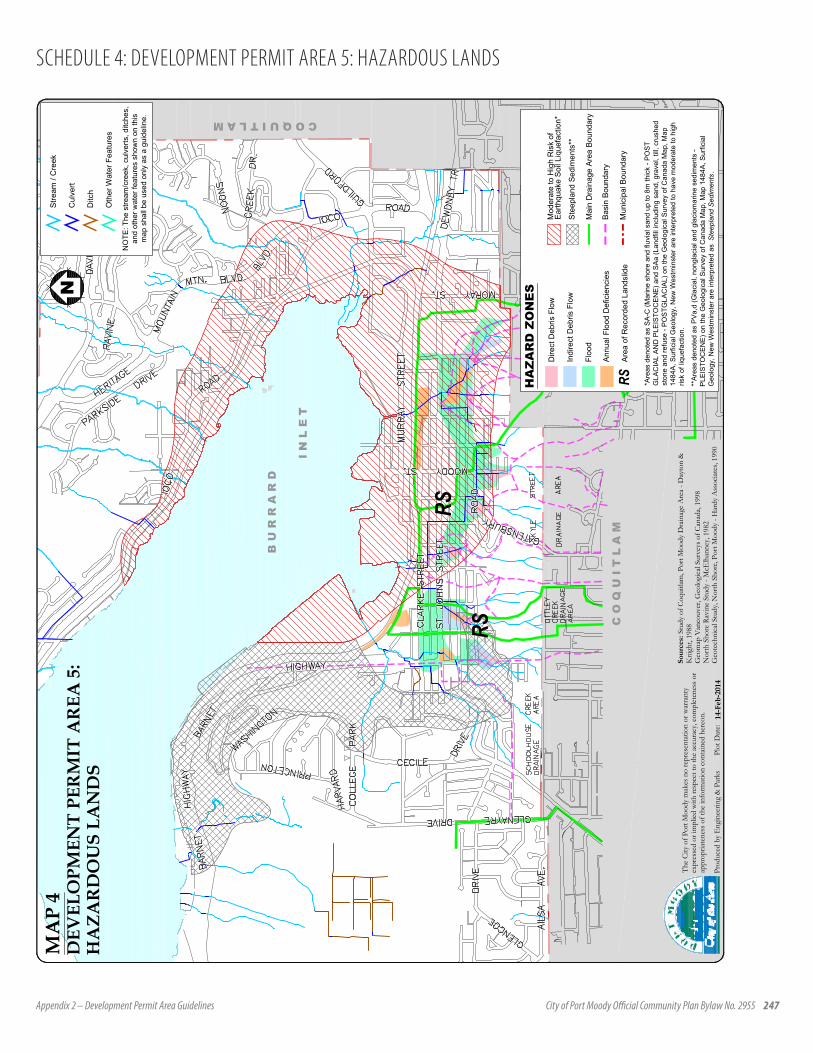
Appendix 2 – Development Permit Area Guidelines City of Port Moody Official Community Plan Bylaw No. 2955 247
SCHEDULE 4: DEVELOPMENT PERMIT AREA 5: HAZARDOUS LANDS
RSRS
I N
L E
T
B U
R R
A R
D
C O Q U I T L A MC O Q U I T L A M
C O
Q U
I T
L A
M
Prod
uced
by
Eng
inee
ring
& P
arks
Plo
t Dat
e:
The
City
of P
ort M
oody
mak
es n
o re
pres
enta
tion
or w
arra
nty
expr
esse
d or
impl
ied w
ith re
spec
t to
the
accu
racy
, com
plet
enes
s or
appr
opria
tene
ss o
f the
info
rmat
ion
cont
ained
her
eon.
Sour
ces:
Stu
dy o
f Coq
uitla
m, P
ort M
oody
Dra
inag
e A
rea
- Day
ton
&K
nigh
t, 19
88G
eom
ap V
anco
uver
, Geo
logi
cal S
urve
ys o
f Can
ada,
1998
Nor
th S
hore
Rav
ine
Stud
y - M
cElh
anne
y, 19
82G
eote
chni
cal S
tudy
, Nor
th S
hore
, Por
t Moo
dy -
Har
dy A
ssoc
iates
, 199
0
MA
P 4
DEV
ELO
PMEN
T PE
RM
IT A
REA
5:
HA
ZAR
DO
US
LAN
DS
14-F
eb-2
014
NS
tream
/ C
reek
Cul
vert
Ditc
h
Oth
er W
ater
Fea
ture
s
NO
TE: T
he s
tream
/cre
ek, c
ulve
rts, d
itche
s,an
d ot
her w
ater
feat
ures
sho
wn
on th
ism
ap s
hall
be u
sed
only
as
a gu
idel
ine.
Dire
ct D
ebris
Flo
w
Indi
rect
Deb
ris F
low
Floo
d
Ann
ual F
lood
Def
icie
ncie
s
Mun
icip
al B
ound
ary
Mai
n D
rain
age
Are
a B
ound
ary
Bas
in B
ound
ary
HA
ZA
RD
ZO
NE
SM
oder
ate
to H
igh
Ris
k of
Ste
epla
nd S
edim
ents
**
Ear
thqu
ake
Soi
l Liq
uefa
ctio
n*
*Are
as d
enot
ed a
s S
A-C
(Mar
ine
shor
e an
d flu
vial
san
d up
to 8
m th
ick
- PO
ST
GLA
CIA
L A
ND
PLE
ISTO
CE
NE
) and
SA
a (L
andf
ill in
clud
ing
sand
, gra
vel,
till,
crus
hed
ston
e an
d re
fuse
- P
OS
TGLA
CIA
L) o
n th
e G
eolo
gica
l Sur
vey
of C
anad
a M
ap, M
ap14
84A
, Sur
ficia
l Geo
logy
, New
Wes
tmin
ster
are
inte
rpre
ted
to h
ave
mod
erat
e to
hig
hris
k of
liqu
efac
tion.
**A
reas
den
oted
as
PV
a,d
(Gla
cial
, non
glac
ial a
nd g
laci
omar
ine
sedi
men
ts -
PLE
ISTO
CE
NE
) on
the
Geo
logi
cal S
urve
y of
Can
ada
Map
, Map
148
4A, S
urfic
ial
Geo
logy
, New
Wes
tmin
ster
are
inte
rpre
ted
as S
teep
land
Sed
imen
ts.
RSA
rea
of R
ecor
ded
Land
slid
e
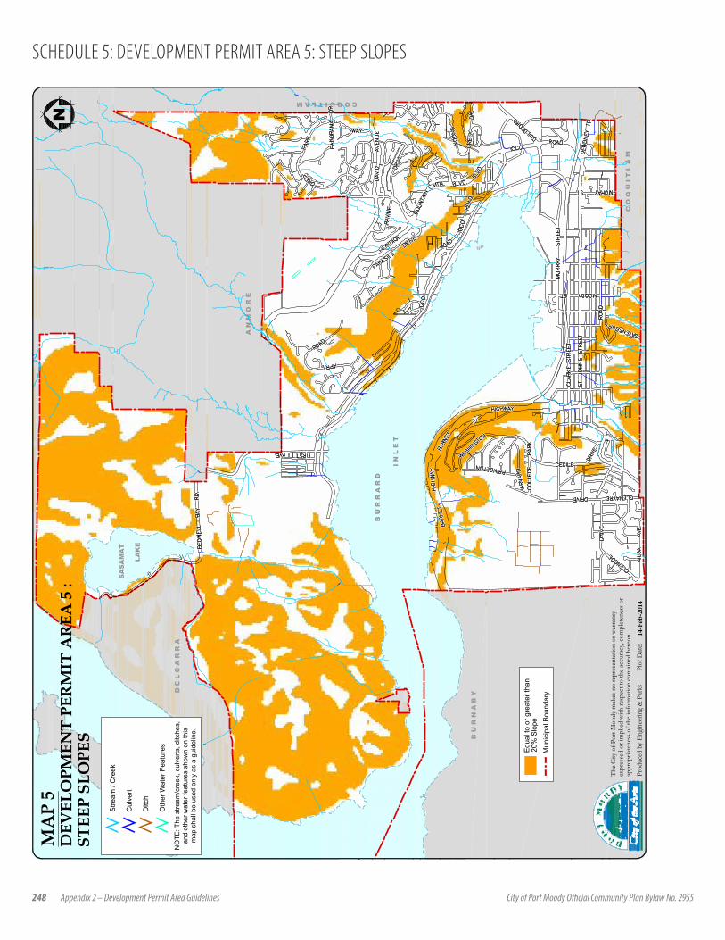
248 Appendix 2 – Development Permit Area Guidelines City of Port Moody Official Community Plan Bylaw No. 2955
SCHEDULE 5: DEVELOPMENT PERMIT AREA 5: STEEP SLOPES
I N
L E
T
C O
Q U
I T
L A
M
B U
R N
A B
Y
C O Q U I T L A M
A N
M O
R E
B U
R R
A R
D
B E
L C
A R
R A
SA
SA
MA
T
LAK
E
N
Prod
uced
by
Eng
inee
ring
& P
arks
Plo
t Dat
e:
The
City
of P
ort M
oody
mak
es n
o re
pres
enta
tion
or w
arra
nty
expr
esse
d or
impl
ied w
ith re
spec
t to
the
accu
racy
, com
plet
enes
s or
appr
opria
tene
ss o
f the
info
rmat
ion
cont
ained
her
eon.
20%
Slo
pe
Mun
icip
al B
ound
ary
Equ
al to
or g
reat
er th
an
MA
P 5
DEV
ELO
PMEN
T PE
RM
IT A
REA
5 :
STEE
P SL
OPE
S
14-F
eb-2
014
Stre
am /
Cre
ek
Cul
vert
Ditc
h
Oth
er W
ater
Fea
ture
s
NO
TE: T
he s
tream
/cre
ek, c
ulve
rts, d
itche
s,an
d ot
her w
ater
feat
ures
sho
wn
on th
ism
ap s
hall
be u
sed
only
as
a gu
idel
ine.