Embed Size (px)
Citation preview

AP Human Geography – Summer Assignment
AP Human Geography is a college-level course that requires analytical skills of the impact that
geography plays in our ever-changing world. Beyond learning the locations of physical and political
features, this course focuses on the interactions between humans and their environment. As a
prerequisite to this course, it is imperative you enter the class with an understanding of basic
geographic knowledge and skills. Through your summer assignment, you will be introduced to the
basics of Human Geography and a much-needed understanding of where on Earth things are located.
Part I: Human Geography Article Reviews
Using reliable Human Geography resources, select 14 articles relating to each chapter of the selected
textbook we will use in class. Read each article you select and complete an article summary. The
chapter topics include:
Ch. 1: Thinking Geographically
Ch. 2: Population
Ch. 3: Migration
Ch. 4: Folk and Popular Culture
Ch. 5: Language
Ch. 6: Religion
Ch. 7: Ethnicity
Ch. 8: Political Geography
Ch. 9: Development
Ch. 10: Agriculture
Ch. 11: Industrialization
Ch. 12: Settlements + Services
Ch. 13: Urban Patterns
Ch. 14: Resource Issues
Each article summary should be an individual document, in numbered order. Type 12 font, double-
spaced paragraph format and proper indentions and paragraph spacing.

Human Geography Article Summary
Topic: ________________________________________________________ Ch. ________ Date: _________
Author: _________________________________ Publication: _____________________________________
Title: _____________________________________________________ Date Published: ________________
Author’s Main Points
Summary

Human Geography Article Summary
Significance to Human Geography
Map
Citation

Part II: Country Profile
Using a country of your choice, complete a country profile notebook following the directions below.
You will need a 3-prong folder to complete your country profile. On the front cover display a creative
image of your country with the following information:
Country Name
World Region
Your Name
Page 1: Using the CIA World Factbook Country Profile page, complete the attached Demographic
Profile
Page 2: Create a physical and political map for your country, labeling important physical + political
features important to your designated country. Utilize a map legend to identify all physical + political
features as well as major landmarks and other important features of your chosen country. You may
use an additional copy of the attached maps for Part 3 of the Summer Assignment.
Page 3: Pictures of what makes your country unique – people, food, buildings, monuments, culture,
cities, resources with captions describing each image and its significance to your country. There may
be more than one image per page, so you choose.
Page 4: Complete 3 current event articles for your country. These articles should demonstrate the
importance of geography and human-environment interaction. Relevant topics can include but not be
restricted to: population, migration, culture, language, religion, social change, political geography,
development, agriculture, industrialism, settlements + services, urban patterns, resources. An
attached current event article analysis sheet can be found below. Each current event must be typed,
12 font, double-spaced and 1 page in length.

Demographic Profile of ________________________________
Total Population
Population Pyramid
Sex Ratio –
CBR –
CDR –
NIR –
Life Expectancy (at birth) –
Dominant Ethnicity Dominant Language Dominant Religion
GDP –
GDP per capita –
GDP per sector
Agriculture –
Industry –
Services –
Social Indicators
HDI –
DTM Stage –
Physician Density –
Hospital Beds Ratio –
Years Schooling –
GII –
Food Security Index –
Unemployment Rate
Largest Export Partner
Electricity Consumption
Petroleum Consumption
Natural Gas Consumption
# of Telephones
# of Cellphones
# of Internet users
Resources
Exports in Dollars Imports in Dollars Export Resource
Export Commodities Import Commodities Import Resource
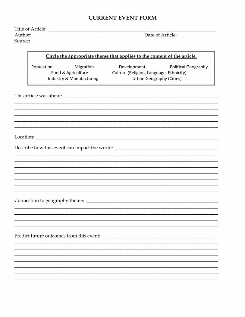
CURRENT EVENT FORM
Title of Article: ______________________________________________________________________ Author: ______________________________________ Date of Article: _________________ Source: _____________________________________________________________________________
This article was about: ________________________________________________________________ _____________________________________________________________________________________ _____________________________________________________________________________________ _____________________________________________________________________________________ _____________________________________________________________________________________ _____________________________________________________________________________________ Location: ____________________________________________________________________________
Describe how this event can impact the world: ___________________________________________ _____________________________________________________________________________________ _____________________________________________________________________________________ _____________________________________________________________________________________ _____________________________________________________________________________________ _____________________________________________________________________________________ _____________________________________________________________________________________ _____________________________________________________________________________________
Connection to geography theme: _______________________________________________________ _____________________________________________________________________________________ _____________________________________________________________________________________ _____________________________________________________________________________________ _____________________________________________________________________________________ Predict future outcomes from this event: ________________________________________________ _____________________________________________________________________________________ _____________________________________________________________________________________ _____________________________________________________________________________________ _____________________________________________________________________________________ _____________________________________________________________________________________ _____________________________________________________________________________________ _____________________________________________________________________________________ _____________________________________________________________________________________
Circle the appropriate theme that applies to the content of the article.
Population Migration Development Political Geography Food & Agriculture Culture (Religion, Language, Ethnicity) Industry & Manufacturing Urban Geography (Cities)

Part III: Map Packet
Directions: Find and label the political entities and physical features listed below. Please, use only the maps
provided for this assignment. Be sure to mark items on the appropriate map, as indicated. Use the colors and
symbols on the sheet at the end of the political + physical features packet. Do NOT place letters and numbers on
your map. If you cannot fit a name on your map, draw lines and write the name out to the side. All labels should be
neat and horizontal. Pace yourself so that you have plenty of time to complete this assignment throughout the
summer.
A. North America
a. Label each of the territories of Canada:
i. New Brunswick viii. Saskatchewan
ii. Prince Edward Island ix. Alberta
iii. Nova Scotia x. British Columbia
iv. Newfoundland and Labrador xi. Yukon Territory
v. Quebec xii. Northwest Territory
vi. Ontario xiii. Nunavut
vii. Manitoba
b. Label the United States (50 states)
c. Label the following major cities:
i. Washington D.C. iv. Chicago
ii. Ottawa v. Toronto
iii. New York City
d. Label and color the following physical features:
i. Rocky Mountains ix. Great Basin
ii. Lake Superior x. Great Plains
iii. Lake Michigan xi. Appalachian Mountains
iv. Lake Huron xii. Gulf of Mexico
v. Lake Erie xiii. Mississippi River
vi. Lake Ontario xiv. Great Salt Lake
vii. Pacific Ocean
viii. Atlantic Ocean
B. Central America
a. Label each of the following countries:
i. Mexico viii. Panama
ii. Guatemala ix. Cuba
iii. Belize x. Jamaica
iv. El Salvador xi. Bahamas
v. Honduras xii. Haiti
vi. Nicaragua xiii. Dominican Republic
vii. Costa Rica xiv. Puerto Rico
b. Label the following major cities:
i. Mexico City
ii. Havana
c. Label and color the following physical features:
i. Gulf of Mexico v. Baja California
ii. Pacific Ocean vi. Yucatan Peninsula
iii. Atlantic Ocean vii. Isthmus of Panama
iv. Panama Canal

C. South America
a. Label each of the following countries:
i. Colombia viii. Brazil
ii. Peru iv. Bolivia
iii. Venezuela x. Paraguay
iv. Guyana xi. Chile
v. Suriname xii. Argentina
vi. French Guiana xiii. Uruguay
vii. Ecuador
b. Label the following major cities:
i. Sao Paulo iii. Lima
ii. Bogota iv. Rio de Janeiro
c. Label and color the following physical features:
i. Pacific Ocean iv. Cape Horn
ii. Atlantic Ocean v. Amazon River
iii. Andes Mountains
D. Africa
a. Label each of the following countries:
i. Morocco xxvii. Benin
ii. Algeria xxviii. Nigeria
iii. Egypt xxix. Cameroon
iv. Tunisia xxx. Central African Republic
v. Libya xxxi. Equatorial Guinea
vi. Western Sahara xxxii. Sao Tome & Principe
vii. Mauritania xxxiii. Gabon
viii. Mali xxxiv. Congo
ix. Niger xxxv. Democratic Republic of the Congo
x. Chad xxxvi. Uganda
xi. Sudan xxxvii. Kenya
xii. South Sudan xxxviii. Rwanda
xiii. Ethiopia xxxix. Burundi
xiv. Eritrea xl. Tanzania
xv. Djibouti xli. Angola
xvi. Somalia xlii. Zambia
xvii. Senegal xliii. Malawi
xviii. Gambia xliv. Mozambique
xix. Guinea-Bissau xlv. Madagascar
xx. Guinea xlvi. Namibia
xxi. Sierra Leone xlvii. Botswana
xxii. Liberia xlviii. Zimbabwe
xxiii. Cote D’Ivoire xlix. Swaziland
xxiv. Burkina Faso l. Lesotho
xxv. Ghana li. South Africa
xxvi. Togo
b. Label the following major cities:
i. Cairo vi. Mogadishu
ii. Lagos vii. Casablanca
iii. Johannesburg viii. Nairobi
iv. Kinshasa ix. Dar es Salaam
v. Khartoum x. Tangiers

c. Label and color the following physical features:
i. Nile River vii. Mediterranean Sea
ii. Congo River viii. Red Sea
iii. Lake Victoria ix. Sahara Desert
iv. Lake Chad x. Strait of Gibraltar
v. Indian Ocean xi. Cape of Good Hope
vi. Atlantic Ocean xii. Suez Canal
E. Middle East
a. Label each of the following countries:
i. Afghanistan x. Iran
ii. Egypt xi. Kuwait
iii. Turkey xii. Bahrain
iv. Cyprus xiii. Qatar
v. Lebanon xiv. United Arab Emirates
vi. Israel xv. Oman
vii. Jordan xvi. Yemen
viii. Iraq xvii. Syria
ix. Saudi Arabia
b. Label the following major cities:
i. Mecca (Makkah) vi. Istanbul
ii. Medina vii. Riyadh
iii. Cairo viii. Tehran
iv. Jerusalem ix. Baghdad
v. Kabul x. Beirut
c. Label and color the following physical features:
i. Arabian Peninsula vii. Dead Sea
ii. Sinai Peninsula viii. Persian Gulf
iii. Mediterranean Sea ix. Strait of Hormuz
iv. Caspian Sea x. Nile River
v. Red Sea xi. Tigris River
vi. Arabian Sea xii. Euphrates River
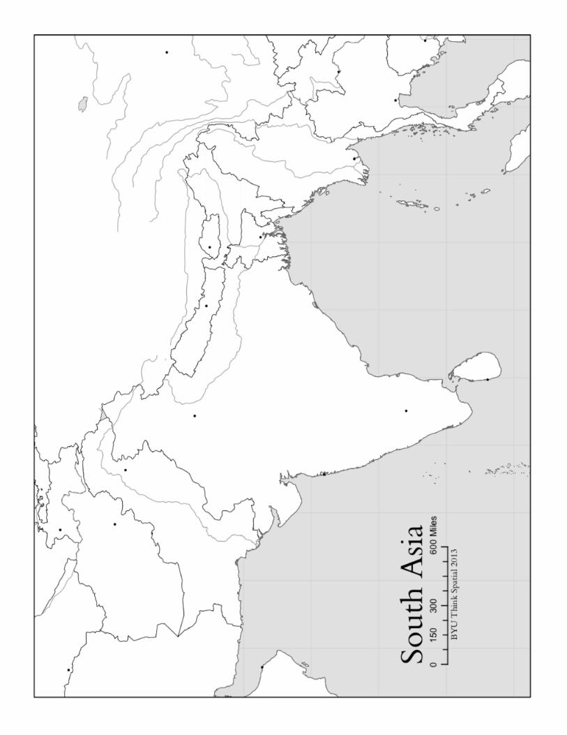
F. South Asia
a. Label each of the following countries:
i. Afghanistan v. India
ii. Pakistan vi. Sri Lanka
iii. Maldives vii. Bhutan
iv. Nepal viii. Bangladesh
b. Label the following major cities:
i. Calcutta iii. New Delhi
ii. Mumbai iv. Karachi
c. Label and color the following physical features:
i. Arabian Sea v. Himalaya Mountains
ii. Bay of Bengal vi. Mt. Everest
iii. Ganges River vii. K2
iv. Indus River

G. Southeast Asia
a. Label each of the following countries:
i. Vietnam vii. Indonesia
ii. Laos viii. Philippines
iii. Cambodia ix. Brunei
iv. Myanmar x. Singapore
v. Thailand xi. East Timor
vi. Malaysia
b. Label the following major cities:
i. Jakarta v. Bangkok
ii. Manila vi. Yangon
iii. Kuala Lumpur vii. Phnom Penh
iv. Hanoi
c. Label and color the following physical features:
i. Mekong River iv. Bay of Bengal
ii. Indian Ocean v. Gulf of Tonkin
iii. Pacific Ocean
H. East Asia
a. Label each of the following countries:
i. China iv. North Korea
ii. Japan v. South Korea
iii. Mongolia vi. Taiwan
b. Label the following major cities:
i. Tokyo v. Hong Kong
ii. Beijing vi. Taipei
iii. Shanghai vii. Seoul
iv. Pyongyang
c. Label and color the following physical features:
i. Himalaya Mountains vi. Xi River
ii. Mount Fuji vii. Yellow Sea
iii. Gobi Desert viii. Pacific Ocean
iv. Yellow River ix. South China Sea
v. Yangtze River x. Sea of Japan
I. Russia and the Former Soviet Republics
a. Label each of the following countries:
i. Russia ix. Tajikistan
ii. Belarus x. Kyrgyzstan
iii. Ukraine xi. Kazakhstan
iv. Moldova xii. Uzbekistan
v. Georgia xiii. Estonia
vi. Armenia xiv. Latvia
vii. Turkmenistan xv. Lithuania
viii. Azerbaijan
b. Label the following major cities:
i. Moscow
ii. St. Petersburg
iii. Kiev
c. Label and color the following physical features:
i. Arctic Ocean vi. Barents Sea
ii. Lake Baikal vii. Baltic Sea
iii. Caspian Sea viii. Bering Sea
iv. Aral Sea ix. Ural Mountains
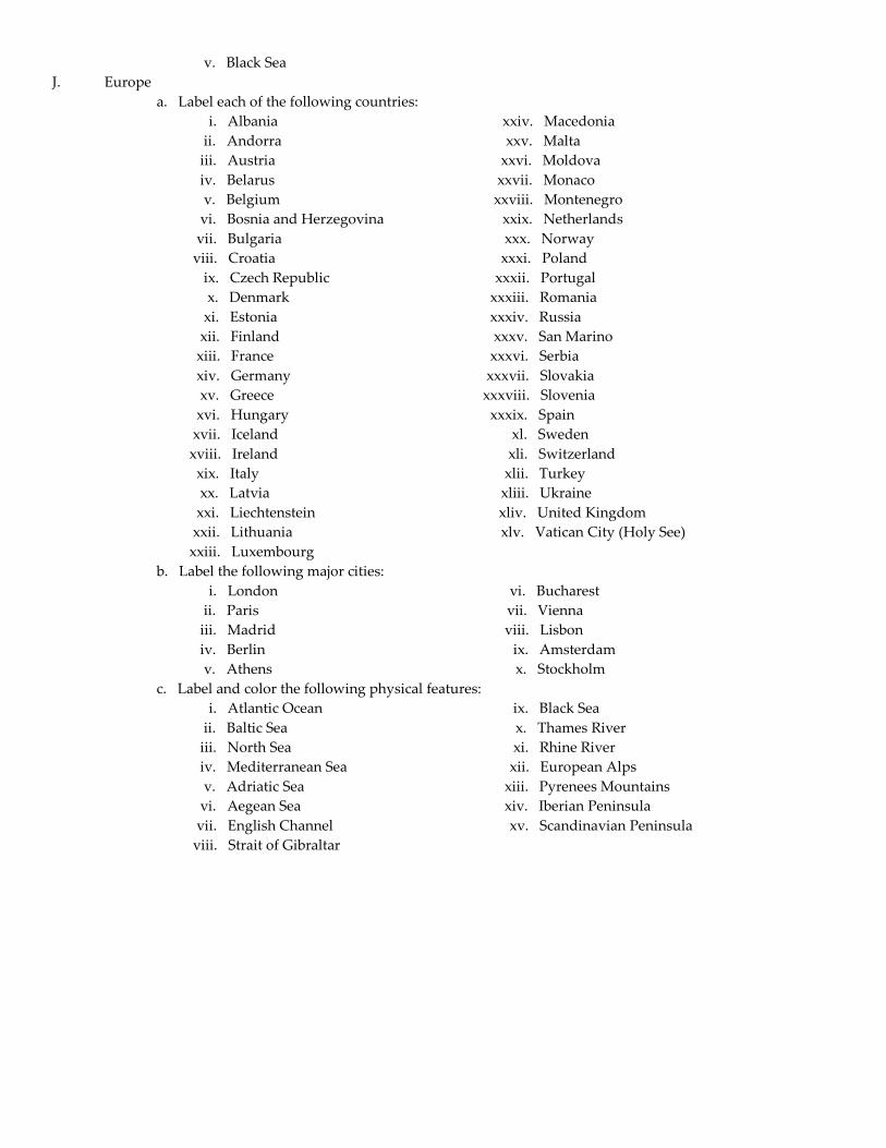
v. Black Sea
J. Europe
a. Label each of the following countries:
i. Albania xxiv. Macedonia
ii. Andorra xxv. Malta
iii. Austria xxvi. Moldova
iv. Belarus xxvii. Monaco
v. Belgium xxviii. Montenegro
vi. Bosnia and Herzegovina xxix. Netherlands
vii. Bulgaria xxx. Norway
viii. Croatia xxxi. Poland
ix. Czech Republic xxxii. Portugal
x. Denmark xxxiii. Romania
xi. Estonia xxxiv. Russia
xii. Finland xxxv. San Marino
xiii. France xxxvi. Serbia
xiv. Germany xxxvii. Slovakia
xv. Greece xxxviii. Slovenia
xvi. Hungary xxxix. Spain
xvii. Iceland xl. Sweden
xviii. Ireland xli. Switzerland
xix. Italy xlii. Turkey
xx. Latvia xliii. Ukraine
xxi. Liechtenstein xliv. United Kingdom
xxii. Lithuania xlv. Vatican City (Holy See)
xxiii. Luxembourg
b. Label the following major cities:
i. London vi. Bucharest
ii. Paris vii. Vienna
iii. Madrid viii. Lisbon
iv. Berlin ix. Amsterdam
v. Athens x. Stockholm
c. Label and color the following physical features:
i. Atlantic Ocean ix. Black Sea
ii. Baltic Sea x. Thames River
iii. North Sea xi. Rhine River
iv. Mediterranean Sea xii. European Alps
v. Adriatic Sea xiii. Pyrenees Mountains
vi. Aegean Sea xiv. Iberian Peninsula
vii. English Channel xv. Scandinavian Peninsula
viii. Strait of Gibraltar


Map Labeling Instructions
All labeling should be straight + horizontal
Use arrows to show small locations or features – do not cram into a small space
Color the feature as directed and write the name in black
Map Feature Symbol and Color
Country
Label
Rivers
Blue line that follow’s the river course
Mountain Peaks/Individual Mountains
Brown triangle inside a brown circle
Mountain Ranges
Line of brown triangles
Deserts
Brown circle covering the feature
Plateaus
Red circle covering the feature
Plains
Yellow circle covering the feature
Peninsulas
Green circle covering the feature
Bodies of Water
Outline edges in blue
Any Other Features
Not Described Above
Label in black