Embed Size (px)
Citation preview

ANNUAL REPORT OF ENVIRONMENTAL IMPACTS FROM THE
HYDROCARBON EXPLORATION AND EXPLOITATION PROGRAM IN
“IOANNINA” BLOCK IN THE REGION OF EPIRUS
YEAR 2018
According to the approval decision’s provisions for the Strategic
Environmental Assessment Report of the survey and exploitation
program in ‘Ioannina’ Block in Epirus Region
Prepared by:
August 2019
DEPTH CHARGE TEST FOR CARBONATE AND CLASTIC FORMATIONS
2 | Σ ε λ ί δ α
TABLE OF CONTENTS
CHAPTER 1 INTRODUCTION ................................................................................................................. 5
1.1 SCOPE OF THE REPORT ................................................................................................................... 5
1.2 SEIA REQUIREMENT FOR ANNUAL REPORT ..................................................................................... 6
1.3 SCOPE AND CONTENTS OF THE REPORT .......................................................................................... 8
1.4 STUDY TEAM ................................................................................................................................. 8
1.5 ENVIRONMENTAL PERMITTING STAGES AND OTHER WORKS COMPLETED PRIOR TO 2018 ................ 9
1.6 BRIEF TECHNICAL DESCRIPTION OF THE PROJECT ........................................................................... 13
1.6.1 GEOPHYSICAL SURVEY PHASES......................................................................................................................... 1
CHAPTER 2 OPERATIONS COMPLETED IN 2018 ..................................................................................... 1
CHAPTER 3 DEPTH CHARGE TEST FOR CARBONATE AND CLASTIC FORMATIONS .................................... 3
3.1 CARBONATE FORMATIONS............................................................................................................. 3
3.2 CLASTIC FORMATIONS ................................................................................................................... 5
CHAPTER 4 ENVIRONMENTAL INDICATORS OF THE WIDER STUDY AREA ............................................... 7
4.1 BIODIVERSITY, FLORA AND FAUNA INDICATORS.............................................................................. 7
4.2 SOIL CHARACTERISTIC INDICATORS ................................................................................................ 9
4.3 LANDSCAPE INDICATORS.............................................................................................................. 11
4.4 WATER INDICATORS .................................................................................................................... 13
4.5 CULTURAL HERITAGE INDICATORS ................................................................................................ 16
CHAPTER 5 MAIN STUDY AREA INDICATORS....................................................................................... 18
5.1 PROTECTED AREAS – NATURA 2000 AREAS ................................................................................... 18
5.2 VEGETATION CATEGORIES INDICATORS ........................................................................................ 20
5.3 CULTURAL HERITAGE INDICATORS ................................................................................................ 22
5.4 INDICATORS OF IMPACT OF VIBRATIONS ON STRUCTURES ............................................................ 23
CHAPTER 6 ENVIRONMENTAL INDICATORS OF THE ENVIRONMENTAL AND SOCIAL ACTION PLAN ....... 24

DEPTH CHARGE TEST FOR CARBONATE AND CLASTIC FORMATIONS
3 | Σ ε λ ί δ α
CHAPTER 7 INDICATORS OF THE ENVIRONMENTAL AND SOCIAL MONITORING PROGRAM .................. 25
CHAPTER 8 CONCLUSIONS AND PROPOSALS ...................................................................................... 33
CHAPTER 9 RELEVANT STUDIES (ORIGINAL TITLES) ............................................................................. 35
9.1 ORIGINAL TITLES IN GREEK ........................................................................................................... 35
9.2 TRANSLATED TITLES IN ENGLISH ................................................................................................... 35

DEPTH CHARGE TEST FOR CARBONATE AND CLASTIC FORMATIONS
4 | Σ ε λ ί δ α
Table of Abbreviations
ESAP Environmental and Social Action Plan
ESBR Environmental and Social Baseline Study Report
EMP Environmental Monitoring Program
GG Government Gazette
JMD Joint Ministerial Decision
MD Ministerial Decision
MSA Main Study Area
NTUA National Technical University of Athens
RBMP River Basin Management Plan
TBT Toolbox Talk
YPEN Ministry for Energy and Environment

DEPTH CHARGE TEST FOR CARBONATE AND CLASTIC FORMATIONS
5 | Σ ε λ ί δ α
CHAPTER 1 INTRODUCTION
1.1 SCOPE OF THE REPORT
Ministerial Decision Α.Π. οικ.172162/2.12.2013 approved the Strategic Environmental Impact
Assessment (SEIA) for the hydrocarbon exploration and exploitation program in the area of
“Ioannina” in the Region of Epirus.
The Ministerial Decision addresses the hydrocarbon exploration and exploitation program in the
onshore area, covering 4,200 km2 in total, which is restricted to the west by the coastline and to the
northwest by the Greek-Albanian borders, while its other sides are presented in the following figure.
The approval of SEIA was followed by Law 4300/2014 (GG 222A/3-10-2014) in October 2014, by virtue
of which the Greek State validated the award of the elaboration of an extensive hydrocarbon
exploration program in the Region of Epirus, and, in particular “Ioannina” block, to the “Energean Oil
and Gas - AEGEAN ENERGY HYDROCARBON EXPLORATION AND PRODUCTION PUBLIC LIMITED
COMPANY” and “ΡΕΤRΑ PETROLEUM INC”.
Under Law 4300/2014, said exploration program is divided into 3 phases and includes the activities
described in the following table.

DEPTH CHARGE TEST FOR CARBONATE AND CLASTIC FORMATIONS
6 | Σ ε λ ί δ α
Table 1-1: Program of Exploration Works for the Onshore Area of Ioannina
Phase Class of Works Description of Works First
Ph
ase
: 3
ye
ars
Seismic Reprocessing of seismic data. Recording of 300 km of new
Seismic 2D data before drilling
Carrying out drilling works Re-entry and deepening of Demetra-1 drill or, if not technically
possible, recording of additional Seismic 2D data.
Other works Geological Surveys, Full Tensor Gravity and Aeromagnetic
Surveys
Se
co
nd
Ph
ase
: 2 y
ea
rs
Seismic -
Carrying out drilling works Drilling of 1st Exploration Deep Well
Other works -
Third
Ph
ase
: 2
ye
ars
Seismic -
Carrying out drilling works Drilling of 2nd Exploration Deep Well
Other works -
1.2 SEIA REQUIREMENT FOR ANNUAL REPORT
Furthermore, the SEIA (MD 172162/2-12-2013) approval decision, in particular chapter C “Monitoring
System of the significant environmental impacts due to the application of the program” states the
following:
“1. To monitor the significant Environmental impacts, an integrated system shall be developed on the
basis of the following principles:
1.1. Monitoring shall include both the state of the environment in the wider area affected by
hydrocarbon exploration and production activities, and in the areas directly affected by those
activities.
1.2. In the context of monitoring, the term ‘wider area’ covers as a minimum the area included in the
exploration and exploitation concession agreement. In this area, the following must be recorded:
quantities and physical properties of the main natural environment aspects, such as mainly
the air, soil, water, flora, fauna and condition of the protected area,

DEPTH CHARGE TEST FOR CARBONATE AND CLASTIC FORMATIONS
7 | Σ ε λ ί δ α
elements of the anthropogenic environment, i.e. related to the population and productive
structuring, institutionalized land uses of housing and production nature, infrastructure works,
and key fields of the area, such as animal production and tourism
1.3. As regards monitoring in the main area, it should focus on all the above and include, in addition,
quantities and indicators concerning the implementation of the approved environmental conditions
for each individual project; observance of the safety procedures in terms of preventing accidents
affecting the environment.
1.4. The spatial and temporal density of recordings, as well as the means used should be
proportionate to the scale of the phenomena and parameters to be monitored, including the
appropriate modifications between directly affected and wider area. The data required to monitor
environmental impact shall be collected and processed on an annual basis. Various sets of data
shall be collected throughout the year in order to enable the identification of shorter-term trends.
1.5. The monitoring shall be based on a number of key environmental sizes reflecting, in a concise
way, the major aspects of environmental progress.
……
The results of monitoring the environmental impacts of the program shall be included in an annual
report, which shall also include their evaluation and proposals for possible required corrective
actions.
Therefore, the scope of this report is to cover relevant requirements as defined and described in the
SEIA approval decision.

DEPTH CHARGE TEST FOR CARBONATE AND CLASTIC FORMATIONS
8 | Σ ε λ ί δ α
1.3 SCOPE AND CONTENTS OF THE REPORT
This report is structured as follows:
S/N Title of Chapter Brief description of the Chapter
1 Introduction
General introductory information is given, such as the scope of the
report, its structure and content, the study team and also
aggregated information on the historical progress of the works and
the environmental licensing of the program. Furthermore, a brief
technical description of the project is provided.
2 Works in 2018 Annual report of works completed in 2018
3 Depth charge test Presentation and results of the depth charge test, which was carried
out in January 2018 in an area with carbonates.
4
Environmental
indicators of the wider
study area
Presentation of the actual impacts of the program for 2018 at a wider
study area level using the environmental indicators proposed in the
first stage of the Environmental and Social Baseline Study
5
Environmental
indicators of main
study area
Presentation of the actual impacts of the program for 2018 at a main
study area level using the environmental indicators proposed in the
second stage of the Environmental and Social Baseline Study
6
Environmental
indicators of
Environmental Action
Plan
Presentation of the actual impacts of the program for 2018 at a main
study area level using the environmental indicators proposed in the
Environmental and Social Action Plan
7
Environmental
indicators of
environmental
monitoring program
Presentation of the actual impacts of the program for 2018 using new
environmental indicators, which emerged from the implementation
of the Environmental Monitoring Program, which has been in progress
since November 2018.
8 Conclusions and
directions
The key conclusions of the report are summarized and directions on
the optimization of the project’s environmental performance are
given.
9 Relevant Studies List of studies relevant to this report
1.4 STUDY TEAM
The following scientists of the company “ENVECO” specializing in environmental monitoring and
environmental protection cooperated for the elaboration of the monitoring of the hydrocarbon
exploration and exploitation program in “Ioannina” block of Epirus region and the compilation of this
Report.
Spyros Papagrigoriou, Civil Engineer, Environmental Engineer MSc
Ioannis Katselis, Mineral Resources Engineer, Environmental Engineer MSc
Ioannis Gavriil, Chemical Engineer, Environmental Engineer MSc
Stamatis Spatulas, Construction Engineer
Zoi Gaitanarou, Mining Engineer, Environmental Engineer MSc
Ioannis Kyprianou, Civil Engineer, Environmental Engineer MSc
Vangelis Pantelias, GIS expert

DEPTH CHARGE TEST FOR CARBONATE AND CLASTIC FORMATIONS
9 | Σ ε λ ί δ α
1.5 ENVIRONMENTAL PERMITTING STAGES AND OTHER WORKS COMPLETED PRIOR TO
2018
This paragraph includes an overview of the evolution of the project both in terms of environmental
permitting and field work, which has been completed prior to 2018.
Works in 2014
No works related to potential impacts on the natural and anthropogenic environment in “Ioannina”
block were implemented in 2014.
The environmental works of 2014 were the following:
Elaboration of a document with the specifications for the first stage of the Environmental and
Social Baseline Study ESBR (11/2014)
Elaboration of the Environmental and Social Action Plan for the Full Tensor Gravity and
Aeromagnetic Survey (11/2014)
Works in 2015
In 2015, in the framework of the Contractor’s contractual obligations for the exploration program,
the following works were performed:
Data collection from the Ministry’s data base
Return of data to the Ministry's data base
Geological and geophysical surveys in “Ioannina” block
Elaboration of Environmental Baseline Study (1st stage)
Full Tensor Gravity and Aeromagnetic Survey
Preparation for the meeting of the Technical Advisory Board (TAB)
Preparation for the call for submission of tenders for the reprocessing of seismic reflection data
Environmental work and assessments
The only works related to potential impacts on the natural and anthropogenic environment in
“Ioannina” block are the implementation works of the Full Tensor Gravity and Aeromagnetic Survey
for which an Environmental Action Plan was prepared in 2014. All the others were related to office or
field works and had no impact whatsoever on the natural and anthropogenic environment.
The 1st Stage of the Environmental Baseline Study, along with an environmental work and
assessments, was elaborated in 2015.
The aim of the 1st Stage of the Environmental Baseline Study was the collection of data to record and
assess the condition of the environment in the wider study area, which covers 4200 km2, in oder to
document its condition prior to the commencement of any work (to avoid blaming the contractor
for any environmental damage that may result from other works) and make it possible to monitor the
impacts of the exploration program.

DEPTH CHARGE TEST FOR CARBONATE AND CLASTIC FORMATIONS
10 | Σ ε λ ί δ α
The 1st Stage of the Environmental Baseline Study also proposed environmental indicators to
accurately and clearly record and quantify the environment’s condition in the exploration area. The
environmental indicators that were proposed to be used in the wider exploration area are:
Biodiversity Indicators – Flora, Fauna
Soil characteristic indicators
Landscape indicators
Water indicators
Socioeconomic environment indicators
Cultural Heritage Indicators
Works in 2016
The following operations were carried out in 2016, in the framework of the Contractor’s contractual
obligations for the exploration program:
Geophysical Data collection from the Ministry’s data base
Return of geophysical data to the Ministry's data base
Geological and geophysical surveys in “Ioannina” block
Elaboration of Environmental Baseline Study (2nd stage)
Preparation for the meeting of the Technical Advisory Board (TAB)
No works related to potential impacts on the natural and anthropogenic environment in “Ioannina”
block were implemented in 2016. More specifically, the environmental works of 2016 were the
following:
Elaboration of Environmental Baseline Study (2nd stage) (10/2016)
Collection of data and fieldwork for the 2nd stage Environmental Baseline Study relating to
the seismic survey area in “Ioannina” block
Data were recorded during the operations and fieldwork of a whole year (4 seasons) was carried out
for the elaboration of the 2nd stage of the Environmental Baseline Study for the area, where the
geophysical survey was planned to take place. More specifically, the following were recorded:
natural environment data, anthropogenic environment data, land use data; also data from local
services were collected.
Finally, calls for submission of tenders were issued for the Environmental Action Plan and for the
geophysical survey.
Works in 2017
The entry of Repsol (Spanish company) in the Contractor’s composition was approved in September
2017 for the “Ioannina” onshore block, assuming the role of Operator;.
In October 2017, the EAP approval was proposed. Initially, it was expected that the Onshore 2D
Seismic Survey for a total length of 300km would start in 2017 plus additional Seismic Survey operations

DEPTH CHARGE TEST FOR CARBONATE AND CLASTIC FORMATIONS
11 | Σ ε λ ί δ α
of 100km, replacing the re-drilling of Demetra-1 well. In the end, this was transferred for the spring of
2018, while in 2017 only tests were carried out in December, at “Lefkothea” and “Kourenta” positions.
More specifically, only test holes, whose depth ranged from 12 to 20m, were carried out from 13 to
19/12/2017, at “Lefkothea”. The detonation was carried out from about 15 to 18/1/2018. Detailed
reference on field tests is included in a separate chapter of this report on works concluded in 2018.
In the framework of the tests, explosions were carried out to examine and finalize the parameters
and technical characteristics of the geophysical surveys that started in spring 2018. Test holes were
opened from 19 to 23/12/2017 at “Kourenta” position. Due to the nature of the soil (flysch), and for
reasons of safety due to the strong rainfalls, no test detonations were carried out at said position.
Studies and surveys were also carried out in 2017, as the required permits for the exploration program
in 2018 were issued.
In particular, the works completed in 2017 are the following:
2nd Stage Environmental Baseline Study: Composition of the recorded data of the 2nd stage
of the Environmental Baseline Study, relating to the area of the seismic survey in “Ioannina”
and submission to the competent service.
Environmental Action Plan: Preparation and submission to the relevant authorities in October
2017 of the Environmental Action Plan for the Onshore Seismic Survey in “Ioannina” block, of
maximum total length: 575 km
Phytotechnical Restoration Study: Preparation of the phytotechnical restoration study of the
affected woodland and its approval from relevant authorities in September 2017.
Field Tests: Field tests in areas with carbonate formations from December 2017 to January
2018.
In the framework of the 2nd stage of the Environmental Baseline Study for the area of geophysical
surveys, the following were carried out:
Collection of available data, studies and literature on the biotic, abiotic and anthropogenic
environment
Collection of information from competent local services (archaeological services, forestry
authorities, environmental authorities etc)
Field data on flora and fauna (with emphasis on avifauna) and ecosystems in the geophysical
survey area in one year (4 seasons)
Satellite pictures in combination with confirmation visits and recording of the land uses,
vulnerabilities and protected/ requiring protection areas.
The scope of the phytotechnical restoration study was the restoration and recreation of the forest
vegetation on the surfaces affected by the project’s operations (intervention zones, as described
above). The restoration is carried out via a comprehensive and effective phytotechnical intervention
in the space, either by using natural processes through natural regeneration or artificial planting of
forest species. As a result, the ecosystem returns to its initial natural condition regarding the operation
of biotic ecological factors characterizing the bio-community of the area.

DEPTH CHARGE TEST FOR CARBONATE AND CLASTIC FORMATIONS
12 | Σ ε λ ί δ α
For the implementation of the OSS program in woodland areas and regarding the procedure
stipulated in the legal framework in force on the issuance of the relevant approvals by the forest
services, the contracting company corresponded with the co-competent services which disclosed
their opinions in documents a) No. 52488/19-4-2017 (document of Ioannina Forestry Authorities; b)
No. 157330/2920/29-5-2017 & 151471/127/24-1-2017 (documents of the Division of Forest Protection &
Agro-Environment, Ministry of the Environment & Energy), clarifying the separate issues related to the
applied procedure .
In the framework of the above, the phytotechnical study was compiled at the Final study stage,
under the provisions of the forest law and the technical specifications set out in decision, No.
53418/3576/162/14-10-1969, of the Minister of Agriculture.
As stipulated in par. ΒΙΙ.3 of JMD 172162/02-12-2013 approving the relevant Strategic Environmental
Impact Assessment (SEIA), the Environmental Action Plan (EAPESAP) was elaborated and approved
on 17/10/2017 (Α.Π. 30192) for the Onshore Seismic Survey (OSS) for “Ioannina” Block, in the Region
of Epirus.
With regard to the impacts of the geophysical survey in “Ioannina” block, in the context of the
EAPESAP elaboration, all possible impacts of the proposed activities on the environmental
parameters of the
Abiotic environment (Paragraph 7.3.2 EAPESAP)
Biotic environment (Paragraph 7.3.3 EAPESAP)
Anthropogenic environment (Paragraph 7.3.4 EAPESAP) were identified.
The possible impacts were identified by using a Table of Program Phases - Cause - Potential Impacts
of the OSS that showed that a more detailed assessment and evaluation of the environmental
impacts was required in the following fields:
Morphology and soil characteristics
Geological and tectonic characteristics
Atmospheric environment
Acoustic environment (noise - vibrations)
Ecosystems, flora and fauna
Social and economic environment
Land Uses
Technical infrastructures
Historical and cultural environment
The impacts for all the above environmental fields were evaluated as weak, short-term and
reversible, taking into account the management measures proposed in the EAPESAP.
Further to field tests, all other works were non-invasive and cannot be related to likely impacts on the
study area. Finally, field tests, as described in the following chapter, take place in sites of insignificant
ecological value, away from sensitive receptors to noise and vibrations; in any case limited pruning

DEPTH CHARGE TEST FOR CARBONATE AND CLASTIC FORMATIONS
13 | Σ ε λ ί δ α
of sparse vegetation will be required and therefore likely impacts from field tests are estimated as
negligible.
1.6 BRIEF TECHNICAL DESCRIPTION OF THE PROJECT
Geophysical surveys for hydrocarbon research aim to map the geological background of an area
where hydrocarbon deposits may exist. This initial phase’s findings are related to the study area’s
geology.
In Ioannina concession area, shot holes are drilled into the surface and an energy source or charge
is placed in the shot hole, usually at the bottom. The depth of shot holes is less than 20 m. Detonation
of the charge sets up energy waves in the surrounding subsurface layers. The reflected seismic signal
will be recorded with previously laid out geophones. Receiver stations, typically located on the
earth's surface, have highly sensitive equipment that detects the energy waves reflected from the
subsurface layers. Receiver stations record the energy waves that will be later processed in order to
determine underground formation structure. Finally, an interpretation of these processed data by
experts through the use of computer tools could identify the desired information with reference to
the area’s geological background, i.e. the potential for the presence of oil or gas.
The equipment to be used for drilling operations, depending on accessibility and soil morphology,
includes Truck-mounted Drilling Rigs and Heliportable Drilling Rigs. The second option has significant
advantages in non-accessible areas with diverse relief, as equipment may be placed on survey
points without requiring the creation of access roads. For the implementation of the geophysical
survey program with air-borne support, temporary helicopter landing areas (helipads) need to be
designated. These areas are mostly clearings and openings whose siting and topography are
considered safe for helicopter landing and take-off. Given the fact that no permanent constructions
or earthworks will take place, helipads are restored to their original condition and land use
immediately upon completion of works.
For survey purposes, there are 10 approved geophysical survey lines, totaling a length of
approximately 400km, as presented in red in Figure 1.6-1 below; additional geophysical survey lines,
totaling a length of approximately 30km are presented in orange. Additional geophysical survey lines
serve as a back-up plan, in case geophysical survey works are not permitted on sections of the 10
approved geophysical survey lines, due to environmental restrictions.
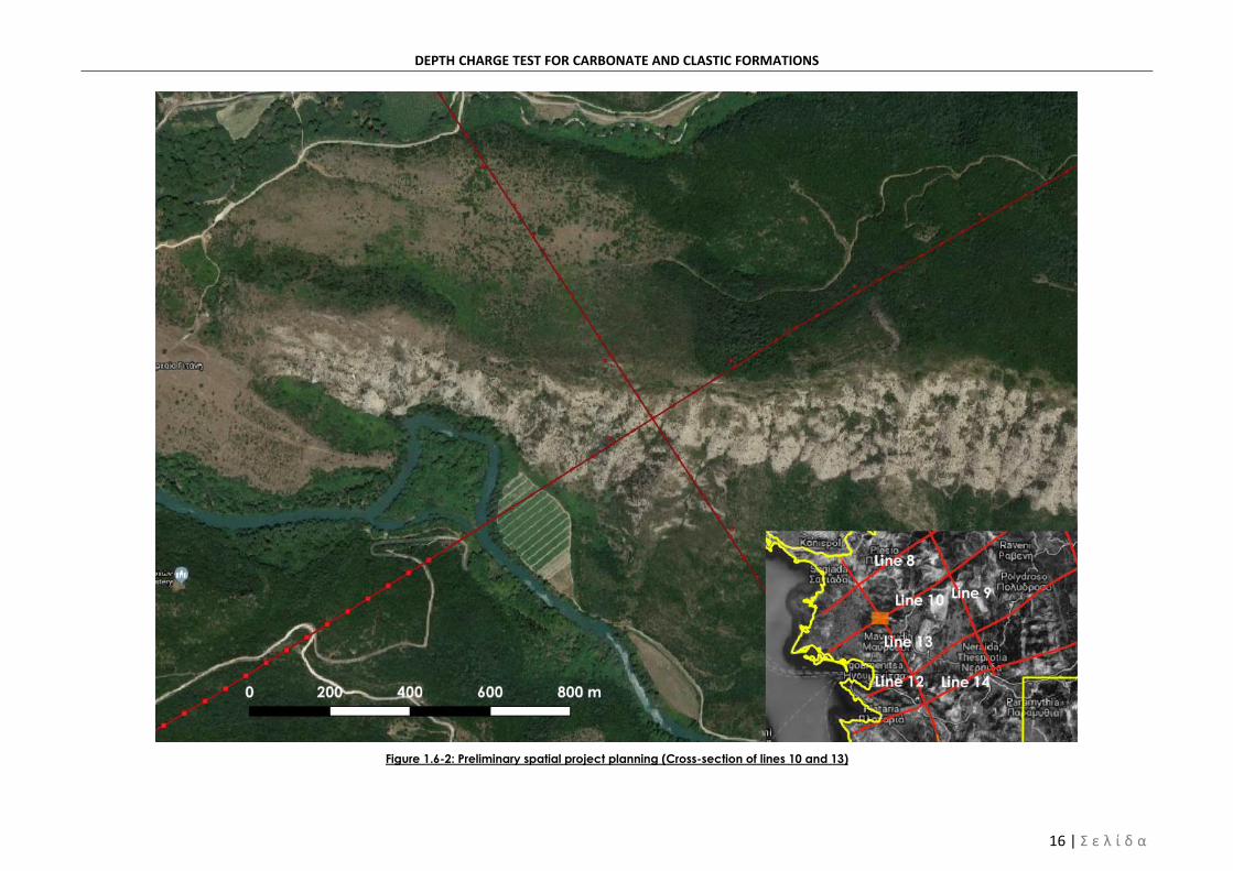
For each geophysical survey line section, a preliminary demarcation of shot holes and necessary
auxiliary spaces is conducted, including helipads and equipment drop zones. An example of this
preliminary plan is provided in Figure 1.6-2 below for the cross-section of geophysical survey lines 10
and 13.
This preliminary planning is indicative and is appropriately modified during works, according to
sensitive natural and man-made environmental elements, as identified during the environmental
monitoring program, so as to ensure compatibility with the approved EAP study1 and its first
amendment2.
Figure 1.6-2 depicts potential land-take for Truck-mounted Drilling Rigs and Heliportable Drilling Rigs;
size difference is obvious. At the west end of line 10, truck-mounted drilling works have been planned,
1 ENVECO S.A., 2017, Environmental Action Plan – Hydrocarbon Exploration and Exploitation Program in Ioannina Block, Athens:
Energean Oil and Gas
2 ENVECO S.A., 2018, Amendment to the Environmental Action Plan – Hydrocarbon Exploration and Exploitation Program in
Ioannina Block, Athens: Repsol

DEPTH CHARGE TEST FOR CARBONATE AND CLASTIC FORMATIONS
14 | Σ ε λ ί δ α
as provided for by the area’s topography and existing road access. In this case, potential land-take
covers approximately 160m2 of rectangular fields, interconnected via a pedestrian access corridor
of 3m in width.
On the other hand, topography conditions and lack of existing road access in all remaining sections
of lines 10 and 13, as depicted in Figure 1.6-2 led to the use of heliportable drilling rigs as an optimal
option. This solution requires the demarcation of temporary helipads but has considerably smaller
requirements in potential land-take. More specifically, a circular potential land-take area, of a 6m
radius will be required for each shot-hole as well as a smaller circular land-take area of a 5m radius
for placing all remaining equipment.
Finally, a circular zone of a 7m diameter will be created for placing the compressor, which supplies
heliportable drilling rigs with compressed air. Shot-holes as interconnected via a 2m-wide corridor.

DEPTH CHARGE TEST FOR CARBONATE AND CLASTIC FORMATIONS
15 | Σ ε λ ί δ α
Figure 1.6-1: Ioannina Block and geophysical survey lines
DEPTH CHARGE TEST FOR CARBONATE AND CLASTIC FORMATIONS
16 | Σ ε λ ί δ α
Figure 1.6-2: Preliminary spatial project planning (Cross-section of lines 10 and 13)

Annual report of the monitoring program of environmental impacts from the hydrocarbon exploration and exploitation program in “Ioannina” block in the region of Epirus - Year 2018
1 | Page
1.6.1 Geophysical Survey Phases
Geophysical survey is implemented per survey line via the following four consecutive phases:
Phase 1: Surveying and vegetation clearance
Phase 2: Drilling
Phase 3: Charging of shot-holes and geophysical survey data collection
Phase 4: Restoration / Rehabilitation
Initially, topographical demarcation and vegetation cutting takes place in the area of interest.
During this phase, any natural/man-made environmental elements are identified on-site and
preliminary project design is modified according to each element’s protection status, as provided
for in the EAP and its first amendment. More specifically, shot-points may be offset either side or
alongside the survey axes, or even omitted, as required. During demarcation of the exact location
of shot-points and receiver points, vegetation clearance takes place, as required.
Upon completion of limited vegetation clearance focusing on required areas around shot-holes and
around temporary equipment placing sites, ‘cuttings’ are brought to the surface with appropriate
equipment, according to each location’s accessibility.
During the third phase, geophones (receiver points) and recording equipment are placed and shot-
holes are charged with limited amounts (2-16kg) of charging material (explosives). Explosive charges
are selected according to each location’s geology and are designed so that any likely impacts from
explosions are negligible at the nearest sensitive receptor (monuments/buildings). The charge is then
covered up with the hole cuttings; detonation of the charge sets up energy waves in the surrounding
subsurface layers. Receiver stations (geophones) record the energy waves that will be later
processed in order to determine underground formation structure.
Upon completion of works, shot-holes are restored. No constructions will remain on site. All equipment
as well as any residual matter/ wastes will be collected and sites will be restored to their initial
condition. Natural vegetation regeneration procedures will be supported with appropriate tree-
planting, as specified by competent authorities.
Annex II of this report presents photographs of all project phases during works that took place in 2018.

Annual report of the monitoring program of environmental impacts from the hydrocarbon exploration and exploitation program in “Ioannina” block in the region of Epirus - Year 2018
1 | Page
CHAPTER 2 OPERATIONS COMPLETED IN 2018
During the first quarter of 2018, geophysical survey operations begun with the depth - charge test of
a location with carbonate formations. All remaining works implemented between January and April
2018 may not be connected to any likely impacts. Such works include training and preparation for
the survey program. Environmental monitoring activities were not required to take place during
implementation of these non-invasive works. In June 2018the amendment of the ESAP was submitted
and then accepted by authorities in July 2018. Until May 2018, works on geophysical lines 12 and 13
were completed, while works on lines 8, 9 and 10 are still ongoing. More specifically:
• Line 12
- Surveying: Surveying works have been completed for 47.1 km of the line and locations of
source and receiver stations have been identified and marked.
- Drilling: Out of a total of 808 planned source station positions, 725 were actually drilled.
- Recording of Geophysical Data: Source stations were installed in all 725 drilling locations.
All stations were activated at the geophysical data recording stage.
- Restoration: Restoration works have been completed across the line.
• Line 13
- Surveying: Surveying works have been completed for 26.2 km of the line and locations of
source and receiver stations have been identified and marked
- Drilling: Out of a total of 444 planned source station positions, 411 were actually drilled.
- Recording of Geophysical Data: Source stations were installed at 398 out of 444 drilled
locations. All stations were activated at the geophysical data recording stage.
- Restoration: Restoration works have been completed across the line
• Line 10
- Surveying: Surveying works have been completed for 8.2 km of the line and locations of
source and receiver stations have been identified and marked
• Line 9
- Surveying: Surveying works have been completed for 5.1 km of the line and locations of
63 source stations and the respective receiver stations have been identified and marked.
• Line 8
- Surveying: Surveying works have been completed for 12.4 km of the line and locations of
source stations and the respective receiver stations have been identified and marked.
• Field tests
- Tests in carbonate and clastic formations: Depth - charge tests have been carried out in
locations with carbonate and clastic rocks at 0.41 and 0.29 km lengths of line 12
respectively.

Annual report of the monitoring program of environmental impacts from the hydrocarbon exploration and exploitation program in “Ioannina” block in the region of Epirus - Year 2018
2 | Page
- Walk-away test: A walk-away test has been carried out at 60 meters of line 13. It must be
noted that, this test does not require drilling of shot-holes anymore, but only placement of
geophones, which are considered as passive measuring equipment. Tests were initially
implemented for 60 geophones at a length of 60m, whereas the EAP amendment
proposed 80 geophones at a length of 80m.
It shall be noted, that it was not necessary to apply the vibration and noise monitoring program during
the field tests given the absence of buildings and noise-sensitive receivers in the 170 m and 250 m
wide zones around the test sites respectively. A brief description of the carbonate depth charge test,
as well as its results, are given in Chapter 3.

Annual report of the monitoring program of environmental impacts from the hydrocarbon exploration and exploitation program in “Ioannina” block in the region of Epirus - Year 2018
3 | Page
CHAPTER 3 DEPTH CHARGE TEST FOR CARBONATE AND CLASTIC FORMATIONS
3.1 CARBONATE FORMATIONS
The depth-charge test for carbonates was conducted from the 15th of December to the 18th of
January 2018 on seismic line 12. During the test, seven similar drilling combinations were developed
with different depths and quantities of explosives.
Each combination consisted of 12 drillings and a total of 84 drilling holes were created. The depths
ranged from 12 to 25 m while charge of explosives ranged from 6 Kg to 16 Kg. An acquisition receiver
spread of about 15 km was used to both record the test shots and test the offset length.
The total length of the test was about 420 m and the width on both sides of the geophysical line was
10 m, while the total surface of the depth charge test reached 4,200 m2.
The figure below shows the locations of the drillings for the whole test area in the "Lefkothea" region
of the municipality of Zitsa.
As shown in the above figure, the area of the test is characterized by extremely sparse shrub
vegetation, while the terrain is flat with an altitude of 419 m and the nearest settlement
(Kokkinohoma) lies at a distance of 1.8 km (northwest). On the respective maps of land cover, the
area is presented as a meadow, while it is far from archaeological sites and monuments.
Concerning the 400 m long test in Lefkothea, the monitoring program which is provided for in the
decision of approval of the Environmental and Social Action Plan (ESAP) was implemented. The
following actions were carried out:

Annual report of the monitoring program of environmental impacts from the hydrocarbon exploration and exploitation program in “Ioannina” block in the region of Epirus - Year 2018
4 | Page
• Areas where there was deforestation of existing vegetation were recorded - There was minimal
cutting of branches and there was no alteration of the natural environment in the intervention area.
• The vibrations, which occurred during the tests at different distances from the drill holes were
recorded in collaboration with the project operator and the results of the monitoring program were
incorporated into the safety distance calculations.
• A search for both declared and non-declared archaeological sites and indications of
archaeological remains in the test area was carried out – No findings
• A search for springs and water wells-boreholes, which could be affected, was carried out in the
test area – No findings
• A search for noise-sensitive uses near the test area, such as settlements or other facilities, was done
in the test area - No findings
• A check for persistent pollution was completed - No waste related to the test works was recorded.
It is noted that, the Body of Inspectors and Auditors (Northern Greece) made an on-site inspection,
and its report (7088 / 4-10-2018) read as follows:
During the audit at the locations inspected:
i. there was no evidence of the existence of solid or liquid waste from the works described, except
for the ribbons, which are used to mark the works and space, and will be collected and removed at
the end of works,
ii. there was minimal vegetation cutting in accordance with the approval of the relevant Forestry
Services (8/2017 and 35/2017 Forestry Police Arrangements of the Decentralized Administration
Coordinator of Epirus-Western Macedonia),
iii. The pipes inside the holes consist of biodegradable material and have been certified according
to EN-13432 and ISO 14855 standards, which guarantees their composition of more than 95% of
carbon of plant origin,
iv. Roads were restored after the rainfall season, according to the statements of the Municipality of
Zitsa of the 11 and 17/04/2018.
v. A phytotechnical restoration study has already been submitted and approved in accordance with
the relevant decision (12); and
vi. in general, no degradation of the natural environment, pollution or even degradation of the
aesthetic and visual alteration of landscape were identified.
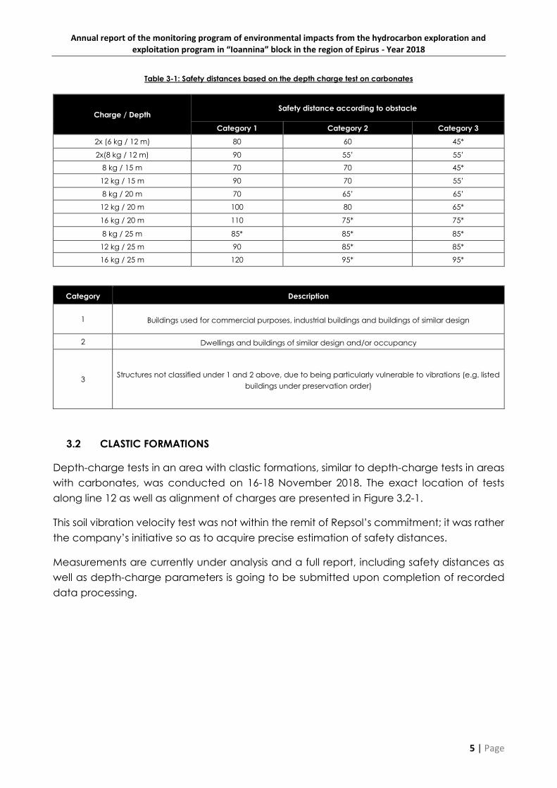
The analysis and processing of the data resulting from the amplitude shot analysis showed
that the optimal combination of parameters for the carbonate rock sites is 20 m depth and
16 kg of charge. These parameters are appropriately modified in cases of sensitive
infrastructure and buildings, such as monuments, in the study area.
The safety distances, which resulted from the depth - charge test for the carbonate rocks
are given in Table 3-1.
Annual report of the monitoring program of environmental impacts from the hydrocarbon exploration and exploitation program in “Ioannina” block in the region of Epirus - Year 2018
5 | Page
Table 3-1: Safety distances based on the depth charge test on carbonates
Charge / Depth Safety distance according to obstacle
Category 1 Category 2 Category 3
2x (6 kg / 12 m) 80 60 45*
2x(8 kg / 12 m) 90 55’ 55’
8 kg / 15 m 70 70 45*
12 kg / 15 m 90 70 55’
8 kg / 20 m 70 65’ 65’
12 kg / 20 m 100 80 65*
16 kg / 20 m 110 75* 75*
8 kg / 25 m 85* 85* 85*
12 kg / 25 m 90 85* 85*
16 kg / 25 m 120 95* 95*
Category Description
1 Buildings used for commercial purposes, industrial buildings and buildings of similar design
2 Dwellings and buildings of similar design and/or occupancy
3 Structures not classified under 1 and 2 above, due to being particularly vulnerable to vibrations (e.g. listed
buildings under preservation order)
3.2 CLASTIC FORMATIONS
Depth-charge tests in an area with clastic formations, similar to depth-charge tests in areas
with carbonates, was conducted on 16-18 November 2018. The exact location of tests
along line 12 as well as alignment of charges are presented in Figure 3.2-1.
This soil vibration velocity test was not within the remit of Repsol’s commitment; it was rather
the company’s initiative so as to acquire precise estimation of safety distances.
Measurements are currently under analysis and a full report, including safety distances as
well as depth-charge parameters is going to be submitted upon completion of recorded
data processing.

Annual report of the monitoring program of environmental impacts from the hydrocarbon exploration and exploitation program in “Ioannina” block in the region of Epirus - Year 2018
6 | Page
Figure 3.2-1: Tests on clastic formations

Annual report of the monitoring program of environmental impacts from the hydrocarbon exploration and exploitation program in “Ioannina” block in the region of Epirus - Year 2018
7 | Page
CHAPTER 4 ENVIRONMENTAL INDICATORS OF THE WIDER STUDY AREA
4.1 BIODIVERSITY, FLORA AND FAUNA INDICATORS
The environmental target in the field of Biodiversity is to protect the latter, to refrain from causing
irreversible losses (biodiversity preservation), as well as to avoid damaging the flora and fauna, the
natural areas and protected species.
Information regarding the registration, identification, assessment and mapping of the limits of
protected areas falling under Directive 92/43/ΕEC (Natura 2000 Network) in the study area and all
over the country, as well as Avifauna Special Protection Areas of the Directive 2009/147/EC are
provided by the competent Ministry for the Environment, Energy and Climate Change Services.
The proposed biodiversity, flora and fauna indicators according to the proposals of the 1st stage ESBR
are the following:
Number and size of Natura 2000 Network Areas
Number and size of areas protected by Greek law
Number and size of Priority Habitats, Annex I, JMD 14849/853/Ε103/4-4-2008
Number of flora and fauna species falling under Annex II, JMD 14849/853/Ε103/2008
Number of avifauna species falling under Annex Ι of JMD 37338/1807/Ε103/2010, as amended
by JMD 8353/276/Ε103/20128353/276/Ε103/2012
The use of indicators is consistent with the general aim of “sustainable environmental management"
given that the loss of natural land in the protected areas is a cause of loss of biodiversity and breaking
up of its cohesion, especially for biotope species for which the above-mentioned areas have been
characterized as protected.
It should be noted that in 2017 the Natura 2000 network areas were updated with JMD 110/1205322
“Determination of technical specifications for the preparation of delimitation study for the onshore
areas of “NATURA 2000” network − update, description and delimitation of terrestrial types of habitats
as Sites of Community Importance” (GG 1419Β/30.04.2017). The list of Natura 2000 network areas was
updated in December 2017 with JMD 50743 (GG 4432B/2017).
Table 4.1-1 below provides the baseline and 2018 values of the indicators, which have not changed.

Annual report of the monitoring program of environmental impacts from the hydrocarbon exploration and exploitation program in “Ioannina” block in the region of Epirus - Year 2018
8 | Page
Table 4.1-1: Biodiversity, flora and fauna indicators
Parameter Indicator Unit Source Baseline value3 2018 value
Natura 2000 Sites
Number of areas of the Natura 2000 network within the
wider study area Number
Natura 2000,
YPEN, ΕΚΒΥ
21 21
Surface of Natura 2000 sites within the wider study area km2 2202 2202
Protected areas by Greek law
Number of areas protected by Greek Law within the wider
study area Number
YPEN,
Management
Bodies, NTUA
4 4
Surface of areas protected by Greek Law within the wider
study area km2 1427.2 1427,.2
Annex I priority habitats of JMD
14849/853/Ε103/4-4-2008
Number of Annex I priority habitats within the wider study
area Number Natura 2000,
YPEN, ΕΚΒΥ,
Management
Bodies, NTUA
6 6
Surface of Annex I priority habitats within the wider study
area km2 214.24 214.24
Flora and fauna species of Annex II of
JMD 14849/853/Ε103/2008
Number of Flora and fauna species of Annex II within the
wider study area Number
Natura 2000,
YPEN, ΕΚΒΥ,
Management
Bodies, NTUA
36 36
Avifauna Species of Annex I of JMD
37338/1807/Ε103/2010, which has been
amended by JMD
8353/276/Ε103/20128353/276/Ε103/2012
Number Avifauna Species of Annex I within the wider study
area Number
Natura 2000,
YPEN, ΕΚΒΥ,
Management
Bodies, NTUA
91 91
3 Baseline values refer to 2014 – (Enveco S.A., 2015. First Stage of Environmental and Social Baseline Report for the Hydrocarbons Exploration and Exploitation Program in the Onshore Area
“IOANNINA”, Athens: Energean Oil and Gas.)

Annual report of the monitoring program of environmental impacts from the hydrocarbon exploration and exploitation program in “Ioannina” block in the region of Epirus - Year 2018
9 | Page
4.2 SOIL CHARACTERISTIC INDICATORS
A significant number of indicators has been studied and developed to describe soil characteristics
and conditions. These indicators are based on environmental parameters directly linked to the soil,
such as: climate, water, run-off, vegetation, farming, cattle farming, land use and management,
tourism, fires, etc.
Deforestation in the European Mediterranean Countries is mainly caused by fires, logging as well as
the transformation of forests and bush-land to farm-land or residential (urban) areas. The impact of
land reclamation includes extensive run-offs, loss of soil and reduction of biodiversity.
The proposed indicators for the description of soil condition are the area and the soil coverage by
forests or woodland in the wider study area of the onshore “Ioannina” block.
The baseline value is the forest areas according to the most recent Corine land cover data for 2012
collected upon completion of the program “GMS/Copernicus Initial Operations
(GIO)Land Monitoring 2011-2013” or GIO LAND. The program aimed to provide comprehensive and
timely information on the type of coverage and land use and the changes thereof on a national
level.
The Environmental target is to protect forests, avoid irreversible losses and refrain from damaging the
forests and woodlands.
The following codes were considered to be forests or woodlands:
3.1.1 Broad-leaved forest
3.1.2 Coniferous forest
3.1.3 Mixed forest
3.2.1 Natural grasslands
3.2.2 Moors and heathland
3.2.3 Sclerophyllous vegetation
3.2.4 Transitional woodland-shrub
3.3.3 Sparsely vegetated areas
3.3.4 Burnt areas
Table 4.2-1 below provides the baseline values of the indicators and their 2018 values, for which no
change has been observed.

Annual report of the monitoring program of environmental impacts from the hydrocarbon exploration and exploitation program in “Ioannina” block in the region of Epirus - Year 2018
10 | Page
Table 4.2-1: Soil characteristic indicators
Parameter Unit of Measurement Data Source Baseline value4 2018 value
Coverage by forests or woodland
Percentage of coverage by
forests or woodland –
Ioannina Regional Unit Percentage %
CORINE 2012
75% 75%
Percentage of coverage by
forests or woodland –
Thesprotia Regional Unit
72% 72%
Surface of coverage by
forests or woodland –
Ioannina Regional Unit km2
2319.5 2319.5
Surface of coverage by
forests or woodland –
Thesprotia Regional Unit
741.6 741.6
4 Enveco S.A., 2015. First Stage of Environmental and Social Baseline Report for the Hydrocarbons Exploration and Exploitation Program in the Onshore Area “IOANNINA”, Athens: Energean
Oil and Gas.

Annual report of the monitoring program of environmental impacts from the hydrocarbon exploration and exploitation program in “Ioannina” block in the region of Epirus - Year 2018
11 | Page
4.3 LANDSCAPE INDICATORS
The proposed landscape indicators are the number and area of protected landscapes (including
Landscapes of Outstanding Natural Beauty, Aesthetic Forests and Listed Natural Monuments and
Landmarks, as well as the areas that have been characterized as protected natural formations). The
use of indicators is consistent with the general aim of “sustainable environmental management"
given that the loss of natural land is a cause of landscape degradation.
The proposed indicators, as proposed by the 1st stage ESBR, are the number of protected landscapes
and their surface.
The baseline value is the number of statutorily protected landscapes in the wider study area (i.e.
within Ioannina Block) during the preparation of the 1st stage ESBR as well as their surface.
The Environmental target is to protect the landscape, to avoid irreversible losses and to refrain from
causing any damage. Information on the registration, identification, assessment and mapping of the
limits of protected landscapes are provided by the competent Ministry of Energy Services.
Table 4.3-1 below provides the baseline and 2018 values for the proposed indicators, for which no
changes have been identified.

Annual report of the monitoring program of environmental impacts from the hydrocarbon exploration and exploitation program in “Ioannina” block in the region of Epirus - Year 2018
12 | Page
Table 4.3-1: Landscape indicators
Parameter Indicator Unit of Measurement Data Source Baseline value5 2018 value
Landscapes of Outstanding
Natural Beauty
Number of Landscapes of
Outstanding Natural Beauty Number
Ministry for the
Environment, Energy and
Climate Change, Greek
Biotope-Wetland Centre
(EKBY), FILOTIS Database,
National Technical
University of Athens
34 34
Aesthetic Forests- Listed Natural
Monuments and Landmarks
Number of Aesthetic Forests- Listed
Natural Monuments and
Landmarks
Number 2 2
Surface of Aesthetic Forests- Listed
Natural Monuments and
Landmarks
km2
Aesthetic
forest: 741.6
stremmata
Aesthetic
forest: 741.6
stremmata
5 Enveco S.A., 2015. First Stage of Environmental and Social Baseline Report for the Hydrocarbons Exploration and Exploitation Program in the Onshore Area “IOANNINA”, Athens: Energean
Oil and Gas.

Annual report of the monitoring program of environmental impacts from the hydrocarbon exploration and exploitation program in “Ioannina” block in the region of Epirus - Year 2018
13 | Page
4.4 WATER INDICATORS
As regards the assessment and evaluation of water condition in the study area, monitoring of the
following indicators has been proposed:
The number of water systems (surface and ground), in good chemical condition, according
to the first revision of the approved water management plan of Epirus River Basin District (GG
4664/Β/2017)
The number of water systems (surface), in good ecological condition, according to the first
revision of the approved water management plan of Epirus River Basin District (GG
4664/Β/2017)
It is noted that the first revision of the River Basin Management Plan (RBMP) for Epirus River Basin District
was published in the Government Gazette (GG) in 2017 according to the requirements of the Water
Framework Directive (2000/60/EC) and the national law. The revised RBMP concerns the 2nd
Management Cycle (2015-20121) of the Framework Directive and is part of the revision process set
forth to be implemented every six years.
The calculation of said indicators includes counting the water systems falling within the study area,
namely the exploration area of Ioannina onshore block. It is noted that the baseline values are the
number of water bodies in good chemical and ecological condition according to the first revision of
the approved water management plan of Epirus River Basin District (GG 4664/Β/2017) and the
relevant monitoring program.
Table 4.4-1 below includes the indicator values for 2018, as well as their corresponding baseline
values. It shall be noted, that the revision of the RBMP was made after the preparation of the 1st Stage
ESBR (Enveco SA, 2015)6, in which the respective baseline values were recorded. Given that the data
for the revision of the RBMP concern the period prior to the commencement of the geophysical
survey program, the respective baseline values were updated. The initial values of the first stage ESBR
are also given in the table.
6Enveco S.A., 2015. First Stage of Environmental and Social Baseline Report for the Hydrocarbons Exploration and Exploitation
Program in the Onshore Area “IOANNINA”, Athens: Energean Oil and Gas.
Annual report of the monitoring program of environmental impacts from the hydrocarbon exploration and exploitation program in “Ioannina” block in the region of Epirus - Year 2018
14 | Page
Table 4.4-1: Water indicators
Parameter Indicator Unit of Measurement Data Source 2014 Value Baseline Value7 2018 Value
Water Bodies in good chemical
condition, according to the
Approved Water Management
Plan for the River Basin District
Number of surface Water Bodies
in good chemical condition,
according to the Approved Water
Management Plan for the River
Basin District – Ioannina Regional
Unit
Number
MINISTRY OF THE
ENVIRONMENT, ENERGY,
CLIMATE CHANGE,
APPROVED
MANAGEMENT PLAN OF
EPIRUS RIVER BASIN
DISTRICT (1st
Amendment)
28 (27 rivers + 1
lake)
34 (31 rivers + 2
lake + 1
transitional)
34 (31 rivers +
2 lake + 1
transitional)
Number of surface Water Bodies
in good chemical condition,
according to the Approved Water
Management Plan for the River
Basin District – Thesprotia Regional
Unit
8 (8 rivers) 11 (11 rivers) 11 (11 rivers)
Number of groundwater Bodies in
good chemical condition,
according to the Approved Water
Management Plan for the River
Basin District – Ioannina Regional
Unit
14 15 15
7 Consortium: ‘1st Amendment of River Basin Management Plan for Thessalia, Epirus and Western Central Greece Water Districts’, 2017. 1st Amendment of River Basin Management Plan, Epirus
Water District (EL05), Athens, Ministry of Environment and Energy – Special Secreteriat for Water

Annual report of the monitoring program of environmental impacts from the hydrocarbon exploration and exploitation program in “Ioannina” block in the region of Epirus - Year 2018
15 | Page
Parameter Indicator Unit of Measurement Data Source 2014 Value Baseline Value7 2018 Value
Number of groundwater Bodies in
good chemical condition,
according to the Approved Water
Management Plan for the River
Basin District – Thesprotia Regional
Unit
7 8 8
Water Bodies in good ecological
condition, according to the
Approved Water Management
Plan for the River Basin District
Surface Water Bodies in good
ecological condition, according
to the Approved Water
Management Plan for the River
Basin District – Ioannina Regional
Unit
Number
MINISTRY OF THE
ENVIRONMENT, ENERGY,
CLIMATE CHANGE,
APPROVED
MANAGEMENT PLAN OF
EPIRUS RIVER BASIN
DISTRICT (1st
Amendment)
28 (28 rivers) 24 (23 rivers + 1
lake)
24 (23 rivers +
1 lake)
Surface Water Bodies in good
ecological condition, according
to the Approved Water
Management Plan for the River
Basin District - Thesprotia Regional
Unit
9 (9 rivers) 10 (10 rivers) 10 (10 rivers)

Annual report of the monitoring program of environmental impacts from the hydrocarbon exploration and exploitation program in “Ioannina” block in the region of Epirus - Year 2018
16 | Page
4.5 CULTURAL HERITAGE INDICATORS
In order to assess and evaluate the condition of the cultural heritage in the wider study area, the
number of declared archaeological sites and monuments in the lease area “Ioannina” is used as an
indicator.
The environmental aim for the Cultural Heritage is its protection. More specifically, the aim is to avoid
irreversible losses and damages in existing protected ruins and monuments.
According to the Permanent Catalogue of Listed Archaeological Sites and Monuments of Greece
(http://listedmonuments.culture.gr/), the number of listed archaeological sites and monuments in
Ioannina and Thesprotia Regional Units is 732.
Table 4.5-1 below provides the baseline and 2018 values for the proposed indicators, which have
not changed.

Annual report of the monitoring program of environmental impacts from the hydrocarbon exploration and exploitation program in “Ioannina” block in the region of Epirus - Year 2018
17 | Page
Table 4.5-1: Cultural and historical environment indicators
Parameter Indicator Unit of
Measurement Data Source Baseline value8 2018 value
Listed Archaeological
Sites and Monuments
Listed Archaeological
Sites and Monuments
– Ioannina Regional
Unit
Number
Ministry of Culture,
Ephorates of
Antiquities of
Ioannina and
Thesprotia, Service
of Newer
Monuments and
Technical Works of
Epirus, Northern
Ionian Sea and
Western
Macedonia
638 638
Listed Archaeological
Sites and Monuments -
Thesprotia
94 94
8 Enveco S.A., 2015. First Stage of Environmental and Social Baseline Report for the Hydrocarbons Exploration and Exploitation Program in the Onshore Area “IOANNINA”, Athens: Energean
Oil and Gas.
Annual report of the monitoring program of environmental impacts from the hydrocarbon exploration and exploitation program in “Ioannina” block in the region of Epirus - Year 2018
18 | Page
CHAPTER 5 MAIN STUDY AREA INDICATORS
The baseline values for the environmental indicators of the main study area (MSA) were re-calculated
in the context of this report due to the reduction in the total proposed length of the geophysical
survey lines to 430 km, which was finally adopted, versus the initial 576 km, which was examined in
the 2nd stage ESBR. In addition, a 250 m wide zone around the temporary helicopter landing / staging
fields was added to the MSA.
5.1 PROTECTED AREAS – NATURA 2000 AREAS
The protection of biodiversity and avoidance of irreversible losses as well as the avoidance of
damages to flora and fauna, natural areas and protected species is an environmental objective in
the area of biodiversity (preservation of biodiversity).
Data on the recording, identification, estimation and mapping of the boundaries of the protected
areas, both of Law 3937/2011 and Directive 92/43 / EEC (Natura 2000 Network) in the study area, but
also in the country as a whole, as well as respective data on the Special Protection Areas for avifauna
according to Directive 2009/147/EC, are available from the respective services of the Ministry of
Environment and Energy.
The proposed indicators for the description of the key elements of the Protected Areas, which are
relevant to the study area are the following:
Number and extent of habitats in Annex I of Directive 92/43 / EEC
Number of flora species in Annex II of Directive 92/43 / EECThe following table gives the baseline
values of the indicators, which were updated for the actual MSA based on mapping data of habitats
issued prior to 20179. Index values for 20181012 were derived using recent habitat mapping data. It
shall be noted, that the observed decrease in Annex I habitats is caused by the declassification of
the habitat, which was initially classified as Habitat Type 3280 (Constantly flowing Mediterranean
rivers with Paspalo-Agrostidion species and hanging curtains of Salix and Populus alba). During the
recent mapping, which has been used for the calculation of the 2018 indicator values, the respective
part of the river was found to not belong to this Annex I habitat type and has been classified as
habitat type “Constantly flowing rivers with no vegetation”. This change, however, may not be
related with the project.
9 Source: ΕΠΠΕΡ - Subprogramme 3, Measure 3.3: "Recognizing and describing habitat types in areas of interest for nature
conservation"
10 Source: Updated mapping of habitat types. National Cadastre and Mapping SA (EKXA AE, 2017): "Development of Large-
Scale Spatial Data Infrastructure (1: 5000) for NATURA 2000 Protected Areas", based on technical specifications defined in
Joint Ministerial Decision 110/1205322 (Government Gazette 1419 / B / 30-4-2012 ) "Definition of technical specifications for the
delineation of land areas in the NATURA 2000 network - updating, description and demarcation of terrestrial habitat types in
Sites of Community Importance"

Annual report of the monitoring program of environmental impacts from the hydrocarbon exploration and exploitation program in “Ioannina” block in the region of Epirus - Year 2018
19 | Page
Table 5.1-1: Biodiversity indicators
Parameter Indicator Unit Source Baseline value11 2018 value12
Habitats of
Annex I of
Directive
92/43/EEC
Number of
Habitats of
Annex I of
Directive
92/43/EEC within
the SACs of the
main study area
Number
Natura
2000
Network
–
SAC
GR2120001
5 4
Surface of
Habitats of
Annex I of
Directive
92/43/EEC within
the SACs of main
study area
km2
Habitat 1420
0.366 Habitat 1420 0.367
Habitat 3280 0.251 - 13 .-
Habitat 5420 0.744 Habitat 5420 0.744
Habitat 92A0 0.272 Habitat 92A0 0.272
Habitat 92D0 0.100 Habitat 92D0 0.100
Flora Species of
Annex II of
Directive
92/43/EEC
Flora Species of
Annex II of
Directive
92/43/EEC within
the main study
area
Number
Natura
2000
Network,
YPEN, ΕΚΒΥ,
Managem
ent Bodies,
NTUA
0
0
11 Source: ΕΠΠΕΡ - Subprogramme 3, Measure 3.3: "Recognizing and describing habitat types in areas of interest for nature
conservation"
12 Source: Updated mapping of habitat types. National Cadastre and Mapping SA (EKXA AE, 2017): "Development of Large-
Scale Spatial Data Infrastructure (1: 5000) for NATURA 2000 Protected Areas", based on technical specifications defined in
Joint Ministerial Decision 110/1205322 (Government Gazette 1419 / B / 30-4-2012 ) "Definition of technical specifications for the
delineation of land areas in the NATURA 2000 network - updating, description and demarcation of terrestrial habitat types in
Sites of Community Importance"
13 Former 3280 (2017), which has recently been classified as a non-Annex I habitat (Constantly flowing rivers with no
vegetation).

Annual report of the monitoring program of environmental impacts from the hydrocarbon exploration and exploitation program in “Ioannina” block in the region of Epirus - Year 2018
20 | Page
5.2 VEGETATION CATEGORIES INDICATORS
For the mapping of vegetation categories within the MSA, the map of vegetation and land uses of
the Department of Thematic Mapping, Forest Maps Directorate, General Directorate for
Development and Protection of Forests and Natural Environment, Special Secretariat of Forests was
used. Vegetation categories within MSA were updated based on field work and interpretation of
satellite images in the framework of the 2nd Stage ESBR (Enveco Α.Ε., 2017)14.
The proposed indicators for the state of vegetation of the main study area are the following:
The surface of the natural vegetation categories of the MSA
The ecological status of the natural vegetation categories of the MSA
The following natural categories of vegetation were mapped within the main study area: oak forests,
fir forests, deciduous shrubs, chestnut forests, meadows, sparse vegetation, surface water bodies &
riparian vegetation and shrubs.
It shall be noted, that the number and ecological status of the natural vegetation categories directly
and effectively determine the ecological value of the flora habitats. The following table includes the
baseline values15, which have been updated for the actual MSA, as well as their respective values
for 2018, which have not changed, as the main source of data for the indicator values calculation,
which is the map of vegetation and land uses of the Department of Thematic Mapping and satellite
images have not been updated since the preparation of the 2nd stage ESBR.
14 Enveco S.A., 2017. Second Stage Environmental and Social Baseline Report for the Seismic Survey in the Onshore Area
“Ioannina”, Athens: Energean Oil and Gas.
15 Ibid.

Annual report of the monitoring program of environmental impacts from the hydrocarbon exploration and exploitation program in “Ioannina” block in the region of Epirus - Year 2018
21 | Page
Table 5.2-1: Vegetation categories indicators
Parameter Indicator Unit Source Baseline value 2018 value
Coverage of
natural
vegetation in the
main study area
Number of
categories of
natural
vegetation
within the main
study area
Number
ESAP
7 7
Surface of land
cover of
categories of
natural
vegetation
within the main
study area
km2
Oak forest 44.2395 Oak forest 44.2395
Fir forest 0.5562 Fir forest 0.5562
Chestnut forest 0.2183 Chestnut forest 0.2183
Shrubs 81.9759 Shrubs 81.9759
Deciduous shrubs 8.9821 Deciduous shrubs 8.9821
Meadows 23.2107 Meadows 23.2107
Surface water bodies and riparian
vegetation 2.7789
Surface water bodies and riparian
vegetation 2.7789
Ecological status
Qualitative
Assessment
of
Ecological
Status
(good,
moderate,
poor)
ESAP
Oak forest Good Oak forest Good
Fir forest Good Fir forest Good
Chestnut forest Good Chestnut forest Good
Shrubs Good Shrubs Good
Deciduous shrubs Good Deciduous shrubs Good
Meadows Good Meadows Good
Surface water bodies and riparian
vegetation Good
Surface water bodies and riparian
vegetation Good

Annual report of the monitoring program of environmental impacts from the hydrocarbon exploration and exploitation program in “Ioannina” block in the region of Epirus - Year 2018
22 | Page
5.3 CULTURAL HERITAGE INDICATORS
The proposed indicators represent the structural state of declared and undeclared cultural heritage
sites within the MSA.
Baseline values correspond to the state, which has been recorded on the basis of bibliographic
references, information by the relevant Ephorates of Antiquities and modern monuments (Ephorate
of Antiquities of Thesprotia and Ephorate of Modern Monuments of Epirus). Cultural heritage data is
shown in land use maps 2 and 3 of the relevant Annex II of the 2nd Stage ESBR at scales 1:100,000 and
1:10,000 respectively.
The protection of monuments and avoidance of irreversible losses (preservation or damages to
existing ruins is an environmental objective in the field of Cultural Heritage.
There are in total 38 protected cultural heritage elements within the main study area (500m Zone),
out of which six are declared archaeological sites, fourteen are other declared monuments and the
remaining eighteen are non-declared monuments.
The table below shows the baseline values of the indicators as they were estimated in the 2nd Stage
ESBR in 2017. Given that no further monuments were explored, no new monuments were declared
and no damage was reported during the monitoring program, the values of the indices for 2018
coincide with the corresponding baseline values.
Table 5.3-1: Cultural heritage indicators
Indicator Unit Source Baseline
value16
2018
Value
Number and state of structural
integrity of declared
archaeological sites and
monuments
Number
/
Qualitive
Assessment
(good, moderate,
poor)
EPHORATES OF ANTIQUITIES OF
IOANNINA AND THESPROTIA
SERVICE FOR MODERN
MONUMENTS OF EPIRUS
-
Environmental and Social
Monitoring Program
20
/
good
20
/
good
Number and state of structural
integrity of non-declared
archaeological sites and
monuments
Αριθμός
Number
/
Qualitive
Assessment
(good, moderate,
poor)
EPHORATES OF ANTIQUITIES OF
IOANNINA AND THESPROTIA
SERVICE FOR MODERN
MONUMENTS OF EPIRUS
-
Environmental and Social
Monitoring Program
18
/
good
18
/
good
16 Enveco S.A., 2017. Second Stage Environmental and Social Baseline Report for the Seismic Survey in the Onshore Area
“Ioannina”, Athens: Energean Oil and Gas.
Annual report of the monitoring program of environmental impacts from the hydrocarbon exploration and exploitation program in “Ioannina” block in the region of Epirus - Year 2018
23 | Page
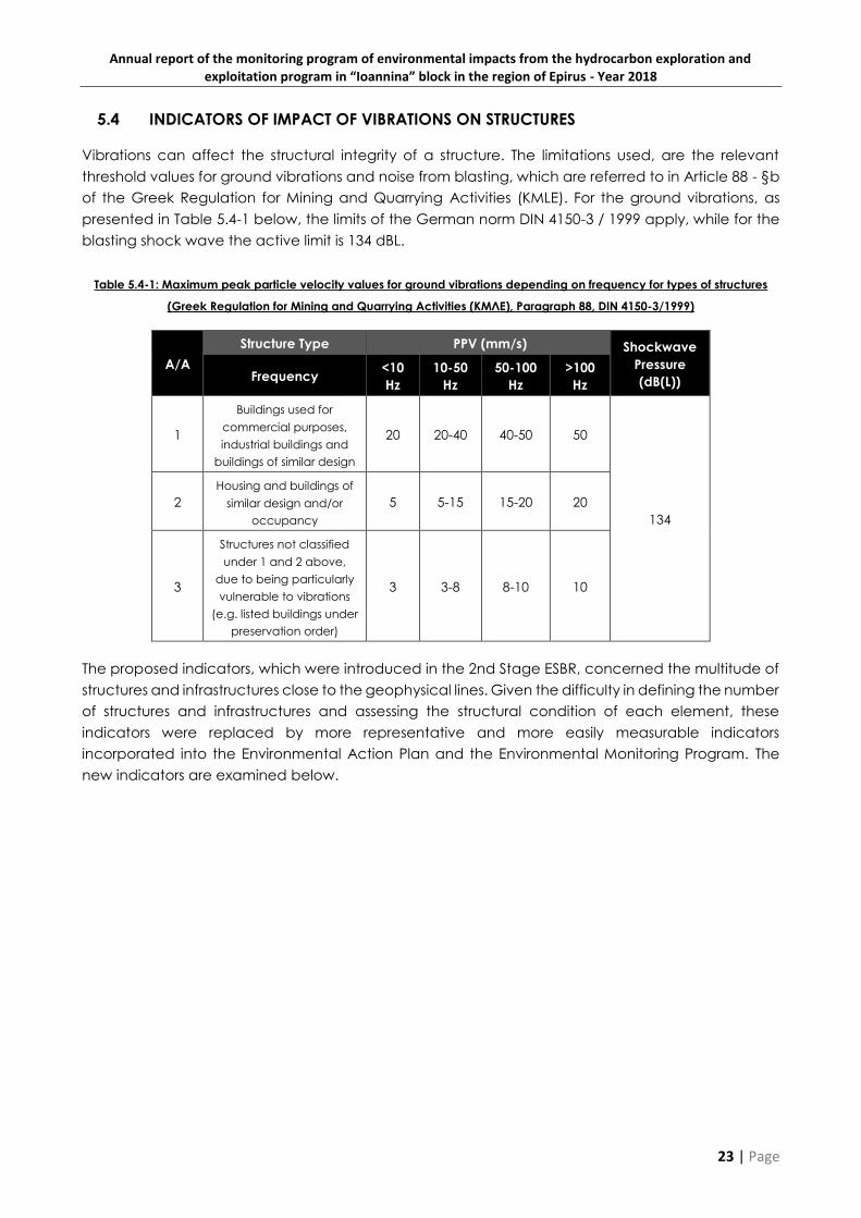
5.4 INDICATORS OF IMPACT OF VIBRATIONS ON STRUCTURES
Vibrations can affect the structural integrity of a structure. The limitations used, are the relevant
threshold values for ground vibrations and noise from blasting, which are referred to in Article 88 - §b
of the Greek Regulation for Mining and Quarrying Activities (KMLE). For the ground vibrations, as
presented in Table 5.4-1 below, the limits of the German norm DIN 4150-3 / 1999 apply, while for the
blasting shock wave the active limit is 134 dBL.
Table 5.4-1: Maximum peak particle velocity values for ground vibrations depending on frequency for types of structures
(Greek Regulation for Mining and Quarrying Activities (ΚΜΛΕ), Paragraph 88, DIN 4150-3/1999)
Α/Α
Structure Type PPV (mm/s) Shockwave
Pressure
(dB(L)) Frequency <10
Hz
10-50
Hz
50-100
Hz
>100
Hz
1
Buildings used for
commercial purposes,
industrial buildings and
buildings of similar design
20 20-40 40-50 50
134
2
Housing and buildings of
similar design and/or
occupancy
5 5-15 15-20 20
3
Structures not classified
under 1 and 2 above,
due to being particularly
vulnerable to vibrations
(e.g. listed buildings under
preservation order)
3 3-8 8-10 10
The proposed indicators, which were introduced in the 2nd Stage ESBR, concerned the multitude of
structures and infrastructures close to the geophysical lines. Given the difficulty in defining the number
of structures and infrastructures and assessing the structural condition of each element, these
indicators were replaced by more representative and more easily measurable indicators
incorporated into the Environmental Action Plan and the Environmental Monitoring Program. The
new indicators are examined below.

Annual report of the monitoring program of environmental impacts from the hydrocarbon exploration and exploitation program in “Ioannina” block in the region of Epirus - Year 2018
24 | Page
CHAPTER 6 ENVIRONMENTAL INDICATORS OF THE ENVIRONMENTAL AND SOCIAL
ACTION PLAN
The key performance indicators, which were introduced in the Environmental and Social Action
Plan17 in the context of the Environmental Management Plan are given in the table below. The target
value for each indicator is also given.
Table 6-1: Key performance indicators – Environmental and Social Action Plan
17 Enveco S.A., 2017. Second Stage Environmental and Social Baseline Report for the Seismic Survey in the Onshore Area
“Ioannina”, Athens: Energean Oil and Gas.

Annual report of the monitoring program of environmental impacts from the hydrocarbon exploration and exploitation program in “Ioannina” block in the region of Epirus - Year 2018
25 | Page
Parameter Index Unit Target 2018
Value
Operational Area of occupation of the
geophysical survey km2 1,3518 0.4619
Significant/protected
species
Injury incidents of protected or
important fauna species Number 0 0
Nuisance to threatened flora
species km2 0 0
Training
Staff to be informed on issues of flora
and fauna protection (Tool Box
Talks)
% 100 100
Accidents/Incidents Fuel / Chemicals Leaks
Number of
incidents 0 0
Fire incidents (related to the project) Number 0 0
Complaints/grievances
Expression of complaints/grievances
about noise Number 0 2
Expression of complaints/grievances
about damages to structures
(buildings, etc.) due to vibrations
Number 0 1
Expression of complaints/grievances
about damages to structures
(buildings, etc.) due to causes other
than vibrations
Number 0 8
Expression of complaints/grievances
concerning agriculture Number 0 2
Expression of complaints/grievances
concerning livestock farming Number 0 5
Solved grievances compared to
total grievances received % 100 100
CHAPTER 7 INDICATORS OF THE ENVIRONMENTAL AND SOCIAL MONITORING
PROGRAM
The experience of the environmental and social monitoring program, which evolves alongside the
works of the geophysical survey according to the provisions of the ESAP, allowed the definition of
representative indicators based on monitored parameters and reflects the impact of the project on
the natural and man-made environment, as well as the progress of work. The set of indicators as well
as their respective values for 2018 based on the data collected by the monitoring team are
presented in Table 7-1. It shall be noted, that the vibration indicators exclusively refer to lines 12 and
18 The target concerns the total extent of the geophysical survey as it has been estimated and is presented in the amendment
of the ESAP – (ENVECO S.A., 2018. Amendment of the Environmental and Social Action Plan (ESAP) – Hydrocarbons Exploration
and Exploitation program in the onshore area “Ioannina”, Αθήνα: Repsol.)
19 The occupation area concerns the works of all phases for lines 8, 9, 10, 12 and 13 (see paragraph Error! Reference source n
ot found.).

Annual report of the monitoring program of environmental impacts from the hydrocarbon exploration and exploitation program in “Ioannina” block in the region of Epirus - Year 2018
26 | Page
13, as geophysical data recording, during which the vibrations are induced, has only taken place
along these lines.
The report is accompanied by an annex (Annex I), which contains all the records of flora and fauna,
as well as a photographic documentation Annex (Annex II).
Table 7-1: Indicators of the environmental and social monitoring program
Indicator Unit Value for
2018
Operational
Occupation per land cover – land use category km2 Table 7-2
Percentage of occupation to the surface of the MSA20 % 0.0021%
Length and Target Percentage of Line Segments in which operations
have been completed per line. km/% Table 7-3
Number and percentage of the total number of source stations of
each line in which operations (heliportable and conventional drilling)
have been completed per line.
Number/% Table 7-4
Avifauna
-
Fauna21
-
Flora
Number of campaigns and analysis per line Number 323
Table 7-5
Number of important avifauna and fauna species records and
analysis per line Number
110
Table 7-5
Number of important fauna species recorded
(non-avifauna) Number 522
Number of important avifauna species recorded Number 1223
Number of important flora species records24 Number 319
Number of important flora species recorded Number 1725
Number of trees with trunk diameters greater than 20 cm, which were
cut. Number 15
20Total surface of MSA 214,4 km2, as defined in the amendment of the ESAP – (ENVECO S.A., 2018. Amendment of the
Environmental and Social Action Plan (ESAP) – Hydrocarbons Exploration and Exploitation program in the onshore area
“Ioannina”, Athens: Repsol.)
21 Data for each line below (Table 7-5) 22 List of species and number or recordings per species in Tables 7-6, 7-7, 7-8 23 Ibid. 24 Species of Annex IV – ENVECO S.A. 2017. Second Stage Environmental and Social Baseline Report for the Seismic Survey in
the Onshore Area “Ioannina”, Athens: Energean Oil and Gas. 25 List of species and number or recordings per species in Tables 7-6, 7-7, 7-8

Annual report of the monitoring program of environmental impacts from the hydrocarbon exploration and exploitation program in “Ioannina” block in the region of Epirus - Year 2018
27 | Page
Indicator Unit Value for
2018
Noise
Number of noise measurements during
Phase 1: Surveying and vegetation clearance Number 13
Number and percentage of noise measurements exceeding limit
values during
Phase 1: Surveying and vegetation clearance
Number/% 3/23%
Number of noise measurements during
conventional drilling operations Number 1
Number and percentage of noise measurements exceeding limit
values during
conventional drilling operations
Number/% 0/0%
Number of noise measurements during
heliportable drilling Number 35
Number and percentage of noise measurements exceeding limit
values during
heliportable drilling
Number/% 21/60%
Number and percentage of noise measurements exceeding limit
value of 70dB for LDEN noise indicator, as defined in GG211773/2012 on
transportational noise emissions during heliportable drilling works
Number/% 0/0%
Vibrations
Number of sensitive receptors (Lines 12 and 13) Number 73
Shotpoints relevant to sensitive receptors (Lines 12+13) Number 321
Number and percentage of exceedances of ground vibrations limits,
as defined in DIN4150 (Lines 12 and 13)
Number/% 15/4.67%
Number and percentage of exceedances of 134dBL, the limit for
blasting shock wave Αριθμός/% 0/0%

Annual report of the monitoring program of environmental impacts from the hydrocarbon exploration and exploitation program in “Ioannina” block in the region of Epirus - Year 2018
28 | Page
Table 7-2: Occupation per land cover category
Category
Line 12 Line 13 Line 9 Line 10 Line 8
Target
(m2)
Value
2018
(m2)
Percentage
(%)
Target
(m2)
Value
2018
(m2)
Percentage
(%)
Target
(m2)
Value
2018
(m2)
Percentage
(%)
Target
(m2)
Value
2018
(m2)
Percentage
(%)
Target
(m2)
Value
2018
(m2)
Percentage
(%)
AAG 4556 1564 34% 0 0 0% 0 0 0% 7601 0 0% 5705 296 5%
AGR 36725 7434 20% 34296 4502 13% 15978 1564 10% 33784 36 0% 30604 2114 7%
OAK1 1355 180 13% 0 0 0% 0 0 0% 2378 0 0% 3232 1563 48%
OAK2 13667 6269 46% 1835 205 11% 4013 0 0% 4661 0 0% 12987 861 7%
OAK3 5074 1413 28% 0 0 0% 583 167 29% 19238 167 1% 14483 1271 9%
BUS1 15285 6680 44% 11134 3956 36% 5524 53 1% 8336 1 0% 10100 2290 23%
BUS2 11311 4635 41% 10361 4751 46% 14005 2054 15% 40801 3715 9% 26522 5850 22%
BUS3 27168 13235 49% 12487 5272 42% 31078 4103 13% 17558 2443 14% 24047 5128 21%
DBU1 838 161 19% 0 0 0% 0 0 0% 0 0 0% 0 0 0%
DBU2 2679 700 26% 0 0 0% 0 0 0% 3796 0 0% 0 0 0%
DBU3 5366 2530 47% 0 0 0% 0 0 0% 1596 0 0% 2292 0 0%
MEA 21347 4679 22% 16017 3949 25% 1732 154 9% 12724 515 4% 17237 5460 32%
RIV 2283 437 19% 210 47 22% 497 0 0% 2375 75 3% 2036 0 0%
OTHER 775 9 1% 948 133 14% 295 149 51% 827 0 0% 2124 1002 47%
Total 148429 49923 34% 87289 22816 26% 73704 8244 11% 155675 6951 4% 151368 25836 17%
Legend
AAG: Abandoned Agricultural Crops, AGR: Agricultural Crops, OAK1: Sparse oak forests (cover 10-40%), OAK2: Dense oak forests (cover 40-70%), BUS1: Dense bushes (coverage of 40-
70%), BUS3: Dense bushes (coverage 70-100%), DBU1: Deciduous shrubs (cover 10-40%), DBU2 : Dense deciduous shrubs (coverage 40-70%), DBU3: Dense deciduous shrubs (cover 70-
100%), MEA: grassland, sparse vegetation, RIV: surface water bodies & aquatic vegetation, OTHER: Other

Annual report of the monitoring program of environmental impacts from the hydrocarbon exploration and exploitation program in “Ioannina” block in the region of Epirus - Year 2018
29 | Page
Table 7-3: Evolution of project per line and phase
Phase
Line 12 Line 13 Line 8* Line 9* Line 10*
Target Value
2018
Percenta
ge
(%)
Target Value
2018
Percenta
ge
(%)
Target Value
2018
Percenta
ge
(%)
Target Value
2018
Percenta
ge
(%)
Target Value
2018
Percenta
ge
(%)
Phase 1: Surveying and
vegetation clearance
(Line length in km)
48.46 47.1 97% 26.62 26.2 98% 53.651 12.4 23% 24.86 5.1 21% 55.252 8.16 15%
Phase 2: Drilling
(Number of drillings) 808 725 90% 444 411 93% 895 0 0% 415 0 0% 922 0 0%
Phase 3: Energy sources
and geophysical data
recording
(Number of drillings)
808 725 90% 444 398 90% 895 0 0% 415 0 0% 922 0 0%
Phase 4:
Restoration/Reforestatio
n, Equipment
demobilization
(Line length in km)
47.1 47.1 100% 26.2 26.2 100% 53.651 0 0% 24.86 0 0% 55.252 0 0%
*Ongoing operations
Table 7-4: Range of use of heliportable – conventional drilling equipment
Equipment Type
Line 12 Line 13 Line 8* Line 9* Line 10*
Total Value
2018
Percenta
ge
(%)
Total Value
2018
Percenta
ge
(%)
Total Value
2018
Percenta
ge
(%)
Total Value
2018
Percenta
ge
(%)
Total Value
2018
Percenta
ge
(%)
Heliportable
725 Drillings
537 74% 411
Drillings
276 67%
895 Drillings
0 0%
415 Drillings
0 0%
922 Drillings
0 0%
Conventional 188 26% 135 33% 0 0% 0 0% 0 0%
* Ongoing operations

Annual report of the monitoring program of environmental impacts from the hydrocarbon exploration and exploitation program in “Ioannina” block in the region of Epirus - Year 2018
30 | Page
Table 7-5: Observations of important fauna – avifauna species per line
Line Number of campaigns Number of important avifauna species observations
Number of
important fauna
species
observations
Total Number
of important
species
12 78 12 2 14
13 20 12 0 12
8 80 24 4 28
9 42 4 0 4
10 103 49 3 52
Total 323 101 9 110

Annual report of the monitoring program of environmental impacts from the hydrocarbon exploration and exploitation program in “Ioannina” block in the region of Epirus - Year 2018
31 | Page
Table 7-6: Important avifauna species and number of Observations
Α/Α Species Number of
observations
1 Pernis apivorus 34
2 Circaetus gallicus 14
3 Lanius collurio 6
4 Dendrocopos medius 10
5 Buteo rufinus 9
6 Accipiter brevipes 4
7 Dendrocopos sp. 1
8 Plegadis falcinellus 16
9 Falco eleonorae 1
10 Milvus migrans 1
11 Circus pygargus 1
12 Lanius senator 4
Table 7-6: Important fauna species (excluding avifauna) and number of observations
Α/Α Species Number of
observations
1 Testudo hermanni 1
2 Testudo marginata 2
3 Ursus arctos 1
4 Emys orbicularis 2
5 Bombina variegata 3

Annual report of the monitoring program of environmental impacts from the hydrocarbon exploration and exploitation program in “Ioannina” block in the region of Epirus - Year 2018
32 | Page
Table 7-7: Important flora species and number of observations
Α/Α Species Number of
observations
1 Anacamptis pyramidalis 68
2 Platanus orientalis 46
3 Digitalis lanata 2
4 Ruscus aculeatus 124
5 Bupleurum karglii 14
6 Serapias vomeracea 9
7 Dictamnus albus 6
8 Quercus ithaburensis 27
9 Ophrys mammosa sudsp. serotina 2
10 Lilium sp. 2
11 Abies borisii-regis 12
12 Ophrys oestrifera subsp. cornutula 1
13 Anacamptis morio 1
14 Anacamptis laxiflora 2
15 Ophrys oestrifera subsp. leptomera 1
16 Ophrys epirotica 1
17 Alnus glutinosa 1

Annual report of the monitoring program of environmental impacts from the hydrocarbon exploration and exploitation program in “Ioannina” block in the region of Epirus - Year 2018
33 | Page
CHAPTER 8 CONCLUSIONS AND PROPOSALS
Indicators for the wider study area
In summary, the indicators for the wider study area, which have been proposed in the 1st stage ESBR
did not differ with respect to their baseline values, as no new sources of the relevant indicator values
were generally found. It shall be noted, however, that the baseline values of the water indicators
have been updated on the basis of the corresponding values included in the 1st update of the Epirus
RBMP, as they refer to the period prior to the start of the geophysical survey.
Indicators for the Main Study Area
Similarly, indicators for the main study area remained at their baseline levels, with the exception of
indicators relating to Natura 2000 priority habitats. It should be noted, that the limited changes are
not related to the project but are a result of the re-mapping of the Natura 2000 sites habitats in 2017.
The new mapping led to the declassification of one of the priority habitats and to minor changes in
the relevant surfaces within the MSA.
Indicators proposed in the ESAP
As far as the indicators provided for in the ESAP are concerned, the project's progress in relation to
the total is about 25%, with regard to the completion of all the phases. During this time, all staff
received information on environmental issues, and there were no incidents of injury of important or
protected species of fauna, while the nuisance to endangered flora species was at zero levels.
Moreover, there were no occurrences of pollutant leakage accidents, and no fire was caused by
the works of the survey. Lastly, the limited number of complaints and the respective high percentage
of successful management show the effectiveness of the terms and conditions under which the
program is being implemented as well as the quickness of the project manager's response to the
demands of the public.
Indicators from the monitoring program
The supplementary indicators of the monitoring program are representative of the development of
the program and its possible impact. The operational indicators show the smooth progression of the
program. In relation to the impact on the natural environment, the limited number of large trees cut
indicates the project operator's commitment to flora protection, and the increased number of
avifauna observations are an indication of the limited impact of the survey on birds. An important
role in this parameter is played by the respective spatial and temporal restrictions, which are
provided for in the ESAP and its amendment. Impact indicators in the anthropogenic environment in
terms of noise and vibrations show a limited number of exceedances of the respective threshold
values and will be taken into account to improve the environmental performance of the project in
2019.
Vibrations
As far as vibrations are concerned, it shall be noted, that no damages have been documented in
the framework of the inspection of structures prior and after the activation of source stations.
Noise
Regarding the values of noise indicators, it is pointed out, that the 50 db(A) limit of PD 1180/1981 has
been used as a threshold value as provided for in the ESAP and its update.
Annual report of the monitoring program of environmental impacts from the hydrocarbon exploration and exploitation program in “Ioannina” block in the region of Epirus - Year 2018
34 | Page
However, the ministerial decision, which regulates transportational noise emissions (M.D.
211773/2012) defines a limitation of 70 db(A) for the LDEN noise indicator. As no exceedances of this
limit have been documented during the operations, adopting this threshold value for the calculation
of the respective heliportable drilling indicator (Number and percentage of noise measurements
exceeding limit values during heliportable drilling) would result in a zero value.
As far as the elevated values of the noise indicator for vegetation clearance is concerned (Number
and percentage of noise measurements exceeding limit values during Phase 1: Surveying and
vegetation clearance), it shall be highlighted, that:
the only value exceeding 55 dB(A) was recorded on a day with high background noise levels
due to a storm and wind, while the recording location was next to the provincial road.
All other exceedances were lower than 55 dB(A) with only one marginally exceeding 51 dB(A)
and thus the LEQ(24h) threshold value of 50 dB(A). All other cases of elevated noise levels may
not be linked with the operations of the project and are explained either by meteorological
conditions or traffic in adjacent roads.
Moreover, the limited number of days with elevated noise indicator values throughout the
year leads to minimal effects of the project on the respective yearly LDEN values and allow the
consideration of the importance of the related impact as limited.
In summary, the overall impression given by the monitored indicators shows, as estimated in the ESAP,
a non-significant effect of the survey on the natural environment. The documented performance in
relation to vibration and noise is to be taken into account in the operations’ planning for 2019. Real-
time monitoring of environmental parameters by the environmental monitoring program team allows
not only capturing possible divergences from environmental targets, but also immediately applying
appropriate corrective – mitigative interventions, such as the modification of the spatial and
temporal plan of the operations and issuing of appropriate compensations.

Annual report of the monitoring program of environmental impacts from the hydrocarbon exploration and exploitation program in “Ioannina” block in the region of Epirus - Year 2018
35 | Page
CHAPTER 9 RELEVANT STUDIES (ORIGINAL TITLES)
9.1 ORIGINAL TITLES IN GREEK
Enveco Α.Ε., 2015. Πρώτο Στάδιο Περιβαλλοντικής Μελέτης Βάσης - Πρόγραμμα Έρευνας και
Εκμετάλλευσης Υδρογονανθράκων στη Χερσαία Περιοχή των Ιωαννίνων, Αθήνα: Energean Oil
and Gas.
Enveco Α.Ε., 2017. Δεύτερο στάδιο Περιβαλλοντικής Μελέτης Βάσης για τη σεισμική έρευνα στη
χερσαία περιοχή «Ιωάννινα», Αθήνα: Energean Oil and Gas.
ENVECO Α.Ε., 2017. Περιβαλλοντικό Σχέδιο Δράσης (ΠΣΔ) - Πρόγραμμα Έρευνας και Εκμετάλλευσης
Υδρογονανθράκων στη Χερσαία Περιοχή «Ιωάννινα», ΑΘήνα: Energean Oil and Gas.
ENVECO Α.Ε., 2018. Τροποποίηση του Περιβαλλοντικού Σχεδίου Δράσης (ΠΣΔ) - Πρόγραμμα Έρευνας
και Εκμετάλλευσης Υδρογονανθράκων στη Χερσαία Περιοχή «Ιωάννινα», Αθήνα: Repsol.
Κοινοπραξία: «1ης Αναθεώρησης ΣΔΛΑΠ Υδατικών Διαμερισμάτων Θεσσαλίας, Ηπείρου και Δυτ.
Στερεάς Ελλάδας» , 2017. 1η Αναθεώρηση του Σχεδίου Διαχείρισης Λεκανών Απορροής
Ποταμών Υδατικού Διαμερίσματος Ηπείρου (EL05), ΑΘήνα: Υπουργείο Περιβάλλοντος &
Ενέργειας, Ειδική Γραμματεία Υδάτων.
9.2 TRANSLATED TITLES IN ENGLISH
Enveco S.A., 2015. First Stage of Environmental and Social Baseline Report for the Hydrocarbons
Exploration and Exploitation Program in the Onshore Area “IOANNINA”, Athens: Energean Oil
and Gas.
Enveco S.A., 2017. Second Stage Environmental and Social Baseline Report for the Seismic Survey in
the Onshore Area “Ioannina”, Athens: Energean Oil and Gas.
ENVECO S.A., 2017. Environmental and Social Action Plan (ESAP) – Hydrocarbons Exploration and
Exploitation program in the onshore area “Ioannina”, Athens: Repsol.
ENVECO S.A., 2018. Amendment of the Environmental and Social Action Plan (ESAP) – Hydrocarbons
Exploration and Exploitation program in the onshore area “Ioannina”, Athens: Repsol.
Κοινοπραξία: «1ης Αναθεώρησης ΣΔΛΑΠ Υδατικών Διαμερισμάτων Θεσσαλίας, Ηπείρου και Δυτ.
Στερεάς Ελλάδας» , 2017. 1η Αναθεώρηση του Σχεδίου Διαχείρισης Λεκανών Απορροής
Ποταμών Υδατικού Διαμερίσματος Ηπείρου (EL05), ΑΘήνα: Υπουργείο Περιβάλλοντος &
Ενέργειας, Ειδική Γραμματεία Υδάτων.

ANNUAL REPORT OF THE MONITORING PROGRAM OF ENVIRONMENTAL
IMPACTS FROM THE HYDROCARBON EXPLORATION AND EXPLOITATION
PROGRAM IN “IOANNINA” BLOCK IN THE REGION OF EPIRUS
YEAR 2018
Annex I
NATURAL ENVIRONMENT MONITORING RECORDS
Prepared by:
March 2019
Annual report of the monitoring program of environmental impacts from the hydrocarbon exploration and exploitation program in “Ioannina” block in the region of Epirus - Year 2018
`1 | P a g e
Table 1: Fauna and avifauna records
#
Tax
on
om
y
Date Species Name Activity Method
Coordinates
(WGS 84 UTM 34N)
X Y
1 B 2018-05-03 Pernis apivorus Passing PC 470305.045 4390610.529
2 B 2018-05-03 Pernis apivorus Passing PC 470305.045 4390610.529
3 B 2018-05-03 Circaetus gallicus Breeding PC 470305.045 4390610.529
4 B 2018-05-03 Testudo hermanni Feeding PC 470305.045 4390610.529
5 B 2018-05-06 Circaetus gallicus Feeding PC 440313.407 4371654.546
6 B 2018-05-07 Pernis apivorus Soaring PC 473219.054 4392408.019
7 R 2018-05-07 Lanius senator Feeding PC 472370.256 4391960.639
8 B 2018-05-10 Lanius collurio Roosting PC 466484.192 4388919.578
9 R 2018-05-10 Testudo marginata Roosting PC 465831.610 4388259.081
10 B 2018-05-11 Pernis apivorus Soaring PC 467904.096 4389221.628
11 B 2018-05-16 Dendrocopus medius Breeding PC 465582.823 4387769.518
12 B 2018-05-16 Dendrocopus medius Breeding PC 465369.357 4387642.175
13 B 2018-05-24 Pernis apivorus Passing PC 442432.152 4371922.862
14 B 2018-05-24 Pernis apivorus Flying 444317.719 4374200.866
15 B 2018-05-25 Circaetus gallicus Soaring PC 441023.347 4374393.526
16 B 2018-05-25 Pernis apivorus Soaring VP 458046.839 4383107.450
17 B 2018-05-26 Circaetus gallicus Passing PC 438510.868 4379203.742
18 B 2018-05-27 Circaetus gallicus Passing PC 437309.907 4381024.098
19 B 2018-05-27 Circaetus gallicus Passing VP 436313.735 4382554.719
20 B 2018-05-27 Buteo ruffinus Passing VP 436313.735 4382554.719
21 B 2018-05-27 Buteo ruffinus Passing VP 436313.735 4382554.719
22 B 2018-05-27 Buteo ruffinus Passing PC 437309.907 4381024.098
23 B 2018-05-27 Buteo ruffinus Passing PC 437309.907 4381024.098
24 B 2018-05-28 Circaetus gallicus Feeding PC 433096.847 4387177.485
25 B 2018-06-03 Pernis apivorus Passing PC 434969.712 4384369.327
26 B 2018-06-07 Pernis apivorus Flying PC 436155.100 4379278.675
27 B 2018-06-07 Pernis apivorus Flying PC 436155.100 4379278.675
28 B 2018-06-07 Pernis apivorus Flying PC 436155.100 4379278.675
29 B 2018-06-07 Pernis apivorus Flying PC 436155.100 4379278.675
30 B 2018-06-07 Pernis apivorus Flying PC 437320.686 4379992.016
31 B 2018-06-07 Pernis apivorus Flying PC 437320.686 4379992.016
32 B 2018-06-07 Pernis apivorus Flying PC 437320.686 4379992.016
33 R 2018-06-08 Lanius senator Presence LT 440093.190 4381586.594
34 B 2018-06-08 Circaetus gallicus Feeding LT 440093.190 4381586.594
35 B 2018-06-17 Buteo ruffinus Feeding Random 443419.845 4370933.897
36 B 2018-06-18 Circaetus gallicus Feeding VP 451346.576 4389557.807
37 B 2018-06-18 Pernis apivorus Flying VP 454478.067 4392138.015
38 B 2018-06-18 Pernis apivorus Flying VP 454478.067 4392138.015
39 B 2018-06-18 Pernis apivorus Flying VP 454478.067 4392138.015
40 B 2018-06-20 Pernis apivorus Flying VP 458831.532 4396106.632

Annual report of the monitoring program of environmental impacts from the hydrocarbon exploration and exploitation program in “Ioannina” block in the region of Epirus - Year 2018
`2 | P a g e
#
Tax
on
om
y
Date Species Name Activity Method
Coordinates
(WGS 84 UTM 34N)
X Y
41 B 2018-06-21 Dendrocopos medius Presence VP 460223.476 4396051.577
42 B 2018-06-21 Dendrocopos medius Presence VP 461693.800 4396894.167
43 B 2018-06-21 Dendrocopos medius Presence VP 461693.800 4396894.167
44 B 2018-06-21 Accipiter brevipes Presence PC 462352.151 4397353.845
45 B 2018-06-21 Accipiter brevipes Presence PC 462352.151 4397353.845
46 B 2018-06-21 Pernis apivorus Flying PC 464002.339 4398445.273
47 R 2018-06-24 Testudo marginata Presence Random 449461.364 4388145.398
48 B 2018-06-24 Pernis apivorus Flying Random 449474.675 4388133.879
49 B 2018-06-25 Dendrocopos medius Presence VP 475963.375 4406700.921
50 B 2018-06-25 Dendrocopos medius Presence VP 475963.375 4406700.921
51 B 2018-06-25 Dendrocopos medius Presence PC 472064.758 4404021.020
52 B 2018-06-25 Dendrocopus sp. Nest Presence PC 472151.921 4403925.142
53 B 2018-06-25 Lanius collurio Breeding LT 471465.798 4403538.874
54 B 2018-06-25 Lanius collurio Breeding LT 471465.798 4403538.874
55 B 2018-06-25 Pernis apivorus Flying VP 467771.273 4401058.831
56 M 2018-06-26 Ursus arctos droopings PC 466670.311 4400239.780
57 B 2018-06-27 Circaetus gallicus Flying 467468.780 4400629.030
58 B 2018-06-28 Plegadis falcinellus Flying LT 433020.934 4377521.453
59 B 2018-06-28 Plegadis falcinellus Flying LT 433020.934 4377521.453
60 B 2018-06-28 Plegadis falcinellus Flying LT 433020.934 4377521.453
61 B 2018-06-28 Plegadis falcinellus Flying LT 433020.934 4377521.453
62 B 2018-06-28 Plegadis falcinellus Flying LT 433020.934 4377521.453
63 B 2018-06-28 Plegadis falcinellus Flying LT 433020.934 4377521.453
64 B 2018-06-28 Plegadis falcinellus Flying LT 432882.111 4377684.816
65 B 2018-06-28 Plegadis falcinellus Flying LT 432875.670 4376992.283
66 B 2018-06-28 Plegadis falcinellus Flying LT 431644.108 4376274.408
67 B 2018-06-28 Plegadis falcinellus Flying LT 431644.108 4376274.408
68 B 2018-06-28 Plegadis falcinellus Flying LT 431644.108 4376274.408
69 B 2018-06-28 Plegadis falcinellus Flying LT 431644.108 4376274.408
70 B 2018-06-28 Plegadis falcinellus Flying LT 431644.108 4376274.408
71 B 2018-06-28 Plegadis falcinellus Flying LT 431644.108 4376274.408
72 B 2018-06-28 Plegadis falcinellus Flying LT 431644.108 4376274.408
73 B 2018-06-28 Plegadis falcinellus Flying LT 431644.108 4376274.408
74 B 2018-06-28 Circaetus gallicus Flying LT 430982.697 4375564.937
75 R 2018-06-28 Emys orbicularis Presence LT 430982.697 4375564.937
76 R 2018-06-30 Lanius senator Presence PC 430771.586 4381521.579
77 R 2018-06-30 Lanius senator Presence PC 430771.586 4381521.579
78 B 2018-06-30 Lanius collurio Presence PC 431323.658 4382060.516
79 B 2018-06-30 Lanius collurio Presence PC 431323.658 4382060.516
80 B 2018-06-30 Lanius collurio Presence PC 431323.658 4382060.516
81 R 2018-06-30 Emys orbicularis PC 431662.509 4382618.801
82 B 2018-06-30 Pernis apivorus Flying VP 433568.315 4384481.160
Annual report of the monitoring program of environmental impacts from the hydrocarbon exploration and exploitation program in “Ioannina” block in the region of Epirus - Year 2018
`3 | P a g e
#
Tax
on
om
y
Date Species Name Activity Method
Coordinates
(WGS 84 UTM 34N)
X Y
83 B 2018-06-30 Pernis apivorus Flying VP 433568.315 4384481.160
84 B 2018-07-01 Pernis apivorus Flying PC 438025.405 4387141.167
85 B 2018-07-01 Circaetus gallicus Flying PC 438025.405 4387141.167
86 B 2018-07-01 Accipiter brevipes Presence VP 438257.534 4387416.895
87 B 2018-07-01 Accipiter brevipes Presence VP 438257.534 4387416.895
88 B 2018-07-01 Pernis apivorus Presence VP 438257.534 4387416.895
89 B 2018-07-01 Pernis apivorus Feeding PC 441394.764 4389730.434
90 B 2018-07-01 Pernis apivorus Feeding PC 441394.764 4389730.434
91 A 2018-07-03 Bombina variegata Breeding PC 449886.021 4395086.142
92 A 2018-07-03 Bombina variegata Breeding PC 449886.021 4395086.142
93 A 2018-07-03 Bombina variegata Breeding PC 449886.021 4395086.142
94 B 2018-07-03 Pernis apivorus Flying PC 449338.727 4395569.874
95 B 2018-07-04 Pernis apivorus Flying VP 452478.554 4397502.470
96 B 2018-07-04 Pernis apivorus Flying VP 452478.554 4397502.470
97 B 2018-07-04 Pernis apivorus Flying VP 452478.554 4397502.470
98 B 2018-07-04 Pernis apivorus Flying VP 452478.554 4397502.470
99 B 2018-07-04 Buteo ruffinus Feeding PC 453141.124 4398498.976
100 B 2018-07-05 Falco eleonorae Flying 463717.668 4398226.412
101 B 2018-07-05 Buteo ruffinus Flying 451349.916 4389556.898
102 B 2018-07-05 Buteo ruffinus Flying 451349.916 4389556.898
103 B 2018-07-06 Pernis apivorus Flying VP 448652.300 4394527.565
104 B 2018-07-06 Circaetus gallicus Flying PC 448373.764 4394288.802
105 B 2018-07-06 Circaetus gallicus Flying PC 448373.764 4394288.802
106 B 2018-10-11 Buteo ruffinus Flying VP 448273.940 4383923.038
107 B 2018-10-14 Dendrocopus medius Presence VP 444090.529 4392538.334
108 B 2018-10-16 Dendrocopus medius Presence VP 449403.990 4381291.783
109 B 2018-10-17 Milrus migrans Presence VP 451669.178 4376190.958
110 B 2018-11-09 Circus pygargus Flying VP 468420.283 4407035.190

Annual report of the monitoring program of environmental impacts from the hydrocarbon exploration and exploitation program in “Ioannina” block in the region of Epirus - Year 2018
4 | P a g e
Table 2: Flora records
# Species Name Line Date
Coordinates
(WGS 84 UTM 34N) Density Nuisance
X Y
1 Anacamptis pyramidalis HP_A6 4/5/2018 470404.698 4408495.333 No data available No disturbance
2 Platanus orientalis HP_A67 4/5/2018 436303.422 4385247.579 No data available No disturbance
3 Digitalis lanata HP_A69 4/5/2018 447331.490 4386876.067 No data available No disturbance
4 Platanus orientalis HP_A69 4/5/2018 447331.045 4386811.030 No data available No disturbance
5 Ruscus aculeatus HP_A69 4/5/2018 447331.045 4386811.030 No data available No disturbance
6 Ruscus aculeatus IO17-10 5/5/2018 438472.100 4380702.610 No data available No disturbance
7 Bupleurum karglii IO17-10 5/5/2018 440726.960 4382015.564 No data available No disturbance
8 Ruscus aculeatus IO17-10 5/5/2018 435153.990 4378692.530 No data available No disturbance
9 Ruscus aculeatus IO17-10 5/5/2018 435791.406 4379067.723 No data available No disturbance
10 Ruscus aculeatus IO17-10 5/5/2018 436206.610 4379309.300 No data available No disturbance
11 Ruscus aculeatus IO17-10 5/5/2018 437146.210 4379881.090 No data available No disturbance
12 Ruscus aculeatus IO17-10 5/5/2018 439337.810 4381203.000 No data available No disturbance
13 Platanus orientalis IO17-10 5/5/2018 439701.909 4381377.757 No data available No disturbance
14 Ruscus aculeatus IO17-10 5/5/2018 439597.910 4381352.490 No data available No disturbance
15 Platanus orientalis IO17-10 5/5/2018 441833.110 4382753.700 No data available No disturbance
16 Platanus orientalis IO17-10 5/5/2018 441982.818 4382853.380 No data available No disturbance
17 Anacamptis pyramidalis IO17-12 5/5/2018 475501.720 4393645.672 No data available No disturbance
18 Ruscus aculeatus IO17-12 5/5/2018 476260.290 4394058.090 No data available No disturbance
19 Ruscus aculeatus IO17-12 5/5/2018 476562.991 4394219.712 No data available No disturbance
20 Ruscus aculeatus IO17-12 5/5/2018 476998.190 4394459.710 No data available No disturbance
21 Ruscus aculeatus IO17-12 5/5/2018 477119.036 4394523.359 No data available No disturbance
22 Anacamptis pyramidalis IO17-12 6/5/2018 473951.290 4392801.169 Rare No disturbance
23 Anacamptis pyramidalis IO17-12 7/5/2018 474749.431 4393233.018 No data available No disturbance
24 Anacamptis pyramidalis IO17-12 7/5/2018 474742.406 4393234.816 No data available No disturbance

Annual report of the monitoring program of environmental impacts from the hydrocarbon exploration and exploitation program in “Ioannina” block in the region of Epirus - Year 2018
5 | P a g e
# Species Name Line Date
Coordinates
(WGS 84 UTM 34N) Density Nuisance
X Y
25 Serapias vomeracea IO17-12 7/5/2018 474962.641 4393351.408 No data available No disturbance
26 Anacamptis pyramidalis IO17-12 7/5/2018 475019.100 4393389.626 No data available No disturbance
27 Anacamptis pyramidalis IO17-12 7/5/2018 475015.324 4393388.639 No data available No disturbance
28 Anacamptis pyramidalis IO17-12 7/5/2018 475117.341 4393435.367 No data available No disturbance
29 Anacamptis pyramidalis IO17-12 7/5/2018 475117.181 4393438.919 No data available No disturbance
30 Anacamptis pyramidalis IO17-12 7/5/2018 475114.697 4393439.704 No data available No disturbance
31 Anacamptis pyramidalis IO17-12 7/5/2018 475145.944 4393450.590 No data available No disturbance
32 Anacamptis pyramidalis IO17-12 7/5/2018 475221.023 4393493.632 No data available No disturbance
33 Ruscus aculeatus IO17-12 7/5/2018 473482.200 4392552.310 No data available No disturbance
34 Anacamptis pyramidalis IO17-12 7/5/2018 472077.479 4391798.880 No data available No disturbance
35 Anacamptis pyramidalis IO17-12 7/5/2018 472076.950 4391794.997 Rare No disturbance
36 Dictamnus albus IO17-12 7/5/2018 472061.598 4391794.720 No data available No disturbance
37 Ruscus aculeatus IO17-12 8/5/2018 471525.810 4391462.600 No data available No disturbance
38 Ruscus aculeatus IO17-12 8/5/2018 471662.890 4391545.110 No data available No disturbance
39 Ruscus aculeatus IO17-12 8/5/2018 471765.700 4391607.000 No data available No disturbance
40 Anacamptis pyramidalis IO17-12 8/5/2018 471826.292 4391638.866 No data available No disturbance
41 Quercus ithaburensis IO17-12 8/5/2018 471861.939 4391653.940 No data available No disturbance
42 Anacamptis pyramidalis IO17-12 8/5/2018 471903.837 4391689.525 No data available No disturbance
43 Anacamptis pyramidalis IO17-12 8/5/2018 471900.479 4391685.875 No data available No disturbance
44 Anacamptis pyramidalis IO17-12 8/5/2018 471926.875 4391704.091 Rare No disturbance
45 Anacamptis pyramidalis IO17-12 8/5/2018 471916.812 4391696.359 No data available No disturbance
46 Anacamptis pyramidalis IO17-12 8/5/2018 471990.284 4391735.491 No data available No disturbance
47 Anacamptis pyramidalis IO17-12 8/5/2018 472015.548 4391749.161 No data available No disturbance
48 ?Bupleurum karglii? IO17-12 8/5/2018 472022.710 4391761.790 No data available No disturbance
49 Anacamptis pyramidalis IO17-12 8/5/2018 472019.864 4391756.804 No data available No disturbance
50 Dictamnus albus IO17-12 8/5/2018 472061.975 4391780.623 Rare No disturbance
51 Dictamnus albus IO17-12 8/5/2018 472057.769 4391779.529 Rare No disturbance

Annual report of the monitoring program of environmental impacts from the hydrocarbon exploration and exploitation program in “Ioannina” block in the region of Epirus - Year 2018
6 | P a g e
# Species Name Line Date
Coordinates
(WGS 84 UTM 34N) Density Nuisance
X Y
52 Anacamptis pyramidalis IO17-12 8/5/2018 469802.598 4390422.697 Rare No disturbance
53 Anacamptis pyramidalis IO17-12 9/5/2018 469997.700 4390543.020 No data available No disturbance
54 Ophrys mammosa sudsp.
serotina IO17-12 9/5/2018 469996.671 4390543.135 No data available No disturbance
55 Ruscus aculeatus IO17-12 9/5/2018 470018.000 4390554.700 No data available No disturbance
56 Anacamptis pyramidalis IO17-12 9/5/2018 470037.135 4390559.070 No data available No disturbance
57 Anacamptis pyramidalis IO17-12 9/5/2018 470121.758 4390615.233 No data available No disturbance
58 Ruscus aculeatus IO17-12 9/5/2018 470137.990 4390626.910 No data available No disturbance
59 Ruscus aculeatus IO17-12 9/5/2018 470172.190 4390647.500 No data available No disturbance
60 Anacamptis pyramidalis IO17-12 9/5/2018 470219.586 4390670.569 No data available No disturbance
61 Lilium sp. IO17-12 9/5/2018 470336.007 4390743.149 No data available No disturbance
62 Dictamnus albus IO17-12 9/5/2018 470345.904 4390751.545 Rare No disturbance
63 Lilium sp. IO17-12 9/5/2018 470340.738 4390746.460 No data available No disturbance
64 Ruscus aculeatus IO17-12 9/5/2018 470429.200 4390802.310 No data available No disturbance
65 Ruscus aculeatus IO17-12 9/5/2018 470686.200 4390957.000 No data available No disturbance
66 Ruscus aculeatus IO17-12 9/5/2018 470771.900 4391008.590 No data available No disturbance
67 Quercus ithaburensis IO17-12 9/5/2018 468803.707 4389811.151 1 individual No disturbance
68 Quercus ithaburensis IO17-12 9/5/2018 468804.475 4389810.149 1 individual No disturbance
69 Ruscus aculeatus IO17-12 10/5/2018 468873.490 4389858.000 No data available No disturbance
70 Dictamnus albus IO17-12 10/5/2018 468898.939 4389877.247 No data available No disturbance
71 Ruscus aculeatus IO17-12 10/5/2018 469486.900 4390234.790 No data available No disturbance
72 Anacamptis pyramidalis IO17-12 10/5/2018 469728.065 4390381.481 Rare No disturbance
73 Platanus orientalis IO17-12 10/5/2018 469744.893 4390385.300 No data available No disturbance
74 Ruscus aculeatus IO17-12 10/5/2018 467431.000 4388921.200 No data available No disturbance
75 Anacamptis pyramidalis IO17-12 10/5/2018 467467.229 4388935.119 No data available No disturbance
76 Anacamptis pyramidalis IO17-12 10/5/2018 467466.894 4388937.229 No data available No disturbance
77 Anacamptis pyramidalis IO17-12 10/5/2018 467462.699 4388939.245 No data available No disturbance
78 Anacamptis pyramidalis IO17-12 11/5/2018 467522.980 4388971.953 No data available No disturbance

Annual report of the monitoring program of environmental impacts from the hydrocarbon exploration and exploitation program in “Ioannina” block in the region of Epirus - Year 2018
7 | P a g e
# Species Name Line Date
Coordinates
(WGS 84 UTM 34N) Density Nuisance
X Y
79 Anacamptis pyramidalis IO17-12 11/5/2018 467522.293 4388971.845 No data available No disturbance
80 Anacamptis pyramidalis IO17-12 11/5/2018 467520.321 4388972.186 No data available No disturbance
81 Anacamptis pyramidalis IO17-12 11/5/2018 467519.729 4388974.187 No data available No disturbance
82 Anacamptis pyramidalis IO17-12 11/5/2018 467520.242 4388973.852 No data available No disturbance
83 Anacamptis pyramidalis IO17-12 11/5/2018 467536.778 4388988.765 No data available No disturbance
84 Ruscus aculeatus IO17-12 11/5/2018 467903.390 4389222.000 No data available No disturbance
85 Quercus ithaburensis IO17-12 11/5/2018 468063.669 4389324.626 No data available No disturbance
86 Quercus ithaburensis IO17-12 11/5/2018 468164.327 4389392.798 4 individuals No disturbance
87 Quercus ithaburensis IO17-12 11/5/2018 468264.735 4389462.971 1 individual No disturbance
88 Quercus ithaburensis IO17-12 11/5/2018 468264.887 4389458.420 1 individual No disturbance
89 Quercus ithaburensis IO17-12 11/5/2018 468312.654 4389495.625 No data available No disturbance
90 Quercus ithaburensis IO17-12 11/5/2018 468318.719 4389489.385 No data available No disturbance
91 Serapias vomeracea IO17-12 11/5/2018 468400.893 4389548.980 Rare No disturbance
92 Quercus ithaburensis IO17-12 11/5/2018 468460.020 4389595.241 2 individuals No disturbance
93 Ruscus aculeatus IO17-12 11/5/2018 467061.410 4388682.600 No data available No disturbance
94 Ruscus aculeatus IO17-12 11/5/2018 467078.100 4388693.600 No data available No disturbance
95 Platanus orientalis IO17-12 11/5/2018 467329.775 4388852.239 No data available No disturbance
96 Ruscus aculeatus IO17-12 11/5/2018 467346.610 4388867.600 No data available No disturbance
97 Ruscus aculeatus IO17-12 11/5/2018 465631.790 4387799.070 No data available No disturbance
98 Ruscus aculeatus IO17-12 11/5/2018 465754.220 4387870.460 No data available No disturbance
99 Platanus orientalis IO17-12 12/5/2018 466010.056 4388019.671 1 individual No disturbance
100 Ruscus auleatus IO17-12 12/5/2018 466010.056 4388019.671 No data available No disturbance
101 Ruscus auleatus IO17-12 12/5/2018 466790.738 4388499.963 No data available No disturbance
102 Ruscus aculeatus IO17-12 12/5/2018 466250.980 4388168.030 No data available No disturbance
103 Ophrys mammosa sudsp.
serotina IO17-12 13/5/2018 466788.939 4388500.951 6 individuals No disturbance
104 Ruscus aculeatus IO17-12 13/5/2018 466877.120 4388561.670 No data available No disturbance
105 Ruscus aculeatus IO17-12 13/5/2018 460079.000 4384580.300 No data available No disturbance

Annual report of the monitoring program of environmental impacts from the hydrocarbon exploration and exploitation program in “Ioannina” block in the region of Epirus - Year 2018
8 | P a g e
# Species Name Line Date
Coordinates
(WGS 84 UTM 34N) Density Nuisance
X Y
106 Anacamptis pyramidalis IO17-12 13/5/2018 460151.690 4384622.801 3 individuals No disturbance
107 Serapias vomeracea IO17-12 13/5/2018 460149.449 4384621.037 1 individual No disturbance
108 Abies borisii-regis IO17-12 13/5/2018 460462.772 4384819.533 1 individual No disturbance
109 Abies borisii-regis IO17-12 13/5/2018 460466.216 4384821.513 1 individual No disturbance
110 Ruscus aculeatus IO17-12 13/5/2018 460487.700 4384831.900 No data available No disturbance
111 Abies borisii-regis IO17-12 13/5/2018 460498.490 4384837.663 1 individual No disturbance
112 Serapias vomeracea IO17-12 13/5/2018 460725.932 4384981.116 4 individuals No disturbance
113 Platanus orientalis IO17-12 13/5/2018 464766.610 4387299.400 No data available No disturbance
114 Platanus orientalis IO17-12 15/5/2018 464649.481 4387247.780 1 individual No disturbance
115 Abies borisii-regis IO17-12 15/5/2018 464689.343 4387257.364 No data available No disturbance
116 Platanus orientalis IO17-12 15/5/2018 463694.711 4386686.078 No data available No disturbance
117 Platanus orientalis IO17-12 15/5/2018 463683.554 4386686.130 No data available No disturbance
118 Ruscus aculeatus IO17-12 15/5/2018 454928.420 4380635.100 No data available No disturbance
119 Abies borisii-regis IO17-12 15/5/2018 458132.870 4383180.930 No data available No disturbance
120 Ruscus aculeatus IO17-12 15/5/2018 451380.950 4378788.580 No data available No disturbance
121 Ruscus aculeatus IO17-12 15/5/2018 449940.100 4378048.420 No data available No disturbance
122 Ruscus aculeatus IO17-12 16/5/2018 439963.600 4371505.500 No data available No disturbance
123 Quercus ithaburensis IO17-12 16/5/2018 438450.910 4370873.210 No data available No disturbance
124 Ruscus aculeatus IO17-12 16/5/2018 438450.910 4370873.180 No data available No disturbance
125 Ruscus aculeatus IO17-12 16/5/2018 476563.013 4394219.750 No data available No disturbance
126 Ruscus aculeatus IO17-12 16/5/2018 464375.800 4387077.456 No data available No disturbance
127 Ruscus aculeatus IO17-12 16/5/2018 464565.172 4387183.462 No data available No disturbance
128 Ruscus aculeatus IO17-12 16/5/2018 460474.815 4384825.727 No data available No disturbance
129 Ruscus aculeatus IO17-12 16/5/2018 460698.085 4384961.952 No data available No disturbance
130 Ruscus aculeatus IO17-12 16/5/2018 460931.647 4385107.430 No data available No disturbance
131 Ruscus aculeatus IO17-12 16/5/2018 461305.445 4385330.740 No data available No disturbance
132 Ruscus aculeatus IO17-12 17/5/2018 476886.997 4394479.659 No data available No disturbance
Annual report of the monitoring program of environmental impacts from the hydrocarbon exploration and exploitation program in “Ioannina” block in the region of Epirus - Year 2018
9 | P a g e
# Species Name Line Date
Coordinates
(WGS 84 UTM 34N) Density Nuisance
X Y
133 Ruscus aculeatus IO17-12 17/5/2018 476886.221 4394477.996 No data available No disturbance
134 Ruscus aculeatus IO17-12 17/5/2018 476885.533 4394477.332 No data available No disturbance
135 Quercus ithaburensis IO17-12 17/5/2018 456286.331 4381586.459 No data available No disturbance
136 Abies borisii-regis IO17-12 17/5/2018 456466.703 4381726.834 No data available No disturbance
137 Abies borisii-regis IO17-12 17/5/2018 456799.652 4382022.925 No data available No disturbance
138 Abies borisii-regis IO17-12 17/5/2018 457160.876 4382333.928 No data available No disturbance
139 Ruscus aculeatus IO17-12 17/5/2018 457294.029 4382444.645 Abundant No disturbance
140 Quercus ithaburensis IO17-12 17/5/2018 455617.746 4381082.554 No data available No disturbance
141 Abies borisii-regis IO17-12 17/5/2018 456648.079 4381871.941 No data available No disturbance
142 Abies borisii-regis IO17-12 17/5/2018 456982.186 4382113.622 No data available No disturbance
143 Ruscus aculeatus IO17-12 17/5/2018 456999.142 4382186.978 No data available No disturbance
144 Ruscus aculeatus IO17-12 17/5/2018 455204.246 4380797.528 No data available No disturbance
145 Quercus ithaburensis IO17-13 18/5/2018 442347.970 4372223.711 1 individual No disturbance
146 Quercus ithaburensis IO17-13 18/5/2018 442242.807 4372212.064 1 individual No disturbance
147 Quercus ithaburensis IO17-13 18/5/2018 442236.723 4372238.081 2 individuals No disturbance
148 Quercus ithaburensis IO17-13 18/5/2018 440987.610 4374498.810 No data available No disturbance
149 Quercus ithaburensis IO17-13 18/5/2018 440528.490 4375453.400 No data available No disturbance
150 Ruscus aculeatus IO17-13 18/5/2018 440528.490 4375453.400 No data available No disturbance
151 ?Bupleurum karglii? IO17-13 18/5/2018 440340.147 4375881.800 No data available No disturbance
152 ?Bupleurum karglii? IO17-13 18/5/2018 440345.857 4375875.541 No data available No disturbance
153 ?Bupleurum karglii? IO17-13 18/5/2018 440345.858 4375875.652 No data available No disturbance
154 Ruscus aculeatus IO17-13 18/5/2018 440340.410 4375873.220 No data available No disturbance
155 ?Bupleurum karglii? IO17-13 18/5/2018 440336.821 4375885.156 No data available No disturbance
156 ?Bupleurum karglii? IO17-13 18/5/2018 440305.592 4375959.315 Abundant No disturbance
157 ?Bupleurum karglii? IO17-13 18/5/2018 440300.834 4375966.455 No data available No disturbance
158 ?Bupleurum karglii? IO17-13 19/5/2018 442692.700 4371373.900 No data available No disturbance
159 Quercus ithaburensis IO17-13 19/5/2018 444573.320 4366944.310 No data available No disturbance

Annual report of the monitoring program of environmental impacts from the hydrocarbon exploration and exploitation program in “Ioannina” block in the region of Epirus - Year 2018
10 | P a g e
# Species Name Line Date
Coordinates
(WGS 84 UTM 34N) Density Nuisance
X Y
160 Quercus ithaburensis IO17-13 19/5/2018 444492.910 4367148.990 No data available No disturbance
161 Ruscus aculeatus IO17-13 20/5/2018 433684.461 4386337.544 No data available No disturbance
162 Ruscus aculeatus IO17-13 20/5/2018 433448.204 4386699.392 No data available No disturbance
163 Ruscus aculeatus IO17-13 20/5/2018 438886.725 4378627.274 No data available No disturbance
164 Ruscus aculeatus IO17-13 20/5/2018 438877.676 4378645.548 No data available No disturbance
165 Ruscus aculeatus IO17-13 20/5/2018 438857.960 4378673.007 No data available No disturbance
166 Ruscus aculeatus IO17-13 21/5/2018 436893.911 4381620.401 No data available No disturbance
167 Ruscus aculeatus IO17-09 21/5/2018 444419.686 4391873.998 IMG_2382
168 Platanus orientalis IO17-09 25/5/2018 446912.365 4386333.095 IMG_2276-2279,presence of the
species linear
169 Platanus orientalis IO17-09 25/5/2018 446953.055 4386321.605 IMG_2280-2281.Trees affected by
the funcus Ceratocystis platani.
170 Platanus orientalis IO17-09 30/5/2018 444974.311 4390598.521
171 Anacamptis pyramidalis HP_A11 1/6/2018 467485.336 4377973.056 No data available No disturbance
172 Ophrys oestifera subsp.
cornutula HP_A11 1/6/2018 467485.336 4377973.056 No data available No disturbance
173 Platanus orientalis HP_A11 1/6/2018 467485.336 4377973.056 No data available No disturbance
174 Serapias vomeracea HP_A12 2/6/2018 450422.595 4378682.961 No data available No disturbance
175 Anacamptis pyramidalis HP_A15 2/6/2018 463950.108 4386812.735 No data available No disturbance
176 Digitalis lanata HP_A16 2/6/2018 440219.447 4381687.283 No data available No disturbance
177 Platanus orientalis HP_A55 2/6/2018 461449.611 4383201.133 No data available No disturbance
178 Serapias vomeracea HP_A55 2/6/2018 461449.611 4383201.133 1 individual No disturbance
179 Platanus orientalis HP_A59 3/6/2018 449307.874 4377780.982 No data available No disturbance
180 Anacamptis morio HP_A6 3/6/2018 470404.698 4408495.333 No data available No disturbance
181 Serapias vomeracea HP_A69 4/6/2018 447331.045 4386811.030 No data available No disturbance
182 Ruscus aculeatus HP_A7 4/6/2018 470006.721 4417111.057 No data available No disturbance
183 Anacamptis laxiflora HP_A70 4/6/2018 463394.846 4375886.966 No data available No disturbance
184 Anacamptis pyramidalis IO17-12 8/6/2018 469786.876 4390416.655 Rare No disturbance
185 Platanus orientalis IO17-12 11/6/2018 465985.844 4387996.915 No data available No disturbance
186 Platanus orientalis IO17-12 11/6/2018 465985.844 4387996.915 1 individual No disturbance

Annual report of the monitoring program of environmental impacts from the hydrocarbon exploration and exploitation program in “Ioannina” block in the region of Epirus - Year 2018
11 | P a g e
# Species Name Line Date
Coordinates
(WGS 84 UTM 34N) Density Nuisance
X Y
187 Anacamptis pyramidalis IO17-12 14/6/2018 465356.290 4387637.990 10 individuals No disturbance
188 Platanus orientalis IO17-12 14/6/2018 454524.960 4380413.510 No data available No disturbance
189 Ruscus aculeatus IO17-12 14/6/2018 462344.240 4385935.170 No data available No disturbance
190 Ophrys oestrifera subsp.
leptomera IO17-12 14/6/2018 462521.293 4386038.539 No data available No disturbance
191 Ruscus aculeatus IO17-12 14/6/2018 462588.510 4386071.970 No data available No disturbance
192 Ruscus aculeatus IO17-12 14/6/2018 462658.370 4386111.100 No data available No disturbance
193 Anacamptis pyramidalis IO17-12 14/6/2018 462703.513 4386128.109 No data available No disturbance
194 Anacamptis pyramidalis IO17-12 14/6/2018 462830.921 4386189.535 No data available No disturbance
195 Anacamptis pyramidalis IO17-12 14/6/2018 462831.927 4386184.536 No data available No disturbance
196 Anacamptis pyramidalis IO17-12 14/6/2018 462830.219 4386186.320 No data available No disturbance
197 Anacamptis pyramidalis IO17-12 14/6/2018 462841.169 4386196.811 No data available No disturbance
198 Ruscus aculeatus IO17-12 15/6/2018 450487.220 4378339.990 No data available No disturbance
199 Ruscus aculeatus IO17-12 15/6/2018 450523.010 4378357.910 No data available No disturbance
200 Ruscus aculeatus IO17-12 15/6/2018 442741.990 4373125.010 No data available No disturbance
201 Ruscus aculeatus IO17-12 15/6/2018 443439.280 4373593.310 No data available No disturbance
202 Platanus orientalis IO17-12 17/6/2018 453647.093 4379927.967 1 individual No disturbance
203 Ruscus aculeatus IO17-12 17/6/2018 453876.485 4380053.869 No data available No disturbance
204 Platanus orientalis IO17-12 17/6/2018 441202.502 4372133.973 1 individual No disturbance
205 Ruscus aculeatus IO17-12 17/6/2018 439691.413 4371401.314 Abundant No disturbance
206 Ruscus aculeatus IO17-12 17/6/2018 439782.324 4371424.914 Abundant No disturbance
207 Ruscus aculeatus IO17-12 17/6/2018 440031.489 4371539.963 Abundant No disturbance
208 ?Bupleurum karglii? IO17-13 18/6/2018 440259.964 4376060.668 Abundant No disturbance
209 ?Bupleurum karglii? IO17-13 18/6/2018 440145.917 4376305.394 Abundant No disturbance
210 Quercus ithaburensis IO17-13 18/6/2018 440144.100 4376311.200 No data available No disturbance
211 Quercus ithaburensis IO17-13 19/6/2018 444371.410 4367422.910 No data available No disturbance
212 Ruscus aculeatus IO17-13 19/6/2018 436605.310 4382109.310 No data available No disturbance
213 Platanus orientalis IO17-09 21/6/2018 448457.894 4383557.875 no cuttings
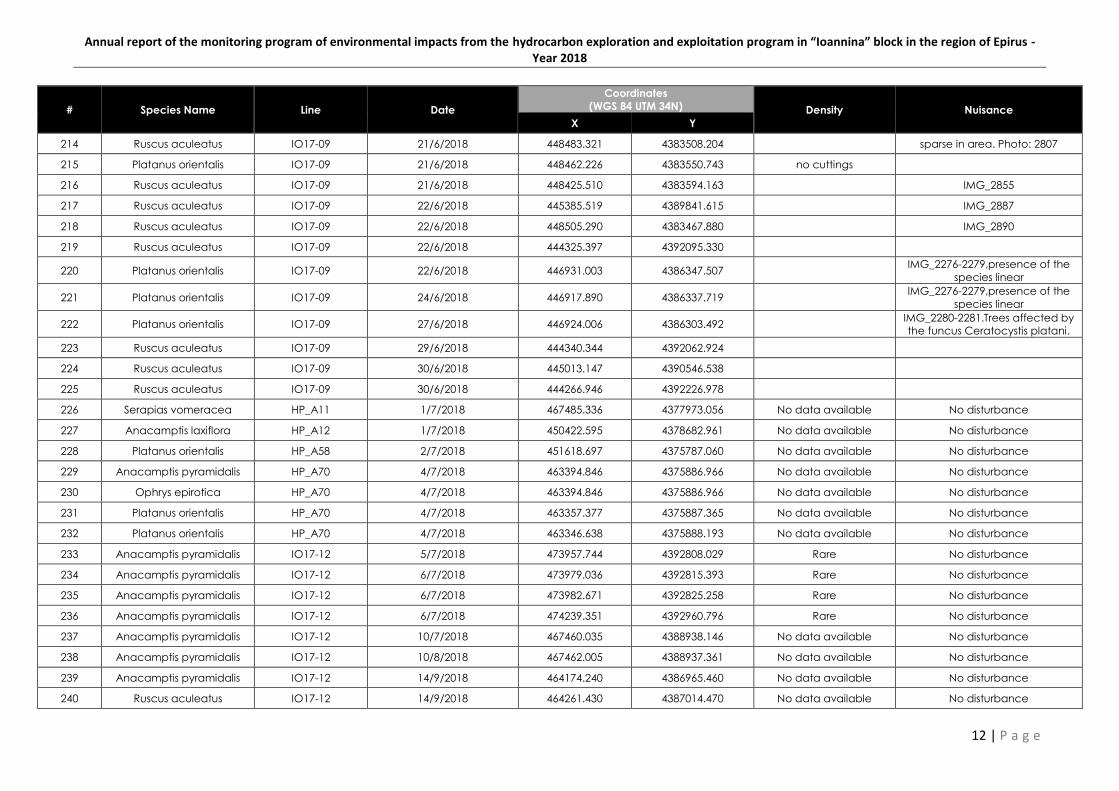
Annual report of the monitoring program of environmental impacts from the hydrocarbon exploration and exploitation program in “Ioannina” block in the region of Epirus - Year 2018
12 | P a g e
# Species Name Line Date
Coordinates
(WGS 84 UTM 34N) Density Nuisance
X Y
214 Ruscus aculeatus IO17-09 21/6/2018 448483.321 4383508.204 sparse in area. Photo: 2807
215 Platanus orientalis IO17-09 21/6/2018 448462.226 4383550.743 no cuttings
216 Ruscus aculeatus IO17-09 21/6/2018 448425.510 4383594.163 IMG_2855
217 Ruscus aculeatus IO17-09 22/6/2018 445385.519 4389841.615 IMG_2887
218 Ruscus aculeatus IO17-09 22/6/2018 448505.290 4383467.880 IMG_2890
219 Ruscus aculeatus IO17-09 22/6/2018 444325.397 4392095.330
220 Platanus orientalis IO17-09 22/6/2018 446931.003 4386347.507 IMG_2276-2279,presence of the
species linear
221 Platanus orientalis IO17-09 24/6/2018 446917.890 4386337.719 IMG_2276-2279,presence of the
species linear
222 Platanus orientalis IO17-09 27/6/2018 446924.006 4386303.492 IMG_2280-2281.Trees affected by
the funcus Ceratocystis platani.
223 Ruscus aculeatus IO17-09 29/6/2018 444340.344 4392062.924
224 Ruscus aculeatus IO17-09 30/6/2018 445013.147 4390546.538
225 Ruscus aculeatus IO17-09 30/6/2018 444266.946 4392226.978
226 Serapias vomeracea HP_A11 1/7/2018 467485.336 4377973.056 No data available No disturbance
227 Anacamptis laxiflora HP_A12 1/7/2018 450422.595 4378682.961 No data available No disturbance
228 Platanus orientalis HP_A58 2/7/2018 451618.697 4375787.060 No data available No disturbance
229 Anacamptis pyramidalis HP_A70 4/7/2018 463394.846 4375886.966 No data available No disturbance
230 Ophrys epirotica HP_A70 4/7/2018 463394.846 4375886.966 No data available No disturbance
231 Platanus orientalis HP_A70 4/7/2018 463357.377 4375887.365 No data available No disturbance
232 Platanus orientalis HP_A70 4/7/2018 463346.638 4375888.193 No data available No disturbance
233 Anacamptis pyramidalis IO17-12 5/7/2018 473957.744 4392808.029 Rare No disturbance
234 Anacamptis pyramidalis IO17-12 6/7/2018 473979.036 4392815.393 Rare No disturbance
235 Anacamptis pyramidalis IO17-12 6/7/2018 473982.671 4392825.258 Rare No disturbance
236 Anacamptis pyramidalis IO17-12 6/7/2018 474239.351 4392960.796 Rare No disturbance
237 Anacamptis pyramidalis IO17-12 10/7/2018 467460.035 4388938.146 No data available No disturbance
238 Anacamptis pyramidalis IO17-12 10/8/2018 467462.005 4388937.361 No data available No disturbance
239 Anacamptis pyramidalis IO17-12 14/9/2018 464174.240 4386965.460 No data available No disturbance
240 Ruscus aculeatus IO17-12 14/9/2018 464261.430 4387014.470 No data available No disturbance
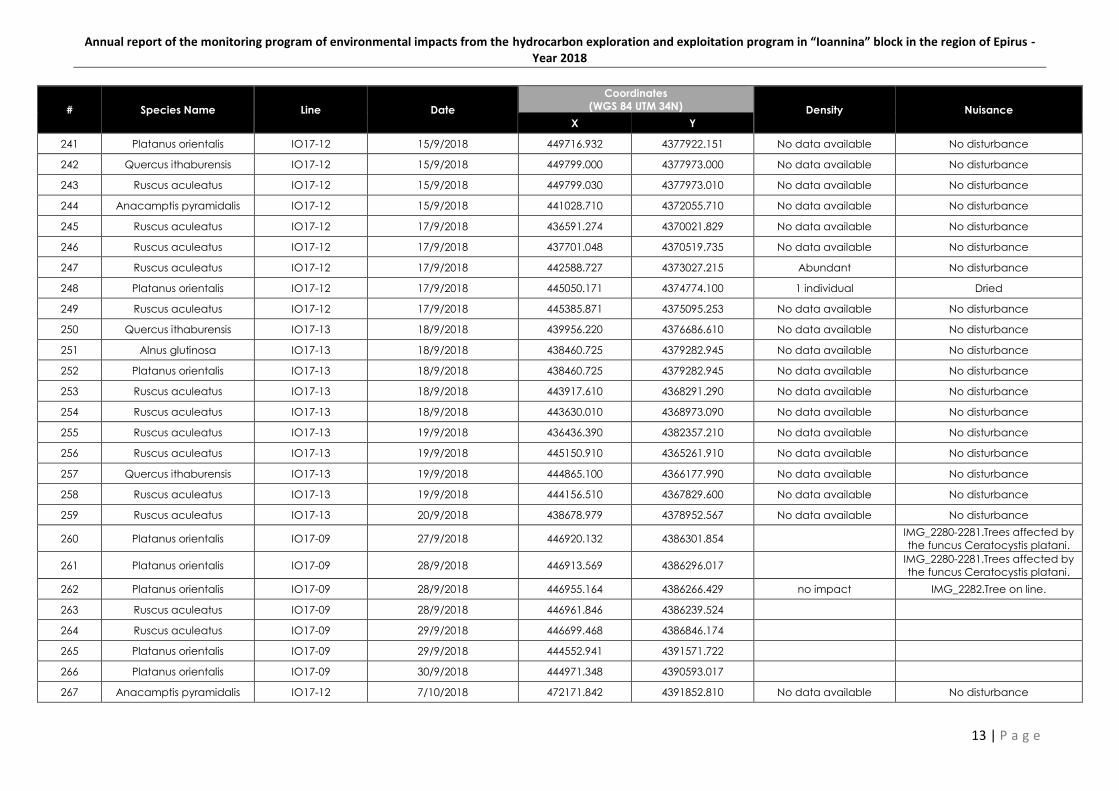
Annual report of the monitoring program of environmental impacts from the hydrocarbon exploration and exploitation program in “Ioannina” block in the region of Epirus - Year 2018
13 | P a g e
# Species Name Line Date
Coordinates
(WGS 84 UTM 34N) Density Nuisance
X Y
241 Platanus orientalis IO17-12 15/9/2018 449716.932 4377922.151 No data available No disturbance
242 Quercus ithaburensis IO17-12 15/9/2018 449799.000 4377973.000 No data available No disturbance
243 Ruscus aculeatus IO17-12 15/9/2018 449799.030 4377973.010 No data available No disturbance
244 Anacamptis pyramidalis IO17-12 15/9/2018 441028.710 4372055.710 No data available No disturbance
245 Ruscus aculeatus IO17-12 17/9/2018 436591.274 4370021.829 No data available No disturbance
246 Ruscus aculeatus IO17-12 17/9/2018 437701.048 4370519.735 No data available No disturbance
247 Ruscus aculeatus IO17-12 17/9/2018 442588.727 4373027.215 Abundant No disturbance
248 Platanus orientalis IO17-12 17/9/2018 445050.171 4374774.100 1 individual Dried
249 Ruscus aculeatus IO17-12 17/9/2018 445385.871 4375095.253 No data available No disturbance
250 Quercus ithaburensis IO17-13 18/9/2018 439956.220 4376686.610 No data available No disturbance
251 Alnus glutinosa IO17-13 18/9/2018 438460.725 4379282.945 No data available No disturbance
252 Platanus orientalis IO17-13 18/9/2018 438460.725 4379282.945 No data available No disturbance
253 Ruscus aculeatus IO17-13 18/9/2018 443917.610 4368291.290 No data available No disturbance
254 Ruscus aculeatus IO17-13 18/9/2018 443630.010 4368973.090 No data available No disturbance
255 Ruscus aculeatus IO17-13 19/9/2018 436436.390 4382357.210 No data available No disturbance
256 Ruscus aculeatus IO17-13 19/9/2018 445150.910 4365261.910 No data available No disturbance
257 Quercus ithaburensis IO17-13 19/9/2018 444865.100 4366177.990 No data available No disturbance
258 Ruscus aculeatus IO17-13 19/9/2018 444156.510 4367829.600 No data available No disturbance
259 Ruscus aculeatus IO17-13 20/9/2018 438678.979 4378952.567 No data available No disturbance
260 Platanus orientalis IO17-09 27/9/2018 446920.132 4386301.854 IMG_2280-2281.Trees affected by
the funcus Ceratocystis platani.
261 Platanus orientalis IO17-09 28/9/2018 446913.569 4386296.017 IMG_2280-2281.Trees affected by
the funcus Ceratocystis platani.
262 Platanus orientalis IO17-09 28/9/2018 446955.164 4386266.429 no impact IMG_2282.Tree on line.
263 Ruscus aculeatus IO17-09 28/9/2018 446961.846 4386239.524
264 Ruscus aculeatus IO17-09 29/9/2018 446699.468 4386846.174
265 Platanus orientalis IO17-09 29/9/2018 444552.941 4391571.722
266 Platanus orientalis IO17-09 30/9/2018 444971.348 4390593.017
267 Anacamptis pyramidalis IO17-12 7/10/2018 472171.842 4391852.810 No data available No disturbance

Annual report of the monitoring program of environmental impacts from the hydrocarbon exploration and exploitation program in “Ioannina” block in the region of Epirus - Year 2018
14 | P a g e
# Species Name Line Date
Coordinates
(WGS 84 UTM 34N) Density Nuisance
X Y
268 Anacamptis pyramidalis IO17-12 7/10/2018 472226.146 4391880.804 No data available No disturbance
269 Anacamptis pyramidalis IO17-12 7/10/2018 472570.974 4392066.579 No data available No disturbance
270 Anacamptis pyramidalis IO17-12 7/10/2018 472579.478 4392070.544 No data available No disturbance
271 Anacamptis pyramidalis IO17-12 7/10/2018 472577.666 4392067.443 No data available No disturbance
272 Anacamptis pyramidalis IO17-12 7/10/2018 472578.861 4392065.885 No data available No disturbance
273 Anacamptis pyramidalis IO17-12 7/10/2018 472690.971 4392120.091 No data available No disturbance
274 Anacamptis pyramidalis IO17-12 7/10/2018 472715.559 4392137.207 Rare No disturbance
275 Ruscus aculeatus IO17-12 7/10/2018 472812.790 4392192.410 No data available No disturbance
276 Anacamptis pyramidalis IO17-12 7/10/2018 472968.766 4392271.716 No data available No disturbance
277 Ruscus aculeatus IO17-12 7/10/2018 473253.190 4392429.220 No data available No disturbance
278 Ruscus aculeatus IO17-12 12/10/2018 466640.380 4388412.810 No data available No disturbance
279 Anacamptis pyramidalis IO17-12 14/10/2018 465148.600 4387517.700 10 individuals No disturbance
280 Anacamptis pyramidalis IO17-12 15/10/2018 464296.170 4387034.230 No data available No disturbance
281 Ruscus aculeatus IO17-12 16/10/2018 443620.010 4373718.710 No data available No disturbance
282 Abies borisii-regis IO17-12 17/10/2018 457524.108 4382645.099 1 individual No disturbance
283 Abies borisii-regis IO17-12 17/10/2018 457636.486 4382746.027 No data available No disturbance
284 Platanus orientalis IO17-12 18/10/2018 445907.623 4375501.688 No data available No disturbance
285 ?Bupleurum karglii? IO17-13 19/10/2018 442876.290 4370996.910 No data available No disturbance
286 Quercus ithaburensis IO17-13 20/10/2018 435441.510 4383735.610 No data available No disturbance
287 ?Bupleurum karglii? IO17-13 20/10/2018 433275.368 4386940.188 No data available No disturbance
288 Ruscus aculeatus IO17-13 20/10/2018 433562.800 4386520.900 No data available No disturbance
289 Ruscus aculeatus IO17-13 20/10/2018 433441.629 4386704.699 No data available No disturbance
290 Ruscus aculeatus IO17-13 20/10/2018 442896.343 4370932.743 No data available No disturbance
291 Ruscus aculeatus IO17-13 20/10/2018 438669.868 4378962.850 Abundant No disturbance
292 Ruscus aculeatus IO17-13 20/10/2018 438662.402 4378974.786 Abundant No disturbance
293 Ruscus aculeatus IO17-13 20/10/2018 438654.766 4378986.944 Abundant No disturbance
294 Ruscus aculeatus IO17-13 20/10/2018 438642.981 4379006.683 Abundant No disturbance

Annual report of the monitoring program of environmental impacts from the hydrocarbon exploration and exploitation program in “Ioannina” block in the region of Epirus - Year 2018
15 | P a g e
# Species Name Line Date
Coordinates
(WGS 84 UTM 34N) Density Nuisance
X Y
295 Ruscus aculeatus IO17-13 20/10/2018 438569.986 4379053.879 Abundant No disturbance
296 Ruscus aculeatus IO17-13 20/10/2018 438575.997 4379053.498 Abundant No disturbance
297 Ruscus aculeatus IO17-13 20/10/2018 438564.005 4379068.799 Abundant No disturbance
298 Ruscus aculeatus IO17-13 20/10/2018 438567.508 4379087.973 Abundant No disturbance
299 Ruscus aculeatus IO17-13 20/10/2018 438570.601 4379120.468 Abundant No disturbance
300 Ruscus aculeatus IO17-13 20/10/2018 438570.598 4379120.024 Abundant No disturbance
301 Ruscus aculeatus IO17-13 20/10/2018 438572.593 4379122.450 Abundant No disturbance
302 Ruscus aculeatus IO17-09 22/10/2018 446893.620 4386377.953
303 Platanus orientalis IO17-09 22/10/2018 446938.108 4386357.225 IMG_2276-2279, presence of the
species linear
304 Platanus orientalis IO17-09 22/10/2018 446936.876 4386352.794 IMG_2276-2279, presence of the
species linear
305 Platanus orientalis IO17-09 26/10/2018 446951.590 4386320.727 IMG_2280-2281.Trees affected by
the funcus Ceratocystis platani.
306 Platanus orientalis IO17-09 27/10/2018 446944.537 4386318.556 IMG_2280-2281.Trees affected by
the funcus Ceratocystis platani.
307 Platanus orientalis IO17-09 27/10/2018 446935.400 4386312.959 IMG_2280-2281.Trees affected by
the funcus Ceratocystis platani.
308 Platanus orientalis IO17-09 27/10/2018 446929.543 4386309.891 IMG_2280-2281.Trees affected by
the funcus Ceratocystis platani.
309 Serapias vomeracea HP_A70 4/11/2018 463394.846 4375886.966 No data available No disturbance
310 Ruscus aculeatus IO17-10 4/11/2018 434894.860 4378541.330 No data available No disturbance
311 Ruscus aculeatus IO17-10 4/11/2018 436774.390 4379645.800 No data available No disturbance
312 Ruscus aculeatus IO17-10 4/11/2018 437044.820 4379816.910 No data available No disturbance
313 Anacamptis pyramidalis IO17-12 5/11/2018 473954.299 4392803.549 Rare No disturbance
314 Ruscus aculeatus IO17-12 7/11/2018 471166.000 4391245.900 No data available No disturbance
315 Dictamnus albus IO17-12 9/11/2018 468830.724 4389831.019 No data available No disturbance
316 Quercus ithaburensis IO17-12 9/11/2018 468851.607 4389840.258 No data available No disturbance
317 Ruscus aculeatus IO17-12 16/11/2018 436556.890 4370014.700 No data available No disturbance
318 Ruscus aculeatus IO17-12 16/11/2018 436980.600 4370193.710 No data available No disturbance
319 ?Bupleurum karglii? IO17-12 16/11/2018 439963.600 4371505.500 No data available No disturbance
Annual report of the monitoring program of environmental impacts from the hydrocarbon exploration and exploitation program in “Ioannina” block in the region of Epirus - Year 2018
16 | P a g e

ANNUAL REPORT OF THE MONITORING PROGRAM OF ENVIRONMENTAL
IMPACTS FROM THE HYDROCARBON EXPLORATION AND EXPLOITATION
PROGRAM IN “IOANNINA” BLOCK IN THE REGION OF EPIRUS
YEAR 2018
Annex II
PHOTOGRAPHIC DOCUMENTATION
Prepared by:
March 2019