Embed Size (px)
Citation preview

1
Annotated Bibliography of Environmental Effects of San Luis Unit Subsurface Agricultural Drainage 3/2011
1. Abu-Saba, K. and S. Ogle. June 2005. Selenium in San Francisco Bay,
Conceptual Model/Impairment Assessment. Prepared for Clean Estuary Partnership, Oakland, CA, 68 pp. http://wwwrcamnl.wr.usgs.gov/Selenium/Library_articles/ 01_Abu-Saba_and_Ogle_2005_Se_in_SF_Bay_Conceptl_Model_Impairmt.pdf
The report was prepared in response to observations of elevated concentrations of selenium in the tissues of diving ducks, and the subsequent California Department of Health Services (DOHS) issuance of health advisories against the consumption of the ducks; these advisories reflect an impairment of San Francisco Bay’s beneficial uses, and served as the basis for the San Francisco Bay Regional Water Quality Control Board (Regional Board) to place six San Francisco Bay water bodies on the 303(d) list as being impaired due to selenium in 1998: Sacramento-San Joaquin Delta, Suisun Bay, Carquinez Strait, San Pablo Bay, Central San Francisco Bay, South San Francisco Bay. This report identified agricultural drainwater contamination in the San Joaquin River as one of the sources of selenium inputs into the Bay/Delta ecosystem: “As a result, the concentrations of total dissolved selenium in the San Joaquin River are much higher than in the Sacramento River, although recent changes in management practices by agricultural (ag) drainwater stakeholders appear to have been effective in reducing the San Joaquin River water total dissolved Se concentrations in 1997-2000 to less than half that observed in 1984-1988 (Cutter and Cutter 2004). Nevertheless, the selenium concentrations in the San Joaquin River remain elevated relative to the Sacramento River, again being predominantly selenate (66% of the total) with much less selenite (3% of the total), and the remainder being assumed to be dissolved organoselenides (Table 6). However, because of the historical diversion of San Joaquin River water for domestic and agricultural uses prior to discharge into the Delta or northern San Francisco Bay (Arthur and Ball 1979), the contribution of the San Joaquin River as a source of selenium has often been considered negligible (Cutter and Diego-McGlone 1990). This may well change as state-mandated increases in the flow of San Joaquin River water to the Delta and Bay come into play (as per the 1994 Bay-Delta Water Accord, SWRCB 1994).” The authors included a graph of selenium concentrations in Potamocorbula amurensis against the ration of San Joaquin River/Delta Outflow (see Figure 9 below). Concentrations of selenium are generally highest when more San Joaquin River water contributes to Delta Outflow. This could be a management concern if conveyance of south of Delta deliveries are changed (such as with a Peripheral Canal) which could result in more San Joaquin River flow reaching further downstream in the Delta/North San Francisco Bay.

2
2. Banuelos, G.S., Z.-Q. Lin, I. Arroyo, and N. Terry. 2005. Selenium volatilization
in vegetated agricultural drainage sediment from the San Luis Drain, Central California. Chemosphere 60: 1203–1213. http://wwwrcamnl.wr.usgs.gov/Selenium/Library_articles/san_luis_articles/ Banuelos_et_al_Se_Volatilization_Vegetated_Sediment_SLD_2005.pdf
Banuelos et al. (2005) conducted a two-year field trial to identify the best plant species that are salt and boron tolerant and can volatilize selenium from drainage sediment. In this experiment, sediment was collected at 0–25 cm depth from the San Luis Drain (SLD), Mendota, CA, and spread to a depth of 40 cm in a previously excavated field plot in 2000 at the USDA Research Facility in Parlier, CA (an area with no history of selenium contamination). The drainage sediment was mixed with clean soil, and vegetated with salado alfalfa (Medicago sativa salado ), salado grass (Sporobulus airoides salado), saltgrass-turf (Distichlis spp. NYPA Turf), saltgrass-forage (Distichlis spicata (L.) Greene), cordgrass (Spartina patens Flageo), Leucaenia (Leucaena leucocephola), elephant grass

3
(Pennistum purpureum), or wild type-Brassica (Brassica spp.). Selenium concentrations in crops grown on SLD-supplemented soil ranged from 7 µg/g selenium, dry weight in elephant grass, to 48 µg/g selenium, dry weight in wild-type Brassica (see Table 3 below). The authors found that overall, rates of selenium volatilization in drainage sediment were relatively low due to high levels of sulfate.
All of the crops grown on soils supplemented with SLD sediment contained selenium well in excess of 3 µg/g (mg/kg), the Level of Concern threshold established for protection of mammals foraging in the SJRIP drainage reuse area in the GBP 2001 Biological Assessment (see USBR 2001).
3. ** Beckon, W.N. October 2008. Toxicity of Selenium to Salmonids. Presentation at the CalFed Science Conference, October 24, 2008, Sacramento, CA, 24 pp. http://wwwrcamnl.wr.usgs.gov/Selenium/Library_articles/ 03_Beckon_Toxicity_of_Se_to_Salmonids_CalFed_Science_Conf_10-24.pdf
4. ** Beckon, W.N., M.C.S. Eacock, and A.G. Gordus. 2008. Biological effects of the Grassland Bypass Project, January 1, 2004 – December 31, 2005. Chapter 7, pages 93-167 in the Grassland Bypass Project Annual Report 2004-2005. San Francisco Estuary Institute. http://wwwrcamnl.wr.usgs.gov/Selenium/Library_articles/ 04_Beckon_etal_Bio_Effects_of_Grassland_Bypass_Project_Jan04.pdf
5. Beckon, W.N. and T.C. Maurer. March 2008. Potential Effects Of Selenium Contamination On Federally-Listed Species Resulting From Delivery Of Federal Water To The San Luis Unit. Prepared for the U.S. Bureau of Reclamation under Agreement # 05AA210003, by U.S. Fish and Wildlife Service, Sacramento Fish and Wildlife Office, Environmental Contaminants Division, Sacramento, CA, 46 pp. http://wwwrcamnl.wr.usgs.gov/Selenium/Library_articles/ 05_Beckon_and_Maurer_Effects_of_SE_on_Listed_Species_from_Deliv.pdf
4
In an analysis of the effects of San Luis Unit selenium contamination on federally listed species, Beckon and Maurer (2008) provided an analysis of the potential effects of drainage on federally listed species within the San Luis Unit (effects of conveying and storing drainwater, as well as applying drainwater to irrigate salt-tolerant plants in reuse areas, and evaporating drainwater in evaporation ponds or solar evaporators) as well as downstream impacts (into sloughs and the San Joaquin River and Bay Delta Estuary). This paper evaluated the potential effects of selenium contamination from subsurface drainage water in the San Luis Unit on the following species: San Joaquin kit fox, giant kangaroo rat, Fresno kangaroo rat, Tipton kangaroo rat, blunt-nosed leopard lizard, giant garter snake, California clapper rail, California least tern, Chinook salmon, steelhead trout, green sturgeon, white sturgeon, delta smelt, and Sacramento splittail. With respect to San Joaquin kit fox, the authors concluded that operations of reuse areas, evaporation ponds and solar evaporators could pose a selenium threat through the food chain to San Joaquin kit fox. For the kangaroo rats the authors found that these species could encounter dietary items at drainage reuse areas that are likely to exceed thresholds for adverse effects. The authors also found that seepage and flood flows carrying agricultural drainwater from the San Luis Unit into the San Joaquin River may impact Chinook salmon and steelhead and could impair efforts to restore them to upstream reaches of this river. Central Valley Chinook salmon and steelhead are among the most sensitive of fish and wildlife to selenium exposure. They are especially vulnerable during juvenile life stages when they migrate and rear in selenium-contaminated Central Valley rivers and the San Francisco Bay/Delta estuary. Rivers and sloughs that carry agricultural drainwater, concentrations of selenium in invertebrates, small (prey) fish, and larger predatory fish commonly reach levels that could kill a substantial portion of young salmon (Beckon et al. 2008) if the salmon, on their downstream migration, are exposed to those selenium-laden food items for long enough for the salmon themselves to bioaccumulate selenium to toxic levels. Based on existing water quality data for selenium in specific reaches of the San Joaquin River, Beckon and Maurer (2008) concluded that there remains a substantial ongoing risk to migrating juvenile Chinook salmon and steelhead in the San Joaquin River, as shown in the Figure below.

5
6. Beckon, W.N., T.C. Maurer, and S.J. Detwiler. 2007. Selenium in the
Ecosystem of the Grassland Area of the San Joaquin Valley: Has the Problem been Fixed? Final Report to the California/Nevada Operations Office, U.S. Fish and Widlife Service, Investigation ID# 20041003.1, Sacramento, CA, 31 pp. http://wwwrcamnl.wr.usgs.gov/Selenium/Library_articles/san_luis_articles/ Beckon_et_al_Se_in_Grasslands_Area_2007.pdf
The U.S. Fish and Wildlife Service, Sacramento Fish and Wildlife Office, Environmental Contaminants Division conducted a field investigation of sediment, aquatic invertebrates, and fish from wetlands in the Grasslands area and analyzed these constituents for selenium from five areas that receive water from different or mixed water sources and were representative of areas where eggs were collected by Hothem and Welsh (1994) in 1986 and 1987. Sediments are thought to serve as an important reservoir of selenium contributing to long-term cycling of selenium in aquatic ecosystems long after influx of selenium has been stopped. The authors conclude that selenium concentrations in sediments and invertebrates are likely due to a continuing influx of selenium contamination that has not been fully abated in the area. The study’s findings included: 1. “Of the 62 avian eggs sampled, 6.5 percent, exceeded the threshold of
concern for avian eggs (6 µg/g dw,). Those four eggs ranged from 6.0 to 6.9 µg/g.
2. Of the 74 whole body fish samples collected (Figure 4), 27 (36.5 percent) exceeded the threshold of concern for selenium in warmwater fish (4 µg/g selenium, Table 1). All 12 samples of striped bass (Morone saxatilis, all of

6
them juveniles: 11 from Gadwall Canal at Santa Cruz Gun Club, and one from Camp 13 Ditch at Checkpoint 4) exceeded the threshold of concern for selenium in warmwater fish.
3. Thirty-two samples of invertebrates were collected in the South Grasslands. Thirteen of these (40.6 percent, Figure 5) reached or exceeded the threshold of concern for invertebrates as diet for birds (3 µg/g dietary selenium, Table 1). The most effective invertebrate bioaccumulators of selenium were European freshwater snails (Physa) and Siberian shrimp (Exopalaemon modestus). The latter is a recently introduced species that evidently bioaccumulates selenium more effectively than other aquatic invertebrates in the area, such as red crayfish, that it seems to be replacing.”
With respect to storm runoff and the fate of agricultural drainage in the Grasslands, the authors noted the following , “Flood waters from the Panoche/Silver Creek watershed contains elevated selenium levels that can overflow agricultural lands, enter water supply channels and drainage ditches, and reach as far east as the Mendota Pool. During and immediately following major storm events, uncontrolled sheet flows across the agricultural landscape inundate and flush drainwater from sumps and open drainage ditches. Such floodwaters sometimes breach or over-top water supply channels, discharging selenium-laden drainwater into the wetlands water supply system. In the Grasslands agricultural area, the subsurface drainage system may be overwhelmed, exceeding, or threatening to exceed, the capacity of the Grassland Bypass Project channel. In such circumstances, Grassland water managers deliberately release into wetland channels (Camp 13 Ditch and/or Agatha Canal) some of the drainwater that would otherwise be routed into the Grassland Bypass channel.”
7. California Central Valley Regional Water Quality Control Board. October 22,
2008. Request for Westlands Water District to File a Report of Waste Discharge. Letter to Tom Birmingham, General Manager, Westlands Water District from Pamela Creedon, Executive Officer, Central Valley Regional Water Board, Rancho Cordova, CA, 2 pp. http://wwwrcamnl.wr.usgs.gov/Selenium/Library_articles/san_luis_articles/ CA_CVRWQCB_Letter_to_Westlands_on_Drainage_10-22-08.pdf
In a letter to Westlands Water District, the Central Valley Regional Water Board noted the following effects of subsurface drainage, “Irrigation water when applied to leach salts from the root zone possesses a threat to ground water quality both in the immediate area of application and adjacent areas where groundwater migrates. Improper treatment and or disposal of this waste water could result in a pollution or nuisance conditions.” With respect to drainage service in the San Luis Unit, the letter stated, “We understand that the Bureau of Reclamation has the statutory duty to provide drainage service to the San Luis Unit and that your District and Reclamation have been working on a resolution of this problem. However, due to the

7
magnitude of the problem and no foreseeable agreement, we must turn to your District to address this problem.” The letter requested the following, “Therefore, under authority of California Water Code Section 13260, I am requesting that you file a report of waste discharge. That report must include a plan and time schedule by sub areas within your District to address both waste collection and disposal issues. Your report must be filed within 90 days.”
8. California Central Valley Regional Water Quality Control Board. January 27,
2005. Comments on the November 2004 Draft Central Valley Project, San Luis Unit Long-Term Water Service Contract Renewal Environmental Impact Statement. Comment Letter to Joe Thompson, USBR Fresno, from Rudy Schnagl, Central Valley Regional Water Board, Agricultural and Planning Unit, Sacramento, CA, 5 pp. http://wwwrcamnl.wr.usgs.gov/Selenium/Library_articles/san_luis_articles/ CA_CVRWQCB_Cmmts_SLU_LTCR_1-27-2005.pdf
The Central Valley Regional Water Board noted the following with respect to effects of long term contract renewals of the San Luis Unit Ag contractors on San Joaquin River water quality: “While it is true that the districts are responsible for compliance with all applicable regulations related to their operations, the Bureau must also bear responsibility for its own actions. Delivery of contract water to the SLU is also delivery of every constituent carried in that water, including salt and other contaminants characterizing Delta water. The Bureau must develop a program to verify that the districts meet all applicable water quality standards/objectives and take action, such as curtailing contract deliveries, when deliveries continue to directly lead to water quality violations. The Cumulative Impacts for Drainage analysis (page 3.2-13) fails to discuss any cumulative water quality impacts of drainage on soils, groundwater and surface water due to the delivery of Delta water for 25 to 40 years.” (emphasis added)
9. California Central Valley Regional Water Quality Control Board. April 18,
2002. Letter to Mr. Gerald Stoltenberg, Westside Resource Conservation District, Five Points, CA from Lonnie Wass, Supervising Engineer, CVRWQCB, Fresno, CA, 2 pp. Available for download on pages 21-22 of the DWR IFDM Manual at: http://wwwrcamnl.wr.usgs.gov/Selenium/Library_articles/ 09_CA_CVRWQCB_Lttr_on_Reg_Rqt_of_Blending_Drainwtr_4-18-2002.pdf
The CV Regional Board’s Fresno Branch Office provided a letter to the Westside Resource Conservation District, Fresno County, clarifying the regulatory requirement for the blending of drainage water used for the irrigation of salt tolerant crops. The letter noted that, "[i]f the reuse of drainage water causes a nuisance, threatens to impair the beneficial uses of ground or surface waters, or is not beneficially used, then additional control and possibly enforcement actions may be needed." Further, the letter stated that, "...any operation that adds unusable drainage water to useable water and results in an unusable blend would probably be considered an unreasonable use of water." The letter concludes that,

8
"The Regional Board believes that a mechanism needs to be developed to ensure drainage water is used for agronomic benefit, protects water quality, and prevents nuisance conditions so that discharge is not disposed of improperly."
10. California Central Valley Regional Water Quality Control Board. 2000. Selenium TMDL for Grasslands Marshes. Staff Report of the California Regional Water Quality Control Board, Central Valley Region, Sacramento, CA, 14 pp. http://wwwrcamnl.wr.usgs.gov/Selenium/Library_articles/ 10_CVRWQCB_Grassl_Marshes_Se_TMDL_2000.pdf
The CV Regional Water Board determined that approximately 75 miles of wetland supply channels and 61,810 acres of wetland marshes were impaired or threatened by elevated selenium concentrations in agricultural subsurface drainage water (California Regional Water Quality Control Board, Central Valley Region, 1998b, Appendix 40). The Regional Board concluded that, “Most exceedances of the 2 µg/L objectives have been associated with flood flows, seepage from the DPA, subsurface agricultural drainage from outside the DPA, and supply water.”
11. C alifornia C entral V alley R egional W ater Quality C ontrol B oard. 1998
(latest revision October 2007). A mendments to the W ater Quality Control Plan for the Sacramento R iver and San Joaquin R iver B asins for the C ontrol of A gricultural Subsurface Drainage Discharges. Fourth E dition. C alifornia R egional W ater Quality C ontrol B oard, C entral V alley R egion. Sacramento, C alifornia, 80 pp. http://wwwrcamnl.wr.usgs.gov/Selenium/L ibrary_articles/ 11_CA _CV R WQCB _Central_V alley_WQCB _1998.pdf
With respect to A gricultural Drainage Discharges in the San Joaquin R iver B asin, the CV R egional B oard noted in this B asin Plan Amendment the following, ‘‘ Water quality in the San Joaquin River has degraded significantly since the late 1940s. During this period, salt concentrations in the River, near Vernalis, have doubled. Concentrations of boron, selenium, molybdenum and other trace elements have also increased. These increases are primarily due to reservoir development on the east side tributaries and upper basin for agricultural development, the use of poorer quality, higher salinity, Delta water in lieu of San Joaquin River water on west side agricultural lands and drainage from upslope saline soils on the west side of the San Joaquin Valley… The water quality degradation in the River was identified in the 1975 Basin Plan and the Lower San Joaquin River was classified as a Water Quality Limited Segment.” Salt and Boron With respect to salt management in the San Joaquin River, the CV Regional Board found that this was the “most serious long-term issue on the San Joaquin River. Salinity impairment in the Lower San Joaquin River remains a persistent problem as salinity water quality objectives continue to be exceeded.” This document noted that “The goal of the salt and boron control program is to achieve compliance with salt and boron water quality objectives without

9
restricting the ability of dischargers to export salt out of the San Joaquin River basin.” The CV Regional Board identified priority control actions on the most significant sources of salt and boron discharges to the lower San Joaquin River, “Priority for implementation of load allocations to control salt and boron discharges will be given to subareas with the greatest unit area salt loading (tons per acre per year) to the LSJR (Table IV-4.2). The priorities established in Table IV-4.2 will be reviewed by 28 July 2012 and every 6 years thereafter…The salt and boron control program establishes salt load limits to achieve compliance at the Airport Way Bridge near Vernalis with salt and boron water quality objectives for the LSJR. The Regional Water Board establishes a method for determining the maximum allowable salt loading to the LSJR. Load allocations are established for nonpoint sources and waste load allocations are established for point sources.”
With respect to salt and boron in supply water, the CV Regional Board noted, “Supply water Load Allocations are established for salts in irrigation water imported to the LSJR Watershed from the Sacramento/San Joaquin River Delta as described in Table IV-4.4. The Regional Water Board will attempt to enter into a Management Agency Agreement (MAA) with the U.S. Bureau of Reclamation to address salt imports from the DMC to the LSJR watershed. The MAA shall include provisions requiring the U.S. Bureau of Reclamation to: a. Meet DMC load allocations; or b. Provide mitigation and/or dilution flows to create additional assimilative capacity for salt in the LSJR equivalent to DMC salt loads in excess of their allocation. The Regional Water Board shall request a report of waste discharge from the U.S. Bureau of Reclamation to address DMC discharges if a
MAA is not established by 28 July 2008. 9. The Regional Water Board will review and update the load allocations and waste load allocations by 28 July 2012 and every 6 years thereafter. Any changes to waste load allocations and/or load allocations can be made through subsequent amendment to this control program.” Time Schedules for Implementation were identified as follows, “The Regional Water Board will incorporate base load allocations into waste discharge requirements and real-time load allocations into conditions of waiver of waste discharge requirements by 28 July 2008. Dischargers regulated under a waiver of waste discharge requirements for dischargers participating in a real-time management program for the control of salt and boron in the LSJR shall comply with the waiver conditions within 1 year of the date of adoption of the waiver.”

10
Selenium in the San Joaquin River The Regional Board identified the following actions would be implemented (per the amendment to the Basin Plan for San Joaquin River subsurface agricultural drainage, and approved by the State Water Board in Resolution No. 96-078) to control selenium discharges from subsurface agricultural drainage discharges: 1. “In developing control actions for selenium, the Regional Board will utilize a
priority system which focuses on a combination of sensitivity of the beneficial use to selenium and the environmental benefit expected from the action.
2. Control actions which result in selenium load reduction are most effective in meeting water quality objectives.
3. With the uncertainty in the effectiveness of each control action, the regulatory program will be conducted as a series of short-term actions that are designed to meet long-term water quality objectives.
4. Best management practices, such as water conservation measures, are applicable to the control of agricultural subsurface drainage.
5. Performance goals will be used to measure progress toward achievement of

11
water quality objectives for selenium. Prohibitions of discharge and waste discharge requirements will be used to control agricultural subsurface drainage discharges containing selenium. Compliance with performance goals and water quality objectives for nonpoint sources will occur no later than the dates specified in Table IV-4.
6. Waste discharge requirements will be used to control agricultural subsurface drainage discharges containing selenium and may be used to control discharges containing other toxic trace elements.
7. Selenium load reduction requirements will be incorporated into waste discharge requirements as effluent limits as necessary to ensure that the selenium water quality objectives in the San Joaquin River downstream of the Merced River inflow is achieved. The Board intends to implement a TMDL after public review.”
Table IV-4. Compliance Time Schedule for Meeting the 4-day Average and
Monthly Mean Water Quality Objective for Selenium.
Selenium Water Quality Objectives (in bold) And Performance Goals (in italics)
Chorpyrifos and Diazinon
The CV Regional Board identified a pesticide runoff control program that shall: “a. Ensure compliance with water quality objectives applicable to diazinon and chlorpyrifos in the San Joaquin River through the implementation of management practices. b. Ensure that measures that are implemented to reduce discharges of diazinon and chlorpyrifos do not lead to an increase in the discharge of other pesticides to levels that cause or contribute to violations of applicable water quality objectives and Regional Water Board policies; and c. Ensure that discharges of pesticides to surface waters are controlled so that pesticide concentrations are at the lowest levels that are technically and economically achievable.”

12
This document requires, “Compliance with applicable water quality objectives, load allocations, and waste load allocations for diazinon and chlorpyrifos in the San Joaquin River is required by 1 December 2010…The water quality objectives and allocations will be implemented through one or a combination of the following: the adoption of one or more waivers of waste discharge requirements, and general or individual waste discharge requirements. To the extent not already in place, the Regional Water Board expects to adopt or revise the appropriate waiver(s) or waste discharge requirements by 31 December 2007.” The Regional Water Board intends to review the diazinon and chlorpyrifos allocations and the implementation provisions in the Basin Plan at least once every five years, beginning no later than 31 December 2009.
12. ** California Department of Water Resources. 2007. San Joaquin Valley
Drainage Monitoring Program, 2002, District Report. California Department of Water Resources, San Joaquin Division, Fresno, CA, 77 pp. http://wwwrcamnl.wr.usgs.gov/Selenium/Library_articles/ 12_CA_DWR_2002_Drainage_Monitoring_Report_2007.pdf
13. Chilcott, J. 2000. Review of Selenium Concentrations in Wetland Water Supply Channels in the Grassland Watershed. California Regional Water Quality Control Board, Central Valley Region. 25 pages. http://wwwrcamnl.wr.usgs.gov/Selenium/Library_articles/ 13_Chilcott_Review_of_SE_Concentrations_in_Grassl_Watershed_2000.pdf
For Water Years 1997 and 1998, Regional Board Staff noted the following with respect to Grassland Wetland Supply Channels water quality: During 1997 and 1998, winter storm and flood flows were directed around the Grassland Bypass to protect the integrity of the Bypass itself. During these high flow events, drainage was released into wetland water supply channels historically used for drainage release. The time periods of these known releases correspond to periods of elevated selenium concentrations in the channels. However, selenium concentrations remained elevated in some water bodies after the known storm water diversions ceased.” “Several potential causes of the elevated selenium concentrations were identified, including releases from the DPA (both in response to flood events and seepage from gates and canals), elevated selenium concentrations in supply water, inflows from other sources such as the Rice Drain and Almond Drive Drain, and local sources such as groundwater seepage and surface return flows.” “Potential sources of selenium in the DMC include: discharge from six shallow groundwater collection systems operated by the USBR as interceptor drains along the DMC and flood flows through existing check drains.” “Two areas have been identified where agricultural subsurface drainage can enter wetland water supply canals from farmland not contained in the DPA. One

13
area is west of the wetland water supply channels and historically drained into the Almond Drive Drain which entered South Grassland Water District at Almond Drive. A second area is a triangle-shaped area of approximately 7,000 acres south of the Poso Drain (also known as the Rice Drain) and north of the DPA which historically drained into the Poso Drain which enters South GWD from the east (Figure 4).”

14
“The Poso Drain (listed as the Rice Drain on US Geological Survey quads) has consistently exceeded the 2 μg/L selenium water quality objective to protect

15
wetland supply water since March 1998. The area farmers are aware of the exceedances in the Rice Drain and have been reviewing the discharges to determine potential selenium sources and options to remove the selenium from the water body. Upon startup of the Grassland Bypass Project, discharges from two systems were redirected into the Grassland Bypass. Additional discharges will either be redirected to the San Luis Drain along the east side of Russell Avenue or will be managed on farm.” “Drainage from the Almond Drive Drain area can impact the San Luis Canal in two ways: direct discharge to the Canal; and discharge to the CCID Main Canal, which is the source of water delivered to the San Luis Canal. In June 1998, a pump was installed on the Old Main Drain, to allow the drain water to be diverted directly into the CCID Main Canal downstream of the diversion to the San Luis Canal. A pump just north of Almond Drive was reactivated in June 1998 to allow drainage to be pumped into the CCID Main Canal when water threatened to enter the San Luis Canal directly through the drop structure. The Almond Drive pump allows drainage to be commingled with supply water upstream of the San Luis Canal diversion. The new plumbing system is expected to remain in place.”
14. Chilcott, J., L. Grober, A. Vargas and J. Eppinger. 2000. Agricultural Drainage
Contribution to Water Quality in the Grassland Watershed of Western Merced County, California: October 1997 - September 1998 (Water Year 1998). California Regional Water Quality Control Board, Central Valley Region, Sacramento, CA, 63 pages. http://wwwrcamnl.wr.usgs.gov/Selenium/Library_articles/ 14_Chilcott_etal_Ag_Dr_in_Grassland_1997-1998_2000.pdf
For Water Year 1998, Regional Board staff identified the primary cause of elevated selenium in wetland supply channels was diversion of stormwater flow into those channels. Other sources of selenium in the wetland channels were identified to include: “…supply water, areas of subsurface agricultural drainage outside of the DPA, tail water runoff and local groundwater seepage.”
15. Chilcott, J. and R. Schnagl. April 1, 2008. Central Valley Selenium Control Program. Presentation to the North Bay Selenium Advisory Committee Meeting. Central Valley Regional Water Quality Control Board, Central Valley Region, Sacramento, CA, 69 pp. http://wwwrcamnl.wr.usgs.gov/Selenium/Library_articles/ 15_Chilcott_and_Schnagl_Central_Valley_Selenium_Control_Program.pdf
This presentation by staff of the Central Valley Regional Water Board to the North Bay Selenium Advisory Committee includes a summary of water quality data in the San Joaquin River, Grassland Bypass Project discharges, and water quality in the San Luis Canal, a wetland supply channel. As is denoted in the figure below, weekly selenium concentrations in San Luis Canal (a Grassland wetland supply channel) still periodically exceed 2 µg/L, typically associated with heavy rainfall events and in the spring of each year (typically March and/or April):

16
16. Crader, P., J. Eppinger and J. Chilcott. 2002. Agricultural Drainage
Contribution to Water Quality in the Grassland Watershed of Western Merced County, California: October 1998 –September 2000 (Water Years 1999 and 2000). Draft Staff Report of the California Regional Water Quality Control Board, Central Valley Region, Sacramento, CA, 76 pages. http://wwwrcamnl.wr.usgs.gov/Selenium/Library_articles/ 16_Crader_et_al_Ag_DW_Contrib_to_Water_Qual_in_Grassland_Waters.pdf
For Water Years 1999 and 2000, Regional Board staff noted with respect to water quality in the Grassland wetland supply channels, “Selenium concentrations greater than 2 ug/L occurred sporadically in the wetland water supply channels, with the majority of elevated concentrations during February, March, and April. Elevated concentrations in the supply channels may be due to a number of factors including elevated selenium levels in supply water, inflows from agricultural subsurface drainage sources outside of the DPA [such as Rice Drain and Almond Drive], and local sources such as groundwater seepage and surface return flows…”

17
17. Cutter, G.A. and L.S. Cutter. 2004. Selenium biogeochemistry in the San Francisco Bay estuary: changes in water column behavior. Estuarine, Coastal and Shelf Science 61 (2004) 463–476. http://wwwrcamnl.wr.usgs.gov/Selenium/Library_articles/san_luis_articles/ Cutter_and_Cutter_Se_biogeochem_SF_Bay_2004.pdf
The authors concluded the following with respect to selenium contamination in the Bay-Delta: “Although refinery effluents were a major source of dissolved selenium (largely as selenite) to the estuary prior to 1998, these discharges have dropped by 66%, making river inputs the largest fluxes of selenium to the Bay except during very low flow periods. Because the San Joaquin River has selenium concentrations at least 10 times those of the Sacramento, future CALFED restoration efforts that increase San Joaquin flows into the Delta may cause the dissolved selenium concentrations in the estuary to rise again.” The authors also found that based on a sixteen year record of concentrations in the uncontaminated Sacramento River shows a remarkably constant concentration: 0.071 ± 0.021 µg Se/L. By comparison, selenium concentrations in the San Joaquin River are 18 times higher than this at Vernalis: 1.25 ± 0.83 µg Se/L, reflecting inputs from the SJV that vary in intensity from year-to-year.
18. Detwiler, S.J., J.P. Skorupa, and T. C. Maurer. 2006. Assessment of Avian Selenium Exposure at Agroforestry Sites in California Final Report, Project ID: 10003.1. Sacramento Fish and Wildlife Office. 86 pp. http://wwwrcamnl.wr.usgs.gov/Selenium/Library_articles/san_luis_articles/ Detwiler_et_al_Se_Exposure_at_Agroforestry_Sites_2006.pdf
The U.S. Fish and Wildlife Service investigated selenium exposure in bird eggs at agroforestry sites in the west-side San Joaquin Valley that were irrigated with subsurface agricultural drainage water. An initial study of agroforestry sites in 1996 found extremely elevated levels of selenium in water bird eggs collected from those sites, “During 1996, staff from the Sacramento Fish and Wildlife Office Environmental Contaminants Division (SFWO-ECD) collected a small set of waterbird eggs from two agroforestry sites. These samples yielded the highest rates of selenium-induced teratogenesis (embryo deformities) ever reported in the scientific literature (Skorupa, 1998a), and established that the method of furrow irrigation being used was attracting breeding waterbirds. More than 56 percent of 30 assessable embryos were deformed at one site, and both sites that were sampled yielded avian eggs exceeding 25 ug Se/g DW (dry weight). The threshold value for embryotoxic effects is only 6 ug Se/g DW.” Subsequent to that initial investigation, a range of agroforestry sites was monitored for avian reproductive activity over several seasons. The authors described the following from this research effort, “Fifteen species of migratory birds were documented to nest at agroforestry study sites. Avian nests were located in every habitat component of IFDM plots—proving that these sites are capable of attracting both foraging and nesting birds. Selenium-typical,

18
embryonic deformities were documented among nesting shorebirds along with instances of highly elevated egg selenium concentrations.” A summary of geometric egg selenium from Red Rock Ranch Integrated on-Farm Drainage Management (IFDM) site is presented in the table below:
Geometric Mean Egg selenium (ppm dwt) from Red Rock Ranch’s IFDM Site for Years 1996, 2000-2003
Species 1996 1998 2000 2001 2002 2003 Killdeer 19 43 24 15 17 11 Recurvirostrids 53 N/A 14 16 13 13 Red-Winged Blackbirds N/A N/A 7.1 5.4 N/A N/A Brewers Blackbirds N/A N/A 3.9 5.2 N/A N/A Western Kingbirds N/A N/A 12 4.5 5.1 N/A House Sparrows N/A N/A 4.8 3.9 3.6 N/A House Finch N/A N/A 4.9 3.4 N/A N/A
With respect to risk analysis by species the authors found the following, “Shorebirds: Shorebird (stilt and killdeer) eggs from Red Rock Ranch IFDM site ranged from 3.9 ug Se/g DW to 82 ug Se/g DW (n = 124) during all years (spanning 1996-2003). The threshold for hatchability effects in these genera is considered by the Service to be between 6-7 ug Se/g DW. All but three eggs from these species collected from Red Rock exceeded this threshold. A single killdeer egg collected from Mendota Agroforestry Plot measured 5.7 ug Se/g DW, while a stilt from the same site contained 31 ug Se/g DW.” “Mallards: A mallard egg collected from the Panoche facility contained 6.5 ug Se/g DW. The most recent analysis of experimental laboratory data for mallards (Ohlendorf, 2003) suggests that at 12.5 ug Se/g DW in the egg there is a 10 percent depression in egg hatchability. Field data for mallards collected by FWS (N > 1,000 eggs) suggests that at about 6 ug Se/g DW in the egg there is about a 6 percent depression in egg hatchability.” Brewer's Blackbird: Among 17 Brewer's blackbird eggs randomly collected at the Red Rock demonstration site in 2000-2001, the highest selenium concentration was 11 ug/g DW (values ranged from 2.6 to 11 ug/g). The highest red-winged blackbird egg at Red Rock contained 8.8 ug Se/g DW (n = 8). At the Panoche facility, two Brewer’s blackbird eggs collected contained 7.2 and 15 ug Se/g DW. The sensitivity of blackbirds to selenium is unknown. In the absence of more specific information, any eggs exceeding 10 ug Se/g DW should be considered a matter of concern, until proven otherwise. Eggs below 6 ug Se/g DW, should be considered safe until proven otherwise. These benchmarks represent a range of sensitivities from other avian species based on established dose-response curves from a robust empirical database. Among both blackbird species and all eggs randomly collected from Red Rock Ranch during this investigation, 17 eggs (68 percent) were below the safe threshold, and 1 (4

19
percent) egg contained sufficient selenium to be of concern. Western Kingbird: Among ten kingbird eggs collected at Red Rock in 2000 and 2001, individual samples contained between 4.2 and 13 ug Se/g DW. Two kingbird eggs collected at the Mendota Agroforestry demonstration site in 2000 contained 9.1 and 9.4 ug Se/g DW. A single egg collected from the Panoche facility contained 5.5 ug Se/g DW. Four kingbird eggs collected by the California Department of Fish and Game (CDFG) from Westlake Farms agroforestry plot in 1991 contained 4.2-6.2 ug Se/g DW. The sensitivity of kingbirds to selenium is unknown. In the absence of more specific information, any eggs exceeding 10 ug Se/g DW should be considered a matter of concern, until proven otherwise. Eggs below 6 ug Se/g DW, should be considered safe until proven otherwise. In total, 80 percent of our randomly sampled eggs from Red Rock IFDM were below the safe threshold, while two eggs (20 percent) exceeded the level of concern.” The authors concluded the following, “This investigation has confirmed that agroforestry or IFDM sites are not without attendant risks; however, the question regarding the relative utility of this particular drainwater management option is more a function of realized risk to wildlife in light of the available alternatives. IFDM sites have reduced wildlife risks by about 80 percent compared to the alternative of operating a traditional evaporation basin to dispose of drainage water. Short of management alternatives that preclude the generation of seleniferous drainwater in the first place (e.g. land retirement), some form of disposal becomes necessary. In this context, IFDM becomes an attractive option.” With respect to IFDM best management practices to reduce selenium exposure to birds, the authors concluded, “Our avian monitoring has revealed the importance of designing features into the project that allow for quick draining and isolation of standing surface water, even if it originates from rainfall. Such pools are capable of supporting food webs sufficient to bioconcentrate selenium and attract foraging avifauna, and should therefore be minimized during the operation of all IFDM facilities.”
19. Deverel, S. 1998 in: California State Water Resources Control Board. 1998.
Oral Hearing Record of the December 9, 1998 Bay-Delta Water Rights Hearing. Sacramento, CA, 405 pp. http://wwwrcamnl.wr.usgs.gov/Selenium/Library_articles/san_luis_articles/ Deverel_Oral_Testimony_in_SWRCB_Bay_Delta_WR_Hearing_12-9-1998.pdf
Dr. S. Deverel spoke as an expert witness on behalf of the San Joaquin Exchange Contractors on upslope effects of drainage (primarily from Westlands) on downslope surface discharges: DR. DEVEREL: “I used the groundwater flow model along with some salute transport modeling to try to estimate the cumulative amount of load that was ending up in Firebaugh [Canal Water District] as a result of water crossing the boundary. Through 1996 I estimated that number to be about 30 percent.”

20
MR. MINASIAN: “Okay. That is 30 percent of the load?” DR. DEVEREL: “30 percent of the load, right.”
20. Deverel, S. 1998. Written Testimony for the SWRCB Bay-Delta Water Rights Hearing, Phase 5. San Joaquin Exchange Contractor’s, Exhibit 5(a), 37 pp. http://wwwrcamnl.wr.usgs.gov/Selenium/Library_articles/san_luis_articles/ Deverel_Written_Testimony_SWRCB_1998.pdf
Dr. Deverel’s written testimony on the effect of the shallow drainage problem upslope of the Firebaugh and CCID (primarily in Westlands) on drainage conditions within Firebaugh and CCID. Relevant exerpts are provided below: “Because there is a need for water to move salts out of the root zone build up during crop production, and the underlying groundwater is in some places poor quality and not fully utilizable, the water table on the Westside will continue to slowly rise. Farming irrigated crops requires that some part of the applied water leaches salts from the root zone. Because of this, hydraulic pressure due to additions to the groundwater pressures on lowland areas where there are drainage systems will increase.” “Continuing water conservation measures that reduce loads throughout the western Valley will reduce the deep percolation and flow to drains in some areas. However, this results in storage of salts in the subsurface that slowly move downwards and to the northeast. The rate of downward movement of water is about 1 foot per year. Groundwater flows laterally at rates of about 10 to 1000 feet per year.” “The increasing hydraulic gradients cause increasing volumes of the higher salinity water to move towards the drain laterals, thus increasing the loads and concentrations.” “The flow to drains and residence time in groundwater of drainage water influences how changing water management practices will change the salt load in the drainage water. Because it often takes groundwater several years to several decades to flow to drainage ditches and laterals, the effects of changing the concentration of the salinity of the irrigation water takes a long time to show up in the drainage water. However, the hydraulic effects are immediate. In other words, if one applies less water this immediately translates to less drainflow…” (emphasis added). “Along the whole frontage of the San Luis Unit with the Exchange Contractors there are sand and gravel lenses located at shallow depths and there are shallow clay layers. There is a hydraulic gradient to the East in these shallow geologic features, and there are calculations which have been done by myself and experiments and calculations by Mr. Kenneth Schmidt, a groundwater hydrologist working for the Firebaugh Canal Water District.”

21
“In 1988, Mr. Schmidt installed and monitored shallow groundwater wells along the boundary between Westlands Water District in the Firebaugh Canal Water District. He calculated that approximately 1000 acre feet of Water per annum of poor-quality Water with an average salinity of 3,700 mg/lt and with selenium in the range of 6 to 142 ppb could be calculated to flow in these shallow lenses and above these shallow clay layers.” “I have personally done calculations preparatory to the subsequent phases of the Trial to be conducted by Judge Wanger when the appeals to the Ninth Circuit are completed which confirms this observation along the whole boundary of the San Luis Unit lands and Firebaugh Canal Water District and CCID.” “I have also been asked if I could quantify the load of salinity and selenium that enters along this boundary by downslope migration compared to the drainage load leaving Firebaugh Canal Water District as an example. Downslope migration does not explain all of the load but a part of it is from this shallow downslope flow, in the range of 20 to 40%...” (emphasis added) “…Elevations of groundwater in saturated areas in upslope areas are higher than elevation in lower areas. Although a particular particle of Water will take many years to migrate, in saturated soils pressure is very quickly transmitted to areas of lesser pressure. That is what is happening here. Pressure transmitted from high areas to low areas as an example will cause poor quality Water to show up in surface drain and be counted as load. A particle of poor quality Water may have originated from farming the downslope areas or migrated in the shallow geological features from farming the downslope areas or migrated in the shallow geological features from upslope, but the pressure causes it to rise into the tile drainage and surface drain and flow out.” “Pumping decreased substantially during the 1950’s and 1960’s as surface water was delivered and groundwater water levels rose. This rise in the groundwater levels continues to occur and has caused increases in pressures in downslope areas which have contributed to drainage flows.”
21. Eppinger, J. and J. Chilcott. 2002. Review of Selenium Concentrations in
Wetlands Water Supply Channels in the Grassland Watershed (Water Years 1999 and 2000). Staff Report of the California Environmental Protection Agency, Regional Water Quality Control Board, Central Valley Region, Sacramento, California. 31 pp. http://wwwrcamnl.wr.usgs.gov/Selenium/Library_articles/ 21_Eppinger_and_Chilcott_Se_Conc_in_Grassl_Watershed_1999-2000.pdf
Regional Board staff conducted a review of selenium concentrations in wetland water supply channels in the Grassland Watershed during Water Years 1999 and 2000 when major storm events were absent. Elevated concentrations of selenium in wetland water supply channels during Water Years 1999 and 2000 occurred

22
sporadically throughout the two years, the maximum concentration was reported as 6.4 ug/L in 1999. A close correlation between selenium concentration in internal channels and supply water selenium concentration was noted during both Water Years 1999 and 2000, particularly in the Agatha Canal and Camp 13 Slough. As noted by the authors, the primary source of selenium in the Grassland Watershed is from subsurface agricultural drainage in the DPA, all of which has now been rerouted around wetland water supply channels by means of the Grassland Bypass Project except during periods of exceptionally high rainfall and flooding. For water years 1999 and 2000, additional sources of selenium were identified in the supply water, and subsurface agricultural drainage from areas outside of the DPA. Potential other sources were identified as tail water runoff and local groundwater seepage. With respect to drainage outside of the DPA the authors noted the following: "Two areas have been identified where agricultural subsurface drainage can enter wetland water supply canals from farmland not contained in the DPA [Grasslands Drainage Area]. One area is west of the wetland water supply channels and historically drained into the Almond Drive Drain. Since Water Year 1999, these discharges have been collected in the CCID Main Drain and diverted into the CCID Main Canal downstream of internal supply channels. Data for Water Years 1999 and 2000 is not available for the Almond Drain site. The second area where agricultural subsurface drainage can enter wetland water supply canals from outside the DPA is a triangle-shaped area of approximately 7,000 acres south of the Poso Drain (also known as the Rice Drain) and north of the DPA. This area historically drained into the Poso Drain, entering South Grassland Water District from the east. Three sites on the Poso (Rice) Drain were monitored for selenium during Water Years 1999 and 2000. Selenium concentrations at all three sites were above 2 ug/L a majority of the time, though a change in tail water management after June 1999 has apparently helped to reduce and stabilize concentrations…”"
During Water Year 1999, selenium concentrations in the Poso Drain were highly variable with concentrations at the upstream Russell Boulevard site ranging from <2 ug/L to 39 ug/L and concentrations at the downstream site (Mallard Road) ranging from <2 ug/L to 24 ug/L…After June 1999, more tail water was discharged through the Rice [Poso] Drain at Russell…Mean selenium concentrations continued to remain above 2 ug/L at all the Rice Drain sites.”
The authors indicated a close correlation between selenium in source water and selenium in wetland supply channels, as represented by the CCID Main Canal at Russell Avenue (source) and Agatha and Camp 13 channels, during the non-flood water years of 1999 and 2000. The report noted that when the source water had elevated selenium concentrations (above 2 ppb) a corresponding increase

23
was noted in the wetland water supply channels. With respect to selenium in the source water the authors noted the following for Delta Mendota Canal (supply water) quality: “Out of the 48 sampling events, selenium concentrations were reported above 2 µg/L eleven times. The highest annual concentrations of selenium at Milepost 100.85 were 8.6 µg/L in December of Water Year 1999 and 2.5 µg/L in January of Water Year 2000. Milepost 110.12 reached a high of 11 µg/L selenium in December of Water Year 1999 and 14.6µg/L in January of Water Year 2000…”
22. ** Faria, J.I. and A. Begaliev. Undated. Solar Evaporator for Integrated on-
Farm Drainage Management (IFDM) System at Red Rock Ranch, San Joaquin Valley, California. California Department of Water Resources, San Joaquin District, Fresno, CA, 51 pp. http://wwwrcamnl.wr.usgs.gov/Selenium/Library_articles/san_luis_articles/ Faria_and_Begaliev_Solar_Evap_DWR_Presentation_undated.pdf
23. ** Faria, J.I., A. Begaliev, V. Cervinka, and K. Buchnoff. Undated. Solar Evaporator for Integrated on-Farm Drainage Management System at Red Rock Ranch, San Joaquin Valley, California. California Department of Water Resources, San Joaquin District, Fresno, CA, 5 pp. http://wwwrcamnl.wr.usgs.gov/Selenium/Library_articles/san_luis_articles/ Faria_et_al_Solar_Evaporator_for_IFDM_System_in_SJV_undated.pdf
24. Fio, J. L. 1997. Geohydrologic Effects on Groundwater Quality. Journal of Irrigation and Drainage Engineering, Vol. 123, No., 3, pages 159-164. http://wwwrcamnl.wr.usgs.gov/Selenium/Library_articles/san_luis_articles/ Fio_Geohydrologic_Effects_on_GW_Quality_1997.pdf
The author utilized a groundwater flow model to provide insight into the effects of percolating irrigation water, local ground water, and regional ground water on the quantity and quality of drainwater from on-farm drains in Panoche Water District. The authors concluded that, “Model results indicate that about 89% of the annual drainflow during 1987-91 originated as recharge directly above the drainage systems, and 11% of the annual drainflow was lateral- and upward-moving ground water that originated as recharge in areas upslope of the drainage systems. There is general correlation between drainage systems that discharge high concentrations of selenium and areas that intercept upward-moving ground water.”
25. Foe, C. November 14, 2005. Methyl Mercury Concentration in Mud Slough, San Luis Drain, and Refuge Wetlands. Letter from Central Valley Regional Water Quality Control Board, Rancho Cordova, CA, to T. C. Maurer, U.S. Fish and Wildlife Service, Sacramento, CA, 2 pp. http://wwwrcamnl.wr.usgs.gov/Selenium/Library_articles/san_luis_articles/ Foe_Methyl_Hg_Conc_in_Mud_Slough_SL_Drain_and_Refuge_Wetlands_11-14-2005.pdf
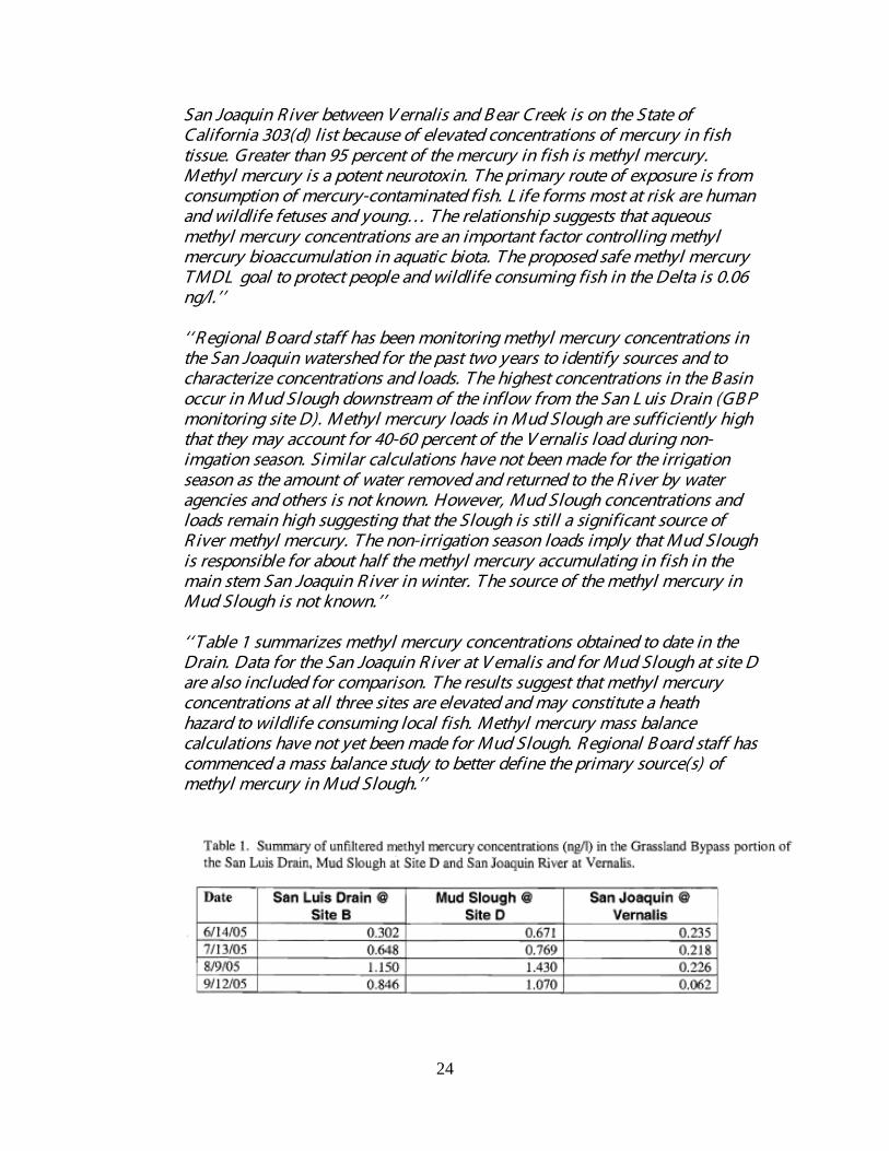
Preliminary methyl mercury water data collected from the vicinity of the San Luis Drain was provided to the Fish and Wildlife Service in a letter from Dr. Chris Foe, staff scientist of the CVRWQCB in 2005. In that letter Dr. Foe noted, ‘‘ T he
24
San Joaquin R iver between V ernalis and B ear Creek is on the State of California 303(d) list because of elevated concentrations of mercury in fish tissue. Greater than 95 percent of the mercury in fish is methyl mercury. Methyl mercury is a potent neurotoxin. T he primary route of exposure is from consumption of mercury-contaminated fish. L ife forms most at risk are human and wildlife fetuses and young… T he relationship suggests that aqueous methyl mercury concentrations are an important factor controlling methyl mercury bioaccumulation in aquatic biota. T he proposed safe methyl mercury T MDL goal to protect people and wildlife consuming fish in the Delta is 0.06 ng/l.’’ ‘‘ R egional B oard staff has been monitoring methyl mercury concentrations in the San Joaquin watershed for the past two years to identify sources and to characterize concentrations and loads. T he highest concentrations in the B asin occur in Mud Slough downstream of the inflow from the San L uis Drain (GB P monitoring site D). Methyl mercury loads in Mud Slough are sufficiently high that they may account for 40-60 percent of the V ernalis load during non-imgation season. Similar calculations have not been made for the irrigation season as the amount of water removed and returned to the R iver by water agencies and others is not known. However, Mud Slough concentrations and loads remain high suggesting that the Slough is still a significant source of R iver methyl mercury. T he non-irrigation season loads imply that Mud Slough is responsible for about half the methyl mercury accumulating in fish in the main stem San Joaquin R iver in winter. T he source of the methyl mercury in Mud Slough is not known.’’ ‘‘ T able 1 summarizes methyl mercury concentrations obtained to date in the Drain. Data for the San Joaquin R iver at V emalis and for Mud Slough at site D are also included for comparison. T he results suggest that methyl mercury concentrations at all three sites are elevated and may constitute a heath hazard to wildlife consuming local fish. Methyl mercury mass balance calculations have not yet been made for Mud Slough. R egional B oard staff has commenced a mass balance study to better define the primary source(s) of methyl mercury in Mud Slough.’’

25
26. Grassland Area Farmers. 2005. Grassland Bypass Project Floodwaters Report. Report submitted by the Grassland Area Farmers, Los Banos, California, to USBR and the Central Valley Regional Water Quality Control Board, May 31, 2005. Eight page report and two page transmittal memo. Available as Attachment B starting on page 98 in the following document: http://wwwrcamnl.wr.usgs.gov/Selenium/Library_articles/ 26_Grassland_Area_Farmers_GBP_Floodwaters_Rpt_2005.pdf
As described in a report submitted to USBR and the Central Valley Regional Water Board, due to heavy rainfall drainage flows that normally would have been routed into the San Luis Drain were rerouted into the Agatha Canal in the south Grasslands, “Rainfall events in October 2004 caused a 20 cfs jump in flows in the San Luis Drain and forced the Grassland Area Farmers to turn off any accessible sumps until flows subsided…The recurring string of storms created saturated soil conditions throughout the Grassland Drainage Area.” “During the period from February 14th through the 16th, 1.6” of rain fell on the Grassland Drainage Area. Rainfall continued to accumulate through the end of February, for a total monthly precipitation of 2.57…By 8 pm on Wednesday, February 16, flow at Site A had increased to 151 cfs and the gate to the Agatha Canal was opened to divert drainage through the wetland channels…By Tuesday, Febrary 22nd, flow at Site A had dropped to 75 cfs and the Agatha gate was closed.” Selenium concentrations in water samples were documented for this period as follows:
Flood Flows into Agatha Canal February 2005
Date Flow (AF) Selenium (µg/L) Selenium (pounds) 2/15/2005 0 0 0 2/16/2005 7 3.5 0.1 2/17/2005 75 4.5 0.9 2/18/2005 50 3.5 0.5 2/19/2005 44 26.5 3.1 2/20/2005 40 39.9 4.3 2/21/2005 40 43.8 4.7 2/22/2005 14 3.7 0.1 2/23/2005 0 44.4 0 2/24/2005 N/A 24.8 N/A 2/25/2005 N/A 24.2 N/A 2/26/2005 N/A 16.6 N/A 2/27/2005 N/A 14.8 N/A 2/28/2005 N/A 9.27 N/A 3/1/2005 N/A 5.1 N/A 3/2/2005 N/A 2.83 N/A

26
27. HT Harvey and Associates. July 2008. San Joaquin River Water Quality
Improvement Project, Phase I Wildlife Monitoring Report 2007. Prepared by HT Harvey and Associates, Fresno, CA for Panoche Drainage District, Firebaugh, CA, 56 pp. http://wwwrcamnl.wr.usgs.gov/Selenium/Library_articles/san_luis_articles/ HT_Harvey_SJRIP_Wildl_Monitor_Rpt_2007_7-11-2008.pdf Data summarized below.
28. HT Harvey and Associates. November 2007. San Joaquin River Water Quality Improvement Project, Phase I, Wildlife Monitoring Report 2006. Prepared by HT Harvey and Associates, Fresno, CA for Panoche Drainage District, Firebaugh, CA, 60 pp. http://wwwrcamnl.wr.usgs.gov/Selenium/Library_articles/san_luis_articles/ HT_Harvey_SJRIP_Wildl_Monitor_Rpt_2006_11-01-2007.pdf Data summarized below.
29. HT Harvey and Associates. June 2006. San Joaquin River Water Quality Improvement Project, Phase I, Wildlife Monitoring Report 2005. Prepared by HT Harvey and Associates, Fresno, CA for Panoche Drainage District, Firebaugh, CA, 47 pp and Attachment. http://wwwrcamnl.wr.usgs.gov/Selenium/Library_articles/san_luis_articles/ HT_Harvey_SJRIP_Wildl_Monitor_Rpt_2005_06-05-2006.pdf Data summarized below.
30. HT Harvey and Associates. May 2005. San Joaquin River Water Quality Improvement Project, Phase I, Wildlife Monitoring Report 2004. Prepared by HT Harvey and Associates, Fresno, CA for Panoche Drainage District, Firebaugh, CA, 37 pp. http://wwwrcamnl.wr.usgs.gov/Selenium/Library_articles/san_luis_articles/ HT_Harvey_SJRIP_Wildl_Monitor_Rpt_2004_05-2005.pdf Data summarized below.
31. HT Harvey and Associates. September 2004. San Joaquin River Water Quality Improvement Project, Phase I, Wildlife Monitoring Report 2003. Prepared by HT Harvey and Associates, Fresno, CA for Panoche Drainage District, Firebaugh, CA, 42 pp. http://wwwrcamnl.wr.usgs.gov/Selenium/Library_articles/san_luis_articles/ HT_Harvey_SJRIP_Wildl_Monitor_Rpt_2003_09-2004.pdf Data summarized below.
32. HT Harvey and Associates. January 2003. San Joaquin River Water Quality Improvement Project, Phase I, Wildlife Monitoring Report 2002. Prepared by HT Harvey and Associates, Fresno, CA for Panoche Drainage District, Firebaugh, CA, 23 pp. http://wwwrcamnl.wr.usgs.gov/Selenium/Library_articles/san_luis_articles/ HT_Harvey_SJRIP_Wildl_Monitor_Rpt_2002_01-29-2003.pdf Data summarized below.

27
33. HT Harvey and Associates. December 2001. San Joaquin River Water Quality Improvement Project, Phase I, Wildlife Monitoring Report 2001. Prepared by HT Harvey and Associates, Fresno, CA for Panoche Drainage District, Firebaugh, CA, 15 pp. http://wwwrcamnl.wr.usgs.gov/Selenium/Library_articles/san_luis_articles/ HT_Harvey_SJRIP_Wildl_Monitor_Rpt_2001_12-14-2001.pdf Data summarized below.
Data from the San Joaquin River Water Quality Improvement Project’s Wildlife Monitoring Reports is summarized in the tables below. For reference, geometric mean egg concentrations for selenium for killdeer and recurvirostrids are above the toxicity threshold of greater than 10 ppm dwt for avian eggs from recommended ecological risk guidelines for the Grassland Bypass Project. Geometric mean egg concentrations for selenium in red-winged blackbirds are above the level of concern from recommended ecological risk guidelines for the Grassland Bypass Project (see Beckon et al 2007). Further, Skorupa (1998: Selenium Poisoning of Fish and Wildlife in Nature: Lessons from Twelve Real-World Examples) found that the threshold for hatchability effects in black-necked stilts (a recurvirostrid) at Tulare Basin was 6-7 ppm selenium on a dry weight basis. By comparison, geometric mean selenium concentrations of recurvirostrid eggs collected from Kesterson Reservoir in the 1980’s (when the reservoir was managed as a drainwater evaporation pond complex) presented below show similar concentrations to the results from the SJRIP reuse area (Kesterson data from: Ohlendorf, H.M., and R.L. Hothem. 1994. Agricultural drainwater effects on wildlife in central California. In D.J. Hoffman, B.A. Rattner, G.A. Burton, Jr., and J. Carins (eds.), Handbook of Ecotoxicology, pp. 577-595. Lewis Publishers, Boca Raton, FL.). In the mid-1980’s the State Water Resources Control Board determined that the avian results at Kesterson Reservoir were so significant that immediate closure and clean-up of Kesterson Reservoir was ordered (SWRCB Order WQ85-1, 1985).

28
Egg selenium concentrations (ppm dwt) from Panoche Drainage District’s San Joaquin River Water Quality Improvement Project’s Reuse Area,
2003-2006 Species 2001 2002 2003 2004 2005 2006 2007 Killdeer 5.5-
13.2 5.2 - 8.6
5.8-33.5
2.79-31.3
6.9-32.2
4.37-54.7
6.95-33.6
Recurvirostrids N/A 6.2 - 33
9.8-98.9
7.53-48.7
22.6-45.7
3.39-95.1
4.75-40.1
Red-Winged Blackbirds
N/A N/A 4.5-11.0
4.79-7.26
N/A 5.54-15.9
6.45-12.1
Geometric Mean Egg selenium (ppm dwt) from Panoche Drainage District’s San Joaquin River Water Quality Improvement Project’s Reuse Area,
2003-2006 Species 2001 2002 2003 2004 2005 2006 2007
Killdeer 8.9 6.7 12.5 13.1 15.9 22.8 17.1 Recurvirostrids N/A 13.6 39.0 15.3 35.3 23.0 19.2 Red-Winged Blackbirds N/A 5.9 6.0 N/A 8.8 8.1
Geometric Mean Egg selenium (ppm dwt) from Kesterson Reservoir,
1983-1985 (data from Ohlendorf and Hothem, 1994) Species 1983 1984 1985
Killdeer N/A 33.1 46.4 Recurvirostrids 16.1 20.9 34.6 Red-Winged Blackbirds N/A 6.0 N/A
34. ** Kaufman, R.C., A. G. Houck, and J. J. Cech, Jr. 2008. Effects of Dietary
Selenium and Methylmercury on Green and White Sturgeon Bioenergetics in Response to Changed Environmental Conditions. Presentation to the CALFED Bay-Delta Program Science Conference, Global Perspectives and Regional Results: Science and Management in the Bay-Delta System. Sacramento, CA. University of California, Davis, 23 pp. http://wwwrcamnl.wr.usgs.gov/Selenium/Library_articles/san_luis_articles/ Kaufman_et_al_Effects_of_Dietary_Se_and_Hg_2008.pdf
35. * Kenneth Schmidt and Associates. May 1997. Groundwater Conditions in and near the Central California Irrigation District. Prepared for Central California Irrigation District, Los Banos, CA, 89 pp. and appendices.
The report concluded (on page 84) that, “The regional direction of groundwater flow in the upper aquifer is to the northeast throughout much of CCID. This is the same direction as delineated for 1980 by Stoddard and Associates (1982). Major sources of recharge to the upper aquifer are canal seepage, deep percolation of excess applied irrigation water, and streamflow seepage.”

29
36. ** Krauter, C. 2006. Atmospheric Salt Emissions from the Concentration of Agricultural Drainage Water by Sprinkler Evaporator. Center for Irrigation Technology, California State University, Fresno for California Department of Water Resources Agreement No. 4600000435-01, 23 pp. http://wwwrcamnl.wr.usgs.gov/Selenium/Library_articles/san_luis_articles/ Krauter_Salt_Emissions_from_Agr_Drainage_Sprinkler_Evaporator_2006.pdf
37. ** Linares, J., R.G. Linville, J. Van Eenennaam, and S. Doroshov. November 2004. Selenium Effects on Health and Reproduction of White Sturgeon in the Sacramento-San Joaquin Estuary. Final Report for Project No. ERP-02-P35 (contract No. 4600002881). University of California, Department of Animal Science, Davis, CA. 56 pp. http://wwwrcamnl.wr.usgs.gov/Selenium/Library_articles/san_luis_articles/ Linares_et_al_Selenium_Effects_on_Health_and_Reproduction_of_White_ Sturgeon_2004.pdf
38. Linville, R.G. 2006. Effects of Excess Selenium on the Health and Reproduction of White Sturgeon (Accipenser transmontanus): Implications for San Francisco Bay-Delta. PhD Dissertation, University of California Davis, 232 pp. http://wwwrcamnl.wr.usgs.gov/Selenium/Library_articles/san_luis_articles/ Linville_Effects_of_Selenium_on_Health_and_Reproduction_of_White_Sturgeon_ PhD_Dissertation_2006.pdf
The author of this PhD Dissertation describes the goal of her research was, “to elucidate the effects of selenium (Se) bioaccumulation on white sturgeon, Acipenser transmontanus, with an emphasis on the San Francisco Bay population.” The research focused on three studies. The first investigated the long-term effects of dietary Se in juvenile white sturgeon. The second study examined the mechanisms of Se maternal transfer in white sturgeon and the impacts of accumulated Se on reproduction. In the third study the author investigated the effects of Se on developing white sturgeon embryos and larvae. The author describes environmental conditions in the benthic clam foodweb of then the San Francisco Bay/Delta: “The filter feeding exotic bivalve Potamocorbula amurensis contains an average Se level of 15 μg/g dw (Linville et al. 2002). This non-native species was introduced into San Francisco Bay in the mid-1980’s and has since become the dominant bivalve in the bay (Carlton et al. 1990; Nichols et al. 1990) and a major food source of benthic-feeding organisms (Urquhart and Regalado 1991). The high Se level and wide distribution of P. amurensis is of great concern because its Se burden significantly exceeds the levels shown to cause toxicity in animals consuming bivalves. Prey items containing greater than 10 μg/g Se have been shown to induce Se toxicity in birds and fish (Adams et al. 1998; Coyle et al. 1993; Hamilton et al. 1990a; Heinz et al. 1989; Hermanutz et al. 1992; Hoffman et al. 1989; Woock et al. 1987). Based upon tissue burdens, the fish most vulnerable to Se contamination in San Francisco Bay are benthic feeders, including white sturgeon (Luoma and Linville 1997; Urquhart and Regalado 1991; White et al. 1987).”

30
With respect to tissue concentrations of selenium in white sturgeon collected from San Francisco Bay/Delta, the author noted, “White sturgeon sampled from San Francisco Bay-Delta between 1986 and 1990 contained Se at concentrations ranging from 9 to 30 μg/g dw in liver (n= 52) and 7 to 152 μg/g dw in muscle (n= 99; Urquhart and Regalado 1991; White et al. 1988). Out of six sturgeon females sampled in the San Francisco Bay-Delta region in the 1990’s, one contained eggs with 3 μg/g Se, four had eggs ranging from 8 to 12 μg/g Se and one female contained eggs with 29 μg/g Se (Kroll and Doroshov 1991). In 2000, white sturgeon from this region exhibited a mean liver Se concentration of 24 μg/g, with some samples reaching as high as 40 μg/g Se (n= 15; Stewart et al. 2004). Linares et al. (2004) reported a mean liver Se concentration of 9.75 μg/g in 36 sub-adult and adult (age 4 – 18) white sturgeon sampled in San Francisco Bay between 2002 and 2004. Recently, three white sturgeon captured from San Francisco Bay-Delta were found to have 7 to 20 μg/g Se in ovaries containing developing eggs (Doroshov Lab, UCD; unpublished data). The Se concentrations found in white sturgeon captured from San Francisco Bay-Delta reach levels previously linked to adverse effects in other fish (Coughlan and Velte 1989; Gillespie and Baumann 1986; Hermanutz et al. 1992; Lemly 1993b).”
Regarding selenium exposure, the author found for white sturgeon that “even moderate increases, or decreases, in the accumulation of Se by reproductive females will affect the exposure level to their offspring. White sturgeon larvae containing Se concentrations above ca. 11 to 15 Se µg/g, following Se maternal transfer or microinjection, demonstrated significant increases of mortality and abnormality rates (including edema and skeletal deformities). Based on the work presented here, the hazard threshold for Se in developing white sturgeon should be set somewhere between 3 and 8 μg/g Se in yolk sac larvae (dw).” The author concluded that, “In San Francisco Bay-Delta, juvenile white sturgeon are susceptible to toxicity at concentrations currently observed in some prey items (i.e., bivalves). In addition, juveniles in this region accumulate Se in their tissues at concentrations similar to those observed in our study. This leads us to suspect that juvenile white sturgeon in San Francisco Bay-Delta may be experiencing cholestasis, depending on individual dietary Se exposure. This potentially fatal liver condition disrupts the flow of bile, which prevents excretion of many toxicants and can lead to direct toxicity by damaging liver tissue. extent of cholestasis in juvenile white sturgeon from San Francisco Bay-Delta should investigated. For adult white sturgeon in San Francisco Bay-Delta, typical Se exposure levels in the benthic food web (ca. 15 μg/g) are below the dietary Se level to which reproductive females were exposed in these experiments (ca. 34 μg/g). However, experimental sturgeon accumulated Se concentrations in liver, muscle and eggs (ca. 12 μg/g Se) that are similar to body burdens of sturgeon in the San Francisco Bay population. The extent of accumulation in liver is most important here since we were exploring the transport of accumulated Se from the liver to the developing eggs. Our research indicates that female white sturgeon in San Francisco Bay-Delta are likely transferring Se to their offspring. Limited

31
data from this region supports this conclusion. Data from ten white sturgeon females sampled in the San Francisco Bay-Delta region show 3 to 29 μg/g Se (dw) in eggs or egg-bearing ovary (Kroll and Doroshov 1991; Doroshov Lab, UCD, unpublished data). Eight of those ten sturgeon exhibited egg Se levels above our proposed hazard threshold range of 3 to 8 μg/g Se in larvae (dw). Our maternal transport study showed strong conservation of Se between the egg and larval stages, indicating that egg Se concentrations may be interchangeable with larval concentrations (when both are calculated on a dry weight basis). Based on this information, it is likely that the accumulation of excess Se by female sturgeon in San Francisco Bay-Delta is affecting the recruitment of white sturgeon in this region. We observed severe edema and skeletal deformities in larvae containing Se concentrations above ca. 11 to 15 Se µg/g. These defects are expected to significantly decrease the probability of survival in white sturgeon larvae. The effected larvae have limited mobility and can be consumed by predators or may fail to start exogenous feeding. In this way, Se-induced developmental defects are an unseen factor in white sturgeon recruitment. White sturgeon eggs and gravid ovaries should be monitored for Se concentrations to determine the magnitude of potential impact on reproduction. Additionally, Se concentrations in the benthic food web should be routinely monitored since relatively small increases of Se in the food web can lead to increased toxicity to this species. Careful management of all processes with potential to increase Se concentrations in the benthic food web is essential to protect sturgeon in San Francisco Bay-Delta and other high-Se systems.”
39. Linville, R.G., S.N. Luoma, L. Cutter and G.A. Cutter. 2002. Increased selenium threat as a result of invasion of the exotic bivalve Potamocorbula amurensis into the San Francisco Bay-Delta. Aquatic Toxicology 57(1-2):51-64. http://wwwrcamnl.wr.usgs.gov/Selenium/Library_articles/ 39_Linville_et_al_Increased_Se_threat_P_amurensis_into_SF_Bay_D.pdf
The authors documented selenium contamination in the water column and in bivalves between the mid-1980s and 1995–1997 in the San Francisco Bay Delta. The authors noted that two changes occurred in the intervening period that would likely affect selenium cycling in the Bay. First, beginning in the mid-1980s, an invading species of bivalve, Potamocorbula amurensis, became the predominant benthic macroinvertebrate in the Bay. Second, greater than normal precipitation and high river runoff occurred during the study period (May 1995–November 1997), in contrast to previous studies that took place during periods of drought. The authors suggest that during periods of greater than normal precipitation more selenium could enter the Bay from the agricultural runoff [San Joaquin River] than had been observed in previous studies.
The authors found that, “Following the aggressive invasion of the bivalve, Potamocorbula amurensis, in the San Francisco Bay-Delta in 1986, selenium contamination in the benthic food web increased. Concentrations in this dominant (exotic) bivalve in North Bay were three times higher in 1995–1997 than in earlier studies, and 1990 concentrations in benthic predators (sturgeon and

32
diving ducks) were also higher than in 1986. The contamination was widespread, varied seasonally and was greater in P. amurensis than in co-occurring and transplanted species.”
The authors further noted, “Total Se concentrations in the dissolved phase never exceeded 0.3 g Se per l in 1995 and 1996; Se concentrations on particulate material ranged from 0.5 to 2.0 g Se per g dry weight (dw) in the Bay. Nevertheless, concentrations in P. amurensis reached as high as 20 g Se per g dw in October 1996. The enriched concentrations in bivalves (6–20 g Se per g dw) were widespread throughout North San Francisco Bay in October 1995 and October 1996. Concentrations varied seasonally from 5 to 20 g Se per g dw, and were highest during the periods of lowest river inflows and lowest after extended high river inflows.” The authors described the invasion of the San Francisco Bay by the exotic bivalve, P. amurensis as follows, “Invasion of San Francisco Bay by the exotic bivalve, P. amurensis, resulted in an increase by threefold of selenium concentrations in the predominant macrobenthic food in the estuary. This is of concern because Se is a strong reproductive toxin for such species, and Se concentrations in P. amurensis in fall 1995 and 1996 were in excess of the toxicologic threshold for adverse effects on such predators. Se-contaminated P. amurensis were widespread in Suisun and San Pablo Bays in 1995 and 1996. Seasonal variability is an important feature of selenium contamination in P. amurensis, with the highest concentrations occurring in fall during the period of longest hydraulic residence times.”
The authors conclude, “…it seems clear that the invasion of the non-native bivalve P. amurensis has resulted in increased bioavailability of a potent environmental toxin to certain benthivores in San Francisco Bay.”
40. * Lucas, L.V. and A.R. Stewart. 2007. Transport, transformation, and effects of
selenium and carbon in the Delta of the Sacramento-San Joaquin Rivers: implications for ecosystem restoration. Prepared for CalFed Ecosystem Restoration Program Agreement No. 4600001955, Project No. ERP-01-C07, U.S. Geological Survey, Menlo Park, CA, 406 pp. http://wwwrcamnl.wr.usgs.gov/Selenium/Library_articles/san_luis_articles/ Lucas_Stewart_Delta_ERP-01-C07.pdf
The authors provided a summary of this joint project implemented by USGS and Stony Brook and Old Dominion Universities to the CalFed Ecosytem Restoration Program. The authors noted the following with respect to selenium contamination in the Bay-Delta: “The sources of selenium contamination in the Bay-Delta are well-known. The main watershed source is agricultural drainage from the San Joaquin Valley (SJV)… A second selenium source is oil refiners who discharge waste to the Suisun Bay from processing Se-enriched crude oil that originates from the SJV and adjacent Coast Ranges. This was the primary source of Se to the Bay until

33
studies identifying that source led to regulation of that discharge in the mid- to late-1990’s.”
“Several explanations for the temporal trends in bivalve Se concentrations (which did not exist in the 1980’s) are possible. One possibility is that refinery inputs of selenium have been replaced by San Joaquin River inputs. Models indicate that if SJR inflows to the Bay increase, as they may have in recent years with barrier management, particulate Se concentrations in the Bay could double, even with no increase in irrigation drainage inputs to the SJR (Fig. 1; Meseck (2002)). The fall increase in Se in P. amurensis also occurs during the time period when the ratio of SJR/Sac River inflow is highest. Further changes in water management could exacerbate these trends…”
Se inputs from the SJR to the Bay primarily control the Se content of Potamocorbula, so Se remains elevated because of continued inputs from this source. The seasonal increase in Se in bivalves roughly follows the ratio of SJR/total inflows to the Bay (Fig. 3). However, comparisons between suspended particulate selenium and SJR inflow ratios are inconclusive, although the data are sparse (Fig. 3). In Fall, the phytoplankton which are a large component of Potamocorbula’s diet could increase their Se contents in response to seasonal inputs of waters containing high selenate and organic selenide concentrations from the SJR.”

34
41. * Maier, K.J., C.R. Nelson, F.C. Bailey, S.J. Klaine, and A.W. Knight. 1998. Accumulation of Selenium by the Aquatic Biota of a Watershed Treated with Seleniferous Fertilizer. Bull. of Env. Contam. and Tox., Vol. 60(3):409-416. http://wwwrcamnl.wr.usgs.gov/Selenium/Library_articles/san_luis_articles/ Maier_et_al_Accumulation_of_Se_by_Biota_in_Watershed_Treated_w_ Fertilizer_1998.pdf
42. McCarthy, M.J. and L. F. Grober. 2001. Total Maximum Daily Load for Selenium in the Lower San Joaquin River. Staff Report of the California Regional Water Quality Control Board, Central Valley Region, Sacramento, CA, 32 pp. http://wwwrcamnl.wr.usgs.gov/Selenium/Library_articles/ 42_McCarthy_and_Grober_2001_TMDL_for_Se_in_the_LSJR_CVRWQCB.pdf
The lower San Joaquin River (SJR) is listed on the Federal Clean Water Act’s 303(d) list as impaired for selenium, which is toxic to waterfowl at high levels. The impairment extends from the Salt Slough confluence to the Airport Way Bridge near Vernalis. The 303(d) listing requires development of a Total Maximum Daily Load (TMDL) for selenium in the lower SJR. The authors identify the major source of selenium in the San Joaquin River comes from, “an area called the Drainage Project Area (DPA) that is currently under regulations to reduce selenium loading. Load allocations have been developed to specify how much selenium can be discharged while still maintaining a healthy ecosystem. Based on these load allocations, waste discharge requirements are assigned to the DPA’s drainage system, the Grassland Bypass Project (GBP)”… While selenium occurs naturally throughout the lower SJR Basin, elevated concentrations of selenium occur in the shallow groundwater in the 97,000 acre DPA contained within the Grassland Watershed. Subsurface agricultural drainage discharges from this area are the major source of selenium... Soils and shallow groundwater with the highest concentrations of selenium in the SJR Basin are located in a 97,000-acre area that has alternately been called the Drainage Study Area, Drainage Problem Area, and most recently, the Drainage Project Area (DPA).” Based on Regional Board reports completed in the late 1990’s, the TMDL for the lower San Joaquin River concludes that “The reports demonstrate that the DPA accounts for, on average, 88% of the selenium load in the lower SJR.”
The report notes, “The lower San Joaquin River (SJR) is listed in accordance with Section 303(d) of the Clean Water Act for exceeding selenium water quality objectives. Areal extent of the impairment was listed as 50 river miles from the Salt Slough confluence to the Airport Way Bridge near Vernalis. This water quality limited segment was listed in 1988 as part of the water quality assessment and 303(d) listing process.” For reference, this section of the SJR was still on the 2006 303(d) list for selenium (see reference SWRCB 2007).
This reach of the SJR drains an area of approximately 2.9 million acres. Mud Slough and Salt Slough are tributaries to the SJR that drain the 370,000-acre Grassland Watershed. These sloughs contain a mix of agricultural return flows,
35
runoff from managed wetlands, rainfall runoff, and flood flows. Mud Slough discharges to the SJR approximately two miles upstream of the confluence between the SJR and the Merced River. Salt Slough flows into the SJR approximately 6 miles upstream of the Mud Slough confluence.
The report found that, “Surface agricultural return flows and wetland discharges from the west side of the SJR have the same selenium concentration as the source water. The selenium concentration depends on whether the source is groundwater, SJR diversions, or the Delta-Mendota Canal. A survey of agricultural discharges to the SJR (Westcot et al., 1989) found the mean selenium concentration of surface return flows, with source water from a mix of SJR and Delta-Mendota Canal water, to be 2.2 µg/L, with a range from 1.8 to 2.7 µg/L.”
The report describes the history of drainage discharges in the Grasslands, “Subsurface agricultural return flows were alternately discharged to Mud Slough and Salt Slough before use of the GBP. Monthly selenium concentrations averaged 14 µg/L for Salt Slough and 7 µg/L for Mud Slough (Grober et al., 1998) from 1986 to 1995. With use of the GBP, Salt Slough no longer received subsurface agricultural return flows, only surface agricultural return flows and wetland discharges. Mud Slough received no surface agricultural return flows upstream of the San Luis Drain confluence; flows are now comprised mostly of wetland discharges. Annual selenium concentration was 1 µg/L for Salt Slough during water year 1997 (Chilcott et al., 1998). Annual selenium concentration was 1 µg/L for Salt Slough and 1 µg/L for Mud Slough upstream of the San Luis Drain during water year 1998 (Chilcott et al., 2000)… The mean annual selenium load from the DPA from 1986 through 1998 was 8,660 pounds. The mean annual selenium load in the SJR near Vernalis during this same period was 9,788 pounds.”
The program to implement this TMDL and the selenium TMDLs for Salt Slough and the Grassland Marshes was adopted in the Regional Board’s 1996 Basin Plan Amendment. Included in this 1996 Basin Plan Amendment is a timetable for meeting selenium water quality objectives in the lower SJR (Note: see reference under California Regional Water Quality Control Board 1998 for this Basin Plan Amendment). A compliance schedule is described as follows, “The schedule for compliance with selenium water quality objectives in the SJR shows that the 5 µg/L objective must be met for the SJR from Sack Dam to the Merced River confluence starting in October 2010. Prior to this date, selenium loads from the DPA may continue to be discharged to the SJR upstream of the Merced River confluence. Attainment of the selenium water quality objective upstream of the Merced River confluence may require significant changes to the DPA discharge, including the relocation of the discharge point… The 5 µg/L four-day average water quality objective for the SJR below the Merced River must be met in AN and W years starting in water year 2006. The 5 µg/L four-day average objective must be met for C, D and BN years starting in water year 2011. The 5 µg/L four-day average water quality objective must also be met for all year types in Mud Slough and the SJR from Sack Dam to the Merced River starting in water year

36
2011. Starting in water year 1997, this amendment also prohibited discharge of agricultural subsurface drainage to Grassland Watershed wetland supply channels and Salt Slough if the discharge results in concentrations exceeding the 2 µg/L water quality objective established for these channels.”
43. National Oceanic and Atmospheric Administration, National Marine Fisheries Service. September 8, 2008. Proposed Rulemaking To Designate Critical Habitat for the Threatened Southern Distinct Population Segment of North American Green Sturgeon; Proposed Rule. Federal Register Vol. 73(174): 52084- 52110. http://wwwrcamnl.wr.usgs.gov/Selenium/Library_articles/ 43_NOAA_NMFS_Green_Sturgeon_Crithab_Prop_Rule_9-8-2008.pdf
§ 226.216 Critical habitat for the Southern Distinct Population Segment of North American Green Sturgeon Acipenser medirostris): Designation of Critical habitat was proposed in this document for the Southern Distinct Population Segment of North American green sturgeon (Southern DPS). The textual descriptions of critical habitat in this Proposed Rule are the definitive source for determining the critical habitat boundaries. Critical habitat boundaries include the SF Bay Delta: Coastal bays and estuaries: Critical habitat is designated to include the following coastal bays and estuaries in California, Oregon, and Washington: (i) Central Valley, California. All tidally influenced areas of San Francisco Bay, San Pablo Bay, Suisun Bay, and the Sacramento-San Joaquin Delta up to the elevation of mean higher high water, including tributaries upstream to the head of tide. Designated areas in the Sacramento-San Joaquin Delta include all waterways within the area defined in California Water Code Section 12220, except for the following excluded slough areas: Fivemile Slough (all reaches upstream from its confluence with Fourteenmile Slough at 38º00′50″ N./ 121º22′09″ W.); Sevenmile Slough (all reaches between Threemile Slough at 38º06′55″ N./ 121º40′55″ W. and Jackson Slough at 38º06′59″ N./ 121º37′44″ W.); Snodgrass Slough (all reaches upstream from Lambert Road at 38º19′14″ N./ 121º31′08″ W.); Tom Paine Slough (all reaches upstream from its confluence with Middle River at 37º47′25″ N./ 121º25′08″ W.); and Trapper Slough (all reaches upstream from 37º53′36″ N./ 121º29′15″ W.). The Primary Constituent Elements for Estuarine Areas were identified to include: Water quality, including temperature, salinity, oxygen content, and other chemical characteristics, necessary for normal behavior, growth, and viability of all life stages. Suitable water temperatures for juvenile green sturgeon should be below 24 ºC. At temperatures above 24 ºC, juvenile green sturgeon exhibit decreased swimming performance (Mayfield and Cech, 2004) and increased cellular stress (Allen et al., 2006). Suitable salinities range from brackish water (10 ppt) to salt water (33 ppt). Juveniles transitioning from brackish to salt water can tolerate prolonged exposure to salt water salinities, but may exhibit decreased growth and activity levels (Allen and Cech, 2007), whereas subadults and adults tolerate a wide range of salinities (Kelly et al., 2007). Subadult and

37
adult green sturgeon occupy a wide range of dissolved oxygen levels, but may need a minimum dissolved oxygen level of at least 6.54 mg O2/l (Kelly et al., 2007; Moser and Lindley, 2007). As described above, adequate levels of dissolved oxygen are also required to support oxygen consumption by juveniles (ranging from 61.78 to 76.06 mg O2 hr-1 kg-1) (Allen and Cech, 2007). Suitable water quality also includes water with acceptably low levels of contaminants (e.g., pesticides, organochlorines, elevated levels of heavy metals; acceptable low levels as determined by NMFS on a case-by-case basis) that may disrupt the normal development of juvenile life stages, or the growth, survival, or reproduction of subadult or adult stages.
44. National Oceanic and Atmospheric Administration, National Marine Fisheries Service. April 7, 2006. Threatened Status for Southern Distinct Population Segment of North American Green Sturgeon. Final Rule. Federal Register Vol. 71(67): 17757-17766. http://wwwrcamnl.wr.usgs.gov/Selenium/Library_articles/ 44_NOAA_NMFS_Green_Sturgeon_Threatened_Status_Final_Rule_4-7-20.pdf
Toxins, invasive species, and water project operations, were all identified as threats to the Southern Distinct Population Segment of the green sturgeon, and “may be acting in concert or individually to lower pelagic productivity in the Delta.: …The Final Rule notes that “toxins may be at least partially responsible for the pelagic organism decline in the Delta. White sturgeon may also accumulate PCBs and selenium (White et al., 1989). While green sturgeon spend more time in the marine environment than white sturgeon and, therefore, may have less exposure, we conclude that some degree of risk from contaminants probably occurs for green sturgeon.”
45. Oppenheimer, E.I. and L.F. Groeber. 2004a. Amendments to the Water Quality
Control Plan for the Sacramento River and San Joaquin River Basins for the Control of Salt and Boron Discharges into the Lower San Joaquin River. Draft Final Staff Report of the Central Valley Regional Water Quality Control Board, San Joaquin River TMDL Unit, Sacramento, CA, 121 pp. http://wwwrcamnl.wr.usgs.gov/Selenium/Library_articles/ 45_Oppenheimer_and_Groeber_Amendmts_to_Water_Qual_Cont_Plan_45.pdf
The authors identified potential Delta impacts from constituents that originate in the San Luis Unit project area: “Water quality in the San Joaquin River has degraded significantly since the late 1940s. During this period, salt concentrations in the River, near Vernalis, have doubled. Concentrations of boron, selenium, molybdenum and other trace elements have also increased. These increases are primarily due to reservoir development on the east side tributaries and upper basin for agricultural development, the use of poorer quality, higher salinity, Delta water in lieu of San Joaquin River water on west side agricultural lands and drainage from upslope saline soils on the west side of the San Joaquin Valley. Point source discharges to surface waters only contribute a small fraction of the total salt and boron loads in the San Joaquin River.”
38
“The Grassland Subarea contains some of most salt-affected lands in the LSJR watershed. This subarea is also the largest contributor of salt to the LSJR (approximately 37% of the LSJR’s mean annual salt load). Previous studies indicate that shallow groundwater in the LSJR watershed is of the poorest quality (highest salinity) in the Grassland Subarea (SJVDP, 1990). The Grassland Subarea drains approximately 1,370 square miles on the west side of the LSJR in portions of Merced, Stanislaus, and Fresno Counties. This subarea includes the Mud Slough, Salt Slough, and Los Banos Creek watersheds. The eastern boundary of this subarea is generally formed by the LSJR between the Merced River confluence and the Mendota Dam. The Grassland Subarea extends across the LSJR, into the east side of the San Joaquin Valley, to include the lands within the Columbia Canal Company [and including the Northern Portion of Westlands Water District]. The western boundary of the subarea generally follows the crest of the Coast Range with the exception of lands within San Benito County, which are excluded.” (underlining added for emphasis)
46. Oppenheimer, E.I. and L.F. Groeber. 2004b. Amendments to the Water Quality Control Plan for the Sacramento River and San Joaquin River Basins for the Control of Salt and Boron Discharges into the Lower San Joaquin River. Draft Final Staff Report Appendix 1: Technical TMDL Report. Central Valley Regional Water Quality Control Board, San Joaquin River TMDL Unit, Sacramento, CA, 109 pp. http://wwwrcamnl.wr.usgs.gov/Selenium/Library_articles/ 46_Oppenheimer_and_Groeber_Amendmts_to_Water_Qual_Cont_Plan_46.pdf
The Technical TMDL Report documents the salt and boron contribution to the San Joaquin River from the Grasslands Subarea as follows: “The average annual discharge from the Grassland Subarea is approximately 210 taf based on water-years 1977 through 1997. Discharge from the Grassland Subarea accounts for approximately 6 percent of the river’s total discharge as measured at Vernalis. The Grassland Subarea contributes approximately 400 thousand tons of salt and 490 tons of boron per year to the LSJR, which accounts for approximately 36 percent of the rivers total salt load and 50% of the rivers total boron load at Vernalis… Subsurface agricultural drainage from the DPA in the Grassland Subarea represents the most concentrated source of salt and boron in the LSJR Watershed.”
47. Paveglio, F.L., and K.M. Kilbride. 2007. Selenium in Aquatic Birds from Central California. J. Wildl. Manage. 71(8): 2550-2555. http://wwwrcamnl.wr.usgs.gov/Selenium/Library_articles/san_luis_articles/ Paveglio_and_Kilbride_2007_SE_in_Aquatic_Birds_from_Central_CA.pdf
The U.S. Fish and Wildlife Service, Division of Natural Resources, Branch of Refuge Biology, Vancouver, WA, conducted follow-up collections during 2005 to determine selenium concentrations in aquatic birds after long-term use (20 years) of predominately freshwater for wetland management in the Grasslands. The authors found the following, “Selenium concentrations were higher for birds from the South Grasslands during 2005, which historically received more undiluted

39
drainage water compared with the North Grasslands. Liver selenium concentrations for black-necked stilts from the South Grasslands were within ranges associated with the first incidence of reproductive impairment. Shovelers, coots, and black-necked stilts from the South Grasslands during 2005 were found to be significantly above the background level (at a 95% confidence level)…” A summary of the selenium concentrations in bird livers from this study are presented in Table 4. The authors conclude that selenium cycling and within Grasslands wetlands likely is attributable to 3 factors: 1) historic use of agricultural drainage resulting in a reservoir of Se in wetlands and supply channel sediments; 2) storm-water inflows; and, 3) unregulated inflows of subsurface drainage directly into wetlands or indirectly into their supply channels.
48. Pierson, F.W., R.R. Thomasson, and J.E. Chilcott. 1987. Investigation of Check Drains Discharging into the Delta-Mendota Canal. Central Valley Regional Water Quality Control Board, Agricultural Unit, Sacramento, CA, 26 pp. http://wwwrcamnl.wr.usgs.gov/Selenium/Library_articles/san_luis_articles/ Pierson_et_al_Check_Drain_Investigation_DMC_1987.pdf
On 22 and 29 July 1986, Regional Board staff investigated the check drains of the Delta Mendota Canal (DMC) along a 45-mile stretch of the DMC between

40
O’Neill Forebay and the Mendota Pool. The authors found that of 93 check drains identified, 20 were actively discharging agricultural runoff into the DMC, an additional five showed recent signs of having received discharges, and 25 drains showed strong likelihood of receiving agricultural flows by virtue of being connected to field drainage systems and being located at the low point of fields(s) in production. The authors concluded the following: “The check drains are a source of selenium and other trace elements to the DMC. In general, each discharge is small, contributing only a fraction of 1 ug/L to the overall selenium concentration in the DMC and Mendota Pool. However, the cumulative effect of each check drain discharge, plus USBR drains, on top of the base load, especially when the flow in the DMC is low, could be significant. Elevated levels of selenium in the DMC are a management problem and should be able to be controlled to protect beneficial uses.”
49. Presser, S.N. February 26, 2001. Comments on Draft Environmental Impact
Statement/Environmental Impact Report for the nine-year renewal of the Grassland Bypass Project. Memorandum from U.S. Geological Survey, Water Resources Division, Menlo Park to Michael Delamore, U.S. Bureau of Reclamation, South-Central California Area Office, Fresno and and Joseph McGahan, Summers Engineering, Hanford, CA, 11 pp. http://wwwrcamnl.wr.usgs.gov/Selenium/Library_articles/san_luis_articles/ Presser_USGS_Comments_on_EIS_EIR_for_GBP_2-26-2001.pdf
In a comment letter on the Draft EIS/EIR for the Grassland Bypass Project, Dr. Presser of the U.S. Geological Survey questioned the ability of the Grassland Bypass Project, to meet future Water Quality Objectives for selenium based on scientific analysis of the forecasts that Project personnel used in applying for a renewal to continue the “experiment” of bypassing drainage around the wetlands. Dr. Presser concluded: “Dry-year water-quality standards for the San Joaquin River below the Merced River are not met through the nine-year process of this EIS/EIR [to justify the extension]. Loads in 2009 remain over 2-fold above those proposed by the state to meet a 5-µg/L Se objective in 2010. The USEPA’s criterion of 5 µg/L cannot be met in Mud Slough and the San Joaquin River above the Merced River…”
Dr. Presser further noted that, “…Concern remains for control of drainage contaminant loads during wet years and the overall effectiveness of planned actions because of the basin-wide nature of groundwater degradation in the western San Joaquin Valley… Recent data from Grassland Bypass Project annual reports shows annual tile sump discharge from the GDA remains at approximately 10,000 pounds of selenium per year…Control activities to recycle and dispose of drainage on IVT lands has led to mobilized selenium being sequestered, mainly in groundwater aquifers and on land, to meet load limits. These control activities are largely a redistribution of a constant load among groundwater, surface water, and land disposal. It remains to be seen how long selenium sequestration can be continued without significantly limiting farming capability or returning to surface water disposal of drainage.”

41
With respect to the source of drainage contaminant loads during wet years in surface waters, the author cited 1998 data (an above normal precipitation year) which found that the surface water component (from Panoche Creek) of uncontrolled discharges into the Grasslands was actually very small in (5.5%).
50. ** Presser, T.S. 1994. “The Kesterson Effect”. Environ. Manage. 18(3): 437-454. http://wwwrcamnl.wr.usgs.gov/Selenium/Library_articles/presser_kesterson_eff_1994.pdf
51. ** Presser, T.S. and S. N. Luoma. 2006. Forecasting Selenium Discharges to the San Francisco Bay-Delta Estuary: Ecological Effects of a Proposed San Luis Drain Extension. U.S. Geological Survey Open-File Report 00-416, 196 pp. http://pubs.usgs.gov/pp/p1646/
52. ** Presser, T.S. and H.M. Ohlendorf. 1987. Biogeochemical Cycling of Selenium in the San Joaquin Valley, California, USA. Environ. Manage. 11(6): 805-821. http://wwwrcamnl.wr.usgs.gov/Selenium/Library_articles/EnvMan11.pdf
53. ** Presser, S.N. and S.E. Schwarzbach. 2008. Technical Analysis of In-Valley Drainage Management Strategies for the Western San Joaquin Valley. U.S. Geol. Surv. Open-File Report 2008-1210, version 1.0. http://pubs.usgs.gov/of/2008/1210/
54. Quinn, N.W.T., J.C. Linneman, and K.K. Tanji. 2006. The San Joaquin Valley Westside Perspective. Lawrence Berkeley National Laboratory, Paper LBNL-60613, University of California, Berkeley, CA, 15 pp. http://wwwrcamnl.wr.usgs.gov/Selenium/Library_articles/ 54_Quinn_etal_2006_perspective.pdf
In a review paper on subsurface drainage on the west-side San Joaquin Valley, the authors noted the following with respect to salt imbalance, “The total salt load imported to the Westside of the Valley by surface water deliveries has been estimated to be approximately 1.7 million metric tons per year (1.9 m tons per yr) (SJVDP, 1990). Approximately 0.45 million metric tons (0.5 m tons) of salts (primarily sodium sulfate) leave the Valley through the San Joaquin River each year. Of the total salt export, agricultural subsurface drainage discharged to the San Joaquin River accounts for about 34.6 million m3 per year (28,000 ac-ft per yr), and 110,000 metric tons (121,000 tons) of salt from an estimated 19,430 ha (48,000 ac) of land with installed subsurface drains…The soils on the west-side are derived from sediments of the Coast Range marine sedimentary rocks and thus have elevated concentrations of soluble salts which are mobilized by infiltrating surface-applied water. Both the Grasslands agricultural and Westlands Subareas are within the arc of westside alluvial fans which originate in the shale beds of the coast range and produce runoff and eroded sediments elevated in selenium.” With respect to the drainage problem in Westlands the authors found, “The Westlands subarea response to these drainage issues, that commanded national attention back in 1985, precede the salt, selenium and boron TMDL’s. Since the

42
subarea has no drainage discharge to the receiving waters of the State it is not directly affected by the TMDL. However these actions have an indirect impact on the hydrology of the Basin owing to regional groundwater flow from Westlands into the Grasslands subarea. Although Quinn and others, using two USGS models that overlay the boundary between the Westlands and Grasslands subareas (Belitz and Phillips., 1993 and Fio and Deverel, 1992) have estimated this migration at less than 5% of the deep percolation in any of the downslope, impacted water districts – the implementation of water conservation, drainage recycling and other drainage reduction best management practices in the Westlands subarea is a benefit to drainage management and disposal in the Grasslands subarea. Soil salinization is a slow but progressive and inevitable process if salt balance is not achieved over the long term (Schoups et al., 2005). Then, the only responses to TMDL drainage restrictions or the lack of a drainage outlet are in-valley disposal options or land retirement.”
55. Schoups, G., Hopmans, J.W., Young, C.A., Vrugt, J.A., Wallender, W. W.,
Tanji, K.K., Panday, S., 2005, Sustainability of irrigated agriculture in the San Joaquin Valley, California: Proceedings of the National Academy of Sciences. Volume 102. No. 43, p. 15352-15356. http://wwwrcamnl.wr.usgs.gov/Selenium/Library_articles/55_schoups_etal_2005.pdf
The authors developed a hydro-salinity model to integrate subsurface hydrology with reactive salt transport for a 1,400-km2 study area that encompassed all or portions of 13 water districts, including Broadview Water District, and the northern half of Westlands Water District south to Cantua Creek in western Fresno County of San Joaquin Valley. The model was used to reconstruct historical changes in salt storage by irrigated agriculture over the past 60 years. The authors found that patterns in soil and groundwater salinity were caused by spatial variations in soil hydrology, the change from local groundwater to snowmelt water as the main irrigation water supply, and by occasional droughts. Gypsum dissolution was found to be a critical component of the regional salt balance. The paper notes that salt input and output values were the same when the total salt input by irrigation water (0.23 Mton) was equal to salt removal by seepage through the Corcoran clay (0.12 Mton) and lateral groundwater f lows toward the San Joaquin Valley trough along the eastern domain boundary (0.11 Mton). In other words, the authors describe vertical salt movement (through the Corcoran clay) as being roughly equivalent to lateral salt movement (toward the San Joaquin River). With respect to the deep groundwater aquifer the authors note that, “This process of salinization of the deeper groundwater bodies may take many decades or longer (26), thus making the deeper groundwater less suitable for drinking or irrigation water purposes and putting the sustainability of current irrigation practices into question.” Based on detailed historic simulations of soil and
43
groundwater salinity in the San Joaquin Valley, the authors also conclude that irrigation in western Fresno County “may not be sustainable.”
56. Skorupa, J.P. December 2, 2004. E-mail from Joe Skorupa, U.S. Fish and Wildlife Service, Arlington, Virginia to Anthony Toto, Central Valley Regional Water Quality Control Board, Fresno. Subject: Re: Panoche 2003 Egg Chemistry. http://wwwrcamnl.wr.usgs.gov/Selenium/Library_articles/san_luis_articles/ Skorupa_Panoche_2003_Egg_Chemistry_12-2-2004.pdf
In an e-mail to Anthony Toto, Joe Skorupa interprets the avian egg data collected from the Grasslands Bypass Project’s reuse area as follows, “…in the absence of nest monitoring data, our best approach is to project expected adverse effects from the data on egg chemistry. I have done that below for the endpoint of teratogenesis (embryo deformities) in black-necked stilts using very reliable and precise species-specific data for black-necked stilts collected primarily within the San Joaquin Valley. Thus, my projections are made from data that are both species- and site-specific. The results indicate that for the flooded pasture we would have expected about 25% of all the stilt eggs laid to contain embryos that would have been deformed if they developed to full term. That's roughly 4-times the frequency of embryo deformities in black-necked stilts that was documented for Kesterson Reservoir in the 1980's. As a general rule of thumb, based on laboratory data for mallards, and field data from Kesterson for a broad array of species (including black-necked stilts), total frequency of failed eggs (including embryo death without deformity) is usually ca. 30% in addition to the rate of teratogenesis. So in this case, ca. 25% teratogenesis + ca. 30% non-teratogenic embryo death would lead to a best-estimate expectation of somewhere around 50% total Se-caused embryo mortality.” Dr. Skorupa concluded with the following, “Beyond any reasonable statistical doubt, the accidental flooding of the Panoche pasture during April/May 2003 caused "take" of black-necked stilts as defined by the MBTA. The level of impact that likely occurred to the nesting stilts at the flooded pasture would have been severe (50% embryo mortality or greater). The failure of the monitoring program to document such adverse effects can be attributed to the program's failure to collect stilt eggs that had been incubated long enough (> one week) to contain developed embryos, or to monitor the fate of uncollected stilt eggs, or to collect fail-to-hatch stilt eggs. Clearly, exactly how the water for this Panoche WD project is managed will be crucial for controlling environmental impacts of the project, with apparently very small margin for error.”

44
57. Steiner, D.B. 2004. Hydrologic Effects of Water Transfers, Temporary Water Transfer Program for the San Joaquin River Exchange Contractors Water Authority – 2005-2014. Appendix B in: Final Environmental Impact Statement, Environmental Impact Report of the Water Transfer Program for the San Joaquin River Exchange Contractors Water Authority 2005-2014. Prepared for U.S. Bureau of Reclamation, Mid-Pacific Region, and the San Joaquin River Exchange Contractors Water Authority by URS Corporation, Oakland, California, 114 pp. http://wwwrcamnl.wr.usgs.gov/Selenium/Library_articles/san_luis_articles/ Steiner_Hydrologic_Effects_of_Water_Transf_2004.pdf
Appendix B (Hydrologic Effects of Water Transfers) of the San Joaquin Exchange Contract 10-year Transfer Program EIS/EIR, on page 6 the author notes the following regarding shallow groundwater movement: “Recent reviews and analysis by CCID have identified the general movement of groundwater in the upper aquifers that underlie the service area of the Exchange Contractors. In general terms, groundwater was found to enter the service area from upslope areas along virtually the entire length of the Exchange Contractors’ boundary.” [reference: Groundwater Conditions in and near the Central California Irrigation District, May 1997 by Kenneth Schmidt and Associates, Fresno, CA].
58. Stephenson, M., C. Foe, G.A. Gill, and K.H. Coale. 2005. Transport, Cycling, and Fate of Mercury and Monomethyl Mercury in the San Francisco Delta and Tributaries: An Integrated Mass Balance Assessment Approach. Project Highlight Report, Submitted to: C. Kelly, and D. Podger, California Bay Delta Authority, Sacramento, California, 12 pp. http://wwwrcamnl.wr.usgs.gov/Selenium/Library_articles/ 58_stephenson_etal_2005_Transport_Cycling_Hg.pdf
The authors described sources of San Joaquin River monomethyl mercury as follows, “The principal finding for the San Joaquin Basin is that Mud Slough contributes about 50% of the MMHg at Vernalis (legal boundary of the Delta) but only 10% of the water volume during the non-irrigation season (September to March). In contrast, the three east-side rivers—Merced, Tuolumne, and Stanislaus—discharge 60% of the water but only 38% of the MMHg. It is not possible to accurately estimate the contribution of Mud Slough to River MMHg concentrations during the irrigation season as about half the river volume is removed by multiple agricultural diversions located between Mud Slough and Vernalis and varying portions of the tail water returned after irrigation. Nonetheless, Mud Slough MMHg concentrations and loads are high during the irrigation season suggesting that the Slough continues to contribute a disproportionate part of the River load.”
59. Stewart, A.R., Luoma, S.N., Schlekat, C.E., Doblin, M.A., and Hieb, K.A., 2004, Food web pathway determines how selenium affects aquatic ecosystems: A San Francisco Bay case study Environmental Science and Technology, v. 38 (17) pp. 4519-4526. http://wwwrcamnl.wr.usgs.gov/tracel/people/robin_stewart.html

45
The authors sampled for selenium in the invertebrate food chain in 1999-2000 from Suisun Bay and closely contiguous habitats in the northern reach of San Francisco Bay. This area was selected because it is a major part of the migration corridor and feeding ground for anadromous fish (e.g., Chinook salmon; white sturgeon; and striped bass) and seasonally is a nursery area for fish that spawn either in freshwater (e.g., Sacramento splittail; striped bass) or the ocean (e.g., Dungeness crab; starry flounder). Predator-prey relationships were determined using stable isotopes and available dietary information. Stable nitrogen isotope ratios (∂15N) provided a spatially and temporally integrated measure of trophic relationships in a food web (i.e., primary producers-> invertebrates->fish) because ∂15N becomes enriched by 2.5-5‰ between prey and predator.
The authors found that, “Selenium concentrations ranged from low to potentially toxic in both invertebrates and fish.” Concentrations of selenium in lower trophic level crustaceans such as amphipods (Ampelisca abdita) ranged from 1 to 3 µg/g (dry weight) and were as high as 6 µg/g in zooplankton. In contrast, selenium concentrations in the Asian clam (Potamocorbula amurensis) a filter-feeding bivalve, were significantly higher than all the crustaceans ranging from 5-20 µg/g.
The authors noted that suspended particulate selenium concentrations in northern San Francisco Bay are relatively low, typically between 0.5 and 1.5 µg/g. The authors concluded that, “…compared to suspended particulate material, Se is significantly biomagnified in P. amurensis, slightly biomagnified in zooplankton, and simply accumulated in other crustaceans.”
Selenium concentrations were found to be highly variable among upper trophic level consumers including crab and fish. The highest concentrations of selenium in fish were observed in older Sacramento splittail (length 18 cm; age 1-2 yr) and white sturgeon (length 135-171 cm; age 14-20 yr). The authors noted that older splittail and white sturgeon accumulated concentrations of selenium that, “… are beyond the toxicity threshold and have been correlated with adverse reproductive effects.” Striped bass were found to have much lower selenium concentrations (length 49-94 cm; 3-10 yr).
Stable isotope results were consistent with known dietary habits and gut-contents studies of the species collected and identified two crustacean-based and one clam-based food web along the salinity gradient. Carbon and nitrogen isotope ratios showed that adult striped bass, leopard shark and starry flounder were foraging toward the marine end of the estuary while juvenile striped bass, yellowfin goby, white sturgeon, Sacramento splittail, Dungeness crab, and C. franciscorum were found to be foraging in fresher waters and were predators.
The authors noted that since its introduction in 1986, the clam P. amurensis has been a dominant food item in the digestive tracts of benthivorous sturgeon and older splittail and this was confirmed by isotopic nitrogen values for these fish in comparison to P. amurensis (sturgeon and older splittail had isotopic nitrogen

46
values of 4.85‰ and 3.24‰ more enriched than P. amurensis as would be expected if the clams contribute to the diet of these fish).
The authors found that selenium accumulation with trophic level was significantly greater through the clam-based foodweb relative to the crustacean-based foodweb. The best-fit regressions for the two food webs suggested that selenium concentrations were typically about 5-fold different between clam- and crustacean-based food webs at the highest trophic levels observed in the San Francisco Bay. The authors conclude that “Higher selenium concentrations at the base of the clam food web and greater rates of selenium trophic transfer led to selenium concentrations in clam predators that exceeded the toxicity threshold for tissues, while those in crustacean predators did not.”
The paper includes a photo of Sacramento splittail with deformities typical of selenium exposure at toxic levels. The authors noted that, “This suggests a toxicologic threat in at least some individuals of an important native species ...”
The authors conclude that, “Biomagnification in San Francisco Bay makes upper trophic levels most vulnerable to Se effects. But unlike other contaminants that biomagnify, differences in the kinetics of uptake and loss at the first trophic step (clams and crustaceans) crustaceans) and propagation of those differences up trophic pathways cause some predators to be more exposed than others to Se. Presumably, this can influence what species might be most likely to disappear from a moderately contaminated environment.”

47
60. (SWRCB) California State Water Resources Control Board. 2007. EPA Approved 2006 Revision of the Clean Water Act Section 303(d) List of Water Quality Limited Segments. SWRCB Division of Water Quality, Sacramento, CA. http://www.waterboards.ca.gov/water_issues/programs/tmdl/ 303d_lists2006_approved.shtml (see Regions 2 and 5)
The Grassland Wetland Supply Channels and Salt Slough are put back on the 2006 303(d) list of impaired water bodies for California as a result of non-compliance with water quality objectives and an existing TMDL (for selenium) for those channels. 2006 CWA SECTION 303(d) LIST OF WATER QUALITY LIMITED SEGMENTS USEPA APPROVED TMDL BEING ADDRESSED BY USEPA APPROVED TMDLS where source includes Agriculture (and would involve the San Luis Unit). This portion of the section 303(d)list contains those waters and pollutants where a TMDL has been approved and an implementation is available, but water quality standards are not yet met: Grassland Marshes for Selenium. Salt Slough (upstream from confluence with San Joaquin River) for Selenium. San Joaquin River (from the Merced River to Delta Boundary) for Selenium. San Joaquin River (from Mud Slough to Delta Boundary) for Chlorpyrifos and Diazinon. San Joaquin River (from Merced River to Delta Boundary) for Boron and Electrical Conductivity. 2006 CWA SECTION 303(d) LIST OF WATER QUALITY LIMITED SEGMENTS REQUIRING TMDLS where source is identified as or includes Agriculture (and would involve San Luis Unit): Grassland Marshes for Electrical Conductivity. Proposed TMDL 2008. Mendota Pool for Selenium (selenium was moved by USEPA from the being addressed list back to the 303(d) list pending completion and USEPA approval of a TMDL). Mud Slough for Electrical Conductivity, (Proposed TMDL 2008), Pesticides (Proposed TMDL 2019), and Selenium (selenium was moved by USEPA from the being addressed list back to the 303(d) list pending completion and USEPA approval of a TMDL). Panoche Creek for selenium. Proposed TMDL 2007.

48
Salt Slough (upstream from confluence with San Joaquin River) for Boron, Chlorpyrifos, Diazinon, and Electrical Conductivity. Proposed TMDLs for all these constituents in 2008. San Joaquin River (from Mud Slough to the Merced River) for DDT (Proposed TMDL 2011), Electrical Conductivity (Proposed TMDL 2006), Group A Pesticides (Proposed TMDL 2011), and Selenium (Proposed TMDL 1996). San Joaquin River (from Bear Creek to the Delta Boundary) for DDT (Proposed TMDL 2011), and Group A Pesticides (Proposed TMDL 2011) and Mercury where Resource Extraction is listed as the source (Proposed TMDL 2020). Carquinez Strait and Suisun Bay for selenium (Proposed TMDL 2019). The 303(d) list notes, “Affected use is one branch of the food chain; most sensitive indicator is hatchability in nesting diving birds, significant contributions from oil refineries (control program in place) and agriculture (carried downstream by rivers); exotic species may have made food chain more susceptible to accumulation of selenium; health consumption advisory in effect for scaup and scoter (diving ducks)…”
61. (SWRCB) California State Water Resources Control Board. February 2006.
ORDER WR 2006 – 0006. In the Matter of Draft Cease and Desist Order Nos. 262.31-16 and 262.31-17 Against the Department of Water Resources and the United States Bureau of Reclamation Under their Water Right Permits and License. Sacramento, CA 33 pp. http://wwwrcamnl.wr.usgs.gov/Selenium/Library_articles/ 61_SWRCB_2006_cease_desist.pdf
“Salinity levels in the southern Delta are influenced by San Joaquin River inflow; tidal action; SWP and CVP water export facilities (primarily water levels and circulation), local pump diversions; agricultural and municipal return flows; channel capacity; and upstream development. … DWR’s permits and USBR’s license and permits listed above in footnote 1 are subject to conditions imposed by Water Right Decision 1641, revised March 15,2000, in accordance with Order WR 2000-025 (hereinafter D-1641)... The State Water Board finds that there is a threat that DWR and USBR will violate their permit/license conditions requiring them to implement the 0.7 interior southern Delta EC objective at the following stations: the San Joaquin River at Brandt Bridge (Station C-6); Old River near Middle River (Station C-8); and Old River at Tracy Road Bridge (P-12).”
62. (SWRCB) California State Water Resources Control Board. March 2000. Revised Water Rights Decision 1641. SWRCB, Sacramento, California. 206 pp. http://wwwrcamnl.wr.usgs.gov/Selenium/Library_articles/62_SWRCB_WRD1641.pdf
In section 10.2.1.2 THE EFFECT OF DISCHARGES IN THE CVP SERVICE AREA ON VERNALIS SALINITY, the SWRCB accounts for the effect of
49
discharges from the west-side San Joaquin CVP Service Area on water quality in the San Joaquin River: • High salinity at Vernalis is caused by surface and subsurface discharges to
the river of highly saline water. The sources of the discharges are agricultural lands and wetlands. These areas receive approximately 70 percent of their water supply from the CVP, 20 percent from precipitation and 10 percent from groundwater.
• The TDS concentration of agricultural drainage water from the Grasslands area that discharges to the river through Mud Slough is approximately 4,000 mg/l. (The Grasslands area includes lands in the northern portion of the SLU).
• In some cases, drainage water is more than ten times the concentration of the Vernalis salinity standard.
• The subsurface drainage problem is region-wide. • In the western San Joaquin Valley, the salts originate from the application of
irrigation water and from soil minerals, which dissolve as water flows through the soil. The salts are stored in groundwater. As more water is applied, hydraulic pressures increase, water moves down gradient, and salt-laden waters are discharged through existing drainage systems and directly to the river as groundwater accretion.
• Based on the above discussion, the SWRCB finds that the actions of the CVP are the principal cause of the salinity concentrations exceeding the objectives at Vernalis. The salinity problem at Vernalis is the result of saline discharges to the river, principally from irrigated agriculture, combined with low flows in the river due to upstream development. The source of much of the saline discharge to the San Joaquin River is from lands on the west side of the San Joaquin Valley which are irrigated with water provided from the Delta by the CVP, primarily through the Delta-Mendota Canal and the San Luis Unit. The capacity of the lower San Joaquin River to assimilate the agricultural drainage has been significantly reduced through the diversion of high quality flows from the upper San Joaquin River by the CVP at Friant. The USBR through its activities associated with operating the CVP in the San Joaquin River basin is responsible for significant deterioration of water quality in the southern Delta. (emphasis added)
63. URS Corporation. May 2001. Grassland Bypass Project EIS/EIR, Volume II -
Appendix D, Groundwater and Soils Technical Report. Prepared for U.S. Bureau of Reclamation, Sacramento and Fresno, and San Luis & Delta-Mendota Water Authority, Los Banos, California, 26 pp. http://wwwrcamnl.wr.usgs.gov/Selenium/Library_articles/san_luis_articles/ URS_Grassland_Bypass_Project_EIS-EIR_Appendix_D_May_2001.pdf
Under Section D.5, with respect to Cumulative Effects the document notes the following, “…Grassland Drainage Area irrigation recharge contributes to on-going regional increases in water table elevation, soil salinity, and groundwater salinity (Belitz and others, 1993). Conversely, irrigation recharge in adjacent and upslope areas contribute to water table elevation, soil salinity, and
50
groundwater salinity increases in the Grassland Drainage Area.” (emphasis added)
“In the Grasslands and Westlands Sub-Basins, California Department of Water Resources reported the area underlain by a water table within 10 feet of land surface has on the average increased about 20,000 acres per year during the period 1991-97 (Department of Water Resources, 2000). The San Joaquin Valley Drainage Implementation Program (1998) reported that in 1990 alone, almost 1.5 million tons of salt were imported and deposited into western San Joaquin Valley soils and water. The water table rise and salinization of soil and groundwater is a significant regional problem.”
64. U.S. Bureau of Reclamation. February 15, 2008. Delta-Mendota Canal Water Quality Monitoring Program Monthly Report of Flows, Concentrations, and Loads, December 2007. Reports distributed monthly via e-mail by Chris Eacock, USBR, Mid-Pacific Region, South Central California Office, Fresno, CA, 22 pp. http://wwwrcamnl.wr.usgs.gov/Selenium/Library_articles/san_luis_articles/ USBR_DMC_Water_Qual_Monitoring_Program_Dec_2007_Rpt_2-15-2008.pdf
USBR water quality monitoring data from various points along the Delta Mendota Canal (DMC) from 2003 to 2007 indicate that between O’Neil Forebay and the Mendota Pool, from 582 to 1283 pounds of selenium has been added to the Delta Mendota Canal supply water annually (see Figure 1. below). Depending on the year, from 67 to 100% of that added load is from the DMC sumps within Firebaugh Canal WD (owned by Reclamation and operated by the DMC Water Users Authority) and the remainder of the added load is from unaccounted sources (e.g., DMC check drains). Some of the check drains along the DMC are located within SLU Districts (e.g., San Luis, Panoche and Pacheco WD’s). Since 2003, selenium in water from DMC sump K was at or exceeded the State Hazardous Waste Standard for selenium in water (1000 µg/L) on two separate dates (May 20, 2003 and April 26, 2006: source USBR). Figure 1.

51
Selenium Loading in the DMC
1093 1064712
516793.25
690 820
869
582
854
2304
299
0
428.75
0
500
1000
1500
2000
2500
2003
2004
2005
2006
2007
Year
DMC UnknownSourcesDMC Sumps
O'Neil Forebay
1 Selenium loads from Unknown Sources were calculated by subtracting the selenium loads from
the DMC sumps and at O’Neil Forebay from the selenium loads at the DMC Terminus (MP-116.48
at Bass Ave). In the case of 2006, the input from Unknown Sources was a negative number, and
therefore assumed to be zero.
2. For the month of September 2007 a monthly selenium load was not available for O’Neil
Forebay. For the purposes of this analysis, a monthly load was calculated as the average of the
monthly selenium loads at this location from September for the years 2003-2006.
Figure 2. shows a comparison of the annual selenium load at the DMC Terminus (MP-116.48 at Bass Ave/Mendota Pool), the annual selenium load measured near the DMC Headworks, and the annual load of selenium discharged from the Grassland Drainage Subarea. This comparison shows that the annual selenium load at the DMC Terminus amounts to from 70 to 84 percent of the load at the DMC Headworks. Author’s note: the total loads of selenium from the DMC Headworks are higher than the loads calculated for O’Neil Forebay. Water quality is consistently poorer at the DMC Headworks than at O’Neil Forebay because DMC supply water at O’Neil is commingled with State Water Project supplies which are pumped from a different location in the Delta and tend to have lower selenium concentrations and less influence from the San Joaquin River.

52
Figure 2.
Selenium Loads in Water from DMC Terminus and Headworks and
Discharges from Grassland Subarea
0
500
1000
1500
2000
2500
3000
3500
4000
4500
5000
2003
2004
2005
2006
2007
Year
DMC at Terminus
DMC at Headworks
Discharges fromGrassland Subarea
1. For the months of September 2007 and November 2007 a monthly selenium load was not available for
DMC at Headworks. For the purposes of this analysis, a monthly load was calculated as the average of the
monthly selenium loads from September and November, respectively, at this location for the years 2003-2006.
2. For the months December 2003, December 2004, December 2005 and January 2006 the selenium load was
calculated as the load from DMC O’Neil plus the load from the DMC sumps. These months are associated with
closure and maintenance of the Mendota Pool and water from the DMC is diverted to the Firebaugh Wasteway.
3. Discharges from Grassland Subarea were calculated as annual selenium loads from Salt Slough plus annual
selenium loads from San Luis Drain Terminus (Data from Grassland Bypass Project Quarterly Reports Oct-Dec
2003 through 2007, available at: http://www.sfei.org/grassland/reports/gbppdfs.htm).

53
Water quality sampling of the DMC sumps (along the Delta Mendota Canal in the Firebaugh Canal Water District) from 2003 through 2007 for total mercury has documented significantly elevated concentrations of total mercury in the sump water that is being pumped into the DMC. Total mercury in water from the DMC sumps has ranged from 200 ng/L to 3,000 ng/L (Figure 3).
Figure 3.
Total Mercury Concentration in DMC Sump Water 2002-2007
0
500
1000
1500
2000
2500
3000
3500
2002 2003 2004 2005 2006 2007
Year
Sump A&BSump CSump D&ESump F&GSump H&JSump K
65. (A) U.S. Bureau of Reclamation. 2007. Central Valley Project Form of Contract for Westlands Water District Interim Contract Providing for Project Water Service from San Luis Unit and Delta Division . U.S. Bureau of Reclamation, Mid-Pacific Region, Sacramento, 63 pp. http://www.usbr.gov/mp/cvpia/3404c/lt_contracts/2007_int_cts/index.html
The 2007 draft Form of Contract for San Luis Unit Interim Contracts included the following contract terms that pertains to water quality:
Article 15, Water and Air Pollution Control, Lines 719-721: The Contractor, in carrying out this Contract, shall comply with all applicable water and air pollution laws and regulations of the United States and the State of California, and shall obtain all required permits or licenses from the appropriate Federal, State, or local authorities. Article 16, Quality of Water, Lines 733-736: The Contractor shall be responsible for compliance with all State and
54
Federal water quality standards applicable to surface and subsurface agricultural drainage discharges generated through the use of Federal or Contractor facilities or Project Water provided by the Contractor within the Contractor's Service Area.
65. (B) U.S. Bureau of Reclamation. May 2006. Final Environmental Impact Statement, San Luis Drainage Feature Re-evaluation. Section Six, Groundwater Resources. Mid-Pacific Region, Sacramento, CA, 45 pp. http://www.usbr.gov/mp/nepa/nepa_projdetails.cfm?Project_ID=61
On page 6-26, with respect to horizontal groundwater flow rates, the SLDFR FEIS noted that “Using the groundwater-flow model results, horizontal groundwater velocities were estimated at about 500 feet/year in the upper 50 feet of the saturated zone for the 1-foot/year seepage rate. Therefore, in 44 years groundwater with high salinity and constituent concentrations could travel about 20,000 feet downgradient from the evaporation basins. Results suggested significant water level increases could affect crop root zone salinity within 3,500 feet of the evaporation basins. These numbers represent maximum velocities and distances, as reduced seepage rates would decrease groundwater velocities and net lateral movement. Furthermore, interceptor drains and vertical cut-off walls could be constructed to limit net lateral groundwater movement..”
66. U.S. Bureau of Reclamation. February 2006. Draft Supplemental Environmental Impact Statement, San Luis Unit Long Term Contract Renewals. USBR, South Central California Office, Fresno, CA, 9 pp. and 3 appendices. http://www.usbr.gov/mp/nepa/nepa_projdetails.cfm?Project_ID=63
On page 11 of Appendix B, Qualitative Analysis/Discussion of Increased Contractual Deliveries, it is noted with respect to effects of Westlands drainage that less than 3% of the deep percolation in any of the downslope impacted water districts. The report does not quantify (i.e., convert the value less than 3% of deep percolation into a quantity of drainage migrating downslope) the effect of drainage migration and hydraulic effects to downslope districts that do discharge to receiving waters: “The Westlands Subarea has no drainage discharge to the receiving waters of the State, therefore it is not directly affected by the current salinity and boron TMDL which limits discharge into the San Joaquin River. However, these actions have an indirect impact on the hydrology of the Basin owing to regional groundwater flow from Westlands into the Grasslands subarea. Although Quinn and others, using two USGS models that overlay the boundary between the Westlands and Grasslands agricultural subareas (Belitz and Phillips, 1993 and Fio and Deverel, 1992) have estimated this migration at less than 3% of the deep percolation in any of the downslope, impacted water districts - the implementation of water conservation, drainage recycling and other drainage management and disposal in the Grasslands agricultural subarea by reducing imported groundwater from upslope.”

55
67. U.S. Bureau of Reclamation. September 27, 2005. Memorandum from Kirk Rogers, Regional Director, USBR Mid-Pacific Region, Sacramento, to Steve Thompson, Manager, USFWS California-Nevada Operations Office, Sacramento, California. Subject: R esponse to R equest for A dditional information and R equest to I nitiate Formal C onsultation Under Section 7 of the E ndangered Species A ct for R enewal of the L ong-T erm W ater Service C ontracts for the San L uis Unit. U .S. B ureau of R eclamation, Mid-Pacific R egion, Sacramento, CA 33 pages and attachment.
On page 22 of Attachment A of the materials provided to the U.S. Fish and Wildlife Service for initiation of formal consultation on long term contract renewals for the San Luis Unit, Reclamation concluded that groundwater movement out of Westlands was minimal and as a result would result in no effects outside of the district: “As described in the September 14, 2004 BA all of the water quality objectives in the area are being met, and therefore there is no anticipated affects from minimal groundwater movements that might be expected to occur in the area. This information is the best available information and is the basis for Reclamation’s assessment of continued deliveries of up to full contract quantities within the range of deliveries and frequencies described in the OCAP studies.”
68. U.S. Bureau of Reclamation. May 19, 2005. Memorandum from Kathy Wood, Chief Resources Division, USBR, South Central California Area Office, Fresno to Wayne White, Field Supervisor, USFWS, Sacramento Fish and Wildlife Office, Subject: R esponse to R equest for A dditional I nformation to I nitiate Formal Section 7 E ndangered Species A ct C onsultation on E xecution of L ong-T erm W ater Delivery Service C ontract R enewals B etween the United States and E ight W ater Service C ontractors of the C entral V alley Project's San L uis Unit (1-1-04-1-2958), 9 pp. and A ttachment. http://wwwrcamnl.wr.usgs.gov/Selenium/L ibrary_articles/san_luis_articles/ USB R _SL U_L T CR _Initiation_Consult_Memo_5-19-2005.pdf
In response to a FWS memo dated November 22, 2004 requesting additional information on the effects of San L uis Unit subsurface drainage outside of the San L uis Unit, R eclamation provided the following response in May 2005, ‘‘ …T he selenium in soil becomes dissolved in shallow groundwater through leaching; a process that has been accelerated by the application of irrigation water beginning over a hundred years ago. While there are localized instances of discontinuous layers of transmissive soils, the overall predominant flow of groundwater in the SL U area is vertical. T here may be instances where the Service is correct that seleniferous agricultural drainage leaves a SL U district by means of subsurface flow. However, such instances of lateral flows are localized and, overall, are negligible.’’

56
69. U.S. Bureau of Reclamation. April 2004. Broadview Water Contract Assignment Project Environmental Assessment/Draft Finding of No Significant Impact. Prepared by Environmental Science Associates for USBR, South Central California Area Office, Fresno, California, 4 chapters and 3 appendices. http://wwwrcamnl.wr.usgs.gov/Selenium/Library_articles/san_luis_articles/ USBR_Broadview_Water_Assignment_EA_April_2004.pdf
A Draft Environmental Assessment of a proposed water assignment (permanent water transfer) from Broadview Water District to Pajaro Valley Water Management Agency (resulting in idling of drainage impacted lands in the Broadview Water District) noted on page 4-2 that, ". . .the Proposed Action would reduce the quantity of drainage water currently being discharged from the BWD [Broadview WD] to the San Joaquin River by approximately 2,600 acre-feet or 70 percent of water per year (Summers Engineering, 2003). More specifically, by fallowing the BWD lands and not applying CVP water for irrigation, the estimated reduction in drain water discharge from existing conditions (approximately 3,700 acre feet per year [afy]), will be reduced by approximately 1,100 afy. Most of these resulting flows are likely attributable to sub-surface flows originating from up-gradient locations to the south and west. More importantly, within this reduction of approximately 2,600 afy, it is estimated that there will be substantial reductions in the quantities of salts, selenium, and boron discharged to the San Joaquin River. Using the existing conditions of approximately 6.57 tons of salt, 0.58 pounds of selenium, and 20 pounds of boron per acre-foot of discharged water from BWD to the San Joaquin River, the Proposed Action would result in the elimination of approximately 17,000 tons of salt, 1,500 pounds of selenium, and 52,000 pounds of boron to the San Joaquin River each year, As the San Joaquin River is listed as an impaired water body and is on the 303(d) list for boron, selenium and electrical conductivity, these reductions provide a desirable benefit to the San Joaquin River. These benefits are summarized in Table 4-1 below.”

57
The document further notes on page 4-12 that, "Although irrigated agriculture would be discontinued within the BWD, under-land flow of groundwater from up-gradient locations would still contribute to drain water within BWD drainage canals." In other words, the Bureau of Reclamation estimated that about a third of the subsurface drainage below Broadview WD originated outside of district boundaries via lateral flow from agricultural lands in the south and west (i.e., Westlands WD). Note: although this water assignment was never executed, Broadview was purchased by Westlands Water District and CVP water deliveries to Broadview were ceased in 2005 and reallocated to Westlands Water District (Source: USBR Central Valley Operations CVP Contract Delivery data).
70. ** U.S. Bureau of Reclamation. April 2002. Selenium in the Delta-Mendota Canal 1987 – 2001. U.S. Bureau of Reclamation, Mid-Pacific Region, Sacramento, CA, 8 pp. and 3 appendices. http://wwwrcamnl.wr.usgs.gov/Selenium/Library_articles/san_luis_articles/ USBR_SE_DMC_1987-2001_April_2002.pdf
71. U.S. Bureau of Reclamation. 2001. Biological Assessment Grassland Bypass Project, 2001-2009, Madera, Merced and Fresno Counties, California. U.S. Bureau of Reclamation, Mid-Pacific Region, Sacramento and Fresno, CA. http://wwwrcamnl.wr.usgs.gov/Selenium/Library_articles/san_luis_articles/ USBR_Final_Biological_Assessment_Grasslands_Bypass_Project_2001.pdf
USBR noted in the Biological Assessment for the Grassland Bypass Project in 2001), “Chronic exposure to diets with selenium concentrations as low as 1 mg/kg can cause adverse effects on mammals (intestinal lesions and longevity in rats, Eisler 1985). Reproductive impairment has been reported at a dietary exposure of 3 mg/kg (rats, Olsen 1986). In dogs (in the same family as kit fox) sublethal effects were found at a dietary exposure of about 7 mg/kg (Rhian and Moxon 1943). Based on these data, 3 mg/kg would be a conservative Level of Concern threshold, and 7 mg/kg would be a reasonable Toxicity threshold for dietary exposure to selenium applicable to mammals such as the kit fox.” Further, the Biological Assessment established a Level of Concern threshold for dietary effects on mammals for plants in the SJRIP drainage reuse area of the GBP as follows, “A monitoring program and contingency plan will be designed with recommendations from the Service to address potential kit fox exposure to selenium. Selenium uptake by salt-tolerant crops irrigated with drainwater at the IVT will continue to be monitored. If selenium concentrations in these crops reach the Level of Concern threshold for dietary effects on mammals (3 mg/kg), a contingency plan and monitoring program will be instituted to determine selenium dietary effects on the small mammal prey of kit fox.”
58
72. U.S. Bureau of Reclamation. 1953. Firebaugh Drainage Investigation, Delta Mendota Division, Central Valley Project. Division of Operations and Maintenance, Sacramento, CA, variously paged. http://wwwrcamnl.wr.usgs.gov/Selenium/Library_articles/san_luis_articles/ USBR_Firebaugh_Drainage_Investigation_excerpts_1953.pdf
A study was undertaken over 41,000 acres on the west side San Joaquin Valley including the service area of the Firebaugh Canal Company to determine: groundwater conditions before and after construction of the DMC; contributions from the DMC to the groundwater; any relationship between the DMC and groundwater conditions; and if high groundwater levels are not due to the DMC, determine the cause. The report found the following with respect to shallow groundwater conditions in the Firebaugh Service Area, “The physical location of the Firebaugh Service Area in relation to the adjacent topographic features places it in an unfavorable position at the foot of long, relatively smooth slopes averaging 25 feet per mile. Through the years, saline and alkaline waters moving down slope have increased deposits of salts in the root zone of plants in flatter areas. Analyses of samples from soil profiles and groundwaters show high concentrations of salts. A substantial portion of the 22,640 acre Firebaugh Service Area either is now or has been affected by high groundwater. Approximately, 18,890 acres or 83 percent of the area, had water within 12 feet of the ground surface at some time during 1951; 12,880 acres, or 57 percent of the area, had water within 8 feet of the ground surface during 1951; 5,070 acres, or 22 percent of the area had water within 4 feet of the ground surface.” The development of groundwater contours from observation well data shows conclusively that the movement of perched groundwater is down-slope and conforms closely to surface topography. This is also shown on profiles taken up-slope across the area. There is evidence that a substantial portion of the groundwater causing trouble within the Firebaugh Service Area originates outside and above the area. This water is from excessive irrigation plus natural precipitation on both the fan and the tributary drainage area. It is supplemented within the area by local excessive irrigation and natural precipitation.”
73. ** (USBR and Service) U.S. Bureau of Reclamation and U.S. Fish and Wildlife Service. 2001. Memorandum of Understanding Between the U.S. Bureau of Reclamation and the U.S. Fish and Wildlife Service Providing for Project and Acquired Water Supplies to Units of the National Wildlife Refuge System in the San Joaquin Valley and the National Wildlife Refuges in the Tulare Basin of California, Contract No. 01-WC-20-1758. U.S. Bureau of Reclamation, Mid-Pacific Region, Sacramento, CA, 23 pp. http://wwwrcamnl.wr.usgs.gov/Selenium/Library_articles/ 73_USBR_USFWS_1758_fws_cnt_11-15-00.pdf

59
74. U.S. Environmental Protection Agency, Region IX. April 17, 2006. USE PA C omments on the Draft E nvironmental I mpact Statement (DE I S) and Supplemental I nformation for R enewal of L ong T erm C ontracts for San L uis Unit C ontractors (C E Q# 050411 and 060056). L etter from E nrique Manzanilla, Director of C ommunities and E cosystems Division, USE PA , San Francisco, C A , to K irk R ogers, R egional Director, USB R , M id-Pacific R egion, Sacramento, C A . 3 pages and A ttachment. http://wwwrcamnl.wr.usgs.gov/Selenium/L ibrary_articles/san_luis_articles/ USE PA _Comments_DE IS_Supplemental_Info_San_L uis_Unit_Contract_ R enewals_4-17-2006.pdf
The U.S. Environmental Protection Agency, Region 9, in a comment letter on the DEIS and Supplemental Information for San Luis Unit Long Term Contracts noted the following with respect to Pollution Mobilization and Movement from the San L uis Unit: “Subsurface drainage flow comes, in part, from the Westlands Water District and other water districts upgradient of the northerly districts with high selenium/Total Dissolved Solid (TDS) concentrations. There is potential for the water deliveries to exacerbate mobilization of pollutants and movement (through shallow groundwater) into areas where there could be fish and wildlife exposure. The closure of Kesterson Reservoir and the San Luis Drain in 1995 has also “exacerbate[d] the aerial extent of shallow groundwater in the district, which has compounded problems associated with waterlogging and evapoconcentration of salts in the shallow aquifer and crop root zone” (USBR SLU LTCR Supplemental Information).
E PA further recommended the following be analyzed in the E IS for San L uis Unit L ong T erm Contract R enewals, ‘‘ T he FE IS should include information on the relationships between irrigation in the San L uis Unit (Westlands Water District and northern districts) and ground water movement downslope, in terms of flow and water quality. I t should provide information on the San L uis Unit’ s role in groundwater accretions and discharges of pollutants into wetlands channels and the San Joaquin R iver and identify impacts to wetlands and wildlife. B ased on this additional information, the FE IS should consider mitigation measures, such as monitoring and adaptive management tools, contract provisions, or changes in amount and location of water applied, which will reduce drainage production and selenium mobilization.’’
75. U.S. E nvironmental Protection A gency, R egion I X . A ugust 13, 2004. USE PA C omments on the Draft E nvironmental I mpact Statement for the 10-Y ear W ater T ransfer Program for the San Joaquin R iver E xchange C ontractors W ater A uthority 2005 --- 2014 (C E Q#040278). L etter from L isa Hanf, M anager, Federal A ctivities Office, C ross M edia Division, USE PA , San Francisco, C A , to R obert E ckart, U.S. B ureau of R eclamation, M id-Pacific R egional Office, Sacramento, C A , 2 pages and A ttachments. http://wwwrcamnl.wr.usgs.gov/Selenium/L ibrary_articles/san_luis_articles/ USE PA _Comments_DE IS_10-Y r_Water_T ransfer_Prog_SJ_E xchange_ Contractors_8-13-2004.pdf

60
In a comment letter on a program for the transfer of up to 130,000 ac-ft/year of substitute water annually made available through conservation, groundwater pumping (including tailwater recovery) and crop idling/temporary land fallowing, the E nvironmental Protection A gency (E PA ) found the following, ‘‘ E lements of the transfer program involving groundwater pumping and tailwater and spill recovery may have the potential to alter the quality of water available for irrigated lands, including refuges which receive water by means of the E xchange Contractor conveyance system. For example, the DE IS provides a brief description of groundwater water, quality, mentioning areas of high salinity, but does not contain enough detail to understand whether, in blending pumped groundwater with surface supplies, there is potential to introduce additional loads of salts, particularly into water which is transferred to other users in the B asin such as the San Joaquin V alley refuges (refuges).’’
With respect to salinity concerns, E PA concluded, ‘‘ A chieving a salt balance which safeguards continued agricultural productivity in the San Joaquin basin is a challenging problem which is being addressed by a number of parties at the local, state, and federal levels. T he R egional Water Quality Control B oard’ s work on a T MDL for salinity/boron has identified excess salt/boron loading in the B asin, although an implementation program to address this problem has not yet been fully developed. While the transfer proposal could help the E xchange Contractors manage salinity in their area, it could be at the expense of transferees such as the refuges. T he issue of high salinity levels in refuge supplies and difficulties this poses for refuge salinity management was raised by the Field Supervisor for the Fish and Wildlife Service, Wayne White, in a letter to R obert Schneider, Central V alley R egional Water Quality Control B oard this year (January 20, 2004).’’
76. ** U.S. Fish and Wildlife Service. March 23, 2009. Comments on the Draft Environmental Impact Statement/Environmental Impact Report for the Continuation of the Grassland Bypass Project from 2010 Through 2019. Memorandum to Judi Tapia, U.S. Bureau of Reclamation, Fresno, CA, from Jan Knight, Acting Field Supervisor, U.S. Fish and Wildlife Service, Sacramento Fish and Wildlife Office, Sacramento, CA, 2 pp. and 45-page Attachment. http://wwwrcamnl.wr.usgs.gov/Selenium/Library_articles/san_luis_articles/ USFWS_Comments_DEIS_Continuation_Grassland_Bypass_Project_ 2010-2019_3-23-2009.pdf
77. ** U.S. Fish and Wildlife Service. March 19, 2009. CEQA scoping comments on the proposed extension of the Grassland Bypass Project and the associated Amendment of the Water Quality Control Plan for the Sacramento River and San Joaquin River Basins for the Control of Agricultural Subsurface Drainage Discharges. Letter to Pamela Creedon, Central Valley Regional Water Board, Rancho Cordova, from Susan Moore, Field Supervisor, U.S. Fish and Wildlife Service, Sacramento Fish and Wildlife Office, Sacramento, CA, 2 pp. and 23-page Attachment. http://wwwrcamnl.wr.usgs.gov/Selenium/Library_articles/san_luis_articles/ USFWS_CEQA_Scoping_Comments_CVRWQCB_GBP_Extension_3-19-09.pdf

61
78. U. S. Fish and Wildlife Service. 2008. Species at Risk from Selenium Exposure in the San Francisco Estuary. Prepared by W.N. Beckon and T.C. Maurer, U.S. Fish and Wildlife Service, Sacramento Fish and Wildlife Office, Environmental Contaminants Division. Sacramento, CA, 81 pp. http://wwwrcamnl.wr.usgs.gov/Selenium/Library_articles/san_luis_articles/ USFWS_Species_at_risk_from_Se_exposure_SF_Estuary_2008.pdf
As part of an EPA-led effort to revise the selenium water quality criteria to be protective of federally listed species in California, the U.S. Fish and Wildlife Service compiled information from scientific literature on the species of fish and wildlife that are most likely to be at risk due to dietary selenium exposure in the San Francisco Bay/Delta. This document provides a compilation of existing pertinent data (diet, body weight, food ingestion rate, natural history) on the species that are most likely to be at risk due to dietary selenium exposure in the San Francisco Bay/Delta. The authors identified the following species would be most at risk from selenium exposure:
Common Name
Scientific Name
Probable Critical Life Stage for SE Effects
Diet Composition Clam-based diet?
bald eagle Haliaeetus leucocephalus
adult female (egg laying)
fish, birds, mammals no
California clapper rail
Rallus longirostris obsoletus
adult female (egg laying)
mussels, spiders, clams, crabs, snails, marsh cordgrass seeds
yes
greater scaup Aythya marila adult male and female (migration)
clams, snails, other mollusks, crustaceans, algae
yes
lesser scaup Aythya affinis adult male and female (migration)
clams, snails, other mollusks, aquatic insects, crustaceans, plants
yes
white-winged scoter
Melanitta fusca adult male and female (migration)
clams, other mollusks, crustaceans, aquatic insects
yes
surf scoter Melanitta perspicillata
adult male and female (migration)
mussels, other mollusks, plants, crustaceans
yes
black scoter Melanitta nigra adult male and female (migration)
mussels, clams, snails, barnacles
yes

62
Chinook salmon
Oncorhynchus tshawytscha
migrating/rearing juvenile
insects, crustacea, juvenile fish
no
steelhead Oncorhynchus mykiss
migrating/rearing juvenile
insects, annelids, Daphnia
no
green sturgeon Acipenser medirostris
juvenile or adult female
benthic crustacea, mollusks and fish
probably substantial
white sturgeon Acipenser transmontanus
juvenile or adult female
Benthic mollusks, and crustacea
substantial
delta smelt Hypomesus transpacificus
juvenile or adult female
Copepods, cladocerans, amphipods, insect larvae
no
Sacramento splittail
Pogonichthys macrolepidotus
juvenile or adult female
Benthic detritius, clams, other mollusks, mysids
substantial
For Bay ducks, the authors noted that these birds “…can bioaccumulate selenium to high concentrations. Bioaccumulation evidently increases through the winter, and is greater in males than in females… contaminants, including selenium, are associated with reduced body size …migration success may be reduced by lowered body condition associated with high body burdens of selenium.” The report references tissue data collected for bay ducks at or above selenium concentrations of 10 μg/g (dry weight) in liver that has been associated with adverse biological effects such as reproductive impairment in experiments with mallards. For California Central Valley Chinook salmon the author noted that this species is “among the most sensitive of fish and wildlife to selenium. They are especially vulnerable during juvenile life stages when they migrate and rear in selenium-contaminated Central Valley rivers and the San Francisco Bay/Delta estuary.” Based on a review of relevant scientific literature, the author concludes, “90 days after swimup, Chinook salmon juveniles that bioaccumulate selenium to a concentration of 7.9 μg/g will most likely suffer 59 percent mortality due to selenium (Figure 11), and the survivors will most likely be reduced in weight by 20 percent due to selenium.”

63
For white sturgeon, considered a surrogate species for green sturgeon the authors concluded, “Thus, white sturgeon in the San Francisco Bay estuary are producing eggs with as much as 35-times normal selenium content. Based on studies regarding toxicity response functions for avian and fish eggs (e.g., Lemly 1996a, 1996b; Skorupa et al. 1996; USDI-BOR/FWS/GS/BIA 1998) and assuming that sturgeon are as sensitive to selenium as birds and other fish, it is highly probable that these fish are reproductively impaired due to selenium exposure. For example, bluegill embryos resulting from ovaries containing 38.6 μg/g selenium exhibited 65 percent mortality (Gillespie and Bauman 1986).”
For Sacramento splittail, the authors concluded, “Splittail are likely to be relatively vulnerable to selenium contamination because of their estuarine habitat and bottom-feeding habits. Splittail feed primarily on bivalves including the overbite clam, Potamocorbula amurensis, which are efficient selenium bioaccumulators (Stewart et al. 2004). Teh et al. (2004) found that juvenile splittail are adversely affected (liver lesions) by chronic exposure (nine months) to a diet of 6.6 μg/g selenium.”

64
79. U.S. Fish and Wildlife Service. August 27, 2007. C omments on Draft E A /I S for 25-Y ear Groundwater Pumping/W ater T ransfer Project for the San Joaquin R iver E xchange C ontractors W ater A uthority. M emorandum to R obert E ckart, U .S. B ureau of R eclamation, Mid-Pacific R egional Office, Sacramento, C A from Michael Hoover, A ssistant Field Supervisor, Sacramento Fish and W ildlife Office, Sacramento, CA 18 pp. and 3 attachments. Pages 8-25 of the Final E A , C omments and R esponses. http://www.usbr.gov/mp/nepa/nepa_projdetails.cfm?Project_ID=2771
In a memorandum from the U.S. Fish and Wildlife Service (Service) to the U.S. B uruea of R eclamation, the Service provided comments on the Draft E nvironmental A ssessment/Initial Study (E A /IS) for a 25-Y ear Groundwater Pumping/Water T ransfer Project (GW/T ransfer Project) proposed by the San Joaquin R iver E xchange Contractors Water A uthority. T he Proposed A ction would develop up to 20,000 acre-feet/year (A FY ) of substitute water from a combination of groundwater pumping and conservation/rotational land fallowing. T he Proposed A ction would include a maximum groundwater pumping regime of 15,000 A FY from up to 20 wells located in the drainage impaired area of Firebaugh Canal Water District and Central California I rrigation District. T he groundwater would be pumped from the upper aquifer above a depth of 350 feet (above the Corcoran clay) but below the drainage impaired shallow groundwater, blended with surface water deliveries into two CCID canals (Outside and Main) to ensure adequate water quality for irrigation needs, and then delivered downstream for agricultural use and refuge water supplies. T he pumped groundwater would substitute for CV P surface water delivery primarily from the Delta Mendota Canal. A n additional 5,000 A FY of water would be ‘‘ developed’’ for transfer from conservation and/or rotational land fallowing. T he Proposed A ction would free up a commensurate quantity of water of the San Joaquin E xchange Contractors’ contract supply equivalent to the quantity developed by this project (up to 20,000 A FY ) for transfer to San L uis Unit contractors and Santa Clara V alley Water District. The Service comments included the following concerns that may impact waters used by the public and private wetlands in the Grasslands Area: “Groundwater substitution (pumping groundwater in the drainage impacted area of Firebaugh and Central California Irrigation District) will likely reduce quality (increase total dissolved solids) of water delivered to Grasslands wetlands and refuges. Effects of groundwater degradation and associated effects to downstream refuge water quality were not adequately addressed in the EA/IS for this project. This transfer program also utilizes land fallowing or tailwater recapture and canal lining for up to 5,000 AFY which could likely have an added effect (beyond what was considered in the 10-year transfer program EIS/EIR for the San Joaquin Exchange Contractors) on reducing dilution flows in the Grassland wetland channels which could result in further water quality degradation (increases in selenium, boron, and salt concentrations) in those waters.”

65
80. ** U.S. Fish and Wildlife Service. August 16, 2007. Comments on the Draft Mitigated Negative Declaration and Initial Study for San Joaquin River Water Quality Improvement Project, Phase I, Part 2, Panoche Drainage District's Drainage Reuse Facility Expansion. Letter to Mr. Dennis Falaschi, General Manager, Panoche Drainage District, Firebaugh, CA, from Kenneth Sanchez, Acting Field Supervisor, Sacramento Fish and Wildlife Office, Sacramento, CA, 12 pp. http://wwwrcamnl.wr.usgs.gov/Selenium/Library_articles/san_luis_articles/ USFWS_Comments_Panoche_DD_SJRIP_Reuse_Area_Expansion_8-16-2007.pdf
81. ** U.S. Fish and Wildlife Service. March 16, 2006. San Luis Drainage Feature Re-evaluation Biological Opinion. U.S. Fish and Wildlife Service, Sacramento Fish and Wildlife Office, Sacramento, CA, 142 pp. http://wwwrcamnl.wr.usgs.gov/Selenium/Library_articles/san_luis_articles/ USFWS_SanLuisDrainageFeatureReevaluation_BO_3-16-06.pdf
82. ** U.S. Fish and Wildlife Service. March 2006. San Luis Drainage Feature Re-evaluation Fish and Wildlife Coordination Act Report. U.S. Fish and Wildlife Service, Sacramento Fish and Wildlife Office, Sacramento, CA, 73 pp. http://wwwrcamnl.wr.usgs.gov/Selenium/Library_articles/san_luis_articles/ USFWS_SanLuisDrainageFeatureReevaluation_Fish&Wildlife_ CoordinationActReport_3-06.pdf
83. ** U.S. Fish and Wildlife Service. January 20, 2004. Comments on the Basin Plan Amendment for the Control of Salt and Boron Discharges into the San Joaquin River Staff Report and Workshop of December 5, 2003. Letter to Robert Schneider, Chair, California Regional Water Quality Control Board, Central Valley Region, from Wayne White, Field Supervisor, Sacramento Fish and Wildlife Office, Sacramento, CA. 4 pp. http://wwwrcamnl.wr.usgs.gov/Selenium/Library_articles/san_luis_articles/ USFWS_Comments_Basin_Plan_Amdmt_Control_Salt-Boron_SJR_1-20-04.pdf
84. ** U.S. Fish and Wildlife Service. November 8, 2002. Letter on Issues Involving Selenium Contamination in the Surface Waters of the Grassland Area of the San Joaquin Valley and Concerns about Effects of this Contamination on Beneficial Uses of These and Downstream Waters. Letter to Robert Schneider, Chair, California Regional Water Quality Control Board, Central Valley Region, from David Harlow, Acting Field Supervisor, Sacramento Fish and Wildlife Office, Sacramento, CA. 7 pp. http://wwwrcamnl.wr.usgs.gov/Selenium/Library_articles/san_luis_articles/ USFWS_Letter_CVRWQCB_Water_Quality_Grasslands_11-8-2002.pdf
85. ** Vance, J. and J.P. Skorupa. 2003. Potential avian selenium exposure of current and proposed drainage of current and proposed drainage water management in the San water management in the San Joaquin Valley. Presentation of Department of Water Resources and U.S. Fish and Wildlife Service at the San Joaquin Valley Natural Communities Conference, 27 March 2003, CSU Bakersfield, CA, 34 pp. http://wwwrcamnl.wr.usgs.gov/Selenium/Library_articles/san_luis_articles/ USFWS_Letter_CVRWQCB_Water_Quality_Grasslands_11-8-2002.pdf
66
86. Wood, M.L., C. Foe, and J. Cooke. 2006. Sacramento – San Joaquin Delta Estuary TMDL for Methylmercury. Draft Staff Report for Scientific Peer Review. Central Valley Regional Water Quality Control Board, Rancho Cordova, CA, 177 pp. http://www.waterboards.ca.gov/centralvalley/water_issues/tmdl/ central_valley_projects/delta_hg/scientific_peer_review/delta_hg_rpt.pdf
The authors note that methylmercury concentrations in aquatic ecosystems are the result of two competing processes: methylation and demethylation. Neither is well understood. Methylation is the addition of a methyl group to an inorganic mercury molecule (Hg+2). Sulfate reducing bacteria are the primary agents responsible for the methylation of mercury in aquatic ecosystems. Sulfate additions have been observed to both stimulate (Gilmour et al., 1992; King et al., 2002) and inhibit (Benoit et al., 1999; Gilmour et al., 1998) methylmercury production. Addition of sulfate is predicted to stimulate methylmercury production when it is limiting. Two factors influencing sulfate concentrations in the Delta-Estuary are the Water Quality Objectives for electrical conductivity (EC) and the ratio of San Joaquin River to Sacramento River water. Both are controllable water quality factors and result from water management decisions made by the State of California. Sulfate concentrations are about seven times higher in the San Joaquin River than in the Sacramento River. The Record of Decision for the CALFED Bay-Delta Program committed the State to evaluate and, if practical, begin construction of a series of permanent, operable barriers in the southern Delta to better control the routing of San Joaquin River water (CALFED Bay-Delta Program, 2004B). An indirect consequence of the permanent barriers is that their operation will determine sulfate concentrations in much of the central and southern Delta. The authors recommended that, “Sulfate amendment studies need to be undertaken with sediment collected throughout the year from the southern, central and western Delta to determine whether the sulfate concentration in the overlying water affect methylmercury production in sediment. Results of these experiments can be considered when evaluating how to manage the permanent, operable barriers in the southern Delta and when considering water right decisions to modify the location of the salinity field in the estuary.”
87. Zawislanski, P.T., S.M. Benson, R. TerBerg, and S.E. Borglin. 2002. Land Disposal of San Luis Drain Sediments, Panoche Water District, South Dos Palos, California. University of California, Lawrence Berkeley Lab, Paper LBNL-51025, Berkeley, CA. 107 pp. http://repositories.cdlib.org/lbnl/LBNL-51025
Zawislanski et al. (2002) applied San Luis Drain (SLD) sediments to land at five sites at two locations near Dos Palos (an area with a history of selenium contamination in subsurface drainwater). Three sites were embankment plots

67
adjacent to the San Luis Drain, and two sites were within a cultivated field. SLD sediment was applied to a 15 cm thickness. In the embankment plots applied sediment selenium concentrations averaged 2.56, 37.10, and 19.53 mg/kg, in Embankment Plot (EP)-1, EP-2, and EP-3, respectively. Alkali mallow (Malvella leprosa) and Russian knapweed (Acroptilon repens) were the dominant plant species on the embankment plots. Selenium concentrations in the aboveground parts of plants from the embankment plots ranged from 0.87 to 1.63 µg/g on a dry weight basis. In the farm plots, selenium concentrations in SLD sediments applied averaged 111.6 and 66.7 mg/kg, in Farm Plot (FP)-1 and FP-2, respectively. Cotton, wheat and cantaloupes were grown in the cultivated field plots. Selenium uptake by cotton, wheat, and cantaloupe resulted in 5- to 20-fold increases in tissue-Se relative to plants from a control area. In all plants, selenium levels were proportional to soil selenium in the given plot; i.e., FP-1 > FP-2 > FP-C. The highest cotton tissue selenium was observed in FP-1 at 22.7 µg/g. The authors concluded that cantaloupe and wheat should not be grown in soils amended with very high Se sediment, in the 50- to 100-mg/kg range due to potential human health risks. Average selenium concentrations in tissues from cotton, wheat, and cantaloupes grown on the Farm Plots amended with San Luis Drain Sediment are represented in figures from this publication below:

68

69
* not included in references
** not annotated