Embed Size (px)
Citation preview

Quentin Devers & Martin Vernier, “An Archaeological Account of the Markha Valley, Ladakh”, Revue d’Etudes Tibétaines, no. 20, Avril 2011, pp. 61-113.
An Archaeological Account of the Markha Valley, Ladakh.
By Quentin Devers1 and Martin Vernier2
n this paper we intend to give a first account of the archaeological remains of Markha valley (Ladakh, state of Jammu & Kashmir, India). In spite of its rich historical heritage, this valley has received
very little to no academic attention, and, except for the temple of Skyu and the fortified village of Hankar, all the sites described here are unpublished material3. Our account will follow a geographical order, reporting the sites as one encounters them when walking the valley upstream. But, before we do so, we shall give a quick overview of the valley’s geographical setting within Ladakh. Markha valley, which is south of and parallel to the Indus [Fig. 1], has five traditional access routes [Fig. 2]. The first and easiest one is by crossing the Zanskar river near its meeting point with the Markha river. There one can cross the Zanskar by means of a rudimentary trolley (although a bridge is now under construction with the aim to link the valley to the modern road network). Until recently, the traditional spot to cross the river was further downstream, nearby the hamlet of Chilling. Once on the other bank one had to follow a path over the low Kuki pass (3420 m) before reaching the Markha valley itself. A second route leads directly from central Ladakh. It starts from the village of Spituk in the Indus valley, on the right bank of the river 7 km south of Leh town, and crosses the mountains via the Ganda pass before it reaches Skyu, the second village of the valley. A third pathway is located a few hundred meters before the monastery of Teacha, at the junction with the Shakyam Tokpo. This route, leading to Zanskar and locally known under the name of Jumlam, used to be a major trade road for the exchange of salt from the northern Changthang lakes and barley from the Zanskar valleys. The last two ways of accessing the valley follow the two streams that merge near Hankar to form the Markha river. One leads to the pasture lands located in the large plain of Nyimaling, where two paths connect to the Indus valley and another one to the Gya-Meru valley. The other stream goes up the Langthang Chen valley: the route then extends over the Zalung Karpo pass from which it leads either southward to Dat in the Karnag area or westward to meet the Jumlam road at Rabrang Sumdo towards Zanskar.
1 Quentin Devers is a PhD candidate at the École Pratique des Hautes Études (Paris), where
he is preparing a dissertation about the archaeological map of Ladakh, under the co-supervision of Alain Thote (Directeur d’étude, EPHE) and David Germano (Professor, University of Virginia). His fieldwork for this paper was fully funded by the Centre de Recherche sur les Civilisations de l’Asie Orientale (UMR8155, CNRS/EPHE/Paris Diderot-Paris 7/Collège de France). To contact him: [email protected].
2 Martin Vernier is an independant scholar on Ladakhi history and archaeology based in Switzerland. He is a member of the board of the Central Asian Museum Leh in charge of the display and exhibition. To contact him: [email protected].
3 For the temple of Skyu and the fortified village of Hankar see respectively Kerin 2007 and Howard 1989.
I

Revue d’Etudes Tibétaines
62
Dzasa Thang (rdza-sa thang)4
At the confluence of the Markha (mar-kha) and Zanskar (zangs-dkar or bzang dkar) rivers, and along the latter, the landscape is constituted by a large plateau named Dzasa Thang. Its length is slightly less than a kilometre and its width is about 500 m. A sacred site called Guru Doh (gu-ru mdo) is located on the opopsite bank, almost facing the Markha river where it meets the waters of the Zanskar. The Dzasa Thang plateau is the only open space along the Zanskar river between its junction with the Indus at Nimu (nyi-mu) and the plains of Padum (dpa-ldum / dpa-dum) further south that begin at Zangla (bzang-la). It is dotted with two carved boulders, located roughly at its two ends. The first boulder, on the northern end, has engravings consisting of a few animal representations. Most of them can’t be identified with certainty. The other boulder, on the southern end of the plateau, is carved with motifs that are more varied. Several anthropomorphic figures are depicted in various positions, along with ibexes, wild sheep and other unidentified animals. The motifs were executed at different periods, as their superimposi-tion and patinas indicate. A Tibetan syllable rgyo was engraved in a more simple and basic manner, and several modern Tibetan letterings were painted on the surface. The boulder is topped with a pole holding prayer flags and white ceremonial scarves (kha btags), showing that it is revered nowadays. This is more likely due to the size of this boulder that stands out in the landscape, which is also probably the reason why it got carved in the first place. It is a recurring fact in Ladakh that rocks of unusual shape, size or colour are revered and linked to local tales and beliefs5.
Kaya (wylie spelling unknown) Kaya is the first and one of the greenest villages of the lower Markha valley. It is located on a terrace on the northern bank of the river and it is divided in two by a side valley that marks its historical centre. On the western crag of this side valley, overlooking the fields of the village, stand, according to local informants, the ruins of an ancient royal storehouse castle (rgyal-po’i mdzod mkhar). The lack of historical sources and the unclear nature of the oral tradition attached to it did not allow us to clarify what is to be understood under the rather vague term “store” – grain storehouse?, tax storehouse?, etc. Remnants of several long buildings are spread along the
4 In this paper we intend to provide in italics the Wylie spellings of all the Tibetan words
and names that we use. However, for some names of places we were not able to collect any satisfactory spelling. In that case only a phonetic rendering of the place is given. In order to facilitate the reading the Wylie spelling is indicated only with the first mention of the word, after which only the most widely used phonetic rendering is used (e.g. “chorten” instead of mchod-rten). The names mentioned in the introduction were voluntarily left aside, because many are from other areas and providing the Wylie spellings for all these places is beyond the scope of this paper.
5 See for example Vohra 1983, p. 67 (bullet ‘g’) and plate 16.

The Markha Valley
63
slope, which are made of mud-mortared mixed-stones6 with rammed earth on their top. Their function is rather unclear. Three buildings made of a similar masonry are contiguous on the top of the slope. On a crag overlooking them is a rectangular tower about 3 x 3 m at its base and about 4 m high [Fig. 3]. Its access is not easy and requires climbing. It is made in a different fashion than the other buildings, in a stonework in a different random texture and without rammed earth. Based on masonry alone, this tower seems older than the other buildings. On the other side of the dry torrent bed, facing the castle, is an almost vertical cliff of very fine clay about 100 m high. On its upper part is a rectangular opening, obviously dug by humans. Even from a careful examination with binoculars it is hard to say what is precisely beyond the opening, but one can reasonably assume that at least one room is dug out there. The lack of proper climbing equipment has unfortunately prevented us from accessing it. On the top of the same cliff, overlooking the valley, are the ruins of what seem to have been walls made of dry stone in random texture. Their position, as well as their discovery at the last minute of our survey, precluded our visiting them. At the mouth of this side valley, down between the castle on one side and the cliff on the other stand some ruins locally said to be the remains of a “lotsawa lhakhang” (lo-tswa-ba lha-khang), or “translator’s temple”. This term refers to Rinchen Zangpo (rin-chen bzang-po), therefore linking, in the oral tradition, the temple to the translator’s time (11th century). Only three ruined walls are left, forming a cella of 6.70 x 6.70 m. The attribution to the great translator is a recurrent phenomenon among local people in Ladakh as almost all temples, or remains of temples, of great antiquity are popularly attributed to him. This is clearly a way to express that these temples are very old, but beyond that, no direct link to Rinchen Zangpo can be traced from these local beliefs. This is even more true for the ruin of Kaya: in its present state of preservation and without any proper excavation, there is not enough material to propose any hypothesis about what it might have once been.
Skyu (wylie spelling unknown) The village of Skyu is contiguous with that of Kaya. Many historical remains are to be found there: two castles, at least one ancient temple, one old chorten featuring murals, and six stelae. Except for one of the castles, all these remains are located at the mouth of the side valley that marks the beginning of the village, which also leads to the villages of Yulchung (yul-chung), Zingchen (wylie spelling unknown) and Spituk (dpe-thub) in the Indus valley over the Ganda pass (wylie spelling unknown). The first castle and the temple are located on each side of this valley, on the eastern and western sides respectively [Fig. 4]. The castle, known as Gyalpo Khar (rgyal-po’i mkhar), is in a very decayed state of conservation. On the slope facing the side valley only pebbles and parts of walls are to be found [Fig. 5]. On the other side of the crag, on the
6 See appendix at the end of this paper about the different types of masonries used in
Markha valley.

Revue d’Etudes Tibétaines
64
slope facing the Markha valley south-eastwardly, is a better looking and probably more recent building. Only a couple walls are left, but they are still preserved on r. 6 m. They are made of a mixed-stones masonry with timber lacing at three different levels that gives the building a palace-like appearance. On a small platform there is a leached trunk in which steps were carved. It is supposed to be used to access a ledge in the cliff that leads to the top of the crag where two lhathos (lha-tho, small structure for propitiating the gods) can be observed. According to the villagers, every year someone makes the vertiginous ascent to renew the juniper branches as well as the prayer flags. The castle is linked to a local tale, the account of which is as follows: there was a local Buddhist king married to a Balti princess. She was coming from Chigtan (cig-ldan) according to most of the different versions of the legend. She was gifted with foresight, enabling her to predict the future. One day she had a premonitory dream about a flood devastating the valley. At that time, the glacier of Taktsungtse (brag-chung-tse) was obstructing the valley of Nyimaling (nyi-ma-gling), where a lake was expanding. If the glacier was to break, the entire valley would be flooded. But nobody listened to her, not even her husband. As a result she decided to write a letter to her parents asking them to come to rescue her. She put the letter in an ibex horn sealed by bee wax, which she threw in Markha river. The horn followed the current down to the Zanskar that carried it to the Indus, which in turn brought it all the way down to Sanjak (wylie spelling unknown). There, the horn went to the Lungma stream (lung-ma chu) and travelled against the current up to Chigtan. Eventually the parents found it stuck in the stream nearby their house, after which they went to take their daughter back home. Later on, the flood occured and the king died without an heir. The castle fell to ruins and thereafter there was no longer a king in Markha valley. In 2009, we came upon some additional information regarding this story. Skyu and Kaya reportedly used to be one and the same village, centred on the gonpa and Gyalpo Khar in modern Skyu. Following a flood coming from the valley of Ganda-la, some of the inhabitants settled downstream and founded Kaya (possible distortion of gshag-byes, “to divide, to split”, in the local dialect) while the others stayed in the ancient village that became Skyu (possibly a distortion of khad-byes, “to get stuck”). The ruins of the old village are still visible at the foot of the Gaylpo Khar. It is not impossible that a flood from Nyimaling or Ganda pass happened at some point in the history of the valley. Floods caused by the collapse of a glacier that temporarily obstructed a stream seem to be recurrent in Ladakhi history and are reported for different valleys in Ladakh. Among them the most famous and impressive are those of the Shyok river into the Indus valley, where Cunningham reported no less than three floods for a period of about 30 years in the first half of the 19th century7. The etymology of the last village in the direction of Nyimaling, Hankar, may be linked with our above discussion. It could come from gangs, “glacier”, and kar-po, “white”. Given the flexiblity of the word gangs in Ladakhi which does not designate a glacier in the same strict sense as its English counterpart, it may well be an indication that there used to be something resembling a glacier at this
7 Cunningham 1854, p. 99-111.
The Markha Valley
65
location obstructing the course of the river8. However, this etymology as well as the two proposed above have to be treated for what they are, i.e. angles of inquiries and in no case historically verified facts. To our knowledge, the chapel of Skyu, along with the fortified village of Hankar, is one of the few historical remains that has been studied so far in the Markha valley. It is located on the other side of the side valley, facing the ruins of the Gyalpo Khar. According to the local traditions two sites linked to the period of the great translator Rinchen Zangpo are said to be located in Markha valley, though neither are mentioned in any biographies from this period nor in the Chronicles of Ladakh (la-dwags rgyal-rabs). Taken in the sense of “ancient” (as explained earlier for Kaya) this popular attribution has been confirmed by recent academic studies at least for this small chapel9. It is located within the back of the more recent dukhang (‘du-khang) locally called Skyu gonpa (dgon-pa), which was built around it [Fig. 6]. It houses a large Maitreya (byams-pa) statue as well as some very damaged murals figuring mandalas and other figures. As a full coverage of this chapel has been recently published by Melissa Kerin10, we will not further describe it here. An interesting point however needs to be highlighted for our concern. In her study Kerin proposes the late 12th century for the murals11. This dating – or let’s say a close range of dating of the late 12th to early 13th century – is further corroborated by our findings in the chorten of Markha village and in Teacha (bte-bya) gonpa, which we will mention later in this paper. If we are right, this small chapel is most probably the remnant of a larger ancient temple enclosed by two chapels. The element leading us to this conclusion is the monumental statue: there is no other example from the considered period of such a large statue set in such a small chapel standing on its own, isolated from any monastic context and not part at least of a larger temple complex. However similar large statues do exist in the valleys around Markha, but they are all parts of larger architectural complexes and follow two different patterns. The first type of structures with large clay statues is found in temple complexes such as those of Mangyu (mang-rgyu) and Sumda Chung (gsum-mda chung). In these two cases the statues of similar size are standing in small chapels on both sides of a central temple12. These small chapels are accessed by low doors and are of homologous sizes as the one in Skyu. The second type of structures with large clay statues are the ones found, among other places, in Saspol (sa-spo-la) Chamba Lhakhang and Wanla (wan-la) old dukhang. In these cases the statues are included in
8 In the above cited chapter, Cunningham ascribes different origins to these dams: 1) some
are actual glaciers extending down to the valley; 2) some are parts of such glaciers that broke and slid down to the valley; 3) some are made of avalanches and masses of ice. For our concern it could not have been an actual glacier as in point 1) as geological studies show that the last glacier at Hankar existed between 40 000 and 78 000 years BP (see Damm 2006, p. 95; Taylor and Mitchell 2000, p. 91 and p. 96). However points 2) and 3) are possible, and compatible with the Ladakhi term gangs.
9 Kerin 2007, p. 54. 10 Kerin 2007. 11 Kerin 2007, p. 54. 12 In Vitali’s typology of temples built during the 10th and 11 th c. in West Tibet this kind of
temple falls under the category: « temples enclosed by other chapels containing a monumental statue ». See Vitali 1996, p. 94.

Revue d’Etudes Tibétaines
66
recesses of the inner temple, where two statues are symmetrically distribu-ted either on both sides of a central altar or on both sides of a central third statue – like in Alchi Sumtsek (a-lci gsum brtsegs). As the murals on the walls of the chapel are most probably contemporary with the statue, the second type is unlikely. Furthermore the layout does not fit this type either. Therefore, very probably the small chapel still standing at Skyu was once one out of two side chapels flanking a temple now gone. About 50 m toward the river from the foot of the castle is an old chorten. Its upper part was recently re-made for the visit of His Holiness the 12th Drukchen Rinpoche in the summer of 2009. Inside, traces of murals are visible but are badly damaged and unclear because of the mess caused by the re-construction and the white washing that followed the completion of the renovation. From the bits remaining, one can note a careful drawing and a style that suggest an ancient origin. A careful study of these murals would be of great interest in order to postulate any dating and determine whether or not a link can be made with the lotsawa lhakhang. Four stelae were grouped inside this chorten after its restoration was completed. They were previously located nearby in a ruined structure and were simply backed against a wall [Fig. 7, stelae 1 to 4, pictures taken when they were at this former location]. Another stela is enshrined in an adjacent basic white-washed shelter and depicts a four armed Chenrezig (spyan-ras-gzigs phyag bzhi-pa) with his five-tipped crown and a lotus in one of his hands [Fig. 7, stela 5]. A sixth stela is located some 20 m from the chorten in the direction of the castle. It features a main bodhisattva figure with a five-tipped crown, a small cross-legged Buddha on the lower right corner and a flaming jewel on the left side [Fig. 7, stela 6]. Some parts of the figure seem to have been scratched at a more recent date. The six stelae from Skyu are all executed on reddish or greenish slabs (that are actually large flat cobbles as indicated by their edges which have been smoothen by the flow of water). Their height does not exceed one meter. The four inside the chorten are obviously of greater aesthetic value than the two others. They follow the traditional iconography and iconometry, though with distinctly rustic traits. They represent bodhisattvas with five- or three-tipped crowns. Some are adorned with necklaces and bracelets and all are resting on lotus-style bases. Out of these four, three are shown standing and the remaining one is sitting cross-legged and holds a vase in his hands. Out of the three standing figures, two have inscriptions on their sides, one in lantsa script and the other in Tibetan uchen (dbu-can) script. Halfway between the Gyalpo Khar and the next village, Pentse (wylie spelling unknown) (i.e. approximately 2 km between the Gyalpo Khar and Pentse), on the right bank of the river stands an interesting site locally known as Lonpo Khar (blon-po mkhar), or “fortress of the minister”. It is composed of two distinct fortifications [Fig. 8]. First, overlooking the path and some 100 m from it, is the main castle. It is composed of several buildings aggregated around what look like two hoodoos that would have lost their hard tops. The walls are all made with mud-mortared mixed-stones in random texture and are in a fair state of preservation. A few walls have small openings about 30 cm wide with stone lintels, but most of them were filled with a mud-mortared masonry in a rearrangement of the site. One wall features bricks on its top, which are of the unusual size of

The Markha Valley
67
c. 42 x 35 x12 cm. Few ceramics are to be observed on the ground, and no timber is left. On top of one of the ‘hoodoo’ a structure is visible, but its access is quite difficult if not impossible. It is most probably the remains of a tower. There is a direct line of sight between the top of the ‘hoodoo’ and Pentse’s top-most tower. On the other hand, it is impossible to see the Gyalpo Khar of Skyu downstream because of the curve of the valley. The second part of the site is to be found some 500 m higher up on the mountain. Accessing these fortifications requires a good amount of determination as they are very high and steep, and no path or even remnants of path are to be found. The last four meters involve climbing, overlooking the vertiginous ascent. The entrance of the site is on top of a small cliff highly perched in the mountain. The buildings, eight in all, are spread along the slope above this cliff. The walls are all made of lightly mud-mortared schist with small stones. The top-most building is a c. 2 x 2 m square tower. Only one sherd was found, and no storage structure of any kind is to be noted. No wood in any form is to be observed either. Some distance down the cliff, there is a small outpost structure watching the crest that goes all the way down to the ‘hoodoo’ crowned with the probable tower of the main castle. In the vicinity of the site, on a small platform above the trail, over a dozen ancient chortens of different types are to be observed. They are very likely linked to the Lonpo Khar as no other remains are to be reported in the area. This emphasizes the importance of the castle, a fact corroborated by its name (“castle of the minister”). A closer study of the chortens and their content could bring valuable information about the history of this site. In the future a few issues need to be investigated for this site. The first one is whether the two castles were functioning together: were they in use at the same time, and if so, were they designed to be complementary? The second question is the access to the top castle: where was the path leading there? If the two castles were complementary, then it is very likely that the path used to be via the crest that goes from the other side of the now inaccessible hoodoo to the outpost that sits shortly before the cliff of the top castle. The third question that arises, and a vital issue in such a case, is the water supply and the use of the top castle: how was this castle – where there is no easy nor short way to water and where there are no traces of storage – used?
Pentse (wylie spelling unknown) The village of Pentse is about three kilometres upstream. On the right bank of the river, along the slope facing it at the junction with a side valley, are the remains of what appear to have been a fortified village. The ruins of various buildings can be seen spread at different levels along the slope [Fig. 9]. On the top of the crest three towers are aligned along a north to south axis. The first and northern-most one (A) is rectangular and c. 2 x 3 m, made of mud-mortared schist in random texture. The second tower (B), made with the same masonry, is of an irregular shape and is approximately 1.5 x 2 m. From both of them one can see the top castle of the Lompo Khar. The last one (C) is also rectangular and c. 1.5 x 2.5 m.

Revue d’Etudes Tibétaines
68
Gesar Kyi Yul (ge-sar-kyi-yul) On a small terrace 700 m upstream on the right bank of the river are the remains of an old village, locally known as Gesar Kyi Yul (ge-sar-kyi-yul) [Fig. 10]. A spring emerges from the foot of the terrace. About 30 buildings are still visible, as well as four chortens including one that collapsed. One building features higher walls with traces of beams, pointing to the existence of a second floor. At least two stages of construction are observable. The first one corresponds to a masonry of mud-mortared mixed-stones in random textures about 40 cm thick, with walls that include boulders at their base at several spots. In a second stage, walls 80 cm thick leaning against those of the first stage were built with dry schist. The site is covered with shards of schist coming from the cliff overlooking the terrace, and several large boulders that fell from it also dot the area. It is quite unclear to us why this location is named after Gesar, we have not collected any material about this. There are nowadays no habitations in the area. The settlement didn’t move to the bottom of the valley, like it is usually the case, it vanished. As we will see with other similar sites, this points to a global evolution of the occupation of the valley.
Gyalpo Shissa Gyak or Gadmo Shi Dud Collapsed ruins adorn the top of a massive boulder about 400 m upstream on the right bank of the river [Fig. 11]. The place is known under two names, Gyalpo Shissa Gyak and Gadmo Shi Dud. These names are linked to a tale still well known in the valley, which we will discuss in a moment. It is a massive boulder measuring 14 x 15 m, and a bit more than 10 m high. Remains of walls made in a muli-colored cobble masonry might have formed one building of importance or a small group of contiguous buildings. There is a small cave on the southern side, about 5 m long and 3 m tall. Small walls at the entrance are visible. It would be interesting to excavate the floor of the cave: it is inclined toward the interior and as a result it seems that there is an important sedimentation, which could be hiding older structures. The tale linked to this site was collected from a variety of informants, but several points remain obscure to us. The main character of the tale is a certain Gyalpo: he was sacking Markha valley and people fled with their most precious belongings before his advance. His name is ambiguous and it is unclear whether he was a famous highwayman who raged in the valley or if he was a local king (rgyal-po) who was ransoming his subjects and thus behaving like a bandit13. At the place today known as Gyalpo Shissa Gyak 13 John Bellezza also pointed that a rgyal-po can be a class of homicidal demons: the main
character could thus be a dead ruler or some other person that died violently and then came back as a demon, it could even not necessarily be a person. Personal communication of the 2nd of March 2010.

The Markha Valley
69
there used to live an old grandmother. She refused to leave the place, arguing that she was too old to flee away, and that she had nothing left to lose anyway. The old lady remained alone at the settlement. By the evening Gyalpo arrived at the village. He asked the grandmother to prepare food and to light a fire to warm him up. She obeyed and started a fire. Gyalpo went to rest close to the fireplace. His chin was lying on the top of his bow, the rope of which was turned in the direction of the fire. Seeing that Gyalpo was nearly falling asleep, the old lady put more wood into the fire. At some point the flames burnt the bowstring, which suddenly broke. The tip of the bow thrust in Gyalpo’s throat and he died on the spot. The etymology of “Gyalpo Shissa Gyak” is quite unclear: Gyalpo (rgyal-po) is the name or title of the main character of the tale as stated above, “shissa” comes from shi-byes “to die”, but the last term “gyak” or “gyaks” is subject to many interpretations. It may derive from mgyogs-pa, “quickly, shortly, suddenly”, in which case the name of the place could then be translated as “where Gyalpo died shortly”. But other interpretations fit the tale and the etymology as well. For example it could also come from gyags that designates the ration of the traveller – mostly tsampa (tsam-pa, roasted barley flour) – in which case the name of the place would mean “where Gyalpo died while obtaining fresh supplies”. The second name, “Gadmon Shi Dud”, is more clear: it comes from rgad-mo shi bdud: “the old lady killed the devil”.
Domolung (rdo-mo-lung) Ruins of a defensive complex are located about 900 m further upstream, on the left bank, on the edge of a crag overlooking the river. The site consists of three main square buildings made in a mixed-stones masonry [Fig. 12]. Two or three corners of walls are still over two meters high and must have formed the main building of the complex. They feature rectangular loopholes on their lower parts, as well as stone niches and stone doorways set in the ground. Surrounding walls remaining on the cliff can be described as shapeless piles of stones and collapsed rows of cobbles. The ruins are located a few meters from a narrow breach in the cliff that allows access to a hidden side valley. After a quick investigation nothing special seems to be found there. The name of the site might come from this hidden valley: rdo “rock”, mo is a feminin particle, and lung “valley”, where the feminine particle mo could well stand in a symbolic way for the interstice in the cliff.
Nagling gomgog (nag-gling dgon-gog) Two and a half kilometres further up the Markha river, on the opposite bank to the place known as Nagling, lies the remains of what must have been in the past an important religious Buddhist complex. The ruins are settled on an inclined terrace bordered on one side by a cliff overlooking the valley and on the other side by a cliff going further up in the mountain [Fig. 13]. Nowadays no access is left to climb up there, and the site is cut off from the rest of the valley by the river that is now flowing all along the cliff. Reaching

Revue d’Etudes Tibétaines
70
the site requires a good knowledge of climbing and a good dose of self control as well, but one is amply rewarded by the rich and interesting remains of this ancient site. The remains consist of eight caves, one main building and a secondary one, four entrance-like structures built at the entrances of the caves, a “lha-bab” or ladder type chorten, and two tsakhangs (tsha-khang), “tsatsa houses”. Remains of small wall sections and earthworks are also present in a state of illegible remnants. One of the caves is nowadays inaccessible (cave 1) and another one is located down the terrace nearby the bank of the river (cave 8). Caves 2 to 7 are located at the foot of the upper cliff and overlook the small steep terrace that once housed the complex that is approximately 200 m long and 50 m wide. One cave stands out from the others by its interior design (cave 2). It features a niche in the outside shape of a Buddhist deity with its two different halos, a round above the head and one more oblong and ogival round the rest of the body [Fig. 14]. There are two other small square niches in the same cave, dug out in the rock, and, on the ground on the right of the central niche, a cooking set built out of mud and stones. The walls of the cave – as well as the walls of all the other caves except for cave 4 – have been plastered with mud and appear smooth although very blackened by smoke. The ceilings exhibit the natural rocks of the cave, while the floors seem to be made in rough rammed earth. Three other caves are located in the vicinity of this “main” one (caves 3, 4 and 5). These three caves show clear remains of basic layout including small niches and stair-like structures that might have served as altars. A last cave is located at the extreme east end of the cliff and was more summarily converted (cave 7). Its less blackened walls contain charcoal drawings, which are obviously a later addition. In fact, all the caves bear simple drawings picturing monks and religious symbols as well as some Tibetan mantric lettering. But these pictographs are all of a more recent execution. The remains of two buildings are located at the lower end of the terrace. The largest one (building A) is rectangular in shape, measures about 8 x 5 m and is built in mud brick above a base made in a masonry of mixed-stones in random texture. A section of a dividing brick wall goes roughly from the middle of the eastern wall few meters into the building. On the south side of this rectangular building, and linked to it at its southeastern corner, a stone wall about 8 m long follows the edge of the cliff immediately overlooking the river all the way to the chorten located at the opposite corner of that building. The ruins of a second building stand at the western end of the terrace. It is made of mud-mortared stones in rough texture, and measures 3.5 x 2.5 m. Remains of walls are located immediately at the entrance of the caves 2, 3, 5 and 6 and were most probably, at a given time, entry locks and façades to the caves. The buildings of caves 2 and 3 are made of neatly aligned mud-mortared mixed-stones surmounted by bricks, while those of caves 5 and 6 are in a rougher masonry. Doorways and remains of windows are still clearly visible in these buildings framing caves 2 and 3.
A tsakhang is located on the thin strip of land forming the eastern end of the plateau leading to cave 7 and is built out of stone masonry with an outside mud plastering. A second structure much smaller partially collapsed is located just next to it. The tsakhang is filled with tsatsa (tsha-tsha) mainly

The Markha Valley
71
in the shape of small conical lha-bab chorten – most of them bearing traces of an ochre coating – and also of few rounded stamped figures of Chenrezig. As tsakhangs are traditionally acting as repositories for religious artifacts (scroll paintings, scriptures14) on top of their primary function of holding ashes of cremated individuals, this structure might be a central part of the site. As such we suspect its proper examination and meticulous excavation could bring out important findings for learning more about the whole site, its affiliation and its dates.
Peldot (wylie spelling unknown) The site of Peldot is located about 500 m upstream. It features a tower perched far above the complex composed of a dozen buildings located at different levels along the slope. The path leading to the tower, built in a very steep and vertiginous escarpment, is partly washed out. It leads to a small berm protected on one side by a wall and bordered on the other by a cliff. From there, the access to the top tower requires a 5 m climb on a rock face made out of schist. The tower is small, less than 2 m in diameter15. All walls in the site are made of schist, either dry or mud-mortared. A small chorten less than a metre tall is to be noted among the remains. Like Nagling, it is on the right bank of the stream while the modern path is on the opposite side. The river, whose course changes easily, runs nowadays alongside the mountain between Peldot and Nagling, making it impossible to walk from one site to the other without crossing the stream. It must have been different in the past, and it would not be surprising that both sites used to be related both physically and in their functionality. The segment of the valley from the Lonpo Khar to Peldot is currently uninhabited, though it is doted with abandoned villages, abandoned defensive sites and even an abandoned cave complex – which is a rare feature in Ladakh. This raises the question of the history of the occupation of the valley: Were there that many more people living there in the past? Were they producing all that wealth in order to support the numerous military structures spread at close intervals as well as a religious complex like Nagling?
Sara (sa-ra) Sara is the name of a small cultivated plateau located on the left bank a kilometre and a half up the valley. Nowadays it is inhabited by a single family that lives in a relatively recent house. Some ruins are located in the slope overlooking the river on the opposite bank slightly upstream. Their access is perilous, the erosion having turned the original slope’s edges into
14 Regarding the findings of ancient religious artifacts in similar structures in the
neighbouring area of Zanskar, see Linrothe and Kerin 2001. 15 None of the authors was able to do the climb. The size of the tower was reported by our
local helper Lobsang Eshey.

Revue d’Etudes Tibétaines
72
an almost vertical cliff. The remains, spread across three different close spots, consist of buildings made of mud-mortared stones in random texture. One wall features a banded texture layer made of slabs set horizontally in the masonry. There are about a dozen buildings of a square ground plan, several enclosures and several structures all of which in too precarious a state for further interpretations. The largest measurable buildings are nearly 3 x 4 m. Partially eroded holes in the ground more than 2 m wide are located around the complex. No pottery was found in the debris of the site.
Chalak (wylie unknwon) The village of Chalak is located less than one and a half kilometres upstream. Nowadays only one house is still inhabited, raising again the issue of the evolution of the occupation of the valley: Were all these sites occupied at the same time? Or do we have the ruins of sites that moved over time, leaving us a horizontal density that is to be sequenced vertically for its interpretation? A long crag, bordered by the Markha valley on one side and by a side valley on the other one, bears the remains of an ancient village on its flat top [Fig. 15]. The site is dominated by two square towers, of which only the bases made in mixed-stones masonries remain. A third noticeable building is also square with a similar base, but only one of its walls is still standing. It is made of bricks whose size is 26 x 20 x 10 cm. The inner side is mud-plastered, and the coat bears several interesting contiguous rows of 14 cm wide circles that are about 1 or 2 mm deep in relief [Fig. 16]. Traces of ochre are still visible on some parts of the wall. These features and the fact that it is the only wall left of the entire site suggest that this building might have had a special function, maybe of religious affiliation. We hope that an analysis of the distributions of the circles, holes and traces of pigment that we are conducting will help us determine whether such an affiliation can be asserted or not. After the last fields of Chalak proper, about half way to the next hamlet of Tinley Katpa (phrin-las gad-pa), one crosses a small side rivulet at a place called Lhatho Marpo (lha-tho dmar-po). This place is believed to have been visited by Taktsang Repa16 for some time. It is marked with a big lhatho and with piles of horns painted in red with ochre. Just next to this site is a boulder engraved with several petroglyphs, including a hunting scene and two possible masks [Fig. 17].
Tinle Katpa (phrin-las gad-pa) A kilometre and a half further up the valley, at the turn that marks the beginning of the hamlet named Tinle Katpa, on a long and thin strip of land
16 Taktsang Repa, born in 1574, was an important yogi. Under the patronage of the king
Sennge Namgyal (seng-ge rnam-rgyal) he established or restored several important monaseries in Ladakh among which Hemis, Hanle and Chemre.

The Markha Valley
73
oriented South to North, slightly overlooking the Markha river and bordering a side valley, lie the remnants of an ancient village and of a small castle. The remains of the habitations are found at the southern end of the terrace. Each one of them can be described as one or two rectangular parallel arrays of stones set vertically into the ground. At first glance one cannot but think of the single- or double-course quadrate enclosures reported all over the Tibetan High Plateau by John Bellezza17. But we have here structures of a very different nature, and the key to understanding them is found in one of the still standing walls of one of the buildings. The bases of its walls are made of the same two parallel arrays of stones solidly planted into the ground, above which a stone masonry was set up. This simple building technique provides a solid and firm base for the walls. Interestingly a few hundred meters downstream in the valley a modern enclosure using the same technique is to be noticed [Fig. 18]. When the site was abandoned the villagers probably re-employed the stones of the walls for new constructions, leaving only those that were deeply planted into the ground18. North of these habitations, at the foot of a crag are two 9 m-long buildings that form the main part of the castle [Fig. 19]. The first one (A) is made of mud-mortared mixed-stones in random texture, while the second one (B) is made of three successive masonries: a mix of dry cobbles and angular stones constitute a terracing base, above which is a mud-mortared stonework in irregular texture pierced with small stone-linteled openings. Finally comes a mix of dry or lightly mortared stones that seem to have been patched above it. A couple of smaller buildings lie on the edge of the ravine bordering the side valley. Up the crag are two square towers. The top-most one has a small building attached to it, though we have not been able to access it. The second tower is 2 x 2 m. Its masonry is of lightly mud-mortared stones in rough texture, featuring large stone linteled loopholes. Interestingly, two of them look toward the first tower, which makes one wonder if there is another access to the latter making it more vulnerable and, as such, necessary to get protected from in case it is taken by an attacker. Ceramic on the surface is to be found at the castle and throughout the plateau. Further north, between the crag and the Markha valley lies a boulder engraved with a dozen petroglyphs. They are of a rather dark patina and depict mostly animals – an ibex and wild sheep – some unreadable designs and a representation of a mask [Fig. 20]. This mascoid figure is of an unusual type, never seen before anywhere else in Ladakh19. Its specificity comes from its realistic rather than geometric and stylised design. All the other mascoids found in Ladakh display triangles to summarize the details of the face delineated by a circle [Fig. 20a]. The mask carved at Tinle Katpa is therefore of a surprisingly realistic type, clearly showing eyebrows, a nose with
17 Type II.2.a and II.2.b in his typology (Bellezza 2008, p. 28). For pictures and drawings of
these structures see Bellezza 2008, p. 117 & 120. 18 Though we believe these enclosures are the remains of buidlings, the possibility that they
could be actual tombs has to be considered and kept in mind. Only excavations will be able to determine it for sure.
19 For an account of Ladakhi rock art see Vernier 2007.

Revue d’Etudes Tibétaines
74
nostrils and lips. The general appearance of the figures and their typology tend to bring them close to similar figures dated from the Bronze Age.
Markha (mar-kha) Markha is the eponymous village of the valley and has several very interesting ruins. Indeed this place alone deserves a full article, which we intend to prepare in the near future. In the current paper we will briefly list and describe the main historical remnants of the place. On a morainal terrace oriented south to north on the right bank of the river are perched the remains of a stronghold featuring the later addition of a palace. An erosional entail divides the terrace in two halves. The northern half bears the remains of a massive quadrangular tower, whereas the palace lies on the southern one [Fig. 21]. The former half of the terrace suffered more from erosion, and as such the enclosure that once protected it is to be found now at the bottom in the valley where it fell. The tower, three or four story high, is made of a massive multi-colored cobble masonry in random texture with timber lacing [Fig. 22]. It is the most heavily built defensive structure of the valley. One of its walls collapsed revealing its interior with its falling timbers and piles of cobbles. Close to it is a building featuring blind walls made of 40 x 20 x 10 cm bricks built on a base of mud-mortared stones in random texture. The rooms are accessed from openings on the roof. These characteristics make one think of a grainhouse. There are other remnants of buildings on this half of the terrace, but they are in a too precarious state for further description and interpretation. The palace, locally called Markha Khar (mkhar), or Markha Gyalpo Khar, is an impressive three-story building made of a multi-colored cobble masonry in random texture. The outer walls are mud-coated and show timber lacing at the lower portions of the building’s corners. At first glance this stonework look more recent than that of the tower. This impression is due to the larger stones used in the lot thicker walls of the latter. But the use of timber lacing indicate that it can’t be much older than the palace. The coarser aspect of the tower is more likely due to a different function of defense rather than to a different period of construction. The palace is topped by the traditional red painted parapet, slightly overhanging. The general shape of the building closely follows the Tibetan architectural style with its typical inward bending walls. Until the recent heavy rains of the summer of 2006 the building was in a fairly good condition. Its ground floor consists of several stores organised around a central hall sustained by round wood pillars, some of them being a later addition. From this central hall one accesses the second floor by stone stairs. There, one finds a large and very blackened kitchen, two long windowless chambers for storing grain, latrines, a store room and a large reception hall with two carved square wooden pillars. The roof of this large room is now partly collapsed, but it is the only room within the palace where all the beams supporting the roof are, like the pillars, of square section [Fig. 23]. The grain chambers are built of mud bricks while the kitchen parting wall is made in a wattle and daub technique. The kitchen contains a cooking set and shelves built into the wall.

The Markha Valley
75
There is also a wooden pillar (ka) – an important component of the traditional beliefs related to the home deity – which has, as an offering, a rather fresh twisted sheaf of barley tied round it. Another interesting detail, also linked to local beliefs and magico-religious practices, is the representation, very blackened through time, of a stylised peyrak (pe-rag) – the traditional lady headdress – on the wall facing the furnace made in clay. The headdress is roughly represented by the means of butter traces as well as two hands on both sides. This strongly recalls the practice, still contemporary, of drawing auspicious designs and symbols on beams and walls during the New Year celebration. A large wooden ladder brings to a much smaller top floor. It consists of two rooms. The largest and nicest one might have been the private chamber or chapel of the chaplain. It is now in an advanced state of decay.
The entire building shows clear signs of past transformations and repairs such as blocked windows and blocked doors or later additional wooden pillars. A lhatho located at the north-eastern corner of the roof is still in use and the villagers regularly renew its juniper branches. This, together with the above mentionned ritual remains located in the kitchen, attests to the fact that the place is still believed to be inhabited by its specific and local spirits and that they are still worshipped nowadays. Lhathos are actually found in many of the ruins we visited. Some sites are literally just a few crumbling walls featuring a lhatho that is still worshiped. Several decayed buildings surround the palace, and the whole is protected by a stone enclosure. The only building still standing within the enclosure is a two room and single-story structure. It is facing south, overlooking the precipice and has a large wooden balcony of traditional local style that is now partially collapsed. The entrance door is painted in red as are the corners of the building. Inside, only one of the two rooms is still accessible, the floor of the second having collapsed. In this room of about 3 x 2.5 m various objects including cooking utensils, locks, leather shields and pottery have been grouped together. Down the terrace, on its eastern side, are located the fairly well preserved and important abandoned buildings of the Hemis Labrang20 (bla-brang). This three-story building is attached to an entrance portico leading to the palace. The eastern façade is pierced with windows and a balcony, while its west side is built directly against the cliff and includes small caves. A large courtyard gallery occupies almost the entire top floor. A few meters east is a very interesting chorten. One of its walls collapsed about 80 years ago (according to local informants), and the entire structure is now in danger of sagging [Fig. 24]. Its inner three remaining walls are covered with murals showing a rich iconographic programme [Fig. 25]. Above the original entrance are portrayed a representation of a form of Mahakala with a horse-mounted protector on the side, two unidentified
20 A labrang, in the case of these buildings, is a rest house to accomodate monks while they
are away of their monastery. Each labrang is owned and managed by a specific monastery. At Markha village, the Hemis Labrang located at the foot of the old palace was used by the monks and other religious dignitaries from Hemis monastery while they were in the valley. It was then converted into a school run by monks just before its final abandonment. It consists of an important three story building, topped by an open courtyard that is surrounded by a gallery.

Revue d’Etudes Tibétaines
76
Kagyüd-pa lamas and, most probably, the famous Tibetan yogini Machig Labdrön. Unfortunately, the wall facing the entrance, which traditionally contains the main figures leading the theme of the whole, is the one that has fallen down. We are then missing the key to fully appreciate and interpret the remaining murals. Those on the two side walls are pretty damaged, only half of each being preserved. The walls still bear a dozen inscriptions, which can be divided in two sets: a first set is integrated with the figures and is likely to be contemporaneous with them, whereas another set was added afterwards, written on a grey background painted above the original motifs. According to their style, as a preliminary dating waiting for further studies, these murals can reasonably be dated from the 14th or 15th centuries. The inner chamber contains a beautifully fluted column topped with a capital carved with floral patterns and makara heads (in Tibetan chu-srin) [Fig. 26]. The capital is engraved with a mandorla housing a Buddha on the center of one side and a Bodhisattva figure on the other [Fig. 27]. Unfortunately, on both sides of the capital the faces of the deities have been damaged and are no longer visible. This is also the case for most of the faces of the painted figures on the walls, which lead to the suspicion of a deliberate act of vandalism. The capital shares many characteristics with wooden pieces from other temples of considerable antiquity in the area. It strongly reminds one of the fluted columns of Alchi Sumtseg and Sumda Chung temple that bear the same floral decorative pattern. The closest exemples are the capitals of Lhachuse [Fig. 26a], both in style and composition. It can also be compared with the capital of Shalkar Lhabrang in Spiti21, where makaras can be seen as well. Based on these resemblances, the column and its capital are most likely from the 12th century22, the 11th century being not to be excluded according to Luczanits to who we shew pictures of it 23. In any case, they clearly predate the chorten and its murals, and have been reused from an earlier construction. We will come back to this point with the site of Teacha, located about 3 km upstream. In the vicinity of this chorten, lying on another one, four stelae were grouped together [Fig. 28]. The first one shows a sitting figure with four arms and is crowned by a five-tipped headdress. As the figure holds a flower in one of its hand and has the two main hands in prayer (anjali mudra) it is most probably a representation of the four-armed Chenrezig. The second stela shows a standing figure with a five-tipped crown as well and a flower is also visible above the left shoulder. The figure bears the bracelets and earing ornaments of the bodhisattvas. A third stela shows a more faded
21 Many thanks to Christian Luczanits for pointing the previous reference and the present
comparison to us. Pictures of this capital can be seen at the following address: http://www.univie.ac.at/itba/pages/pictures/ShalkharCapital/index.html . 22 The carvings of Lhachuse have been very recently revisited by Poell in a forthcoming
article. He shows that though they are very close to those found at Alchi, they display earlier features and are much closer to Kashmiri Buddhist sculpture (p. 12). Though it is hard to say how much earlier, there are clearly from before the 13th century. As for the world famous Alchi Sumtseg, it has been amply studied and surveyed. Luczanits shed new light on it, stating its foundation to be from the early 13th century (Luczanits 2007, p. 73). Sumda Chung is part of what Luczanits calls the “Alchi group of monuments”, which he dates to be from around 1200 (Luczanits 2005, p. 86).
23 We really want to thank Christian Luczanits for his insights and support on the different artworks presented in this paper.

The Markha Valley
77
sitting figure with a five-tipped crown and earrings. The fourth and last stela is engraved with a sitting figure of a Buddha in bhumisparsha mudra and holds what could be a bowl in one hand. This one could accordingly be a representation of Sakyamuni. All four stelae are quite deeply carved and show a rustic interpretation of the iconography and especially of the iconometry. The rustic character of the execution and the absence of similar pieces securely dated prevent us from proposing a date for them. The monastery of the village, being of a relatively recent construction – it is dedicated to Shamunata, the third incarnation of the founder of Hemis monastery, Tagtsang Repa – and of limited historical interest, will not be taken into account here. The great historical significance of Markha village is evidenced by the valley being named after it, the stronghold with its palace, the extraordinary findings in the chorten and the stelae.
Thangring (thang-ring) A kilometre and a half upstream, on a crag on the right bank of the valley, at a place locally known as Thangring, stands the remains of a small castle. No path to approach it is to be observed. Accordingly, accessing it requires some climbing. Its core is a 3 m large irregular pentagon tower built in a masonry of mud-mortared stones in rough textures made with large cobbles and large angular stones. It is pierced with small loopholes. A few other buildings are spread on the short slope between it and the cliff. In one of the retaining walls one can see two to three stages of construction. The site is in a too poor state of preservation to account for the exact layout of the different buildings. Cobbles are covering the entire ground, and only one fragment of ceramic was noticed above them. A small outpost like Thangring points to an evolution of the dangers in the valley. If we leave Skyu, Markha and Hankar aside, which are later sites, the numerous small defensive structures spread all along the valley are designed for resisting small attackers like brigands, inter-valleys or inter-villages raiders. They are not built to face a larger threat: the inhabitants were protecting themselves from local enemies. However, the later sites of Skyu, Markha and Hankar respond to another design, where the valley is taken as a whole, and where the fortresses are built to resist larger attacks, at a time when the ennemies to be secured from are more distant and more powerful (like the Tibeto-Mongols, the Baltis or the Dogras) and when the valley was then a full component of the larger Ladakhi kingdom.
Shakhyam (wylie spelling unknown) Only 600 m upstream, on the left bank of Markha river at its confluence with Shakhyam Tokpo, remnants of structures made of dry schist are visible along a very steep slope. They are in a very bad state of preservation, and one can only suppose that they may be the remains of some kind of fortifications. Shakhyam Tokpo used to be an important route for the trade of salt brought from the Chang Thang area to the Zanskar valleys to be

Revue d’Etudes Tibétaines
78
exchanged there for grain. This trade route is still well known locally under the name “Jumlam” (gzhum-lam or zhum-lam). Caravans using sheep and goats as pack animals transported goods along this route until the late 1980’s24. As a result, this site may well have had some kind of customs and defensive role.
Teacha or Techa25 About 700 m after this important junction, on a double twist of the valley stands the site of Teacha. It is spread across two crags separated by a side gorge. The original paths to these two crags were built on the escarpments bordering the side gorge, with their ascent beginning at the same level in the gorge, whose entrance is guarded by a wall [Fig. 29]. On the eastern crag, proudly perched on the towering cliff that looms above Markha river, stands the small monastery known under the name of Teacha or Techa gompa [Fig. 30 & 31]. The complex, nowadays affiliated to Hemis gonpa, consists of a few buildings perched 80 m above the path. Remains of small structures made of dry stone in random texture dot the slope for several meters below the present complex and all around it. The relatively flat top of the cliff is literally crowned with various remains of building structures. The site is sprinkled with chortens from different periods as well as lhathos and mendongs (mani walls). When one has completed the trying climb, one has to pass through an entrance portico that gives access to the religious complex. The compound consists mainly of a dukhang preceded by a small covered courtyard, a residential building for monks, a few storerooms and a new dukhang that was built during the spring of 2009. The walls of the courtyard preceding the old assembly hall still bear at some places remnants of mantra lettering. In the dukhang itself there are few remains – some thangkas (thang-ka) paintings and few pieces of furniture – but there are no statues left. Interestingly, some ancient war gear is to be found in a small wooden safe, including a helmet and a chainmail. The main wall (opposite the entrance) bears figures, the main ones being Maitreya Buddha, a Kagyudpa lama and Dorje Chen (rdo-rje-’chang). These three characters are painted with gold paint (gser-chu). In the middle of the right wall a door leads to the gongkhang (mgon-khang) – the chapel housing the dharmapala or ferocious protectors of the faith. The room is, as it is often the case for gonkhangs, closed to visitors almost all year long, so we are not able to describe it here. Two small rooms for the accommodations of the monk in charge were set up in an old building a few meters away from the old dukhang. Following the visit of the Drukchen Rinpoche to the valley in June 2009 a new dukhang was built on top of the site that houses the books and statues of the deities that were previously in the old one. The most exciting artifact to be found is an ancient wooden fragment. It was identified by chance during our survey in the summer of 2009. It is an
24 Oral communication from the ven. Tsering Tundrup, Tahan-Tungri-pa, 1998. 25 Etymologically the name of the monastery is unclear to us, according to some local
informants it might come from bteg-byes, “to lift”, or from theb-byes, “to reach to extend”.

The Markha Valley
79
ancient carved console or carved beam’s end presently used to support a rough pillar in the small courtyard preceding the old dukhang [Fig. 32]. The fragment shows a stylised lion with the tail curled above its back: a carved line made of square dots depicts its mane, its ears are triangular and its jaws are big and round. Two flowers are engraved on its body: one on the hip and another one, more elaborate, on its shoulder. The piece was reshaped at some point with a double curve that severely damaged the face. Such a double curve strongly reminds one of those on capitals of a more recent provenance, and as such probably indicates a past reuse of this piece as a capital. Although severely damaged, this lion is in many ways similar to those found in other Ladakhi temples dating from the 12th to 14th centuries. Its overall shape and its stylistic features are undeniable signs of its antiquity. Indeed similar wooden lions, used either as consoles, beams’ ends or portico elements, are observed in the Sumstek26 and Lotsawa lhakhangs in Alchi, as well as in the temples of Sumda Chung, Mangyu27, Wanla28, Ensa, and Lhachuse29. The latter is perhaps the closest in style [Fig. 32a]. In our opinion, this piece should be connected with the fluted column and carved capital of the chorten of Markha village. They may very well have the same origin, i.e. a temple that would have been destroyed or transformed quite early in history, and from which several pieces would have been reused in various locations in the valley. The fact that their closest exemples are to be found in a single temple, in Lhachuse, is also a corroborating sign. Such a temple could be identified with the ruined temple of Kaya, or with the temple that likely once stood along with the chapel of Skyu. If we are right, i.e. if this temple existed and if the wood works from Markha and Teacha come from it, then it would have to be considered preceding what Luczanits call the “Alchi group of monuments”30. Both the column and the console show close similarities with these temples, but with attributes that show that they are earlier. As for the murals, Kerin noted the “stylistic resonances with paintings at Alchi’s Sumtsek” but that they “narrowly predate [it]” 31. It’s geographical setting is also similar, i.e. on a network of secondary routes that run parallel to the Indus valley32. As said previously, His Holiness the 12th Drukchen Rinpoche visited the valley recently and all the temples and monasteries on his way were reconditioned and cleaned. Several new additional buildings for His
26 As stated previously, Christian Luczanits dated the foundation of the Sumstek as being
from the early 13th century (Luczanits 2007, p. 73). 27 Sumda Chung and Mangyu are part of what Luczanits calls the “Alchi group of
monuments”, which he dates to be from around 1200 (Luczanits 2005, p. 86). 28 Christian Luczanits dates the foundation of the temple of Wanla as being between the end
of the 13th and the early 15th century, “most likely the first half of the fourteenth century” (Luczanits 2002, p. 124).
29 Heinrich Poell, as seen previously, dates the wood carvings of Lhachuse as preceding the Alchi Sumstek, so as being from before the 13th century (Poell forthcoming, p. 12).
30 See Luczanits 2005, p. 65, footnote 1. 31 Kerin 2007, p. 58. 32 The possible temple of Chalak also has to be kept in mind. It is geographically closer to
both Markha and Teacha, and, as no other temple is to be found in the area that could have reused its art at its dismantling, it makes the traveling of its carvings to these two places more logical. A closer study of the possible sculptural configuration of the wall of Chalak will, hopefully, give us a better idea of whether such an origin is possible or not.

Revue d’Etudes Tibétaines
80
Holiness’ accommodations purposes (gzim-chung) were added to different religious compounds and in some cases intensive restoration work was accomplished. As a result of these activities, this carved ancient wood fragment seems to have resurfaced out of a storeroom. Another intriguing artifact and, indeed, even more enigmatic, also resurfaced for this occasion: a statuette of a small lion made out of dark-greenish soft stone, measuring about 9,5 x 4 x 3 cm [Fig. 33]. We found it in a garbage heap that was, as asserted by the monk in charge, completing the cleaning of the old dukhang. The figure shows uncharacteristic features: it depicts a feline recognizable by its tail – short and thick – represented up on its back. A collar of hair around the neck represents the mane of the beast, which makes it a lion. The legs are incomplete (sketched or broken), but the thighs and shoulders are strongly highlighted. The left rear leg is marked by eight strokes similar to a superficial representation of fur. The shoulders are separated from the rest of the body by a slight depression that ends in a point under the body. Its mouth opens with a sketch of its upper and lower canines and also possibly its tongue. The eyes are almond shaped and slightly rounded; only the right eye shows clear traces of an eyebrow. The nose is pointed and slightly damaged. The flanks were clumsily engraved with Tibetan Uchen letters. On the left flank a possible “da” or “nga” or more probably a draft sketch of “om”; on the right flank an “a” or more probably another “om”. The figure has twenty holes of about 4 mm all over its body, distributed more or less symmetrically. They served as a support for incense sticks (some are still clogged by the remains of incense). The holes located on the back, the thighs, the shoulder and one of those on the neck pierce through the whole body. Some holes on the back and on the skull are contiguous. These interventions seem recent and made with the same tool. The statuette shows at some points the trace of the tool used to shape it, a blade or at least a flat tool with a blade more than 5mm wide. This is evident in some flat surfaces where corners have been trimmed. Except for some angular parts, mainly located on the face and legs, the rest of the body has been polished and presents a smooth appearance. A quite similar figure of a lion from a reliquary, but made out of crystal, was found in Dharmarajika Stupa complex at Taxila33. Though very close in size and style, it does not have a tail or a mane. Given its size and the fact that the figure of the lion is traditionally linked to Vairocana, this piece could originate from a reliquary as well, but this cannot be asserted without further investigation34. Let us now turn to the remains located on the western crag. The first half of the path that once led there is now washed out. All the structures are made of dry stone in random texture with a predominance of schist. The top consists mainly of a 3 x 3 m square building (A) that was likely a tower, from which an allure runs for about 25 m on the crest [Fig. 34]. One side of the
33 See Drachenfels and Luczanits 2008. Many thanks to Amy Heller for kindly bringing this
resource to our attention. 34 We want to mention here the opinion of Christian Luczanits, who rightly pointed that the
lion of the reliquary of Taxila was there because of its precious material, not because it is a lion. Given the soft stone the lion of Teacha is made of, it’s actually quite unlikely that it originated from a reliquary as well.

The Markha Valley
81
allure is cut in the bedrock while the other is bordered by a short 60 cm high wall with triangular loopholes. From the end of the allure, one can see downstream the sites of Shakhyam and Thangring. On the other side, upstream, one can only see the gonpa, which obstructs the view farther away. There are several other small defensive structures along the end of the crag (D and E), as well as along the slope facing the Markha valley (B and C) [Fig. 34]. It looks like there is another structure on top of the towering crest behind the eastern end of the allure, but its access remains an open question. It should be noted that the defensive structures are all oriented toward the Markha valley, with D watching the entrance of the side valley – none are watching the side valley itself nor the path. The building (A) has walls made of bricks above a base of mixed-stones masonry, of which only a few bricks remain. They are quite weathered, but their size is still measurable: 32 x 20 x 10 cm. The western half has been quickly re-built with dry stones up to a height of 1 m. This points to a hasty reconstruction after a previous abandonment or destruction. The stonework is similar to that of the wall bordering the allure, as well as of the other walls visible on this crag in general. The structures currently visible are thus likely a late state of the site, hurriedly constructed to face a sudden threat. The original structures are at least building (A) and the allure - of which one side was cut in the bedrock. In our opinion the other structures (B, C, D and E) are also probably built over older levels, but a closer study of the site is necessary to determine it. The original path to the gonpa on the eastern crag was on the side gorge and is now also partly washed out. The current path is on the slope facing the Markha valley. There one finds several dry stone structures that look like remnants of defensive features. It is likely that in the past these structures were more numerous and that they were dismantled with the construction of the current path. From the gonpa one has an open view upstream, while downstream the view is totally obstructed by the western crag. It is pretty clear that Teacha as a defensive site was designed from the beginning as a whole, i.e. with one part on each crag. There is little doubt that the eastern crag was also defensive, as witnessed by the structures visible along the slope. The particular twist of the valley at this spot implies that, in order to have an efficient defensive function, the site had to be settled on both crags in order to see in both directions, upstream and downstream. The most important direction to watch is, according to us, downstream in order to see the sites of Thangring and Shakhyam Tokpo whose functions are very likely to guard the Shakhyam Tokpo route to Zanskar. Looking upstream from this vantage point, there is not much to be seen: the valley quickly makes another turn and leads to Hankar, a few hours walk away. Up to Hankar no site has been noted – so very likely no message was ever to be expected from this direction. In this respect, the western crag is the most strategic one, but its narrowness makes it a tricky place to settle a full-size defensive site. On the eastern crag, the flat top makes it easy to build several buildings and the steepness of its ascent easy to defend. The two paths leading to the same spot on the side valley, the defensive wall at its entrance (F), and the total absence of defensive structures on both crags oriented toward the side valley show that they were functioning together. Furthermore, these facts indicate that the side gorge

Revue d’Etudes Tibétaines
82
was expected to remain a safe place where the defenders could go back and forth from one crag to the other: they were not expecting an attacker coming from there. The layout of this side gorge makes it really easy to defend when one has the control of both crags: a wall as short as the one closing the gorge may have very well been enough to protect it. A last feature to be noted is a tower on the opposite side of the Markha river (H). We have not been able to access it: it is situated high up and does not seem accessible from this valley. Perhaps a path leading there is to be found in the Shakhyam Thokpo valley. To conclude, the three sites Thangring, Shakhyam and Teacha are likely linked with the function of guarding and locking the valley at this important confluence of Shakhyam Tokpo and Markha river. A question that will need to be addressed in the future is the importance of this trade route in the past wealth of the valley.
Hankar (wylie spelling unknown) Hankar is the last village before the valley splits up. On top of a crag lie the remains described by Howard as “the perfect fossil of a defensible town”35 [Fig. 35, 36 & 37]. We will not repeat here what Howard already wrote about this site, and we will accordingly proceed only with a brief description of what is to be found here. Locally, this ancient town is believed to have been a residence of the lonpo, or minister, of Domkhar (mdo-mkhar), in the Sham (gsham) area. The town is surrounded by cliffs that ensure its defense. Most of the buildings lie on the northwestern half of the plateau, and are dominated by a tower perched on a small crag located on the northeastern corner of the town [Fig. 38]. The latter is built in a very neat mixed-stones masonry in random texture with timber lacing. Its doorframe, very weathered and about 80 x 80 cm, is finely and thoroughly carved. Howard proposes to see in it “a geometric type similar to the Wan-la balcony”36. A careful examination of the upper frame reveals that the pattern is rather floral with interlaced flowers and buds coming out of a central vase (bum-pa) [Fig. 39]. Actually, this vase seems to be in line with the eight symbols of luck, which, from left to right would be: the umbrella, the knot, the wheel, one unidentified, the vase, the conch, the lotus, and another unindentified. According to Luczanits, to whom we shew further pictures of the lintel, it could date from the 12th or 13th century37.
35 Howard 1989, p. 261. 36 Howard 1989, p. 264. 37 We want to thank him again for his valuable comments, the identification of the pattern of
the eight symbols must be fully credited to him. Here are some of his observations, which we find helpful and useful to indicate : “ […] The vase is placed in the centre, since the scroll surrounding the symbols derives from it. The latter is not really used as such in the woodcarvings of the earliest monuments in the region (Ribba, Kojarnath, Tholing), but becomes very common in both painting and sculpture of the 12th century onwards. Of the eight symbols of luck, the knot is rather unusual, but does relate to those represented in the Alchi Sumtsek murals, the wheel has comparisons all over in the early monuments, from Tabo to Alchi. If the vase has prominent ribbons at the side, it would put it rather

The Markha Valley
83
For Howard the buildings exhibit “so few signs of repair and modification that they seem all to come from one period and not to have been in use for long”38. An analysis of the mortars used throughout the site leads us to disagree with this statement. It seems to us that there are three observable stages of construction. During the first, walls were built with a yellow mortar, and openings featured only stone lintels. Then, in a second stage, many walls were patched and their upper parts rebuilt with a masonry using a red mortar. The walls that show traces of reconstruction always have red mortar on top of the yellow mortar. Red-mortared walls feature both wood and stone lintels. Buildings made entirely with this latter masonry tend to have neater walls, use more schist and less cobbles. Finally, in a third stage, the tower in its present form was built with a stonework using again yellow mortar. In our opinion this later construction was made at a time when the rest of the town was no longer in use, the villagers having left to settle down in the valley. But excavations are needed to support this hypothesis. In addition to the lhatho located on the top of the tower and still maintained by the villagers, the remains of another one are visible in the ruins of a building in the western part of the town. It is now reduced to a pile of half-decomposed juniper branches from which emerge a few leached arrows whose fletchings are still observable. Its location within a building – not on a roof – and the large number of cobbles engraved with religious figures may attest to the presence of an ancient religious building inside the town. At the foot of the crag, bordering an important set of chortens of various sizes, a small village temple (yul lha-khang) is believed to shelter religious artifacts from the old defensible town. Its rudimentary exploration, executed in respect of the limits set by the person in charge of the temple (and therefore not exhaustive), revealed some interesting ancient tangkas (thang-ka) and clay statues as well as one or possibly two kashmiri-style bronzes. Among the tangka paintings, two have an inlay of a drinking scene featuring male figures wearing turbans and women with peyrak-like headdresses.
Taktsungtse (brag-chung-tse) A kilometre after Hankar the valley splits up. Following the northern-most stream in the valley of Nymaling leads to the small high plateau of Taktsungtse. There traces of earthworks of abandoned fields as well as irrigation channels can be observed. Ruins of mud-mortared stone constructions are located at three different points overlooking the terraces. These few basic and now partly collapsed buildings might have once been a small permanent or semi-permanent settlement. Two lhathos still overlook the site, and a few hundred meters downstream some fields of barley are still cultivated by the inhabitants of Hankar. The place has been used for several decades as a camping ground on the way to the higher pasturelands
towards the end of the range given above [i.e. the 13th century]” (personal communication of the 1st November 2010).
38 Howard 1989, p. 264.

Revue d’Etudes Tibétaines
84
and by trekkers, and the increasing tourist activity during the last twenty years or so have considerably spoiled the place.
Conclusion In spite of its mere 40 km, Markha valley has a rich archaeological heritage that extends from protohistorical rock art to late medieval architecture. Though it is very close to the Indus valley and the main road network, surprisingly it has not received adequate scholarly attention. This situation is now hopefully on the way of being corrected. Besides providing the first comprehensive description of the different sites in the valley, we have proposed a few leads to start interpreting its history. The ruins of settlements long abandoned (Gesar, Peldot, Chalak), the ruins of habitation where there are nowadays only a few people left (Pentse, Sara, Tinle Katpa), the defensive sites distant from any villages (Domolung, Lonpo Khar, Thangring, Shakhyam, Teacha) are as many signs that the occupation of the valley used to be quite different in the past. As to know whether these sites were all in use at the same time, pointing to a far more important population, or whether they were used at different periods, pointing to a moving occupation, only proper excavations will allow us to determine it. These sites are also as many signs that the valley was probably wealthier in the past, in order to support an extensive defensive network and a more important religious community. We can also outline an evolution of the defense of the valley: the older defensive sites are smaller and dot the valley at close intervals, whereas the more recent sites are larger, more heavily built, a lot less numerous and located at places indicating that the valley was considered as a whole (i.e. located at its beginning, middle and end). This points to a shift from a defense against small attackers that could come from anywhere in the valley to a defense designed to resist larger threats that could come only from outside. Comparative studies with the sites found in other areas such as Nubra, Purig, Sham, etc. will help us deepen these observations and determine to what extent these schemes (evolution of the settlements and evolution of the defensive sites) are applicable on a more global scale. In coming papers we intend to address several issues that we have raised in this article (the murals of the chorten of Skyu; the standing wall of Chalak; a full study of the chorten of Markha; the possible link between the column of Markha chorten, the sculpted console of Teacha monastery and the chapel of Skyu; the chronological framework of the fortified sites, their typology and their use; the comparative studies with other areas). We hope that these pages will help raise awareness of this interesting part of Ladakh among other scholars. We also hope that in the near future some action can be promoted to conserve and prevent both the full collapse of the chorten of Markha village and any further decay of its palace.
Appendix: notes on the masonries in Markha valley The masonries in Markha valley can be divided in six types that can be grouped under two larger categories. All these masonries are in random texture:

The Markha Valley
85
1. Masonry made mainly with cobbles:
a. Multi-colored cobble masonry [Fig. 40]: stones are mud-mortared and are mainly cobbles of several colors, the most noticeable and characteristic being green. The stones come from fluvio-glacial sediments, visible at various locations in the valley. We call this masonry “multi-colored” to differentiate it from the more classic cobble stoneworks found in other valleys, like at the castle of Phey, where the stones are all of the same greyish color and where they are more rounded [Fig. 46]. In the rest of Ladakh masonries with cobbles point to early, though undateable, constructions39. However, in Markha valley, where this material is abundant, there are far more buildings built with cobbles, and these masonries appear to have been used down to more recent periods.
b. Multi-colored cobble masonry with timber lacing [Fig. 41]: it is the same kind of masonry, with the addition of timber lacing. This feature is used to stabilize multistory buildings, and points to more recent constructions, though it is delicate to venture any terminus post quem for this building technique in Markha valley. This masonry is used in only two sites: Skyu’s Gyalpo Khar and Markha’s palace.
2. Masonry made mainly with angular stones:
a. Mixed-stones masonry [Fig. 42]: stones are mud-mortared and of mixed natures. This is the most common masonry used at every periods.
b. Masonry with a mix of schist and small stones [Fig. 43]: there is little to no mortar, and small stones 2 to 3 cm in diameter are used to stabilize the slabs of schist. The buildings made with this masonry tend to look older than those made with other angular stones masonries. However we have no dateable examples.
c. Masonry with a predominance of schist [Fig. 44]: the courses are mainly made of schist and are mud-mortared. This masonry is usually found on sites that are built over a schist bedrock. This type of masonry seems to have been used at every periods.
d. Mixed-stones masonry with timber lacing [Fig. 45]: this is the same type of masonry as 2.a) with the addition of timber lacing. Like for 1.a) it points to a more recent construction. Only one building uses this technique: the tower of Hankar. It is also the only one that can be dated, thanks to its doorframe that is, as we saw, from the 12th or 13th century.
Acknowledgement Martin Vernier — My warmest thanks to my colleagues and friends who made possible my various studies over the past decades and who accompanied me on sometimes very demanding trips. Among them I am especialy indebted to Ven. Tsering Tundup, Tsetan Spalzing, Tsewang Gombo and Lobsang Eshey. I would also like to express my deepest
39 Howard 1989, p. 219.

Revue d’Etudes Tibétaines
86
gratitude o the Italo-Swiss foundation Carlo Leone et Mariena Montandon for their support.
Quentin Devers — I would like to thank the Centre de Recherche sur les Civilisations de l’Asie Orientale (UMR8155, CNRS/EPHE/Paris Diderot-Paris 7/Collège de France) for funding my fieldwork in 2009. Many thanks to Ferréol Salomon for accompanying me to Markha valley and for his valuable insights on geomorphology. I also would like to thank Tsewang Gombo, Tsetan Spalzing and Lobsang Eshey for their wonderul help and support in the field.
We both would like to thank Andre Alexander with whom we are looking forward to collaborating more closely in the future. Our gratitude also goes to Brenton Sullivan who helped us proofread our English, John V. Bellezza who corrected us on some terminological terms, and of course Christian Luczanits who gave us great insights on the artworks. Finally, many thanks to Laurianne Bruneau, whose own dissertation writing unfortunately prevented from co-writing this paper.
Bibliography
Ahmed M., 1999, “The Salt Trade: Rupshu’s Annual Trek to Tso Kar”,
Ladakh: Culture, History, and Development Between Himalaya and Kararoram; Recent Research on Ladakh 8: Proceedings of the Eighth Colloquium of the International Association for Ladakh Studies Held at Moesgaard, Aarhus University, 5-8 June 1997, M. Van Beek, K. B. Bertelsen and P. Pedersen (Ed.), Aarhus, Aarhus University Press, p. 32-48.
Cunningham, A., 1854, Ladak: Physical, Statistical, and Historical; With Notices
of the Surrounding Countries, New Delhi, Sagar Publications, 485 p. Bellezza, J. V., 2008, Zhang Zhung, Foundations of Civilisation in Tibet, Wien,
Österreichischen Akademie der Wissenschaften, 841 p. Damm, B., 2006 “Late Quaternary Glacier Advances in the Upper Catchment
Area of the Indus River (Ladakh and Western Tibet)”, Quaternary International, 154-155, p. 87-99.
Drachenfels, D. von and C. Luczanits, 2008, Gandhara, the Buddhist Heritage
of Pakistan: Legends, Monasteries, and Paradise, Bonn, Kunst- und Ausstellungshalle der Bundesrepublik Deutschland, 384 p.
Howard, N.F., 1989, “The Development of the Fortresses of Ladakh C. 959 to
c. 1650 A.D.”, East and West, 39, p. 217-288. Kerin, M. R., 2007, “Faded Remains: Little-Known 12th Century Wall
Paintings in Ladakh’s Markha valley”, Orientations, 38 (4), p. 54-59. Linrothe, R. and M. Kerin, 2001, “Deconsecration and Discovery: the Art of
Karsha’s Kadampa Chorten Revealed”, Orientations, 32 (10), p. 52-63.
The Markha Valley
87
Luczanits, C, 2007, “Alchi Sumtseg Reconsidered”, Recent research on Ladakh
2007, J. Bray and N. Tsering (Ed.), Leh, J&K Academy for Art, Culture & Languages, p. 61-72.
Luczanits, C, 2005, “The Early Buddhist Heritage of Ladakh Reconsidered”,
Ladakhi Histories: Local and Regional Perspectives, J. Bray (Ed.), Leiden, Brill, p. 65-96.
Luczanits, C, 2002, “The Wanla Bkra shis gsum brtsegs”, Buddhist Art and
Tibetan Patronage Ninth to Fourteenth Centuries, PIATS 2000: Proceedings of the Ninth Seminar of the International Association for Tibetan Studies, Leiden 2000, D. E. Klimburg-Salter and E. Allinger (Ed.), Leiden, Brill, p. 115-125.
Poell, H., forthcoming, The Wood Carvings of Lachuse, A Hidden Jewel of Early
Mediaeval Ladakhi Art, 18 p. Taylor, P. J. and W. A. Mitchell, 2000, “The Quaternary Glacial History of the
Zanskar Range, North-West Indian Himalaya”, Quaternary International, 65-66, p. 81-99.
Vernier M., 2007, Exploration et documentation des pétroglyphes du Ladakh: 1996-
2006, Como, Fondation Carlo Leone et Mariena Montandon, 81 p. Vohra, R., 1983, “History of the Dards and the Concept of Minaro Traditions
Among the Buddhist Dards in Ladakh”, Recent Research on Ladakh: History, Culture, Sociology, Ecology: Proceedings of a Conference Held at the Universität Konstanz, 23-26 November 1981, D. Kantowsky and R. Sander (Ed.), München, Weltforum Verlag, p. 51-80.

Revue d’Etudes Tibétaines
88
Fig. 1: Map of Ladakh, displaying the different places cited in the text. [credits: Devers 2009]

The Markha Valley
89
Fig. 2: Map of Markha Valley. [credits: Vernier 2009]

Revue d’Etudes Tibétaines
90
Fig. 3: Kaya: tower of the castle viewed from the west (mud-mortared stones, r. 3x3 m). [credits: Devers 2009]
Fig. 4: Skyu: sketch map of the center of the village. Not to scale. [credits: Vernier 2009]

The Markha Valley
91
Fig. 5: Skyu: ruins of the Gyalpo Khar over the slope on the left. The renovated chorten with the stelae is
on the far right. Panorama taken from the gonpa, looking eastward. [credits: Devers 2009]
Fig. 6: Skyu: gonpa seen from the Gyalpo Khar looking wetward. [credits: Devers 2009]

Revue d’Etudes Tibétaines
92
Fig. 7: Skyu: the six stelae. Pictures of stelae 1 to 4 were taken before their relocation in the reno- vated chorten. [credits: stelae 1 to 5: Vernier 2004; stela 6: Devers 2009]
Fig. 8: Skyu: Lonpo Khar from the south. The arrow on the background points to the remains of the top castle. [credits: Devers 2009]

The Markha Valley
93
Fig. 9: Pentse: sketch map of the ruins. Not to scale. [credits: Vernier 2009]
Fig. 10: Gesar: panoramic view of the ruins from the north. [credits: Devers 2009]

Revue d’Etudes Tibétaines
94
Fig. 11: Gyalpo Shissa Gyak: view of the boulder from the river on the south east (r. 14x15x10 m). Ruins are over its top. [credits: Devers 2009]
Fig. 12: Domolung: view of the main ruins from the oppo- site bank looking westward. [credits: Devers 2009]

The Markha Valley
95
Fig.13: Nagling: general view of the caves and buildings as seen from the opposite bank. [credits: Vernier 2009]
Fig. 14: Nagling: “meditation” niche of cave 2. [credits: Vernier 2003]

Revue d’Etudes Tibétaines
96
Fig. 15: Chalak: general view of the site from the top-most tower, looking south-eastward. The standing wall in the middle is detailed on fig.16. [credits: Devers 2009]
Fig. 16: Chalak: wall with the contiguous rows of circles on the left and on the bottom. The yellow folder is 24x31 cm. Wall made of mud-bricks (26x20x10 cm). Circles are 14 cm in diameter. Picture taken from
the south. [credits: Devers 2009]

The Markha Valley
97
Fig. 17: Chalak: selected petroglyphs from the rock art site of Lhatho Marpo. From left to right: two possible “mascoid’ figures and one ibex. [credits: Vernier 2009]
Fig. 18: Tinle Katpa: a modern low wall using the same construction technique of stones set in the ground as a basis for the stone work. Wall in dry stone, r. 1 m high. [credits: Devers 2009]

Revue d’Etudes Tibétaines
98
Fig. 19: Tinle Katpa: ruins of the castle viewed from the south-east. [credits: Devers 2009]
Fig. 20: Tinle Katpa: engraved boulder with the “mascoid”. The pen measures 15 cm. [credits: Devers 2009]
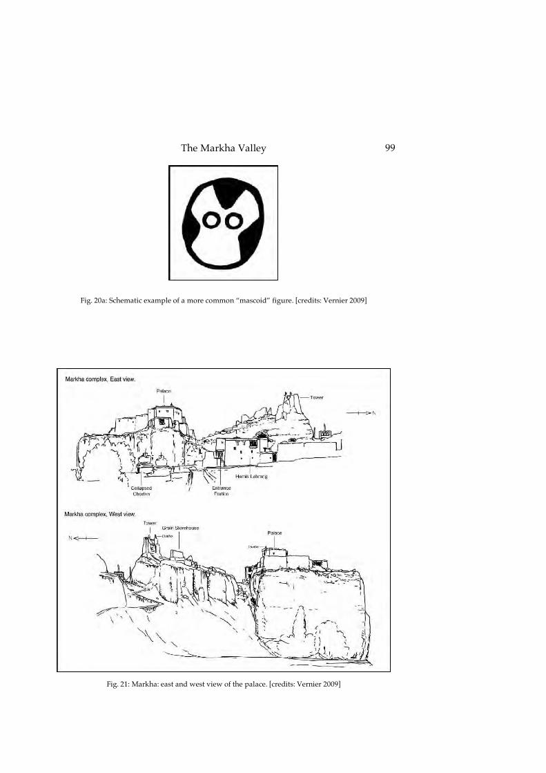
The Markha Valley
99
Fig. 20a: Schematic example of a more common “mascoid” figure. [credits: Vernier 2009]
Fig. 21: Markha: east and west view of the palace. [credits: Vernier 2009]

Revue d’Etudes Tibétaines
100
Fig. 22: Markha: tower of the northern crag (left, mud-mortared stones) and possible grainehouse (right, mudbricks: 40x20x10 cm) viewed from the west. [credits: Devers 2009]
Fig. 23: Markha: “reception hall” of the second floor, with timbers of square section. [credits: Vernier 2004]

The Markha Valley
101
Fig. 24: Markha: chorten with the collapsed wall seen from the palace, looking eastward. [credits: Devers 2009]
Fig. 25: Markha: interior of the chorten viewed from the collapsed wall. The original door is now closed with piled stones (background). The fluted column with the engraved capital is in the middle (see fig.26).
The murals are probably from the 14th century and the column from the 12th century. [credits: Devers 2009]

Revue d’Etudes Tibétaines
102
Fig. 26: Markha: eastern side of the fluted pillar and sculpted capital (juniper, 24 cm in diameter, probably 12th century). [credits: Devers 2009]

The Markha Valley
103
Fig. 26a: Lhachuse: one of the capitals inside the temple (12th century). [credits: Luczanits 2000, picture ID: Lhachuse CL00 51_36]
Fig. 27: Markha: eastern and western side of the capital. [credits: Vernier 2009]

Revue d’Etudes Tibétaines
104
Fig. 28: Markha: the four stelae next to the chorten. [credits: Vernier 2004 (pictures) & 2009 (drawings)]
Fig. 29: Teacha: sketch map of the site. Not to scale. [credits: Vernier 2009]

The Markha Valley
105
Fig. 30: Teacha: view of the monastery from the valley upstream looking north-westward. [credits: Devers 2009]
Fig. 31: Teacha: view of the monastery from the allure on the western crag (so monastery viewed from the other side as compared to Fig.30). The path visible is the former one, descending in the side valley.
[credits: Devers 2009]

Revue d’Etudes Tibétaines
106
Fig. 32: Teacha: sculpted consol (juniper?, 70x27x17 cm, probably 12th century). [credits: Vernier 2009]
Fig. 32a: Lhachuse: sculpted console (12th century). [credits: Luczanits 2000, picture ID: Lhachuse CL00 51_33]
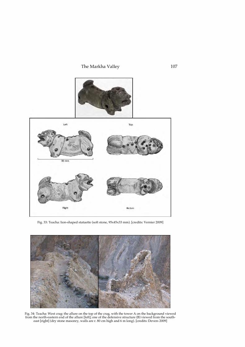
The Markha Valley
107
Fig. 33: Teacha: lion-shaped statuette (soft stone, 95x45x33 mm). [credits: Vernier 2009]
Fig. 34: Teacha: West crag: the allure on the top of the crag, with the tower A on the background viewed from the north-eastern end of the allure [left]; one of the defensive structure (B) viewed from the south-
east [right] (dry stone masonry, walls are r. 80 cm high and 6 m long). [credits: Devers 2009]

Revue d’Etudes Tibétaines
108
Fig. 35: Hankar: view of the fortified village from the north-west. [credits: Devers 2009]
Fig. 36: Hankar: panoramic view of the village from the tower looking south-westward. [credits: Devers 2009]
Fig. 37: Hankar: sketch map of the ruins. Scale approximate. [credits: Vernier 2009]
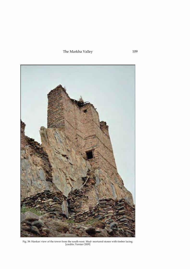
The Markha Valley
109
Fig. 38: Hankar: view of the tower from the south-west. Mud- mortared stones with timber lacing. [credits: Vernier 2009]

Revue d’Etudes Tibétaines
110
Fig. 39: Hankar: sculpted doorframe of the tower. The lintel part is r. 80 cm long. [credits: Vernier 2009]

The Markha Valley
111
Fig. 40: Multi-colored cobble masonry: stones are mainly cobbles and are of several colors, the most noticeable and characteristic being green. The stones come from fluvio- glacial sediments, visible at
various locations in the valley. Tower of Thangring, the wall is about 1 m high. [credits: Devers 2009]
Fig. 41: Multi-colored cobble masonry with timber lacing. Timber lacing is a sign of more modern construction. Tower of Markha, the wall is about 2.5 m long. [credits: Devers 2009]
Fig. 42: Mixed-stones masonry. Wall of building A, castle of Tinley Katpa. [credits: Devers 2009]

Revue d’Etudes Tibétaines
112
Fig. 43: Masonry with a mix of schist and small stones. The latter are 2 to 3 cm in diameter and are between the slabs of schist. Such stone works have little to no mor- tar. The yellow folder is 24 x 31 cm.
Wall of the circular room downhill of tower C, Pentse. [credits: Devers 2009]
Fig. 44: Masonry with a predominance of schist. This wall is one of those made with red mortar at Hankar. [credits: Devers 2009]
Fig. 45: Mixed-stones masonry with timber lacing. Tower of Hankar. The wall on the foreground is about 1.5 m long. [credits: Devers 2009]

The Markha Valley
113
Fig. 46: Masonry of greyish cobbles at the castle of Phey. The blue folder is 24x31 cm. [credits: Devers 2009]