Embed Size (px)
Citation preview
New South Wales
Albury Local Environmental Plan 2010under the
Environmental Planning and Assessment Act 1979
Published LW 13 August 2010 Page 1
2010 No 433
I, the Minister for Planning, pursuant to section 33A of the Environmental Planningand Assessment Act 1979, adopt the mandatory provisions of the StandardInstrument (Local Environmental Plans) Order 2006 and prescribe matters requiredor permitted by that Order so as to make a local environmental plan as follows:(10/05995)
TONY KELLY, MLCMinister for Planning
Contents
Albury Local Environmental Plan 2010
2010 No 433
Page
Part 1 Preliminary1.1 Name of Plan 5
1.1AA Commencement 51.2 Aims of Plan 51.3 Land to which Plan applies 51.4 Definitions 51.5 Notes 61.6 Consent authority 61.7 Maps 61.8 Repeal of other local planning instruments applying
to land 61.8A Savings provision relating to development applications 7
1.9 Application of SEPPs 71.9A Suspension of covenants, agreements and instruments 7
Part 2 Permitted or prohibited development2.1 Land use zones 92.2 Zoning of land to which Plan applies 102.3 Zone objectives and Land Use Table 102.4 Unzoned land 102.5 Additional permitted uses for particular land 112.6 Subdivision—consent requirements 11
2.6AA Demolition requires consent 122.6BB Temporary use of land 12
Land Use Table
Part 3 Exempt and complying development3.1 Exempt development 343.2 Complying development 353.3 Environmentally sensitive areas excluded 36
Part 4 Principal development standards4.1 Minimum subdivision lot size 38
4.1A Exceptions to minimum lot sizes for certain residential development 38
4.2 Rural subdivision 38
Page 2
Page
Albury Local Environmental Plan 2010
Contents
2010 No 433
4.2A No strata or community title subdivisions in certain rural, environmental and residential zones 39
4.2B Erection of dwelling houses on land in certain residential, rural and environmental protection zones 40
4.3 Height of buildings 414.4 Floor space ratio 414.5 Calculation of floor space ratio and site area 424.6 Exceptions to development standards 44
Part 5 Miscellaneous provisions5.1 Relevant acquisition authority 465.2 Classification and reclassification of public land 475.3 Development near zone boundaries 475.4 Controls relating to miscellaneous permissible uses 485.5 Development within the coastal zone 495.6 Architectural roof features 505.7 Development below mean high water mark 505.8 Conversion of fire alarms 505.9 Preservation of trees or vegetation 51
5.10 Heritage conservation 525.11 Bush fire hazard reduction 555.12 Infrastructure development and use of existing
buildings of the Crown 55
Part 6 Urban release areas6.1 Arrangements for designated State public
infrastructure 566.2 Public utility infrastructure 566.3 Development control plan 576.4 Relationship between Part and remainder of Plan 58
Part 7 Additional local provisions7.1 Earthworks 597.2 Water 597.3 Protected regrowth 607.4 Flood planning 607.5 Development on or near the Murray River 617.6 Essential services 637.7 Landfill Buffer Area 637.8 Airspace operations 647.9 Development in areas subject to airport noise 65
7.10 Location of sex services premises 66
Page 3
Page
Albury Local Environmental Plan 2010
Contents
2010 No 433
Schedule 1 Additional permitted uses 67Schedule 2 Exempt development 70Schedule 3 Complying development 77Schedule 4 Classification and reclassification of
public land 78Schedule 5 Environmental heritage 79
Dictionary 100
Page 4
Albury Local Environmental Plan 2010 Clause 1.1
Part 1Preliminary
Albury Local Environmental Plan 2010under the
Environmental Planning and Assessment Act 1979
2010 No 433
Part 1 Preliminary1.1 Name of Plan
This Plan is Albury Local Environmental Plan 2010.
1.1AA CommencementThis Plan commences on the day on which it is published on the NSWlegislation website.
1.2 Aims of Plan(1) This Plan aims to make local environmental planning provisions for
land in Albury in accordance with the relevant standard environmentalplanning instrument under section 33A of the Act.
(2) The particular aims of this Plan are as follows:(a) to give effect to the desired outcomes, principles and actions
contained in the Council’s adopted strategies and policydocuments, and
(b) to promote sustainable urban development by providing forefficient management of urban growth and resource utilisation,and
(c) to promote a city for the people, with a high level of social andphysical amenity and a diversity of activities and uses, and
(d) to maintain or improve biodiversity across Albury, and to avoidsignificant impacts on matters of environmental significance.
1.3 Land to which Plan appliesThis Plan applies to the land identified on the Land Application Map.
1.4 DefinitionsThe Dictionary at the end of this Plan defines words and expressions forthe purposes of this Plan.
Page 5
Albury Local Environmental Plan 2010Clause 1.5
Part 1 Preliminary
2010 No 433
1.5 NotesNotes in this Plan are provided for guidance and do not form part of thisPlan.
1.6 Consent authorityThe consent authority for the purposes of this Plan is (subject to the Act)the Council.
1.7 Maps(1) A reference in this Plan to a named map adopted by this Plan is a
reference to a map by that name:(a) approved by the Minister when the map is adopted, and(b) as amended or replaced from time to time by maps declared by
environmental planning instruments to amend or replace thatmap, and approved by the Minister when the instruments aremade.
(2) Any 2 or more named maps may be combined into a single map. In thatcase, a reference in this Plan to any such named map is a reference tothe relevant part or aspect of the single map.
(3) Any such maps are to be kept and made available for public access inaccordance with arrangements approved by the Minister.
(4) For the purposes of this Plan, a map may be in, and may be kept andmade available in, electronic or paper form, or both.Note. The maps adopted by this Plan are to be made available on the officialNSW legislation website in connection with this Plan. Requirements relating tothe maps are set out in the documents entitled Standard technical requirementsfor LEP maps and Standard requirements for LEP GIS data which are availableon the Department of Planning’s website.
1.8 Repeal of other local planning instruments applying to land(1) All local environmental plans and deemed environmental planning
instruments applying only to the land to which this Plan applies arerepealed.Note. The following local environmental plans are repealed under thisprovision:Albury Local Environmental Plan 2000Hume Local Environmental Plan 2001
(2) All local environmental plans and deemed environmental planninginstruments applying to the land to which this Plan applies and to otherland cease to apply to the land to which this Plan applies.
Page 6
Albury Local Environmental Plan 2010 Clause 1.8A
Part 1Preliminary
2010 No 433
1.8A Savings provision relating to development applicationsIf a development application has been made before the commencementof this Plan in relation to land to which this Plan applies and theapplication has not been finally determined before that commencement,the application must be determined as if this Plan had not commenced.Note. However, under Division 4B of Part 3 of the Act, a developmentapplication may be made for consent to carry out development that may only becarried out if the environmental planning instrument applying to the relevantdevelopment is appropriately amended or if a new instrument, including anappropriate principal environmental planning instrument, is made, and theconsent authority may consider the application. The Division requires publicnotice of the development application and the draft environmental planninginstrument allowing the development at the same time, or as closely together asis practicable.
1.9 Application of SEPPs(1) This Plan is subject to the provisions of any State environmental
planning policy that prevails over this Plan as provided by section 36 ofthe Act.
(2) The following State environmental planning policies (or provisions) donot apply to the land to which this Plan applies:State Environmental Planning Policy No 1—Development StandardsState Environmental Planning Policy No 4—Development WithoutConsent and Miscellaneous Exempt and Complying Development(clause 6 and Parts 3 and 4)State Environmental Planning Policy No 60—Exempt and ComplyingDevelopment
1.9A Suspension of covenants, agreements and instruments(1) For the purpose of enabling development on land in any zone to be
carried out in accordance with this Plan or with a development consentgranted under the Act, any agreement, covenant or other similarinstrument that restricts the carrying out of that development does notapply to the extent necessary to serve that purpose.
(2) This clause does not apply:(a) to a covenant imposed by the Council or that the Council requires
to be imposed, or(b) to any prescribed instrument within the meaning of section 183A
of the Crown Lands Act 1989, or(c) to any conservation agreement within the meaning of the
National Parks and Wildlife Act 1974, or
Page 7
Albury Local Environmental Plan 2010Clause 1.9A
Part 1 Preliminary
2010 No 433
(d) to any Trust agreement within the meaning of the NatureConservation Trust Act 2001, or
(e) to any property vegetation plan within the meaning of the NativeVegetation Act 2003, or
(f) to any biobanking agreement within the meaning of Part 7A ofthe Threatened Species Conservation Act 1995, or
(g) to any planning agreement within the meaning of Division 6 ofPart 4 of the Act.
(3) This clause does not affect the rights or interests of any public authorityunder any registered instrument.
(4) Under section 28 of the Act, the Governor, before the making of thisclause, approved of subclauses (1)–(3).
Page 8
Albury Local Environmental Plan 2010 Clause 2.1
Part 2Permitted or prohibited development
2010 No 433
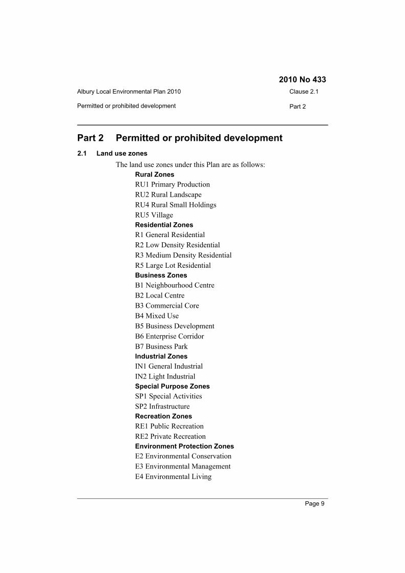
Part 2 Permitted or prohibited development2.1 Land use zones
The land use zones under this Plan are as follows:Rural ZonesRU1 Primary ProductionRU2 Rural LandscapeRU4 Rural Small HoldingsRU5 VillageResidential ZonesR1 General ResidentialR2 Low Density ResidentialR3 Medium Density ResidentialR5 Large Lot ResidentialBusiness ZonesB1 Neighbourhood CentreB2 Local CentreB3 Commercial CoreB4 Mixed UseB5 Business DevelopmentB6 Enterprise CorridorB7 Business ParkIndustrial ZonesIN1 General IndustrialIN2 Light IndustrialSpecial Purpose ZonesSP1 Special ActivitiesSP2 InfrastructureRecreation ZonesRE1 Public RecreationRE2 Private RecreationEnvironment Protection ZonesE2 Environmental ConservationE3 Environmental ManagementE4 Environmental Living
Page 9
Albury Local Environmental Plan 2010Clause 2.2
Part 2 Permitted or prohibited development
2010 No 433
Waterway ZonesW2 Recreational Waterways
2.2 Zoning of land to which Plan appliesFor the purposes of this Plan, land is within the zones shown on theLand Zoning Map.
2.3 Zone objectives and Land Use Table(1) The Land Use Table at the end of this Part specifies for each zone:
(a) the objectives for development, and(b) development that may be carried out without consent, and(c) development that may be carried out only with consent, and(d) development that is prohibited.
(2) The consent authority must have regard to the objectives fordevelopment in a zone when determining a development application inrespect of land within the zone.
(3) In the Land Use Table at the end of this Part:(a) a reference to a type of building or other thing is a reference to
development for the purposes of that type of building or otherthing, and
(b) a reference to a type of building or other thing does not include(despite any definition in this Plan) a reference to a type ofbuilding or other thing referred to separately in the Land UseTable in relation to the same zone.
(4) This clause is subject to the other provisions of this Plan.Notes.
1 Schedule 1 sets out additional permitted uses for particular land.2 Schedule 2 sets out exempt development (which is generally exempt
from both Parts 4 and 5 of the Act). Development in the land use tablethat may be carried out without consent is nevertheless subject to theenvironmental assessment and approval requirements of Part 5 of theAct or, if applicable, Part 3A of the Act.
3 Schedule 3 sets out complying development (for which a complyingdevelopment certificate may be issued as an alternative to obtainingdevelopment consent).
4 Clause 2.6 requires consent for subdivision of land.5 Part 5 contains other provisions which require consent for particular
development.
2.4 Unzoned land(1) Development may be carried out on unzoned land only with consent.
Page 10
Albury Local Environmental Plan 2010 Clause 2.5
Part 2Permitted or prohibited development
2010 No 433
(2) Before granting consent, the consent authority:(a) must consider whether the development will impact on adjoining
zoned land and, if so, consider the objectives for development inthe zones of the adjoining land, and
(b) must be satisfied that the development is appropriate and iscompatible with permissible land uses in any such adjoining land.
2.5 Additional permitted uses for particular land(1) Development on particular land that is described or referred to in
Schedule 1 may be carried out:(a) with consent, or(b) if the Schedule so provides—without consent,in accordance with the conditions (if any) specified in that Schedule inrelation to that development.
(2) This clause has effect despite anything to the contrary in the Land UseTable or other provision of this Plan.
2.6 Subdivision—consent requirements(1) Land to which this Plan applies may be subdivided, but only with
consent.(2) However, consent is not required for a subdivision for the purpose only
of any one or more of the following:(a) widening a public road,(b) a minor realignment of boundaries that does not create:
(i) additional lots or the opportunity for additional dwellings,or
(ii) lots that are smaller than the minimum size shown on theLot Size Map in relation to the land concerned,
(c) a consolidation of lots that does not create additional lots or theopportunity for additional dwellings,
(d) rectifying an encroachment on a lot,(e) creating a public reserve,(f) excising from a lot land that is, or is intended to be, used for
public purposes, including drainage purposes, rural fire brigadeor other emergency service purposes or public toilets.
Note. If a subdivision is exempt development, the Act enables the subdivisionto be carried out without consent.
Page 11
Albury Local Environmental Plan 2010Clause 2.6AA
Part 2 Land Use Table
2010 No 433
2.6AA Demolition requires consentThe demolition of a building or work may be carried out only withconsent.Note. If the demolition of a building or work is identified in an applicableenvironmental planning instrument, such as this Plan or State EnvironmentalPlanning Policy (Exempt and Complying Development Codes) 2008, as exemptdevelopment, the Act enables it to be carried out without consent.
2.6BB Temporary use of land(1) The objective of this clause is to provide for the temporary use of land
if the use does not compromise future development of the land, or havedetrimental economic, social, amenity or environmental effects on theland.
(2) Despite any other provision of this Plan, development consent may begranted for development on land in any zone for a temporary use for amaximum period of 52 days (whether or not consecutive days) in anyperiod of 12 months.
(3) Development consent must not be granted unless the consent authorityis satisfied that:(a) the temporary use will not prejudice the subsequent carrying out
of development on the land in accordance with this Plan and anyother applicable environmental planning instrument, and
(b) the temporary use will not adversely impact on any adjoiningland or the amenity of the neighbourhood, and
(c) the temporary use and location of any structures related to the usewill not adversely impact on environmental attributes or featuresof the land, or increase the risk of natural hazards that may affectthe land, and
(d) at the end of the temporary use period the land will, as far as ispracticable, be restored to the condition in which it was before thecommencement of the use.
(4) Despite subclause (2), the temporary use of a dwelling as a sales officefor a new release area or a new housing estate may exceed the maximumnumber of days specified in that subclause.
(5) Subclause (3) (d) does not apply to the temporary use of a dwelling as asales office mentioned in subclause (4).
Land Use TableNote. A type of development referred to in the Land Use Table is a reference to that type ofdevelopment only to the extent it is not regulated by an applicable State environmental
Page 12
Albury Local Environmental Plan 2010 Clause 2.6BB
Part 2Land Use Table
2010 No 433
planning policy. The following State environmental planning policies in particular may berelevant to development on land to which this Plan applies:State Environmental Planning Policy (Affordable Rental Housing) 2009 (including provision forsecondary dwellings)State Environmental Planning Policy (Housing for Seniors or People with a Disability) 2004State Environmental Planning Policy (Infrastructure) 2007 (relating to public facilities such asthose for air transport, correction, education, electricity generation, health services, ports,railways, roads, waste management and water supply systems)State Environmental Planning Policy (Mining, Petroleum Production and Extractive Industries)2007State Environmental Planning Policy (Rural Lands) 2008State Environmental Planning Policy No 33—Hazardous and Offensive DevelopmentState Environmental Planning Policy No 50—Canal Estate DevelopmentState Environmental Planning Policy No 62—Sustainable AquacultureState Environmental Planning Policy No 64—Advertising and Signage
Zone RU1 Primary Production
1 Objectives of zone• To encourage sustainable primary industry production by
maintaining and enhancing the natural resource base.• To encourage diversity in primary industry enterprises and
systems appropriate for the area.• To minimise the fragmentation and alienation of resource lands.• To minimise conflict between land uses within the zone and land
uses within adjoining zones.
2 Permitted without consentEnvironmental protection works; Extensive agriculture; Home-basedchild care; Home occupations; Intensive plant agriculture
3 Permitted with consentAgricultural produce industries; Bed and breakfast accommodation;Dual occupancies; Dwelling houses; Extractive industries; Farmbuildings; Farm stay accommodation; Group homes; Mining; Roads;Roadside stalls; Rural workers’ dwellings; Secondary dwellings; Anyother development not specified in item 2 or 4
4 ProhibitedAir transport facilities; Amusement centres; Bulky goods premises;Business premises; Car parks; Caravan parks; Cemeteries; Child carecentres; Correctional centres; Crematoria; Depots; Educationalestablishments; Entertainment facilities; Exhibition homes; Exhibition
Page 13

Albury Local Environmental Plan 2010Clause 2.6BB
Part 2 Land Use Table
2010 No 433
villages; Freight transport facilities; Function centres; Health servicesfacilities; Home occupations (sex services); Industrial retail outlets;Industries; Information and education facilities; Livestock processingindustries; Marinas; Mortuaries; Office premises; Passenger transportfacilities; Places of public worship; Port facilities; Recreation facilities(indoor); Registered clubs; Residential accommodation; Restrictedpremises; Retail premises; Service stations; Sex services premises;Storage premises; Timber and building supplies; Tourist and visitoraccommodation; Truck depots; Vehicle body repair workshops;Vehicle repair stations; Vehicle sales or hire premises; Warehouse ordistribution centres; Wholesale supplies
Zone RU2 Rural Landscape
1 Objectives of zone• To encourage sustainable primary industry production by
maintaining and enhancing the natural resource base.• To maintain the rural landscape character of the land.• To provide for a range of compatible land uses, including
extensive agriculture.
2 Permitted without consentEnvironmental protection works; Extensive agriculture; Home-basedchild care; Home occupations
3 Permitted with consentAgricultural produce industries; Animal boarding or trainingestablishments; Aquaculture; Bed and breakfast accommodation; Dualoccupancies; Dwelling houses; Farm buildings; Farm stayaccommodation; Group homes; Hotel or motel accommodation;Intensive plant agriculture; Roads; Rural workers’ dwellings;Secondary dwellings; Any other development not specified in item 2or 4
4 ProhibitedAgriculture; Air transport facilities; Amusement centres; Boat repairfacilities; Bulky goods premises; Business premises; Car parks;Caravan parks; Cemeteries; Child care centres; Crematoria; Depots;Entertainment facilities; Exhibition homes; Exhibition villages;Forestry; Freight transport facilities; Function centres; Health servicesfacilities; Home occupations (sex services); Industrial retail outlets;Industries; Landscape and garden supplies; Marinas; Mortuaries; Officepremises; Passenger transport facilities; Places of public worship; Portfacilities; Public administration buildings; Recreation facilities
Page 14
Albury Local Environmental Plan 2010 Clause 2.6BB
Part 2Land Use Table
2010 No 433
(indoor); Recreation facilities (major); Registered clubs; Residentialaccommodation; Restricted premises; Restriction facilities; Retailpremises; Rural industries; Service stations; Sex services premises;Storage premises; Timber and building supplies; Tourist and visitoraccommodation; Transport depots; Truck depots; Vehicle body repairworkshops; Vehicle repair stations; Vehicle sales or hire premises;Warehouse or distribution centres; Wholesale supplies
Zone RU4 Rural Small Holdings
1 Objectives of zone• To enable sustainable primary industry and other compatible land
uses.• To maintain the rural and scenic character of the land.• To ensure that development does not unreasonably increase the
demand for public services or public facilities.• To minimise conflict between land uses within the zone and land
uses within adjoining zones.
2 Permitted without consentHome-based child care; Home occupations
3 Permitted with consentBed and breakfast accommodation; Dual occupancies; Dwellinghouses; Extensive agriculture; Farm buildings; Farm stayaccommodation; Group homes; Horticulture; Roads; Roadside stalls;Rural workers’ dwellings; Secondary dwellings; Any otherdevelopment not specified in item 2 or 4
4 ProhibitedAir transport facilities; Amusement centres; Boat repair facilities;Bulky goods premises; Business premises; Car parks; Caravan parks;Cemeteries; Child care centres; Correctional centres; Crematoria;Depots; Entertainment facilities; Exhibition homes; Exhibition villages;Extractive industries; Forestry; Freight transport facilities; Functioncentres; Home occupations (sex services); Industrial retail outlets;Industries; Intensive livestock agriculture; Marinas; Mortuaries; Officepremises; Passenger transport facilities; Places of public worship; Portfacilities; Recreation facilities (indoor); Recreation facilities (major);Recreation facilities (outdoor); Registered clubs; Residentialaccommodation; Restricted premises; Restriction facilities; Retailpremises; Rural industries; Service stations; Sex services premises;Storage premises; Tourist and visitor accommodation; Transport
Page 15
Albury Local Environmental Plan 2010Clause 2.6BB
Part 2 Land Use Table
2010 No 433
depots; Truck depots; Vehicle body repair workshops; Vehicle repairstations; Vehicle sales or hire premises; Warehouse or distributioncentres; Waste or resource management facilities; Wholesale supplies
Zone RU5 Village
1 Objectives of zone• To provide for a range of land uses, services and facilities that are
associated with a rural village.• To ensure that land use and development maintains and
contributes to the character of both the Table Top and Lake Humevillages.
• To protect the amenity of all residents within this zone.
2 Permitted without consentEnvironmental protection works; Home-based child care; Homeoccupations
3 Permitted with consentChild care centres; Community facilities; Dwelling houses; Extensiveagriculture; Neighbourhood shops; Places of public worship;Recreation areas; Recreation facilities (indoor); Recreation facilities(outdoor); Roads; Schools; Self-storage units; Tank-based aquaculture;Any other development not specified in item 2 or 4
4 ProhibitedAgriculture; Air transport facilities; Airstrips; Biosolids treatmentfacilities; Correctional centres; Depots; Electricity generating works;Exhibition homes; Exhibition villages; Extractive industries; Forestry;Home occupations (sex services); Industrial retail outlets; Industries;Residential flat buildings; Restricted premises; Restriction facilities;Rural industries; Sex services premises; Storage premises; Vehiclebody repair workshops; Warehouse or distribution centres; Waste orresource management facilities
Zone R1 General Residential
1 Objectives of zone• To provide for the housing needs of the community.• To provide for a variety of housing types and densities.• To enable other land uses that provide facilities or services to
meet the day to day needs of residents.
Page 16
Albury Local Environmental Plan 2010 Clause 2.6BB
Part 2Land Use Table
2010 No 433
• To encourage affordable housing.• To encourage medium density housing that is designed to achieve
a high standard of amenity.
2 Permitted without consentEnvironmental protection works; Home-based child care; Homeoccupations
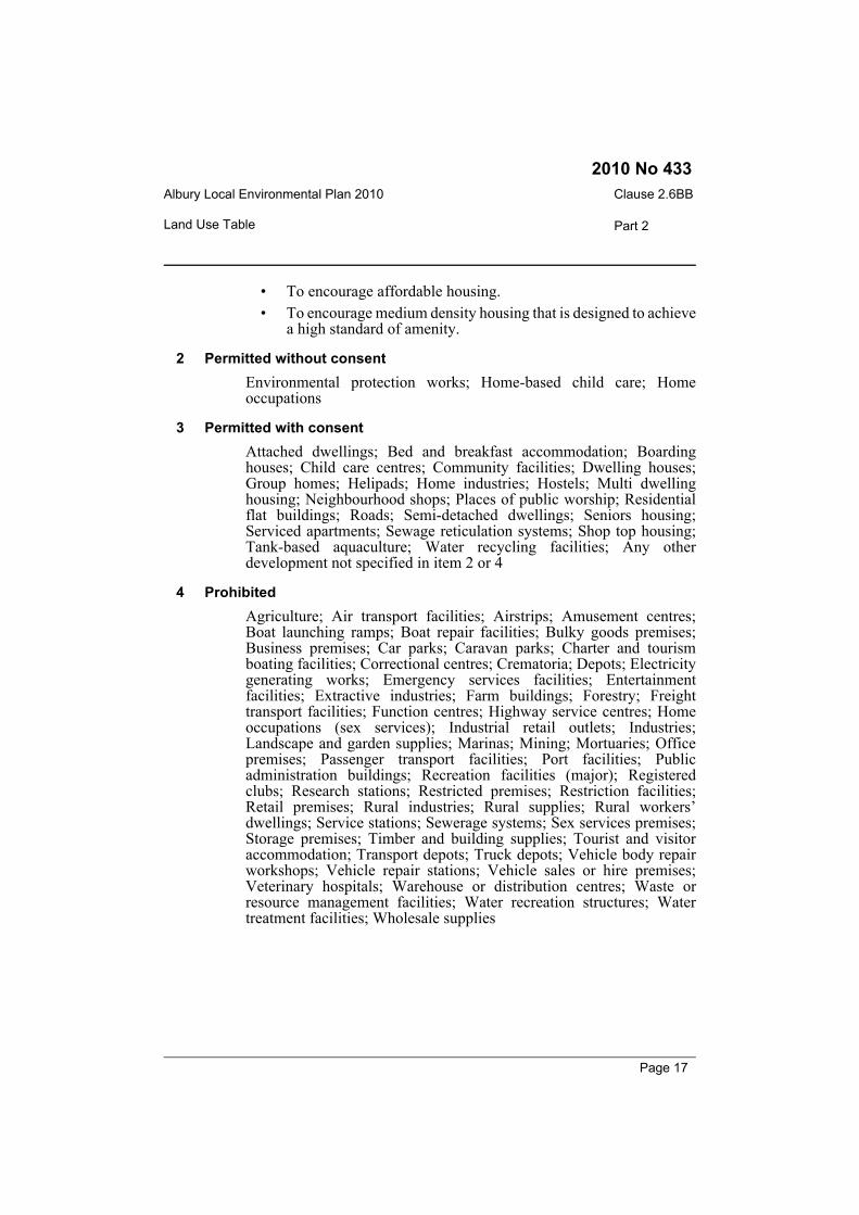
3 Permitted with consentAttached dwellings; Bed and breakfast accommodation; Boardinghouses; Child care centres; Community facilities; Dwelling houses;Group homes; Helipads; Home industries; Hostels; Multi dwellinghousing; Neighbourhood shops; Places of public worship; Residentialflat buildings; Roads; Semi-detached dwellings; Seniors housing;Serviced apartments; Sewage reticulation systems; Shop top housing;Tank-based aquaculture; Water recycling facilities; Any otherdevelopment not specified in item 2 or 4
4 ProhibitedAgriculture; Air transport facilities; Airstrips; Amusement centres;Boat launching ramps; Boat repair facilities; Bulky goods premises;Business premises; Car parks; Caravan parks; Charter and tourismboating facilities; Correctional centres; Crematoria; Depots; Electricitygenerating works; Emergency services facilities; Entertainmentfacilities; Extractive industries; Farm buildings; Forestry; Freighttransport facilities; Function centres; Highway service centres; Homeoccupations (sex services); Industrial retail outlets; Industries;Landscape and garden supplies; Marinas; Mining; Mortuaries; Officepremises; Passenger transport facilities; Port facilities; Publicadministration buildings; Recreation facilities (major); Registeredclubs; Research stations; Restricted premises; Restriction facilities;Retail premises; Rural industries; Rural supplies; Rural workers’dwellings; Service stations; Sewerage systems; Sex services premises;Storage premises; Timber and building supplies; Tourist and visitoraccommodation; Transport depots; Truck depots; Vehicle body repairworkshops; Vehicle repair stations; Vehicle sales or hire premises;Veterinary hospitals; Warehouse or distribution centres; Waste orresource management facilities; Water recreation structures; Watertreatment facilities; Wholesale supplies
Page 17
Albury Local Environmental Plan 2010Clause 2.6BB
Part 2 Land Use Table
2010 No 433
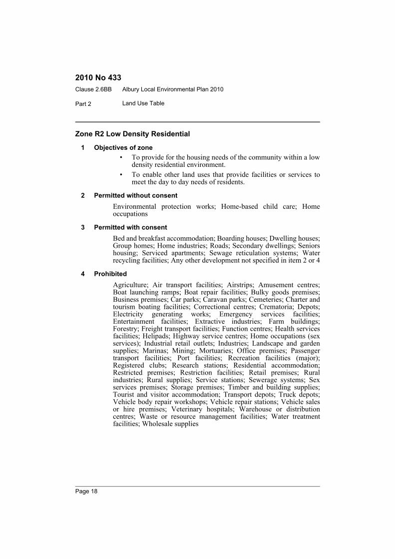
Zone R2 Low Density Residential
1 Objectives of zone• To provide for the housing needs of the community within a low
density residential environment.• To enable other land uses that provide facilities or services to
meet the day to day needs of residents.
2 Permitted without consentEnvironmental protection works; Home-based child care; Homeoccupations
3 Permitted with consentBed and breakfast accommodation; Boarding houses; Dwelling houses;Group homes; Home industries; Roads; Secondary dwellings; Seniorshousing; Serviced apartments; Sewage reticulation systems; Waterrecycling facilities; Any other development not specified in item 2 or 4
4 ProhibitedAgriculture; Air transport facilities; Airstrips; Amusement centres;Boat launching ramps; Boat repair facilities; Bulky goods premises;Business premises; Car parks; Caravan parks; Cemeteries; Charter andtourism boating facilities; Correctional centres; Crematoria; Depots;Electricity generating works; Emergency services facilities;Entertainment facilities; Extractive industries; Farm buildings;Forestry; Freight transport facilities; Function centres; Health servicesfacilities; Helipads; Highway service centres; Home occupations (sexservices); Industrial retail outlets; Industries; Landscape and gardensupplies; Marinas; Mining; Mortuaries; Office premises; Passengertransport facilities; Port facilities; Recreation facilities (major);Registered clubs; Research stations; Residential accommodation;Restricted premises; Restriction facilities; Retail premises; Ruralindustries; Rural supplies; Service stations; Sewerage systems; Sexservices premises; Storage premises; Timber and building supplies;Tourist and visitor accommodation; Transport depots; Truck depots;Vehicle body repair workshops; Vehicle repair stations; Vehicle salesor hire premises; Veterinary hospitals; Warehouse or distributioncentres; Waste or resource management facilities; Water treatmentfacilities; Wholesale supplies
Page 18

Albury Local Environmental Plan 2010 Clause 2.6BB
Part 2Land Use Table
2010 No 433
Zone R3 Medium Density Residential
1 Objectives of zone• To provide for the housing needs of the community within a
medium density residential environment.• To provide a variety of housing types within a medium density
residential environment.• To enable other land uses that provide facilities or services to
meet the day to day needs of residents.• To encourage increased residential density in locations with
ready access to the Albury and Lavington commercial corezones.
• To encourage the provision of affordable housing.
2 Permitted without consentEnvironmental protection works; Home-based child care; Homeoccupations
3 Permitted with consentAttached dwellings; Bed and breakfast accommodation; Boardinghouses; Child care centres; Community facilities; Group homes; Multidwelling housing; Neighbourhood shops; Places of public worship;Roads; Seniors housing; Serviced apartments; Sewage reticulationsystems; Water recycling facilities; Any other development notspecified in item 2 or 4
4 ProhibitedAgriculture; Air transport facilities; Airstrips; Amusement centres;Boat launching ramps; Boat repair facilities; Bulky goods premises;Business premises; Car parks; Caravan parks; Cemeteries; Charter andtourism boating facilities; Correctional centres; Crematoria; Depots;Electricity generating works; Emergency services facilities;Entertainment facilities; Extractive industries; Farm buildings;Forestry; Freight transport facilities; Function centres; Helipads;Highway service centres; Home occupations (sex services); Industrialretail outlets; Industries; Landscape and garden supplies; Marinas;Mining; Mortuaries; Office premises; Passenger transport facilities;Port facilities; Recreation facilities (major); Registered clubs; Researchstations; Restricted premises; Restriction facilities; Retail premises;Rural industries; Rural supplies; Rural workers’ dwellings; Servicestations; Sewerage systems; Sex services premises; Storage premises;Timber and building supplies; Tourist and visitor accommodation;Transport depots; Truck depots; Vehicle body repair workshops;
Page 19
Albury Local Environmental Plan 2010Clause 2.6BB
Part 2 Land Use Table
2010 No 433
Vehicle repair stations; Vehicle sales or hire premises; Veterinaryhospitals; Warehouse or distribution centres; Waste or resourcemanagement facilities; Water recreation structures; Water reticulationsystems; Wholesale supplies
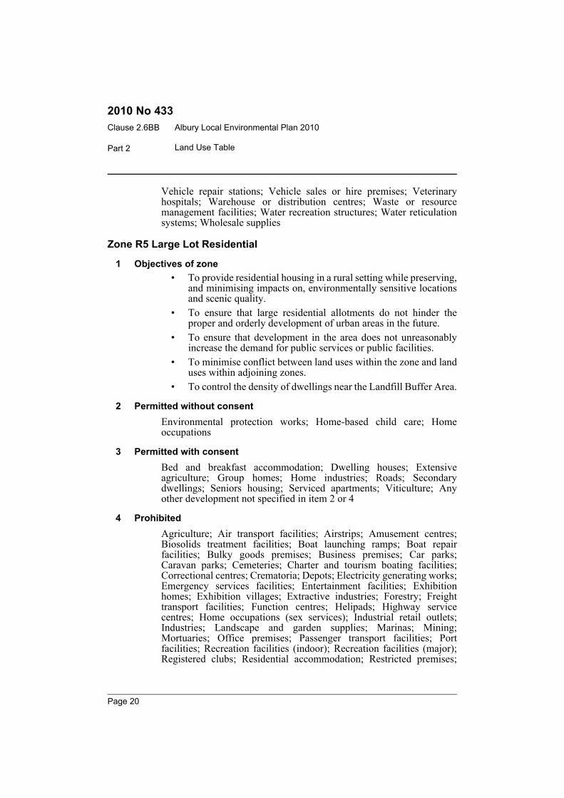
Zone R5 Large Lot Residential
1 Objectives of zone• To provide residential housing in a rural setting while preserving,
and minimising impacts on, environmentally sensitive locationsand scenic quality.
• To ensure that large residential allotments do not hinder theproper and orderly development of urban areas in the future.
• To ensure that development in the area does not unreasonablyincrease the demand for public services or public facilities.
• To minimise conflict between land uses within the zone and landuses within adjoining zones.
• To control the density of dwellings near the Landfill Buffer Area.
2 Permitted without consentEnvironmental protection works; Home-based child care; Homeoccupations
3 Permitted with consentBed and breakfast accommodation; Dwelling houses; Extensiveagriculture; Group homes; Home industries; Roads; Secondarydwellings; Seniors housing; Serviced apartments; Viticulture; Anyother development not specified in item 2 or 4
4 ProhibitedAgriculture; Air transport facilities; Airstrips; Amusement centres;Biosolids treatment facilities; Boat launching ramps; Boat repairfacilities; Bulky goods premises; Business premises; Car parks;Caravan parks; Cemeteries; Charter and tourism boating facilities;Correctional centres; Crematoria; Depots; Electricity generating works;Emergency services facilities; Entertainment facilities; Exhibitionhomes; Exhibition villages; Extractive industries; Forestry; Freighttransport facilities; Function centres; Helipads; Highway servicecentres; Home occupations (sex services); Industrial retail outlets;Industries; Landscape and garden supplies; Marinas; Mining;Mortuaries; Office premises; Passenger transport facilities; Portfacilities; Recreation facilities (indoor); Recreation facilities (major);Registered clubs; Residential accommodation; Restricted premises;
Page 20

Albury Local Environmental Plan 2010 Clause 2.6BB
Part 2Land Use Table
2010 No 433
Restriction facilities; Retail premises; Rural industries; Rural supplies;Service stations; Sex services premises; Storage premises; Timber andbuilding supplies; Tourist and visitor accommodation; Transportdepots; Truck depots; Vehicle body repair workshops; Vehicle repairstations; Vehicle sales or hire premises; Veterinary hospitals;Warehouse or distribution centres; Waste or resource managementfacilities; Water treatment facilities; Wholesale supplies
Zone B1 Neighbourhood Centre
1 Objectives of zone• To provide a range of small-scale retail, business and community
uses that serve the needs of people who live or work in thesurrounding neighbourhood.
• To ensure that the densities for commercial development reflectthe needs of the local community and the capacity of the existingroad and transport network.
• To enable other land uses that are compatible with thecommercial and retail function of a neighbourhood centre.
2 Permitted without consentHome-based child care; Home occupations
3 Permitted with consentBoarding houses; Business premises; Child care centres; Communityfacilities; Food and drink premises; Neighbourhood shops; Roads;Sewage reticulation systems; Shop top housing; Shops; Any otherdevelopment not specified in item 2 or 4
4 ProhibitedAgriculture; Air transport facilities; Airstrips; Backpackers’accommodation; Boat repair facilities; Bulky goods premises; Caravanparks; Cellar door premises; Cemeteries; Charter and tourism boatingfacilities; Correctional centres; Crematoria; Depots; Electricitygenerating works; Emergency services facilities; Entertainmentfacilities; Exhibition homes; Exhibition villages; Extractive industries;Farm buildings; Farm stay accommodation; Forestry; Freight transportfacilities; Helipads; Home occupations (sex services); Hospitals;Industrial retail outlets; Industries; Marinas; Mining; Mortuaries;Passenger transport facilities; Port facilities; Recreation facilities(major); Research stations; Restricted premises; Restriction facilities;Retail premises; Rural industries; Rural workers’ dwellings; Seweragesystems; Sex services premises; Storage premises; Truck depots;
Page 21
Albury Local Environmental Plan 2010Clause 2.6BB
Part 2 Land Use Table
2010 No 433
Vehicle body repair workshops; Warehouse or distribution centres;Waste or resource management facilities; Wholesale supplies
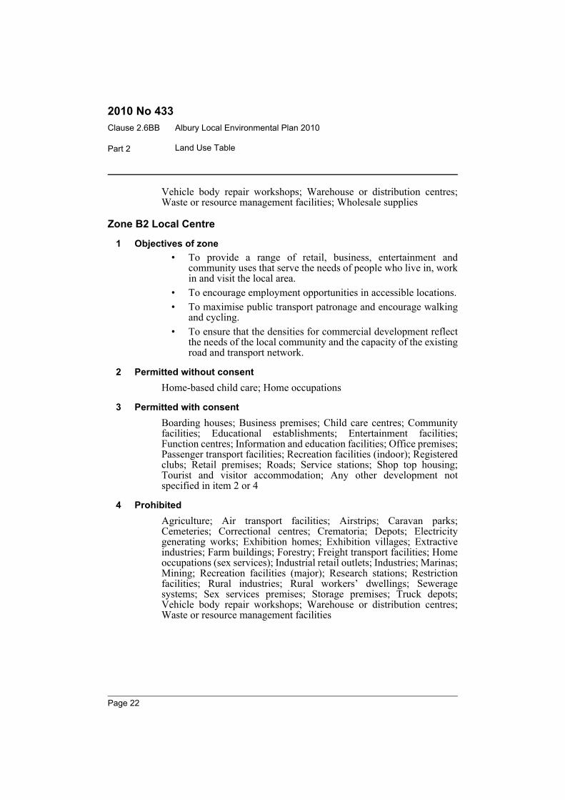
Zone B2 Local Centre
1 Objectives of zone• To provide a range of retail, business, entertainment and
community uses that serve the needs of people who live in, workin and visit the local area.
• To encourage employment opportunities in accessible locations.• To maximise public transport patronage and encourage walking
and cycling.• To ensure that the densities for commercial development reflect
the needs of the local community and the capacity of the existingroad and transport network.
2 Permitted without consentHome-based child care; Home occupations
3 Permitted with consentBoarding houses; Business premises; Child care centres; Communityfacilities; Educational establishments; Entertainment facilities;Function centres; Information and education facilities; Office premises;Passenger transport facilities; Recreation facilities (indoor); Registeredclubs; Retail premises; Roads; Service stations; Shop top housing;Tourist and visitor accommodation; Any other development notspecified in item 2 or 4
4 ProhibitedAgriculture; Air transport facilities; Airstrips; Caravan parks;Cemeteries; Correctional centres; Crematoria; Depots; Electricitygenerating works; Exhibition homes; Exhibition villages; Extractiveindustries; Farm buildings; Forestry; Freight transport facilities; Homeoccupations (sex services); Industrial retail outlets; Industries; Marinas;Mining; Recreation facilities (major); Research stations; Restrictionfacilities; Rural industries; Rural workers’ dwellings; Seweragesystems; Sex services premises; Storage premises; Truck depots;Vehicle body repair workshops; Warehouse or distribution centres;Waste or resource management facilities
Page 22
Albury Local Environmental Plan 2010 Clause 2.6BB
Part 2Land Use Table
2010 No 433
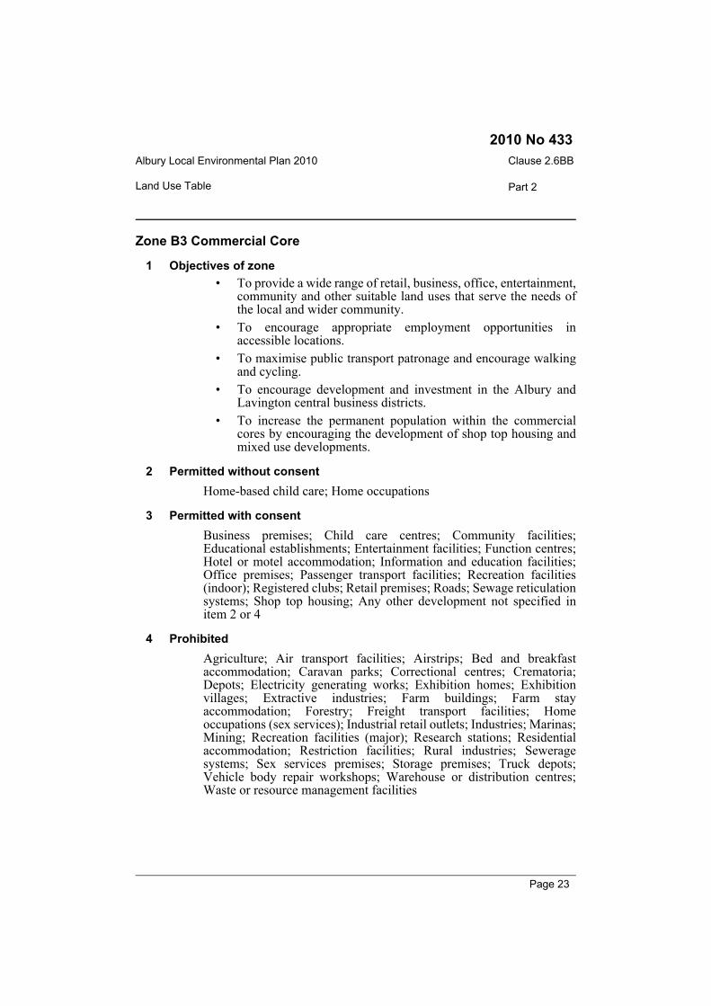
Zone B3 Commercial Core
1 Objectives of zone• To provide a wide range of retail, business, office, entertainment,
community and other suitable land uses that serve the needs ofthe local and wider community.
• To encourage appropriate employment opportunities inaccessible locations.
• To maximise public transport patronage and encourage walkingand cycling.
• To encourage development and investment in the Albury andLavington central business districts.
• To increase the permanent population within the commercialcores by encouraging the development of shop top housing andmixed use developments.
2 Permitted without consentHome-based child care; Home occupations
3 Permitted with consentBusiness premises; Child care centres; Community facilities;Educational establishments; Entertainment facilities; Function centres;Hotel or motel accommodation; Information and education facilities;Office premises; Passenger transport facilities; Recreation facilities(indoor); Registered clubs; Retail premises; Roads; Sewage reticulationsystems; Shop top housing; Any other development not specified initem 2 or 4
4 ProhibitedAgriculture; Air transport facilities; Airstrips; Bed and breakfastaccommodation; Caravan parks; Correctional centres; Crematoria;Depots; Electricity generating works; Exhibition homes; Exhibitionvillages; Extractive industries; Farm buildings; Farm stayaccommodation; Forestry; Freight transport facilities; Homeoccupations (sex services); Industrial retail outlets; Industries; Marinas;Mining; Recreation facilities (major); Research stations; Residentialaccommodation; Restriction facilities; Rural industries; Seweragesystems; Sex services premises; Storage premises; Truck depots;Vehicle body repair workshops; Warehouse or distribution centres;Waste or resource management facilities
Page 23
Albury Local Environmental Plan 2010Clause 2.6BB
Part 2 Land Use Table
2010 No 433
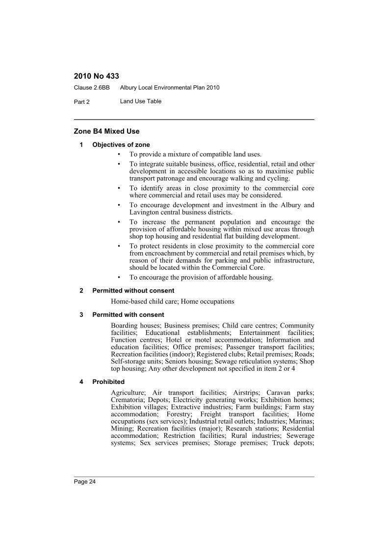
Zone B4 Mixed Use
1 Objectives of zone• To provide a mixture of compatible land uses.• To integrate suitable business, office, residential, retail and other
development in accessible locations so as to maximise publictransport patronage and encourage walking and cycling.
• To identify areas in close proximity to the commercial corewhere commercial and retail uses may be considered.
• To encourage development and investment in the Albury andLavington central business districts.
• To increase the permanent population and encourage theprovision of affordable housing within mixed use areas throughshop top housing and residential flat building development.
• To protect residents in close proximity to the commercial corefrom encroachment by commercial and retail premises which, byreason of their demands for parking and public infrastructure,should be located within the Commercial Core.
• To encourage the provision of affordable housing.
2 Permitted without consentHome-based child care; Home occupations
3 Permitted with consentBoarding houses; Business premises; Child care centres; Communityfacilities; Educational establishments; Entertainment facilities;Function centres; Hotel or motel accommodation; Information andeducation facilities; Office premises; Passenger transport facilities;Recreation facilities (indoor); Registered clubs; Retail premises; Roads;Self-storage units; Seniors housing; Sewage reticulation systems; Shoptop housing; Any other development not specified in item 2 or 4
4 ProhibitedAgriculture; Air transport facilities; Airstrips; Caravan parks;Crematoria; Depots; Electricity generating works; Exhibition homes;Exhibition villages; Extractive industries; Farm buildings; Farm stayaccommodation; Forestry; Freight transport facilities; Homeoccupations (sex services); Industrial retail outlets; Industries; Marinas;Mining; Recreation facilities (major); Research stations; Residentialaccommodation; Restriction facilities; Rural industries; Seweragesystems; Sex services premises; Storage premises; Truck depots;
Page 24
Albury Local Environmental Plan 2010 Clause 2.6BB
Part 2Land Use Table
2010 No 433
Vehicle body repair workshops; Warehouse or distribution centres;Waste or resource management facilities
Zone B5 Business Development
1 Objectives of zone• To enable a mix of business and warehouse uses, and specialised
retail uses that require a large floor area, in locations that areclose to, and that support the viability of, centres.
2 Permitted without consentNil
3 Permitted with consentAquaculture; Child care centres; Light industries; Passenger transportfacilities; Roads; Self-storage units; Sewage reticulation systems; Shoptop housing; Warehouse or distribution centres; Any other developmentnot specified in item 2 or 4
4 ProhibitedAgriculture; Air transport facilities; Airstrips; Caravan parks; Cellardoor premises; Cemeteries; Correctional centres; Crematoria; Depots;Electricity generating works; Exhibition homes; Exhibition villages;Extractive industries; Farm buildings; Forestry; Home occupations (sexservices); Industries; Marinas; Mining; Research stations; Residentialaccommodation; Restricted premises; Restriction facilities; Ruralindustries; Service stations; Sewerage systems; Sex services premises;Storage premises; Tourist and visitor accommodation; Vehicle bodyrepair workshops
Zone B6 Enterprise Corridor
1 Objectives of zone• To promote businesses along main roads and to encourage a mix
of compatible uses.• To provide a range of employment uses (including business,
office, retail and light industrial uses) and residential uses (butonly as part of a mixed use development).
• To maintain the economic strength of centres by limiting retailingactivity.
2 Permitted without consentNil
Page 25
Albury Local Environmental Plan 2010Clause 2.6BB
Part 2 Land Use Table
2010 No 433
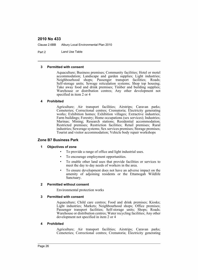
3 Permitted with consentAquaculture; Business premises; Community facilities; Hotel or motelaccommodation; Landscape and garden supplies; Light industries;Neighbourhood shops; Passenger transport facilities; Roads;Self-storage units; Sewage reticulation systems; Shop top housing;Take away food and drink premises; Timber and building supplies;Warehouse or distribution centres; Any other development notspecified in item 2 or 4
4 ProhibitedAgriculture; Air transport facilities; Airstrips; Caravan parks;Cemeteries; Correctional centres; Crematoria; Electricity generatingworks; Exhibition homes; Exhibition villages; Extractive industries;Farm buildings; Forestry; Home occupations (sex services); Industries;Marinas; Mining; Research stations; Residential accommodation;Restricted premises; Restriction facilities; Retail premises; Ruralindustries; Sewerage systems; Sex services premises; Storage premises;Tourist and visitor accommodation; Vehicle body repair workshops
Zone B7 Business Park
1 Objectives of zone• To provide a range of office and light industrial uses.• To encourage employment opportunities.• To enable other land uses that provide facilities or services to
meet the day to day needs of workers in the area.• To ensure development does not have an adverse impact on the
amenity of adjoining residents or the Ettamogah WildlifeSanctuary.
2 Permitted without consentEnvironmental protection works
3 Permitted with consentAquaculture; Child care centres; Food and drink premises; Kiosks;Light industries; Markets; Neighbourhood shops; Office premises;Passenger transport facilities; Self-storage units; Shops; Roads;Warehouse or distribution centres; Water recycling facilities; Any otherdevelopment not specified in item 2 or 4
4 ProhibitedAgriculture; Air transport facilities; Airstrips; Caravan parks;Cemeteries; Correctional centres; Crematoria; Electricity generating
Page 26
Albury Local Environmental Plan 2010 Clause 2.6BB
Part 2Land Use Table
2010 No 433
works; Exhibition homes; Exhibition villages; Extractive industries;Farm buildings; Forestry; Home occupations (sex services); Industries;Marinas; Mining; Research stations; Residential accommodation;Restricted premises; Restriction facilities; Retail premises; Ruralindustries; Sex services premises; Sewerage systems; Storage premises;Tourist and visitor accommodation; Vehicle sales or hire premises;Waste or resource management facilities
Zone IN1 General Industrial
1 Objectives of zone• To provide a wide range of industrial and warehouse land uses.• To encourage employment opportunities.• To minimise any adverse effect of industry on other land uses.• To provide for industrial uses in close proximity to transport
infrastructure.
2 Permitted without consentEnvironmental protection works
3 Permitted with consentAquaculture; Depots; Freight transport facilities; Light industries;Neighbourhood shops; Roads; Sawmill or log processing works; Takeaway food and drink premises; Warehouse or distribution centres; Anyother development not specified in item 2 or 4
4 ProhibitedAgriculture; Airports; Bulky goods premises; Business premises;Caravan parks; Cemeteries; Community facilities; Correctional centres;Educational establishments; Exhibition homes; Exhibition villages;Farm buildings; Forestry; Function centres; Home-based child care;Hospitals; Information and education facilities; Mortuaries; Officepremises; Registered clubs; Research stations; Residentialaccommodation; Restriction facilities; Retail premises; Ruralindustries; Tourist and visitor accommodation
Zone IN2 Light Industrial
1 Objectives of zone• To provide a wide range of light industrial, warehouse and related
land uses.• To encourage employment opportunities and to support the
viability of centres.
Page 27
Albury Local Environmental Plan 2010Clause 2.6BB
Part 2 Land Use Table
2010 No 433
• To minimise any adverse effect of industry on other land uses.• To enable other land uses that provide facilities or services to
meet the day to day needs of workers in the area.
2 Permitted without consentEnvironmental protection works
3 Permitted with consentAquaculture; Depots; Light industries; Neighbourhood shops; Roads;Self-storage units; Take away food and drink premises; Warehouse ordistribution centres; Waste or resource transfer stations; Any otherdevelopment not specified in item 2 or 4
4 ProhibitedAgriculture; Airports; Bulky goods premises; Business premises;Caravan parks; Cemeteries; Community facilities; Correctional centres;Crematoria; Educational establishments; Electricity generating works;Emergency services facilities; Exhibition homes; Exhibition villages;Farm buildings; Forestry; Function centres; Home-based child care;Hospitals; Industries; Information and education facilities; Mortuaries;Office premises; Registered clubs; Residential accommodation;Restricted premises; Restriction facilities; Retail premises; Ruralindustries; Storage premises; Tourist and visitor accommodation;Waste or resource management facilities
Zone SP1 Special Activities
1 Objectives of zone• To provide for special land uses that are not provided for in other
zones.• To provide for sites with special natural characteristics that are
not provided for in other zones.• To facilitate development that is in keeping with the special
characteristics of the site or its existing or intended special use,and that minimises any adverse impacts on surrounding land.
2 Permitted without consentEnvironmental protection works
3 Permitted with consentThe purpose shown on the Land Zoning Map, including anydevelopment that is ordinarily incidental or ancillary to development forthat purpose; Roads
Page 28
Albury Local Environmental Plan 2010 Clause 2.6BB
Part 2Land Use Table
2010 No 433
4 ProhibitedAny development not specified in item 2 or 3
Zone SP2 Infrastructure
1 Objectives of zone• To provide for infrastructure and related uses.• To prevent development that is not compatible with or that may
detract from the provision of infrastructure.
2 Permitted without consentEnvironmental protection works
3 Permitted with consentThe purpose shown on the Land Zoning Map, including anydevelopment that is ordinarily incidental or ancillary to development forthat purpose; Roads
4 ProhibitedAny development not specified in item 2 or 3
Zone RE1 Public Recreation
1 Objectives of zone• To enable land to be used for public open space or recreational
purposes.• To provide a range of recreational settings and activities and
compatible land uses.• To protect and enhance the natural environment for recreational
purposes.• To protect and improve open space areas within the area of the
City of Albury, including the Albury-Wodonga RegionalParklands.
• To offer opportunities for tourism development.• To provide public access to the foreshore of the Murray River.
2 Permitted without consentEnvironmental protection works
Page 29
Albury Local Environmental Plan 2010Clause 2.6BB
Part 2 Land Use Table
2010 No 433
3 Permitted with consentBoat launching ramps; Boat sheds; Charter and tourism boatingfacilities; Child care centres; Community facilities; Environmentalfacilities; Information and education facilities; Jetties; Kiosks; Marinas;Markets; Moorings; Recreation areas; Recreation facilities (indoor);Recreation facilities (major); Recreation facilities (outdoor);Restaurants; Roads; Signage; Water recreation structures
4 ProhibitedAny development not specified in item 2 or 3
Zone RE2 Private Recreation
1 Objectives of zone• To enable land to be used for private open space or recreational
purposes.• To provide a range of recreational settings and activities and
compatible land uses.• To protect and enhance the natural environment for recreational
purposes.• To offer opportunities for tourism development.• To allow for alternative uses of open space areas for community
purposes compatible with surrounding areas.
2 Permitted without consentEnvironmental protection works
3 Permitted with consentAquaculture; Boat launching ramps; Boat sheds; Car parks; Caravanparks; Charter and tourism boating facilities; Child care centres;Community facilities; Environmental facilities; Flood mitigationworks; Function centres; Hotel or motel accommodation; Informationand education facilities; Jetties; Kiosks; Marinas; Markets; Moorings;Recreation areas; Recreation facilities (indoor); Recreation facilities(major); Recreation facilities (outdoor); Registered clubs; Restaurants;Roads; Serviced apartments; Signage; Water recreation structures
4 ProhibitedAny development not specified in item 2 or 3
Page 30
Albury Local Environmental Plan 2010 Clause 2.6BB
Part 2Land Use Table
2010 No 433
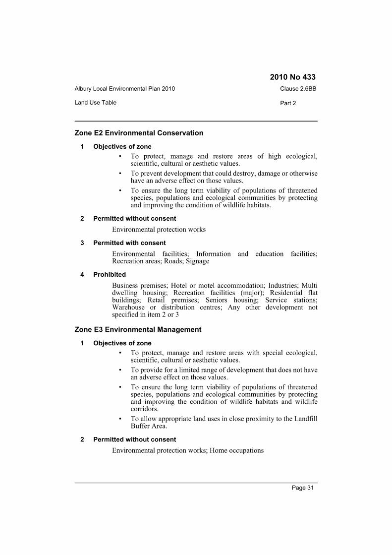
Zone E2 Environmental Conservation
1 Objectives of zone• To protect, manage and restore areas of high ecological,
scientific, cultural or aesthetic values.• To prevent development that could destroy, damage or otherwise
have an adverse effect on those values.• To ensure the long term viability of populations of threatened
species, populations and ecological communities by protectingand improving the condition of wildlife habitats.
2 Permitted without consentEnvironmental protection works
3 Permitted with consentEnvironmental facilities; Information and education facilities;Recreation areas; Roads; Signage
4 ProhibitedBusiness premises; Hotel or motel accommodation; Industries; Multidwelling housing; Recreation facilities (major); Residential flatbuildings; Retail premises; Seniors housing; Service stations;Warehouse or distribution centres; Any other development notspecified in item 2 or 3
Zone E3 Environmental Management
1 Objectives of zone• To protect, manage and restore areas with special ecological,
scientific, cultural or aesthetic values.• To provide for a limited range of development that does not have
an adverse effect on those values.• To ensure the long term viability of populations of threatened
species, populations and ecological communities by protectingand improving the condition of wildlife habitats and wildlifecorridors.
• To allow appropriate land uses in close proximity to the LandfillBuffer Area.
2 Permitted without consentEnvironmental protection works; Home occupations
Page 31
Albury Local Environmental Plan 2010Clause 2.6BB
Part 2 Land Use Table
2010 No 433
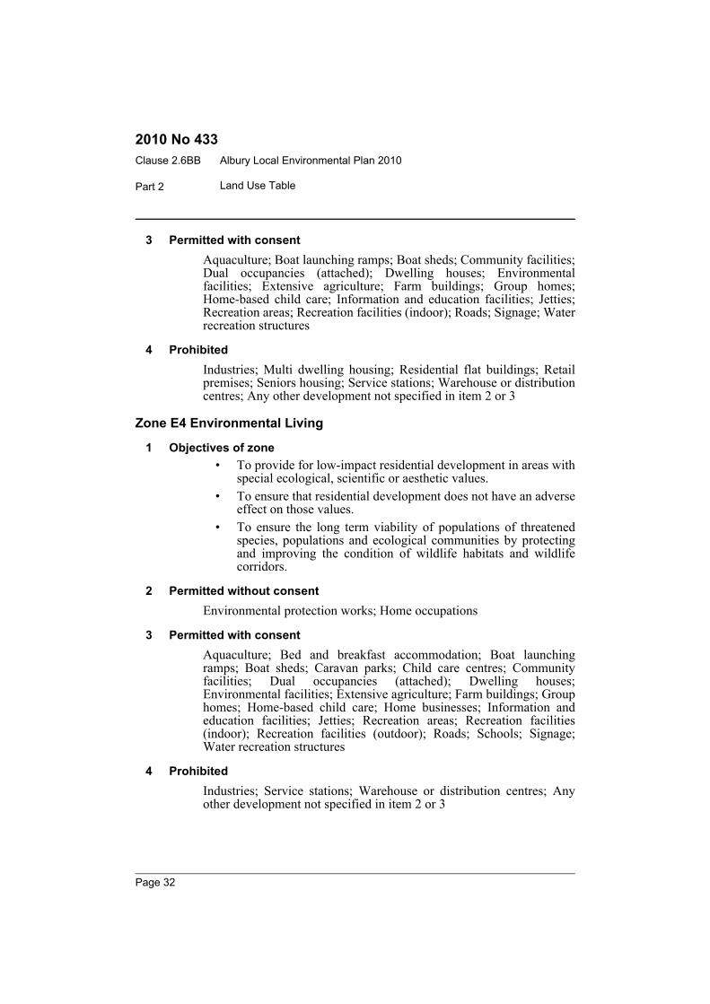
3 Permitted with consentAquaculture; Boat launching ramps; Boat sheds; Community facilities;Dual occupancies (attached); Dwelling houses; Environmentalfacilities; Extensive agriculture; Farm buildings; Group homes;Home-based child care; Information and education facilities; Jetties;Recreation areas; Recreation facilities (indoor); Roads; Signage; Waterrecreation structures
4 ProhibitedIndustries; Multi dwelling housing; Residential flat buildings; Retailpremises; Seniors housing; Service stations; Warehouse or distributioncentres; Any other development not specified in item 2 or 3
Zone E4 Environmental Living
1 Objectives of zone• To provide for low-impact residential development in areas with
special ecological, scientific or aesthetic values.• To ensure that residential development does not have an adverse
effect on those values.• To ensure the long term viability of populations of threatened
species, populations and ecological communities by protectingand improving the condition of wildlife habitats and wildlifecorridors.
2 Permitted without consentEnvironmental protection works; Home occupations
3 Permitted with consentAquaculture; Bed and breakfast accommodation; Boat launchingramps; Boat sheds; Caravan parks; Child care centres; Communityfacilities; Dual occupancies (attached); Dwelling houses;Environmental facilities; Extensive agriculture; Farm buildings; Grouphomes; Home-based child care; Home businesses; Information andeducation facilities; Jetties; Recreation areas; Recreation facilities(indoor); Recreation facilities (outdoor); Roads; Schools; Signage;Water recreation structures
4 ProhibitedIndustries; Service stations; Warehouse or distribution centres; Anyother development not specified in item 2 or 3
Page 32
Albury Local Environmental Plan 2010 Clause 2.6BB
Part 2Land Use Table
2010 No 433
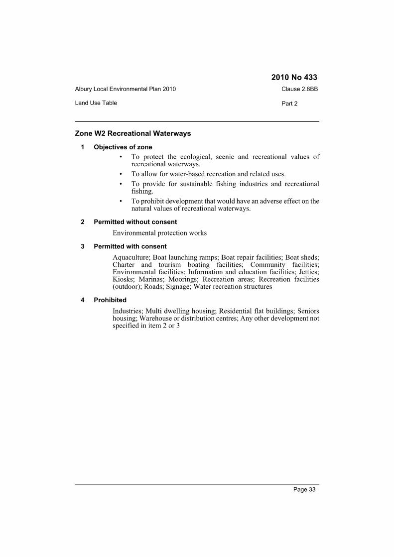
Zone W2 Recreational Waterways
1 Objectives of zone• To protect the ecological, scenic and recreational values of
recreational waterways.• To allow for water-based recreation and related uses.• To provide for sustainable fishing industries and recreational
fishing.• To prohibit development that would have an adverse effect on the
natural values of recreational waterways.
2 Permitted without consentEnvironmental protection works
3 Permitted with consentAquaculture; Boat launching ramps; Boat repair facilities; Boat sheds;Charter and tourism boating facilities; Community facilities;Environmental facilities; Information and education facilities; Jetties;Kiosks; Marinas; Moorings; Recreation areas; Recreation facilities(outdoor); Roads; Signage; Water recreation structures
4 ProhibitedIndustries; Multi dwelling housing; Residential flat buildings; Seniorshousing; Warehouse or distribution centres; Any other development notspecified in item 2 or 3
Page 33
Albury Local Environmental Plan 2010Clause 3.1
Part 3 Exempt and complying development
2010 No 433
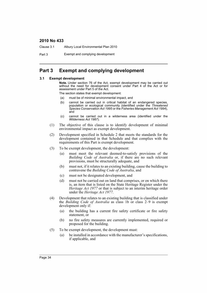
Part 3 Exempt and complying development3.1 Exempt development
Note. Under section 76 of the Act, exempt development may be carried outwithout the need for development consent under Part 4 of the Act or forassessment under Part 5 of the Act.The section states that exempt development:(a) must be of minimal environmental impact, and(b) cannot be carried out in critical habitat of an endangered species,
population or ecological community (identified under the ThreatenedSpecies Conservation Act 1995 or the Fisheries Management Act 1994),and
(c) cannot be carried out in a wilderness area (identified under theWilderness Act 1987).
(1) The objective of this clause is to identify development of minimalenvironmental impact as exempt development.
(2) Development specified in Schedule 2 that meets the standards for thedevelopment contained in that Schedule and that complies with therequirements of this Part is exempt development.
(3) To be exempt development, the development:(a) must meet the relevant deemed-to-satisfy provisions of the
Building Code of Australia or, if there are no such relevantprovisions, must be structurally adequate, and
(b) must not, if it relates to an existing building, cause the building tocontravene the Building Code of Australia, and
(c) must not be designated development, and(d) must not be carried out on land that comprises, or on which there
is, an item that is listed on the State Heritage Register under theHeritage Act 1977 or that is subject to an interim heritage orderunder the Heritage Act 1977.
(4) Development that relates to an existing building that is classified underthe Building Code of Australia as class 1b or class 2–9 is exemptdevelopment only if:(a) the building has a current fire safety certificate or fire safety
statement, or(b) no fire safety measures are currently implemented, required or
proposed for the building.(5) To be exempt development, the development must:
(a) be installed in accordance with the manufacturer’s specifications,if applicable, and
Page 34
Albury Local Environmental Plan 2010 Clause 3.2
Part 3Exempt and complying development
2010 No 433
(b) not involve the removal or pruning of a tree or other vegetationthat requires a permit or development consent for removal orpruning, unless that removal or pruning is undertaken inaccordance with a permit or development consent.
Note. A permit for the removal or pruning of a tree or other vegetation may begranted under this Plan. A development consent for the removal of nativevegetation may be granted where relevant under the Native Vegetation Act2003.
(6) A heading to an item in Schedule 2 is part of that Schedule.
3.2 Complying developmentNote. Under section 76A of the Act, development consent for the carrying outof complying development may be obtained by the issue of a complyingdevelopment certificate.The section states that development cannot be complying development if:(a) it is on land that is critical habitat of an endangered species, population
or ecological community (identified under the Threatened SpeciesConservation Act 1995 or the Fisheries Management Act 1994), or
(b) it is on land within a wilderness area (identified under the Wilderness Act1987), or
(c) the development is designated development, or(d) the development is on land that comprises, or on which there is, an item
of environmental heritage (that is listed on the State Heritage Register orin Schedule 5 to this Plan or that is subject to an interim heritage orderunder the Heritage Act 1977), or
(e) the development requires concurrence (except a concurrence of theDirector-General of the Department of Environment, Climate Changeand Water in respect of development that is likely to significantly affect athreatened species, population, or ecological community, or its habitat(identified under the Threatened Species Conservation Act 1995)), or
(f) the development is on land identified as an environmentally sensitivearea.
(1) The objective of this clause is to identify development as complyingdevelopment.
(2) Development specified in Part 1 of Schedule 3 that is carried out incompliance with:(a) the development standards specified in relation to that
development, and(b) the requirements of this Part,is complying development.Note. See also clause 5.8 (3) which provides that the conversion of fire alarmsis complying development in certain circumstances.
Page 35
Albury Local Environmental Plan 2010Clause 3.3
Part 3 Exempt and complying development
2010 No 433
(3) To be complying development, the development must:(a) be permissible, with consent, in the zone in which it is carried out,
and(b) meet the relevant deemed-to-satisfy provisions of the Building
Code of Australia, and(c) have an approval, if required by the Local Government Act 1993,
from the Council for an on-site effluent disposal system if thedevelopment is undertaken on unsewered land.
(4) A complying development certificate for development specified inPart 1 of Schedule 3 is subject to the conditions (if any) set out in Part 2of that Schedule.
(5) A heading to an item in Schedule 3 is part of that Schedule.
3.3 Environmentally sensitive areas excluded(1) Exempt or complying development must not be carried out on any
environmentally sensitive area for exempt or complying development.(2) For the purposes of this clause:
environmentally sensitive area for exempt or complying developmentmeans any of the following:(a) the coastal waters of the State,(b) a coastal lake,(c) land to which State Environmental Planning Policy No 14—
Coastal Wetlands or State Environmental Planning PolicyNo 26—Littoral Rainforests applies,
(d) land reserved as an aquatic reserve under the FisheriesManagement Act 1994 or as a marine park under the MarineParks Act 1997,
(e) land within a wetland of international significance declared underthe Ramsar Convention on Wetlands or within a World heritagearea declared under the World Heritage Convention,
(f) land within 100 metres of land to which paragraph (c), (d) or (e)applies,
(g) land identified in this or any other environmental planninginstrument as being of high Aboriginal cultural significance orhigh biodiversity significance,
(h) land reserved as a state conservation area under the NationalParks and Wildlife Act 1974,
Page 36
Albury Local Environmental Plan 2010 Clause 3.3
Part 3Exempt and complying development
2010 No 433
(i) land reserved or dedicated under the Crown Lands Act 1989 forthe preservation of flora, fauna, geological formations or forother environmental protection purposes,
(j) land identified as being critical habitat under the ThreatenedSpecies Conservation Act 1995 or Part 7A of the FisheriesManagement Act 1994,
(j1) land within the Landfill Buffer Area,(j2) land to which clause 7.5 applies.
Page 37
Albury Local Environmental Plan 2010Clause 4.1
Part 4 Principal development standards
2010 No 433
Part 4 Principal development standards4.1 Minimum subdivision lot size
(1) The objectives of this clause are as follows:(a) to protect rural and environmental land from inappropriate
development,(b) to maintain the existing function and character of the rural areas
of Albury,(c) to minimise fragmentation of rural lands,(d) to encourage a diversity of lot sizes, housing forms and densities
in residential zones,(e) to ensure subdivision does not create unreasonable or
uneconomic demands for the provision or extension of services.(2) This clause applies to a subdivision of any land shown on the Lot Size
Map that requires development consent and that is carried out after thecommencement of this Plan.
(3) The size of any lot resulting from a subdivision of land to which thisclause applies is not to be less than the minimum size shown on the LotSize Map in relation to that land.
(4) This clause does not apply in relation to the subdivision of individuallots in a strata plan or community title scheme.
4.1A Exceptions to minimum lot sizes for certain residential development(1) The objective of this clause is to encourage housing diversity without
adversely impacting on residential amenity.(2) This clause applies to land in Zone R1 General Residential and Zone R3
Medium Density Residential.(3) Despite clause 4.1, development consent may be granted to a single
development application for both of the following:(a) the subdivision of land into 3 or more lots if the size of each lot
is equal to or greater than 300 square metres,(b) development for the purpose of an attached dwelling, a
semi-detached dwelling or a dwelling house on each lot resultingfrom the subdivision.
4.2 Rural subdivision(1) The objective of this clause is to provide flexibility in the application of
standards for subdivision in rural zones to allow land owners a greaterchance to achieve the objectives for development in the relevant zone.
Page 38
Albury Local Environmental Plan 2010 Clause 4.2A
Part 4Principal development standards
2010 No 433
(2) This clause applies to the following rural zones:(a) Zone RU1 Primary Production,(b) Zone RU2 Rural Landscape,(c) Zone RU4 Rural Small Holdings,(d) Zone RU6 Transition.Note. When this Plan was made it did not include Zone RU6 Transition.
(3) Land in a zone to which this clause applies may, with consent, besubdivided for the purpose of primary production to create a lot of a sizethat is less than the minimum size shown on the Lot Size Map in relationto that land.
(4) However, such a lot cannot be created if an existing dwelling would, asthe result of the subdivision, be situated on the lot.
(5) A dwelling cannot be erected on such a lot.Note. A dwelling includes a rural worker’s dwelling (see definition of that term inthe Dictionary).
4.2A No strata or community title subdivisions in certain rural, environmental and residential zones(1) The objective of this clause is to ensure that land to which this clause
applies is not fragmented by subdivisions that would create additionaldwelling entitlements.
(2) This clause applies to land in the following zones that is used, orproposed to be used, for residential accommodation or tourist andvisitor accommodation:(a) Zone RU1 Primary Production,(b) Zone RU2 Rural Landscape,(c) Zone RU4 Rural Small Holdings,(d) Zone R2 Low Density Residential,(e) Zone R5 Large Lot Residential,(f) Zone E3 Environmental Management,(g) Zone E4 Environmental Living.
(3) Development consent must not be granted for the subdivision of a lot towhich this clause applies for a strata plan or community title schemethat would create lots below the minimum lot size specified for that loton the Lot Size Map.
Page 39

Albury Local Environmental Plan 2010Clause 4.2B
Part 4 Principal development standards
2010 No 433
4.2B Erection of dwelling houses on land in certain residential, rural and environmental protection zones(1) The objectives of this clause are as follows:
(a) to minimise unplanned rural residential development,(b) to enable the replacement of lawfully erected dwelling houses in
rural and environmental protection zones.(2) This clause applies to land in the following zones:
(a) Zone RU1 Primary Production,(b) Zone RU2 Rural Landscape,(c) Zone RU4 Rural Small Holdings,(d) Zone RU5 Village,(e) Zone R5 Large Lot Residential,(f) Zone E3 Environmental Management,(g) Zone E4 Environmental Living.
(3) Development consent must not be granted for the erection of a dwellinghouse on land to which this clause applies, and on which no dwellinghouse has been erected, unless the land is:(a) a lot that is at least the minimum lot size specified for that land
by the Lot Size Map, or(b) a lot created before this Plan commenced and on which the
erection of a dwelling house was permissible immediately beforethat commencement, or
(c) a lot resulting from a subdivision for which development consent(or equivalent) was granted before this Plan commenced and onwhich the erection of a dwelling house would have beenpermissible if the plan of subdivision had been registered beforethat commencement.
Note. A dwelling cannot be erected on a lot created under clause 9 of StateEnvironmental Planning Policy (Rural Lands) 2008 or clause 4.2.
(4) Despite any other provision of this clause, development consent may begranted for the erection of a dwelling house on land to which this clauseapplies if:(a) there is a lawfully erected dwelling house on the land and the
dwelling house to be erected is intended only to replace theexisting dwelling house, or
Page 40
Albury Local Environmental Plan 2010 Clause 4.3
Part 4Principal development standards
2010 No 433
(b) the land would have been a lot referred to in subclause (3) had itnot been affected by:(i) a minor realignment of its boundaries that did not create an
additional lot, or(ii) a subdivision creating or widening a public road or public
reserve or for another public purpose.
4.3 Height of buildings(1) The objectives of this clause are as follows:
(a) to ensure the height of buildings complement the streetscape orthe historic character of the area in which the buildings arelocated,
(b) to protect the heritage character and significance of buildings andnot adversely affect the heritage integrity of heritage items andheritage conservation areas identified in this Plan,
(c) to ensure the height of buildings protects the amenity ofneighbouring properties in terms of visual bulk, access tosunlight and privacy,
(d) to nominate heights that will provide a transition in built formbetween varying land use intensities.
(2) The height of a building on any land is not to exceed the maximumheight shown for the land on the Height of Buildings Map.
4.4 Floor space ratio(1) The objectives of this clause are as follows:
(a) to ensure that the density, bulk and scale of development isappropriate for a site,
(b) to ensure that the density, bulk and scale of developmentintegrates with the streetscape and character of the area in whichthe development is located,
(c) to facilitate development that contributes to the economic growthof the Albury and Lavington Central Business Districts.
(2) The maximum floor space ratio for a building on any land is not toexceed the floor space ratio shown for the land on the Floor Space RatioMap.
Page 41
Albury Local Environmental Plan 2010Clause 4.5
Part 4 Principal development standards
2010 No 433
4.5 Calculation of floor space ratio and site area(1) Objectives
The objectives of this clause are as follows:(a) to define floor space ratio,(b) to set out rules for the calculation of the site area of development
for the purpose of applying permitted floor space ratios,including rules to:(i) prevent the inclusion in the site area of an area that has no
significant development being carried out on it, and(ii) prevent the inclusion in the site area of an area that has
already been included as part of a site area to maximisefloor space area in another building, and
(iii) require community land and public places to be dealt withseparately.
(2) Definition of “floor space ratio”
The floor space ratio of buildings on a site is the ratio of the gross floorarea of all buildings within the site to the site area.
(3) Site area
In determining the site area of proposed development for the purpose ofapplying a floor space ratio, the site area is taken to be:(a) if the proposed development is to be carried out on only one lot,
the area of that lot, or(b) if the proposed development is to be carried out on 2 or more lots,
the area of any lot on which the development is proposed to becarried out that has at least one common boundary with anotherlot on which the development is being carried out.
In addition, subclauses (4)–(7) apply to the calculation of site area forthe purposes of applying a floor space ratio to proposed development.
(4) Exclusions from site area
The following land must be excluded from the site area:(a) land on which the proposed development is prohibited, whether
under this Plan or any other law,(b) community land or a public place (except as provided by
subclause (7)).(5) Strata subdivisions
The area of a lot that is wholly or partly on top of another or others in astrata subdivision is to be included in the calculation of the site area only
Page 42
Albury Local Environmental Plan 2010 Clause 4.5
Part 4Principal development standards
2010 No 433
to the extent that it does not overlap with another lot already included inthe site area calculation.
(6) Only significant development to be included
The site area for proposed development must not include a lot additionalto a lot or lots on which the development is being carried out unless theproposed development includes significant development on thatadditional lot.
(7) Certain public land to be separately considered
For the purpose of applying a floor space ratio to any proposeddevelopment on, above or below community land or a public place, thesite area must only include an area that is on, above or below thatcommunity land or public place, and is occupied or physically affectedby the proposed development, and may not include any other area onwhich the proposed development is to be carried out.
(8) Existing buildings
The gross floor area of any existing or proposed buildings within thevertical projection (above or below ground) of the boundaries of a siteis to be included in the calculation of the total floor space for thepurposes of applying a floor space ratio, whether or not the proposeddevelopment relates to all of the buildings.
(9) Covenants to prevent “double dipping”
When consent is granted to development on a site comprised of 2 ormore lots, a condition of the consent may require a covenant to beregistered that prevents the creation of floor area on a lot (the restrictedlot) if the consent authority is satisfied that an equivalent quantity offloor area will be created on another lot only because the site includedthe restricted lot.
(10) Covenants affect consolidated sites
If:(a) a covenant of the kind referred to in subclause (9) applies to any
land (affected land), and(b) proposed development relates to the affected land and other land
that together comprise the site of the proposed development,the maximum amount of floor area allowed on the other land by thefloor space ratio fixed for the site by this Plan is reduced by the quantityof floor space area the covenant prevents being created on the affectedland.
Page 43
Albury Local Environmental Plan 2010Clause 4.6
Part 4 Principal development standards
2010 No 433
(11) Definition
In this clause, public place has the same meaning as it has in the LocalGovernment Act 1993.
4.6 Exceptions to development standards(1) The objectives of this clause are:
(a) to provide an appropriate degree of flexibility in applying certaindevelopment standards to particular development, and
(b) to achieve better outcomes for and from development byallowing flexibility in particular circumstances.
(2) Consent may, subject to this clause, be granted for development eventhough the development would contravene a development standardimposed by this or any other environmental planning instrument.However, this clause does not apply to a development standard that isexpressly excluded from the operation of this clause.
(3) Consent must not be granted for development that contravenes adevelopment standard unless the consent authority has considered awritten request from the applicant that seeks to justify the contraventionof the development standard by demonstrating:(a) that compliance with the development standard is unreasonable
or unnecessary in the circumstances of the case, and(b) that there are sufficient environmental planning grounds to
justify contravening the development standard.(4) Consent must not be granted for development that contravenes a
development standard unless:(a) the consent authority is satisfied that:
(i) the applicant’s written request has adequately addressedthe matters required to be demonstrated by subclause (3),and
(ii) the proposed development will be in the public interestbecause it is consistent with the objectives of the particularstandard and the objectives for development within thezone in which the development is proposed to be carriedout, and
(b) the concurrence of the Director-General has been obtained.(5) In deciding whether to grant concurrence, the Director-General must
consider:(a) whether contravention of the development standard raises any
matter of significance for State or regional environmentalplanning, and
Page 44
Albury Local Environmental Plan 2010 Clause 4.6
Part 4Principal development standards
2010 No 433
(b) the public benefit of maintaining the development standard, and(c) any other matters required to be taken into consideration by the
Director-General before granting concurrence.(6) Consent must not be granted under this clause for a subdivision of land
in Zone RU1 Primary Production, Zone RU2 Rural Landscape,Zone RU3 Forestry, Zone RU4 Rural Small Holdings, Zone RU6Transition, Zone R5 Large Lot Residential, Zone E2 EnvironmentalConservation, Zone E3 Environmental Management or Zone E4Environmental Living if:(a) the subdivision will result in 2 or more lots of less than the
minimum area specified for such lots by a development standard,or
(b) the subdivision will result in at least one lot that is less than 90%of the minimum area specified for such a lot by a developmentstandard.
Note. When this Plan was made it did not include Zone RU3 Forestry orZone RU6 Transition.
(7) After determining a development application made pursuant to thisclause, the consent authority must keep a record of its assessment of thefactors required to be addressed in the applicant’s written requestreferred to in subclause (3).
(8) This clause does not allow consent to be granted for development thatwould contravene any of the following:(a) a development standard for complying development,(b) a development standard that arises, under the regulations under
the Act, in connection with a commitment set out in a BASIXcertificate for a building to which State Environmental PlanningPolicy (Building Sustainability Index: BASIX) 2004 applies or forthe land on which such a building is situated,
(c) clause 5.4,(c1) clauses 4.1A, 4.2A, 6.1 and 7.5.
Page 45

Albury Local Environmental Plan 2010Clause 5.1
Part 5 Miscellaneous provisions
2010 No 433
Part 5 Miscellaneous provisions5.1 Relevant acquisition authority
(1) The objective of this clause is to identify, for the purposes of section 27of the Act, the authority of the State that will be the relevant authorityto acquire land reserved for certain public purposes if the land isrequired to be acquired under Division 3 of Part 2 of the LandAcquisition (Just Terms Compensation) Act 1991 (the owner-initiatedacquisition provisions).Note. If the landholder will suffer hardship if there is any delay in the land beingacquired by the relevant authority, section 23 of the Land Acquisition (JustTerms Compensation) Act 1991 requires the authority to acquire the land.
(2) The authority of the State that will be the relevant authority to acquireland, if the land is required to be acquired under the owner-initiatedacquisition provisions, is the authority of the State specified below inrelation to the land shown on the Land Reservation Acquisition Map(or, if an authority of the State is not specified in relation to landrequired to be so acquired, the authority designated or determined underthose provisions).
(3) Development on land acquired by an authority of the State under theowner-initiated acquisition provisions may, before it is used for thepurpose for which it is reserved, be carried out, with developmentconsent, for any purpose.Note. If land, other than land specified in the Table to subclause (2), is requiredto be acquired under the owner-initiated acquisition provisions, the Minister ofPlanning is required to take action to enable the designation of the acquiringauthority under this Part. Pending the designation of the acquiring authority forthat land, the acquiring authority is to be the authority determined by order of theMinister for Planning (see section 21 of the Land Acquisition (Just TermsCompensation) Act 1991).
Type of land shown on Map Authority of the StateZone RE1 Public Recreation and marked “Local open space”
Council
Zone RE1 Public Recreation and marked “Regional open space”
The corporation constituted under section 8 of the Act
Zone SP2 Infrastructure and marked “Classified road”
Roads and Traffic Authority
Zone E1 National Parks and Nature Reserves and marked “National Park”
Minister administering the National Parks and Wildlife Act 1974
Page 46

Albury Local Environmental Plan 2010 Clause 5.2
Part 5Miscellaneous provisions
2010 No 433
5.2 Classification and reclassification of public land(1) The objective of this clause is to enable the Council to classify or
reclassify public land as “operational land” or “community land” inaccordance with Part 2 of Chapter 6 of the Local Government Act 1993.Note. Under the Local Government Act 1993, “public land” is generally landvested in or under the control of a council (other than roads, Crown reservesand commons). The classification or reclassification of public land may also bemade by a resolution of the Council under section 31, 32 or 33 of the LocalGovernment Act 1993. Section 30 of that Act enables this Plan to dischargetrusts on which public reserves are held if the land is reclassified under this Planas operational land.
(2) The public land described in Part 1 or Part 2 of Schedule 4 is classified,or reclassified, as operational land for the purposes of the LocalGovernment Act 1993.
(3) The public land described in Part 3 of Schedule 4 is classified, orreclassified, as community land for the purposes of the LocalGovernment Act 1993.
(4) The public land described in Part 1 of Schedule 4:(a) does not cease to be a public reserve to the extent (if any) that it
is a public reserve, and(b) continues to be affected by any trusts, estates, interests,
dedications, conditions, restrictions or covenants that affected theland before its classification, or reclassification, as operationalland.
(5) The public land described in Part 2 of Schedule 4, to the extent (if any)that it is a public reserve, ceases to be a public reserve when thedescription of the land is inserted into that Part and is discharged fromall trusts, estates, interests, dedications, conditions, restrictions andcovenants affecting the land or any part of the land, except:(a) those (if any) specified for the land in Column 3 of Part 2 of
Schedule 4, and(b) any reservations that except land out of the Crown grant relating
to the land, and(c) reservations of minerals (within the meaning of the Crown Lands
Act 1989).Note. In accordance with section 30 (2) of the Local Government Act 1993, theapproval of the Governor to subclause (5) applying to the public land concernedis required before the description of the land is inserted in Part 2 of Schedule 4.
5.3 Development near zone boundaries(1) The objective of this clause is to provide flexibility where the
investigation of a site and its surroundings reveals that a use allowed on
Page 47
Albury Local Environmental Plan 2010Clause 5.4
Part 5 Miscellaneous provisions
2010 No 433
the other side of a zone boundary would enable a more logical andappropriate development of the site and be compatible with the planningobjectives and land uses for the adjoining zone.
(2) This clause applies to so much of any land that is within the relevantdistance of a boundary between any 2 zones. The relevant distance is 20metres.
(3) This clause does not apply to:(a) land in Zone RE1 Public Recreation, Zone E1 National Parks and
Nature Reserves, Zone E2 Environmental Conservation, Zone E3Environmental Management or Zone W1 Natural Waterways, or
(b) land within the coastal zone, or(c) land proposed to be developed for the purpose of sex services or
restricted premises.Note. When this Plan was made it did not include Zone E1 National Parks andNature Reserves or Zone W1 Natural Waterways.
(4) Despite the provisions of this Plan relating to the purposes for whichdevelopment may be carried out, consent may be granted todevelopment of land to which this clause applies for any purpose thatmay be carried out in the adjoining zone, but only if the consentauthority is satisfied that:(a) the development is not inconsistent with the objectives for
development in both zones, and(b) the carrying out of the development is desirable due to
compatible land use planning, infrastructure capacity and otherplanning principles relating to the efficient and timelydevelopment of land.
(5) The clause does not prescribe a development standard that may bevaried under this Plan.
5.4 Controls relating to miscellaneous permissible uses(1) Bed and breakfast accommodation
If development for the purposes of bed and breakfast accommodation ispermitted under this Plan, the accommodation that is provided to guestsmust consist of no more than 3 bedrooms.
(2) Home businesses
If development for the purposes of a home business is permitted underthis Plan, the carrying on of the business must not involve the use ofmore than 50 square metres of floor area.
Page 48
Albury Local Environmental Plan 2010 Clause 5.5
Part 5Miscellaneous provisions
2010 No 433
(3) Home industries
If development for the purposes of a home industry is permitted underthis Plan, the carrying on of the home industry must not involve the useof more than 50 square metres of floor area.
(4) Industrial retail outlets
If development for the purposes of an industrial retail outlet is permittedunder this Plan, the retail floor area must not exceed:(a) 20% of the combined gross floor area of the industrial retail outlet
and the building or place on which the relevant industry is carriedout, or
(b) 400 square metres,whichever is the lesser.
(5) Farm stay accommodation
If development for the purposes of farm stay accommodation ispermitted under this Plan, the accommodation that is provided to guestsmust consist of no more than 3 bedrooms.
(6) Kiosks
If development for the purposes of a kiosk is permitted under this Plan,the gross floor area must not exceed 10 square metres.
(7) Neighbourhood shops
If development for the purposes of a neighbourhood shop is permittedunder this Plan, the retail floor area must not exceed 100 square metres.
(8) Roadside stalls
If development for the purposes of a roadside stall is permitted underthis Plan, the gross floor area must not exceed 10 square metres.
(9) Secondary dwellings
If development for the purposes of a secondary dwelling is permittedunder this Plan, the total floor area of the dwelling (excluding any areaused for parking) must not exceed whichever of the following is thegreater:(a) 60 square metres,(b) 20% of the total floor area of both the self-contained dwelling and
the principal dwelling.
5.5 Development within the coastal zoneNot applicable
Page 49
Albury Local Environmental Plan 2010Clause 5.6
Part 5 Miscellaneous provisions
2010 No 433
5.6 Architectural roof featuresNot adopted
5.7 Development below mean high water markNot applicable
5.8 Conversion of fire alarms(1) This clause applies to a fire alarm system that can be monitored by New
South Wales Fire Brigades or by a private service provider.(2) The following development may be carried out, but only with consent:
(a) converting a fire alarm system from connection with the alarmmonitoring system of New South Wales Fire Brigades toconnection with the alarm monitoring system of a private serviceprovider,
(b) converting a fire alarm system from connection with the alarmmonitoring system of a private service provider to connectionwith the alarm monitoring system of another private serviceprovider,
(c) converting a fire alarm system from connection with the alarmmonitoring system of a private service provider to connectionwith a different alarm monitoring system of the same privateservice provider.
(3) Development to which subclause (2) applies is complying developmentif it consists only of:(a) internal alterations to a building, or(b) internal alterations to a building together with the mounting of an
antenna, and any support structure, on an external wall or roof ofa building so as to occupy a space of not more than 450mm ×100mm × 100mm.
(4) A complying development certificate for any such complyingdevelopment is subject to a condition that any building work may onlybe carried out between 7.00 am and 6.00 pm on Monday to Friday andbetween 7.00 am and 5.00 pm on Saturday, and must not be carried outon a Sunday or a public holiday.
(5) In this clause:private service provider means a person or body that has entered into anagreement that is in force with New South Wales Fire Brigades tomonitor fire alarm systems.
Page 50
Albury Local Environmental Plan 2010 Clause 5.9
Part 5Miscellaneous provisions
2010 No 433
5.9 Preservation of trees or vegetation(1) The objective of this clause is to preserve the amenity of the area
through the preservation of trees and other vegetation.(2) This clause applies to species or kinds of trees or other vegetation that
are prescribed for the purposes of this clause by a development controlplan made by the Council.Note. A development control plan may prescribe the trees or other vegetationto which this clause applies by reference to species, size, location or othermanner.
(3) A person must not ringbark, cut down, top, lop, remove, injure orwilfully destroy any tree or other vegetation to which any suchdevelopment control plan applies without the authority conferred by:(a) development consent, or(b) a permit granted by the Council.
(4) The refusal by the Council to grant a permit to a person who has dulyapplied for the grant of the permit is taken for the purposes of the Act tobe a refusal by the Council to grant consent for the carrying out of theactivity for which a permit was sought.
(5) This clause does not apply to a tree or other vegetation that the Councilis satisfied is dying or dead and is not required as the habitat of nativefauna.
(6) This clause does not apply to a tree or other vegetation that the Councilis satisfied is a risk to human life or property.
(7) A permit under this clause cannot allow any ringbarking, cutting down,topping, lopping, removal, injuring or destruction of a tree or othervegetation:(a) that is or forms part of a heritage item, or(b) that is within a heritage conservation area.Note. As a consequence of this subclause, the activities concerned will requiredevelopment consent. The heritage provisions of clause 5.10 will be applicableto any such consent.
(8) This clause does not apply to or in respect of:(a) the clearing of native vegetation that is authorised by a
development consent or property vegetation plan under theNative Vegetation Act 2003 or that is otherwise permitted underDivision 2 or 3 of Part 3 of that Act, or
(b) the clearing of vegetation on State protected land (within themeaning of clause 4 of Schedule 3 to the Native Vegetation Act2003) that is authorised by a development consent under the
Page 51
Albury Local Environmental Plan 2010Clause 5.10
Part 5 Miscellaneous provisions
2010 No 433
provisions of the Native Vegetation Conservation Act 1997 ascontinued in force by that clause, or
(c) trees or other vegetation within a State forest, or land reservedfrom sale as a timber or forest reserve under the Forestry Act1916, or
(d) action required or authorised to be done by or under theElectricity Supply Act 1995, the Roads Act 1993 or the SurveyingAct 2002, or
(e) plants declared to be noxious weeds under the Noxious Weeds Act1993.
5.10 Heritage conservationNote. Heritage items, heritage conservation areas and archaeological sites (ifany) are shown on the Heritage Map. The location and nature of any such item,area or site is also described in Schedule 5.
(1) Objectives
The objectives of this clause are:(a) to conserve the environmental heritage of Albury, and(b) to conserve the heritage significance of heritage items and
heritage conservation areas including associated fabric, settingsand views, and
(c) to conserve archaeological sites, and(d) to conserve places of Aboriginal heritage significance.
(2) Requirement for consent
Development consent is required for any of the following:(a) demolishing or moving a heritage item or a building, work, relic
or tree within a heritage conservation area,(b) altering a heritage item or a building, work, relic, tree or place
within a heritage conservation area, including (in the case of abuilding) making changes to the detail, fabric, finish orappearance of its exterior,
(c) altering a heritage item that is a building by making structuralchanges to its interior,
(d) disturbing or excavating an archaeological site while knowing, orhaving reasonable cause to suspect, that the disturbance orexcavation will or is likely to result in a relic being discovered,exposed, moved, damaged or destroyed,
(e) disturbing or excavating a heritage conservation area that is aplace of Aboriginal heritage significance,
Page 52
Albury Local Environmental Plan 2010 Clause 5.10
Part 5Miscellaneous provisions
2010 No 433
(f) erecting a building on land on which a heritage item is located orthat is within a heritage conservation area,
(g) subdividing land on which a heritage item is located or that iswithin a heritage conservation area.
(3) When consent not required
However, consent under this clause is not required if:(a) the applicant has notified the consent authority of the proposed
development and the consent authority has advised the applicantin writing before any work is carried out that it is satisfied that theproposed development:(i) is of a minor nature, or is for the maintenance of the
heritage item, archaeological site, or a building, work,relic, tree or place within a heritage conservation area, and
(ii) would not adversely affect the significance of the heritageitem, archaeological site or heritage conservation area, or
(b) the development is in a cemetery or burial ground and theproposed development:(i) is the creation of a new grave or monument, or excavation
or disturbance of land for the purpose of conserving orrepairing monuments or grave markers, and
(ii) would not cause disturbance to human remains, relics,Aboriginal objects in the form of grave goods, or to a placeof Aboriginal heritage significance, or
(c) the development is limited to the removal of a tree or othervegetation that the Council is satisfied is a risk to human life orproperty, or
(d) the development is exempt development.(4) Effect on heritage significance
The consent authority must, before granting consent under this clause,consider the effect of the proposed development on the heritagesignificance of the heritage item or heritage conservation areaconcerned. This subclause applies regardless of whether a heritageimpact statement is prepared under subclause (5) or a heritageconservation management plan is submitted under subclause (6).
(5) Heritage impact assessment
The consent authority may, before granting consent to any developmenton land:(a) on which a heritage item is situated, or(b) within a heritage conservation area, or
Page 53
Albury Local Environmental Plan 2010Clause 5.10
Part 5 Miscellaneous provisions
2010 No 433
(c) within the vicinity of land referred to in paragraph (a) or (b),require a heritage impact statement to be prepared that assesses theextent to which the carrying out of the proposed development wouldaffect the heritage significance of the heritage item or heritageconservation area concerned.
(6) Heritage conservation management plans
The consent authority may require, after considering the significance ofa heritage item and the extent of change proposed to it, the submissionof a heritage conservation management plan before granting consentunder this clause.
(7) Archaeological sites
The consent authority must, before granting consent under this clause tothe carrying out of development on an archaeological site (other thanland listed on the State Heritage Register or to which an interim heritageorder under the Heritage Act 1977 applies):(a) notify the Heritage Council of its intention to grant consent, and(b) take into consideration any response received from the Heritage
Council within 28 days after the notice is sent.(8) Places of Aboriginal heritage significance
The consent authority must, before granting consent under this clause tothe carrying out of development in a place of Aboriginal heritagesignificance:(a) consider the effect of the proposed development on the heritage
significance of the place and any Aboriginal object known orreasonably likely to be located at the place, and
(b) notify the local Aboriginal communities (in such way as it thinksappropriate) about the application and take into consideration anyresponse received within 28 days after the notice is sent.
(9) Demolition of item of State significance
The consent authority must, before granting consent for the demolitionof a heritage item identified in Schedule 5 as being of State significance(other than an item listed on the State Heritage Register or to which aninterim heritage order under the Heritage Act 1977 applies):(a) notify the Heritage Council about the application, and(b) take into consideration any response received from the Heritage
Council within 28 days after the notice is sent.
Page 54
Albury Local Environmental Plan 2010 Clause 5.11
Part 5Miscellaneous provisions
2010 No 433
(10) Conservation incentives
The consent authority may grant consent to development for anypurpose of a building that is a heritage item, or of the land on which sucha building is erected, even though development for that purpose wouldotherwise not be allowed by this Plan, if the consent authority issatisfied that:(a) the conservation of the heritage item is facilitated by the granting
of consent, and(b) the proposed development is in accordance with a heritage
conservation management plan that has been approved by theconsent authority, and
(c) the consent to the proposed development would require that allnecessary conservation work identified in the heritageconservation management plan is carried out, and
(d) the proposed development would not adversely affect theheritage significance of the heritage item, including its setting,and
(e) the proposed development would not have any significantadverse effect on the amenity of the surrounding area.
5.11 Bush fire hazard reductionBush fire hazard reduction work authorised by the Rural Fires Act 1997may be carried out on any land without consent.Note. The Rural Fires Act 1997 also makes provision relating to the carrying outof development on bush fire prone land.
5.12 Infrastructure development and use of existing buildings of the Crown(1) This Plan does not restrict or prohibit, or enable the restriction or
prohibition of, the carrying out of any development, by or on behalf ofa public authority, that is permitted to be carried out with or withoutconsent, or that is exempt development, under the State EnvironmentalPlanning Policy (Infrastructure) 2007.
(2) This Plan does not restrict or prohibit, or enable the restriction orprohibition of, the use of existing buildings of the Crown by the Crown.
Page 55
Albury Local Environmental Plan 2010Clause 6.1
Part 6 Urban release areas
2010 No 433
Part 6 Urban release areas6.1 Arrangements for designated State public infrastructure
(1) The objective of this clause is to require satisfactory arrangements to bemade for the provision of designated State public infrastructure beforethe subdivision of land in an urban release area to satisfy needs that arisefrom development on the land, but only if the land is developedintensively for urban purposes.
(2) Development consent must not be granted for the subdivision of land inan urban release area if the subdivision would create a lot smaller thanthe minimum lot size permitted on the land immediately before the landbecame, or became part of, an urban release area, unless theDirector-General has certified in writing to the consent authority thatsatisfactory arrangements have been made to contribute to the provisionof designated State public infrastructure in relation to that lot.
(3) Subclause (2) does not apply to:(a) any lot identified in the certificate as a residue lot, or(b) any lot created by a subdivision previously consented to in
accordance with this clause, or(c) any lot that is proposed in the development application to be
reserved or dedicated for public open space, public roads, publicutility undertakings, educational facilities or any other publicpurpose, or
(d) a subdivision for the purpose only of rectifying an encroachmenton any existing lot.
(4) This clause does not apply to land in an urban release area if all or anypart of the land is in a special contributions area (as defined bysection 93C of the Act).
6.2 Public utility infrastructure(1) Development consent must not be granted for development on land in
an urban release area unless the Council is satisfied that any publicutility infrastructure that is essential for the proposed development isavailable or that adequate arrangements have been made to make thatinfrastructure available when it is required.
(2) This clause does not apply to development for the purpose of providing,extending, augmenting, maintaining or repairing any public utilityinfrastructure.
Page 56
Albury Local Environmental Plan 2010 Clause 6.3
Part 6Urban release areas
2010 No 433
6.3 Development control plan(1) The objective of this clause is to ensure that development on land in an
urban release area occurs in a logical and cost-effective manner, inaccordance with a staging plan and only after a development controlplan that includes specific controls has been prepared for the land.
(2) Development consent must not be granted for development on land inan urban release area unless a development control plan that providesfor the matters specified in subclause (3) has been prepared for the land.
(3) The development control plan must provide for all of the following:(a) a staging plan for the timely and efficient release of urban land
making provision for necessary infrastructure and sequencing,(b) an overall transport movement hierarchy showing the major
circulation routes and connections to achieve a simple and safemovement system for private vehicles, public transport,pedestrians and cyclists,
(c) an overall landscaping strategy for the protection andenhancement of riparian areas and remnant vegetation, includingvisually prominent locations, and detailed landscapingrequirements for both the public and private domain,
(d) a network of passive and active recreational areas,(e) stormwater and water quality management controls,(f) amelioration of natural and environmental hazards, including
bushfire, flooding and site contamination and, in relation tonatural hazards, the safe occupation of, and the evacuation from,any land so affected,
(g) detailed urban design controls for significant development sites,(h) measures to encourage higher density living around transport,
open space and service nodes,(i) measures to accommodate and control appropriate
neighbourhood commercial and retail uses,(j) suitably located public facilities and services, including provision
for appropriate traffic management facilities and parking.(4) Subclause (2) does not apply to any of the following development:
(a) a subdivision for the purpose of a realignment of boundaries thatdoes not create additional lots,
(b) a subdivision of land if any of the lots proposed to be created isto be reserved or dedicated for public open space, public roads orany other public or environmental protection purpose,
Page 57
Albury Local Environmental Plan 2010Clause 6.4
Part 6 Urban release areas
2010 No 433
(c) a subdivision of land in a zone in which the erection of structuresis prohibited,
(d) proposed development on land that is of a minor nature only, ifthe consent authority is of the opinion that the carrying out of theproposed development would be consistent with the objectives ofthe zone in which the land is situated.
6.4 Relationship between Part and remainder of PlanA provision of this Part prevails over any other provision of this Plan tothe extent of any inconsistency.
Page 58
Albury Local Environmental Plan 2010 Clause 7.1
Part 7Additional local provisions
2010 No 433
Part 7 Additional local provisions7.1 Earthworks
(1) The objectives of this clause are as follows:(a) to ensure that earthworks for which development consent is
required will not have a detrimental impact on environmentalfunctions and processes, neighbouring uses, cultural or heritageitems or features of the surrounding land,
(b) to allow earthworks of a minor nature without separatedevelopment consent.
(2) Development consent is required for earthworks unless:(a) the work does not alter the ground level (existing) by more than
600 millimetres, or(b) the work is exempt development under this Plan or another
applicable environmental planning instrument, or(c) the work is ancillary to other development for which
development consent has been given.(3) Before granting development consent for earthworks, the consent
authority must consider the following matters:(a) the likely disruption of, or any detrimental effect on, existing
drainage patterns and soil stability in the locality,(b) the effect of the proposed development on the likely future use or
redevelopment of the land,(c) the quality of the fill or the soil to be excavated, or both,(d) the effect of the proposed development on the existing and likely
amenity of adjoining properties,(e) the source of any fill material and the destination of any
excavated material,(f) the likelihood of disturbing relics,(g) the proximity to and potential for adverse impacts on any
watercourse, drinking water catchment or environmentallysensitive area.
Note. The National Parks and Wildlife Act 1974, particularly section 86, dealswith disturbing or excavating land and Aboriginal objects.
7.2 Water(1) The objective of this clause is to maintain the hydrological functions of
riparian land waterways and aquifers, including protecting:(a) water quality, and
Page 59
Albury Local Environmental Plan 2010Clause 7.3
Part 7 Additional local provisions
2010 No 433
(b) natural water flows, and(c) the stability of the bed and banks of waterways, and(d) groundwater systems.
(2) This clause applies to land identified as “Sensitive Area” on the NaturalResources Sensitivity—Water Map.
(3) Before determining a development application for development on landto which this clause applies, the consent authority must consider anyadverse impact from the proposed development on:(a) the water quality of receiving waters, and(b) the natural flow regime, and(c) the natural flow paths of waterways, and(d) the stability of the bed, shore and banks of waterways, and(e) the flows, capacity and quality of groundwater systems.
(4) Development consent must not be granted to development on land towhich this clause applies unless the consent authority is satisfied that:(a) the development is designed, sited and will be managed to avoid
any adverse environmental impact, or(b) if that impact cannot be avoided—the development is designed,
sited and will be managed to minimise that impact, or(c) if that impact cannot be minimised—the development will be
managed to mitigate that impact.
7.3 Protected regrowth(1) The objective of this clause is to identify, for the purposes of the Native
Vegetation Act 2003, protected regrowth on land in Zone E2Environmental Conservation and Zone E3 EnvironmentalManagement.
(2) Regrowth of native vegetation on all land in Zone E2 EnvironmentalConservation and Zone E3 Environmental Management is identified asprotected regrowth for the purposes of section 10 (1) of the NativeVegetation Act 2003.
(3) In this clause, protected regrowth has the same meaning as it has in theNative Vegetation Act 2003.
7.4 Flood planning(1) The objectives of this clause are as follows:
(a) to minimise the flood risk to life and property associated with theuse of land,
Page 60

Albury Local Environmental Plan 2010 Clause 7.5
Part 7Additional local provisions
2010 No 433
(b) to allow development on land that is compatible with the land’sflood hazard, taking into account projected changes as a result ofclimate change,
(c) to avoid significant adverse impacts on flood behaviour and theenvironment.
(2) This clause applies to:(a) land that is shown as “Flood planning area” on the Flood
Planning Map, and(b) other land at or below the flood planning level.
(3) Development consent must not be granted to development on land towhich this clause applies unless the consent authority is satisfied thatthe development:(a) is compatible with the flood hazard of the land, and(b) will not significantly adversely affect flood behaviour resulting
in detrimental increases in the potential flood affectation of otherdevelopment or properties, and
(c) incorporates appropriate measures to manage risk to life fromflood, and
(d) will not significantly adversely affect the environment or causeavoidable erosion, siltation, destruction of riparian vegetation ora reduction in the stability of river banks or watercourses, and
(e) is not likely to result in unsustainable social and economic coststo the community as a consequence of flooding.
(4) A word or expression used in this clause has the same meaning as it hasin the NSW Government’s Floodplain Development Manual publishedin 2005, unless it is otherwise defined in this clause.
(5) In this clause:flood planning level means the level of a 1:100 ARI (average recurrentinterval) flood event plus 0.5 metre freeboard.Flood Planning Map means the Albury Local Environmental Plan2010 Flood Planning Map.
7.5 Development on or near the Murray River(1) The objectives of this clause are to:
(a) support the natural migration of the river channel, includingriverine processes, and
(b) protect and improve the bed and bank stability of the MurrayRiver, and
(c) maintain or improve the water quality of the Murray River, and
Page 61
Albury Local Environmental Plan 2010Clause 7.5
Part 7 Additional local provisions
2010 No 433
(d) protect the amenity, scenic landscape values, cultural heritage ofthe Murray River and public access to riverine corridors, and
(e) conserve and protect riverine corridors, including wildlifehabitat.
(2) Despite any other provision of this Plan, development consent may onlybe granted to development on land in the river front area for thefollowing purposes and if the purpose is permissible on the land in therelevant zone:(a) a boat launching ramp, boat repair facility, boat shed, charter and
tourism boating facility or marina,(b) the extension or alteration of an existing building that is wholly
or partly in the river front area (provided that the extension oralteration will be located no closer to the river bank than theexisting building),
(c) environmental protection works,(d) extensive agriculture and intensive plant agriculture,(e) walking trails, cycleways, picnic facilities, recreation facilities
and recreation facilities (outdoors).(3) Development consent must not be granted under subclause (2) unless
the consent authority is satisfied of all of the following:(a) the development will contribute to achieving the objectives for
the zone in which the land is located,(b) the appearance of the development, from both the Murray River
and adjacent river front area, will be compatible with thesurrounding area,
(c) the development is not likely to cause environmental harm suchas:(i) pollution or siltation of the Murray River, or
(ii) an adverse effect on surrounding uses, marine habitat,wetland areas, flora or fauna habitats, or
(iii) an adverse effect on drainage patterns,(d) the development will only cause minimal visual disturbance to
the existing landscape,(e) continuous public access, and opportunities to provide
continuous public access, along the river front and to the MurrayRiver will not be compromised,
(f) any historic, scientific, cultural, social, archaeological,architectural, natural or aesthetic significance of the land onwhich the development is to be carried out and of surroundingland will be maintained.
Page 62
Albury Local Environmental Plan 2010 Clause 7.6
Part 7Additional local provisions
2010 No 433
(4) In this clause:bed, of the Murray River, means the whole of the soil of the channel inwhich the river flows, including the portion:(a) that is alternatively covered or left bare with a rise or fall in the
supply of water, and(b) that is adequate to contain the river and its average or mean stage
without reference to extraordinary freshets in the time of flood orto extreme droughts.
river bank means the limit of the bed of the Murray River.river front area means any land within 400 metres of the high bank ofthe Murray River within Zone RU1 Primary Production, Zone RU2Rural Landscape, Zone E2 Environmental Conservation, Zone E3Environmental Management, Zone RE1 Public Recreation or Zone RE2Private Recreation.
7.6 Essential services(1) This clause does not apply to land in an urban release area.(2) Development consent must not be granted to development unless the
consent authority is satisfied that any of the following services that areessential for the proposed development are available or that adequatearrangements have been make to make them available when required:(a) the supply of water,(b) the supply of electricity,(c) the disposal and management of sewage,(d) stormwater drainage or on-site conservation,(e) suitable road access.
7.7 Landfill Buffer Area(1) The objective of this clause is to control inappropriate development in
close proximity to the Landfill Buffer Area to avoid land use conflicts.(2) This clause applies to development on land within the “Landfill Buffer
Area”.(3) Development consent must not be granted to development on land to
which this clause applies unless the consent authority has considered thefollowing:(a) the likely adverse impacts on the proposed development by the
existing and continued operations of the Landfill Buffer Area,
Page 63
Albury Local Environmental Plan 2010Clause 7.8
Part 7 Additional local provisions
2010 No 433
(b) the likely adverse impact of the development on the existing andcontinued operations of the Landfill Buffer Area,
(c) whether the development is sited to maximise the distancebetween the development and the Landfill Buffer Area tominimise potential land use conflict,
(d) whether the development is suitably located to minimise anyviews of the Landfill Buffer Area to avoid any likely adversevisual impact.
7.8 Airspace operations(1) The objectives of this clause are as follows:
(a) to provide for the effective and on-going operation of the AlburyAirport by ensuring that such operation is not compromised byproposed development that penetrates the Obstacle LimitationSurface for that airport,
(b) to protect the community from undue risk from such operation.(2) If a development application is received and the consent authority is
satisfied that the proposed development may penetrate the ObstacleLimitation Surface as shown on the Obstacle Limitation Surface Mapfor the Albury Airport, the consent authority must not grantdevelopment consent unless it has consulted with the relevantCommonwealth body about the application.
(3) Development consent may be granted for the development if therelevant Commonwealth body advises the consent authority that:(a) the development will penetrate the Obstacle Limitation Surface
but it has no objection to its construction, or(b) the development will not penetrate the Obstacle Limitation
Surface.(4) Development consent must not be granted for the development if the
relevant Commonwealth body advises the consent authority that thedevelopment will penetrate the Obstacle Limitation Surface and shouldnot be constructed.
(5) In this clause:relevant Commonwealth body means the body, under Commonwealthlegislation, that is responsible for approvals for development thatpenetrates the Obstacle Limitation Surface for Albury Airport.
Page 64
Albury Local Environmental Plan 2010 Clause 7.9
Part 7Additional local provisions
2010 No 433
7.9 Development in areas subject to airport noise(1) The objectives of this clause are as follows:
(a) to prevent certain noise sensitive developments from beinglocated near the Albury Airport and its flight paths,
(b) to assist in minimising the impact of aircraft noise from thatairport and its flight paths by requiring appropriate noiseattenuation measures in noise sensitive buildings,
(c) to ensure that land use and development in the vicinity of thatairport do not hinder or have any other adverse impact on theongoing, safe and efficient operation of that airport.
(2) Before issuing development consent to development on land in thevicinity of that airport, the consent authority:(a) must consider whether the development will result in an increase
in the number of dwellings or people affected by aircraft noise,and
(b) must consider the location of the development in relation to thecriteria set out in Table 2.1 (Building Site Acceptability Based onANEF Zones) in AS 2021—2000, Acoustics—Aircraft noiseintrusion—Building siting and construction, and
(c) must be satisfied that the development will meet AS 2021—2000, Acoustics—Aircraft noise intrusion—Building siting andconstruction with respect to interior noise levels for the purposesof:(i) if the development will be in ANEF contour 25 to 30—
public administration buildings, and(ii) if the development will be in ANEF contour 25 to 30—
hostels and hotel or motel accommodation, and(iii) if the development will be in ANEF contour 25 to 35—
business premises, office premises and retail premises, and(iv) if the development will be in ANEF contour 30 to 40—
light industry.(3) In this clause:
ANEF contour means a noise exposure contour shown as an ANEFcontour on the Noise Exposure Forecast Contour Map for that airportprepared by the Department of the Commonwealth responsible forairports.
Page 65
Albury Local Environmental Plan 2010Clause 7.10
Part 7 Additional local provisions
2010 No 433
7.10 Location of sex services premises(1) The objective of this clause is to minimise land use conflicts and
adverse amenity impacts by providing a reasonable level of separationbetween sex services premises, specified land uses and places regularlyfrequented by children.
(2) In deciding whether to grant development consent to development forthe purposes of sex services premises, the consent authority mustconsider the following:(a) if the premises will be located on land that adjoins, is directly
opposite or is separated only by a local road from land:(i) in Zone R1 General Residential, Zone R2 Low Density
Residential, Zone R3 Medium Density Residential orZone RE1 Public Recreation, or
(ii) used for the purposes of a child care centre, a communityfacility, a school or a place of public worship,
(b) the impact the proposed development and its hours of operationwould have on any place likely to be regularly frequented bychildren:(i) that adjoins the proposed development, or
(ii) that can be viewed from the proposed development, or(iii) from which a person can view the proposed development.
Page 66

Albury Local Environmental Plan 2010
Additional permitted uses Schedule 1
2010 No 433
Schedule 1 Additional permitted uses(Clause 2.5)
1 Use of certain land at 502 Guinea Street, Albury(1) This clause applies to land at 502 Guinea Street, Albury, being Lot 1,
DP 834096.(2) Development for the purpose of pubs is permitted with consent.
2 Use of certain land at 571 Kiewa Street, Albury(1) This clause applies to land at 571 Kiewa Street, Albury, being Lots 1–3,
SP 65046.(2) Development for the purpose of office premises is permitted with
consent.
3 Use of certain land at 557 Thurgoona Street, Albury(1) This clause applies to land at 557 Thurgoona Street, Albury, being
Lot 2, DP 726722.(2) Development for the purpose of business premises is permitted with
consent.
4 Use of certain land at 206 East Street, East Albury(1) This clause applies to land at 206 East Street, East Albury, being
Lot 231, DP 1003470.(2) Development for the purpose of business premises or office premises is
permitted with consent.
5 Use of certain land at 238 Central Reserve Road, Ettamogah(1) This clause applies to land at 238 Central Reserve Road, Ettamogah,
being Lot 1, DP 869535.(2) Development for the purpose of extractive industries is permitted with
consent.
6 Use of certain land at 253 Shaw Street, Lavington(1) This clause applies to land at 253 Shaw Street, Lavington, being Lot 2,
DP 856969.(2) Development for the purpose of mines or extractive industries is
permitted with consent.
Page 67
Albury Local Environmental Plan 2010
Schedule 1 Additional permitted uses
2010 No 433
7 Use of certain land at 521 Wagga Road, Lavington(1) This clause applies to land at 521 Wagga Road, Lavington, being Part
Lot 132, DP 700737.(2) Development for the purpose of business premises is permitted with
consent.
8 Use of certain land at 997–1009 Mate Street, North Albury(1) This clause applies to land at 997–1009 Mate Street, North Albury,
being Lot 261, DP 22813.(2) Development for any of the following purposes is permitted with
consent:(a) service stations,(b) food and drink premises,(c) shops.
9 Use of certain land at 545 Union Road, North Albury(1) This clause applies to land at 545 Union Road, North Albury, being
Lot 4, DP 776810.(2) Development for any of the following purposes is permitted with
consent:(a) service stations,(b) food and drink premises,(c) shops.
10 Use of certain land at 1001 Waugh Road, North Albury(1) This clause applies to land at 1001 Waugh Road, North Albury, being
Lot 4, DP 771722.(2) Development for the purpose of business premises is permitted with
consent.
11 Use of certain land at 482 Hovell Street, South Albury(1) This clause applies to land at 482 Hovell Street, South Albury, being
Lot 11, DP 1067319.(2) Development for the purpose of industrial retail outlets is permitted
with consent.
Page 68
Albury Local Environmental Plan 2010
Additional permitted uses Schedule 1
2010 No 433
12 Use of certain land at 330 Kaitlers Road, Springdale Heights(1) This clause applies to land at 330 Kaitlers Road, Springdale Heights,
being Lot 1969, DP 629850.(2) Development for the purpose of pubs is permitted with consent.
13 Use of certain land at 338 Kaitlers Road, Springdale Heights(1) This clause applies to land at 338 Kaitlers Road, Springdale Heights,
being Lots 2, 3 and 4, DP 861754.(2) Development for any of the following purposes is permitted with
consent:(a) business premises,(b) food and drink premises,(c) shops.
14 Use of certain land at 634 Gerogery Road and 149 Marnie Road, Table Top(1) This clause applies to land at 634 Gerogery Road and 149 Marnie Road,
Table Top, being Lot 503, DP 588266 and Lot 2, DP 854316.(2) Development for the purpose of rural industries is permitted with
consent.
15 Use of certain land at 208 Winchester Lane, Table Top(1) This clause applies to land at 208 Winchester Lane, Table Top, being
Lot 2, DP 101841 and Lot 3, DP 233061.(2) Development for the purpose of extractive industries is permitted with
consent.
16 Use of certain land at 5 Kinross Court, Thurgoona(1) This clause applies to land at 5 Kinross Court, Thurgoona, being
Lot 581, DP 785549.(2) Development for the purpose of pubs is permitted with consent.
17 Use of certain land at 1033 Padman Drive, West Albury(1) This clause applies to land at 1033 Padman Drive, West Albury, being
Lot 6, DP 243742.(2) Development for the purpose of landscape and garden supplies is
permitted with consent.
Page 69
Albury Local Environmental Plan 2010
Schedule 2 Exempt development
2010 No 433
Schedule 2 Exempt development(Clause 3.1)
Note 1. State Environmental Planning Policy (Exempt and Complying Development Codes)2008 specifies exempt development under that Policy. The Policy has State-wide application.This Schedule contains additional exempt development not specified in that Policy.Note 2. Exempt development may be carried out without the need for development consentunder the Act. Such development is not exempt from any approval, licence, permit or authoritythat is required under any other Act and adjoining owners’ property rights and the common lawstill apply.
Filming(1) Note. Provision repealed under the Standard Instrument (Local Environmental
Plans) Order 2006.
(2) May only be carried out on land:(a) on which there is a heritage item, or(b) within a heritage conservation area, or(c) identified in clause 3.3 as an environmentally sensitive area for
exempt development,if the filming does not involve or result in any of the following:(d) any changes or additions that are not merely superficial and
temporary to any part of a heritage item, a heritage conservationarea or an environmentally sensitive area,
(e) the mounting or fixing of any object or article on any part of suchan item or area (including any building or structure),
(f) the movement, parking or standing of any vehicle or equipmenton or over any part of such an item or area that is not specificallydesigned for the movement, parking or standing of a vehicle orequipment on or over it,
(g) any changes to the vegetation on, or level of, such an item or areaor any changes to any other natural or physical feature of the itemor area.
(3) Must not create significant interference with the neighbourhood.(4) The person carrying out the filming must obtain a policy of insurance
that adequately covers the public liability of the person in respect of thefilming for an amount of not less than $10,000,000.
(5) If the filming is carried out on private land, the filming must not becarried out for more than 30 days within a 12-month period at theparticular location.
Page 70
Albury Local Environmental Plan 2010
Exempt development Schedule 2
2010 No 433
(6) A filming management plan must be prepared and lodged with theconsent authority for the location at least 5 days before thecommencement of filming at the location. The plan must contain thefollowing information and be accompanied by the following documents(without limiting the information or documents that may be submitted):(a) the name, address and telephone number of the person carrying
out the filming (such as a production company) and of theproducer for the filming,
(b) a brief description of the filming to be carried out (for example, atelevision commercial, a television series, a feature film or adocumentary),
(c) the proposed location of the filming,(d) the proposed commencement and completion dates for the
filming at the location,(e) the proposed daily length of filming at the location,(f) the number of persons to be involved in the filming,(g) details of any temporary structures (for example, tents or
marquees) to be erected or used at the location for the purposesof the filming,
(h) the type of filming equipment to be used in the filming (such as ahand-held or mounted camera),
(i) proposed arrangements for parking vehicles associated with thefilming during the filming,
(j) whether there will be any disruption to the location of the filmingor the surrounding area and the amenity of the neighbourhood(for example, by the discharge of firearms or explosives, theproduction of offensive noise, vibrations, disruption to trafficflow or the release of smells, fumes, vapour, steam, soot, ash,dust, waste water, grit or oil),
(k) whether the filming will involve the use of outdoor lighting orany other special effects equipment,
(l) a copy of the public liability insurance policy that covers thefilming at the location,
(m) a copy of any approval given by a public or local authority tocarry out an activity associated with the proposed filming at thelocation, such as the following:(i) an approval by the Roads and Traffic Authority for the
closure of a road,(ii) an approval by the Council for the erection or use of a
temporary structure, closure of a road or a public footpath,or a restriction in pedestrian access,
Page 71
Albury Local Environmental Plan 2010
Schedule 2 Exempt development
2010 No 433
(iii) an approval by the Environment Protection Authority foran open fire,
(iv) an approval by the NSW Police Force for the discharge offirearms,
(v) an approval by the Land and Property ManagementAuthority for the use of Crown land,
(n) details of any temporary alteration or addition to any building orwork at the location for the purposes of the filming.
(7) The person carrying out the filming must, at least 5 days before thecommencement of filming at the particular location, give notice inwriting (by way of a letter-box drop) of the filming to residents withina 50m radius of the location. The notice must contain the followinginformation:(a) the name and telephone number of the person carrying out the
filming (such as a production company) and of a contactrepresentative of that person,
(b) a brief description of the filming to be carried out at the location,and any proposed disruptions to the location or the surroundingarea or the amenity of the neighbourhood,
(c) the proposed commencement and completion dates for thefilming at the location,
(d) the proposed daily length of filming at the location.
Fuel tanks in Zone RU1 Primary Production(1) Must be located above ground.(2) Must be less than 6m above ground level (existing).(3) Must not be used for commercial or industrial activities unless ancillary
to primary lawful land use.(4) Must not have a capacity more than 5,000L.(5) Must be constructed of prefabricated materials, freestanding and not
rely on other structures for support.(6) Must be located at least 30m from each lot boundary.(7) Must be located at least 100m from a classified road.(8) Must be located at least 40m from a river (inclusive of watercourses,
tributary, branch or other watercourse).(9) Must not be located on a ridgeline or in a visually prominent location.
Page 72
Albury Local Environmental Plan 2010
Exempt development Schedule 2
2010 No 433
(10) Must comply with AS 1940—2004, The storage and handling offlammable and combustible liquids.
(11) Must not be located within bush fire prone land.
Signage in Zone B3 Core Commercial—above awning signs(1) Must not cover windows or doors above awning level.(2) Must be non-illuminated.(3) Must not cover more than 50% of the above awning building face.(4) Must be centred on the wall.(5) If located on or in, or in relation to, a heritage item or draft heritage
item—must obtain Council consent.(6) Maximum number—1 per lot.(7) Maximum projection—100mm.
Signage—under awning signs(1) Maximum number—1 per lot.(2) Maximum dimensions—0.6m long and 0.3m wide.(3) Must be at least 2.7m above ground level (existing).(4) Must be located less than 3m above ground level (existing) or must be
below fascia, whichever is the lesser.(5) Maximum projection—300mm.
Signage—drop awning signs(1) Must not cover more than 50% of the blind.(2) Must be a sign that is painted onto, fixed flush to or part of a roll down
blind, which is secured to an awning.(3) Must be non-illuminated.
Signage—fascia signs(1) Must be painted onto or attached to the fascia or return of an awning and
not exceed the height of the fascia or return.(2) Must be non-illuminated.(3) Must not extend more than 100mm from the fascia or return end of the
awning.
Page 73
Albury Local Environmental Plan 2010
Schedule 2 Exempt development
2010 No 433
Signage—wall signs(1) Must be attached to the wall of a building (other than the transom of a
doorway or display window).(2) Must not cover more than 50% of the wall surface.(3) The upper and lower 1m of the wall must be free of signage.(4) Maximum number in residential and environmental zones—1 per lot.(5) Maximum number in rural, business, industrial and recreational
zones—2 per lot.
Signage—real estate signs(1) Must be non-illuminated.(2) Must be removed within 14 days of sale or lease.(3) If advertising an entire estate or complex, must be removed at sale or
lease of 90% of lots or tenancies, or within 5 years, whichever occursfirst.
(4) Maximum number—2 per lot.(5) Maximum area for a residential site—3m2.(6) Maximum area for a business or industrial site—5m2.
Signage—top hamper signs(1) Must be attached to the transom of a doorway or display window.(2) Maximum number—2 per frontage.(3) Must not extend below the head of the doorway or window to which it
is attached.(4) Must be non-illuminated.
Signage—under awning signs(1) Must not project beyond awning edge.(2) Must be at least 2.7m above ground level (existing).(3) Maximum number—1 per lot.
Signage—window signs(1) Must be painted or displayed on the interior or exterior of the window.(2) Must not occupy more than 50% of the window surface.
Page 74
Albury Local Environmental Plan 2010
Exempt development Schedule 2
2010 No 433
Temporary structures (other than tents and marquees), and temporary alterations or additions to buildings or works, solely for filming purposes
(1) May only be erected, used, altered or added to in connection withfilming that is exempt development.
(2) Temporary structure must not be at the location for more than 30 dayswithin a 12-month period.
(3) Alteration or addition to the building or work must not remain in placefor more than 30 days within a 12-month period.
(4) Temporary structure, or building or work in its altered or added to form,must not be accessible to the public.
Tents or marquees used solely for filming purposes(1) May only be used in connection with filming that is exempt
development.(2) Total floor area of all tents or marquees on location at the same time
must not exceed 200m2.(3) Must be located within at least 3m from any boundary adjoining a
public road and at least 1m from any other boundary.(4) Must have the following number of exits arranged so as to afford a ready
means of egress from all parts of the tent or marquee to open space or aroad:(a) 1 exit if the floor area of the tent or marquee does not exceed
25m2,(b) 2 exits in any other case.
(5) Width of each exit must be at least:(a) 800mm if the floor area of the tent or marquee is less than 150m2,
or(b) 1m in any other case.
(6) Height of the walls must not exceed:(a) 4m if erected on private land, or(b) 5m in any other case.
(7) Height as measured from the surface on which the or marquee is erectedto the highest point of the tent or marquee must not exceed 6m.
(8) Must resist loads determined in accordance with the followingAustralian and New Zealand Standards entitled:(a) AS/NZS 1170.0:2002, Structural design actions—General
principles,
Page 75
Albury Local Environmental Plan 2010
Schedule 2 Exempt development
2010 No 433
(b) AS/NZS 1170.1:2002, Structural design actions—Permanent,imposed and other actions,
(c) AS/NZS 1170.2:2002, Structural design actions—Wind actions.(9) Must not remain at the location more than 2 days after the completion
of the filming at the location.
Page 76
Albury Local Environmental Plan 2010
Complying development Schedule 3
2010 No 433
Schedule 3 Complying development(Clause 3.2)
Note. State Environmental Planning Policy (Exempt and Complying Development Codes)2008 specifies complying development and the complying development conditions for thatdevelopment under that Policy. The Policy has State-wide application. This Schedule containsadditional complying development not specified in that Policy.
Part 1 Types of development(When this Plan was made, this Part was blank)
Part 2 Complying development certificate conditionsNote 1. Complying development must comply with the requirements of the Act, theEnvironmental Planning and Assessment Regulation 2000 and this Plan.(When this Plan was made, this Part was blank)
Page 77
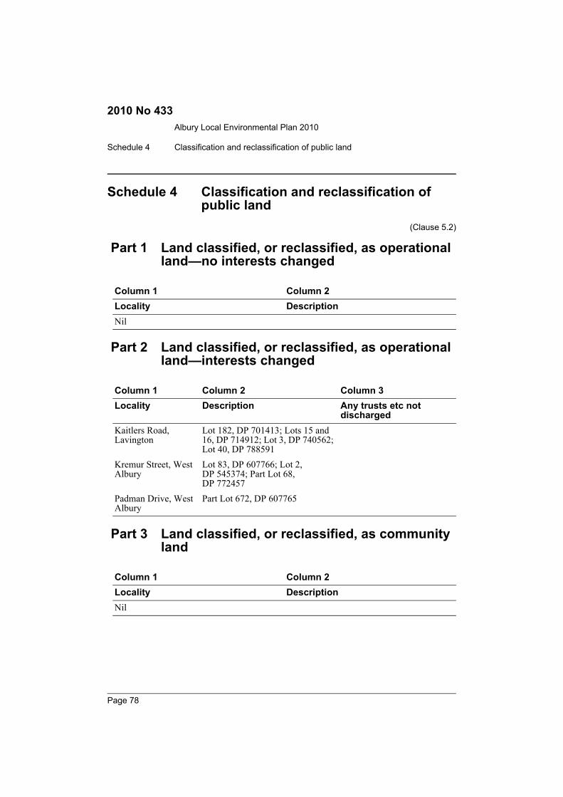
Albury Local Environmental Plan 2010
Schedule 4 Classification and reclassification of public land
2010 No 433
Schedule 4 Classification and reclassification of public land
(Clause 5.2)
Part 1 Land classified, or reclassified, as operational land—no interests changed
Part 2 Land classified, or reclassified, as operational land—interests changed
Part 3 Land classified, or reclassified, as community land
Column 1 Column 2Locality DescriptionNil
Column 1 Column 2 Column 3Locality Description Any trusts etc not
dischargedKaitlers Road, Lavington
Lot 182, DP 701413; Lots 15 and 16, DP 714912; Lot 3, DP 740562; Lot 40, DP 788591
Kremur Street, West Albury
Lot 83, DP 607766; Lot 2, DP 545374; Part Lot 68, DP 772457
Padman Drive, West Albury
Part Lot 672, DP 607765
Column 1 Column 2Locality DescriptionNil
Page 78
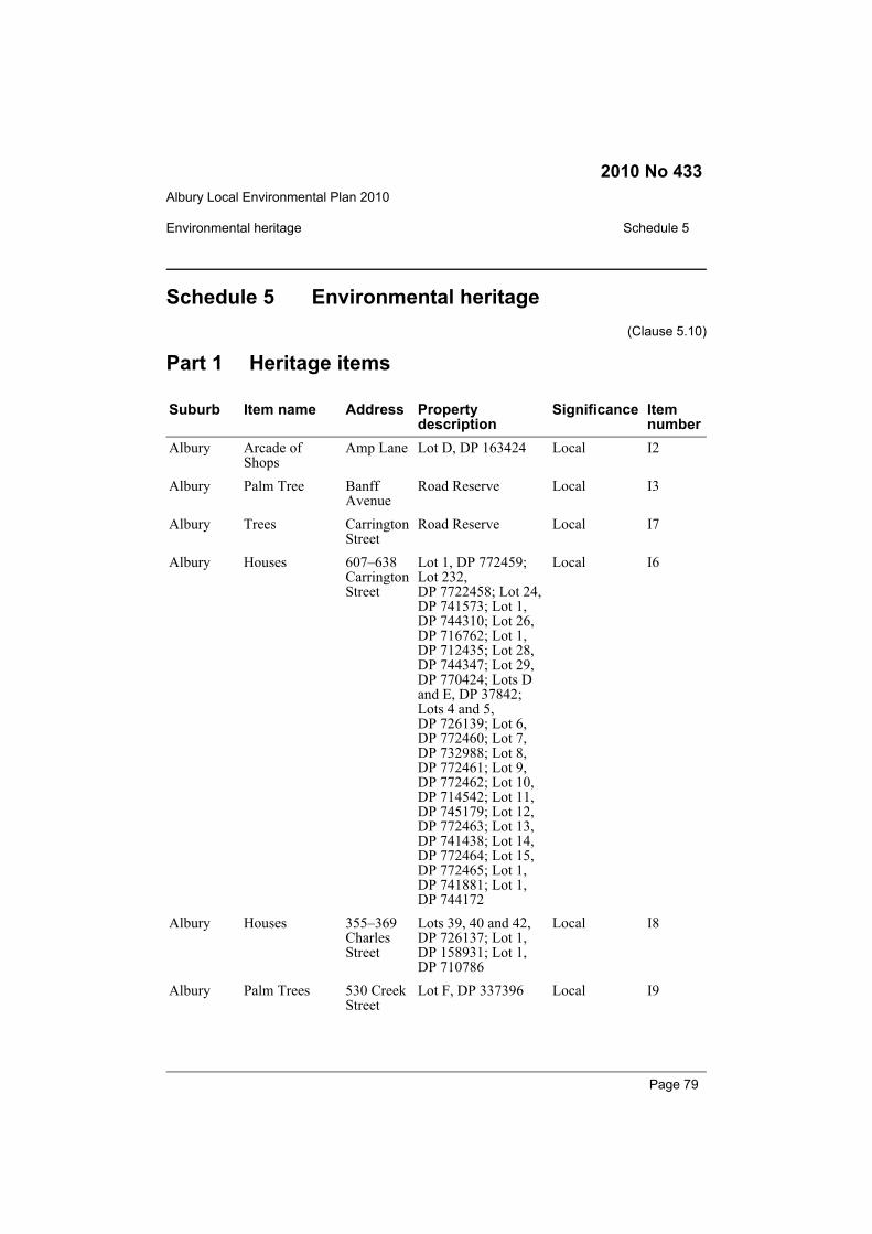
Albury Local Environmental Plan 2010
Environmental heritage Schedule 5
2010 No 433
Schedule 5 Environmental heritage(Clause 5.10)
Part 1 Heritage items
Suburb Item name Address Property description
Significance Item number
Albury Arcade of Shops
Amp Lane Lot D, DP 163424 Local I2
Albury Palm Tree Banff Avenue
Road Reserve Local I3
Albury Trees Carrington Street
Road Reserve Local I7
Albury Houses 607–638 Carrington Street
Lot 1, DP 772459; Lot 232, DP 7722458; Lot 24, DP 741573; Lot 1, DP 744310; Lot 26, DP 716762; Lot 1, DP 712435; Lot 28, DP 744347; Lot 29, DP 770424; Lots D and E, DP 37842; Lots 4 and 5, DP 726139; Lot 6, DP 772460; Lot 7, DP 732988; Lot 8, DP 772461; Lot 9, DP 772462; Lot 10, DP 714542; Lot 11, DP 745179; Lot 12, DP 772463; Lot 13, DP 741438; Lot 14, DP 772464; Lot 15, DP 772465; Lot 1, DP 741881; Lot 1, DP 744172
Local I6
Albury Houses 355–369 Charles Street
Lots 39, 40 and 42, DP 726137; Lot 1, DP 158931; Lot 1, DP 710786
Local I8
Albury Palm Trees 530 Creek Street
Lot F, DP 337396 Local I9
Page 79

Albury Local Environmental Plan 2010
Schedule 5 Environmental heritage
2010 No 433
Albury House “Springfield”
431 Crisp Street
Lot 5, DP 15135 Local I10
Albury House “Avonlea”
511 Crisp Street
Lot 3, DP 726154 Local I11
Albury House 448 David Street
Lot 101, DP 862248 Local I18
Albury Albury Public School “The Castle”
465 David Street
Lot 1, DP 816713 Local I19
Albury Albury Public School
481 David Street
Lot 1, DP 816713 Local I360
Albury The Model Store
582 David Street
Lot 100, DP 800916 State I191
Albury House “Fernhurst”
591 David Street
Part Lot 111, DP 861689
Local I20
Albury Adamshurst 603 David Street
Lot 12, DP 716626 Local I21
Albury Houses 648 and 652 David Street
Lot 2, DP 900688; Part Lot 3, DP 758013
Local I22
Albury House 655 David Street
Lot 3, DP 1041370 Local I23
Albury Corner Store and House
659 David Street
Lot 2, DP 716970 Local I24
Albury Terrace Houses 662–670 David Street
Lots 32–34 and 85, DP 252025; Lot E, DP 108208
Local I25
Albury House 791 David Street
Lot 11, DP 37395 Local I26
Albury Parkland Dean Street (West)
Road Reserve Local I61
Albury Thiel’s Building
442–444 Dean Street
Lot 1, DP 737742 Local I29
Albury Shop 452 Dean Street
Part Lot 1, DP 856110
Local I31
Suburb Item name Address Property description
Significance Item number
Page 80
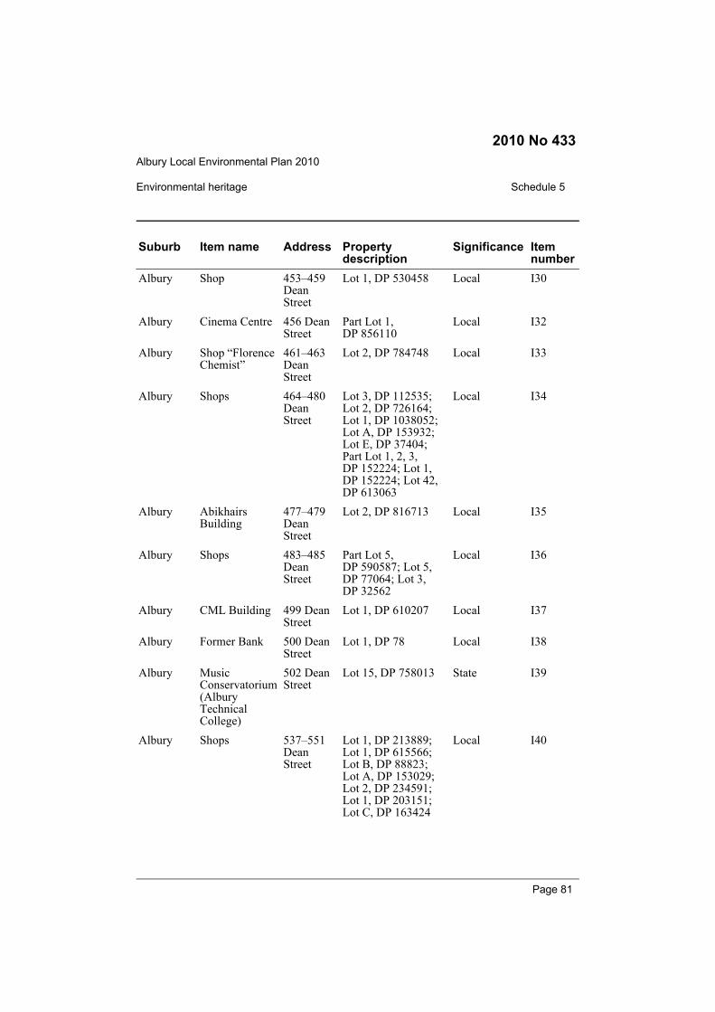
Albury Local Environmental Plan 2010
Environmental heritage Schedule 5
2010 No 433
Albury Shop 453–459 Dean Street
Lot 1, DP 530458 Local I30
Albury Cinema Centre 456 Dean Street
Part Lot 1, DP 856110
Local I32
Albury Shop “Florence Chemist”
461–463 Dean Street
Lot 2, DP 784748 Local I33
Albury Shops 464–480 Dean Street
Lot 3, DP 112535; Lot 2, DP 726164; Lot 1, DP 1038052; Lot A, DP 153932; Lot E, DP 37404; Part Lot 1, 2, 3, DP 152224; Lot 1, DP 152224; Lot 42, DP 613063
Local I34
Albury Abikhairs Building
477–479 Dean Street
Lot 2, DP 816713 Local I35
Albury Shops 483–485 Dean Street
Part Lot 5, DP 590587; Lot 5, DP 77064; Lot 3, DP 32562
Local I36
Albury CML Building 499 Dean Street
Lot 1, DP 610207 Local I37
Albury Former Bank 500 Dean Street
Lot 1, DP 78 Local I38
Albury Music Conservatorium (Albury Technical College)
502 Dean Street
Lot 15, DP 758013 State I39
Albury Shops 537–551 Dean Street
Lot 1, DP 213889; Lot 1, DP 615566; Lot B, DP 88823; Lot A, DP 153029; Lot 2, DP 234591; Lot 1, DP 203151; Lot C, DP 163424
Local I40
Suburb Item name Address Property description
Significance Item number
Page 81
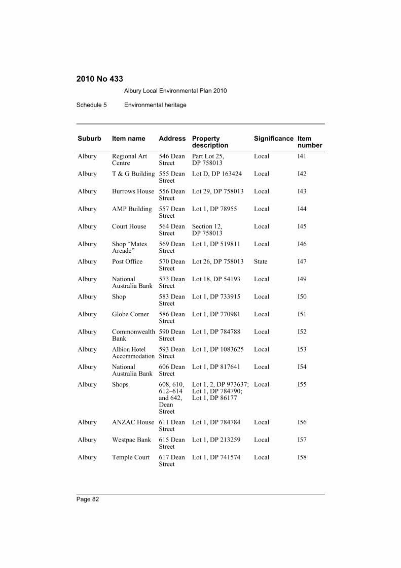
Albury Local Environmental Plan 2010
Schedule 5 Environmental heritage
2010 No 433
Albury Regional Art Centre
546 Dean Street
Part Lot 25, DP 758013
Local I41
Albury T & G Building 555 Dean Street
Lot D, DP 163424 Local I42
Albury Burrows House 556 Dean Street
Lot 29, DP 758013 Local I43
Albury AMP Building 557 Dean Street
Lot 1, DP 78955 Local I44
Albury Court House 564 Dean Street
Section 12, DP 758013
Local I45
Albury Shop “Mates Arcade”
569 Dean Street
Lot 1, DP 519811 Local I46
Albury Post Office 570 Dean Street
Lot 26, DP 758013 State I47
Albury National Australia Bank
573 Dean Street
Lot 18, DP 54193 Local I49
Albury Shop 583 Dean Street
Lot 1, DP 733915 Local I50
Albury Globe Corner 586 Dean Street
Lot 1, DP 770981 Local I51
Albury Commonwealth Bank
590 Dean Street
Lot 1, DP 784788 Local I52
Albury Albion Hotel Accommodation
593 Dean Street
Lot 1, DP 1083625 Local I53
Albury National Australia Bank
606 Dean Street
Lot 1, DP 817641 Local I54
Albury Shops 608, 610, 612–614 and 642, Dean Street
Lot 1, 2, DP 973637; Lot 1, DP 784790; Lot 1, DP 86177
Local I55
Albury ANZAC House 611 Dean Street
Lot 1, DP 784784 Local I56
Albury Westpac Bank 615 Dean Street
Lot 1, DP 213259 Local I57
Albury Temple Court 617 Dean Street
Lot 1, DP 741574 Local I58
Suburb Item name Address Property description
Significance Item number
Page 82

Albury Local Environmental Plan 2010
Environmental heritage Schedule 5
2010 No 433
Albury Beehive Building
637 Dean Street
Lot 1, DP 218953 Local I59
Albury Shop “Maples Building”
639 Dean Street
Lot 1, DP 91049 Local I60
Albury Houses 582–606 Englehardt Street
Lot 1, DP 784769; Lots 1, 3, 5, DP 726176; Lot 1, DP 798367; Lots 1, 2, 3, 4, 5, DP 285428; Lot 3, DP 772441
Local I62
Albury House 730 Fellowes Crescent
Lot 1, DP 16543 Local I63B
Albury Forrest Hill Area
Forrest Hill Avenue
Lots 1, 4, 5, 6, 7, 8, 9, 10, 11, 13, 14, 15, 16, 17, 18, 19, 20, 21, 22, 23, 24, 25, 26, 31, 32, 33, 34, 35, 36, 39, 43, 44, 45, 46, 49, 50, 51, 52, 53, 54, 55, 56, 57, 58, 59, 60, 61, 62, 63, 64, 65, 66, 67, 68, 69, 70, 71, 72, 73, 74, 75 and 76, DP 16543; Lot 1, DP 500096; Lots A and B, DP 374770; Lot 201, DP 29754; Lots A, B and C, DP 336092; Lot 26, DP 251157; Lots A and B, DP 382642; Lots A and B, DP 339171; Lots A, B and C, DP 336632; Lots A and B, DP 335612; Part Lot 1, DP 758013
Local I63A
Albury House 528 George Street
Lot 1, DP 716799 Local I64
Suburb Item name Address Property description
Significance Item number
Page 83
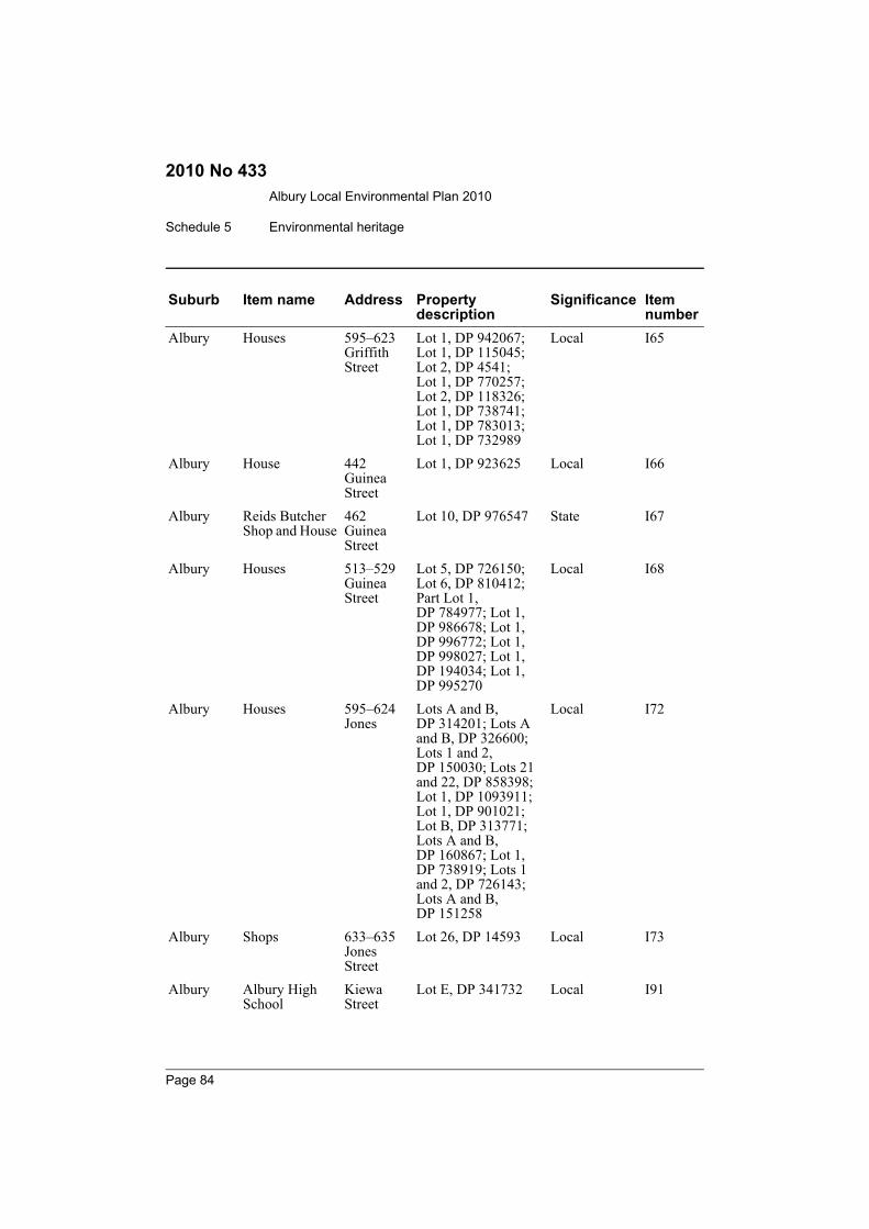
Albury Local Environmental Plan 2010
Schedule 5 Environmental heritage
2010 No 433
Albury Houses 595–623 Griffith Street
Lot 1, DP 942067; Lot 1, DP 115045; Lot 2, DP 4541; Lot 1, DP 770257; Lot 2, DP 118326; Lot 1, DP 738741; Lot 1, DP 783013; Lot 1, DP 732989
Local I65
Albury House 442 Guinea Street
Lot 1, DP 923625 Local I66
Albury Reids Butcher Shop and House
462 Guinea Street
Lot 10, DP 976547 State I67
Albury Houses 513–529 Guinea Street
Lot 5, DP 726150; Lot 6, DP 810412; Part Lot 1, DP 784977; Lot 1, DP 986678; Lot 1, DP 996772; Lot 1, DP 998027; Lot 1, DP 194034; Lot 1, DP 995270
Local I68
Albury Houses 595–624 Jones
Lots A and B, DP 314201; Lots A and B, DP 326600; Lots 1 and 2, DP 150030; Lots 21 and 22, DP 858398; Lot 1, DP 1093911; Lot 1, DP 901021; Lot B, DP 313771; Lots A and B, DP 160867; Lot 1, DP 738919; Lots 1 and 2, DP 726143; Lots A and B, DP 151258
Local I72
Albury Shops 633–635 Jones Street
Lot 26, DP 14593 Local I73
Albury Albury High School
Kiewa Street
Lot E, DP 341732 Local I91
Suburb Item name Address Property description
Significance Item number
Page 84
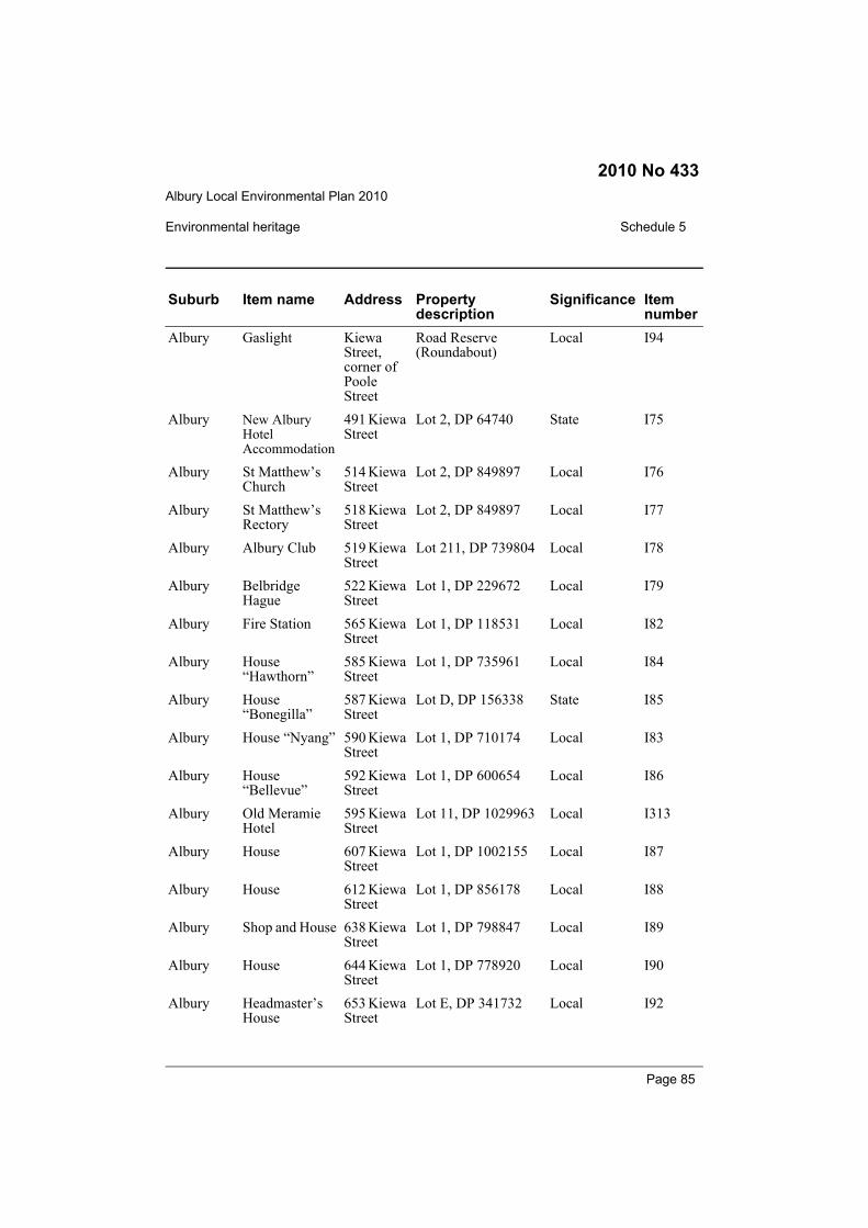
Albury Local Environmental Plan 2010
Environmental heritage Schedule 5
2010 No 433
Albury Gaslight Kiewa Street, corner of Poole Street
Road Reserve (Roundabout)
Local I94
Albury New Albury Hotel Accommodation
491 Kiewa Street
Lot 2, DP 64740 State I75
Albury St Matthew’s Church
514 Kiewa Street
Lot 2, DP 849897 Local I76
Albury St Matthew’s Rectory
518 Kiewa Street
Lot 2, DP 849897 Local I77
Albury Albury Club 519 Kiewa Street
Lot 211, DP 739804 Local I78
Albury Belbridge Hague
522 Kiewa Street
Lot 1, DP 229672 Local I79
Albury Fire Station 565 Kiewa Street
Lot 1, DP 118531 Local I82
Albury House “Hawthorn”
585 Kiewa Street
Lot 1, DP 735961 Local I84
Albury House “Bonegilla”
587 Kiewa Street
Lot D, DP 156338 State I85
Albury House “Nyang” 590 Kiewa Street
Lot 1, DP 710174 Local I83
Albury House “Bellevue”
592 Kiewa Street
Lot 1, DP 600654 Local I86
Albury Old Meramie Hotel
595 Kiewa Street
Lot 11, DP 1029963 Local I313
Albury House 607 Kiewa Street
Lot 1, DP 1002155 Local I87
Albury House 612 Kiewa Street
Lot 1, DP 856178 Local I88
Albury Shop and House 638 Kiewa Street
Lot 1, DP 798847 Local I89
Albury House 644 Kiewa Street
Lot 1, DP 778920 Local I90
Albury Headmaster’s House
653 Kiewa Street
Lot E, DP 341732 Local I92
Suburb Item name Address Property description
Significance Item number
Page 85

Albury Local Environmental Plan 2010
Schedule 5 Environmental heritage
2010 No 433
Albury Trees 682 Kiewa Street
Lot A, DP 360825 Local I93
Albury House 341 Macauley Street
Lot 1, DP 197292 Local I95
Albury Houses 438 and 440 Macauley Street
Lots 1 and 2, DP 794580
Local I100
Albury Houses 446 and 448 Macauley Street
Lot 1, DP 784642 and Lot 2, DP 784643
Local I101
Albury House 447 Macauley Street
Lot 1, DP 795531 Local I102
Albury House 452 Macauley Street
Lot 1, DP 784643 Local I103
Albury Terrace Houses 480–484 Macauley Street
Lot 1, DP 784752; Lot 1, DP 838973; Lot 1, DP 784753
Local I104
Albury House 552 Macauley Street
Lot 2, DP 204045 Local I105
Albury Houses 638–642 Macauley Street
Lot 1, DP 939249; Lot 2, DP 945043; Lot B, DP 348679
Local I106
Albury House “Quamby”
641 Macauley Street
Lot 1, DP 330905 Local I107
Albury Memorial Bowl Monument Hill
Lot 1, DP 41002 Local I108
Albury Monument Monument Hill
Local I110
Albury House 494 Nathan Avenue
Lot 1, DP 734248 Local I111
Albury Convent of Mercy
441 Olive Street
Part Lot 1, DP 1052494
Local I113
Suburb Item name Address Property description
Significance Item number
Page 86

Albury Local Environmental Plan 2010
Environmental heritage Schedule 5
2010 No 433
Albury Albury Public School “The Manor”
468 Olive Street
Lot 1, DP 816713 Local I114
Albury Albury Motors 484 Olive Street
Lot 2, DP 1070613 Local I115
Albury Methodist Church
551 Olive Street
Lot 3, DP 726166 Local I116
Albury Shops “Abikhair’s”
558–560 Olive Street
Lot 2, DP 726163 Local I118
Albury Methodist Church Hall
559 Olive Street
Lot 3, DP 726166 Local I117
Albury St David’s Manse
589 Olive Street
Part Lot 234, DP 839055
Local I119
Albury St David’s Church Hall
591 Olive Street
Part Lot 234, DP 839055
Local I120
Albury St David’s Church
595 Olive Street
Part Lot 234, DP 839055
Local I121
Albury House “The Cedar”
610 Olive Street
Part Lot 111, DP 861689
Local I122
Albury University Buildings
616–630 Olive Street
Part Lot 111, DP 861689
Local I123
Albury Houses 627–645 Olive Street
Lot 1, DP 519345; Lot 106, DP 1034826; Lot B, DP 160168; Lots 1, 2 and 3, DP 726150
Local I126
Albury House “Boldrewood”
640 Olive Street
Part Lot 111, DP 861689
Local I124
Albury House “Adams”
646 Olive Street
Part Lot 111, DP 861689
Local I125
Albury Trees Paine Place
Road Reserve Local I128
Albury House “Ben Werrin”
599 Paine Street
Lot 4, DP 731985 Local I127
Albury House 26 Pilbara Place
Lot 21, DP 632839 Local I129
Suburb Item name Address Property description
Significance Item number
Page 87
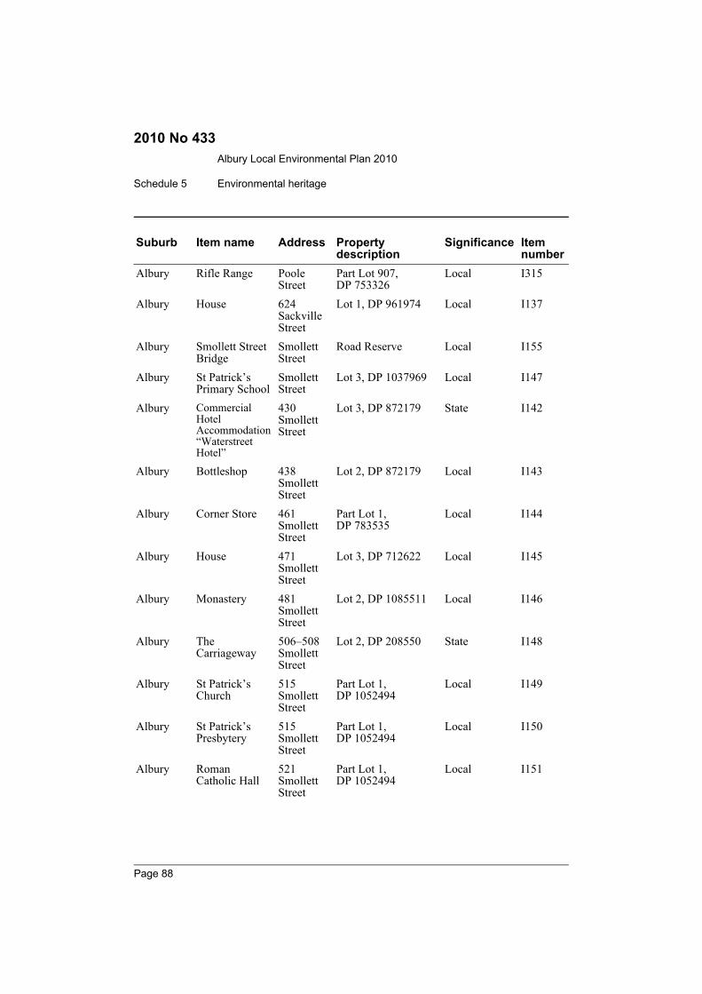
Albury Local Environmental Plan 2010
Schedule 5 Environmental heritage
2010 No 433
Albury Rifle Range Poole Street
Part Lot 907, DP 753326
Local I315
Albury House 624 Sackville Street
Lot 1, DP 961974 Local I137
Albury Smollett Street Bridge
Smollett Street
Road Reserve Local I155
Albury St Patrick’s Primary School
Smollett Street
Lot 3, DP 1037969 Local I147
Albury Commercial Hotel Accommodation “Waterstreet Hotel”
430 Smollett Street
Lot 3, DP 872179 State I142
Albury Bottleshop 438 Smollett Street
Lot 2, DP 872179 Local I143
Albury Corner Store 461 Smollett Street
Part Lot 1, DP 783535
Local I144
Albury House 471 Smollett Street
Lot 3, DP 712622 Local I145
Albury Monastery 481 Smollett Street
Lot 2, DP 1085511 Local I146
Albury The Carriageway
506–508 Smollett Street
Lot 2, DP 208550 State I148
Albury St Patrick’s Church
515 Smollett Street
Part Lot 1, DP 1052494
Local I149
Albury St Patrick’s Presbytery
515 Smollett Street
Part Lot 1, DP 1052494
Local I150
Albury Roman Catholic Hall
521 Smollett Street
Part Lot 1, DP 1052494
Local I151
Suburb Item name Address Property description
Significance Item number
Page 88
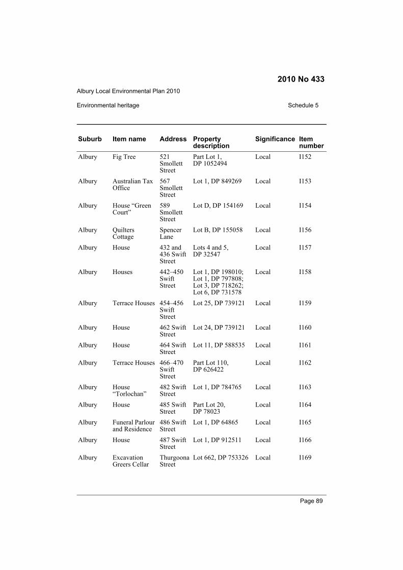
Albury Local Environmental Plan 2010
Environmental heritage Schedule 5
2010 No 433
Albury Fig Tree 521 Smollett Street
Part Lot 1, DP 1052494
Local I152
Albury Australian Tax Office
567 Smollett Street
Lot 1, DP 849269 Local I153
Albury House “Green Court”
589 Smollett Street
Lot D, DP 154169 Local I154
Albury Quilters Cottage
Spencer Lane
Lot B, DP 155058 Local I156
Albury House 432 and 436 Swift Street
Lots 4 and 5, DP 32547
Local I157
Albury Houses 442–450 Swift Street
Lot 1, DP 198010; Lot 1, DP 797808; Lot 3, DP 718262; Lot 6, DP 731578
Local I158
Albury Terrace Houses 454–456 Swift Street
Lot 25, DP 739121 Local I159
Albury House 462 Swift Street
Lot 24, DP 739121 Local I160
Albury House 464 Swift Street
Lot 11, DP 588535 Local I161
Albury Terrace Houses 466–470 Swift Street
Part Lot 110, DP 626422
Local I162
Albury House “Torlochan”
482 Swift Street
Lot 1, DP 784765 Local I163
Albury House 485 Swift Street
Part Lot 20, DP 78023
Local I164
Albury Funeral Parlour and Residence
486 Swift Street
Lot 1, DP 64865 Local I165
Albury House 487 Swift Street
Lot 1, DP 912511 Local I166
Albury Excavation Greers Cellar
Thurgoona Street
Lot 662, DP 753326 Local I169
Suburb Item name Address Property description
Significance Item number
Page 89

Albury Local Environmental Plan 2010
Schedule 5 Environmental heritage
2010 No 433
Albury Houses 522–534 Thurgoona Street
Lots 20, 22, 23, 52 and 53, DP 975067; Lot 21, DP 1037558
Local I168
Albury Shop 552 Thurgoona Street
Lot 2, DP 285455 Local I167
Albury Elm Court 435 Townsend Street
Lot 411, DP 746903 State I172
Albury Shop 459 Townsend Street
Lot 1, DP 88947 Local I173
Albury Kia Ora 473 Townsend Street
Lot 21, DP 1053711 Local I174
Albury House “Cumnock”
418 Wilson Street
Lot 1, DP 199815 Local I184
Albury Houses 420–424 Wilson Street
Lots 31 and 32, DP 705788
Local I185
Albury Shop 426 Wilson Street
Lot 2, DP 744918 Local I186
Albury Shop and Two Dwellings
436–440 Wilson Street
Lots 1, 2, and 3, DP 711823
Local I187
Albury House “Uralba” 443 Wilson Street
Lot 1, DP 735251 Local I188
Albury Gun Shop 444 Wilson Street
Lot D, DP 158810 Local I189
Albury House 449 Wilson Street
Lot 1, DP 711518 Local I190
Albury Soden’s Hotel Accommodation
459 Wilson Street
Lot 1, DP 255854 Local I192
Suburb Item name Address Property description
Significance Item number
Page 90
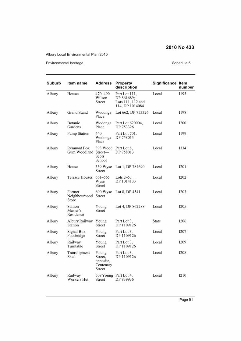
Albury Local Environmental Plan 2010
Environmental heritage Schedule 5
2010 No 433
Albury Houses 470–490 Wilson Street
Part Lot 111, DP 861689; Lots 111, 112 and 114, DP 1014084
Local I193
Albury Grand Stand Wodonga Place
Lot 662, DP 753326 Local I198
Albury Botanic Gardens
Wodonga Place
Part Lot 620004, DP 753326
Local I200
Albury Pump Station 440 Wodonga Place
Part Lot 701, DP 758013
Local I199
Albury Remnant Box Gum Woodland
393 Wood Street—Scots School
Part Lot 8, DP 758013
Local I334
Albury House 559 Wyse Street
Lot 1, DP 784690 Local I201
Albury Terrace Houses 561–565 Wyse Street
Lots 2–5, DP 1014133
Local I202
Albury Former Neighbourhood Store
600 Wyse Street
Lot 8, DP 4541 Local I203
Albury Station Master’s Residence
Young Street
Lot 4, DP 862288 Local I205
Albury Albury Railway Station
Young Street
Part Lot 3, DP 1109126
State I206
Albury Signal Box, Footbridge
Young Street
Part Lot 3, DP 1109126
Local I207
Albury Railway Turntable
Young Street
Part Lot 3, DP 1109126
Local I209
Albury Transhipment Shed
Young Street, opposite, Centenary Street
Part Lot 3, DP 1109126
Local I208
Albury Railway Workers Hut
508 Young Street
Part Lot 4, DP 839936
Local I210
Suburb Item name Address Property description
Significance Item number
Page 91
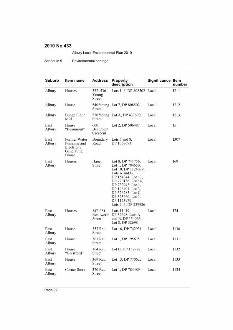
Albury Local Environmental Plan 2010
Schedule 5 Environmental heritage
2010 No 433
Albury Houses 532–536 Young Street
Lots 1–6, DP 808502 Local I211
Albury House 540 Young Street
Lot 7, DP 808502 Local I212
Albury Bunge Flour Mill
570 Young Street
Lot A, DP 437690 Local I213
East Albury
House “Beaumont”
600 Beaumont Crescent
Lot 2, DP 506487 Local I5
East Albury
Former Water Pumping and Electricity Generating House
Boundary Road
Lots 6 and 8, DP 1068693
Local I307
East Albury
Houses Hanel Street
Lot 8, DP 741756; Lot 1, DP 784650; Lot 10, DP 1124079; Lots A and B, DP 154844; Lot 13, DP 770136; Lot 14, DP 732943; Lot 1, DP 196401; Lot 3, DP 326283; Lot C, DP 323660; Lot 1, DP 1123979; Lots 2–5, DP 229926
Local I69
East Albury
Houses 347–381 Kenilworth Street
Lots 11–19, DP 32698; Lots A and B, DP 154066; Lot 8, DP 32698
Local I74
East Albury
House 357 Rau Street
Lot 16, DP 742931 Local I130
East Albury
House 361 Rau Street
Lot 1, DP 195675 Local I131
East Albury
House “Grestford”
364 Rau Street
Lot B, DP 157988 Local I132
East Albury
House 369 Rau Street
Lot 13, DP 770622 Local I133
East Albury
Corner Store 370 Rau Street
Lot 1, DP 784489 Local I134
Suburb Item name Address Property description
Significance Item number
Page 92
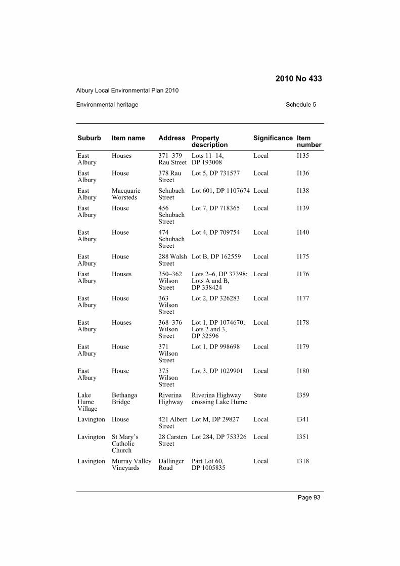
Albury Local Environmental Plan 2010
Environmental heritage Schedule 5
2010 No 433
East Albury
Houses 371–379 Rau Street
Lots 11–14, DP 193008
Local I135
East Albury
House 378 Rau Street
Lot 5, DP 731577 Local I136
East Albury
Macquarie Worsteds
Schubach Street
Lot 601, DP 1107674 Local I138
East Albury
House 456 Schubach Street
Lot 7, DP 718365 Local I139
East Albury
House 474 Schubach Street
Lot 4, DP 709754 Local I140
East Albury
House 288 Walsh Street
Lot B, DP 162559 Local I175
East Albury
Houses 350–362 Wilson Street
Lots 2–6, DP 37398; Lots A and B, DP 338424
Local I176
East Albury
House 363 Wilson Street
Lot 2, DP 326283 Local I177
East Albury
Houses 368–376 Wilson Street
Lot 1, DP 1074670; Lots 2 and 3, DP 32596
Local I178
East Albury
House 371 Wilson Street
Lot 1, DP 998698 Local I179
East Albury
House 375 Wilson Street
Lot 3, DP 1029901 Local I180
Lake Hume Village
Bethanga Bridge
Riverina Highway
Riverina Highway crossing Lake Hume
State I359
Lavington House 421 Albert Street
Lot M, DP 29827 Local I341
Lavington St Mary’s Catholic Church
28 Carsten Street
Lot 284, DP 753326 Local I351
Lavington Murray Valley Vineyards
Dallinger Road
Part Lot 60, DP 1005835
Local I318
Suburb Item name Address Property description
Significance Item number
Page 93
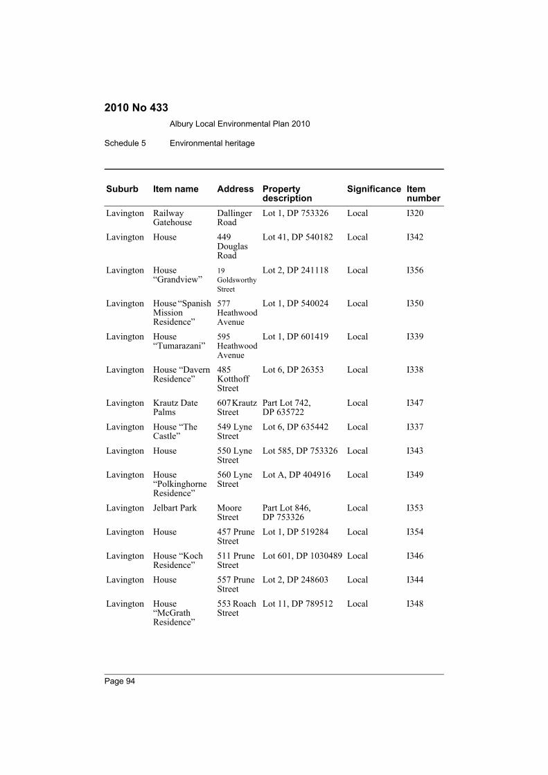
Albury Local Environmental Plan 2010
Schedule 5 Environmental heritage
2010 No 433
Lavington Railway Gatehouse
Dallinger Road
Lot 1, DP 753326 Local I320
Lavington House 449 Douglas Road
Lot 41, DP 540182 Local I342
Lavington House “Grandview”
19 Goldsworthy Street
Lot 2, DP 241118 Local I356
Lavington House “Spanish Mission Residence”
577 Heathwood Avenue
Lot 1, DP 540024 Local I350
Lavington House “Tumarazani”
595 Heathwood Avenue
Lot 1, DP 601419 Local I339
Lavington House “Davern Residence”
485 Kotthoff Street
Lot 6, DP 26353 Local I338
Lavington Krautz Date Palms
607 Krautz Street
Part Lot 742, DP 635722
Local I347
Lavington House “The Castle”
549 Lyne Street
Lot 6, DP 635442 Local I337
Lavington House 550 Lyne Street
Lot 585, DP 753326 Local I343
Lavington House “Polkinghorne Residence”
560 Lyne Street
Lot A, DP 404916 Local I349
Lavington Jelbart Park Moore Street
Part Lot 846, DP 753326
Local I353
Lavington House 457 Prune Street
Lot 1, DP 519284 Local I354
Lavington House “Koch Residence”
511 Prune Street
Lot 601, DP 1030489 Local I346
Lavington House 557 Prune Street
Lot 2, DP 248603 Local I344
Lavington House “McGrath Residence”
553 Roach Street
Lot 11, DP 789512 Local I348
Suburb Item name Address Property description
Significance Item number
Page 94
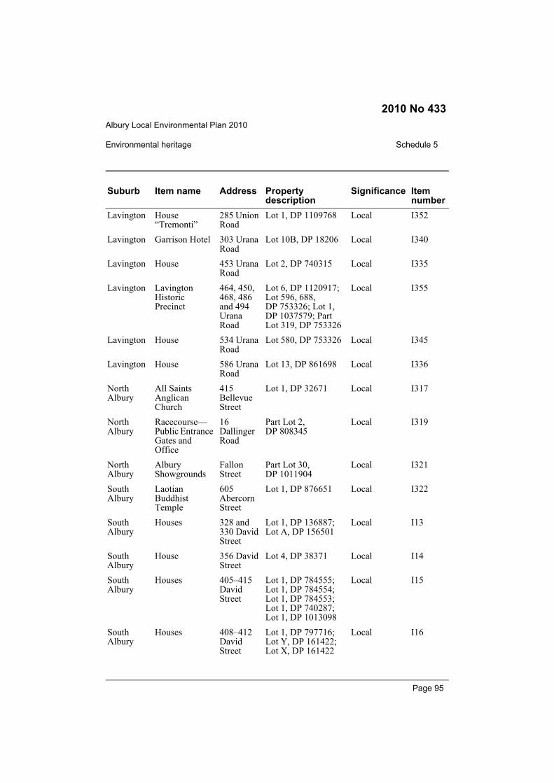
Albury Local Environmental Plan 2010
Environmental heritage Schedule 5
2010 No 433
Lavington House “Tremonti”
285 Union Road
Lot 1, DP 1109768 Local I352
Lavington Garrison Hotel 303 Urana Road
Lot 10B, DP 18206 Local I340
Lavington House 453 Urana Road
Lot 2, DP 740315 Local I335
Lavington Lavington Historic Precinct
464, 450, 468, 486 and 494 Urana Road
Lot 6, DP 1120917; Lot 596, 688, DP 753326; Lot 1, DP 1037579; Part Lot 319, DP 753326
Local I355
Lavington House 534 Urana Road
Lot 580, DP 753326 Local I345
Lavington House 586 Urana Road
Lot 13, DP 861698 Local I336
North Albury
All Saints Anglican Church
415 Bellevue Street
Lot 1, DP 32671 Local I317
North Albury
Racecourse—Public Entrance Gates and Office
16 Dallinger Road
Part Lot 2, DP 808345
Local I319
North Albury
Albury Showgrounds
Fallon Street
Part Lot 30, DP 1011904
Local I321
South Albury
Laotian Buddhist Temple
605 Abercorn Street
Lot 1, DP 876651 Local I322
South Albury
Houses 328 and 330 David Street
Lot 1, DP 136887; Lot A, DP 156501
Local I13
South Albury
House 356 David Street
Lot 4, DP 38371 Local I14
South Albury
Houses 405–415 David Street
Lot 1, DP 784555; Lot 1, DP 784554; Lot 1, DP 784553; Lot 1, DP 740287; Lot 1, DP 1013098
Local I15
South Albury
Houses 408–412 David Street
Lot 1, DP 797716; Lot Y, DP 161422; Lot X, DP 161422
Local I16
Suburb Item name Address Property description
Significance Item number
Page 95
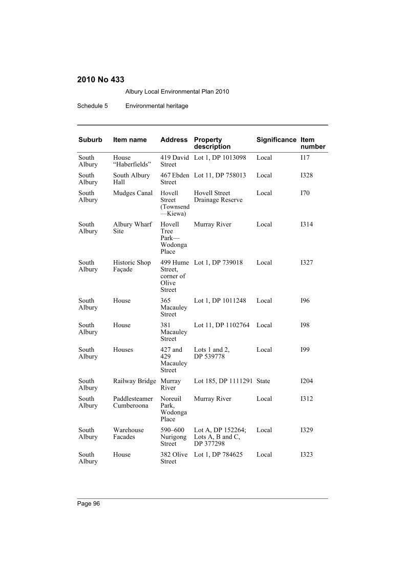
Albury Local Environmental Plan 2010
Schedule 5 Environmental heritage
2010 No 433
South Albury
House “Haberfields”
419 David Street
Lot 1, DP 1013098 Local I17
South Albury
South Albury Hall
467 Ebden Street
Lot 11, DP 758013 Local I328
South Albury
Mudges Canal Hovell Street (Townsend—Kiewa)
Hovell Street Drainage Reserve
Local I70
South Albury
Albury Wharf Site
Hovell Tree Park—Wodonga Place
Murray River Local I314
South Albury
Historic Shop Façade
499 Hume Street, corner of Olive Street
Lot 1, DP 739018 Local I327
South Albury
House 365 Macauley Street
Lot 1, DP 1011248 Local I96
South Albury
House 381 Macauley Street
Lot 11, DP 1102764 Local I98
South Albury
Houses 427 and 429 Macauley Street
Lots 1 and 2, DP 539778
Local I99
South Albury
Railway Bridge Murray River
Lot 185, DP 1111291 State I204
South Albury
Paddlesteamer Cumberoona
Noreuil Park, Wodonga Place
Murray River Local I312
South Albury
Warehouse Facades
590–600 Nurigong Street
Lot A, DP 152264; Lots A, B and C, DP 377298
Local I329
South Albury
House 382 Olive Street
Lot 1, DP 784625 Local I323
Suburb Item name Address Property description
Significance Item number
Page 96

Albury Local Environmental Plan 2010
Environmental heritage Schedule 5
2010 No 433
South Albury
Houses 316–318 Townsend Street
Lot B, DP 157752 Local I170
South Albury
House 322 Townsend Street
Lot A, DP 157752 Local I324
South Albury
House 332 Townsend Street
Lot 11, DP 734388 Local I325
South Albury
House 364 Townsend Street
Lot F, DP 159662 Local I326
South Albury
Gas and Fuel Building
419 Townsend Street
Lot 1, DP 226889 Local I171
South Albury
Turks Head Museum
Wodonga Place
Lot 1, DP 542181 Local I195
South Albury
Hovell Tree Wodonga Place
Lot 7057, DP 1023470
Local I197
South Albury
Car Club House 292 Wodonga Place
Lot 1, DP 758013 Local I194
South Albury
circa 1885 Brick Colonial Georgian Building
406 Wodonga Place
Lot 1, DP 1076239 Local I196
Springdale Heights
House “Muniong”
Hume Highway
Lot 21, DP 625950 Local I214
Table Top Ettamogah Vineyard Ruins
Ettamogah Road
Lot 1, DP 129993 Local I316
Table Top House “The Ivy”
610 Old Sydney Road
Lot 251, DP 876607 Local I311
Table Top House “The Glasshouse”
638 Old Sydney Road
Lot 1, DP 224527 Local I309
Table Top Maryvale Table Top Road
Lot 100, DP 100761 Local I310
Suburb Item name Address Property description
Significance Item number
Page 97
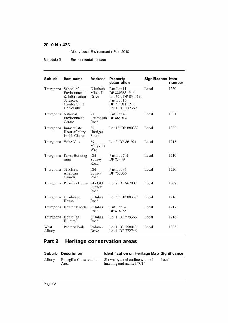
Albury Local Environmental Plan 2010
Schedule 5 Environmental heritage
2010 No 433
Part 2 Heritage conservation areas
Thurgoona School of Environmental & Information Sciences, Charles Sturt University
Elizabeth Mitchell Drive
Part Lot 11, DP 880383; Part Lot 701, DP 834429; Part Lot 16, DP 717911; Part Lot 1, DP 132369
Local I330
Thurgoona National Environment Centre
97 Ettamogah Road
Part Lot 4, DP 865914
Local I331
Thurgoona Immaculate Heart of Mary Parish Church
20 Hartigan Street
Lot 12, DP 880383 Local I332
Thurgoona Wine Vats 69 Maryville Way
Lot 2, DP 861921 Local I215
Thurgoona Farm, Building ruins
Old Sydney Road
Part Lot 701, DP 83449
Local I219
Thurgoona St John’s Anglican Church
Old Sydney Road
Part Lot 83, DP 753356
Local I220
Thurgoona Riverina House 545 Old Sydney Road
Lot 8, DP 867003 Local I308
Thurgoona Guadalupe House
St Johns Road
Lot 36, DP 883375 Local I216
Thurgoona House “Noorla” St Johns Road
Part Lot 62, DP 878155
Local I217
Thurgoona House “St Hillaire”
St Johns Road
Lot 1, DP 579366 Local I218
West Albury
Padman Park Padman Drive
Lot 1, DP 758013; Lot 4, DP 772746
Local I333
Suburb Description Identification on Heritage Map SignificanceAlbury Bonegilla Conservation
AreaShown by a red outline with red hatching and marked “C1”
Local
Suburb Item name Address Property description
Significance Item number
Page 98
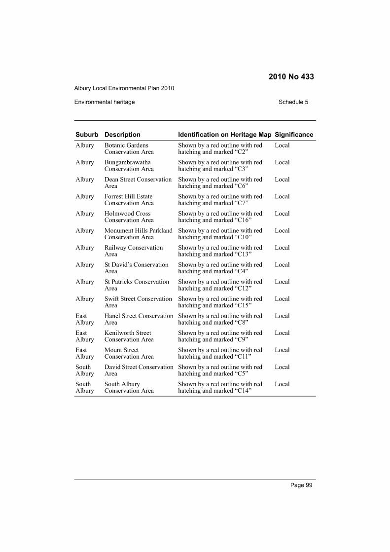
Albury Local Environmental Plan 2010
Environmental heritage Schedule 5
2010 No 433
Albury Botanic Gardens Conservation Area
Shown by a red outline with red hatching and marked “C2”
Local
Albury Bungambrawatha Conservation Area
Shown by a red outline with red hatching and marked “C3”
Local
Albury Dean Street Conservation Area
Shown by a red outline with red hatching and marked “C6”
Local
Albury Forrest Hill Estate Conservation Area
Shown by a red outline with red hatching and marked “C7”
Local
Albury Holmwood Cross Conservation Area
Shown by a red outline with red hatching and marked “C16”
Local
Albury Monument Hills Parkland Conservation Area
Shown by a red outline with red hatching and marked “C10”
Local
Albury Railway Conservation Area
Shown by a red outline with red hatching and marked “C13”
Local
Albury St David’s Conservation Area
Shown by a red outline with red hatching and marked “C4”
Local
Albury St Patricks Conservation Area
Shown by a red outline with red hatching and marked “C12”
Local
Albury Swift Street Conservation Area
Shown by a red outline with red hatching and marked “C15”
Local
East Albury
Hanel Street Conservation Area
Shown by a red outline with red hatching and marked “C8”
Local
East Albury
Kenilworth Street Conservation Area
Shown by a red outline with red hatching and marked “C9”
Local
East Albury
Mount Street Conservation Area
Shown by a red outline with red hatching and marked “C11”
Local
South Albury
David Street Conservation Area
Shown by a red outline with red hatching and marked “C5”
Local
South Albury
South Albury Conservation Area
Shown by a red outline with red hatching and marked “C14”
Local
Suburb Description Identification on Heritage Map Significance
Page 99
Albury Local Environmental Plan 2010
Dictionary
2010 No 433
Dictionary(Clause 1.4)
Aboriginal object means any deposit, object or other material evidence (not being ahandicraft made for sale) relating to the Aboriginal habitation of an area of NewSouth Wales, being habitation before or concurrent with (or both) the occupation ofthat area by persons of non-Aboriginal extraction, and includes Aboriginal remains.acid sulfate soils means naturally occurring sediments and soils containing ironsulfides (principally pyrite) or their precursors or oxidation products, whoseexposure to oxygen leads to the generation of sulfuric acid (for example, by drainageor excavation).Acid Sulfate Soils Manual means the manual by that name published by the AcidSulfate Soils Management Advisory Committee and made publicly available.advertisement has the same meaning as in the Act.Note. The term is defined as a sign, notice, device or representation in the nature of anadvertisement visible from any public place or public reserve or from any navigable water.advertising structure has the same meaning as in the Act.Note. The term is defined as a structure used or to be used principally for the display of anadvertisement.affordable housing has the same meaning as in the Act.Note. The term is defined as housing for very low income households, low income householdsor moderate income households, being such households as are prescribed by the regulationsor as are provided for in an environmental planning instrument.agricultural produce industry means an industry involving the handling, treating,processing or packing of produce from agriculture (including dairy products, seeds,fruit, vegetables or other plant material), and includes flour mills, cotton seed oilplants, cotton gins, feed mills, cheese and butter factories, and juicing or canningplants, but does not include a livestock processing industry.agriculture means any of the following:(a) animal boarding or training establishments,(b) aquaculture,(c) extensive agriculture,(d) farm forestry,(e) intensive livestock agriculture,(f) intensive plant agriculture.
air transport facility means an airport or a heliport that is not part of an airport, andincludes associated communication and air traffic control facilities or structures.airport means a place used for the landing, taking off, parking, maintenance or repairof aeroplanes (including associated buildings, installations, facilities and movementareas and any heliport that is part of the airport).
Page 100
Albury Local Environmental Plan 2010
Dictionary
2010 No 433
airstrip means a single runway for the landing, taking off or parking of aeroplanesfor private aviation only, but does not include an airport, heliport or helipad.amusement centre means a building or place (not being part of a pub or registeredclub) used principally for playing:(a) billiards, pool or other like games, or(b) electronic or mechanical amusement devices, such as pinball machines,
computer or video games and the like.animal boarding or training establishment means a building or place used for thebreeding, boarding, training, keeping or caring of animals for commercial purposes(other than for the agistment of horses), and includes any associated riding school orancillary veterinary hospital.aquaculture has the same meaning as in the Fisheries Management Act 1994.Note. The term is defined as follows:aquaculture means:(a) cultivating fish or marine vegetation for the purposes of harvesting the fish or marine
vegetation or their progeny with a view to sale, or(b) keeping fish or marine vegetation in a confined area for a commercial purpose (such
as a fish-out pond),but does not include:(c) keeping anything in a pet shop for sale or in an aquarium for exhibition (including an
aquarium operated commercially), or(d) anything done for the purposes of maintaining a collection of fish or marine vegetation
otherwise than for a commercial purpose, or(e) any other thing prescribed by the regulations (made under the Fisheries Management
Act 1994).This Dictionary also contains definitions of natural water-based aquaculture, pond-basedaquaculture and tank-based aquaculture.archaeological site means an area of land:(a) shown on the Heritage Map as an archaeological site, and(b) the location and nature of which is described in Schedule 5, and(c) that contains one or more relics.attached dwelling means a building containing 3 or more dwellings, where:(a) each dwelling is attached to another dwelling by a common wall, and(b) each of the dwellings is on its own lot of land (not being an individual lot in a
strata plan or community title scheme), and(c) none of the dwellings is located above any part of another dwelling.attic means any habitable space, but not a separate dwelling, contained wholly withina roof above the ceiling line of the storey immediately below, except for minorelements such as dormer windows and the like.
Page 101
Albury Local Environmental Plan 2010
Dictionary
2010 No 433
backpackers’ accommodation means tourist and visitor accommodation:(a) that has shared facilities, such as a communal bathroom, kitchen or laundry,
and(b) that will generally provide accommodation on a bed basis (rather than by
room).basement means the space of a building where the floor level of that space ispredominantly below ground level (existing) and where the floor level of the storeyimmediately above is less than 1 metre above ground level (existing).bed and breakfast accommodation means tourist and visitor accommodationcomprising a dwelling (and any ancillary buildings and parking) where theaccommodation is provided by the permanent residents of the dwelling and:(a) meals are provided for guests only, and(b) cooking facilities for the preparation of meals are not provided within guests’
rooms, and(c) dormitory-style accommodation is not provided.Note. See clause 5.4 for controls relating to the number of bedrooms.biodiversity means biological diversity.biological diversity has the same meaning as in the Threatened Species ConservationAct 1995.Note. The term is defined as follows:biological diversity means the diversity of life and is made up of the following 3 components:(a) genetic diversity—the variety of genes (or units of heredity) in any population,(b) species diversity—the variety of species,(c) ecosystem diversity—the variety of communities or ecosystems.biosolid waste application means the application of sludge or other semi-solidproducts of human sewage treatment plants to land for the purpose of improving landproductivity, that is undertaken in accordance with the NSW Environment ProtectionAuthority’s guidelines titled Environmental Guidelines: Use and Disposal ofBiosolids Products (EPA 1997) and Addendum to Environmental Guidelines: Useand Disposal of Biosolids Products (EPA 2000a).biosolids treatment facility means a building or place used as a facility for thetreatment of biosolids from a sewage treatment plant or from a water recyclingfacility.boarding house means a building:(a) that is wholly or partly let in lodgings, and(b) that provides lodgers with a principal place of residence for 3 months or more,
and(c) that may have shared facilities, such as a communal living room, bathroom,
kitchen or laundry, and
Page 102

Albury Local Environmental Plan 2010
Dictionary
2010 No 433
(d) that has rooms, some or all of which may have private kitchen and bathroomfacilities, that accommodate one or more lodgers,
but does not include backpackers’ accommodation, a group home, a servicedapartment, seniors housing or hotel or motel accommodation.boat launching ramp means a structure designed primarily for the launching oftrailer borne recreational vessels, and includes associated car parking facilities.boat repair facility means any facility (including a building or other structure) usedprimarily for the construction, maintenance or repair of boats, whether or notincluding the storage, sale or hire of boats, but does not include a marina or boat shed.boat shed means a building or other structure used for the storage and routinemaintenance of a boat or boats and that is associated with a private dwelling ornon-profit organisation, and includes any skid used in connection with the buildingor other structure.brothel has the same meaning as in the Act.building has the same meaning as in the Act.Note. The term is defined to include part of a building and any structure or part of a structure,but not including a manufactured home, a moveable dwelling or associated structure (or partof a manufactured home, moveable dwelling or associated structure).building height (or height of building) means the vertical distance between groundlevel (existing) at any point to the highest point of the building, including plant andlift overruns, but excluding communication devices, antennae, satellite dishes, masts,flagpoles, chimneys, flues and the like.building identification sign means a sign that identifies or names a building and thatmay include the name of a building, the street name and number of a building, and alogo or other symbol, but that does not include general advertising of products, goodsor services.building line or setback means the horizontal distance between the propertyboundary or other stated boundary (measured at 90 degrees from the boundary) and:(a) a building wall, or(b) the outside face of any balcony, deck or the like, or(c) the supporting posts of a carport or verandah roof,whichever distance is the shortest.bulky goods premises means a building or place used primarily for the sale by retail,wholesale or auction of (or for the hire or display of) bulky goods, being goods thatare of such size or weight as to require:(a) a large area for handling, display or storage, or(b) direct vehicular access to the site of the building or place by members of the
public for the purpose of loading or unloading such goods into or from theirvehicles after purchase or hire,
but does not include a building or place used for the sale of foodstuffs or clothingunless their sale is ancillary to the sale or hire or display of bulky goods.
Page 103
Albury Local Environmental Plan 2010
Dictionary
2010 No 433
bush fire hazard reduction work has the same meaning as in the Rural Fires Act1997.Note. The term is defined as follows:bush fire hazard reduction work means:(a) the establishment or maintenance of fire breaks on land, and(b) the controlled application of appropriate fire regimes or other means for the reduction
or modification of available fuels within a predetermined area to mitigate against thespread of a bush fire,
but does not include construction of a track, trail or road.bush fire prone land has the same meaning as in the Act.Note. The term is defined, in relation to an area, as land recorded for the time being as bushfire prone land on a map for the area certified as referred to in section 146 (2) of the Act.bush fire risk management plan means a plan prepared under Division 4 of Part 3of the Rural Fires Act 1997 for the purpose referred to in section 54 of that Act.business identification sign means a sign:(a) that indicates:
(i) the name of the person or business, and(ii) the nature of the business carried on by the person at the premises or
place at which the sign is displayed, and(b) that may include the address of the premises or place and a logo or other
symbol that identifies the business,but that does not include any advertising relating to a person who does not carry onbusiness at the premises or place.business premises means a building or place at or on which:(a) an occupation, profession or trade (other than an industry) is carried on for the
provision of services directly to members of the public on a regular basis, or(b) a service is provided directly to members of the public on a regular basis,and may include, without limitation, premises such as banks, post offices,hairdressers, dry cleaners, travel agencies, internet access facilities, medical centres,betting agencies and the like, but does not include sex services premises.canal estate development means development that incorporates wholly or in part aconstructed canal, or other waterway or waterbody, that is inundated by or drains toa natural waterway or natural waterbody by surface water or groundwater movement(not being works of drainage, or for the supply or treatment of water, that areconstructed by or with the authority of a person or body responsible for thosefunctions and that are limited to the minimal reasonable size and capacity to meet ademonstrated need for the works), and that either:(a) includes the construction of dwellings (which may include tourist and visitor
accommodation) of a kind other than, or in addition to:(i) dwellings that are permitted on rural land, and
(ii) dwellings that are used for caretaker or staff purposes, or
Page 104
Albury Local Environmental Plan 2010
Dictionary
2010 No 433
(b) requires the use of a sufficient depth of fill material to raise the level of all orpart of that land on which the dwellings are (or are proposed to be) located inorder to comply with requirements relating to residential development onflood prone land.
car park means a building or place primarily used for the purpose of parking motorvehicles, including any manoeuvring space and access thereto, whether operated forgain or not.caravan park means land (including a camping ground) on which caravans (orcaravans and other moveable dwellings) are, or are to be, installed or placed.catchment action plan has the same meaning as in the Catchment ManagementAuthorities Act 2003.Note. The term is defined as a catchment action plan of an authority that has been approvedby the Minister under Part 4 of the Catchment Management Authorities Act 2003.cellar door premises means retail premises that sell wine by retail and that aresituated on land on which there is a commercial vineyard, where all of the wineoffered for sale is produced in a winery situated on that land or is producedpredominantly from grapes grown in the surrounding area.cemetery means a building or place for the interment of deceased persons or theirashes.charter and tourism boating facility means any facility (including a building or otherstructure) used for charter boating or tourism boating purposes, being a facility thatis used only by the operators of the facility and that has a direct structural connectionbetween the foreshore and the waterway, but does not include a marina.child care centre means a building or place used for the supervision and care ofchildren that:(a) provides long day care, pre-school care, occasional child care or
out-of-school-hours care, and(b) does not provide overnight accommodation for children other than those
related to the owner or operator of the centre,but does not include:(c) a building or place used for home-based child care, or(d) an out-of-home care service provided by an agency or organisation accredited
by the Children’s Guardian, or(e) a baby-sitting, playgroup or child-minding service that is organised informally
by the parents of the children concerned, or(f) a service provided for fewer than 5 children (disregarding any children who
are related to the person providing the service) at the premises at which at leastone of the children resides, being a service that is not advertised, or
(g) a regular child-minding service that is provided in connection with arecreational or commercial facility (such as a gymnasium), by or on behalf of
Page 105
Albury Local Environmental Plan 2010
Dictionary
2010 No 433
the person conducting the facility, to care for children while the children’sparents are using the facility, or
(h) a service that is concerned primarily with the provision of:(i) lessons or coaching in, or providing for participation in, a cultural,
recreational, religious or sporting activity, or(ii) private tutoring, or
(i) a school, or(j) a service provided at exempt premises (within the meaning of Chapter 12 of
the Children and Young Persons (Care and Protection) Act 1998), such ashospitals, but only if the service is established, registered or licensed as part ofthe institution operating on those premises.
classified road has the same meaning as in the Roads Act 1993.Note. The term is defined as follows:classified road means any of the following:(a) a main road,(b) a highway,(c) a freeway,(d) a controlled access road,(e) a secondary road,(f) a tourist road,(g) a tollway,(h) a transitway,(i) a State work.
(See Roads Act 1993 for meanings of these terms.)clearing native vegetation has the same meaning as in the Native Vegetation Act2003.Note. The term is defined as follows:clearing native vegetation means any one or more of the following:(a) cutting down, felling, thinning, logging or removing native vegetation,(b) killing, destroying, poisoning, ringbarking, uprooting or burning native vegetation.(See Division 3 of Part 3 of the Native Vegetation Act 2003 for the exclusion of routineagricultural management and other farming activities from constituting the clearing of nativevegetation if the landholder can establish that any clearing was carried out for the purpose ofthose activities.)coastal foreshore means land with frontage to a beach, estuary, coastal lake,headland, cliff or rock platform.coastal lake means a body of water specified in Schedule 1 to the StateEnvironmental Planning Policy No 71—Coastal Protection.coastal waters of the State—see section 58 of the Interpretation Act 1987.
Page 106
Albury Local Environmental Plan 2010
Dictionary
2010 No 433
coastal zone has the same meaning as in the Coastal Protection Act 1979.Note. The term is defined as follows:coastal zone means:(a) the area within the coastal waters of the State as defined in Part 10 of the Interpretation
Act 1987 (including any land within those waters), and(b) the area of land and the waters that lie between the western boundary of the coastal
zone (as shown on the maps outlining the coastal zone) and the landward boundary ofthe coastal waters of the State, and
(c) the seabed (if any) and the subsoil beneath, and the airspace above, the areas referredto in paragraphs (a) and (b).
The coastal zone consists of the area between the western boundary of the coastal zoneshown on the maps outlining the coastal zone and the outermost boundary of the coastalwaters of the State. The coastal waters of the State extend, generally, to 3 nautical miles fromthe coastline of the State.community facility means a building or place:(a) owned or controlled by a public authority or non-profit community
organisation, and(b) used for the physical, social, cultural or intellectual development or welfare of
the community,but does not include an educational establishment, hospital, retail premises, place ofpublic worship or residential accommodation.community land has the same meaning as in the Local Government Act 1993.correctional centre means:(a) any premises declared to be a correctional centre by a proclamation in force
under section 225 of the Crimes (Administration of Sentences) Act 1999,including any juvenile correctional centre or periodic detention centre, and
(b) any premises declared to be a detention centre by an order in force undersection 5 (1) of the Children (Detention Centres) Act 1987,
but does not include any police station or court cell complex in which a person is heldin custody in accordance with any Act.Council means the Albury City Council.crematorium means a building in which deceased persons or pets are cremated, andincludes a funeral chapel.Crown reserve means:(a) a reserve within the meaning of Part 5 of the Crown Lands Act 1989, or(b) a common within the meaning of the Commons Management Act 1989, or(c) lands within the meaning of the Trustees of Schools of Arts Enabling Act 1902,but does not include land that forms any part of a reserve under Part 5 of the CrownLands Act 1989 provided for accommodation.curtilage, in relation to a heritage item or conservation area, means the area of land(including land covered by water) surrounding a heritage item, a heritage
Page 107
Albury Local Environmental Plan 2010
Dictionary
2010 No 433
conservation area, or building, work or place within a heritage conservation area, thatcontributes to its heritage significance.dairy (pasture-based) means a dairy where the only restriction facilities present arethe milking sheds and holding yards and where cattle are constrained for no morethan 10 hours in any 24 hour period (excluding during any period of drought orsimilar emergency relief).demolish, in relation to a heritage item, or a building, work, relic or tree within aheritage conservation area, means wholly or partly destroy, dismantle or deface theheritage item or the building, work, relic or tree.depot means a building or place used for the storage (but not sale or hire) of plant,machinery or other goods (that support the operations of an existing undertaking)when not required for use.designated State public infrastructure means public facilities or services that areprovided or financed by the State (or if provided or financed by the private sector, tothe extent of any financial or in-kind contribution by the State) of the followingkinds:(a) State and regional roads,(b) bus interchanges and bus lanes,(c) land required for regional open space,(d) land required for social infrastructure and facilities (such as land for schools,
hospitals, emergency services and justice purposes).drainage means any activity that intentionally alters the hydrological regime of anylocality by facilitating the removal of surface or ground water. It may include theconstruction, deepening, extending, opening, installation or laying of any canal,drain or pipe, either on the land or in such a manner as to encourage drainage ofadjoining land.dual occupancy means 2 dwellings (whether attached or detached) on one lot of land(not being an individual lot in a strata plan or community title scheme), but does notinclude a secondary dwelling.dwelling means a room or suite of rooms occupied or used or so constructed oradapted as to be capable of being occupied or used as a separate domicile.dwelling house means a building containing only one dwelling.earthworks means excavation or filling.ecologically sustainable development has the same meaning as in the Act.educational establishment means a building or place used for education (includingteaching), being:(a) a school, or(b) a tertiary institution, including a university or a TAFE establishment, that
provides formal education and is constituted by or under an Act.
Page 108

Albury Local Environmental Plan 2010
Dictionary
2010 No 433
electricity generating works means a building or place used for the purpose ofmaking or generating electricity.emergency services facility means a building or place (including a helipad) used inconnection with the provision of emergency services by an emergency servicesorganisation.emergency services organisation means any of the following:(a) the Ambulance Service of New South Wales,(b) New South Wales Fire Brigades,(c) the NSW Rural Fire Service,(d) the NSW Police Force,(e) the State Emergency Service,(f) the New South Wales Volunteer Rescue Association Incorporated,(g) the New South Wales Mines Rescue Brigade established under the Coal
Industry Act 2001,(h) an accredited rescue unit within the meaning of the State Emergency and
Rescue Management Act 1989.entertainment facility means a theatre, cinema, music hall, concert hall, dance halland the like, but does not include a pub or registered club.environmental facility means a building or place that provides for the recreationaluse or scientific study of natural systems, and includes walking tracks, seating,shelters, board walks, observation decks, bird hides or the like, and associateddisplay structures.environmental protection works means works associated with the rehabilitation ofland towards its natural state or any work to protect land from environmentaldegradation, and includes bush regeneration works, wetland protection works,erosion protection works, dune restoration works and the like.estuary has the same meaning as in the Water Management Act 2000.Note. The term is defined as follows:estuary means:(a) any part of a river whose level is periodically or intermittently affected by coastal tides,
or(b) any lake or other partially enclosed body of water that is periodically or intermittently
open to the sea, or(c) anything declared by the regulations (under the Water Management Act 2000) to be an
estuary,but does not include anything declared by the regulations (under the Water Management Act2000) not to be an estuary.excavation means the removal of soil or rock, whether moved to another part of thesame site or to another site, but does not include garden landscaping that does notsignificantly alter the shape, natural form or drainage of the land.
Page 109
Albury Local Environmental Plan 2010
Dictionary
2010 No 433
exhibition home means a dwelling built for the purposes of the public exhibition andmarketing of new dwellings, whether or not it is intended to be sold as a privatedwelling after its use for those purposes is completed, and includes any associatedsales or home finance office or place used for displays.exhibition village means 2 or more exhibition homes and associated buildings andplaces used for house and land sales, site offices, advisory services, car parking, foodand drink sales and other associated purposes.extensive agriculture means:(a) the production of crops or fodder (including irrigated pasture and fodder
crops), or(b) the grazing of livestock, or(c) bee keeping,for commercial purposes, but does not include any of the following:(d) animal boarding or training establishments,(e) aquaculture,(f) farm forestry,(g) intensive livestock agriculture,(h) intensive plant agriculture.extractive industry means the winning or removal of extractive materials (otherwisethan from a mine) by methods such as excavating, dredging, tunnelling or quarrying,including the storing, stockpiling or processing of extractive materials by methodssuch as recycling, washing, crushing, sawing or separating, but does not include turffarming.extractive material means sand, soil, gravel, rock or similar substances that are notminerals within the meaning of the Mining Act 1992.farm building means a structure the use of which is ancillary to an agricultural useof the landholding on which it is situated and includes a hay shed, stock holding yard,machinery shed, shearing shed, silo, storage tank, outbuilding or the like, but doesnot include a dwelling.farm stay accommodation means tourist and visitor accommodation provided topaying guests on a working farm as a secondary business to primary production.Note. See clause 5.4 for controls relating to the number of bedrooms.feedlot means a confined or restricted area used to rear and fatten cattle, sheep orother animals for the purpose of meat production, fed (wholly or substantially) onprepared and manufactured feed, but does not include a poultry farm, dairy orpiggery.fill means the depositing of soil, rock or other similar extractive material obtainedfrom the same or another site, but does not include:(a) the depositing of topsoil or feature rock imported to the site that is intended for
use in garden landscaping, turf or garden bed establishment or top dressing of
Page 110
Albury Local Environmental Plan 2010
Dictionary
2010 No 433
lawns and that does not significantly alter the shape, natural form or drainageof the land, or
(b) the use of land as a waste disposal facility.filming means recording images (whether on film or video tape or electronically orby other means) for exhibition or broadcast (such as by cinema, television or theinternet or by other means), but does not include:(a) still photography, or(b) recording images of a wedding ceremony or other private celebration or event
principally for the purpose of making a record for the participants in theceremony, celebration or event, or
(c) recording images as a visitor or tourist for non-commercial purposes, or(d) recording for the immediate purposes of a television program that provides
information by way of current affairs or daily news.fish has the same meaning as in the Fisheries Management Act 1994.Note. The term is defined as follows:Definition of “fish”(1) Fish means marine, estuarine or freshwater fish or other aquatic animal life at any
stage of their life history (whether alive or dead).(2) Fish includes:
(a) oysters and other aquatic molluscs, and(b) crustaceans, and(c) echinoderms, and(d) beachworms and other aquatic polychaetes.
(3) Fish also includes any part of a fish.(4) However, fish does not include whales, mammals, reptiles, birds, amphibians or other
things excluded from the definition by the regulations under the Fisheries ManagementAct 1994.
flood mitigation work means work designed and constructed for the express purposeof mitigating flood impacts. It involves changing the characteristics of floodbehaviour to alter the level, location, volume, speed or timing of flood waters tomitigate flood impacts. Types of works may include excavation, construction orenlargement of any fill, wall, or levee that will alter riverine flood behaviour, localoverland flooding, or tidal action so as to mitigate flood impacts.floor space ratio—see clause 4.5.Floor Space Ratio Map means the Albury Local Environmental Plan 2010 FloorSpace Ratio Map.food and drink premises means retail premises used for the preparation and retailsale of food or drink for immediate consumption on or off the premises, and includesrestaurants, cafes, take away food and drink premises, milk bars and pubs.
Page 111

Albury Local Environmental Plan 2010
Dictionary
2010 No 433
forestry has the same meaning as forestry operations in the Forestry and NationalPark Estate Act 1998.Note. The term is defined as follows:forestry operations means:(a) logging operations, namely, the cutting and removal of timber from land for the purpose
of timber production, or(b) forest products operations, namely, the harvesting of products of trees, shrubs and
other vegetation (other than timber) that are of economic value, or(c) on-going forest management operations, namely, activities relating to the management
of land for timber production such as thinning, bush fire hazard reduction, bee-keeping,grazing and other silvicultural activities, or
(d) ancillary road construction, namely, the provision of roads and fire trails, and themaintenance of existing railways, to enable or assist in the above operations.
freight transport facility means a facility used principally for the bulk handling ofgoods for transport by road, rail, air or sea, including any facility for the loading andunloading of vehicles, aircraft, vessels or containers used to transport those goodsand for the parking, holding, servicing or repair of those vehicles, aircraft or vesselsor for the engines or carriages involved.function centre means a building or place used for the holding of events, functions,conferences and the like, and includes convention centres, exhibition centres andreception centres, but does not include an entertainment facility.funeral chapel means premises used to arrange, conduct and cater for funerals andmemorial services, and includes facilities for the short-term storage, dressing andviewing of bodies of deceased persons, but does not include premises with mortuaryfacilities.funeral home means premises used to arrange and conduct funerals and memorialservices, and includes facilities for the short-term storage, dressing and viewing ofbodies of deceased persons and premises with mortuary facilities.gross floor area means the sum of the floor area of each floor of a building measuredfrom the internal face of external walls, or from the internal face of walls separatingthe building from any other building, measured at a height of 1.4 metres above thefloor, and includes:(a) the area of a mezzanine, and(b) habitable rooms in a basement or an attic, and(c) any shop, auditorium, cinema, and the like, in a basement or attic,but excludes:(d) any area for common vertical circulation, such as lifts and stairs, and(e) any basement:
(i) storage, and(ii) vehicular access, loading areas, garbage and services, and
Page 112
Albury Local Environmental Plan 2010
Dictionary
2010 No 433
(f) plant rooms, lift towers and other areas used exclusively for mechanicalservices or ducting, and
(g) car parking to meet any requirements of the consent authority (includingaccess to that car parking), and
(h) any space used for the loading or unloading of goods (including access to it),and
(i) terraces and balconies with outer walls less than 1.4 metres high, and(j) voids above a floor at the level of a storey or storey above.
ground level (existing) means the existing level of a site at any point.ground level (finished) means, for any point on a site, the ground surface aftercompletion of any earthworks (excluding any excavation for a basement, footings orthe like) for which consent has been granted or that is exempt development.ground level (mean) means, for any site on which a building is situated or proposed,one half of the sum of the highest and lowest levels at ground level (finished) of theouter surface of the external walls of the building.group home means a dwelling that is a permanent group home or a transitional grouphome.group home (permanent) or permanent group home means a dwelling:(a) that is occupied by persons as a single household with or without paid
supervision or care and whether or not those persons are related or paymentfor board and lodging is required, and
(b) that is used to provide permanent household accommodation for people witha disability or people who are socially disadvantaged,
but does not include development to which State Environmental Planning Policy(Housing for Seniors or People with a Disability) 2004 applies.group home (transitional) or transitional group home means a dwelling:(a) that is occupied by persons as a single household with or without paid
supervision or care and whether or not those persons are related or paymentfor board and lodging is required, and
(b) that is used to provide temporary accommodation for the relief orrehabilitation of people with a disability or for drug or alcohol rehabilitationpurposes, or that is used to provide half-way accommodation for personsformerly living in institutions or temporary accommodation comprisingrefuges for men, women or young people,
but does not include development to which State Environmental Planning Policy(Housing for Seniors or People with a Disability) 2004 applies.hazardous industry means development for the purpose of an industry that, when thedevelopment is in operation and when all measures proposed to reduce or minimiseits impact on the locality have been employed (including, for example, measures to
Page 113
Albury Local Environmental Plan 2010
Dictionary
2010 No 433
isolate the development from existing or likely future development on other land inthe locality), would pose a significant risk in the locality:(a) to human health, life or property, or(b) to the biophysical environment.hazardous storage establishment means any establishment where goods, materialsor products are stored that, when in operation and when all measures proposed toreduce or minimise its impact on the locality have been employed (including, forexample, measures to isolate the establishment from existing or likely futuredevelopment on other land in the locality), would pose a significant risk in thelocality:(a) to human health, life or property, or(b) to the biophysical environment.headland includes a promontory extending from the general line of the coastline intoa large body of water, such as a sea, coastal lake or bay.health care professional means any person registered under an Act for the purposeof providing health care.health consulting rooms means a medical centre that comprises one or more roomswithin (or within the curtilage of) a dwelling house used by not more than 3 healthcare professionals who practise in partnership (if there is more than one suchprofessional) who provide professional health care services to members of the public.health services facility means a building or place used as a facility to provide medicalor other services relating to the maintenance or improvement of the health, or therestoration to health, of persons or the prevention of disease in or treatment of injuryto persons, and includes the following:(a) day surgeries and medical centres,(b) community health service facilities,(c) health consulting rooms,(d) facilities for the transport of patients, including helipads and ambulance
facilities,(e) hospitals.heavy industry means an industry that requires separation from other land usesbecause of the nature of the processes involved, or the materials used, stored orproduced. It may consist of or include a hazardous or offensive industry or involvethe use of a hazardous or offensive storage establishment.Height of Buildings Map means the Albury Local Environmental Plan 2010 Heightof Buildings Map.helipad means a place not open to the public used for the taking off and landing ofhelicopters.
Page 114
Albury Local Environmental Plan 2010
Dictionary
2010 No 433
heliport means a place open to the public used for the taking off and landing ofhelicopters, whether or not it includes:(a) a terminal building, or(b) facilities for the parking, storage or repair of helicopters.heritage conservation area means an area of land:(a) shown on the Heritage Map as a heritage conservation area or as a place of
Aboriginal heritage significance, and(b) the location and nature of which is described in Schedule 5,and includes any heritage items situated on or within that area.heritage conservation management plan means a document prepared in accordancewith guidelines prepared by the Department of Planning that documents the heritagesignificance of an item, place or heritage conservation area and identifiesconservation policies and management mechanisms that are appropriate to enablethat significance to be retained.heritage impact statement means a document consisting of:(a) a statement demonstrating the heritage significance of a heritage item,
archaeological site, place of Aboriginal heritage significance or other heritageconservation area, and
(b) an assessment of the impact that proposed development will have on thatsignificance, and
(c) proposals for measures to minimise that impact.heritage item means a building, work, archaeological site, tree, place or Aboriginalobject:(a) shown on the Heritage Map as a heritage item, and(b) the location and nature of which is described in Schedule 5, and(c) specified in an inventory of heritage items that is available at the office of the
Council.Heritage Map means the Albury Local Environmental Plan 2010 Heritage Map.heritage significance means historical, scientific, cultural, social, archaeological,architectural, natural or aesthetic value.highway service centre means a building or place used as a facility to providerefreshments and vehicle services to highway users, and which may include any oneor more of the following:(a) restaurants or take away food and drink premises,(b) service stations and facilities for emergency vehicle towing and repairs,(c) parking for vehicles,(d) rest areas and public amenities.
Page 115

Albury Local Environmental Plan 2010
Dictionary
2010 No 433
home-based child care means a dwelling used by a resident of the dwelling for thesupervision and care of one or more children and that satisfies the followingconditions:(a) the service is licensed within the meaning of the Children and Young Persons
(Care and Protection) Act 1998,(b) the number of children (including children related to the carer or licensee)
does not at any one time exceed 7 children under the age of 12 years, includingno more than 5 who do not ordinarily attend school.
home business means a business carried on in a dwelling, or in a building ancillaryto a dwelling, by one or more permanent residents of the dwelling that does notinvolve:(a) the employment of more than 2 persons other than those residents, or(b) interference with the amenity of the neighbourhood by reason of the emission
of noise, vibration, smell, fumes, smoke, vapour, steam, soot, ash, dust, wastewater, waste products, grit or oil, traffic generation or otherwise, or
(c) the exposure to view, from any adjacent premises or from any public place, ofany unsightly matter, or
(d) the exhibition of any notice, advertisement or sign (other than a notice,advertisement or sign exhibited on that dwelling to indicate the name of theresident and the business carried on in the dwelling), or
(e) the sale of items (whether goods or materials), or the exposure or offer for saleof items, by retail, except for goods produced at the dwelling or building,
but does not include bed and breakfast accommodation, home occupation (sexservices) or sex services premises.Note. See clause 5.4 for controls relating to the floor area used to carry on the business.home industry means a light industry carried on in a dwelling, or in a buildingancillary to a dwelling, by one or more permanent residents of the dwelling that doesnot involve:(a) the employment of more than 2 persons other than those residents, or(b) interference with the amenity of the neighbourhood by reason of the emission
of noise, vibration, smell, fumes, smoke, vapour, steam, soot, ash, dust, wastewater, waste products, grit or oil, traffic generation or otherwise, or
(c) the exposure to view, from any adjacent premises or from any public place, ofany unsightly matter, or
(d) the exhibition of any notice, advertisement or sign (other than a notice,advertisement or sign exhibited on that dwelling to indicate the name of theresident and the light industry carried on in the dwelling), or
Page 116
Albury Local Environmental Plan 2010
Dictionary
2010 No 433
(e) the sale of items (whether goods or materials), or the exposure or offer for saleof items, by retail, except for goods produced at the dwelling or building,
but does not include bed and breakfast accommodation or sex services premises.Note. See clause 5.4 for controls relating to the floor area used to carry on the home industry.home occupation means an occupation carried on in a dwelling, or in a buildingancillary to a dwelling, by one or more permanent residents of the dwelling that doesnot involve:(a) the employment of persons other than those residents, or(b) interference with the amenity of the neighbourhood by reason of the emission
of noise, vibration, smell, fumes, smoke, vapour, steam, soot, ash, dust, wastewater, waste products, grit or oil, traffic generation or otherwise, or
(c) the display of goods, whether in a window or otherwise, or(d) the exhibition of any notice, advertisement or sign (other than a notice,
advertisement or sign exhibited on that dwelling to indicate the name of theresident and the occupation carried on in the dwelling), or
(e) the sale of items (whether goods or materials), or the exposure or offer for saleof items, by retail,
but does not include bed and breakfast accommodation, a brothel or home occupation(sex services).home occupation (sex services) means the provision of sex services in a dwellingthat is a brothel, or in a building that is a brothel and is ancillary to such a dwelling,by no more than 2 permanent residents of the dwelling and that does not involve:(a) the employment of persons other than those residents, or(b) interference with the amenity of the neighbourhood by reason of the emission
of noise, traffic generation or otherwise, or(c) the exhibition of any notice, advertisement or sign, or(d) the sale of items (whether goods or materials), or the exposure or offer for sale
of items, by retail,but does not include a home business or sex services premises.horticulture means the cultivation of fruits, vegetables, mushrooms, nuts, cutflowers and foliage and nursery products for commercial purposes, but does notinclude retail sales or viticulture.hospital means a building or place used for the purpose of providing professionalhealth care services (such as preventative or convalescent care, diagnosis, medical orsurgical treatment, psychiatric care or care for people with disabilities, or counsellingservices provided by health care professionals) to people admitted as in-patients(whether or not out-patients are also cared for or treated there), and includes ancillaryfacilities for (or that consist of) any of the following:(a) day surgery, day procedures or health consulting rooms,(b) accommodation for nurses or other health care workers,
Page 117
Albury Local Environmental Plan 2010
Dictionary
2010 No 433
(c) accommodation for persons receiving health care or for their visitors,(d) shops or refreshment rooms,(e) transport of patients, including helipads, ambulance facilities and car parking,(f) educational purposes or any other health-related use,(g) research purposes (whether or not it is carried out by hospital staff or health
care workers or for commercial purposes),(h) chapels,(i) hospices,(j) mortuaries.
hostel means premises that are generally staffed by social workers or supportproviders and at which:(a) residential accommodation is provided in dormitories, or on a single or shared
basis, or by a combination of them, and(b) cooking, dining, laundering, cleaning and other facilities are provided on a
shared basis.hotel or motel accommodation means tourist and visitor accommodation (whetheror not licensed premises under the Liquor Act 2007):(a) comprising rooms or self-contained suites, and(b) that may provide meals to guests or the general public and facilities for the
parking of guests’ vehicles,but does not include backpackers’ accommodation, a boarding house, bed andbreakfast accommodation or farm stay accommodation.industrial retail outlet means a building or place that:(a) is used in conjunction with an industry (including a light industry) but not in
conjunction with a warehouse or distribution centre, and(b) is situated on the land on which the industry is carried out, and(c) is used for the display or sale (whether by retail or wholesale) of only those
goods that have been manufactured on the land on which the industry is carriedout.
Note. See clause 5.4 for controls relating to the retail floor area.industry means the manufacturing, production, assembling, altering, formulating,repairing, renovating, ornamenting, finishing, cleaning, washing, dismantling,transforming, processing or adapting, or the research and development of any goods,chemical substances, food, agricultural or beverage products, or articles forcommercial purposes, but does not include extractive industry or a mine.information and education facility means a building or place used for providinginformation or education to visitors, and the exhibition or display of items, andincludes an art gallery, museum, library, visitor information centre and the like.
Page 118
Albury Local Environmental Plan 2010
Dictionary
2010 No 433
intensive livestock agriculture means the keeping or breeding, for commercialpurposes, of cattle, poultry, goats, horses or other livestock, that are fed wholly orsubstantially on externally-sourced feed, and includes the operation of feed lots,piggeries, poultry farms or restricted dairies, but does not include the operation offacilities for drought or similar emergency relief or extensive agriculture oraquaculture.intensive plant agriculture means any of the following carried out for commercialpurposes:(a) the cultivation of irrigated crops (other than irrigated pasture or fodder crops),(b) horticulture,(c) turf farming,(d) viticulture.jetty means a horizontal decked walkway providing access from the shore to thewaterway and is generally constructed on a piered or piled foundation.kiosk means retail premises used for the purposes of selling food, light refreshmentsand other small convenience items such as newspapers, films and the like.Note. See clause 5.4 for controls relating to the gross floor area.Land Application Map means the Albury Local Environmental Plan 2010 LandApplication Map.Land Reservation Acquisition Map means the Albury Local Environmental Plan2010 Land Reservation Acquisition Map.Land Zoning Map means the Albury Local Environmental Plan 2010 Land ZoningMap.Landfill Buffer Area means the area of land identified as “Landfill Buffer Area” onthe Landfill Buffer Map.Landfill Buffer Map means the Albury Local Environmental Plan 2010 LandfillBuffer Map.landscape and garden supplies means a building or place where trees, shrubs, plants,bulbs, seeds and propagating material are offered for sale (whether by retail orwholesale), and may include the sale of landscape supplies (including earth productsor other landscape and horticulture products) and the carrying out of horticulture.landscaped area means a part of a site used for growing plants, grasses and trees, butdoes not include any building, structure or hard paved area.light industry means an industry, not being a hazardous or offensive industry orinvolving use of a hazardous or offensive storage establishment, in which theprocesses carried on, the transportation involved or the machinery or materials useddo not interfere with the amenity of the neighbourhood by reason of noise, vibration,smell, fumes, smoke, vapour, steam, soot, ash, dust, waste water, waste products, gritor oil, or otherwise.
Page 119

Albury Local Environmental Plan 2010
Dictionary
2010 No 433
liquid fuel depot means storage premises that are used for the bulk storage forwholesale distribution of petrol, oil, petroleum or other inflammable liquid and atwhich no retail trade is conducted.livestock processing industry means an industry that involves the commercialproduction of products derived from the slaughter of animals (including poultry) orthe processing of skins or wool of animals, derived principally from surroundingdistricts, and includes such activities as abattoirs, knackeries, tanneries, woolscoursand rendering plants.Lot Size Map means the Albury Local Environmental Plan 2010 Lot Size Map.maintenance, in relation to a heritage item or a building, work, archaeological site,tree or place within a heritage conservation area, means ongoing protective care. Itdoes not include the removal or disturbance of existing fabric, alterations, such ascarrying out extensions or additions, or the introduction of new materials ortechnology.marina means a permanent boat storage facility (whether located wholly on land,wholly on the waterway or partly on land and partly on the waterway) together withany associated facilities, including:(a) any facility for the construction, repair, maintenance, storage, sale or hire of
boats, and(b) any facility for providing fuelling, sewage pump-out or other services for
boats, and(c) any facility for launching or landing boats, such as slipways or hoists, and(d) any associated car parking, commercial, tourist or recreational or club facility
that is ancillary to a boat storage facility, and(e) any associated single mooring.market means retail premises comprising an open-air area or an existing buildingused for the purpose of selling, exposing or offering goods, merchandise or materialsfor sale by independent stall holders, and includes temporary structures and existingpermanent structures used for that purpose on an intermittent or occasional basis.mean high water mark means the position where the plane of the mean high waterlevel of all ordinary local high tides intersects the foreshore, being 1.44m above thezero of Fort Denison Tide Gauge and 0.515m Australian Height Datum.medical centre means business premises used for the purpose of providing healthservices (including preventative care, diagnosis, medical or surgical treatment,counselling or alternative therapies) to out-patients only, where such services areprincipally provided by health care professionals, and may include the ancillaryprovision of other health services.mezzanine means an intermediate floor within a room.mine means any place (including any excavation) where an operation is carried onfor mining of any mineral by any method and any place on which any mining relatedwork is carried out, but does not include a place used only for extractive industry.
Page 120
Albury Local Environmental Plan 2010
Dictionary
2010 No 433
mine subsidence district means a mine subsidence district proclaimed undersection 15 of the Mine Subsidence Compensation Act 1961.mining means mining carried out under the Mining Act 1992 or the recovery ofminerals under the Offshore Minerals Act 1999, and includes:(a) the construction, operation and decommissioning of associated works, and(b) the rehabilitation of land affected by mining.mixed use development means a building or place comprising 2 or more differentland uses.mooring means a detached or freestanding apparatus located on or in a waterway andthat is capable of securing a vessel.mortuary means premises that are used, or intended to be used, for the receiving,preparation, embalming and storage of bodies of deceased persons pending theirinterment or cremation.moveable dwelling has the same meaning as in the Local Government Act 1993.Note. The term is defined as follows:moveable dwelling means:(a) any tent, or any caravan or other van or other portable device (whether on wheels or
not), used for human habitation, or(b) a manufactured home, or(c) any conveyance, structure or thing of a class or description prescribed by the
regulations (under the Local Government Act 1993) for the purposes of this definition.multi dwelling housing means 3 or more dwellings (whether attached or detached)on one lot of land (not being an individual lot in a strata plan or community titlescheme) each with access at ground level, but does not include a residential flatbuilding.native fauna means any animal-life that is indigenous to New South Wales or isknown to periodically or occasionally migrate to New South Wales, whethervertebrate (including fish) or invertebrate and in any stage of biologicaldevelopment, but does not include humans.native flora means any plant-life that is indigenous to New South Wales, whethervascular or non-vascular and in any stage of biological development, and includesfungi and lichens, and marine vegetation within the meaning of Part 7A of theFisheries Management Act 1994.native vegetation has the same meaning as in the Native Vegetation Act 2003.Note. The term is defined as follows:Meaning of “native vegetation”(1) Native vegetation means any of the following types of indigenous vegetation:
(a) trees (including any sapling or shrub, or any scrub),(b) understorey plants,(c) groundcover (being any type of herbaceous vegetation),(d) plants occurring in a wetland.
Page 121
Albury Local Environmental Plan 2010
Dictionary
2010 No 433
(2) Vegetation is indigenous if it is of a species of vegetation, or if it comprises species ofvegetation, that existed in the State before European settlement.
(3) Native vegetation does not include any mangroves, seagrasses or any other type ofmarine vegetation to which section 205 of the Fisheries Management Act 1994 applies.
Natural Resources Sensitivity—Water Map means the Albury Local EnvironmentalPlan 2010 Natural Resources Sensitivity—Water Map. natural water-based aquaculture means aquaculture undertaken in naturalwaterbodies (including any part of the aquaculture undertaken in tanks, ponds orother facilities such as during hatchery or depuration phases).Note. Typical natural water-based aquaculture is fin fish culture in cages and oyster, musselor scallop culture on or in racks, lines or cages.navigable waterway means any waterway that is from time to time capable ofnavigation and is open to or used by the public for navigation, but does not includeflood waters that have temporarily flowed over the established bank of awatercourse.neighbourhood shop means retail premises used for the purposes of selling smalldaily convenience goods such as foodstuffs, personal care products, newspapers andthe like to provide for the day-to-day needs of people who live or work in the localarea, and may include ancillary services such as a post office, bank or dry cleaning,but does not include restricted premises.Note. See clause 5.4 for controls relating to the retail floor area.non-potable water means water that does not meet the standards or values fordrinking water recommended from time to time by the National Health and MedicalResearch Council.NSW Coastal Policy means the publication titled NSW Coastal Policy 1997: ASustainable Future for the New South Wales Coast, published by the Government.offensive industry means any development for the purpose of an industry that would,when the development is in operation and when all measures proposed to reduce orminimise its impact on the locality have been employed (including, for example,measures to isolate the development from existing or likely future development onother land in the locality), emit a polluting discharge (including, for example, noise)in a manner that would have a significant adverse impact in the locality or on theexisting or likely future development on other land in the locality.offensive storage establishment means any establishment where goods, materials orproducts are stored and that would, when all measures proposed to reduce orminimise its impact on the locality have been employed (including, for example,measures to isolate the establishment from existing or likely future development onother land in the locality), emit a polluting discharge (including, for example, noise)in a manner that would have a significant adverse impact in the locality or on theexisting or likely future development on other land in the locality.office premises means a building or place used for the purpose of administrative,clerical, technical, professional or similar activities that do not include dealing withmembers of the public at the building or place on a direct and regular basis, except
Page 122
Albury Local Environmental Plan 2010
Dictionary
2010 No 433
where such dealing is a minor activity (by appointment) that is ancillary to the mainpurpose for which the building or place is used.operational land has the same meaning as in the Local Government Act 1993.parking space means a space dedicated for the parking of a motor vehicle, includingany manoeuvring space and access to it, but does not include a car park.passenger transport facility means a building or place used for the assembly ordispersal of passengers by any form of transport, including facilities required forparking, manoeuvring, storage or routine servicing of any vehicle that uses thebuilding or place.place of Aboriginal heritage significance means an area of land shown on theHeritage Map that is:(a) the site of one or more Aboriginal objects or a place that has the physical
remains of pre-European occupation by, or is of contemporary significance to,the Aboriginal people. It can (but need not) include items and remnants of theoccupation of the land by Aboriginal people, such as burial places, engravingsites, rock art, midden deposits, scarred and sacred trees and sharpeninggrooves, or
(b) a natural Aboriginal sacred site or other sacred feature. It includes naturalfeatures such as creeks or mountains of long-standing cultural significance, aswell as initiation, ceremonial or story places or areas of more contemporarycultural significance.
place of public worship means a building or place used for the purpose of religiousworship by a congregation or religious group, whether or not the building or place isalso used for counselling, social events, instruction or religious training.pond-based aquaculture means aquaculture undertaken in structures that areconstructed by excavating and reshaping earth, which may be earthen or lined, andincludes any part of the aquaculture undertaken in tanks, such as during the hatcheryor pre-market conditioning phases, but does not include natural water-basedaquaculture.Note. Typical pond-based aquaculture is the pond culture of prawns, yabbies or silver perch.port facilities means any of the following facilities at or in the vicinity of a designatedport within the meaning of section 47 of the Ports and Maritime Administration Act1995:(a) facilities for the embarkation or disembarkation of passengers onto or from
any vessels, including public ferry wharves,(b) facilities for the loading or unloading of freight onto or from vessels and
associated receival, land transport and storage facilities,(c) wharves for commercial fishing operations,(d) refuelling, launching, berthing, mooring, storage or maintenance facilities for
any vessel,(e) sea walls or training walls,
Page 123
Albury Local Environmental Plan 2010
Dictionary
2010 No 433
(f) administration buildings, communication, security and power supplyfacilities, roads, rail lines, pipelines, fencing, lighting or car parks.
potable water means water that meets the standards or values for drinking waterrecommended from time to time by the National Health and Medical ResearchCouncil.private open space means an area external to a building (including an area of land,terrace, balcony or deck) that is used for private outdoor purposes ancillary to the useof the building.property vegetation plan has the same meaning as in the Native Vegetation Act 2003.Note. The term is defined as follows:property vegetation plan means a property vegetation plan that has been approved underPart 4 of the Native Vegetation Act 2003.pub means licensed premises under the Liquor Act 2007 the principal purpose ofwhich is the sale of liquor for consumption on the premises, whether or not thepremises include hotel or motel accommodation and whether or not food is sold orentertainment is provided on the premises.public administration building means a building used as offices or foradministrative or other like purposes by the Crown, a statutory body, a council or anorganisation established for public purposes, and includes a courthouse or a policestation.public authority has the same meaning as in the Act.public land has the same meaning as in the Local Government Act 1993.Note. The term is defined as follows:public land means any land (including a public reserve) vested in or under the control of thecouncil, but does not include:(a) a public road, or(b) land to which the Crown Lands Act 1989 applies, or(c) a common, or(d) land subject to the Trustees of Schools of Arts Enabling Act 1902, or(e) a regional park under the National Parks and Wildlife Act 1974.public reserve has the same meaning as in the Local Government Act 1993.public utility infrastructure in relation to an urban release area, includesinfrastructure for any of the following:(a) the supply of water,(b) the supply of electricity,(c) the disposal and management of sewage.
Page 124
Albury Local Environmental Plan 2010
Dictionary
2010 No 433
public utility undertaking means any of the following undertakings carried on orpermitted to be carried on by or by authority of any Government Department or underthe authority of or in pursuance of any Commonwealth or State Act:(a) railway, road transport, water transport, air transport, wharf or river
undertakings,(b) undertakings for the supply of water, hydraulic power, electricity or gas or the
provision of sewerage or drainage services,and a reference to a person carrying on a public utility undertaking includes areference to a council, electricity supply authority, Government Department,corporation, firm or authority carrying on the undertaking.rainwater tank means a tank designed for the storage of rainwater gathered on theland on which the tank is situated.recreation area means a place used for outdoor recreation that is normally open tothe public, and includes:(a) a children’s playground, or(b) an area used for community sporting activities, or(c) a public park, reserve or garden or the like,and any ancillary buildings, but does not include a recreation facility (indoor),recreation facility (major) or recreation facility (outdoor).recreation facility (indoor) means a building or place used predominantly for indoorrecreation, whether or not operated for the purposes of gain, including a squash court,indoor swimming pool, gymnasium, table tennis centre, health studio, bowling alley,ice rink or any other building or place of a like character used for indoor recreation,but does not include an entertainment facility, a recreation facility (major) or aregistered club.recreation facility (major) means a building or place used for large-scale sporting orrecreation activities that are attended by large numbers of people whether regularlyor periodically, and includes sports stadiums, showgrounds, racecourses and motorracing tracks.recreation facility (outdoor) means a building or place (other than a recreation area)used predominantly for outdoor recreation, whether or not operated for the purposesof gain, including a golf course, golf driving range, mini-golf centre, tennis court,paint-ball centre, lawn bowling green, outdoor swimming pool, equestrian centre,skate board ramp, go-kart track, rifle range, water-ski centre or any other building orplace of a like character used for outdoor recreation (including any ancillarybuildings), but does not include an entertainment facility or a recreation facility(major).Reduced Level (RL) means height above the Australian Height Datum, being thedatum surface approximating mean sea level that was adopted by the NationalMapping Council of Australia in May 1971.registered club has the same meaning as in the Registered Clubs Act 1976, whetheror not entertainment is provided at the club.
Page 125
Albury Local Environmental Plan 2010
Dictionary
2010 No 433
relic means any deposit, object or other material evidence of human habitation:(a) that relates to the settlement of the area of Albury, not being Aboriginal
settlement, and(b) that is more than 50 years old, and(c) that is a fixture or is wholly or partly within the ground.research station means a building or place operated by a public authority for theprincipal purpose of agricultural, environmental, fisheries, forestry, minerals or soilconservation research, and includes any associated facility for education, training,administration or accommodation.residential accommodation means a building or place used predominantly as a placeof residence, but does not include tourist and visitor accommodation.residential care facility means accommodation for seniors (people aged 55 years ormore) or people with a disability that includes:(a) meals and cleaning services, and(b) personal care or nursing care, or both, and(c) appropriate staffing, furniture, furnishings and equipment for the provision of
that accommodation and care,not being a dwelling, hospital or psychiatric facility.residential flat building means a building containing 3 or more dwellings, but doesnot include an attached dwelling or multi dwelling housing.resource recovery facility means a building or place used for the recovery ofresources from waste, including works or activities such as separating and sorting,processing or treating the waste, temporary storage, transfer or sale of recoveredresources, energy generation from gases and water treatment, but not includingre-manufacture or disposal of the material by landfill or incineration.restaurant means a building or place the principal purpose of which is the provisionof food or beverages to people for consumption on the premises, whether or nottakeaway meals and beverages or entertainment are also provided.restricted dairy means a dairy (other than a dairy (pasture-based)) where restrictionfacilities are present in addition to milking sheds and holding yards, and where cattlehave access to grazing for less than 10 hours in any 24 hour period (excluding duringperiods of drought or similar emergency relief). A restricted dairy may comprise thewhole or part of a restriction facility.restricted premises means business premises or retail premises that, due to theirnature, restrict access to patrons or customers over 18 years of age, and includes sexshops and similar premises but does not include hotel or motel accommodation, apub, home occupation (sex services) or sex services premises.restriction facilities means facilities where animals are constrained for managementpurposes, including milking sheds, pads, feed stalls, holding yards and paddockswhere the number of livestock exceeds the ability of vegetation to recover from the
Page 126
Albury Local Environmental Plan 2010
Dictionary
2010 No 433
effects of grazing in a normal growing season, but does not include facilities fordrought or similar emergency relief.retail premises means a building or place used for the purpose of selling items byretail, or for hiring or displaying items for the purpose of selling them by retail orhiring them out, whether the items are goods or materials (or whether also sold bywholesale).road means a public road or a private road within the meaning of the Roads Act 1993,and includes a classified road.roadside stall means a place or temporary structure used for retail selling ofagricultural produce or hand crafted goods (or both) produced from the property onwhich the stall is situated or from an adjacent property.Note. See clause 5.4 for controls relating to the gross floor area.rural industry means an industry that involves the handling, treating, production,processing or packing of animal or plant agricultural products, and includes:(a) agricultural produce industry, or(b) livestock processing industry, or(c) use of composting facilities and works (including to produce mushroom
substrate), or(d) use of sawmill or log processing works, or(e) use of stock and sale yards, or(f) the regular servicing or repairing of plant or equipment used for the purposes
of a rural enterprise,undertaken for commercial purposes.rural supplies means a building or place used for the display, sale (whether by retailor wholesale) or hire of stockfeeds, grains, seed, fertilizers, veterinary supplies andother goods or materials used in farming and primary industry production.rural worker’s dwelling means a dwelling, ancillary to a dwelling house on the samelandholding, used as the principal place of residence by persons employed for thepurpose of agriculture or a rural industry on that land.sawmill or log processing works means a building or place used for handling,cutting, chipping, pulping or otherwise processing logs, baulks, branches or stumps,principally derived from surrounding districts, into timber or other products derivedfrom wood.school means a government school or non-government school within the meaning ofthe Education Act 1990.secondary dwelling means a self-contained dwelling that:(a) is established in conjunction with another dwelling (the principal dwelling),
and(b) is on the same lot of land (not being an individual lot in a strata plan or
community title scheme) as the principal dwelling, and
Page 127
Albury Local Environmental Plan 2010
Dictionary
2010 No 433
(c) is located within, or is attached to, or is separate from, the principal dwelling.Note. See clause 5.4 for controls relating to the total floor area.self-storage units means storage premises that consist of individual enclosedcompartments for storing goods or materials (other than hazardous or offensivegoods or materials).semi-detached dwelling means a dwelling that is on its own lot of land (not being anindividual lot in a strata plan or community title scheme) and is attached to only oneother dwelling.seniors housing means residential accommodation that consists of:(a) a residential care facility, or(b) a hostel, or(c) a group of self-contained dwellings, or(d) a combination of these,and that is, or is intended to be, used permanently for:(e) seniors or people who have a disability, or(f) people who live in the same household with seniors or people who have a
disability, or(g) staff employed to assist in the administration of the residential accommodation
or in the provision of services to persons living in the accommodation,but does not include a hospital.service station means a building or place used for the sale by retail of fuels andlubricants for motor vehicles, whether or not the building or place is also used for anyone or more of the following:(a) the ancillary sale by retail of spare parts and accessories for motor vehicles,(b) the cleaning of motor vehicles,(c) installation of accessories,(d) inspecting, repairing and servicing of motor vehicles (other than body
building, panel beating, spray painting, or chassis restoration),(e) the ancillary retail selling or hiring of general merchandise or services or both.serviced apartment means a building or part of a building providing self-containedtourist and visitor accommodation that is regularly serviced or cleaned by the owneror manager of the building or part of the building or the owner’s or manager’s agents.sewage reticulation system means a building or place used for the collection andtransfer of sewage to a sewage treatment plant or water recycling facility fortreatment, or transfer of the treated waste for use or disposal, including associated:(a) pipelines and tunnels, and(b) pumping stations, and(c) dosing facilities, and
Page 128
Albury Local Environmental Plan 2010
Dictionary
2010 No 433
(d) odour control works, and(e) sewage overflow structures, and(f) vent stacks.
sewage treatment plant means a building or place used for the treatment and disposalof sewage, whether or not the facility supplies recycled water for use as an alternativewater supply.sewerage system means a biosolids treatment facility, sewage reticulation system,sewage treatment plant, water recycling facility, or any combination of these.sex services means sexual acts or sexual services in exchange for payment.sex services premises means a brothel, but does not include home occupation (sexservices).shop means retail premises that sell groceries, personal care products, clothing,music, homewares, stationery, electrical goods or other items of generalmerchandise, and may include a neighbourhood shop, but does not include food anddrink premises or restricted premises.shop top housing means one or more dwellings located above (or otherwise attachedto) ground floor retail premises or business premises.signage means any sign, notice, device, representation or advertisement thatadvertises or promotes any goods, services or events and any structure or vessel thatis principally designed for, or that is used for, the display of signage, and includes:(a) building identification signs, and(b) business identification signs, and(c) advertisements,but does not include traffic signs or traffic control facilities.site area means the area of any land on which development is or is to be carried out.The land may include the whole or part of one lot, or more than one lot if they arecontiguous to each other, but does not include the area of any land on whichdevelopment is not permitted to be carried out under this Plan.Note. The effect of this definition is varied by clause 4.5 for the purpose of the determinationof permitted floor space area for proposed development.site coverage means the proportion of a site area covered by buildings. However, thefollowing are not included for the purpose of calculating site coverage:(a) any basement,(b) any part of an awning that is outside the outer walls of a building and that
adjoins the street frontage or other site boundary,(c) any eaves,(d) unenclosed balconies, decks, pergolas and the like.spa pool has the same meaning as in the Swimming Pools Act 1992.Note. The term is defined to include any excavation, structure or vessel in the nature of a spapool, flotation tank, tub or the like.
Page 129
Albury Local Environmental Plan 2010
Dictionary
2010 No 433
stock and sale yard means a building or place used on a commercial basis for thepurpose of offering livestock or poultry for sale and may be used for the short-termstorage and watering of stock.storage premises means a building or place used for the storage of goods, materials,plant or machinery for commercial purposes and where the storage is not ancillary toany business premises or retail premises on the same parcel of land.storey means a space within a building that is situated between one floor level andthe floor level next above, or if there is no floor above, the ceiling or roof above, butdoes not include:(a) a space that contains only a lift shaft, stairway or meter room, or(b) a mezzanine, or(c) an attic.swimming pool has the same meaning as in the Swimming Pools Act 1992.Note. The term is defined as follows:swimming pool means an excavation, structure or vessel:(a) that is capable of being filled with water to a depth of 300 millimetres or more, and(b) that is solely or principally used, or that is designed, manufactured or adapted to be
solely or principally used, for the purpose of swimming, wading, paddling or any otherhuman aquatic activity,
and includes a spa pool, but does not include a spa bath, anything that is situated within abathroom or anything declared by the regulations made under the Swimming Pools Act 1992not to be a swimming pool for the purposes of that Act.take away food and drink premises means food and drink premises that arepredominantly used for the preparation and sale of food or drink (or both) forimmediate consumption away from the premises.tank-based aquaculture means aquaculture utilising structures that are constructedfrom materials such as fibreglass, plastics, concrete, glass or metals, are usuallysituated either wholly or partly above ground, and may be contained within a purposebuilt farm or industrial style sheds or plastic covered hothouse to assist in controllingenvironmental factors.telecommunications facility means:(a) any part of the infrastructure of a telecommunications network, or(b) any line, equipment, apparatus, tower, mast, antenna, tunnel, duct, hole, pit,
pole or other structure or thing used, or to be used, in or in connection with atelecommunications network.
telecommunications network means a system, or series of systems, that carries, or iscapable of carrying, communications by means of guided or unguidedelectromagnetic energy, or both.temporary structure has the same meaning as in the Act.Note. The term is defined as follows:temporary structure includes a booth, tent or other temporary enclosure (whether or not partof the booth, tent or enclosure is permanent), and also includes a mobile structure.
Page 130
Albury Local Environmental Plan 2010
Dictionary
2010 No 433
the Act means the Environmental Planning and Assessment Act 1979.timber and building supplies means a building or place used for the display, sale(whether by retail or wholesale) or hire of goods or materials that are used in theconstruction and maintenance of buildings.tourist and visitor accommodation means a building or place that providestemporary or short-term accommodation on a commercial basis, and includes hotelor motel accommodation, serviced apartments, bed and breakfast accommodationand backpackers’ accommodation.transport depot means a building or place used for the parking or servicing of motorpowered or motor drawn vehicles used in connection with a passenger transportundertaking, business, industry or shop.truck depot means a building or place used for the servicing and parking of trucks,earthmoving machinery and the like.turf farming means the commercial cultivation of turf for sale and the removal of turffor that purpose.urban release area means the area of land identified as “Urban Release Area” on theUrban Release Area Map.Urban Release Area Map means the Albury Local Environmental Plan 2010 UrbanRelease Area Map.vehicle body repair workshop means a building or place used for the repair ofvehicles or agricultural machinery, involving body building, panel building, panelbeating, spray painting or chassis restoration.vehicle repair station means a building or place used for the purpose of carrying outrepairs or the selling of, and fitting of accessories to, vehicles or agriculturalmachinery, but does not include a vehicle body repair workshop.vehicle sales or hire premises means a building or place used for the display, sale(whether by retail or wholesale) or hire of motor vehicles, caravans, boats, trailers,agricultural machinery and the like, whether or not accessories are sold or displayedthere.veterinary hospital means a building or place used for diagnosing or surgically ormedically treating animals, whether or not animals are kept on the premises for thepurpose of treatment.viticulture means the cultivation of grapes for commercial purposes for use in theproduction of fresh or dried fruit or wine.warehouse or distribution centre means a building or place used mainly orexclusively for storing or handling items (whether goods or materials) pending theirsale, but from which no retail sales are made.waste disposal facility means a building or place used for the disposal of waste bylandfill, incineration or other means, including such works or activities as recycling,resource recovery and other resource management activities, energy generation fromgases, leachate management, odour control and the winning of extractive material togenerate a void for disposal of waste or to cover waste after its disposal.
Page 131
Albury Local Environmental Plan 2010
Dictionary
2010 No 433
waste management facility means a facility used for the storage, treatment, purifyingor disposal of waste, whether or not it is also used for the sorting, processing,recycling, recovering, use or reuse of material from that waste, and whether or notany such operations are carried out on a commercial basis. It may include but is notlimited to:(a) an extractive industry ancillary to, required for or associated with the
preparation or remediation of the site for such storage, treatment, purifying ordisposal, and
(b) eco-generating works ancillary to or associated with such storage, treatment,purifying or disposal.
waste or resource management facility means a waste or resource transfer station, aresource recovery facility or a waste disposal facility.waste or resource transfer station means a building or place used for the collectionand transfer of waste material or resources, including the receipt, sorting,compacting, temporary storage and distribution of waste or resources and the loadingor unloading of waste or resources onto or from road or rail transport.water recreation structure means a structure used primarily for recreationalpurposes that has a direct structural connection between the shore and the waterway,and may include a pier, wharf, jetty or boat launching ramp.water recycling facility means a building or place used for the treatment of sewageeffluent, stormwater or waste water for use as an alternative supply to mains water,groundwater or river water (including, in particular, sewer mining works), whetherthe facility stands alone or is associated with other development, and includesassociated:(a) retention structures, and(b) treatment works, and(c) irrigation schemes.water reticulation system means a building or place used for the transport of water,including pipes, tunnels, canals, pumping stations, related electricity infrastructure,dosing facilities and water supply reservoirs.water storage facility means a dam, weir or reservoir for the collection and storageof water, and includes associated monitoring or gauging equipment.water supply system means a water reticulation system, water storage facility, watertreatment facility, or any combination of these.water treatment facility means a building or place used for the treatment of water(such as a desalination plant or a recycled or reclaimed water plant) whether thewater produced is potable or not, and includes residuals treatment, storage anddisposal facilities, but does not include a water recycling facility.waterbody means a waterbody (artificial) or waterbody (natural).waterbody (artificial) or artificial waterbody means an artificial body of water,including any constructed waterway, canal, inlet, bay, channel, dam, pond, lake or
Page 132
Albury Local Environmental Plan 2010
Dictionary
2010 No 433
artificial wetland, but does not include a dry detention basin or other stormwatermanagement construction that is only intended to hold water intermittently.waterbody (natural) or natural waterbody means a natural body of water, whetherperennial or intermittent, fresh, brackish or saline, the course of which may havebeen artificially modified or diverted onto a new course, and includes a river, creek,stream, lake, lagoon, natural wetland, estuary, bay, inlet or tidal waters (including thesea).watercourse means any river, creek, stream or chain of ponds, whether artificiallymodified or not, in which water usually flows, either continuously or intermittently,in a defined bed or channel, but does not include a waterbody (artificial).waterway means the whole or any part of a watercourse, wetland, waterbody(artificial) or waterbody (natural).wetland means:(a) natural wetland, including marshes, mangroves, backwaters, billabongs,
swamps, sedgelands, wet meadows or wet heathlands that form a shallowwaterbody (up to 2 metres in depth) when inundated cyclically, intermittentlyor permanently with fresh, brackish or salt water, and where the inundationdetermines the type and productivity of the soils and the plant and animalcommunities, or
(b) artificial wetland, including marshes, swamps, wet meadows, sedgelands orwet heathlands that form a shallow waterbody (up to 2 metres in depth) wheninundated cyclically, intermittently or permanently with water, and areconstructed and vegetated with wetland plant communities.
wholesale supplies means a building or place used for the display, sale or hire ofgoods or materials by wholesale only to businesses that have an Australian BusinessNumber registered under the A New Tax System (Australian Business Number) Act1999 of the Commonwealth.
Page 133