Embed Size (px)
Citation preview
Aggregate dredging and the Norfolk coastline
a regional perspective of marine sand and gravel off the Norfolk coast since the Ice Age
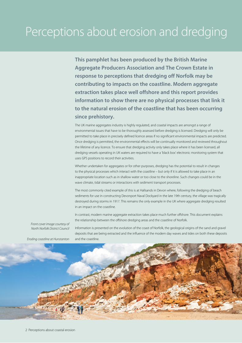
2 Perceptions about coastal erosion
This pamphlet has been produced by the British Marine Aggregate Producers Association and The Crown Estate in response to perceptions that dredging off Norfolk may be contributing to impacts on the coastline. Modern aggregate extraction takes place well offshore and this report provides information to show there are no physical processes that link it to the natural erosion of the coastline that has been occurring since prehistory.The UK marine aggregates industry is highly regulated, and coastal impacts are amongst a range of
environmental issues that have to be thoroughly assessed before dredging is licensed. Dredging will only be
permitted to take place in precisely defined licence areas if no significant environmental impacts are predicted.
Once dredging is permitted, the environmental effects will be continually monitored and reviewed throughout
the lifetime of any licence. To ensure that dredging activity only takes place where it has been licensed, all
dredging vessels operating in UK waters are required to have a ‘black box’ electronic monitoring system that
uses GPS positions to record their activities.
Whether undertaken for aggregates or for other purposes, dredging has the potential to result in changes
to the physical processes which interact with the coastline – but only if it is allowed to take place in an
inappropriate location such as in shallow water or too close to the shoreline. Such changes could be in the
wave climate, tidal streams or interactions with sediment transport processes.
The most commonly cited example of this is at Hallsands in Devon where, following the dredging of beach
sediments for use in constructing Devonport Naval Dockyard in the late 19th century, the village was tragically
destroyed during storms in 1917. This remains the only example in the UK where aggregate dredging resulted
in an impact on the coastline.
In contrast, modern marine aggregate extraction takes place much further offshore. This document explains
the relationship between the offshore dredging areas and the coastline of Norfolk.
Information is presented on the evolution of the coast of Norfolk, the geological origins of the sand and gravel
deposits that are being extracted and the influence of the modern day waves and tides on both these deposits
and the coastline.
Perceptions about erosion and dredging
Eroding coastline at Hunstanton
Front cover image courtesy of North Norfolk District Council

In 2013, a total of 739km2 of seabed was licensed for marine aggregate
extraction around the UK, of which 98.67km2 was actually dredged. A total
of 16.03 million tonnes of marine aggregate was extracted during 2013,
of which 10.63 million tonnes was used for construction aggregate in
England and Wales, 4.09 million tonnes was exported to the Continent for
use as construction aggregate, and 1.31 million tonnes was used for beach
replenishment and contract fill at locations across the UK.
Off the East Anglian coastline (Norfolk, Suffolk and Essex), 178.71km2 of seabed area was licensed for marine
aggregate extraction. Within this, dredging actually took place in 32.42km2, producing 4.99 million tonnes of
marine sand and gravel. Some 3.69 million tonnes of marine aggregate dredged from licensed areas in the
Anglian region was landed at wharves in England for use as construction aggregate – mainly at sites along
the Thames. A further 1.30 million tonnes was exported to the near Continent, also to be used as construction
aggregate.
Marine aggregate is also commonly used to support beach nourishment schemes, providing benefits to
communities, local economies and the environment. Since 1999, nearly four million tonnes of marine sand and
gravel has been used to support schemes at Happisburgh, Southwold, Clacton and Southend.
The dredging process itself involves the dredger trailing a pipe along the seabed while moving slowly forwards
(c.3 - 5 km/h). Powerful centrifugal electric pumps draw a mixture of sand, gravel and seawater through a
draghead which rests on the seabed, up the dredge pipe and into the hold of the vessel. The sand and gravel
settles into the base of the vessel’s hold, while the excess water is returned to the sea via overflow spillways.
The dredging process typically results in a cut of sediment 0.3m deep and 2m wide being removed as the
vessel uses GPS positions to navigate within the licence area.
A key misconception about the marine aggregate dredging process is that it results in large holes in the
seabed. By using the total tonnage dredged over a given period, together with the area of seabed where
dredging takes place, it is possible to calculate the average lowering of the seabed that has resulted. In the
case of the licences off Norfolk, Suffolk and Essex, over the 15-year period between 1998 and 2012, 134.9
million tonnes (81.1 million m3) was dredged from an area of 249km2. This equates to the seabed across the
area dredged being lowered by an average of 0.33m, although in reality the intensity of dredging activity will
be more uneven.
Dredging off Norfolk
Dredging off Norfolk 3
Licence areas off the Norfolk, Suffolk and Essex coast.
4 Evolution of the Norfolk coast
Ice
Tundra plain
Tundraplain
Maximum extent of thelast ice sheet in Britain
Tundra
Present coastline
Pres
ent c
oast
line
- Hol
land
“Dover S
traits
”
‘Rhine’
‘Thames’
‘Blyth’
‘Yare’
‘Stour’‘Alde’
‘Medway’
River floodplainsextending acrosstundra
Reconstruction of southern North Sea during last glacial maximum 20,000 years before present:
the increase in global ice volume reduced sea level by over 100m, exposing the UK continental shelf as dry land. Rivers extended onto the area which was, at the time, tundra across to Holland and France
Sands and gravels deposited by rivers over their floodplains are now dredged as marine aggregates
Tundra
In the Ice Age, the area we now know as Norfolk was Arctic tundra crossed by
rivers like the Yare which deposited sand and gravel. As sea levels rose, this
now valuable aggregate resource was submerged and separated from the
new shoreline by sand banks created from sediments from the still eroding
coastline.
Twenty thousand years ago, Norfolk was part of a vast expanse of Arctic tundra extending from the edge of
an ice sheet across to present day Holland and beyond. Rivers like the Yare crossed this low-lying landscape
and deposited sand and gravel over their floodplains. Mammoth and other Ice Age mammal bones, teeth and
tusks are often found in dredged aggregates and in fishing nets from this now flooded area. When the climate
warmed, the sea level rapidly rose and submerged the landscape, which became the bed of the southern
North Sea. The coastline retreated as the sea rose, and cliffs made of older glacial sands formed, slowing but
not stopping the advance of the sea.
Evolution of the Norfolk coast: from continental tundra to island margin
Norfolk coastal evolution from Mediaeval to present day
showing villages lost to coastal erosion with approximate date from historical records
Present day nearshore sandbanks have been supplied by, and grown from, sand lost from the coast by erosion over several thousand years
Present-day banks locally cover the Ice Age river valley
Submerged Ice Age river valley: unrelated to coastal erosion. Dredging areas located offshore
Former coastline retreating
Erosion
Erosion
Erosion
Shipden (14 Century)
Foulness (15 Century)
Cromer
Happisburgh
(17-18 Century)
Ness
Whimpwell (c.15 Century)
Eccles (17-19 Century)
Great Yarmouth
Newton Cross (14 Century)
Lowestoft
Dunwich (Mediaeval)0 15
km
Clare(15 Century)
Former coastline retr eating
5
Coastal erosion and the advance of the
sea continues, and historical records show
that many villages have been lost since
Roman and Mediaeval times. The coast
is prone to erosion due to the unstable
sand-rich cliffs combined with easily
scoured near-shore sediments. Indeed,
the sand banks just off the coast of
Great Yarmouth are largely formed from
sediment released by this coastal erosion.
Aggregate dredging takes place offshore
of these banks in one of the Ice Age
river floodplains. Investigations and
assessments of the effects of dredging
demonstrate that it is not accelerating
the natural process of coastal erosion in
Norfolk.
Evolution of the Norfolk coast: from continental tundra to island margin
Source: Claimed by the Sea (Norfolk) by Chris and Sarah Weston, 1994, Wood Green Publications
The North Sea reached its present level 4,000 years ago but coastal erosion continued. Records of erosion and flooding go back to Roman times.

1: Last glaciation 20,000 years ago: sea level over 100m lower, present seabed exposed as land. Cold climate. Deposition of sand and gravel in Yare valley south of ice sheet. Strong winds off ice sheet cause accumulation of sands near ice margin.
2: Rising sea as ice melts after last ice age 10-7,000 years ago. Warming climate. River Yare retreats as floodplain is submerged by the sea. Glacial sands are reworked by rising sea to form sandbanks.
Present coastline
Wind-blown sandsat edge of ice sheet
Glacial sandsgradually submerged
Yare floodplain
SouthwoldSouthwold
Orford
Rising sea
Ancestral River Yare– braided gravel bedriver and floodplain
Periglacial tundra plain
Present coastline
Orford
Ice
Ice sheet marg
in
6 Geological origins
1: Last glaciation 20,000 years ago: sea level over 100m lower, present seabed exposed as land. Cold climate. Deposition of sand and gravel in Yare valley south of ice sheet. Strong winds off ice sheet cause accumulation of sands near ice margin.
2: Rising sea as ice melts after last ice age 10-7,000 years ago. Warming climate. River Yare retreats as floodplain is submerged by the sea. Glacial sands are reworked by rising sea to form sandbanks.
Present coastline
Wind-blown sandsat edge of ice sheet
Glacial sandsgradually submerged
Yare floodplain
SouthwoldSouthwold
Orford
Rising sea
Ancestral River Yare– braided gravel bedriver and floodplain
Periglacial tundra plain
Present coastline
Orford
Ice
Ice sheet marg
inThe sand and gravel dredged off Norfolk originated in the Ice Age, or
Pleistocene, covering the last two million years or so of geological time. The
diagrams below illustrate the formation of the aggregate deposits in four
stages, starting in the last glaciation in the region over 20,000 years ago.
A similar sequence of events has been repeated many times over the past two million years. The aggregate
deposits were laid down in a river draining a cold tundra landscape that looked like parts of the modern-day
Canadian or Siberian Arctic. River floods caused by snow and ground ice melting in the spring and summer
over thousands of years brought down flint gravels and quartz sands, forming a wide braided river floodplain
east of the present position of Great Yarmouth. Prehistoric flint hand axes made by our ancestors have recently
been found in aggregate deposits in this area, dating back over 250,000 years when the North Sea was dry
land, crossed by the ancestral River Yare.
Geological origins: Arctic tundra, lost rivers and sand banks

3: Around 7-5,000 years ago, the Yare valley is drowned downstream of the present coastline. The river’s sands and gravels are preserved on the seabed. Sandbanks form where sand is released from coastal erosion and where pre-existing glacial sands are reworked by the encroaching rising sea after the Ice Age.
4: Present day. Inner, nearshore banks are supplied by coastal erosion. Banks and coastline are not supplied by the now submerged, immobile and "fossil" Yare floodplain deposits which are now dredged for marine aggregate.
Southwold
Orford
Southwold
Orford
Inner Banks
Outer Great Yarmouth Banks
Sands from erosion ofcoast and reworking ofglacial sands by the seaform sandbanks
Drowned river valley- relict sediments
Palaeo-Yarevalley and floodplain
Relict river sediments arenow dredged: no feed to inshore banks or coastline
North Sea
Sea continues to rise and erode the coast
Erosion
Present coast
7
The river floodplain was submerged by the rising sea at the end of the last Ice Age, becoming first an estuary
and then fully marine by about 5,000 years ago. Marine geophysical and sampling surveys now show that
the river’s sand and gravel have remained in-situ within the ancient floodplain. Locally, the gravelly deposits
are buried by the younger inshore sandbanks. Dredging of the old floodplain deposits far from the coast has
no effect on coastal erosion because these sands and gravels are not part of the present coastal or sandbank
sediment system.
3: Around 7-5,000 years ago, the Yare valley is drowned downstream of the present coastline. The river’s sands and gravels are preserved on the seabed. Sandbanks form where sand is released from coastal erosion and where pre-existing glacial sands are reworked by the encroaching rising sea after the Ice Age.
4: Present day. Inner, nearshore banks are supplied by coastal erosion. Banks and coastline are not supplied by the now submerged, immobile and "fossil" Yare floodplain deposits which are now dredged for marine aggregate.
Southwold
Orford
Southwold
Orford
Inner Banks
Outer Great Yarmouth Banks
Sands from erosion ofcoast and reworking ofglacial sands by the seaform sandbanks
Drowned river valley- relict sediments
Palaeo-Yarevalley and floodplain
Relict river sediments arenow dredged: no feed to inshore banks or coastline
North Sea
Sea continues to rise and erode the coast
Erosion
Present coast
8 Today’s marine processes
Relationship between Norfolk coast and offshore dredging areas:
the sand and gravel being removed from the dredging areas is not part of the modern sediment transport system or coast
Not to scale
Deep water channels separate the banks
Inshore sandbanks: Holm Sand, Scroby Sands - separate from aggregate resources. They locally protect the coast from storm waves
South Cross Sands
NewarpBank
Seabed covered with sand ripples aligned with the tide
Dredged seabed depressions: do not fill in from surrounding seabed: relict or ‘fossil’ deposits do not move in present marine environment
Aggregate resources: infilling river valley or floodplain formed in the Ice Age
20-30 metres seawater depth over aggregate areas: too deep for waves to affect the seabed regularly
Dredging areas - seaward of nearshore banks
Tidal stream
Tidal stream
Cromer
‘Soft’ coast naturally eroding
NorwichSea Palling
Lowestoft
Tide: runs coast parallel so there is no sediment movement to or from the dredging areas and the coast
Yarmouth Roads
Sea surface
Longshoredrift
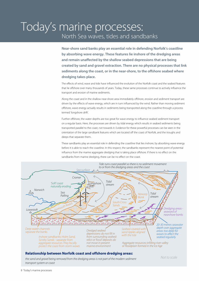
Near-shore sand banks play an essential role in defending Norfolk’s coastline
by absorbing wave energy. These features lie inshore of the dredging areas
and remain unaffected by the shallow seabed depressions that are being
created by sand and gravel extraction. There are no physical processes that link
sediments along the coast, or in the near-shore, to the offshore seabed where
dredging takes place.
The effects of wind, wave and tide have influenced the evolution of the Norfolk coast and the seabed features
that lie offshore over many thousands of years. Today, these same processes continue to actively influence the
transport and erosion of marine sediments.
Along the coast and in the shallow near-shore area immediately offshore, erosion and sediment transport are
driven by the effects of wave energy, which are in turn influenced by the wind. Rather than moving sediment
offshore, wave energy actually results in sediments being transported along the coastline through a process
termed ‘longshore drift’.
Further offshore, the water depths are too great for wave energy to influence seabed sediment transport
on a regular basis. Here, the processes are driven by tidal energy which results in seabed sediments being
transported parallel to the coast, not towards it. Evidence for these powerful processes can be seen in the
orientation of the large sandbank features which are located off the coast of Norfolk, and the troughs and
deeps that separate them.
These sandbanks play an essential role in defending the coastline that lies inshore, by absorbing wave energy
before it is able to reach the coastline. In this respect, the sandbanks represent the nearest point of potential
influence from the marine aggregate dredging that is taking place offshore. If there is no effect on the
sandbanks from marine dredging, there can be no effect on the coast.
Today’s marine processes: North Sea waves, tides and sandbanks
Cross section from Gorleston to the offshore dredging grounds in the southern North Sea showing what lies beneath the seabed
The dredging areas are seaward of the near-shore banks and extraction of the ancient river deposits oshore will have no eect on either the banks or coastline: the submerged river deposits are “fossil” and immobile in the present marine environment and are unrelated to both the sands of the coastline and the nearshore banks
Vertical exaggeration x66
SeabedBase of sandbanks
WEST Gorleston EAST
0
10
20
30
0
10
20
30
0 1 2 3 4 5 6 7 8 9 10 11 12 13 14 15 16
Met
res b
elow
sea
surfa
ce
Met
res b
elow
sea
surfa
ce
Distance from coast (km)
Ice Age River Yare �oodplain depositsDredging areasSea surfaceInshore banks and channels
Gorleston Road Corton Sand South Cross Sands
9
While the sediment processes that occur in and around the dredging areas are dominated by tides, the
fossil sand and gravel resources being dredged remain unaffected. Modern sediments (mobile sand) will be
transported across the surface of the seabed as sand waves and ripples by tides, in a coast-parallel direction.
However, the marine aggregate resources remain immobile and in-situ as they have done for many thousands
of years.
Over time, dredging results in shallow depressions being created (typically 2-4m deep over 1-2km) as
the underlying fossil sand and gravel resource is removed. Monitoring data shows the modern sediment
continuing to be transported by the tide. Rather than infilling these depressions, the modern sediment
continues to be transported across and through them.
Similarly, the adjacent sandbank features which lie inshore of the dredging areas remain unaffected by the
shallow depressions that are being created further offshore.
While the sandbank features provide a buffer to the wave energy coming from offshore, conversely, they also
provide a natural barrier to sediment moving from the coastline. There can be a misperception that there is a
gentle slope between coast and the dredge areas located further offshore, which allows sediment to be ‘drawn
down’ into the dredged depressions.
Profiles of water depth (taken from Admiralty charts) from the coast out to the dredging areas clearly show
a series of deeps and banks in between the two that beach sediments would have to somehow ‘traverse’ in
order to get to the dredge area. Modern sediment transport processes, driven by either wave or tide, actually
run coast-parallel (broadly north/south), so there is no transport mechanism for this to happen. Further
evidence of this can be seen in monitoring data, which shows the dredged depressions are not being infilled.
In terms of modern sediments, there are no physical processes that link sediments along the coast or in the
near-shore to the offshore area where dredging takes place. Furthermore, the fossil sediments being removed
from the dredging areas do not form part of the modern sediment transport system, and are completely
unrelated to the sediments present along the coast and the processes acting upon them.
In fact, the only way that the fossil sands and gravels being dredged will find their way to the coast is if they are
deliberately placed there. In this respect, the marine aggregate industry fulfils an important role in helping to
protect the coastline of Norfolk by supplying sand and gravel resources in support of beach replenishment.
10 Monitoring, assessment & regulation
Aggregate extraction is closely regulated to protect the environment. Expert
studies are undertaken and extraction licences will be refused if there is any
genuine concern about impacts on the coastline. Monitoring of the dredged
seabed continues throughout the life of a licence – typically 15 years.
Marine aggregate dredging in English waters is regulated by the Marine Management Organisation through
marine licences which are intended primarily to protect the environment. Before dredging can be licensed,
dredging applications are subject to a rigorous assessment process which takes several years. Operators are
responsible for commissioning detailed environmental impact studies, including coastal impact studies which
consider the potential effects of the proposed dredging on waves and sediment mobility as well as coastal
processes.
The outcomes of these studies are reviewed and scrutinised by government regulators and advisors as well as
numerous other stakeholders, and if there is any remaining serious doubt over the potential for coastal impacts
then dredging will not be permitted.
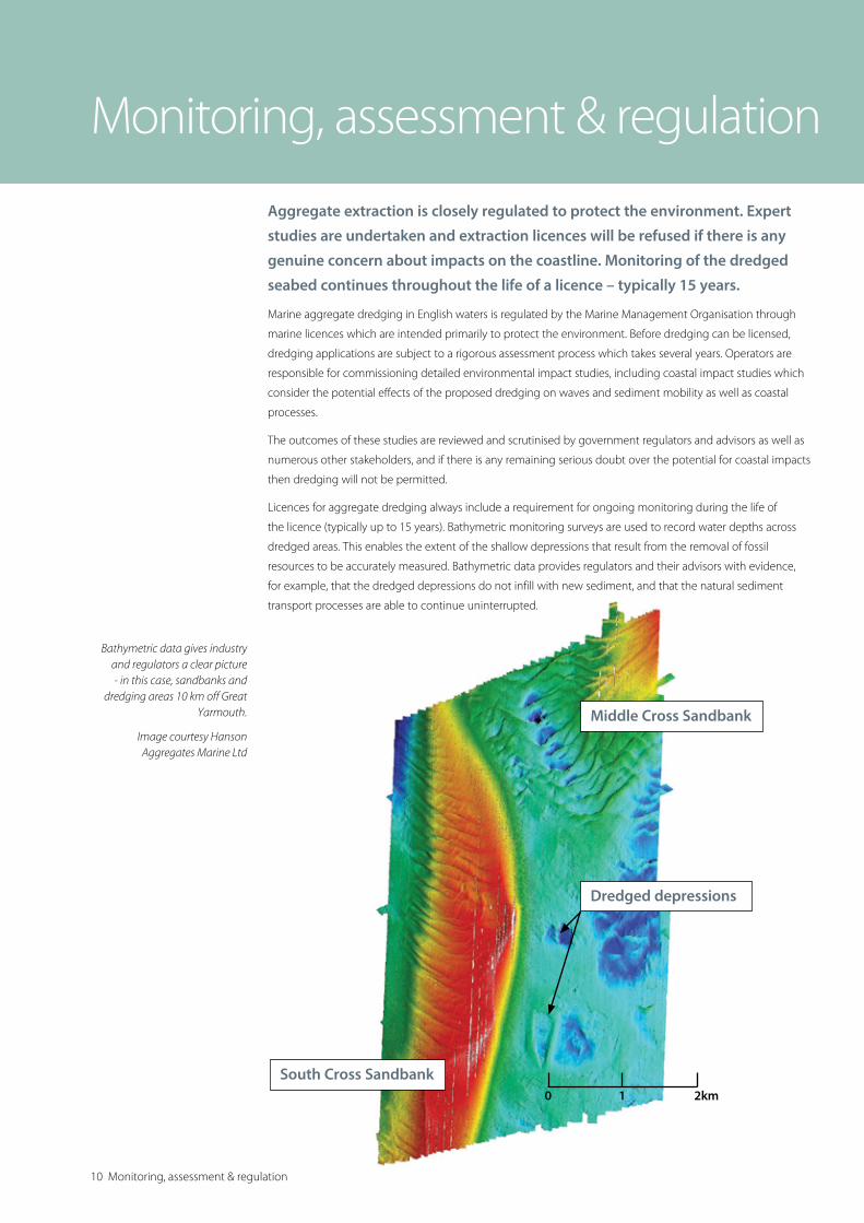
Licences for aggregate dredging always include a requirement for ongoing monitoring during the life of
the licence (typically up to 15 years). Bathymetric monitoring surveys are used to record water depths across
dredged areas. This enables the extent of the shallow depressions that result from the removal of fossil
resources to be accurately measured. Bathymetric data provides regulators and their advisors with evidence,
for example, that the dredged depressions do not infill with new sediment, and that the natural sediment
transport processes are able to continue uninterrupted.
Monitoring, assessment & regulation
Bathymetric data gives industry and regulators a clear picture - in this case, sandbanks and
dredging areas 10 km off Great Yarmouth.
Image courtesy Hanson Aggregates Marine Ltd
South Cross Sandbank
Middle Cross Sandbank
Dredged depressions
0 1 2km

Dredging in Europe 11
It has been suggested that UK
marine aggregates are exported to
Holland and Belgium because those
Governments do not allow dredging
in their own waters. The reality is that
UK operators deliver construction
aggregates to those countries as
their continental shelves do not have
deposits of coarse aggregate. Needs
for fine and medium-grained sand for
construction and beach replenishment
are met in large quantities from local
sources off Holland and Belgium.
Around 40 million tonnes of sand is dredged from
licensed areas in Dutch waters each year, around
double that dredged from all UK waters. A national
environmental impact study undertaken by the Dutch
government concluded that dredging in a depth of
20m or more on their continental shelf would not
result in coastal impacts, subject to no more than
2m of sediment being removed. Consequently, operators are able to obtain a production licence to dredge
in >20m of water by simply paying a licence fee, and without the need to undertake a site-specific impact
assessment. This approach contrasts to regulation in English waters, where licence areas lie in water depths
of between 10 – 50 m and detailed site specific assessments of dredging proposals have to be undertaken
irrespective of the tonnage being dredged or the water depths involved.
For larger scale extraction requirements which require more than 2m of sediment to be removed from water
depths of more than 20m, site-specific assessments are required before the activity is permitted. The Dutch
authorities have recently permitted over 360 million tonnes of marine sand to be removed over a five-year
period to support the extension of Rotterdam harbour1. The dredging depths and volumes of sediment
involved meant that a full Environmental Impact Assessment (EIA) was necessary before dredging began. This
scale of dredging represents over 70 times that dredged off East Anglia in a single year.
Another example of this is the ‘Sand Engine’2 project in the province of Zuid Holland. During 2011, around
30 million tonnes of marine sand was dredged from licence areas 10km off the Dutch coast to create a new
hook-shaped peninsula. This will naturally erode over 20 years to maintain and enhance beach levels, which in
turn will ensure that the communities, infrastructure and environment located inland are protected.
1Rotterdam harbour project: http://www.maasvlakte2.com/en/index/
2Sand Engine project: http://www.dezandmotor.nl/en-GB/the-sand-motor/introduction/
Dredging in Europe
The Crown Estate - London16 New Burlington Place
London
W1S 2HX
T 020 7851 5000
British Marine Aggregate Producers AssociationGillingham House
38-44 Gillingham Street
London
SW1V 1HU
T 020 7963 8000
W www.bmapa.org
ISBN: 978-1-906410-56-8
© The Crown Estate & British Marine Aggregate Producers Association 2015
The Crown Estate - Edinburgh6 Bell’s Brae
Edinburgh
EH4 3BJ
T 0131 260 6070
Printed on paper from sustainable forests
Marine aggregates are an essential part of our daily lives, satisfying around
20% of all the sand and gravel needed for construction in England and Wales.
At a time when rising sea levels pose a growing threat, marine sand and gravel
is also vital to coastal protection.
Construction aggregates influence every facet of modern life – from the homes we live in and the transport
infrastructure we use to get around, to the energy and fresh water that we take for granted. In order to
maintain and develop the built environment in which we live, every person in Britain indirectly generates
demand for three tonnes of aggregates every year – equivalent to around 200 million tonnes each year.
The majority of this need is met by material from recycled or secondary sources (25%), sand, gravel or crushed
rock quarried from the land. A proportion of the demand is, however, met by sand and gravel dredged from
the sea. In England and Wales, marine aggregates represent around 20% of all the sand and gravel used in
construction. In the south east of England, a third of all construction materials come from marine sources.
Marine dredged sand and gravel also have a strategic
role in supplying large-scale coastal defence and beach
replenishment projects – over 25 million tonnes being used
for this purpose since the mid-1990s. With the growing
threats posed by rises in sea levels and more frequent
storms, the use of marine sand and gravel for coast
protection purposes will become increasingly important.
The commercial rights to marine aggregates in English
waters are administered by The Crown Estate. Operators
are required to pay a royalty for every tonne of sand and
gravel they dredge. In the financial year 2013/14, marine
aggregate extraction generated royalty revenue of £15.6
million, the surplus of which was passed to HM Treasury.
Marine aggregate facts
This document has been produced by BMAPA and The Crown Estate in consultation with members of the Local Government Association Coastal Special Interest Group. Local authorities around England acknowledge the importance of marine aggregate dredging for economic regeneration. They strongly support the use of a sound scientific evidence base with effective regulation and monitoring in determining from where material should be extracted.
W www.thecrownestate.co.uk
@thecrownestate