Embed Size (px)
Citation preview

1. Catastrophic lateral collapses: some problems
Since the collapse of the northern flank of Mount St.Helens at the start of the eruption of 18 May 1980, the lat-eral collapse of the flanks of large volcanoes has come tobe recognized as a major process in their developmentand an infrequently occurring but severe volcanic hazard.Giant debris avalanche deposits have been identified botharound continental stratovolcanoes (Siebert, Glicken &Ui, 1987) and around oceanic island volcanoes such asthe Hawaiian islands (Moore, 1964; Lipman et al. 1988;Moore et al. 1989; Moore, Normark & Holcomb, 1994)and the Canary Islands (Holcomb & Searle, 1991;Masson, 1994; Watts & Masson, 1995). These studieshave concentrated upon the debris avalanche depositsthemselves, and on the mechanics of debris avalanchemovement over long horizontal distances (Campbell,1989). Relatively little work has been done on the initialstages of collapse and on the precursory period of defor-mation in which slow creeping movements (slumps, inthe terminology of McGuire (1996)) accelerate andundergo a transition to catastrophic failure. Photographsof the 18 May 1980 collapse of Mount St. Helens clearlyshow that the collapse began with rapid large-scale slid-ing of discrete fault blocks (Voight, 1981).
The principal problem encountered in studying these
early stages of catastrophic lateral collapses, which arecritical to the understanding of potential precursory phenomena as well as the transition to the dynamic self-lubrication (Campbell, 1989) stage of debris avalanchemovement, is of course that much of the potential evi-dence is normally destroyed by the disintegration of therock masses involved. Studies of deeply incised lateralcollapse structures on the island of Gran Canaria (Day &Perez Torrado, unpub. data) indicate, however, that aregion of coherent deformation, with displacements ondiscrete faults of up to several kilometres, may be presentbeneath the floors of collapse scars. Structural analysis ofsuch regions may provide considerable insight into themechanics of catastrophic lateral collapses. Even in thesecases, however, the initial stages of deformation are atleast partly obscured by the later, large-magnitude move-ments. More direct insights into the early stages of cata-strophic lateral collapses may be offered by incomplete oraborted collapse structures. In this paper we describe onesuch structure from the island of El Hierro.
2. Geology and geochronology of El Hierro
El Hierro, the westernmost island in the Canarian archi-pelago, is the emergent summit of a volcanic shield, some13 000 km3 in volume and with a triangular shape in plan.
Geol. Mag. 134 (4), 1997, pp. 523–537. Printed in the United Kingdom © 1997 Cambridge University Press 523
Age and geometry of an aborted rift flank collapse:the San Andres fault system, El Hierro, Canary Islands
S. J. DAY*, J. C. CARRACEDO† & H. GUILLOU‡
* Department of Geography & Geology, Cheltenham & Gloucester College of Higher Education,Francis Close Hall, Swindon Road, Cheltenham GL50 4AZ, UK
† Estacion Volcanologica de Canarias, CSIC, Aptdo. Correos 195, La Laguna 38206, Tenerife, Canary Islands, Spain‡ Centre des Faibles Radioactivities, Laboratoire Mixte CEA-CNRS, 91198 Gif-Sur-Yvette, France
(Received 20 June 1996; accepted 11 March 1997)
Abstract – The catastrophic slope failures and landslides that occur in the final stages of lateral collapses ofvolcanoes destroy much of the evidence for precursory deformation and the early stages of the collapsesconcerned. Aborted or incomplete collapse structures, although rare, are rich sources of information onthese stages of development of catastrophic collapses. The San Andres fault system, on the volcanic islandof El Hierro, is a relatively young (between about 545 and about 261–176 ka old) but inactive lateral collapse structure. It appears to represent an aborted giant landslide. It is developed along the flank of asteep-sided volcanic rift zone, and is bounded by a discrete strike-slip fault zone at the up-rift end, closest tothe centre of the island. This geometry differs markedly from that of collapse structures on stratovolcanoesbut bears some similarities to that of active fault systems on Hawaii. Although the fault system has under-gone little erosion, cataclasites which formed close to the palaeosurface are well exposed. These cataclasitesare amongst the first fault rocks to be described from volcano lateral collapse structures and include the only pseudotachylytes to have been identified in such structures to date. Their development at unusuallyshallow depths is attributed to large movements on the fault in a single event, the inferred aborted landslide,and a lack of pressurized pore water. The absence of pressurized fluids in the slumping block may havecaused the San Andres fault system to cease moving, rather than develop into a giant volcanic landslide. Therecognition that the San Andres fault system is inactive greatly reduces the estimated volcanic hazard asso-ciated with El Hierro. However, the lack of evidence for precursory deformation prior to the aborted land-slide event is disturbing as it implies that giant lateral collapses can occur on steep-sided oceanic islandswith little warning.
https://www.cambridge.org/core/product/BCAFC69CEFB3B88B166C0CD3D586EA67Downloaded from https://www.cambridge.org/core. INIST CNRS, on 01 Sep 2017 at 08:53:31, subject to the Cambridge Core terms of use, available at https://www.cambridge.org/core/terms.

524 S. J. DAY, J. C. C A R R AC E D O & H. G U I L L O U
Figure 1. Geological map of eastern El Hierro, showing relationships of lithostratigraphic units to the San Andres fault system. Insetsshow location of El Hierro and positions of other collapse structures on the island.
https://www.cambridge.org/core/product/BCAFC69CEFB3B88B166C0CD3D586EA67Downloaded from https://www.cambridge.org/core. INIST CNRS, on 01 Sep 2017 at 08:53:31, subject to the Cambridge Core terms of use, available at https://www.cambridge.org/core/terms.
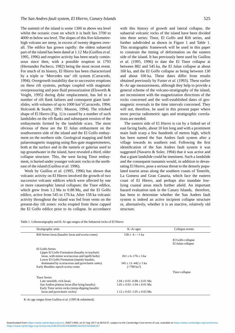
The summit of the island is some 1300 m above sea levelwhilst the oceanic crust on which it is built lies 3700 to4000 m below sea level. The slopes of this five-kilometre-high volcano are steep, in excess of twenty degrees over-all. The edifice has grown rapidly: the oldest subaerialpart of the island has been dated at 1.12 Ma (Guillou et al.1995, 1996) and eruptive activity has been nearly contin-uous since then, with a possible eruption in 1793(Hernandez Pacheco, 1982) being the most recent event.For much of its history, El Hierro has been characterizedby a triple or ‘Mercedes star’ rift system (Carracedo,1994). Overgrowth instability due to successive eruptionson these rift systems, perhaps coupled with magmaticoverpressuring and pore fluid pressurization (Elsworth &Voight, 1995) during dyke emplacement, has led to anumber of rift flank failures and consequent giant land-slides, with volumes of up to 1000 km3 (Carracedo, 1994;Holcomb & Searle, 1991; Masson, 1994). The trilobedshape of El Hierro (Fig. 1) is caused by a number of suchlandslides on the rift flanks and subsequent erosion of theembayments formed by the landslide scars. The mostobvious of these are the El Julan embayment on thesouthwestern side of the island and the El Golfo embay-ment on the northern side. Geological mapping and fieldpalaeomagnetic mapping using flux-gate magnetometers,both at the surface and in the tunnels or galerias used totap groundwater in the island, have revealed a third, oldercollapse structure. This, the west facing Tinor embay-ment, is buried under younger volcanic rocks in the north-east of the island (Guillou et al. 1996).
Work by Guillou et al. (1995, 1996) has shown thatvolcanic activity on El Hierro involved the growth of twosuccessive volcanic edifices which were affected by oneor more catastrophic lateral collapses: the Tinor edifice,which grew from 1.2 Ma to 0.88 Ma, and the El Golfoedifice, active from 545 to 176 ka. After 158 ka volcanicactivity throughout the island was fed from vents on thepresent-day rift zones: rocks erupted from these cappedthe El Golfo edifice prior to its collapse. In accordance
with this history of growth and lateral collapse, the subaerial volcanic rocks of the island have been dividedinto three series: Tinor, El Golfo and Rift series, and further subdivided as shown in Figure 1 and Table 1. This stratigraphic framework will be used in this paper to constrain the timing of deformation on the eastern side of the island. It has previously been used by Guillouet al. (1995, 1996) to date the El Tinor collapse atbetween 882 and 545 ka, the El Julan collapse at about160 ka, and the El Golfo collapse as being between 130and about 100 ka. These dates differ from resultsobtained previously by Fuster et al. (1993). These earlierK–Ar age measurements, although they help to provide ageneral scheme of the volcano-stratigraphy of the island,are inconsistent with the magnetization directions of therocks concerned and the well-established dates of geo-magnetic reversals in the time intervals concerned. Theywill not, therefore, be used in this present paper wheremore precise radiometric ages and stratigraphic correla-tions are needed.
The eastern side of El Hierro is cut by a linked set ofeast facing faults, about 10 km long and with a prominentmain fault scarp a few hundreds of metres high, whichhas been named the San Andres fault system after a village towards its southern end. Following the first identification of the San Andres fault system it was suggested (Navarro & Soler, 1994) that it was active andthat a giant landslide could be imminent. Such a landslideand the consequent tsunamis would, in addition to devas-tating El Hierro, pose a serious threat to the densely popu-lated tourist areas along the southern coasts of Tenerife,La Gomera and Gran Canaria, which face the easterncoast of El Hierro, and perhaps also inundate low-lying coastal areas much further afield. An important hazard evaluation task in the Canary Islands, therefore,has been to determine whether the San Andres fault system is indeed an active incipient collapse structure or, alternatively, whether it is an inactive, relatively oldstructure.
The San Andres fault system, El Hierro, Canary Islands 525
Table 1. Lithostratigraphy and K-Ar age ranges of the Subaerial rocks of El Hierro
Stratigraphic units K–Ar ages Collapse events
Rift Series lavas (basaltic lavas and scoria cones) 158 ± 4 – <1 ka
El Golfo collapseEl Julan collapse
El Golfo SeriesUpper El Golfo Formation (basaltic to trachytic lavas, with minor scoriaceous and lapilli beds): 261 ± 6–176 ± 3 ka
Lower El Golfo Formation (mainly basaltic,dominated by scoriaceous and pyroclastic units): 545 ± 11–442 ± 5 ka
Early Brunhes–epoch scoria cones (<790 ka?)
Tinor collapse
Tinor SeriesLate xenolith- rich lavas: 1.04 ± 0.01–0.88 ± 0.01 MaSan Andres plateau lavas (flat-lying basalts): 1.05 ± 0.02–1.04 ± 0.01 MaEarly Tinor series rocks (steep-dipping basaltic lavas and pyroclastic rocks): 1.12 ± 0.02–1.05 ± 0.02 Ma
K-Ar age ranges from Guillou et al. (1995 & submitted).
https://www.cambridge.org/core/product/BCAFC69CEFB3B88B166C0CD3D586EA67Downloaded from https://www.cambridge.org/core. INIST CNRS, on 01 Sep 2017 at 08:53:31, subject to the Cambridge Core terms of use, available at https://www.cambridge.org/core/terms.

3. Geometry and kinematics of the San Andres faultsystem
3.a. Onshore exposures
The San Andres fault system is exposed over a distance ofabout 10 km along the eastern side of the northeasternlobe of El Hierro, from the coast east of the island’s maintown, Valverde, to the 900 m high cliffs of the Las Playasembayment at the southwestern limit of its outcrop. Largeparts of the fault system are covered by lavas of the ElGolfo and Rift series (Fig. 1). Nevertheless, three seg-ments of the fault system can be distinguished (Fig. 2).Overall, the geometry of the fault system differsmarkedly from the horseshoe type of collapse structurefamiliar from stratovolcanoes, and it is thereforedescribed here in some detail.
(1) Northern splay faults. From Punta Negra [160788]to the valley west of Pico de los Moles at least two diverg-ing faults are present, one largely concealed below a lavaflow in Barranco de Tejecita and the other cutting thepost-Tinor, Brunhes-epoch scoria cones (Picos andRivera cones; see Table 2) which occur to the south of thisbarranco. The latter fault is well exposed in a road cut at[147777] where it is orientated 092°/82°S and has a verti-cal offset of about 20 metres, downthrown to the south,indicated by the offset of a distinctive thin-bedded lapilliunit in the scoria cone exposed in the road cut. Grooves
on the fault surface plunge at 67° towards 111°, approxi-mately perpendicular to the trend of the main fault to thesouthwest but oblique to the fault trend at this locality(Fig. 2). The concealed fault to the north appears to juxta-pose the Brunhes-epoch scoria cones against Matuyama-epoch lavas of the Tinor edifice and is therefore likely tohave a substantially larger throw. The slip direction onthis fault is unknown, although it too has a broadlyeast–west trend.
(2) Central fault segment. From about [130777] to apoint 1 km northeast of San Andres, at [099754], thenorthwestern boundary of the San Andres fault system ismarked by a prominent southeast-facing scarp up to 200metres high. This scarp is dominated by outcrops of Tinorseries lavas, but has patchy exposures of grooved faultsurfaces and indurated fault breccias, most notably atabout [122771] where the Barranco de Tinor cuts thescarp and the fault has been exposed over a distance ofabout 70 metres in a recent road cut; this exposure is dis-cussed further in Section 5. In addition, the late Tinorseries lavas which crop out at the foot of the scarp arelocally covered by soft, poorly exposed, largely unlithi-fied breccias; these are themselves covered by later lavasaround [110765]. These contain a wide variety of lavaclasts, are clast-supported, lack bedding, and have a yel-low silt- to fine sand-grade matrix. They are thereforeinterpreted as scree deposits formed at the foot of thescarp, which were buried beneath the later El Golfo andRift series lavas and subsequently exhumed.
The fault exposed at the foot of the scarp, and locallypreserved on its surface, has a principal orientation ofabout 052°/ 65°SE but has a number of right-steppingsegments, of up to 700 metres trace length, and typicallystriking 070° to 080°. Slip directions on the main faultsegments and on the dextral steps, as indicated by toolmarks and grooves on exposed fault surfaces, do appearto be similar, however (Figs 2, 3). It will be noted thatthese slip directions vary from parallel to the dip of themain fault segments to having a significant dextral com-ponent, implying a component of southward movementof the hangingwall block. However, all the slip directiondata come from the northern half of this section of thefault system and the apparent dextral component may bea consequence of deformation within the hangingwallblock, as in the case of faults described by Roberts(1996), rather than a component of the overall motion ofthe hangingwall block.
The total offset on the fault is not precisely measurablebecause of the lack of directly correlated lavas or otherstratigraphic units on either side. However, the height of thescarp, and the occurrence of Jaramillo-age, normal mag-netic polarity lavas in the hangingwall sequence a few hun-dred metres below the top of the scarp whilst the footwallsequence is almost entirely composed of pre-Jaramillo,reversed-polarity lavas (Guillou et al. 1995, 1996), suggestthat the vertical offset on the central part of the fault systemsis a few hundreds of metres, down-to-the-east.
Along the northern part of its length, as far south as the
526 S. J. DAY, J. C. C A R R AC E D O & H. G U I L L O U
Figure 2. Simplified map of San Andres fault system, showingslip directions at the main exposures of fault surfaces. The segments of the fault system shown are defined and discussed inthe text.
https://www.cambridge.org/core/product/BCAFC69CEFB3B88B166C0CD3D586EA67Downloaded from https://www.cambridge.org/core. INIST CNRS, on 01 Sep 2017 at 08:53:31, subject to the Cambridge Core terms of use, available at https://www.cambridge.org/core/terms.
intersection with a prominent 080° trending segment at[119768], the main, scarp-forming fault is the only oneobserved. To the southwest, however, a number of gener-ally northeast–southwest trending faults are exposed inthe barrancos to the east of the main fault scarp (see Fig. 2).These are mainly southeast facing normal faults, withthrows of a few tens of metres, but a prominent linearscarp in grid square [1075], some 50 m high, may be awest facing antithetic fault scarp.
As noted above, the fault system is buried belowyounger lavas southwest of [099754]. However, the well-defined eastern edge of the central plateau, for about 3 kmfurther to the southwest, is collinear with the exposedfault scarp. It is therefore proposed that this segment ofthe San Andres fault system, trending about 045° overall,extends as far southwest as grid reference [072728].
(3) Las Playas transfer faults. Rocks of the Tinor edi-fice are exposed extensively to the south of the Las Playas‘embayment’ (Carracedo, 1994). This topographic fea-ture is actually a very large barranco or erosional canyon,with a much lower width (measured parallel to the coast)to depth (perpendicular to the coast) ratio than the truecollapse-related embayments elsewhere in the island.Exposure is especially good in the sea cliffs south of LasPlayas, which are up to 600 metres high. However, apartfrom an extensive series of open fractures and a singlesubvertical fault, all of which are close to and parallel tothe coastline (and therefore most probably related torecent undermining of the cliffs by the sea), there is noevidence of faulting in this part of the island. The Tinorseries rocks exposed in the southern cliffs of the LasPlayas barranco are also undeformed.
The cliffs at the head of the Las Playas barranco andthose on its northern side expose numerous faults. Theseaffect both Tinor series rocks and the mainly pyroclasticrocks of the Lower El Golfo sequence, but are truncatedby undeformed Upper El Golfo lavas (Fig. 1). In the northwall of the barranco, the faults dip east to southeast andshow down-to-the-east offsets of Tinor and Lower ElGolfo series rocks: their geometry appears to be similar to
that of the faults to the north. In contrast, the headwall ofthe barranco is cut by southeast trending subverticalfaults with no consistent sense of apparent displacement.Given the movement sense on the faults further to thenorth, these latter faults are best explained as a strike-slipfault zone with the overall movement vector perpendicu-lar to the cliff and various subsidiary vertical movementson individual faults occurring as a result of irregularitiesin the fault surfaces themselves. Furthermore, such astrike-slip fault zone would either bound the moving faultblocks to the northeast, or at least transfer the displace-ment to dip-slip faults offshore, thus explaining the lackof onshore faulting related to the San Andres fault systemsouth of the Las Playas barranco. The most likely expla-nation for the development of the Las Playas barrancoitself is that it is the product of preferential erosion alonga weak fractured zone formed by these strike-slip faults.
The overall seaward-facing geometry and displace-ment pattern of the San Andres fault system supports theinterpretation that it is a lateral collapse structure. Theasymmetry of the structure as exposed on land, with theup-rift (southern, in this case) end bounded by a strike-slip fault system whilst the down-rift end is formed byarcuate oblique-slip faults, is in marked contrast to the‘horseshoe’ type of collapse structure found on stratovol-canoes such as Mount St. Helens and Socompa (Voight etal. 1981; Francis et al. 1985) but is typical of faulting-dominated collapse structures in the Canary Islands (Day,unpub. data). There are also many similarities to thegeometry of active fault and dyke systems on the southernflank of the island of Hawaii (Swanson, Duffield & Fiske,1976; Lipman et al. 1985), where the zones of seawarddisplacement on the South and East rift zones of Kilaueavolcano are separated by a region of complex deforma-tion that must, from the geometry of displacementepisodes on the rift zones, have a largely strike-slipgeometry overall. As will be shown in Sections 4 and 6,however, the kinematics or history of deformation of theSan Andres fault system differs from that of theseHawaiian slump structures.
The San Andres fault system, El Hierro, Canary Islands 527
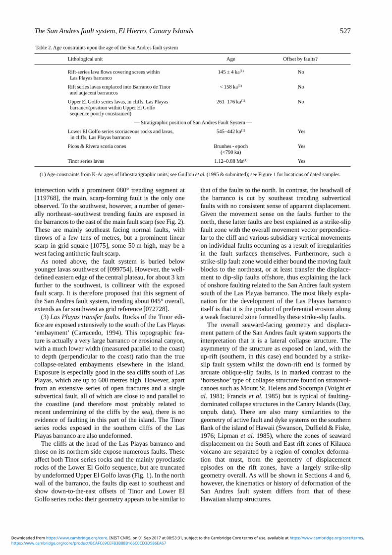
Table 2. Age constraints upon the age of the San Andres fault system
Lithological unit Age Offset by faults?
Rift-series lava flows covering screes within 145 ± 4 ka(1) NoLas Playas barranco
Rift series lavas emplaced into Barranco de Tinor < 158 ka(1) Noand adjacent barrancos
Upper El Golfo series lavas, in cliffs, Las Playas 261–176 ka(1) Nobarranco(position within Upper El Golfosequence poorly constrained)
— Stratigraphic position of San Andres Fault System —
Lower El Golfo series scoriaceous rocks and lavas, 545–442 ka(1) Yesin cliffs, Las Playas barranco
Picos & Rivera scoria cones Brunhes - epoch Yes(<790 ka)
Tinor series lavas 1.12–0.88 Ma(1) Yes
(1) Age constraints from K-Ar ages of lithostratigraphic units; see Guillou et al. (1995 & submitted); see Figure 1 for locations of dated samples.
https://www.cambridge.org/core/product/BCAFC69CEFB3B88B166C0CD3D586EA67Downloaded from https://www.cambridge.org/core. INIST CNRS, on 01 Sep 2017 at 08:53:31, subject to the Cambridge Core terms of use, available at https://www.cambridge.org/core/terms.

3.b. Constraints upon the offshore extent of the San Andresfault system
In contrast to the southwestern and northern submarineslopes of El Hierro, which have been extensively studiedusing shallow seismic profiling and sidescan sonar imag-ing techniques (Holcomb & Searle, 1991; Masson, 1994,1996), relatively little is known about the eastern slopesbelow sea level. The abundant exposures of older, Tinorseries rocks onshore, especially in the northern half of theregion occupied by the fault system, makes it unlikelythat structures offshore associated with the San Andresfault system could have been entirely buried by youngereruptive products from the northeast rift of El Hierro
(Fig. 1). Detailed bathymetric mapping of the seafloor inthe offshore region is therefore needed to define accu-rately the offshore extent of the San Andres fault system.Nevertheless, available bathymetric maps (Hunter, Searle& Laughton, 1983) and the detailed surveys carried outon the other sides of the island and in the adjacent oceanbasins can be used to constrain hypotheses regarding theoffshore extent of the San Andres fault system:
(1) That it forms a block within the headwall of alargely or wholly submerged collapse structure offshore.
(2) That it forms the only onshore section of a regionalfault system, which could either be a normal fault systemwith a broadly northeast–southwest trend or, less plausi-bly since the scale of the structure would have to be muchlarger, a strike-slip fault system with a broadly north-west–southeast trend overall and a large dilational jog orpull-apart basin to the east of El Hierro.
(3) That it forms a localized structure, linked only to aset of faults which emerge on the submarine slope of theisland. These offshore faults could either be northwestdipping thrusts (if the overall geometry of the structureresembled a rotational slump failure) or southeast dipping(downslope-dipping) low-angle detachment faults.
These three hypotheses are now considered in turn.(1) The convex-to-the-east shape of the eastern coast-
line of El Hierro and the available bathymetry do not indi-cate the presence of a submerged collapse scar offshore.As noted above, such a collapse scar could not have beencompletely infilled by younger lavas. Furthermore, devel-opment of a complete collapse on this side of the islandwithin the time limits defined below (Section 4) would beexpected to be associated with emplacement of a giantdebris avalanche deposit and, most probably, a megatur-bidite of basaltic composition, which would be recordedin existing GLORIA sidescan sonar surveys of the regionto the south and east (Holcomb & Searle, 1991) and in thesedimentary record in the offshore basins (Pearce &Jarvis, 1995); no such deposit has been found, themegaturbidite g (Pearce & Jarvis, 1995) being within theappropriate age bracket but derived from a trachytic orsyenitic composition source region.
(2) Both of these regional fault geometries continueinto surveyed regions within a few tens of kilometres ofEl Hierro, in which fault systems of the required dimen-sions (normal fault scarps hundreds of metres high, orstrike-slip faults with displacements of the order of kilometres and corresponding surface disturbances)would be easily detected if present. To the northeast, anortheast–southwest trending fault system would crossinto areas south and west of the island of Tenerife,between this island and the islands of La Gomera and LaPalma, which have been surveyed by GLORIA sidescansonar and in part by the higher-resolution TOBI instru-ment (Watts & Masson, 1995; Masson, 1994); a continua-tion to the southwest would pass into areas also surveyedusing the GLORIA instrument (Holcomb & Searle,1991). A broadly northwest–southeast trending fault system, running either north or south of El Hierro, would
528 S. J. DAY, J. C. C A R R AC E D O & H. G U I L L O U
Figure 3. Lower hemisphere Schmidt projection stereonetsshowing (a) poles to measured fault surfaces within the SanAndres fault system; (b) measured slip directions indicated bygrooves on fault surfaces.
https://www.cambridge.org/core/product/BCAFC69CEFB3B88B166C0CD3D586EA67Downloaded from https://www.cambridge.org/core. INIST CNRS, on 01 Sep 2017 at 08:53:31, subject to the Cambridge Core terms of use, available at https://www.cambridge.org/core/terms.

cut the seafloor in surveyed areas to the north, west orsouth (Masson, 1996; Holcomb & Searle, 1991). No suchregional faults, on the required scale, have been found,and whilst parts of such structures could have been buriedby younger debris avalanches (Masson, 1996) sufficientareas of bedrock and deep-sea sediment sequences existin these regions (Masson, 1994, 1996; Watts & Masson,1995) to exclude the possibility that such faults are present.
(3) As noted above, the area on the submarine slopes ofEl Hierro in which the toe of a localized slump structuremight appear at the surface has not been surveyed in suffi-cient detail to either prove or disprove this final inter-pretation of the geometry of the San Andres fault system.This interpretation is, however, the only one that is con-sistent with the information presently available.
We conclude, although the evidence is largely negative,that the onshore faults described here are the principalstructures of the San Andres fault system. Our favouredinterpretation is that they represent the headwall andupper sidewalls of a structure whose downslope limitintersects the seafloor surface in the unsurveyed lowerslopes of the El Hierro edifice, perhaps one to three kilo-metres below sea level.
4. Age of the San Andres fault system
As noted in Section 2, the well-developed topographicfault scarp associated with the San Andres fault systemled to the suggestion that it was an active incipient col-lapse structure and, therefore, a major natural hazard(Navarro & Soler, 1994). However, consideration of theage relationships of the faults to lavas and other volcanicrocks dated in the study of Guillou et al. (1995, 1996)leads to a different conclusion. These age relationshipsare summarized in Table 2; K–Ar sampling sites andother key localities are indicated in Figure 1.
The critical constraints upon the age of the San Andresfault system are:
(a) The occurrence of Rift series lava flows whichcross the fault without displacement, in barrancos incisedinto the fault scarp (Fig. 1).
(b) The presence of scree-covering lava flows as old as145 ka in the Las Playas barranco. As noted in Section3.a, this barranco has been incised along the strike-slipfaults bounding the up-rift end of the San Andres faults.The presence of Rift-series lavas as old as 145 ka cover-ing screes below its eastern wall therefore requires thefaults to be at least as old as this.
(c) The faults in the headwall of the Las Playas bar-ranco are truncated by an erosion surface overlain byunfaulted basaltic to trachytic lavas of the Upper El Golfoformation (Fig.1). These particular rocks have not beendated but their stratigraphic correlatives elsewhere in theisland range from 176 to 261 ka old.
All three of these constraints indicate a minimum agefor the San Andres fault system of between approxi-mately 150 and 250 ka. The oldest Lower El Golfo series
rocks dated by Guillou et al. (1995, 1996) are, however,only 545 ka old, implying that the fault system is substan-tially younger than this; an age of around 250 ka seemsmost likely. Furthermore, the San Andres fault systemmust pre-date the El Golfo collapse, since this post-datesthe whole of the Upper El Golfo formation , and it proba-bly pre-dates the El Julan collapse, of probable age c. 160ka, (Guillou et al. 1996) as well. It follows that the SanAndres faults were not reactivated during these collapses.
The conclusion to be drawn from these age relation-ships is that the San Andres fault system is an old andinactive structure which is unlikely to be reactivated. Theapparently fresh topographic fault scarp present in thecentral section of the fault system has been produced byrelatively recent preferential erosion of the soft palaeo-scree deposits accumulated at its foot, which hasexhumed the hard, indurated fault rocks discussed inSection 5, and footwall rocks (Tinor series lavas) whichare also resistant to erosion. It also follows from these agerelationships that the fault system may represent anincomplete or aborted lateral collapse (other possibilitiesare considered in Section 6), and if so, it is the only one ofits kind known in the Canary Islands.
5. Fault rocks in the San Andres fault system
Fault rocks are not exposed in the active lateral collapsestructures which have been described from many oceanicisland and other volcanoes (Moore et al. 1989; Lenat,1990; Labazuy, 1996). This is commonly because ofrapid burial of the fault scarps under contemporaneouslava flows. In contrast, fault rocks in varying states ofweathering and erosion are exposed at a number of locali-ties along the San Andres fault system, most notablythose at which the fault surfaces themselves are suffi-ciently well preserved to have grooves indicative of faultslip directions (Fig. 2).
5.a. Outcrop characteristics of fault rocks
By far the largest and best-preserved exposure of thesefault rocks is in and adjacent to a recently dug 70 m longroad cut just north of the Barranco de Tinor at [122771].The wall of this cut is formed by the grooved fault planeitself; the footwall and hangingwall rocks adjacent to thefault plane are exposed in an adjacent section of the roadcut and in the barranco (Fig. 4).
At this locality, both footwall and hangingwall rocksare mainly basaltic lavas of the Tinor series, with a fewthin intercalated lapilli beds and soil horizons. Lavaflows, red soil and lapilli beds, and even individual flowlobes can be traced to within a metre of the fault surfaceon both sides. The footwall rocks appear undeformed out-side the fault zone. The development of an indistinct openfold, some tens of metres across, may account for theslight curvature of the lavas in the hangingwall sequenceon the north side of the barranco (Fig. 4a); however, thiscould also be a primary feature, related to infilling of a
The San Andres fault system, El Hierro, Canary Islands 529
https://www.cambridge.org/core/product/BCAFC69CEFB3B88B166C0CD3D586EA67Downloaded from https://www.cambridge.org/core. INIST CNRS, on 01 Sep 2017 at 08:53:31, subject to the Cambridge Core terms of use, available at https://www.cambridge.org/core/terms.
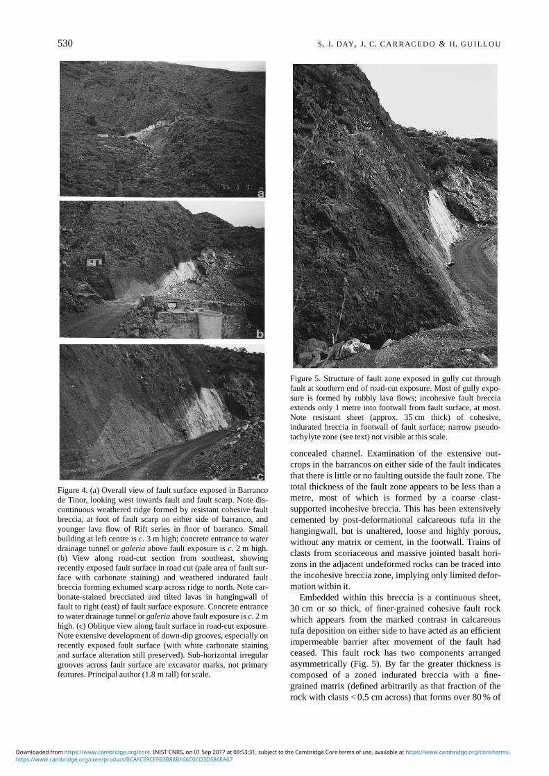
concealed channel. Examination of the extensive out-crops in the barrancos on either side of the fault indicatesthat there is little or no faulting outside the fault zone. Thetotal thickness of the fault zone appears to be less than ametre, most of which is formed by a coarse clast-supported incohesive breccia. This has been extensivelycemented by post-deformational calcareous tufa in thehangingwall, but is unaltered, loose and highly porous,without any matrix or cement, in the footwall. Trains ofclasts from scoriaceous and massive jointed basalt hori-zons in the adjacent undeformed rocks can be traced intothe incohesive breccia zone, implying only limited defor-mation within it.
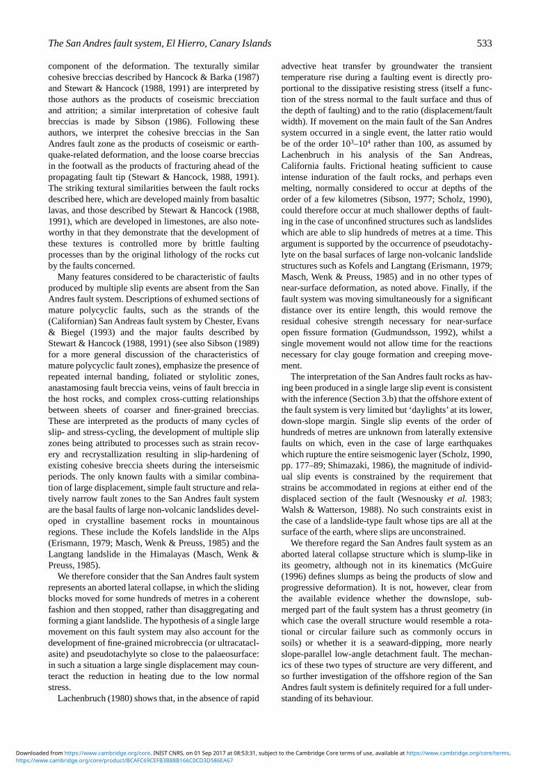
Embedded within this breccia is a continuous sheet,30 cm or so thick, of finer-grained cohesive fault rockwhich appears from the marked contrast in calcareoustufa deposition on either side to have acted as an efficientimpermeable barrier after movement of the fault hadceased. This fault rock has two components arrangedasymmetrically (Fig. 5). By far the greater thickness iscomposed of a zoned indurated breccia with a fine-grained matrix (defined arbitrarily as that fraction of therock with clasts < 0.5 cm across) that forms over 80 % of
530 S. J. DAY, J. C. C A R R AC E D O & H. G U I L L O U
Figure 4. (a) Overall view of fault surface exposed in Barrancode Tinor, looking west towards fault and fault scarp. Note dis-continuous weathered ridge formed by resistant cohesive faultbreccia, at foot of fault scarp on either side of barranco, andyounger lava flow of Rift series in floor of barranco. Smallbuilding at left centre is c. 3 m high; concrete entrance to waterdrainage tunnel or galeria above fault exposure is c. 2 m high.(b) View along road-cut section from southeast, showingrecently exposed fault surface in road cut (pale area of fault sur-face with carbonate staining) and weathered indurated faultbreccia forming exhumed scarp across ridge to north. Note car-bonate-stained brecciated and tilted lavas in hangingwall offault to right (east) of fault surface exposure. Concrete entranceto water drainage tunnel or galeria above fault exposure is c. 2 mhigh. (c) Oblique view along fault surface in road-cut exposure.Note extensive development of down-dip grooves, especially onrecently exposed fault surface (with white carbonate stainingand surface alteration still preserved). Sub-horizontal irregulargrooves across fault surface are excavator marks, not primaryfeatures. Principal author (1.8 m tall) for scale.
Figure 5. Structure of fault zone exposed in gully cut throughfault at southern end of road-cut exposure. Most of gully expo-sure is formed by rubbly lava flows; incohesive fault brecciaextends only 1 metre into footwall from fault surface, at most.Note resistant sheet (approx. 35 cm thick) of cohesive,indurated breccia in footwall of fault surface; narrow pseudo-tachylyte zone (see text) not visible at this scale.
https://www.cambridge.org/core/product/BCAFC69CEFB3B88B166C0CD3D586EA67Downloaded from https://www.cambridge.org/core. INIST CNRS, on 01 Sep 2017 at 08:53:31, subject to the Cambridge Core terms of use, available at https://www.cambridge.org/core/terms.

the rock close to the fault surface but less than 40 % at its boundary with the unlithified footwall breccia: in theterminology of Sibson (1977) the latter is a protocatacla-site whilst the clast-poor rock is a cataclasite. There is acorresponding increase in clast size away from the faultsurface as well. The clasts are mainly angular and basalticin composition, reflecting the dominance of this rock typein the Tinor series, but paler-weathering lava clasts andrecognizable lapilli are also present throughout, implyingextensive mechanical mixing in this zone. The contactbetween the indurated breccia and the incohesive brecciais planar and there is no evidence of veining of the latterby the former, or vice-versa. There is no foliation or othershape fabric in either the matrix or in the larger clast population.
On the eastern and upper surface of this indurated breccia is a thin (0.5 to 1 cm) layer of strongly indurated,porcellanous dark purplish-grey rock which forms thefault surface itself. This rock is a matrix-supported micro-breccia, with relatively few and small (a few millimetresacross) identifiable lithic clasts set in the porcellanousmatrix. Again, there is no foliation or shape fabric in thisrock. There is no indurated breccia on the hangingwallside of this rock, which on the basis of the field evidenceis an ultracataclasite in the Sibson (1977) classification. Ithas a sharp contact against the tufa-cemented breccianoted above, and is itself largely covered by white pow-dery tufa on that part of the fault plane which has recentlybeen exposed.
Overall, the fault zone as exposed at this locality bearsmany points of resemblance to the neotectonic faultsdescribed by Hancock & Barka (1987) and Stewart &Hancock (1988, 1991), cutting limestones in Greece andsouthwest Turkey. The principal difference apparent atoutcrop is the development of much finer-grained micro-breccia, particularly in the thin band adjacent to the faultsurface itself. We note, however, that the intermediate tomajor faults described by these workers, with total slipscomparable to that on the main San Andres fault, have amore complex architecture with multiple sheets of cohe-sive breccia within a broader zone of incohesive breccia.They consider that this complex architecture is producedby multiple episodes of coseismic slip with gradualmigration of deformation into the hangingwall of the faultzone. The simple architecture and thin cohesive brecciasheet of the San Andres fault is more closely comparableto the minor faults described by Stewart & Hancock(1991), with only metres to a few tens of metres of offset.
Other exposures of fault breccia along the San Andresfault system are much less well preserved than those adja-cent to the Barranco de Tinor. However, exposures ofresistant, indurated fault breccia form a discontinuouserosional scarp up to five metres high for some hundredsof metres both to the north of the Barranco de Tinor andthrough the fault bend to the south around [119768].Deeply weathered cohesive fault breccia is also presentalong the Valverde–San Andres road as far southwest as[099754]. Only a single band of indurated fault breccia is
ever present in these exposures; there are no multiplefault strands and thus no evidence for polyphase faultmovement.
5.b. Thin section petrographic characteristics of the faultrocks
Thin section photomicrographs of the two indurated rocktypes at the Barranco de Tinor locality are shown inFigure 6. Whilst the matrix of the main indurated breccia(Fig. 6a) is clearly composed of microscopic clasts ofsimilar (basaltic) composition to the larger clasts, the por-cellanous rock at the contact and the adjacent brecciasshow a number of features which indicate the develop-ment of pseudotachylyte during slip on the fault. Thematrix of the porcellanous rock itself, shown in the lowerpart of Figure 6b, is non-clastic and cryptocrystallineapart from the occurrence of sparse orbicular structures,less than 0.1 mm across, which may represent devitrifica-tion spherulites. The adjacent microbreccia containsnumerous clasts of a distinctive cataclastic rock, with dis-crete basaltic clasts set in a dark cryptocrystalline matrix.Many clasts of this type have cauliform margins againstthe matrix (Fig. 6c) which resemble those formed bychilling of hot magma during magma mixing, and in afew cases they are markedly vesicular (Fig. 6d). The darkcryptocrystalline matrix in these clasts is interpreted to bebasaltic pseudotachylyte, although it lacks the quenchcrystals commonly seen in fault pseudotachylytes(Maddock, 1983; Masch, Wenk & Preuss, 1985; Clarke,1990; Camacho, Vernon & Fitzgerald, 1995). With theexception of the landslide rocks described by Masch,Wenk & Preuss (1985), the pseudotachylytes describedby these authors formed in impermeable rocks at greaterdepths in the crust than did the San Andres fault rocks(see Section 5.c) and are therefore likely to have cooledrather more slowly than the San Andres fault rocks, whichwould account for the relative lack of quench crystalgrowth in the latter. The crystallites described by Masch,Wenk & Preuss (1985) from their electron microscopystudy are submicron-sized; crystallites of similar sizewould not would not be visible optically even if they werepreserved in the rather more altered San Andres pseudo-tachylytes.
Some of the basaltic clasts in the microbreccias of theSan Andres fault have very fine-grained hornfels texturesand show decomposition of mafic minerals to opaqueoxides, suggesting rapid heating under moderately oxi-dizing conditions which may have taken place duringfault movement. In general, however, evidence of strongheating is restricted to the pseudotachylyte band on thefault surface itself and to the pseudotachylyte clasts. Thedevelopment of cauliform margins on some of the latterdoes, however, suggest that the fine-grained clastic matrixof the microbreccia was behaving mechanically as a vis-cous fluid, perhaps as a result of the coseismic fault rockfluidization mechanism recently proposed by Melosh(1996).
The San Andres fault system, El Hierro, Canary Islands 531
https://www.cambridge.org/core/product/BCAFC69CEFB3B88B166C0CD3D586EA67Downloaded from https://www.cambridge.org/core. INIST CNRS, on 01 Sep 2017 at 08:53:31, subject to the Cambridge Core terms of use, available at https://www.cambridge.org/core/terms.

5.c. Depth of formation of the fault rocks
A notable feature of the San Andres fault system is thatthese fault rocks appear to have been formed close to thepalaeosurface. The asymmetry of the fault zone in theBarranco de Tinor exposure, with only loose breccia beingdeveloped on the hangingwall side of the main slip surface,indicates that the movement of the fault has juxtaposed loose breccias formed near the palaeosurface(hence the widespread occurrence of scree breccias bankedup against the fault scarp in adjacent exposures) with cata-clasites formed at slightly greater depth. However, sincethe total vertical displacement on the fault system was per-haps 200 to 300 m, it follows that the cataclasites and ultra-cataclasites in the uplifted sequence on the footwall side ofthe main slip surface must have been formed at similardepths. This is in contrast to the open fissure faults, extend-ing to depths of 500 m or more, described from the riftzones of Iceland (Gudmundsson, 1992, 1995; Forslund &Gudmundsson, 1992) and to the few-kilometres-deepcreeping gouge zones identified or inferred from seismicevidence along large mature tectonic fault zones (Scholz,1990). Reasons for the differences between the rocks of theSan Andres fault system and those found in these otherfaults are considered further in the next section.
6. Movement history and mechanics of the SanAndres fault system
The cross-cutting relationships described in Section 4 showthat the San Andres fault system was active only during ageologically short period of at most 400 000 years, but donot provide constraints on its pattern of activity during thatperiod. Three main possible styles of behaviour may be dis-tinguished: that the fault system was a slow-moving, creep-ing structure active over a long period in a manner similarto large parts of the deforming eastern flank of Mount Etnain Sicily (Firth et al., 1996; Rasa, Azzaro & Leonardi,1996); that it moved in a large number of discrete earth-quakes over an extended period; and that it moved in a fewclosely spaced events (or even a single event) during theformation of an aborted lateral collapse. In the absence ofcontemporaneous sedimentary deposits draping a growingfault scarp or of intrusive bodies with complex cross-cutting relationships, no conclusive answer to this questionis possible. Nevertheless, some strong indications are pro-vided by the fault rocks described in Section 5.
The total absence of fine-scale banding, matrix folia-tions, clast alignments or other evidence for continuousdeformation or flow within the cataclasites indicates that slow, continuous fault creep was not a significant
532 S. J. DAY, J. C. C A R R AC E D O & H. G U I L L O U
Figure 6. Photomicrographs of fault rocks from Barranco de Tinor exposure. All photographs taken in plane-polarized light; widths offields of view 3.25 mm in all cases. (a) Microbreccia from main indurated breccia: basaltic clasts in matrix of very small altered clasts.(b) Porcellanous pseudotachylyte microbreccia, immediately adjacent to fault plane, in lower part of photomicrograph, with sharpirregular contact against indurated microbreccia at top of picture. Cut by post-deformational carbonate veins. (c) Clast within micro-breccia adjacent to pseudotachylyte, composed of basaltic clasts set in pseudotachylyte matrix. Note irregular cauliform margin ofclast. (d) Vesiculated pseudotachylyte in clast in microbreccia. Vesicles lined with post-deformational carbonate.
https://www.cambridge.org/core/product/BCAFC69CEFB3B88B166C0CD3D586EA67Downloaded from https://www.cambridge.org/core. INIST CNRS, on 01 Sep 2017 at 08:53:31, subject to the Cambridge Core terms of use, available at https://www.cambridge.org/core/terms.
component of the deformation. The texturally similarcohesive breccias described by Hancock & Barka (1987)and Stewart & Hancock (1988, 1991) are interpreted bythose authors as the products of coseismic brecciationand attrition; a similar interpretation of cohesive faultbreccias is made by Sibson (1986). Following theseauthors, we interpret the cohesive breccias in the SanAndres fault zone as the products of coseismic or earth-quake-related deformation, and the loose coarse brecciasin the footwall as the products of fracturing ahead of thepropagating fault tip (Stewart & Hancock, 1988, 1991).The striking textural similarities between the fault rocksdescribed here, which are developed mainly from basalticlavas, and those described by Stewart & Hancock (1988,1991), which are developed in limestones, are also note-worthy in that they demonstrate that the development ofthese textures is controlled more by brittle faultingprocesses than by the original lithology of the rocks cutby the faults concerned.
Many features considered to be characteristic of faultsproduced by multiple slip events are absent from the SanAndres fault system. Descriptions of exhumed sections ofmature polycyclic faults, such as the strands of the(Californian) San Andreas fault system by Chester, Evans& Biegel (1993) and the major faults described byStewart & Hancock (1988, 1991) (see also Sibson (1989)for a more general discussion of the characteristics ofmature polycyclic fault zones), emphasize the presence ofrepeated internal banding, foliated or stylolitic zones,anastamosing fault breccia veins, veins of fault breccia inthe host rocks, and complex cross-cutting relationshipsbetween sheets of coarser and finer-grained breccias.These are interpreted as the products of many cycles ofslip- and stress-cycling, the development of multiple slipzones being attributed to processes such as strain recov-ery and recrystallization resulting in slip-hardening ofexisting cohesive breccia sheets during the interseismicperiods. The only known faults with a similar combina-tion of large displacement, simple fault structure and rela-tively narrow fault zones to the San Andres fault systemare the basal faults of large non-volcanic landslides devel-oped in crystalline basement rocks in mountainousregions. These include the Kofels landslide in the Alps(Erismann, 1979; Masch, Wenk & Preuss, 1985) and theLangtang landslide in the Himalayas (Masch, Wenk &Preuss, 1985).
We therefore consider that the San Andres fault systemrepresents an aborted lateral collapse, in which the slidingblocks moved for some hundreds of metres in a coherentfashion and then stopped, rather than disaggregating andforming a giant landslide. The hypothesis of a single largemovement on this fault system may also account for thedevelopment of fine-grained microbreccia (or ultracatacl-asite) and pseudotachylyte so close to the palaeosurface:in such a situation a large single displacement may coun-teract the reduction in heating due to the low normalstress.
Lachenbruch (1980) shows that, in the absence of rapid
advective heat transfer by groundwater the transient temperature rise during a faulting event is directly pro-portional to the dissipative resisting stress (itself a func-tion of the stress normal to the fault surface and thus ofthe depth of faulting) and to the ratio (displacement/faultwidth). If movement on the main fault of the San Andressystem occurred in a single event, the latter ratio wouldbe of the order 103–104 rather than 100, as assumed byLachenbruch in his analysis of the San Andreas,California faults. Frictional heating sufficient to causeintense induration of the fault rocks, and perhaps evenmelting, normally considered to occur at depths of theorder of a few kilometres (Sibson, 1977; Scholz, 1990),could therefore occur at much shallower depths of fault-ing in the case of unconfined structures such as landslideswhich are able to slip hundreds of metres at a time. Thisargument is supported by the occurrence of pseudotachy-lyte on the basal surfaces of large non-volcanic landslidestructures such as Kofels and Langtang (Erismann, 1979;Masch, Wenk & Preuss, 1985) and in no other types ofnear-surface deformation, as noted above. Finally, if thefault system was moving simultaneously for a significantdistance over its entire length, this would remove theresidual cohesive strength necessary for near-surfaceopen fissure formation (Gudmundsson, 1992), whilst asingle movement would not allow time for the reactionsnecessary for clay gouge formation and creeping move-ment.
The interpretation of the San Andres fault rocks as hav-ing been produced in a single large slip event is consistentwith the inference (Section 3.b) that the offshore extent ofthe fault system is very limited but ‘daylights’ at its lower,down-slope margin. Single slip events of the order ofhundreds of metres are unknown from laterally extensivefaults on which, even in the case of large earthquakeswhich rupture the entire seismogenic layer (Scholz, 1990,pp. 177–89; Shimazaki, 1986), the magnitude of individ-ual slip events is constrained by the requirement thatstrains be accommodated in regions at either end of thedisplaced section of the fault (Wesnousky et al. 1983;Walsh & Watterson, 1988). No such constraints exist inthe case of a landslide-type fault whose tips are all at thesurface of the earth, where slips are unconstrained.
We therefore regard the San Andres fault system as anaborted lateral collapse structure which is slump-like inits geometry, although not in its kinematics (McGuire(1996) defines slumps as being the products of slow andprogressive deformation). It is not, however, clear fromthe available evidence whether the downslope, sub-merged part of the fault system has a thrust geometry (inwhich case the overall structure would resemble a rota-tional or circular failure such as commonly occurs insoils) or whether it is a seaward-dipping, more nearlyslope-parallel low-angle detachment fault. The mechan-ics of these two types of structure are very different, andso further investigation of the offshore region of the SanAndres fault system is definitely required for a full under-standing of its behaviour.
The San Andres fault system, El Hierro, Canary Islands 533
https://www.cambridge.org/core/product/BCAFC69CEFB3B88B166C0CD3D586EA67Downloaded from https://www.cambridge.org/core. INIST CNRS, on 01 Sep 2017 at 08:53:31, subject to the Cambridge Core terms of use, available at https://www.cambridge.org/core/terms.
Numerous examples of lateral collapse structureswhich have developed into giant landslides occur in theCanary Islands (Carracedo, 1994), as in similar settingsin many other volcanically active regions, but to ourknowledge the San Andres fault system is the firstdescribed example of a inactive but uncompleted lateralcollapse structure. The question then clearly arises of thecause of this unusual behaviour on the part of the SanAndres fault system. The explanation may lie in the faultrocks described in Section 5. The development of highlyindurated ultracataclasite and pseudotachylyte in the out-crop of the main fault in Barranco de Tinor, the lack ofsyn-displacement veining, the lack of cementation of theloose breccia on the footwall side of the fault, and thetotal lack of visible alteration zones (apart from calicheformation) in the rocks adjacent to the fault, all point tofaulting in dry conditions, without the presence of signifi-cant amounts of groundwater. A noteworthy feature of ElHierro at present is that the water table in the island isclose to sea level and the bulk of the edifice is water-unsaturated (Navarro & Soler, 1994), owing to its highpermeability. This may also have been the case at the timeof movement on the San Andres faults.
The lack of significant groundwater involvement in theSan Andres fault system is in strong contrast to exhumedcollapse structures in the Pliocene Roque Nublo volcanoof Gran Canaria, where fault and gouge dyke orientationsand the presence of abundant mobilized clay-rich gougebreccia point to the presence of abundant and highly pres-surized groundwater during lateral collapses of this vol-cano (Day & Perez Torrado, unpub. data), whichproduced well-known debris avalanche deposits (GarciaCacho et al. 1987; Schmincke, 1987; Mehl & Schmincke,1992; K. Mehl, unpub. Ph.D. thesis, Ruhr-Univ.,Bochum, 1993). Disaggregation of the sliding blocks inthe Roque Nublo collapse structures is believed to havebeen caused, at least in part, by injection of mobilizedgouge breccia mud, at high pressure, into these blocksfrom the adjacent fault zone (Day, 1996; Day & PerezTorrado, unpub. data). We therefore propose that, whilstdebris avalanches themselves may travel long distances inthe absence of water or other liquid components(Erismann, 1979; Campbell, 1989), a key factor control-ling the initiation of debris avalanches may be the pres-ence or absence of pore-fluid-saturated rocks within thecoherently deforming or slumping (see McGuire (1996)for discussion of the relevant terminology) fault blocks.Theoretical predictions of the significance of this contrastare to be found in the work of Elsworth & Voight (1995,1996). These workers have carried out numerical model-ling of the effects of dyke emplacement in a steep-sidedoceanic island rift zone upon the stability of the rift flanksand they show that pore fluid pressurization through heat-ing of these fluids is likely to be critical to the develop-ment of sustained flank instability and consequent debrisavalanche development. We propose that the incompleteor aborted lateral collapse structure represented by theSan Andres fault system may have been preserved in its
present state as a result of a lack of groundwater pressur-ization during its development.
7. Implications for volcanic hazards associated withthe island of El Hierro
The recognition that the San Andres fault system is anold, inactive structure which was not reactivated duringsubsequent collapses elsewhere on El Hierro, rather thanbeing an incipient feature, very much reduces the proba-bility of catastrophic lateral collapses on this island in thenear future. The volume of the island has been substan-tially reduced in the last 160 ka or so by two giant collapses, those of El Julan and El Golfo, and the recentRift series lavas appear to form only a thin veneer overmost of the island (Carracedo, 1994; Guillou et al. 1995,1996). A new volcanic edifice is in the early stages ofgrowth within the El Golfo embayment, but this is at pre-sent only a small feature and is unlikely to grow to a sizecomparable to that of the older volcanic edifices, such asEl Golfo, for some hundreds of thousands of years.Whilst the eruption of lava flows and associated small-scale explosive volcanic activity (along with small-scalerock falls and collapses in the precipitous cliffs of the ElGolfo embayment) present local hazards, it seems that El Hierro presents much less of a regional hazard thanwas thought, and certainly much less of a hazard than larger, rapidly growing volcanic edifices elsewherein the Canary Islands, such as the Cumbre Vieja on LaPalma or Teide on Tenerife.
8. Implications for the evaluation of volcano lateralcollapse and giant landslide hazards: the role ofstructural studies
More generally, the case of the San Andres fault systemillustrates the importance of careful application of geological mapping, stratigraphic techniques andgeochronology to the evaluation of hazards associatedwith recent volcanic edifices. We have shown that theoriginal inference that it was a young and potentiallyactive structure, based on the apparently fresh morphol-ogy of the fault scarp, is a false one, rendered invalid bythe discovery that the fault scarp is in the process of beingexhumed by erosion of the soft scree deposits banked upagainst it. In contrast, our inference that it is a relativelyold and inactive structure is based upon the use of clearcross-cutting and other stratigraphic relationships of thefault system to the various lithostratigraphic/magne-tostratigraphic units of El Hierro (Tables 1, 2). Whilst theradiometric dates assigned to these units (Guillou et al.1995, 1996) are invaluable in quantifying the age of thefault system, we emphasize that it is the evidence fromthe mapping that gives us confidence in our assertion thatthe San Andres fault system is old and inactive.
Our conclusion that the San Andres fault system wasinvolved in a single large deformation event, an abortedlateral collapse, has an alarming implication. The lack of
534 S. J. DAY, J. C. C A R R AC E D O & H. G U I L L O U
https://www.cambridge.org/core/product/BCAFC69CEFB3B88B166C0CD3D586EA67Downloaded from https://www.cambridge.org/core. INIST CNRS, on 01 Sep 2017 at 08:53:31, subject to the Cambridge Core terms of use, available at https://www.cambridge.org/core/terms.
observed precursory deformation (although our data donot exclude small movements of the order of metres onthe main fault system or on minor faults not yet located)implies that catastrophic events of this kind can occur onsteep-sided volcanic islands such as El Hierro withoutsubstantial precursory deformation. This behaviour is instrong contrast to the progressive slumping observed onother island and coastal volcanoes (most notably Hawaii:Swanson, Duffield & Fiske, 1976; Lipman et al. 1985).This is most probably because of the lower slope anglesand larger size of the latter type of volcano, which resultsin seaward displacement of one or more flanks on flat orlandward-dipping basal faults (a structure analogous tothe ‘critical wedge’ geometry of mountain belts (Davis,Suppe & Dahlen, 1983)). In such a deformational struc-ture, catastrophic failures will only occur when the wedgeis oversteepened by this deformation. In contrast, themuch steeper constructional slopes of islands such as ElHierro may cause catastrophic failure almost as soon asslip on a seaward-dipping basal fault begins. Theoreticalmodels of the effects of dyke intrusion upon rift zoneflank stability (Elsworth & Voight, 1995, 1996) andobservations of syn-eruptive faulting in the neighbouringCanarian island of La Palma during 1949 (Bonelli Rubio,1950; S. J. Day, mapping in progress), as well as geodeticstudies in Hawaii (Denlinger et al. 1995) suggest that acatastrophic failure of this type is most likely to occurduring or immediately after rift zone eruptions on unstable islands, when the stresses in the structure areaugmented by magma pressure and (perhaps more impor-tantly) its strength is reduced by pore fluid pressurization.Nevertheless, rift-zone eruptions are common and soflank failures can only occur in a small proportion of sucheruptions. Recognizing that lateral collapse is about tooccur, in the absence of substantial precursory deforma-tion, therefore poses a severe problem for volcano emer-gency management on steep-sided volcanic islands suchas La Palma. In the absence of clear warnings from theactual deformation, prediction of catastrophic collapsesin such situations requires a theoretical understanding ofthe conditions and processes which lead to these events aswell as measurement of the relevant physical variables inthe volcano involved.
We consider that progress in providing this theoreticalbasis may be aided by further studies of old volcanicstructures. The discovery of preserved fault rocks alongthe San Andres fault system points to the possibility ofstudying the kinematics and mechanics of the coherentlydeforming stages or regions of lateral collapses using thetechniques of structural geology and microstructuralanalysis which have been applied to tectonic faults formany years (see Scholz (1990) for a review). Comparisonof these volcano structures with large non-volcanic land-slides should also provide many insights. Active volca-noes are unlikely to be suitable for such studies, becauseeven when they are temporarily exposed in fault scarpsthe fault rocks themselves are likely to be rapidly buriedby lavas and other volcanic rocks draping the scarps. A
more profitable approach may be to study ancientexhumed collapse structures which have been incised tovarying degrees by later erosion, in precisely the samemanner in which structural studies of deeply erodedmountain belts have been used for many years to interpretthe processes operating at the present day in their activecounterparts.
Acknowledgements. Work on El Hierro by SJD was financedby EU Environment Programme Contract EV5V-CT92-0170 toW. J. McGuire; that by JCC and HG by Spanish DGICYT(PB92-0119) and NATO (CRG 940609) research projects. Wethank P. Hancock and G. P. Roberts for discussions of the faultrocks and fault zone structures, D. Elsworth for discussions onthe importance of pressurized pore fluids in lateral collapses,and W. McGuire for discussion of collapse mechanics andnomenclature and his review of the manuscript.
References
BONELLI RUBIO, J. M. 1950. Contribucion al estudio de la erup-cion del Nambroque o San Juan (Isla de La Palma).Madrid: Instituto Geografico y Catastral, 25 pp.
CAMACHO, A., VERNON, R. H. & FITZGERALD, J. D. 1995. Largevolumes of anhydrous pseudotachylyte in the WoodroffeThrust, eastern Musgrave Ranges, Australia. Journal ofStructural Geology 17, 371–83.
CAMPBELL, C. S. 1989. Self-lubrication for long run-out land-slides. Journal of Geology 97, 653–65.
CARRACEDO, J. C. 1994. The Canary Islands: an example ofstructural control on the growth of large oceanic-islandvolcanoes. Journal of Volcanology and GeothermalResearch 60, 225–41.
CHESTER, F. M., EVANS, J. P. & BIEGEL, R. L. 1993. Internalstructure and weakening mechanisms of the San Andreasfault. Journal of Geophysical Research 98, 771–86.
CLARKE, G. L. 1990. Pyroxene microlites and contact metamor-phism in pseudotachylyte veinlets from MacRobertsonLand, east Antarctica. Australian Journal of EarthSciences 37, 1–8.
DAVIS, D., SUPPE, J. & DAHLEN, F. A. 1983. Mechanics of fold-and-thrust belts and accretionary wedges. Journal ofGeophysical Research 88, 1153–72.
DAY, S. J. 1996. Hydrothermal pore fluid pressure and the stabil-ity of porous, permeable volcanoes. In Volcano Instabilityon the Earth and Terrestrial Planets (eds W. J. McGuire,A. P. Jones and J. Neuberg), pp. 77–93. Geological Societyof London, Special Publication no. 110.
DENLINGER, R. P., LISOWSKI, M., MIKLIUS, A. & SAKO, M. 1995.A delicate balance at Kilauea volcano: insights gainedfrom a four month pause in seaward flank displacement.Abstract, IUGG XXI General Assembly, Boulder,Colorado, July 1995.
ELSWORTH, D. & VOIGHT, B. 1995. Dike intrusion as a trigger forlarge earthquakes and the failure of volcano flanks. Journalof Geophysical Research 100, 6005–24.
ELSWORTH, D. & VOIGHT, B. 1996. Evaluation of volcano flankinstability triggered by dyke intrusion. In VolcanoInstability on the Earth and Terrestrial Planets (eds W. J.McGuire, A. P. Jones and J. Neuberg), pp. 45–53.Geological Society of London, Special Publication no.110.
ERISMANN, T. H. 1979. Mechanisms of large landslides. RockMechanics 12, 15–46.
FIRTH, C., STEWART, I., MCGUIRE, W. J., KERSHAW, S. &
The San Andres fault system, El Hierro, Canary Islands 535
https://www.cambridge.org/core/product/BCAFC69CEFB3B88B166C0CD3D586EA67Downloaded from https://www.cambridge.org/core. INIST CNRS, on 01 Sep 2017 at 08:53:31, subject to the Cambridge Core terms of use, available at https://www.cambridge.org/core/terms.
VITA-FINZI, C. 1996. Coastal elevation changes in easternSicily: implications for volcano instability at Mount Etna.In Volcano Instability on the Earth and Terrestrial Planets(eds W. J. McGuire, A. P. Jones and J. Neuberg),pp. 153–167. Geological Society of London, SpecialPublication no. 110.
FORSLUND, T. & GUDMUNDSSON, A. 1992. Structure of Tertiaryand Pleistocene normal faults in Iceland. Tectonics 11,57–68.
FRANCIS, P. W., GARDEWEG, M., O’CALLAGHAN, L. J., RAMIREZ,C. F. & ROTHERY, D. A. 1985. Catastrophic debrisavalanche deposit of Socompa volcano, North Chile.Geology 13, 600–3.
FUSTER, J. M., HERNAN, F., CENDRERO, A., COELLO, J.,CANTAGREL, J. M., ANCOCHEA, E. & IBARROLA, E. 1993.Geochronologia de la isla de El Hierro (Islas Canarias).Boletin Real Sociedad de Espana de Historia y Naturaleza(Seccione Geologica) 88, 85–97.
GARCIA CACHO, L., ANGUITA, F., ARANA, V., BARBERI, F., DIEZ-GIL, J. L., ORTIZ, R. & SBRANA, A. 1987. Una Nueva perspectiva de la Formacion Roque Nublo (Gran Canaria).Boletin Geologia y Mineralogia 98, 859–63.
GUDMUNDSSON, A. 1992. Formation and growth of normal faultsat the divergent plate boundary in Iceland. Terra Nova 4,464–71.
GUDMUNDSSON, A. 1995. Infrastructure and mechanics of vol-canic systems in Iceland. Journal of Volcanology andGeothermal Research 64, 1–22.
GUILLOU, H., CARRACEDO, J. C., LAJ, C., KISSEL, C., PEREZ
TORRADO, F. & RODRIGUEZ BADIOLA, E. 1995. K–Ar agesand magnetic reversals from lavas of El Hierro, CanaryIslands. Terra Abstracts 1, 163. VIII Congress EUG,Strasbourg 1995.
GUILLOU, H., CARRACEDO, J. C., PEREZ TORRADO, F. &RODRIGUEZ BADIOLA, E. 1996. K–Ar ages and magneticstratigraphy of a hotspot-induced, fast-grown oceanicisland: El Hierro, Canary Islands. Journal of Volcanologyand Geothermal Research 73, 141–55.
HANCOCK, P. L. & BARKA, A. A. 1987. Kinematic indicators onactive normal faults in western Turkey. Journal ofStructural Geology 9, 573–84.
HERNANDEZ PACHECO, A. 1982. Sobre una posible erupcion en1793 en la isla de El Hierro (Canarias). EstudiosGeologicos 38, 15–25.
HOLCOMB, R. T. & SEARLE, R. C. 1991. Large landslides fromoceanic volcanoes. Marine Geotechnology 10, 19–32.
HUNTER, P. M., SEARLE, R. C. & LAUGHTON, A. S. 1983.Bathymetry of the N.E. Atlantic, Sheet 5–Continental margin of N.W. Africa. Wormley, U.K. Institute ofOceanographic Sciences Deacon Laboratory.
LABAZUY, P. 1996. Recurrent landsliding events on the subma-rine flank of Piton de la Fournaise volcano (RéunionIsland). In Volcano Instability on the Earth and TerrestrialPlanets (eds W. J. McGuire, A. P. Jones and J. Neuberg),pp. 295–306. Geological Society of London, SpecialPublication no. 110.
LACHENBRUCH, A. H. 1980. Frictional heating, fluid pressure,and the resistance to fault motion. Journal of GeophysicalResearch 85, 6097–6112.
LIPMAN, P. W., LOCKWOOD, J. P., OKAMURA, R. T., SWANSON,D. A. & YAMASHITA, K. M. 1985. Ground deformation asso-ciated with the 1975 magnitude 7.2 earthquake and result-ing changes in activity of Kilauea volcano, Hawaii. UnitedStates Geological Survey Professional Paper no. 1276.
LIPMAN, P. W., NORMARK, W. P., MOORE, J. G., WILSON, J. B. &GUTMACHER, C. E. 1988. The giant submarine Alika debris
slide, Moana Loa, Hawaii. Journal of GeophysicalResearch 93, 4279–99.
LENAT, J. I. (ed.) 1990. Le Volcanisme de La Réunion.Monographie. Publ. Cetre de Recherches Volcanologiques,Clermont-Ferrand, France.
MADDOCK, R. H. 1983. Melt origin of fault-generated pseudo-tachylytes demonstrated by textures. Geology 11, 105–8.
MASCH, L., WENK, H. R. & PREUSS, E. 1985. Electronmicroscopy study of hyalomylonites – evidence for fric-tional melting in landslides. Tectonophysics 115, 131–60.
MASSON, D. G. 1994. RRS Discovery Cruise 205. TOBI surveysand coring of debris flows west of the Canaries. Institute ofOceanographic Sciences Deacon Laboratory CruiseReport no. 239, 23 pp.
MASSON, D. G. 1996. Catastrophic collapse of the volcanicisland of El Hierro 15 ka ago and the history of landslidesin the Canary Islands. Geology 24, 231–4.
MCGUIRE, W. J. 1996. Volcano instability: a review of contem-porary themes. In Volcano Instability on the Earth andTerrestrial Planets (eds W. J. McGuire, A. P. Jones and J. Neuberg), pp. 1–23. Geological Society of London,Special Publication no. 110.
MEHL, K. & SCHMINCKE, H.-U. 1992. Multiple sector collapseof the Pliocene Roque Nublo Stratocone on Gran Canaria(Canary Islands). III Congreso Geologico Espana, VIIICongreso Latinoamericano Geologica, Salamanca(abstracts) 1, 448–52.
MELOSH, H. J. 1996. Dynamical weakening of faults by acousticfluidisation. Nature 379, 601–5.
MOORE, J. G. 1964. Giant submarine landslides on the HawaiianRidge. United States Geological Survey ProfessionalPaper 501-D, D95–D98.
MOORE, J. G., CLAGUE, D. A., HOLCOMB, R. T., LIPMAN, P. W.,NORMARK, W. R. & TORRESAN, M. E. 1989. Prodigioussubmarine landslides on the Hawaiian ridge. Journal ofGeophysical Research 94, 17465–84.
MOORE, J. G., NORMARK, W. R. & HOLCOMB, R. T. 1994. GiantHawaiian landslides. Annual Review of the Earth andPlanetary Sciences 22, 119–44.
NAVARRO, J. M. & SOLER, C. 1994. El Agua en El Hierro.Resumen del Avance del Plan Hidrologico de la isla de ElHierro. Santa Cruz de Tenerife; Excmo. Cabildo Insular deEl Hierro y Consejeria de Obras Publicos Vivienda y Agua,59 pp.
PEARCE, T. J. & JARVIS, I. 1995. High-resolution chemostratigra-phy of Quaternary distal turbidites: A case study of newmethods for the analysis and correlation of barrensequences. In Non-biostratigraphical methods of datingand correlation (eds R. E. Dunay and E. A. Hailwood),pp. 107–43. Geological Society of London, SpecialPublication no. 89.
RASA, R., AZZARO, R. & LEONARDI, O. 1996. Aseismic creep onfaults and flank instability at Mount Etna volcano, Sicily.In Volcano Instability on the Earth and Terrestrial Planets(eds W. J. McGuire, A. P. Jones and J. Neuberg),pp. 179–92. Geological Society of London, SpecialPublication no. 110.
ROBERTS, G. P. 1996. Variation in fault-slip directions alongactive and segmented normal fault systems. Journal ofStructural Geology 18, 835–45.
SCHMINCKE, H. U. 1987. Geological Field Guide to GranCanaria (1st edition). Kiel: Pluto Press, 267 pp.
SCHOLZ, C. H. 1990. The Mechanics of Earthquakes andFaulting. Cambridge, UK: Cambridge University Press,439 pp.
SHIMAZAKI, K. 1986. Small and large earthquakes: the effects of
536 S. J. DAY, J. C. C A R R AC E D O & H. G U I L L O U
https://www.cambridge.org/core/product/BCAFC69CEFB3B88B166C0CD3D586EA67Downloaded from https://www.cambridge.org/core. INIST CNRS, on 01 Sep 2017 at 08:53:31, subject to the Cambridge Core terms of use, available at https://www.cambridge.org/core/terms.

the thickness of the seismogenic layer and the free surface.In Earthquake source mechanics (eds S. Das, J. Boatwrightand C. H. Scholz), pp. 209–16. American GeophysicalUnion Monograph no. 37.
SIBSON, R. H. 1977. Fault rocks and fault mechanisms. Journalof the Geological Society, London 133, 191–214.
SIBSON, R. H. 1986. Brecciation processes in fault zones:inferences from earthquake rupturing. Pure & AppliedGeophysics 124, 156–75.
SIBSON, R. H. 1989. Earthquake faulting as a structural process.Journal of Structural Geology 11, 1–14.
SIEBERT, L., GLICKEN, H. & UI, T. 1987. Volcanic hazards fromBezymianny- and Bandai-type eruptions. Bulletin ofVolcanology 49, 435–59.
STEWART, I. S. & HANCOCK, P. L. 1988. Fault zone evolution andfault scarp degredation in the Aegean region. BasinResearch 1, 139–53.
STEWART, I. S. & HANCOCK, P. L. 1991. Scales of structural heterogeneity within neotectonic normal fault zones in theAegean region. Journal of Structural Geology 13,191–204.
SWANSON, D. A., DUFFIELD, W. A. & FISKE, R. S. 1976.Displacement of the south flank of Kilauea volcano: the
result of forceful intrusion of magma into the rift zones.United States Geological Survey Professional Paper no. 963.
VOIGHT, B. 1981. Time scale for the first moments of the May18th Eruption. In The 1980 Eruptions of Mount St. Helens,Washington (eds P. Lipman and D. R. Mullineaux),pp. 69–92. United States Geological Survey ProfessionalPaper no. 1250.
VOIGHT, B., GLICKEN, H., JANDA, R. J. & DOUGLASS, P. M. 1981.Catastrophic rockslide avalanche of May 18. In The 1980Eruptions of Mount St. Helens, Washington (eds P. Lipmanand D. R. Mullineaux), pp. 347–77. United StatesGeological Survey Professional Paper no. 1250.
WALSH, J. J. & WATTERSON, J. 1988. Analysis of the relationshipbetween displacement and dimensions of faults. Journal ofStructural Geology 10, 238–47.
WATTS, A. B. & MASSON, D. G. 1995. A giant landslide on thenorth flank of Tenerife, Canary Islands. Journal ofGeophysical Research 100, 24487–98.
WESNOUSKY, S. G., SCHOLZ, C. H., SHIMAZAKI, K. & MATSUDA,T. 1983. Earthquake frequency distribution and themechanics of faulting. Journal of Geophysical Research88, 9331–40.
The San Andres fault system, El Hierro, Canary Islands 537
https://www.cambridge.org/core/product/BCAFC69CEFB3B88B166C0CD3D586EA67Downloaded from https://www.cambridge.org/core. INIST CNRS, on 01 Sep 2017 at 08:53:31, subject to the Cambridge Core terms of use, available at https://www.cambridge.org/core/terms.