Embed Size (px)
Citation preview

buildingcommunityWORKSHOPOCTOBER 2016
AFFORDABLE HOUSING & TODASSESSING PARKING LOTS AS STIMULUS TO AFFORDABLE HOUSING DEVELOPMENT AT DART RAIL STATIONS

The buildingcommunityWORKSHOP is a Texas based nonprofit community design center seeking to improve the livability and viability of communities through the practice of thoughtful design and making. We enrich the lives of citizens by bringing design thinking to areas of our city where resources are most scarce. To do so, [bc] recognizes that it must first understand the social, economic, and environmental issues facing a community before beginning work.
PREPARED BY
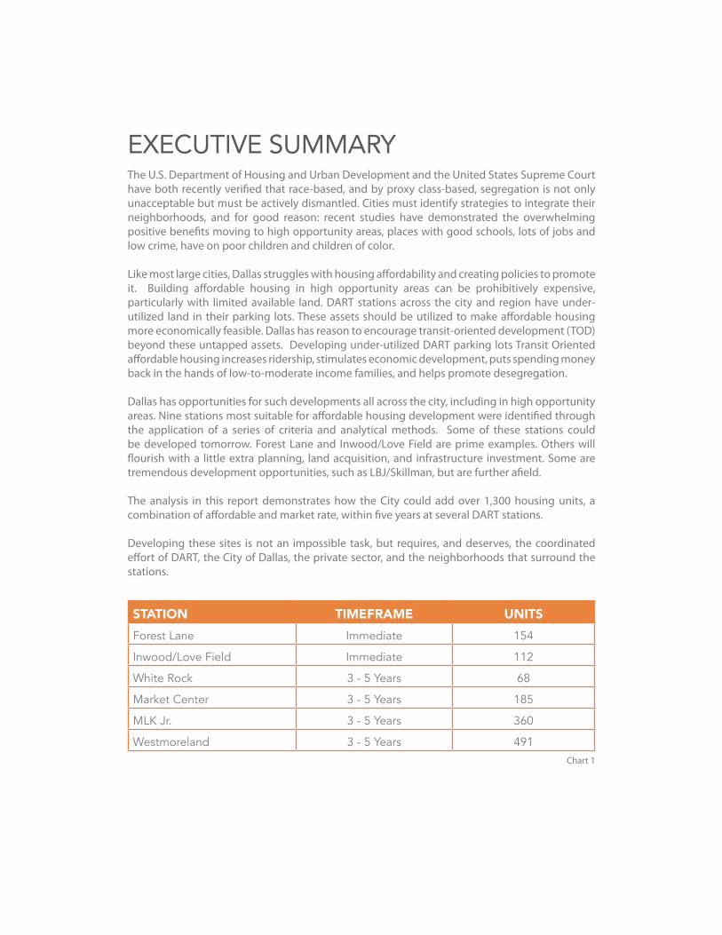
EXECUTIVE SUMMARYThe U.S. Department of Housing and Urban Development and the United States Supreme Court have both recently verified that race-based, and by proxy class-based, segregation is not only unacceptable but must be actively dismantled. Cities must identify strategies to integrate their neighborhoods, and for good reason: recent studies have demonstrated the overwhelming positive benefits moving to high opportunity areas, places with good schools, lots of jobs and low crime, have on poor children and children of color.
Like most large cities, Dallas struggles with housing affordability and creating policies to promote it. Building affordable housing in high opportunity areas can be prohibitively expensive, particularly with limited available land. DART stations across the city and region have under-utilized land in their parking lots. These assets should be utilized to make affordable housing more economically feasible. Dallas has reason to encourage transit-oriented development (TOD) beyond these untapped assets. Developing under-utilized DART parking lots Transit Oriented affordable housing increases ridership, stimulates economic development, puts spending money back in the hands of low-to-moderate income families, and helps promote desegregation.
Dallas has opportunities for such developments all across the city, including in high opportunity areas. Nine stations most suitable for affordable housing development were identified through the application of a series of criteria and analytical methods. Some of these stations could be developed tomorrow. Forest Lane and Inwood/Love Field are prime examples. Others will flourish with a little extra planning, land acquisition, and infrastructure investment. Some are tremendous development opportunities, such as LBJ/Skillman, but are further afield.
The analysis in this report demonstrates how the City could add over 1,300 housing units, a combination of affordable and market rate, within five years at several DART stations.
Developing these sites is not an impossible task, but requires, and deserves, the coordinated effort of DART, the City of Dallas, the private sector, and the neighborhoods that surround the stations.
STATION TIMEFRAME UNITSForest Lane Immediate 154
Inwood/Love Field Immediate 112
White Rock 3 - 5 Years 68
Market Center 3 - 5 Years 185
MLK Jr. 3 - 5 Years 360
Westmoreland 3 - 5 Years 491Chart 1

TABLE OF CONTENTSIntroductionBackgroundMethodologyStation Profiles Forest Lane Inwood / Love Field Market Center MLK Jr. Westmoreland White Rock 8th & Corinth Bachman LBJ / SkillmanPolicy Road MapReferences
010206131418222630343842444648


buildingcommunityWORKSHOP 2016 | 1
INTRODUCTIONThe lack of affordable housing has reached crisis levels in America, exacerbating racial and socioeconomic segregation and their social and economic externalities.1 Many Americans are prevented from finding homes in the type of healthy, integrated neighborhoods that lead to positive life outcomes for their children. In line with its world-class aspirations, Dallas should strive to be proactive in the fight for racial and economic integration, affordability, and access to opportunity for its middle class and working poor citizens. Affordable Housing and TOD: Assessing Parking Lots as Stimulus To Affordable Housing Development at DART Rail Stations demonstrates how publicly-owned land at DART Rail stations can be utilized as a low-cost asset for affordable housing development that will improve the quality of life for the middle class and working poor, strengthen the transit system, and help neighborhood revitalization with smarter land-use and development patterns.
Transit-oriented development (TOD) and affordable housing are important on their own, but are more meaningful in tandem. When built in areas with greater opportunity, that have greater access to jobs, quality schools, other amenities, and less exposure to crime than lower-income neighborhoods, the positive impacts of transit-oriented affordable housing are multiplied. This report outlines research on the mutualistic relationship between TOD and affordable housing, and argues for the need to pursue such a symbiosis. When built, affordable TOD results in housing and transportation cost savings for residents; increased ridership for transit agencies; new jobs and economic development; integrated neighborhoods; and environmental benefits from reducing vehicle miles travelled.
Affordable Housing and TOD: Assessing Parking Lots as Stimulus To Affordable Housing Development at DART Rail Stations, first builds on existing research that demonstrates the benefits of transit-oriented affordable housing and then summarizes the methodology used to identify criteria, extract data, and finally perform the analysis on stations within the Dallas city limits that have DART owned parking lots or land and the potential to achieve maximum benefits for future residents. The location of opportunity areas as identified by the U.S. Department of Housing and Urban Development (HUD) was a key factor in these rankings. As were other data such as proximity to jobs, high quality schools, crime, and unemployment. This ranking helped pinpoint stations that could be developed for affordable housing immediately, while additional factors, such as change in poverty over time, helped determine stations that could benefit from planning for future development, and stations that aligned with local policy initiatives and investments.
To reflect the various stages of development and redevelopment of neighborhoods around the city, stations were divided into three development timeframes: Immediate, 3-5 Years, and 10-12 Years. Planning and schematic design exercises led to site-specific development recommendations for stations in the Immediate and 3-5 Year categories, while more general long-term planning concepts were proposed for the 10-12 Year stations. Actors who may have influence over station development, whether as advocates or opponents, were identified, and basic engagement strategies to gather neighborhood input and support were outlined alongside key challenges for all stations.
These development recommendations are a first step toward implementation. The final section of this document is provides policy recommendations that illustrates how the public sector should adapt to fully exploit the benefits inherent in transit-oriented affordable housing development at DART Rail stations in Dallas.
2 | buildingcommunityWORKSHOP 2016
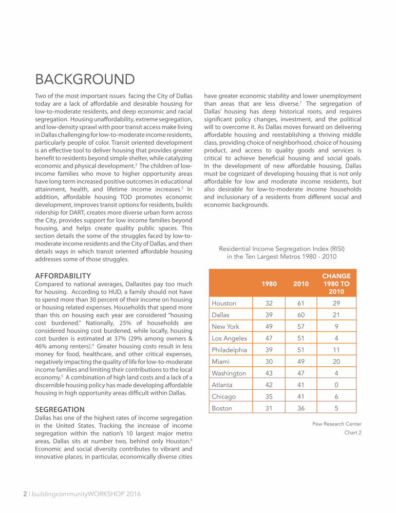
Two of the most important issues facing the City of Dallas today are a lack of affordable and desirable housing for low-to-moderate residents, and deep economic and racial segregation. Housing unaffordability, extreme segregation, and low-density sprawl with poor transit access make living in Dallas challenging for low-to-moderate income residents, particularly people of color. Transit oriented development is an effective tool to deliver housing that provides greater benefit to residents beyond simple shelter, while catalyzing economic and physical development.2 The children of low-income families who move to higher opportunity areas have long term increased positive outcomes in educational attainment, health, and lifetime income increases.3 In addition, affordable housing TOD promotes economic development, improves transit options for residents, builds ridership for DART, creates more diverse urban form across the City, provides support for low income families beyond housing, and helps create quality public spaces. This section details the some of the struggles faced by low-to-moderate income residents and the City of Dallas, and then details ways in which transit oriented affordable housing addresses some of those struggles.
AFFORDABILITYCompared to national averages, Dallasites pay too much for housing. According to HUD, a family should not have to spend more than 30 percent of their income on housing or housing related expenses. Households that spend more than this on housing each year are considered “housing cost burdened.” Nationally, 25% of households are considered housing cost burdened, while locally, housing cost burden is estimated at 37% (29% among owners & 46% among renters).4 Greater housing costs result in less money for food, healthcare, and other critical expenses, negatively impacting the quality of life for low-to-moderate income families and limiting their contributions to the local economy.5 A combination of high land costs and a lack of a discernible housing policy has made developing affordable housing in high opportunity areas difficult within Dallas.
SEGREGATIONDallas has one of the highest rates of income segregation in the United States. Tracking the increase of income segregation within the nation’s 10 largest major metro areas, Dallas sits at number two, behind only Houston.6 Economic and social diversity contributes to vibrant and innovative places; in particular, economically diverse cities
have greater economic stability and lower unemployment than areas that are less diverse.7 The segregation of Dallas’ housing has deep historical roots, and requires significant policy changes, investment, and the political will to overcome it. As Dallas moves forward on delivering affordable housing and reestablishing a thriving middle class, providing choice of neighborhood, choice of housing product, and access to quality goods and services is critical to achieve beneficial housing and social goals. In the development of new affordable housing, Dallas must be cognizant of developing housing that is not only affordable for low and moderate income residents, but also desirable for low-to-moderate income households and inclusionary of a residents from different social and economic backgrounds.
BACKGROUND
1980 2010CHANGE 1980 TO
2010
Houston 32 61 29
Dallas 39 60 21
New York 49 57 9
Los Angeles 47 51 4
Philadelphia 39 51 11
Miami 30 49 20
Washington 43 47 4
Atlanta 42 41 0
Chicago 35 41 6
Boston 31 36 5
Residential Income Segregation Index (RISI) in the Ten Largest Metros 1980 - 2010
Chart 2
Pew Research Center
buildingcommunityWORKSHOP 2016 | 3
TRANSIT-ORIENTED DEVELOPMENTOver the past two decades TOD has been used in the United States as a tool to create well-balanced, complete communities. There is no uniform definition of TOD, but the Federal Transportation Agency identifies three common attributes: “a high quality walking environment, a mix of land uses, and higher-density development within a designated area (typically one-quarter to one-half mile) surrounding a transit station or stop”.8 To many, TOD is an attempt to realign the dispersed, low-density development model that dominated much of America’s growth following World War II. When TOD is done well, it is a development strategy that integrates housing, transportation, public space, neighborhood retail and services, and community amenities in good urban form.
Transportation. Building housing at DART transit stations can increase DART ridership and reduce the economic and environmental burden of car dependency. • People who live in TODs are 5 times more likely to use
transit and people who work in TODs are 3.5 times more likely to use it.9
• TOD reduces vehicle miles traveled (VMT), increases mobility, and improves access to jobs.10
• Households in walkable neighborhoods with good transit access spend 9 percent of their income on transportation, while households in auto-dependent neighborhoods spend 25 percent.11
TOD nodes promote better urban form; reduce the infrastructural burden resulting from suburban sprawl; reduce traffic congestion; promote equitable distribution of affordable housing developments to high opportunity areas;, and support increased access to employment. 12, 13
Support Low-Income Families. Combining access to affordable housing and public transit can reduces the financial burden of low-income families. On average Americans spend 57 percent of household income on housing and transportation.14 In some areas working families are spending as much or more on transportation than housing.3 Transit users in Dallas can save around $9,00015 by taking transit in place of driving and better utilize those funds for food, clothing, education, healthcare, and asset development.16 With smart investments in TOD, this can greatly support low-to-moderate income workers in Dallas.17 Living in transit rich areas also has measured health benefits. Safe, quality neighborhoods lead to
healthier populations, reducing reliance on expensive public health services.18
Diverse neighborhoods. When done well, TODs support the development of diverse housing products at multiple price points. This in turn creates, supports, and maintains neighborhood diversity and vitality. Communities that offer “housing for a mix of incomes produce better economic, social and environmental outcomes for all residents.”19 Additionally income diversity is shown to support:• equal access to safe neighborhoods near well-funded
schools and good city services • greater access to a wider variety of jobs and
opportunities • enhanced community stability and sustainability• reduced concentrations of poverty and the isolation
of low-income households.
Economic Development. TOD projects catalyze economic development, neighborhood investment, and increased tax base. Leveraging private investment, TODs can also deliver public benefits, including housing affordability and high-quality public spaces.20 TODs also:• Create jobs during and after construction. • Increase the disposable income for households.21
• Attract increased commercial and retail activity around transit stations.22
• Increase the utilization and efficiency of public resources.23
• Increased property values and ad valurem taxes.24
Quality Public Spaces. TODs can create public spaces by leveraging the density of the development more strategically. Public spaces located in “high-density, mixed-use development[s] are often safer, pedestrian friendly, active, and contribute to creating vibrant and lively neighborhoods”.25 A key element of TOD is the need for station area planning. Without proper coordination and planning, this key element of quality placemaking can be lost.
SUMMARYLeveraging publicly owned land at transit stops provides an economically feasible pathway to achieve greater integration and access to opportunities for low-to-moderate income households. Low-income neighborhoods in Dallas have limited access to social and economic opportunity because of high levels of poverty,

4 | buildingcommunityWORKSHOP 2016
poor access to jobs, and deteriorating infrastructure. Many of Dallas’ high opportunity areas have few viable sites for development of affordable housing at a meaningful scale, making large, low-intensity land uses such as DART station parking lots highly desirable, and a logical choice for affordable housing development. Leveraging DART owned land for singular developments, or as a piece of larger development agreements, furthers the city’s housing and neighborhood vitality agenda, and supports DART’s operational and development goals. These transit-oriented
affordable housing will also increase DART ridership, relieve congestion on roads, increase disposable income, improve the quality of life for low-income residents, create new and better access to jobs, and encourage more sustainable urban form. Placing these developments in higher opportunity and lower poverty areas, gives children from low-income families a significantly better chance to break the cycle of poverty and lead more productive lives.
Housing + Transportation Burden, for low and moderate income households at 80% AMI
Chart 3
Less than 20
20 to 29
30 or More
5
10
15
20
25%
Housing Cost Burden by Income for households in Dallas
Less than 20,000
20,000 - 34,999
35,000 - 49,999
50,000 - 74,999
75,000 or More
Percent of Income Spent on Housing
Map 1
36% - 46%
47% - 74%
75% +

buildingcommunityWORKSHOP 2016 | 5
6 | buildingcommunityWORKSHOP 2016
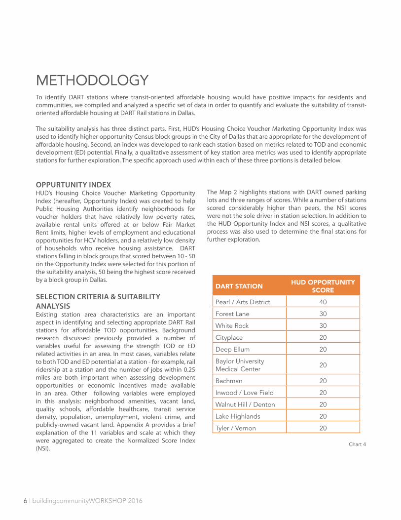
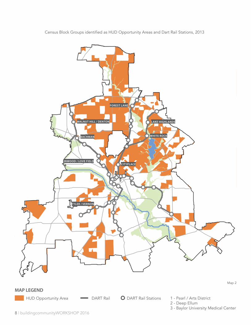
METHODOLOGYTo identify DART stations where transit-oriented affordable housing would have positive impacts for residents and communities, we compiled and analyzed a specific set of data in order to quantify and evaluate the suitability of transit-oriented affordable housing at DART Rail stations in Dallas.
The suitability analysis has three distinct parts. First, HUD’s Housing Choice Voucher Marketing Opportunity Index was used to identify higher opportunity Census block groups in the City of Dallas that are appropriate for the development of affordable housing. Second, an index was developed to rank each station based on metrics related to TOD and economic development (ED) potential. Finally, a qualitative assessment of key station area metrics was used to identify appropriate stations for further exploration. The specific approach used within each of these three portions is detailed below.
OPPURTUNITY INDEX HUD’s Housing Choice Voucher Marketing Opportunity Index (hereafter, Opportunity Index) was created to help Public Housing Authorities identify neighborhoods for voucher holders that have relatively low poverty rates, available rental units offered at or below Fair Market Rent limits, higher levels of employment and educational opportunities for HCV holders, and a relatively low density of households who receive housing assistance. DART stations falling in block groups that scored between 10 - 50 on the Opportunity Index were selected for this portion of the suitability analysis, 50 being the highest score received by a block group in Dallas.
SELECTION CRITERIA & SUITABILITY ANALYSISExisting station area characteristics are an important aspect in identifying and selecting appropriate DART Rail stations for affordable TOD opportunities. Background research discussed previously provided a number of variables useful for assessing the strength TOD or ED related activities in an area. In most cases, variables relate to both TOD and ED potential at a station - for example, rail ridership at a station and the number of jobs within 0.25 miles are both important when assessing development opportunities or economic incentives made available in an area. Other following variables were employed in this analysis: neighborhood amenities, vacant land, quality schools, affordable healthcare, transit service density, population, unemployment, violent crime, and publicly-owned vacant land. Appendix A provides a brief explanation of the 11 variables and scale at which they were aggregated to create the Normalized Score Index (NSI).
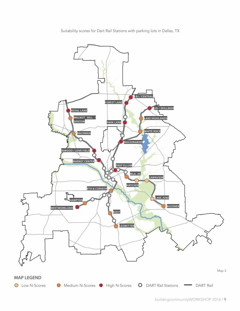
The Map 2 highlights stations with DART owned parking lots and three ranges of scores. While a number of stations scored considerably higher than peers, the NSI scores were not the sole driver in station selection. In addition to the HUD Opportunity Index and NSI scores, a qualitative process was also used to determine the final stations for further exploration.
DART STATION HUD OPPORTUNITY SCORE
Pearl / Arts District 40
Forest Lane 30
White Rock 30
Cityplace 20
Deep Ellum 20
Baylor University Medical Center 20
Bachman 20
Inwood / Love Field 20
Walnut Hill / Denton 20
Lake Highlands 20
Tyler / Vernon 20
Chart 4
buildingcommunityWORKSHOP 2016 | 7
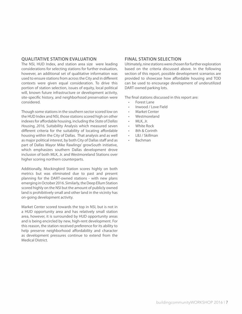
QUALITATIVE STATION EVALUATION The NSI, HUD Index, and station area size were leading considerations for selecting stations for further evaluation, however, an additional set of qualitative information was used to ensure stations from across the City and in different contexts were given equal consideration. To drive this portion of station selection, issues of equity, local political will, known future infrastructure or development activity, site-specific history, and neighborhood preservation were considered.
Though some stations in the southern sector scored low on the HUD Index and NSI, those stations scored high on other indexes for affordable housing, including the State of Dallas Housing, 2016, Suitability Analysis which measured seven different criteria for the suitability of locating affordable housing within the City of Dallas. That analysis and as well as major political interest, by both City of Dallas staff and as part of Dallas Mayor Mike Rawlings’ growSouth initiative, which emphasizes southern Dallas development drove inclusion of both MLK, Jr. and Westmoreland Stations over higher scoring northern counterparts.
Additionally, Mockingbird Station scores highly on both metrics but was eliminated due to past and present planning for the DART-owned stations - with new plans emerging in October 2016. Similarly, the Deep Ellum Station scored highly on the NSI but the amount of publicly owned land is prohibitively small and other land in the vicinity has on-going development activity.
Market Center scored towards the top in NSI, but is not in a HUD opportunity area and has relatively small station area, however, it is surrounded by HUD opportunity areas and is being encircled by new, high-rent development. For this reason, the station received preference for its ability to help preserve neighborhood affordability and character as development pressures continue to extend from the Medical District.
FINAL STATION SELECTIONUltimately, nine stations were chosen for further exploration based on the criteria discussed above. In the following section of this report, possible development scenarios are provided to showcase how affordable housing and TOD can be used to encourage development of underutilized DART-owned parking lots.
The final stations discussed in this report are: • Forest Lane• Inwood / Love Field• Market Center• Westmoreland • MLK, Jr.• White Rock • 8th & Corinth• LBJ / Skillman• Bachman
8 | buildingcommunityWORKSHOP 2016
HUD Opportunity Area DART Rail DART Rail Stations
MAP LEGEND
Census Block Groups identified as HUD Opportunity Areas and Dart Rail Stations, 2013
BACHMAN
FOREST LANE
WHITE ROCK
CITYPLACE
1 - Pearl / Arts District 2 - Deep Ellum3 - Baylor University Medical Center
INWOOD / LOVE FIELD
WALNUT HILL / DENTON LAKE HIGHLANDS
TYLER / VERNON
1
2
3
Map 2
buildingcommunityWORKSHOP 2016 | 9
MAP LEGEND
Low N-Scores Medium N-Scores High N-Scores DART Rail Stations DART Rail
Suitability scores for Dart Rail Stations with parking lots in Dallas, TX
BACHMAN
FOREST LANE
INWOOD / LOVE FIELD
MARKET CENTER
LBJ / SKILLMAN
LAKE HIGHLANDS
WHITE ROCK
BUCKNER
LEDBETTER
MLK, JR.
LBJ / CENTRAL
MOCKINGBIRD
PARK LANE
WALNUT HILL /
DENTON
ROYAL LANE
WESTMORELAND
HAMPTON
HATCHER
LAWNVIEW
LAKE JUNE
KIEST
8TH & CORINTH
DEEP ELLUM
Map 3

10 | buildingcommunityWORKSHOP 2016
STATION PROFILESThe following section profiles nine DART stations identified according to HUD opportunity areas, a suitability analysis of station development potential, and later adjustments to reflect political and development realities. Each station profile includes high-level facts about the station and the surrounding area, a narrative of our recommended development strategy, and a map showing changes to the physical and regulatory environment we recommend to productively and sensitively steward each station’s neighborhood towards its TOD future.
Beyond these common elements, each station is grouped according to its perceived development time table: Immediate, 3-5 Years, 10-12 Years.
Development sites that could obtain financing, gather political and community support, and begin construction now are Forest Lane Station and Inwood/Love Field Station. These station profiles include more detailed site-level recommendations such as a development pro forma, site plan, and character images of similar development types.
Development sites that require additional groundwork, including market growth, capital improvements by the City, and more extensive land acquisition and site reconfiguration, fall into the 3-5 year category. Each 3-5 year station profile includes a neighborhood scale map identifying key moves that need to be made beyond the station area but do not have as detailed a site plan or a pro forma. These include Market Center Station, MLK Station, White Rock Station, Westmoreland Station, and 8th & Corinth Station. Westmoreland Station and 8th & Corinth Station are somewhat more complicated and may have phases that could happen slightly more quickly than 3-5 years and some that may take longer.
Development sites that should be a part of a larger area master planning process due to the significant infrastructure, land use, or connectivity changes that are being, or ought to be, made in the surrounding area are included in the 5 10-12 year category. These sites have significant development potential, but must be viewed as part of a more comprehensive area study. Such a study could be done collaboratively between the City of Dallas, DART and other key stakeholders. These are LBJ/Skillman Station and Bachman Station.
All of the recommendations made on the following pages are conceptual and illustrate potential. Inspired by these studies, communities, elected officials, developers, and public servants can prioritize collaborative transit-oriented development and work towards detailed, consensus solutions for each site.
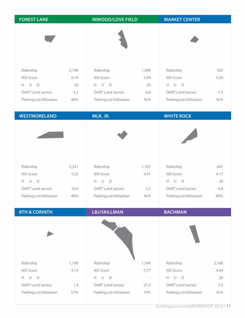
buildingcommunityWORKSHOP 2016 | 11
Ridership
Ridership
Ridership
Ridership
Ridership
Ridership
Ridership
Ridership
Ridership
2,198
2,321
1,700
1,599
1,107
1,394
559
667
2,168
6.14
5.22
4.13
5.49
4.41
5.77
5.30
4.17
4.04
30
-
-
20
-
-
-
30
20
4.2
10.6
1.4
6.8
3.5
27.3
2.5
6.6
7.0
48%
49%
57%
N/A
N/A
19%
N/A
40%
N/A
NSI Score
NSI Score
NSI Score
NSI Score
NSI Score
NSI Score
NSI Score
NSI Score
NSI Score
H U D
H U D
H U D
H U D
H U D
H U D
H U D
H U D
H U D
DART Land (acres)
DART Land (acres)
DART Land (acres)
DART Land (acres)
DART Land (acres)
DART Land (acres)
DART Land (acres)
DART Land (acres)
DART Land (acres)
Parking Lot Utilization
Parking Lot Utilization
Parking Lot Utilization
Parking Lot Utilization
Parking Lot Utilization
Parking Lot Utilization
Parking Lot Utilization
Parking Lot Utilization
Parking Lot Utilization
FOREST LANE
WESTMORELAND
8TH & CORINTH
INWOOD/LOVE FIELD
MLK, JR.
LBJ/SKILLMAN
MARKET CENTER
WHITE ROCK
BACHMAN

12 | buildingcommunityWORKSHOP 2016
DESCRIPTIONThe Forest Lane Station is a heavily used stop on DART’s Red Line, located near the intersection of Forest Lane and North Central Expressway one stop north of Presbyterian Hospital at Walnut Hill Station and one stop south of LBJ/Central Station and Texas Instrument’s main campus. Across Forest Lane is the largely single-family Hamilton Park neighborhood and Presbyterian Village North senior community separates the rail station from the single-family Stults Road neighborhood to the southeast. Community and regional retail line Forest Lane to the west. There a several religious institutions and educational campuses in close proximity to the station in addition to a Texas Instruments corporate campus and Medical City Dallas Hospital.
DEVELOPMENT STRATEGYForest Lane station is prepared for immediate development, assuming the parcel to the west currently housing an unoccupied RaceTrac gas station can be acquired. The station’s location in a HUD opportunity area, with good schools and access to transit and jobs, indicate its potential for effective affordable housing.
The parking area directly adjacent to the rail station, as bisected by the entry drive, should be left intact, based on its volume of use. The parking area to the left of the entry drive should be combined and replatted with RaceTrac property to create a developable parcel. This requires no disruption of the existing bus routes through the existing parking lot.
The newly created parcel is fit for a medium density, 3 to 5 story apartment development geared towards families earning between 60 and 120 percent AMI, with a wraparound parking garage for residents. This garage could potentially have overflow parking for transit users. This scale of development is compatible with the surrounding area and resembles a recent development under construction on the north side of Forest Lane to the west of the site. Forest Lane, as a major arterial, acts as a buffer between the site and the single-family neighborhood opposite street.
FAST FACTSParcel Size 4.2 acresRidership 2,198
SUITABILITYNormalized Score 6.14 Normalized Rank 3/23HUD Opportunity 30
STAKEHOLDERSPublic + ElectedCouncilperson A. McGough Council District 10Key City Depts. Parks, StormwaterSchool Dist. Richardson ISD
NON-PROFIT STAKEHOLDERSGreater Cornerstone Baptist Church, Dallas Lutheran School, The Buddhist Center of Dallas, Presbyterian Village North, Hamilton Park Historic Preservation Foundation, Stults Road Homeowners Association, Northwood Heights Homeowners Alliance
PRIVATE SECTOR STAKEHOLDERSTexas Instruments, Medical City
FOREST LANE | 8210 FOREST LN
buildingcommunityWORKSHOP 2016 | 13
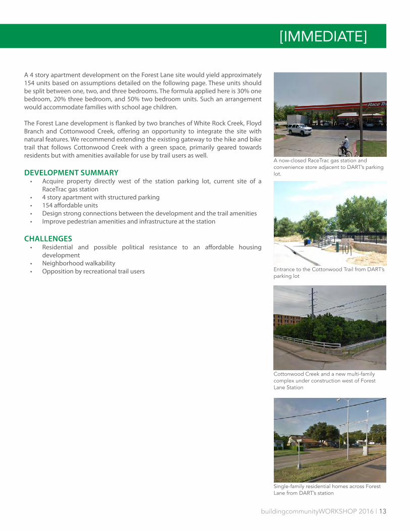
A 4 story apartment development on the Forest Lane site would yield approximately 154 units based on assumptions detailed on the following page. These units should be split between one, two, and three bedrooms. The formula applied here is 30% one bedroom, 20% three bedroom, and 50% two bedroom units. Such an arrangement would accommodate families with school age children.
The Forest Lane development is flanked by two branches of White Rock Creek, Floyd Branch and Cottonwood Creek, offering an opportunity to integrate the site with natural features. We recommend extending the existing gateway to the hike and bike trail that follows Cottonwood Creek with a green space, primarily geared towards residents but with amenities available for use by trail users as well.
DEVELOPMENT SUMMARY• Acquire property directly west of the station parking lot, current site of a
RaceTrac gas station• 4 story apartment with structured parking• 154 affordable units• Design strong connections between the development and the trail amenities• Improve pedestrian amenities and infrastructure at the station
CHALLENGES• Residential and possible political resistance to an affordable housing
development• Neighborhood walkability• Opposition by recreational trail users
A now-closed RaceTrac gas station and convenience store adjacent to DART’s parking lot.
Entrance to the Cottonwood Trail from DART’s parking lot
Cottonwood Creek and a new multi-family complex under construction west of Forest Lane Station
Single-family residential homes across Forest Lane from DART’s station
[IMMEDIATE]

14 | buildingcommunityWORKSHOP 2016
MAP LEGEND
Buildable Area
DART Station
Green Space
SITE PLAN
Buildable Area 1.4 acresUnits 154Parking Spots 154
FOREST LANE
FOREST LANE STATION
FOREST LANE | 8210 FOREST LN
buildingcommunityWORKSHOP 2016 | 15
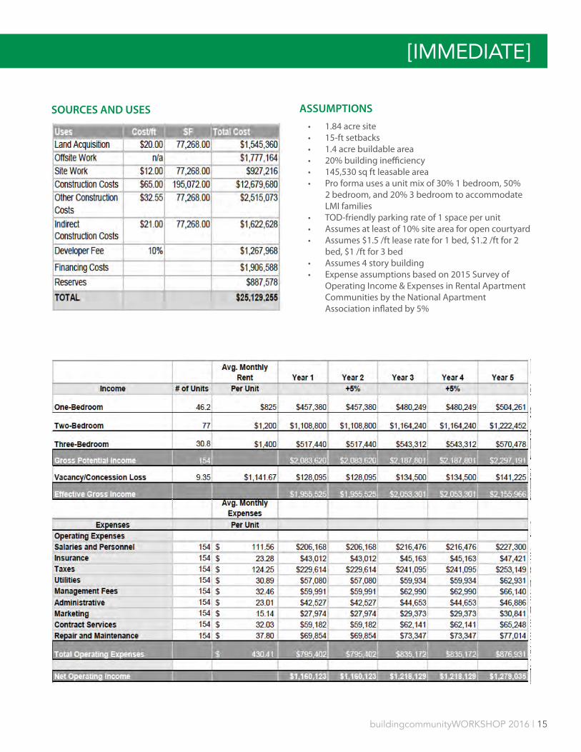
SOURCES AND USES ASSUMPTIONS
• 1.84 acre site• 15-ft setbacks• 1.4 acre buildable area• 20% building inefficiency• 145,530 sq ft leasable area• Pro forma uses a unit mix of 30% 1 bedroom, 50%
2 bedroom, and 20% 3 bedroom to accommodate LMI families
• TOD-friendly parking rate of 1 space per unit• Assumes at least of 10% site area for open courtyard• Assumes $1.5 /ft lease rate for 1 bed, $1.2 /ft for 2
bed, $1 /ft for 3 bed• Assumes 4 story building• Expense assumptions based on 2015 Survey of
Operating Income & Expenses in Rental Apartment Communities by the National Apartment Association inflated by 5%
[IMMEDIATE]
16 | buildingcommunityWORKSHOP 2016
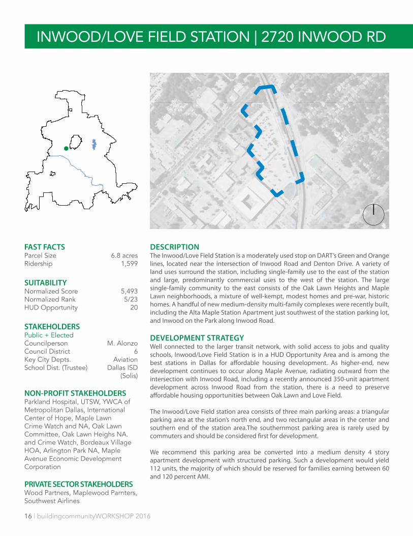
DESCRIPTIONThe Inwood/Love Field Station is a moderately used stop on DART’s Green and Orange lines, located near the intersection of Inwood Road and Denton Drive. A variety of land uses surround the station, including single-family use to the east of the station and large, predominantly commercial uses to the west of the station. The large single-family community to the east consists of the Oak Lawn Heights and Maple Lawn neighborhoods, a mixture of well-kempt, modest homes and pre-war, historic homes. A handful of new medium-density multi-family complexes were recently built, including the Alta Maple Station Apartment just southwest of the station parking lot, and Inwood on the Park along Inwood Road.
DEVELOPMENT STRATEGYWell connected to the larger transit network, with solid access to jobs and quality schools, Inwood/Love Field Station is in a HUD Opportunity Area and is among the best stations in Dallas for affordable housing development. As higher-end, new development continues to occur along Maple Avenue, radiating outward from the intersection with Inwood Road, including a recently announced 350-unit apartment development across Inwood Road from the station, there is a need to preserve affordable housing opportunities between Oak Lawn and Love Field.
The Inwood/Love Field station area consists of three main parking areas: a triangular parking area at the station’s north end, and two rectangular areas in the center and southern end of the station area.The southernmost parking area is rarely used by commuters and should be considered first for development.
We recommend this parking area be converted into a medium density 4 story apartment development with structured parking. Such a development would yield 112 units, the majority of which should be reserved for families earning between 60 and 120 percent AMI.
Inwood / Love Field | 2720 Inwood RdINWOOD/LOVE FIELD STATION | 2720 INWOOD RD
FAST FACTSParcel Size 6.8 acresRidership 1,599
SUITABILITYNormalized Score 5,493 Normalized Rank 5/23HUD Opportunity 20
STAKEHOLDERSPublic + ElectedCouncilperson M. Alonzo Council District 6Key City Depts. AviationSchool Dist. (Trustee) Dallas ISD
(Solis)
NON-PROFIT STAKEHOLDERSParkland Hospital, UTSW, YWCA of Metropolitan Dallas, International Center of Hope, Maple Lawn Crime Watch and NA, Oak Lawn Committee, Oak Lawn Heighs NA. and Crime Watch, Bordeaux Village HOA, Arlington Park NA, Maple Avenue Economic Development Corporation
PRIVATE SECTOR STAKEHOLDERSWood Partners, Maplewood Parnters, Southwest Airlines
buildingcommunityWORKSHOP 2016 | 17
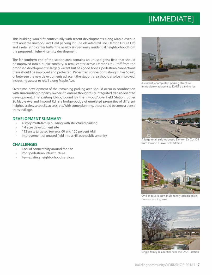
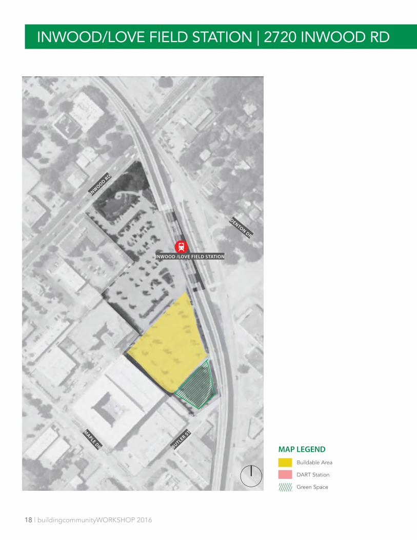
This building would fit contextually with recent developments along Maple Avenue that abut the Inwood/Love Field parking lot. The elevated rail line, Denton Dr Cut Off, and a retail strip center buffer the nearby single-family residential neighborhood from the proposed, higher-intensity development.
The far southern end of the station area contains an unused grass field that should be improved into a public amenity. A retail center across Denton Dr Cutoff from the proposed development is largely vacant but has good bones; pedestrian connections there should be improved and protected. Pedestrian connections along Butler Street, or between the new developments adjacent the station, area should also be improved, increasing access to retail along Maple Ave.
Over time, development of the remaining parking area should occur in coordination with surrounding property owners to ensure thoughtfully integrated transit-oriented development. The existing block, bound by the Inwood/Love Field Station, Butler St, Maple Ave and Inwood Rd, is a hodge-podge of unrelated properties of different heights, scales, setbacks, access, etc. With some planning, these could become a dense transit village.
DEVELOPMENT SUMMARY• 4 story multi-family building with structured parking• 1.4 acre development site• 112 units targeted towards 60 and 120 percent AMI• Improvement of unused field into a .45 acre public amenity
CHALLENGES• Lack of connectivity around the site• Poor pedestrian infrastructure• Few existing neighborhood services
A currently-completed parking structure immediately adjacent to DART’s parking lot
A large retail strip opposed Denton Dr Cut Off from Inwood / Love Field Station
One of several new multi-family complexes in the surrounding area
Single-family residential near the DART station
[IMMEDIATE]
18 | buildingcommunityWORKSHOP 2016
INW
OOD RD
DENTON DR
MAPLE DR BUTLER ST
INWOOD /LOVE FIELD STATION
Inwood / Love Field | 2720 Inwood RdINWOOD/LOVE FIELD STATION | 2720 INWOOD RD
MAP LEGEND
Buildable Area
DART Station
Green Space

buildingcommunityWORKSHOP 2016 | 19
SOURCES AND USES ASSUMPTIONS• 1.48 acre site• 15-ft setbacks• 1.13 acre buildable area• 20% building inefficiency• .9 acre building footprint• Pro forma uses a unit mix of 30% 1 bedroom, 50% 2
bedroom, and 20% 3 bedroom to accommodate LMI families
• TOD-friendly parking rate of 1 space per unit• Assumes at least of 10% site area for open courtyard• Assumes $1.5 /ft lease rate for 1 bed, $1.2 /ft for 2 bed,
$1 /ft for 3 bed• Assumes 4 story building• Expense assumptions based on 2015 Survey of
Operating Income & Expenses in Rental Apartment Communities by the National Apartment Association inflated by 5%
[IMMEDIATE]
20 | buildingcommunityWORKSHOP 2016
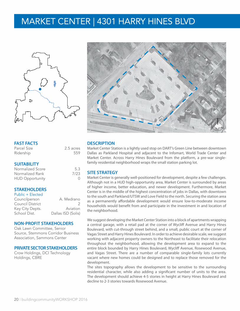
DESCRIPTIONMarket Center Station is a lightly used stop on DART’s Green Line between downtown Dallas as Parkland Hospital and adjacent to the Infomart, World Trade Center and Market Center. Across Harry Hines Boulevard from the platform, a pre-war single-family residential neighborhood wraps the small station parking lot.
SITE STRATEGYMarket Center is generally well-positioned for development, despite a few challenges. Although not in a HUD high-opportunity area, Market Center is surrounded by areas of higher income, better education, and newer development. Furthermore, Market Center is in the middle of the highest concentration of jobs in Dallas, with downtown to the south and Parkland/UTSW and Love Field to the north. Securing the station area as a permanently affordable development would ensure low-to-moderate income households would benefit from and participate in the investment in and location of the neighborhood.
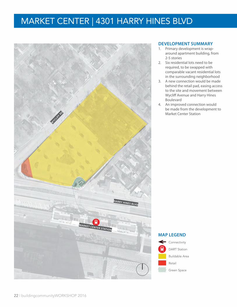
We suggest developing the Market Center Station into a block of apartments wrapping a central garage, with a retail pad at the corner of Wycliff Avenue and Harry Hines Boulevard, with cut-through street behind, and a small, public court at the corner of Vagas Street and Harry Hines Boulevard. In order to achieve desirable scale, we suggest working with adjacent property owners to the Northeast to facilitate their relocation throughout the neighborhood, allowing the development area to expand to the entire block bounded by Harry Hines Boulevard, Wycliff Avenue, Rosewood Avenue, and Vagas Street. There are a number of comparable single-family lots currently vacant where new homes could be designed and to replace those removed for the development. The sites topography allows the development to be sensitive to the surrounding residential character, while also adding a significant number of units to the area. The development should achieve 4-5 stories in height at Harry Hines Boulevard and decline to 2-3 stories towards Rosewood Avenue.
MARKET CENTER | 4301 HARRY HINES BLVD
FAST FACTSParcel Size 2.5 acresRidership 559
SUITABILITYNormalized Score 5.3Normalized Rank 7/23HUD Opportunity 0
STAKEHOLDERSPublic + ElectedCouncilperson A. Medrano Council District 2Key City Depts. AviationSchool Dist. Dallas ISD (Solis)
NON-PROFIT STAKEHOLDERSOak Lawn Committee, Senior Source, Stemmons Corridor Business Association, Sammons Center
PRIVATE SECTOR STAKEHOLDERSCrow Holdings, DCI Technology Holdings, CBRE
buildingcommunityWORKSHOP 2016 | 21
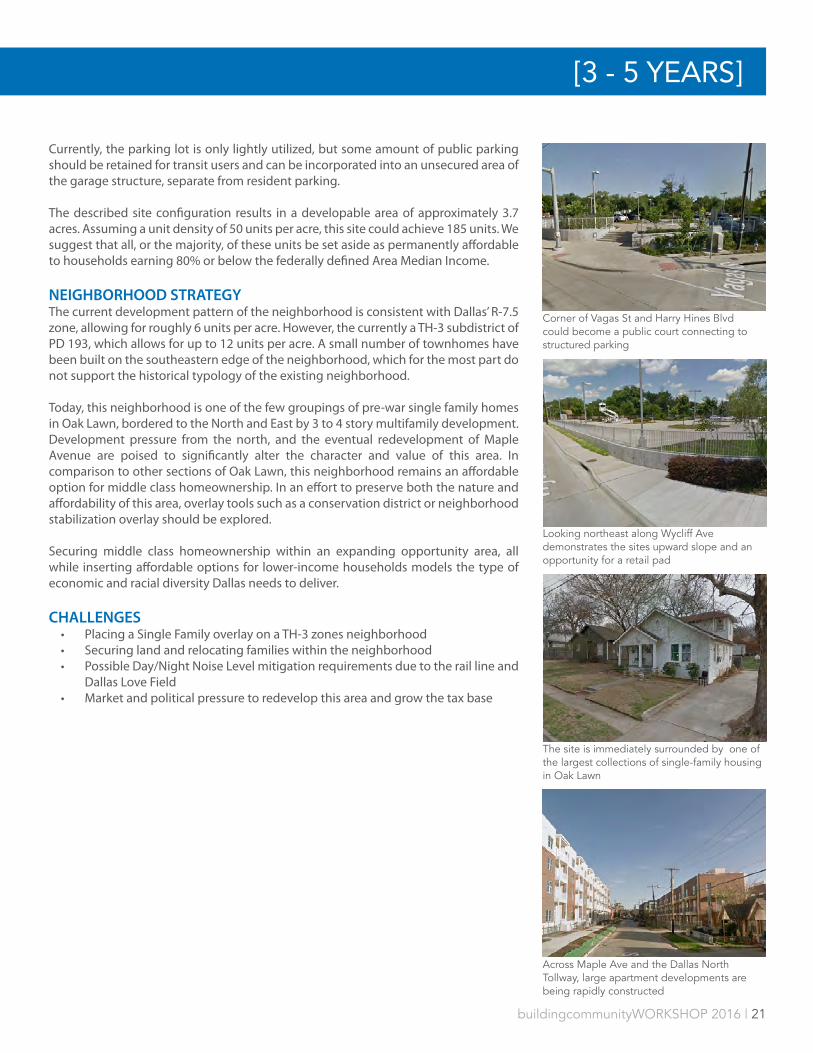
Currently, the parking lot is only lightly utilized, but some amount of public parking should be retained for transit users and can be incorporated into an unsecured area of the garage structure, separate from resident parking.
The described site configuration results in a developable area of approximately 3.7 acres. Assuming a unit density of 50 units per acre, this site could achieve 185 units. We suggest that all, or the majority, of these units be set aside as permanently affordable to households earning 80% or below the federally defined Area Median Income.
NEIGHBORHOOD STRATEGYThe current development pattern of the neighborhood is consistent with Dallas’ R-7.5 zone, allowing for roughly 6 units per acre. However, the currently a TH-3 subdistrict of PD 193, which allows for up to 12 units per acre. A small number of townhomes have been built on the southeastern edge of the neighborhood, which for the most part do not support the historical typology of the existing neighborhood.
Today, this neighborhood is one of the few groupings of pre-war single family homes in Oak Lawn, bordered to the North and East by 3 to 4 story multifamily development. Development pressure from the north, and the eventual redevelopment of Maple Avenue are poised to significantly alter the character and value of this area. In comparison to other sections of Oak Lawn, this neighborhood remains an affordable option for middle class homeownership. In an effort to preserve both the nature and affordability of this area, overlay tools such as a conservation district or neighborhood stabilization overlay should be explored.
Securing middle class homeownership within an expanding opportunity area, all while inserting affordable options for lower-income households models the type of economic and racial diversity Dallas needs to deliver.
CHALLENGES• Placing a Single Family overlay on a TH-3 zones neighborhood• Securing land and relocating families within the neighborhood• Possible Day/Night Noise Level mitigation requirements due to the rail line and
Dallas Love Field• Market and political pressure to redevelop this area and grow the tax base
Corner of Vagas St and Harry Hines Blvd could become a public court connecting to structured parking
Looking northeast along Wycliff Ave demonstrates the sites upward slope and an opportunity for a retail pad
The site is immediately surrounded by one of the largest collections of single-family housing in Oak Lawn
Across Maple Ave and the Dallas North Tollway, large apartment developments are being rapidly constructed
[3 - 5 YEARS]
22 | buildingcommunityWORKSHOP 2016
HARRY HINES BLVD
WYCLIF
F RD
MARKET CENTER STATION
MAP LEGEND
Connectivity
DART Station
Buildable Area
Retail
Green Space
MARKET CENTER | 4301 HARRY HINES BLVD
DEVELOPMENT SUMMARY1. Primary development is wrap-
around apartment building, from 2-5 stories
2. Six residential lots need to be required, to be swapped with comparable vacant residential lots in the surrounding neighborhood
3. A new connection would be made behind the retail pad, easing access to the site and movement between Wycliff Avenue and Harry Hines Boulevard
4. An improved connection would be made from the development to Market Center Station
buildingcommunityWORKSHOP 2016 | 23
HARRY HINES BLVD
WYCLIF
F AVE
DA
LLAS N
OR
TH
TOLLW
AY
MAPLE AVE
I-35E
MA
RKET CEN
TER BLVD
[3 - 5 YEARS]
MAP LEGEND
DART Station
Vacant Parcels
Building Footprints
Green Spaces
Site
HUD Opportunity Areas
Higher Density Areas
PD 193
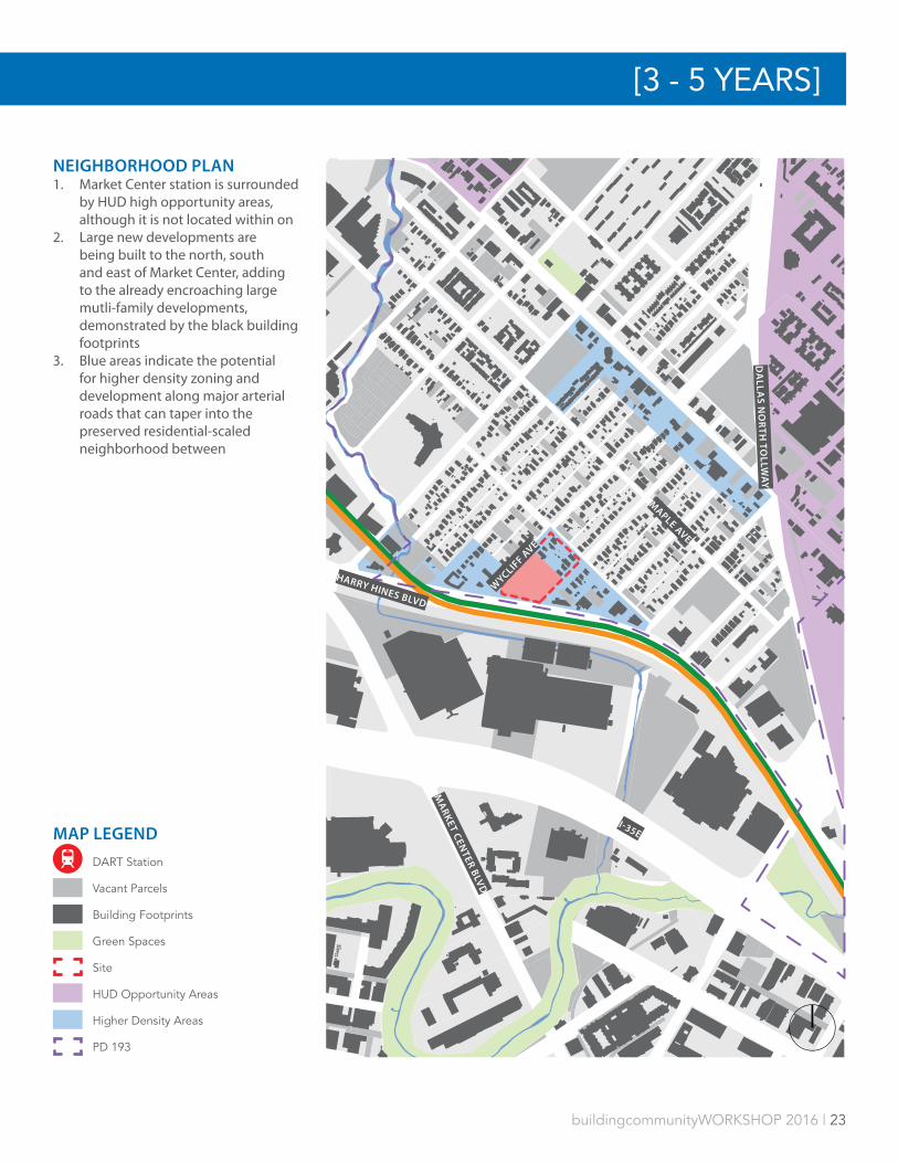
NEIGHBORHOOD PLAN1. Market Center station is surrounded
by HUD high opportunity areas, although it is not located within on
2. Large new developments are being built to the north, south and east of Market Center, adding to the already encroaching large mutli-family developments, demonstrated by the black building footprints
3. Blue areas indicate the potential for higher density zoning and development along major arterial roads that can taper into the preserved residential-scaled neighborhood between

24 | buildingcommunityWORKSHOP 2016
DESCRIPTIONMLK, Jr. Station is a moderately used stop on DART’s Green Line, located south of Fair Park and three stops south of downtown Dallas. A handful of neighborhood commercial and retail uses separate MLK, Jr. Station from Fair Park, including several auto-oriented businesses. The station’s namesake Martin Luther King Jr. Blvd is lined with additional commercial and institutional uses nearby, notably James Madison High School and the multi-use MLK Center. A mixture of apartments, historic homes, new community-based residential development, and vacant land characterize land use south of the station.
DEVELOPMENT STRATEGYMLK, Jr. Station sits in a socioeconomically troubled part of South Dallas that has reason for optimism. The station is on the periphery of revitalization efforts spreading from Uptown and the Central Business District, through Deep Ellum and the Cedars. MLK, Jr. Station is located just two short blocks away from the “Museum Green” proposed in the 2003 Fair Park Comprehensive Development Plan, an effort that could dramatically alter the fabric of the southern edge of Fair Park. Furthermore, unlike areas of South Dallas that are predominately single-family homes, MLK, Jr. Station is in close proximity to a handful of large, vacant blocks ready for development just west of the station, and neighborhood-oriented retail and commercial activity to the northeast and southeast. The confluence of these factors point to a neighborhood with a bright, but not imminent development future. MLK, Jr. Station presents an opportunity to set a tone of good, thoughtful city-shaping and design for South Dallas.
Several strategic moves will prime MLK, Jr. Station for development. The most important of these moves is to extend S. Trunk Ave. to intersect with Trezevant St., creating two complete city blocks. Then, the J.B. Jackson Transit Center can be eliminated or pivoted to reroute buses along S. Trunk Ave. and Trezevant St. We suggest acquiring the residential lots adjacent the station, facing Trezevant St, and the handful of commercial parcels adjacent the J.B. Jackson Transit Center facing Martin
MLK, JR. | 1412 S. Trunk AveMLK, JR. | 1412 S. TRUNK AVE
FAST FACTSParcel Size 3.5 acresRidership 1,107
SUITABILITYNormalized Score 4.41Normalized Rank 11/23HUD Opportunity n/a
STAKEHOLDERSPublic + ElectedCouncilperson T. YoungCouncil District 7Key City Depts. Parks, MLK CenterSchool Dist. (Trustee) Dallas ISD
(Nutall)
NON-PROFIT STAKEHOLDERSFair Park Estates Homeowners Association, Southfair CDC, ICDC, Friends of Fair Park, WINS, Revitalize South Dallas Coalition
PRIVATE SECTOR STAKEHOLDERSEban Village

buildingcommunityWORKSHOP 2016 | 25
Luther King Jr. Blvd., and replatting to create two parcels each slightly smaller than 2 acres. Each of these parcels should be developed into a pair of 3-5 story apartment buildings, with either wraparound or atop podium parking.
Site 1 should be solely residential, aside from a conditioned space for transit users waiting for bus or train service that connects to the building’s parking garage.
Site 2 should be a mixed-use building, with street-level retail or commercial uses fronting Martin Luther King Jr. Blvd. and wrapping around the corner onto Trunk Ave. to serve transit users. The parking garage should accommodate residents and users of the commercial or retail units.
Sites 1 and 2 should consist primarily of market rate housing units, with a portion set aside for long-term affordability, or a mechanism to convert to affordable units when the neighborhood reaches a certain threshold. As MLK, Jr. Station is not in a HUD opportunity area, market-rate private development is needed to inject economic life and encourage a mixed-income neighborhood.
The existing bus drop-off that divides the two halves of the potential development should be converted into a limited access street with a landscaped pedestrian walk, or a linear green space that benefits residents, and creates an alternative route for transit users who prefer not to walk along the busy Martin Luther King Jr Blvd.
NEIGHBORHOOD STRATEGYNeighborhood development near the station should focus on encouraging moderate to high density walkable, mixed-use development between Trunk Ave. and Fair Park and west of Al Lipscomb Way between Malcolm X Blvd. and Fair Park.This should include reducing the number of auto-dependent businesses, improving block structure, advocating for planned complete street modifications to Martin Luther King Jr Blvd., and creating a greener, more neighborhood friendly, more permeable Fair Park.
CHALLENGES• Land acquisition• Removal of JB Jackson Jr Transit Center and rerouting of buses• Local politics• Slow progress in Fair Park redevelopment
Martin Luther King Jr Blvd
Single-family Residential homes in the surrounding neighborhood
Trunk Ave., looking at the DART Rail station
Vacant land in the station area
[3 - 5 YEARS]

26 | buildingcommunityWORKSHOP 2016
TREZEVANT AVE
TRUNK AVE
J B JACKSON JR BLVD
MARTIN
LUTHER KIN
G JR B
LVD
ROBERT B CULLUM BLVD
DEVELOPMENT SUMMARY1. Extend and route bus traffic along
Trunk Ave2. Acquire all non-DART parcels bound
by the DART Green Line, Trezevant St, JB Jackson Jr Blvd and Martin Luther King Jr Blvd
3. 1 residential and 1 mixed use development site
4. Site 1: a. 2.43 acresb. 170 units
5. Site 2: a. 2.82 acresb. 190 unitsc. 38,000 sq ft retail/office
MLK, JR. | 1412 S. Trunk Ave
SITE 2
SITE 1
MLK, JR. STATION
MLK, JR. | 1412 S. TRUNK AVE
MAP LEGEND
Connectivity
DART Station
Buildable Area
Retail
Impacted Parcels
Green Space

buildingcommunityWORKSHOP 2016 | 27
NEIGHBORHOOD PLAN1. Large vacant parcels to the east and
west of site should be developed as mixed-use, moderate to high density urban blocks
2. Fair Park’s edges should be made more permeable to engage the neighborhood
3. Vacant parcels to the south of the neighborhood should be developed for homeownership
4. Al Lipscomb Way and Martin Luther King Jr. Blvd would be made into complete streets
ROBERT B CULLUM BLVD
MARTIN
LUTHER KIN
G JR B
LVD
FAIR PARK
PAR
RY
AV
E
AL LIP
SCOMB W
AY
MAP LEGEND
DART Station
Vacant Parcels
Building Footprints
Green Spaces
Site
[3 - 5 YEARS]

28 | buildingcommunityWORKSHOP 2016
DESCRIPTION Westmoreland Station is the heavily-used southern terminus of DART’s Red Line. Located at the intersection of S. Westmoreland Road and W. Illinois Avenue, a wide variety of land uses surround the station. A number of warehouse and light industrial uses sit to the south - a small number of which are vacant. Across Illinois Ave is a well-kempt, working, and middle class neighborhood adjacent to a major electric substation at the northeast corner of Illinois Ave. and Westmoreland Rd. The station area has significant retail presence within 0.25 miles, including a small retail strip directly west of the station and a shopping center with a grocery anchor further west, across Westmoreland Rd.
SITE STRATEGYAt over 10 acres, Westmoreland Station is a large site without a clear strategy. While the station is not in a HUD Opportunity Area, it does have the highest suitability score of any station in southern Dallas. Redevelopment of the station area could be pitched as a walkable, mixed-use development considering its high ridership numbers, proximity to neighborhood-oriented retail uses and the potential for substantial, neighborhood-friendly redevelopment of the surrounding industrial uses.
The site may be politically appealing, and should be proposed to District 3 councilperson Casey Thomas and District 1 councilperson, and head of the Housing Committee, Scott Griggs, as a key project for the area and opportunity for partnership. As a southern Dallas station, development at Westmoreland should be of similar interest to Mayor Rawlings as part of his growSouth plan aimed at stimulating growth and development in southern Dallas.
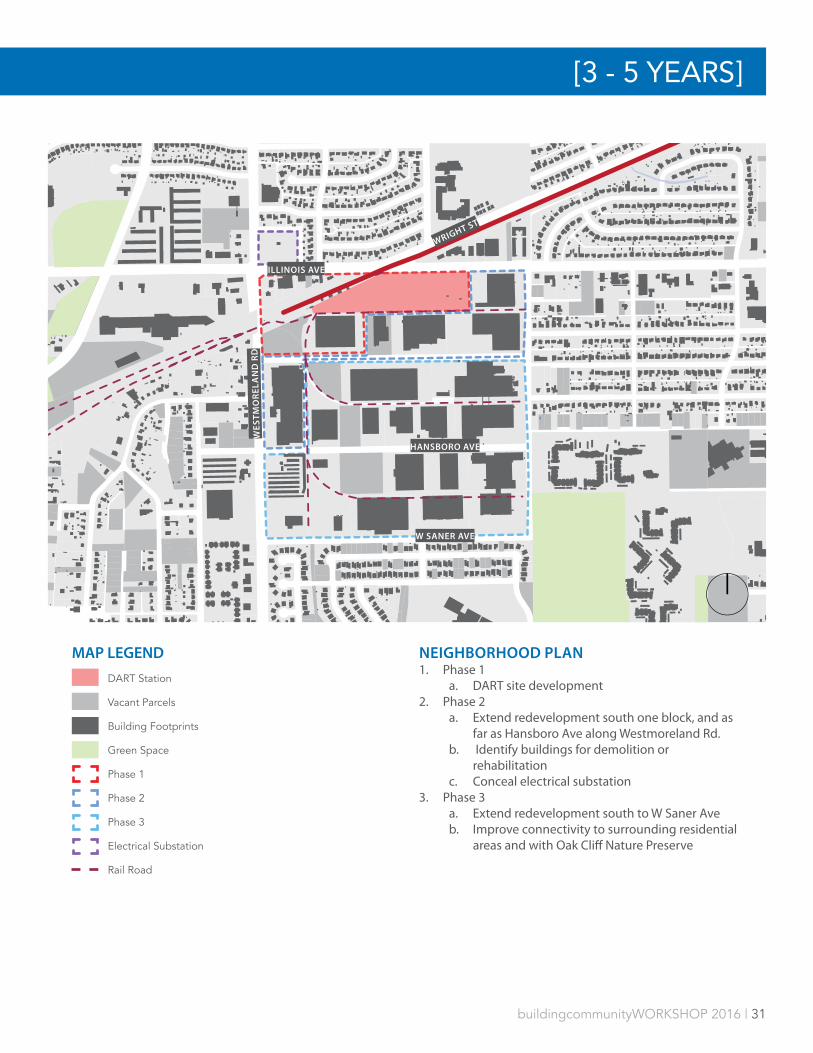
While development should begin in the next 3-5 years, it should be framed in a 3-phase approach to redeveloping the 150 acres bounded by W Illinois Ave, Pierce St, W Saner Ave and S Westmoreland Rd.
WESTMORELAND | 12646 S. Westmoreland RdWESTMORELAND | 2646 S. WESTMORELAND RD
FAST FACTSParcel Size 10.6 acresRidership 2,321
SUITABILITYNormalized Score 5.22Normalized Rank 8/23HUD Opportunity n/a
STAKEHOLDERSPublic + ElectedCouncilperson C. ThomasCouncil District 3Key City Depts. ParksSchool Dist. (Trustee) Dallas ISD
(Foreman)
NON-PROFIT STAKEHOLDERSLoupot Heights NA, Texas Land Conservancy
PRIVATE SECTOR STAKEHOLDERSUniversity General Hospital, Amerisouth Realty, SVC Manufacturing, Benchmark Opportunity Partners

buildingcommunityWORKSHOP 2016 | 29
We propose focusing first on the station parking lot, the adjacent commercial uses to the northwest of the station, and a vacant industrial building to the south of the existing parking lot. The retail strip northwest of the station should be reoriented to better interface with the DART station. Site 1 should be developed first, and contain medium density rental housing. Site 2 should be developed in conjunction with Site 3. Site 2 should be mixed-use, with 3-5 story rental housing to the east, stepping down to 2-3 story live/work spaces to the west. Site 3 should be developed as structured parking for transit riders and shoppers with neighborhood services on the bottom floor to accommodate commuters.
Finally, a public plaza should be developed in the triangular space bordering the station to the southeast, serving local residents and DART riders, while softening the transition between the station and existing warehouse and light industrial uses.
NEIGHBORHOOD STRATEGYA larger neighborhood development strategy for Westmoreland will greatly depend on the sustainability of the aging single-use, industrial developments to the south of the station. A series of vacant buildings south of the station at 2700 S Westmoreland Rd was recently sold, advertised for its conversion possibilities, and we believe that it is likely other businesses will leave the area due to the costs of maintaining aging structures, the abandonment of rail spurs, and the need to seek locations with more convenient highway or rail access. This station has a strong opportunity to respond to natural evolutions within the surrounding neighborhood and respond with a new development strategy.
Phase 2 will focus on the possible development and redevelopment of the first block of structures bordering the station area. Some existing structures, such as parts of the 2700 S Westmoreland complex, may have redevelopment potential, while others will require completely new forms. The relocation of active businesses into unused buildings or vacant lots in the area should be explored. In addition to land accumulation and development, efforts should be made at the neighborhood scale to ensure the preservation of affordable housing and area quality of life. Opportunities for work repair programs aimed at preserving existing affordable housing should be identified in the single-family neighborhood to the north of the station, Loupot Heights. The extensive green space surrounding LV Stockard Middle School should be made more inclusive to the public through a shared agreement between DISD and the City of Dallas.
Phase 3 of a development strategy extends into the remaining blocks of warehouse and light industrial uses between Glenfield Ave. and W Saner Ave. Key attention will need to be made in this phase to reestablish north-south connectivity in the area. Reducing the block sizes in this area will be critical to the creation of a walkable, transit-oriented development. This phase should also incorporate sensitive access to the Oak Cliff Nature preserve to the southeast.
Vacant DART-owned land adjacent to the parking area
Vacant warehouse and land adjacent to DART’s parking area
Building located at 2700 S Westmoreland Rd
An electrial substation across Illinois Ave
[3 - 5 YEARS]

30 | buildingcommunityWORKSHOP 2016
MAP LEGEND
DART Station
Buildable Area
Retail
Green Space
Connectivity
Rail Road
ILLINOIS AVE
WESTMORELAND STATION
WES
TM
OR
ELA
ND
RD
GLENFIELD AVE
ILLI
NO
IS A
VE
DEVELOPMENT SUMMARY 1. Site 1
a. 3 to 5 story multi-family with wrapped parkingb. 3.43 acresc. 247 units
2. Site 2a. 3 to 5 story multi-family with wrapped
parking and 1 to 2 story office or live/work spaces
b. 3.67 acresc. 244 unitsd. 24 Live/Work spaces
3. Site 3 a. Land acquisitionb. Parking garage with ground level neighborhood
service and retail 4. Public plaza
a. 1 acre
WESTMORELAND | 12646 S. WESTMORELAND RD
SITE 1SITE 2
SITE 3
buildingcommunityWORKSHOP 2016 | 31
MAP LEGEND
DART Station
Vacant Parcels
Building Footprints
Green Space
Phase 1
Phase 2
Phase 3
Electrical Substation
Rail Road
ILLINOIS AVE
WES
TM
OR
ELA
ND
RD
HANSBORO AVE
W SANER AVE
WRIGHT ST
[3 - 5 YEARS]
NEIGHBORHOOD PLAN1. Phase 1
a. DART site development2. Phase 2
a. Extend redevelopment south one block, and as far as Hansboro Ave along Westmoreland Rd.
b. Identify buildings for demolition or rehabilitation
c. Conceal electrical substation3. Phase 3
a. Extend redevelopment south to W Saner Aveb. Improve connectivity to surrounding residential
areas and with Oak Cliff Nature Preserve
32 | buildingcommunityWORKSHOP 2016
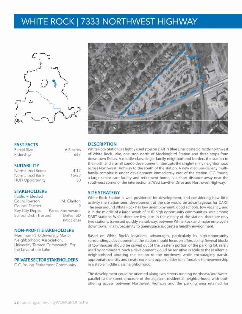
WHITE ROCK | 7333 NORTHWEST HIGHWAY
DESCRIPTIONWhite Rock Station is a lightly used stop on DART’s Blue Line located directly northwest of White Rock Lake, one stop north of Mockingbird Station and three stops from downtown Dallas. A middle-class, single-family neighborhood borders the station to the north and a small condo development interrupts the single-family neighborhood across Northwest Highway to the south of the station. A new medium-density multi-family complex is under development immediately east of the station. C.C. Young, a large senior care facility and retirement home, is a short distance away near the southwest corner of the intersection at West Lawther Drive and Northwest Highway.
SITE STRATEGYWhite Rock Station is well positioned for development, and considering how little activity the station sees, development at the site would be advantageous for DART. The area around White Rock has low unemployment, good schools, low vacancy, and is in the middle of a large swath of HUD high opportunity communities- rare among DART stations. While there are few jobs in the vicinity of the station, there are only two stations, traversed quickly via subway, between White Rock and major employers downtown. Finally, proximity to greenspace suggests a healthy environment.
Based on White Rock’s locational advantages, particularly its high-opportunity surroundings, development at the station should focus on affordability. Several blocks of townhouses should be carved out of the western portion of the parking lot, rarely used by commuters. Such a development would be sensitive in scale to the residential neighborhood abutting the station to the northwest while encouraging transit-appropriate density and create excellent opportunities for affordable homeownership in a stable middle class neighborhood.
The development could be oriented along two streets running northeast/southwest, parallel to the street structure of the adjacent residential neighborhood, with both offering access between Northwest Highway and the parking area retained for
FAST FACTSParcel Size 6.6 acresRidership 667
SUITABILITYNormalized Score 4.17Normalized Rank 15/23HUD Opportunity 30
STAKEHOLDERSPublic + ElectedCouncilperson M. ClaytonCouncil District 9Key City Depts. Parks, StormwaterSchool Dist. (Trustee) Dallas ISD
(Micciche)
NON-PROFIT STAKEHOLDERSMerriman Park/University Manor Neighborhood Association, University Terrace Crimewatch, For the Love of the Lake
PRIVATE SECTOR STAKEHOLDERSC.C. Young Retirement Community
buildingcommunityWORKSHOP 2016 | 33
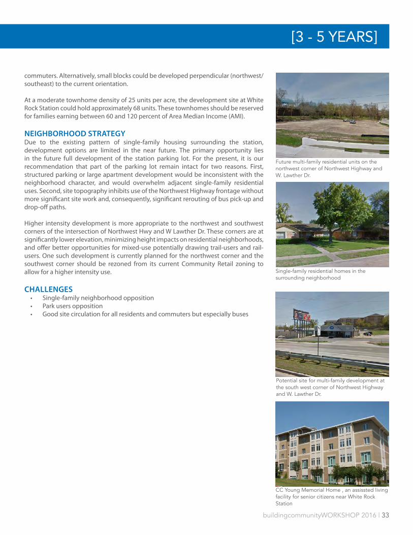
commuters. Alternatively, small blocks could be developed perpendicular (northwest/southeast) to the current orientation.
At a moderate townhome density of 25 units per acre, the development site at White Rock Station could hold approximately 68 units. These townhomes should be reserved for families earning between 60 and 120 percent of Area Median Income (AMI).
NEIGHBORHOOD STRATEGYDue to the existing pattern of single-family housing surrounding the station, development options are limited in the near future. The primary opportunity lies in the future full development of the station parking lot. For the present, it is our recommendation that part of the parking lot remain intact for two reasons. First, structured parking or large apartment development would be inconsistent with the neighborhood character, and would overwhelm adjacent single-family residential uses. Second, site topography inhibits use of the Northwest Highway frontage without more significant site work and, consequently, significant rerouting of bus pick-up and drop-off paths.
Higher intensity development is more appropriate to the northwest and southwest corners of the intersection of Northwest Hwy and W Lawther Dr. These corners are at significantly lower elevation, minimizing height impacts on residential neighborhoods, and offer better opportunities for mixed-use potentially drawing trail-users and rail-users. One such development is currently planned for the northwest corner and the southwest corner should be rezoned from its current Community Retail zoning to allow for a higher intensity use.
CHALLENGES• Single-family neighborhood opposition• Park users opposition• Good site circulation for all residents and commuters but especially buses
Future multi-family residential units on the northwest corner of Northwest Highway and W. Lawther Dr.
Single-family residential homes in the surrounding neighborhood
Potential site for multi-family development at the south west corner of Northwest Highway and W. Lawther Dr.
CC Young Memorial Home , an assissted living facility for senior citizens near White Rock Station
[3 - 5 YEARS]
34 | buildingcommunityWORKSHOP 2016
MAP LEGEND
DART Station
Buildable Area
Retail
Green Space
Connectivity
Rail Road
NORTHWEST HIGHWAY
WHITE ROCK STATION
WHITE ROCK | 7333 E. Northwest Hwy
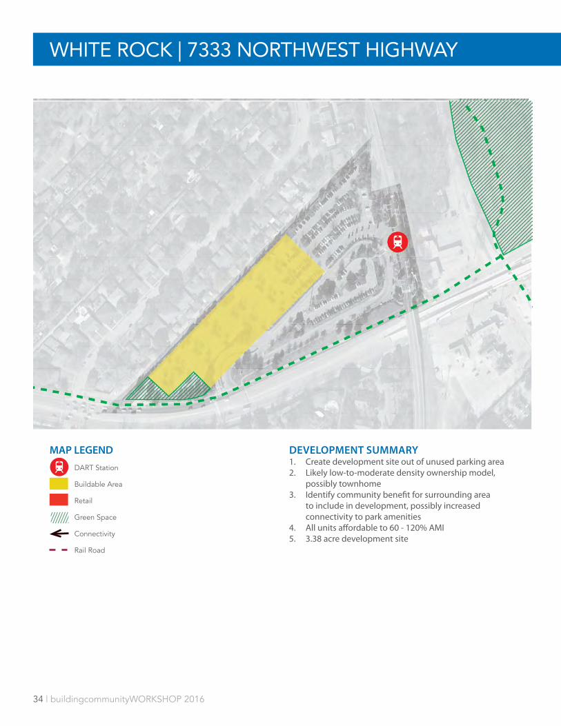
DEVELOPMENT SUMMARY 1. Create development site out of unused parking area2. Likely low-to-moderate density ownership model,
possibly townhome3. Identify community benefit for surrounding area
to include in development, possibly increased connectivity to park amenities
4. All units affordable to 60 - 120% AMI5. 3.38 acre development site
WHITE ROCK | 7333 NORTHWEST HIGHWAY

buildingcommunityWORKSHOP 2016 | 35
MAP LEGEND
DART Station
Vacant Parcels
Building Footprints
Green Space
Potential Site
Multi-family Project
Future Development
Trails
NORTHWEST HIGHWAY
W LAWTHER DR
E MOCKIN
GBIRD LN
WALLIN
G LN
NEIGHBORHOOD PLAN1. Encourage dense development at intersection of W
Lawther Dr and Northwest Hwy2. Balance development with environmental sensibility
and recreational access
[3 - 5 YEARS]
WHITE ROCK LAKE

36 | buildingcommunityWORKSHOP 2016
DESCRIPTIONThe 8th & Corinth Station is a moderately trafficked stop on DART’s Red and Blue lines, located near the intersection of 8th Street and Corinth Street Road. Bordered by Cedar Creek to the south, other land uses include an auto parts complex to the northeast. Modest single-family neighborhoods The Heights and Skyline Heights, schools, and religious organizations lie to the south and southeast. Brackins Village, a low density Dallas Housing Authority multi-family property sits on several acres to the west of the station.
SITE STRATEGYThe development of the areas at and around the 8th street and Corinth station is unique among many of the 3 to 5 year station profiles. While there is limited DART owned land, the directly adjacent properties are substantial in size and have consolidated ownership, suggested easier land acquisition. This area has the potential to become a TOD village.
A long term development vision for this area was recently created by the City of Dallas’ CityDesign Studio as part of a larger urban design planning process for The Bottom neighborhood, a single-family neighborhood northwest of the station. Within The Bottom Urban Structure and Guidelines, the sites in this development strategy are designated as Phase II and III of neighborhood growth. The development strategy presented here borrows the vision and goals of The Bottom Urban Structure and Guidelines.
The first phase targets the DART-owned parcel directly across S Corinth St Rd from the station for the development of a medium-density, market rate, multi-family development with structured parking. Due to the size of the parcel, there may be an opportunity to include retail or office uses in addition to the residential uses. Given the high poverty rates, additional affordable housing is not advised for this site. However, because maintaining economic diversity is critically important, a strategy should be
8TH & CORINTH | 1740 E. 8th St8TH AND CORINTH | 7040 E. 8TH ST
FAST FACTSParcel Size 1.4 acresRidership 1,700
SUITABILITYNormalized Score 4.13Normalized Rank 16/23HUD Opportunity n/a
STAKEHOLDERSPublic + ElectedCouncilperson C. ArnoldCouncil District 4Key City Depts. Parks, Trinity RiverSchool Dist. (Trustee) Dallas ISD
(Blackman)
NON-PROFIT STAKEHOLDERSDallas Housing Authority, Operation 10th Street, American Care Academy, Golden Gate Baptist Church, Greater El Bethel Baptist Church
PRIVATE SECTOR STAKEHOLDERSMatthews-Southwest, Therm Processes, Coffey Family, Bishop-Corwin Properties

buildingcommunityWORKSHOP 2016 | 37
identified for inserting or increasing the number of affordable units offered in direct response to the changes in the market dynamics of the area.
Later phases will include the development of the site on the northwest and northeast corners of 8th & Corinth. Both sites have existing structures occupied by commercial and warehouse uses. A mixture of residential, retail, and office uses would be appropriate for these sites. Development of the station parking lot may also become possible as the area becomes truly transit-oriented and the small parking lot becomes obsolete. Neighborhood services oriented to the station may be successful here. Finally, the aging Brackins Village housing project should be redeveloped for mixed incomes and to better interface with 8th Street. Attention should be paid to how future development engages the existing single family residential to the north, particularly in regard to the height and scale of future development relative to the areas varied topography.
NEIGHBORHOOD STRATEGYAs previously mentioned, 2014’s The Bottom Urban Structure and Guidelines, as adopted by the Dallas City Council, provides a long term neighborhood development strategy for The Bottom neighborhood that lies northwest of the 8th & Corinth station along the Trinity River. Any future planning around the 8th & Corinth station should coordinate with that plan and local stakeholders and should take into consideration:• Land consolidation or master development agreement• Leveraging the development of public space/green space to build low impact
development infrastructure, and reduce the need to upgrade stormwater infrastructure
• Emphasize the linkages between existing natural resources/green space and future development.
Low -density automotive or light industrial uses surround much of 8th & or Corinth station
DART currently owns a large, vacant land across Corinth St Rd from the station
Single-family housing in the the adjacent Bottom neighborhood
Aging public housing in close proximity to the station
[3 - 5 YEARS]

38 | buildingcommunityWORKSHOP 2016
DEVELOPMENT SUMMARY1. Neighborhood services retail
development at station on 1.2 acres
8TH & CORINTH | 1740 E. 8th St
8TH & CORINTH
Map image drawn from City of Dallas City Design Studio ‘s The Bottom: Urban Structure and Guidelines
8TH AND CORINTH | 7040 E. 8TH ST
MAP LEGEND
DART Station
Existing Parking Area

buildingcommunityWORKSHOP 2016 | 39
NEIGHBORHOOD PLANFOLLOW CITYDESIGN STUDIO’S THE BOTTOM URBAN STRUCTURE AND GUIDELINES1. Medium-density multi-family
development on 3.11 acres2. Land acquisition and consolidation
on the north side of E 8th St3. Redevelopment of Dallas Housing
Authority’s Brackins Village complex
CO
RIN
TH S
T R
D
8TH ST
CLARENDON DR
11TH ST
TRINITY RIVER
[3 - 5 YEARS]
MAP LEGEND
DART Station
Vacant Parcels
Building Footprints
Green Space
Potential Site

40 | buildingcommunityWORKSHOP 2016
BACHMAN | 9739 DENTON DR
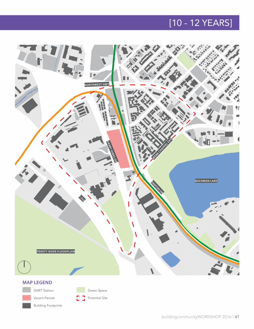
DESCRIPTIONThe Backman Station is a highly used stop on DART’s Green and Orange line, near Denton Drive and Webb Chapel Extension. Other major infrastructure surrounding the station includes I-35E, Northwest Highway, Harry Hines Boulevard, and a commercial rail corridor. A variety of land uses surround the station, including multi-family, commercial, and institutional uses. The area east of the station is comprised of multiple large, low-density multi-family housing developments. Bachman Lake is located just to the southeast of the station and accessible by Denton Drive.
DEVELOPMENT STRATEGYThe area surrounding Bachman Station has a number of features that make it intriguing for development, but that necessitate a comprehensive planning effort. The station sits just north of where Bachman Lake and Elm Fork floodplain pinch developed land to barely more than Stemmons Freeway, Harry Hines Blvd and a DART bus service yard, creating a natural southern boundary. Northwest Highway creates a boundary to the north while Bachman Lake and the Elm Fork floodplain create boundaries to the east and west, forming a naturally bounded 180-acre redevelopment zone with Bachman Station at its center.
40 of those approximately 180 acres are publicly owned, either by the City of Dallas or DART. This gives the public sector a substantial role in determining the development future of the area, and a vested interest in, and responsibility to, the area. The majority of this publicly owned land is in a multi-purpose facility to the west of Harry Hines Blvd that is occupied in part by police and sanitation facilities. the land is currently used inefficiently, dominated by surface parking surrounding low-slung buildings. Land ownership outside of the public sector is controlled by a small number of large landholders with low intensity land use or aging apartments.
To the east of Harry Hines are densely concentrated but aging garden apartments, interspersed with a few condominium buildings. Between 30 and 50 years old, these buildings may be nearing the end of their productive life.
The proximity to the Elm Fork of the Trinity River, and its attendant ponds and forest, to the west and Bachman Lake to the east uniquely position the Bachman Station as the center of extraordinary natural, environmental, and recreational potential.
Finally, Bachman Station has access to crucial infrastructure in the DART Green and Orange Lines, I-35E, Harry Hines Blvd, and Northwest Highway, providing easy access to major job centers and points of interest throughout the region.
Without prescribing an area vision, it seems critical that any redevelopment plan at Bachman Station should be led by the public sector, focus on access to and integration with natural and recreational amenities, and should help integrate the relatively divided areas on either side of Harry Hines Blvd with a focus on the rail station itself as a centerpiece.
FAST FACTSParcel Size 7 acresRidership 2,168
SUITABILITYNormalized Score 4.04 Normalized Rank 19/23HUD Opportunity 20
STAKEHOLDERSPublic + ElectedCouncilperson M. Alonzo Council District 6Key City Depts. Parks, Stormwater,
AviationSchool Dist. Dallas ISD
NON-PROFIT STAKEHOLDERSBachman/Northwest Highway Community Association, Love Field West CrimeWatch
PRIVATE SECTOR STAKEHOLDERSLove Field, Southwest Airlines
buildingcommunityWORKSHOP 2016 | 41
MAP LEGEND
DART Station
Vacant Parcels
Building Footprints
Green Space
Potential Site
HA
RRY
HIN
ES DR
NORTHWEST HWY
I-35E
WEBB C
HAPPEL EXT
DENTON DR
[10 - 12 YEARS]
BACHMAN LAKE
TRINITY RIVER FLOODPLAIN

LBJ/SKILLMAN | 10100 LBJ FRWY
SITE DESCRIPTIONThe LBJ/Skillman Station is a moderately used stop on DART’s Blue line near the intersection of I-635 (LBJ Freeway) and Miller Road. The station is bordered by I-635 to the west and the Kansas City Southern Railroad line to the east. To the east of the rail line, the land uses largely include warehouses and distribution hubs, with some light industrial uses. To the north of the station, and to the west of I-635, multifamily and commercial uses dominate the landscape.
DEVELOPMENT STRATEGYDevelopment at the LBJ/Skillman Station has been well studied for some time because of the scale of DART’s assets around the station and the proposed public investment to improve I-635 and realign the inefficient and congested Skillman/Audelia/I-635 interchange. Developing this interchange and its surroundings was first identified as a priority implementation project in the 2006 ForwardDallas! Comprehensive Plan - which emphasized the potential for TOD at LBJ/Skillman Station. It is also listed as a priority in the Skillman Tax Increment Finance District plan. Spearheaded by the Lake Highlands Area Improvement Association, the North Texas Council of Government and City of Dallas funded and conducted a study along with OMNIPLAN and others to lead a community visioning process for the LBJ/Skillman Station and surrounding area that was eventually adopted by the Dallas City Council as the LBJ-Skillman Urban Planning Initiative Study.This plan focused on correcting the intersection of Skillman, Audelia and LBJ to streamline traffic, reclaim unused right-of-way for development opportunities, and connect to transit via TOD on DART-owned parcels to the northwest of the station. We agree that these are priority issues for the area.
Reconstruction of the Skillman/Audelia/I-635 intersection is planned as part of a larger infrastructure reconstruction initiative named LBJ East, but remains unfunded, threatening the full extent of the plans laid out in the LBJ-Skillman Urban Planning Initiative Study. Development at LBJ/Skillman Station ought to be able to proceed regardless of the LBJ East project’s status or the final Skillman realignment solution, but it seems unlikely to do so. In general, we agree with OMNIPLAN’s vision of commercial/mixed use development at a medium density along a new spine street parallel the LBJ service road.
FAST FACTSParcel Size 27.3 acresRidership 1,394
SUITABILITYNormalized Score 5.77Normalized Rank 4/23HUD Opportunity n/a
STAKEHOLDERSPublic + ElectedCouncilperson A. McGough Council District 10Key City Depts. PNV, CityDesignSchool Dist. Richardson ISD
NON-PROFIT STAKEHOLDERSDallas County Community College District, TxDOT, Lake Highlands Area Improvement Association, Chimney Hill Homeowners Association, Country Forest/Jackson Meadows Homeowners Association, Town Creek Homeowners Association
PRIVATE SECTOR STAKEHOLDERSWrh Sage Pointe Ltd, Dp Partners Ltd Ps, Pc Azul Llc, Ps Texas Holdings Ltd

buildingcommunityWORKSHOP 2016 | 43
[10 - 12 YEARS]
I-635
SKILLM
AN RD
SKILLM
AN RD
AU
DEL
IA R
DA
UD
ELIA
RD
ROYAL LN
LBJ / SKILLMAN STATION
MAP LEGEND
DART Station
Vacant Parcels
Building Footprints
Green Space
Potential Site
Skillman/635 Interchange
Rail Road
44 | buildingcommunityWORKSHOP 2016
CONCLUSION & POLICY ROADMAPThe City of Dallas is in desperate need of affordable housing, and transit oriented development offers a great opportunity to address that need within our City. The land around our DART stations is sparse and precious, and we has a community need to ensure that the land is utilized as a true public benefit. By incorporating affordable housing into transit oriented developments around the stations, we not only address the need for affordable housing but also, increase economic and job development, create housing and transportation cost savings for residents, increase ridership for the transit agency, create better integrated neighborhoods, and reduce the environmental impact of auto travel by reducing vehicle miles travelled.
This report has laid out those benefits, provided an analysis to determine the stations most suitability for this type of development, and analyzed each one of the most suitable stations to determine a timeframe and potential possibilities. More work is needed to achieve equitable transit oriented development in Dallas, some by the City, some by DART and some by the development community and their partners. Chief among these efforts should be more coordination and partnerships between the City, DART and developers and non-profit partners to identify sites in which collective resources could be leveraged to achieve high quality, desirable and equitable development. In addition the City should evaluate it's current policies and challenges those policies and the market present; and then strategies for moving forward to achieve equitable transit oriented development, similar to the analysis below of DART. Lastly, developers, planners, engineers, architects, financiers and non-profits should be more creative and innovative in their thinking around development at DART rail stations, and look to successful examples elsewhere of equitable transit oriented development.
What follows is an analysis of current DART policies, challenges and strategies for moving forward for DART. A similar anaylse of the City should be undertaken to understand how it's policies and programs could be improved as well.
CURRENT DART TOD POLICIES DART currently faces both structural and political barriers to effectively drive future TOD projects. The following section outlines DART’s existing TOD policies, challenges to developing DART owned land, and strategies for mitigating barriers to DART’s role in station area TOD.
DART has two primary guiding documents for planning, coordinating and implementing transit oriented development. The first, Transit Oriented Development Policies, was approved in October 1989 and recently updated in 2015. This document lays a foundation for DART’s TOD goals, strategies and process. The second, DART TOD Guidelines Handbook, developed in August of 2008, begins to outline station development typologies, and the different elements of station area development.
Combined, the two documents affirm the following goals and strategies for Transit Oriented Development:
Goals1. Increase transit ridership through the coordinated planning of land use and quality
development projects on and around DART station properties and along DART transit routes and corridors.27
2. Enhance the quality of life through the coordinated development of accessible pedestrian and non-motorized environments at transit stops and stations.
CONCLUSION & POLICY ROADMAP

buildingcommunityWORKSHOP 2016 | 45
3. Enhance the value of DART real property and other assets by designing transit facility access, and circulation to accommodate future TOD while maintaining accessibility and visibility to transit.
Strategies1. DART seeks to foster cooperative relationships with other governmental entities,
local communities, and the private sector for the development of comprehensive development plans, station area plans, property acquisition and disposition, and development of financial strategies and tools such as assessment districts, tax increment finance districts, or improvement districts, any of which may be located on and off DART property.
2. DART seeks to coordinate planning efforts with other governmental entities and communities in the DART service area early on in the development process to enhance multi-modal access to and from DART stops and stations and ensure appropriate transit supportive uses.
3. DART seeks to enhance the future value of planned DART facilities for TOD.4. DART seeks to encourage direct connections to transit stops and stations from
surrounding development. Projects shall be consistent with City/Community TOD policies and plans.
5. DART seeks to use the appropriate method of disposing of DART real property for Transit Oriented Development projects to achieve specific development objectives and demonstrate a benefit to DART.
CHALLENGES1. Existing levels of station areas planning and structures by which future development
is reviewed does not meet the current demands of multi-organization collaboration, securing financing, and long-term development oversight.
2. “Many regions around the country are collaborating, studying and planning for TOD implementation. Regional visioning, in particular, is a useful organizing principle through which to view this work holistically – as more than simply a single real estate project or a
collection of real estate projects.”28
3. Current State regulations limit how DART can lease or sale DART owned property, and what can built with authority funds. Creating additional barriers for DART when seeking to leverage the their resources to facilitate future TOD projects.
4. While it can own and reserve land, the DART authority cannot develop agency-owned property, nor can it sell or lease authority owned land for less than the fair market value.
5. “This is considered outside of, and potentially distracting to, the agency’s central mission of running a transit business. Dallas’s much-heralded Mockingbird Station TOD would not have happened had the developer not been able to utilize property through agreements with DART.” 29
6. Reliance on and RFP process to invite or review potential TOD projects has not proved to provide enough clarity, support, or vision to drive TOD projects in Dallas. • potential developers, partners, or the City of Dallas that No visible program to
invite partnerships or development 7. TOD planning, financing, and long term oversight required strong coordination between
DART and other local, state, or federal organizations. • No formal efforts have been undertaken with DART, City of Dallas, Dallas County,
or the Federal Transit Administration
46 | buildingcommunityWORKSHOP 2016
STRATEGIES FOR MOVING FORWARD1. Leverage existing TOD Planning and Financing tools
a. Station Area Development Planningb. Joint Development Agreementsc. Dallas Tax Increment Financingd. FTA property acquisition assistance for joint-development agreementse. HUD Funds (at stations in opportunity areas)
2. Be an Active Partner in TOD Developmenta. Through the development planning process for each station, DART should begin
to identify authority held assets that can be leveraged to ensure integrated development
b. Identify existing landholders and potential development partners for all stations to understand future development potential
c. Coordinate planning, funding, and political efforts between DART and the City of Dallas
3. Develop Masterplans for station to reduce development risk and build local supporta. Ensure development at the transit station, not just in the surrounding area
through the development of station development master plans.b. Reduce the likelihood of DART board member making continual revisions or
outright rejecting a development proposal due to the lack of a clear vision.c. Increased the capacity of the agency to seek additional transit funding or grants
due the existence of a stakeholder supported plan.
CONCLUSION & POLICY ROADMAP

buildingcommunityWORKSHOP 2016 | 47
48 | buildingcommunityWORKSHOP 2016
1. Leopold, Josh, Liza, Getsinger, Panela Blumenthal, Katya Abazajian and Reed Jordean. The Housing Affordability Gap for Extremely Low Income Renters in 2013. The Urban Institute. http://www.urban.org/research/publication/housing-affordability-gap-extremely-low-income-renters-2013/view/full_report Accessed October 2016.
2. Pollack, Melind and Prater, Brian. “Filling the Financing Gap for Equitable Transit-Oriented Development. April 2013. Accessed August 2016. http://www.liifund.org/wp-content/uploads/2013/04/TOD-Report-03-26-13-FINAL.pdf
3. Chetty, Raj, Nathaniel Hendren, and Lawrence F. Katz. The Effects of Exposure to Better Neighborhoods on Children: New Evidence from the Moving to Opportunity Experiment. Cambridge: Harvard, May 2015. Accessed September 2015. http://www.nber.org/papers/w21156.pdf
4. ACS B25106: Tenure by housing costs as a percentage of household income in the past 12 months - Universe: Occupied housing units
5. Joint Center for Housing Studies. The State of the Nation’s Housing 2015. Cambridge: Harvard Research Center, 2015. Accessed August 2015. http://www.jchs.harvard.edu/sites/jchs.harvard.edu/files/jchs-sonhr-2015-ch1.pdf
6. Fry, Richard and Paul Taylor. The Rise of Residential Segregation by Income. Washington D.C: Pew Research Center, 2012. Accessed August 2015. http://www.pewsocialtrends.org/2012/08/01/the-rise-of-residential-segregation-by-income/
7. Malizia, Emil E. and Shanzi Ke. “The Influence of Economic Diversity on Unemployment and Stability.” Journal of Regional Science Volume 33, Issue 2 (1993). 221–235
8. Cambridge Systematics, Inc and Myer, Mohaddes Associates. The Role of State DOTs in Support of Transit-Orients Development (TOD). National Cooperative Highway Research Program, Transportation Research Board Project 25-25, Task 20, 2006. Accessed July 2015. http://www.fta.dot.gov/documents/Project_25-25_Task_20_final_report.pdf
9. The Center for Transit-Oriented Development. TOD 201 Mixed-Income Housing Near Transit: Increasing Affordability With Location Efficiency. Oakland, Washington D.C., and Los Angeles: Center for Transit-Oriented Development and US Department of Transportation, 2009. Accessed July 2015. http://www.
ctod.org/pdfs/tod201.pdf10. Transit Cooperative Research Program (TCRP).
Transit-Oriented Development in the United States: Experiences, Challenges, and Prospects Report 102. Washington D.C: Federal Administration, 2004. Access July 2015. http://onlinepubs.trb.org/onlinepubs/tcrp/tcrp_rpt_102.pdf
11. The Center for Transit-Oriented Development. TOD 201 Mixed-Income Housing Near Transit: Increasing Affordability With Location Efficiency. Oakland, Washington D.C., and Los Angeles: Center for Transit-Oriented Development and US Department of Transportation, 2009. Accessed July 2015. http://www.ctod.org/pdfs/tod201.pdf
12. Cambridge Systematics, Inc and Myer, Mohaddes Associates. The Role of State DOTs in Support of Transit-Orients Development (TOD). National Cooperative Highway Research Program, Transportation Research Board Project 25-25, Task 20, 2006. Accessed July 2015. http://www.fta.dot.gov/documents/Project_25-25_Task_20_final_report.pdf
13. Transit Cooperative Research Program (TCRP). Transit-Oriented Development in the United States: Experiences, Challenges, and Prospects Report 102. Washington D.C: Federal Administration, 2004. Access July 2015. http://onlinepubs.trb.org/onlinepubs/tcrp/tcrp_rpt_102.pdf
14. The Center for Transit-Oriented Development. TOD 201 Mixed-Income Housing Near Transit: Increasing Affordability With Location Efficiency. Oakland, Washington D.C., and Los Angeles: Center for Transit-Oriented Development and US Department of Transportation, 2009. Accessed July 2015. http://www.ctod.org/pdfs/tod201.pdf
15. American Public Transportation Association. 2016. Public Transit Riders Will Reap Big Savings As They Look to Dump The Pump. http://www.apta.com/mediacenter/pressreleases/2016/Pages/September-Transit-Savings.aspx. Accessed August 2016.
16. Cambridge Systematics, Inc and Myer, Mohaddes Associates. The Role of State DOTs in Support of Transit-Orients Development (TOD). National Cooperative Highway Research Program, Transportation Research Board Project 25-25, Task 20, 2006. Accessed July 2015. http://www.fta.dot.gov/documents/Project_25-25_Task_20_final_report.pdf
17. Reconnecting America. (2012). Locating Affordable Housing Near Transit: A Strategic Economic Decision.
REFERENCES

buildingcommunityWORKSHOP 2016 | 49
http://www.reconnectingamerica.org/assets/Uploads/20120904AHpolicybrief.pdf
18. Reconnecting America. (2012). Locating Affordable Housing Near Transit: A Strategic Economic Decision. http://www.reconnectingamerica.org/assets/Uploads/20120904AHpolicybrief.pdf
19. The Center for Transit-Oriented Development. TOD 201 Mixed-Income Housing Near Transit: Increasing Affordability With Location Efficiency. Oakland, Washington D.C., and Los Angeles: Center for Transit-Oriented Development and US Department of Transportation, 2009. Accessed July 2015. http://www.ctod.org/pdfs/tod201.pdf
20. The Center for Transit-Oriented Development. TOD 201 Mixed-Income Housing Near Transit: Increasing Affordability With Location Efficiency. Oakland, Washington D.C., and Los Angeles: Center for Transit-Oriented Development and US Department of Transportation, 2009. Accessed July 2015. http://www.ctod.org/pdfs/tod201.pdf
21. Reconnecting America. (2012). Locating Affordable Housing Near Transit: A Strategic Economic Decision. http://www.reconnectingamerica.org/assets/Uploads/20120904AHpolicybrief.pdf
22. Cambridge Systematics, Inc and Myer, Mohaddes Associates. The Role of State DOTs in Support of Transit-Orients Development (TOD). National Cooperative Highway Research Program, Transportation Research Board Project 25-25, Task 20, 2006. Accessed July 2015. http://www.fta.dot.gov/documents/Project_25-25_Task_20_final_report.pdf
23. “Public Transit Riders Will Reap Big Savings As They Look to Dump The Pump on June 21,” American Public Transportation Association. Press release, June 20, 2012, on apta website http://www.apta.com/mediacenter/pressreleases/2012/Pages/120620_TSR.aspx. Accessed August 2015
24. Through Recession and Recovery Economic and Fiscal Impacts of Capital and Operating Spending by Dallas Area Rapid, 2014. Accessed August 2016. http://www.dart.org/about/economicdevelopment/January2014DARTEconomicandFiscalImpacts.pdf
25. Reconnecting America. (2012). Locating Affordable Housing Near Transit: A Strategic Economic Decision. http://www.reconnectingamerica.org/assets/Uploads/20120904AHpolicybrief.pdf
26. http://www.dallasnews.com/business/business/2016/10/05/dart-seeking-developers-
mockingbird-station-properties. Accessed October 2016.
27. Transit Oriented Development Policy. Dallas Area Rapid Transit. Resolution 890135, October 24, 1989. Policy No. IV.03(Planning) http://www.dart.org/economicdevelopment/DARTTODPolicy2008.pdf
28. Pollack, Melinda and Brian Prater. Filling the Financing Gap for Equitable Transit-Oriented Development: Lessons from Atlanta, Denver, the San Francisco Bay Areas and the Twin Cities. New York and Washington D.C: Living Cities, 2013. Accessed August 2015. http://www.liifund.org/wp-content/uploads/2013/04/TOD-Report-03-26-13-FINAL.pdf
29. Transit Cooperative Research Program (TCRP). Transit-Oriented Development in the United States: Experiences, Challenges, and Prospects Report 102. Washington D.C: Federal Administration, 2004. Access July 2015. http://onlinepubs.trb.org/onlinepubs/tcrp/tcrp_rpt_102.pdf