Embed Size (px)
Citation preview

Aerial Fertilisation Requirements
June 2015
Published by: Forest ServiceDepartment of Agriculture, Food & the Marine,Johnstown Castle EstateCo. WexfordTel. Lo-Call 1890 200 509E-mail [email protected] www.agriculture.gov.ie/forestservice
For copies of all forms described in this document, please contact the Approval Section (Aerial Fertilisation Licensing), Forest Service, Department of Agriculture, Food & the Marine, Johnstown Castle Estate, Co. Wexford.
These Aerial Fertilisation Requirements will be kept under review by the Forest Service, and comments and suggestions are welcome.
All photos Forest Service.
Sample maps (including front cover map) supplied courtesy of Coillte. Front cover map produced on Coillte GIS - Ordnance Survey Ireland Licence No. EN 0013712 (Digital Contract) © Ordnance Survey Ireland / Government of Ireland
© Forest Service, Department of Agriculture, Food & the Marine, Ireland
June 2015
1
3
5
8
9
12
12
15
15
15
16
16
17
18
19
21
22
Contents
1. Introduction
Overview of these Requirements
2. Preliminary planning
Assessing silvicultural requirements
Assessing environmental sensitivities
Combining the silvicultural and environmental assessments
3. Preparing and submitting the Aerial Fertilisation Licence Application
Preparing the application
Submitting the application
Planning a rolling programme
4. Operations
Licensing details
Applications of P and N
Aerial Fertilisation Commencement Form
Operational details
Heavy rain and high winds
Assessing the accuracy of the fertiliser application
Contingency planning
5. Licence utilisation
Aerial Fertilisation Completion Form
Appendix A: Foliar nutrient concentrations and indicative fertiliser requirements
Appendix B: Examples of nutrient deficiencies in conifers

Forest Service, Department of Agriculture, Food & the Marine

Section 1 Introduction
Overview of these Requirements
As set out under the European Communities (Aerial Fertilisation) (Forestry) Regulations 2012 (S.I.125 of 2012), the aerial fertilisation of forests requires a licence issued on application by the Minister of Agriculture, Food & the Marine. Applications for an aerial fertilisation licence must include certain information, and any aerial fertilisation subsequently licensed must adhere to various requirements set out in S.I.125 of 2012 and to any specific conditions attached to the licence itself. The body responsible for overseeing this process is the Forest Service of the Department of Agriculture, Food & the Marine.
In its assessment of applications for aerial fertilisation, the overall aim of the Forest Service is to facilitate the operation where it is silviculturally appropriate and where it does not pose an undue threat to the environment. Where nutrient deficiency is identified and treatment needed, forest owners should consider manual application first and foremost, as the preferred method of fertiliser application. Owners should assess nutrient needs early – rather than later – in the rotation, and aerial fertilisation should not be regarded as a substitute for appropriate early manual fertilisation. Generally, the Forest Service will not license aerial fertilisation in areas where manual fertilisation is practical.
These Aerial Fertilisation Requirements are divided into separate sections reflecting the various stages involved in undertaking aerial fertilisation. These are: (i) the preliminary planning required; (ii) the preparation and submission of the formal application for the licence; and (iii) the carrying out of the operation itself, under licence.
Readers should be familiar with the full legal text underpinning these requirements, as set out in S.I.125 of 2012 (see www.irishstatutebook.ie).
Aerial Fertilisation Requirements
1.

Forest Service, Department of Agriculture, Food & the Marine
2.

Section 2 Preliminary planning
Assessing silvicultural requirements
The first step in planning for aerial fertilisation is to assess the nutrient requirements of the crop. The ability to recognise nutrient deficiency visually is an essential skill for all forest managers. It will aid decisions regarding the timing and type of fertiliser application required. Also, foliar analysis (which is a mandatory requirement under S.I.125 of 2012) is useful for confirming the visual assessment in complex or abnormal situations. It is important to prevent severe nutrient deficiency in crops, as these will take longer to respond to fertiliser application, particularly if foliage has been lost.
Potentially nutrient-deficient areas which may require fertilisation should first be identified based on a recent (i.e. within the previous 5 years) stand inventory detailing species, planting year, top height, estimated yield class, etc. Follow-up foliage sampling and subsequent foliar analysis carried out by an accredited laboratory will enable a competent person to identify whether or not fertilisation is required, and if so, the appropriate prescription.
The appendix entitled ‘Sample collection for foliar analysis’ of the Forest Service Forestry Standards & Procedures Manual sets out the procedures for collecting foliar samples for foliar analysis. Note, conifer foliage samples should be collected during the dormant season, ideally in the period mid-November to the end of December.
Pathways should be cut through the site, positioned every 150 metres along the main access route to the site (e.g. forest road, rideline). These pathways will serve several functions throughout the early stage of the rotation, including access for stand inventory work and foliar sampling, access for Forest Service inspections relating to the application for the aerial fertilisation licence itself, and access around the time of the operation, to assess the accuracy of the fertiliser spread. Pathway entrances should be clearly marked with hazard tape.
Note, restrictions set out under S.I.125 of 2012 regarding permissible fertiliser types, concentrations and application rates must be observed. These are set out in Table 1.
Aerial Fertilisation Requirements
Element Acceptable formulations Maximum permissible concentration
Maximum permissible application rate per single net hectare (*)
Phosphorus (P) Granulated Rock Phosphate 11-‐12% 350 kg
Nitrogen (N) Granulated Urea 46% 350 kg
Potassium (K) Muriate of Potash 50% 250 kg
(* As set out under S.I.125 of 2012, total net hectarage for aerial fertilisation is the total area of forested land subject to an application for an aerial fertilisation licence that does not include exclusion zones and untreated areas, i.e. the total area of the proposed fertiliser ‘drop zone’, after the various exclusion zones and untreated areas have been excluded.)
Table 1 Restrictions regarding permissible fertiliser types, concentrations and application rates for aerial fertilisation (as set out under S.I.125 of 2012).
3.

Forest Service, Department of Agriculture, Food & the Marine
4.
Aerial Fertilisation Requirements
Having identified the general area requiring fertilisation, the applicant and his/her Registered Forester should identify and exclude from treatment any localised areas where a response to the application would not occur (e.g. areas of poor growth due to water-logging or impeded drainage, or areas planted with species wholly unsuited to the site conditions).
Overall, minimise the treatment area to the actual area on-the-ground that requires fertilisation. Avoid ‘snapping’ automatically to existing management boundaries or physical boundaries on-the-ground.
At this point, the method of fertiliser application – manual or aerial – should be considered. Owners should assess nutrient needs early in the rotation, and aerial fertilisation should not be regarded as a substitute for appropriate early manual fertilisation. Generally, the Forest Service will not license aerial fertilisation in areas where manual fertilisation is practical.
Appendix A includes a table outlining the fertiliser requirements for P, N and K for Sitka spruce and Norway spruce, based on the results of foliar analysis. Note, this table is indicative for Sitka spruce and Norway spruce only. Various crop and site parameters will influence the exact fertiliser application rate suitable for any individual aerial fertilisation operation. In complex or abnormal cases, additional diagnosis or opinion should be sought from an expert in the area of forest crop nutrition. (Typically, pine species require less fertiliser input.)
Assessing environmental sensitivities
Having identified areas requiring aerial fertilisation, the applicant and his/her Registered Forester must then consider the various environmental sensitivities that may exist. S.I.125 of 2012 sets out particular features on and adjoining the site that require prescribed exclusions zones. These include water abstraction points, aquatic zones, Special Areas of Conservation (SACs) and Special Protection Areas (SPAs), dwellings, and archaeological sites. Exclusion zones in relation to SACs and SPAs are also applied to Natural Heritage Areas (NHAs). See Table 2 for details.
Ground-truthing is essential to identify and map any relevant watercourses. These are defined as (mainly artificial) watercourses not shown on 1:5,000 Ordnance Survey maps but which are directly connected to an aquatic zone. Individual relevant watercourses require exclusion zones ranging from 25 metres to 50 metres or greater, depending on their nature. For example, relevant watercourses that are free-flowing throughout the year should be treated as aquatic zones and assigned a 50 metre exclusion zone. Other features may also merit exclusion zones on a site-by-site basis, such as biodiversity features and walking routes.
Also, the position of necessary storage, loading and refuelling depots must be identified. These depots must be positioned on a dry, elevated site at least 50 metres from the nearest aquatic zone.
The following are further environmental requirements and restrictions to be considered during the preliminary planning stage, regarding Appropriate Assessment, the Water Framework Directive, priority Freshwater Pearl Mussel catchments, and Hen Harrier SPAs.
Photos opposite Sitka spruce displaying various symptoms of potential phosphorus and nitrogen deficiency, including (clockwise from top left) overall reduced form, stunted leader
growth, and short discoloured needle growth. For comparison, the bottom right photo shows healthy foliage displaying a distinctive blue-ish hue.
5.

NATURA sites and the Forest Service Appropriate Assessment Procedure (AAP)
As required under the European Communities (Birds and Natural Habitats) Regulations 2011 (S.I.477 of 2011), the Forest Service undertakes a Screening of applications to assess if there is a possibility of the project - both alone or in combination with other projects - having a significant effect on a NATURA site (i.e. SAC or SPA) over the short, medium and long term. If so, or where uncertainty exists, the Forest Service seeks a NATURA Impact Statement (NIS) from the applicant, and subsequently undertakes an Appropriate Assessment, primarily to gauge the nature of the impact and the effectiveness of any mitigation measures proposed. The Forest Service can only issue an approval / licence if it has determined (either after Screening or Appropriate Assessment) that the project will not significantly affect the NATURA site.
The Forest Service AAP applies to aerial fertilisation. See the Forest Service Forestry Standards & Procedures Manual for further details regarding the AAP.
Water Framework Directive
Under the European Communities (Water Policy) Regulations 2003 (S.I.722 of 2003), the Forest Service must exercise its functions in a manner consistent with the provisions of the European Water Framework Directive (WFD). The WFD sets out four core objectives regarding rivers, lakes and groundwater. These are: to prevent deterioration; to restore good status; to reduce chemical pollution; and to achieve water-related protected area objectives.
As part of its assessment of an application for an aerial fertilisation licence, the Forest Service will consider the status of the relevant waterbody (or waterbodies) (*) underlying and downstream of the site. Of particular concern are waterbodies of high status and waterbodies associated with water-related protected areas (e.g. aquatic SACs).
Feature Minimum exclusion zone
Abstraction point of a source of water intended for human consumption
100 metres
Aquatic zone (defined as a permanent or seasonal river, stream or lake shown on an Ordnance Survey 1:5,000 scale map)
50 metres
Special Area of Conservation (SAC), Special Protection Area (SPA), Natural Heritage Area (NHA)
30 metres (unless with the written permission of the Minister of Arts, Heritage & the Gaeltacht)
A dwelling house 30 metres (unless with the written permission of the owner or occupier)
Non-‐forested land 30 metres (unless with the written permission of the owner or occupier)
Roads (public, private or forest) 15 metres
At or on a recorded monument or place to which Section 12 of the National Monuments (Amendment) Act 1994 (No.17 of 1994) refers. [Note, good forestry practice generally requires an exclusion zone of 20 metres or greater from the outer edge of the archaeological site.]
Table 2 Aerial fertilisation exclusion zones, based on the European Communities (Aerial Fertilisation) (Forestry) Regulations 2012 (S.I.125 of 2012).
Forest Service, Department of Agriculture, Food & the Marine
6.

Aerial Fertilisation Requirements
The Forest Service must ensure that any licence issued is consistent with the objectives under the WFD. Applicants and Registered Foresters should be aware of the above requirements regarding the WFD and tailor applications accordingly, before submission.
(* A surface waterbody is a defined area of land draining into a section of a stream or river. Waterbodies represent the basic hydrological unit under the WFD, with each assigned a status (‘high’, ‘good’, ‘moderate’, ‘poor’, ‘bad’) and objectives for improvement and protection.)
Freshwater Pearl Mussel
The Forest Service will not license aerial fertilisation within any of the following priority Freshwater Pearl Mussel catchments, due to the highly endangered status of the species and its exacting requirements regarding water quality: Bundorragha (Mayo), Currane (Kerry), Dawros (Galway), Caragh (Kerry), Kerry Blackwater (Kerry), Ownagappul (Cork), Owenriff (Galway), and Glaskeelan (Donegal).
Hen Harrier SPAs
As a potential disturbance operation, aerial fertilisation falls under the AAP-related Hen Harrier Red Area Procedure in relation to SPAs designated for breeding Hen Harrier – see the Forest Service Forestry Standards & Procedures Manual for further details. As set out, where an applicant is seeking to undertake aerial fertilisation during the Hen Harrier breeding season (1st April to 15th August inclusive), s/he must first contact the Forest Service several months prior to the submission of the Aerial Fertilisation Licence Application Form, to clarify whether or not the site of the operation (including storage, loading and refuelling depots) lies within a Red Area (a defined area generated by records of breeding activity). If so and the applicant still wishes to undertake the operation during the breeding season, a NATURA Impact Statement (NIS) must be submitted with the application, including (inter alia) a report setting out the results of a prescribed breeding survey, together with (if applicable) details of mitigating site factors and / or proposed protective measures.
The following applies in all cases involving aerial fertilisation within a Hen Harrier SPA: throughout the breeding season, flight time spent traversing the SPA to and from the site of the operation must be minimised, and the flying altitude throughout this traverse must be maintained at no less than 1,300 feet / 400 metres above ground level. A map and a pilot declaration confirming these details must be provided with the Aerial Fertilisation Completion Form – See Section 5.
7.
Note, the environmental assessment may prompt the applicant and his/her Registered Forester to propose wider exclusion zones and other additional safeguards. The assessment may also make it apparent that aerial fertilisation would be an unrealistic proposition on some or all of the site, due to environmental sensitivities.
Combining the silvicultural and environmental assessments
By combining the separate assessments of the silvicultural needs of the crop and the environmental sensitivities of the site, the applicant and the Registered Forester can now identify and map the ‘net hectarage’ for aerial fertilisation. As set out under S.I.125 of 2012, total net hectarage for aerial fertilisation is the actual area of forest to be treated, excluding exclusion zones and untreated areas. The net hectarage is a key component of the application procedure - see Section 3.
Forest Service, Department of Agriculture, Food & the Marine
8.

Aerial Fertilisation Requirements
Section 3 Preparing and submitting the Aerial
Fertilisation Licence Application
Preparing the application
The initial application for an aerial fertilisation licence comprises the following elements:
1. A completed Aerial Fertilisation Licence Application Form, with the various sections completed in full, including sections relating to the site and plantation details and details of the proposed aerial fertilisation. Restrictions set out under S.I.125 of 2012 regarding permissible fertiliser type(s), concentration(s) and application rate(s) must be observed. See Table 1, Section 2.
2. A location map showing the site of the operation, based on the 1:50,000 Discovery Series.
3. An operational map comprising an original or composite OSi 1:5,000 map or aerial photograph, and clearly illustrating the following details, using appropriate colours and symbols and a clear legend. (Note, this map must provide a suitable basis for the production of an electronic map for uploading onto the cockpit Global Positioning System (GPS), for subsequent use by the helicopter pilot during the operation itself.)
¾ The specific treatment area (‘net hectarage’) proposed for aerial fertilisation. As set out in Section 2, this must exclude untreated areas where a silvicultural response to an application would not occur, waterlogged areas and exclusion zones arising from the various environmental considerations identified.
¾ The position of storage, loading and refuelling depots required for the proposed aerial fertilisation operation. Note, these depots must be positioned on a dry, elevated site at least 50 metres from the nearest aquatic zone.
¾ The location of various features necessitating exclusion zones under S.I.125 of 2012 (e.g. drinking water abstraction points, aquatic zones, European designated habitats, dwelling houses, archaeological sites). Of particular note are any aquatic zones or drinking water abstraction points on, adjacent to, or downslope from, the intended treatment area.
¾ Exclusion zones required to physically separate the aerial fertilisation application from the various features listed under S.I.125 of 2012. Exclusion zones must be no less than those set out under S.I.125 (see Table 2, page 6), and greater, if deemed necessary on-the-ground.
¾ Other sensitive features on or adjacent to the site, and appropriate exclusion zones. Of particular importance are relevant watercourses crossing or adjacent to the site, as outlined in Section 2.
9.

4.8
14
5
1
1
2
3
2 3
5334
0A
5329
4D
5329
3I
1074
00.0
0000
0
1074
00.0
0000
0
1080
00.0
0000
0
1080
00.0
0000
0
279500.000000
279500.000000
280000.000000
280000.000000
280500.000000
280500.000000
Aer
ial F
ertil
isat
ion
2012
Com
partm
ents
Sub
Com
partm
ents
Fore
st R
oad
RO
W R
oad
Trac
k
GFM
onum
ents
Riv
ers
/ Dra
ins
Lake
s
SAC
NH
A
PNH
A
SPA
ESB
Line
s
Cou
nty
Roa
dsN
P
NS
R Oth
er
1:5,
000
Fore
st:
M
O24
- D
rum
neen
Cat
egor
y:
Op.
Cod
e:
Fore
ster
:
Offi
ce N
o:
Mob
ile N
o:
Map
Ann
otat
ions
DFe
rtilis
er D
epot
! (W
ater
Sam
plin
g P
oint
Ure
a an
d P
hosp
hate
App
licat
ion
50m
Fer
tilis
er E
xclu
sion
Zon
e
30m
Fer
tilis
er E
xclu
sion
zon
e
15m
Fer
tilis
er E
xclu
sion
zon
e
OS
Map
: M
ayo
31
Pro
duce
d on
Coi
llte
GIS
- O
rdna
nce
Sur
vey
Irela
nd L
icen
ce N
o E
N 0
0137
12 (D
igita
l Con
tract
) © O
rdna
nce
Sur
vey
Irela
nd/G
over
nmen
t of I
rela
nd
020
040
010
0M
eter
s
Map
1 A
n ex
ampl
e of
the
oper
ation
al m
ap to
acc
ompa
ny th
e A
eria
l Fer
tilis
ation
Lic
ence
App
licati
on F
orm
. (Sa
mpl
e m
ap
not-
to-s
cale
.) (C
ourt
esy:
Coi
llte)
Forest Service, Department of Agriculture, Food & the Marine
Posi
tion
of
stor
age,
load
ing
and
refu
ellin
g de
pots
10.
Prod
uced
on
Coi
llte
GIS
- O
rdna
nce
Surv
ey Ir
elan
d Li
cenc
e N
o. E
N 0
0137
12 (D
igita
l Con
trac
t) ©
Ord
nanc
e Su
rvey
Irel
and/
Gov
ernm
ent o
f Ire
land
Aerial Fertilisation Requirements
See opposite for an example of the operational map to accompany the Aerial Fertilisation Licence Application Form.
Additional documentation must also accompany the Aerial Fertilisation Licence Application Form, namely:
¾ A detailed stand inventory (and accompanying stand map) undertaken within the previous 5 years, and used as the basis for the silvicultural assessment (see Section 2). The inventory should clearly indicate the plots to be treated, and detail the corresponding area, species composition, planting year, DBH, Top Height and Yield Class for each, along with details of any previous fertiliser application(s) applied.
¾ A report from an accredited laboratory setting out the results of the foliar analysis.
¾ A report setting out the recommendations from a competent person (such as a Registered Forester with experience in assessing forest nutrient deficiency), outlining the proposed fertiliser prescription based on the foliar analysis, the type of fertiliser to be used, the concentration of fertiliser, and the rate of fertiliser application per net hectare. Appendix A includes a table outlining the optimal and deficient foliar nutrient concentrations for Sitka spruce and Norway spruce, and associated fertiliser requirements. Note, this table is indicative for these two species only. (Typically, pine species require less fertiliser input.) Various crop and site parameters will influence the exact fertiliser application rates suitable for any individual aerial fertilisation operation. In complex or abnormal cases, additional diagnosis or opinion should be sought from an expert in the area of forest crop nutrition.
Aerial fertilisation must only take place between the 1st of April and the 31st of August in any one year. The Minister may, if s/he is satisfied that exceptional circumstances so warrant, grant an aerial fertilisation licence for a period outside of these dates. If such a derogation is being sought, clearly state so in the Aerial Fertilisation Licence Application Form, detailing the proposed application period and the reason(s) for seeking the derogation. If having to seek a derogation, applying fertiliser before the 1st of April is likely to be of greater silvicultural benefit than applying after the 31st August.
Declarations by both the applicant and the Registered Forester, as set out in the Aerial Fertilisation Licence Application Form, must be read carefully by both parties before being signed.
As described in Section 2, the Forest Service undertakes a Screening of applications to assess if there is a possibility of the project - both alone or in combination with other projects - having a significant effect on a NATURA site (SAC or SPA) over the short-, medium- and long-term. If so, or where uncertainty exists, the Forest Service seeks a NATURA Impact Statement (NIS) from the applicant, and subsequently undertakes an Appropriate Assessment. It is therefore in the interest of the Applicant to review the conservation objectives and qualifying interests of any potentially relevant NATURA site, and to provide supplementary information (including details of any additional protective measures proposed, such as wider exclusion zones) with the application. (Details of individual NATURA sites are available on the National Parks & Wildlife Service website www.npws.ie/protectedsites/) Within the context of the Forest Service Appropriate Assessment Procedure, this may allow the Forest Service to arrive at a decision at the earlier Screening stage, that the project will not have a significant effect on the NATURA site, thereby saving the applicant both time and expense.
11.
Submitting the application
Once completed, the application can be submitted to the Approvals Section (Aerial Fertilisation Licensing), Forest Service, Department of Agriculture, Food & the Marine, Johnstown Castle Estate, Co. Wexford. It will be subsequently assessed by the Forest Service, with referral to third parties (e.g. Local Authority, Inland Fisheries Ireland, National Parks & Wildlife Service) undertaken as deemed necessary.
Where issued, individual aerial fertilisation licences are valid for a specified period of time. Typically, a 2-year licence should be sought. This will allow flexibility and will facilitate preferred practice regarding P and N application, whereby the application of each is staggered over two consecutive years, allowing optimum uptake (see below).
Note, the Minister may refuse an application for an aerial fertilisation licence, or may revoke a licence, once issued, on grounds set out in S.I.125 of 2012.
Planning a rolling programme
To facilitate adequate time for processing and inspection before both the permitted and the optimal application period, applications for an aerial fertilisation licence should be submitted during the middle of the year preceding the intended treatment year. This will allow individual licences to be in place at the very start of the treatment year, thereby allowing maximum flexibility.
The schematic opposite outlines a typical 3-year cycle for an aerial fertilisation licence covering separate applications of P and N.
Forest Service, Department of Agriculture, Food & the Marine
12.

Aerial Fertilisation Requirements
Jan. Feb.
March
April
May
Foliar analysis carried out on conifer foliar samples collected in the preceding mid-‐November to end-‐December period.
Planning stage, leading to the submission by 30th June of the Aerial Fertilisation Licence Application Form to the Forest Service, detailing (inter alia) separate applications of P and N.
June
July
Aug.
Sept.
Oct.
Nov.
Assessment of the application by the Forest Service (including referrals, AA SCREENING, etc.), leading to the issuing of a 2-‐year aerial fertilisation licence towards the year’s end.
YEAR 0
Dec.
Jan. 2-‐year aerial fertilisation licence commences on the 1st January. Feb.
March
APRIL
MAY
JUNE
July
Aug.
Aerial fertilisation must only take place between 1st April and the 31st August. However, for optimal uptake, P SHOULD BE APPLIED BETWEEN 1ST APRIL AND 30TH JUNE.
Licence holder submits an Aerial Fertilisation Commencement Form to the Forest Service at least 21 days before the proposed date of the operation.
Licence holder submits an Aerial Fertilisation Completion Form to the Forest Service no later than 12 weeks after the operation.
Sept.
Oct.
Nov.
YEAR 1
Dec.
Jan.
Feb.
March
APRIL
MAY
JUNE
July
Aug.
Aerial fertilisation must only take place between 1st April and the 31st August. However, for optimal uptake, N SHOULD BE APPLIED BETWEEN 1ST APRIL AND 30TH JUNE.
Licence holder submits an Aerial Fertilisation Commencement Form to the Forest Service at least 21 days before the proposed date of the operation.
Licence holder submits an Aerial Fertilisation Completion Form to the Forest Service no later than 12 weeks after the operation.
Sept.
Oct.
Nov.
YEAR 2
Dec. 2-‐year aerial fertilisation licence expires on the 31st December.
Figure 1 Schematic outlining a typical 3-year cycle for an aerial fertilisation licence covering separate applications of P and N.
13.

Forest Service, Department of Agriculture, Food & the Marine
14.

Section 4 Operations
Licensing details
Aerial fertilisation can only take place once a valid licence has been received by the applicant, and in strict adherence to specific requirements set out under S.I.125 of 2012 and any general and specific conditions attached to the licence itself, including the fertiliser type(s), concentration(s) and application rate(s). Any person (including operators) who, by act or omission, contravenes Regulations 3(1), 8, 10(3), 11 or 12(3) or a condition of an aerial fertilisation licence, or who aids or abets such a contravention, commits an offence. Full details are set out in S.I.125 of 2012.
Also, the Minister may revoke an aerial fertilisation licence with immediate effect where she or he believes that there is a risk to animals, plants or public health or to the environment. Full details are set out in S.I.125 of 2012.
Aerial fertilisation must only take place between the 1st of April and the 31st of August in any one year, unless, on application, the Minister is satisfied that exceptional circumstances so warrant, and grants an aerial fertilisation licence for a period outside of these dates.
Applications of P and N
In general, where both P and N are required, the application of each should be staggered over two consecutive years (see Figure 1, page 13). P should be applied in April - June in Year 1, and N applied in April - June in Year 2. A combined application of both P and N within a single year, or deviation from the above application windows, will result in a suboptimal uptake of nutrients.
Aerial Fertilisation Commencement Form
The licence holder must submit to the Forest Service a completed Aerial Fertilisation Commencement Form at least 21 days before the proposed date of the operation. The purpose of this procedure is to alert the Forest Service of the upcoming operation. The Forest Service will forward the submitted form to the various referral bodies associated with the file, for that same purpose. Furthermore, the licence holder should also inform the relevant District Forestry Inspector of the exact day of the operation, to allow his / her presence onsite.
Where separate applications of P and N are being carried out under the same licence, each application must be preceded by a separate Aerial Fertilisation Commencement Form (see Figure 1, page 13).
Aerial Fertilisation Requirements
15.
Operational details
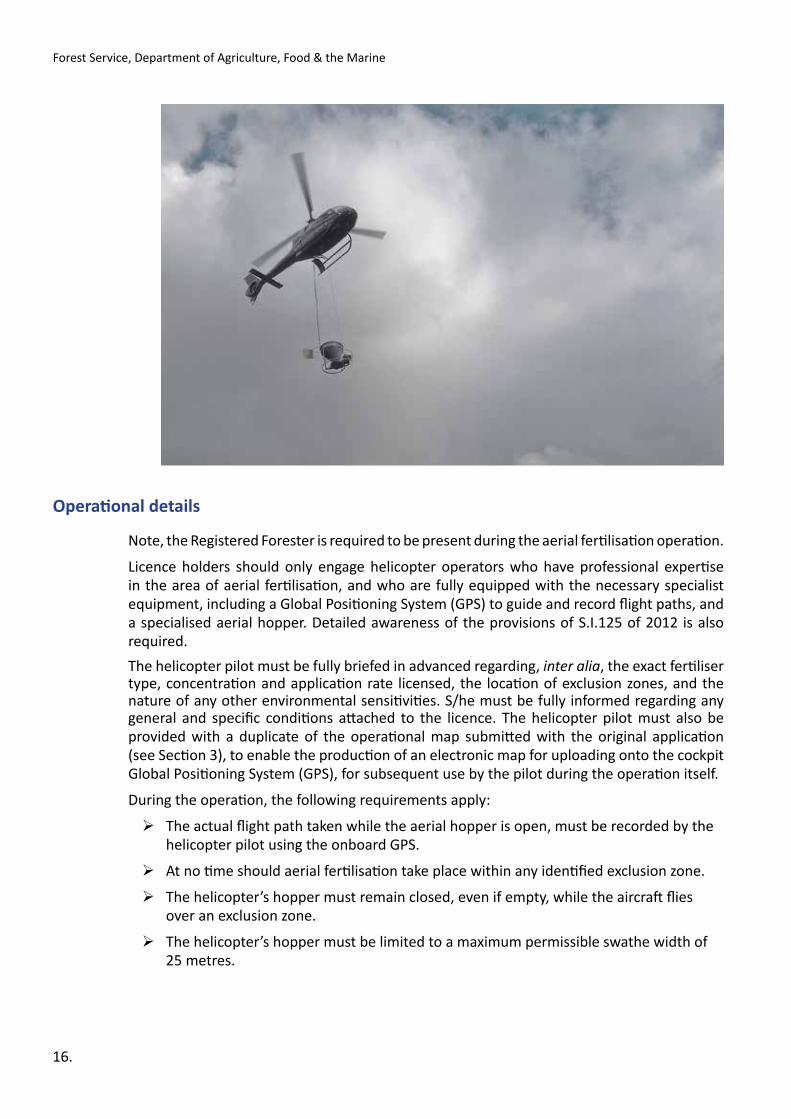
Note, the Registered Forester is required to be present during the aerial fertilisation operation.
Licence holders should only engage helicopter operators who have professional expertise in the area of aerial fertilisation, and who are fully equipped with the necessary specialist equipment, including a Global Positioning System (GPS) to guide and record flight paths, and a specialised aerial hopper. Detailed awareness of the provisions of S.I.125 of 2012 is also required.
The helicopter pilot must be fully briefed in advanced regarding, inter alia, the exact fertiliser type, concentration and application rate licensed, the location of exclusion zones, and the nature of any other environmental sensitivities. S/he must be fully informed regarding any general and specific conditions attached to the licence. The helicopter pilot must also be provided with a duplicate of the operational map submitted with the original application (see Section 3), to enable the production of an electronic map for uploading onto the cockpit Global Positioning System (GPS), for subsequent use by the pilot during the operation itself.
During the operation, the following requirements apply:
¾ The actual flight path taken while the aerial hopper is open, must be recorded by the helicopter pilot using the onboard GPS.
¾ At no time should aerial fertilisation take place within any identified exclusion zone.
¾ The helicopter’s hopper must remain closed, even if empty, while the aircraft flies over an exclusion zone.
¾ The helicopter’s hopper must be limited to a maximum permissible swathe width of 25 metres.
Forest Service, Department of Agriculture, Food & the Marine
16.

Aerial Fertilisation Requirements
Heavy rain and high winds
Restrictions apply in relation to heavy rain and high winds, in order to minimise the risk of freshly-applied fertiliser being washed into receiving waters, or of wind-borne drift during application falling on adjoining exclusion zones.
Aerial fertilisation must not take place in the 48-hour period before predicted heavy rain, during heavy rain, or in the 48-hour period following heavy rain. Heavy rain is defined by Met Éireann as a precipitation rate that exceeds 2 mm per hour averaged over 3 or 6 hours. Consult the Met Éireann website www.met.ie and review the forecast details for the meteorological station nearest to the site.
Similarly, aerial fertilisation must not take place when the wind speed exceeds, or is forecast to exceed, Beaufort Scale 5 / 35 kilometres per hour / 19 knots. Again, consult www.met.ie and review the forecast details for the meteorological station nearest to the site.
Where lighter wind speeds permit application, it is generally good practice for helicopters to fly into the wind when applying fertiliser, as this further limits the possibility of any lateral drift.
Accessing the accuracy of the fertiliser application
Bucket sampling
Sample buckets or some other suitable open-top containers must be positioned within any aquatic exclusion zone onsite, in order to verify the accuracy of the aerial drop and the flight path data. Sample buckets must be in place before the application commences. Position buckets in pairs 25 metres and 50 metres back from the water’s edge, every 100 metres along the length of the aquatic zone. This paired arrangement allows for an assessment of any fertiliser drift that might occur.
Buckets must be subsequently checked immediately after application and before rainfall, and their contents recorded. They may also be checked by the Forest Service immediately after the operation.
Sample buckets should also be positioned throughout the intended treatment area, to confirm treatment.
Afterwards, buckets are to be collected and their contents (if any) broadcast onsite at least 50 metres away from any aquatic zone or relevant watercourse.
Water grab sampling
Water grab sampling at a selected point(s) within receiving stream or river may be required by the Forest Service before and after the operation, to establish a snapshot of water chemistry pre- and post-application. Where required, the water grab sampling point should be located within any receiving stream or river at an accessible point downstream of, and as close as possible to, the site, and before any confluence with other streams and rivers. Two or more sample points may be necessary, if there are two or more aquatic zones involved.
Water grab samples must be taken at the intervals detailed in Table 3.
The collection of water grab samples should follow the basic field methodology that applies
17.

under the protocol for the determination of the acid sensitivity of surface water in the context of afforestation. See the Forest Service Forestry Standards & Procedures Manual for further details.
After collection, each sample should be sent without delay to an accredited laboratory (as detailed in the Forestry Standards & Procedures Manual) and analysed for basic chemistry (including pH, Total P, Ortho P, ammonia, nitrate and K). The results and interpretation of the analysis should be then be submitted to the Forest Service with the Aerial Fertilisation Completion Form - see Section 5.
Contingency planning
A contingency plan must be prepared and available onsite, setting out the procedures to be followed and relevant agencies to be immediately contacted, in situations where potential environmental damage occurs during the operation itself. All operators onsite, including the helicopter pilot, should be made familiar with the document. Of most concern in relation to aerial fertilisation is the potential contamination of any aquatic zone or relevant watercourse. However, other types of potential environmental damage might occur, such as the accidental release of fertiliser over adjoining non-forested land.
The contingency plan should list a local contact name and telephone number for the following agencies and parties, to facilitate immediate notification in situations where potential environmental damage occurs during the operation:
¾ Forest Service, Department of Agriculture, Food & the Marine
¾ Inland Fisheries Ireland
¾ National Parks & Wildlife Service
¾ Local Authority
¾ Environmental Protection Agency (EPA)
¾ National Monuments Service
¾ Adjoining landowners
¾ An Garda Síochána
A detailed fire plan should also be prepared and available onsite, containing details set out in the Forest Service Forest Protection Guidelines. Health and safety is also paramount, and various legal requirements will apply regarding responsibilities and onsite documentation (see the Health & Safety Authority website www.hsa.ie for details).
Forest Service, Department of Agriculture, Food & the Marine
18.
Pre-‐application sampling Post-‐application sampling
For P: Four samples 1 week apart, with the 1st sample taken 1 week after the application
For both P and N: Two samples 1 week apart, with the 2nd sample taken immediately before the commencement of the aerial fertilisation application
For N: Two samples 1 week apart, with the 1st sample taken 1 week after the application
Table 3 Required intervals for water grab sampling.

Aerial Fertilisation Requirements
Section 5 Licence utilisation
Aerial Fertilisation Completion Form
An Aerial Fertilisation Completion Form must be submitted to the Forest Service no later than 12 weeks after the completion of the operation. Where separate applications of P and N are involved, two separate Aerial Fertilisation Completion Forms are required (see Figure 1, page 13).
The following details are required in the Aerial Fertilisation Completion Form:
¾ aerial fertilisation licence number
¾ name, company (if applicable) and contact details of the licence holder
¾ name, company and contact details of the helicopter pilot
¾ date and time of the aerial fertilisation operation
¾ forest area fertilised during the operation
¾ details of the fertiliser(s) applied (type, concentration, application rate)
¾ weather conditions during the operation, both onsite and as recorded by Met Éireann (www.met.ie)
¾ swathe width of the fertiliser spread.
The following supplementary documentation is also required:
¾ A map illustrating the actual flight path of the helicopter while the aerial hopper was open, is also required. This must be based on GPS tracking data recorded by the pilot during the operation itself. The map must also show the position of the water grab sampling point(s), where sampling is required. See example overleaf.
¾ Where pre- and post-water grab sampling is stipulated as a licensing condition by the Forest Service (see Section 4), a copy of the report provided by the accredited laboratory is required, setting out the results and interpretation of the analysis undertaken on the collected samples.
¾ Where, in accordance with the licence issued, the operation was carried out within a Hen Harrier SPA during the breeding season 1st April to 15th August inclusive, a map and a pilot declaration must be provided, confirming that the flight time spent traversing the SPA to and from the site of the operation was minimised, and that the flying altitude throughout this traverse was maintained at no less than 1,300 feet / 400 metres above ground level.
The Registered Forester is also required to make a signed declaration that: (i). s/he was present during the aerial fertilisation operation; (ii). the operation was carried out in accordance with the requirements of S.I.125 of 2012 and with any conditions attached to the licence; and (iii). the details set out in the Aerial Fertilisation Completion Form are accurate.
19.

14
5
1
1
2
3
2 3
5334
0A
5329
4D
5329
3I
1074
00.0
0000
0
1074
00.0
0000
0
1080
00.0
0000
0
1080
00.0
0000
0
279500.000000
279500.000000
280000.000000
280000.000000
280500.000000
280500.000000
Aer
ial F
ertil
isat
ion
2012
Com
plet
ion
Map
Com
partm
ents
Sub
Com
partm
ents
Fore
st R
oad
RO
W R
oad
Trac
k
GFM
onum
ents
Lake
s
ESB
Lin
es
Cou
nty
Roa
dsN
P
NS
R Oth
er
1:5,
000
Fore
st:
M
O24
- D
rum
neen
Pilo
ts N
ame:
Chr
is S
hiel
Lice
nce
No.
: A
FA60
4
Fert
type
/rate
: U
rea/
300
Con
ditio
ns:
Dry
/Cle
ar/C
alm
Swat
he:
24m
Dat
e: 2
1/08
/201
2
OS
Map
: M
ayo
31
Pro
duce
d on
Coi
llte
GIS
- O
rdna
nce
Sur
vey
Irela
nd L
icen
ce N
o E
N 0
0137
12 (D
igita
l Con
tract
) © O
rdna
nce
Sur
vey
Irela
nd/G
over
nmen
t of I
rela
nd
020
040
010
0M
eter
s
Lege
nd Flig
ht P
ath
Ure
a
Lice
nce
Are
a
Map
2 A
n ex
ampl
e of
the
fligh
t pat
h m
ap fo
r an
app
licati
on o
f ure
a, to
acc
ompa
ny th
e A
eria
l Fer
tilis
ation
Com
pleti
on F
orm
. (S
ampl
e m
ap n
ot-t
o-sc
ale.
) (Co
urte
sy: C
oillt
e)
Forest Service, Department of Agriculture, Food & the Marine
Posi
tion
of w
ater
gr
ab s
ampl
ing
poin
t
20.
Prod
uced
on
Coi
llte
GIS
- O
rdna
nce
Surv
ey Ir
elan
d Li
cenc
e N
o. E
N 0
0137
12 (D
igita
l Con
trac
t) ©
Ord
nanc
e Su
rvey
Irel
and/
Gov
ernm
ent o
f Ire
land

Aerial Fertilisation Requirements
Appendix AFoliar nutrient concentrations and
indicative fertiliser requirements
The following table outlines the fertiliser requirements for P, N and K for Sitka spruce and Norway spruce, based on the results of foliar analysis. Note, this table is indicative for Sitka spruce and Norway spruce only. Various crop and site parameters will influence the exact fertiliser application rate suitable for any individual aerial fertilisation operation. In complex or abnormal cases, additional diagnosis or opinion should be sought from an expert in the area of forest crop nutrition. (Typically, pine species require less fertiliser input.)
Element Foliar result (Nutrient %)
Comment Fertiliser requirement
> 0.13 Optimum to satisfactory No fertiliser required
0.12 – 0.13 Marginally low
Only apply fertiliser if either N or K is also marginally low to deficient
200 kg Granulated Rock Phosphate (GRP) (11-‐12% P) / ha
0.11 – 0.12 Low 250 kg GRP (11-‐12% P) / ha
0.10 – 0.11 Deficient 300 kg GRP (11-‐12% P) / ha
Phosphorus (P)
< 0.10 Severely deficient 350 kg GRP (11-‐12% P) / ha (1)
> 1.20 Optimum to satisfactory No fertiliser required
1.10 – 1.20 Marginally low
Only apply fertiliser if either P or K is also marginally low to deficient
250 kg Granulated Urea (46% N) / ha
1.00 – 1.10 Low 300 kg Granulated Urea (46% N) / ha
Nitrogen (N)
< 0.90 Severely deficient 350 kg Granulated Urea (46% N) / ha (1)
> 0.50 Optimum to satisfactory No fertiliser required
0.40 – 0.50 Low
Only apply fertiliser if either N or P is also deficient
200 kg Muriate of Potash (MOP) (50% K) / ha
Potassium (K)
< 0.30 Severely deficient 250 kg MOP (50% K) / ha (1,2)
1 Higher application rates are prohibited by S.I.125 of 2012. 2 If all three elements (P, N and K) are deficient, then apply P and N fertilisers only (excluding K). 21.

Appendix BExamples of nutrient deficiencies in
conifers
22.
Forest Service, Department of Agriculture, Food & the Marine

Phosphorus and nitrogen deficiency in Sitka spruce on peat. (Red and white markings on survey pole are 20 cm in length.)
23.
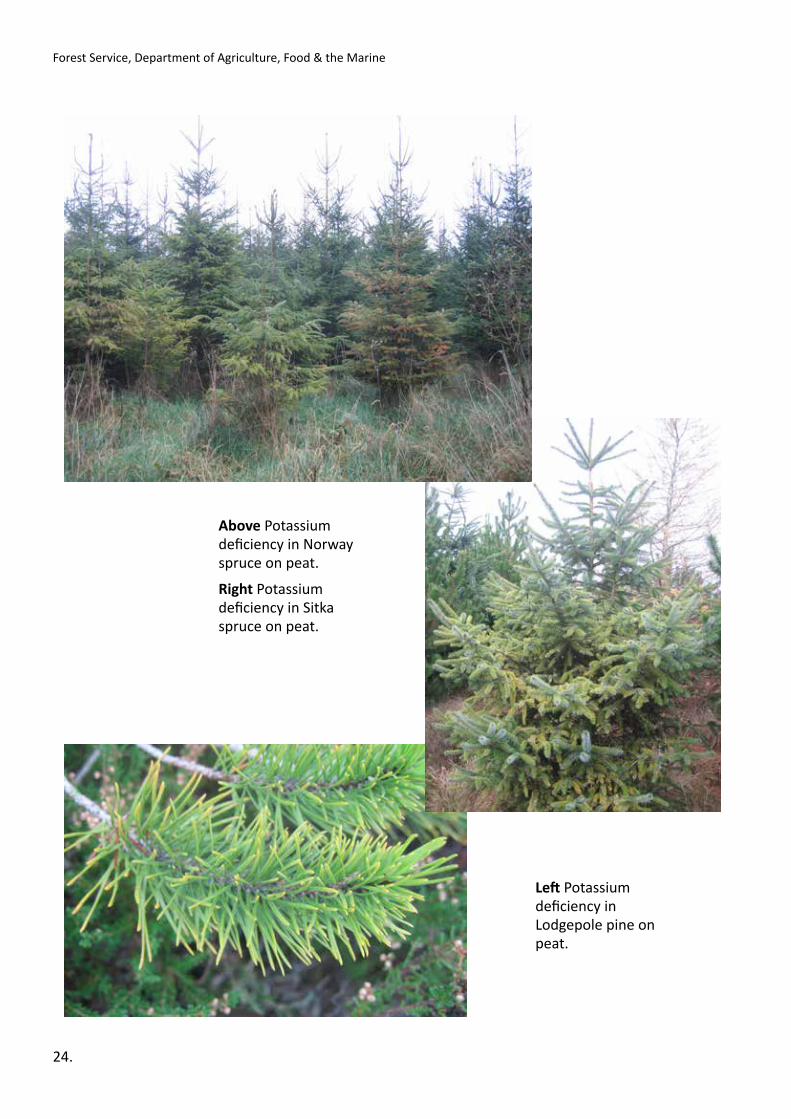
Aerial Fertilisation Requirements
Left Potassium deficiency in Lodgepole pine on peat.
24.
Forest Service, Department of Agriculture, Food & the Marine
Above Potassium deficiency in Norway spruce on peat.
Right Potassium deficiency in Sitka spruce on peat.