Embed Size (px)
Citation preview

Advances in Coastal Inundation Simulation Using Unstructured-Grid Coastal Ocean Models
MARICOOS Coastal Inundation Module Design WorkshopSeptember 14-15, 2006
Bob Beardsley (WHOI)
Changsheng Chen (UMass-Dartmouth)
Bob Weisberg (U. South Florida)
Joannes Westerink (U. Notre Dame)

Basic Requirements for Inundation Simulation
1) A high-resolution, physics-based circulation model with flooding and drying capabilities.
2) A high-resolution water depth (bathymetry) and land elevation data set on which to overlay the model.
3) Accurate enough river discharge, tidal forcing, and surface wind and pressure fields to drive the model.
(coastal flooding caused by river discharge, tides, storm surge, and tsunami processes)
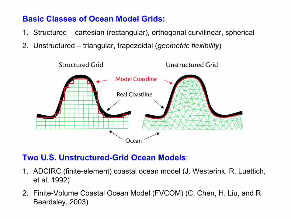
Basic Classes of Ocean Model Grids:1. Structured – cartesian (rectangular), orthogonal curvilinear, spherical
2. Unstructured – triangular, trapezoidal (geometric flexibility)
Two U.S. Unstructured-Grid Ocean Models: 1. ADCIRC (finite-element) coastal ocean model (J. Westerink, R. Luettich,
et al, 1992)
2. Finite-Volume Coastal Ocean Model (FVCOM) (C. Chen, H. Liu, and R Beardsley, 2003)

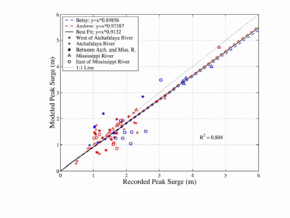
Example of ADCIRC applied to Hurricane Surge Simulation
Westerink, et al, 2006. A Basin to Channel Scale Unstructured Grid Hurricane Storm Surge Model Applied to Southern Louisiana, Monthly Weather Review (in review)

OBC’s:
1. Tides
2. Inverted Barometer
Land BC’s:
1. Upriver Tidal Propagation
2. River Discharge
Surface Forcing:
1. Wind Stress
2. Atmospheric Pressure(Large domain approach simplifies boundary conditions, avoids tidal resonance problems in GoM, at the cost of ~ 5-10% additional grid cells/computational effort)


Hurricane Betsy track and 10 minute averaged maximum marine wind speed contours from H*WIND (m/s)

Hurricane Betsy modeled peak storm surge elevation, with error in peak storm surge height (m) at stations. Positive error values indicate model over-prediction and negative values indicate under-prediction. Dry areas are shown in gray and levee structures are shown as brown lines.

Steps taken to obtain accurate model simulation
1. Very careful adjustment of bathymetry and elevation data from different sources to common surface (steric effects).
2. Different methods used for flooding and drying of grid cells, barriers (impervious and porous), spillways.
3. Used two hurricane models to produce surface wind and pressure fields to drive model.
4. Modification of wind field over land and in land-water zone due to spatial change in surface roughness (zo) caused by land canopy, buildings, etc.
5. Adjusted grid resolution, bathymetry/topography detail as suggested by model results and model/data comparisons.
6. Wind-wave effects on ocean roughness zo, surge elevation, and sediment/structure change TO BE ADDED.

FVCOM: Finite-Volume Coastal Ocean Model
Key Features: • An unstructured triangle grid for representing complex coastal
geometry• 3D primitive equations, with flow dependent turbulence closure• Finite-volume (differences of fluxes) for mass, momentum, heat,
and salt conservation, plus computational efficiency• Provision for flooding and drying land
Examples: 1. Hurricane surge simulation2. NE regional model system for inundation simulation

Example of FVCOM applied to Hurricane Surge SimulationWeisberg and Zheng, 2006. What May Have Occurred Had Hurricane Ivan Made Landfall Within the Tampa Bay Region?

A Zoom View of the Tampa Bay Region
Longitude

Merged Bathymetry and Topography


FVCOM
Surface Wave Model SWAN
Local Inundation Models(FVCOM, ADCIRC, ...)
Sediment Transport Model(USGS)
Regional Mesoscale Model (MM5,WRF)
NCEP North American Weather Model (NAM)Satellite SSTBuoy WindsInsolation
Satellite SST, U,V
Buoy T,S,U,V,P
Freshwater Input
Ocean GCM
Global Tidal Model
Global Wave Model
Existing Models
Core Models
KEY
Heat Flux Wind Stress
P-E U,VBC’s
Data
BC’s
BC’s
BC’s
U,V, Waves, Langmuir Cells
Form Drag
Bottom Stress
Schematic of UMassD Regional NE Model System for Inundation Simulation/Prediction
In Development

Region domain MM5(resolution: 30 km)
Non-hydrostatic
Wind stress, heat flux, air pressure, precipitation - evaporation
Local domain MM5(resolution: 10 km)
ETA/NAM
Air stationsBuoy dataSatellite dataLocal network
SST (9 km)Local buoys
Assimilation
Assimilation
Nested
Nested
The Gulf of Maine/Georges Bank MM5 Weather Forecast Model SystemSong Hu and Zhongxiang Wu
Local domain
Regional domainSites of Surface Buoys
On-going modifications:1. Convert the MM5 to 4 km resolution over the Gulf of Maine and 1 km resolution
over Georges Bank, Mass Bay and New England Shelf 2. Convert to WRF mesoscale model


256 Processors (Intel 3.4 GHz Pentium 4)256 Gigabytes RAM, Infiniband High Speed Network 7 Terabytes disk space
Third Generation Gulf of Maine FVCOM


M2 tidal currents

Summary
• ADCIRC and FVCOM both use unstructured triangular grids to represent complex coastal geometries - allowing “river to basin” grids with sufficient horizontal resolution to capture key physical processes
• ADCIRC and FVCOM both feature flooding and drying - allowing them to simulate inundation associated with river, tidal, storm surge, and tsunami processes
• FVCOM uses finite-volume approach – providing excellent local mass, momentum, heat, salt conservation
• FVCOM is an open community model system – with support by a UMassD/WHOI development team lead by C. Chen, G. Cowles, and R. Beardsley.
• UMassD NE regional coupled atmosphere/ocean FVCOM system exists - which could provide starting point for regional inundation prediction system.