Embed Size (px)
Citation preview
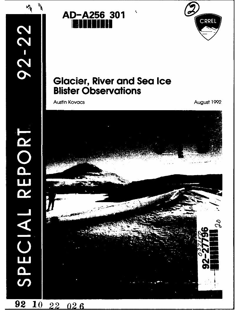
AD-A256 301
Glacier, River and Sea IceBlister ObservationsAustin Kovacs August 1992
i44
92 10 22 02
e -
AbsftrctIce blister observations made by the author In Greenland, Alaska and Antarcticaare discussed. Ice blisters up to 3 m high and tens of meters long were observedon rivers and glaciers as well as on a subsurface glacial pool. Ice blistersobserved by other investigators are also discussed, as is ice blister morphology(solid, hollow or water-filled), the processes associated with their formation andtheir potential as a resource for potable water.
Cover: Ice blister on refrozen melt 'river,' Koeffliiz Glacier Ice Tongue,Antarctica. Mt. Erebus rises majestically some 100 km in thedistance. Note the wind-polished ice on the left flank of the blister andthe typical cleavage crack, which is broadest at the apex of the iceblister.
For conversion of SI metric units to U.SJBr•Itsh customary units of measurementconsult ASTM Standard E380, Metric Practice Guide, published bythe AmericanSociety for Testing and Materials, 1916 Race St., Philadelphia, Pa. 19103.
Special Report 92-22 M
U.S. Army Corpsof EngineersCold Regions Research &Engineering Laboratory
Glacier, River and Sea IceBlister ObservationsAustin Kovacs August 1992
Accesion For
NTIS CRA&MDTIC TABUnannounced ElJustification-----------
By .... .............-- -------------------
Dist. ibution I
Availability Codes
Avai end/ orDist SpecialA v tI
Approved for public release; distffibution is unlimited.
PREFACE
This report was prepared by Austin Kovacs, Research Civil Engineer, Applied ResearchBranch, Experimental Engineering Division, U.S. Army Cold Regions Research and Engi-neering Laboratory.
The author acknowledges the background information provided by Dr. William Harrisonof the Geophysical Institute, University of Alaska, on his Greenland ice blister observations,Frederick E. Crory of CRREL on his Alaska ice blister observations and Giles McDonald ofAnchorage, Alaska, on the exploded icing reported in Sloan et al. (1976). He also acknowl-edges the review of this report by Frederick Crory and Kevin L. Carey of CRREL.
The contents of this report are not to be used for advertising or promotional purposes.Citation of brand names does not constitute an official endorsement or approval of the useof such commercial products.
ii
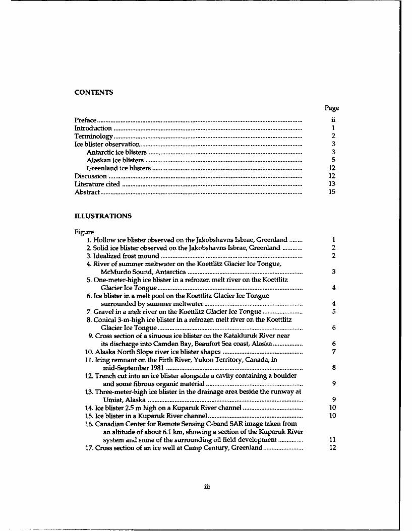
CONTENTS
Page
Preface ........................................................................................................................... iiIntroduction ................................................................................................................. 1Term inology ................................................................................................................. 2Ice blister observation ................................................................................................. 3
Antarctic ice blisters .......................................................................................... 3Alaskan ice blisters .............................................................................................. 5Greenland ice blisters ......................................................................................... 12
D iscussion .................................................................................................................... 12Literature cited .......................................................................................................... 13A bstract ......................................................................................................................... 15
ILLUSTRATIONS
Figure1. Hollow ice blister observed on the Jakobshavns Isbrae, Greenland ........ 12. Solid ice blister observed on the Jakobshavns Isbrae, Greenland ............ 23. Idealized frost mound ................................................................................... 24. River of summer meltwater on the Koettlitz Glacier Ice Tongue,
McMurdo Sound, Antarctica ................................................................... 35. One-meter-high ice blister in a refrozen melt river on the Koettlitz
Glacier Ice Tongue ..................................................................................... 46. Ice blister in a melt pool on the Koettlitz Glacier Ice Tongue
surrounded by summer meltwater ........................................................... 47. Gravel in a melt river on the Koettlitz Glacier Ice Tongue ...................... 58. Conical 3-m-high ice blister in a refrozen melt river on the Koettlitz
Glacier Ice Tongue ..................................................................................... 69. Cross section of a sinuous ice blister on the Katakluruk River near
its discharge into Camden Bay, Beaufort Sea coast, Alaska .................. 610. Alaska North Slope river ice blister shapes ............................................... 711. Icing remnant on the Firth River, Yukon Territory, Canada, in
mid-September 1981 ................................................................................ 812. Trench cut into an ice blister alongside a cavity containing a boulder
and some fibrous organic material ........................................................ . 913. Three-meter-high ice blister in the drainage area beside the runway at
Umiat, Alaska ............................................................................................ 914. Ice blister 2.5 m high on a Kuparuk River channel .................................... 1015. Ice blister in a Kuparuk River channel ......................................................... 1016. Canadian Center for Remote Sensing C-band SAR image taken from
an altitude of about 6.1 km, showing a section of the Kuparuk Riversystem and some of the surrounding oil field development ............... 11
17. Cross section of an ice well at Camp Century, Greenland ........................ 12
iii
Glacier, River and Sea Ice
Blister Observations
AUSTIN KOVACS
INTRODUCTION All blisters were found in the ablation zone wheresummer surface melt forms pools in glacial ice
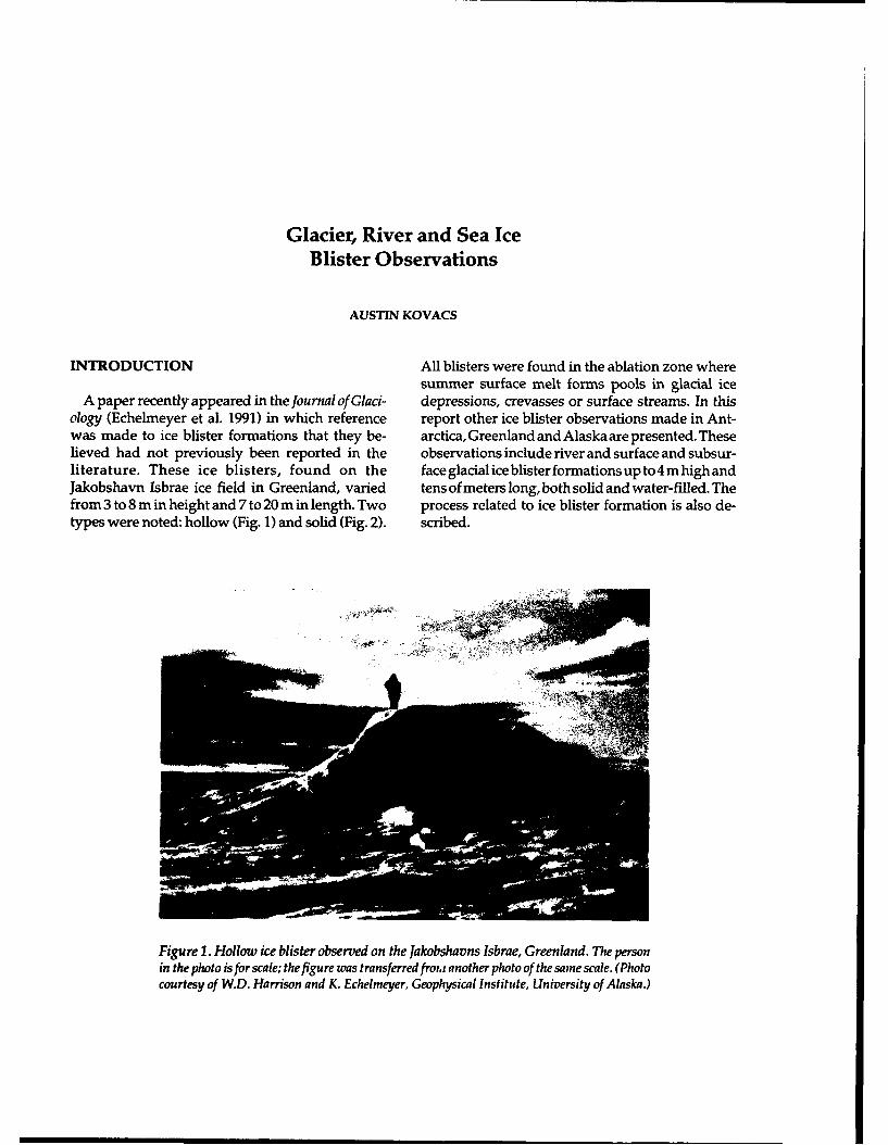
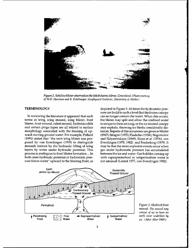
A paper recently appeared in the Journal of Glaci- depressions, crevasses or surface streams. In thisology (Echelmeyer et al. 1991) in which reference report other ice blister observations made in Ant-was made to ice blister formations that they be- arctica, Greenland and Alaska are presented. Theselieved had not previously been reported in the observations include river and surface and subsur-literature. These ice blisters, found on the faceglacialiceblisterformationsupto4mhighandJakobshavn Isbrae ice field in Greenland, varied tens of meters long, both solid and water-filled. Thefrom 3 to 8 m in height and 7 to 20 m in length. Two process related to ice blister formation is also de-types were noted: hollow (Fig. 1) and solid (Fig. 2). scribed.
Figure 1. Hollow ice blister observed on the Jakobshavns Isbrae, Greenland. The personin the photo is for scale; the figu re was transferred froi, i another photo of the same scale. (Photocourtesy of W.D. Harrison and K. Echelmeyer, Geophysical Institute, University of Alaska.)
VV1u-
Figure 2. Solid ice blister observed on the Jakobshavns Isbrae, Greenland. (Photo courtesyof W.D. Harrison and K. Echelineyer, Geophysical Institute, University of Alaska.)
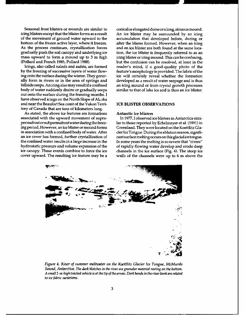
TERMINOLOGY depicted in Figure 3. At times the hydrostatic pres-sure can build to such a level that the frozen canopy
In reviewing the literature it appeared that such can no longer contain the water. When this occurs,terms as icing, icing mound, icing blister, frost the blister may split and allow the confined waterblister, frost mound, naled mound, hydrolaccolith to escape to form an icing, or the ice mound canopyand certain pingo types are all related to surface may explode, throwing ice blocks considerable dis-morphology associated with the freezing of up- tances. Reports of this occurrence are given in Mullerward-moving ground water. For example, Pollard (1947), Strugov (1955), Plashchev (1956), Bogomolov(1991) stated that "the term icing blister was pro- and Sklyarevskaya (1969), Sloan et al. (1976), vanposed by van Everdingen (1978) to distinguish Everdingen (1978, 1982) and Frederking (1979). Itmounds formed by the hydraulic lifting of icing may be that the more explosive events occur whenlayers by water under hydraulic potential. This gas under hydrostatic pressure has accumulatedprocess is analogous to frost blister formation.... In between the ice and water. Gas bubbles coming upboth cases hydraulic potential or hydrostatic pres- with suprapermafrost or subpermafrost water issure forces water" upward to the freezing front, as not unusual (Liestol 1977, van Everdingen 1982).
Earth Seasonallyand/or Ice Mound "-Thawed Ground
~Continuously"
-Thawed Ground
Permafrost Figure 3. Idealized frostnmound. The mound may
consist of ice or have anf Penetrating f•T~ Free o- Suprapermafrost j, Subpermafrost earth cover underlain by
Frost Water Water Water ice. (After Alter 1969.)
2
Seasonal frost blisters or mounds are similar to conicalorelongated domeoralong, sinuous mound.icing blisters except that the blister forms as a result An ice blister may be surrounded by an icingof the movement of ground water upward to the accumulation that developed before, during orbottom of the frozen active layer, where it freezes. after the blister formed. However, when an icingAs the process continues, crystallization forces and an ice blister are both found at the same loca-gradually push the soil canopy and underlying ice tion, the ice blister is frequently referred to as anmass upward to form a mound up to 3 m high icing blister or icing mound. This can be confusing,(Pollard and French 1985, Pollard 1988). but the confusion can be resolved, at least in the
Icings, also called naleds and aufeis, are formed reader's mind, if a good-quality photo of theby the freezing of successive layers of water flow- feature's morphology is provided. The fabric of theing onto the surface during the winter. They gener- ice will certainly reveal whether the formationally form in rivers or in the area of springs and developed as a result of water seepage and is thushillside seeps. An icing also may result if a confined an icing mound or from crystal growth processesbody of water suddenly drains or gradually seeps similar to that of lake ice and is thus an ice blister.out onto the surface during the freezing months. Ihave observed icings on the North Slope of AI,3kaand near the Beaufort Sea coast of the Yukon Terri- ICE BLISTER OBSERVATIONStory of Canada that are tens of kilometers long.
As stated, the above ice features are formations Antarctic ice blistersassociated with the upward movement of supra- In 1977, 1 observed ice blisters in Antarctica simi-permafrostorsubpermafrostwaterduringthe freez- lar to those reported by Echelmeyer et al. (1991) ining period. However, an ice blister or mound forms Greenland. They were located on the Koettlitz Gla-in association with a confined body of water. After cier Ice Tongue. During the ablation season, signifi-an ice cover has formed, further crystallization of cant surface melting occurs on this glacial ice tongue.the confined water results in a large increase in the In some years the melting is so severe that "rivers"hydrostatic pressure and volume expansion of the of rapidly flowing water develop and erode deepice canopy. These events combine to force the ice channels in the ice surface (Fig. 4). The steep icecover upward. The resulting ice feature may be a walls of the channels were up to 6 m above the
7n
4W,
Figure 4. River of summer meltwater on the Koettlitz Glacier Ice Tongue, McMurdoSound, Antarctica. The dark blotches in the river are granular material resting on the bottom.A small I -m-high tracked vehicle is at the tipof thearrow. Dark bands in the river bankare relatedto ice fabric variations.
3
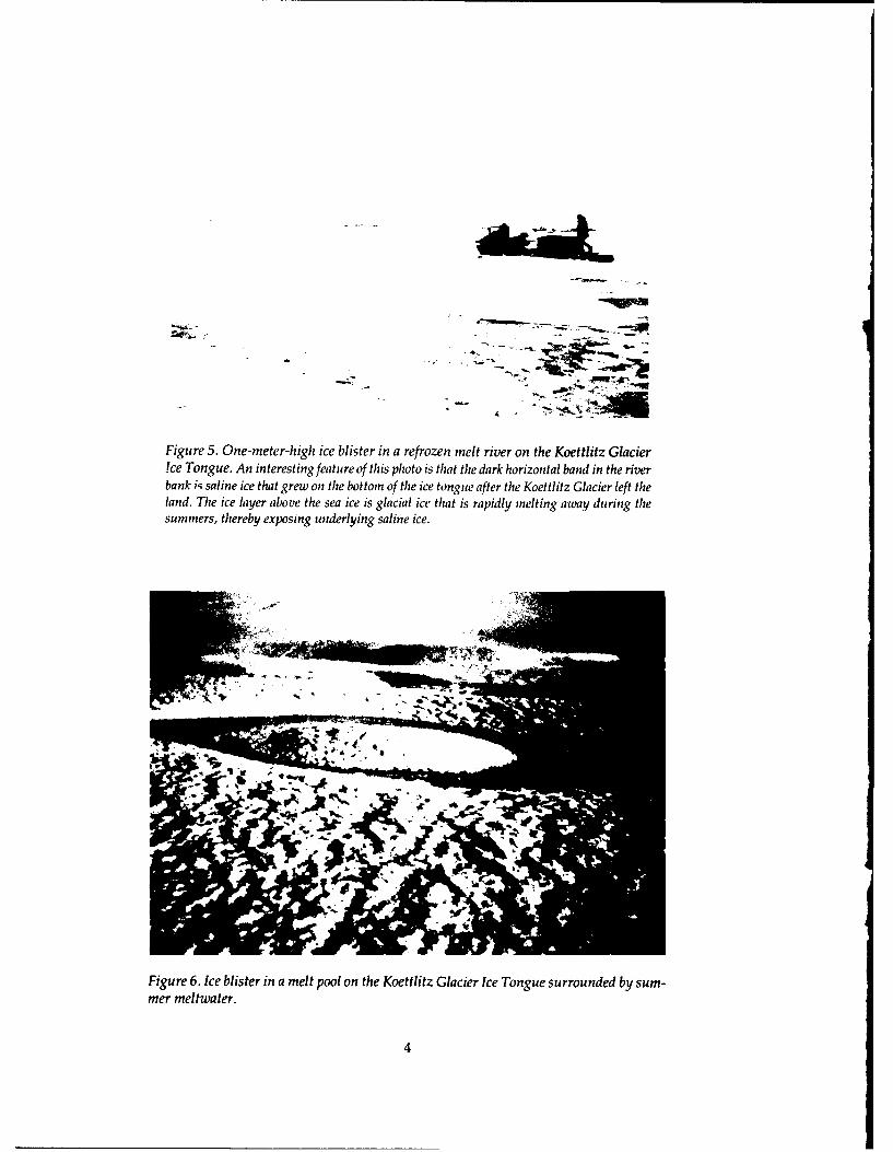
Figure 5. One-meter-high ice blister in a refrozen melt river on the Koettlitz Glacierice Tongue. An interesting feature of this photo is that the dark horizontal band in the riverbank is saline ice that grew on the bottom of the ice tongue after the Koettlitz Glacier left theland. The ice layer above the sea ice is glacial ice that is rapidly melting away during thesummers, thereby exposing underlying saline ice.
Figure 6. Ice blister in a melt pool on the Koettlitz Glacier Ice Tongue surrounded by sum-mer meltwater.
4
T°
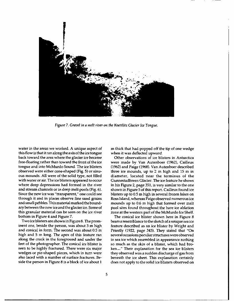
Figure 7. Gravel in a melt river on the Koettlitz Glacier Ice Tongue.
water in the areas we worked. A unique aspect of m thick that had popped off the tip of one wedgethis flow is that it ran along the axis of the ice tongue when it was deflected upward.back toward the area where the glacier ice became Other observations of ice blisters in Antarcticafree-floating rather than toward the front of the ice were made by Van Autenboer (1962), Cailleuxtongue and into McMurdo Sound. The ice blisters (1962) and Paige (1968). Van Autenboer describedobserved were either cone-shaped (Fig. 5) or sinu- three ice mounds, up to '2 m high and 15 in inous mounds. All were of the solid type, not filled diameter, located near the terminus of thewith water or air. The ice blisters appeared to occur Gunnestadbreen Glacier. The ice feature he showswhere deep depressions had formed in the river in his Figure 2, page 351, is very similar to the oneand stream channels or in deep melt pools (Fig. 6). shown in Figure 5 of this report. Cailleux found iceSince the new ice was "transparent," one could see blisters up to 0.5 m high in several frozen lakes onthrough it and in places observe fine sand grains Ross Island, whereas Paige observed numerous iceand small pebbles. Thismaterial marked thebound- mounds up to 0.6 m high that formed over meltary between the new ice and the glacier ice. Some of pool sites found throughout the bare ice ablationthis granular material can be seen on the ice river zone at the western part of the McMurdo Ice Shelf.bottom in Figure 4 and Figure 7. The conical ice blister shown here in Figure 8
Two ice blisters are shown in Figure 8. The prom- bears a resemblance to the sketch of a unique sea iceinent one, beside the person, was about 3 m high feature described as an ice blister by Wright andand conical in form. The second was about 0.5 m Priestly (1922, page 343). They stated that "Onhigh and 5 m long. The apex of this feature ran several occasions peculiar structures were observedalong the crack in the foreground and under the in sea ice which resembled in appearance nothingfeet of the photographer. The conical ice blister is so much as the skin of a blister, which had bro-seen to be highly fractured. There were six major ken...." Their explanation for the sea ice blisterswedges or pie-shaped pieces, which in turn were they observed was a sudden discharge of gas fromalso laced with a number of surface fractures. Be- beneath the ice sheet. This explanation certainlyside the person in Figure 8 is a block of ice about I does not apply to the solid ice blisters observed on
5
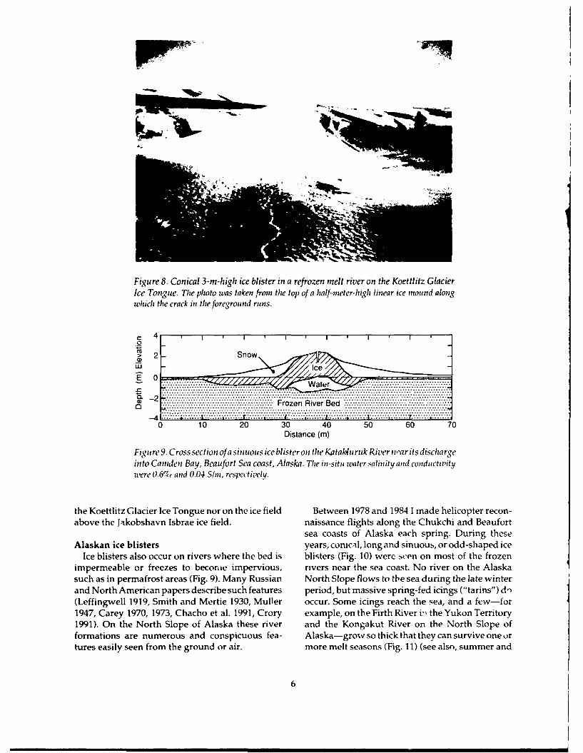
Figure 8. Conical 3-m-high ice blister in a refrozen melt river on the Koettlitz GlacierIce Tongute. The photo was taken from the top of a half-meter-high linear ice mound alongwhich the crack in the foreground runs.
C- 4 l I I I I I
wJ> 2-So
E 0.. .....:::. .. W at r
0.. 10. 20. 30----40----50------0---70-
S-2 .... .... ........... .. . . ....................... .. ....................... ....... ...... .v.'.v.:'.:v v '
S.-.-.-.-..-.-.-.-. .-------- --- -- --.........-....... ............................. ---------- --- -;-.-.-.-.---- ......... ; ----
S... ........ ................... ........................................ . . . . . . . . . . . . . . . . . . . . .-- ...•..v..i..:.......:.4 v...:.........T.. :...... .... v...I..•.... •.... .... :...:... ... '.. ..... :...!..;.....I... ...... 1........1..........
0 10 20 30 40 50 60 70
Distance (m)
Fi gu re 9. Cross section of a siniuous ice blister on the Katakturuk River nar its dischargeinto Camden Bay, Beaufort Sea coast, Alaska. The in-sitm water salinity and conductivitywere 0.67c and 0.04 S/in, respectively.
the Koettlitz Glacier Ice Tongue nor on the ice field Between 1978 and 1984 1 made helicopter recon-above the Jakobshavn Isbrae ice field. naissance flights along the Chukchi and Beaufort
sea coasts of Alaska each spring. During theseAlaskan ice blisters years, conical, long and sinuous, or odd-shaped ice
Ice blisters also occur on rivers where the bed is blisters (Fig. 10) were zven on most of the frozenimpermeable or freezes to become impervious, rivers near the sea coast. No river on the Alaskasuch as in permafrost areas (Fig. 9). Many Russian North Slope flows to the sea during the late winterand North American papers describe such features period, but massive spring-fed icings ("tarins") d'n(Leffingwell 1919, Smith and Mertie 1930, Muller occur. Some icings reach the sea, and a few-f or1947, Carey 1970, 1973, Chacho et al. 1991, Crory example, on the Firth River i" the Yukon Territory1991). On the North Slope of Alaska these river and the Kongakut River on the North Slope offormations are numerous and conspicuous fea- Alaska-grow so thick that they can survive one ortures easily seen from the ground or air. more melt seasons (Fig. 11) (see also, summer and
6
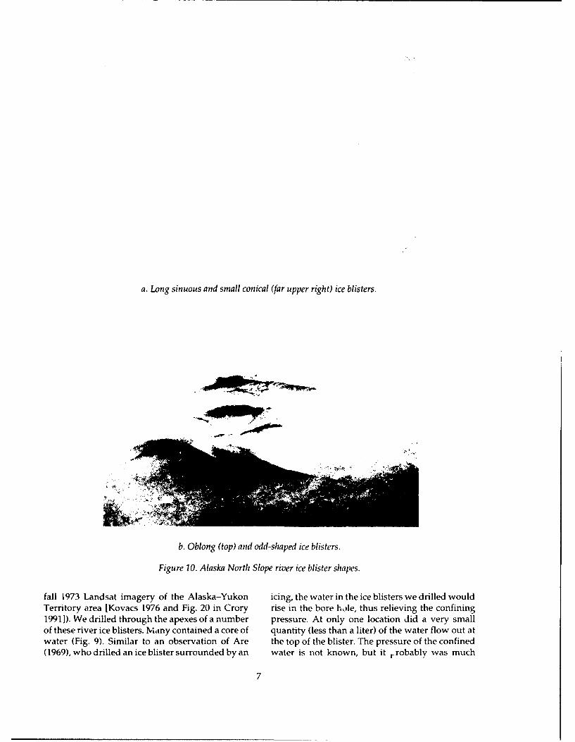
a. Long sinuous and small conical (far upper right) ice blisters.
b. Oblong (top) and odd-shaped ice blisters.
Figure 10. Alaska North Slope river ice blister shapes.
fall 1973 Landsat imagery of the Alaska-Yukon icing, the water in the ice blisters we drilled wouldTerritory area [Kovacs 1976 and Fig. 20 in Crory rise in the bore hole, thus relieving the confining19911). We drilled through the apexes of a number pressure. At only one location did a very smallof these river ice blisters. Mviany contained a core of quantity (less than a liter) of the water flow out atwater (Fig. 9). Similar to an observation of Are the top of the blister. The pressure of the confined(1969), who drilled an ice blister surrounded by an water is not known, but it rrobably was much
7
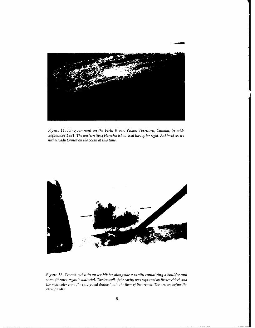
Figure 11. Icing remnant on the Firth River, Yukon Territory, Canada, in mid-September 1981. The western tip of Herschel Island is at the top far right. A skim of sea icehad already formed on the ocean at this time.
t1
Figure 12. Trench cut into an ice blister alongside a cavity containing a boulder andsome fibrous organic material. The ice wall of the cavity was ruptured by the ice chisel, andthie meltwater from the cavity had drained onto the floor of the trench. The arrows define thecavitiy width.
8
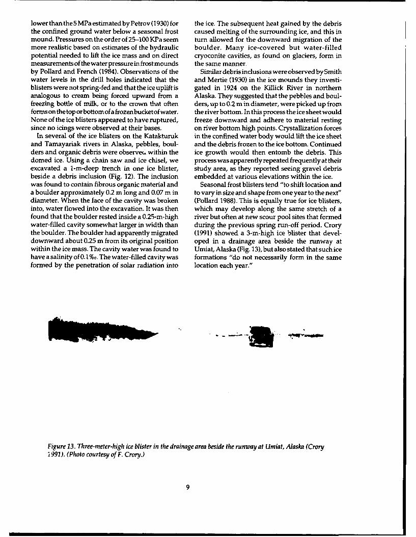
lower than the5 MPa estimated by Petrov (1930) for the ice. The subsequent heat gained by the debristhe confined ground water below a seasonal frost caused melting of the surrounding ice, and this inmound. Pressures on the order of 25-100 KPa seem turn allowed for the downward migration of themore realistic based on estimates of the hydraulic boulder. Many ice-covered but water-filledpotential needed to lift the ice mass and on direct cryoconite cavities, as found on glaciers, form inmeasurements of the water pressure in frost mounds the same manner.by Pollard and French (1984). Observations of the Similar debris inclusions were observed by Smithwater levels in the drill holes indicated that the and Mertie (1930) in the ice mounds they investi-blisters were not spring-fed and that the ice uplift is gated in 1924 on the Killick River in northernanalogous to cream being forced upward from a Alaska. They suggested that the pebbles and boul-freezing bottle of milk, or to the crown that often ders, up to 0.2 m in diameter, were picked up fromforms on the top or bottom of a frozen bucket of water. the river bottom. In this process the ice sheet wouldNone of the ice blisters appeared to have ruptured, freeze downward and adhere to material restingsince no icings were observed at their bases. on river bottom high points. Crystallization forces
In several of the ice blisters on the Katakturuk in the confined water body would lift the ice sheetand Tamayariak rivers in Alaska, pebbles, boul- and the debris frozen to the ice bottom. Continuedders and organic debris were observe(c within the ice growth would then entomb the debris. Thisdomed ice. Using a chain saw and ice chisel, we process was apparently repeated frequently at theirexcavated a i-m-deep trench in one ice blister, study area, as they reported seeing gravel debrisbeside a debris inclusion (Fig. 12). The inclusion embedded at various elevations within the ice.was found to contain fibrous organic material and Seasonal frost blisters tend "to shift location anda boulder approximately 0.2 m long and 0.07 m in to vary in size and shape from one year to the next"diameter. When the face of the cavity was broken (Pollard 1988). This is equally true for ice blisters,into, water flowed into the excavation. It was then which may develop along the same stretch of afound that the boulder rested inside a 0.25-m-high river but often at new scour pool sites that formedwater-filled cavity somewhat larger in width than during the previous spring run-off period. Crorythe boulder. The boulder had apparently migrated (1991) showed a 3-m-high ice blister that devel-downward about 0.25 m from its original position oped in a drainage area beside the runway atwithin the ice mass. The cavity water was found to Umiat, Alaska (Fig. 13), but also stated that such icehave a salinity of 0.1%o. The water-filled cavity was formations "do not necessarily form in the sameformed by the penetration of solar radiation into location each year."
Figure 13. Three-meter-high ice blister in the drainage area beside the runway at Umiat, Alaska (Crory1991). (Photo courtesy of F. Crory.)
9
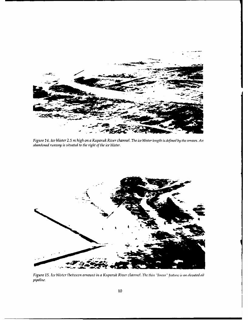
Figure 14. Ice blister 2.5 m high on a Kuparuk River channel. The ice blister length is defined by the arrow's. Anabandoned runway is situated to the right of the ice blister.
'J4V
Figure 15. Ice blister (betweenI arrows) ini a Kuparuk River channel. Tlie thin "linear" feature is an elevated oilpipeline.
10
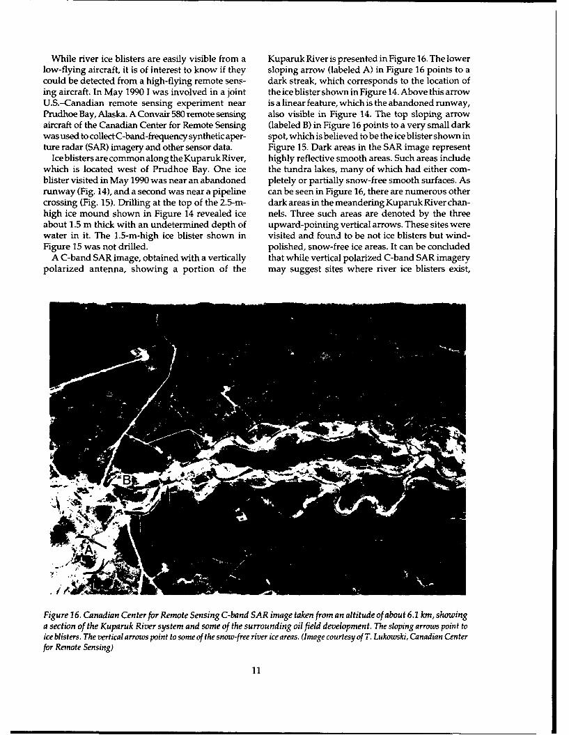
While river ice blisters are easily visible from a Kuparuk River is presented in Figure 16. The lowerlow-flying aircraft, it is of interest to know if they sloping arrow (labeled A) in Figure 16 points to acould be detected from a high-flying remote sens- dark streak, which corresponds to the location ofing aircraft. In May 1990 1 was involved in a joint the ice blister shown in Figure 14. Above this arrowU.S.-Canadian remote sensing experiment near is a linear feature, which is the abandoned runway,Prudhoe Bay, Alaska. A Convair 580 remote sensing also visible in Figure 14. The top sloping arrowaircraft of the Canadian Center for Remote Sensing (labeled B) in Figure 16 points to a very small darkwas used to collect C-band-frequency synthetic aper- spot, which is believed to be the ice blister shown inture radar (SAR) imagery and other sensor data. Figure 15. Dark areas in the SAR image represent
Ice blisters are common along the Kuparuk River, highly reflective smooth areas. Such areas includewhich is located west of Prudhoe Bay. One ice the tundra lakes, many of which had either com-blister visited in May 1990 was near an abandoned pletely or partially snow-free smooth surfaces. Asrunway (Fig. 14), and a second was near a pipeline can be seen in Figure 16, there are numerous othercrossing (Fig. 15). Drilling at the top of the 2.5-m- dark areas in the meandering Kuparuk River chan-high ice mound shown in Figure 14 revealed ice nels. Three such areas are denoted by the threeabout 1.5 m thick with an undetermined depth of upward-pointing vertical arrows. These sites werewater in it. The 1.5-m-high ice blister shown in visited and found to be not ice blisters but wind-Figure 15 was not drilled, polished, snow-free ice areas. It can be concluded
A C-band SAR image, obtained with a vertically that while vertical polarized C-band SAR imagerypolarized antenna, showing a portion of the may suggest sites where river ice blisters exist,
IW
,¢/,
Figure 26. Canadian Center for Remote Sensing C-band SAR image taken from an altitude of about 6.1 kin, showinga section of the Kuparuk River system and some of the surrounding oil field development. The sloping arrows point toice blisters. The vertical arrows point to some of the snow-free river ice areas. (Image courtesy of T. Lukowski, Canadian Centerfor Remote Sensing)
11
Snow Surface numerous other areas produce a similar backscat-ter. Perhaps another SAR frequency band or an-other antenna polarization would offer better ice
-12-15 m blister detection. Theoretical backscatter consider-ations for SAR appear to suggest otherwise.
Greenland ice blisters~40-45 m River icings and ice blisters have been observed
on the rivers of the Nunatarssuak area, east ofThule, Greenland (Colton and Holmes 1954). Oneice mound was about 1.5 m high, 4.5 m wide and 7.5rm long and was cracked parallel to the longaxis,
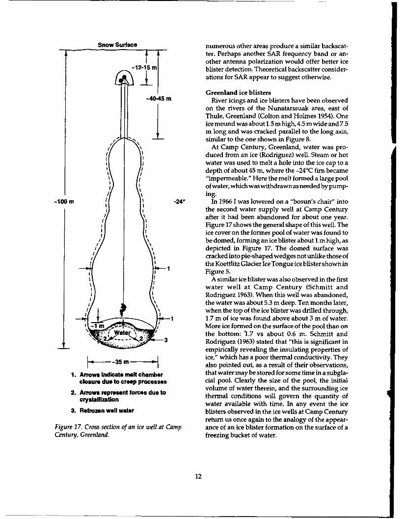
/,-,, similar to the one shown in Figure 8./ " At Camp Century, Greenland, water was pro-
duced from an ice (Rodriguez) well. Steam or hotwater was used to melt a hole into the ice cap to adepth of about 45 m, where the -24°C firn became"impermeable." Here the melt formed a large poolof water, which was withdrawn as needed by pump-ing.
-100 m .240 In 1966 1 was lowered on a "bosun's chair" intothe second water supply well at Camp Century
after it had been abandoned for about one year.I I Figure 17 shows the general shape of this well. The
II ice cover on the former pool of water was found tobe domed, forming an ice blister about I m high, asI
//
depicted in Figure 17. The domed surface wascracked into pie-shaped wedges not unlike those ofthe Koettlitz Glacier Ice Tongue ice blister shown in
S1 Figure 5.A similar ice blister was also observed in the first
water well at Camp Century (Schmitt andRodriguez 1963). When this well was abandoned,the water was about 5.3 m deep. Ten months later,when the top of the ice blister was drilled through,
1 1.7 m of ice was found above about 3 m of water./r More ice formed on the surface of the pool than on
Water the bottom: 1.7 vs about 0.6 m. Schmitt and- 3 Rodriguez (1963) stated that "this is significant in
empirically revealing the insulating properties of-35 m ice," which has a poor thermal conductivity. They--35 malso pointed out, as a result of their observations,
1. Arrows Indicate melt chamber that water may be stored for some time in a subgla-closure due to creep processes cial pool. Clearly the size of the pool, the initial
volume of water therein, and the surrounding ice2. Arrows represent forces due to thermal conditions will govern the quantity of
crystallizationl water available with time. In any event the ice
3. Refrozen well water blisters observed in the ice wells at Camp Centuryreturn us once again to the analogy of the appear-
Figure 17. Cross section of an ice well at Camp ance of an ice blister formation on the surface of aCentury, Greenland. freezing bucket of water.
12
DISCUSSION Are, F.Z. (1969) Mechanism of development anddegradation of naleds in Ulakan-Taryn Springs. In:
The solid glacial ice blisters Echelmeyer et al. (1991) Siberian Naleds (O.N. Tolstikhin and V.M. Piguzova,saw in Greenland and I observed in Antarctica prob- Eds.), p. 107-116. USA Cold Regions Research andably grew following the general theory described by Engineering Laboratory, Draft Translation 399 (un-Sumgin (1941), Liverovskiiand Morozov (1941), Lewis published).(1962), Nekrasov (1969) and others as applying to Bogomolov, N.S. and A.N. Sklyarevskaya (1969)frost mounds in general and river ice blisters, domes On exploration of hydrolaccoliths in the southernor mounds in particular. Once the runoff season part of Chilinskaya Oblast. In: Siberian Naleds (O.N.ended and the shallower surface waters froze to the Tolstikhin and V.M. Piguzova, Eds.), p. 187-191.surrounding glacial ice, water in the deeper pools USA Cold Regions Research and Engineering Labo-became fully confined byice. With time the expansive ratory, Draft Translation 399 (unpublished).forces in the confined water, associated with contin- Cailleux, A. (1962) Ice mounds on frozen lakes inued freezing, either gradually, intermittently or sud- McMurdo Sound, Antarctica. Journal of Glaciology,denly forced the ice cover upward (van Everdingen 4(31): 131-133.[1982] measuredafrostblistergrowthof0.55minone Carey, K.L. (1970) Icing occurrence, control andday). During this process the ice blisters cracked at prevention: An annotated bibliography. USA Coldtheir apexes, and secondary cracks formed until all Regions Research and Engineering Laboratory,the water in the blisters had frozen and expansive Special Report 151.uplift stopped. Since no icings existed beside the Carey, K.L. (1973) Icings developed from surfaceKoettlitz Glacier or Alaska river ice blisters visited, water and ground water. USA Cold Regions Re-none of the confined water had escaped during ice search and Engineering Laboratory, Monographuplift and fracturing. The hollow iceblisters observed III-D3.on theJakobshavn Isbrae ice field by Echelmeyer etal. Cederstrom, D.J., P.M. Johnston and S. Zublitsky(1991)had apparently drained. The general iceblister (1953) Occurrence and development of groundformation process described above is also applicable water in permafrost regions. U.S. Geological Sur-to the ice mounds observed on many Alaskan rivers, vey, Circular 275.as well as to those that developed in the subsurface Chacho, E.F., Jr., C.M. Collins, A.J. Delaney andglacial well pools at Camp Century. S.A. Arcone (1991) River icing mounds: A winter
The question may be asked: Why are ice blisters of water source on the eastern North Slope of Alaska.interest? An abundant supply of water for domestic In: Northern Hydrology: Selected Papers, Proceedingsand fire-fighting purposes is of critical importance at of the Northern Hydrology Symposium, Saskatoon,any cold regions site (Cederstrom et al. 1953, Alter Saskatchewan, Canada, (T.D. Powers and C.S.L.1969). This is a problem on the North Slope of Alaska, Ommanney, Ed.), p. 32-45.wheremostfreshwaterbodiesareshallowand freeze Colton, R.B. and C.D. Holmes (1954) Geomor-completely during the winter. Ice blister sites may, phology of the Nunatarssuak area. Final Report ontherefore, offer an expedient but limited source of the Scientific Program (Program B), Operation Icepotable water. However, our limited drill hole mea- Cap 1953. Stanford Research Institute.surements, and the more extensive ones made by Crory, F.E. (1991) Construction guidelines for oilChacho et al. (1991) on several Alaska North Slope and gas exploration in northern Alaska. USA Coldrivers, revealed that not all ice blisters form over Regions Research and Engineering Laboratory,pools of water deep enough to preclude complete CRREL Report 91-21.winter freeze-up. Indications are that, for some Alas- Echelmeyer, K., T.S. Clarke and W.D. Harrisonkan rivers, ice blisters over about 1.4 m high have a (1991) Surficial glaciology of Jakobshavns Isbrae,high probability of containing water (Chacho et al. West Greenland: Part I. Surface morphology. Jour-1991). nal of Glaciology, 37(127): 368-382.
Frederking, R.M.W. (1979) Rupture of an ice moundnear Cape Dorset, N.W.T. Canadian Geotechnical
LITERATURE CITED Journal, 16: 604-609.Kovacs, A. (1976). Grounded ice in the fast ice zone
Alter, A.J. (1969) Water supply in cold regions. along the Beaufort Sea coast of Alaska. USA ColdUSA Cold Regions Research and Engineering Labo- Regions Research and Engineering Laboratory,ratory, Monograph III-C5a. CRREL Report 79-31.
13
Leffingwell, E. DeK. (1919) The Canning River Pollard, W.H. and H.W. French (1984) The ground-region, northern Alaska. U.S. Geological Survey, water hydraulics of a seasonal frost mound, NorthProfessional Paper 109. Fork Pass, Yukon Territory. Canadian Journal ofLewis, C.R. (1962) Icing mound on Sadlerochit Earth Sciences, 21(10): 1073-1081.River, Alaska. Arctic, 15(2): 145-150. Pollard, W.H. and H.W. French (1985) The internalLiestol, 0. (1977) Pingos, springs, and permafrost structure of ice crystallography of seasonal frostin Spitsbergen. ARBOK 1975, Norsk Polarinstitutt, mounds. Journal of Glaciology, 3(108): 157-162.Oslo, Nornay, p. 7-29. Schmitt, R.P. and R. Rodriguez (1963) GlacierLiverovskii, A.V. and K.D. Morozov (1941) Con- water supply and sewage disposal systems. Sympo-struction on permafrost. USA Corps of Engineers sium on Antarctic Logistics, Boulder, Colorado, Na-Frost Effects Laboratory, ACFEL Report TL-21. tional Academy of Sciences, National ResearchMuller, S.W. (1947) Permafrost or Permanently Fro- Council, p. 329-338.zen Ground and Related Engineering Problems. Ann Sloan, C.E., C. Zenone and L.R. Mayo (1976) IcingsArbor, Michigan: J.W. Edwards, Inc. along the Trans-Alaska Pipeline route. U.S. Geo-Nekrasov, I.A. (1969) On ground interbedding in logical Survey, Professional Paper 979.ice hummocks of naleds. In: Siberian Naleds (O.N. Smith, P.S. and J.B. Mertie, Jr. (1930) Geology andTolstikhin and V.M. Piguzova, Ed.), p. 192-196. mineral resources of northwestern Alaska. U.S.USA Cold Regions Research and Engineering Labo- Geological Survey, Bulletin 815.ratory, Draft Translation 399 (unpublished). Strugov, A.S. (1955) Rupture of a hydrolaccolith.Paige, R.A. (1968) Sub-surface melt pools in the Priroda, 46(6): 117.McMurdo Ice Shelf, Antarctica. Journal of Glaciol- Sumgin, M.I. (1941) Icings and icing mounds.ogy, 7(51): 511-516. Priroda, 30(1): 26-33.Petrov, V.G.(1930)ThenaledsoftheAmur-Yakutsk Van Autenboer, T. (1962) Ice mounds and melthighway. Izdanie Akademi Nauk SSSRi Nauchno- phenomena in the Sor-Rondaine, Antarctica. Jour-Issledovatel'skogo Avtomobil'no. Dorozhanogo nal of Glaciology, 4: 349-354.Instituta. van Everdingen, R.O. (1978) Frost mounds at BearPlashchev, A.V. (1956) Rupture of an ice mound. Rock, nearFortNorman, NorthwestTerritories, 1975-Priroda, 45: 9-113. 1976. Canadian Journal of Earth Sciences, 15: 263-276.Pollard, W.H. (1988) Seasonal frost mounds. In: van Everdingen, R.O. (1982) Frost blisters of theAdvances in Periglacial Geomorphology (M.J. Clark, Bear Rock Spring area near Fort Norman, N.W.T.Ed.), p. 201-229. New York: John Wiley and Sons, Arctic, 35(2): 243-265.Ltd. Wright, C.S. and R.E. Priestley (1922). Glaciology,Pollard, W.H. (1991) Seasonal frost mounds. The British (Terra Nova) Antarctic Expedition 1910-1913.Canadian Geographer, 35(2): 214-218. London: Harrison and Sons, Ltd.
14
Form ApprovedREPORT DOCUMENTATION PAGE OMB No. 0704-0188
Public reporting burden for this collection of information is estimated to average 1 hour per response, including the time for reviewing instructions, searching existing data sources. gathering andmaintaining the data needed, and completing and reviewing the collection of information. Send comments regarding this burden estimate or any other aspect of this collection of information,including suggestion for reducing this burden, to Washington Headquarters Services, Directorate for Information Operations and Reports, 1215 Jefferson Davis Highway, Suite 1204. Arlington.VA 22202-4302, and to the Office of Management and Budget. Paperwork Reduction Project (0704-0188). Washington, DC 20503.
1. AGENCY USE ONLY (Leave blank) 2. REPORT DATE 3. REPORT TYPE AND DATES COVEREDAugust 1992
4. TITLE AND SUBTITLE 5. FUNDING NUMBERS
Glacier, River and Sea Ice Blister Observations
6. AUTHORS
Austin Kovacs
7. PERFORMING ORGANIZATION NAME(S) AND ADDRESS(ES) 8. PERFORMING ORGANIZATIONREPORT NUMBER
U.S. Army Cold Regions Research and Engineering Laboratory72 Lyme Road Special Report 92-22Hanover, New Hampshire 03755-1290
9. SPONSORING/MONITORING AGENCY NAME(S) AND ADDRESS(ES) 10. SPONSORINGIMONITORINGAGENCY REPORT NUMBER
11. SUPPLEMENTARY NOTES
12a. DISTRIBUTION/AVAILABILITY STATEMENT 12b. DISTRIBUTION CODE
Approved for public release; distribution is unlimited.
Available from NTIS, Springfield, Virginia 22161
13. ABSTRACT (Maximum 200 words)
Ice blister observations made by the author in Greenland, Alaska and Antarctica are discussed. Ice blisters up to3 m high and tens of meters long were observed on rivers and glaciers as well as on a subsurface glacial pool. Iceblisters observed by other investigators are also discussed, as is ice blister morphology (solid, hollow or water-filled), the processes associated with their formation and their potential as a resource for potable water.
14. SUBJECT TERMS 15. NUMBER OF PAGES21
Freshwater ice Ice blisters River ice 16. PRICE CODEGlacier ice Ice mounds Water supply
17. SECURITY CLASSIFICATION 18. SECURITY CLASSIFICATION 19. SECURITY CLASSIFICATION 20. LIMITATION OF ABSTRACT
OF REPORT OF THIS PAGE OF ABSTRACT
UNCLASSIFIED UNCLASSIFIED UNCLASSIFIED UL
NSN 7540-01-280-5500 *U.S GOVERNMENT PRINTING OFFCE: 1 Standard Form 298 (Rev. 2-89)Prescflbed by ANSI Sld. Z39-18296-102


![Randolph Glacier Inventory: A Dataset of Global Glacier ... · Zheltyhina. 2012, Randolph Glacier Inventory [v2.0]: A Dataset of Global Glacier Outlines. Global Land Ice Measurements](https://img.dokumen.tips/doc/110x75/5f1037d37e708231d448062a/randolph-glacier-inventory-a-dataset-of-global-glacier-zheltyhina-2012-randolph.jpg)