Embed Size (px)
Citation preview

A SIMPLEMETHOD OF DEMONSTRATINGCONVECTION AND CONDENSATION
JOHN LEIGHLYUniversity of California, Berkeley’, California
Explanations of convective movements in the atmosphere byreference to the circulation produced in a room by an artificialsource of heat were probably invented at the now remote timewhen the circulation of the atmosphere first became an appro-priate topic of discussion in heated classrooms. They have re-mained a standard constituent of the ritual of instruction, sur-viving all changes in pedagogic theory and in the technology ofheating buildings. But the conscientious teacher has always toqualify this time-hallowed comparison with a reservation im-posed by the presence of a ceiling in the room; that is, by thepresence of a mechanical barrier to vertical circulation that hasno close counterpart, in the form of a solid surface capping alayer of air, in the atmosphere. There is, however, one type ofmeteorologic situation, probably commoner than is generallyrecognized, in which there is an effective "ceiling" in the atmos-phere that checks convection: a distribution of temperature inthe vertical such that warmer air overlies colder air, the dis-tribution called, because on the average temperature decreasesupward through the atmosphere, an inversion. If the inversionlies at a height above the surface of the earth such that there isa layer of air of some thickness below it, vertical convectivemovements within the layer below it proceed almost as if thislayer were actually confined above by a solid ceiling like thatwhich limits convection in a heated room. The processes thatgo on in a layer of air below an inversion are therefore wellsuited to demonstration by means of an indoor model. As willappear from what follows, several of these processes may beclosely approximated in a model that is exceedingly simple toconstruct.
TEMPERATURE INVERSIONS AND ASSOCIATED PHENOMENA
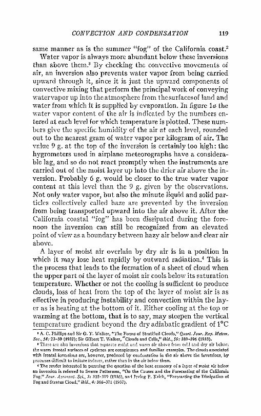
Figure la illustrates by means of a graph of temperature plot-ted against elevation the characteristic vertical distribution oftemperature in the air along the California coast in summer. Atthis season there is a persistent inversion at a height of a fewhundred meters above sea level that separates a layer of cooland moist air below from warm and dry air above. The equally
117

118SCHOOL SCIENCE AND MATHEMATICS
persistent summer "fog5^�at low elevations stratus cloud ratherthan true fog�occurs just below the inversion. It is perhapsbetter to say that the layer of cloud is formed at the top of themoist layer of air, since when it is formed in late afternoon orevening it appears first just below the inversion and becomesprogressively thicker by the extension of condensation down-ward. The daily cycles of warming and cooling, of condensationand dissipation of the cloud, and of convective movements with-in the moist layer are affected but slightly, if at all, by the warmand dry air above.
roSOO
9--)(Inversion
Cloud
Temperature15 20
Temperature, degrees C.
Fig. 1. a, results of aerologic flight at San Diego, California, Sept. 6, 1935. The full line shows thetemperature of the air up to a height of 1600 meters; the numbers beside the plotted points give thespecific humidity of the air at the several heights, to the nearest gram of water per kilogram of air.b, diagrammatic representation of the apparatus described in the text, showing the part of the apparatusin which a cloud is formed, c, probable vertical distribution of temperature in the apparatus.
This is not the only example that can be cited of an inversionthat marks off a layer of air within which the meteorologic pro-cesses proceed as if below a ceiling. The Arctic Ocean in winteris generally covered by a layer of cold air below an inversion, inwhich, again, daily changes in temperature proceed independ-ently of the warmer air above.1 In lower latitudes and at greaterheights there are inversions similar to the one illustrated in fig-ure lo, but less persistent, that may be recognized in the resultsof aerologic observations. Sometimes they can be recognized bythe observer at the ground through the presence below them ofcertain kinds of cloud, notably the kind called altocumulus.These cloud layers are formed below inversions in much the
i H. U. Sverdrup, "The North Polar Cover of Cold Air," MonUsly Weallier Review, 53: 471-472(1925).
CONVECTION AND CONDENSATION 119
same manner as is the summer "fog" of the California coast.2Water vapor is always more abundant below these inversions
than above them.3 By checking the convective movements ofair, an inversion also prevents water vapor from being carriedupward through it, since it is just the upward components ofconvective mixing that perform the principal work of conveyingwatervapor up into the atmosphere from thesurfacesof land andwater from which it is supplied by evaporation. In figure la thewater vapor content of the air is indicated by the numbers en-tered at each level for which temperature is plotted. These num-bers give the specific humidity of the air at each level, roundedout to the nearest gram of water vapor per kilogram of air. Thevalue 9 g. at the top of the inversion is certainly too high: thehygrometers used in airplane meteorographs have a considera-ble lag, and so do not react promptly when the instruments arecarried out of the moist layer up into the drier air above the in-version. Probably 6 g. would be closer to the true water vaporcontent at this level than the 9 g. given by the observations.Not only water vapor, but also the minute liquid and solid par-ticles collectively called haze are prevented by the inversionfrom being transported upward into the air above it. After theCalifornia coastal "tog" has been dissipated during the fore-noon the inversion can still be recognized from an elevatedpoint of view as a boundary between hazy air below and clear airabove.A layer of moist air overlain by dry air is in a position in
which it may lose heat rapidly by outward radiation.4 This isthe process that leads to the formation of a sheet of cloud whenthe upper part of the layer of moist air cools below its saturationtemperature. Whether or not the cooling is sufficient to produceclouds, loss of heat from the top of the layer of moist air is aseffective in producing instability and convection within the lay-er as is heating at the bottom of it. Either cooling at the top orwarming at the bottom, that is to say, may steepen the verticaltemperature gradient beyond the dry adiabatic gradient of 1°C
« A. C. Phillips and Sir G. T. Walker, "The Forms of Stratified Clouds," Quart. Jour. Roy. Meteor.Soc., 58: 23-30 (1932); Sir Gilbert T. Walker. "Clouds and Cells," ibid., 59: 389-396 (1933).
* There are also inversions that separate moist and warm air above from cold and dry air below:the warm frontal surfaces of cyclones are conspicuous and familiar examples. The clouds associatedwith frontal inversions are, however, produced by condensation in the air above the inversions, byprocesses difficult to imitate indoors, rather than in the air below them.
4 The reader interested in pursuing the question of the heat economy of a layer of moist air belowan inversion is referred to Sverre Petterssen, "On the Causes and the Forecasting of the CaliforniaFog," Jour. Aeronaut. Sci., 3: 305-309 (1936), and Irving P. Krick, "Forecasting the Dissipation ofFog and Stratus Cloud," ibid., 4:366-371 (1937).
120 SCHOOL SCIENCE AND MATHEMATICS
per hundred meters difference in elevation, and so make thelayer below the inversion unstable.5 When a layer of fog or cloudhas a humpy or billowy upper surface, the humps and billowsare generally evidence of convection within the moist layer inwhich the fog or cloud has been formed.6 The forms of altocum-ulus clouds give similar evidence of instability in the relativelythin layers of air in which they are formed. Altocumulus cloudsoccur as sheets composed of patches or puffs of cloud. The in-dividual patches and puffs show by their shape as plainly as dothe more scattered cumulus clouds produced at lower elevationsthat they are loci of ascent and convection in unstable air. Onemay make the general statement that wherever a layer of moistair is overlain by drier air rapid loss of heat at the top of themoist layer may be expected. If the bottom of the layer coolsless rapidly than the top�as in air over the sea, for example,where the air next to the water surface has a very small dailyrange of temperature�thermal convection and clouds of thecumulus type are common. Instability and convection resultingfrom cooling at the top of a layer of air are probably of as fre-quent occurrence over and near the sea as instability and con-vection resulting from heating at the bottom are over the land.
A MODEL SYSTEMA layer of moist air capped by an inversion is very nearly a
closed system so far as exchange of matter with its surroundingsis concerned, though it is free to exchange heat with its sur-roundings through conduction and radiation. These qualitiesmay be reproduced in a model constructed for purposes of dem-onstration. In the present reasoning the thermal inversion isconsidered as having a purely mechanical function, namely toserve as a barrier to movement of air upward or downward intoand out of the system. In a model intended to imitate thisnatural system the inversion may, therefore, without placingtoo great a strain on the requirement of similarity between pro-totype in nature and indoor model, be replaced by a mechanicalcover. If we are to have convection in the model system, atemperature gradient directed upward within it will have to be
s The temperature gradient below the inversion in the sounding plotted in figure lo is about the dryadiabatic gradient, possibly slightly steeper.
9 Almost any collection of cloud photographs provides examples of humpy and billowy upper sur-faces of cloud sheets. Photographs of the California coastal "fog" taken from above that show evidenceof convection within the cloud layer are reproduced in U. S. Weather Bureau, Cloud Forms Accordingto the International Sysfem of Classification (2nd ed., Washington, 1928), fig. 11, p. 12; and in AlexanderMcAdie, Clouds (Cambridge, n. d.), plates IV and V.

CONVECTION AND CONDENSATION 121
produced. This is not a difficult task, since the gradient maybe produced either by adding heat at the bottom or by remov-ing it at the top. If in addition we are to have condensation inthe upper part of the system copious enough to be easily seen,the temperature gradient will have to be steeper than is neces-sary if convection alone were aimed at. For the sake of simplicity
FIG. 2. Appearance of the apparatus described in the text. Thecamera does not catch the threads of cloudy and clear air involvedin the convective circulation inside the bubble, but records only arather uniform cloud.
of construction the temperature either at top or at bottom mayconveniently be the temperature of the air in the room. Con-densation will be most abundant if water vapor is condensed outof saturated air at a temperature higher than room temperature;convenience will then be further served if the temperature atthe top of the system, to which the enclosed air is cooled, is room

122 SCHOOL SCIENCE AND MATHEMATICS
temperature, and the temperature at the bottom considerablyhigher. The general structure of an apparatus that will fulfil theconditions of the experiment becomes evident: it will supplysaturated air at a temperature considerably higher than roomtemperature at the bottom of an enclosed cylindric or prismaticspace, and this air will be cooled to room temperature at thetop, with condensation of a part of its water vapor. The higherthe temperature of the saturated air at the bottom of the col-umn, and the cooler the air in the room, the more copious willthe condensation be.One thinks immediately of a glass jar containing hot water,
over the mouth of which a cold jar of the same diameter is in-verted. One knows just as immediately what would happen inthis combination: the inside surface of the cold jar would befogged, and further developments within the system would beconcealed from the inquiring eye. The cool upper part of thesystem should obviously be enclosed by a wall of some trans-parent material that will not fog. A material fulfilling these con-ditions is not easily found in the laboratory. But we have allbeen familiar since early childhood with certain hollow objectsmade of a transparent, non-fogging material that except for dur-ability is perfectly suited to the present purpose; namely soapbubbles. A soap film is, moreover, thinner than any practicablesolid wall, and so permits more rapid loss of heat from the coolextremity of the system than could be easily attained with or-dinary laboratory material. The following simple procedure sat-isfies all the requirements of the experiment:Put a plain glass tumbler into a pan of hot water deep enough
to submerge the glass completely, and leave it there until it hasbecome well heated. Remove it quickly, holding it mouth down-ward, and dip the open mouth into a soap solution so that a soapfilm is formed over the mouth. Insert a slender glass tube throughthe film into the interior of the glass, and blow through the tubeuntil a bubble is raised above the mouth of the glass. Removethe tube, and set the glass down. If the bubble is inflated to avolume approximately equal to that of the glass on which itrests, as in the example illustrated by figure 2, it will be filledwith a light cloud before the inflation is completed. At this stagethe cloud is homogeneous, since blowing into the bubble effectsa thorough mixing of the air in the apparatus. After the glass isset down the turbulence induced by blowing into the bubble diesout, and an active and regular convective circulation between

CONVECTION AND CONDENSATION 123
the warm interior of the glass and the cooler interior of the bub-ble is developed. Clear warm air rises into the bubble and coolerair filled with cloud droplets sinks downward from the bubbleinto the glass. As the descending air is warmed, the dropletscarried in it are evaporated. The apparatus�if so absurdly sim-ple an arrangement can be dignified with so learned a name�should be viewed in a good light against a dark background.Within it the processes are reproduced that go on in a layer ofunstable air in the atmosphere when the ascending air is cooledbelow its condensation temperature: ascent is accompanied bycondensation in the form of cloud, and descent is accompaniedby evaporation of the cloud droplets carried downward. Theglass remains warm enough to prevent fogging, the only ob-struction to vision being the drops of water that adhere to it.The liquid film composing the bubble remains perfectly clear,since water condensed on it immediately becomes part of thefilm.The whaler used should be as hot as possible. Dipping the hand
into cold water before putting it into the hot water to take outthe glass makes possible the use of hotter water than otherwisecould be endured. The mouth of the glass should be dipped intothe soap solution as quickly as possible, so that mixing of thehot saturated air inside the glass with the cooler and drier air ofthe room may be kept at a minimum. For blowing the bubble Ifind the glass tube of an ordinary medicine dropper satisfactory.The soap solutions sold for use with children^ bubble-pipesyield slightly tougher bubbles than ordinary soap. In spite ofall precautions, the film will sometimes be broken when the tubeis pushed through it. It is well to have two or three glasses inthe pan of hot water, to be taken out in regular order, so that ifa film is broken the glass can be returned to the pan and a freshhot one taken out. I find it convenient to have the pan under ahot water tap, with hot water running into it and overflowinginto the sink at a rate sufficient to keep the glasses at the highesttemperature at which they can be handled.The bubbles last from one to two minutes: since water is con-
stantly being condensed on their inside surfaces, the rapid evap-oration from their outside surfaces is compensated, and they donot break promptly as a result of evaporation. The mouth of theglass shown in figure 2 has a diameter of 2 inches; it is difficultto get a soap film to form across the mouth of a much largerglass. If the bubble lasts long enough�and it usually does�the

124 SCHOOL SCIENCE AND MATHEMATICS
cloud inside it is finally dissipated, the last of it to disappear be-ing a thin wisp drifting about the top of the bubble. The glassand the air inside it lose heat rapidly to the air in the room, sothat the temperature gradient between the air in the glass andthe air in the bubble is evened out, and the convective cirucla-tion dependent upon this gradient gradually ceases. The clouddroplets disappear by merging with the soap film or with thewater that adheres to the inside of the glass. Dissipation of thecloud in the apparatus is therefore the result of a process quitedifferent from that which causes dissipation of a fog or cloudlayer below an inversion in the atmosphere. In nature the dis-sipation is the result of warming from below until the tempera-ture of the cloud becomes high enough to evaporate the dropletsinto the air in which they float.
MODEL AND PROTOTYPE
In figure 16 the combination of glass and bubble is drawn soas to place the cloud in the bubble in a position parallel to thecloud below the inversion in the atmosphere. In c .of the samefigure the probable distribution of temperature from the bottomof the glass up into the air above the apparatus is indicated. Iam not able to draw a temperature scale for this curve, since Ihave made no measurements of temperature in the apparatus.In the early stages of the experiment the difference in tempera-ture between bottom and top must amount to forty or fiftydegrees C; so great a difference in temperature within a verticaldistance of twelve to fifteen centimeters constitutes a tempera-ture gradient much steeper than any that could develop underthe natural conditions represented in a of the figure. But whenviewed under favorable circumstances the processes that can beobserved in a cloud layer formed in unstable air resemble closelythose that can be seen in the apparatus described. In construct-ing a model it is always appropriate and convenient to exagger-ate the rate of a process at the same time as its scale is reduced.The following conditions are similar in the two systems repre-
sented in a and b of figure 1: loss of heat at the top, resulting ina steep vertical temperature gradient and active convectionwithin the system; formation of a cloud at the top of the systemas a result of cooling the air there below its saturation tempera-ture; and a barrier that prevents mixing of the air in the closedsystem with the overlying drier air. If mixing with the overlyingair occurred in either case, the temperature gradient and con-

CONVECTION AND CONDENSATION 125
vective movements would be weakened and the cloud dissipatedthrough dilution with drier air. The principal differences be-tween the two systems are these: In nature the system loses heatupward by radiation, while in the model heat is also lost by con-duction, mainly through the soap film, but also through thewalls of the glass. In the large-scale convection in nature me-chanical changes in temperature resulting from ascent and de-scent of air are superimposed on the flow of heat from theground into the layer of air below the inversion and out of thislayer by radiation. In the model, on the other hand, the smallscale of the convective movements makes such mechanicalchanges in temperature insignificant. While the mechanicalchanges in temperature determine the vertical distribution oftemperature in the air below an inversion, they would not ex-ist, and so would not affect condensation, were it not for themain flow of heat. Their absence from the model therefore doesnot detract greatly from the accuracy with which it reproducesthe mechanism of convection and condensation below an inver-sion in the atmosphere.
INTERNATIONAL CONGRESS OF MATHEMATICIANSOn invitation of the American Mathematical Society, the International
Congress of Mathematicians is to meet in Cambridge, Massachusetts,September 4-12,1940. It is hoped that this meeting will prove to be a greatscientific occasion as well as a significant factor in international under-standing and good will. The mathematicians of the United States and Can-ada sincerely hope that they will be permitted to welcome a large numberof visiting mathematicians.
Six sections are tentatively planned for the presentation of papers:(I) Algebra and Theory of Numbers; (II) Analysis; (III) Geometry andTopology; (IV) Probability, Statistics, Actuarial Science, Economics; (V)Mathematical Physics and Applied Mathematics; (VI) Logic, Philoso-phy, History, Diadactics. The International Commission on the Teachingof Mathematics proposes to have a session in connection with the Con-gress.These short papers will be preferably in one of the official languages of
the Congress (English, French, German, and Italian), and will not exceedten minutes in length.
Detailed information will be sent in due course to all members of theAmerican Mathematical Society. Others interested in receiving informa-tion may file their names in the Office of the Society, and such personswill receive from time to time information regarding the program andarrangements.
Communications should be addressed to the American MathematicalSociety, 531 West 116th Street, New York City, U.S.A.