Embed Size (px)
Citation preview

OCEANOLOGICA ACTA 1979- VOL. 2 - No 1 ~ -----~-
A near-bottom trave·rse of Roc kali Trough: hydrographie
Bottom currents Sedimentation
Bedforms Deep tow
Bottom photographs Courants profonds
Sédimentation Figures sédimentaires
Engin profond remorqué Photographies sous-marine
and geologie inferences
ABSTRACT
RÉSUMÉ
Peter Lonsdale •, Charles D. Hollister b
• Marine Physical Laboratory of the Scripps Institution of Oceanography, La Jolla, University of California, San Diego, California 92093. b Woods Hole Oceanographie Institution, Woods Hole, Massachusetts 02543.
Received 2/5/78, in revised form 11/8/78, accepted 18/8/78.
Two profiles with a deeply-towed instrument package provide a broken traverse of geologie and hydrographie data across the southern Rockall Trough. These nearbottom observations are supplemented with airgun profiles, a CTD cast, and current meter data. Symmetric sand ripples at bathyal depths on both margins, which are superimposed on a field of sand waves on the slope of Rockall Bank, are attributed to bed load transport by tidal currents. Abyssal thermohaline currents are inferred from ripples, scour crescents and other indicators on more than 2 000 stereo pairs of bottom photographs. In addition to the expected southerly currents on the western side of the trough, which is a passage for Norwegian Sea Overflow, there is evidence for fast, narrow and erosive currents of Labrador Sea Water and Northeast Atlantic Deep Water (Neadw) at the eastern boundary. The northeasterly Neadw current at the foot of the Irish Continental slope appears to be part of a cyclonic loop which brings silica-rich water into the trough, has built and is now eroding a narrow continental rise, and has transferred much terrigenous debris to the western side of the trough, for deposition along Feni Ridge. Maximum Late Pleistocene deposition on Feni Ridge has been on its northwest flank, beneath a weak reverse (northeasterly) current. On the southeastern fl.ank of Feni Ridge local alternation of slow and fast sediment deposition (probably caused by topographically induced local variations in current speed of the benthic boundary layer) has created 2 km-wavelength mud waves that migrate up the regional slope at less than 1 m/1 000 years.
Oceanol. Acta, 1979, 2, 1, 91-105.
Une traverse profonde du bassin de Rockall conclusions hydrographiques et géologiques
Deux profils réalisés au sud du bassin de Rockall au moyen d'un ensemble d'instruments traînés sur le fond, apportent une série d'enregistrements géologiques et hydrologiques. A ces observations près du fond s'ajoutent des profils sismiques (canon à air), un enregistrement CID et des mesures de courants. Des rides de sables symétriques ObServées sur les deux flancs du bassin en domaine bathyal, surimposées à un champ de dunes de sable sur la pente du banc de Rockall, sont attribuées à un charriage dû aux courants de marées. Ces rides, des traces d'érosions et d'autres indications observées sur 2 000 stéréophotographies du fond mettent en évidence la présence de courants de fond d'origine thermohaline. Un courant nord-sud, correspondant au passage de l'eau profonde de
Contribution of the Scripps Institution of Oceanography, new series. Contribution No. 4248 of the Woods Hole Oceanographie Institution.
91

P. LONSDALE. C. D. HOLLISTER
la Mer de Norvège, existe sur le côté ouest du bassin. Dans la zone orientale apparaissent des courants rapides, très localisés et érosifs, provoqués par l'eau de la mer du Labrador et de l'eau profonde de l'Atlantique Nord-Est. La masse d'eau profonde de l'Atlantique Nord-Est qui semble être une portion de la loupe cyclonique située au pied de la pente irlandaise, enrichit le bassin en silice. Elle transporte un volume important de sédiments terrigènes sur le côté ouest du bassin et a ainsi édifié la ride Feni, qu'elle érode actuellement. Le dépôt le plus tardif sur la ride Feni au cours du Pléistocène terminal, a eu lieu sur sur son flanc nord-ouest sous un faible courant inverse dirigé vers le nord-est. Sur le flanc sud-est de la ride Feni, la vitesse des courants de fond a subi des variations locales probablement induites par la topographie. Ces variations ont entraîné localement une alternance de dépôts lents et de phases rapides; cette alternance est à l'origine de la mise en place d'une série de dunes de vases d'une période de 2 km, migrant vers le haut de la pente à moins de 1 m/1 000 ans.
Oceanol. Acta, 1979, 2, 1, 91-105.
INTRODUCTION
Rockall Trough is a 250 km-wide oceanic basin whose formation, by Mesozoic sea-floor spreading, detached the microcontinent of Rockall from the continental margin of western Europe. The depression is bounded by step-faulted continental crust, and, to the north, by the Wyville-Thomson Ridge. lt has provided a settling basin for several kilometers of pelagie and terrigenous sediments, and a passage for bottom-water currents that include a branch of Norwegian Sea overflow. Several studies have examined the interaction between currents and sediments in Rockall Trough, concentrating on the source of Norwegian Sea inflow (Ellett, Roberts, 1973), the formation of moats around its seamounts (Roberts et al., 1973), and the growth of the Feni Ridge, a sinuous drift of current-deposited sediment (Johnson, Schneider, 1969; Jones et al., 1970). Two recent comprehensive papers have described the source and circulation of water masses in the trough, as deduced from their physical and chemical properties (Ellett, Martin, 1973), and its structure and sedimentation, inferred mainly from low-frequency seismic reflection profiles (Roberts, 1975).
During the summer of 1975, on Expedition Natow, we made detailed surveys at severa} sites in the northeast Atlantic, examining the rote of bottom currents in controlling abyssal sedimentation by studying small
92
areas of sea floor with a deeply-towed geophysical instrument package, arrays of near-bottom current meters, CTD-plus-nephelometer casts, and cores. Part way through these operations, a failure of the main propulsion unit ( aft cycloid) of the vessel (R/V « Knorr ») made it impossible to maneuver while towing and we were then limited to making two long, straight tows (A and B of Fig. 1) which together form a broken traverse of Rockall Trough. A nephelometer and CTD station (Knorr Station 698) was occupied at the southeast end of segment A. During a brief spell of unusually calm weather a "normal" transponder-navigated deep tow + current meter + CTD + coring station was occupied further north on Feni Ridge (Site C of Fig. 1; Flood et al., 1979). This paper describes the deep-tow traverse and the current meter results from site C.
The near-bottom geophysical instrument package used was the deep-tow "fish" of the Marine Physical Laboratory (Spiess, Mudie, 1970; Spiess, Tyce, 1973). Of its array of sensors, the most valuable on this traverse were the photographie system (a stereo-pair of vertically directed still-cameras, plus a snapshot television), the high-resolution 4-kHz profiler, and the pair of sidelooking sonars (110 kHz). Bottom photographs were taken in 36 sets of 30 to 200 frames (a "photo run") distributed throughout the transect, to yield a total of 2 050 pairs of photographs (with an additional 1 000 pairs at station C). The orientation of each frame

is calculated from the track of the towing ship, as determined by satellite navigation and Loran C: the deep-tow fish has negligible yawing motion during a straight tow, and orientations are probably good to within 10°.
The bottom photographs provide new information on the distribution, direction and approximate speed of bottom currents in the trough. Side-looking sonar records and photographs allow the mapping ofbedforms, rock outcrops, and loose rock fragments along the traverse. Our near-bottom reflection profiles have very limited penetration ( < 100 rn), but usefully complement low-frequency airgun profiles by providing high resolution of the superficial sediment layers, which should be most directly related to observable patterns of bottom circulation and sediment dispersal. Both parts A and B
Figure 1 Bathymetry of Rockal/ Trough and vicinity, after Roberts (1975) and Johnson et al. (1971). /sobaths every 200 m; throughout this paper depths are. in meters corrected for sound velocity by using Matthews Tables. "A", "B" and "C" are deep-tow sites. Location of other profiles from Ewing et al., 1974; Bailey et al., 1974 and Roberts, 1975. · Inset shows regional location, and position ofnear-bottom current meter Natow 12CM, whose results are mentioned in the text.
93
HYDROGRAPHY AND GEOLOGY OF ROCKALL TROUGH
of the traverse were along the tracks of Lamont-Doherty airgun profiles (Conrad 0913 and Vema 2305 respectively, both published in Ewing et al., 1974).
BOTTOM WATER CIRCULATION
Photographie evidence of bottom currents
The art of interpreting bottom-current regimes from sets of · oriented photographs has been codified by HeezenandHollister(1964; 1971, pp. 335-421). The most useful indicators are regular bedforms (principally sand and silt ripples) and obstacle marks (e. g., scour crescents and sediment shadows); the texture ofthe sea floor may also be resolved and provide sorne elues.
]3•
..
Jo• 9•
IJ.. .J w J:
"' "' w 0
Il: m w J:
s•w
,LAMONT-DOHERTY •••• • REFLECTION PROFILES
,..NORTH WALES AND 'OISCOVERY' ,........ REFLECTION PROFILES
P. LONSDALE. C. O. HO LLI STER
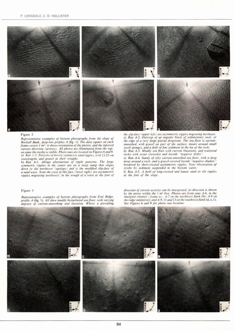
Figure 2 R epresentative examples of houom photographs from the slope of Rocka/1 Bank , deep-tow profiles A (fig. 1 ). The data square on each frame co vers 1 m 2
: it shows oriemation of the photos, and the inferred current direction (arrows) . Ali photos are illuminatedfrom the top ; on sorne the strohe is visible. Photo runs are loca1ed on Figures 6 and 9. a) Run .-1-1. Pauerns oj most/y symmetric sand ripples, witlt 12-25 cm wavelengths and grave/ in their troughs. b) Run A-l. Abrupt a/ternations of ripple palterns. The large symmetric ripples in the center are on a steep ramp thal slopes down to the northwest ( upslope) and i.1· the modified slip-face of a sand wave. Near the crest of this face ( /ower right ) are asymmelric ripples migraling north wesl ; in !he trough of a wave al !he foOI of
Figure 3
Represenlalive examples of bottom pho10graphs from Feni Ridge, profile A (fig . 1). Al/ show muddy bio1urba1ed seajioor, wilh varying degrees of curren /- smoothing and linealion. Where a prevailing
-~-
94
the slip-face ( upperleji ) are asymmelric ripples migra1ing nonheasl . c) Run A-2. Olllcrop of an angular black of sedimentary rock , or !he edge of a very large glacial drops/One. The sea jioor is currenlsmoo!hed, wilh grave/ on part of the surface, moats around small sessil sponges , and a drift of fine sedimenl in the lee of !he rock . d) Run A-3. Muddy sea jioor wilh current linealions , and scattered rocks wilh scour crescents and leeside "negcuive drif!s". e) Run A-4. Sandy of silty current-smoothed sea jfoor, with a deep moa/ around a rock , and a gravel-covered leeside "negalive shadow" hordered by short-cres!ed asymmetric ripples. Nole obscuralion of s1robe by sedimenl suspended in !he bollom water. f) Run A-5. A field of long-crested and lunale sand or silt ripples al !he fool of 1he slope.
direclion of currenl aCiivily can he in1erpre1ed, its direclion is shown by !he arrow wilhin !he 1 m2 box. Pholos are from runs A-6, in the marginal channel (./rame a): A-7 on 1he nonhwest(fank (b); A-8 on !he ridge summil (c); and A-9, Il and 13 on the sou!h wes!jiank (d , e, f ). See Figures 6 and 9 for pholo run location .

Figure 4 Representative examples of bouom photographs from the upper Irish slope, profile B (fig. 1). The data square on each frame co vers 1 m2
: it shows orientation of the photo and the in fer red current direction ( arrow) . Photo runs are located on Figures 6 and 9. a) Run B-4, on the steep scarp at the top of the slope. Rounded boulders, probably dropped from young icebergs , that are now veneered with muel. b) Run B-6. A field of straight , sharp-crested symm~:tric ripples oriented along the slope. Wavelengths range from 10 ta 40 cm, and there are concentrations of grave/ in the ripple troughs.
Figure 5 Representative examples of bottom photographs from deeper parts of deep-tow profile B (fig. 1). See Figures 6, 9 and 10 for photo run locations. a) and b) Runs B-IO and B-12. A stiff, muddy seabed, smoother by current activity but on/y slighlly ( if at al/) lineated. Abundant rimless biogenic craters are characteristic of this part of the lower s/ope . c) Run B-1 5. Smooth , muddy seajioor on the continental rise, with little indication of a prevailing current direction except near the scattered rocks, which have sma/1 lee-side drifts and gravel-covered
95
HYDROGRAPHY AND GEOLOGY OF ROCKALL TROUGH
c) Run B-7. A current-swept outcrop oj)ointed rock , veneered with pebbles and sma/1 sand patches. d) Run B-7. Pebbles and bou/ders overlying a rock jioor , with sma/1 patches of sand in the lees of sorne of the obstacles. e) Run B-8. A massive gnarled rock outcrop , surrounded by grave/. f) Run B-9. Two adjacent boulders , probably glacial dropstones, each with a gravel-jil/ed moat. Surrounding sediment is heavily tracked. Note the divergence in inferred current direction during the nearby runs B-7 to B-9 is explained by local divergence of the s/ope contours: in al/ cases the inferred current is para/le/ to the local contours (fig. 6).
"negative shadows" formee/ by winnowing. d ) ande) Run B-16, near the foot of the continental rise. Currentlineated sea floor dense/y strewn with rock fragments, which are surrounded with scour crescents and /eeside drijis. There are occasionalfields of asymmetric /ong- crested ripples (frame and, top right ) . The observee/ c/ustering of many of the pebbles into "rock nests" probably results from delivery 10 the sea j/oor of a group of stones frozen together with interstitia/ ice, which melted at depth. f) Run B-1 8, a stream/ined muddy sea jioor on the eastern margin of the sediment drift on the jioor of Rock al/ Trough. Note obscuration of strobe, indicative of high boltom-water turbidity.

P. LONSDALE. C. D. HOLLISTER
We infer "strong" bottom currents where most of the photographs in a photo run show asymmetric sand ripples (Fig. 2 j); deep scour crescents, often partially filled with coarse grave!, upstream of rocks (Fig. 2 d); and "negative shadows" downstream of obstacles, where increased turbulence creates an elongate patch of coarse lag gravet; rather than a lee drift (Fig. 2 e). Although we lack direct confirmation from Rockall Trough, we suggest that these characteristics indicate a persistent bottom current of at least 12-15 cm/sec., with maximum speeds probably greater than 20 cm/sec. For example, a current meter (Natow 12 CM) 20 rn above photographically identical terrain at the foot of Hatton Drift on the western side of Rockall Plateau (see Fig. 1, inset) recorded a very steady flow with an average velocity of 13.8 cm/sec., an average speed of 14.9 cm/sec., and a maximum speed of 22 cm/sec., during its 1 week of operation. Photographie evidence for "moderate" currents includes drifts of sediment in the lee of small obstacles (Fig. 5 c), with deep scour crescents and lee-side scour only around the largest rocks (Fig. 4 j). Where obstacles are absent, we do not find regular bedforms, but there are distinctly elongate drifts of sediment (Fig. 3 e).
Strong to moderate bottom currents are inferred at four places on the Rockall Trough traverse (Fig. 6 a and b), and in each case the currents are flowing parallel to local contours, in the following regions: at 2 000 to 2 400 rn beside the foot of the Rockall Plateau continental slope, flowing southwest; at about 2 400 rn on the southeast flank of Feni Ridge, also fl.owing southwest; at 2 600 to 2 960 rn in the angle between the foot of the Irish continental slope and the adjacent abyssal plain, flowing east-northeast; and at 1 400 to 1 600 rn beside the Irish continental slope, fl.owing south and north of east.
During photo run A-1, at 1 315-1 345 rn on the slope of Rockall Plateau, the side-looking sonars mapped a field of transverse sand waves, with a wavelength of 7-8 rn, and heights of less than 0.5 m. Crest-tines are oriented along the contours, and the pattern of echoes and acoustic shadows indicates that their steepest slopes face uphill, to the northwest. Bottom photographs at this site show a rippled sea floor of winnowed sand (Fig. 2 a and b). Many of the ripples, including those superimposed on steep slopes identified as sand waves' relict slip faces (Fig. 2 b), are symmetric. Sorne of the ripples are asymmetric, and the orientation of most of their slip faces indicates upslope migration, though there are locally divergent directions (Fig. 2 b). A similar bedform assemblage (symmetric and asymmetric ripples superimposed on asymmetric sand waves, with a net upslope bed load transport) has been described from depths of 1 600-1 700 rn on the fl.anks of Horizon Guyot (Lonsdale et al., 1972), where direct current measurements show topographically accelerated internai tides to be responsible for bedform migration. By analogy,
Figures 6 a and b Deep tracks of profiles A and B, with locations of camera runs, and inferred directions and approximate magnitudes of bottom currents. Bathymetry after Johnson et al. (1971).
96
12•30'W tz•zo'w
22
/ STRONG } BOTTOM / MOOERATE CURRENTS
#,, WEAK ~N:J~REO / ALTERNATING PHOTOGRAPHS
• DIRECTION INOETERMINATE
MERCATOR PROJECTION
10 KILOMETERS 55ozo'N / OEEP·TOW TRACK
Figure 6 a
12•1o'w tz•oo'w
MERCATOR PROJECTION
10 KILOMETERS
/ DEEP-TOW TRACK
/""PHOTO RUN
Figure 6 b
55•to'
55•oo'
54°30'
54°20'

we attribute the bedforms of photo run A-1, and symmetric sand ripples aligned parallel to the regional contours of the upper Irish continental slope (Fig. 4 b), to bed-load transport by oscillatory tidal currents.
Inferred bottom currents are weak elsewhere on the traverse, even on the Irish continental shelf, which here is unusually deep and probably therefore unaffected by the surface storm waves that are effective agents on most of this exposed shelf (Draper, 1967). On sorne frames of sorne photo runs in the trough, careful scrutiny reveals a subtle lineation of the sea floor, with srnall sediment drifts in the lee ofbiogenic bumps and obstacles, and the current direction inferred in these instances has been plotted on Figure 8: the most interesting pattern revealed is of a reverse (i. e., northeasterly) flow on the north-west flank of Feni Ridge (photo run A-7; Fig. 3 b). In almost ali photographs, even on photo runs from which no current direction can be extracted, the sea floor appears to have been smoothed by sorne form of current activity, and does not show the maze of trails and the Iitter of faecal mounds that are characteristic of the most tranquil abyssal environments. Smoothed, but non-lineated, sea floor is also characteristic of the photographs from site C, where 2 current meters moored 20 rn above the sea floor for 4 1 /2 days recorded a flow to the west-northwest with average velocities of only 3. 7 and 3.3 cm/sec. However, superimposed on this slow thermohaline flow was a strong semidiumal tidal oscillation, with the major axis of the tidal ellipse, at 210°, oriented at right angles to the net flow. The average current speeds at each meter were almost twice the average velocities, and the maximum speed, averaged over 15 minutes, was 13.5 cm/sec.
Significance of the observations
Beneath the surface waters, where the North Atlantic Current has a local anticyclonic gyre, the water masses
Figure 7 Datafrom CTD Cast 698 (see Fig. lfor location), with approximate water mass boundaries delineated. Northeast Atlantic Deep Water ( Ellett, Martin, 1973) is interpreted as a mixture of Norwegian Sea
HYDROGRAPHY AND GEOLOGY OF ROCKALL TROUGH
recognized in Rockall Trough by Ellett and Martin ( 1973) are: Gibraltar Water, at 800 to 1 200 rn, characterized by high salinity and low oxygen; Labrador Sea Water, at 1 200 to about 2 000 rn, with high oxygen (exceeding 6.0 ml/1); and the underlying Northeast Atlantic Deep Water (Neadw). Our new measurements at Station 698, in the center of our traverse, show a simi1ar stratification (Fig. 7). The deep salinity maximum near the top of the Neadw indicates a northem, Norwegian Sea, source, and recent observations have confirmed that a branch of dense Norwegian Sea Overflow leaks at high velocity (> 80 cm/sec.) across Wyville-Thomson Ridge into the northem end ofRockall Trough (Ellett, Roberts, 1973; Roberts, 1975). However, the maximum potential density (cre) measured in this leak, immediately downstream from this sill out of Faeroe Bank Channel (in which cre > 28. 0), is only 27. 85, because of dilution with overlying Atlantic Water near the sill on WyvilleThomson Ridge (Ellett, Roberts, 1973). Below 2 500 rn at station 698 potential density exceeds 27 .9. Episodic spillover of undiluted overflow water from Faeroe Bank Channel might be a possible source of this deepest stratum in Rockall Trough. However, its high silica concentration strongly suggests a southem origin, with an immediate source in the West European Basin, which receivesAntarctic Bottom Water (Aabw) that has crossed the Mid-Atlantic Ridge in equatorial regions and spread northward (Mann et al., 1973), mixing en route with the densest Neadw (which has flowed out of Faeroe Bank Channel and passed west of Rockall Plateau).
The photographie traverse helps assess the supply routes and rates for sorne of the water masses in Rockall Trough. Our observation of the effects of an intense but thin (500 rn) and narrow (10 km) current entering the trough along the foot of the Irish continental slope defines a section of the flow path of silica-rich bottom water from the West European Basin. We suggest that this current makes a cyclonic loop in Rockall Trough:
Overjiow Water that has leaked across Wyville-Thomson Ridge, and Eastern Basin Water that ultimately has an Antarctic Bottom Water source. The light scattering data from the Geosecs nephelometer is on an arbitrary scalt·.
POTENTIAL TEMPERATURE "C LIGHT SCATTERING kHz
DEPTH met ers
500
1000
1500
2000
2500
4·0 6·0 a·o 0~0·0
112·0 4q,ooo , ....... ~~!~?~.
o x +' .._ .. ... ;:• ;~p~Ê~otAEtE.R ~v ··~::f~~~:
lt 0 "- ----..a""""-.·;~ -- ~ -...... - '
HIGH SALINITY~~~f-oxYGEN---~~)~GIBRA.LTAR _ _.=_ WATER
- - - ..r·- -J'- - - -% - - -·~;.- - - - - - - ~- - -~ 1 ~· .
LOW SALINITY ~ •~\ HIGH 8 OXYGEN }.; LABRADOR SEA WATER ~• l i \ ~ \
l 1 .,.o 7.. • ;.;;:,.,:;:;- -i : ----"<~, - - ....::.r ..... :.;:,. - - - - - - - - /-MAXIMUM FROM 9 o .... ").·.·-
NORWEGIAN SEA ' 1 NORTHEAST ··:·;, •.• ATLANTIC DEEP/ ~E..!!_FL~ -~-··- - - - - -- t:...- - -- - ·::·os:: .. , ..... ,.. WATER
' HIGH SILICA. LOW OXYGEN - -o- '··.· .. Î STRATUM WITH A SOUTHERN (AA8W) SOURCÊ 0 -o ··-... __..a"'
?
35·0 35·1 35·2 10 20 30 40 5·0 6·0 SALINITY %o SILICA ~IJ alli OXYGEN ml/1
97

P. LONSDALE, C. D. HOLLISTER ·
Figure 8 The deduced pattern of deep circulation in Rockall Trough. The current direction at site C is as recorded by our meters. lnset map ( ajier Jvers, 1975; and Roberts, 1975) shows how the Rockall Trough circulation .fits into the ol"eral/ pattern of the deep Aorth Atlantic. Gray pattern denotes turhidity-current-produced deep sea jans.
the inflow hugs the southeast margin of the trough, crosses to the northwest margin in a broader, slow flow (as measured at Site C) near 56"N, and exits along the flank of Feni Ridge (Fig. 8). The exiting (southwesterly) current is augmented by slightly less dense Norwegian Sea Overflow that has leaked out of Faeroe Bank Channel and flowed south between Rockall Bank and Anton Dohrn Seamount (Roberts et al., 1973). Across our traverse, the combined outflow current is broad, and covers most of the width of Feni Ridge; however, it has a narrow high-velocity core which hugs the foot of the Rockall slope. Another axis of faster flow at about 2 400 rn depth on the southeast flank of Feni Ridge (Fig. 6 a), probably diverged from the core of the current upstream, where the crest of Feni Ridge separates from the continental margin near 55°30'N. Between the axes of the southwesterly current is a weak reverse flow (to the northeast) on the northwest flank of Feni Ridge.
We identify the strong current at 1 500-1 650 rn on the middle Irish slope with the core of the Labrador Sea Water. The high velocities indicated for this region suggest that much of this stratum may also be renewed by a narrow jet along the southeastern margin of the trough, though this contradicts the widely-held notion that Labrador Sea Water spreads so slowly that its core is a sui table "leve! of no motion" for use in geostrophic calculations (e. g., Worthington, 1976). We find no clear evidence of a current of Labrador Sea Water on the northwest margin of the trough, though the extensive reworking and moating of sediments at similar depths elsewhere on Rockall Plateau (Davies, Laughton, 1972) have also been attributed to motion in this water mass. There is significant sediment reworking and bed load transport at depths of 1 300-1 350 rn (Fig. 2 a and h),
98
but the observed effects are attributable to strong oscillatory currents that effectively mask any signal from a net flow. Similarly, on the upper Irish slope there are symmetric ripples at the depth of Gibraltar Water, and effects of the current that supplies this water mass cannot be distinguished. Symmetric ripples have also been photographed near the top of the continental slope offBrittany (Heezen et al., 1959, Plate 11).
Our interpretation of the bottom circulation should be compared with those based on geostrophic calculations. Ellett and Martin (1973, p. 616) constructed a geostrophic velocity section across the central Rockall Trough, but chose 1 800 rn as the leve! of no motion, because they had "no evidence of a strong circulation which could impart movement to lower layers", and therefore derived negligible current velocities deeper than 1 500 rn (the depth of the shallowest "strong current" inferred in Figure 6 b). Ivers (1975) selected a "leve!'' of no motion which varied in depth across the section ("Discovery II", Stations 3 823-3 833), and obtained a cyclonic circulation below 1 500 rn, with a northeasterly current flowing faster than 5 cm/sec. along the Irish continental slope, and a southwesterly flow, at approximately the same velocity, on the western si de of the trough. Our data support lver's analysis of the Neadw circulation pattern, which he interpreted as a localloop of a general North Atlantic cyclonic bottom circulation.
lnferring bottom currents from density distributions or from snapshots of the sea floor is a poor substitute for measuring them with current meters. Perhaps the most significant result of our photographie traverse was the discovery of the effects of fast boundary currents that seem amena ble to study with even short -term current meter deployments, but which are so narrow (10-20 km, Fig. 6 a and b) that accurate geostrophic analysis would be difficult, even if closely-spaced casts were available. Sorne of these fast bottom currents occur in water masses and at eastern boundary situations where conventional wisdom suggests that thermohaline motions should be slow: the same is true for bottom currents at the eastern boundary of the Iceland Basin, where a steady flow with an average velocity of 14 cm/sec. has been measured (Hollister et al., 1976).
GEOLOGY OF THE MARGINS
Rockall Slope
Deep-tow traverse "A" (Fig. 1) included a profile down the lower half of the southeast flank of Rockall Bank, from a depth of 1 200 rn to the "marginal channel" (Roberts, 1975) as its foot. Although this part of the slope has a gentle gradient (average 2. 5°) and lacks evidence of the slumping that has denuded the slope further north (Roberts, 1972), its co ver of unconsolidated sediment is very sparse. Between depths of 1 300 and 1 400 rn there are patches of sediment which show up as thin ( < 10 rn) lenses of acoustically transparent material on the near-bottom 4-kHz profile and have rippled, winnowed sand at the surface (e. g., Fig. 2 a
HYDROGRAPHY AND GEOLOGY OF ROCKALL TROUGH
CTD 6 8
Figure 9
PROFILE A
•• 10
•• 10
25 KM V. E.•I5X
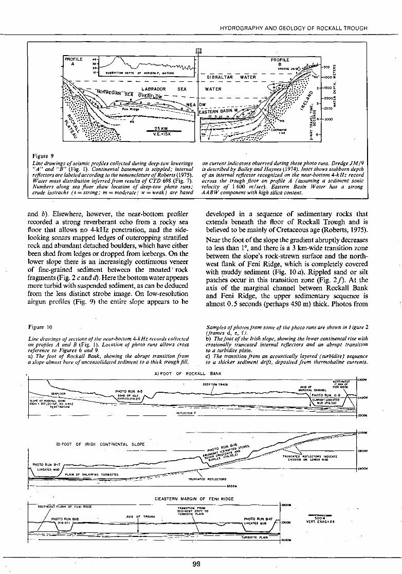
Line drawings of seismic profiles collected during deep-tow lowerings "A" and "B" (Fig. 1). Continental basement is stipp/ed; internai rejlectors are labeled according to the nomenclature of Roberts ( 1975). Water mass distribution inferred from results of CTD 698 (Fig. 7). Numbers along sea floor show location of deep-tow photo runs; cru de isotrachs ( s = strong; m = modera te; w = weak) are based
and b). Elsewhere, however, the near-bottom profiler recorded a strong reverberant echo from a rocky sea fl.oor that allows no 4-kHz penetration, and the sidelooking sonars mapped ledges of outcropping stratified rock and abundant detached boulders, which have either been shed from ledges or dropped from icebergs. On the lower slope there is an increasingly continuous veneer of fine-grained sediment between the moated ··rock fragments (Fig. 2 c and d). Here the bottom water appears more turbid with suspended sediment, as can be deduced from the less distinct strobe image. On low-resolution airgun profiles (Fig. 9) the entire slope appears to be
Figure 10
Line drawings oj sections oj the near-bouom 4-kHz records collected on profiles A and B (Fig. 1). Location oj photo runs allows cross reference to Figures 6 and 9. a) The foot of Rockall Bank, showing the abrupt transition from a slope a/most bare ofunconsolidated sediment to a thick troughfill.
Gl BRALTAR WATER
WATER
500 ffi ... ...
IOOO:E
% 2 1500 ~
Q
2000~ !;;
2500.
3000
on current indicators observed during these photo runs. Dredge J M /9 is described by Bailey and Haynes (1974). lnset shows stubborn depth of an interna/ rejlector recognized on the near-bottom 4-kHz record across the trough .floor on profile A ( assuming a sediment sonic velocity of 1 600 misee). Eastern Basin Water has a strong AABW component with high si/ica content.
developed in a sequence of sedimentary rocks that extends beneath the fl.oor of Rockall Trough and is believed to be mainly ofCretaceous age (Roberts, 1975).
Near the foot of the slope the gradient abruptly decreases to less than 1°, and there is a 3 km-wide transition zone between the slope's rock-strewn surface and the northwest flank of Feni Ridge, which is completely covered with muddy sediment (Fig. 10 a). Rippled sand or silt patches occur in this transition zone (Fig. 2j). At the axis of the marginal channel between Rockall Bank and Feni Ridge, the upper sedimentary sequence is almost 0 .. 5 seconds (perhaps 450 rn) thick. Photos from
Samples ofphotosjrom sorne oj the photo runs are shown in ligure 2 (frames d, e, f). b) The foot of the Irish slope, showing the lower continental rise with erosionally truncated internai rejlectors and an abrupt transition to a turbidite plain. c) The transition from an acoustically layered ( turbidite) sequence to a thicker sediment drift, deposited from thermohaline currents.
Al FOOT OF ROCKALL BANK
t-----~------------------------------------------------------------------------------------------wNO~RTruHw~E~ST.-~;~ AXIS OF FEN/ RIDGE
DEEP/TOW TRACK FLANK OF
1--PHOTO RUN A-5 MARGINAL CHANNEL \-SEAFLOOR - -" - ' 1
- SAND OR SILT _'\..\l_P~CHURO~ONTRLUINNEATAE-06} \ Z400M SLOPE OF ROCKALL BANK RIPPLES IFIG.2F) "~
lH:IG:HL~Y~R~EF~LE~CT:IV:E·:·:·:·~KH:Z----~~:::=:::::::::::=::::::::~~~~~~~~==~========~============~~~MU~D~(F~I~~3~Al~~~i PENETRATION
REFLECTOR F
BI FOOT OF IRISH CONTINENTAL SLOPE
ClEASTERN MARGIN OF FENI RIDGE
t-~s~ozu~rH~<~•s~r•F~c•~•~•~o,~,.~.~,~.,~ .. ~.--------------~------------,-.-.. -5,-11-0•--,•-0-M----------------------~z~M SEDIMENT DRIFT TO TURBI DIT; PLAt N PHOTO RUN 818 AXIS l' TROUGH \ PHOTO RUN 8-17 j:"
t--~---... \ (FtG.Hjr-----....---o====-!f==--..;.;....;:o=-..===lo;\--.=oç::; LINEATED MUD J 2900M
------~--------------~T~UR~B~IO_ITE~PL~A~IN--~~~
99
500M VERT. EXAG.• X4
ZOODM

P. LO NSDALE. C. D. HOLLI STE R
the axis (photo run A-6) indicate a smoothly streamlined sea floor being swept by a muddy southwesterly bottom current.
Irish continental margin
The deep-tow instrument was lowered to within 50 rn of the sea floor on the outer continental shelf, and towed about 10 km to the deep (495 rn) shelf break. The track down the continental margin (Fig. 6 b) lay between two large slope canyons across the narrow (10 km wide) continental rise, and onto the abyssal plain (Fig. 9).
This part of the outer shelf, remote from the main dispersal routes of terrigenous sediment (Ken yon, Stride, 1970), has but a thin cover of Neogene sediments unconformably overlying an older, mainly Mesozoic lens up to 500 rn thick, and Paleozoic basement (Fig. Il ; Bailey et al.. 1974). Sonar records and bottom photographs indicate a smooth sandy bottom, without the spectacular sand waves and ribbons characteristic of more currentswept parts of the West European Shelf (e. g., Kenyon, Strike, 1970). Near the shelf edge (photo run B-3), the seabed is strewn with ill-sorted, angular rock fragments and rounded cobbles up to 1 rn diameters. These are probably proximal glacio-marine deposits (Vanney, Dangeard, 1975), left by the Pleistocene Irish ice sheet which extended across the entire shelf.
The continental slope has an average inclination of 4°, and its upper half has a very thin and patchy veneer of unconsolidated sediments. Immediately below the shelf break is a 200 m-high scarp whose 12° slope trun-
Figure Il A section of near-bottom 4-kHz data from mud waves on the southeast flank of Feni Ridge, located between photo runs A-Il and A-12 of Figures 6 and 9. The top trace, which shows internai stratification most clearly, is a record oj the sea jfoor and subborrom layer rhar is uncorrecred for variable depth of the instrument package; Z is the altitude of the instrument abo ve the seafloor. The middle trace shows the path of the deep-tow instrument ; its vertical excursion , bringing ir cl oser ro the sea floor than usual, were made in a l'ain search fo r
cates the entire section of flat-lying shelf strata, the underlying unconformity, and the upper part of the older, westward-dipping sedimentary prism. Ledges of consolidated rock crop out on this scarp, and most of the photographs (photo run B-4) show abundant boulders and cobbles (e. g. , Fig. 4 a). Dredging of the scarp (Bailey, Haynes, 1974, Dredge JM / 9) has yielded lithified calcarenite with reworked Upper Eocene microfossils (Dobson et al., 1976), partly justifying the correlation, based on continuity of acoustic stratigraphy, between the shelf-edge unconformity ("R4" of Figure 9) and the deep-water basal Oligocene unconforrnity of Rockall Trough and Plateau (responsible for Reflector R 4; (Roberts, 1975).
Truncation of strata on this rather gentle scarp seems to have been by current erosion, rather than by postdepositional faulting or slumping, for which we have no evidence on the near-bottom 4-kHz profile. We suspect that thermohaline currents associated with bottom water formation during glacial periods were responsible for the erosional trimming of the sedimentary prism, and that the fields of worn cobbles (Fig. 4 a) are glaciomarine !ag deposits, like those photographed at similar depths near present Antarctic ice fronts (Dangeard, Vanney, 1975). A light dusting of fine-grained sediment on the cobbles at the top of the Irish slope indicates that this lag deposit is relict, and is not being maintained by the present current regime. In the Climap reconstruction of the North Atlantic circulation at the last glacial maximum, 18 000 BP, this part of the margin, where relatively saline surface waters at the margins of the
sma/1-scale bedjorms. The lower trace shows Thal "true shape" of the sea floor and internai reflectors, with a vertical exaggeration of about 4X. Note variable thickness of the stratum overly ing Reflector F; the numbers are estimates of post-F sedimentation rates, assuming a sediment sonic velocity of 1 600 rn / sec, and a 660 000 BP date for the rejfector. The sk etches illustrate models of sediment deposition over (a) a flat seajfoor sloping at right angles to the current direction and (b) a sea floor with regular mud waves corrugations superimposed on the regional transverse s/ope.
100

subtropical gyre came in contact with the ice shelves, is considered the likeliest glacial North Atlantic equivalent of the present Weddell Sea (Mclntyre et al., 1976, p. 71). Fast(> 25 cm/sec.) bottom currents at the Weddell Sea shelf-break have been measured by Foldvik and Kvinge (1974), and their geological effectiveness is attested by the scour and Iag deposits there. The deepest erosional incision, a notch through the entire sedimentary sequence to the Paleozoic (?) continental basement occurs between 1 300 and 1 500 rn on the middle part of the slope (Fig. 9). The sides of the notch have been terraced by differentiai erosion, with resistant ledges occurring at the outcrop of the principal internai ref!ectors. Photographs of jointed and massive rock outcrops, and grave! and boulder pavements (photo runs B-7 and B-8; Fig. 4 c, d and e) show that current erosion, or at !east nondeposition, is presently active, with a high-velocity jet of low-turbidity Labrador Sea Wateras the agent. Surroundingbathymetry (Fig. 6b) is good enough to confirm that the erosional notch in the slope is not a tributary of a submarine canyon, eut primarily by turbidity currents; besides, significant though less intense scour occurs beyond the notch (e. g., photo run B-9, Fig. 4 f).
Deeper than about 1 700 rn on the slope the nearbottom 4-kHz profiler resolved a continuous layer of unconsolidated sediment overlying Reflector R4. Superficial rock fragments are absent from side-looking sonar records or on photographs from runs B-10 to B-14, implying that any glacial dropstones have been buried by postglacial sediment accumulation. The seabed is smooth and pockmarked with rimless biogenic crates (Fig. 5 a and b). The post-R 4 stratum thickens downslope, gradually at first, and then abruptly to about 400 rn at a water depth of 2 100 rn (Fig. 9), close to the leve! of transition from clear Labrador Sea Water to turbid Neadw at CTD 698. We consider this youngest sediment prism, extending from a depth of 2 100 to 2 950 rn, as a miniature continental rise, though its regional gradient is about 4°, the same as on the rest of the continental slope. The surface of the rise, especially in its convex upper part, is hummocky, with broad along-slope corrugations, up to 30 rn high and 2 km across, superimposed on the regional slope.
The deepest part of the continental rise, especially below 2 700 rn, is a site of recent, and probably continuing, erosion. Internai reflectors of the rise are truncated by the sea floor (Fig. 10 b), which is littered by a relict deposit of ice-rafted grave! and cobbles similar to that presently accumulating on Antarctic continental rises (Heezen, Hollister, 1971; Dangeard, Vanney, 1975), and has patches of winnowed, rippled sand (Fig. 5 d and e). The image of the strobe is slightly blurred in photographs from photo run 16 (e. g., Fig. 5 d), indicating that the bottom water is somewhat more turbid than on shallower parts of the continental slope and rise. At the foot of the rise there is an abrupt stratigraphie transition to acoustically laminated, flat-lying strata (Fig. 10 b ), and the lag deposit of superficial rock fragments, mapped by side-looking sonars, ends abruptly at the margin of this plain. The streamlined microtopography of the muddy abyssal plain (e. g., Fig. 5 f) demonstrates that
101
HYDROGRAPHY AND GEOLOGY OF ROCKALL TROUGH
the fast bottom current extends onto the plain, but that there it is depositional rather than erosional. The indistinctness of the strobe image (Fig. 5 f) shows that bottom water turbidity is much greater than on the rise.
Discussion
Existing descriptions of sedimentation on the margins of Rockall Trough rely main! y on low-resolution seismic profiles (e. g., Bailey et al., 1974; Roberts, 1975). The near-bottom acoustic and photographie records enhance these studies, not merely by allowing description of finer detail (e. g., of ri pp le and sand wave distribution), but by resolving the structure of the most recent sediments, those that are being deposited or eroded because of existing (and measurable) environmental conditions. It is often misleading to relate structures mapped by seismic profilers to patterns of bottom water currents and turbidity determined by oceanographie measurements, because the low-resolution profiler displays only the integrated results of millions of years of deposition and erosion (see discussion by Worthington and Wright, 1971). For example, seismic reflection profiles show the scarp eroded at the top of the Irish slope (Bailey et al., 1974), and a narrow continental rise deposited along part of the margin of Porcupine Bank and lreland (Roberts, 1975), but near-bottom data are needed to show that these features are not related to the present dynamic regime: the recent (probably postglacial) histocy is of deposition on the scarp (Fig. 4 a), and erosion on the rise (Fig.' 10 b). In contrast, erosion of the middle Irish slope inferred from airgun records (Fig. 9) could have been attributed to turbidity current · excavation of a now-extinct canyon, except that the near-bottom data shows that continuing erosion by a thermohaline current is a better explanation.
Further examples of sites where airgun records indicate sea-f!oor erosion but the higher-resolution deep-tow profiles show recent rapid deposition occur on the fioor of the trough, and are discussed below. Of course, Rockall Trough is a particularly bad place for relating large-scale geologie structures to existing hydrography, because the latter has prevailed for only a short (postglacial) time. For most of the past million years the trough was bordered with ice-sheets, which delivered large volumes ofterrigenous debris and certain! y modified the deep circulation, if only by preventing Norwegian Sea overf!ow (Streeter, 1973; Alvinerie et al., 1978). The narrow continental rise at the foot of the Irish slope may have been almost entirely built during the Pleistocene, by deposition from a boundary current which swept northeastward into the trough as it does today (Fig. 6 b ), but was much more turbid because of the glut of terrigenous input during glacials. Recent erosion like that on the Irish continental rise is a common feature of continental rises and sediment drifts in the western North Atlantic that experienced very rapid deposition during most of the Pleistocene (e. g., Hollister et al., 1974; Johnson, Lonsdale, 1976), and a postglacial decrease in bottom water turbidity (rather than an increase in current speed) may be a general explanation.

P. LONSDALE, C. D. HOLLISTER
SEDIMENTATION ON THE FLOOR OF ROCKALL TROUGH
The turbidite plain
The eastern half of the central Rockall Trough is dominated by gently sloping turbidite fans and their distal plains. Their principal sediment sources have been the Irish and Hebridean continental margins (Roberts, 1975), though in the Pleistocene sorne sediment was transferred there by debris flows which moved down the southeast slope of Rockall Bank and across the northem Feni Ridge (Flood et al., 1978). In the southem part of the trough, where direct terrigenous influx from the margin bas been limited, turbidites are less extensive. Lowfrequency seismic profiles at the site of our deep-tow profile "B" (Fig. 1) have been interpreted as showing a 100 km-wide turbidite plain, incised by "small channels" (Roberts, 1975). Our high-resolution deep-tow profile showed that the modem plain, with flat-lying acoustically laminated surface sediments, is much narrower, and our track crossed no turbidite channels. Only 2.6 km from the foot of the Irish continental ri se (Fig. 10 c) there is an abrupt transition from horizontal, layered sediments, interpreted as turbidites, to a thicker, acoustically more transparent section. The latter thickens upslope, to the northwest, and appears identical to the drifts of sediment deposited by southwesterly thermohaline currents in the western half of the trough.
Airgun profiles and the near-bottom 4-kHz profile together show that any turbidite strata in this region are thin, and that coeval sediment drifts are thicker. We deduce that a large fraction of the sediment Joad of turbidity currents that reached this part of the trough floor has been pirated by thermohaline currents and transferred by the cyclonic loop of the bottom water circulation (Fig. 8) to the western half of the trough, where it built Feni Ridge. Alternatively sorne of the quartz-rich material recovered in cores on the Feni Ridge may have come from the eastern portion of the Wyville-Thomson Ridge during interglacial periods (Latouche, Parra, 1976).
Feni Ridge
Deep-tow profile A (Fig. 1) included a complete traverse of Feni Ridge sediment drift, from the marginal channel at the foot of Rockall Plateau to the depression between Feni Ridge and the smaller, secondary ridge on its southeast flank (Jones et al., 1970, Profile J). At this crossing the crest of Feni Ridge is 30 km from the foot of Rockall Plateau, having diverged from the margin about 100 km upstream. Maximum sediment thickness of this part of Feni Ridge, above the almost flat-lying Reflector R4, is 0. 9 seconds, or about 800 m.
The near-bottom 4-kHz profiler recorded a distinctive acoustic stratigraphy across the en tire ridge, with 4-5 continuous and closely-spaced reflectors in the upper 10-20 rn, a fairly transparent stratum, and a strong reflector (designated ''F'') at a subbottom depth of 20-50 m. Sorne of these reflections are probably caused
102
by zones rich in coarse-grained volcanic ash: core RC9-225, taken on the profile at the position of photo run A-7 (Fig. 9), has two such ash zones in its upper 10 rn (Ruddiman, Mclntyre, 1976). Reflector F is at a depth of 48 rn at the site of this core, which had an average accumulation rate of 7. 3 cm/ 1 000 years for the past 127 000 years (Ruddiman, Mclntyre, 1976): by extrapolation, the age of Reflector F is about 660 000 BP, and, if it is a synchronous horizon, the variation in its subbottom depth across the ridge (Fig. 9 inset) records spatial variations in sediment accumulation since that time. As expected, the post-F stratum thins towards the margins of the ridge, but there is also a local minimum within 5 km of its crest. The maximum post-F accumulation is on the northwest flank of the ridge, where truncation of reflectors in the upper part of the post-R4 sequence records an earlier episode of erosion. High Pleistocene sedimentation rates at the sites of Core RC9-225 and the nearby V 23-81, which are near the post-F depocenter, were caused by rapid deposition during the glacials of fine-grained terrigenous debris, that was delivered not by icebergs but by bottom currents (Ruddiman, Mclntyre, 1976). The spatial variation in Late Pleistocene accumulation rates on the Feni Ridge transect is therefore mainly attributable to differentiai deposition from muddy glacial bottom currents, with preferential deposition on the northwest flank because the currents were decelerated there. Further north where no marginal channel separates the summit ofF eni Ridge from the foot ofRockall Bank, the pattern of Pleistocene deposition from thermohaline currents bas been disrupted over a wide arca of the ridge (e. g., at Site C of Figure 1; Flood et al., 1979) by erosive debris flows spawned from slumps on the slopes of the bank (Roberts, 1972).
On the lower southwest flank of the ridge there is a spatial periodicity in the thickness of the post-F stratum, associated with the presence of Iarge-scale bedforms. These are regular symmetric mud waves, subparallel to the regional contours and to the current, which have an average wavelength of 2 km, and amplitudes of up to 30 m. The marked local variation in accumulation rates is not between ridges and troughs of the waves (which would cause a change in amplitude), but between slopes of different aspect, which causes the waves to migrate. Accumulation rates on northwest-facing slopes, inferred from the thickness of the post-F stratum, are as muchas 70% grea ter than on slopes that face southeast (Fig. 11), and as a result the waves have migrated slowly northwest, up the regional slope of Feni Ridge and across the prevailing current, at an average rate of 0. 25 ml 1 000 years. Fields of similar mud waves are characteristic of many sediment drifts at the margins of North Atlantic basins, where shaping of rapidly deposited terrigenous sediment by thermohaline boundary currents is known or suspected (e. g., Fox et al., 1968; Rona, 1969; Johnson, Schneider, 1969; Jones et al., 1970; Markl et al., 1970; Ruddiman, 1972; Jacobi et al., 1975; Embley, Langseth, 1977), and upslope migration of the waves is typical. Undulation of subbottom reflectors on airgun records indicates that mud waves have been present throughout the deposition of the upper 0. 5 seconds of sediment, and

were probably initiated in the Late Miocene (Roberts, 1975).
Speculations on the dynamics of sedimentation from thermohaline currents
The striking local and regular variations in sediment accumulation rates on the mud waves of Feni Ridge, with parallel bands Jess than 1 km apart whose accumulation rates differ by 70%, could be explained by regular cross-stream variations in either the turbidity or the current speed of the benthic boundary layer. Cross-stream alternation of fast and slow currents, which is required in the explanation of other types of longitudinal abyssal bedforms (Lonsdale, Spiess, 1977) is the more plausible. Density or pressure surfaces in deep currents flowing over inclined plane beds tend to paralle1 the regional slope of the sea floor (Amos et al., 1971; Stommel, Aarons, 1972). However, where the bottom is regularly corrugated, with large-scale waves whose long crests are parallel to the flow, isopycnals near the bottom tend to conform to the actual topography (Stommel, Aarons, 1972, p. 715). As a result, horizontal pressure gradients in the near-bottom water are locally intensified over parts of the wave that face southeast, down the regional si ope (Fig. 11): this causes faster cutrents there, greater shear stress on the bed, and impeded deposition. ln contrast, immediately above the upslope faces of the waves, where the 2. 5° local slope is opposed to the 1 o regional gradient, horizontal pressure gradients are reduced, and there is relatively slack water which favors deposition. According to this theory a stable configuration is attained, with regular corrugations in the bed being maintained by regular threads of fast and slow flow (presumably connected by a secondary circulation which feeds turbid water from fast to slow bands) that are caused by the regular bedforms. To test it we need new observational data, in the form of measurements by current meters precise! y positioned onto the different slopes of an active mud wave.
The dynamics of current flow and sediment deposition on Feni Ridge, in the section where the crest is detached from Rockall Slope, mimic on a giant scale those deduced for individual mud waves on its surface. The southeast side of the ridge is swept by a moderately fast southwesterly current that delivers fine-grained terrigenous · sediment in suspension, but which impedes deposition. Deposition is concentrated on the northwest side where. because the slope of the topography is opposite to that of isobars in a deep southwesterly current, the current is decelerated, and even reversed (at photo run A-7, Fig. 6 a), just as on Blake-Bahama Outer Ridge (Heezen et al., 1966; Amos et al., 1971). The mere presence of slack water over the northeast slope is not enough to account for the preferential deposition there: what is important, just as in differentiai deposition on the mud waves, is that a band of slack water is sandwiched between fast currents that can provide a èontinuous supply by turbid water by cross-flow secondary circulation. The northwest slopes of Feni Ridge, and of its
103
HYDROGRAPHY AND GEOLOGY OF ROCKALL TROUGH
mud waves, are zones of bottom water deceleration, and experiments with dilute suspensions of fine cohesive sediments in turbulent ftows (e. g., Partheniades et al., 1968) have shown that rapid deposition is an immediate consequence of deceleration. Differentiai deposition on Feni Ridge has not resulted in simple northwest migration of its crest during the Late Pleistocene, as it has on individual mud waves, because of limited deposition near the summit (Fig. 9, inset). Less deposition may occur . on the shallowest parts of the ridge because they are above the most turbid bottom water (Fig. 7), though the nepheloid layer tends to maintain a constant thickness rather than a constant upper limit (Jones et al., 1970).
The present shape of Feni Ridge tends to control the pattern of Neadw flow over it. Its shape, particularly the separation of its crest from the si ope of Roc kali Bank, has probably been controlled by the interaction ofNeadw with the overlying Labrador Sea Water. The divergence of the crest from the slope occurs close to the intersection of the muddy southwesterly Neadw current with a clear easterly Labrador Sea Water current that has been channeled between Rockall Bank and Lorien Bank (where its geological effects have been described by Roberts, 1975). Bryan (1970) explains the origin of the Blake-Bahama Outer Ridge with a simple hydrodynamic model of deposition at the convergence of a muddy Western Boundary Undercurrent with the shallower, clearer Florida Current, and his mode! seems directly applicable to Feni Ridge. However, the explanation is not complete, since the Neogene histories of both the Blake-Bahama Outer Ridge and Feni Ridge have been complex, and they have also been shaped by erosion (on the northwest flank ofFeni Ridge; on both flanks of the Blake-Bahama Outer Ridge, Ewing, Hollister, 1972). Sedimentation on Feni Ridge has doubtless been affected by changes in the bottom water circulation that resulted from changing geography and climate. Temporal variations in speed and turbidity of the cyclonic loop that brings Neadw from potential sources of suspended sediment along the West European Margin have probably been more important than changes in the intensity of Norwegian Sea Overflow. The latter current may have been initiated only at the end of the Miocene, following subsidence of the Iceland-Faeroe Ridge (Schrader et al., 1976), and was not active during most of the Late Pleistocene, when the Norwegian Sea was ice-covered (Streeter, 1973; Kellogg, 1976): despite this, Late Pleistocene sediment accumulation rates on the ridge ofup to 12 cm/1 000 years (at Core V 23-81; Ruddiman, Mclntyre, 1976) were much greater than the post-R 4 average rate (Roberts, 1975).
SUMMARY OF CONCLUSIONS
The most important bottom current in Rockall Trough, both hydrographically and as a geological agent, is a cyclonic loop of Northeast Atlantic Deep Water (induding a basal silica-rich stratum that ultimately has an Antarctic source) that enters along the northwest margin of Porcupine Bank and exits as a southwesterly current

P. LONSDALE, C. D. HOLLISTER
along Feni Ridge and the lower slopes of Rockall Bank. The southwesterly flow is reinforced by a leak of overflow water from the Norwegian Sea. Although the Northeast Atlantic Deep Water is commonly regarded as a fairly stagnant water mass in this part of the ocean, on both western and eastern margins of the trough it is fast enough to cause erosion and bed load transport of sand, though on the eastern boundary these effects are restricted to a very narrow band at the foot of the slope. Labrador Sea Water, generally assumed to spread throughout the North Atlantic as a slow drift, also forms a fast erosive current on the Irish slope. At slightly shallower depths oscillatory tidal currents shape sand into small ripples and larger waves.
The Irish continental slope near 54°N and the southeast slope of Rockall Bank near 55~ both have only a thin and discontinuous cover of unconsolidated Tertiary sediment, not because it has slumped off them, but because of limited supply of terrigenous debris and current scour. Erosional truncation of a shallow-water lens of Tertiary sediment at the top of the Irish slope probably occurred at periods during the Pleistocene when bottom water was produced near a local ice front. Typically stony proximal glacio-marine deposits here are now being slowly buried with fine-grained sediment. Superficial glacial dropstones are common in Rockall Trough wherever postglacial deposition has been restricted by current activity. They are exposed as a lag deposit on the lower slopes of a narrow Irish continental rise, which was probably constructed by the inflow current of the Neadw loop during the Pleistocene, when it had a high suspended load of terrigenous glacial flour.
Most of the post-Eocene sediment in Rockall Trough, including a large fraction of that originally delivered by turbidity currents, has been entrained by cyclonic bottom circulation and deposited on the western side of the trough in sediment drifts, of which the largest is Feni Ridge. Norwegian Sea Overflow currents have had a minor role in transporting sediment and shaping the ridge. During the Late Pleistocene, sedimentation rates on Feni Ridge were high ( > 3 cm/yr), especially on the north west slope ( > 7 cm/yr), where there is now a slow reverse (northeasterly) current. On the southeast flank of the ridge sediment accumulation was also highest on local slopes inclined to the northwest, namely the upslope faces of large-scale longitudinal mud waves. As a result the mudwaves migrated upslope, across the current, at about . 25 ml 1 000 years. The 70% difference in accumulation rates on the different faces of a single mud wave are thought to be caused by topographically induced alternations of fast and slow currents in the benthic boundary layer, and this process may account for the maintenance and migration of similar abyssal mud waves on currentswept sediment drifts at the margins of other ocean basins.
Acknowledgments
Most of the data used in this report was collected on R/V ''Knorr'"s Expedition 51, and we wish to thank the master (E. Hiller), officers and crew, and scientific
party for contributing to the success of the work at sea. The deep-tow instrument was cared for by D. E. Boegeman and M. Benson, and J. Donovan and J. Rogers took most of the photographs. W. Gardner was responsible for processing the CID data. The manuscript was reviewed by R. Flood and D. A. Johnson.
Funding was from NSF grants DES 74-03690, DES 74-20396 and OCE 76-21592 and ONR contracts N00014-75-C-0704 and N00014-75-C-0749 to the Marine Physical Laboratory; and ONR Contract N00014-74-C-0262 NR 083-004 to Hollister.
REFERENCES
Alvincrie J., Caralp M., Latouche C., Moyes J., Vigneaux M., 1978. Apport à la Connaissance de la paléohydrologie de l'Atlantique Nord-Oriental pendant le Quaternaire terminal, Oceanol. Acta. 1, 1, 87-98. Amos A. F., Gordon A. L., Schneider F. D., 1971. Water masses and circulation patterns in the region of the Blake-Bahama Outer Ridge, Deep-Sea Res., IS, 145-165. Bailey R. J., Crzywacz J. M., Buckley J. S., 1974. Sei smic reflection profiles of the continental margin bordering the Rockall Trough, J. Geol. Soc., London, 130, 55-70.
Bailey R. J., Haynes J. R., 1974. New dredge samples from the continental margin bordering Rockall Trough, Mar. Geol., 16, M 57-M 62. Bryan G. M., 1970. Hydrodynamic mode) of the Blake Outer Ridge, J. Geophys. Res., 75, 4530-4537.
Dangeard L., Vanncy J. R., 1975. Essai de classification des dépôts glacio-marins d'après l'examen des photographies sous-marines, Ann. lnst. Oceanogr., Paris, 51, 143-153. Davies T. A., Laughton A. S., 1972. Sedimentary processes in the North Atlantic Ocean, Initial Reports of the Deep Sea Drilling Project, V. 12, A. S. Laughton, W. Berggren et al., U.S. Gov't Printing Office, Washington, D.C., 905-934. Dobson M. R., Garrett P., H ayn es J. R., Jenkins D. G., Medani A. H., 1976. Upper Cretaccous and Cenozoic carbonates from the margins of Rockall Trough, N. Atlantic, J. Geol. Soc., London, 132, 611-621. Draper L., 1967. Wave activity at the sea bed around northwestern Europe, Mar. Geol., 5, 133-140. Ellett D. J., Martin J. H. A., 1973. The ·physical and chemical oceanography of the Rockall Channel, Deep-Sea Res., 20, 585-625.
V Ellett D. J., Roberts D. G., 1973. The overflow of Norwegian Sea /' deep water across the Wyville-Thomson Ridge, Deep-Sea Res.,
20, 819-835.
104
Embley R. W., Langseth M. G., 1977. Sedimentation processes on the continental ri se of northeastern South America, Mar. Geol., 25, 279-297.
Ewing J. 1., Ewing M., Windisch C., Aiken T., 1974. Underway marine geophysical data in the North Atlantic. Parts E and F: Seismic reflection profiles, Laomont-Doherty Survey of the World Ocean, edited by M. Talwani, Ewing J. 1., Hollister C. D., 1972. Regional aspects of deep sea drilling in the western North Atlantic, Initial Reports of the Deep Se a Drilling Project, C. D. Hollister, J. 1. Ewing et al., V. 11, U.S. Gov't Printing Office, Washington, D.C., 951-973. Flood R. D., Hollister C. D., Lonsdale P. F., 1979. Disruption of the Feni sediment drift by debris flows and associated turbidity currents from Rockall Bank, Mar. Geol. (in press). Foldvik A., Kvinge T.,J974. Bottom currents in the Weddell Sea, Report No. 37, Geophysical lnstitute of the Univ. of Bergen, Division A: Physical Oceanography, Bergen, Norway, 43 p. Fox P.J., Heezen B. C., Harian A. M., 1968. Abyssal anti-dunes, Nature, 220, 470-472.
Heezen B. C., Hollister C. D., 1964. Deep-sea current evidence from abyssal sediments, Mar. Geol., 1, 141-174.
Heezen B. C., Hollister C. D., 1971. The Face of the Deep, Oxford U.P., New York, 659 p.

Heezen B. C., Tharp M., Ewing M., 1959. The floors of the ocean: 1. The North Atlantic, Geai. Soc. Am. Spec. Pap., 65, 122. Heezen B. C., Hollister C. D., Ruddiman W. F., 1966. Shaping of the Continental Rise by Deep Geostrophic Contour Currents, Science, 152, 502-508.
Hollister C. D., Flood R. D., Johnson D. A., Lonsda1e P. F., Southard J. B., 1974. Abyssal furrows and hyperbolic echo traces on the Bahama Outer Ridge, Geology, 2, 395-400. Hollister C. D., Gardner W. D., Lonsdale P. F., Spencer D. W., 1976. New evidence for northward-flowing bottom water along the Hatton sediment drift, eastern North Atlantic, Eos, Trans. Am. Geophys. Union, 57, 261.
v lvers W., 1975. The deep circulation in the northern North Atlantic, "- Ph. D. Thesis, University of California, San Diego, 179 p.
Jacobi R. D., Rabinowitz P. D., Embley R. W., 1975. Sediment waves on the Moroccan continental rise, Mar. Geol., 19, M 61-M 67.
Johnson D. A., Lonsdale P. F., 1976. Erosion and sedimentation around Mytilus Seamount, New England Continental Rise, Deep-Sea Res., 23, 429-440.
Johnson G. L., Schneider E. D., 1969. Depositional ridges in the North Atlantic, Earth Planet. Sc. Lett., 6, 416-422.
Johnson G. L., Vogt P. R., Schneider E. D., 1971. Morphology of the north-eastern Atlantic and Labrador Sea, Dtsche Hydrogr. Z., 24, 49-73.
Jones E. J. W., Ewing M., Ewing J.l., Eittreim S. L., 1970. Influences of Norwegian Sea overflow water on sedimentation in the northern North Atlantic and Labrador Sea, J. Geophys. Res., 75, 1655-1680.
x_ Kellogg T. B., 1976. Late Quaternary climatic change: Evidence from deep-sea cores of Norwegian and Greenland Seas, Investigation of Late Quaternary Paleoceanography and Paleoclimatology, edited by R. M. Cline, J. D. Hays, Geai. Soc. Am. Mem., 145, 77-110.
Kenyon J'S. H., Stride A. H., 1970. The tidc-swept continental shelf between the Shetland Isles and France, Sedimentology, 14, 159-173.
Latouche C., Parra M., 1976. Minéralogie et géochimie des sédiments quaternaires de l'océan Atlantique nord-oriental (mer de Norvège, golfe de Gascogne). Essais d'interprétations sédimentologiques, Mar. Geai., 22, 33-69.
Lonsdale P., Normark W. R., Newman W. A., 1972. Erosion and sedimentation on Horizon Guyot, Bull. Geo!. Soc. Am., &3, 289-316.
Lonsdale P. F., Spiess F. N., 1977. Abyssal bedforms explored with a dceply towed instrument package, Mar. Geol., 23, 57-75.
Mann C. R., Coote A. R., Garner D. M., 1973. The meridional distribution of silicate in the western Atlantic Ocean, Deep-Sea Res., 20, 791-801.
Mark! R. G., Bryan G. M., Ewing J. I., 1970. Structure of the Blake-Bahama Outer Ridge, J. Geophys. Res., 75, 4539-4555.
HYDROGRAPHY AND GEOLOGY OF ROCKALL TROUGH
Mclntyre A., Kipp N. G., He Be A. W., Crowley T., Kellogg T., Gardner J. V., Prell W., Ruddiman W. F., 1976. Glacial North Atlantic 18,000 years ago: a CLIMAP reconstruction, Investigations of Late Quaternary Paleoceanography and PaleociLmato!ogy, edited by R. M. Cline, J. D. Hays, Geol. Soc. Am. Mem., 145, 43-76. Partheniades E., Cross R. H., Ayora A., 1968. Further results on the deposition of cohesive sediments, Proceedings of the II th Conference of Coastal Engineers, Am. Soc. Civ. Eng., l, 723-742. Roberts D. G., 1972. Slumping on the eastern margin of the Rockall Bank, North Atlantic Ocean, Mar. Geol., 13, 225-237. Roberts D. G., Hogg N. H., Bishop D. G., Flewellen C. G., 1973. Sediment distribution around moated seamounts in the Rockall Trough, Deep-Sea Res., 21, 175-184. Roberts D. G., 1975. Marine geology of the Rockall Plateau, Philos. Trans. R. Soc., London, Ser. A, 27&, 447-509. Roua P. A., 1969. Linear "lower continental rise hills" off Cape Hatteras, J. Sediment Petra/., 39, 1132-1141.
Ruddiman W. F., 1972. Sediment redistribution on the Reykjanes Ridge: seismic evidence, Bull. Geol. Soc. Am., &3, 2039-2062.
Ruddiman W. F., Mclntyre A., 1976. Northeast Atlantic paleoclimatic changes over the past 600 000 years, Investigation .of Late Quaternary Paleoceanography and Paleoclimatology, ed1ted by R. M. Cline, J. D. Hays, Geai. Soc. Am. Mem., 145, 111-145. Schrader H. J., Bjorklund K., Manum S., Martini E., Hinte J. van, 1976. Cenozoic biostratigraphy, physical stratigraphy and paleooceanography in the Norwegian-Greenland Sea: DSDP Leg .38 paleontological synthesis, Initial Reports of the Deep S~a D~tll!ng Project, M. Talwani, G. Udintsev et al., 38, U.S. Gov t Pnntmg Office, Washington, D.C. 1197-1211.
Spiess F. N., Mudie J. D., 1970. Small-scale topographie and magnetic features, The Sea, edited by A. E. Maxwell, 4, pt. 1, John Wiley and Sons, Inc., New York, 205-250. Spiess F. N., Tyce R. C., 1973. Marine Physical Laboratory deep tow instrumentation system, Scripps Inst. Oceanogr. Ref 73-4, 37 p.
X Stommel H., Aarons A. B., 1972. On the abyssal circulation of ~he world oceans. V. The influence of bottom slope on the broademng · of inertial boundary currents, Deep-Sea Res., 19, 707-718.
Streeter S. S., 1973. Bottom water and benthonic foraminifera in the North Atlantic. Glacial-interglacial contrasts, Q. Res., 3, 131-141.
Vanney J. R., Dangeard L., 1976. Les dépôts glacio-marins actuels et anciens, Rev. Geogr. Montreal, 30, 9-50.
X Worthington, L. V., 1976. On the North Atlantic circulation, Johns Hopkins Oceanogr. Stud., 6, 110 p.
105
Worthington L. V., Wright W. R., 1971. Discussion of a paper by X. Le Pichon, S. Eittreim, J. 1. Ewing, "A sedimentary channel along Gibbs fracture zone", J. Geophys. Res., 76. 6606-6608.