Embed Size (px)
Citation preview

THE KING’S AND PABLO ROADS FLORIDA’S FIRST HIGHWAYS
A NARRATIVE HISTORY OF THEIR CONSTRUCTION
AND ROUTES IN ST. JOHNS COUNTY
Historic Property Associates, Inc.St. Augustine, Florida
July 2009

THE KING’S AND PABLO ROADS
FLORIDA’S FIRST HIGHWAYS
A NARRATIVE HISTORY OF THEIR CONSTRUCTION AND ROUTES IN ST. JOHNS COUNTY
Prepared for ST. JOHNS COUNTY
GROWTH MANAGEMENT SERVICES
By Paul L. Weaver, MA
Historic Property Associates, Inc. P.O. Box 1002
St. Augustine, Florida 32085-1002 Phone (904) 824-5178
Fax (904) 824-4880
July, 2009

2
TABLE OF CONTENTS Illustrations...............….........................................................................................3 Introduction ..........................................................................................................5 Methodology and Sources.....................................................................................6 Chapter 1: History and Development of King’s Road.........................................14 Chapter 2: History and Development of Pablo Road..........................................81 Conclusions and Recommendations…………………………………………….146 Bibliography.........................................................................................................148 Appendices/Attachments Tables of Course of Roads through Government Land Office Plats and Field Notes Course of Roads on Topographic Maps Course of Roads on 1950 St. Johns County Township Plats Course of Roads on Topographic Maps and Aerials in Power Point Preservation
3
ILLUSTRATIONS Illustration 1 Survey Plat of Martin Hernandez Grant, T10S, R29S, Sec. 47..........................9 Illustration 2 Topographic Map, Martin Hernandez Grant, T10S, R29S, Sec. 47…………..10 Illustration 3 Aerial Map, Martin Hernandez Grant, T10S, R29S, Sec. 47…………..……...11 Illustration 4 US Survey Plat of Martin Hernandez Grant, T10S, R29S, Sec. 47...................21 Illustration 5 King’s Road South, Survey, Martin Hernandez Grant, Ferry Tract.................29 Illustration 6 King’s Road South, Survey, Martin Hernandez Grant, Pellicer Creek……….31 Illustration 7 King’s Road North, Survey, Joseph Sanchez Grant, San Carlos Ave………...34 Illustration 8 King’s Road North, Survey, Gabriel Perpall Grant, North St. Aug.………….36 Illustration 9 King’s Road North , Survey, Eliza Robinson Grant, North St. Aug…………...38 Illustration 10 King’s Road North, Survey, Joseph Delespine Grant, St. Sebastian River…..39 Illustration 11 King’s Road North, Pass of Navarro, St. Sebastian River………………….…40 Illustration 12 King’s Road North, St. Marks Pond………… ………….……………………42 Illustration 13 King’s Road North, Reuben Charles Grant, Nine Mile Spring…………….….43 Illustration 14 King’s Road North, Anthelm Gay Grant, 12 Mile Swamp..……………….….44 Illustration 15 King’s Road North, Christopher Minchin Grant, Durbin Swamp…………….46 Illustration 16 King’s Road North, Mary Ann Davis Grant, Davis Branch…………………..47 Illustration 17 King’s Road, 1822 Charles Vignoles Map of St. Johns County………………57 Illustration 18 King’s Road, 1837 John Lee Williams Map of St. Johns County...…………..58 Illustration 19 King’s Road, 1864 Coastal Survey Map of St. Johns County...………………59 Illustration 20 King’s Road South, 1936 Road County Map..………………………………..73 Illustration 21King’s Road North, 1936 Road County Map..………………………………...74 Illustration 22 King’s Road Middle, 1936 Road County Map...……………………………...75 Illustration 23 King’s Road South, Site of Ft. Peyton.……...………………………………...78 Illustration 24 King’s Road South, Site of Osceola Capture..………………………………...79 Illustration 25 Pablo Road, Roque Leonardi Grant, Sweetwater Branch………………….....81 Illustration 26 Spanish Map, Mouth of St. Johns River-Pablo Creek………………………....82 Illustration 27 1740 Oglethorpe Map Pablo-San Diego Road …………….……………….....84 Illustration 28 1762 Jeffrey’s Map Road to St. Johns………….………..………………….....86 Illustration 29 1765 Plat of Ft. Mossy Road to St. Johns………………..………………….....86 Illustration 30 1819 Birch Map Road to Pablo…………………………..………………….....93 Illustration 31 Pablo Road, Joseph Sanchez Grant, San Marco Avenue….……………….....96 Illustration 32 Pablo Road, John Gianopoly Grant, San Marco Avenue….……………….....98 Illustration 33 Pablo Road, Antonio Montero Grant, San Marco Avenue……..………….....99 Illustration 34 Pablo Road, Gabriel Perpall Grant, San Marco Avenue…..………………...101 Illustration 35 Pablo Road, Joseph Baya Grant, San Marco Avenue….…………………....103 Illustration 36 Pablo Road, Eliza Robinson Grant, San Marco Avenue…..………………...105 Illustration 37 Pablo Road, Joseph Sanchez, Owner of Capuaca Ranch..…………………...106 Illustration 38 Pablo Road, Joseph Sanchez Grant, Capuaca Ranch.….…………………....108 Illustration 39 Pablo Road, Daniel Hurlburt Grant,.. ……………….….…………………....110 Illustration 40 Pablo Road, Daniel Hurlburt Grant,.. ……………….….…………………....112 Illustration 41 Pablo Road, Daniel Hurlburt Grant,.. ……………….….…………………....113 Illustration 42 Pablo Road, Roque Leonardi Grant, Sweetwater Branch.…………………....118 Illustration 43 Pablo Road, William Travers Grant, Deep Creek……..….….……………....119

4
Illustration 44 Pablo Road, Thomas Travers Grant, Smith Creek..….…………………....120 Illustration 45 Pablo Road, Joseph Sanchez Grant, Diego Plains…………………….......122 Illustration 46 Pablo Road, Castro y Ferrer Grant, San Pablo Plantation…………….......124 Illustration 47 Pablo Road, North, 1936 Road County Map..…………………………….135 Illustration 48 Pablo Road, Middle, 1936 Road County Map...…………………………..136

5
INTRODUCTION The King's Road has attracted the attention of professional and amateur historians and geography sleuths for well over a half century, acquiring along the way an almost romantic historical aura. The 1976 Bicentennial Celebration, which encouraged the identification of historic places associated with events that could be tied to the Revolutionary War era, sparked particular emphasis on the road, for any visible pieces of it that could be found would appear to offer a tangible remnant of that special time in America's past. Three notable descriptions of the road appeared during the Bicentennial era. James Ward, a reporter for the Florida Times Union, wrote a series of articles which the paper prominently published. Ward focused attention on the contemporary communities and places through which the road passed. Charles Coombs, a member of the St. Augustine Historical Society's Board of Directors and a respectable local historian, performed an admirable piece of research in piecing together evidence describing the road's path in the immediate environs of the Ancient City. The Society published his article. Charles Bockelman, a retired surveyor living in New Smyrna Beach, had the benefit of specialized professional knowledge in plotting the location of the road from historical maps. He produced a manuscript whose opaque prose disguised some efficient research. These earlier studies were supplemented by a report in 1997 co-written by the author of the present report entitled, “The King’s Road: Florida’s First Highway.” This report provided a general history of the road and plotted its course from New Smyrna Beach north to Moultrie Creek. Renewed attention on the historic road arises from time to time as new generations of scholars and historical sleuths discover its existence. In recent years, development within the St. Johns County has soared, making it, in turn, among the fastest growing places in the United States. The development threatens to obliterate the area's physical heritage. As each new subdivision is plotted over the course of the old road, concern rises. In response to fears expressed by several historical and anthropological societies in the region, the St. Johns County Growth Management Services Department agreed to sponsor this study to find the true path of the historic road and the Pablo Road, another important colonial road north of St. Augustine. This study will enable St. Johns County and interested groups to take steps to preserve parts of these roads; or at least to note the existence of the historic route with markers at appropriate places. The authors of this study hope that their work will encourage further research. For that reason, this study incorporates references to government land office survey records, descriptions of early maps and survey documents, and abundant map reproductions that others may use in their own efforts to find remnants of the road. The logical next step in this process should be archaeological investigations to confirm physical traces of the King’s and Pablo roads.

6
METHODOLOGY and SOURCES Finding the King's and Pablo roads challenges the combined research skills of a historian and geographer. Abundant documentation for the roads exists in contemporary historical materials that encompass all periods of the state's history. Maps by literally the hundreds illustrate the history and general and specific routes of both roads through colonial and territorial East Florida. In many cases, these documents show both roads in measurable locations, from the colonial period when both roads were built, through the twentieth century, when they continued to serve as landmarks on survey maps. Geography is a key to understanding the location and differences between the King’s and Pablo Road. As described in Second Spanish Period (1784-1821) and Territorial and Statehood period documents (1821-1861), immediately north of St. Augustine in the Eliza Robinson (T7S, R29E Section 55) and Joseph Delespine (T6S, R29E, Section 81) grants, the King’s Road was referred to as the “High” Road and the Pablo Road as the “Low” Road. The King’s Road, where possible followed the central, sand ridge that runs north-south through St. Johns County. One can tell the King’s Road is close by the rise in elevation in such places as West Augustine, the bluffs of Moultrie Creek, and Durbin, the highest point in St. Johns County. The Pablo or “Low” Road ran closer to the “Low” country along the North River and served the plantations, military and mission sites between St. Augustine and the mouth of Pablo Creek, near present day Mayport. Contemporary and historic topographic maps and field inspection are helpful in understanding the course of both roads. The course of both roads was shaped by natural features, particularly creeks, swamps and rivers. Given that both roads were constructed with manual labor, before heavy road building equipment was available, geography clearly was a major force in shaping their course. In most instances colonial authorities had limited choices as to where to build the roads. In sum, the roads followed the course of least resistance and in the case of the King’s Road, where possible, the highest and best drained lands. Our search for the roads began with documentary evidence. Before looking at maps we needed to know as closely as possible the dates for construction of the roads, times when they may have been abandoned or repaired, who used them, and their purposes. For the King’s Road, the trail of evidence starts with the planning for and construction of the road during the so-called British Period of Florida's history (1764-1783), an era embracing the American Revolutionary War. Of all the periods that encompass the road's history, this one offers to scholars who must confine their search to this country the sparest resources. While some repositories in Florida, such as the St. Augustine Historical Society, carry a few bodies of primary materials (it holds copies of correspondence from the files of Lt. Gov. and, later, acting Governor John Moultrie, for example), relatively little original documentation is found outside of England, notably the British Public Records Office, where most records from the British occupation of Florida were deposited by their owners or by the Royal agencies of government long ago. Ironically, Spanish records of both roads are more abundant. Florida repositories contain an abundance of documentation, particularly from the Second Spanish Period (1784-1821). The Spanish Colonial Government's administrative records from that time were seized by the

7
American Provisional Government in 1821 and eventually deposited in Washington. Copies now reside at the P.K. Yonge Library of Florida History, University of Florida and the St. Augustine Historical Society Library. Calendars for the records offer a synopsis of each document. Examination of these documents, for the most part, requires close knowledge of Spanish and, notably, the ability to read the manuscript handwriting from the period. Although the documents are available locally, they represent a body of information even less investigated by scholars than the British Period materials, resulting from the language problem. To this time, no scholar has systematically perused this body of documentation for information about the King's and Pablo roads. When the United States assumed control of Florida in 1821, the Congress established a special court to hear claims for lands granted to settlers by the Spanish governors. The court assembled the documentation pertaining to such claims. The original copies of these materials, including survey maps (discussed below), the original grant documents, and the pleadings before the U.S. claims court, reside in the Florida State Archives in Tallahassee. Microfilm copies exist at the St. Augustine Historical Society and at the Bureau of Land Records, Florida Department of Environmental Protection, in Tallahassee. Within recent years Spanish Land Grant records have become accessible through the Internet at the Florida State Archives web site www.floridamemory.com/Collections/SpanishLandGrants. These documents are important to this project because the King's and Pablo Roads ran through or beside many of the east coast land grants, often serving as a boundary monument. Internet access to these important records has greatly facilitated the researcher’s task. The records of the United States administration for the Territory of Florida (1821-1845) are found in the National Archives. Those records were collected and the most important of them published in the nineteenth century in a multi-volume set, five volumes of which devoted to Florida's territorial administration. The volumes were edited again and republished in the 1950s. While these published volumes offer a significant body of essential correspondence from the period they obviously do not contain the full record. For example, these Territorial Papers do not reprint all of the correspondence from the Quartermaster General of the Army files, critical to a study of the road because that office was responsible for its reconstruction during the Territorial Period. The newspapers from the time appear to contain relatively little information regarding construction of the road or its condition. They do, however, occasionally carry items such as letters from the territorial delegates that speak to funding requests, advertisements for construction bids and post office routes, and notices of property sales that mention locations on "the public road." We used three major sources of maps: St. Augustine Historical Society Library, the Special Collections at the P.K. Yonge Library of Florida History, University of Florida; and the Bureau of Land Records, Department of Environmental Protection, in Tallahassee. No holding that we are aware of in Florida contains maps of the British era plantations that might reference the road. In the 1997 study Professor Daniel Schafer of the University of North Florida permitted examination of the relative few that he has thus far retrieved in copy form from the British

8
Museum. That institution holds a trove of maps and documents relating to colonial Florida history that only a relative handful of scholars have to date examined. Aside from the maps pertaining to land grants, no map showing the road's location in a "scalable" form was found that dated before 1834, when the federal land survey made its way to east Florida. Many general area maps of Florida were drafted during the colonial period including one by British Surveyor Gerard De Brahm. Its small scale did not permit precise location of the Pablo and King’s roads, although maps like that drawn by De Brahm are vital in establishing at least their general location. The cartographic body most critical to establishing a precise location for the roads consists of township maps and field notes prepared by federal surveyors who set the township, range and section lines in east Florida. These surveyors began their task in the vicinity of St. Augustine in 1834. Unfortunately, they had not gotten far when the long simmering feud between settlers and Indians erupted, forcing the surveyors to abandon the field. They did not resume the task until 1845. In the interim, the United States Army cut additional paths and roads in the area to facilitate movement of troops and supplies and probably introduced further confusion for later observers who came across a road or trail or path in the wilderness of east Florida. We were able to access all of the original government land office records, including field notes, through the LABINS or the Land Boundary Identification System at the Florida Department of Environmental Protection web site. The LABINS (data.labins.org) site contains all historic plats and field notes together with indexes from the mid-1830s to the mid-1850s, and in some limited instances later survey data. Digital copies of these records, where they document the course of the roads, are being provided the County Growth Management Services Department. Comparison of survey records from the 1830s with those from the 1840s and 1850s was important in verifying changes in the roads that might have occurred during the Second Seminole War (1835-1842). United State Government Surveyors used features such as the road to mark their location on the maps they prepared and they "called out" such features on the field notes they prepared. Thus the maps will reveal a road cutting across a section, township or range line; and the accompanying field note will record the distance of that feature from a beginning point. The question that a modern interpretation of these maps and field notes present is whether the road which a surveyor in the field in 1834 or 1851 described as the King's Road or Pablo Road was indeed that, or whether it might not have been a different road. The roads were known by various names depending on their geographic context and the time when they were recorded. Sometimes they were called by their names or were simply referred to as the “public road, the road or old road.” North of St. Augustine they intersected near Nine Mile Road, and parts of both roads were incorporated into modern roads. Whatever the name, documentary and physical evidence supports that the King’s Road north and south of St. Augustine to the respective county lines and the Pablo Road to the St. Johns River were unified but distinct roads, following continuous courses.

9
The documentary evidence from the Territorial Period, notably the military correspondence between officials reconstructing the road and their superiors, suggests strongly that from the Duval County line to the Flagler County line, the United States Army reconstructed the King's Road over the path through east Florida that they found in 1821 when the United States assumed possession of Florida. There is no evidence that the Spanish colonial government constructed a second road in the area after they took over control from the British. Moreover, Spanish land grants document the road in essentially the same place that United States Government Surveyors found it in the 1830s. We therefore believe that the road work between 1828 and 1831 by the U.S. Army followed the path of the British road, at least as far south as Pellicer Creek. Further complications resulted when the Second Seminole War (1835-1842) began. The Seminole Indians burned the bridges over the many creeks between St. Augustine and New Smyrna. Although no correspondence has emerged to indicate that the United States Army reconstructed the road, military and other maps suggest that a new route was forged which skirted the headwaters of the Tomoka River and Spruce Creek, placing it west of the original road. Such a westerly route would have deprived the Indians of bridges to burn again and give military forces a dependable avenue for moving troops and supplies southward. In addition to several military maps that show westerly and easterly branches of the road in that sector was one published by a well known contemporary historian, John Lee Williams of Picolata. Williams did not offer a scalable version of the route nor did he explain the divergence, but his map introduced a persistent element of confusion for several generations of investigators. However, the comparison of the pre-Seminole War records compared with survey data from the 1840s and 1850s, indicate that the course of the road changed little in St. Johns County during the Seminole War. The best evidence that we have of the original route of the King's and Pablo roads is provided, then, by the United States Government Land Office Records, particularly township maps and field notes. Where it was possible, the roads called out as the King's or Pablo roads by the surveyors who set those lines were matched against other maps from the period, particularly the land grant survey maps to determine if even a general location match could be made. Where we were able to define with some precision the route of either on a current topographic quadrangle map or township map, it is noted. This report is accompanied by a set of United States Geodetic Survey quadrangle maps and 1950 Township maps for the entire area north and south of St. Augustine—to the Duval and Flagler county lines--that contains the route of the King's and Pablo roads. The routes are marked. Along the paths are annotations that reference specific maps, indicating where the information was obtained with reference to that point. These maps are further supplemented by digital copies of topographic, aerial maps and the aforementioned historic plats and field notes that documented the course of the roads through the county. These maps are being provided to the County Growth Management Services Department on a jump drive in a Power Point slide show. Examples of these maps are shown in Illustrations 1-3 on the following pages. The crossing of the King’s Road at Pellicer Creek is shown on the United States Government Survey Plat of the Martin Hernandez Grant in Illustration 1. The path is then located on contemporary USGS Topographic and aerial maps in Illustrations 2 and 3.

Illustration 1 – United States Government Survey Plat of the Martin Hernandez Grant, T10S, R30E, Sec. 47, shows the crossing of the King’s Road at Pellicer Creek at the St. Johns-Flagler County line
10

11Illustration 2 – USGS Topographic Map of the Martin Hernandez Grant, T10S, R30E, Sec. 47, shows the crossing of the King’s Road at Pellicer Creek at the St. Johns-Flagler County line

12Illustration 3 – Aerial Mapt of the Martin Hernandez Grant, T10S, R30E, Sec. 47, shows the crossing of the King’s Road at Pellicer Creek at the St. Johns-Flagler County line

13
Tables of the township maps through each section and field notes referencing the location of both roads are included in the appendices of the report. Our comments on the roads as they passed through each section are also included in the text of the report and the tables. Thus, another investigator who desires to trace the course of the road shall have easy access to the documentation about its course. For purposes of analysis the history and location of the King’s and Pablo roads are divided into separate chapters.

14
CHAPTER 1: THE KING'S ROAD "a wide beautiful highway, not a stump of a tree to be found" (John Forbes, 1774) THE BRITISH PERIOD (1763-1784) Establishing a network of roads became a top priority of Colonel James Grant, the first governor of British East Florida, after he arrived in St. Augustine on August 29, 1764. More than 3,000 Spanish residents had evacuated the colony after it passed from Spanish to British control in 1763, leaving behind only three families and a small garrison of British troops. Grant characterized what he found as "a State of Nature, not an acre of land planted...and nobody to work or at work." 1Settlers were desperately needed but the governor realized that efforts to lure them from "the northern colonys [where]...whole families [frequently move] from one province
1. Grant to the Earl of Egmont, 16 June 1768, in the governor's letterbook, a series of bound ledgers among the Ballindalloch Castle Muniments (letterbook, BCM hereafter). The papers of James Grant of Ballindalloch are in possession of Sir Ewan Macpherson-Grant, Bart. Access via The Secretary, National Register of Archives (Scotland), P.O. Box 36, Edinburgh. Charles Loch Mowat, East Florida as a British Province, 1763-1784 (Berkeley: University of California Press, 1943; Gainesville: University of Florida Press, A Facsimile Reproduction, 1964), is still the best survey. Robin F.A. Fabel, "British Rule in the Floridas," in Michael Gannon, ed., The New History of Florida (Gainesville: University Press of Florida, 1996), is of special value for West Florida. Wilbur H. Siebert, ed., Loyalists in East Florida, 1774 to 1785, Vol. 2 (Deland, FL., 1929), is the most accessible published source for the story of the Loyalists in the province. Documents of the East Florida Loyalist Claims Commission, 1784-86, in Great Britain, Public Record Office (PRO), Kew, Treasury 77, are of immense value for plantation survey maps and an understanding of development. For violence and disruption during the war years, see Martha Condray Searcy, The Georgia-Florida Contest in the American Revolution, 1776-1778 (Tuscaloosa: University of Alabama Press, 1985), and J. Leitch Wright, Jr., Florida in the American Revolution (Gainesville: University Presses of Florida, 1975). Paul David Nelson, General James Grant: Scottish Soldier and Royal Governor of East Florida (Gainesville: University Press of Florida, 1993), is the only comprehensive biography of Grant. Bernard Bailyn, "Failure in Xanadu," Voyagers to the West; A Passage in the Peopling of America on the Eve of the Revolution (New York: Alfred A. Knopf, 1986), judges the colony an immigration and economic failure. David Hancock, Citizens of the World: London Merchants and the Integration of the British Atlantic Community, 1735-1785 (Cambridge University Press: 1995), in a chapter on Richard Oswald's Tomoka and Halifax River plantation, is unjustifiably critical. Very different interpretations can be found in Daniel L. Schafer, "Yellow Silk Ferret Tied Round Their Wrists": African Americans in British East Florida, 1763-1784, in David R. Colburn and Jane L. Landers, The African American Heritage of Florida (Gainesville: University Press of Florida, 1995), 71-103; and Schafer, "Plantation Development in British East Florida: A Case Study of the Earl of Egmont," Florida Historical Quarterly, LXIII (October 1984), 172-183. For the Spanish evacuation and St. Augustine during the British era, see Jean Parker Waterbury, "The Castillo Years, 1668-1763," and Schafer, "'not so gay a Town in America as this'; St. Augustine, 1763-1784," in Waterbury, ed., The Oldest City: St. Augustine, Saga of Survival (St. Augustine Historical Society, 1983). See also Major Francis Ogilvie to Board of Trade, St. Augustine, January 26, 1764, PRO, Colonial Office, Series 5, Volume 540 (CO 5/540 hereafter). The Bicentennial of the American Revolution celebration inspired a number of studies of the King's Road. They include James H. Schaub, "The King's Road: A National Historic Civil Engineering Landmark," Engineering Issues: Journal of Professional Activities, Proceedings of the American Society of Civil Engineers, Vol. 103, No. E13, July 1977, pages 217-222; Charles Coombs, "The Old King's Road." Escribano, Vol. 2, 1977, 45-74; and a series of newspaper articles, written by James R. Ward, "Florida's Neglected Treasure," Florida Times-Union Jacksonville, Fla, 7 October-19 December, 1973.

15
to another in waggons" would be severely limited by the poor condition of the roads in Florida.2The few narrow routes that existed were often impassable in rainy weather and fit only for foot or horse traffic under optimal conditions. A road of sorts ran from St. Augustine to Savannah, Georgia, but Grant became "uneasy upon finding that some [settlers who]...had attempted to come here were obliged to return on account of bad roads & difficulties they met with in passing rivers, as no ferry boats were established..."3 Lacking sufficient resources in the province's budget to construct an adequate road network, Grant proposed to raise subscriptions to build a road to connect East Florida and Georgia. He made a generous personal contribution and solicited other settlers in Florida, Georgia and South Carolina for similar donations. By July 1765 he had raised 500 guineas for the project and secured a pledge from the Georgia colonial assembly to build a road south from Fort Barrington to the boundary at the St. Mary's River.4 In the summer of 1765 Georgia planter Jonathon Bryan searched for a route for the northern segment of the road between St. Augustine and the St. Mary's River. Riding on horseback for eleven hours, Bryan recorded a distance of thirty-eight miles from St. Augustine to the narrows on the St. Johns River known as the Cowford (now Jacksonville). Beyond the Cowford he rode north for forty-five miles across numerous cypress ponds and the south branch of the Nassau River. Bryan predicted the "road must be causway almost the whole way" with several short bridges, a project of "great difficulty."5 He promised to return with his black slaves and construct a thirteen foot wide roadway with a ditch on one side in the low and swampy areas if the governor were willing to meet his price of £1,100 British Sterling. Governor Grant declined the offer because of insufficient funds in the budget. He informed the Lords of Trade, however, that if no other contractors stepped forward he intended to purchase fifty enslaved Africans to build a road suitable for carriages.6 When even that proved impossible, the northern route of what eventually became known as the King's Road lay dormant for years. It would not be until 1775, only months before the violence associated with the American Revolution swept through the region, that the route from St. John's River to St. Mary's River would be completed. The road south of St. Augustine was entrusted to the care of East Florida's Lieutenant Governor, John Moultrie, a new resident who had moved with his family and slaves from South Carolina. March 23, 1765, Moultrie pledged to Grant: "You may depend on my utmost endeavors to
2. James Grant to Commissioners of Trade and Plantations, St. Augustine, 1 March 1765, CO 5/540.
3. Ibid. For the road to Savannah see J. Mitchell, "British Colonies of North America," 1755, CO 700/27.
4. Grant to Board, St. Augustine, 4 April & 16 July 1765, CO 5/540; 1 March 1765, and letterbook, BCM.
5. Bryan to Grant, Savanna River, 2 June 1765, 394 (hereafter #394), BCM.
6. Grant to Lords of Trade, St. Augustine, 16 July 1765, letterbook, BCM.
16
forward the road, but believe no one will undertake till fall..."7Moultrie's prediction was unduly optimistic. Despite the urgency to provide a road for Dr. Andrew Turnbull, the British entrepreneur who was expected to launch a massive plantation settlement at Mosquito Inlet, it would be late 1767 before a passable road to the south was completed. In December the governor announced a road from St. Augustine to Turnbull's property at Mosquito Inlet had been "blazed by my [Indian] friend Grey Eyes when for 3 years others could not open one."8The eight ships arranged by Dr. Turnbull that left Gibraltar in April 1768 carrying over 1,400 indentured laborers from several Mediterranean countries arrived in St. Augustine during July. By August 10th, Governor Grant reported, "the 1,400 settlers composed of Greeks, Italians and Mahonese, were sent, some by water and some by land to the Mosquettoes, where all of them were fixed upon plantations."9 The route they followed to Turnbull's New Smyrna settlement was the trail blazed by Grant's "friend Grey Eyes." Grant soon realized the trail was inadequate. When a rebellion by some of the New Smyrna laborers erupted on August 19, 1768, provincial troops were subjected to lengthy delays trying to reach the settlement via the road. After calm was restored, Turnbull and planters from other estates being developed along the Tomoka, Halifax and Indian Rivers began clamoring for road improvements. Grant listened to the planters complain of the "difficulties" and "inconveniences" experienced "when their business obliges them to come or send to town--many of them have lost horses upon the journey and have been obliged to walk a part of the way on foot."10 The governor resolved to begin "in the spring to mend the worse spots of that road first, by making causeways and bridges in the swampy marshy places and afterwards to complete the whole by degree." Before his new plan could be put in motion James Grant had returned to Britain to tend to an inherited estate in Scotland and to receive medical treatment for his various ailments. January 19, 1772, Grant met in London with the Commissioners of Trade and Plantations to present his plan for improving the colony's roads and other public works. The Commissioners authorized the plan March 1, 1772.11Grant immediately sent word to Lt. Governor Moultrie in St. Augustine to press ahead with the roads. He instructed Moultrie: "I wish Captain Bisset to undertake the road from the Matanzas Swamp to the Timouka, from thence to Smyrnea and on to Mr. Eliott's plantation at Stobbs."12The road must accommodate carriages, the governor directed, and be complete with
7. Moultrie to Grant, Charleston, #261, BCM.
8. Grant to Lord Egmont, St. Augustine, 23 December 1767, Letterbook, BCM. Studies of the New Smyrna colony can be found in E.P. Panagopoulos, New Smyrna: An Eighteenth Century Greek Odyssey (Brookline, Mass.: Holy Cross Press, 1966); and Patricia Griffin, Mullet on the Beach (St. Augustine: St. Augustine Historical Society, 1989).
9. Grant to Lord Hillsborough, St. Augustine, 29 Aug. 1768, CO 5/549.
10. Grant to Board, St. Augustine, 14 December 1770, CO 5/545.
11. James Grant to Board: "My Public Works-British East Florida," #242, BCM; CO 5/545.
12. London, 1 April 1772, letterbook, BCM.

17
causeways, bridges and ditches. Grant authorized a maximum payment of £1,200 with half paid in advance and the balance released only when all settlers in the vicinity of the road signified the work was satisfactory. He warned Moultrie: "I shall travel that road in a Post Chaise and four in November 1773 and if there is a stop or a bad step or an insufficient bridge there will be no living in the house with me."13 With James Grant absent in London, John Moultrie proceeded to direct the first major public works program in Florida history. Grant had judged the old causeway from St. Augustine to the San Sebastian's River inadequate and ordered a new one raised so high that no water could come over it during spring floods. He directed Moultrie to enlist the assistance of Colonel Carr and soldiers from the St. Augustine garrison, but the Lt. Governor instead put four of his own slaves and an Irish overseer to work on the causeway and a new bridge over San Sebastian's River.14 Beyond the San Sebastian, Richard Payne became the contractor for the section of the road leading to Matanzas River.15By June 20, 1772, Moultrie could inform Grant: "I have at several times gone over the road leading from this [town] to the Matanzas Swamp and shall not think much of giving it any little help it may want."16 Had more money been available the road could have better, Moultrie commented, but as it was "in the wettest season a waggon or coach and six may goe full trot over it to the end." Robert Bisset, a leading East Florida planter, agreed to build the longer and more difficult segment between the Matanzas and Tomoka Rivers, and beyond to Dr. Turnbull's New Smyrna settlement. Moultrie met him July 23, 1772, to discuss Grant's directive to build a "causway and bridge over the lagoon at the north end of Doctor Turnbull's settlement" and decided it would be "almost impractible" without additional funds. He was willing to ask Turnbull to assign his own laborers to improve the works, but he was "sure no body here will undertake it...It must not be a wooden bridge. The worms would carry it away in two years if the [storm] gales should let it stand so long. It must be of stone."17 If Turnbull declined, Moultrie and Bissett planned to divert the route to "go between that place and the old way, which would not be above two miles about." On November 3, 1772, Moultrie mailed a progress report on road construction and other public works to the absentee governor. He had personally laid out a route for the segment to run from St. Augustine north to the Cowford and come to an agreement with Captain John Fairlamb and his nephew Joshua Yallowby to supervise the work. The route north of the St. Johns River had
13. Ibid.
14. Moultrie to Grant, St. Augustine, 20 June 1772, #242, BCM. For a sketch of the 1767 San Sebastian's bridge built by Lt. James Moncrief see PRO, Map Guide, MPG 592.
15. Identification of contractors, the amounts paid for the labor and materials, and dates of construction and payments can be found in PRO, Audit Office 1/1261/147-150 (1769-1784).
16. #242, BCM.
17. Moultrie to Grant, St. Augustine, 23 July 1772, #242, BCM.

18
also been selected and a contract issued to Charles and Jermyn Wright, brothers of Sir James Wright, the governor of Georgia. Actual road work to the north of St. Augustine would not begin for several more months, but Bisset's progress to the south had been substantial, prompting Moultrie to extend it even farther: "I have agreed with Bisset for £1,150 to carry the Southern road to Stobbs farm. If Dr. Turnbull will make the causway and bridge over the mouth of his Lagoon, I have made a reserve in the contract with Bisset of £400 for him. If he will not undertake [it] no one else will. I shall therefore in that case carry the road two miles higher up, and it will then be not above 2 miles about, or very little more."18 Dr. David Yeats, a medical doctor and secretary of the province, had already travelled the completed section of the road. In October 1772 he wrote: "Bissett is busy in carrying on the road from the Musquettoes," his slaves clearing obstructions from the roadway, cutting the trees low to permit carriage wheels to pass over the stumps, digging drainage ditches, and packing the roadways.19Frederick George Mulcaster, a member of the Royal Engineers and the province's surveyor general and the illegitimate half-brother of King George III, had also observed the work. He wrote January 15, 1773: "Bisset is on the New Road. He has made seven miles of it fit for a coach and six. It will be a very good one."20 There was even more good news in June 1773, when Moultrie said Bisset's work went on "extraordinary well" and announced his arrangements with James Penman to build another road to the west, from St. Augustine to Picolata. By this time, however, Moultrie had learned that his public works projects would no longer be supervised by James Grant. On April 22, 1773, Grant had announced his intentions to stand for elections to Parliament and resigned as governor of East Florida. It would not be until March 1774 that Grant's replacement, Colonel Patrick Tonyn, arrived in St. Augustine and was sworn into office. Without a formal supervisor during the interim, Moultrie would report directly to the Board of Trade on progress on the King's Road.21 Bisset kept his laborers at work to the south. On February 23, 1774, the Reverend John Forbes praised the "road [that] really may with propriety be called the King's Highway: it forms a wide beautiful avenue, not a stump of tree to be found."22Three months later, David Yeats judged the bridge over Spruce Creek as superior to those built previously over the Matanzas and San Sebastians Rivers.23Lt. Mulcaster reported in August 1774 that "Bisset's Road is finished to John of Groat's home."24
18. Moultrie to Grant, St. Augustine, 3 Nov. 1772, #242, BCM. See also the letter of 8 June 1773.
19. Yeats to Grant, St. Augustine, 23 October 1772, #250, BCM.
20. Mulcaster to Grant, St. Augustine, #260, BCM.
21. Moultrie to Brant, St. Augustine, 3 June 1773, #370, BCM.
22. #481, BCM.
23. Yeats to Grant, St. Augustine, 24 May 1774, #369, BCM.
24. Mulcaster to Grant, St. Augustine, 9 Aug. 1774, #369, BCM.

19
The southern segment of the King's Road was completed in 1774. Robert Bisset was paid £1,150 for the work. Travelers along the route who benefited from the ease of transportation the road provided included John Moultrie, who in October 1775 reminisced on the trips he had made in the previous year to his rice plantation just north of Tomoka River: "I go regularly once a month to Tomoka, go through in a day, with great ease and pleasure to self and horses." Moultrie enjoyed the travel so much that he placed an order for "a new machine in the room of my old to perform these exploits." He asked a manufacturer in a northern colony (he called them "Yankee people") to send him a coach that was "airy and handsome as possible."25 Sometime in 1775 the northern segment of the road was completed to just west of Colerain, Georgia. Travelers on foot or horseback, or in heavily loaded wagons, could finally traverse British East Florida from the vicinity of New Smyrna on the south to the St. Mary's River on the north. Measuring sixteen feet across, with ditches and pine logs laid crosswise in the wet portions (corduroy ribbing) and causeways through the swamps and bridges across the many creeks and rivers, the commodious King's Road beckoned to migrants from the northern colonies.26 John Moultrie, David Yeats, Frederick Mulcaster and the Reverend John Forbes continued to write to James Grant in London, but not about the completed King's Road. Their correspondence increasingly fretted over the revolutionary sentiment growing in the British North American colonies. In June 1776, with the American Revolution well under way to the north, rebels from Georgia began destructive raids on plantations north and west of the St. Johns River, bringing commerce and civilian travel to a halt between Cowford and the St. Marys River. The King's Road became a transportation route for the contending armies and guerrilla bands who ravaged the settlements bordering both sides of the St. Mary's River. Late in the war years refugees from the southeastern colonies who remained loyal to the Crown followed the route to Loyalist East Florida with their families and slaves and what they had retained of their personal belongings. East Florida was ceded back to Spain in 1783, prompting another cycle of evacuation, followed by an influx of new settlers seeking land grants from the Spanish government. Many would follow the route that James Grant had planned in the early 1770s, a route they would call the King's Road, a name that persists to the present.27
25. Moultrie to Grant, St. Augustine, 28 Oct. 1775, #232, BCM.
26. Charles Vignoles, Observations on the Floridas (Gainesville: University Presses of Florida, 1977, A Facsimile Reproduction of the 1823 Edition).
27William R. Adams, et al, “The King’s Road, Florida’s First Highway,” (St. Augustine, 1997, unpublished manuscript prepared by Historic Property Associates, Inc., 1997), 11.
20
The Course of the Kings Road South of St. Augustine, During the British Period The map most often used for determining the general course of the King’s Road during the British Period is William Gerard De Brahm’s 1769 map of East Florida. William Gerard De Brahm was the Surveyor General for the Southern District of North America.28 De Brahm’s map was accompanied by field notes, but is done at a small scale. In April, 1975 amateur historian Charles Coomes published a highly useful article in El Escribano , the historical journal of the St. Augustine Historical Society. In his article entitled, “The King’s Road of British East Florida.” Coomes transposed the roads shown on DeBrahm’s map onto modern road maps and base maps. Although limited in geographic scope, his work is particularly useful for understanding colonial roads in the vicinit 29y of St. Augustine.
“De Brahm’s Route to Little Matance River” passed west of St. Augustine and proceeded south. A spur led east to St. Augustine, likely crossing the San Sebastian River at King’s Ferry Way. The road at King’s Ferry Way at Ferry Place is shown on a Second Spanish Period land grant to Martin Hernandez (T7S, R30E, Section 37).30 Bearing south the road passed through the lands of William DeBrahm north of Woodcutter’s (Moultrie) Creek. The road passed well west of the main channel of Woodcutter’s Creek and then headed south west of Cicilia (Moses) Creek. Its south course paralleled branches of Cicilia Creek to the east and the branch of another creek to the west. South of Cicilia Creek the road proceeds south west of other branches (Coco Branch now Cracker Branch) through piney lands. It crossed Pellicer Creek west of a place for a mill (Hewitt’s Mill).31 One of the more prominent locations of the King’s Road was at the John Moultrie Grant at Woodcutter’s (Moultrie Creek), approximately five miles south of St. Augustine. The British distributed many grants along the coast of East Florida. The King’s Road ran through or beside many of them. A 1775 survey of the Moultrie Grant is one of the first to locate graphically the course of the King’s Road in St. Johns County. The Moultrie’s grant survey shows the road in its traditional course as it bears southwest from the bluffs of the Creek near Old Moultrie Road across the north branch of the creek to place where Ft. Peyton was located during the Second Seminole War.32
28 William Gerard De Brahm. “A Plan of Part of the Coast of East Florida including St. Johns River, from an Actual survey.” 1769 copy held at St. Augustine Historical Society Library. 29 Charles Coomes, “The King’s Road of British East Florida.” El Escribano, 35-68. 30William Gerard De Brahm. “A Plan of Part of the Coast of East Florida including St. Johns River, from an Actual survey.” 1769 copy held at St. Augustine Historical Society Library; Martin Hernandez Grant, Confirmed Claims, American State Papers Vol. 4, p. 160-202, Report 1, No. 63, 1824 see Florida Memory Project, State Archives and Library, Spanish Land Grants in Florida, Martin Hernandez Grant, 26-52.. 31William Gerard De Brahm. “A Plan of Part of the Coast of East Florida including St. Johns River, from an Actual survey.” 1769 copy held at St. Augustine Historical Society Library; James Robertson Ward and Dena Snodgrass, Old Hickory’s Town: an Illustrated History of Jacksonville, (Florida Pub. Co., Jacksonville, Fla. 1982), 76. 32William R. Adams, et al, “The King’s Road, Florida’s First Highway,” (St. Augustine, 1997,unpublished manuscript prepared by Historic Property Associates, Inc., St. Augustine, FL, 1997), 7,11.

21
During the British Period the King’s Road passed through a grant to John Hewitt. The Hewitt Mill site has become an important landmark along the King’s Road. Hewitt was an important building contractor in St. Augustine. He constructed the steeple for St. Peter’s Church there. The mill at Pellicer Creek at a portion of the creek known as Hulett’s Branch likely supplied materials for Hewitt’s construction projects. The mill was in operation from the British Period until 1813, when it was destroyed during the “Patriot War.” The location of Hewitt’s Mill and the nearby King’s Road can be found on Spanish and United States surveys.33 The 1769 De Brahm Map likely shows the course of a road blazed to Andrew Turnbull's New Smyrna settlement by General James Grant's Indian "friend Grey Eyes." The 1767 survey of “De Brahm’s Route to Little Matance River” was done about this time. The “Little Matance” was Pellicer Creek, the southern limit of effective Spanish rule of East Florida in 1763 when the British assumed sovereignty. As Charles Coomes describes in his article on the King’s Road, the British “followed the trails used by the Spanish, and the Indians before them.”34 Thus, the road shown on the De Brahm map likely followed a Spanish road or trail used primarily for transporting horses and cattle from St. Augustine at least to Pellicer Creek. No British Period map, except for the plat of the Moultrie Grant, shows the actual route of the construction of the King’s Road, undertaken between 1772 and 1775. No authoritative documentation of the route of the King’s Road would be undertaken until the United States Government Surveys of the 1830s. The United States Government Surveys show the King’s Road generally following the course of the road drawn by De Brahm in 1769 south of St. Augustine.
33William P. Ryan, The Search for the Old King’s Road, (William P. Ryan, Flagler County, 2006), 115-116, 128 ; Martin Hernandez Grant, Confirmed Claims, American State Papers Vol. 5, p. 377, Report 1, No. 63, 1828 see Florida Memory Project, State Archives and Library, Spanish Land Grants in Florida, Martin Hernandez Grant, 1-25. 34 Coomes, “The King’s Road of British East Florida.” 38.

Illustration 4 – The John Hewitt Mill site was located in the Martin Hernandez Grant, T10S, R30S, Sec. 47,
22

23
The Course of the Kings Road North of St. Augustine, During the British Period William Gerard De Brahm’s 1769 map of East Florida also showed the course of a road north of St. Augustine, often attributed to be the King’s Road. On the De Brahm map the main course of this road passed west of St. Augustine and proceeded north. The road was labeled the “Path to the Cow Ford,” located at what today is downtown Jacksonville. From the crossing of the San Sebastian River at King’s Ferry Way, the road headed north and passed through the John Mackey Grant and west around Red House Branch, a tributary of the San Sebastian River. The map identifies Vila Rubin and the Andrew Turnbull Grant in what today is the vicinity of State Road 16. A spur of the road branches east to St. Augustine at what was likely the Ferry Crossing of the San Sebastian River at the Stockade, about two miles north of St. Augustine.35 Charles Coomes traced William Gerard De Brahm’s survey on a USGS 7.5 Minute Topographic Map for the St. Augustine Quadrangle. Coomes traced two routes shown on the De Brahm map and field notes. One was the 1768 “Path to the Cow Ford” and the other was the 1767 “De Brahm’s Route to Little Matance River.” Coomes started both roads at present day San Marcos Avenue and San Carlos Avenue. 36 While Coomes starting point appears to be correct, it is mislabeled. Coomes projection actually begins at the Hornabeque or Hornwork, an earthenwork defense line, completed in 1719. The Hornwork extended from a cove at the Mission Nombre de Dios property west in the vicinity of Cincinnati and Rohde avenues to the San Sebastian River. The Hornwork provided protection for the La Costa and La Leche missions, where displaced Creek Indians settled in the present day Abbott Tract. Coomes mistook the Hornabeque Line for the Mil y Quinientas Line at San Carlos Avenue which was constructed during the Second Spanish Period (1784-1821), approximately one-half mile north. Despite this minor error, the Coomes projection of the two roads seems to be reasonably accurate, based on subsequent historic documentation. From the starting point at the Hornabeque, both roads proceeded north along present day San Marco Avenue to its intersection with U.S. Highway 1. The Path to the Cow Ford then proceeded north on the west side of the highway and the Florida East Coast Railroad line to a point opposite the St. Augustine Airport, about five miles north of the colonial city. At this point the Path to the Cow Ford took a sharp turn almost 90 degrees west and crossed the headwaters of the San Sebastian River. This crossing was still evident on a 1944 USGS quadrangle of St. Augustine.37 Coomes projected the second road or the “Road to the Little Matance River’’ as following the eastern bank or marshes of the San Sebastian River in a north-northwesterly direction. This route continued on this course until reaching a point where it “Crossed the head of San Sebastian’s Rivulet,” described in Spanish land grants, United States Surveys and other subsequent documents as the Pass of Navarro. From the Pass of Navarro, this road proceeded
35 James Robertson Ward and Dena Snodgrass, Old Hickory’s Town: an Illustrated History of Jacksonville, (Florida Pub. Co., Jacksonville, Fla. 1982), 76; Florida Memory Project, Joseph Delespine Grant, Page 82 to 113, Box: 10, Folder 8, Pages 1-31 Pages 3,5. 36Coomes, “The King’s Road of British East Florida.” 50-51. 37 1944 USGS quadrangle of St. Augustine
24
west to Vila Rubin, near the headwaters of Red House Branch, where it proceeded south toward the Little Matance River or Pellicer Creek.38 North of St. Augustine De Brahm showed the “Path to the Cow Ford” running parallel to a feature labeled as Nine Mile Swamp on the De Brahm Map. The map shows a road branching off from the “Path to the Cow Ford” in the vicinity of Nine Mile Swamp (Twelve Mile Swamp on subsequent maps) and heading northeast. This road was labeled the Path to Diego. The Path to Diego was identified in subsequent historic periods as the Pablo Road. The branch road was located west of a place labeled Rich Mount, likely Marshall Creek. From the intersection with the Path to Diego, the main road proceeded northwest through pinelands toward the Cow Ford. The Road paralleled Cunningham’s Bay (Cunningham Creek) and crossed a branch of Gray’s Creek (Julington Creek) at a place called Davis’s (Little Davis Branch of Julington Creek in Duval County). The road then crosses a swamp north of Julington Creek and continues to the Cowford.39 The general course of the King’s Road along the Path to the Cowford, from the point west of the San Sebastian River, five miles north of St. Augustine to the Duval County line at Durbin Creek, is confirmed in this location on general and specific maps, particularly Spanish land grants and United States Government Survey plats, in subsequent historic periods. The original course of the King’s Road from Durbin Creek north is clearly shown on the 1902 Official Map of Duval County.40 While Charles Coomes did an admirable job in locating the roads shown by De Brahm in 1767 and 1768, his interpretation of the identity of the roads is questionable. To begin with De Brahm was a surveyor not a road builder. His course clearly shows the course of existing roads. While work was done on a road between St. Augustine and the Georgia border about 1766, its path was never documented. The construction of the King’s Road was done between 1772 and 1775, some years after the De Brahm map and survey. Coomes does give some credit to the Indians and Spanish for road building. He indicates that the British “followed the trails used by the Spanish, and the Indians before them.” 41 However, he simplifies nearly two hundred years of Spanish occupation. Coomes interprets the entire First Spanish Period (1565-1763), as being the theme of the Cross and Sword: the colonization of Florida by Spanish missionaries and soldiers. This interpretation is generally true for the period from1600 to the destruction of the Franciscan missions in 1702 by South Carolinians led by Governor James Moore. However, St. Augustine and outlying areas of Spanish Florida did support some significant economic activity, particularly citrus cultivation and cattle ranching during the 18th century. From the 1740s on the Spanish were producing commercial citrus and exporting orange products to the English colonies to the north.
38 Coomes, “The King’s Road of British East Florida.” 50-51. 39William Gerard De Brahm. “A Plan of Part of the Coast of East Florida including St. Johns River, from an Actual survey.” 1769 copy held at St. Augustine Historical Society Library. 40Duval County, FL, 1902 Official Map made by order of the County Commision, 1898 revised in 1902 by Roland Woodward. 41 Coomes, “The King’s Road of British East Florida.” 38.

25
Moreover, cattle were first introduced to the North American continent by the early Spanish explorers, who brought with them small groups of Andalusian cattle. The Spanish cattle industry is well documented and was adopted by Florida Indians, such as the “Cowkeeper Indians,” who lived in the Payne’s Prairie area, south of Gainesville in Alachua County. Missions established by the Spanish in the 1600's had substantial herds of cattle. By 1700 there were over 30 privately owned ranchos in Florida. In the early 1700s, James Moore, the English Governor of South Carolina, led a raid into Florida and took back several thousand cattle and horses to sell to Carolina settlers. Raids of this type continued for many years.42 As the name implies the Path to the Cow Ford was an important route for moving cattle. As Coomes points out, immediately upon its completion in 1775, the King’s Road was used for moving cattle. In 1777 an expedition from Florida, including 100 East Florida Rangers marched on Georgia and captured Fort Barrington. The Rangers seized approximately 2,000 cattle and returned south with 1,800 head crossing the St. Johns River and presumably following the King’s Road back to St. Augustine.43 Well established cattle ranches are known to have existed in the areas served by the roads shown on the De Brahm Map. On January 21, 1764, when the last Spanish ship departed only the following Spanish remained: Francis Xavier Sanchez, Manuel Solana, Antonio de Leon, Sebastian Espinosa, Francisco Canto, Pablo de Aguilar, Francisco Salgado, Josef de Almo and Luciano de Herrera. Sanchez, Solana, and Espinosa all had well-established cattle ranches, many of them on the Diego Plains in present day Palm Valley. These ranches also included the Capuaca grant and plantation owned by the Sanchez family north of St. Augustine where Araquay Subdivision and the former Ponce de Leon Golf Course site are located. During the Second Spanish Period, Jose Simeon Sanchez owned the Capuaca plantation which bordered the Path to the Cow Ford as shown on the De Brahm Map. During the 1790s, his father, Francis Xavier Sanchez, supplied cattle to the Spanish garrison at St. Augustine from his plantations at Capuaca and San Diego. The San Diego area was accessed by the “Path to Diego” shown on the De Brahm Map.44 During the Second Spanish Period, Francis Xavier Sanchez, Pedro Mestre, Sebastian Espinosa and Bernardo de Castro de Ferrer all owned cattle ranches at the Diego Plains near the headwaters of the North River and Pablo Creek.45 The roads that Charles Coomes attributes to the British on the 1767-1768 De Brahm surveys were almost certainly Spanish roads. The road from the Hornabeque to the point five miles north of St. Augustine is shown as a Spanish road on maps dating from 1763 and before.46 Furthermore, Spanish land grant records and United States Government survey records show this road is almost identical to the course of the Capuaca-Pablo-Araquay Road which followed a
42 See Charles Arnade, “Cattle Raising in Spanish Florida. 1513-1763,” Agricultural History, 35 (1961), pp. 116-124; see Florida Cattle Ranching: Five Centuries of Tradition, on display at the Museum of Florida History; see also Florida Cracker Cattle and Cracker Horse Program at www.florida-agriculture.com/livestock/cracker_cattle. 43Coomes, “The King’s Road of British East Florida.” 43-44. 44See East Florida Papers, (November 6, 1794, 51 doc 1794-941-doc32San Vizente Carlos Howard to Juan Nepomuceno de Quesada) October 31, 180, 7141 1807-171St. Augustine Francisco Xavier Sanchez testamentary proceedings 45See East Florida Papers, May 5, 1807, 159 1807-477St. Augustine Various persons sue Pedro Mestre. 46Pablo Castello, “Plano del Presidio de San Agustin de la Florida, y sus contornos…” July 21, 1763.
26
course distinct from the King’s Road. Surveys of Spanish land grants to Eliza Robinson (T7S, R30, Section 55) and Joseph Delespine identify this road as the Lower Road. The Path to the Cowford north and west of the point five miles north of St. Augustine was likely incorporated into the King’s Road when it was constructed between 1772 and 1775. Parts of the “The Path to Little Matance River” were incorporated into the King’s Road as well. It was described in the Second Spanish Period grants to Eliza Robinson and Joseph Delepine in this location as the “High Road.” 47 Apparently, the British built the King’s Road from the Pass of Navarro northwest to meet the “Path to the Cow Ford.” farther north, likely where the “Path to the Cowford” or the Pablo-Araquay Road branched west. The construction of the bridge and ferry on the south course of the Kings Road at King’s Ferry Way and Ferry Place, apparently made the Path to the Little Matance River south of Red House Branch of secondary importance. This road appears to have been abandoned for a time and not incorporated into the King’s Road built between 1772 and 1775. A portion of “Path to Little Matance River” was likely re-built between 1828 and 1832, following the construction of bridge across the San Sebastian River at present day King Street in the former year. In 1832, a survey of the Joseph Delespine Grant entered in evidence as part of a circuit court suit shows the King’s Road crossing Red House Branch following closely the course of the “Path to Little Matance River.” However, the road is not shown on the original Spanish survey of the Delespine Grant completed in 1821 by Jorge Clark, the Surveyor General for East Florida. 48
47 Florida Memory Project, Joseph Delespine Grant, Page 82 to 113, Box: 10, Folder 8, Pages 1-31 Pages 3,5.; Florida Memory Project, Eliza Robinson Grant, Page 1 of 30 of Dossier, Box: 28, Folder 1, Pages 7,9,12, and 19. 48Coomes, “The King’s Road of British East Florida.” 67; Florida Memory Project. Joseph Delespine Grant, Page 82 to 113, Box: 10, Folder 8, Pages 1-31 see Pages 3,5.

27
THE KING’S ROAD DURING THE SECOND SPANISH PERIOD (1784-1821) The exchange of flags representing the return of the Florida peninsula to Spanish rule resulted in an exodus of British subjects from East Florida. Fewer than 2,000 inhabitants remained in the colony. Many of the Protestant, English speaking settlers, fearing to reside under the authority of a Catholic monarch, simply abandoned their lands, though some owners of generous spreads upon well situated river banks and along the coastline stayed. Only St. Augustine and Fernandina contained concentrated populations. The largest number of rural settlers lived in the vicinity of Cowford, where the King's Road crossed the St. Johns River, at what is now downtown Jacksonville. In his tour of the province in 1786, less than two years after his arrival, the Spanish Governor, Vicente Manuel de Zespedes, found only twenty-eight families, comprising 126 inhabitants, outside the settled communities.49 South of St. Augustine, the governor traveled by water upon the St. Johns River as far as Lake George. There was little development to inspect and few people to meet. The extensive plantations along the coastline had been abandoned in short order following the departure of the British. Where once stood well ordered lands of groves, houses, barns, gardens, and croplands, which one observer described as a tiny local representation of fashionable eighteenth century English society, nothing of substance remained.50 Between St. Augustine and the abandoned settlement of New Smyrna the King's Road ran beside or through a progression of emptied British plantations. The impressive country estate of British Lieutenant Governor John Moultrie, "Bella Vista," located four miles south of St. Augustine on the Matanzas River, exemplified the fate of the East Florida holdings. It housed a "A Stone mansion 52 by 42 feet lower Story Rustic, upper Ionick, a rustick hall 44 feet long, Six arches support the ceiling, a dining parlour....Offices and other necessary buildings for a hundred people besides Kitchen garden 10 acres fenced and laid out in pleasure gardens containing a bowling green..."51 Indians burned the buildings soon after Moultrie's departure in 1784. A second plantation of Moultrie's, "Rosetta," on the south bank of the Tomoka River thirty-five miles farther south, was similarly destroyed.52 Spanish authorities decided to repopulate the colony. Zespedes suggested in 1787 that they should attempt to attract European nationals who had recently homesteaded within the United
49 Helen Hornbeck Tanner, Zespedes in East Florida 1784-1790 (Coral Gables: University of Miami Press, 1963), 129-130. This provides the definitive study of the period's early years. Additional accounts of the era can be found in Patricia Griffin, "The Spanish Return," in Waterbury, ed. The Oldest City; and in Gannon, ed., The New History of Florida.
50Charlton Tebeau, A History of Florida (Coral Gables: University of Miami Press, 1971), 91.
51 Siebert, Loyalists in East Florida, 239.
52 Alice Strickland, Ashes on the Wind; the Story of the Lost Plantations (Volusia County Historical Commission, 1985), 17.

28
States. Pressures from the Americans on Florida's northern borders soon compelled the Spanish, for all their misgivings, to adopt a liberal immigration policy, allowing non-Catholics to settle the provinces and offering generous land grants to settlers in return for a promise to occupy and work the land.53 The lands in East Florida that lay along navigable waterways and beside the ocean obviously held the greatest attraction. By the end of the period, 1821, when the United States formally took control of the province, there remained little unclaimed space along the east coast from the St. Marys River on the north to the Mosquitos Inlet on the south. Toward the end of their regime, anticipating transfer of the colony to the United States, the Spanish governors began with growing abandon to distribute grants of land to loyal settlers as rewards for services or favors.54 The King's Road either formed the boundary for many of the Spanish land grant tracts along the east coast, or the road passed through them. Spanish authorities required a survey of each claim. Many of those surveys were performed by the colonial government's assigned Surveyor General for East Florida, an American, George (aka Jorge) J. F. Clarke.55 The documentary record of each grant, contained in the Spanish archives, which the United States took possession of in 1821, and the accompanying survey and map of the grant, constituted an indispensable testament to ownership. The surveys offer documentation that a road through the region existed, for surveyors invariably used the feature as a location monument when they came across it.56 Many of the survey maps drafted at the time of the original grant and maps made after 1821 to support a claim for U.S. title to the lands show a north-south road, variously marked as the King's Road, the Road to Mosquitos, Road to Tomoka, or simply, the Public Road. The road formed the boundary of a number of the grants; others it bisected. The spelling of Mosquitos, Tomoka and public varies on the maps. The accuracy of the land grant survey maps drawn during the Second Spanish Period was uneven. Surveyors used standard units of measurement, but their instruments were relatively primitive. Moreover, surveyors trekking through the wild and dangerous territory of East Florida doubtlessly took liberties that compromised results. Swarming clouds of mosquitoes, dangerous animals, hostile Indians, and even prowling revolutionaries awaited them, while a myriad number of streams, creeks, and rivers and long stretches of swamp land made a treachery of foot travel. The U.S. federal judges adjudicating the boundaries of claims found at once that the maps left them by Spanish authorities were unreliable. Indeed, in testimony before the East Florida land Commission in 1823, George J.F. Clarke admitted that because of difficulties the countryside presented surveys of lands more than fifteen miles distant from St. Augustine were
53 Griffin, in Waterbury, ed., The Oldest City, 139-140.
54 Joe Knetsch, "Spanish Land Grants: a Problem for Florida Surveyors; the Case of George J. F. Clarke." Unpublished manuscript.
55Ibid., passim. 56 Similar surveys of British land grants were made during the British period, but the records, for the most part, remain in the British Museum and have never been retrieved. Prof. Dan Shafer of the University of North Florida has recently acquired copies of several, but many more not available to scholars in this country remain in London.

29
not physically made. In cases boundaries may have been drawn on existing maps and placed into evidence.57 The King's Road often served as a boundary monument to land grants between St. Augustine, Jacksonville and New Smyrna. The survey maps for those grants, accurate or not, thus picked the road up as it moved from plantation to plantation. While the maps trace its general route through East Florida, in most cases the measurements which the surveyors took and the monuments they used to set their lines present difficulties to the modern observer, a question of precision. What can be said is that the historical evidence suggests with reasonable certainty that the course of the King's Road did not change during the Second Spanish Period. Moreover, Spanish authorities took active administrative steps to maintain the road. They employed a system of road maintenance not unlike that which their American successors used, one that county governments in east Florida followed into the early twentieth century. The system relied on the draft labor of property owners along the right-of-way. Many probably used slaves. Those who did not contribute labor instead paid a road maintenance fee. Thus, at least in the settled part of East Florida, stretching from the Georgia border to the Tomoka River, the King's Road was actively kept up throughout the period. No documentation exists to suggest that Spanish authorities altered its course in any place.58 The Course of the Kings Road South of St. Augustine, During the Second Spanish Period The course of the King’s Road south of St. Augustine is not nearly as well documented as is the course to the north. A c. 1817 sketch map given to General Andrew Jackson shows the general course of the King’s Road south of St. Augustine during the Second Spanish Period, but without many of the landmarks indicated on its course to the north.59 Southwest of St. Augustine, the road proceeded from the ferry crossing west of King’s Ferry Way and passed through grants confirmed to Martin Hernandez and Antonio Huertas. These grants were on the west side of the San Sebastian River, opposite the Lincolnville neighborhood, southwest of downtown St. Augustine. On the west side of the San Sebastian, the King’s Road passed through the Hernandez Grant, known as the Ferry Grant, and then proceeded west to form part of the south boundary of the Huertas Grant. From the Huertas Grant the King’s Road proceeded southwest following the course documented on the 1769 DeBrahm Map and confirmed on the United States Government Surveys of the 1830s, 1840s and 1850s. The road passed through no more Spanish land grants until reaching, ironically, a second grant to Martin Hernandez at Pellicer Creek at the site of the mill documented on the De Brahm Map. The precise location of the King’s Road is described in abstracts of the individual grants listed below.
57Joe Knetsch, "The Surveys of George Mackay: A Drawer of Lines on the Map of South Florida." The Florida Surveyor, Vol. II, Issue 1 (October 1994), 15. At least one surveyor, Robert McHardy, owned a plantation near the Tomoka River and presumably did conduct his surveys in the field.
58East Florida Papers, Section 32, Reel 61, Document 1812-78. 59 c. 1817 sketch map given to General Andrew Jackson; Ward, Old Hickory’s Town, p. 104.

Martin Hernandez Grant, Section 39, T7S, R30E (Ferry Place, west side of the San Sebastian River, near junction of US 1/SR 207, St. Augustine west to Old Spanish Trail) Known as the Ferry Grant, the Martin Hernandez Grant was a twenty acre grant located on the west side of the San Sebastian River. It was granted to Martin Hernandez in May, 1798 in part for his service as the Master Carpenter of Royal Works for the Spanish Crown in St. Augustine. A Spanish survey by Jorge Clark in May, 1819 shows a public road leading from the ferry landing on the San Sebastian into the Antonio Huertas Grant to the west.60
Illustration 5 – Spanish survey of the Martin Hernandez Grant on the San Sebastian River showing the ferry landing and public road which began the King’s Road south of St. Augustine.
30
60 Martin Hernandez Grant, Confirmed Claims, American State Papers Vol. 4, p. 160-202, Report 1, No. 63, 1824 see Florida Memory Project, State Archives and Library, Spanish Land Grants in Florida, Martin Hernandez Grant, 28.

Antonio Huertas Grant, Section 45, T7S, R29E (West Augustine, near junction of Ferry Place and Old Spanish Trail, Grant Street and Rodriquez Street) The Antonio Huertas Grant was located north and west of the Martin Hernandez Grant on the west side of the San Sebastian River. It was granted to Huertas in October, 1813. Several documents in Huertas’s petition for title to the grant reference the Royal Road of the Ferry as forming part of the south boundary of the grant as it proceeded east from the Hernandez Grant.61 The Ferry Road joined the King’s Road just north of State Road 207, where present day Old Spanish Trail is located. Martin Hernandez Grant, Section 47, T10S, R30E (Pellicer Creek., near junction of US 1/County Road 204, St. Johns-Flagler County line) From the Huertas Grant the King’s road proceeded approximately twenty miles before crossing another confirmed Spanish land grant. This was a second grant to Martin Hernandez, located at Pellicer’s Creek at a place known as Hewitt’s Mill. The mill site was referenced on the De Brahm Map. The Hernandez Grant straddles Pellicer Creek and the St. Johns-Flagler County lines. The southern portion of the grant, now in Flagler County, contained Hewitt’s Old Mill, dating from the British Period. The mill was in operation from the British Period until 1813, when it was destroyed during the “Patriot War.”62 Spanish and United State survey maps of the Hernandez Grant document the King’s Road north of Pellicer Creek in St. Johns County and crossing the creek into present day Flagler County. The location of the roadway is documented through a causeway and bridge over the creek. A bridge over the creek is shown on an 1833 survey map of the Martin Hernandez Grant. The route of the road through this location is further confirmed by a contemporary sketch map prepared by long-term St. Johns County surveyor William Jones.
31
61 Antonio Huertas Grant, Confirmed Claims, American State Papers Vol. 5, p. 376, 378, Report 1, No. 3, 1828 see Florida Memory Project, State Archives and Library, Spanish Land Grants in Florida, Antonio Huertas Grant, Page 152 of 175 Box: 19, Folder 7, Page 2. 62William P. Ryan, The Search for the Old King’s Road, (William P. Ryan, Flagler County, 2006), 115-116, 128 ; Martin Hernandez Grant, Confirmed Claims, American State Papers Vol. 5, p. 377, Report 1, No. 63, 1828 see Florida Memory Project, State Archives and Library, Spanish Land Grants in Florida, Martin Hernandez Grant, 1-25.

32Illustration 6 – Spanish survey of the Martin Hernandez Grant, T10S, R30S, Sec. 47, showing the King’s Road and bridge crossing at Pellicer Creek.

33
The Course of the Kings Road North of St. Augustine, During the Second Spanish Period A c. 1817 sketch map given to General Andrew Jackson shows the general course of the King’s Road north of St. Augustine during the Second Spanish Period. While not precise, the map shows the road in relation to certain landmarks which indicate the road followed a consistent course since its original construction. A branch of The King’s Road connects with a road leading from Ft. St. Marks (the Castillo de San Marcos). This would be the Mil y Quinientas Road from Orange Street to San Carlos Avenue. From the Mil y Quinientas Road a single road leads north connecting with a road crossing the San Sebastian in the vicinity of what today is Red House Branch. North of Red House Branch the King’s Road is shown veering northwest. It is labeled the King’s Road to Cow Ford. The King’s Road proceeded northwest to an area just east of an area marked as St. Marks Swamp (Pond). Here the road forks. The east fork proceeds northeast toward the 20 Mile House west of Pablo Creek. The west fork is the continuation of the King’s Road to the Cow Ford. The King’s Road continues northwest passing through 12 Mile Swamp. Farther north it crosses Durbin Bridge, near what today is the Duval-St. Johns County line, and then continues to the Cow Ford at present day Jacksonville.63 A more precise course of the King’s Road north of the colonial city of St. Augustine is confirmed by surveys and other documents relating to Spanish land grants confirmed to Gabriel Perpall, Joseph Delespine, Eliza Robinson, Reuben Charles, Anthelm Gay, and Christopher Minchen and an unconfirmed claim of Pablo Sabate. These documents show the course of the King’s road north of St. Augustine along the San Sebastian River (Gabriel Perpall, Eliza Robinson, Joseph Delespine), Twelve Mile Swamp in the vicinity of St. Marks Pond (Sabate), Nine Mile Spring (Reuben Charles, vicinity Nine Mile Road), 12 Mile Swamp/Hilden (Anthelm Gay) and Durbin Bridge (Christopher Minchen, Durbin, Durbin Creek) during the Second Spanish Period. In 1975 Charles Coomes, using Spanish land grant records, traced the King’s Road along this course north of the colonial city of St. Augustine during the Second Spanish Period. According to Coomes, from the Mil y Quinientas Road at the intersection of present day San Carlos and San Marco avenues, the King’s Road, described as the Road to St. Nicholas, headed west then north along the San Sebastian River. The course of the road in this location is described in a Spanish survey of a grant to Joseph S. (Jose Simeon) Sanchez (T7S, R30E, Section 50) This location today would be the south and west sides of Davenport Park, where the Old City Waterworks were once located.64 According to Coomes, the King’s Road followed the east margin of the San Sebastian River along the west boundary of three grants later confirmed by the United States government to Gabriel W. Perpall. The Perpall Grants (T7S, R30E, Sections 45-47) extended from San Carlos Avenue north to Waldo Street, just south of present day State Road 16 or the Picolata Road. All three of these grants were described in documents presented by Perpall to the Board of Land
63 c. 1817 sketch map given to General Andrew Jackson in Ward, Old Hickory’s Town, 104. 64Coomes, “The King’s Road of British East Florida,” 61.

34
Commissioners of East Florida as being bound on the west by the road to St. Nicholas also known as the King’s Road.65 North of the Perpall grants, Coomes traced the King’s Road along the western boundary of a grant confirmed to Eliza Robinson ((T7S, R30E, Section 55). The Robinson Grant was located between the San Sebastian River and San Marco Avenue north of McMillan Avenue, about 300 feet north of State Road 16, known historically as the Horn Road. The Robinson Grant was located at a place known in the Second Spanish Period as the Stockade or the Hornabeque (Horn Work). The stockade was a battery dating from the First Spanish Period, which anchored the west side of the Mose defense line, the third and last of three Spanish defense lines north of the colonial city. Coomes identifies a road branching northwest from the west boundary of the Robinson Grant, along the bank and marshes of the San Sebastian River, as the King’s Road. The west branch of the Pablo Road, which connected with the Capuaca Road (also the east branch of the Pablo Road) by the Old Horn Road, began at the west side of the Robinson Grant and proceeded north along the west boundary of the Robinson Grant and the west boundary of the Joseph S. Sanchez Grant (T7S, R29E, Section 50) .66 Coomes identifies a final grant north of St. Augustine through which the King’s Road passed. This is the Daniel Hurlburt Grant (T6S, R29E, Section 53). The Hurlburt Grant was located about four miles northwest of St. Augustine, just north of State Road 16A or Lewis Speedway and west of U.S. Highway 1. According to Coomes, the King’s Road passed east to west across the grant at a place called the Pass of Navarro. Coomes field checked the location of the Pass Navarro and the remains of an old bridge at the place where the King’s Road crossed the San Sebastian River. He placed the Pass Navarro at Lewis Speedway. A causeway across the river just south of Lewis Speedway at this location remains. Coomes produced a map of the King’s Road through the Hurlburt Grant at this location and also a map of the King’s Road north from San Carlos Avenue to the northwest corner of the Eliza Robinson Grant.67 Charles Coomes description of the King’s Road in these locations appears accurate and well-documented. The precise location of the King’s Road north of St. Augustine to the Duval County line is further described in abstracts of the individual grants listed below. Road near SW corner Joseph Sanchez Grant, Section 50, T7S, R30E (San Carlos Avenue to San Sebastian River, St. Augustine) During the Second Spanish Period a branch of the Kings Road began at the northern line of the Mil y Quinientas at what today is San Carlos Avenue. At the end of the Mil y Quinientas Road, was a grant to Joseph M. Sanchez, at what today is the intersection of San Marco and San Carlos avenues. A c. 1819 Spanish survey of the grant shows the Camino de San Nicolas or St. Nicholas Road as it proceeded west along the Mil Y Quinientas Line or present day W. San Carlos Avenue until reaching the San Sebastian River, where it proceeded north. St. Nicholas was the name of a military post located on the King’s Road on the south bank of the St. Johns opposite downtown Jacksonville. The place known as St. Nicholas was synonymous with the
65Ibid. 66Ibid. 67Ibid,, 58-64.

location of the Cow Ford and later the general location of the City of Jacksonville founded after the United States acquired Florida in 1821.68
Illustration 7 – Spanish survey shows the King’s Road at San Carlos Avenue
35
68Spanish Land Grants, Florida Memory Project, Florida State Archives, Joseph Sanchez Claim, Pages 1-25 of Dossier, Box: 29, Folder 15, Page 6.

36
Road on W. Side Gabriel W. Perpall Grants, Section 45, 46, 47, T7S, R30E (San Sebastian River from San Carlos Avenue to Waldo Street, one block south of the Picolota Road (State Road 16), St. Augustine) North of the Mil y Quinientas on the west side of the Pablo Road were three Spanish land grants confirmed to Gabriel W. Perpall. The first grant (Section 47) was opposite the Joseph Sanchez Grant at the northwest corner of the Mil y Quinientas, north of present day Davenport Park. In his 1823 petition for confirmation of the claim, Perpall described the grant as being bounded on the east by the Capuaca Road and on the south and west by the St. Nicholas Road which led to present day Jacksonville and ran along the shore of the San Sebastian River. No Spanish or United States government surveys were entered in evidence in support of the claim.69 The second grant to Gabriel W. Perpall (Section 46) was north of and contiguous with the first. In a February 5, 1805 petition for royal title, the east boundary of the second Perpall Grant was described as the Camino Real to Capuaca, but no mention is made of a road on the west boundary which is described as being the margin of the San Sebastian River. In 1819 a survey was prepared by Andres Burgevin, describing the grant as being between the Ferry River (San Sebastian) and the road to Capuaca. The survey is referenced in the dossier but is not presently included. A survey prepared by Burgevin for the northernmost of the three Perpall Grants (Section 45) in 1820 shows the road on the west as leading to San Nicholas or San Diego.70 The third grant to Gabriel W. Perpall (Section 45) was north and contiguous with the second. In 1820 a survey prepared by Andres Burgevin described the grant as being between the Ferry River (San Sebastian) and the road to Capuaca. The survey shows the Camino Real or royal road to Capuaca on the east side of the grant. On the north is the old road that leaves the Capuaca Road. Perpall’s 1823 petition for confirmation of the claim contains a similar description. According to Charles Coomes the old road is Waldo Street. On the west side of the grant is the St. Nicholas-San Diego Road. The old road connected the Capuaca Road and the Diego Road, which continued due north to the Stockade at the southwest corner of the Eliza Robinson Grant. At this point the Diego Road became known as the Pablo Road on surveys and land claims documents of the Eliza Robinson Grant. The St. Nicholas Road branched northwest from the west boundary of the Robinson Grant following the east shoreline of the San Sebastian River.71
69Florida Memory Project, Spanish Land Grants, Gabriel W. Perpall Grant, 328 to 342 of Dossier, Box: 26, Folder 13, Pages 3,10,14. 70 Florida Memory Project, Gabriel W. Perpall Grant, 288 to 308 of Dossier, Box: 26, Folder 11, Pages 3,8. 71 Florida Memory Project, Gabriel W. Perpall Grant, pages 253 to 286 of Dossier, Box: 26, Folder 10, Pages 4,6,

Illustration 8 –Survey of Perpall Grant showing King’s Road aka Road to St. Nicholas on west boundary of grant Waldo Street is north boundary and San Marco Avenue is east boundary
37

38
Road on W. Side Eliza Robinson Grant, Section 55, T7S, R30E (San Sebastian River, St. Augustine, from McMillan Street north of State Road 16 along the east bank of the San Sebastian River to vicinity of City Limits of St. Augustine at Ponce Island Dr.) North of the Perpall grants on the west side of the Pablo Road 1.5 miles from St. Augustine was a 105 acre grant to Eliza Robinson at a place called the Stockade. An 1821 private survey shows the Robinson Grant on the San Sebastian River between the Capuaca Road, which later joined the Pablo Road, and the St. Nicholas Road. The St. Nicholas Road briefly followed the west boundary of the grant and then veered northwest following the course of the San Sebastian River. The Capuaca Road is referenced on the survey as the Lower Road. Also shown on the survey is an Old Battery which likely guarded the Ferry Crossing on San Sebastian River. The Robinson Grant was located north of the Picolata Road or present day State Road 16, beginning at McMillan Street. Robinson’s 1823 petition for confirmation of the claim describes the grant as being bound on the west by the public road running north and on the east by the Lower Road. From the Robinson Grant, the branch of the King’s Road from San Carlos Avenue continued north along the San Sebastian River and the east boundary of the Joseph Delespine Grant before continuing to the west.72 Road on E. Boundary of Joseph Delespine Grant, Section 51, T7S, R29E/81, T6S, R29E (San Sebastian River, St. Augustine, north of State Road 16/west of U.S. 1, north to vicinity of Lewis Speedway Road) Northwest of the Eliza Robinson, about 2 miles from St. Augustine, was a 600 acre grant confirmed to Joseph Delespine at the headwaters of the Sebastian River. The grant was conceded to Juan Huertas in May, 1811 and conveyed by Huertas to Delespine in February, 1821. An 1821 survey by Jorge Clark shows the east boundary of the grant following the road from the Robinson Grant to the south along the east bank of the San Sebastian River. The road, described as the St. Nicholas Road in grant claims to the south, followed the west boundary of the Robinson Grant and then veered northwest following the course of the San Sebastian River. The Clark Survey of the Delespine claim shows the road, described as the Public Road from St. Augustine, continuing this course along the east bank of the San Sebastian River to a place known as the Pass Navarro. The Pass Navarro, located at present day Lewis Speedway and west of the entrance to the old St. Augustine Golf Course, was a ford and a road leading west to Red House Branch. The Pass Navarro crossed north of Red House Branch. According to the Clark Survey, from the Delespine Grant, the road proceeded northwest from the east boundary of the Delespine and joined the main course of the King’s or St. Nicholas Road to present day Jacksonville. Also shown on the 1821 Clark Survey was the Ferry Road, located on the west side of the San Sebastian River and leading from the Stockade at the southeast corner of the grant to Picolata.73
72Florida Memory Project, Eliza Robinson Grant, Page 1 of 30 of Dossier, Box: 28, Folder 1, Pages 7,9,12, and 19. 73Florida Memory Project Joseph Delespine Grant, Page 82 to 113, Box: 10, Folder 8, Page 1-31 Pages 3,5.

Illustration 9 – Eliza Robinson Grant showing King’s Road following course of San Sebastian River. Pablo Road is west boundary and Capuaca Road is east boundary
39

Illustration 10 – Survey of the Joseph Delespine Grant shows the King’s Road aka Public Road to St. Augsutstine along the east shore of the San Sebastian River at Red House Branch
40

The Clark Survey does not show the King’s Road running north-south across Red House Branch. The Pablo Road to the east of the Delespine Grant is referenced on a survey of the Robinson Grant as the Lower Road. Delespine’s petition for confirmation to the claim described the road on the east boundary as the High Road. Spanish documents accompanying the claim described the road as the royal road or high road. These terms likely refer to the relative elevations of the two roads. The Pablo Road and branches to Araquay and Marshall Creek, passed through the low country west of the North River. An 1882 Survey of Part of Township 6 South-Range 29 East, recorded as an official St. Johns County Map, shows the road as the Old Jacksonville Road, crossing San Sebastian Creek, north of the Pass of Navarro. The road leading to Red House Branch is shown on the 1882 map as the Pass Navarro Road. An Old English Redoubt is located on the Pass Navarro Road just west of where it meets the Pablo Road as it passes along the west boundary of the Capuaca Grant (Section 54) belonging to Joseph S. Sanchez. The King’s Road crossing the San Sebastian River north of the Pass of Navarro is shown below in a survey of the Daniel Hurlburt Grant (T6S, R29E, Section 53).74
Illustration 11 – The King’s Road is shown crossing the San Sebastian River north of the Pass of Navarro at the bottom of the survey. The Pablo Road former the east boundary of the grant
74Florida Memory Project, Spanish Land Grants Joseph Delespine Grant, Page 82 to 113, Box: 10, Folder 8, Page 1-31 Pages 2,3,5,7,9,11 and 13. St. Johns County Courthouse, Official Records, Map Book , Page.
41
42
Pablo Sabate Unconfirmed Claim, T6S, R29E (Northwest of the Pass of Navarro at St. Sebastian River (Lewis Speedway) in the St. Marks Pond Vicinity, west of FEC Rail Line, east of Twelve Mile Swamp) According to Joseph Delespine grant and United States Government Surveys dating from the mid-1830s to the 1850s, the King’s Road crossed the headwaters of the San Sebastian River north of the Pass of Navarro, located at present day Lewis Speedway, and joined the main branch of the King’s Road west of the river and east of Twelve Mile Swamp. The road then headed north paralleling the Casacola Plantation of Pablo Sabate to the east. The best documentation of the King’s Road in this location during the colonial period is an unconfirmed claim filed by Pablo Sabate in the early 1820s. According to the claim, the Sabate Grant was located seven miles north of St. Augustine and encompassed 2500 acres. In a June, 1818 survey prepared by Andres Burgevin, the King’s Road is shown as it follows a slightly irregular course bearing north. The Burgevin Survey calls the road the Camino de San Nicolas or St. Nicholas Road. The survey shows natural and manmade features, in the vicinity of the road, which provide clues to its location. On the east side of the road are the lands of Casacola or the Casacola Plantation in a grant confirmed to Pablo Sabate Grant (Section 50). The west side of the grant is bounded by Big Swamp and at the center the irregular features of St. Marks Pond. Pablo Sabate’s c. 1823 petition for confirmation of the claim describes the grant as being bounded on the east by the road to the Cowford and on the west by St. Marks Pond and the St. Marks Plantation.75 Sabate’s petition for confirmation of the claim was denied by the United States government but the Burgevin survey appears to be accurate as to the location of the King’s Road.
75Florida Memory Project, Spanish Land Grants, Pablo Sabate, Unconfirmed Claim, Page 1 of 16 Box: 8, Folder 1, Pages 1,4,7,10

Illustration 12 – 1818 Spanish Survey of Unconfirmed Spanish land grant to Pablo Sabate. The King’s Road aka the Road to St. Nicholas is the east boundary of the survey. St. Marks Pond is shown on the west side of the grant
43

Reuben Charles Grant, Section 45, T6S, R29E (Nine Mile Spring/vicinity of Nine Mile Road/Whitecastle Road/Subdivision) North of the unconfirmed claim of Pablo Sabate was a Spanish land grant confirmed to Reuben Charles. The cover of Charles’s claim dossier described the grant as being at Nine Mile Spring on the King’s Road. Charles’s c. 1823 petition for confirmation of the claim provides a similar description. A deed to Charles that same year described the west boundary of the grant as the “public road called the Road to Cowford.” In May, 1836 Henry Washington completed a plat of the grant, showing the road on its west side. The plat also shows a road branching northeast from the grant. This road was shown in United States Government plats and described in field notes as the Pablo Road proceeding east to the Roque Leonardy Grant at Sweetwater Branch (T5S, R29E, Section 61).76
Illustration 13 –Survey of Reuben Charles Grant shows the King’s Road where it joins the Pablo Road
44
76 Florida Memory Project, Spanish Land Grants Reuben Charles: Page 12 of 24, Box: 7, Folder 17, Page 2,3, 7,10 states on Kings Road; Page 20 of 24, Box: 7, Folder 17, Page 10 shows Road crossing grant

Anthelm Gay Grant, Section 40, T5S, R29E/Section 37, T5S, R28E (Twelve Mile Swamp/Hilden) North of the claim of Reuben Charles was a Spanish land grant confirmed to Anthelm Gay. Gay’s August, 1823 petition for confirmation of the claim described the grant as measuring 160 acres and being located at 12 Mile Swamp on the “public road of St. Nicholas.” The road to St. Nicholas formed its north boundary. The petition indicated that the grant was initially conveyed in February, 1816 to Juan Leonardy for military service. Andres Burgevin surveyed the grant in April, 1819 and showed the St. Nicholas Road as the northern boundary of the grant. Leonardy conveyed the grant to Anthelm Gay in November, 1820 In June, 1836 United States Government Surveyor Henry Washington completed a plat of the grant, showing the “Road of St. Nicholas” as the northern boundary of the grant.77
Illustration 14 – The King’s Road forms the northern boundary of the Anthelm Gay Grant near Hilden
77Florida Memory Project, Spanish Land Grants Anthelm Gay Grant: Page 237 to 275, Box: 15, Folder 3, Page 38.
45

46
Christopher Minchen Grant, Section 48, T4S, R28E (Duval County Line, Durbin Creek branch) North of the claim of Anthelm Gay was a Spanish land grant to Christopher Minchen Grant. A survey by Jorge Clark in July, 1819 indicated the grant was located west of the 20 Mile Swamp at the Big Bend Swamp. Minchen’s c. 1823 petition for confirmation of the claim described the grant as measuring 400 acres and being located west, (incorrectly indicated as east) of the 20 Mile House at Big Bend Swamp. A c. 1836 United States Government survey plat of the grant shows the “Road from Jacksonville to St. Augustine” passing through the grant in a northwest direction. The Minchen Grant was located just north of the Duval-St. Johns County line on a branch of Durbin Creek.78 Mary Ann Davis Grant, Section 37, T4S, R28E (Duval County, Bayard Vicinity, Little Davis Branch) North of the Christopher Minchen Grant was a Spanish Land Grant confirmed to Mary Ann Davis. The Spanish Crown conveyed the grant to John Barker in 1815 at a place on the road leading from St. Augustine to the Cowford, St. Johns River. Barker conveyed the grant to Davis in 1822 at a place called Davis Creek on the same road, 25 miles from St. Augustine. Davis’s c. 1823 petition for confirmation of the claim described the grant as measuring 500 acres and being at the same location on the public road as described in the aforementioned documents. A c. 1836 United States Government survey plat of the grant shows the road passing through the grant in a northwest direction. In June, 1836 United States Government Surveyor Henry Washington completed a plat of the grant, calling out the Kings Road passing through the grant. The surveyor’s field notes describe the road as being situated at Davis Creek on the Kings Road. The Davis Grant was located north of the Duval-St. Johns County line at Bayard on what today is Little Davis Branch.79
78Florida Memory Project, Spanish Land Grants Unconfirmed Claim of Christopher Minchin Grant, Pages 1 to 18, Box: 7, Folder 33, Page 2,4,10, 16 color survey. 79Florida Memory Project, Spanish Land Grants Mary Ann Davis Grant, Pages 1-20, Box: 10, Folder 2, Page 19 color survey; Page 20 of 135, Box: 10, Folder 2, Page 20 survey describes as situated on the Kings Road.
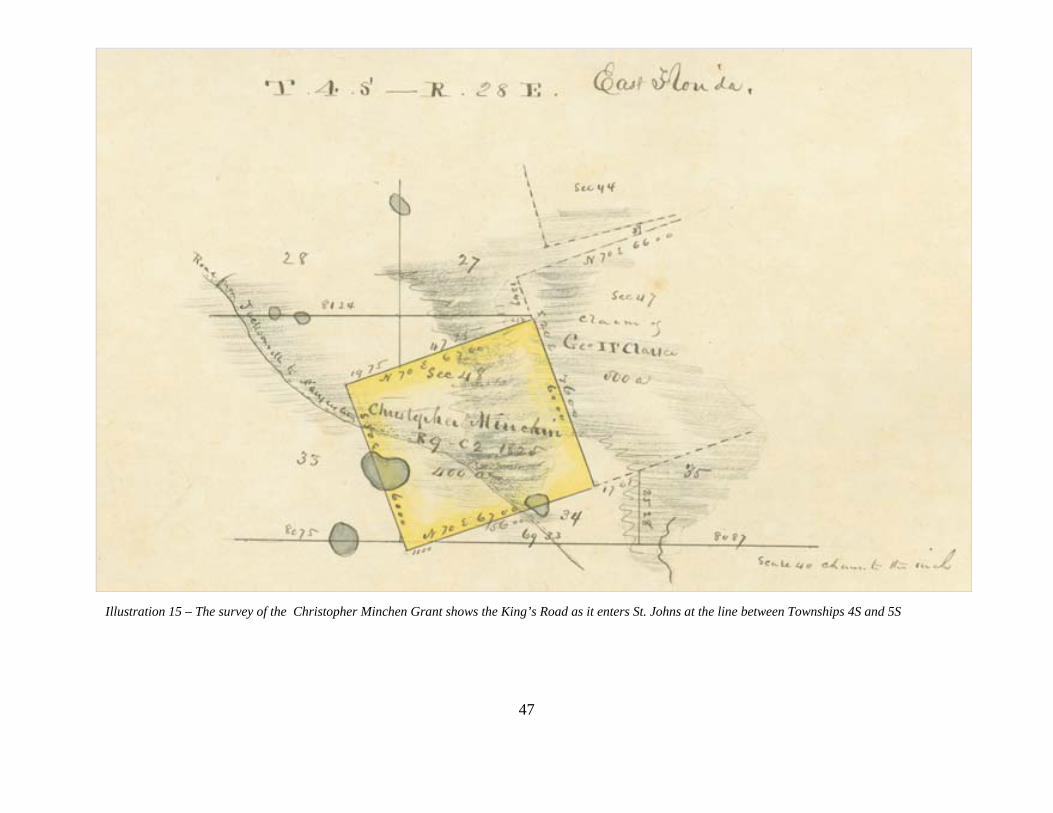
Illustration 15 – The survey of the Christopher Minchen Grant shows the King’s Road as it enters St. Johns at the line between Townships 4S and 5S
47

Illustration 16 – The Mary Ann Davis Grant plat shows course of the King’s Road just north of the Duval-St. Johns county line
48

49
THE KINGS ROAD DURING THE TERRITORIAL/STATEHOOD/CIVIL WAR PERIOD (1821-1865) Unable to exert effective control of its unruly possession, Spain in 1819 succumbed to the diplomatic overtures of the United States and signed the Adams-Onis Treaty, relinquishing ownership of its Florida colony. The transfer of flags occurred in 1821. Andrew Jackson, who had more than once commanded American forces on military forays into the peninsula, was named provisional governor. In July of that year Jackson created St. Johns and Escambia counties, the first political sub-divisions within the new territory. St. Johns County encompassed all of Florida east of the Suwannee River.80 Settlers soon began arriving in growing numbers. Speculators saw great opportunity in the underdeveloped and relatively unpopulated territory. St. Johns County contained slightly more than 5,000 inhabitants when the United States took control. Further expansion appeared constrained only by physical limitations and by a problem that had intensified during the previous era of Spanish rule, Indian unrest, stemming mainly from squabbles over land.81 More than any other factor, the absence of roads limited settlement.82 Settlers and speculators began almost at once to agitate for improvements. Congress, which controlled all of the purse strings for the Territory of Florida, had to be convinced that internal improvements were necessary.83 Early plans called for a general system of roads that would connect various sections of the territory. The first and most extensive undertaking would become the Bellamy Road, planned to link Pensacola with St. Augustine, reaching across the northern fringe of the territory.84 In 1821 the King's Road was the main road in the territory. It was already a half century old by that date and stretches of it, particularly south of Pellicer Creek, had been poorly maintained. More than 60 percent of the land mass in east Florida consists of pine flatwoods.85 Extensive drainage programs that began later in the century and that continue to this day have obscured the physical characteristics that east Florida possessed in colonial times. Finding high ground upon which to erect a permanent roadway along the coast must have been exceedingly difficult then. The roadway the British made was seasonally washed and rewashed, recurring rains and freshets tearing at its path. Moreover, enough time had elapsed since its original construction to permit even the largest of plants to grow to maturity in its very midst. This was particularly true in the
80 William R. Adams, et al, “The King’s Road, Florida’s First Highway,” (St. Augustine, 1997,unpublished manuscript prepared by Historic Property Associates, Inc., St. Augustine, FL, 1997), 23. 81 Ibid. 82 Tebeau, A History of Florida, 140. 83 Sidney Walter Martin, Florida during the Territorial Days. (Athens: University of Georgia Press, 1944), 125.
84 See Alice Whitman, "Transportation in Territorial Florida." Florida Historical Quarterly. 17 (1938):25-53; and Mark F. Boyd, ed., "The First American Road in Florida: Pensacola-St. Augustine Highway, 1824." Florida Historical Quarterly. 14, no. 2 (1935):17-106; and 14, no. 3 (1935):138-192.
85Stanley Bond and James Smith, "Stomping the Flatwoods: An Archaeological Survey of St. Johns County, Florida," Manuscript, Copy in the St. Augustine Historical Society (1983), 33.

50
latter years of the Second Spanish Period, when royal authorities lacking resources and with no incentives to maintain it, allowed the road to fall into disrepair.86 Within months of the territory's formation a group of east Florida citizens sent a petition to Congress requesting opening of the King's Road from the St. Mary's River, which marked Florida's northeastern border, to St. Augustine. They argued that more than forty miles would be saved in transporting the mail by land rather than by the sea route. The claimed that the King's Road was in a "Tolerable state of repair" and pointed out that it had served as the direct line of communication between Georgia and Florida "when both were united under the Government of Great Britain."87 Throughout the remainder of 1822 the appropriations request churned its way through Congress. The funding request was placed in the proposed budget for the War Department, since road construction in the territory was a military responsibility. In a February 1823 memorandum to the Congress, perhaps in response to an inquiry regarding the object of the proposed funding, Florida's territorial delegate, Joseph Hernandez, described the current condition of the old road from the St. Mary's River to the Mosquitos Inlet, the Florida section of its historic route. The specific section of the road required to be opened, he wrote, led from the St. Mary's River at Colerain to Cowford (Jacksonville). From Cowford to St. Augustine, he said, the road was presently open and "in good order."88 Turning to the southern portion of the road, Hernandez said that from the "head of the Matanzas River" to the Tomoka River the road was also in good order. From Tomoka southward to the "old Town of Old Smyrna," about 30 miles, it required work. The principal causeways, he wrote, were nearly "as good as ever" and, along with the 30 miles of road between St. Augustine and the Tomoka River, could be repaired with "little labor." Hernandez did not describe the condition of the road south of the Tomoka River, only arguing that it "will contribute much to promote the interest of that important part of the Territory, where the best sugar lands are."89 The varying condition of the road undoubtedly resulted from the intensity of use that different sections of it received during the late colonial period. The largest number of rural settlers in east Florida between 1800 and 1820 lived north of St. Augustine. Inhabitants of the growing
86A map of East Florida drawn in 1823 by Charles Vignoles shows a stage road from Coleraine to the Tomoka River; then a single line marked "old road grown up" from the Tomoka River to Smyrna; and south of Smyrna, a "path grown up" leading to a spot north of Merritt Island, called "Ross old place." University of Florida, Gainesville, P.K. Yonge Library, Special Collections.
87"Memorial to Congress by the Citizens of St. Augustine and St. Johns County," February 20, 1822, Territorial Papers of the United States, Florida, Vols. 22-26, ed. Clarence Carter (Washington: Government Printing Office, 1956-1962), 22:366-367 (hereafter cited as Territorial Papers).
88"Memorandum by Delegate Hernandez Re Opening Roads in the Florida Territory," Territorial Papers, 22:633-634, February, 1823.
89 Ibid., 634.

51
settlement near the crossing of the St. Johns River at Cowford (about where the Main Street Bridge presently stands) undoubtedly used the road to travel back and forth to St. Augustine, the provincial capitol and East Florida's largest community. Cattle drives also served to keep the road from becoming overgrown. Travelers proceeding from Georgia into Florida would have kept the stretch from the Georgia border to Cowford open. The inhabitants of plantations between St. Augustine and the Tomoka River would likewise have used the road to some degree. South of the Tomoka River, however, there were no settlements and few plantations. That section of the road consequently fell into greater disrepair than others. The House of Representatives approved on February 5, 1823 a bill authorizing the president to open a road in the Territory of Florida, specifically directing that it follow "in the old track of a road known by the name of the King's road, passing by Jacksonville, on the River St. John's and St. Augustine to the old town of Smyrna." The use of military troops to construct the road was authorized and $15,000 approved for construction purposes. Unfortunately for the settlers of east Florida, the session ended before the Senate was able to act upon the measure and another year elapsed before Congress could reconsider the initiative.90 In August 1824, the Quartermaster General of the Army issued orders to Col. James Gadsden to survey a route from St. Augustine to Cape Florida, instructing him to take the "most direct route," near the coast, and to mark his way by blazing trees. Gadsden was further directed to submit a detailed report to the Quartermaster General describing the countryside, the nature of the soils, Indians in the vicinity of the road, streams, required bridges, and his estimate of constructions costs.91 The submission of Gadsden's report was due before the next session of the Congress, allowing less than six months for completion of the survey and report. It was not enough time. Beginning the work in the heat of late summer, besieged by mosquitoes and rains in a countryside that swarmed with angry Indians, Gadsden and his men made it only as far as the St. Lucie River before illness among his troops forced him to stop further work. Two members of his party, in fact, were buried "in the wilderness." In a preliminary report, Gadsden said that he had marked the route of the King's Road as far south as the Tomoka River. From there, he reported, the path of the remaining distance to Smyrna could be "traced without much difficulty." Gadsden recommended the "complete repair of the old King's Road," which he said could be done at "trifling expense - It is already in tolerable condition; the old causeways only requiring repair and the small creeks which it crosses to be bridged."92 With fresh troops Gadsden returned to complete the survey, and in August 1825 he sent the Quartermaster General a more detailed report, responding to the full set of questions about the area originally asked of him. Describing the route which the road would take, Gadsden concentrated on the section south of St. Augustine. The crossing at the Tomoka, he said, was
90 "Bill for Opening Roads in the Florida Territory," Territorial Papers, 22:634-635, February 5, 1823. 91 "The Quartermaster General to James Gadsden," Territorial Papers, 23:40-41, August 13, 1824.
92 "James Gadsden to the Quartermaster General," Territorial Papers, 23:301-309, December 21, 1824. The volume includes a map that Gadsden drew of the route he blazed. The map is not drawn to a scale.

52
"favorable for a ferry," for it still had an old causeway in place that could be easily repaired. The property owner there, a "Mr. Andeson (sic)," Gadsden reported, "is willing to establish a flat for the accommodation of Travelers so soon as the road can be opened." Should construction south of the Tomoka River to Smyrna be undertaken at that time, "the route of the road marked, will have to be abandoned at the Tomoka ferry and the old Kings road followed or a more easterly route selected so as to cross spruce creek at or near its connection with the Halifax." Gadsden then continued:
The facilities however of crossing this creek from its width & margins of marsh are diminished on approaching its mouth -on the old Kings road there is the remains of a causeway which may be repaired without much labor - I am inclined however to the opinion that the superior advantages of a more easterly route will more than counterbalance any greater difficulties which may be encountered from crossing the creek still nearer its mouth - If the road be opened to Smyrna it may be continued at a very inconsiderable expense, should it be deemed important, along the high ridge of the South Halifax Sound to the Hawlover at Indian River; thus avoiding the bad cypress swamps near the heads of this stream....93
In its next session, Congress took up an appropriations request to construct the road. The committee report included a letter from Florida's territorial delegate, Joseph White, in which White said that although the King's Road, "the main highway into East Florida," had been constructed of "durable causeways," many of which remained intact, the "obstructions between them are so insurmountable that this section of the country is, in great measure, excluded from communication." The Committee on Roads and Canals in February 1826 reported out a bill authorizing opening and repair of the road from the Georgia line to New Smyrna via St. Augustine.94 By July 1826, contract offers from private individuals for completion of the northern section of the road. These contracts, which addressed completion of nearly one-half the entire distance, were awarded to men "living on the line of Road; one residing at Gravelly Hill & one near Jacksonville." The contracts stipulated that the King's Road was to be 25 feet wide and "the remaining part 20 feet wide." That is, where the reconstructed road followed the original path, it was to be 25 feet wide; newly constructed roadway needed to be only 20 feet in width. The correspondent warned that the cost would exceed Gadsden's $11,000 estimate, resulting from the higher cost of using private contractors rather than federal troops for construction work.95 Whether any of those contracts were actually signed and work completed by private contractors the records do not indicate. The following March, Lt. Harvey Brown, the assistant quartermaster general at St. Augustine, was instructed to employ the "disposable force" of troops to open and
93 Ibid., "James Gadsden to the Quartermaster General," August 20, 1825. 94 Senate Document 29, 19 Congress, 1 Session, February 6, 1826; The final act authorized the use of federal troops stationed in Florida to assist in construction.
95 "Daniel E. Burch to the Quartermaster General," Territorial Papers, 23:600-602, July 9, 1826.

53
repair the King's Road from Georgia to New Smyrna. Brown's orders were not specific. They read that the
track of the old road is presumed, for the most part, sufficiently wide already - The law is silent on this point -The road, should, however, be wide enough at all places, to admit of the ordinary vehicles passing each other on the route - In other respects, the face of the Country through which the road passes, will indicate the kind of work and finish which should be bestowed upon it, to render it durable and passable at all seasons....
Brown was further directed to award a contract for completion of a bridge across the San Sebastian River at St. Augustine, but only if the right-of-way leading to both sides of the river were donated to the City of St. Augustine. Construction of that bridge was to prove a troubling episode in the work on the King's Road.96 Not until November of that year did the troops begin to arrive in St. Augustine. Brown reported that, in the meantime, he had examined the entire length of the proposed road. From Coleraine on the St. Mary's River to the Tomoka River, he foresaw little difficulty. The area south of the Tomoka was another matter. "There is not the slightest remains of the old road to be found and I very much doubt, whether one ever existed." Excepting Indians, he thought he and his guide to have been "the... only persons to have traveled over this part of the country for the past fifty years." Brown expressed doubt that south of the Tomoka River the road would find little use and that in two or three years it would already require major repairs.97 At least one group of citizens agreed with the lieutenant, petitioning the Congress to reassign the funds for completion of the road south of the Tomoka River to construct instead a water canal linking the Matanzas and Halifax rivers.98 In January 1828 Brown reported completion of the "northern section" of the road, presumably from Coleraine to St. Augustine. Citing the citizens' petition, he requested instructions on whether to proceed with work on the remaining length. Referring evidently to that part of the road between St. Augustine and the Tomoka River, Brown said it could be finished by April 1.99 He was instructed instead to begin work on the San Sebastian bridge. Brown, in turn, asked the Quartermaster General for approval to use monies appropriated for the road itself to construct the bridge. In the meantime, he promised to finish the road as far south as the Tomoka River within the month and then begin work on the bridge.100 Whether it was Brown's reluctance to begin work on the road south of the Tomoka River or his difficulties with the San Sebastian bridge that got him into trouble, available records do not
96 "The Quartermaster General to Harvey Brown." Territorial Papers, 23:804, March 26, 1827.
97"Harvey Brown to the Quartermaster General." Territorial Papers, 23:933, November 7, 1827.
98 "Memorial to Congress from the Inhabitants of St. Augustine, Matanzas, and Tomoka," Territorial Papers, 23:945, December 11, 1827.
99"Harvey Brown to the Quartermaster General," Territorial Papers, 23:1012, January 22, 1828. 100"Harvey Brown to the Quartermaster General," Territorial Papers, 23:1031-1032, March 3, 1828.

54
indicate. In December, 1829 he signed a request for bids to construct the road from the Tomoka River to New Smyrna and to construct the bridge over the San Sebastian River.101 Within a week of dispatching the bids for approval by the Quarter Master, Brown was relieved of his duty and brought to trial. The Assistant Quartermaster General at St. Augustine, Major George Bender, inspected the road and reported that it was "one of the best that the nature of the soil would admit." The causeways leading to the bridge had been completed, but work on the bridge itself stopped once Brown's trial was ordered. Bender concurred with Brown's opinion that a road south of the Tomoka River would receive little or no use, soon fall into disrepair and, like places on the road "constructed a few years ago...from this place to Tallahassee," disappear.102 The bids that Brown drew up contain specifications for the road south of the Tomoka River:
The road is to be made sixteen feet wide; - all trees, stumps, palmetto roots, and brush & are to be entirely and clearly removed; the stumps to be cut in such a manner that the edges shall be even with, and the centers not more than 3 inches above the level of the ground; all low and swampy places must be well and substantially causewayed; and when the ground will admit, a ditch of three feet wide and 2 feet deep, will be required on each side. and then well covered with brushes or palmettos, the whole well covered with dirt will be required; the causeways must be made so high as to be above the water during the wettest seasons, when the causeways are of any length, or there is any run of water, good substantial culverts...will be required; across the creeks, bridges of substantial light wood, heart of pine, or cypress timber, and covered with good three inch plank...the bridges to be so high as to be above the reach of the highest freshets; they will be surmounted by substantial hand rails. At the ferry, on each side of the Tomoka river a good and substantial abutment, made of logs, will be required, and also a large flat....103
The East Florida Herald reported April 1, 1829 that Congress had given instructions to extend the road to New Smyrna and to finish the bridge over the San Sebastian River.104 Evidently, Brown's difficulties, whatever their cause, resulted in further prolonged delay in construction of both the bridge and the road. A grand jury, convened in St. Augustine in early December 1829 and presided over by jury foreman Joseph Hernandez, the former territorial delegate and a prominent landowner, complained about the construction delays. Furthermore, a group of landowners petitioned for completion of the road south of the Tomoka River. Although Brown had recommended against construction of that part of the road and nothing had been done since his dismissal, now a year past, the petitioners argued that, as a result of land purchases in the vicinity, the situation had since changed. Their petition to the Secretary of War continued: 101Record Group 92. Office of the Quartermaster General, Consolidated Correspondence Files, Box 924, Roads-Florida, "Harvey Brown to the Quartermaster General," December 23, 1828 (hereafter cited as Quartermaster General Records).
102"George Bender to the Quartermaster General," Territorial Papers, 24:10, January 7, 1829.
103 Advertisement from the East Florida Herald, in Quartermaster General Records, December 23, 1828.
104East Florida Herald, April 1, 1829.

55
(The landowners) are actually at work, establishing sugar plantations in Turnbull Swamp, at New Smyrna, and several who reside in New York...have been here, and made purchases and will commence their plantations the ensuing winter, and that there are very extensive tracts, in the immediate vicinity of New Smyrna, which in the course of a few years will besettled, and a public road would greatly facilitate the communication with this place....
They asked that the "old road made by the English Government, may be...repaired and Bridges built over the several small streams, which it intersects in its course from Tomoca." The petition concluded that this could "be done at trifling expense, since all the causeways across the Swamps are already made, and the road in many place is good for several miles."105 Brown's replacement, Lt. John L'Engle, began in late December 1829 collecting equipment and horses to renew work on the road and bridge. Work progressed during the summer months and by mid-September L'Engle's men found themselves three miles south of Spruce Creek, before logistical problems and late summer mosquitos and flies forced a temporary suspension of the work.106 In early January the road extended to the canal, three miles north of New Smyrna.107 It finally reached the town itself in mid-summer 1831. The bridge over the San Sebastian River was also constructed during this time.108 Several years had passed since the work on the northern sections of the road began, enough time for the elements to take their toll of a dirt road carved through the forest of east Florida. The recurrent task of making repairs to the road began in 1831, even before the full route to New Smyrna had been completed.109 In April 1833 Delegate Joseph White wrote that the Post Office Department planned to authorize mail deliveries along the road.110 The advertisement for bids to make the mail run from St. Augustine to New Smyrna did not, however, appear until July 1834.111 In the meantime White began receiving complaints about the condition of the road below the Tomoka River. For a distance of twenty miles south of Pellicer's Creek the road was in "wretched" condition, the petitioners said, the poorly built bridges either decayed or destroyed. Indians hunting otters had burned the bridge over Spruce Creek. The petitioners asked for repairs and for construction of a bridge over the Tomoka River.112
105 "William Bell & twenty nine others to John Eaton, Secretary of War," Quartermaster General Records, October 8, 1829.
106"John L'Engle to the Quartermaster General," Territorial Papers, 24:441, September 15, 1830.
107 "John L'Engle to the Quartermaster General," Territorial Papers, 24:481, January 9, 1831. 108 John L'Engle to Thomas Jesup, July 12, 1831, Quartermaster General files.
109 Ibid.
110 East Florida Herald, April 11, 1833 111 "Post Route Advertisement," Territorial Papers, 24:35, July 10, 1834. 112"Inhabitants of Mosquito County to delegate White," November 8, 1833, Territorial Papers, 24:935-936; A St. Augustine Grand Jury complained in late December 1834 that the San Sebastian River bridge remained uncompleted. "Presentment of the Grand Jury of St. Johns and Mosquito Counties," Territorial Papers, 25:80-81;

56
The planters in east Florida living along the coast south of St. Augustine soon faced greater problems than a wretched road. The long simmering troubles between Indians and white settlers erupted in hostilities in December 1835. On Christmas Day bands of Seminoles burned the buildings in New Smyrna and began raiding plantations along the river. Within two months hardly a building remained standing from St. Augustine to New Smyrna. As the settlers fled to protected towns or military posts, the Indians set to work destroying the vestiges of white occupation, including the bridges along the route of the King's Road.113 The war dragged on for seven years, although by late 1837 the settlers in east Florida apparently felt conditions immediately south of St. Augustine secure enough to consider returning to their lands. They petitioned the Congress for an appropriation to repair the road and its bridges. Lt. L'Engle, still on duty in late 1838 (at the same rank and in command of the same detail after eight years!), reported that work on the road had been completed and his work party discharged. But if the road had been repaired, it must soon again have deteriorated, for in 1844, two years after hostilities ceased, the "Citizens of East Florida" petitioned the Congress yet another time to appropriate monies to fix the road, which, they said, destroyed by "natural decay," had become impassable. Not until that date, in late 1844, was the resettlement of New Smyrna, vacated some nine years before, contemplated.114 The war had interrupted the federal surveys in east Florida. The surveyors, laying out township, range and section lines, were making their way southward along the east coast and by April 1835 had reached the outskirts of New Smyrna. Then, "in consequence of difficulties with Indians," they abandoned the field.115 Surveys in that part of the state did not resume until 1845. In some cases, townships in east Florida that had been surveyed in 1834 or 1835 were resurveyed between 1845 and 1849. During that time, the road had, in places, become so indistinguishable that the surveyors encountering the feature while running a traverse line did not monument it. But, in most townships which the road traversed, it appears on their maps and was described in their field notes. Those maps and the accompanying field notes provide the most accurate evidence available regarding the road's actual location.
Several sources blamed the Indians for destroying the bridges. For this specific incident, see Judge David R. Dunham to Quartermaster General Thomas Jesup, November 9, 1835, Quartermaster General files.
113"Petition to Congress by Citizens of East Florida," Territorial Papers, 25:446-447, December 27, 1837. 114 "Petition to the House of Representatives by Citizens of East Florida," Territorial Papers, 26:975-977, December 16, 1844; a year earlier a St. Augustine newspaper complained that the bridges on the road to Jacksonville "are much decayed, and almost impassable." If not repaired, the paper said, "the mail stage could not cross." This editorial was undoubtedly referring to, among others, the San Sebastian River Bridge. St. Augustine News, December 30, 1843.
115"Robert Butler to Elijah Hayward" (commanding general, Land Office), Territorial Papers, 25:127-129, April 23, 1835.

57
The General Course of the Kings Road During the Territorial/Statehood Periods/Civil War Period (1821-1865) Many general maps of Florida were drafted in the early years of the Territorial Period, including one published in 1822 by Charles Vignoles, a professional surveyor. Its small scale did not permit precise location of the King’s Road, although maps like that drawn by Vignoles are vital in establishing the general course of the road. The 1822 Vignoles map entitled “St. Johns River Bar to the Cowford” shows the King’s Road at the Cowford leading south following a course consistent with the De Brahm maps and Spanish maps, surveys and documents. The 1837 John Lee Williams Map also shows the general course of the King’s Road from Jacksonville to St. Augustine and south to Pellicer Creek.116 An 1864 United States Coastal Survey map of St. shows the northern course of the Kings Road at that time. The road follows the course shown on the United State Government surveys of the 1850s. The 1864 map is topographic and shows the course of the road followed the highest, best drained land between St. Augustine and the Duval County line near Durbin Creek. The colonial course along the east side of the San Sebastian River from St. Augustine to the Navarro Pass at the headwaters of this body of water is not shown. A branch of the road is shown west of the San Sebastian River beginning on the north side of the Picolata Road. From the Picolata Road, the Kings Road proceeded north crossing Red House Branch and a branch of the San Sebastian River. This is apparently the course of the road after the bridge at the San Sebastian River was constructed in the early 1830s. To the west of the road, beginning at the Picolata Road, was the Twelve Smile Swamp. To the east were the hammock land, marshes, and wetlands of the North River. These natural features channeled the road as it proceeded north through the primarily pine woods east of Twelve Mile Swamp to the St. Johns River at the historic Cowford on the St. Johns River.117
116 Saint Johns River . . . bar to Cowford. Drawn from British survey. Photostat. Map Author: Vignoles, Charles Map Number: R2.1822.002.1997.1539 Map Year: 1822 ; 117 1864, "Northern Part of Florida compiled and published at the United States Coast Survey Office, 1864"

Illustration 17 – The 1822 Charles Vignoles Map shows the course of the King’s Road north of St. Augustine
58

Illustration 18 –The beautifully colored 1837 John Lee Williams shows the King’s Road north and south of St. Augustine
59

Illustration 19 – 1864 Coast Survey Map showing the King’s Road
From the Picolata Road, the c. 1830 west branch of the King’s Road proceeded north crossing Red House Branch and a small branch of the San Sebastian River. The road then proceeded north paralleling Twelve Mile Swamp. Its course in this area followed that documented on the 1818 survey of the Pablo Sabate Claim. East of St. Marks Pond the road briefly joined the Pablo Road as it proceeded north from St. Augustine. After a short distance the Kings Road branched northwest toward Jacksonville and the Pablo Road branched northeast towards the headwaters of the North River. The Kings Road then continued northwest crossing Durbin Creek near the Duval-St. Johns County line on its way to Jacksonville.118
60118 Ibid.

61
The Specific Course of the Kings Road, South of St. Augustine to Flagler County, During the Territorial/Statehood/Civil War Periods (1821-1865) Beginning in the mid-1830s and ending in the early 1850s, United State Government surveyors mapped the course of the Kings Road in St. Johns County through township plats and field notes. Many confirmed Spanish Grants were also individually surveyed with plats and field notes. The precise location of the King’s Road south of St. Augustine to the Flagler County line is further described in abstracts of the Township Plats listed below. The course of the road is shown in detail on the Power Point slide show that accompanies this report. Township 7S, Range 30E (City of St. Augustine, San Sebastian River west from King Street to Range Line of 30E) The plat of Township 7S, Range 30E covers St. Augustine. Ironically, all other plats mapping areas of St. Johns County are detailed as to the location of the King’s Road, while the one for the city is almost entirely lacking. A separate map was made of the city with field notes of each street, block and lot. Nonetheless, the 1851 A.M. Randolph plat shows a road crossing the San Sebastian River following the course of present day Kings Street west into the Avice and Vail Grant (Section 37/ and T7S, R29E, Section 41). The 1839 field notes for a survey of the Avice and Vail Grant indicate a road and bridge at this location. This would be the causeway and bridge constructed across the San Sebastian River in the early 1830s.119 Charles Croom’s article discusses the King’s Road through the City of St. Augustine. Lieutenant Harvey Brown describes the road passing through the City of St. Augustine and the Ferry Crossing on the San Sebastian in correspondence concerning the construction of bridge at the west end of present day King Street. A letter from General Thomas S. Jesup in 1825 indicates that there was no part of the King’s road on the west side of St. Augustine between the Pass of Navarro and King’s Ferry Way and Ferry Place. As quoted in Croom’s article Jessup stated: “Those who travel from the north would cross the San Sebastian’s where they do now (at the Pass of Navarro), unless a bridge was to be built at or near the Stockade (the Robinson Grant just north of State Road 16), or at Pepino’s ferry, in which case the ‘King’s Road from the Cow-ford would be extended down the west side of the river to such bridge and there cross.”120 After the bridge was built, it is likely the King’s Road from Jacksonville was extended south of Red House Branch to the new crossing at King’s Street. This would explain the placement of the King’s Road bearing north and south across a bridge at Red House Branch on the survey of the Joseph Delespine Grant in 1832. This route is shown on the 1864 Coastal Survey Map. A 1924 plat by St. Johns County Surveyor Peter Kendrick shows the c. 1830 King’s Road extension through the Delespine Grant and the ruins of the bridge across Red House Branch.121
119 Township 7S, R30E, Benjamin and J.B.Clements Survey, 1834-1835. 120 Coomes, “The King’s Road of British East Florida.” 56-57. 121 “Plat of Lands Albert Lewis Estate” St. Johns County Map Book 3, page 43.

62
Township 7S, Range 29E (City of St. Augustine, from King’s Street, south in the vicinity of Rodriquez, Whitney streets, following this course to Old Spanish Trail across SR 207 along Old Hastings Road to vicinity of Old Dixie Highway/Old Moultrie to King’s Estate Road, crossing at FEC railroad near Township line between T7S-T8S. The King’s Road through this area, particularly south of State Road 207, follows closely the course of Dobbs Road, just east of the FEC Railroad line, known as the Moultrie Cut, added in the 1920s) The 1839 Benjamin and J.B. Clements shows the Tomoka Road branching from the Picolata Road and heading west and then south around present day Oyster Creek. The road then crosses the section line between the Avice and Vail Grant (Section 41) and the Antonio Huertas Grant (Section 45). Field notes for these two former Spanish land grants confirm the road in this location. The road continues south on the 1839 plat through Sections 24, 25, and 36, just west of the range line of Range 29E. Field notes for these sections recorded in 1850 show the King’s Road crossing the south lines of these sections. The 1853 A.M. Randolph plat shows a remnant of the road in sections 24, 25 and 36.122 Township 8S, Range 29E (From railroad crossing at Old Moultrie Road and King’s Estate Road to County Road known as King’s Road following King’s road to the vicinity of Moultrie Creek. Then across Moultrie Creek to site of Ft. Peyton, then south through undeveloped lands across Interstate 95 to the Township Line of 8S-9S) The 1835 Benjamin and J.B. Clements plat shows the Tomoka Road entering the north line of Section 1 and bearing southwest around a branch of Moultrie Creek. The Tomoka Road passes through the east and south lines of Section 2, near the southeast corner of the section. Just south of the north line of Section 2 in Section 11 the road crosses Moultrie Creek as it turns north. The road on this course appears very similar to that shown on 1775 survey of the John Moultrie Grant. South of Moultrie Creek, the road then bears south crossing the north and south lines of Section 14 and entering Section 23. The road then bears southwest crossing the west line of Section 23 into Section 22. Then it proceeds south across the south line of Section 22, through Section 27, into Section 34. From Section 34 it proceeds southeast into and through Section 35, crossing the south line of Section 35 and the Township line between T8S and T9S. The 1852 A.M. Randolph Plat show the road, labeled as the King’s Road, following the same general course through Township 8S. The location of Ft. Peyton is identified on the plat in Section 11, Government Lot 6 and the Road to Palatka joins the road in Section 22, heading southwest.123
122T7S/R29E/Sections: ID: 110578, DATE: 11/13/1852, Surveyor: Henry Washington/R.W. Randolph/A.M. Randolph.. 123T8S/R29E/Sections: ID: 110578, DATE: 11/13/1852,, Surveyor: Henry Washington/R.W. Randolph/A.M. Randolph .

63
Township 9S, Range 29E (From west of Interstate 95 at Township Line 8S-9S across County Road 206 paralleling I-95 to Range Line 29E-30E, approximately .25 west of I-95, Section 31 west of the FEC rail line and 1 mile north of County Road 204) The 1835 Benjamin and J.B. Clements plat shows the Tomoka Road entering Township 9S and passing north-south through sections 2, 11 and 14 west of Fish Swamp. The Clements Survey shows the road passing through piney, flat woods and between swamps and wetlands as it proceeds south, southeast. Entering Section 23 the road continues southeast near the southeast corner of the section and passes into Section 24. From Section 24 the road continued south, southeast, passing west of Fish Swamp, which flows into Pellicer Creek, to the south line with Section 36. The 1835 Clements survey was the only one undertaken for Township 9S, Range 29E.124 Township 9S, Range 30E (From west line of Section 31 at Range Line between 29E-30E to Township Line between 9S-10S west of the FEC rail line and 1 mile north of County Road 204) The 1835 Benjamin and J.B. Clements plat shows the Tomoka Road entering Township 9S Range 30E in Section 31 and bearing southeast and west of a swamp, which flows into Schoolhouse Branch.. A.M. Randolph updated the Clements Survey in 1850 and 1852. The course of the road remains the same but is called out as the King’s Road. A creek and swampland to the east of the road is labeled as Coco Branch (now Cracker Branch).125 Township 10S, Range 30E (From Township Line between 9S-10S west of the FEC rail line and 1 mile north of County Road 204 to St. Johns-Flagler County line at Pellicer Creek) The 1834 Benjamin and J.B. Clements plat shows the Tomoka Road entering Township 10S Range 30E across the north line of Section 6 and passing north of Schoolhouse Branch across the west line of Section 6, again north of Schoolhouse Branch. The road then entered the north line of Section 8 and followed the east line of 8 with Section 9 to a point where it crosses Pellicer Creek. The Clements brothers updated the 1835 Survey in 1850. The course of the road remains the same but is called out as the King’s Road. The Martin Hernandez Grant (Section 47) has been added to the plat, replacing Section 8. The 1850 Plat shows the road crossing Pellicer Creek and passing by Hewlett’s Old Mill.126
124T9S/R29E, ID: 110648,DATE: 03/01/1835, Surveyor: Benjamin and J.B. Clements . 125T9S/R30E, ID: 110648,DATE: 03/01/1835, Surveyor: Benjamin and J.B. Clements 126 T10S/R30E, Date: 1849, Surveyor: A.M. Randolph.

64
The Course of the Kings Road, North of St. Augustine, During the Territorial, Statehood, Civil War Periods (1821-1865) Beginning in the mid-1830s and ending in the early 1850s, United State Government surveyors mapped the course of the Kings Road in St. Johns County north of St. Augustine through township plats and field notes. Many confirmed Spanish Grants were also individually surveyed with plats and field notes. The township plats clearly show the course of the road north of St. Augustine beginning with Township 6S, R29E and continuing to the Duval County Line, north of Durbin. Ironically, from the Mil Y Quinientas at the northern limits of St. Augustine in Township 7S, Range 30E to the Township line the plats are almost entirely lacking information on the King’s Road. All other plats mapping areas of St. Johns County to the north are detailed as to the location of the King’s Road. The precise location of the King’s Road north of St. Augustine to the Duval County line is further described in abstracts of the Township Plats listed below Township 7S, Range 30E/ Township 7S, Range 29E (North St. Augustine, San Sebastian River from San Carlos Avenue to City Limits of St. Augustine) In May, 1836 United States Government Surveyors Benjamin and J.B. Clements completed a plat of the township. The township map does not clearly show the course of the Kings Road, although individual grant claims reference it as a boundary. These grants are recorded on the Clement’s Plat. According to these claims, many of them made in the early 1820s, leaving the Mil y Quinientas at San Carlos Avenue, the road proceeded northwest along the banks of the San Sebastian River. It formed the west boundary of a series of Spanish Land Grants as it proceeded north. In the mid-1830s, just north of the Mil y Quinientas, along the banks of the San Sebastian River, Benjamin and J.B.Clements recorded three Spanish land grants confirmed to Gabriel W. Perpall. The first grant (Section 47) and third (Section 45) were described in claims documentation as being bounded west by the St. Nicholas Road which led to present day Jacksonville and ran along the shore of the San Sebastian River. No individual United States government surveys were entered in evidence in support of the claims and the township plats showing the grants do not reference the road. No mention of the King’s Road is made in the field notes of the survey of the grant lines in the 1830s. The road in this location might have been abandoned because of the extension of the King’s Road across Red House Branch about 1830 and the preferred use of the Pass Navarro (State Road 16A/Lewis Speedway) and Horn Roads (State Road 16/Picolata Road) connecting to the Capuaca and Pablo-Araquay roads to the north.127 North of the Perpall grants was a 105 acre grant to Eliza Robinson at a place called the Stockade. Documents in the Robinson Claim also reference the west boundary of the grant as the St. Nicholas or Public Road heading north. No individual United States government surveys were
127 Florida Memory Project, Spanish Land Grants Gabriel W. Perpall Grant, 328 to 342 of Dossier, Box: 26, Folder 13, Pages 3,10,14; Gabriel W. Perpall Grant, 288 to 308 of Dossier, Box: 26, Folder 11, Pages 3,8; Gabriel W. Perpall Grant, pages 253 to 286 of Dossier, Box: 26, Folder 10, Pages 4,6.

65
entered in evidence in support of the claim. A second township plat similar to the first but with the addition of the Pedro Estopa Grant (Section 44) was also completed in May, 1836. In March, 1851 H.M. Randolph completed the surveying of Township 7S, confirming the aforementioned grants in the same location.128 Part of the Robinson Grant extended into Township 7S, R29E. Plats of this township show the King’s Road proceeding northwest from the west boundary of the Robinson Grant along the shoreline of the San Sebastian River. Township 6S, Range 29E (North City Limits of St. Augustine to Nine Mile Road/US 1 Junction) In January, 1834 United States Government Surveyor Henry Washington completed two plats for Township 6S. The Washington plats clearly showed the Kings Road as it proceeded northwest along the banks of the San Sebastian River. The road enters Township 6S at Section 36 and proceeds northwest, crossing the San Sebastian River at the Pass of Navarro. After crossing the San Sebastian River it continued in a northwest direction through the northeast corner of Section 35. It continues northwest through Section 26 where it crosses a branch of the San Sebastian River. It then continues north through Section 27 and continues north/northwest through Section 22. It continues north through Section 15, where it is described as the Jacksonville Road. It passes north through Fractional Section 10 and enters Section 9. In Section 9 it proceeded north and paralleled the west boundary of the Pablo Sabate Grant (Section 50), known as the Casacola Plantation. It also paralleled St. Marks Pond to the west. This course is documented by the 1818 Andres Burgevin survey of the Pablo Sabate unconfirmed claim. The road continued north into the western portion of the Reuben Charles Grant (Section 45). The Jacksonville/Kings Road then proceeded northwest into Section 4. A second road branched northeast from the Jacksonville/Kings Road in Section 45 and was described in plats of Township 5S, R29E as the Pablo Road. In Section 4, the Jacksonville/Kings Road bore north/northwest roughly paralleling the course of the Pablo Road to the east.129 A.M. Randolph completed the surveying of Township 6S, Range 29E in 1853. Randolph showed the course of the Jacksonville/Kings Road as depicted on the 1834 Henry Washington Township plats. The Randolph Plat showed one major change. In Section 26 a branch of the road is shown heading south. This branch proceeds south while the original road headed southeast and curved around a hardwood hammock as it enters Section 35. The branch heads south into Section 35 and continues south into Section 81, the Joseph Delespine Grant and connected with the Picolata Road to the south of Red House Branch. The branch follows the course of the King’s Road on the British Period De Brahm Map. It might have been re-built after the bridge across the San Sebastian River was constructed. It is likely the King’s Road from
128Florida Memory Project, Spanish Land Grants, Eliza Robinson Grant, Page 1 of 30 of Dossier, Box: 28, Folder 1, Pages 7,9,12, and 19. T7S/R30E, ID: 112519,DATE: 05/28/1836SURVEYOR: BENJAMIN/J.B. CLEMENTS; T7S/R30E, ID: 112518,DATE: 05/28/1836 SURVEYOR: BENJAMIN/J.B. CLEMENTS; T7S/R30E, ID: 110704 DATE: 03/06/1851, SURVEYOR: BENJAMIN/J.B. CLEMENTS/HENRY WASHINGTON/H.M. RANDOPLH 129T6S/R29E, ID: 112473 DATE: 01/01/1834 SURVEYOR: Henry Washington; T6S/R29E, ID: 110644 DATE: 01/01/1834SURVEYOR: Henry Washington;
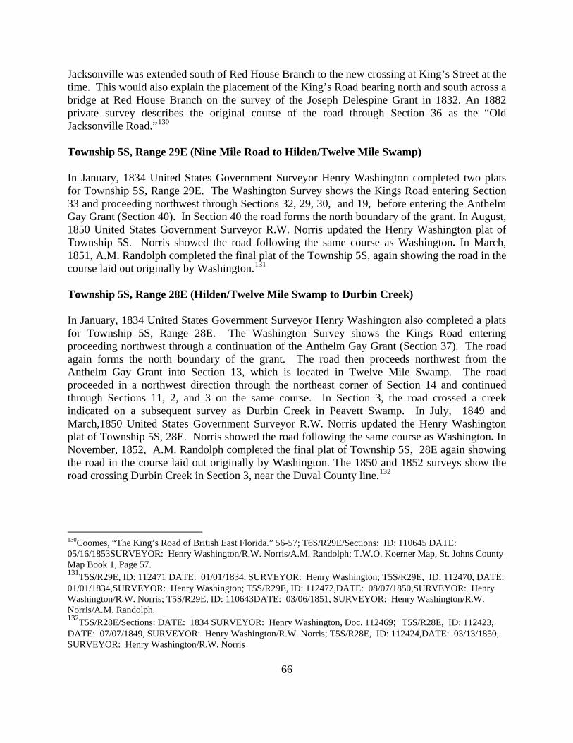
66
Jacksonville was extended south of Red House Branch to the new crossing at King’s Street at the time. This would also explain the placement of the King’s Road bearing north and south across a bridge at Red House Branch on the survey of the Joseph Delespine Grant in 1832. An 1882 private survey describes the original course of the road through Section 36 as the “Old Jacksonville Road.”130 Township 5S, Range 29E (Nine Mile Road to Hilden/Twelve Mile Swamp) In January, 1834 United States Government Surveyor Henry Washington completed two plats for Township 5S, Range 29E. The Washington Survey shows the Kings Road entering Section 33 and proceeding northwest through Sections 32, 29, 30, and 19, before entering the Anthelm Gay Grant (Section 40). In Section 40 the road forms the north boundary of the grant. In August, 1850 United States Government Surveyor R.W. Norris updated the Henry Washington plat of Township 5S. Norris showed the road following the same course as Washington. In March, 1851, A.M. Randolph completed the final plat of the Township 5S, again showing the road in the course laid out originally by Washington.131 Township 5S, Range 28E (Hilden/Twelve Mile Swamp to Durbin Creek) In January, 1834 United States Government Surveyor Henry Washington also completed a plats for Township 5S, Range 28E. The Washington Survey shows the Kings Road entering proceeding northwest through a continuation of the Anthelm Gay Grant (Section 37). The road again forms the north boundary of the grant. The road then proceeds northwest from the Anthelm Gay Grant into Section 13, which is located in Twelve Mile Swamp. The road proceeded in a northwest direction through the northeast corner of Section 14 and continued through Sections 11, 2, and 3 on the same course. In Section 3, the road crossed a creek indicated on a subsequent survey as Durbin Creek in Peavett Swamp. In July, 1849 and March,1850 United States Government Surveyor R.W. Norris updated the Henry Washington plat of Township 5S, 28E. Norris showed the road following the same course as Washington. In November, 1852, A.M. Randolph completed the final plat of Township 5S, 28E again showing the road in the course laid out originally by Washington. The 1850 and 1852 surveys show the road crossing Durbin Creek in Section 3, near the Duval County line.132
130Coomes, “The King’s Road of British East Florida.” 56-57; T6S/R29E/Sections: ID: 110645 DATE: 05/16/1853SURVEYOR: Henry Washington/R.W. Norris/A.M. Randolph; T.W.O. Koerner Map, St. Johns County Map Book 1, Page 57. 131T5S/R29E, ID: 112471 DATE: 01/01/1834, SURVEYOR: Henry Washington; T5S/R29E, ID: 112470, DATE: 01/01/1834,SURVEYOR: Henry Washington; T5S/R29E, ID: 112472,DATE: 08/07/1850,SURVEYOR: Henry Washington/R.W. Norris; T5S/R29E, ID: 110643DATE: 03/06/1851, SURVEYOR: Henry Washington/R.W. Norris/A.M. Randolph. 132T5S/R28E/Sections: DATE: 1834 SURVEYOR: Henry Washington, Doc. 112469; T5S/R28E, ID: 112423, DATE: 07/07/1849, SURVEYOR: Henry Washington/R.W. Norris; T5S/R28E, ID: 112424,DATE: 03/13/1850, SURVEYOR: Henry Washington/R.W. Norris

67
THE POST CIVIL WAR ERA (1865-1950) Florida joined the Union in 1845. Statehood brought significant changes to the administration of roads, resulting from the transfer of authority from Washington to Tallahassee. The state legislature delegated responsibility for declaration and maintenance of roads to the various counties. There was, in the early decades of the state's history, no state department of transportation. An 1874 law, titled "An Act to Establish and Keep in Good Repair the Public Roads and Highways in this State," declared that all roads and highways "laid out according to law" shall be declared public roads. County commissions were given authority to order the creation or discontinuation of public roads.133 Under the authority given them by the state, county commissions created local agencies headed by appointed road commissioners to supervise construction and maintenance of roads. State law spelled out their duties: "(L)ay off the roads into divisions of convenient lengths and size and apportion the hands liable to work on the roads," appoint a supervisor for each road or road district, and assemble a list of "all the hands" who could perform work on the roads in that district. The supervisors were authorized to appropriate materials for road maintenance. Furthermore, able-bodied males between the ages of eighteen and forty-five living in the vicinity of a road had to contribute eight days' labor each year for maintenance of the road.134 After the end of the Civil War, St. Johns County formally adopted the Kings Road as a county road. The Board of County Commissioners (BOCC or Board) of St. Johns County met in special session on May 29, 1866 with the primary purpose to address the need for repair and maintenance of the roads and bridges of St. Johns County through the appointment of a full Board of Road Commissioners, as required by the laws of the state, willing and able to serve.135 The BOCC appointed two replacement Road Commissioners, to fill positions left by the refusal of one appointee to serve and the removal of another from domicile in the County. The number of road and type of maintenance and repairs were apparently such at that time that a separate slate of Road Commissioners for each road was currently instituted. The Kings Road South of St. Augustine in the Post Civil War Era At a meeting held on October 5, 1868, John Allen, Peter Pellicer and Joseph Johnston were appointed as Road Commissioners for the Tomoka Road from St. Augustine to the south boundary of the county. The Tomoka Road was the name given the Kings Road by United States Government surveyors among others during the course of surveying the county in the 1830s, 1840s and 1850s. The Tomoka River was situated just below the southern boundary of St. Johns County, which at that time included much of current Flagler County, and just north of the town of Ormond in Volusia County. The Kings Road crossing at the Tomoka River became a prominent place name and the Kings Road and Tomoka Road were often used interchangeably. At its meeting of February 9, 1869, the BOCC rescinded all its prior actions in relation to Road
133Florida Statutes, 2007-[No. 32], 1874, pp. 2-31.
134 Ibid. 135BOCC Minutes Book A, page 7

68
Commissioners and appointed a new slate of three road commissioners for the County of St. Johns, namely Jacob J. Lee, William Mickler and J.D. Stanbury.136 The Road Commissioners immediately began improvements to the Kings/Tomoka Road. In 1869, the proposed expenditures of the Board included two separate requests for bridge repairs, one for a bridge over Moultrie Creek and the other for a bridge located on the Tomoka Road. In 1871 the Board of County Commission granted permission to the Jacksonville & St. Augustine Railroad the right to use part of King’s Road from St. Augustine to Jacksonville for their railroad bed so long as a replacement road was properly constructed.137 It is not clear whether this change was ever undertaken. On November 22, 1872 George Carter and Cordin Barnes were appointed Road Masters Tomoka Road from Pellicers Creek to the nine mile post and from there to the junction with the Picolata Road north of St. Augustine138 United States Government surveyors generally referred to the King’s Road north of the Picolata Road as the Jacksonville Road during the course of surveying the county in the 1830s, 1840s and 1850s. In late 1872 and early 1873, the County Commission approved substantial sums for work on the Tomoka Road. In the years from 1875-1880 the Board continued maintaining the road and the Tomoka Road Bridge over Moultrie Creek.139 On January 4, 1876, the BOCC appointed a slate of three road commissioners for each of the four primary county roads extending from St. Augustine. These were: the Tomoka Road from St. Augustine south in the eastern part of the county towards Ormond and the Tomoka River to the Volusia County line; the Jacksonville Road from St. Augustine north to the Duval County line; the Palatka Road from St. Augustine southwesterly to the western part of the county towards Palatka and Putnam County line; and the Picolata Road, westerly to the St. Johns River at Picolata.140 Between 1875 and 1879, road commissioners were appointed for the Tomoka Road. The appointments reference the general course of the road with commissioners being responsible for maintenance of the road in the vicinity of St. Augustine, Moultrie Creek and Pellicer Creek. In October, 1880 the County Commission allocated funding for building a bridge, where the Tomoka Road crossed Pellicer Creek.141 Public roads were usually laid out and constructed with the consent and cooperation of property owners in the vicinity of proposed or existing route. The commissions had the authority to adopt an existing road as a public road. On February 4, 1880 the St. Johns County Board of County Commissioners appointed a committee to lay out a public road leading southward from St. Augustine to Pellicer's Creek, the south boundary of the county, separating it from Flagler County. By August the road, known as the Carter Road, had been completed.142 The Carter Road followed the course of S. Whitney Street to the southern city limits of St. Augustine. A year later a second road in the same vicinity, the Moultrie road, was constructed. The two intersected and
136 Carter Affidavit 137BOCC Minute Book A, page 134-135 138BOCC Minute Book A, page 174. 139BOCC Minutes Book A, page 258; Book A, 312; Book A, 337-338; Book A, page 392. 140BOCC Minutes Book A, page 285. 141 Carter Affidavit. 142 St. Johns County, County Commission Minute Books Book A, PP. 431-432

69
followed the course of what today is the Dixie Highway and Old Moultrie Road to the vicinity of King’s Estate Road. Here the Carter Road briefly joined the Kings Road, where it heads south of King’s Estate Road, before bearing due south toward Moultrie Creek. The Carter Road then crossed Moultrie Creek through the Reyes Grant, (T8S, R29E, Section 37). On the south side of Moultrie Creek, the Carter Road continued (and remains today), south to Watson Road. About six miles south of the city, at Watson Road, the Carter Road joined Moultrie Road, at what today is Datil Pepper Road, then formed a single road to the south boundary of the county.143
The construction of the Carter and Moultrie Roads made much of the Tomoka or King’s Road obsolete. Parts of the King’s Road, particularly the sections south of Moultrie Creek, fell into disuse as the Moultrie and Carter roads became the principal north-south roadways south of St. Augustine. In the 1880s parts of the King’s Road north of Pellicer Creek were not well maintained and fell into disrepair. This was largely due to the presence of the shorter, more direct route along the Carter Road from St. Augustine to Pellicer Creek. In 1885, the county commission dealt with bridges along the Tomoka Road. At its April 7, 1885 meeting the county commission order abandoned the 9 mile bridge on the old Tomoka Road.144 Much of the King’s Road, particularly the sections south of Moultrie Creek, fell into disuse as the Moultrie and Carter road became the principal north-south roadways south of St. Augustine. Because of its connection with the original King’s Road at Pellicer Creek and the continuation of the King’s Road in present day Flagler County, the Carter Road was sometimes referred to as the King’s or Tomoka Road. The utility and prominence of the original King’s Road was further diminished with the opening of the Dixie Highway from St. Augustine to Hastings and then to Flagler County by 1917 and the opening of U.S. Highway 1 in December, 1927145 The Kings Road North of St. Augustine in the Post Civil War Era The history of the King’s Road north of St. Augustine to the Duval County line is distinct from the portion of the road to the south. Beginning in 1866 the Board of County Commissioners re-established its authority over public roads in St. Johns County. Road commissioners were appointed for the Jacksonville and Pablo roads and all county owned and maintained roads north of St. Augustine.146 On January 4, 1876, the BOCC appointed a slate of three road commissioners for each of the four primary county roads extending from St. Augustine. One of these was the Jacksonville Road from St. Augustine north to the Duval County line.147 A c. 1885 St. Johns County map, recorded prior to the construction of the Florida East Coast Railroad, shows the course of this road. The map shows the Jacksonville Road following the original course of the King’s Road from northern St. Augustine to the Duval County line. It passes along the San Sebastian River to the Pass of Navarro, and then follows the course of the King’s Road to its junction with the Pablo Road. The Jacksonville Road then follows the general course of the King’s Road from Nine Mile Road north to Durbin Creek and the Duval County
143Ibid., Minute Book A, 429. 144BOCC Minutes Book B, page 63. 145CMF, December, 1927. 146 BOCC Minutes Book A, page 34. 147BOCC Minutes Book A, page 285.

70
Line. A portion of the Jacksonville Road at the Pass of Navarro is shown on an 1884 map of the Daniel Hurlburt Grant (T6S, R29E, Section 53), prepared about the same time as the St. Johns County Map.148 From the early 1880s until the World War I era the importance of the King’s Road and other county roads was diminished by the construction of railroads. A line known as the Jacksonville, St. Augustine and Halifax Railroad paralleled the west side of the Jacksonville Road or the former King’s Road from the county line to Nine Mile Road and the Pablo Road from Nine Mile Road to St. Augustine. Henry Flagler’s Florida East Coast Railroad subsequently absorbed this railroad and extended its line to Miami in 1896 and Key West in 1913. Stops along the rail line included Durbin, Sampson, and Magnolia Grove. These were all settlements along the Jacksonville Road as well.149 A map entitled “Sketch of St. Augustine-Jacksonville County Road” recorded March 6, 1911 shows a “new road” between St. Augustine and Jacksonville. This map again showed the St. Augustine-Jacksonville Road, essentially following the course of the King’s Road with some minor variations, mostly resulting from the construction of the Florida East Coast Railroad, to the junction with the Pablo Road in the vicinity of Nine Mile Road.150 The “new road” then intersected with the Pablo Road and followed the course of the Pablo Road to St. Augustine. Several sections of the King’s Road north of Nine Road on the west side of the FEC rail line were excluded from the “new road.” The main section excluded was about one mile in length and is located between Durbin and Hilden and remains today. South of Nine Mile Road a portion of the Pablo Road known as the “Casacola Road” was also excluded from the new road. This section was opposite the St. Augustine Airport between Gun Club Road and Lewis Speedway Portions of this section of the road also appear to be intact.151 The establishment of the Florida State Road Department in 1915 signaled the beginning of a modern road system for the state, designed to accommodate and facilitate the dramatic increase in automotive transportation. Counties throughout Florida, including St. Johns, began instituting modern road building techniques to state standards and mapping local, state and federal roads within their political subdivisions. Moreover, county engineers or surveyors under contract to the counties usually depicted roads, particularly improved roads, on their maps. The St. Augustine-Jacksonville County Road, consisting of the portions of the King’s Road and the Pablo Road east of the FEC rail line, was incorporated into the Dixie Highway about 1915. The adoption of the Pablo Road from St. Augustine to the junction of the King’s Road at Nine Mile Road as part of Jacksonville Road made the portion of the King’s Road south of Nine Mile Road to St. Augustine obsolete. The construction of what became the FEC rail line in the early
148 St. Johns County Map Book, 1 pages 57, 81. 149George F. Cram, (Chicago, IL: Geo. F. Cram, 1886) 63; Ormando Willis Gray, Gray's Atlas (Phiadelphia, PA: O. W. Gray and Son, 1886) 91 150St. Johns County Map Book, 1 page 183 151 BOCC Minutes Book D, page 224.

71
1880s further contributed to the obsolescence and isolation of the King’s Road from Lewis Speedway or State Road 16A north to its junction with the Pablo Road near Nine Mile Road. In St. Johns County the Dixie Highway generally followed the route of the King’s Road from the north county line to Nine Mile Road where it joined the route of the Pablo Road to St. Augustine. Built with brick, it was the county’s first hard surface road. The demands of traffic within a decade compelled construction of a second, larger east coast road, U.S. Highway 1 or State Road 4. Prior to World War I, the federal government played little role in road building, but from the early 1920s on it provided increasing funding. The utility and prominence of the original Dixie Highway following the course of the King’s Road and Pablo Road was diminished with the opening of U.S. Highway 1 in December, 1927.152 The course of U.S. 1 followed a new course between the Florida East Coast Line and the Dixie Highway from the Duval County line into St. Augustine. The Dixie Highway, following the course of portions of the King’s Road-Pablo Road became a secondary road or in some instances reverted to private ownership. The 1936 Florida State Road Department Map of St. Johns County is a detailed map showing the United State Government Survey grid. This map shows all of the main cities, state roads, US Highways, railroads, and main county roads. The Dixie Highway, following the course of portions of the King’s and Pablo Roads, is not shown on this map and has been replaced by U.S. Highway 1/State Road 4 as the main north-south road to St. Augustine from Duval County Duval County line is not shown on this map.153
The Course of the King’s Road South of St. Augustine in the Post Civil War Era The King’s Road south of St. Augustine had, since its inception, swung west around the navigable portions of Moultrie and Moses creeks and the wetland west of the Matanzas River. It followed the path of least resistance, passing along a sand ridge and primarily through piney woods on its course to Pellicer Creek. The new Carter Road joined the Kings Road at or near the Pellicer Creek Bridge. The King’s Road then crossed Pellicer Creek in the Martin Hernandez Grant (Section 47) and continued south into what today is Flagler County. In the 1880s parts of the King’s Road north of Pellicer Creek were not well maintained and fell into disrepair. This was largely due to the presence of the shorter, more direct route along the Carter Road from St. Augustine to Pellicer Creek. In 1885, the county commission dealt with bridges along the Tomoka Road. At its April 7, 1885 meeting the county commission order abandoned the 9 mile bridge on the old Tomoka Road154 In all of the counties through which the King's Road passed, surveyors drawing the plats for proposed subdivisions often used the road as a reference point. Moreover, county engineers or surveyors under contract to the counties usually depicted the road on their maps. The most authoritative of these maps are a series of county road maps prepared by the county engineer or a civil engineer under contract with the county. These maps are the “Map of St. Johns County,
152CMF, December, 1927. 153 Florida State Road Department, St. Johns County, 1936.
154BOCC Minutes Book B, page 63.

72
Florida, June, 1917” prepared by Seth Perkins & Sons, civil engineers; “Map of St. Johns County, 1919,” prepared by Gould T. Butler County Engineer; “Map of St. Johns County,” attributed to Gould T. Butler; and St. Johns County, Florida, March 1923” prepared by J.F. Rodenbough, County Engineer. These maps show various parts of the original King’s Road, north and south of St. Augustine. In south St. Johns County, in the vicinity of Moses Creek, a 1915 map entitled the "Clark Grant Plat," prepared by Ellis, Curtis & Kooker, a Jacksonville firm, shows the alignment of the Carter Road and even indicates its composition-oyster shell.155 Portions of the King’s Road are shown on this map to the west of the Carter Road, labeled as the Tomoka Road, on the 1915 map. An official 1923 map of St. Johns County prepared by J.F. Rodenbough shows the course of public roads through the county. The course of the King’s Road from King’s Estate Road to the crossing at Pellicer’s Creek is shown on this map. A larger scale map, prepared c. 1925 by prominent Civil Engineer Peter Kendrick, showed the course of the King’s, Carter and Moultrie roads south of Moultrie Creek. The Kendrick Map shows all three as “Unimproved Highways.” The Kendrick Map shows the King’s Road in its traditional course from a point west of Moses Creek to Pellicer Creek. A 1943 USGS topographic map of the St. Augustine quadrangle shows the course of the King’s Road from King’s Estate Road south to a point west of Dupont Centre near what today is County Road 206. The King’s Road again followed its traditional course. The Course of the King’s Road North of St. Augustine in the Post Civil War Era The course of the King’s Road north of St. Augustine is shown on a series of maps beginning in the 1880s. A c. 1880 United Stated Coast and Geodetic Survey Map shows the King’s Road north of the junction with the Pablo Road in the vicinity of Nine Mile Road. North of this point the road follows the course shown on the United States Government surveys of the 1850s. East of St. Marks Pond the Pablo Road briefly joined the Kings Road as it proceeded north from St. Augustine. After a short distance the Kings Road branched northwest toward Jacksonville and the Pablo Road branched northeast towards the headwaters of the North River. An east-west road that followed the general course of present day county road 210 began at New Switzerland on the St. Johns River, passed between Durbin Creek and Twelve Mile Swamp, and crossed the King’s Road before heading east to the ford at the headwaters of the North River where it met the Pablo Road. The King’s Road continued northwest crossing Durbin Creek near the Duval-St. Johns County line on its way to Jacksonville. A portion of the King’s Road in the southeast corner of Township 6S, R29E was shown on an 1884 survey by P.W. Koerner, Civil Engineer.156 Most of the King’s Road north from the junction with the Pablo Road near Nine Mile Road was incorporated into the Dixie Highway about 1915. The King’s Road generally following the
155The firm remains in existence, owned by Harlo G. Everitt, who provided a copy of the map. Oyster shells were widely used in early twentieth century road construction. The advent of the automobile hurried expansion of the road system throughout the state. Along the east coast abundant Indian mounds containing vast quantities of oyster shells provided a convenient supply of the material. Not altogether unwittingly, much of the state's aboriginal heritage was destroyed in removal of the shell for road construction.
1561864, "Northern Part of Florida compiled and published at the United States Coast Survey Office, 1864."

73
course of the Dixie Highway from this juncture to the Duval County line was depicted on a series of county maps during this period. These maps are the “Map of St. Johns County, Florida, June, 1917” prepared by Seth Perkins & Sons, civil engineers; “Map of St. Johns County, 1919,” prepared by Gould T. Butler County Engineer; “Map of St. Johns County,” attributed to Gould T. Butler; and “St. Johns County, Florida, March 1923” prepared by J.F. Rodenbough, County Engineer. The road is also shown on a 1917 Soil Survey Map of St. Johns County. The King’s Road, south of Nine Mile Road from St. Mark’s Pond to Red House Branch, is shown on a 1943 USGS topographic map of the St. Augustine quadrangle. The road is specifically labeled “Old King’s Road” on the map.

74
Illustration 20 – 1936 Florida Road Department Map of St. Johns County
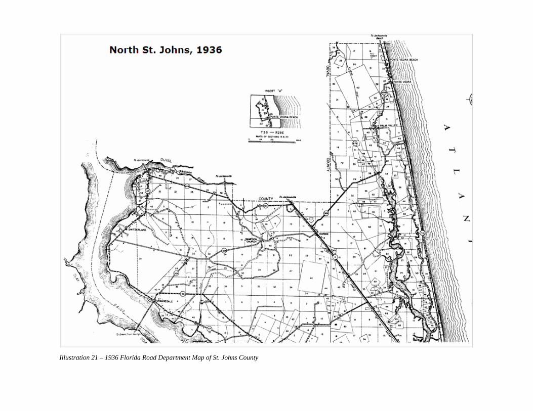
75Illustration 21 – 1936 Florida Road Department Map of St. Johns County

76
Illustration 22 – 1936 Florida Road Department Map of St. Johns County

77
THE COURSE OF THE KING’S ROAD IN CONTEMPORARY ST. JOHNS COUNTY The King’s Road was designed to connect Florida’s southern most settlement, New Smyrna with points north, particularly the Georgia Colony. It was built to provide a route for trade, new settlers, and, most importantly, cattle, one of Florida’s most important colonial products. The importance of cattle was embodied by the Cow Ford at present day Jacksonville, where livestock crossed on its way to northern markets. On the south side it connected with St. Augustine at the ferry crossing on the San Sebastian at King Ferry’s Way and Ferry Place and proceeded south-southwest to the Flagler County line at Pellicer Creek. On the north, it left the city at the northern defense line of the city defined in the Second Spanish Period by the Mil y Quienientas or Fifteen Hundred Yards at present day San Carlos Avenue. It then proceeded northwest along the San Sebastian River to the Pass of Navarro and then continued north to the Duval County line at Durbin Creek. The most authoritative source for the course of the King’s Road is the United States Government surveys of East Florida recorded during the 1830s, 1840s and 1850s. Consisting of township plats, surveys of Spanish land grants, and field notes, these records provide a measured course of the road that can be transposed to modern base maps. Beginning at the Duval County line, the King’s Road was located east of US Highway 1 and just south of Durbin Creek. Detailed maps of Duval County confirm this point where the road crossed the county line. For most of its course south to Nine Mile Road the King’s Road followed the course of the Old Dixie Highway, on the east side of US 1. From the county line the King’s Road proceeds south for about a half mile, before making a curve to the east, then crossing State Road 210 and then curving southwest to the site of Durbin Fire Tower. Half a mile pass the site of the tower, the road crosses the Old Dixie Highway and US 1 at the westerly approach to State Road 210 to the latter highway. The King’s Road continues on the west side of US 1 for about a mile before it again crosses US 1 bearing southeast and joins the Old Dixie Highway at Hilden. It then follows the course of the Old Dixie Highway to Nine Mile Road. At Nine Mile Road the King’s Road crosses US 1 and bears south between US 1 and Twelve Mile Swamp for about six miles. At a point west of State Road 16A, the course of the road becomes debatable. During the 1970s James R. Ward and Charles Coomes took different positions on the course and identity of the road from this point south. In 1973, Ward, a journalist, wrote in a series of articles in the Florida Times-Union that the King’s Road by-passed St. Augustine. Ward relied on United States Government Surveys and a1832 court case involving the Joseph Delespine Grant which showed the King’s Road heading south to intersect the Picolata Road. According to Ward, the King’s Road then proceeded on the west side of the San Sebastian River, bypassing St. Augustine, on its way to Moultrie Creek.157 Coomes, partly in response to Ward, focused his efforts on the road in the vicinity of St. Augustine. Coomes provided evidence that the King’s Road did indeed passed through St. Augustine. Although his research was not exhaustive, Coomes appears to have been closer to the truth. While no detailed mapping of the King’s Road was undertaken until the United States Government surveys of the 1830s, Spanish land grants north and west of St. Augustine 157 Florida Times-Union, December 18, 1973, page C-1.

78
documented the course of the road from the Pass of Navarro at State Road 16A along the east bank of the San Sebastian River into the north side of St. Augustine at San Carlos Avenue. The original Spanish survey in 1821 by Jorge Clark of the Delepsine Grant did not show the King’s Road crossing Red House Branch and proceeding south in the direction of the Picolata Road. William Gerard de Brahm’s survey of this area showed “The Path to Little Matance River” crossing Red House Branch in 1768. One can reasonably conclude that the “The Path to Little Matance River” was essentially abandoned from the Pass of Navarro to the ferry crossing southwest of St. Augustine when the King’s Road was constructed between 1772 and 1775. Contrary to Ward’s interpretation, the construction of the King’s Road did go directly through St. Augustine and in fact eliminated the need for the “by-pass” to the west. Historical evidence indicates the “King’s Road” shown on the 1832 survey was built in the general location of the “The Path to Little Matance River” about the time the United States Army built the bridge across the San Sebastian River at King Street in St. Augustine. A 1914 county map entitled “Plat of Lands Albert Lewis Estate” shows the “by-pass,” labeled the “Old Road to St. Augustine” as it passed through the Joseph Delespine Grant and crossing Redhouse Branch. The Redhouse Branch crossing shows the ruins of a burned bridge.158 From the ferry crossing in the vicinity of Ferry Place, the King’s Road followed the course of Old Spanish Trail across SR 207 and along Old Hastings Road to the vicinity of Dobb’s Road. From this point the King’s Road proceeded south, following closely the course of Dobbs Road, just east of the FEC Railroad line, to King’s Estate Road. North of the intersection of King’s Estate Road, in alignment with a County Road known as King’s Road, is a section of road identified in tax assessor’s maps as a portion of the King’s Road formally abandoned by county ordinance. From King’s Estate Road, the King’s Road follows the general course of a county road identified as the King’s Road to the vicinity of Moultrie Creek. The King’s Road then passed across Moultrie Creek and Wildwood Drive to a site identified on United States Government Plats as the site of Seminole War era Ft. Peyton in Section 11, T8S, R29E. South from the site of Ft. Peyton, developers have created an easement and linear park preserving a portion of the King’s Road to the site of the capture of Seminole Indian Chief Osceola, about a mile south, in Section 14. From the Osceola Capture Site the road proceeds southwest about a mile through undeveloped lands across Interstate 95 and the another three miles south to the line between Townships 8 South and 9 South at State Road 206. From State Road 206 the road proceeds south-southeast between a quarter and three quarters of a mile west of I-95 to Range Line 29E-30E. For about four miles it follows the general course of a graded road shown on various county road maps during the period between 1917 and 1926. About two miles north of Pellicer Creek, the King’s Road separates from the graded road and proceeds southeast about one-half mile to another graded road which it generally follows for about one mile to the FEC rail line. From the FEC rail line it proceeds a short distance to a point near the Old Midway Church site and across State Road 204 for about one-half mile to the crossing at Pellicer Creek and into Flagler County at the Hewitt’s Mill site.
158St. Johns County Map Book, 3 page 43.

With the exception of the environs of St. Augustine, the course of the King’s Road is remarkably intact. A portion of the road from Fairbanks Avenue, west of the FEC rail line, to Sebastian Way, south of the St. Johns County Administrative Center remains. From Lewis Speedway North to the Duval County Line, only a few sections of the road, where it crosses US 1 and the FEC Railway, have been lost to development. From the City of St. Augustine to King’s Estate Road north of Moultrie Creek, the road has been largely lost to development. From Moultrie Creek south to the sites of Ft. Peyton and the Osceola Capture Site, the road has been preserved through a private easement. From the Osceola Capture Site to the county line at Pellicer Creek the road passes through an area that remains largely undeveloped. This fact presents St. Johns County with a unique opportunity for preservation and promotion of the road.
Illustration 23 – The Site of Ft. Peyton south of Moultrie Creek near Wildwood Drive is one of the landmarks along the King’s Road
79

Illustration 24 – The capture of Seminole Chief Osceola south of Moultrie Creek was an important event associated with the King’s Road
80

81

CHAPTER TWO: THE HISTORY AND COURSE OF THE PABLO ROAD

82
THE PABLO ROAD DURING THE FIRST SPANISH PERIOD (1565-1763) The Pablo Road dates to First Spanish Period (1565-1763). The road connected St. Augustine with the St. Johns River in the vicinity of present day Pablo Creek and Mayport in Duval County. It was part of a continuous roadway that began at the Cubo Defense line, on the north side of the colonial city of St. Augustine, and extended north paralleling the west side of the North or Tolomato River. Upon reaching the headwaters of the North River, it crossed a ford and proceeded northeast to Ft. San Diego, an eighteenth century Spanish defense position which guarded the strategically important land bridge between the North River and Pablo Creek, a tidal creek located south of the St. Johns River. Because of its connection with Ft. San Diego and the Diego Plains, a well-known Spanish cattle ranching area, the road was often referred to as Diego Road or the Path to Diego. The road continued to Spanish sentinel posts and defense positions which guarded the mouth of Pablo Creek and the St. Johns River. There the road provided access to the St. Johns and the interior of Florida and nearby inland waterways which led to present day coastal Georgia and South Carolina. The Pablo Road was named for a place called Pablo or San Pablo Creek. The earliest date of the naming of the creek is unknown but likely occurred near the time of the establishment of St. Augustine in 1565. In 1564 present day St. Johns Bluff became the location of Ft. Caroline, the first French Colony in North America, and one of the first European-established settlements in what today is the continental United States. In 1565 the Spanish supplanted the French and replaced French places names such as Ft. Caroline with San Mateo. In about 1587 the Spanish established a mission named San Juan del Puerto on present day Ft. George Island. Over time the French Rivière du Mai or the May River, initially called Rio de Corrientes by the Spanish, became know as the Rio San Juan or St. Johns River for the Spanish mission at its mouth.1 Given its highly visible and strategic location, San Pablo or Pablo Creek, known in Spanish as Cano de San Pablo, was likely named for the Apostle Paul during this early period. Pablo Creek remains the name of the tidal creek that divides the Jacksonville beaches from the rest of Duval County. The municipality of Jacksonville Beach was originally known as Pablo Beach.
1Bonnie G. McEwan, Bonnie G., Ed. The Spanish Missions of La Florida. University Press of Florida, 1993 98, 330.

83Illustration 26 – Spanish Map Showing the Mouth of the St. Johns River and Pablo Creek on its south side

84
The precise date of the origin of the Pablo Road is unknown but the road likely followed a course tread by Florida’s indigenous people prior to the European contact period. A 1902 Map of Duval County shows the Pablo Road, inaccurately described as the King’s Road from St. Augustine, at a major shell mound near the mouth of Pablo Creek.2 The Spanish probably followed this trail as they developed a chain of missions and military posts along the inland waterways and barrier islands which extended from St. Augustine to Santa Elena on present day Parris Island, South Carolina. The Pablo Road might well have been used by Jonathan Dickinson, the Philadelphia Quaker and merchant, who was shipwrecked at Jupiter Inlet on September 23, 1696. Dickinson walked from St. Augustine to the St. Johns River at the beginning of December, 1796. On the second day he reached a sentinel post at the northernmost of three creeks near the mouth of the St. Johns River. The next day he and his fellow shipwreck survivors crossed to San Juan del Puerto on Ft. George Island before continuing their journey to the English settlement of Charleston.3 Approximately six years later, an unknown Spanish cartographer documented the sentinel post and Cano de San Pablo following the 1702 attack of Governor John Moore and his fellow South Carolinian against Spanish Florida. The sentinel post was located on the east side of the creek near present day Mayport. A road is shown leading from the mouth of the river south toward St. Augustine. Fort Piribiriba and two Indian towns which it protected were located adjacent the St. Johns on the west side of Pablo Creek.4 The earliest documentation of the full extent of the Pablo Road dates to 1736. In March, 1736 General James Oglethorpe and Creek Indian allies sailed from Savannah down the inland passage to the north side of the St. Johns River. Upon reaching the St. Johns, they found Spanish sentinel posts at the mouth of the St. Johns River and at Pablo Creek, likely at or near the sentinel post shown on the c. 1702 Spanish map.5 In May, 1740 Oglethorpe returned to the St. Johns and camped near the mouth of Pablo Creek. From there Oglethorpe sent a detachment of troops to Ft. San Diego, a strategic point and long standing landmark along the road between Pablo Creek and St. Augustine. Near the fort was the ranch of Diego Espinosa, who owned significant numbers of horse and cattle. Oglethorpe’s forces captured the fort and its garrison before proceeding with their attack on St. Augustine.6 A sketch map prepared at the time of the Oglethorpe attack documented the course of the road as it proceeded from Oglethorpe’s camp at Pablo Creek to Ft. San Diego. Ft. San Diego was later documented as being located in a Spanish land grant to Andres Papy (T6S, R29E, Section 42) From Ft. San Diego the road passed near the headwaters of the North River and continued south paralleling the course of the river to St. Augustine.7
2 1902 Map of Duval County 3 Ward, Old Hickory’s Town, 52; 1902 “Duval County Map.” 4 Ibid., 53 5 Ibid, 54 6 Ibid, 60 7 Ibid., 54

Illustration 27 – 1740 Oglethorpe Map showing road from Pablo and Ft. San Diego to St. Augustine
North of the colonial city of St. Augustine the road which led to Pablo Creek passed through a series of defense works and small agricultural developments in what today is known as the North City area of St. Augustine. The North City area is the location of significant pre-historic and historic period archaeological sites. The Fountain of Youth west of Magnolia Avenue in the Williams Addition and Fountain of Youth subdivisions contains both aboriginal and 16th century historic sites. Two Spanish missions, La Leche and La Costa, were located in what today is the Abbott Tract Subdivision. Limited agriculture occurred in the area with the principal development located near the banks of Macariz or Hospital Creek in the vicinity of what today is the campus of the Florida School for the Deaf and Blind and Nelmar Terrace and Fullerwood subdivisions. At this location settlers from the Canary Islands established an agricultural community during the last years of the First Spanish Period (1565-1763).8 During the colonial period, the area in North City accessed by the Pablo Road was primarily used as a defense perimeter. The defense perimeter protected the only land bridge from points north accessed by the road to Pablo Creek to the peninsula where the presidio or fortified town of St. Augustine was located. The establishment of the English colony of South Carolina in the late 17th century intensified development of the northern defenses of the city. The effort began with the completion of the coquina stone Castillo de San Marcos in 1692 at the southern boundary of the area.9 Following the attack of Colonel James Moore from South Carolina in 1702 the Spanish developed the area north of the Castillo de San Marcos as a well-designed 8Adams, Nolan, Scardaville, Steinbach and Weaver, “Historic Sites and Buildings Survey of St. Augustine, Florida.” October, 1980, 19-21; Pablo Castello, “Plano del Presidio de San Agustin de la Florida, y sus contornos.” July 21, 1763.
859 Adams, et al, “Historic Sites and Buildings Survey,” 21.

86
defense perimeter. The Cubo Line, completed in 1704 and located just north of present day Orange Street, extended from the Castillo to the St. Sebastian River. The Hornabeque or Hornwork, an earthenwork defense line, was completed in 1719. It extended from a cove at the Mission Nombre de Dios property west in the vicinity of Cincinnati and Rohde avenues to the St. Sebastian River.10 The Hornwork provided protection for the La Costa and La Leche missions, where displaced Creek Indians settled in the present day Abbott Tract. The La Leche village included a coquina chapel near the northern end of Water Street. The Mission Indians abandoned their land and St. Augustine in 1763 when the British acquired Florida. Farther to the north the road to Pablo Creek passed near Gracia Real de Santa Teresa de Mose also known as Fort Mose. Fort Mose was completed in 1738 near the northern city limits of St. Augustine on the marshes of North River. Now a state park and well-documented archaeological site, it was the location of the earliest documented free black settlement in the United States. The Mose defense line was completed in 1762 and extended diagonally from Fort Mose to the St. Sebastian River just north of State Road 16 at McMillan Avenue.11 At the river crossing on the Sebastian, the Spanish constructed a fortification known as the Estacada de las Dos Millas or Two Mile Stockade. The Two Mile Stockade eventually became part of the Eliza Robinson Grant and later Fairbanks Plantation during the antebellum era and today is located in the Florida East Coast Right-of-Way west of McMillan Subdivision.12
The road from Pablo Creek north of the colonial city of St. Augustine is documented in several maps drawn during the last years of the First Spanish Period. The1762 Jeffrey Map shows the road as the “Road to the St. Johns.”13 A much larger scale, more detailed 1763 map by Spanish engineer Pablo Castello shows the road leading from the Hornwork defense line to the Mose line. From the Mose Defense Line the road led north toward Indian Creek on the south side of what today is the St. Augustine Airport. Based on these maps the road to Pablo Creek followed the approximate course of San Marco Avenue. Although precise maps and surveys of the course of the road are lacking during the First Spanish Period, the available documentation indicates that the general course of the road between St. Augustine and Pablo Creek seemed to have been shaped by swamps, rivers, ridges and other natural features. The course of the road would become clearer in subsequent periods, when more comprehensive, better quality mapping and surveying techniques became available.
10Ibid., 20-21. 11Adams, et al, “Historic Sites and Buildings Survey,” 21, 35; Jane Landers, “Fort Mose, Gracia Real de Santa Teresa de Mose: A Free Black Town in Spanish Colonial Florida,” 1992, St. Augustine, 3-4. 12. Eliza Robinson Grant, Page 1 of 30 of Dossier, Box: 28, Folder 1, Pages 7,9,12,16, and 19. 13 Jeffreys Map, 1762
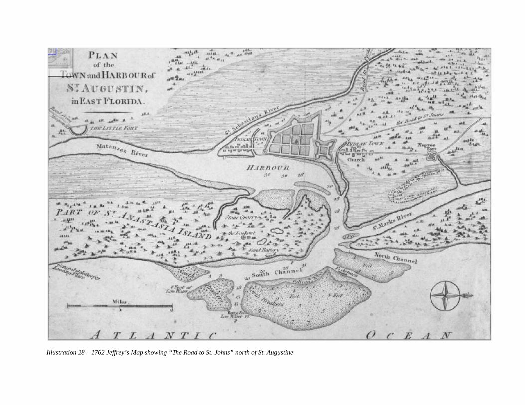
87Illustration 28 – 1762 Jeffrey’s Map showing “The Road to St. Johns” north of St. Augustine

THE PABLO ROAD DURING THE BRITISH PERIOD (1763-1784) In 1763 the British acquired East Florida under terms of the Treaty of Paris. The course of the road to Pablo Creek is better documented, although not to the level it would become in subsequent periods. A 1765 British Period map, although limited in area, shows the road in the northern part of St. Augustine. The map entitled Plan of the land between Fort Mossy (Mose) and St. Augustine is important because it shows the Pablo Road, a little more than a year after the British gained sovereignty over Florida, before they were able to make substantial physical changes to East Florida.14 The 1765 British period map shows the area between the Hornabeque and the Mose defense line as cleared fields with a road following the course of present day San Marco Avenue heading north. The area between the Cubo Line and the Hornabeque was a clear field of fire without agricultural or other improvements. A small trail ran from the city gates to the center of the Hornabeque. From the Hornabeque north, running a distance of 1.5 to 2 miles, was a road to the Ft. Mose defense line. As the road left the Ft. Mose defense line it was labeled as the “Road to the St. Johns” on the map.
88
Illustration 29 – 1765 Map showing the Pablo Road labeled “Road to the St. Johns” at the Mose Defense line
141765, Plan of the land between Fort Mossy (Mose) and St. Augustine, East Florida, Florida Photo. Archives.

89
The authoritative map for the general course of the Pablo Road during the British Period is William Gerard De Brahm’s 1769 map of East Florida.15 The De Brahm map of East Florida showed the course of a road north of the colonial city of St. Augustine, often attributed to be the King’s Road. The road was labeled the “Path to the Cow Ford,” located at what today is downtown Jacksonville.16 Charles Coomes traced William Gerard De Brahm’s 1768 “Path to the Cow Ford” on a USGS 7.5 Minute Topographic Map for the St. Augustine Quadrangle.17 Coomes projection, labeled as San Carlos Avenue, actually begins at the Hornabeque or Hornwork in the vicinity of Cincinnati and Rohde avenues. From the starting point at the Hornabeque, the “Path to the Cow Ford” proceeded north along present day San Marco Avenue to its intersection with U.S. Highway 1. The “Path to the Cow Ford” then proceeded north on the west side of the highway and the Florida East Coast Railroad line to a point opposite the St. Augustine Airport, about five miles north of the colonial city. At this point the Path to the Cow Ford took a sharp turn almost 90 degrees west and crossed the headwaters of the San Sebastian River. This crossing was still evident on a 1944 USGS quadrangle of St. Augustine.18 North of the crossing five mile north of St. Augustine De Brahm showed the “Path to the Cow Ford” running parallel to a feature labeled as Nine Mile Swamp on the De Brahm Map. The map shows a road branching from the “Path to the Cow Ford” in the vicinity of Nine Mile Swamp (Twelve Mile Swamp on subsequent maps) and heading northeast. This road was labeled the Path to Diego. The Path to Diego was identified in subsequent historic periods as the Pablo Road. The branch road was located west of a place labeled Rich Mount, likely Marshall Creek.19 Proceeding northeast the road crosses a creek in the vicinity of what today is Sweetwater Branch. Bodies of water labeled Oak and Hickory Branches are located to the east. The road then bears northeast through lands of Nowland and the vicinity of lands belonging to Nowland.20 The De Brahm map clearly shows the course of a Spanish Road from the Hornabeque to the Path to Diego and to Diego itself. The “Path to the Cow Ford” matches exactly the course of the “Road to the St. Johns” shown on the 1765 map from the Hornabeque to north of the Mose Defense Line. While work was done on a road between St. Augustine and the Georgia border about 1766, its path was never documented. The construction of the King’s Road was clearly done between 1772 and 1775, some years after the De Brahm map and survey.21 Cattle ranches are known to have existed in the areas served by the roads shown on the De Brahm Map. Francis Xavier Sanchez, Manuel Solana, and Sebastian Espinosa all had long-established cattle ranches, many of them on the Diego Plains in present day Palm Valley. These ranches also included the Capuaca grant and plantation owned by the Sanchez family north of St. Augustine where
15Ward, Old Hickory’s Town, 76; de Brahm Map, 1769 located at SAHS. 16Ward, Old Hickory’s Town, 76; Florida Memory Project, Spanish Land Grants in Florida Joseph Delespine Grant, Page 82 to 113, Box: 10, Folder 8, Page 1-31 Pages 3,5. 17Coomes, “The King’s Road of British East Florida.” 50-51. 18 1944 USGS quadrangle of St. Augustine 19 de Brahm Map, 1769 located at SAHS. 20Ward, Old Hickory’s Town, 76; de Brahm Map, 1769 located at SAHS. 21 Coomes, “The King’s Road of British East Florida.” 38.

90
Araquay Subdivision and the former Ponce de Leon Golf Course site are located. The San Diego area was accessed by the “Path to Diego” shown on the De Brahm Map.22 The road from the Hornabeque to the point five miles north of St. Augustine is shown as a Spanish road on maps dating from 1765 and before.23 Furthermore, Spanish land grant records and United States Government survey records show this road is almost identical to the course of the Capuaca-Pablo-Araquay Road which followed a course distinct from the King’s Road. Surveys of Spanish land grants to Eliza Robinson (T7S, R30, Section 55) and Joseph Delespine (T6S, R29E, Section 81) identify this road as the Lower Road. The “Path to the Cow Ford” north and west of the point five miles north of St. Augustine was likely incorporated into the King’s Road when it was constructed between 1772 and 1775.24 The 1765 map and other maps from the First Spanish period and the British Period prior to 1772 are important in that they document the location and presence of the road to Pablo Creek and the mouth of the St. Johns River prior to the construction of the King’s Road. Once the King’s Road was constructed there became confusion about the course and identity of it and the Pablo Road, . a confusion that persists to this day. There can be no doubt, however, that the Pablo Road pre-dated the King’s Road. The purpose of the Pablo Road was to connect St. Augustine by land with missions, military posts, and cattle ranches north to the mouth of the St. Johns River, a purpose that clearly pre-dated the arrival of the British and the construction of the King’s Road. The purpose of the King’s Road was to connect East Florida with the British colonies to the north, a purpose that post-dated the First Spanish Period.25
22November 6, 179451 doc 1794-941-doc32San Vizente Carlos Howard to Juan Nepomuceno de Quesada October 31, 1807141 1807-171St. Augustine Francisco Xavier Sanchez testamentary proceedings 23 Jeffreys Map, 1762. 1765, Plan of the land between Fort Mossy (Mose) and St. Augustine, East Florida, Florida Photo. Archives. 24Coomes, “The King’s Road of British East Florida.” 67; Florida Memory Project, Spanish Land Grants in Florida Joseph Delespine Grant, Page 82 to 113, Box: 10, Folder 8, Page 1-31 Pages 3,5. Eliza Robinson Grant, Page 1 of 30 of Dossier, Box: 28, Folder 1, Pages 7,9,12,16, and 19. 25Adams, et al, “Historic Sites and Buildings Survey,” 21; “Plan of the land between Fort Mossy (Mose) and Saint Augustine” 1765, Florida State Archives.

91
THE PABLO ROAD DURING THE SECOND SPANISH PERIOD (1784-1821) Historical Background The first comprehensive, authoritative records documenting the full course of the Pablo Road date to the Second Spanish Period. The most important of these are Spanish land grant records. Starting in 1790, Spain offered land grants to encourage settlement in the province of East Florida. Spanish land grant records from this period provide a description of land granted; dates of grant; size of grant; boundaries; proof of occupancy, improvements and cultivation, surveys; copies of royal grants; testimonials; correspondence; deeds; and wills. Through the Adams-Onis Treaty of 1819, the United States agreed to confirm title to any validly held Spanish land grants. After the United State Government assumed sovereignty over Florida in 1821, former Spanish subjects and new settlers with purported title filed claims with the United States government in order to prove validity of land ownership. Applicants proved validity through written documentation, surveys and testimony. Beginning in 1823, the Board of Land Commissioners of East Florida accepted these records and supplemented Spanish records with formal petitions, translations of Spanish documents, surveys, and other documents produced by the Board, United States surveyors, and other federal authorities. All records were incorporated into dossiers for each claim. The Board, federal courts or the United States Congress eventually either confirmed or denied each individual claim. Custodianship of these records was give to the State of Florida in 1845.26 In 1907, a state law directed the Commissioner of Agriculture of the State of Florida to take charge of all field notes, surveys, maps, plats, papers, and records, a part of which were those pertaining to Spanish land grants, and created the Field Note Division as depository. In 1942, the WPA’s Florida Historical Records Survey published Spanish Land Grants in Florida, a five volume transcription and abstraction of grants, including a history of the creation, use, and preservation of the Spanish land system and records. The original Spanish Land Grant records in Florida are currently held by the Florida State Archives in Tallahassee.27
Valid Spanish land grants in St. Johns County were surveyed by United States government surveyors between 1834 and 1853. Spanish land grants are easily recognized by their numbers (37 or higher) and their irregular, organic form in contrast to the regular, symmetrical, square form of the United State Government Survey System. The irregular form of Spanish land grants was an important factor in documenting the location of the Pablo Road in that the Spanish used primarily a monument system of surveying rather than the regular measures of the United States Survey method. The system employed as survey boundaries natural and man-made features such as lakes, rivers, creeks and bodies of water or man-made features such as fences, ditches, canals, or roads. Such features are permanent and considered by surveyors and courts to be more authoritative than survey measurements which are subject to human error. The Pablo Road under various names was used as a boundary for many Spanish land grants between St. Augustine and the St. Johns River near Mayport. These boundaries provide information about the specific and
26 Florida Memory Project, Spanish Land Grants in Florida. www.floridamemory.com 27 Ibid.

92
general course of the road during the years between 1790 and 1821. Some grants even originated in the British Period and include information about the road during the years prior to 1784. Where the boundaries were incorporated into the United State Government Township Plats, field notes and surveys of individual grants a permanent authoritative location of the road as it existed from 1790 through the 1850s was created. General Course of the Pablo Road from St. Augustine to the St. Johns River near Mayport A c. 1817 sketch map given to General Andrew Jackson gives the general course of the Pablo Road north of St. Augustine during the Second Spanish Period. While not precise, the map shows the road in relation to certain landmarks which indicate the road followed a consistent general course. On the c. 1817 sketch map a road is shown leading north from Ft. St. Marks (the Castillo de San Marcos). This would be the Mil y Quinientas Road which led from the Cubo Line at Orange Street to San Carlos Avenue. From the Mil y Quinientas Road a single road leads north connecting with a road crossing the St. Sebastian in the vicinity of what today is Lewis Speedway Road. This shows the course of the King’s Road. In the vicinity of Nine Mile Road the Pablo Road is shown proceeding north and separating form a road labeled the King’s Road to Cow Ford. The road then proceeded north paralleling the North River. It crossed the North River at its headwaters, just north of a place named North River Landing, likely what is know today as Spanish Landing. The road proceeded north from the headwaters of the North River on the east side of Pablo Creek. It passed east of a place labeled Bisset’s Landing on Pablo Creek and ends on the map at a place labeled as Don Bartolome’s. This would be Don Bartolome de Castro y Ferrer Grant at what was known as San Pablo Plantation.28 A survey of the Bartolome de Castro y Ferrer Grant shows the road passing north through the grant toward the mouth of Pablo Creek near the entrance of the St. Johns River.29 No name is given the road on the c. 1817 map. However, Spanish land grants from the northern limits of the colonial city of St. Augustine to the mouth of the St. Johns River show a continuous road following this general course, know by a variety of names. These names were associated with the places, plantations and geographic features through which the road passed. North of San Carlos Avenue, at the colonial limits of the City of St. Augustine, the road was primarily known as the Capuaca Road and secondarily as the Moses Road. These names were given for the Capuaca (Araquay Subdivision/old St. Augustine Golf Links and Moses Plantation (site of Ft. Mose) north of St. Augustine. At the Capuaca Plantation, the road was called the Pablo Road, for its ultimate destination of the Pablo area in the vicinity of the mouth of the St. Johns River. Between the Capuaca Plantation and the Araquay Plantation, approximately eight miles north of St. Augustine on the North River at Araquay Creek, the name Pablo Road was interchangeable with Araquay Road. A branch of the road appears to have crossed a colonial bridge at Araquay Creek. Farther north the road branched to the Araquay Plantation, a grant confirmed to Antonio
28Ward, Old Hickory’s Town, p. 104; Manuscript Map of the Coast of Florida from Little Cumberland Island to the South Lagoon, Enclosed with Jackson to Adams, October 4, 1821, Parker #1327 after 1817 held St. Augustine Historical Society Library. 29Florida Memory Project, Spanish Land Grants in Florida Bartolome Castro y Ferrer Grant, Page 1 of 26 Box: 7, Folder 7, Page 20, 23.

93
Hindsman (T6S, R29E, Section 49). This branch of the road was known as the Diego Road, for the place name Diego just north of the headwaters of the North River. The Diego Road crossed Marshall Creek in the vicinity of Spanish land grants confirmed to Juana Paredes, James Andreu, Clara Andreu before entering the Roque Leonardi Grant. The Pablo Road paralleled the Diego Road as it proceeded north through a large grant to Pablo Sabate. North of the Sabate Grant it briefly intersected the King’s Road in the Reuben Charles Grant just south of present day Nine Mile Road. The Pablo Road then headed northeast and entered the Roque Leonardi Grant. In the Roque Leonardi Grant at Sweetwater Branch, the Pablo Road again joined the Diego Road. From Sweetwater Branch north to Diego, in the Andres Papy Grant (Township 4S, Range 29E, Section 42), the names Diego and Pablo were interchangeable. North of Diego, the road was consistently called the Pablo Road on historic maps and documents as it extends through what today are the municipalities of Jacksonville Beach, Neptune Beach and Atlantic Beach and terminates in the vicinity of Mayport. The Pablo Road follows the general course of Penman Road and the northern portion of Mayport Road and remains a major north-south thoroughfare through the beach communities of Duval County.
A less general but more accurate map, the “1819, Plan of St. Augustine, by Birch” shows the Pablo Road proceeding from the colonial city north toward the St. Johns River.30 This map is the earliest documented reference to the Pablo Road found in the course of researching this study. The configuration of roads on the map is consistent with that further documented by Spanish land grant claims and United States Government land office records. The Birch map shows two branches of the Pablo Road. The first follows the course of the Mil Y Quinientas-Capuaca-Moses Road as documented in Spanish land grants records. The second branch began at the Stockade, north of State Road 16, and proceeded north from the old Fort Mose defense line until it intersected the other branch of the Pablo Road in the Capuaca Grant of Jose Simeon Sanchez. At the Stockade, the King’s Road, labeled the “Road to Cowford on the St. Johns,” branched northwest following the course of the St. Sebastian River. The course of the second branch of the Pablo Road and the King’s Road were also corroborated by Spanish land grants.
30“1819, Plan of St. Augustine, by Birch,” This 9.84inx15.55in map includes coastline, coastal features, navigational hazards, soundings, an anchorage, a grid of the city, fortifications, roads, plantations, and pictorial representation of vegetation and marshland. Notes on map refer to fields, orange groves, and to types of trees. Map is oriented with West at top.

94Illustration 30 – 1819 Birch Map showing branches of Pablo Road and King’s Road described as Road to Cowford on the St. Johns

95
Specific Course of the Pablo Road from St. Augustine to the St. Johns River near Mayport After 1784, when they reacquired Florida and re-occupied St. Augustine, the Spanish revamped the defenses north of the colonial city. They abandoned the Hornabeque, which was in ruinous condition, and designed a new defense perimeter know as the Mil y Quinientas or 1,500 varas (Spanish yards). The Mil y Quinientas extended from the Cubo Line at the northern boundary of the colonial City of St. Augustine to the approximate location of San Carlos Avenue. It represented the range of cannon fire from the Castillo de San Marcos and measured approximately one-mile. The Spanish issued land grants in this area with the requirement that the grantees grow only low lying crops, build only temporary structures, and keep the area clear of trees and dense undergrowth. Grants were typically three to five acres and located on both sides of the Mil y Quinientas Road, know today as San Marco Avenue.31 The Mil y Quinientas Road began at the City Gates at the Cubo Line and merged with the “Road to the St. Johns,” shown on the 1765 map of the area north of colonial city, where the Hornabeque Line once existed. It then continued to the northern line of the Mil y Quinientas at what today is the intersection of San Marco and San Carlos avenues. A continuous road to the area known as Pablo at the mouth of the St. Johns River began at the end of Mil y Quinientas at San Carlos and San Marcos avenues. The road followed the course of the“Road to the St. Johns” shown on the 1765 of the area between the colonial city and Ft. Mose map. The road, from the Mil y Quinientas to the Mose Defense Line, was most commonly called the Road to Capuaca or Moses, although the “1819, Plan of St. Augustine, by Birch” refers to it as the “Road to Pablo.” The Capuaca Road led to a plantation and Spanish land grant confirmed to Joseph S. (Jose Simeon) Sanchez, a member of one of Florida’s cattle ranching families, between the northern limits of the city and Indian Creek in what today is the Araquay neighborhood. According to Spanish land grant documents and United States Government surveys, the Capuaca Road, with the exception of the “1819, Plan of St. Augustine, by Birch,” began being called the Pablo Road north of the old Mose Defense Line. A short distance from the Mil y Quinientas at San Carlos Avenue, on the north boundary of the last of three grants to Gabriel W. Perpall, an old road left the Capuaca Road and headed due west. According to Charles Coomes the old road was located at present day Waldo Street.32 On the west side of the Perpall Grant was the St. Nicholas-San Diego Road. The old road connected the Capuaca Road and the Diego Road, which continued due north to the Stockade at the southwest corner of the Eliza Robinson Grant. The old road is shown on the 1765 map connecting the “Road to the St. Johns” with the Stockade at the southwest corner of the Ft. Mose Defense Line. At the point where the old road from the Capuaca joined the St. Nicholas Road, the road is referred to in the Perpall land grant documentation as the St. Nicholas-Diego Road. At the Stockade or the southwest corner of the Eliza Robinson Grant, the St. Nicholas or King’s Road branched northwest following the east
31Adams, et al, “Historic Sites and Buildings Survey,” 22-24; Michael C. Scardaville, “Abbott Tract Historic District,” 1980, n.p. 32 Coomes, “The King’s Road of British East Florida,” p. 61.

96
s of St. Augustine.
shoreline of the San Sebastian River.33 The Pablo Road, which connected with the Capuaca Road by the Old Road, is first called by this name at the Stockade at the west side of the Robinson Grant. From the southwest corner of the Robinson Grant, the Pablo Road proceeded north along the west boundary of the Robinson Grant and the west boundary of the Joseph S. Sanchez Grant (T7S, R29E, Section 50).34 The Capuaca Road joined the Pablo Road in the Joseph S. Sanchez Grant, north of the Mose Line, in the vicinity of what today is US Highway 1 North and Ponce Island Drive at the entrance to the old Ponce de Leon Motor Lodge near the northern city limit The precise location of the Pablo Road north of St. Augustine from San Carlos Avenue to the Duval County line is further described in abstracts of individual grants listed below. Capuaca Road W. Side Joseph Sanchez Grant, Section 50, T7S, R30E (San Marco Avenue from San Carlos Avenue to Alfred Street, St. Augustine) At the end of the Mil y Quinientas Road, the road to Pablo formed the west boundary of a grant to Joseph M. Sanchez, at what today is the intersection of San Marco and San Carlos avenues. The Sanchez Grant covered approximately twelve acres and forms much of what today is Nelmar Terrace Subdivision. The road at the Joseph Sanchez Grant was described by various names as it passed through land grants and places to the St Johns River to the north. An undated c. 1819 Spanish survey of the grant describes the road as the road to Capuaca. On the letter giving title to the grant on January 11, 1808, the road is described as the Camino Real or Royal Road to Moses or Capuaca. On his petition to the United States Government Joseph M. Sanchez described the Pablo Road as the main road to Moses and Capuaca. United States Government Surveyors Benjamin and J.B. Clements surveyed the grant in May, 1836 and recorded it as Section 50, T7S, R30E. They described it as being as being located at the northern limit of the City of St. Augustine on the Capuaca Road. Moses referred to the portion of the road as it passed through the vicinity of Ft. Mose and the Mose Defense Line. The Capuaca Road described a portion of the road north of St. Augustine as it passed through the Capuaca Grant also belonging to Joseph S. Sanchez. 35
33 Florida Memory Project, Spanish Land Grants in Florida Gabriel W. Perpall Grant, pages 253 to 286 of Dossier, Box: 26, Folder 10, Pages 4,6. 34 Ibid. 35Florida Memory Collection, Spanish Land Grants, Joseph Sanchez Claim, Page 2 of 25 Box: 29, Folder 15, Page 2,4,6, and 8.

Illustration 31 – Joseph Sanchez Grant
97

98
Capuaca Road W. Side John Gianopoly Grant, Section 55, T7S, R30E (San Marco Avenue from Alfred Street to Macariz Street, St. Augustine) North of the Joseph Sanchez Grant on the east side of the road to Pablo was the John Gianopoly Grant. The Gianopoly Grant forms what today is the Gianopoly Tract Subdivision of the City of St. Augustine and the campus of the Florida School for the Deaf and Blind. In a Spanish royal sale to Gianopoly on June 25, 1821, the grant is described as bounded on the west by the Capuaca Road36 In his petition for title in 1823, Gianopoly described the grant as being bounded on the west by the public road. A private survey that same year gave a similar description. United States Government Surveyors Benjamin and J.B. Clements surveyed the grant in May, 1836 and recorded it as Section 55, T7S, R30E. They described it as being located north of the City of St. Augustine. Although the Capuaca Road or public road is not mentioned, in the survey the west boundary appears to follow the course of the road. The northwest corner of the grant is described in the Montero Grant to the north as being a point on the Capuaca Road.37 Capuaca Road W. Side Antonio Montero Grant, Section 48, T7S, R30E (San Marco Avenue from Macariz Street to Robinson Creek, St. Augustine) North of the John Gianopoly Grant on the east side of the road to Pablo was the Antonio Montero Grant. The cover of the land grant dossier describes the grant as being on the road to Capuaca. Governor Enrique White confirmed the grant to Montero on January 23, 1808, describing the road as being bounded on the west by the Capuaca Road. An 1809 Spanish survey by Juan Purcell shows the road, described as the road to Moses, as being on the west side of the grant. In their petition for title in 1823, the heirs of Montero described the grant as being bounded on the west by the road to Capuaca. A private survey that same year gave a similar description. United States Government Surveyors Benjamin and J.B. Clements surveyed the grant in May, 1836 and recorded it as Section 48, T7S, R30E. They described it as being located north of the City of St. Augustine and east of the Capuaca Road. The Capuaca Road is referenced in the survey as being the west boundary of the grant. The course of the road is given in the field notes.38
36Florida Memory Project, Spanish Land Grants in Florida, John Gianopoly Grant, Pages 31-64 of dossier, Box: 15, Folder 13, Page 11, 15, 19, 20, 28-29. 37Florida Memory Project, Spanish Land Grants in Florida John Gianopoly Grant, Pages 31-64 of dossier, Box: 15, Folder 13, Page 11, 15, 19, 20, 28-29; Antonio Montero Grant, Pages 1-31 of dossier| Box: 24, Folder 11, Page 3. 38Antonio Montero Grant, pages 1-31 of dossier| Box: 24, Folder 11, Pages 2,3,8,9,16,22,26,30.

99Illustration 32 – 1823 Gianopoly Grant survey showing the Pablo Road aka Public Road now San Marco Ave.

Illustration 33 – 1823 Montero Grant survey showing the Pablo Road aka Public Road now San Marco Ave.
100

101
Capuaca Road E. Side Gabriel W. Perpall Grant, Section 45, 46, 47, T7S, R30E (San Marco Avenue from San Carlos Avenue to Waldo Street, St. Augustine); Pablo-Diego Road west side of Gabriel W. Perpall Grant, Section 45. North of the Mil y Quinientas on the west side of the road to Pablo were three Spanish land grants confirmed to Gabriel W. Perpall. The first grant (Section 47) was opposite the Joseph Sanchez Grant at the northwest corner of the Mil y Quinientas. In his 1823 petition for confirmation of the claim, Perpall described the grant as being bounded on the east by the Capuaca Road and on the south and west by the St. Nicholas Road which led to present day Jacksonville and ran along the shore of the St. Sebastian River. No Spanish or United States government surveys were entered in evidence in support of the claim.39 The second grant to Gabriel W. Perpall (Section 46) was north of and contiguous with the first. In a February 5, 1805 petition for royal title, the east boundary of the second Perpall Grant was described as the Camino Real to Capuaca. In 1819 a survey was prepared by Andres Burgevin, describing the grant as being between the Ferry River (St. Sebastian) and the road to Capuaca. The survey is referenced in the dossier but is not included. A survey prepared by Burgevin for the northernmost of the three Perpall Grants (Section 45) in 1820 shows the road on the west as leading to San Nicholas or San Diego. An 1834 Certificate of the Claim by the Keeper of the Public Archive described the grant as being bounded on the east by the Capuaca Road. The certification contains field notes with survey calls of the boundary as it follows the west side of the Capuaca Road. No United States government surveys were entered in evidence in support of the claim.40 The third grant to Gabriel W. Perpall (Section 45) was north and contiguous with the second. In an1800 petition for royal title, the east boundary of the third Perpall Grant was described as the road to the Capuaca Hacienda. An 1820 survey prepared by Andres Burgevin described the road as being between the Ferry River (St. Sebastian) and the road to Capuaca. The survey shows the Camino Real or royal road to Capuaca on the east side of the grant. On the north is the old road that leaves the Capuaca Road. According to Charles Coomes, this is Waldo Street. On the west side of the grant is the St. Nicholas or San Diego Road. This is the first reference to San Diego or Pablo in Second Spanish Period documentation. Perpall’s 1823 petition for confirmation of the claim contains a similar description. An 1834 Certificate of the Claim by the Keeper of the Public Archive described the grant as being bounded on the east by the Capuaca Road. The certification contains field notes with survey calls of the boundary as it follows the west side of the Capuaca Road. No United States government surveys were entered in evidence in support of the claim.41
39Florida Memory Project, Spanish Land Grants in Florida Gabriel W. Perpall Grant, 328 to 342 of Dossier, Box: 26, Folder 13, Pages 3,10,14. 40Florida Memory Project, Spanish Land Grants in Florida Gabriel W. Perpall Grant, pages 253 to 286 of Dossier, Box: 26, Folder 10, Pages 3,4,6,8,9,13,19,34. 41Florida Memory Project, Spanish Land Grants in Florida Gabriel W. Perpall Grant, pages 253 to 286 of Dossier, Box: 26, Folder 10, Pages 3,4,6,8,9,13,19,34.

102Illustration 34 – 1820 Perpall Grant survey showing the Pablo Road aka Capuaca Road now San Marco Ave.

103
Capuaca Road E. Side Pedro Estopa Grant, Section 44, T7S, R30E (San Marco Avenue at Waldo Street to McMillan Street, St. Augustine) North of the third grant to Gabriel W. Perpall (Section 45) was a grant to Pedro Estopa (Section 44), described in the cover for confirmation as the Stockade. In a 1793 petition for royal title, the grant was described as being located at the Crossing (of the St. Sebastian River), 1 ¾ miles north of St. Augustine. In 1823 a private survey described the grant as being bounded on the east by the public road, south by the Perpall Grant, west by the St. Sebastian River and north by the Robinson Grant. Estopa’s c. 1823 petition for confirmation of the claim and a United States government survey by Benjamin and J.B. Clements contain similar descriptions.42 Capuaca Road W. Side John Segui Grant, Section 51, T7S, R30E (San Marco Avenue vicinity of Macariz Street, St. Augustine The John Segui Grant was a former British Grant that was in the possession of Segui from end of the British period in 1783 until confirmed by Spanish Governor Enrique White on December 1, 1806. No boundaries of the grant are given in the Spanish records. United States Government Surveyors Benjamin and J.B. Clements surveyed the grant in May, 1836 and recorded it as Section 51, T7S, R30E. The Capuaca Road is referenced in the survey as being the west boundary of the grant. The course of the road is given in the field notes.43 Capuaca Road W. Side Francisco Fusha Grant, Section 52, T7S, R30E (San Marco Avenue north of Picolata Road, St. Augustine) North of the John Segui Grant was a small, seven acre grant of Pedro Fusha. A memorial in May, 1804 describe the grant as being bounded on the west by the Camino Real. An 1834 Certificate of the Claim by the Keeper of the Public Archive described the grant as being bounded on the west by the Capuaca Road. United States Government Surveyors Benjamin and J.B. Clements surveyed the grant in May, 1836 and recorded it as Section 48, T7S, R30E.44 Capuaca Road W. Side Joseph Baya Grant, Section 56, T7S, R30E (San Marco Avenue vicinity of north city limits/Ft. Mose, St. Augustine) North of the Macariz area grants on the east side of the Pablo Road two miles north of St. Augustine was a 118 acre grant to Joseph Baya at Mose. The Baya Grant contained the site of the free black settlement of Mose, and thus was given the place name. Baya’s 1823 petition for confirmation of the claim describes the grant as being bound on the west by the public road. United States Government Surveyors Benjamin and J.B. Clements surveyed the grant in May, 1836 and recorded it as Section 56, T7S, R30E. The Capuaca Road is referenced in the survey as being the west boundary of the grant. The course of the road is given in the field notes.45
42Florida Memory, Spanish Land Grants, Pedro Estopa Grant, pages 1-18, Box: 11, Folder 14, Page 2-4, 9, 13, 17. 43Florida Memory, Spanish Land Grants John Segui Grant, pages 28 of 47, Box: 30, Folder 9, Pages 29,30,33. 44Florida Memory, Spanish Land Grants, Pedro Fusha Grant, pages 1-21, Box: 14, Folder 17, Page 5, 9, 13. 45Florida Memory Project, Spanish Land Grants in Florida Joseph Baya Grant, Page 1 of 8 of Dossier, Box: 3, Folder 25, Pages 3, 8.

104Illustration 35 –Survey of Baya Grant describing the Pablo Road aka Capuaca Road now San Marco Ave

105
Capuaca Road E. Side/Pablo Road W. Side of Eliza Robinson Grant, Section 55, T7S, R30E (West Side US 1, north of State Road 16 at McMillan Street to the City Limits of St. Augustine) North of the Macariz area grants 1.5 miles from St. Augustine was a 105 acre grant to Eliza Robinson at a place called the Stockade. A petition to the Spanish Governor for title in 1821 describes the grant as formerly being the location of a brick factory. An 1821 survey shows the Robinson Grant on the St. Sebastian River between the Lower Road and the St. Nicholas Road, referred to in other documents as the High Road. The Pablo Road is referenced on the survey as the west boundary. Also showed on the survey is an Old Battery which likely guarded the Ferry Crossing on St. Sebastian River. The Robinson Grant was located north of the Picolata Road or present day State Road 16, beginning at McMillan Avenue. The course of both road is given in the 1821 survey and an 1821 deed. Robinson’s 1823 petition for confirmation of the claim describes the grant as being bound on the west by the public road running north and on the east by the Lower Road.46
46Florida Memory Project, Spanish Land Grants in Florida Eliza Robinson Grant, Page 1 of 30 of Dossier, Box: 28, Folder 1, Pages 7,9,12,16, and 19.

106Illustration 36 –The Eliza Robinson Grant was bounded by the two branches of the Pablo Road

Pablo Road, W. Side Joseph S. Sanchez Grant, Section 60, T7S, R29E/Section 50, T6S, R29E (former Ponce de Leon Golf Course and Araquay Subdivision between Robinson and Indian Creeks) The Pablo and Capuaca roads joined in the Joseph S. Sanchez Grant. Located north of the Baya and Robinson grants and the Moses area the 500 acre grant to Joseph S. Sanchez was described as being at Navarro Creek on the North River and was known as Capuaca. The Sanchez Grant was located on the east side of the Pablo Road as it proceeded north from the west boundary of the Eliza Robinson Grant. The Sanchez Grant was derived from a British Grant in the possession of Jesse Fish. Fish acted as land agent for many First Spanish Period property owners wishing to sell their holdings in 1763-1764 during the transition from Spanish to British rule. Joseph S. Sanchez’s father, Francis X. Sanchez, acquired the grant and held it for many years before it became the property of his son. Members of the Sanchez family were among the few Spanish subjects who remained in Florida under British rule and were heavily involved in the cattle industry. The Sanchez family owned the Capuaca Ranch and the San Diego Ranch, both of which were located on the Pablo Road.
Illustration 37 – Joseph S. Sanchez, cattle baron and owner of Capuaca and San Diego Ranches
Joseph S. Sanchez’s c.1823 petition for confirmation of the claim describes the grant as being bound on the west by the Pablo Road. United States Government Surveyors Benjamin and J.B. Clements surveyed the grant in May, 1836 and recorded it as Section 60, T7S, R29E and Section 50, T6S, R29E. The Pablo Road is called out on the plat of the grant as the west boundary of the
107

108
grant and described as such in the field notes. The course of the road is also given in the field notes. Given the long standing integrity of the grant, it seems likely that the Pablo Road had been in this location since the British period and possibly since the First Spanish Period. The road appears to follow the course of “The Path to the Cow Ford” in Charles Coomes article on the King’s Road.47
47Florida Memory Project, Spanish Land Grants in Florida Joseph S. Sanchez Grant, Page 1 of 10 of Dossier, Box: 29, Folder 17, Pages 3, 5-6.

109
Illustration 38 –The Capuaca Ranch owned by the Sanchez family and bounded on the west by the Pablo Road

110
Pablo Road, E. Side Daniel Hurlburt Grants, Section 51, 52,53 T6S, R29E (North of St. Johns County Governmental Complex, vicinity Avenue A., opposite the St. Augustine Airport) The southernmost of three contiguous grants to Daniel Hurlburt (Section 53) was located three to four miles north of St. Augustine. Known as the Four Mile Grant it encompassed 200 acres. A Spanish deed in 1814 describe the grant as being bound on the east by a road leading to Araquay. This road was a continuation of the road described as the Pablo Road in the Joseph S. Sanchez Grant to the south and east. United States Government Surveyor Henry Washington surveyed the grant in June, 1836 and recorded it as Section 53, T6S, R29E. The Pablo-Araquay Road is shown on the plat of the grant as the east boundary of the grant and described as such in the survey notes. The field notes for the three Hurlburt grants indicate the Araquay and Pablo Road names were interchangeable.48
48Florida Memory Project, Spanish Land Grants in Florida Daniel Hurlburt Grant, Page 60 of 74 of Dossier, Box: 19, Folder 16, Page 3
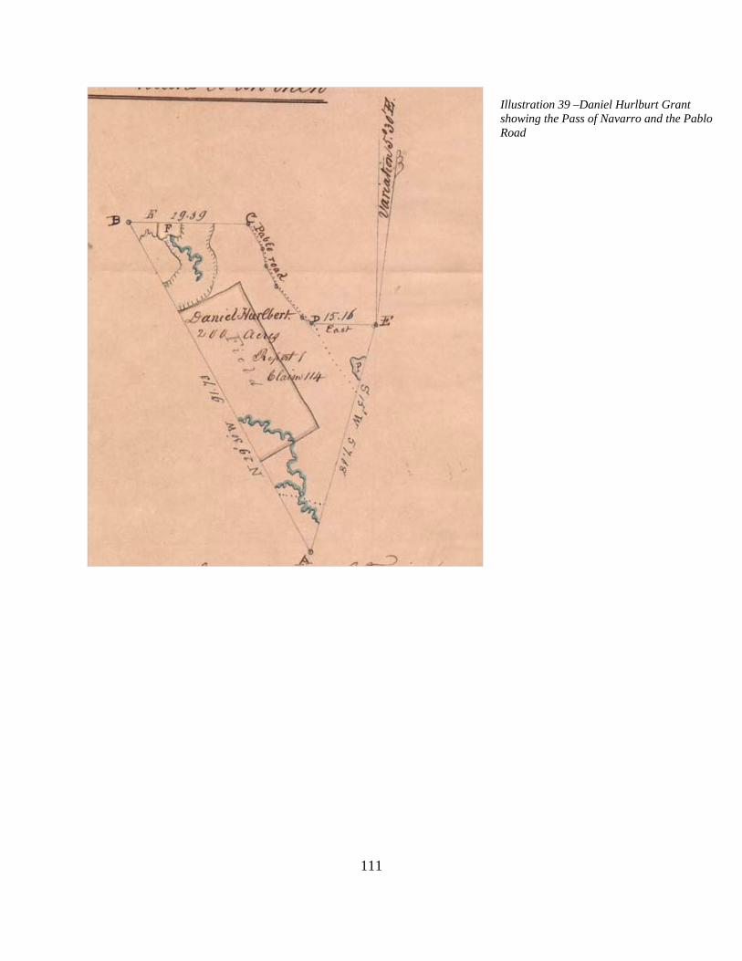
Illustration 39 –Daniel Hurlburt Grant showing the Pass of Navarro and the Pablo Road
111

112
The middle of three contiguous grants to Daniel Hurlburt (Section 52) was known as the Five Mile Grant. It encompassed 200 acres. A Spanish deed in 1814 describe the grant as being bound on the east by a road leading to Araquay. This road was a continuation of the road described as the Pablo Road in the Joseph S. Sanchez Grant to the south. United States Government Surveyors Benjamin and J.B. Clements surveyed the grant in June, 1836 and recorded it as Section 52, T6S, R29E. The Pablo Road is shown on the plat of the grant as the east boundary of the grant and described as such in the survey notes.49 The northernmost of three contiguous grants to Daniel Hurlburt (Section 51) was located six miles from St. Augustine. Known as the Levet or Six Mile Grant it encompassed 300 acres. A Spanish deed in 1821 and Daniel Hurlburt’s c.1823 petition for confirmation of the claim describe the grant as being bound on the east by a road leading to Araquay. This road was a continuation of the road described as the Pablo Road in the Joseph S. Sanchez Grant to the south. United States Government Surveyors Benjamin and J.B. Clements surveyed the grant in June, 1836 and recorded it as Section 51, T6S, R29E. The Araquay Road is shown on the plat of the grant as the east boundary and described as such in the survey notes. The field notes indicate the names Araquay and Pablo were interchangeable.50
49Florida Memory Project, Spanish Land Grants, Hurlburt Grant, Page 24 of 58 of Dossier, Box: 19, Folder 15, Page 25, 27,30, 35. 50Florida Memory Project, Spanish Land Grants, Hurlburt Grant, Page 1 of 23 of Dossier, Box: 19, Folder 14, Page 3,11,12,13, 23.

113Illustration 40 – The Daniel Hurlburt Grant, T6S, R29E, Sec. 52 bounded on the east by the Pablo-Araquay Road

114Illustration 41 – The Daniel Hurlburt Grant, T6S, R29E, Sec. 51 bounded on the east by the Pablo-Araquay Road

115
Pablo Road W. Side/North Line Pablo Sabate Grant, Section 50 T6S, R29E (Indian Creek following the west sections lines to Capo Island Road, the following the course of the Old Dixie Highway to the Reuben Charles Grant, south of Nine Mile Road) The Pablo Sabate Grant was a massive 2,133 acre grant extending from Indian Creek south of the St. Augustine Airport to Araquay Creek and the Reuben Charles Grant, just south of Nine Mile Road. It was six miles long and three miles wide. It was bounded on the north by the Araquay Creek and Araquay Bridge, on the south by Indian Creek and on the east by the North River. The west boundary extended from Indian Creek on the south side of the present day St. Augustine Airport to a point just south of Nine Mile Road. From Indian Creek a portion of the west boundary was formed by the public road that led to Araquay Creek. The road followed the Araquay-Pablo Road that formed the east boundary of the three Daniel Hurlburt Grants to a point at the northeast corner of T6S, R29E, Section 51, the northernmost of the three Hurlburt grants. According to Pablo Sabate’s c. 1823 petition for title to the Board of Land Commissioner of East Florida, the grant had an uninterrupted chain of title dating to 1764. At that time Juan Jose Elixio de la Puente conveyed the grant to Jesse Fish, whose heirs remained in custody of the grant until 1792. Unfortunately, no survey of the grant was undertaken prior to the United States Government survey of June, 1836. United States Government Surveyors Henry Washington surveyed the grant in June, 1836 and recorded it as Section 50, T6S, R29E. The Pablo or Araquay Road is shown on the plat of the grant as the west boundary of the Sabate Grant until it reached the northeast corner of the northernmost Daniel Hurlburt Grant (Section 51) and described it as the Pablo-Araquay Road in accompanying survey field notes. The road is documented through field notes as crossing the northern boundary of the grant in the vicinity of the Reuben Charles Grant, where it is again described as the Pablo Road. An 1882 survey of the Hurlburt and Sabate grants show the Pablo or Araquay Road continuing north from the northeast corner of the Hurlburt Grant towards the King’s Road where it passes through the Reuben Charles Grant near Nine Mile Road.51 Pablo Road passes through Reuben Charles Grant, Section 45, T6S, R29E (Nine Mile Spring/Nine Mile Road /White Castle Road Vicinity) North of the claim of Pablo Sabate was a Spanish land grant confirmed to Reuben Charles. The cover of Charles’s claim dossier described the grant as being at Nine Mile Spring on the King’s Road. Charles’s c. 1823 petition for confirmation of the claim provides a similar description. A deed to Charles that same year described the west boundary of the grant as the “public road called the Road to Cowford.” In May, 1836 Henry Washington completed a plat of the grant, showing the road in the western side. The plat show a second road entering the grant and later branching northeast, similar to the course of the Diego Path shown on the 1769 De Brahm Map. This road was shown in plats and field notes of T6S as the Pablo Road leading east to the Roque Leonardy Grant (Section 61).52
51Pablo Sabate Grant, Page 1- 31, Box: 28, Folder 14, Page 3,5,10-12, 17; St. Johns County Courthouse, Recording Section, Plat Book 1, Page 57; Daniel Hurlburt Grant, Page 1-58 of Dossier, Box: 19, Folder 15, Page 35; Daniel Hurlburt Grant, Page 1-23 of Dossier, Box: 19, Folder 14, Page 12. 52Reuben Charles: Pages 1-24, Box: 7, Folder 17, Page 2, 3, 7, 10.

116
Diego Road W. Side James Arnau Grant, Section 45 T5S, R29E, Section 48 T6S, R29E (Marshall Creek) The Diego Road was a branch of the Pablo Road and was, at times, synonymous with it in name and course. It apparently branched east from the Pablo Road in the vicinity of the Antonio Hindsman Grant and passed through a series of land grants before again joining the Pablo Road in a grant to Roque Leonardi. The James Arnau Grant (Section 45) was one of the grants along the Diego Road. It was located south of Marshall Creek, contiguous with the Clara P. Arnau Grant to the north. Located about nine miles from St. Augustine in the vicinity of the Marshall Plantation, the grant, measuring 125 acres, was conceded to James Arnau in April, 1807. A survey by Andres Burgevin in June, 1818 shows the grant as being bound on the west by the Camino de San Diego or San Diego Road. Burgevin also surveyed the Clara Arnau and Roque Leonardi grants to the north in 1818. Burgevin’s three surveys show the Diego Road in continuous alignment as it proceeds north from Marshall Creek, across Sweetwater Branch and toward San Diego. James Arnau’s c.1823 petition for confirmation of the claim describe the grant as being bound on the west by the main road leading to St. Diego. This road was likely a branch of the Araquay-Pablo Road to the south and west as described in the Sabate and Hurlburt grant claims, plats and supplemental surveys. United States Government Surveyor Henry Washington surveyed the grant in June, 1836 and recorded it as Section 48, T6S, R29E and Section 45, T6S, R29E. The San Diego Road is not shown on the plat of the grant or described in the survey notes. The 1834 Henry Washington Plat does, however, show traces of the road as it proceeds north from Marshall Creek. United States Government Plats prepared between 1834 and 1851 shows the Pablo Road north of the James Arnau Grant in the Roque Leonardi Grant in alignment with the road passing through the Arnau Grant.53 Diego Road W. Side Juana Paredes Grant, Section 57, T5S, R29E, (Marshall Creek) The Juana Paredes Grant was located at Marshall Creek, between the James Arnau Grant and the Clara P. Arnau Grant to the north. Located about nine miles from St. Augustine in the vicinity of the North River, the grant, measuring 125 acres, was conceded in April, 1807. A survey by G. Darling in September, 1823 shows the Road from St. Augustine to Diego crossing the Juana Paredes Grant near the west boundary. The road passed west of Marshall Creek as it branched north. Andres Burgevin’s surveys of the James Arnau, Clara Arnau and Roque Leonardi grants in 1818 show the road in this location as it proceeds north from Marshall Creek and across Sweetwater Branch toward San Diego. The San Diego Road was likely a branch of the Araquay-Pablo Road to the south and west as described in the Sabate and Hurlburt grant claims, plats and supplemental surveys. The 1834 Henry Washington Plat shows traces of the road as it proceeds north from Marshall Creek. Washington’s field notes and those of R.W. Norris survey of the Paredes Grant, mention the Diego Road or an old road in this location.54
53James Arnau Grant, Page 1 of 21 of Dossier, Box: 1, Folder 19, Pages 3,10,12,18. 54Juana Paredes Grant, Page 1 of 21 Box: 25, Folder 23, Pages 2,3 and 7; United States Government Survey, Field Notes, Volume 173, pages 165-166 Juana Paredes Claim

117
Diego Road, W. Side Clara Arnau Grant, Section 44 T5S, R29E (north side of Marshall Creek, Palencia Development) The Clara Arnau Grant (Section 44) was located north of Marshall Creek, contiguous with the James Arnau Grant to the south. Located about nine miles from St. Augustine in the vicinity of the Marshall Plantation, the grant, measuring 175 acres, was conceded to Francis Arnau, deceased husband of Clara Arnau, in April, 1807. A survey by Andres Burgevin in June, 1818 described the grant as being located on the Camino de San Diego or San Diego Road. The road was shown on the survey plat but was located east of the west boundary which was a linear measurement. Burgevin also surveyed the James Arnau grant to the south and the Roque Leonardi grant to the north in 1818. Burgevin’s three surveys shows the Diego Road in continuous alignment as it proceeded north to St. Diego A c.1823 petition for confirmation of the claim describe the grant as being bound on the west by the main road leading from St. Augustine to San Diego. United States Government Surveyor Henry Washington surveyed the grant in June, 1836 and recorded it as Section 44, T5S, R29E. The San Diego Road is not shown on the plat of the grant or described in the survey notes. The 1834 Henry Washington Plat of Township 5S, R29E does, however, show traces of a road near the west boundary of the grant as it proceeds north. United States Government Plats prepared between 1834 and 1851 shows the Pablo Road north of the Clara Arnau Grant in the Roque Leonardy Grant in alignment with the road passing through the James Arnau and Clara Arnau grant on the 1818 Burgevin Surveys.55 Pablo-Diego Road, near W. Side Roque Leonardi Grant, Section 61 T5S, R29E (Sweetwater Branch, Deep Creek) The Roque Leonardi Grant (Section 61) was located at Sweetwater Branch on the North River, about 12 miles north of St. Augustine. It was contiguous with the Clara Arnau Grant to the south. A survey by Andres Burgevin in June, 1818 show the grant as being located on the Camino de San Diego or San Diego Road. The road, as shown on the survey plat, was located east of the west boundary which was a linear measurement. It passed across two prongs of Sweetwater Branch and then crossed a tidal creek shown as the first salt water creek (Deep Creek) before heading north toward the William Travers Grant. A landing is shown at the salt water creek (Spanish Landing). Andres Burgevin also surveyed the James Arnau grant and Clara Arnau grants to the south in 1818. Burgevin’s three surveys show the road in continuous alignment as it proceeds north toward San Diego. This road was a branch of the Araquay-Pablo Road to the south as described in the Sabate and Huertas grant claims, plats and supplemental surveys. No United States Survey of the grant was included in the Leonardi claim. United States Government Plats prepared between 1834 and 1851 shows the Pablo Road north of the Clara Arnau Grant in the Leonardi Grant in alignment with the road passing through the Arnau Grant.56
55Clara Arnau Grant, Pages 1-21, Box: 1, Folder 17, Pages 12, 21 56Roque Leonardi Grant, Page 1-21 of Dossier, Box: 21, Folder 9, Page 12,15-16.

118
Pablo-Diego Road, E. Side William Travers Grant, Section 62 T5S, R29E (North River, between Deep and Smith Creeks) The William Travers Grant (Section 62) was located on the North River, at a place called Santa Lucia. Located north of the Leonardi Grant and measuring 450 acres, it was conceded to Lazaro Ortega in 1793. A c. 1818 survey by Andres Burgevin showed the grant as being bounded on the east by the Camino de San Diego or San Diego Road. The road proceeds along the marshes of the North River. No United States Survey of the grant was included in the Travers claim. United States Government Plats prepared between 1834 and 1851 shows the road in this location as it proceeds north along the marshes of the North River toward St. Diego. It is shown as continuation of the Pablo Road proceeding north from the Roque Leonardy Grant on United States Government Plats prepared between 1834 and 1851.57 Pablo-Diego Road, E. Side Hannah Smith Grant, Section 39 T5S, R29E (Smith Creek) The Hannah Smith Grant (Section 39) was located on the North River, at a place called Santa Lucia. Located north of the Travers Grant and measuring 389 acres, it was originally conceded by the Spanish Crown to John Andreu in 1804. Hannah Smith purchased to the grant in April, 1819. The road proceeds along the marshes of the North River. No United States Survey of the grant was included in the Smith claim. United States Government Plats prepared between 1834 and 1851 shows the road in this location as it proceeds north along the marshes of the North River toward St. Diego. The road is located slightly west of the meander line of the marsh. It is shown as continuation of the Pablo Road proceeding north from the Roque Leonardi Grant on United States Government Plats prepared between 1834 and 185158 Pablo-Diego Road, E. Side Heirs of Thomas Travers Grant, Section 65 T5S, R29E/Section 57 T4S R29E (North River, north of Smith Creek) The William Travers Grant (Section 65/57) was located on the North River, at a place called Old Savannas. Located north of the Hannah Smith Grant about 16 miles from St. Augustine and measuring 1000 acres, it was conceded to Militia Captain Miguel Iznardy in 1793 and later conveyed to Thomas Travers. It was used as a rice plantation and was a former British Grant to a Mr. Man. An April 25, 1819 survey by Andres Burgevin showed the grant as being bounded on the east by the Camino de San Diego or San Diego Road as it proceed north. South of the grant was a body of water called the First Tidal Creek and to the north was the Second Tidal Creek. West of the grant was the Twenty Mile Road or the Road to San Vicente Ferrer or the Road to the Bluff (St. Johns Bluff on the St. Johns River). The San Diego Road proceeds along the marshes of the North River. No United States Survey of the grant was included in the Travers claim. United States Government Plats prepared between 1834 and 1851 shows the road in this location as it proceeds north along the marshes of the North River toward St. Diego. These plats show the road as a continuation of the Pablo Road proceeding north from the Roque Leonardi Grant.59
57William Travers Grant, Page 1-18 of Dossier, Box: 32, Folder 15, Page 2-4,15,18. 58Hannah Smith, Page 1-8 of Dossier, Box: 31, Folder 3, Page 2-3 59William Travers Grant, Page 42-89 Box: 32, Folder 9, Pages 2,3,15,37,39.
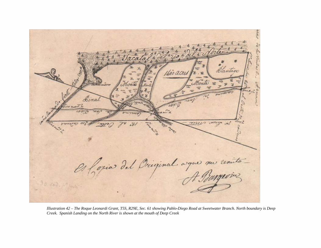
119
Illustration 42 – The Roque Leonardi Grant, T5S, R29E, Sec. 61 showing Pablo-Diego Road at Sweetwater Branch. North boundary is Deep Creek. Spanish Landing on the North River is shown at the mouth of Deep Creek

120Illustration 43 – Translation of 1821 Spanish survey of the William Travers Grant showing the Pablo-Diego Road as the east boundary of the grant

121Illustration 44 – 1819 Spanish survey of Thomas Travers Grant showing the Pablo-Diego Road as the east boundary of the grant. 20 Mile Road to St. Johns Bluff is shown west of the grant.

122
Pablo Road, E. Side Pedro Miranda Grant, Section 55 T4S, R29E (County Road 210/Palm Valley Road, Palm Valley) The Pedro Miranda Grant (Section 55) was located on the North River, at a place called Blides Old Field in Cabbage Swamp. No mention of the road was made in the claim for the Miranda Grant. United States Surveyor Henry Washington surveyed the grant in June 20th, 1836, but the road was not shown. United States Government Plats prepared between 1834 and 1851 shows the Pablo Road on the east side of the grant as it proceeds north.60 Pablo Road, Pedro Mestre Grant, Section 54 T4S, R29E (County Road 210/Palm Valley Road, Palm Valley) The Pedro Mestre Grant (Section 54) was located north of the headwaters of the North River. It was a 640 acre Donation Grant. Donation Grants were given to settlers in possession of former Spanish grants but lacking adequate title or documentation for claims. United States Surveyor Henry Washington surveyed the grant on June 20th, 1836, and showed the road crossing diagonally across the grant. United States Government Plats prepared between 1834 and 1851 show the Pablo Road in this location as it proceeds north.61 Pablo Road, Joseph S. Sanchez Grant, Section 43 T4S, R29E (County Road 210/Palm Valley Road, Palm Valley) The Joseph S. Sanchez Grant (Section 43) was located at the Diego Plains. It was a 600 acre grant. It was surveyed in 1793 by Pedro Marrot and conveyed to the heirs of Francis Xavier Sanchez on February 12, 1811. The grant served as a cattle ranch for the Sanchez family who were the meat contractors for the Spanish garrison at St. Augustine. United States Surveyor Henry Washington surveyed the grant on June 20th, 1836, and showed the road passing diagonally through the grant. United States Government Plats prepared between 1834 and 1851 shows the Pablo Road in this location as it proceeds north.62
60Pedro Miranda Grant Pages 1-14, Box: 24, Folder 5, Page 12. 61Pedro Mestre Grant Pages 1-6, Box: 23, Folder 14, Pages 3-4. 62Joseph S. Sanchez Grant Pages 1-14, Box: 29, Folder 16, Page 3

123Illustration 45 – Plat of San Diego Grant/Ranch of Joseph S. Sanchez showing course of Pablo Road

124
Pablo Road, Andres Papy Grant, Section 42 T4S, R29E (County Road 210/Palm Valley Road, Palm Valley, contains site of Ft. San Diego) The Andres Papy Grant was a 126 acre grant located at a plantation known as Ft. San Diego. The Papy Grant appears to have been the site of the former First Spanish Period Fort of San Diego. It was surveyed in 1793 by Pedro Marrot but the Marrot survey is not included in the Papy claim. Royal title was conveyed to Josefa Espinosa on January 25, 1811. It was subsequently sold to Phillip Solana who then conveyed it to Ana Pons in February, 1819. Andres Papy later acquired the grant and submitted a claim to the United States Government in 1823. United States Government Plats prepared between 1834 and 1851 show the Pablo Road in this location as it proceeds north.63 Pablo Road, Christina Hill Grant, Section 70 T4S, R29E (End of County Road 210/Palm Valley Road at A1A, Sawgrass vicinity) The Christina Hill Grant was a 405 acre grant located at a plantation known as Casina Loca . The Hill Grant was north of the site of the former First Spanish Period Fort of San Diego. Hill received the grant based on the military service of her deceased husband, Joseph Sanchez, and head rights of herself, her children and slaves. A list of her family members and slaves is included with her claim. No Spanish or United States surveys were included with the claim. United States Government Plats prepared between 1834 and 1851 show the Pablo Road passing through the Hill Grant as it proceeds north toward the St. Johns River.64 Pablo Road, Bartolome Castro y Ferrer Grant, Section T3S, R29E (Jacksonville Beach, Penman Road) The Bartolome de Castro y Ferrer Grant was a massive 2266 acre grant located at a plantation known as San Pablo on Pablo Creek near the St. Johns River. The Castro y Ferrer is shown on the c. 1817 sketch map given to General Andrew Jackson Grant. The San Pablo Plantation was originally granted to Juan McQueen in 1804 and conveyed to Bartolome de Castro y Ferrer by royal title in 1809. His petition for title in 1823 describes the location as San Pablo. United States Surveyor Henry Washington surveyed the grant on June 20th, 1836 and showed the San Pablo Road passing north-south along the east side of the grant. United States Government Plats prepared between 1834 and 1851 show the Pablo Road passing through the Castro y Ferrer Grant as it proceeds north toward the St. Johns River.65
63Andres Papy Grant, Page 6-13 Box: 25, Folder 19, Page 2,3. 64Christina Hill Grant, Page 1- 32 Box: 18, Folder 11, Pages 2-4. 65Bartolome Castro y Ferrer Grant, Page 1-26 Box: 7, Folder 7, Page 20, 23.

125
Illustration 46 – Survey of San Pablo Plantation, now Jacksonville Beach

126
Andrew DeWees Grant, Section T3S, R29E (Mayport Road north to Mayport) The Pablo Road terminated in the Andrew DeWees Grant on the south side of the St. Johns River and east side of Pablo Creek. DeWees’s heirs petition for title in 1823 describes the grant in this location. United States Surveyor Henry Washington surveyed the grant on June 20th, 1836 but does not show the San Pablo Road. United States Government Plats prepared between 1834 and 1851 show the Pablo Road passing through the DeWees Grant. The DeWees Grant encompassed the area which today includes Mayport, the Mayport Naval Base and Seminole Beach.66
66Andrew DeWees Grant, Page 1-52 Box: 10, Folder 11, Page 52

127
THE COURSE OF THE PABLO ROAD DURING THE TERRITORIAL-STATEHOOD-CIVIL WAR PERIODS (1821-1865) Many general maps of Florida were drafted in the early years of the Territorial Period, including one published in 1822 by Charles Vignoles, a professional surveyor. Its small scale did not permit precise location of the road, although maps like that drawn by Vignoles are vital in establishing the general course of the Pablo Road. The 1822 Vignoles map entitled “St. Johns River Bar to the Cowford” shows the Pablo Road at the mouth of the St. Johns River and Pablo Creek. Vignoles shows the road ending at a redoubt near the mouth of the river, where the St. Johns Lighthouse was subsequently constructed. A branch of the road lead to a landing at the mouth of Pablo Creek. Although not labeled on the Vignoles map, this was likely the site of the colonial sentry post at Pablo Creek. A 1902 map of Duval County showed a major Indian mound at this site. A 1918 USGS Topographic Map of Mayport shows this location as Weldon Landing at Sherman Creek. The 1837 John Lee Williams Map also shows the general course of the Pablo Road from St. Augustine to the St. Johns River.67 Beginning in the mid-1830s and ending in the early 1850s, United State Government surveyors mapped the course of the Pablo Road in St. Johns County through township plats and field notes. Many confirmed Spanish Grants were also individually surveyed with plats and field notes. The township plats show the course of the road beginning at the Mil Y Quinientas at the northern limits of St. Augustine in Township 7S, Range 30E and following a continuous course paralleling the North River, where it crossed its headwaters, and proceeding to the mouth of the St. Johns River near Mayport. Township 7S, Range 30E (North City area of St. Augustine, San Marco Avenue from San Carlos Avenue to US 1 and the northern limit of the City of St. Augustine) In May, 1836 United States Government Surveyors Benjamin and J.B. Clements completed a plat of the township. While the township map does not clearly show the course of the road, individual grant surveys and field notes reference it as a boundary. These grants are recorded on the Clement’s Plat and generally refer to the road as the road to Capuaca or the Joseph S. Sanchez Grant, located between Robinson Creek and Indian Creek. Leaving the Mil y Quinientas at San Carlos Avenue the Capuaca Road was bounded on the east by the Joseph Sanchez Grant (Section 50), the John Gianopoly Grant (Section 49) and the Jose Montero Grant (Section 48) as it proceed north along present day San Marco Avenue. On the west side, the road was bounded by three grants to Gabriel W. Perpall. Farther north the road was bounded by grants to Eliza Robinson (Section 55) on the west side and Joseph Baya (Section 56) on the east side. According to field notes the Pablo Road began on the west side of the Eliza Robinson Grant. A second township plat similar to the first but with the addition of the Pedro Estopa Grant (Section 44) was completed in May, 1836. This survey showed the Capuaca Road as the east boundary of the grant. In March, 1851 H.M. Randolph completed the surveying of
67Saint Johns River . . . bar to Cowford. Drawn from British survey. Photostat. Map Author: Vignoles, Charles Map Number: R2.1822.002.1997.1539 Map Year: 1822 ; Duval County, FL, “1902 Official Map made by order of the County Commision 1898 revised in 1902” by Roland Woodward.

128
Township 7S. The Francisco Fusha Grant was included with the plat at that time. The grants, their boundary and the location of the road remained consistent on the post 1836 plat and field notes for Township 7S.68 Township 6S, Range 30E (North of St. Augustine, between Ft. Mose and Indian Creek) In January, 1834 United States Government Surveyor Henry Washington completed a plat for Township 6S. The Washington plat clearly showed the Pablo Road as it proceeded north along the west boundary of the Joseph S. Sanchez Grant also known as the Capuaca Plantation (Section 54). Washington’s township plat clearly labels the Pablo Road as it proceeds north from the Baya and Robinson grants. While shown on the Washington Plat of Township 6S, Range 30E, the Pablo Road was actually west of the Range Line in Township 6S, Range 29E.69 Township 7S, Range 29E (North St. Augustine, San Sebastian River south of Lewis Speedway) Parts of the Eliza Robinson (Section 49) and Joseph S. Sanchez (Section 50) grants extended into the northeast corner of Township 7S, R29E. Plats of this township show the grants where the Pablo Road formed the boundary. The Pablo Road was also described as the boundary in the field notes.70 Township 6S, Range 29E (North of St. Augustine, from the city limits of St. Augustine to Nine Mile Road, Palencia Subdivision vicinity) In January, 1834 United States Government Surveyor Henry Washington completed a plat for Township 6S. The Washington plat clearly showed the Pablo Road as it proceeded north along the west boundary of the Joseph S. Sanchez Grant (Section 54) and the east boundary of the first of three Daniel Hurlburt grants (Section 53). Washington’s plat showed survey monuments along the road at this location. The road proceeded north along the east boundaries of the northern two Daniel Hurlburt grants (Sections 51 and 52) and a portion of the west boundary of the Pablo Sabate Grant (Section 50). Washington’s plat showed survey monuments along the road at these points as well. The road was described as the Araquay Road north of the Joseph S. Sanchez Grant on the plat but as the Araquay aka Pablo Road in the field notes. The road was not shown as it proceeded north into the Sabate Grant, but was shown on an 1882 private survey by P.W. Koerner, Civil Engineer, following this course. The 1882 survey shows survey monuments at the east corners of Sections 51 and 52 in the road.71 A.M. Randolph completed
68Division of State Lands, Board of Trustees Land Documents, T6S/R30E 69Division of State Lands, Board of Trustees Land Documents, T7S/R29E 70Division of State Lands, Board of Trustees Land Documents, T7S/R29E ID: 110578DATE: 11/13/1852, SURVEYOR: Henry Washington/R.W. Randolph/A.M. Randolph 71 T.W.O. Koerner Map, St. Johns County Map Book 1, Page 57.

129
the surveying of Township 6S in 1853. He showed the road following the same course as Washington and included Washington’s traverse measurements of both the Pablo and Araquay Roads. Field notes describe a road located near the northwest corner of the Sabate Grant which is described in the field notes of the adjacent Reuben Charles Grant to have been the northern extension of the Pablo Road. As described in Henry Washington’s and A.M Randolph’s field notes in 1834 and 1853, the Pablo Road continued north into the western portion of the Reuben Charles Grant (Section 45) where it briefly intersected the King’s Road. The Pablo/King’s Road then proceeded northwest into Section 4. The Pablo Road branched northeast from the Jacksonville/Kings Road in Section 4 and was described in plats of Townships 6S, R29E and 5S, R29E as the Pablo Road. In Section 4, the Jacksonville/Kings Road bore north/northwest roughly paralleling the course of the Pablo Road to the east as it headed north to the St. Johns-Duval County line.72 Township 5S, Range 29E (North of St. Augustine, Nine Mile Road to North River north of Smith Creek) In January, 1834 United States Governent Surveyor Henry Washington also completed a plat for Township 5S. Spanish surveys of land grants to Clara Arnau (Section 44) and James Arnau (Section 45) showed the Diego Road, a branch of the Pablo Road, as the west boundary of both grants. The Washington survey shows a faint dotted line along the west side of the two grants, perhaps indicating remnants of the road. Washington’s field notes show the Diego Road passing through the Juana Paredes Grant (Section 57), west of the east boundaries of the Arnau Grants. To the north, in Section 28, Washington shows a road in line with west boundaries of James and Clara Arnau grants to the south. Part of Section 28 was later incorporated into the Section 61, the Roque Leonardi Grant. Proceeding north in Section 21 the road again appears in line with the west boundaries of James and Clara Arnau grants to the south. Section 21 was also later incorporated into the Section 61, the Roque Leonardi Grant. In Section 21 the Diego Road crosses Sweetwater Branch near the Section Line with Section 28. Here it is joined by the Pablo Road bearing northeast from the King’s Road and passing through Sections 33 and 28. In Section16 the road bears northeast around a swamp and across Deep Creek. In Section 15 the road bears northeast to the northeast corner of Section 15. In Section 10 the road heads north from the northeast corner of Section 15 just east of section line along the marshes of North River. It crosses Smith Creek into Section 39, the Hannah Smith Grant, where it heads north through the east side of the grant. The road then passes north through Section 3, where it proceeds to the township line.73 In August, 1850 United States Government Surveyor R.W. Norris updated the Henry Washington plat of Township 5S. The Norris Plat shows no evidence of the Diego Road through the Arnau Grants (Sections 44-45). In Section 53, Theresa Marshall Grant, the Pablo Road passes through the west and north lines. In Section 33 the Pablo Road heads north through government lots 3,6,11,14 into Section 28. In Section 28 the Pablo Road intersects the Diego
72Division of State Lands, Board of Trustees Land Documents, T6S/R29E ID: 112473 DATE: 01/01/1834; SURVEYOR: Henry Washington; T6S/R29E. ID: 110644, DATE: 01/01/1834SURVEYOR: Henry Washington. 73Division of State Lands, Board of Trustees Land Documents, T5S R29E ID 112470. 01/01/1834; SURVEYOR Henry Washington

130
Road and heads north. From this point north to the old fort at Diego (T4S, R28E, Section 42, the Andres Papy Grant), the Pablo Road is variously referred to as the Diego or Pablo Road. In Section16 the road bears northeast around a swamp and across Deep Creek. In Section 15 the road heads northeast through Gov. Lots 1 and 2. In Section 10 the road heads north through Gov. Lots 1-3. It then crosses Smith Creek into Section 39, the Hannah Smith Grant, where it heads north through the east side of the grant. The road then passes north through Section 3, where it proceeds to the township line.74 In March, 1851, A.M. Randolph completed the final plat of Township 5S. Again the Randolph Plat shows no evidence of the Diego Road through the Arnau Grants (Sections 44-45). A road which passes to the west of the Arnau Grants is indicated as the Pablo Road on the plat. In Section 33 the Pablo Road heads north through government lots 3,6,11, and 14 into Section 28. From Section 28 the Pablo Road enters the west boundary of the Roque Leonardi Grant (Section 61) and intersects an original portion of the Diego Road and heads north. A portion of Section 28 was incorporated into Section 61, the Roque Leonardi Grant. Proceeding north in the Roque Leonardi Grant the road again appears in line with the west boundaries of James and Clara Arnau grants to the south. Section 21 was also incorporated into the Roque Leonardi Grant on the Randolph Plat.75 In the Roque Leonardi Grant the Pablo Road is called out. The Road proceeds north/northeast across Sweetwater Branch into Section 16. In Section 16 a road branches northwest to form the Twenty Mile Road to San Vicente Ferrer and St. Johns Bluff as it passes through Gov. Lot 1. In Section 15 the road heads northeast through Government Lots 1,2,4. It then enters Section 62, the William Travers Grant, where it forms the east boundary. The 20 Mile Road to San Vicente Ferrer St. Johns Bluff; passes through the west side of the Travers Grant. The Pablo Road enters Section 10 where it forms the west. boundary of the Fractional Section. In Section 39, the road head north through the east side of the Hannah Smith Grant. The road then enters Section 65, the William Travers Grant, where it forms the eastern boundary of the grant.76
74Division of State Lands, Board of Trustees Land Documents, T5S, R29E, Date; 08/1850 Surveyor R.W. Norris Doc. ID: 112472. 75Division of State Lands, Board of Trustees Land Documents, T5S R29E ID 110643 01/01/1851; SURVEYOR AM Randolph. 76Ibid.

131
Township 4S, Range 29E (North of Smith Creek, follows Palm Valley Road, County Road 210, to the vicinity of Sawgrass) In April, 1834 United States Government Surveyor Henry Washington completed a plat of Township 4S in northeast St. Johns County. The Washington plat clearly showed the Pablo Road east of Diego Swamp. Beginning at the township line with Township 5S, the road proceeded north near the east boundary of Section 34 and along the east boundary of the Pedro Miranda Grant (Section 55). Washington’s plat showed the road bearing northeast from the Miranda Grant and crossing at a ford north of the headwaters of the North River in an un-surveyed area. It then continued a similar course through the Pedro Mester Grant (Section 54). The road turned north through Section 22, 15, and 43, the Joseph S. Sanchez Grant. After passing through the Sanchez Grant, it passed through Section 9, the east half of Section 42, the Andres Papy Grant, and Sections 4 and 3.77 The course of the road through Township 4S was clearly shaped by the presence of Diego Swamp to the west. A second plat by Henry Washington at the same time showed the road following the same course. In March, 1851, A.M. Randolph completed the final plat of Township 4S. As the road entered the Township from the south, it proceeded north forming the east boundary of Section 57, the William Travers Grant, an addition to the Washington survey. It the followed the same course as the 1834 Washington Survey through Sections 55, the un-surveyed area north of the headwaters of the North River, and Sections 54 and 22. In Section15 the road took a slightly different course as it proceeded north. It then continued north through Sections 43, 9, 42, 4, 70 (the recently surveyed Christina Hill Grant) and section 3.78 Township 3S, Range 29E (Ponte Vedra, Duval County, South Jacksonville Beach) In April, 1834 United States Government Surveyor Henry Washington completed a plat for Township 3S in southeast Duval County. This area included Pablo Creek and the southern portion of the Pablo Plantation of John McQueen and Bernardo de Castro y Ferrer. The road proceeded north through Sections 34, 27, 16, 9, 4 and 37, the Bernardo de Castro y Ferrer Grant also known as the Pablo Plantation. In March, 1851, A.M. Randolph completed the final plat of Township 3S. Randolph shows the road following the same course as Washington. Section 55, the William Hart Grant, was added to the plat. The road formed the east boundary of the grant.79
77Division of State Lands, Board of Trustees Land Documents,T4S R29E ID 112470. 04/1834; SURVEYOR Henry Washington ID: 112469. 78Division of State Lands, Board of Trustees Land Documents, T4S R29E ID 112470. 03/1851; SURVEYOR A.M. Randolph Washington, ID: 110642. 79Division of State Lands, Board of Trustees Land Documents, T3S R29E ID 112470. 04/1834; SURVEYOR Henry Washington ID: 112467; Division of State Lands, Board of Trustees Land Documents, T3S R29E ID 112470. 03/1851; SURVEYOR A.M. Randolph Washington, ID: 110641
132
Township 2S, Range 29E (Duval County/Jacksonville Beaches) In April, 1834 United States Government Surveyor Henry Washington completed a plat for Township 2S in southeast Duval County, today the Jacksonville Beaches. This area included Pablo Creek and the Pablo Plantation of John McQueen and Bernardo de Castro y Ferrer. The road proceeded north primarily through Section 38, the northern part of the Bernardo de Castro y Ferrer Grant also known as the Pablo Plantation. In March, 1851, A.M. Randolph completed the final plat of Township 2S. Randolph shows the road following the same course as Washington. From Section 38, the road proceeded north through Sections 28, 21,17,8 and 37, the Andrew DeWees Grant.80 Township 1S, Range 29E (Mayport, Duval County) In October, 1849 United States Government Surveyor David Burr completed a plat for Township 1S in east Duval County, today Mayport. The survey shows two roads entering Section 37, the Andrew DeWees. One was the Pablo Road to the lighthouse and the other the road to the beach. In February, 1883 H.S. Duval completed an updated survey of the Township. Duval showed the road to the Lighthouse as being the Kings Road, an apparent historical error.81 An 1864 United States Coastal Survey map of northeast Florida shows the course of the Pablo Road at that time. It confirms the accuracy of the United States Government Surveys, particularly those completed in the early 1850s. The Pablo Road follows the course shown on the United States Government surveys of the 1850s. East of St. Marks Pond the Pablo Road briefly joins the Kings Road as it proceeded north from St. Augustine. After a short distance the Kings Road branched northwest toward Jacksonville and the Pablo Road branched northeast towards the headwaters of the North River. At the headwaters of the North River, the Pablo Road joined an east-west road that followed the general course of present day county road 210. This road began at New Switzerland on the St. Johns River, passed between Durbin Creek and Twelve Mile Swamp, cross the King’s Road and headed east to the ford at the headwaters of the North River where it met the Pablo Road. The Pablo Road then proceeded north on the east side of Pablo Creek to the vicinity of Mayport and the Lighthouse at the mouth of the St. Johns River. The Kings Road then continued northwest crossing Durbin Creek near the Duval-St. Johns County line on its way to Jacksonville.82
80Division of State Lands, Board of Trustees Land Documents, T2S R29E , 04/1834; SURVEYOR Henry Washington ID: 110641; T2S R29E ID 112470. 03/1851; SURVEYOR A.M. Randolph Washington, ID: 111523, ID: 110640 81Division of State Lands, Board of Trustees Land Documents, T1S R29E 08/1849; SURVEYOR David Burr ID: 110641; T1S R29E 0/1883; SURVEYOR H.S. Duval ID: 110638 821864, "Northern Part of Florida compiled and published at the United States Coast Survey Office, 1864"

133
THE COURSE OF THE PABLO ROAD IN THE POST CIVIL WAR ERA At the end of the Civil War, public roads in St. Johns County were in poor condition due to years of deferred maintenance. The Board of County Commissioners (BOCC or Board) of St. Johns County met in special session on May 29, 1866 with the primary purpose to address the need for repair and maintenance of the roads and bridges of St. Johns County through the appointment of a full Board of Road Commissioners, as required by the laws of the state.83 The number of roads and type of maintenance and repairs were apparently such at that time that a separate slate of Road Commissioners for each road was instituted. On January 4, 1876, the BOCC appointed a slate of three road commissioners for each of the four primary county roads extending from St. Augustine. These were: the Tomoka Road from St. Augustine south in the eastern part of the county towards Ormond and the Tomoka River to the Volusia County line; the Jacksonville Road from St. Augustine north to the Duval County line; the Palatka Road from St. Augustine southwesterly to the western part of the county towards Palatka and Putnam County line; and the Picolata Road, westerly to the St. Johns River at Picolata.84 The St. Augustine-Jacksonville Road appears to have followed the general course of the King’s Road, to the west of the Pablo Road. The course of the Pablo Road is shown on a series of maps beginning in the 1880s. A c. 1880 United States Coast and Geodetic Survey Map shows the road following the course shown on the United States Government surveys of the 1850s. East of St. Marks Pond the Pablo Road briefly joined the Kings Road as it proceeded north from St. Augustine. After a short distance the Kings Road branched northwest toward Jacksonville and the Pablo Road branched northeast towards the headwaters of the North River. At the headwaters of the North River, the Pablo Road joined an east-west road that followed the general course of present day county road 210. This road began at New Switzerland on the St. Johns River, passed between Durbin Creek and Twelve Mile Swamp, cross the King’s Road and headed east to the ford at the headwaters of the North River where it met the Pablo Road. The Pablo Road then proceeded north on the east side of Pablo Creek to the vicinity of Mayport and the Lighthouse at the mouth of the St. Johns River. The Kings Road then continued northwest crossing Durbin Creek near the Duval-St. Johns County line on its way to Jacksonville.85 The Pablo Road from Robinson Creek north into the Sabate Grant was also shown on an 1882 private survey by P.W. Koerner, Civil Engineer, following this course. 86 From the early 1880s until the World War I era the importance of the Pablo and other county roads was diminished by the construction of railroads. A line known as the Jacksonville, St. Augustine and Halifax Railroad paralleled the west side of the Jacksonville Road or the former King’s Road from the county line to Nine Mile Road and the Pablo Road from Nine Mile Road to St. Augustine. Henry Flagler’s Florida East Coast Railroad subsequently absorbed this railroad and extended its line to Miami in 1896 and Key West in 1913. Stops along the rail line
83BOCC Minutes Book A, page 7. 84BOCC Minutes Book A, page 285. 851864, "Northern Part of Florida compiled and published at the United States Coast Survey Office, 1864." 86 T.W.O. Koerner Map, St. Johns County Map Book 1, Page 57.

134
included Durbin, Sampson, and Magnolia Grove. These were all settlements along the Jacksonville Road as well.87 The establishment of the Florida State Road Department in 1915 signaled the beginning of a modern road system for the state, designed to accommodate and facilitate the dramatic increase in automotive transportation. Counties throughout Florida, including St. Johns, began instituting modern road building techniques to state standards and mapping local, state and federal roads within their political subdivisions. Moreover, county engineers or surveyors under contract to the counties usually depicted roads, such as the Pablo Road, on their maps. The most authoritative of these maps in St. Johns County are a series of county road maps prepared by the county engineer or a civil engineer under contract with the county. These maps are the “Map of St. Johns County, Florida, June, 1917” prepared by Seth Perkins & Sons, civil engineers; “Map of St. Johns County, 1919,” prepared by Gould T. Butler County Engineer; “Map of St. Johns County,” attributed to Gould T. Butler; and “St. Johns County, Florida, March 1923” prepared by J.F. Rodenbough, County Engineer. These maps show various parts of the original Pablo Road, north of St. Augustine. The 1917 Seth Perkin’s Map shows the Pablo Road from Nine Mile South to St. Augustine at the golf links north of town as following the course of the Dixie Highway. Other official county maps produced from 1917 and 1923 show the road following a similar course. The Dixie Highway was first planned in 1914 to connect the United States Midwest with the South. The leading promoter of the Dixie Highway was Carl Fisher of Miami. The route began in Chicago and ended in Miami. In Florida it proceeded from the state line through Jacksonville to Miami. In St. Johns County the road followed the route of the King’s Road from the north county line to Nine Mile Road where it joined the route of the Pablo Road to St. Augustine. From St. Augustine it followed the route of present day State Road 207 to Hastings where it proceeded south into Flagler County. Built with brick, it was the county’s first hard surface road. The demands of traffic within a decade compelled construction of a second, larger east coast road, U.S. Highway 1 or State Road 4. Prior to World War I, the federal government played little role in road building, but from the early 1920s on it provided increasing funding. The utility and prominence of the original Dixie Highway following the course of the King’s Road and Pablo Road was diminished with the opening of U.S. Highway 1 in December, 1927.88 The course of U.S. 1 followed a new course between the Florida East Coast Line and the Dixie Highway from the Duval County line into St. Augustine. The Dixie Highway, following the course of portions of the King’s Road-Pablo Road, became a secondary road or in some instances reverted to private ownership.
The 1917 Seth Perkins Map shows the Pablo Road in the northeast area of the county at Palm Valley. In this area, the road is shown as a graded road from the headwaters of the North River following the course documented on the United States Government surveys of the 1830s, 1840s
87George F. Cram, (Chicago, IL: Geo. F. Cram, 1886) 63; Ormando Willis Gray, Gray's Atlas (Phiadelphia, PA: O. W. Gray and Son, 1886) 91 88CMF, December, 1927.

135
and 1850s. The road proceeded north from the North River to Palm Valley and then to the Duval County line. It connected with a road from the Twenty Mile, located in the vicinity of what today is the Country Road 210. A portion of the Twenty Mile Road north of Sweetwater Branch is shown on the Perkins Map. A secondary road that follows the course of the Diego Road from north of Araquay Creek to Marshall Creek is also shown on the Perkins Map. No portion of the Pablo Road is shown from the vicinity of Nine Mile Road north to the headwaters of the North River.89 The 1923 map of St. Johns County, Florida prepared by J.F. Rodenbough, County Engineer generally conforms to the 1917 Seth Perkins in regard to the Pablo Road. The road follows the course of the Dixie Highway from St. Augustine past the St. Augustine Golf Links to the Reuben Charles Grant where it joined the Kings Road. The Dixie Highway then followed the Kings Road north past Nine Mile Road, through Hilden and Durbin to the Duval County line. A secondary road that follows the course of the Diego Road from north of Araquay Creek to Sweetwater Branch is also shown on the Rodenbough Map. The map shows the Pablo Road as a graded road from the headwaters of the North River generally following the course documented on the United States Government surveys of the 1830s, 1840s and 1850s.90
The 1936 Florida State Road Department Map of St. Johns County is a detailed map showing the United State Government Survey grid. This map shows all of the main cities, state roads, US Highways, railroads, and main county roads. The Dixie Highway, following the course of portions of the King’s and Pablo Roads, is not shown on this map and has been replaced by U.S. Highway 1/State Road 4 as the main north-south road to St. Augustine from Duval County. Palm Valley Road is shown as County Road 306. It proceeds from U.S. 1 at Durbin to the headwaters of the North River where it joins the course of the Pablo Road. Palm Valley Road then follows the course of the Pablo Road, to the vicinity of Ponte Vedra, where it branches northeast to the Ponte Vedra development on Old A1A. The portion of Pablo Road north from Ponte Vedra to the Duval County line is not shown on this map.91
89“Map of St. Johns County, Florida, June, 1917,” St. Johns County Map Book 1, Page 57. 90 “St. Johns County, Florida, March 1923” prepared by J.F. Rodenbough, County Engineer. 91“St. Johns County Florida Road Map. Florida State Road Department (Tallahassee, FL, 1936)

136Illustration 47 – 1936 State Road Map of North St. Johns County. Pablo Road joins County Road 210 (Palm Valley Road) on east side of North River

137Illustration 48 –1936 State Road Map of Mid St. Johns County..

138
The 1950 United States Government Survey Plats are an excellent source for documenting the course of the Pablo Road from St. Augustine to the Duval County Line at Ponte Vedra Beach. The Board of Commissioners of St. Johns County ordered the plat prepared to update the final United States Government Survey Maps of St. Johns County completed during the 1850s. They are done at the same scale as the 1850s version and show the course of the road on the United States Government Survey grid in a contemporary context. A township by township description of the Pablo Road as it proceeds north from St. Augustine is provided below. Township 7S, Range 30E (North City of St. Augustine, San Marco Avenue from San Carlos Avenue to US 1 and the northern limit of the City of St. Augustine ) The 1950 Plat of Township 7S shows the course of the Pablo Road based on its location in relation to Spanish land grants. Most of these grants are recorded on the Clement’s Plat of 1834. At San Carlos Avenue the Pablo Road, referred to in this area as the Capuaca Road, was bounded on the east by the Joseph Sanchez Grant (Section 50), the John Gianopoly Grant (Section 49) and the Jose Montero Grant (Section 48) as it proceeded north along San Marco Avenue on the 1950 Plat. On the west side, the road was bounded by three grants to Gabriel W. Perpall which bound the west side of San Marco Avenue to State Road 16. Farther north the road was bounded by on the west by a grant to Eliza Robinson (Section 55) and on the east by a grant to Joseph Baya (Section 56). The road in this area on the 1950 plat has been absorbed by US Highway 1 or lost to development. Township 6S, Range 29E (Course of the Pablo Road, North City Limit of St. Augustine from Robinson Creek to vicinity of Nine Mile Road)
The 1950 United States Government Survey of Plats of St. Johns County shows the course of the Pablo-Araquay Road along Section 54 (Joseph S. Sanchez Grant) following US 1 from Robinson Creek/Ft. Mose the Ft. Mose vicinity north to Indian Creek; on the south side of the St. Augustine Airport Property. On the west of US 1 and the Florida East Coast (FEC) rail line near the east boundary of Section 53 Daniel Hurlburt Grant shows a soft surface road following the Hurlburt Section line north. The soft surface road continues north along the east line of Section 52 the Daniel Hurlburt Grant to near the northeast corner of the section where it crosses/intersects the FEC rail line and US Highway 1. Along the east line of Section 51, the third Daniel Hurlburt Grant, the Pablo Road follows a remnant of the Old Dixie Highway. The road follows the Dixie Highway across US 1 at what today is Gun Club Road and continues north along what today is Capo Island Road. The 1950 Plat shows the road following the course of the Old Dixie Highway, just west of the swamps and wetlands of Araquay Creek, to the northwest corner of Section 50, the Pablo Sabate Grant. On the 1950 Plat, the Pablo Road, following the Old Dixie Highway, intersects the Kings Road in Section 45, the Reuben Charles Grant, at a place named South Durbin, just south of Nine Mile Road. After briefly intersecting the King’s Road the Pablo Road, bears northeast through Section, Government Lots 9, 7,8 and 1 the 1853 Plat. A soft surface road is shown on the location on the 1950 plat.

139
Township 5S, Range 29E (1950 Course of the Pablo Road, from vicinity of Nine Mile Road northeast across Sweetwater Branch to Smith Creek, west side of North River) Entering Township 5S the Pablo Road follows the same course as a soft surface road passing from the south to the north line of Section 33 on the 1950 Plat. In Section 53, the Theresa Marshall Grant, the soft surface road passes through Government Lots 14,11,6 and 3 following the 1853 course of the Pablo Road. It continues into Section 28 and passes through Government Lots 6 and 3, again following the 1853 course. The soft surface road enters the west line of Section 61 and exits on the north line at a ford on Deep Creek. Unlike the 1853 course, no remnant of the road is shown crossing Sweetwater Branch on the 1950 Plat. In Section 15, the northeast side of Deep Creek the soft surface road continues through Government Lot 4 and ends in Lot 2. North of Deep Creek, also in Section 15, a road following the course of the historic Twenty Mile Road branches northwest. The 1853 Plat shows the Pablo Road passing along the marshes of the North River along the eastern boundaries of Sections 62, 10,39 and 65 just west of Smith Creek in Cabbage Swamp. No road is shown through these sections on this location on the 1950 Map. Township 4S, Range 29E (1950 Course of the Pablo Road, from Cabbage Swamp, north of Smith Creek, west side of North River north to vicinity headwaters of North River, then along CR 210 Palm Valley Road to Palm Valley, then north to junction of CR 210 and A1A at north line of Township 4S).
The 1853 Plat shows the Pablo Road passing along the marshes of the North River at or near the eastern boundaries of Sections 57, 60, 63 and 55 just north of Smith Creek in Cabbage Swamp. No road is shown through these sections on the 1950 Map. At the place where the Pablo Road crossed a ford near the headwaters of the North River, the 1950 Plat shows the remnant of a road, following the course of the historic road. In Section 54, the Pedro Mestre Grant, the Pablo Road follows the course of County Road 210, the Palm Valley Road. The historic road follows the course of the Palm Valley Road north through Sections 22,15,43,9,42, where the site of Ft. San Diego was located, and then through Sections 4,70 and 3. At the line between Townships 3 and 2 the Pablo Road joined AIA and proceeded north.
Township 3S, Range 29E (1950 Course of the Pablo Road, from junction of CR 210 and A1A, north of AIA to the Duval County Line).
The 1851 Plat A.M Randolph Plats through the Sections 34, 27, the southwest corner of Section 22, and Section 16. At the north line of Section 16, the Pablo Road crosses Duval-St. Johns County line, following the east boundary of Section 55, the William Hart Grant. This course differs slightly from the course of AIA. The 1851 course follows an unimproved road labeled St. Augustine Coastal Boulevard before entering Duval County. The 1950 Plat shows Florida A1A following a course slightly east.

140
Township 3S,2S,1S, Range 29E (1950 Course, North of Duval County line to Mayport) Immediately north of the St. Johns County-Duval County line, the Pablo Road appears to have been lost to modern development. The road passed through the Jacksonville Beach Municipal Golf Course. It then followed the course of a road leading from the golf course to Beach Boulevard. From Beach Boulevard the Pablo Road followed the general course of Penman Road, a major north-south thoroughfare, through Jacksonville Beach, and Neptune Beach. Crossing Atlantic Boulevard the Pablo Road continues following Royal Palm Drive. The Pablo Road north of Royal Palm Drive has been lost to development, but the alignment to the north joins Mayport Road. Mayport Road is shown on the February, 1883 H.S. Duval as being the Kings Road, leading to the Old St. Johns Lighthouse. The confusion between the two road is likely attributable to the junction of the Pablo and Kings Road, near Nine Mile Road in St. Johns County.92
92 In February, 1883 H.S. Duval completed an updated survey of the Township. Division of State Lands, ID: 110637.
141
CONTEMPORARY COURSE OF THE PABLO ROAD FROM ST. AUGUSTINE TO THE DUVAL COUNTY LINE AT PONTE VEDRA
Township 7S, Range 30E (North City of St. Augustine, San Marco Avenue from San Carlos Avenue to US 1 and the northern limit of the City of St. Augustine near Rio Vista Drive) The Pablo Road began at what today is San Carlos Avenue. At San Carlos Avenue the Pablo Road, referred to in this area as the Capuaca Road, proceeded north along San Marco Avenue to the junction with US Highway 1 in the vicinity of Rambla Street across from the Winn Dixie Shopping Plaza. This course is confirmed by the historic boundaries of Spanish land grants and several recorded county maps. The northern portion of this course is documented on several maps of the Joseph Baya Grant which includes the Ft. Mose State Park. An 1887 map shows the “Public Road from St. Augustine” following the course of San Marco as it bends northwest in the vicinity of the Bella Vista Condominiums.93 This course is further confirmed by a 1923 plat of the Baya Grant and a second plat dating from the same period which shows the road absorbed by the Dixie Highway and the former road bed of the FEC Railroad. The first plat also shows the west branch of the Pablo Road, labeled the Araquay Road, following the west boundary of the Eliza Robinson Grant (Section 55) and the Joseph S. Sanchez Grant (Section 49) in adjacent Township 7S, Range 29E.94 The main branch of the Pablo Road has been absorbed by US Highway 1 to the point where it crosses the line between Range 30E and 29E near Rio Vista Drive near the northern limits of the City of St. Augustine. Remnants of the west branch of the Pablo Road appear to exist between the Winn Dixie Shopping plaza and the northern city limits at Sebastian Way. Township 6S, Range 29E/29E (Course of the Pablo Road, North of St. Augustine from North City Limit of St. Augustine to vicinity of Nine Mile Road-International Golf Parkway at Palencia)
The line between Township 6S and 7S forms the northern limit of the City of St. Augustine. The branch of the Pablo Road extending from San Marco Avenue continued north into Township 6S following the course of US 1 North until joining the west branch of the Pablo Road near the entrance to the old Ponce de Leon Motor Lodge and Golf Club at Ponce Island Drive. The west branch of the Pablo Road proceeded north from McMillan Street until joining the east branch and forming a single road. The junction of the two roads is illustrated by a 1922 St. Johns County Road Road Map which clearly documents the course of the Pablo-Araquay Road as it passes north along the line between Sections 36 and 54.95 From this point north the Pablo-Araquay Road followed the west boundary of Section 54 (Joseph S. Sanchez Grant). From the entrance to the old Ponce de Leon Golf Course at Ponce Island Road north to Lewis Speedway there is currently no evidence of the Pablo Road. The west boundary of the Sanchez Grant, which was
93St. Johns County Deed Book II, p. 165 94St Johns County Map Book 3, p. 16; Map Book 3, p. 63. 95St. Johns County Map Book 3, p. 77.

142
defined by the Pablo-Araquey Road, passes through US 1 and the Araquay Subdivision. The road appears to have been absorbed by these developments.
On the west side of US 1 and the Florida East Coast (FEC) rail line, from Lewis Speedway north, the Pablo-Araquay Road closely follows the course of Avenue A near the east boundary of Section 53 (Daniel Hurlburt Grant). Avenue A becomes a soft surface road following the Hurlburt Section line north. The soft surface road continues north along the east line of Section 52 the Daniel Hurlburt Grant to near the northeast corner of the section at the FEC railroad crossing at Big Oak Road. A map entitled “Sketch of St. Augustine-Jacksonville County Road” recorded March 6, 1911 shows a “new road” between St. Augustine and Jacksonville.96 The “new road” generally followed the course of the King’s Road north of St. Augustine and then intersected and followed the course of the Pablo Road to St. Augustine. Several sections of the old roads on the west side of the FEC rail line were excluded from the “new road.” South of Nine Mile Road a portion of the Pablo Road known as the “Casacola Road” was also excluded from the new road. This section was opposite the St. Augustine Airport between Gun Club Road and Lewis Speedway and closely follows the course of Avenue A.97
The historic course of the Pablo road crossed the FEC rail line and US Highway 1 in the vicinity of Big Oak Road and passes along the east line of Section 51, the third Daniel Hurlburt Grant, across the St. Augustine Airport Property to Gun Club Road. The road continued north along what today is Capo Island Road past Island Landing Road. A section of the road has been lost to development between Island Road and the south end of the Old Dixie Highway. The Pablo Road follows the course of the Old Dixie Highway, just west of the swamps and wetlands of Araquay Creek, across Venetian Boulevard to Pine Circle North. On the 1950 Plat, the Pablo Road, following the Old Dixie Highway, intersects the Kings Road in Section 45, the Reuben Charles Grant, at a place named South Durbin, just south of Nine Mile Road. This section of the road is no longer evident from Pine Circle north to the Reuben Charles Grant at White Castle Road. After briefly intersecting the King’s Road the Pablo Road, proceeded northeast through Section 4, Government Lots 9, 7,8 and 1. This portion of the road has been lost to the Palencia Development.
96St. Johns County Map Book, 1 page 183 97 BOCC Minutes Book D, page 224.

143
Township 5S, Range 29E (Course of the Pablo Road, from vicinity of Nine Mile Road northeast across Sweetwater Branch to Smith Creek, west side of North River) Entering Township 5S the Pablo Road passed from the south to the north line of Section 33 In Section 53, the Theresa Marshall Grant, the road passed through Government Lots 14,11,6 and 3. It continued into Section 28 and passes through Government Lots 6 and 3. The course of the road in this area has been absorbed by the Palencia development. The Pablo Road appears to have been located in the vicinity of North Loop Parkway and Esmeralda Drive in Palencia north of Shannon Road. The Pablo Road entered the west line of Section 61 from Section 28 and exited on the north line at a ford on Deep Creek. In 1951 the Nocatee-Manatee Crate Company issued a 60 foot right-of-way to St. Johns County through Sections 20 and 21 and the Roque Leonardy Grant, Section 61 for use as a county road. This right-of-way formed in part Pine Island Road. The portion of the right-of-way in the Roque Leonardy Grant north of Pine Island Road followed the Pablo Road and led to a Girl Scout Camp at the historic ford on Deep Creek.98 In Section 15, on the northeast side of Deep Creek, the Pablo Road continues along the east margin of Cabbage Swamp. The 1853 Plat of Township 5S shows the Pablo Road passing along the marshes of the North River along the eastern boundaries of Sections 62,10,39 and 65 just west of Smith Creek in Cabbage Swamp. An unimproved road following the historic course of the Pablo Road remains in this location. North of Deep Creek, also in Section 15, a road following the course of the historic Twenty Mile Road branches northwest. An unpaved road remains in this area and proceeds north between Dry Swamp on the west side and Cabbage Swamp on the east through Sections 16, 62, 9, 39,4,5, and 64 in Township 5S, Range 29E, and Sections 58 and 32 in Township 4S, Range 29E before reaching Palm Valley Road. Township 4S, Range 29E (Course of the Pablo Road, from Cabbage Swamp, north of Smith Creek, west side of North River north to vicinity headwaters of North River, then along CR 210 Palm Valley Road to Palm Valley, then north to junction of CR 210 and A1A at north line of Township 4S).
The 1853 Plat shows the Pablo Road passing along the marshes of the North River at or near the eastern boundaries of Sections 57,60, 63 and 55 just north of Smith Creek in Cabbage Swamp. No road is shown through these sections on current topographic maps, although physical evidence of the road may exist. The crossing of the Pablo Road at the North River has been lost to the development of the Intracoastal Waterway. On the east side of the Intracoastal Waterway, in Section 54, the Pedro Mestre Grant, the Pablo Road follows the course of County Road 210, the Palm Valley Road. The historic road follows the course of the Palm Valley Road north through Sections 22,15,43,9,42, where the site of Ft. San Diego was located, and then through Sections 4,70 and 3. At the line between Townships 3 and 2 the Pablo Road joins AIA and proceeds north.
98 St. Johns County Deed Book 192, pages 70-73.

144
Township 3S, Range 29E (Course of the Pablo Road from the junction of CR 210 and A1A, north of AIA to the Duval County Line).
The 1851 Plat A.M Randolph Plats shows the Pablo Road passing through Sections 34, 27, the southwest corner of Section 22, and Section 16. At the north line of Section 16, the Pablo Road crossed Duval-St. Johns County line, following the east boundary of Section 55, the William Hart Grant. This course differs slightly from the course of AIA. The 1851 course follows an unimproved road labeled St. Augustine Coastal Boulevard before entering Duval County. Florida A1A follows a course slightly to the east.
Townships 3S,2S,1S, Range 29E (North of Duval County line to Mayport) Immediately north of the St. Johns County-Duval County line, the Pablo Road appears to have been lost to modern development. The road passed through the Jacksonville Beach Municipal Golf Course. It then followed the course of a road leading from the golf course to Beach Boulevard. From Beach Boulevard the Pablo Road followed the course of Penman Road, a major north-south thoroughfare, through Jacksonville Beach, and Neptune Beach. Crossing Atlantic Boulevard the Pablo Road continues following Royal Palm Drive. The Pablo Road north of Royal Palm Drive has been lost to development, but the alignment to the north joins Mayport Road. Mayport Road is shown on the February, 1883 H.S. Duval as being the Kings Road, leading to the Old St. Johns Lighthouse. The confusion between the two road is likely attributable to the junction of the Pablo and Kings Road, near Nine Mile Road in St. Johns County.99
99In February, 1883 H.S. Duval completed an updated survey of the Township. Division of State Lands, ID: 110637.

145
Summary
The Pablo Road is likely the oldest historic period road in Florida and certainly one of the oldest in the United States. It was used by soldiers, missionaries, cattlemen and invaders such as James Oglethorpe. It connected St. Augustine to the strategically important confluence of the St. Johns River and Pablo Creek. Its history and course are clearly documented from maps and other historical records, particularly Spanish land grant records and United States survey plats and field notes. It has been incorporated into San Marco Avenue, United States Highway 1, and the Old Dixie Highway near St. Augustine and County Road 210 and A1A in the Ponte Vedra-Palm Valley area. It has been lost to modern improvements in the Palencia development east of US 1 and International Golf Parkway, formerly Nine Mile Road. Portions of the road remain intact and largely unimproved north of St. Augustine between Lewis Speedway and Big Oak Road. A portion of the road, north of Palencia from Pine Island Road to County Road 210, remains in pristine condition. Much of the road north of Deep Creek is located in the Nocatee Preserve. This portion of the road, in particular, offers an opportunity for preservation and interpretation of a highly significant historic feature.

146
RECOMMENDATIONS
This report was prepared at the request of the St. Johns County Growth Management Services Department. The following recommendations are, therefore, directed for implementation by local government authorities. The recommendations are as follows: 1. Multi-County Preservation Effort: The King’s and Pablo roads are indisputably among America’s most historic pathways. Remaining physical traces of the original roads should be preserved and advertised where that is practical. The feasibility of multi-county action to convert parts of the road into public pathways, such as bike paths or jogging paths, should be investigated. The potential for doing this shall, in large part, hinge upon a close physical examination of the route, which is suggested in the next recommendation. 2. Archeological Examination: For reasons of time and available funding for the project, there was no archeological examination of any part of the routes of the King’s and Pablo roads during the course of this study. Funding and the participation of professional archeologists shall be required to initiate the archeological process. Permission shall have to be secured to conduct examination of potential sites. The objective of archeological examination should be a) verification of the existence of the road in given locations; b) information regarding methods and materials used in the construction of the road; and c) discovery of cultural materials incidental to use of the roads. 3. Florida Master Site File Forms and National Register Activity: The archeological examination should result in completion of Florida Site File forms for appropriate sections of the roads, where their physical integrity remain. Selected locations might be linked in a National Register nomination. While the completion of either set of forms will not result in the preservation of the roads, the process will at least provide a documentary base of information that preservation can rely upon. That is, essentially, the principal purpose for both site forms and nominations. 4. Markers: Appropriate historical markers should be placed in highly conspicuous locations to attract public attention to the roads. These locations include specific sites where traces of the roads remain or public thoroughfares that presently lie over the original roadbed. Both might be considered. The final selection of locations for markers should result from a) a definitive inspection of the routes: and b) deliberations of the local governing bodies and their historical organizations, in this case the St. Johns County Historical Commission. The selection of markers should be made on the basis of location where a) the markers would draw maximum public attention; b) relatively scenic locations; c) a visible imprint of the roads might be seen; and d) where existence of a public right-of-way offered a place for a marker.

147
5. Publications: There is great public interest in the Old King’s Road. The Pablo Road is much less publicized. The public effort suggested in this report can only succeed by arousing public support. This requires, in turn, educational measures. The consultants have provided St. Johns County with a power point presentation that can be used for presentations to local organizations. Additionally, the county should look to underwrite various publications that will call public attention to the roads. Markers constitute a permanent advertisement; brochures and booklets will expand knowledge about the roads and further encourage public attention and participation in their preservation.

148
BIBLIOGRAPHY PRIMARY SOURCES East Florida papers. Engineering section; Maps and Plans section. PUBLIC DOCUMENTS BRITISH PUBLIC RECORDS OFFICE Audit Office. Bundle 1261. Rolls 147, 148, 150. Declared Accounts of Moultrie, Tonyn, and William Knowles (1769-1770). Colonial Office. 5/545. p. 115-116 Memorial of Grant to Board of Trade. U.S. FEDERAL GOVERNMENT Published Documents Carter, Clarence E., ed. Territorial Papers of the United States. Vols. 22-26. Washington: Government Printing Office, 1956-1962. Cowles, Calvin. comp. Atlas to Accompany the Official Records of the Union and Confederate Armies. Washington, D.C.: Government Printing Office, 1891-1895. U.S. Congress. American State Papers. Public Lands. 8 vols. Washington, D.C.: Gales & Seaton, 1790-1837. U.S. Treasury Department. Statement of Appropriations and Expenditures for Public Buildings, Rivers, and Harbors, Forts, Arsenals, and Other Public Works from March 4, 1789 to June 30, 1882. Washington, D.C.: Government Printing Office, 1882. Works Progress Administration. Spanish Land Grants in Florida. 5 volumes. Tallahassee, 1940. National Archives Record Group 77. Records of the Office of Chief Engineers. L247-21, L247-22, L247-23, & Special List 29: List of Selected Map of States and Territories. L166.
Six maps in the collection contain information regarding the Kings Road. The maps date between the 1820s and 1840s, and range between scaled sketch maps prepared by U.S. Army officers and maps clipped from atlases.

149
Record Group 92. Office of the Quartermaster General. Consolidated Correspondence Files. Box 924. Roads-Florida.
Twenty-eight documents held within this collection pertain to the Kings Road and the condition of roads in East Florida between 1824 and 1835. The majority were prepared by U.S. Army officers. Land Grants. Florida State Archives, Florida Memory Project, Spanish Land Grants: www.floridamemory.com/Collections/SpanishLandGrants Reuben Charles. See Florida Memory Project, Spanish Land Grants Reuben Charles: Page 12 of 24, Box: 7, Folder 17, Page 2,3, 7,10 states on Kings Road; Page 20 of 24, Box: 7, Folder 17. Mary Ann Davis. See Florida Memory Project, Spanish Land Grants Mary Ann Davis Grant, Pages 1-20, Box: 10, Folder 2, Page 19 color survey; Page 20 of 135, Box: 10, Folder 2, Page 20 survey describes as situated on the Kings Road. Joseph Delespine. See Florida Memory Project. Page 82 to 113, Box: 10, Folder 8, Pages 1-31. Anthelm Gay. See Florida Memory Project, Spanish Land Grants Anthelm Gay Grant: Page 237 to 275, Box: 15, Folder 3. Martin Hernandez Grant, Confirmed Claims, American State Papers Vol. 4, p. 160-202, Report 1, No. 63, 1824 see Florida Memory Project, State Archives and Library, Spanish Land Grants in Florida, Martin Hernandez Grant, 26-52.. Martin Hernandez Grant, Confirmed Claims, American State Papers Vol. 5, p. 377, Report 1, No. 63, 1828 see Florida Memory Project, State Archives and Library, Spanish Land Grants in Florida, Martin Hernandez Grant, 1-25. Antonio Huertas Grant, Confirmed Claims, American State Papers Vol. 5, p. 376, 378, Report 1, No. 3, 1828 see Florida Memory Project, State Archives and Library, Spanish Land Grants in Florida, Antonio Huertas Grant, Page 152 of 175 Box: 19, Folder 7. Christpher Minchin. Florida Memory Project, Spanish Land Grants Unconfirmed Claim of Christopher Minchin Grant, Pages 1 to 18, Box: 7, Folder 33. Gabriel W. Perpall. See Florida Memory Project, Spanish Land Grants, Gabriel W. Perpall Grant, 328 to 342 of Dossier, Box: 26, Folder 13.

150
Gabriel W. Perpall. See Florida Memory Project, Gabriel W. Perpall Grant, 288 to 308 of Dossier, Box: 26, Folder 11. Gabriel W. Perpall. Florida Memory Project, Gabriel W. Perpall Grant, pages 253 to 286 of Dossier, Box: 26, Folder 10. Eliza Robinson. See Florida Memory Project, Eliza Robinson Grant, Page 1-30 of Dossier, Box: 28, Folder 1. Pablo Sabate. See Florida Memory Project, Spanish Land Grants t, Pablo Sabate, Unconfirmed Claim, Page 1 of 16 Box: 8, Folder 1. NEWSPAPERS East Florida Herald Florida Gazette New Smyrna News Niles Weekly Register St. Augustine News, December 15, 1838; St. Augustine East Florida Herald
Issues from 1823 through 1835 contain sporadic, brief mentions of the road or of plantations south of St. Augustine that were connected by the road.

151
MAPS 1763 Pablo Castello, “Plano del Presidio de San Agustin de la Florida, y sus contornos…” July 21, 1763. 1769 William Gerard De Brahm. “A Plan of Part of the Coast of East Florida including St. Johns River, from an Actual survey.” 1769 copy held at St. Augustine Historical Society Library. c. 1817 Manuscript Map of the Coast of Florida from Little Cumberland Island to the South Lagoon, Enclosed with Jackson to Adams, October 4, 1821, Parker #1327 after 1817 held St. Augustine Historical Society Library. 1823 A map of East Florida drawn in 1823 by Charles Vignoles c. 1825 Geographical, Statistical and Historical Map of Florida. 1827 Joseph Drayton, A complete historical, chronological, and geographical American atlas (Philadelphia, PA: Carey and Lea, 1827 Plate 37 from the Special Collections Department University of South Florida. 1827 J.H. Young (Philadelphia, PA: A. Finley, 1827) from the Special Collections Department University of South Florida 1832, I. T. Hinton & Simpkin & Marshall Map of Florida. 1834, Hand Colored Map of Florida 1835, Map of Florida 1839, Map of Florida that was “Entered according to Act of Congress in the year 1839 by H.S. Tanner in the clerks office of the eastern district of Pennsylvania. 1842 Green Leaf Map of Florida 1845 Sidney E. Morse Map 1850 Map of Florida, published by Thomas Cowperthwait & Co. 1859, Surveyor General Map of Florida 1864, "Northern Part of Florida compiled and published at the United States Coast Survey Office, 1864."

152
1865, General Topographical Map Sheet XI, Atlas to Accompany the Official Records of the Union and Confederate Armies 1873, Map of Florida 1882 T.W.O. Koerner Map of Hurlburt Grant (Pass of Navarro), St. Johns County Map Book 1, Page 57. 1886 St. Johns County Florida George F. Cram. Chicago, IL. 1902 Duval County, FL, Official Map made by order of the County Commission 1898 revised in 1902 by Roland Woodward 1917 Seth Perkin’s “Map of St. Johns County, Florida, June, 1917” 1917 Soil Survey Map of St. Johns County 1919 “Map of St. Johns County, 1919,” prepared by Gould T. Butler County Engineer; 1923 “St. Johns County, Florida, March 1923” prepared by J.F. Rodenbough, County Engineer. 1936 Florida State Road Department “St. Johns County, Florida.” 1943 USGS Quadrangle of St. Augustine

153
SECONDARY SOURCES Adams, William R. Adams, et al. “The King’s Road, Florida’s First Highway,” St. Augustine, 1997, unpublished manuscript prepared by Historic Property Associates, Inc., 1997. Arnade, Charles. “Cattle Raising in Spanish Florida. 1513-1763,” Agriculatural History, 35 (1961), pp. 116-124. Bockelman, Charles. "The Kings Road to Florida: The Stagecoach Route." New Smyrna Beach, 1976. Bond, Stanley and James Smith, "Stomping the Flatwoods: An Archaeological Survey of St. Johns County, Florida," Manuscript, Copy in the St. Augustine Historical Society (1983). Boyd, Mark F. ed. "The First American Road in Florida: Pensacola-St. Augustine Highway, 1824." Florida Historical Quarterly. 14, no. 2 (1935):17-106; and 14, no. 3 (1935):138-192. Cohen, M. M. Notices of Florida and the Campaigns. Facsimile reprint of the 1836 edition. University of Florida Press, 1964. Coombs, Charles S. "The Old King's Road." Escribano. Vol. 2 (1977), 45-74. De Vorsey, Louis, Jr., ed. DeBrahm's Report of the General Survey in the Southern District of North America. Columbia, S.C.: University of South Carolina Press, 1971. Fitzgerald, T.E. Volusia County, Past and Present. Daytona Beach: Observer Press, 1937.
Fitzgerald briefly traces the development of the Kings Road and provides a contemporary assessment of its use and condition.
Gannon, Michael, ed. The New History of Florida. Gainesville: University Press of Florida, 1996. Hawks, J.M. The East Coast of Florida: A Descriptive Narrative. Lynn, Mass.: Lewis and Winship Publishers, 1887. Knetsch, Joe. "Spanish Land Grants: A Problem for Florida Surveyors. The Case of George J. F. Clarke." Unpublished manuscript. Tallahassee, 1997. Knetsch, Joe. "The Surveys of George Mackay: A Drawer of Lines on the Map of South Florida." The Florida Surveyor, Vol. II, Issue 1 (October 1994), 15. Lockey, Joseph Byrne. East Florida 1783-1785 a File of Documents Assembled, and Many of Them Translated. Berkeley: University of California Press. 1949.

154
Martin, Sidney Walter. Florida during the Territorial Days. Athens: University of Georgia Press, 1944.
Contains a chapter on internal improvements, including two short paragraphs on the King's Road. The author cited only two secondary sources and provides information that is otherwise generally known.
Mowat, Charles Loch. East Florida as a British Province 1763-1784. Berkeley: University of California Press. 1943. Panagopoulos, E. P. New Smyrna: An Eighteenth Century Greek Odyssey. Gainesville: University of Florida Press, 1966. Ryan, William P. The Search for the Old King’s Road,. William P. Ryan, Flagler County, 2006. Schaub, James H. "The King's Road: A National Historic Civil Engineering Landmark." Engineering Issues. (July 1977), 217-222. Schene, Michael. Hopes Dreams, and Promises: A History of Volusia County, Florida. Daytona Beach: News Journal Corporation, 1976. Siebert, Wilbur Henry. Loyalists in East Florida, 1774 to 1785; The Most Important Documents Pertaining Thereto, Edited with an Accompanying Narrative . 2 volumes. DeLand: Florida State Historical Society, 1929. Sprague, John T. The Origins, Progress, and Conclusion of the Florida War. Facsimile reprint of the 1848 edition. Gainesville: University of Florida Press, 1964. Strickland, Alice. Ashes on the Wind; the Story of the Lost Plantations. Volusia County Historical Commission, 1985. Tanner, Helen Hornbeck. Zespedes in East Florida 1784-1790. Coral Gables: University of Miami Press. 1963. Tebeau, Charlton. A History of Florida. Coral Gables: University of Miami Press, 1971. Vanderhill, Burke G. "The Alachua Trail: A Reconstruction. Florida Historical Quarterly. 55 (1977):423-441. Ward, James Robertson and Dena Snodgrass. Old Hickory’s Town: an Illustrated History of Jacksonville. Florida Pub. Co., Jacksonville, Fla. 1982. Waterbury, Jean Parker, ed. The Oldest City: St. Augustine, Saga of Survival. St. Augustine: St. Augustine Historical Society, 1983.

155
Whitman, Alice. "Transportation in Territorial Florida." Florida Historical Quarterly. 17 (1938):25-53.
Contextual information is provided on pages 30-31. The sources cited include John Lee Williams' The Territory of Florida (1837).
Williams, John Lee. The Territory of Florida. Facsimile reprint of the 1837 edition. Gainesville: University of Florida Press, 1962 Wright, J. Leitch. Florida in the American Revolution. Gainesville: University of Florida Presses. 1975.

156
TABLES OF PLATS AND FIELD NOTES TOWNSHIP, RANGE & SECTION DESCRIPTION The following list presents a geographic description of the route of the Kings Road through St. Johns County, north to south from the St. Johns-Duval County line to the St. Johns-Flagler County line at Pellicer Creek. KINGS ROAD SOUTH OF ST. AUGUSTINE T7S/R29E ID: 110578 DATE: 1834 SURVEYOR: Henry Washington
Road proceeds South
41 Avice & Viel Grant enters E lines from King Street 44 Antonio Huertas Grant passes through S line 24 passes N/S lines 25 passes N/S lines 36 passes N/S lines
156

FIELD NOTES: T7S/R29E/Sections: DATE: 1834 SURVEYOR: Benjamin and J.B. Clements
Vol. 44 Diagram Index Page 7
SECTION COMMENTS
41 p. 300 east line, south 63 chains x Tomoka Road 44 n/a 24 p. 326 south line, W 27.5 x Tomoka Road 26 p. 332 south line, E 69.5 x Tomoka Road 36 p. 304 south line, E 50 x Tomoka Road
157

T7S/R29E ID: 112477 DATE: 05/09/1850 SURVEYOR: R.W. Norris (see also ID: 112476 version of same plat)
Road proceeds South
SECTION COMMENTS
41 Avice & Viel Grant N/A 44 Antonio Huertas Grant remnants of road shown 24 passes N/S lines 25 passes N/S lines 36 passes N/S lines
158

FIELD NOTES: T7S/R29E DATE: 1850 SURVEYOR: R.W. Norris Vol. 173 Diagram Index Page 6
41 n/a 44 p. 365: south line Antonio Huertas Grant, E, 67 chains x King’s Road 24 p. n/a 25 p. 398: S line W 22 x King’s Road 36 p. 397 south line, E 49.5 x King’s Road
159

T7S/R29E ID: 110646 DATE: 05/16/1853 SURVEYOR: A. M. Randolph
Road proceeds South
SECTION COMMENTS
41 Avice & Viel Grant not shown 44 Antonio Huertas Grant not shown 24 passes N/S lines 25 passes N/S lines 36 passes N/S lines
160

T8S/R29E ID: DATE: 1834 SURVEYOR: Henry Washington
Road Proceeds Southwest/South
SECTION COMMENTS
1 Crosses N. line/W line 2 Crosses E line/S line 11 Crosses N. line/S line 14 Crosses N. line/S line 23 Crosses N. line/W line 22 Crosses E line/S line 27 Crosses N. line/S line 34 Crosses N. line/E line 35 Crosses E line/S line
161

T8S/R29E/Sections: ID: DATE: 1850 SURVEYOR: Henry Washington/R.W. Randolph/A.M. Randolph
Road Proceeds Southwest/South
SECTION COMMENTS
1 Crosses N. line/W line 2 Crosses E line/S line 11 Crosses N. line/S line 14 Crosses N. line/S line 23 Crosses N. line/W line 22 Crosses E line/S line 27 Crosses N. line/S line 34 Crosses N. line/E line 35 Crosses E line/S line
162

FIELD NOTES: T8S/R29E/Sections: DATE: 1834 SURVEYOR: Benjamin and J.B. Clements
Vol. 44 Diagram Index Page 7
SECTION COMMENTS
1 N/A 2 p. 353: E line, south 66 chains x Tomoka Road p. 353: S line, east 73 chains x Tomoka Road 11 p. 359: S line, east 19 chains x Tomoka Road 14 p. 365: S line, east 15 chains x Tomoka Road 23 N/A 22 p. 370: E line, south 16 chains x Tomoka Road S line, east 64 chains x Tomoka Road 27 p. 376: S line, east 72 chains x Tomoka Road 34 p. 380: S line, east 26 chains x Tomoka Road 35 N/A
163

FIELD NOTES: T8S/R29E/Sections: DATE: 1850 SURVEYOR: A.M. Randolph
Vol. 183 Diagram Index Page 6
SECTION COMMENTS
1 p. 133: W line, S 63 x Old King’s Road 2 p. 143: S line, W 13 chains x road 11 p. 144: S line, east 19 chains x King’s Road 14 p. 146: S line, east 6 chains x road 23 N/A 22 p. 147: S line, east 66 chains x road 27 p. 153: S line, east 74 chains x road 34 N/A 35 p. 131: S line, east 14 x King’s Road p. 148: W line, south 21 x road
164

T9S/R29E ID: 110648 DATE: 03/01/1835 SURVEYOR: BENJAMIN AND J.B. CLEMENTS
SECTION COMMENTS
T9S/R29E/Sections: (1834: Benjamin Clements) 2 heads N/S through piney, flatwoods West of swamp/cypress also present 11 heads N/S through piney, flatwoods east of swamp 14 heads N/S through piney, flatwoods between swamps at section lines of 11/14 also swamps farther south 23 heads SE through piney, flatwoods NE corner of section 24 heads SE through piney, flatwoods 25 heads SE/east of hammock 36 NE corner of Section/heads SE around swamp
165

FIELD NOTES: T9S/R29E DATE: 1834 SURVEYOR: Benjamin and J.B. Clements
Vol. 44 Diagram Index Page 9
SECTION COMMENTS
2 p. 401: S line, E 10 chains x Tomoka Road 11 p. 407: S line, E 32 chains x Tomoka Road 14 p. 413: S line, E 67 chains x Tomoka Road 23 p. 419: E line, S 25 chains x Tomoka Road 24 p. 420: S line, E 30 chains x Tomoka Road 25 p. 426: S line, E 61 chains x Tomoka Road 36 p. 393: S line, E 14 chains x Tomoka Road
166

T9S/R30E DATE: 1834 SURVEYOR: Benjamin and J.B. Clements
SECTION COMMENTS
31 Crosses from W line to S line bearing SE
167

FIELD NOTES: T9S/R30E DATE: 1834 SURVEYOR: Benjamin and J.B. Clements
Vol. 42 Diagram Index Page 4
SECTION COMMENTS
31 p. 41: S line, E 80 chains x Tomoka Rd.
168

T10S/R30E ID: 110712 DATE: 03/01/1835 SURVEYOR: BENJAMIN AND J.B. CLEMENTS
6 5 Government Lots 1,2 47
169

FIELD NOTES: T10S/R30E DATE: 1834 SURVEYOR: Benjamin and J.B. Clements
Vol. 42 Diagram Index Page 4
SECTION COMMENTS
6 p. 102: E line, S 44 chains x Tomoka Rd. 5 Government Lots 1,2 n/a 47 Martin Hernandez Grant p. 103: S line, E 61 chains x Tomoka Rd. Shown as Section 8
170

FIELD NOTES: T10S/R30E DATE: 1850 SURVEYOR: R.W. Norris
Vol. 183 Diagram Index Page 9
SECTION COMMENTS
6 n/a. 5 Government Lots 1,2 p. 267 S line, E 62 chains x road p. 266 W line, S 43 chains x road 47 Martin Hernandez Grant pp. 249: NE corner SW 15 chains x road pp. 250: 4th line NE 92 chains x road
171
KING’S ROAD, NORTH OF ST. AUGUSTINE T7S/R30E/Sections: ID: 112519 DATE: 05/28/1836 SURVEYOR: BENJAMIN/J.B. CLEMENTS NORTH BOUNDARY: MIL Y QUINIENTAS ROAD (SAN MARCO AVENUE AT SAN CARLOS AVENUE)
Road appears abandoned west from San Carlos along east bank of St. Sebastian River to Eliza Robinson Grant
SECTION COMMENTS
45-47 (Gabriel W. Perpall) not shown on plat; not described in field notes
55 (Eliza Robinson Grant) not shown on plat; described in field notes
T7S/R30E/Sections: ID: 112518 DATE: 05/28/1836 SURVEYOR: BENJAMIN/J.B. CLEMENTS
Plat same as above but Section 44, Pedro Estopa Grant has been added
SECTION COMMENTS
44 (Pedro Estopa Grant) W. boundary of grant
T7S/R30E/Sections: ID: 112518 DATE: 03/06/1851 SURVEYOR: BENJAMIN/J.B. CLEMENTS/HENRY WASHINGTON/H.M. RANDOPLH
Plat same as above but Section , Francisco Fusha Grant has been added
SECTION COMMENTS
52 (Francisco Fusha Grant) W. boundary of grant
172

FIELD NOTES: T7S/R30E/Sections: DATE: 1835 SURVEYOR: Benjamin and J.B. Clements
Vol. 58 Diagram Index Page 1
SECTION COMMENTS
45-47 (Gabriel W. Perpall) rd. not on township plat; not described in field notes
Sec. 45: 111-112, W. boundary follows St. Sebastian
to ditch at northern boundary of grant then east
Sec. 46: 109-110, W. boundary follows St. Sebastian
to boundary line between Secs. 45-46. then east
Sec. 47: 107-108, W. boundary follows St. Sebastian
to boundary line between Secs. 46-47. then east;
south line follows north line of street (San Carlos
Avenue) to St. Sebastian
44 (Pedro Estopa Grant) rd. not on township plat; not described in field notes
113-114; S. boundary follows ditch at boundary with
Sec. 45, GW Perpall Grant; W. boundary follows St.
Sebastian to ditch at S. boundary with E.S. Robinson
55 (Eliza Robinson Grant) rd. not shown on plat; described in field notes
115-116; S. boundary follows ditch at boundary with
Sec. 44, Estopal Grant; W. boundary follows Jax.-
St. Aug. Road to N. boundary of E.S. Robinson/ditch
173

T7S/R30E/Sections: DATE: 1850 SURVEYOR: A.M. RANDOPLH
Vol. 184 Diagram Index Page 17
SECTION COMMENTS
NW corner Twp. 6th mile N x St. Sebastian 26.5; x road 27 (King’s Road); X road 35 (Pablo Road—west branch); x road 35; x road 59 55 (Eliza Robinson Grant) rd. not shown on plat; described in field notes
115-116; S. boundary follows ditch at boundary with
Sec. 44, Estopa Grant; W. boundary follows Jax.-
St. Aug. Road to N. boundary of E.S. Robinson (Francisco Fusha) 367: S line SW x
174

T6S/R29E/Sections: ID: 112473 DATE: 01/01/1834 SURVEYOR: Henry Washington Road proceeds northwest from St. Sebastian River, west of grants to Hurlburt and Pablo Sabate at Casacola; passes east of St. Marks Pond.
SECTION COMMENTS
36 Crosses St. Sebastian River N. of Pass of Navarro
bearing NW; 35 bears NW through NE corner of section 26 bears NW across branch of St. Sebastian River 27 bears N 22 bears N/NW 15 road indicated as Jacksonville Road 10 passes through a portion of fractional section 9 bears north parallel with west boundary of Sabate Grant aka Casacola and east of St. Marks Pond 45 passes through west portion of Reuben Charles Grant bearing north; branches off to NW; east Branch bears N/NE to join Pablo Road 4 bears N/NW parallel branch to Pablo Road East of St. Marks Pond
175

T6S/R29E/Sections: ID: 110644 DATE: 01/01/1834 SURVEYOR: Henry Washington Plat same as above T6S/R29E/Sections: ID: 110645 DATE: 05/16/1853 SURVEYOR: Henry Washington/R.W. Norris/A.M. Randolph Same as above with following changes: 26 Jacksonville Road branches south 35 Branch of road head south/old road curves SE around hardwood hammock 81 Jos. Delespine Grant; branch of road heads south 45 Reuben Charles Grant; branch to Pablo Road 4 Branch to Pablo Road shown
176

FIELD NOTES: T6S/R29E/Sections: DATE: 1834 SURVEYOR: Henry Washington
Vol. 59 Diagram Index Page 11
SECTION COMMENTS/FIELD NOTE LOCATION
36 p. 220 south boundary 6th mile of T6S/
E: 47 chains x public road (Jax./St. Nich.) E: 66 chains x public road (Pablo Road) Jos. Sanchez Grant w. section line 35 p. 270 E boundary S x 28 chains Jax. Rd. 26 p. 270 S. boundary E 59.6 x Jaxs. Rd. 27 p. 259 E boundary N 33 x Jax. Rd. 22 p. 267-269 15 p. 266-267 S boundary E 36 x Jax. Rd. 10 p. 266-267 S boundary E 5.5 x Jax. Rd W boundary NW 24.5 x Jax. Rd. 9 261 (4 & 9) 45 224-225: 1st run; SW 57 x Jax. Rd. 3rd run: NE 2 x Jax. Rd.; 12 x Pablo Rd. 4 261-262 S boundary E 54 cross Jax. Rd.
177

T6S/R29E/5 DATE: 1850 SURVEYOR: R.W. Norris Vol. 173 Diagram Index Page 8
SECTION COMMENTS/FIELD NOTE LOCATION
36 p. 86: S line E. 47.5 x Jax. R.; 65 x Pablo Rd.
p. 135: W line N 53.5 x road to St. Aug. 35 p. 81: S line E 35 x road to Jax. 26 p.134 S line E 20 x Jax. Rd. E 59 x Jax. Rd. p. 121: W line N 31.5 x Jax. Rd. 27 (E line of 26) 22 p. 128 S line W 21 x road to Jax. 15 p. 123-124 S line E 35 x Jax. Rd. 10 p. 126-127 W line N 13.5 x road to Aug. S line E 5 x road to Jax. 9 p. 116, 125 No help. 45 p. 241 corner W. side road to Jax. N line NE 11 x Pablo Rd. 4 p. 116 S line E 55.5 Jax. Rd. 99 (FJ Fatio Grant) p. 35: NE corner chains 50 links W of Road to St. Aug., 2 chains N. Pass of Navarro: N 5 x St. Aug. Rd. p. 36: SE 35 x Road to St. Aug.
178

99 (FJ Fatio Grant) p. 37: W. boundary NE 35.5 x road to Jax. p. 38: NW 9.5 x road to Jax.
179

. T6S/R29E DATE: 03/06/1853 SURVEYOR: A.M. Randolph
Course of Kings Road compared with 1950 Township Plat of St. Johns County from North St. Augustine to Nine Mile Road north Both 1853 and 1950 Plats show southern extension of road through Sections 26,35 and 81.
36 1853 passes through Govt. Lots 4,3; not
shown on 1950 Plat 35 1853 plat shows road passing through Govt Lot 2; 1950 shows road bearing northwest from NE corner bend of Racetrack Road 26 1853 plat shows road passing through Govt Lots 10,5,6,7 ; 1950 shows road passing through Lots 10,9,8,7; both roads intersect at Govt. Lot 7 where the road head north. 27 Both plats show road heading north through Govt. Lots 9,8,1, and 2. 22 Both plats show road heading north through Govt. Lots 14,9,6,1 and 2. 15 Both plats show road heading north through Govt. Lots 7,5 and 3. 1950 shows road clipping corner of GL 2. 10 Both plats show road heading north through Section. 9 Both plats show road heading north through Govt. Lots 14,7,6 and 1. 4 Both plats show road heading north through Govt. Lot 13 south of Sec. 45 (Reuben Charles) 45 Both plats show road intersecting Pablo Road in grant 4 Both plats show road heading north through Govt. Lots 10,6 and 3. In GL 6 road intersects Nine Mile Road/US 1 on 1950 plat
180

T6S/R29E/Sections: DATE: 03/06/1853 SURVEYOR: A.M. Randolph Course of Kings Road compared with 1950 Township Plat of St. Johns County
Southern extension of road through Sections 26,35 and 81.
26 Both plats show road heading south through Govt. Lots 8,7. In GL 6 road from St. Augustine intersects southern extension 35 Both plats show road heading north through Govt. Lots 11,6, and 3. 81 Jos. Delespine Grant; road heads south on both plats toward Picolata Rd.
181

T5S/R29E ID: 112471 DATE: 01/01/1834 SURVEYOR: Henry Washington Road proceeds north
SECTION COMMENTS
33 bears NW 32 bears NW 29 bears NW 30 bears NW 19 bears NW 40 bears NW; bears NW forms N. boundary Anthelm Gay Grant T5S/R29E ID: 112470 DATE: 01/01/1834 SURVEYOR: Henry Washington
Road proceeds north
SECTION COMMENTS
Same as above T5S/R29E ID: 112472 DATE: 08/07/1850 SURVEYOR: Henry Washington/R.W. Norris
Road proceeds north
SECTION COMMENTS
33 bears NW through Gov. Lots 12,13 32 bears NW 29 bears NW 30 bears NW through Gov. Lots 1,2 19 bears NW through Gov. Lots 5,9,10 40 bears NW; bears NW forms N. boundary Anthelm Gay Grant
182

T5S/R29E/Sections: ID: 110643 DATE: 03/06/1851 SURVEYOR: Henry Washington/R.W. Norris/A.M. Randolph Road proceeds north
SECTION COMMENTS
Same as above
183

FIELD NOTES: T5S/R29E DATE: 1834 SURVEYOR: Henry Washington
Vol. 59 Diagram Index Page 9
SECTION COMMENTS/FIELD NOTE LOCATION
33 157/Township Line 3rd mile south line ; E crosses Jacksonville Rd. 13.5; x Pablo Road 33. 32 189: x Jacksonville Road; NE corner S 45.5 29 188: South boundary E: 44 chains x road 30 186: E boundary S 42 chains x road 19 185 S boundary: W 26 chains/table of meas. 40 164-165 Anthelm Gay Grant Jax. Aka St. Nich Road; survey of N line runs along road 154 Range Line ?188 Table; T5S/R29E/5 DATE: 1850 SURVEYOR: R.W. Norris Vol. 173 Diagram Index Page 2
SECTION COMMENTS/FIELD NOTE LOCATION
33 167 W line N: 35 x Jax. Rd. 32 no help 29 170 S line W. 36.5 x Jax. Rd. 171 W line N 46.00 x road 30 19 172: S line W 27.5 road x road. 40 173: N line of grant; does not mention road 182: Traverse of road NE to range line
184

T5S/R29E/Sections: DATE: 03/06/1853 SURVEYOR: A.M. Randolph
Course of Kings Road compared with 1950 Township Plat of St. Johns County
from Nine Mile Road north. Road proceeds north paralleling US 1
SECTION COMMENTS
33 Parallels US 1 north; road follows remnant of Old Dixie Highway 32 Parallels US 1 north; road follows remnant of Old Dixie Highway 29 Parallels US 1 north; road follows remnant of Old Dixie Highway 30 Parallels US 1 north; road follows remnant of Old Dixie Highway 19 Parallels US 1 north; road follows remnant of Old Dixie Highway 40 Parallels US 1 north; road follows remnant of Old Dixie Highway
185

T5S/R28E/Sections: DATE: 1834 SURVEYOR: Henry Washington 37 North Boundary Anthelm Gay Grant 13 passes through 12 Mile Swamp Govt. Lots 10,11,6,5,4 14 passes through NE corner 11 bears NW 2 bears NW 3 passes across creek T5S/R28E/Sections: ID: 112423 DATE: 07/07/1849 SURVEYOR: Henry Washington/R.W. Norris Road proceeds north (Described as Road to Jacksonville)
SECTION COMMENTS
Same as above T5S/R28E/Sections: ID: 112424 DATE: 03/13/1850 SURVEYOR: Henry Washington/R.W. Norris Road proceeds north
SECTION COMMENTS
Same as above with additional details 37 passes just south of 12 Mile Swamp . 3 passes across Durbin Creek
186

FIELD NOTES: T5S/R28E/Sections: DATE: 1834 SURVEYOR: Henry Washington
Vol. 51 Diagram Index Page 10
SECTION COMMENTS/FIELD NOTE LOCATION
37 see previous T6S field notes for Anthelm Gay Grant 13 376: west boundaryS: 13.50 chains Road from St. Augustine to Jacksonville 14 see above 11 390: S boundary W 12.50 chains 2 388 S: boundary W. 62 chains 377 W boundary S 29.50 chains 3 T5S/R28E/Sections: DATE: 1834 SURVEYOR: Henry Norris
Vol. 174 Diagram Index Page 11
SECTION COMMENTS/FIELD NOTE LOCATION
37 see previous T6S field notes for Anthelm Gay Grant 13 291: 3rd mile south Range Line Road to St. Augustine 319: W: boundary N: 22 chains x road 14 see above 11 315 S boundary W 12.50 chains 2 297 S: boundary W. 30.5 chains 298 W boundary S 30 chains 3 T5S line/4th mile N side; E: 52 chains x Road to Augustine
187

T5S/R28E/Sections: ID: 110578 DATE: 11/13/1852 SURVEYOR: Henry Washington/R.W. Randolph/A.M. Randolph Road proceeds north
SECTION COMMENTS
Same as above with additional details 3 passes through Durbin Creek in Peavett Swamp
188

T5S/R28E/Sections: DATE: 11/13/1852 SURVEYOR: A.M. Randolph
Course of Kings Road compared with 1950 Township Plat of St. Johns County
from Nine Mile Road north. Road proceeds north paralleling US 1
37 Parallels US 1 north; road follows remnant of Old Dixie Highway 13 Parallels US 1 north; road follows remnant of Old Dixie Highway 14 Road follows remnant of Old Dixie Highway Crosses US 1 parallels W. side FEC tracks 11 Parallels US 1 north; road follows remnant of Old Dixie Highway 2 Parallels US 1 north; road follows remnant of Old Dixie Highway 3 Parallels US 1 north; road follows remnant of Old Dixie Highway
189

TOWNSHIP PLATS/PABLO ROAD NORTH FROM ST. AUGUSTINE T7S/R30E/Sections: ID: 112519 DATE: 05/28/1836 SURVEYOR: BENJAMIN/J.B. CLEMENTS NORTH BOUNDARY: MIL Y QUINIENTAS ROAD (SAN MARCO AVENUE AT SAN CARLOS AVENUE)
Road proceeds north from San Carlos along present day San Marco Avenue
SECTION COMMENTS
50 (Joseph Sanchez Grant) W. boundary of grant
49 (John Gianopoly Grant) W. boundary of grant
48 (Jose Montero Grant) W. boundary of grant
45-47 (Gabriel W. Perpall) E. boundary of grant
55 (Eliza Robinson Grant) E. boundary of grant
56 (Joseph Baya Grant) W. boundary of grant
T7S/R30E/Sections: ID: 112518 DATE: 05/28/1836 SURVEYOR: BENJAMIN/J.B. CLEMENTS
Plat same as above but Section 44, Pedro Estopa Grant has been added
SECTION COMMENTS
44 (Pedro Estopa Grant) E. boundary of grant
T7S/R30E/Sections: ID: 110704 DATE: 03/06/1851 SURVEYOR: BENJAMIN/J.B. CLEMENTS/HENRY WASHINGTON/H.M. RANDOPLH
Plat same as above but Section , Francisco Fusha Grant has been added
SECTION COMMENTS
52 (Francisco Fusha Grant) E. boundary of grant
190

FIELD NOTES T7S/R30E/Sections: DATE: 1835 SURVEYOR: Benjamin and J.B. Clements
Vol. 58 Diagram Index Page 1
SECTION COMMENTS
50 (Joseph Sanchez Grant) pp: 119-120: W. boundary of grant
49 (John Gianopoly Grant) pp: 121-122: W. boundary of grant
48 (Jose Montero Grant) pp: 123-124: W. boundary of grant
45-47 (Gabriel W. Perpall) rd. not on township plat; described in field notes
Sec. 45: 111-112, E. boundary Capuaca Road
Sec. 46: 109-110, E. boundary Capuaca Road
Sec. 47: 107-108, E. boundary Capuaca Road
44 (Pedro Estopa Grant) rd. not on township plat; 113-114
E. boundary Capuaca Road
55 (Eliza Robinson Grant) rd. not shown on plat; described in field notes
pp: 115-116; E. boundary Capuaca Road
56 (Joseph Baya Grant) pp: 117-118: W. boundary of grant
T7S/R30E/Sections: DATE: 03/06/1851 SURVEYOR: A.M. RANDOPLH
Vol. 184 Diagram Index Page 17
SECTION COMMENTS
NW corner Twp. 6th mile N x St. Sebastian 26.5; x road 27; X road 35; x road 35; x road 59 55 (Eliza Robinson Grant) pp. 368 described in field notes; from NW corner T7S
E x Pablo Road 14.60; cross road .5
191

T7S/R30E/DATE: 03/06/1851 SURVEYOR: A. M. RANDOPLH
Course of Pablo Road on 1950 Township Plat of St. Johns County
SECTION COMMENTS
50 (Joseph Sanchez Grant) San Marco Avenue from San Carlos Avenue to
49 (John Gianopoly Grant) San Marco Avenue from Gianaopoly Avenue to
48 (Jose Montero Grant) San Marco Avenue from to
45-47 (Gabriel W. Perpall) San Carlos Avenue to Waldo Street
44 (Pedro Estopa Grant) Waldo Street to McMillan Street
55 (Eliza Robinson Grant) McMillan Street north to T7S, R29E
56 (Joseph Baya Grant) San Marco Ave./US 1 N to northern city limit
192

TOWNSHIP PLATS T6S/R30E/Sections: ID: 110703 DATE: 03/06/1851 SURVEYOR: Henry Washington/ A.M. Randolph SECTION COMMENTS
54 (Joseph S. Sanchez Grant) W. boundary of grant/includes 9 survey points on road
Described as Pablo Road (shows eastern part of grant;
Road located west of range line)
193

T6S/R29E ID: 112473 DATE: 01/01/1834 SURVEYOR: Henry Washington Road proceeds northwest from present day
SECTION COMMENTS
54 (Joseph S. Sanchez Grant) W. boundary of grant/includes 9 survey points on road
Described as Pablo Road
53 (Daniel Hurlburt Grant) E. boundary of grant/includes survey points on road
Described as Pablo Road
52 (Daniel Hurlburt Grant) E. boundary of grant/includes survey points on road
Described as Araquay Road
51 (Daniel Hurlburt Grant) E. boundary of grant/includes survey points on road
described as Araquay Road 50 (Pablo Sabate Grant) W. boundary of grant/to NE corner Section 53?
(only portions of road visible on plats)
T6S/R29E/Sections: ID: 110644 DATE: 01/01/1834 SURVEYOR: Henry Washington Plat same as above T6S/R29E/Sections: ID: 110645 DATE: 05/16/1853 SURVEYOR: Henry Washington/R.W. Norris/A.M. Randolph Plat same as above but includes Henry Washington’s Traverse measurments on the Pablo and Araquay roads in sections 52 and 53 (Daniel Hurlburt) grants and 54 (Joseph S. Sanchez Grant)
194

FIELD NOTES T6S/R29E/Sections: DATE: 1835 SURVEYOR: Henry Washington Vol. 59 Diagram Index Page 11
SECTION COMMENTS
54 (Joseph S. Sanchez Grant) pp: 271-272 W. boundary of grant/includes 13 survey
points on road Described as Pablo Road
53 (Daniel Hurlburt Grant) pp: 226-227: 1st line NW 15 x Jax. Road; 2nd line E 29.39
to Pablo Rd.; 3rd S along meanders of Pablo Rd. shows
(shows table of measurements); 4th line SW 17.10 x
Pablo Rd.
52 (Daniel Hurlburt Grant) pp: 228-229 E. boundary of grant/includes 15 survey
points on road Described as Araquay Rd aka Pablo Rd.
S line E 29.39 to post west side Pablo Rd.
51 (Daniel Hurlburt Grant) pp: 230 E. boundary of grant/includes 12 survey
points on road Described as Araquay Rd aka Pablo Rd.
50 (Pablo Sabate Grant) 274-277 N: boundary NE corner at site of Arqquay
Bridge; NW 4.00 x Old Road; 71 x old road 122 x old road 3 262 S line E 55 x road 36 220: 6th mile of township E 47 x public road (Jax.);
66 x road (Pablo) S line
195

T6S/R29E/ DATE: 05/16/1853 SURVEYOR: A.M. Randolph Course of Pablo Road compared with 1950 Township Plat of St. Johns County
from north St. Augustine to Nine Mile Road
SECTION COMMENTS
54 (Joseph S. Sanchez Grant) runs US 1 from Robinson Creek/Ft. Mose north to
(east side Pablo Rd) Indian Creek; southside St.
Airport Property
53 (Daniel Hurlburt Grant) soft surface road follows Hurlburt Section line on (west side Pablo Rd.) W. Side US 1/FEC rail line north
52 (Daniel Hurlburt Grant) soft surface road continues north along section
(west side Pablo Rd.) to near NE corner of section where it crosses/
intersects FECRR/US 1
51 (Daniel Hurlburt Grant) road follows remnant of Old Dixie Highway on
(west side Pablo Rd.) the east side of airport property north to NE corner
of section; crosses what today is Gun Club Road
and follows present day Capo Island Rd.
50 (Pablo Sabate Grant) road follows remnant of Old Dixie Highway on (east side Pablo Rd) north side of airport property north to NE corner of section 51; crosses what today is Gun Club Road
and follows present day Capo Island Rd north;
1950 plat shows road following Old Dixie
Highway to NW corner Section 50; passes west of
swamps/wetlands around Araquay Creek; 1834
Washington Field Notes indicate old road at this
location.
45 (Reubin Charles Grant) crosses S section line and intersects Kings Road at S. Durbin, just south of Nine Mile Road 4 heads NE through Gov. Lots 9,7,8,1 on 1853 plat soft surface road this general location on 1950 plat
196
T6S/R29E/Sections: ID: 112471 DATE: 01/01/1834 SURVEYOR: Henry Washington Road proceeds north
SECTION COMMENTS
45 James Arnau Grant (west boundary of claim), faint dotted line appears on survey
44 Clara Arnau Grant (west boundary of claim), faint dotted line appears on survey T5S/R29E/Sections: ID: 112470 DATE: 01/01/1834 SURVEYOR: Henry Washington Road proceeds north
SECTION COMMENTS
45 James Arnau Grant (west boundary of claim) faint line appears on west boundary 44 Clara Arnau Grant (west boundary of claim), 28 road appears in line with west boundaries of James and Clara Arnau grants to the south; Section 28 was later incorporated into the Section 61, the Roque Leonardi Grant 21 road appears in line with west boundaries of James and Clara Arnau grants to the south; Section 28 was later incorporated into the Section 61, the Roque Leonardi Grant. Crosses Sweetwater Branch near Section Line of Section 28. 16 road heads NW across ?; 15 road heads NW to NE corner Section 15 10 road heads N from NE corner Section 15/ SE corner Section just east of section line along marshes of North River; crosses Creek 39 road heads N through east side of Hannah Smith Grant 3 road heads N to Township Line
197

FIELD NOTES T5S/R29E/Sections: DATE: 1835 SURVEYOR: Henry Washington Vol. 59 Diagram Index Page 9
SECTION COMMENTS
45 (Jame s Arnau Grant) 161-162 no mention of road 44 (Clara Arnau Grant) 163-164 no mention of road 33 157: E 33 x Pablo Rd. 28 189-190 S line E 37.5 x Pablo Road 64 x old road (Diego Rd.) 21 183-184 S line W 22 x old road.(Diego Rd) 24 x Pablo Rd. 16 179-180 S line E 63 x Pablo Rd. E line N 17.50 x Pablo Rd. 15 no information 10 175 S line E 24 x Pablo Rd. 39 159: N line SW 5 x Pablo Rd. 160: S line NE 54.5 x Pablo Rd 3 171: N line 66.83 x road (?); not shown Diego Road 34 W line N 23 x old road (shown on Washington plat) 28 S line E 64 x old road
198

T5S/R29E/Sections: ID: 112472 DATE: 08/07/1850 SURVEYOR: Henry Washington/R.W. Norris
Pablo Road proceeds north
SECTION COMMENTS
45 James Arnau Grant (west boundary of claim) no evidence of original road 44 Clara Arnau Grant (west boundary of claim), no evidence of original road 53 Theresa Marshall Grant; road passes through west Portion 33 spur of King’s Road heads north through government lots 3,6,11,14 into Section 28 28 spur of King’s Road intersects original portion of Pablo Road and heads north; no evidence of road through James and Clara Arnau Grants 21 road appears in line with west boundaries of James and Clara Arnau grants to the south; Section 28 was later incorporated into the Section 61, the Roque Leonardi Grant. 16 road heads NE across ?; 15 road heads NE through Gov. Lots 1,2 10 road heads N through Gov. Lots 1-3 39 road heads N through east side of Hannah Smith Grant 3 road heads N to Township Line through Gov. Lot 16
199

FIELD NOTES T5S/R29E/Sections: DATE: 1850 SURVEYOR: RW Norris Vol. 173 Diagram Index Page 2
SECTION COMMENTS
45 162 no mention of road 44 163 no mention of road Marshall Grant: 153-154: 4th Line: SW: SW: 4th line 73 x Pablo Rd SE: 5th line 5 x Pablo Rd. 57 165-166 Juana Paredes: S line SE 15 x Diego Rd. 33 . 28 177: S line E 38 x Pablo Rd;. 64 x old road (Diego Rd.) 21 .205: S line W 32 x Pablo Rd. 16 209: S line W 28 Diego Rd. 15 210: W line N 43 x Diego Rd 10 211: W line 0
39 202-203: N line NE 48 x Diego Rd. S line NE 63 x Diego Rd 3 190 no help
200

T5S/R29E/Sections: ID: 110643 DATE: 03/06/1851 SURVEYOR: Henry Washington/R.W. Norris/A.M. Randolph Road proceeds north
SECTION COMMENTS
45 James Arnau Grant (west boundary of claim) no evidence of original road 44 Clara Arnau Grant (west boundary of claim), no evidence of original road 53 Theresa Marshall Grant; road passes through west Portion (Note: Marshall Grant was mis-surveyed and not at this location) 33 spur of King’s Road heads north through government lots 3,6,11,14 into Section 28 28 spur of King’s Road intersects original portion of Pablo Road and heads north; no evidence of road through James and Clara Arnau Grants 61 Roque Leonardi Grant; Pablo Road is called out; Road proceeds N/NE crosses branches of Sweet- water Branch 16 road heads NE across ?; road branches NW to form 20 Mile/Road to San Vicente Ferrer/ St. Johns Bluff; passes through Gov. Lot 1 15 road heads NE through Gov. Lots 1,2,4 62 Pablo Road forms E. Boundary Wm. Travers Grant 20 Mile/Road to San Vicente Ferrer/ St. Johns Bluff; passes through west side of grant 10 road forms W. boundary Fractional Section 39 road heads N through east side of Hannah Smith Grant 65 Pablo Road forms E. Boundary Wm. Travers Grant
201

T5S/R29E/Sections: DATE: 1851 SURVEYOR: A.M. Randolph Vol. 183 Diagram Index Page 5
SECTION COMMENTS
45 122 44 N/A 53 N/A 28 N/A 61 65-68: Survey begins crossing 1st Tidal Creek Pablo Rd; W line NW 70 x Pablo Rd. then Sweetwater Branch 16 N/A 15 N/A 62 69-71 E boundary Pablo Rd. NE/S E corners surveyed 10 N/A 39 N/A 65 N/A
202

T5S/R29E/ DATE: 05/16/1853 SURVEYOR: A.M. Randolph Course of Pablo Road compared with 1950 Township Plat of St. Johns County
from north Nine Mile Road to vicinity headwaters of North River, south of CR 210
SECTION COMMENTS
45 Diego Road or road to Ft. San Diego in present day Palm Valley was the west boundary of the grant and intersected Pablo Road to the north in Section 61. No evidence of Diego Road is shown on 1950 Plat 44 Diego Road or road Ft. San Diego in present day Palm Valley was the west boundary of the grant and intersected Pablo Road to the north in Section 61. No evidence of Diego Road is shown on 1950 Plat 33 shows soft surface road through SW/NW lines following 1853 course 53 shows soft surface road through Govt. Lots 14, 11 6,3 following 1853 course 28 shows soft surface road through Govt. Lots 6,3 following 1853 course 61 soft surface road crosses 1st Tidal Creek and W line following 1853 course; remnants of road located north/south Sweetwater Branch but crossing is not shown 15 shows soft surface road through Govt. Lots 4, 2 remnants of 20 mile road to St. Johns Bluff branches NW 62 1853 road course not shown 10 1853 road course not shown 39 1853 road course not shown 65 1853 road course not shown
203

T4S/R29E/Sections: ID: 112469 DATE: 04/01/1834 SURVEYOR: Henry Washington Road proceeds north
SECTION COMMENTS
34 Pablo Road runs along E. boundary; Gov. Lot 1
55 Pedro Miranda Grant; road runs E. of Diego Swamp along E. boundary of Grant to north Headwaters of North River Un-surveyed section where road passes headwaters of North River bearing NE 54 road passes through Pedro Mester Grant bearing NE 22 Gov. Lots 2,4 15 Gov. Lot 3 43 Joseph S. Sanchez Grant; runs N on east side Diego Swamp 9 Gov. Lot 16 42 Andres Papy; runs through East side 9 Gov. Lots. 1-3 4 Gov. Lots. 1-3 3 East of Diego Swamp T4S/R29E/Sections: ID: 112468 DATE: 04/01/1834 SURVEYOR: Henry Washington Same as above
204

T4S/R29E/Sections: ID: 110642 DATE: 03/06/1851 SURVEYOR: Henry Washington/R.W. Norris/A.M. Randolph SECTION COMMENTS
57 Wm. Travers Grant; E: boundary; supplants Sec. 33 55 Pedro Miranda Grant; road runs E. of Diego Swamp along E. boundary of Grant to north Headwaters of North River Un-surveyed section where road passes headwaters of North River bearing NE 54 passes through Pedro Mester Grant bearing NE 22 Gov. Lots 2,4 15 Gov. Lot 4 (Changes course from 1834) 43 Joseph S. Sanchez Grant; runs N on east side Diego Swamp 9 Gov. Lot 16 42 Andres Papy; runs through East side 9 Gov. Lots. 1-3 4 Gov. Lots. 1-3 70 Christina Hill; runs north 3 East of Diego Swamp
205

FIELD NOTES T4S/R29E DATE: 1834 SURVEYOR: Henry Washington Road proceeds north
Vol. 59 Diagram Index Page 7
SECTION COMMENTS
34 87-88: 4th mile T4S E 14 x St. Aug. Rd. heading From mouth of St. Johns River to St. Aug. 55 105-106: NW corner NE 29 cross rd; meanders marsh SE 13 x Pablo Rd. to southwest corner survey; 106: last line SE 30 x Pablo Rd. 54 109-111: last line 30.5 x Pablo Rd. 28 133: from Sec. 51 Ben Chaires with salt marsh NE 29 to ford of North River 22 126: line between 15/22 49 x Pablo Rd. 15 126: line between 15/22 49 x Pablo Rd. 43 93: 1st line NW 18 x Pablo Rd. 9 125: S line W 8 x Pablo Rd. 42 92-93: 2nd line SW 9.5 x Pablo Rd. 4 122: S line W 18 x Pablo Rd. 3 121: W line N 48 x Pablo Rd. 39 99-100: line from E run 9.5 cross Pablo Rd.
206

FIELD NOTES T4S/R29E DATE: 1834 SURVEYOR: Henry Washington Road proceeds north
Vol. 183 Diagram Index Page 4
SECTION COMMENTS
57 77-78: NE corner post on Pablo Rd.; Gives traverse of rd. from SE to NE corner 55 121-122: S line 60.5 x road Headwaters of North River Un-surveyed section where road passes headwaters of North River bearing NE 54 N line JS Sanchez 16 x rd. 22 15 100 S line E 19 x rd; 40 x rd. 43 99: E line J.S. Sanchez SW 35.5 post in rd. 9 42 9 4 70 120: S line E 15 x road 3 93: W line NW 50 x rd.
207
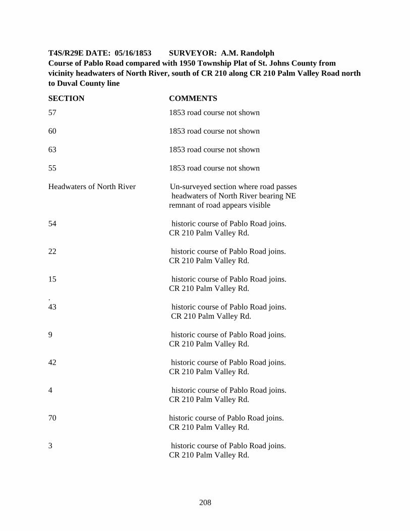
T4S/R29E DATE: 05/16/1853 SURVEYOR: A.M. Randolph Course of Pablo Road compared with 1950 Township Plat of St. Johns County from vicinity headwaters of North River, south of CR 210 along CR 210 Palm Valley Road north to Duval County line
SECTION COMMENTS
57 1853 road course not shown 60 1853 road course not shown 63 1853 road course not shown 55 1853 road course not shown Headwaters of North River Un-surveyed section where road passes headwaters of North River bearing NE remnant of road appears visible 54 historic course of Pablo Road joins. CR 210 Palm Valley Rd. 22 historic course of Pablo Road joins. CR 210 Palm Valley Rd. 15 historic course of Pablo Road joins. CR 210 Palm Valley Rd. . 43 historic course of Pablo Road joins. CR 210 Palm Valley Rd. 9 historic course of Pablo Road joins. CR 210 Palm Valley Rd. 42 historic course of Pablo Road joins. CR 210 Palm Valley Rd. 4 historic course of Pablo Road joins. CR 210 Palm Valley Rd. 70 historic course of Pablo Road joins. CR 210 Palm Valley Rd. 3 historic course of Pablo Road joins. CR 210 Palm Valley Rd.
208

T3S/R29E/Sections: ID: 112467 DATE: 04/01/1834 SURVEYOR: Henry Washington SECTION COMMENTS
34 Proceeds N. 27 Gov. Lots 12,9,10,7,4,3 21 16 9 4 14,13,12,6,4,1 37 Bernardo de Castro y Ferrer T3S/R29E/Sections: ID: 112466 DATE: 04/01/1834 SURVEYOR: Henry Washington SECTION COMMENTS
34 Proceeds N. 27 Gov. Lots 12,9,10,7,4,3 16 9 4 14,13,12,6,4,1 37 Bernardo de Castro y Ferrer
209

T3S/R29E/Sections: ID: 110641 DATE: 03/06/1851 SURVEYOR: Henry Washington/AM Randolph SECTION COMMENTS
34 Proceeds N. 27 Gov. Lots 12,9,10,7,4,3 22 clips SW corner 16 55 William Hart Grant; East boundary 9 4 14,13,12,6,4,1 37 Bernardo de Castro y Ferrer
210

T2S/R29E/Sections: ID: 111520 DATE: 12/01/1835 SURVEYOR: Henry Washington Bears North SECTION COMMENTS
38 Bernardo de Castro y Ferrer T2S/R29E/Sections: ID: 111523 DATE: 05/03/1836 SURVEYOR: Henry Washington Bears North
SECTION COMMENTS
38 Bernardo de Castro y Ferrer 28 21 17 8 37 Andrew DeWees T2S/R29E/Sections: ID: 110640 DATE: 03/06/1851 SURVEYOR: Henry Washington/Henry Randoph Bears North SECTION COMMENTS
38 Bernardo de Castro y Ferrer 28 21 17 8 37 Andrew DeWees
211

T1S/R29E/Sections: ID: 110637 DATE: 10/01/1849 SURVEYOR: Henry Washington/David Burr Bears North
SECTION COMMENTS
37 Andrew DeWees Shows Road to Lighthouse/Road to Beach T1S/R29E/Sections: ID: 110638 DATE: 02/16/1883 SURVEYOR: H.S. Duval Bears North
SECTION COMMENTS
37 Andrew DeWees Shows Kings Road to Mayport/Old Light House
212

213

214

215


![[Social Philosophy] [Constructivism] - Bruner, Jerome - The Narrative Construction of Reality (1991)](https://img.dokumen.tips/doc/110x75/563db8ad550346aa9a95e1cb/social-philosophy-constructivism-bruner-jerome-the-narrative-construction.jpg)