Embed Size (px)
Citation preview

Malcolm Skinner
Paul Abbiss
Phil Banks
Helen Fyfe
Ian Whittaker
AQAA-level
GeographyFor A-level and AS
SAMPLE MATERIAL
This title has been selected for
AQA’s offi cial approval process
Also available:
AQA A-level Geography Dynamic LearningDynamic Learning is an innovative online subscription service that enriches your teaching and simplifi es your planning, providing lesson planning tools, readymade presentations, differentiated worksheets, exam support, self-marking tests, geographical resources and eTextbook elements that all work together to create the ultimate classroom and homework resource.
Prices from: £440 + VAT for access until December 2018 • Publishing from: Spring 2016
AQA A-level Geography Student GuidesReinforce students’ geographical understanding throughout their course; clear topic summaries with sample questions and answers help students improve their technique and achieve their best.
Price: £9.99 • Publishing from: July 2016
Essential Maths Skills for AS/A-level GeographyHelp your students improve their skills and feel confi dent about the maths they need for A-level Geography with this essential guide.
Price: £9.99 • Publishing: September 2016
My Revision Notes: AQA A-level GeographyUnlock your students’ full potential at A-level with revision guides that focus on the key knowledge and skills required for the 2016 specifi cation.
Prices from: £10.99 • Publishing from: January 2017
Geography Review magazineGeography Review magazine helps students learn more, gaining deeper subject knowledge and the skills to study independently at A-level and beyond. It broadens students’ understanding of topical issues around the globe, providing them with extra facts and examples to enhance their exam responses.
Institutional price: £38 • Student price: £15 • 4 issues per year
Philip Allan Events Ensure that you are fully prepared for the upcoming changes by attending one of our Introducing the New AQA Geography A-level: Core and Options courses.
Join highly-regarded trainer David Redfern as he explores approaches to teaching the new areas of study in the 2016 specifi cation.
AQA Training From understanding and preparing to teach new specifi cations, through to developing subject expertise and moving leadership, AQA has a training offering for you. Continued professional development training is provided to over 30,000 teachers each year, either through face to face, online or in school courses, events and workshops.
For more information and to book your place, visit www.aqa.org.uk/cpd
Confi dently navigate the new AQA A-level specifi cation with print and digital resources that support your planning, teaching and assessment needs; brought to you by the leading Geography publisher alongside Geography Review magazine and expert-led, inspirational CPD events.The following print and digital resources have been selected for AQA’s offi cial approval process:AQA A-level Geography Student’s Book 9781471858697 April 2016 £35.99AQA A-level Geography Student eTextbook 9781471859083 May 2016 From £9
To request Inspection Copies, eInspection Copies or free, no obligation 30-day Student eTextbook trials, visit www.hoddereducation.co.uk/Geography/ALevel/AQA
To fi nd out more and request Inspection Copies, eInspection Copies and free, no obligation Dynamic Learning trials, visit www.hoddereducation.co.uk/Geography/ALevel/AQA
The Whiteboard eTextbook and Teaching and Learning Resources have not been entered into the AQA approval process
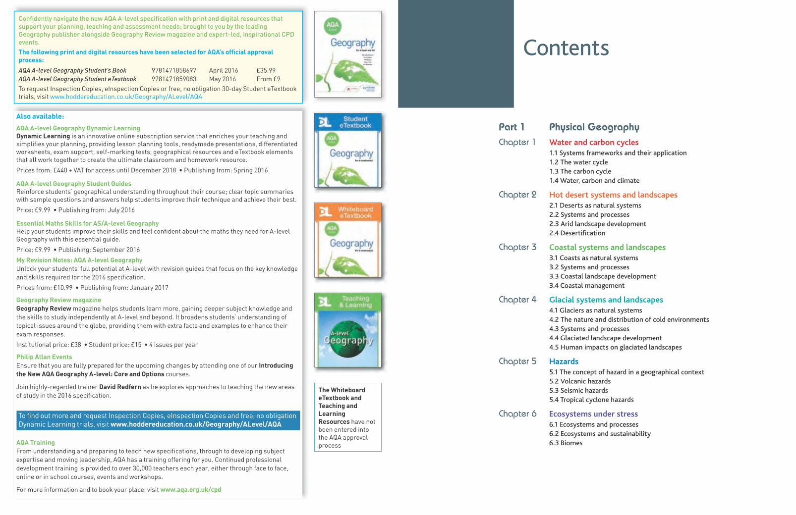
Contents
Part 1 Physical GeographyChapter 1 Water and carbon cycles
1.1 Systems frameworks and their application 1.2 The water cycle 1.3 The carbon cycle 1.4 Water, carbon and climate
Chapter 2 Hot desert systems and landscapes
2.1 Deserts as natural systems2.2 Systems and processes 2.3 Arid landscape development 2.4 Desertification
Chapter 3 Coastal systems and landscapes
3.1 Coasts as natural systems 3.2 Systems and processes 3.3 Coastal landscape development 3.4 Coastal management
Chapter 4 Glacial systems and landscapes
4.1 Glaciers as natural systems4.2 The nature and distribution of cold environments 4.3 Systems and processes 4.4 Glaciated landscape development 4.5 Human impacts on glaciated landscapes
Chapter 5 Hazards
5.1 The concept of hazard in a geographical context 5.2 Volcanic hazards 5.3 Seismic hazards 5.4 Tropical cyclone hazards
Chapter 6 Ecosystems under stress
6.1 Ecosystems and processes 6.2 Ecosystems and sustainability 6.3 Biomes
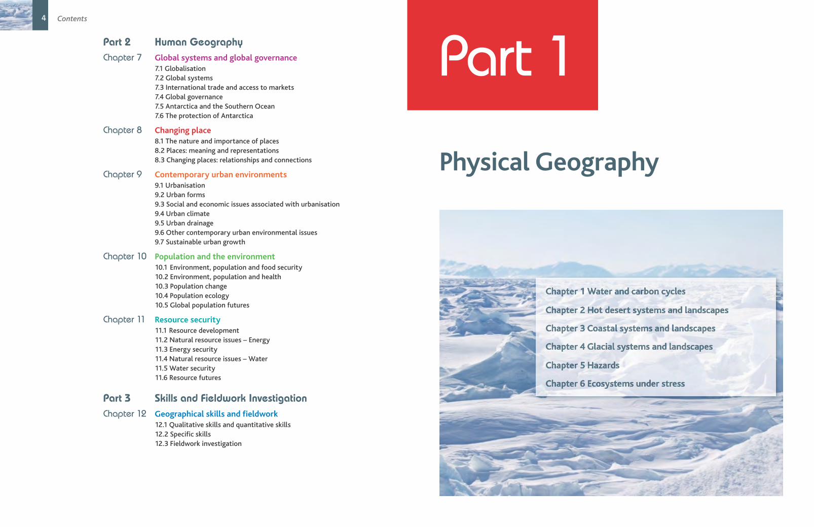
4 Contents
Part 2 Human GeographyChapter 7 Global systems and global governance
7.1 Globalisation 7.2 Global systems 7.3 International trade and access to markets 7.4 Global governance 7.5 Antarctica and the Southern Ocean 7.6 The protection of Antarctica
Chapter 8 Changing place
8.1 The nature and importance of places 8.2 Places: meaning and representations 8.3 Changing places: relationships and connections
Chapter 9 Contemporary urban environments
9.1 Urbanisation 9.2 Urban forms 9.3 Social and economic issues associated with urbanisation 9.4 Urban climate 9.5 Urban drainage 9.6 Other contemporary urban environmental issues 9.7 Sustainable urban growth
Chapter 10 Population and the environment
10.1 Environment, population and food security 10.2 Environment, population and health 10.3 Population change 10.4 Population ecology10.5 Global population futures
Chapter 11 Resource security
11.1 Resource development 11.2 Natural resource issues – Energy 11.3 Energy security 11.4 Natural resource issues – Water 11.5 Water security11.6 Resource futures
Part 3 Skills and Fieldwork InvestigationChapter 12 Geographical skills and fieldwork
12.1 Qualitative skills and quantitative skills 12.2 Specific skills 12.3 Fieldwork investigation
Part 1
Physical Geography
Chapter 1 Water and carbon cycles
Chapter 2 Hot desert systems and landscapes
Chapter 3 Coastal systems and landscapes
Chapter 4 Glacial systems and landscapes
Chapter 5 Hazards
Chapter 6 Ecosystems under stress
Chapter
In this chapter you will study:● systems frameworks and their application● the water cycle● the carbon cycle● water, carbon and climate.
The cycling of water has obvious and signifi cant implications for the health and prosperity of society. The availability and quantity of water is vital to life on Earth and helps to tie together the Earth’s lands, oceans and atmosphere into an integrated physical system. Added to this is that water vapour is the most important greenhouse gas and is a major driving factor in determining climate. The global water cycle is driven by many complex processes and interactions at a variety of scales, which are often poorly understood and badly represented in model predictions.
Carbon is everywhere, in the oceans, in rocks and soils, in all forms of life and in our atmosphere. Without carbon, as we know it, life would not exist. The well-being and functioning of our planet depends on carbon and how it cycles through the Earth’s system. The carbon cycle plays a key role in regulating Earth’s global temperature and climate by controlling the amount of another greenhouse gas, carbon dioxide, in the atmosphere.
Both the water and carbon cycles (and other aspects of geography) can be studied by considering them as systems.
1.1 Systems frameworks and their applicationBecause the Earth is highly complex, geographers have attempted to simplify aspects of it so that relationships between components can be better understood. These simplifications are called models (e.g. the water cycle, the demographic transition model). One type of model that is widely used, particularly in physical geography is the system.
A system is an assemblage of interrelated parts that work together by way of some driving process. They are a series of stores or components that have flows or connections between them. There are three types of property: elements, attributes, and relationships. Elements are the things that make up the system of interest. Attributes are the perceived characteristics of the elements. Relationships are descriptions of how the various elements (and their attributes) work together to carry out some kind of process. Most systems share the same common characteristics. These include:
● They have a structure that lies within a boundary.
● They are generalisations of reality, removing incidental detail that obscures fundamental relationships.
● They function by having inputs and outputs of material (energy and/or matter) that is processed within the components causing it to change in some way.
● They involve the flow of material between components.
1 Water and carbon cycles
858697_AQA_Geog_A_Level_C1_06-09.indd 6 29/10/15 10:07 PM
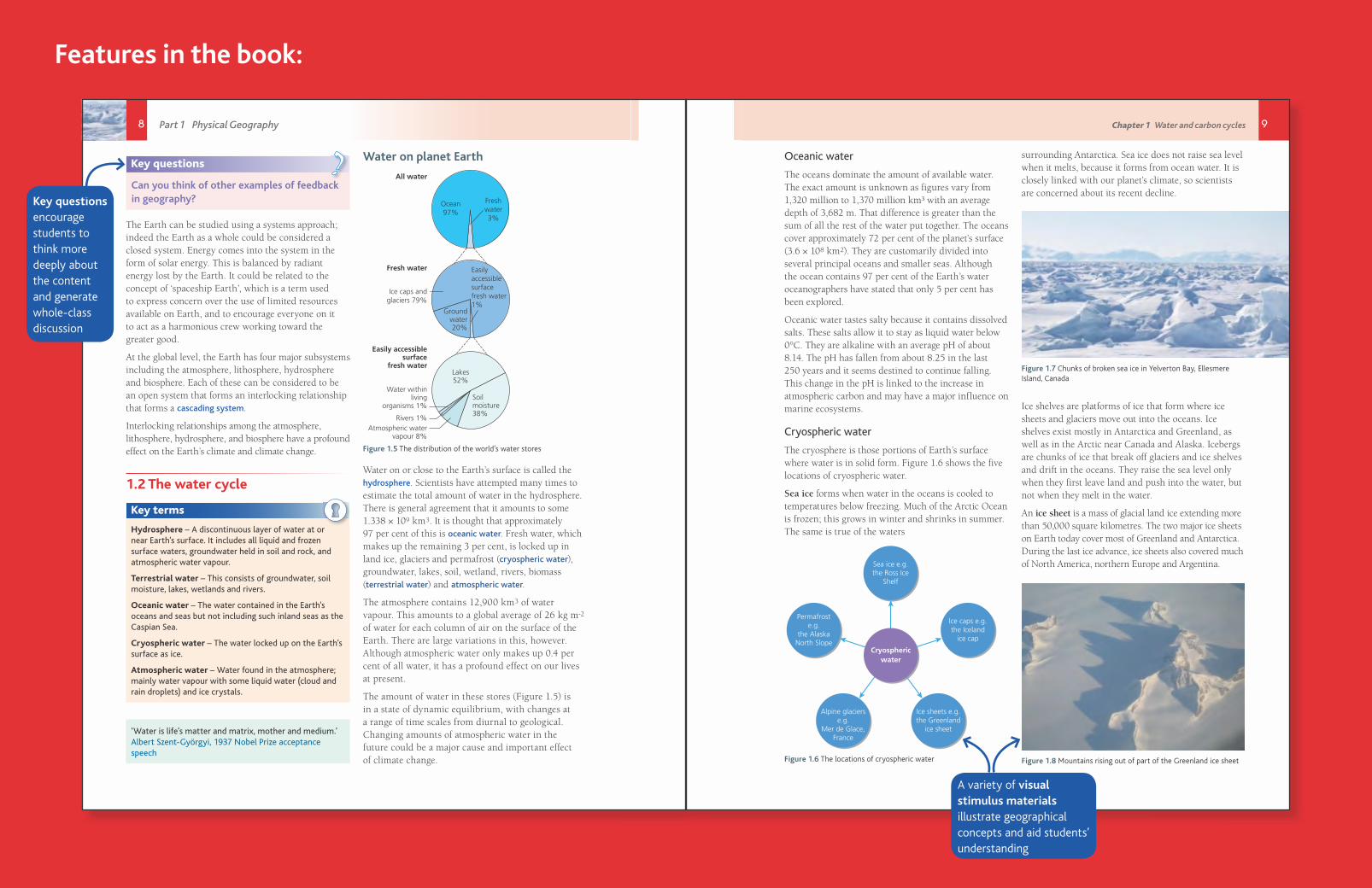
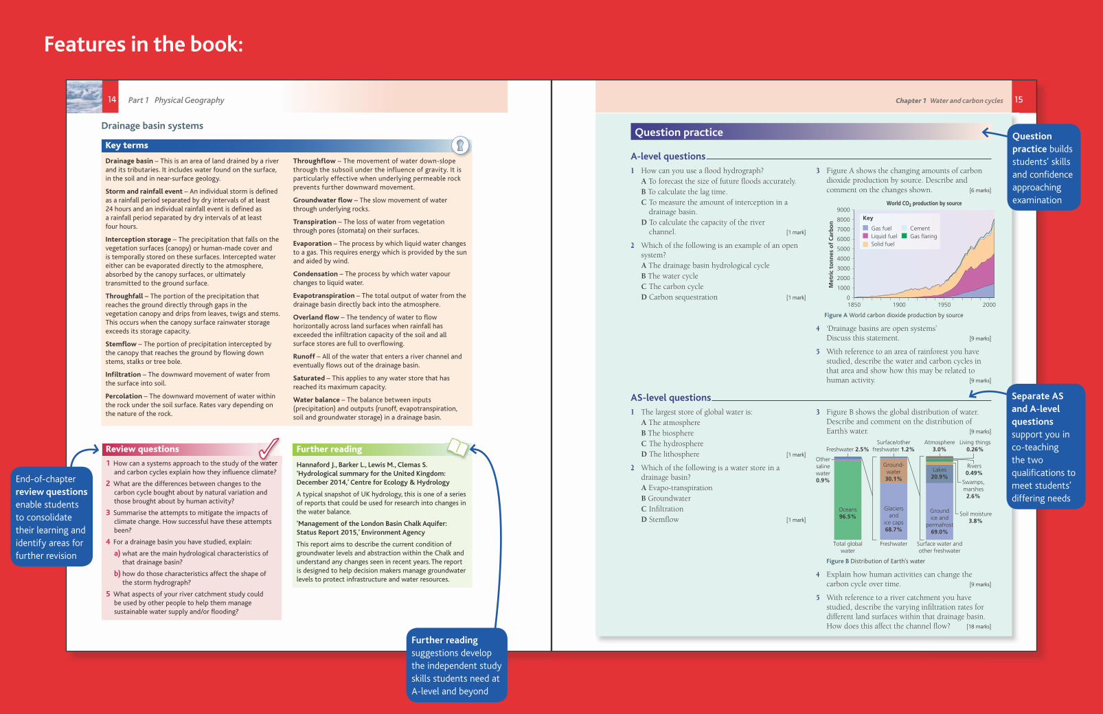
Chapter introductions outline the key content, help students track their learning and provide useful revision summaries
Chapter 1 Water and carbon cycles 7
Key terms
System – A system is a set of interrelated components working together towards some kind of process.
Store/component – A part of the system where energy/mass is stored or transformed.
Flow/transfer – A form of linkage between one store/component that involves movement of energy or mass.
Input – The addition of matter and/or energy or into a system.
Output – The movement of matter and/or energy out of a system.
System boundary – Outer edge of system; the interface between one system and another.
Dynamic equilibrium – This occurs when inputs balance outputs so that the overall system does not change.
Positive feedback – Change in the state of a system that causes the initial change to increase.
Negative feedback – Change in the state of a system that counteracts or dampens that change.
System element – System elements are the kinds of things or substances composing the system. They may be atoms or molecules, or larger bodies of matter, e.g. sand grains, rain drops etc.
Cascading system – This is made up of a chain of open systems where the output from one open system forms the input into another. Rivers are a classic example of open cascade systems.
Systems can be classified as:
● Isolated systems: these have no interactions with anything outside the system boundary. There is no input or output of energy or matter. Many controlled laboratory experiments are this type of system and they are rare in nature.
● Closed systems: these have transfers of energy both into and beyond the system boundary but not transfer of matter (Figure 1.1).
● Open systems: these are where matter and energy can be transferred from the system across the boundary into the surrounding environment. Most ecosystems are an example of open systems (Figure 1.2).
Component/store
Output
Input
Figure 1.1 A closed system – very rare in nature
Store/componentFlow Output
Store/componentInput
Figure 1.2 An open system, e.g. a drainage basin hydrological system
When there is a balance between the inputs and outputs then the system is said to be in a state of dynamic equilibrium. This means that the stores stay the same. If, however, one of the elements of the system changes, for example one of the inputs increases without any corresponding change in the outputs, then the stores change and the equilibrium is upset. This is called feedback. There are two types of feedback:
● positive feedback where the effects of an action (e.g. an increase in carbon dioxide) are amplified or multiplied by subsequent ‘knock-on’ or secondary effects. (Figure 1.3)
● negative feedback where the effects of an action (e.g. the increased use of fossil fuels) are nullified by its subsequent knock-on effects. (Figure 1.4)
Globaltemperature
rise
More CO2 inthe atmosphere
Increasedoceanic
temperatures
Dissolved CO2released by
warmer oceans
More CO2to act as a
greenhouse gas
Warm waterless able todissolve gas
Warmsthe oceans
CO2 backinto the
atmosphere
Figure 1.3 Example of positive feedback in a system
Increase inatmospheric CO2
Reducesatmospheric CO2
More plantgrowth
Start:Increased use of fossil fuels
Global temperatureincrease
Increased takeup of CO2
Reduced CO2 has a‘dampening’ effect
and reducesglobal temperatures
Figure 1.4 Example of negative feedback in a system
858697_AQA_Geog_A_Level_C1_06-09.indd 7 29/10/15 10:07 PM
Key terms are defi ned throughout, equipping students with high-level geographical vocabulary to use in their exam responses and geographical investigation
Features in the book:
8 Part 1 Physical Geography
Key questions
Can you think of other examples of feedback in geography?
?
The Earth can be studied using a systems approach; indeed the Earth as a whole could be considered a closed system. Energy comes into the system in the form of solar energy. This is balanced by radiant energy lost by the Earth. It could be related to the concept of ‘spaceship Earth’, which is a term used to express concern over the use of limited resources available on Earth, and to encourage everyone on it to act as a harmonious crew working toward the greater good.
At the global level, the Earth has four major subsystems including the atmosphere, lithosphere, hydrosphere and biosphere. Each of these can be considered to be an open system that forms an interlocking relationship that forms a cascading system.
Interlocking relationships among the atmosphere, lithosphere, hydrosphere, and biosphere have a profound effect on the Earth’s climate and climate change.
1.2 The water cycle
Key terms
Hydrosphere – A discontinuous layer of water at or near Earth’s surface. It includes all liquid and frozen surface waters, groundwater held in soil and rock, and atmospheric water vapour.
Terrestrial water – This consists of groundwater, soil moisture, lakes, wetlands and rivers.
Oceanic water – The water contained in the Earth’s oceans and seas but not including such inland seas as the Caspian Sea.
Cryospheric water – The water locked up on the Earth’s surface as ice.
Atmospheric water – Water found in the atmosphere; mainly water vapour with some liquid water (cloud and rain droplets) and ice crystals.
‘Water is life’s matter and matrix, mother and medium.’Albert Szent-Györgyi, 1937 Nobel Prize acceptance speech
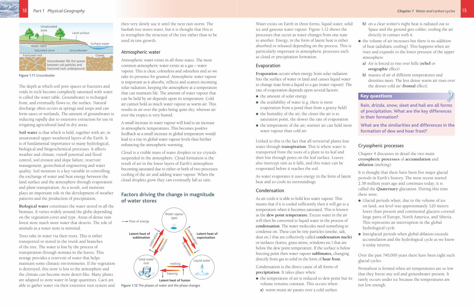
Water on planet Earth
Fresh water
Ice caps andglaciers 79%
Groundwater20%
Easily accessiblesurface
fresh waterLakes52%
Soilmoisture38%
Water withinliving
organisms 1%
Rivers 1%Atmospheric water
vapour 8%
Easilyaccessiblesurfacefresh water1%
All water
Ocean97%
Freshwater3%
Figure 1.5 The distribution of the world’s water stores
Water on or close to the Earth’s surface is called the hydrosphere. Scientists have attempted many times to estimate the total amount of water in the hydrosphere. There is general agreement that it amounts to some 1.338 × 10⁹ km3. It is thought that approximately 97 per cent of this is oceanic water. Fresh water, which makes up the remaining 3 per cent, is locked up in land ice, glaciers and permafrost (cryospheric water), groundwater, lakes, soil, wetland, rivers, biomass (terrestrial water) and atmospheric water.
The atmosphere contains 12,900 km3 of water vapour. This amounts to a global average of 26 kg m-2 of water for each column of air on the surface of the Earth. There are large variations in this, however. Although atmospheric water only makes up 0.4 per cent of all water, it has a profound effect on our lives at present.
The amount of water in these stores (Figure 1.5) is in a state of dynamic equilibrium, with changes at a range of time scales from diurnal to geological. Changing amounts of atmospheric water in the future could be a major cause and important effect of climate change.
858697_AQA_Geog_A_Level_C1_06-09.indd 8 29/10/15 10:07 PM
Key questions encourage students to think more deeply about the content and generate whole-class discussion
Chapter 1 Water and carbon cycles 9
Oceanic water
The oceans dominate the amount of available water. The exact amount is unknown as figures vary from 1,320 million to 1,370 million km³ with an average depth of 3,682 m. That difference is greater than the sum of all the rest of the water put together. The oceans cover approximately 72 per cent of the planet’s surface (3.6 × 10⁸ km2). They are customarily divided into several principal oceans and smaller seas. Although the ocean contains 97 per cent of the Earth’s water oceanographers have stated that only 5 per cent has been explored.
Oceanic water tastes salty because it contains dissolved salts. These salts allow it to stay as liquid water below 0°C. They are alkaline with an average pH of about 8.14. The pH has fallen from about 8.25 in the last 250 years and it seems destined to continue falling. This change in the pH is linked to the increase in atmospheric carbon and may have a major influence on marine ecosystems.
Cryospheric water
The cryosphere is those portions of Earth’s surface where water is in solid form. Figure 1.6 shows the five locations of cryospheric water.
Sea ice forms when water in the oceans is cooled to temperatures below freezing. Much of the Arctic Ocean is frozen; this grows in winter and shrinks in summer. The same is true of the waters
Ice caps e.g.the Iceland
ice cap
Permafroste.g.
the AlaskaNorth Slope
Sea ice e.g.the Ross Ice
Shelf
Ice sheets e.g.the Greenland
ice sheet
Alpine glacierse.g.
Mer de Glace,France
Cryosphericwater
Figure 1.6 The locations of cryospheric water
surrounding Antarctica. Sea ice does not raise sea level when it melts, because it forms from ocean water. It is closely linked with our planet’s climate, so scientists are concerned about its recent decline.
Figure 1.7 Chunks of broken sea ice in Yelverton Bay, Ellesmere Island, Canada
Ice shelves are platforms of ice that form where ice sheets and glaciers move out into the oceans. Ice shelves exist mostly in Antarctica and Greenland, as well as in the Arctic near Canada and Alaska. Icebergs are chunks of ice that break off glaciers and ice shelves and drift in the oceans. They raise the sea level only when they first leave land and push into the water, but not when they melt in the water.
An ice sheet is a mass of glacial land ice extending more than 50,000 square kilometres. The two major ice sheets on Earth today cover most of Greenland and Antarctica. During the last ice advance, ice sheets also covered much of North America, northern Europe and Argentina.
Figure 1.8 Mountains rising out of part of the Greenland ice sheet
858697_AQA_Geog_A_Level_C1_06-09.indd 9 29/10/15 10:08 PM
Features in the book:
A variety of visual stimulus materials illustrate geographical concepts and aid students’ understanding

10 11Chapter 1 Water and carbon cycles Part 1 Physical Geography
Together, the Antarctic and Greenland ice sheets contain more than 99 per cent of the freshwater ice on Earth. The Antarctic ice sheet extends almost 14 million km², roughly the area of the United States of America and Mexico combined. It contains 30 million km³ of ice. The Greenland ice sheet extends about 1.7 million km², covering most of the island of Greenland.
Ice sheets form in areas where snow that falls in winter does not melt entirely over the summer. Over thousands of years, the layers of snow pile up into thick masses of ice, growing thicker and denser as the weight of new snow and ice layers compresses the older layers. Ice sheets are constantly in motion, slowly flowing downhill under their own weight. Near the coast, most of the ice moves through relatively fast-moving outlets called ice streams, glaciers and ice shelves. As long as an ice sheet accumulates the same mass of snow as it loses to the sea, it remains stable.
Ice sheets contain enormous quantities of frozen water. If the Greenland ice sheet melted, scientists estimate that sea level would rise about six metres. If the Antarctic ice sheet melted, sea level would rise by about 60 metres.
Ice caps are thick layers of ice on land that are smaller than 50,000 km². They are usually found in mountainous areas. Ice caps tend to be dome-shaped and are centred over the highest point of an upland area. They flow outwards covering almost everything in their path, becoming the major source for many glaciers.
Ice caps occur all over the world from the polar regions to mountainous areas such as the Himalayas, the Rockies, the Andes and the Southern Alps of New Zealand. The Furtwängler glacier on Kilimanjaro, at 60,000 km² is Africa’s only remaining ice cap. It is melting rapidly and may soon disappear.
Figure 1.9 The Furtwängler ice cap. The last ice cap in Africa
Alpine glaciers are thick masses of ice found in deep valleys or in upland hollows. Most valley glaciers are fed by ice from ice caps or smaller corrie glaciers. These glaciers are particularly important in the Himalayas where about 15,000 Himalayan glaciers form a unique reservoir which supports perennial rivers such as the Indus, Ganges and Brahmaputra which, in turn, are the lifeline of millions of people in South Asian countries (Pakistan, Nepal, Bhutan, India and Bangladesh).
Permafrost is defined as ground (soil or rock and including ice or organic material) that remains at or below 0°C for at least two consecutive years. The thickness of permafrost varies from less than one metre to more than 1,500 metres. Most of the permafrost existing today formed during cold glacial periods, and has persisted through warmer interglacial periods, including the Holocene (last 10,000 years). Some relatively shallow permafrost (30 to 70 metres) formed during the second part of the Holocene (last 6,000 years) and some during the Little Ice Age (from 400 to 150 years ago). Subsea permafrost occurs close to 0°C over large areas of the Arctic continental shelf, where it formed during the last glacial period on the exposed shelf landscapes when sea levels were lower. Permafrost is found beneath the ice-free regions of the Antarctic continent and also occurs beneath areas in which the ice sheet is frozen to its bed.
The permafrost has begun to melt as climate warms. This melting is releasing large amounts of carbon dioxide and methane, potentially affecting global climates.
Terrestrial water
Terrestrial water falls into four broad classes:
● surface water
● ground water
● soil water
● biological water.
Surface water is the free-flowing water of rivers as well as the water of ponds and lakes.
Rivers act as both a store and a transfer of water; they are streams of water within a defined channel. They transfer water from the ground, from soils and from the atmosphere to a store. That store maybe wetlands, lakes or the oceans.
Rivers make up only a small percentage (0.0002 per cent) of all water, covering just 1,000,000 km² with a volume of 2,120 km³. One river alone, the Amazon in South America is the largest river by discharge of water in the world, averaging a discharge of about 209,000 m³/s, greater than the next seven largest independent rivers combined. It drains an area of about 7,050,000 km² and accounts for approximately one-fifth of the world’s total river flow. The portion of the river’s drainage basin in Brazil alone is larger than any other river’s basin. The Amazon enters Brazil with only one-fifth of the flow it finally discharges into the Atlantic Ocean, yet already has a greater flow at this point than the discharge of any other river.
Lakes are stores of fresh water found in hollows on the land surface. They are generally deemed a lake if they are greater than two hectares in area. Any standing body of water smaller than this is termed a pond.
The majority of lakes on Earth are fresh water, and most lie in the Northern Hemisphere at higher latitudes. Canada has an estimated 31,752 lakes larger than three km² and an estimated total number of at least 2 million. Finland has 187,888 lakes 500 m² or larger, of which 56,000 are large (10,000 m²).
The largest lake is the Caspian Sea at 78,200 km³. It is a remnant of an ancient ocean and is about 5.5 million years old. It is generally fresh water, though becomes more saline in the south where there are few rivers flowing into it. The deepest lake in the world is Lake Baikal in Siberia with a mean depth of 749 metres and a deepest point at 1,637 m.
Wetlands: The Ramsar Convention defines wetlands as: ‘areas of marsh, fen, peatland or water whether natural or artificial, permanent or temporary, with water that is static or flowing where there is a dominance by vegetation’.
They are areas where water covers the soil, or is present either at or near the surface of the soil all year or for varying periods of time during the year, including during the growing season. Water saturation determines how the soil develops and the types of plant and animal communities living in and on the soil. Wetlands may support both aquatic and terrestrial species. The prolonged presence of water creates
conditions that favour the growth of specially adapted plants and promote the development of characteristic wetland soils.
Wetlands vary widely because of regional and local differences in soils, topography, climate, hydrology, water chemistry, vegetation and other factors, including human disturbance. They are found from the polar regions to the tropics and on every continent except Antarctica.
Brazil
Bolivia
Paraguay
Argentina
Andes Mountains
Peru
Chile0 100km
N
Figure 1.10 The location of the Pantanal wetlands
The Pantanal of South America is often referred to as the world’s largest freshwater wetland system, it extends through millions of hectares of central-western Brazil, eastern Bolivia and eastern Paraguay. It is a complex system of marshlands, floodplains, lagoons and interconnected drainage lines. It also provides economic benefits by being a huge area for water purification and groundwater discharge and recharge, climate stabilisation, water supply, flood abatement, and an extensive, transport system, among numerous other important functions.
Wetlands are the main ecosystem in the Arctic. These peatlands, rivers, lakes, and shallow bays cover nearly 60 per cent of the total surface area. Arctic wetlands store enormous amounts of greenhouse gases and are critical for global biodiversity
Ground water is water that collects underground in the pore spaces of rock. Scientists have set a lower level of groundwater at a depth of 4,000 metres, but it is known that there are large quantities of water below that. A very deep borehole in the Kola Peninsula in northern Russia found huge quantities of hot mineralised water at a depth of thirteen kilometres.
12 13Chapter 1 Water and carbon cycles Part 1 Physical Geography
Water exists on Earth in three forms, liquid water, solid ice and gaseous water vapour. Figure 1.12 shows the processes that occur as water changes from one state to another. Energy, in the form of latent heat is either absorbed or released depending on the process. This is particularly important in atmospheric processes such as cloud or precipitation formation.
Evaporation
Evaporation occurs when energy from solar radiation hits the surface of water or land and causes liquid water to change state from a liquid to a gas (water vapour). The rate of evaporation depends upon several factors:
● the amount of solar energy
● the availability of water (e.g. there is more evaporation from a pond than from a grassy field)
● the humidity of the air, the closer the air is to saturation point, the slower the rate of evaporation
● the temperature of the air, warmer air can hold more water vapour than cold air.
Linked to this is the fact that all terrestrial plants lose water through transpiration. This is where water is transported from the roots of a plant to its leaf and then lost through pores on the leaf surface. Leaves also intercept rain as it falls, and this water can be evaporated before it reaches the soil.
As water evaporates it uses energy in the form of latent heat and so cools its surroundings.
Condensation
As air cools it is able to hold less water vapour. This means that if it is cooled sufficiently then it will get to a temperature when it becomes saturated. This is known as the dew point temperature. Excess water in the air will then be converted to liquid water in the process of condensation. The water molecules need something to condense on. These can be tiny particles (smoke, salt, dust etc.) that are collectively called condensation nuclei or surfaces (leaves, grass stems, windows etc.) that are below the dew point temperature. If the surface is below freezing point then water vapour sublimates, changing directly from gas to solid in the form of hoar frost.
Condensation is the direct cause of all forms of precipitation. It takes place when:
● the temperature of air is reduced to dew point but its volume remains constant. This occurs when:
a) warm moist air passes over a cold surface
b) on a clear winter’s night heat is radiated out to Space and the ground gets colder, cooling the air directly in contact with it.
● the volume of air increases but there is no addition of heat (adiabatic cooling). This happens when air rises and expands in the lower pressure of the upper atmosphere:
a) Air is forced to rise over hills (relief or orographic effect)
b) masses of air of different temperatures and densities meet. The less dense warm air rises over the denser cold air (frontal effect).
Key questions
Rain, drizzle, snow, sleet and hail are all forms of precipitation. What are the key differences in their formation?
What are the similarities and differences in the formation of dew and hoar frost?
?
Cryospheric processes
Chapter 4 discusses in detail the two main cryospheric processes of accumulation and ablation (melting).
It is thought that there have been five major glacial periods in Earth’s history. The most recent started 2.58 million years ago and continues today; it is called the Quaternary glaciation. During this time there were:
● Glacial periods when, due to the volume of ice on land, sea level was approximately 120 meters lower than present and continental glaciers covered large parts of Europe, North America, and Siberia. This represents an interruption in the global hydrological cycle
● Interglacial periods when global ablation exceeds accumulation and the hydrological cycle as we know it today returns.
Over the past 740,000 years there have been eight such glacial cycles.
Permafrost is formed when air temperatures are so low that they freeze any soil and groundwater present. It rarely occurs under ice because the temperatures are not low enough.
Groundwater fills the spacesbetween soil particles andfractured rock underground.
Gravel
Surface water
Land surface
Unsaturatedzone
Fractured rock
Water tableWater tableSaturated zoneSaturated zone GroundwaterGroundwaterSaturated zone Groundwater
Water table
Figure 1.11 Groundwater
The depth at which soil pore spaces or fractures and voids in rock become completely saturated with water is called the water table. Groundwater is recharged from, and eventually flows to, the surface. Natural discharge often occurs at springs and seeps and can form oases or wetlands. The amount of groundwater is reducing rapidly due to extensive extraction for use in irrigating agricultural land in dry areas.
Soil water is that which is held, together with air, in unsaturated upper weathered layers of the Earth. It is of fundamental importance to many hydrological, biological and biogeochemical processes. It affects weather and climate, runoff potential and flood control, soil erosion and slope failure, reservoir management, geotechnical engineering and water quality. Soil moisture is a key variable in controlling the exchange of water and heat energy between the land surface and the atmosphere through evaporation and plant transpiration. As a result, soil moisture plays an important role in the development of weather patterns and the production of precipitation.
Biological water constitutes the water stored in all the biomass. It varies widely around the globe depending on the vegetation cover and type. Areas of dense rain forest store much more water that deserts. The role of animals as a water store is minimal.
Trees take in water via their roots. This is either transported or stored in the trunk and branches of the tree. The water is lost by the process of transpiration through stomata in the leaves. This storage provides a reservoir of water that helps maintain some climatic environments. If the vegetation is destroyed, this store is lost to the atmosphere and the climate can become more desert-like. Many plants are adapted to store water in large quantities. Cacti are able to gather water via their extensive root system and
then very slowly use it until the next rain storm. The baobab tree stores water, but it is thought that this is to strengthen the structure of the tree rather than to be used in tree growth.
Atmospheric water
Atmospheric water exists in all three states. The most common atmospheric water exists as a gas – water vapour. This is clear, colourless and odourless and so we take its presence for granted. Atmospheric water vapour is important as it absorbs, reflects and scatters incoming solar radiation, keeping the atmosphere at a temperature that can maintain life. The amount of water vapour that can be held by air depends upon its temperature. Cold air cannot hold as much water vapour as warm air. This results in air over the poles being quite dry, whereas air over the tropics is very humid.
A small increase in water vapour will lead to an increase in atmospheric temperatures. This becomes positive feedback as a small increase in global temperature would lead to a rise in global water vapour levels thus further enhancing the atmospheric warming.
Cloud is a visible mass of water droplets or ice crystals suspended in the atmosphere. Cloud formation is the result of air in the lower layers of Earth’s atmosphere becoming saturated due to either or both of two processes: cooling of the air and adding water vapour. When the cloud droplets grow they can eventually fall as rain.
Factors driving the change in magnitude of water stores
Water vapour(gas)
Latent heat ofvaporisation
evaporation
Liquid water
Latent heat of fusion
Solid water(ice)
Flow of energy
Latent heat ofsublimation
subl
imat
ion
melting
freezing
depo
sitio
n
condensation
Figure 1.12 The phases of water and the phase changes
14 Part 1 Physical Geography
Drainage basin systems
Key terms
Drainage basin – This is an area of land drained by a river and its tributaries. It includes water found on the surface, in the soil and in near-surface geology.
Storm and rainfall event – An individual storm is defined as a rainfall period separated by dry intervals of at least 24 hours and an individual rainfall event is defined as a rainfall period separated by dry intervals of at least four hours.
Interception storage – The precipitation that falls on the vegetation surfaces (canopy) or human-made cover and is temporally stored on these surfaces. Intercepted water either can be evaporated directly to the atmosphere, absorbed by the canopy surfaces, or ultimately transmitted to the ground surface.
Throughfall – The portion of the precipitation that reaches the ground directly through gaps in the vegetation canopy and drips from leaves, twigs and stems. This occurs when the canopy surface rainwater storage exceeds its storage capacity.
Stemflow – The portion of precipitation intercepted by the canopy that reaches the ground by flowing down stems, stalks or tree bole.
Infiltration – The downward movement of water from the surface into soil.
Percolation – The downward movement of water within the rock under the soil surface. Rates vary depending on the nature of the rock.
Throughflow – The movement of water down-slope through the subsoil under the influence of gravity. It is particularly effective when underlying permeable rock prevents further downward movement.
Groundwater flow – The slow movement of water through underlying rocks.
Transpiration – The loss of water from vegetation through pores (stomata) on their surfaces.
Evaporation – The process by which liquid water changes to a gas. This requires energy which is provided by the sun and aided by wind.
Condensation – The process by which water vapour changes to liquid water.
Evapotranspiration – The total output of water from the drainage basin directly back into the atmosphere.
Overland flow – The tendency of water to flow horizontally across land surfaces when rainfall has exceeded the infiltration capacity of the soil and all surface stores are full to overflowing.
Runoff – All of the water that enters a river channel and eventually flows out of the drainage basin.
Saturated – This applies to any water store that has reached its maximum capacity.
Water balance – The balance between inputs (precipitation) and outputs (runoff, evapotranspiration, soil and groundwater storage) in a drainage basin.
Review questions
1 How can a systems approach to the study of the water and carbon cycles explain how they infl uence climate?
2 What are the differences between changes to the carbon cycle bought about by natural variation and those brought about by human activity?
3 Summarise the attempts to mitigate the impacts of climate change. How successful have these attempts been?
4 For a drainage basin you have studied, explain:
a) what are the main hydrological characteristics of that drainage basin?
b) how do those characteristics affect the shape of the storm hydrograph?
5 What aspects of your river catchment study could be used by other people to help them manage sustainable water supply and/or fl ooding?
How can a systems approach to the study of the water
Further reading
Hannaford J., Barker L., Lewis M., Clemas S. ‘Hydrological summary for the United Kingdom: December 2014,’ Centre for Ecology & Hydrology
A typical snapshot of UK hydrology, this is one of a series of reports that could be used for research into changes in the water balance.
‘Management of the London Basin Chalk Aquifer: Status Report 2015,’ Environment Agency
This report aims to describe the current condition of groundwater levels and abstraction within the Chalk and understand any changes seen in recent years. The report is designed to help decision makers manage groundwater levels to protect infrastructure and water resources.
858697_AQA_Geog_A_Level_C1_14-15.indd 14 10/19/15 4:25 PM
15Chapter 1 Water and carbon cycles
Question practice
A-level questions1 How can you use a flood hydrograph? A To forecast the size of future fl oods accurately. B To calculate the lag time. C To measure the amount of interception in a
drainage basin. D To calculate the capacity of the river
channel. [1 mark]
2 Which of the following is an example of an open system?
A The drainage basin hydrological cycle B The water cycle C The carbon cycle D Carbon sequestration [1 mark]
3 Figure A shows the changing amounts of carbon dioxide production by source. Describe and comment on the changes shown. [6 marks]
01850 1900 1950 2000
World CO2 production by source
Met
ric
ton
nes
of
Car
bo
n
1000
2000
3000
4000
5000
6000
7000
8000
9000
Gas fuelLiquid fuelSolid fuel
Key
CementGas flaring
Figure A World carbon dioxide production by source
4 ‘Drainage basins are open systems’Discuss this statement. [9 marks]
5 With reference to an area of rainforest you have studied, describe the water and carbon cycles in that area and show how this may be related to human activity. [9 marks]
AS-level questions1 The largest store of global water is: A The atmosphere B The biosphere C The hydrosphere D The lithosphere [1 mark]
2 Which of the following is a water store in a drainage basin?
A Evapo-transpiration B Groundwater C Infi ltration D Stemfl ow [1 mark]
3 Figure B shows the global distribution of water. Describe and comment on the distribution of Earth’s water. [9 marks]
Swamps,marshes2.6%
Soil moisture3.8%
Othersalinewater0.9%
Lakes20.9%
Groundice and
permafrost69.0%
Glaciersand
ice caps68.7%
Freshwater 2.5%Surface/other
freshwater 1.2%Atmosphere
3.0%Living things
0.26%
Rivers0.49%
Oceans96.5%
Total globalwater
Freshwater Surface water andother freshwater
Ground-water30.1%
Figure B Distribution of Earth’s water
4 Explain how human activities can change the carbon cycle over time. [9 marks]
5 With reference to a river catchment you have studied, describe the varying infi ltration rates for different land surfaces within that drainage basin. How does this affect the channel fl ow? [18 marks]
858697_AQA_Geog_A_Level_C1_14-15.indd 15 10/19/15 4:25 PM
End-of-chapter review questions enable students to consolidate their learning and identify areas for further revision
Question practice builds students’ skills and confi dence approaching examination
Separate AS and A-level questions support you in co-teaching the two qualifi cations to meet students’ differing needs
Features in the book:
Further reading suggestions develop the independent study skills students need at A-level and beyond
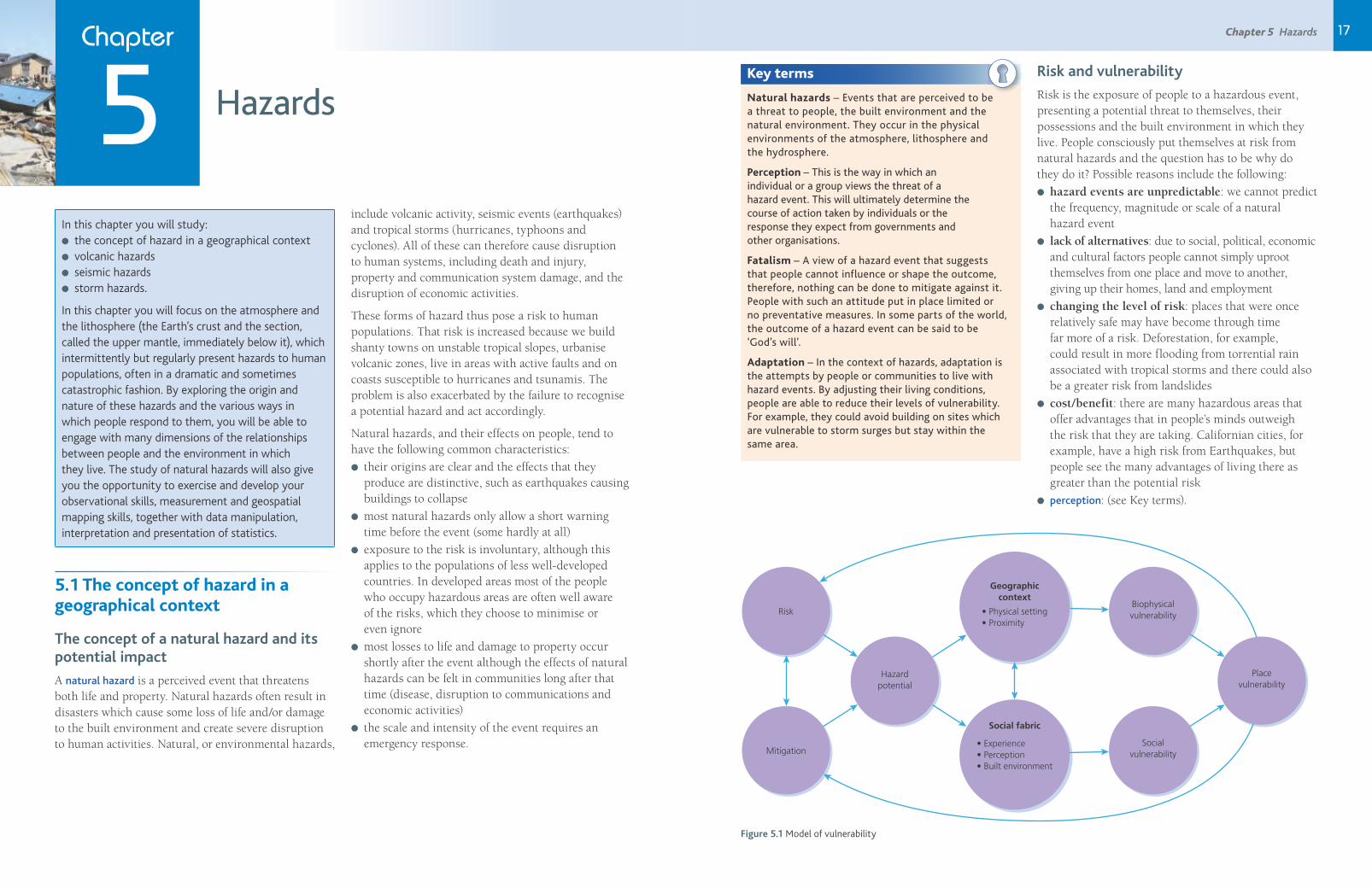
17Chapter 5 Hazards Chapter
5 Hazards
In this chapter you will study:● the concept of hazard in a geographical context● volcanic hazards● seismic hazards● storm hazards.
In this chapter you will focus on the atmosphere and the lithosphere (the Earth’s crust and the section, called the upper mantle, immediately below it), which intermittently but regularly present hazards to human populations, often in a dramatic and sometimes catastrophic fashion. By exploring the origin and nature of these hazards and the various ways in which people respond to them, you will be able to engage with many dimensions of the relationships between people and the environment in which they live. The study of natural hazards will also give you the opportunity to exercise and develop your observational skills, measurement and geospatial mapping skills, together with data manipulation, interpretation and presentation of statistics.
5.1 The concept of hazard in a geographical context
The concept of a natural hazard and its potential impact
A natural hazard is a perceived event that threatens both life and property. Natural hazards often result in disasters which cause some loss of life and/or damage to the built environment and create severe disruption to human activities. Natural, or environmental hazards,
include volcanic activity, seismic events (earthquakes) and tropical storms (hurricanes, typhoons and cyclones). All of these can therefore cause disruption to human systems, including death and injury, property and communication system damage, and the disruption of economic activities.
These forms of hazard thus pose a risk to human populations. That risk is increased because we build shanty towns on unstable tropical slopes, urbanise volcanic zones, live in areas with active faults and on coasts susceptible to hurricanes and tsunamis. The problem is also exacerbated by the failure to recognise a potential hazard and act accordingly.
Natural hazards, and their effects on people, tend to have the following common characteristics:
● their origins are clear and the effects that they produce are distinctive, such as earthquakes causing buildings to collapse
● most natural hazards only allow a short warning time before the event (some hardly at all)
● exposure to the risk is involuntary, although this applies to the populations of less well-developed countries. In developed areas most of the people who occupy hazardous areas are often well aware of the risks, which they choose to minimise or even ignore
● most losses to life and damage to property occur shortly after the event although the effects of natural hazards can be felt in communities long after that time (disease, disruption to communications and economic activities)
● the scale and intensity of the event requires an emergency response.
Key terms
Natural hazards – Events that are perceived to be a threat to people, the built environment and the natural environment. They occur in the physical environments of the atmosphere, lithosphere and the hydrosphere.
Perception – This is the way in which an individual or a group views the threat of a hazard event. This will ultimately determine the course of action taken by individuals or the response they expect from governments and other organisations.
Fatalism – A view of a hazard event that suggests that people cannot influence or shape the outcome, therefore, nothing can be done to mitigate against it. People with such an attitude put in place limited or no preventative measures. In some parts of the world, the outcome of a hazard event can be said to be ‘God’s will’.
Adaptation – In the context of hazards, adaptation is the attempts by people or communities to live with hazard events. By adjusting their living conditions, people are able to reduce their levels of vulnerability. For example, they could avoid building on sites which are vulnerable to storm surges but stay within the same area.
Risk and vulnerability
Risk is the exposure of people to a hazardous event, presenting a potential threat to themselves, their possessions and the built environment in which they live. People consciously put themselves at risk from natural hazards and the question has to be why do they do it? Possible reasons include the following:
● hazard events are unpredictable: we cannot predict the frequency, magnitude or scale of a natural hazard event
● lack of alternatives: due to social, political, economic and cultural factors people cannot simply uproot themselves from one place and move to another, giving up their homes, land and employment
● changing the level of risk: places that were once relatively safe may have become through time far more of a risk. Deforestation, for example, could result in more flooding from torrential rain associated with tropical storms and there could also be a greater risk from landslides
● cost/benefit: there are many hazardous areas that offer advantages that in people’s minds outweigh the risk that they are taking. Californian cities, for example, have a high risk from Earthquakes, but people see the many advantages of living there as greater than the potential risk
● perception: (see Key terms).
Hazardpotential
Risk
Mitigation
Placevulnerability
Biophysicalvulnerability
Socialvulnerability
Geographiccontext
Social fabric
• Physical setting• Proximity
• Experience• Perception• Built environment
Figure 5.1 Model of vulnerability
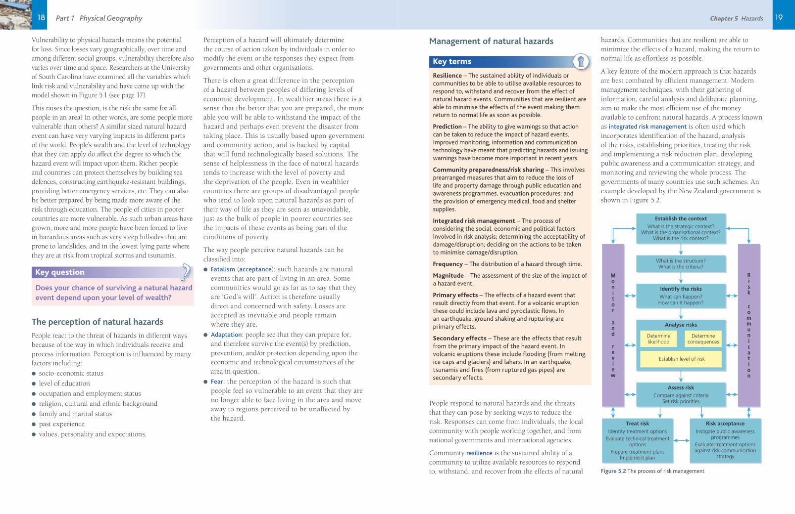
1918 Chapter 5 Hazards Part 1 Physical Geography
Vulnerability to physical hazards means the potential for loss. Since losses vary geographically, over time and among different social groups, vulnerability therefore also varies over time and space. Researchers at the University of South Carolina have examined all the variables which link risk and vulnerability and have come up with the model shown in Figure 5.1 (see page 17).
This raises the question, is the risk the same for all people in an area? In other words, are some people more vulnerable than others? A similar sized natural hazard event can have very varying impacts in different parts of the world. People’s wealth and the level of technology that they can apply do affect the degree to which the hazard event will impact upon them. Richer people and countries can protect themselves by building sea defences, constructing earthquake-resistant buildings, providing better emergency services, etc. They can also be better prepared by being made more aware of the risk through education. The people of cities in poorer countries are more vulnerable. As such urban areas have grown, more and more people have been forced to live in hazardous areas such as very steep hillsides that are prone to landslides, and in the lowest lying parts where they are at risk from tropical storms and tsunamis.
Key question
Does your chance of surviving a natural hazard event depend upon your level of wealth?
?
The perception of natural hazards
People react to the threat of hazards in different ways because of the way in which individuals receive and process information. Perception is influenced by many factors including:
● socio-economic status
● level of education
● occupation and employment status
● religion, cultural and ethnic background
● family and marital status
● past experience
● values, personality and expectations.
Perception of a hazard will ultimately determine the course of action taken by individuals in order to modify the event or the responses they expect from governments and other organisations.
There is often a great difference in the perception of a hazard between peoples of differing levels of economic development. In wealthier areas there is a sense that the better that you are prepared, the more able you will be able to withstand the impact of the hazard and perhaps even prevent the disaster from taking place. This is usually based upon government and community action, and is backed by capital that will fund technologically based solutions. The sense of helplessness in the face of natural hazards tends to increase with the level of poverty and the deprivation of the people. Even in wealthier countries there are groups of disadvantaged people who tend to look upon natural hazards as part of their way of life as they are seen as unavoidable, just as the bulk of people in poorer countries see the impacts of these events as being part of the conditions of poverty.
The way people perceive natural hazards can be classified into:
● Fatalism (acceptance): such hazards are natural events that are part of living in an area. Some communities would go as far as to say that they are ‘God’s will’. Action is therefore usually direct and concerned with safety. Losses are accepted as inevitable and people remain where they are.
● Adaptation: people see that they can prepare for, and therefore survive the event(s) by prediction, prevention, and/or protection depending upon the economic and technological circumstances of the area in question.
● Fear: the perception of the hazard is such that people feel so vulnerable to an event that they are no longer able to face living in the area and move away to regions perceived to be unaffected by the hazard.
Management of natural hazards
Key terms
Resilience – The sustained ability of individuals or communities to be able to utilise available resources to respond to, withstand and recover from the effect of natural hazard events. Communities that are resilient are able to minimise the effects of the event making them return to normal life as soon as possible.
Prediction – The ability to give warnings so that action can be taken to reduce the impact of hazard events. Improved monitoring, information and communication technology have meant that predicting hazards and issuing warnings have become more important in recent years.
Community preparedness/risk sharing – This involves prearranged measures that aim to reduce the loss of life and property damage through public education and awareness programmes, evacuation procedures, and the provision of emergency medical, food and shelter supplies.
Integrated risk management – The process of considering the social, economic and political factors involved in risk analysis; determining the acceptability of damage/disruption; deciding on the actions to be taken to minimise damage/disruption.
Frequency – The distribution of a hazard through time.
Magnitude – The assessment of the size of the impact of a hazard event.
Primary effects – The effects of a hazard event that result directly from that event. For a volcanic eruption these could include lava and pyroclastic flows. In an earthquake, ground shaking and rupturing are primary effects.
Secondary effects – These are the effects that result from the primary impact of the hazard event. In volcanic eruptions these include flooding (from melting ice caps and glaciers) and lahars. In an earthquake, tsunamis and fires (from ruptured gas pipes) are secondary effects.
People respond to natural hazards and the threats that they can pose by seeking ways to reduce the risk. Responses can come from individuals, the local community with people working together, and from national governments and international agencies.
Community resilience is the sustained ability of a community to utilize available resources to respond to, withstand, and recover from the effects of natural
hazards. Communities that are resilient are able to minimize the effects of a hazard, making the return to normal life as effortless as possible.
A key feature of the modern approach is that hazards are best combated by efficient management. Modern management techniques, with their gathering of information, careful analysis and deliberate planning, aim to make the most efficient use of the money available to confront natural hazards. A process known as integrated risk management is often used which incorporates identification of the hazard, analysis of the risks, establishing priorities, treating the risk and implementing a risk reduction plan, developing public awareness and a communication strategy, and monitoring and reviewing the whole process. The governments of many countries use such schemes. An example developed by the New Zealand government is shown in Figure 5.2.
What is the strategic context?What is the organisational context?
What is the risk context?
What is the structure?What is the criteria?
Establish the context
What can happen?How can it happen?
Identify the risks
Identity treatment optionsEvaluate technical treatment
optionsPrepare treatment plans
Implement plan
Instigate public awarenessprogrammes
Evaluate treatment optionsagainst risk communication
strategy
Treat risk Risk acceptance
Compare against criteriaSet risk priorities
Assess risk
Analyse risks
Determinelikelihood
Establish level of risk
Determineconsequences
Risk
communication
Monitor
and
review
Figure 5.2 The process of risk management
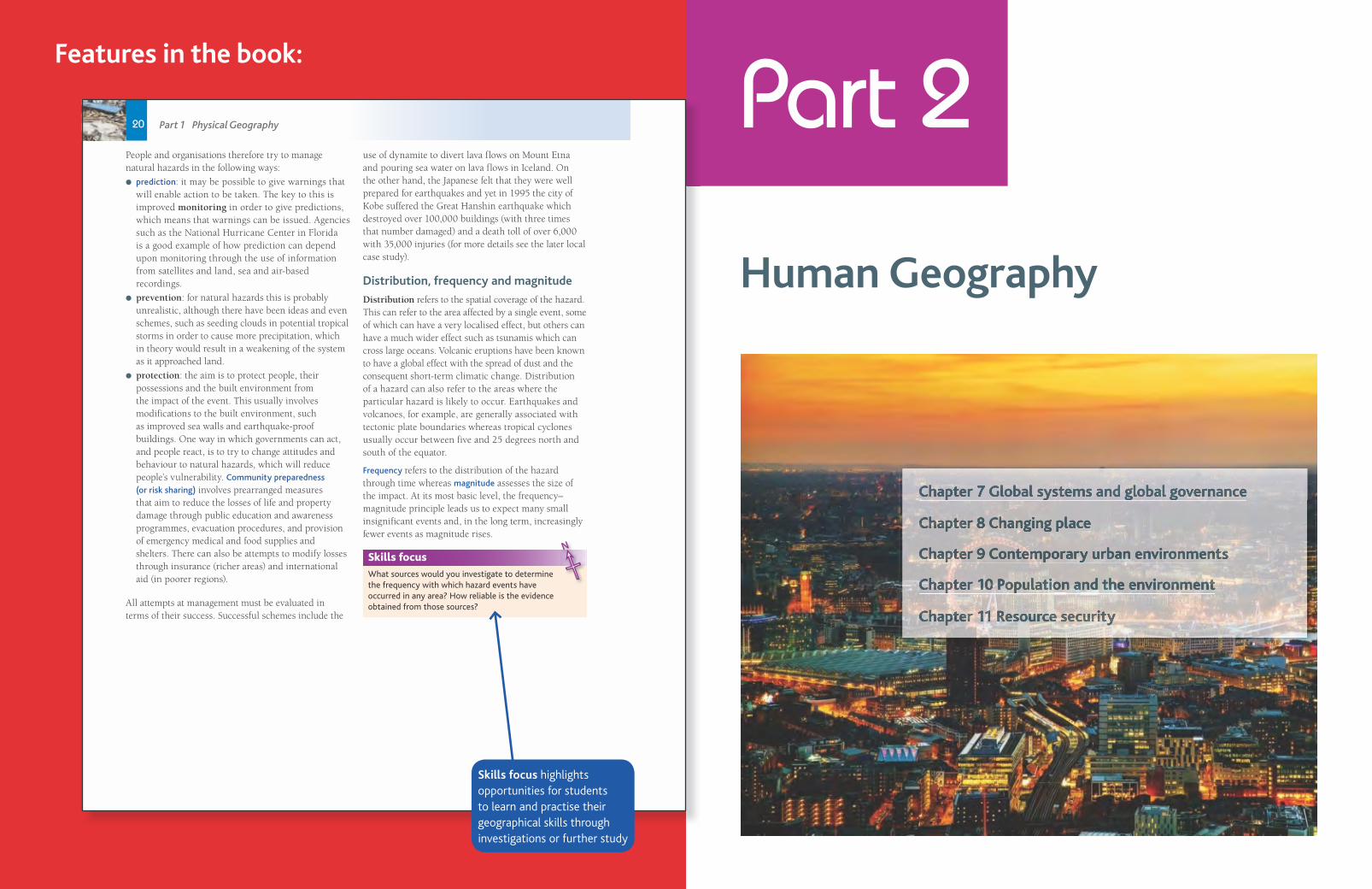
Part 2
Human Geography
Chapter 7 Global systems and global governance
Chapter 8 Changing place
Chapter 9 Contemporary urban environments
Chapter 10 Population and the environment
Chapter 11 Resource security
20 Part 1 Physical Geography
People and organisations therefore try to manage natural hazards in the following ways:
● prediction: it may be possible to give warnings that will enable action to be taken. The key to this is improved monitoring in order to give predictions, which means that warnings can be issued. Agencies such as the National Hurricane Center in Florida is a good example of how prediction can depend upon monitoring through the use of information from satellites and land, sea and air-based recordings.
● prevention: for natural hazards this is probably unrealistic, although there have been ideas and even schemes, such as seeding clouds in potential tropical storms in order to cause more precipitation, which in theory would result in a weakening of the system as it approached land.
● protection: the aim is to protect people, their possessions and the built environment from the impact of the event. This usually involves modifications to the built environment, such as improved sea walls and earthquake-proof buildings. One way in which governments can act, and people react, is to try to change attitudes and behaviour to natural hazards, which will reduce people’s vulnerability. Community preparedness
(or risk sharing) involves prearranged measures that aim to reduce the losses of life and property damage through public education and awareness programmes, evacuation procedures, and provision of emergency medical and food supplies and shelters. There can also be attempts to modify losses through insurance (richer areas) and international aid (in poorer regions).
All attempts at management must be evaluated in terms of their success. Successful schemes include the
use of dynamite to divert lava flows on Mount Etna and pouring sea water on lava flows in Iceland. On the other hand, the Japanese felt that they were well prepared for earthquakes and yet in 1995 the city of Kobe suffered the Great Hanshin earthquake which destroyed over 100,000 buildings (with three times that number damaged) and a death toll of over 6,000 with 35,000 injuries (for more details see the later local case study).
Distribution, frequency and magnitude
Distribution refers to the spatial coverage of the hazard. This can refer to the area affected by a single event, some of which can have a very localised effect, but others can have a much wider effect such as tsunamis which can cross large oceans. Volcanic eruptions have been known to have a global effect with the spread of dust and the consequent short-term climatic change. Distribution of a hazard can also refer to the areas where the particular hazard is likely to occur. Earthquakes and volcanoes, for example, are generally associated with tectonic plate boundaries whereas tropical cyclones usually occur between five and 25 degrees north and south of the equator.
Frequency refers to the distribution of the hazard through time whereas magnitude assesses the size of the impact. At its most basic level, the frequency–magnitude principle leads us to expect many small insignificant events and, in the long term, increasingly fewer events as magnitude rises.
Skills focus
What sources would you investigate to determine the frequency with which hazard events have occurred in any area? How reliable is the evidence obtained from those sources?
N
858697_AQA_Geog_A_Level_C4_20-20.indd 20 10/11/15 9:35 PM
Skills focus highlights opportunities for students to learn and practise their geographical skills through investigations or further study
Features in the book:

Chapter 8 Changing place 23Chapter
8 Changing place
In this chapter you will study:● the different meanings and categories of place● the different ways of interpreting place● the character of place and how this can change
over time.
Place is an everyday word and a key term within the study of geography. Place can be seen as a defi nite location on a map or it may refer to the description of the human and physical characteristics of a particular location. For many, the most familiar example of place is their home as it is where they feel most attached and can be themselves. Place is more than just location however and academic geographers increasingly discuss the different aspects of place – the so-called multidimensionality of place. This may include subjective aspects such as emotional responses to place, or fi lm, photography, art and media representations of place. The Nobel Peace Prize winner Malala Yousafzai conveys an emotional response to place when she compares life in Birmingham to that of her homeland of the Swat Valley in Pakistan:
‘When I stand in front of my window and look out, I see tall buildings, long roads full of vehicles moving in orderly lines, neat green hedges and lawns, and tidy pavements to walk on. I close my eyes and for a moment I am back in my valley – the high snow-topped mountains, green waving fi elds and fresh blue rivers – and my heart smiles when it looks at the people of Swat.’ (prologue, I am Malala, 2013)
There has been a renewed interest in place more recently as events of the Arab Spring in North Africa and the Occupy movements in Europe and North America have centred around place issues, while the role of globalisation and multinationals has been seen to have had a negative impact on place and identity.
8.1 The nature and importance of place
The concept of place
Key questions
How do we define place?
How do we distinguish place from location?
?
The first place you may think of is your home, where you live and where your physical possessions and memories are gathered together. The place where you live is a particular place. However, the meaning of the term place has been hotly debated and varies according to discipline. To those in planning, place may refer to the built environment, artists and writers attempt to evoke place in their work and to a philosopher, place may be a way of being-in-the-world. Broadly speaking, geographers refer to three aspects of place: location, locale and sense of place (see Figure 8.1).
Location is clearly the starting point here but places take on a significance far greater than simply location and this is where the other two dimensions of place begin to form the wider picture. We can recognise these three aspects in the example of the town of Glastonbury.
Location: Glastonbury is in the county of Somerset. It is located 23 miles south of Bristol. Latitude 51.1456 N and Longitude 2.7144 W. It is situated at a dry point on the low-lying Somerset Levels.
Locale: Glastonbury has its own unique character. It is home to a number of visitor attractions including Glastonbury Abbey and Glastonbury Tor. The Visit Britain website describes it as ‘alive with a history that sits comfortably alongside colourful myth and
legend. The Abbey was an early centre of pilgrimage and many believe King Arthur is buried amid the ruins. It is said that a young Christ also visited Glastonbury and that the Holy Grail is hidden nearby. Quirky independent shops abound selling everything from healing crystals to cakes.’ The National Trust describes Glastonbury Tor as being ‘one of the most spiritual sites in the country. Its pagan beliefs are still very much celebrated. It’s a beautiful place to walk, unwind and relax.’
Sense of place: Glastonbury is a place of great spiritual importance for people interested in Paganism, religious connections or the King Arthur affiliation. For many others, Glastonbury evokes emotions about the internationally famous music festival which takes place most years at Worthy Farm in Pilton on the edge of Glastonbury.
Place
This refers to the subjectiveand emotional attachment
people have to a place. This may be completely
different when looked atfrom another’s perspective.
Sense of place
Locale, unlike location,takes into account the
effect that people have ontheir setting. In terms of
locale, a place is shaped bythe people, cultures and
customs within it.
Locale
‘Where’ a place is, forexample, the coordinates
on a map.
Location
Figure 8.1 The different aspects of place
Figure 8.4 Glastonbury Tor is considered a spiritual site. Excavations at the top of the Tor have revealed the plans of two superimposed churches of St Michael, of which only a fi fteenth-century tower remains
Figure 8.2 The fi rst Glastonbury Festival took place in June 1970. It was attended by 1500 people and cost one pound entry with free milk from the farm
0 200km
N
Glastonbury
Figure 8.3 Location of Glastonbury
Chapter 25
Features in the book:
24 Part 2 Human Geography
Theoretical approaches to place
1 A descriptive approach is the idea that the world is a set of places and each place can be studied and is distinct. For example, you might produce a geography of your local area.
2 A social constructionist approach sees place as a product of a particular set of social processes occurring at a particular time. For example, Trafalgar Square was built to commemorate a British naval victory in the 1800s, and using a social constructionist approach, this place could be understood as a place of empire and colonialism. When the square is used for demonstrations, it would be viewed more as a place of protest against authority.
3 A phenomenological approach is not interested in the unique characteristics of a place or why it was constructed. Instead it is interested in how an individual person experiences place, recognising a highly personal relationship between place and person. The work of geographers Yi-Fu Tuan and Edward Relph has been particularly important here. Tuan developed the term ‘topophilia’ to describe the affective bond between people and place and argued that it is through human perception and experience that we get to know places. Relph argues that the degree of attachment, involvement, and concern that a person or group has for a particular place is critical in our understanding of place.
The meanings of place
Key question
In what way can place(s) be given meaning?
?The cultural geographer Jon Anderson argues that places can be defined and given meaning by the traces that exist within them. Material traces are physical additions to the environment and include things such as buildings, signs and statues; non-material traces include events, performances or emotions which occur in that place.
Case study
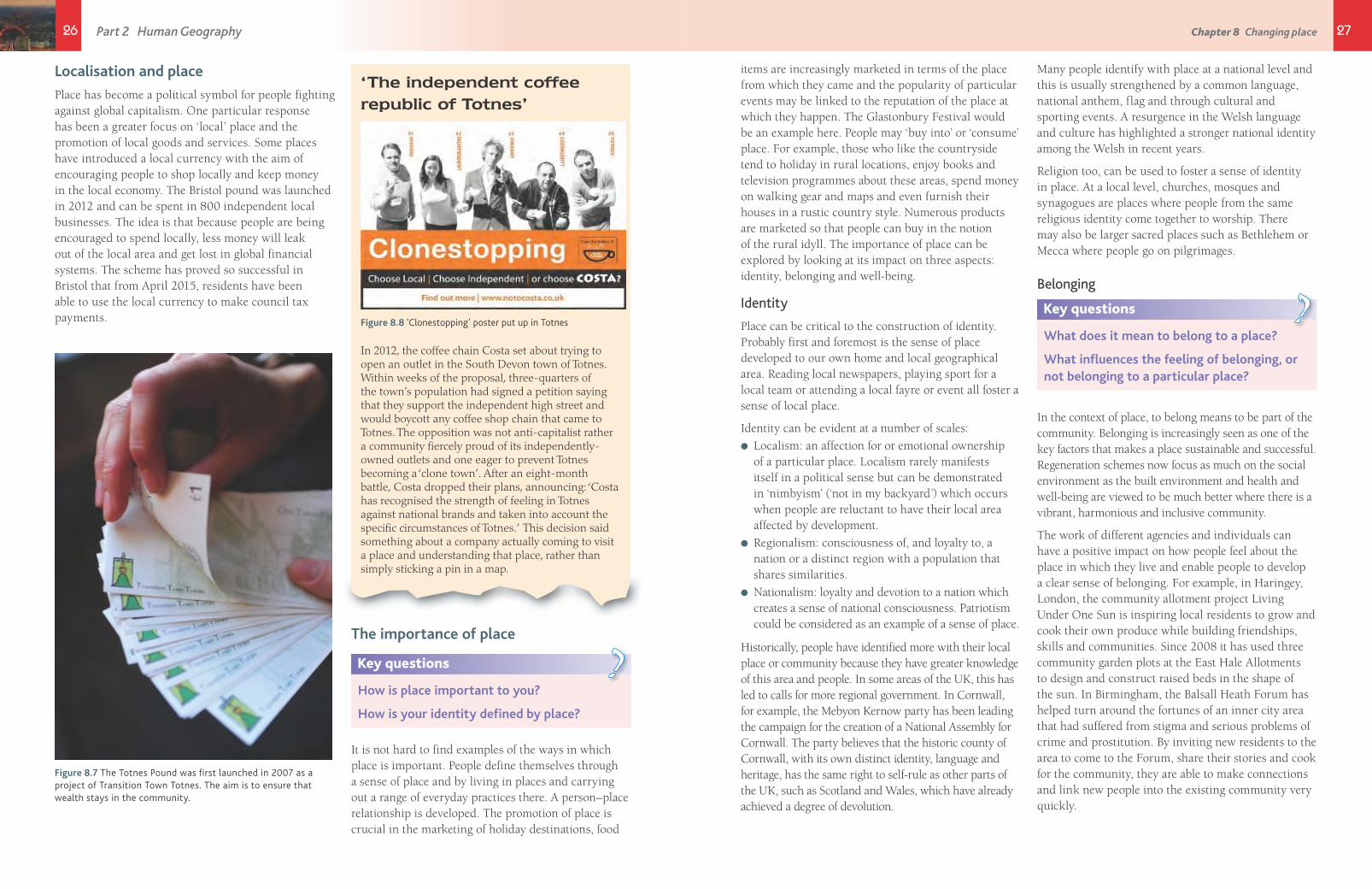
Trafalgar Square, London
We can understand and interpret places by looking carefully at the traces which are found there. In Trafalgar Square the immediate traces we see are the statue of Admiral Lord Nelson, the column on which this stands, a large public square and two fountains. However, we can look behind these traces to try and understand the meanings behind them and the aims of the ‘trace-makers’ who constructed them.
The statue of Admiral Lord Nelson is at the top of a column that bears his name in a square commemorating Nelson’s naval victory over combined French and Spanish fleets in 1805. It has been suggested that the city planners of the 1800s wanted to commemorate British leadership and victory, and this place could be understood as a space of empire. Furthermore, it sought to inspire pride and patriotism in the country. Trafalgar Square is still used to celebrate victory and is often the focus for national celebrations such as sporting victories and London’s successful Olympics bid.
Traces change over time and this is evidenced by The Fourth Plinth Programme in Trafalgar Square. The fourth plinth was initially intended to hold an equestrian statue of William IV, but had remained vacant due to lack of funding. Since 1999, however, it has become a centrepiece for some of the world’s most provocative contemporary
public art in a bid to showcase London as the cultural and artistic capital of the world. Commissions have included a marble torso of a pregnant artist, a large blue cockerel and the controversial Antony Gormley plinth entitled ‘One and other’ which involved 2,400 selected members of the public spending one hour each on the plinth doing whatever they wanted. Art installations like this reflect the notion that although London is a place of tradition, it is also not afraid to take risks and embrace innovation and diversity.
Figure 8.5 Trafalgar Square is a popular London tourist attraction
858697_AQA_Geog_A_Level_C8_24-25.indd 24 10/19/15 4:24 PM
25Chapter 8 Changing place
A global sense of place
The economic and social geographer Doreen Massey has written about a global sense of place, in which she questions the idea that places are static. She argues instead that places are dynamic, they have multiple identities and they do not have to have boundaries. She used her own local area to illustrate that place is influenced by constantly changing elements of a wider world.
‘Take, for instance, a walk down Kilburn High Road, my local shopping centre. It is a pretty ordinary place, north-west of the centre of London. … Thread your way through the … traffi c diagonally across the road from the newsstand and there’s a shop which as long as I can remember has displayed saris in the window. Four life-sized models of Indian women and realms of cloth. On the door a notice announces a forthcoming concert at Wembley Arena: Anand–Milind present Rekha, live, with Aamir Khan, Juhi Chawla and Raveena Tandon. On another ad, for the end of the month, is written, “All Hindus are cordially invited.” In another newsagents I chat with the man who keeps it, a Muslim unutterably depressed by events in the Gulf.’(Massey, 1994)
Massey argues that the character of a place can only be seen and understood by linking that place to places beyond. She concludes ‘What we need, it seems to me, is a global sense of the local, a global sense of place.’
Key questions
To what extent is your local place influenced by external factors?
How has globalisation affected your local area?
?
Globalisation and place
Some argue that globalisation has made place less important as the forces of global capitalism have eroded local cultures and produced identical or homogenised places. This can be seen through the increased presence of global chains such as Starbucks in high streets all over the world. The American novelist James Kunstler has talked of a ‘geography of nowhere’ – where processes such as urban sprawl have led to community-less cities covering huge areas of countryside with identical shopping malls, car parks and roads. He argues that ‘every place is like no place in particular and the term placelessness has been used to describe such places.
However, there is also evidence that some local places and cultures are resisting the power of multinational companies and the companies themselves are increasingly having to adapt to the local market place. This is known as glocalization. One example of this is the McDonald’s franchise. There are currently more than 36,000 McDonald’s restaurants in over 100 countries around the world but the aim to increase profits further has led to the company adapting its brand and product to the local market place. In Hindu countries, for example, beef has been removed from the menu while in Muslim countries, pork has been removed. The number of McCafés has increased in countries with a coffee culture.
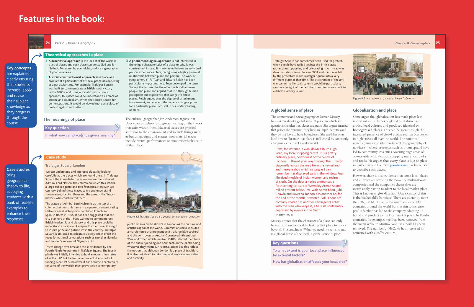
Trafalgar Square has sometimes been used for protest, when people have rallied against the British state rather than supporting and celebrating it. Anti-Iraq war demonstrations took place in 2004 and the traces left by the protestors made Trafalgar Square into a very different place at that time. The attachment of the anti-war banner to Nelson’s column would be particularly symbolic in light of the fact that the column was built to celebrate victory in war.
Figure 8.6 ‘No more war’ banner on Nelson’s Column
858697_AQA_Geog_A_Level_C8_24-25.indd 25 10/19/15 4:24 PM
Key concepts are explained clearly ensuring that students increase, apply and revise their subject knowledge as they progress through the course
Case studies bring geographical theory to life, supplying students with a bank of real-life examples to enhance their responses
26 27
items are increasingly marketed in terms of the place from which they came and the popularity of particular events may be linked to the reputation of the place at which they happen. The Glastonbury Festival would be an example here. People may ‘buy into’ or ‘consume’ place. For example, those who like the countryside tend to holiday in rural locations, enjoy books and television programmes about these areas, spend money on walking gear and maps and even furnish their houses in a rustic country style. Numerous products are marketed so that people can buy in the notion of the rural idyll. The importance of place can be explored by looking at its impact on three aspects: identity, belonging and well-being.
Identity
Place can be critical to the construction of identity. Probably first and foremost is the sense of place developed to our own home and local geographical area. Reading local newspapers, playing sport for a local team or attending a local fayre or event all foster a sense of local place.
Identity can be evident at a number of scales:
● Localism: an affection for or emotional ownership of a particular place. Localism rarely manifests itself in a political sense but can be demonstrated in ‘nimbyism’ (‘not in my backyard’) which occurs when people are reluctant to have their local area affected by development.
● Regionalism: consciousness of, and loyalty to, a nation or a distinct region with a population that shares similarities.
● Nationalism: loyalty and devotion to a nation which creates a sense of national consciousness. Patriotism could be considered as an example of a sense of place.
Historically, people have identified more with their local place or community because they have greater knowledge of this area and people. In some areas of the UK, this has led to calls for more regional government. In Cornwall, for example, the Mebyon Kernow party has been leading the campaign for the creation of a National Assembly for Cornwall. The party believes that the historic county of Cornwall, with its own distinct identity, language and heritage, has the same right to self-rule as other parts of the UK, such as Scotland and Wales, which have already achieved a degree of devolution.
Many people identify with place at a national level and this is usually strengthened by a common language, national anthem, flag and through cultural and sporting events. A resurgence in the Welsh language and culture has highlighted a stronger national identity among the Welsh in recent years.
Religion too, can be used to foster a sense of identity in place. At a local level, churches, mosques and synagogues are places where people from the same religious identity come together to worship. There may also be larger sacred places such as Bethlehem or Mecca where people go on pilgrimages.
Belonging
Key questions
What does it mean to belong to a place?
What influences the feeling of belonging, or not belonging to a particular place?
?
In the context of place, to belong means to be part of the community. Belonging is increasingly seen as one of the key factors that makes a place sustainable and successful. Regeneration schemes now focus as much on the social environment as the built environment and health and well-being are viewed to be much better where there is a vibrant, harmonious and inclusive community.
The work of different agencies and individuals can have a positive impact on how people feel about the place in which they live and enable people to develop a clear sense of belonging. For example, in Haringey, London, the community allotment project Living Under One Sun is inspiring local residents to grow and cook their own produce while building friendships, skills and communities. Since 2008 it has used three community garden plots at the East Hale Allotments to design and construct raised beds in the shape of the sun. In Birmingham, the Balsall Heath Forum has helped turn around the fortunes of an inner city area that had suffered from stigma and serious problems of crime and prostitution. By inviting new residents to the area to come to the Forum, share their stories and cook for the community, they are able to make connections and link new people into the existing community very quickly.
Localisation and place
Place has become a political symbol for people fighting against global capitalism. One particular response has been a greater focus on ‘local’ place and the promotion of local goods and services. Some places have introduced a local currency with the aim of encouraging people to shop locally and keep money in the local economy. The Bristol pound was launched in 2012 and can be spent in 800 independent local businesses. The idea is that because people are being encouraged to spend locally, less money will leak out of the local area and get lost in global financial systems. The scheme has proved so successful in Bristol that from April 2015, residents have been able to use the local currency to make council tax payments.
Figure 8.7 The Totnes Pound was fi rst launched in 2007 as a project of Transition Town Totnes. The aim is to ensure that wealth stays in the community.
The importance of place
Key questions
How is place important to you?
How is your identity defined by place?
?
It is not hard to find examples of the ways in which place is important. People define themselves through a sense of place and by living in places and carrying out a range of everyday practices there. A person–place relationship is developed. The promotion of place is crucial in the marketing of holiday destinations, food
‘The independent coffee republic of Totnes’
Figure 8.8 ‘Clonestopping’ poster put up in Totnes
In 2012, the coffee chain Costa set about trying to open an outlet in the South Devon town of Totnes. Within weeks of the proposal, three-quarters of the town’s population had signed a petition saying that they support the independent high street and would boycott any coffee shop chain that came to Totnes. The opposition was not anti-capitalist rather a community fi ercely proud of its independently-owned outlets and one eager to prevent Totnes becoming a ‘clone town’. After an eight-month battle, Costa dropped their plans, announcing: ‘Costa has recognised the strength of feeling in Totnes against national brands and taken into account the specifi c circumstances of Totnes.’ This decision said something about a company actually coming to visit a place and understanding that place, rather than simply sticking a pin in a map.
Chapter 8 Changing placePart 2 Human Geography
28 29
Individuals may have different views about what makes a place great. Is it likely that all the residents of Skipton, Newnham, Monmouth and Falmouth agree with the Sunday Times survey? There are certain features which are generally accepted to be more important in promoting happiness and well-being within a place as shown in Figure 8.9. Public parks and open spaces improve quality of life and there is a strong connection between the quality of social infrastructure (people-support networks) in communities and the well-being of new residents. Lower crime rates make people feel safer and good
transport routes and accessibility reduce feelings of isolation. Further ideas about the impact of place on well-being are discussed in more detail in Chapter 10.
The power of place in political protest has arisen recently in reactions to unpopular political regimes and problems associated with capitalism. In 2011 Tahrir Square in Cairo was the focal point of the Egyptian Revolution against former president Hosni Mubarak. The square became established as a focal point and a symbol for the ongoing Egyptian democracy demonstrations.
Well-being
Key questions
What are the qualities you would look for in a good place to live or work?
Which of the following reasons would you deem most important when choosing a great place to live?
?
In 2014, a Sunday Times survey judged Skipton in North Yorkshire as the best place to live in Britain due to its proximity to the Yorkshire
Dales, its great schooling and independent shops along a ‘buzzing’ high street. Newnham came a close second for its offering of ‘country living in the heart of Cambridge’, and retaining a ‘genuine village feel’ despite its location near the centre of the university town. Earning a bronze medal, Monmouth, near the border between Wales and England, is said to have a charming feel and a great selection of independent schools, while the coastal town of Falmouth in Cornwall completed the top four for its combination of wonderful sea views, beaches and countryside and its reputation as a cultural hub.
Case study: The Transition Town movement
Transition Network was founded in 2007 as a response to the twin threats of climate change and peak oil (the point in time when the maximum rate of extraction of oil is reached, after which the rate of production is expected to enter terminal decline). Since then it can be said to have gone on to tackle many other issues including some associated with globalisation such as dilution of place identity and loss of community and economy. One of the founders, Rob Hopkins, says ‘It’s about what you can create with the help of the people who live in your
street, reimagining and rebuilding your neighbourhood, your town. If enough people do it, it can lead to real impact, to real jobs and real transformation of the places we live, and beyond.’
There are now over 1,200 Transition initiatives worldwide and increasing numbers of places are embracing a life where communities come together to share skills, grow food, provide care for dependents and fight inequality.
Learn more about Transition Network at www.transitionnetwork.org.
street, reimagining and rebuilding your neighbourhood,
Figure 8.9 What makes a great place? The Place Diagram is one of the tools PPS has developed to help communities evaluate places. The inner ring represents a place’s key attributes, the middle ring its intangible qualities, and the outer ring its measurable data.
Figure 8.10 What does transition include?
Chapter 8 Changing placePart 2 Human Geography

30
Figure 8.11 Tahrir Square also known as ‘Martyr Square’, is a major public town square in downtown Cairo, Egypt. The square has been the location and focus for political demonstrations in Cairo that saw the resignation of President Mubarak in 2011, and the ousting of President Morsi in 2013
In London, the Occupy movement, campaigning against social and economic inequality around the world, camped outside St Paul’s Cathedral in the financial heart of the city. Similarly recognisable sites were chosen in other parts of the world as the Occupy movement relies on the power of place to attract attention and lodge itself in people’s memories.
Figure 8.12 Occupy London camp in front of St Paul’s Cathedral, October 2011
Insider and outsider perspectives on place
People have a stronger relationship with the places they are familiar with. ‘To be inside a place is to belong to it and identify with it, and the more profoundly inside you are the stronger is the identity with the
place.’ (Relph, 1976). This is the main reason why people living within a place are more likely to oppose developments within their local area than those from outside. This nimbyism can be seen with local opposition to housing developments, wind farms and fracking proposals.
There is also the notion here that people, activities and events can be seen as ‘in place’ or ‘out of place’. Why for example may a businessman feel ‘in place’ in Canary Wharf in London, while a homeless person may not, and what does this mean for how the place is defined? If certain people feel ‘out of place’, why is this, and who has created this feeling? As the politics of the UK and other countries becomes more focused on immigration, there is a greater need to understand the notion of place in the production of insiders and outsiders.
‘A place for everything and everything in its place’ is a well-known phrase that suggests there is a particular ordering of things in the world. Cultural geographer Tim Cresswell argues that people, things and practices are often strongly linked to particular places and when these links are broken, or when people have acted out of place, they are deemed to have committed something of a crime. Graffiti on historic buildings or litter in an area of outstanding beauty are examples of this but increasingly we are seeing groups of people being treated as outsiders. In the past this has included travellers, protestors, non-whites, gay, lesbian and bisexual people. In cities today, measures have been adopted to deter the presence of groups of youths and homeless people in certain areas. A high pitched alarm known as the mosquito is used as a sonic youth deterrant whilst floor spikes or studs are used to discourage people from sleeping rough in shop or office doorways.
At the same time, there are some groups who purposely build their own places and communities to live differently from the mass of people. Communes, Traveller communities and religious groups are just some of these. The Amish for example are an American Protestant group with around 200,000 members descended from European Anabaptists who moved to the USA to escape persecution. The Amish live in small rural communities where strong family and social ties allow them their own distinctive and separate way of life.
Part 2 Human Geography
The Publishers would like to thank the following for permission to reproduce copyright material:
Photo credits
p.5 © Alexandra Kobalenko/All Canada Photos/Corbis; p.9t © Alexandra Kobalenko/All Canada Photos/Corbis; p.9b © Philip Banks; p.10 © David Coleman / Alamy; p.16,18,20 © yankane/Getty Images/iStock; p.21 ©AndreyKrav/Thinkstock; p.23b © Steve Taylor ARPS / Alamy; p.23t © Roger Cracknell 01/classic / Alamy; p.24 © Alistair Laming / Alamy; p.25 Greg Watts/REX; p.26b © Jim Wileman / Alamy; p.26t Image by Wordsmith One for Transition Town Totnes’ Clone-stopping Campaign’; p.28 Used with permission from Project for Public Places. Website http://www.pps.org/reference/grplacefeat/; p.29 Copyright - Transition Network/Designer - Trucie Mitchell; p.30t © dpa picture alliance archive / Alamy; p.31t © Jenny Matthews / Alamy
Acknowledgements
p.15 Fig A © Ronald Manley from http://www.climatedata.info/forcing/gases/carbon-dioxide; Fig B adapted from Igor Shiklomanov’s chapter ‘World fresh water resources’ in Peter H. Gleick (ed), Water in Crisis: A Guide to the World’s Fresh Water Resources, (OUP 1993).
Every effort has been made to trace all copyright holders, but if any have been inadvertently overlooked the Publishers will be pleased to make the necessary arrangements at the fi rst opportunity.
Hachette UK’s policy is to use papers that are natural, renewable and recyclable products and made from wood grown in sustainable forests. The logging and manufacturing processes are expected to conform to the environmental regulations of the country of origin.
Orders: please contact Bookpoint Ltd, 130 Milton Park, Abingdon, Oxon OX14 4SB. Telephone: +44 (0)1235 827720. Fax: +44 (0)1235 400454. Lines are open 9.00a.m.–5.00p.m., Monday to Saturday, with a 24-hour message answering service. Visit our website at www.hoddereducation.co.uk
ISBN 978 1471 85869 7
© Malcolm Skinner, Paul Abbiss, Philip Banks, Helen Fyfe, Ian Whittaker 2015
First published in 2015 by
Hodder Education,
An Hachette UK Company
Carmelite House, 50 Victoria Embankment
London, EC4Y 0DZ
All rights reserved. Apart from any use permitted under UK copyright law, no part of this publication may be reproduced or transmitted in any form or by any means, electronic or mechanical, including photocopying and recording, or held within any information storage and retrieval system, without permission in writing from the publisher or under licence from the Copyright Licensing Agency Limited. Further details of such licences (for reprographic reproduction) may be obtained from the Copyright Licensing Agency Limited, Saffron House, 6–10 Kirby Street, London EC1N 8TS.
Cover photo © Science Photo Library / Alamy
Illustrations by Aptara, Inc.
This sample material is taken from AQA A-level Geography which has been selected for AQA’s offi cial approval process.
Encourage every student to develop in-depth knowledge and advanced geographical skills using the market-leading AQA Student’s Book, fully updated for 2016 with detailed content coverage, fascinating case studies and assessment preparation materials.
• Enables students of all abilities to increase, apply and revise their subject knowledge as they work through clear explanations of key terms and topics
• Brings geographical theory to life by providing a rich source of up-to-date case studies for each physical and human topic
• Builds the core, cartographic, graphical, statistical and ICT skills that students need to maximise their potential through a dedicated skills section tailored to AQA’s 2016 specifi cation
• Helps students engage with challenging concepts, refl ect on their learning and map their progress with pointer questions throughout and end-of-chapter review questions
• Allow AS and A-level students to approach their exams with confi dence by undertaking a variety of practice questions written by subject specialists with examining experience
• Supports you in planning relevant and exciting fi eldwork projects that meet the changed fi eldwork and investigation requirements
AQAA-level
Geography For A-level and AS
which has
Encourage every student to develop in-depth knowledge and advanced
For the 2016 specifi cation
AuthorsMalcolm Skinner is a Head of Geography with examining experience. He has written and edited many successful A-level Geography textbooks.
Paul Abbiss is a former Head of Geography with examining experience. He now teaches at Dudley Sixth.
Phil Banks is an experienced author and teacher with examining experience. He now works as an educational consultant.
Helen Fyfe is Head of Geography at Torquay Boys’ Grammar School and has examining experience.
Ian Whittaker is a Head of Geography at Cardinal Newman College in Preston and has examining experience.
Textbook subject to change based on Ofqual feedback.
To request Inspection Copies or eInspection Copies and pre-order your class sets visit
www.hoddereducation.co.uk/Geography/ALevel/AQA
Dynamic Learning
AQA A-level Geography Dynamic Learning is an online subscription solution that supports teachers and students with high quality content and unique tools. Dynamic Learning incorporates Teaching and Learning Resources, Revision and Question Practice and Whiteboard and Student eTextbook elements that all work together to give you the ultimate classroom and homework resource.
Sign up for a free, no obligation trial at www.hoddereducation.co.uk/dynamiclearning
ALSO AVAILABLE
ISBN: 9781471858697