Embed Size (px)
DESCRIPTION
A BRIEF HISTORY OF METROPOLITAN PLANNING IN MELBOURNE, AUSTRALIA
Citation preview
A BRIEF HISTORY OF METROPOLITANPLANNING IN MELBOURNE, AUSTRALIAJun TsutsumiRay Wyatt
This issue considerably extends the scope of Applied GIS. Whereas in previous issues the technic-alities of GIS and remote sensing tended to dominate, we here take our first step towards moresynoptic and policy-advising components of GIS application. In no way do we intend to forsakethe detailed topic areas which have served us so well in the past; we merely want to add somethingelse to them. Accordingly, volume 2 number 2 contains a little of the old and a large chunk ofthe new.
The latter takes the form of a special collection of theme papers on GIS-based analyses ofurban land use and activity patterns within the Australian city of Melbourne and elsewhere –always with an eye on the policy implications that such investigations invariably prompt. Withthe final edition of 2006, 2 (3), also planned to be a special theme issue, but one which focuseson GIS-oriented decision support for improved rural management, by the end of the year we willhave fully completed our rounding out of Applied GIS’ range.
In other words, by 2007 the ambit of Applied GIS will extend all the way from detailed remotesensing and spatial analysis, through decision support for managing the natural environment tourban morphology and planning. This will advantageously position our journal for attracting alarge number of high-quality papers from across the complete spectrum of applied GIS.
To usher in such expansion, the bulk of this editorial will contextualize the papers that arepart of the urban morphology theme. This should enable readers to better appreciate and under-stand them. Nevertheless, we will begin by introducing the other two, non-theme papers thathave made it through Applied GIS’s refereeing system independently of the theme issue.
1. THE NON-THEME PAPERSThe first of these, Brian Lees’ contribution towards better interpretation of spectral data, continuesthis journal’s growing tradition of excellence. It describes work that surely sits at the researchfrontier. It exploits an innovative statistical method to extract hidden information from imagesrather than rely on the more traditional, but frequently error-prone conversion of interval tonominal data.
The second of our “normal” papers also extends Applied GIS’s tradition of rigorous spatialanalysis, although this time within the context of the highly urbanized state of Singapore. Bymeasuring spatial proximity in ways that are only practical using modern GIS, and by interviewingno less than 5000 people to find out what sort of facilities they would like to be close to, thispaper deduces which Singaporean suburbs are likely to be in demand as locations for new publichousing in the future.
2. THE THEME PAPERSFour out of the five theme papers were actually written by Japanese scholars. As such, theirwritings could shake some Melbournians out of their complacency that stems from satisfaction
EDITORIAL
APPLIED GIS, VOLUME 2, NUMBER 2, 2006 MONASH UNIVERSITY EPRESS 07.1
with a high-quality, urban environment. Yet on the other hand, outside researchers sometimesmiss the true essence of Melbourne’s history, character and current management. Accordingly,this editorial has been written by two people, one being a Japanese urban geographer who hasvisited Melbourne no less than nine times, and the other being a local researcher who has adoptedMelbourne as his home town.
Melbourne is a sprawling metropolis of 3.6 million people which is aesthetically pleasing,popular with tourists, commercially important, comfortable, nurturing and a leader in highereducation, medical research, entertainment, shopping and multi-cultural cuisine. Nevertheless,some commentators have agonized over its physical environment, which they say is deteriorating.This is despite Melbourne’s “quality of life” index having been judged in 1990, by a UN commit-tee, to be the world’s highest, and it has remained amongst the leaders ever since. Hence ifnothing else, Melbourne’s amenity has shown considerable resistance to the forces pulling itdownwards towards the environmental depths plumbed by less attractive world cities.
One of the keys to such resilience is the history of Melbourne’s metropolitan planning, whichwe will examine here on the basis that one needs to look backwards to see where a city is currentlypositioned, as well as the direction in which it could go in the future. We will then highlight someof the insights provided by the theme papers, along with some of their policy-relevant implications.
2.1 MELBOURNE’S METROPOLITAN PLANNING
Although “town and country planning” began in England during the nineteenth century, andalthough during the same period Australia adopted a British style public administration system,Anglophone city planning was late coming to Melbourne. Nevertheless, a replica of London’s“Board of Works” was set up in late nineteenth century Melbourne to tackle the major problemof the day – sewerage disposal.
The cleansing of London in the 1880’s had been one of the great civic achievements of itstime, and the results achieved within “smelly” Melbourne during the 1890’s were no less spec-tacular. To this day Melbourne has a vast network of underground sewerage tunnels that flowinto a huge, open-air treatment facility located on its south western fringe. This sewerage farmstill attracts hundreds of the world’s municipal engineers who are keen to copy it - provided theycan find so much space in their own localities.
It is therefore hardly surprising that the “Melbourne and Metropolitan Board of Works”(MMBW) wielded so much power for so long. Its annual right to extract a “metropolitan im-provement rate” from virtually every property owner across the metropolitan area was enshrinedwithin the legislation of the state of Victoria. Moreover, even though in the late twentieth centuryMMBW was dismantled, and partially privatized, to survive only as the much weakened “Mel-bourne Water”, this institution was for a long time expected to control Melbourne land usepatterns as a matter of course – especially since all property owners also had to also pay theMMBW a “metropolitan improvement rate”, which was specifically earmarked for the acquisitionand maintenance of public space, and “planning”.
Nevertheless, the MMBW’s land use planning always laboured under at least two majorhandicaps. Firstly, it was the local councils, of which there were, traditionally, 56 across theMelbourne metropolitan area, who often determined how the land would be used. These councilshad their own zoning plans, which were supposed to mesh with the broad zones of the MMBW’smetropolitan planning scheme but which frequently did not. That is, at a plot-by-plot level, most
A BRIEF HISTORY OF METROPOLITAN PLANNING IN MELBOURNE, AUSTRALIA EDITORIAL07.2
development control was carried out by the local authority rather than by the metropolitan au-thority.
Secondly, even at the broad, metropolitan scale, the historic nature of the MMBW meantthat it was water engineers and not town planners who mostly determined the direction in whichthe suburbs would spread. The 200 or so planners on the fifth and sixth floors of the MMBWbuilding could talk all they liked about how to manipulate Melbourne’s pattern of land uses,but it was the 7000 or so engineers, higher up on the upper floors, who had the actual power tocontrol urban morphology.
More exactly, unless the engineers’ “preferred development areas” – a euphemism for areasthat were cheaper to service with water reticulation, corresponded to the planners’ zones for futureresidential development, the planners’ plans never came to fruition. It was water engineers whowere determining where and when Melbourne should grow, just like the Sydney Water Board’sengineers for many years determined the shape of Sydney despite the best efforts of its urbanplanners. This meant that planners in Melbourne and elsewhere became very frustrated, whichpartly explains their behaviour, as covered in the next sub-section.
2.2 MONKEYING WITH MORPHOLOGY
Urban problems have usually prompted the same traditional response from Melbourne’s metro-politan planners – a response that John Patterson (1979) so famously labelled “monkeying withmorphology”. That is, they always suggested new alterations to the layout, or spatial morphologyof the Melbourne metropolitan area to somehow alleviate the city’s problems and generally in-crease its citizens’ quality of life. Put differently, Melbourne’s planners have always been keento propose a number of alternative land use patterns for taming the expanding, polluting monsterthat Melbourne has always shown signs of becoming.
This is illustrated in an early MMBW report (1967) where several alternative layouts forMelbourne were canvassed, some of which are shown in Figure 1. Shown in red is the existingbuilt up area; the yellow indicates where extra development is to take place over the next twentyyears, and green designates “open space”.
On the top left the intention is service Melbourne’s existing spatial pattern of growth, andon the top right the aim is to push much new development towards the less popular northernand western areas. In the middle is a proposal to banish much of Melbourne’s new developmentto satellite towns that would be located beyond a partial green belt and which would emulatethe English “new towns” of the post World War 2 era. Finally, the two scenarios along the bottomof Figure 1 show two kinds of “corridor growth plus green wedges of open space between cor-ridors to act as the fresh air-providing ‘lungs’ of the city”. The pattern on the bottom left involvesexpansion along major transport arteries, and on the bottom right is shown a plan to have ex-pansion within planned “sectors” in order to fit in with the American geographer, Homer Hoyt’s“sector theory”.
This report was followed by a statement of planning policy (MMBW, 1971) in which someversion of the “corridors with green wedges” layout was recommended as a blueprint for futureMelbourne and public responses were invited. Something like 4000 such responses were received,and they were subsequently dealt with in a further report (MMBW, 1974).
A BRIEF HISTORY OF METROPOLITAN PLANNING IN MELBOURNE, AUSTRALIA EDITORIAL 07.3
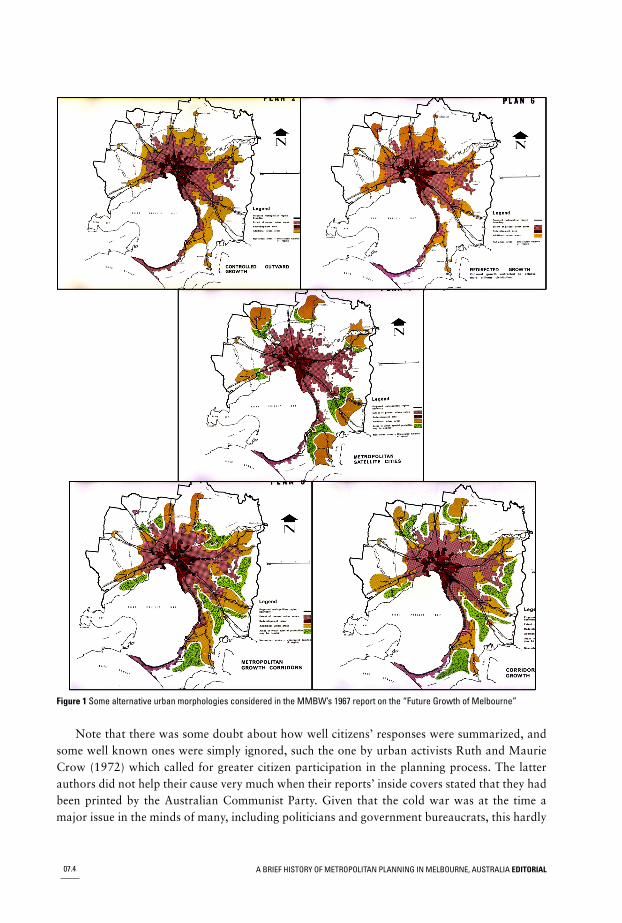
Figure 1 Some alternative urban morphologies considered in the MMBW’s 1967 report on the “Future Growth of Melbourne”
Note that there was some doubt about how well citizens’ responses were summarized, andsome well known ones were simply ignored, such the one by urban activists Ruth and MaurieCrow (1972) which called for greater citizen participation in the planning process. The latterauthors did not help their cause very much when their reports’ inside covers stated that they hadbeen printed by the Australian Communist Party. Given that the cold war was at the time amajor issue in the minds of many, including politicians and government bureaucrats, this hardly
A BRIEF HISTORY OF METROPOLITAN PLANNING IN MELBOURNE, AUSTRALIA EDITORIAL07.4
tended to curry favour within the corridors of power. The planning process simply proceed asalways, slowly and in a non-radical and measured way.
Yet even the conservative metropolitan plan began to be amended almost straight away, asvarious interest groups applied for, and were granted assorted local variations to it. By 1981there were 151 amendments, and by today there have been hundreds more. This begs the questionof how many amendments does it take before a plan can no longer be regarded as a plan at all.Clearly, Melbourne’s metropolitan planning system was fairly weak.
Such weakness is often overlooked by outside researchers who read “official” documentsclaiming that public plans have genuine legislative “teeth”. By contrast, local participants in theplanning process realize otherwise. Apart from the difficulty of ever achieving draconian landuse control within any liberal democracy, there are other, more subtle reasons why any Australianmetropolitan plan is bound to be fairly ineffectual.
Firstly, urban planning tends to lack credibility because whenever a set of alternative “scen-arios” for future growth are evaluated, such evaluation is never scientific. This is not becausethe planners in Melbourne are necessarily lazy or prejudiced against an empirical, scientific ap-proach. It is just that the state of the (planning) art can never transform itself into a rigorousscience. One can hardly run a controlled laboratory experiment in order to test each alternativeplan’s desirability, because planning scenarios are things that take more than a generation toevolve and they always exist only in the real world. Nor can one compare proposed scenarioswith different plans that have been tried elsewhere, because like everywhere else Melbourne hasits own unique features, which make it impossible to rigorously and comprehensively envisagewhat each blueprint for its future would actually be like to live in.
Put differently, whether or not one prefers a sprawling, or a dense or a corridor-based citytends to be based on subjective judgment stemming from prejudices about the intrinsic worth ofsprawling cities, compact settlements, corridors and so forth. Worse, in Melbourne such judgmentshave become not only polarized but also politicized. On the one hand the MMBW supported itscorridors/green wedges plan on the grounds that it was balanced and practical and it fitted neatlyinto an expanded MMBW region. On the other, an eastern regional growth plan was supportedby those planners who worked for the state of Victoria (Town and Country Planning Board,1967), partly because such a layout allowed metropolitan Melbourne to expand eastwards intoareas controlled by state government bureaucrats, thereby depriving the MMBW of some of itspolitical power.
This battle between rival institutions waged for some years, with the ascendancy usually goingto the MMBW, and so the eastern regional alternative faded from the stage of genuinely viableplans. However, MMBW’s attitude in favour of its own corridors/green wedges plan graduallybegan to morph into something else. The latter can be seen emerging within many MMBW reports(MMBW 1979a, 1979b, 1981; Little, 1977; Little and Carter, 1979) and since MMBW’s fallfrom grace the same idea has been advocated within state planners’ reports (Ministry for Planningand Environment, 1986; 1987; 1994). In such documents it is always argued that any plan’sdominant thrust should be towards the containment of suburban sprawl.
Moreover, such a policy persists to this day (Department of Sustainability and Environment,2005). It involves placing a barrier around Melbourne’s suburban expansion and encouragingresidents onto public transport by having relatively more of them living within walking distancefrom suburban “hot spots”. The latter are meant to comprise denser and more mixed property
A BRIEF HISTORY OF METROPOLITAN PLANNING IN MELBOURNE, AUSTRALIA EDITORIAL 07.5
development; they are now called “activity centres”; they should contain shops, offices and me-dium- to high-density housing, and they should straddle some form of transport exchange thatis linked to other activity centres via the public transit system.
Yet this policy has almost always been a spectacular failure. This might be because, just likethe former MMBW water engineers did, property developers now control much of Melbourne’smetropolitan planning. It is in the financial interest of such developers to be allowed to buildhigher-density housing not only within activity centres but also across suburbia in general, andin their attempt to contain sprawl, planners have granted the developers this permission. Hencebuilding companies have often lost interest in making activity centres work; it is more lucrativefor them to erect dual-occupancy housing on formerly single-dwelling allotments almost every-where.
Yet unlike what the city planners had hoped for, such suburban “densification” has generatedmostly high-price housing for wealthy singles, empty nesters and retirees. This has meant thatpoor families, for whom a consolidated city was supposed to provide more affordable housing,have been forced to locate at the cheaper metropolitan periphery where they are more remotefrom city facilities than ever. In short, property developers continue to make money while plannersagonize over why their policy has not brought all classes of people into the middle suburbs tomake Melbourne a more densely settled and socially diverse place.
It is true that much of the torpedoing of Melbourne’s land use planning has been at the handsof resident action groups from the green and leafy eastern suburbs, such as the “Save our Suburbs”(SOS) organization. These have managed to stop many higher-density development initiativeswithin their neighbourhoods, whether such developments were proposed as part of a designatedactivity centre or not. But whatever the explanation, it seems fairly certain that Melbourne’surban planners monkeying with morphology has had a lot less impact than official governmentdocuments would suggest.
2.3 BALANCED AND CONTROLLED GROWTH
For example, a major problem that has distressed Melbourne’s planners and others for decadesis the city’s tendency to grow towards the south and east rather than towards the less hospitablenorth and west. To the government planners it simply did not feel right that Melboune’s CBDwas, and is still becoming increasingly off centre – most cities have their CBD roughly in themiddle. Nor was this welcomed by the large retailers as their city department stores became in-creasingly more remote from the vast swathes of southern and eastern suburbia.
However, many such retailers overcame this problem by building large, stand alone, drive-in shopping centre complexes or hypermarkets, often in defiance of the metropolitan plan whichwanted such developments only within activity centres but which was relatively powerless tostop them. In fact, planners frequently even allowed such centres to be built close to strip shoppingcentres, thereby taking away their trade and causing them to decline, even though the plannershad sometimes designated such strips to be future activity centres.
In short, planning policy within Melbourne today is full of compromises. One only has tolook at the pattern of land releases being advocated by VicPlan, by the Urban DevelopmentAuthority before it, and by the various public growth-management authorities before that, tosee that they were all trying to have a “little each way”. For example, on the one hand an em-phasis on “north west stimulation” is still very much in evidence, with far greater hectares of
A BRIEF HISTORY OF METROPOLITAN PLANNING IN MELBOURNE, AUSTRALIA EDITORIAL07.6
new residential land being earmarked for release in such areas. Yet on the other hand there hasalways been a concession to the reality that the south eastern, Berwick corridor will continue tobe Melbourne’s fastest growing area, and so some land releases have always been planned forthat region as well.
Hence no matter how much talk about limiting sprawl exists within the current State govern-ment’s Melbourne 2030 report (Department of Sustainability and Environment, 2005), as indeedthere has been in so many previous publications, there endures an acknowledgement that Mel-bourne will continue to sprawl in the “wrong” direction”, just as the private sector controllersof growth want it to.
Moreover, some argue that VicPlan has been diverted towards servicing the demands ofprivate developers within the massive, central city Docklands project, causing it to even tempor-arily lose sight of its traditional advocacy for more northern and western sprawl. Such diversionis always justified on the grounds that inner-area growth will make Melbourne more compactand easier to service, yet in so doing, the planners have let down the less wealthy residents yetagain.
As already noted, poorer people are being increasingly forced out of accessible areas andcloser to the cheaper but ever more distant outskirts of the metropolis, where public transportis scarce or even nonexistent, forcing dual car ownership and hardship. Worse, they are nowbeing made to live at far higher densities than their predecessors, given the penchant for govern-ments to allow the private sector to develop huge suburban estates themselves in order to savethe government money. Mega developers work to a “bottom line” whose health will only beacceptable to their accountants when ordinary people’s living densities are made higher thanthose traditionally enjoyed within the world’s most liveable city.
Meanwhile, the planners continue to justify such corporate greed on the vaguest of grounds,which they tend to label with nebulous terms like “sustainability” – compact, self-contained,private housing estates on the city fringes are supposed to be more environmentally friendly.Such justifications have not, and probably can never be properly tested for validity. But this doesnot stop both private and public authorities from mouthing them incessantly.
Hopefully, some of the papers in the theme issue will help readers to appreciate the factsmore clearly, and to see through some of the double talk that has always characterised Melbourne’smetropolitan planning. If so, “public” understanding will be raised by a small amount and this,although never definitive, is the only thing that will re-shape government spending priorities toresist dominance by vested interest groups who, for too long, have claimed that their profit-making is actually in the public interest.
2.4 THE THEME ISSUE’S MESSAGES
As an example of increased insight, note the paper by Tsutsumi and O’connor. It highlights thestrong building activity that is currently occurring within the Melbourne CBD and which is beingstimulated by growing demands for accommodation and property ownership by overseas studentsand their benefactors. Such stimulation of the central area certainly seems to have come at anopportune time. The flight from Melbourne of many company headquarters to its traditionalrival – Sydney, a metropolis that has recently forged ahead in terms of population growth andattainment of “world city” status – could have led to property decline in Melbourne’s centre.But it has not, thanks to the tertiary education sector.
A BRIEF HISTORY OF METROPOLITAN PLANNING IN MELBOURNE, AUSTRALIA EDITORIAL 07.7
It is also true that such inner-area growth happens to match the developers’ and planners’rhetoric that a more concentrated city is more environmentally and economically sustainable.Yet it is probably impossible to fully test whether or not such inner-city densification is environ-mentally superior, and it may not be economically sustainable at all. Hence although this inner-city boom has been fortuitous and beneficial, it should on no account lead to complacency. Perhapscapital from overseas needs ultimately to be supplemented from other sources.
Yet such a cautionary note may be too pessimistic. Tsutsumi and O’Connor also imply,without suggesting it directly, that the continued growth of Melbourne’s CBD employment inthe “finance and insurance” sector is actually due to residential apartments being built behindthe street frontages in order to subsidize the creation of office facilities within older and morevisible “heritage” façades.
However, it seems debatable that such development is being propped up by the real estateindustry in this way. Something more permanent might be at work. For instance, it could be thatthe Melbourne CBD job market is strong because of the opportunities provided through the citybeing a leader within the information technology, health care, education and medical researchsectors. Add to this its cooler climate, parklands, manageable size, general comfort and more“refined” environment compared to some other Australian cities, and it begins to appear thatMelbourne’s central area possesses a strong base for continued prosperity well into the future.Time will tell.
Nevertheless, the paper by Yamashita, Fujii and Itoh, on suburban shopping centres, reinforcesthis optimistic tone. These authors’ view of the beneficial effects of planning within metropolitanMelbourne is far more charitable than the opinions expressed above. They point out that notonly has Melbourne’s CBD remained much more economically healthy than CBDs within manyUS cities, but small-scale shops have also flourished in Melbourne’s suburban centres better thanthey have in places like USA, Japan and Canada. To them, this is mostly due to Melbourne’spolicy of boosting “district centres” and “activity centres” since the 1980’s. Where the latteroccur, they often contain a mix of functions, which postpones the day when Melbourne succumbsto the Los Angeles type of “big box” centre. Each of the latter tries to be a mini-city in itself, yeteach one further dilutes the coherent retailing fabric of the metropolis.
However, centres like Moonie Ponds and Glen Waverly, which Yamashita, Fujii and Itohsurvey in detail and generally praise, may not actually be carrying the future with them, becauseif visitor numbers were accessed we would probably find that the larger battle is being lost. Thatis, it is probable that more and more people are being attracted to car-based, stand-alone hyper-markets rather than to public transit-oriented activity centres. In this sense, although Melbourne’splanners may have staved off the inevitable for now, the suburban environment is probablycreeping towards Americanization all the same. As these authors suggest, more research, partic-ularly in the form of user surveys, is required.
The paper by Ishikawa and Tsutsumi conveys a similar message, even though it is not aboutMelbourne at all. Their paper is about Dallas, USA, which displays many of the characteristicsthat Melbourne will acquire if some of its current trends continue unchecked – like neglect of itspublic transport system. Although Melbourne is not as large as Dallas-Fort Worth, and althoughit has a more coherent network of suburban shopping centres, and despite the segregation of itsnon English-speaking migrants being not so extreme, car-based cross-suburban commuting inMelbourne is on the rise and its public transport patronage is falling.
A BRIEF HISTORY OF METROPOLITAN PLANNING IN MELBOURNE, AUSTRALIA EDITORIAL07.8
Ishikawa and Tsutsumi go on to describe, in some detail, the modest success that some newrail facilities within Dallas have had in terms of boosting the extent and variety of activities nearits stations, not to mention their revitalizing of parts of Dallas’ long defunct downtown area.Yet two things should be kept in mind. Firstly, these new rail initiatives have to a great extentsimply serviced changes to the city that had already happened in the private enterprise-led fashionof American urban development. Secondly, public transport usage in Dallas is still declining.
Although the authors are hopeful that the proportion of people using transit will rise oncethe full transit network becomes operational in Dallas by 2007, their paper tends to suggest thatit is very difficult for new, fixed-rail facilities to service everyone. Today’s residents in Dallas,Melbourne or wherever, demand flexibility, which is why the motor car continues to dominate.Hence breaking car dependence within any city, even in those where urban planners have hadsome small successes, continues to be a very daunting task.
The paper by Fujii, Yamashita and Itoh echoes this when it comprehensively comparescommuter flows within Atlanta and Melbourne. Once again, Melbourne’s strong CBD and moreself-contained suburban activity centres are highlighted, yet the authors point out that there isstill considerable cross-suburban commuting in Melbourne. Moreover, such within-suburbcommuting is usually serviced by private car rather than by public transport, due to the demandsfor flexibility from such groups as two-income households.
In other words, their paper carefully presents both the good and the bad. It details the eco-nomic and social strength of Melbourne’s inner areas and how up to 50% of commuters intothe CBD use public transport. Yet on the other hand, there are far more jobs in Melbourne’ssuburbs than in its central city, and commuting to these suburban jobs is every bit as car dependentas it is anywhere in the US. Moreover, although the planner-induced and wider range of functionswithin Melbourne’s suburban centres, compared to its American equivalents, will theoreticallyprompt greater self containment around them and so generate less suburban travel overall, theystill lack the sheer scale of US “edge cities”, and this actually makes them less of a magnet forlocalized travel.
The overall impression left by our visiting scholars then, apart from their slightly greaterappreciation of the achievements of Melbourne’s urban planners, is that car dependence is amajor and growing problem. This is why the fifth paper, written by one of the editors, takes upthis theme.
It argues that a large portion of the 478,000 jobs within Melbourne’s inner areas are commutedto, by car, from the suburbs, each day. Such cars clog up inner-area roads and slow down streettrams to the point of discouraging even locals from using them. This causes higher peak-hourair pollution, heavy wastage of fossil fuels and a massive annual economic bill for congestion.Moreover, although the growing car dependence problem has existed for at least 50 years, re-markably little progress has been made in terms of solving it.
Accordingly, this paper uses GIS to explore a completely untried and technical solution,which contrasts with traditional land use pattern-oriented solutions – Personal Rapid Transit.This is such a radical proposal that few people are likely to be convinced of its efficacy, yet theauthor tries to show that at least it ought to be experimented with, albeit in a way that exploitsMelbourne’s present transport infrastructure rather than competes against it.
Overall, we hope that the analyses and discussions in this theme issue will prove beneficialto everyone who seeks greater urban knowledge and insight. If so, readers will reach better and
A BRIEF HISTORY OF METROPOLITAN PLANNING IN MELBOURNE, AUSTRALIA EDITORIAL 07.9

more GIS-informed conclusions about how urban planners within their own city can improvetheir urban environment.
Jun Tsutsumi and Ray WyattMelbourne,August 2006
REFERENCESCrow, R.; Crow, M. 1972. Plan for Melbourne: Part 3. Melbourne: Victorian State Committee of the
Communist Party of Australia.Department of Sustainability and Environment. 2005. Melbourne 2030, Melbourne. Available from:
http://www.dse.vic.gov.au/melbourne2030online/content/introduction/02summary.html.Little, F.M. 1977. Socio-economic implications of urban development. Melbourne: Urban Economic
Consultants Pty Ltd and MMBW.Little, F.M.; Carter, R.A. 1979. Urban development economic development and growth. Melbourne. Urban
Economic Consultants Pty Ltd and MMBW.Ministry for Planning and Environment. 1986. Pilot study of urban consolidation policy and its application
to metropolitan Melbourne. Melbourne: Travers Morgan Pty Ltd.Ministry for Planning and Environment. 1987. Shaping Melbourne’s future. Melbourne.Ministry for Planning and Environment. 1994. Melbourne metropolitan strategy. Melbourne.Melbourne and Metropolitan Board of Works. 1967. The future growth of Melbourne. Melbourne.Melbourne and Metropolitan Board of Works. 1971. Planning policies for the Melbourne metropolitan
region. Melbourne.Melbourne and Metropolitan Board of Works. 1974. Report on general concept objections. Melbourne.Melbourne and Metropolitan Board of Works. 1979a. Alternative strategies for metropolitan Melbourne.
Melbourne.Melbourne and Metropolitan Board of Works. 1979b. The challenge of change. Melbourne.Melbourne and Metropolitan Board of Works. 1981. Metropolitan strategy implementation. Melbourne.Patterson, J. 1979. Melbourne and metropolitan: Monkeying with morphology (again) (?) in Proceedings
and Papers of the Melbourne Metropolitan Planning Options Forum. Melbourne: Department ofTown and regional Planning. University of Melbourne. 78–83.
Town and Country Planning Board of Victoria. 1967. Organization for strategic planning. Melbourne.
Cite this article as: Tsutsumi, Jun; Wyatt, Ray. 2006. ‘A brief history of metropolitan planning in Melbourne,Australia’. Applied GIS 2 (2). pp. 7.1–7.10. DOI: 10.2104/ag060007.
A BRIEF HISTORY OF METROPOLITAN PLANNING IN MELBOURNE, AUSTRALIA EDITORIAL07.10