Embed Size (px)
Citation preview
Vancouver Port Authority Northwest Hydraulic Consultants Ltd. /Triton Consultants Ltd. Roberts Bank Container Expansion File: 33863 Coastal Geomorphology Study - 95 - November 2004
8.0 PROJECT IMPACTS FROM DELTAPORT EXPANSION
8.1 GENERAL APPROACH
The main features of the Deltaport Third Berth Project are described in Section 1.4. The general
plan and layout of the project is based on Hemmera (2003) and drawings provided by VPA.
Based on the experience and knowledge gained from earlier port developments on Roberts Bank,
the following potential physical impacts were considered:
• potential triggering of new dendritic drainage channels and erosion of eelgrass on the tidal flats;
• potential local erosion or scour adjacent to new structures;
• potential impacts to overall delta stability caused by interruption of sediment transport; and
• changes to deposition patterns in dredged basins and adjacent areas.
However, given the relatively small scale of the proposed development in comparison to
previous works, it was recognized that potential impacts were likely to be more localized in
extent. This meant that the analysis required a relatively fine resolution in order to detect
impacts.
The assessment of morphologic response is based on two different approaches. First, the
numerical wave models and hydrodynamic models were used to generate representative
hydrodynamic simulations of “With Project” and “Without Project” conditions. The difference
between “With Project” and “Without Project” velocities and bed shear stresses were then
mapped to represent the zone of potential impacts. Additional sediment transport computations
were then made to further assess the effect of these hydraulic changes on sediment movement
patterns.
Second, additional interpretative geomorphic assessments were made independently of the
numerical modeling. These interpretive studies rely primarily on the experience gained from
earlier developments at the Ferry Terminal and Roberts Bank, as well as the extensive field
observations that were made during the investigation (Appendix C). The main focus of this work
Vancouver Port Authority Northwest Hydraulic Consultants Ltd. /Triton Consultants Ltd. Roberts Bank Container Expansion File: 33863 Coastal Geomorphology Study - 96 - November 2004
is to identify the potential for new drainage channels to develop in response to the extension and
dredging work planned at Deltaport.
8.2 IMPACTS ON WAVES
Figures 4-2 through 4-4 show representative examples of wave transformations on Roberts Bank
under present conditions. Additional plots were made with the proposed Deltaport Third Berth
project in-place. The projected impact of the project on the wave heights in the study area is very
small and is difficult to even detect from visual examination of the two sets of plots. Therefore,
output from the two sets were compared by computing the changes between the “With Project”
and “Without Project” conditions at each point in the model grid. Two parameters were used to
represent the project impacts: a) changes in bottom velocity, expressed by U1-U0, and b) changes
in the sediment mobility, expressed by T1-T0. The comparisons were made for the conditions
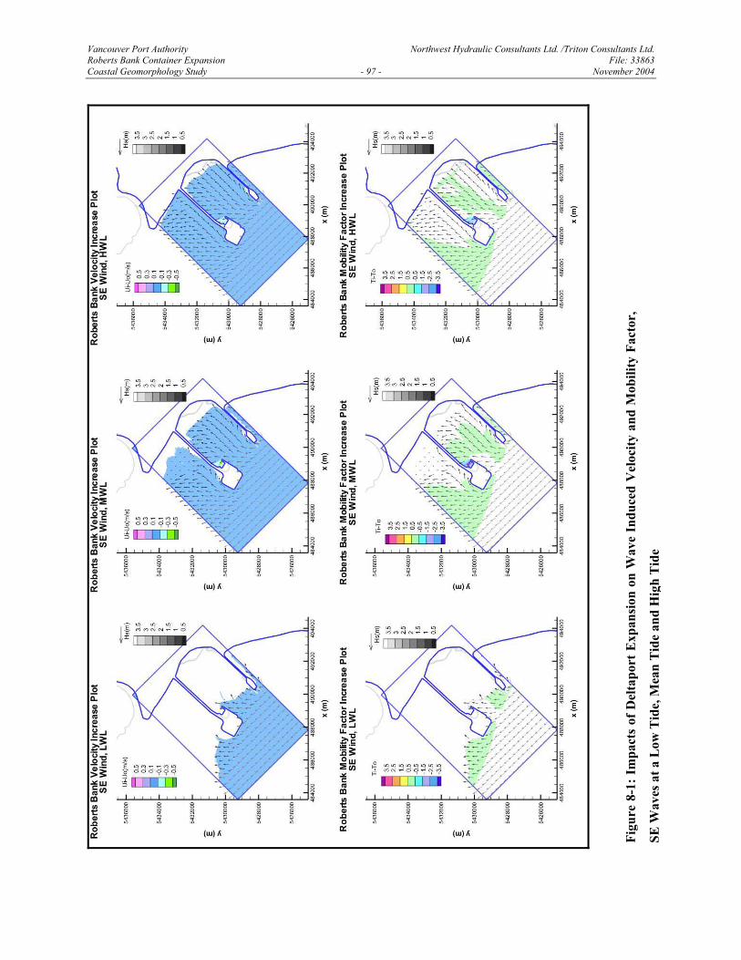
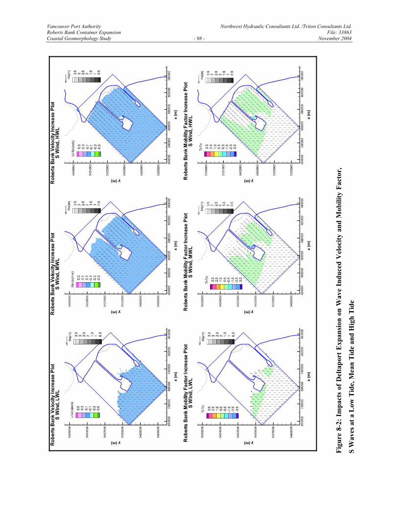
listed in Table 4-1. Figure 8-1 illustrates the impacts on waves from the southeast at low,
medium and high points of a Mean Tide, in terms of the change in velocity and the change in
mobility. Figure 8-2 illustrates the same impacts on waves from the south. These directions were
selected for display since they produced the greatest overall impacts. However, in all cases, the
impact zone was very localized, being limited virtually to the footprint of the main structures.
The wave height was increased directly in front of the wharf extension. The wave height was
reduced directly behind the wharf and along the side of the causeway directly behind the wharf
extension due to sheltering. No significant changes occurred in the vicinity of the drainage
channels or on the upper portions of the tidal flats.
8.3 IMPACTS ON TIDAL CURRENTS
The “With Project” bathymetry was digitized and was used to generate a new computational
mesh for the inter-causeway area. The new wharf was also added as a no-flow boundary. The
model was then re-run for a range of different tide conditions. Initial review of the model output
showed that the impacts of Deltaport expansion were very localized, and essentially confined to
the immediate flow field around the modified structures and the dredged channel. It was also
found that the absolute magnitude of the changes was very small. Therefore, in order to illustrate
these changes graphically, we have prepared detailed comparisons of the local area around the
Vancouver Port Authority Northwest Hydraulic Consultants Ltd. /Triton Consultants Ltd. Roberts Bank Container Expansion File: 33863 Coastal Geomorphology Study - 97 - November 2004
Figu
re 8
-1: I
mpa
cts
of D
elta
port
Exp
ansi
on o
n W
ave
Indu
ced
Vel
ocity
and
Mob
ility
Fac
tor,
SE W
aves
at a
Low
Tid
e, M
ean
Tid
e an
d H
igh
Tid
e
Vancouver Port Authority Northwest Hydraulic Consultants Ltd. /Triton Consultants Ltd. Roberts Bank Container Expansion File: 33863 Coastal Geomorphology Study - 98 - November 2004
Figu
re 8
-2: I
mpa
cts
of D
elta
port
Exp
ansi
on o
n W
ave
Indu
ced
Vel
ocity
and
Mob
ility
Fac
tor,
S W
aves
at a
Low
Tid
e, M
ean
Tid
e an
d H
igh
Tid
e
Vancouver Port Authority Northwest Hydraulic Consultants Ltd. /Triton Consultants Ltd. Roberts Bank Container Expansion File: 33863 Coastal Geomorphology Study - 99 - November 2004
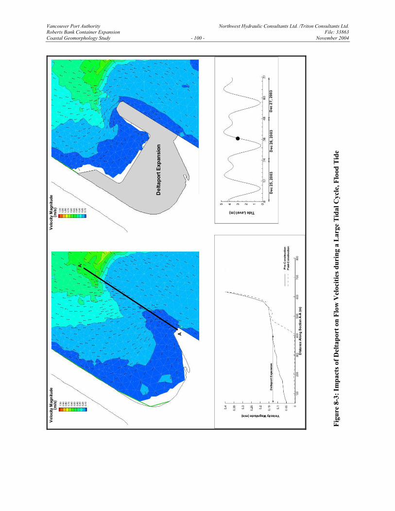
project site. Due to the large amount of output generated during the computer runs, it is not
practical to reproduce all of the results. The current patterns are illustrated for a representative
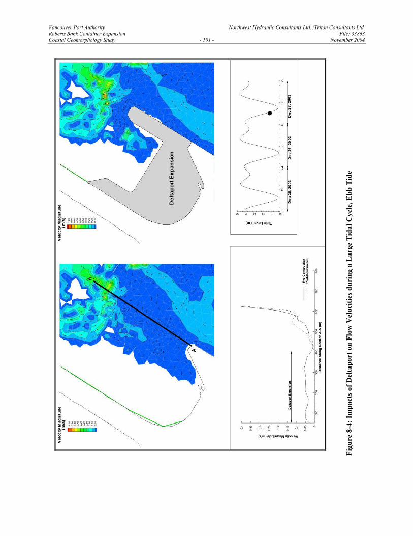
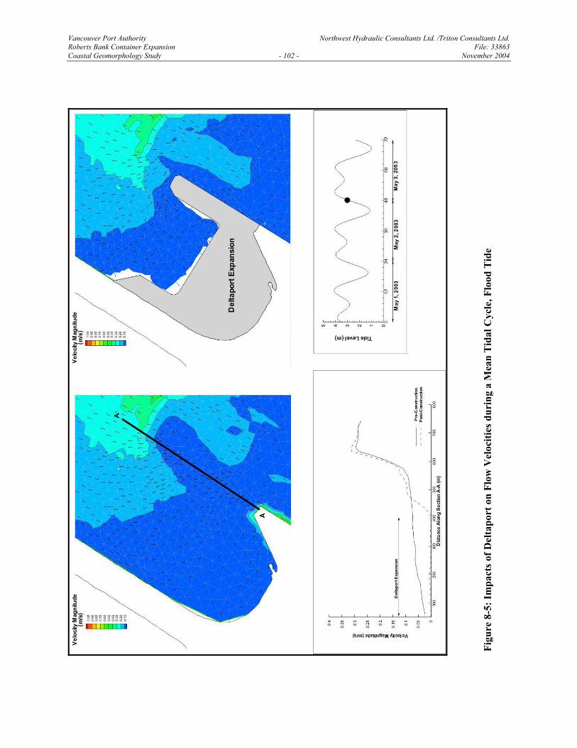
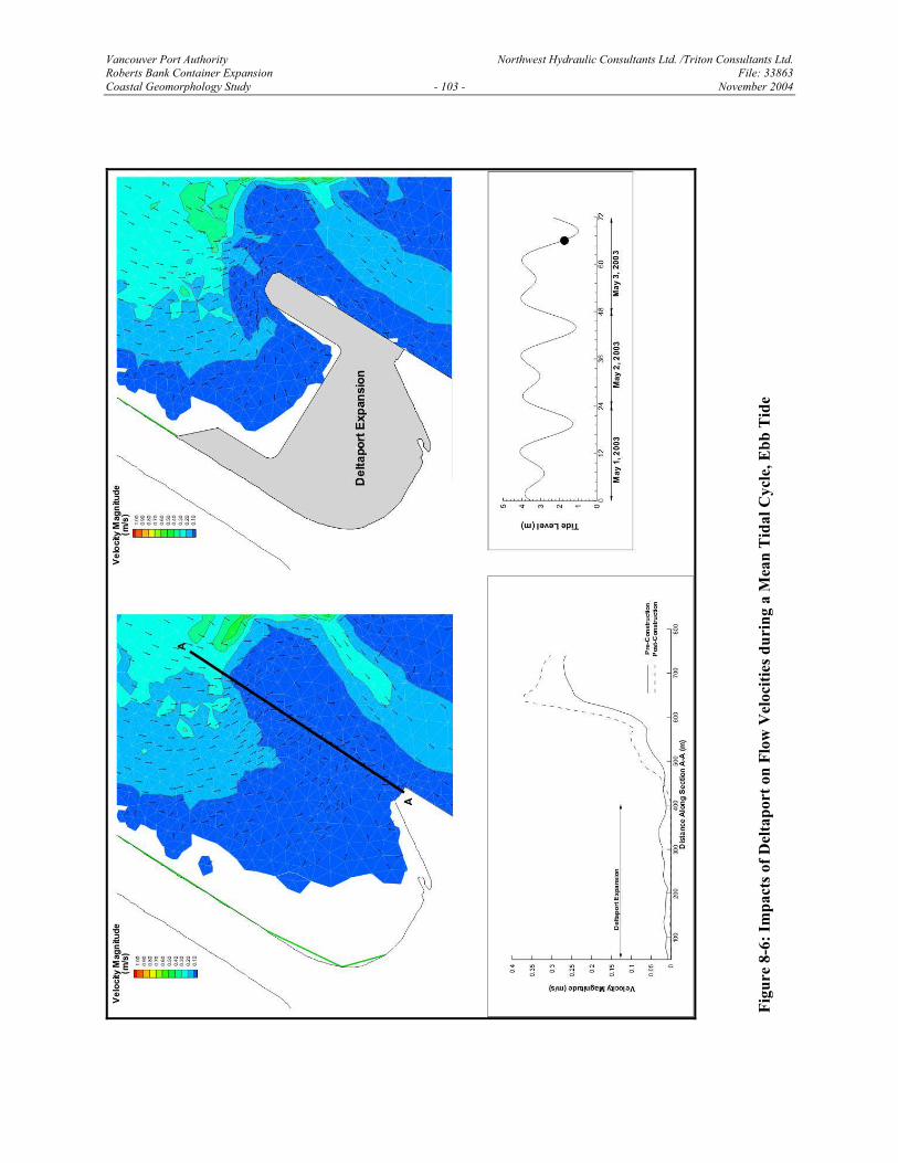
large tidal range during flood and ebb tide conditions in Figures 8-3 and 8-4. Figures 8-5 and 8-
6 show similar results for a representative mean tidal range. Additional plots for different tidal
ranges and times are provided in Appendix B.
The plots show that the end of the present wharf extends into the flow, inducing a zone of flow
divergence and a re-circulating eddy behind it during flood tides (Figures 8-3 and 8-5).
Extending the wharf further simply displaces this flow pattern landward but does not appear to
significantly change the overall pattern. During the ebb tide, the wharf causes the flow to
accelerate around its end, creating a zone of local flow concentration (Figures 8-4 and 8-6).
Extension of the wharf creates higher flow concentration at the end of the structure. However,
the absolute magnitude of the peak velocities remains very low and is typically less than 0.1 m/s.
These results indicate that the primary impact of the proposed Deltaport expansion will be to
effectively shift the existing flow patterns shoreward.
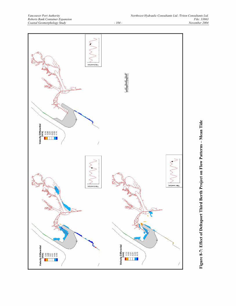
Figure 8-7 shows the differences between “With Project” and “Without Project” tidal current
velocities during a mean tide. Results for other tide conditions are presented in Appendix B. The
velocity differences were computed at each node in the computational mesh. These values were
then plotted and contoured to illustrate the spatial extent of the project impacts. Velocity
differences of less than 0.05 m/s were considered to be insignificant as they are within the
tolerance of the numerical model computations. These figures show that the impacts were highly
localized and so small as to be near the tolerance of the numerical computations. (Some apparent
velocity differences far from the project site are clearly induced by numerical imprecision rather
than actual project impacts).
8.4 IMPACTS ON SEDIMENT TRANSPORT
The magnitude of the wave bottom velocities and tidal current velocities in the vicinity of the
proposed expansion area are well below the threshold for significant sediment transport of fine
Vancouver Port Authority Northwest Hydraulic Consultants Ltd. /Triton Consultants Ltd. Roberts Bank Container Expansion File: 33863 Coastal Geomorphology Study - 100 - November 2004
Figu
re 8
-3: I
mpa
cts o
f Del
tapo
rt o
n Fl
ow V
eloc
ities
dur
ing
a L
arge
Tid
al C
ycle
, Flo
od T
ide
Vancouver Port Authority Northwest Hydraulic Consultants Ltd. /Triton Consultants Ltd. Roberts Bank Container Expansion File: 33863 Coastal Geomorphology Study - 101 - November 2004
Figu
re 8
-4: I
mpa
cts o
f Del
tapo
rt o
n Fl
ow V
eloc
ities
dur
ing
a L
arge
Tid
al C
ycle
, Ebb
Tid
e
Vancouver Port Authority Northwest Hydraulic Consultants Ltd. /Triton Consultants Ltd. Roberts Bank Container Expansion File: 33863 Coastal Geomorphology Study - 102 - November 2004
Figu
re 8
-5: I
mpa
cts o
f Del
tapo
rt o
n Fl
ow V
eloc
ities
dur
ing
a M
ean
Tid
al C
ycle
, Flo
od T
ide
Vancouver Port Authority Northwest Hydraulic Consultants Ltd. /Triton Consultants Ltd. Roberts Bank Container Expansion File: 33863 Coastal Geomorphology Study - 103 - November 2004
Figu
re 8
-6: I
mpa
cts o
f Del
tapo
rt o
n Fl
ow V
eloc
ities
dur
ing
a M
ean
Tid
al C
ycle
, Ebb
Tid
e
Vancouver Port Authority Northwest Hydraulic Consultants Ltd. /Triton Consultants Ltd. Roberts Bank Container Expansion File: 33863 Coastal Geomorphology Study - 104 - November 2004
Figu
re 8
-7: E
ffec
t of D
elta
port
Thi
rd B
erth
Pro
ject
on
Flow
Pat
tern
s – M
ean
Tid
e
Vancouver Port Authority Northwest Hydraulic Consultants Ltd. /Triton Consultants Ltd. Roberts Bank Container Expansion File: 33863 Coastal Geomorphology Study - 105 - November 2004
sand. Therefore, we do not expect significant alterations in sediment transport patterns to occur
as a result of Deltaport expansion. Furthermore, no significant local scour or infilling is
anticipated adjacent to the wharf, navigation channel or in the tug basin.
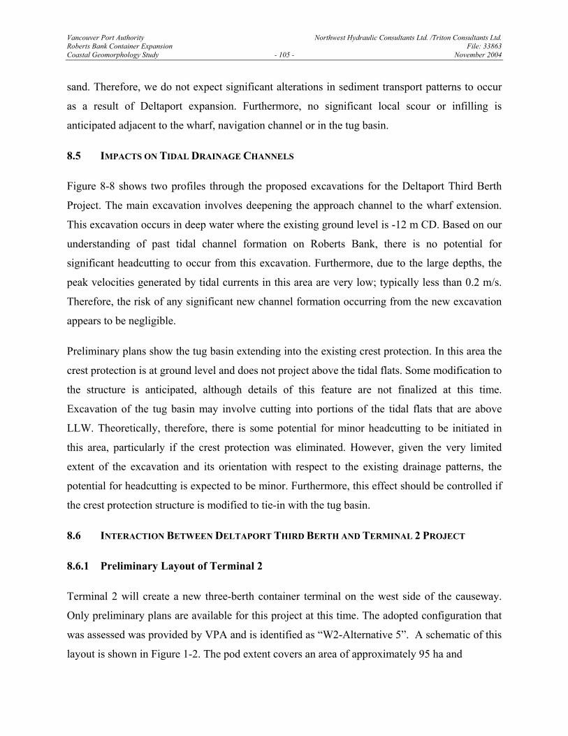
8.5 IMPACTS ON TIDAL DRAINAGE CHANNELS
Figure 8-8 shows two profiles through the proposed excavations for the Deltaport Third Berth
Project. The main excavation involves deepening the approach channel to the wharf extension.
This excavation occurs in deep water where the existing ground level is -12 m CD. Based on our
understanding of past tidal channel formation on Roberts Bank, there is no potential for
significant headcutting to occur from this excavation. Furthermore, due to the large depths, the
peak velocities generated by tidal currents in this area are very low; typically less than 0.2 m/s.
Therefore, the risk of any significant new channel formation occurring from the new excavation
appears to be negligible.
Preliminary plans show the tug basin extending into the existing crest protection. In this area the
crest protection is at ground level and does not project above the tidal flats. Some modification to
the structure is anticipated, although details of this feature are not finalized at this time.
Excavation of the tug basin may involve cutting into portions of the tidal flats that are above
LLW. Theoretically, therefore, there is some potential for minor headcutting to be initiated in
this area, particularly if the crest protection was eliminated. However, given the very limited
extent of the excavation and its orientation with respect to the existing drainage patterns, the
potential for headcutting is expected to be minor. Furthermore, this effect should be controlled if
the crest protection structure is modified to tie-in with the tug basin.
8.6 INTERACTION BETWEEN DELTAPORT THIRD BERTH AND TERMINAL 2 PROJECT
8.6.1 Preliminary Layout of Terminal 2
Terminal 2 will create a new three-berth container terminal on the west side of the causeway.
Only preliminary plans are available for this project at this time. The adopted configuration that
was assessed was provided by VPA and is identified as “W2-Alternative 5”. A schematic of this
layout is shown in Figure 1-2. The pod extent covers an area of approximately 95 ha and
Vancouver Port Authority Northwest Hydraulic Consultants Ltd. /Triton Consultants Ltd. Roberts Bank Container Expansion File: 33863 Coastal Geomorphology Study - 107 - November 2004
the seaward edge is flush with the existing pod. A large dredged basin and navigation channel
extends out to the west and south west to provide access. Preliminary plans would require
substantial dredging into the western portion of the tidal flats. The excavation would extend to
approximately El. 1 m (CD). It was assumed that no mitigation measures were provided at the
site.
8.6.2 Effect on Waves
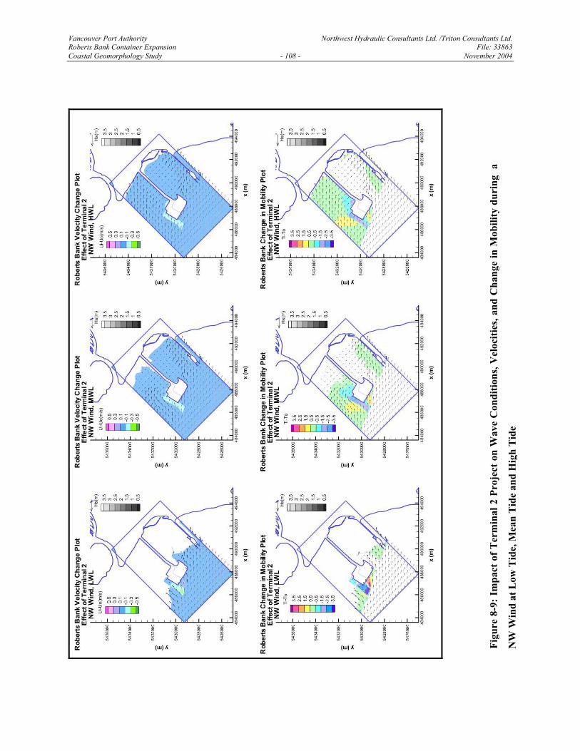
A complete series of wave refraction runs was made using the preliminary Terminal 2
configuration to determine if there was any risk of it causing additional impacts to the area
impacted by the Third Berth Project. The runs were made for the complete set of deep-water
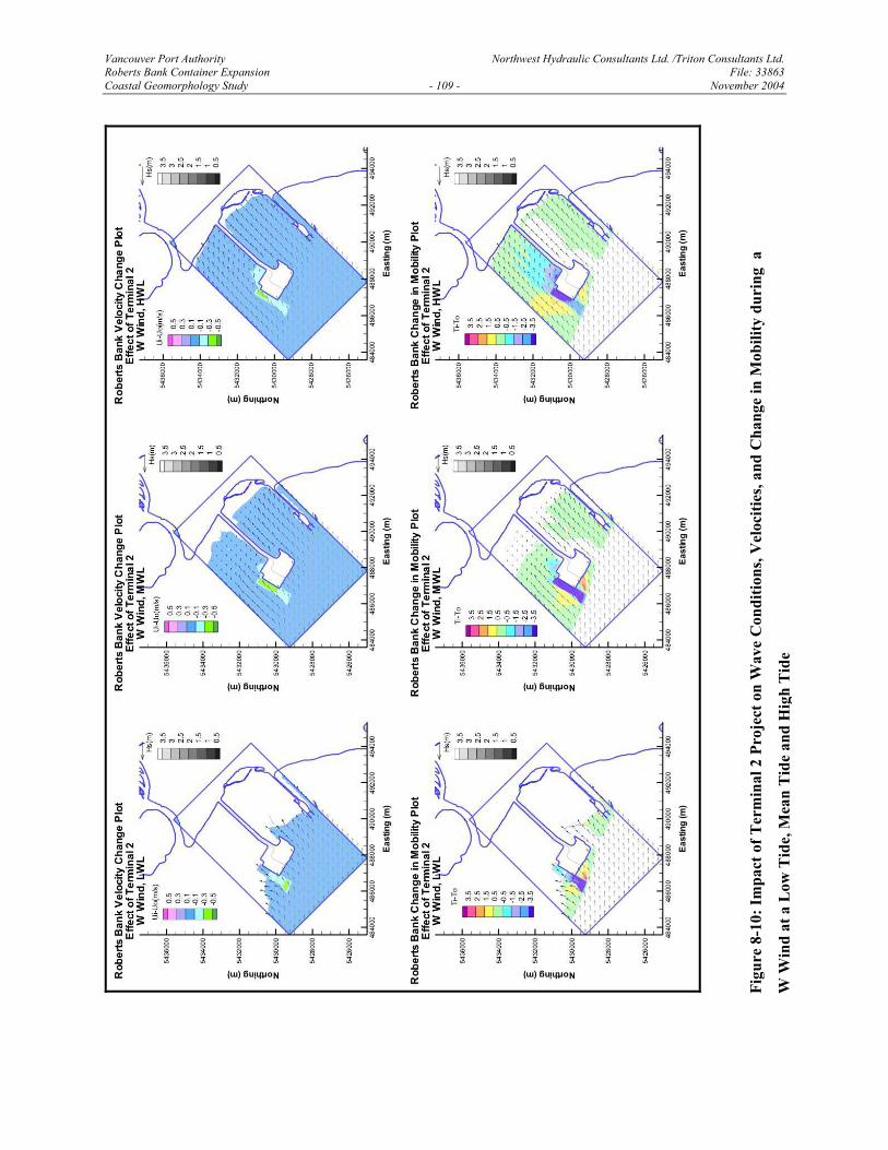
wind and wave conditions listed in Table 4-1. Figures 8-9 and 8-10 illustrate representative
results for waves approaching from the northwest and west. These directions were chosen since
they represented the most severe for producing impacts at Deltaport. All of the comparisons
indicate that potential wave impacts from Terminal 2 would be localized on the west side of the
Causeway and would not extend into the inter-causeway area in the vicinity of Deltaport.
Therefore, any potential impacts from Terminal 2 should not interact with the localized wave
impacts associated with Deltaport expansion.
8.6.3 Effect on Tidal Currents
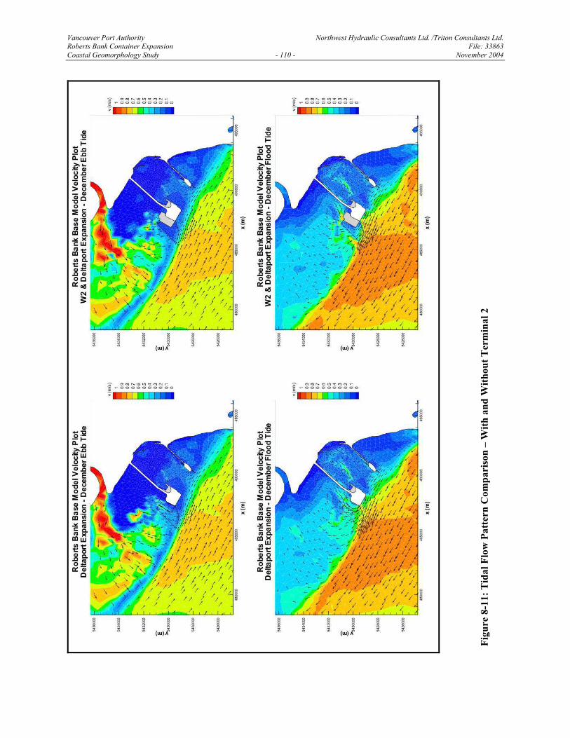
Figure 8-11 illustrates the effects of the proposed Terminal 2 on tidal current patterns. The
proposed new terminal is expected to induce significant changes to the velocity and flow patterns
on the west side of the causeway and upper portions of the tidal flats northwest of the causeway
and seaward of the west corner of the existing terminal. However, no impacts were detected
within the inter-causeway area or in the vicinity of the Third Berth project.
8.6.4 Assessment of Results
Terminal 2, as presently defined by VPA, is not expected to interact with, or modify the
hydraulic and morphologic impacts generated by the proposed Deltaport Third Berth project. In
terms of potential effects on waves, tidal current hydrodynamics and sedimentation, the Third
Berth Project and additional new development at Terminal 2 can be considered independently.
Vancouver Port Authority Northwest Hydraulic Consultants Ltd. /Triton Consultants Ltd. Roberts Bank Container Expansion File: 33863 Coastal Geomorphology Study - 108 - November 2004
Figu
re 8
-9: I
mpa
ct o
f Ter
min
al 2
Pro
ject
on
Wav
e C
ondi
tions
, Vel
ociti
es, a
nd C
hang
e in
Mob
ility
dur
ing
a
NW
Win
d at
Low
Tid
e, M
ean
Tid
e an
d H
igh
Tid
e
Vancouver Port Authority Northwest Hydraulic Consultants Ltd. /Triton Consultants Ltd. Roberts Bank Container Expansion File: 33863 Coastal Geomorphology Study - 109 - November 2004
Figu
re 8
-10:
Impa
ct o
f Ter
min
al 2
Pro
ject
on
Wav
e C
ondi
tions
, Vel
ociti
es, a
nd C
hang
e in
Mob
ility
dur
ing
a
W W
ind
at a
Low
Tid
e, M
ean
Tid
e an
d H
igh
Tid
e
Vancouver Port Authority Northwest Hydraulic Consultants Ltd. /Triton Consultants Ltd. Roberts Bank Container Expansion File: 33863 Coastal Geomorphology Study - 110 - November 2004
Figu
re 8
-11:
Tid
al F
low
Pat
tern
Com
pari
son
– W
ith a
nd W
ithou
t Ter
min
al 2
Vancouver Port Authority Northwest Hydraulic Consultants Ltd. /Triton Consultants Ltd. Roberts Bank Container Expansion File: 33863 Coastal Geomorphology Study - 111 - November 2004
9.0 CONCLUSIONS
Based on the combined analysis of the numerical modelling and geomorphic investigations, the
following conclusions have been reached with respect to the proposed Deltaport Third Berth and
Terminal 2 Projects:
1. Impacts of the proposed Deltaport Third Berth Project on tidal currents and waves will be
small and localized and essentially confined to the immediate flow field around the wharf
extension and the dredged channel. Tidal velocities will increase locally along the front
of the wharf extension, and decrease behind the wharf extension. The magnitude of the
velocities in the impact zone is well below the threshold for any significant sediment
transport. We do not expect any significant morphological impacts to develop in response
to changes in tidal flow magnitude or direction.
2. The end of the present wharf extends into the flow, which causes a zone of flow
divergence and a weak eddy to form behind the wharf during flood tides. Extending the
wharf simply shifts the flow pattern landward but does not appear to significantly change
the overall pattern. During the ebb tide, flow accelerates and concentrates at the end of
the wharf. Extending the wharf will create higher flow concentration at the end of the
structure; however, the absolute magnitude of the peak velocities remains very low and is
typically less then 0.1 m/s, which is very similar to the present situation.
3. The risk of new tidal drainage channels forming in response to planned navigation
dredging appears to be very low. The proposed channel excavation will occur in
relatively deep water (below LLW and the tidal flats where headcutting is initiated) and
will not induce significant headcutting on the tidal flats. There is some potential for
localized disturbance of the tidal flats near the proposed tug basin, which could induce
shallow, small-scale channels to form, although this can be controlled if the existing crest
protection structure is modified. Further design information on the tug basin and plans for
re-aligning the crest protection structure need to be reviewed and assessed.
Vancouver Port Authority Northwest Hydraulic Consultants Ltd. /Triton Consultants Ltd. Roberts Bank Container Expansion File: 33863 Coastal Geomorphology Study - 112 - November 2004
4. Model simulations were made to assess potential cumulative effects the proposed
Terminal 2 Project could have on the Deltaport Third Berth Project. This analysis showed
the presently proposed Terminal 2 Project would not affect hydrodynamic or sediment
transport conditions in the vicinity of the Deltaport Third Berth Project. In terms of
potential effects on waves, tidal current hydrodynamics and sedimentation, the Third
Berth Project and Terminal 2 development can be considered independently.
5. Previous port developments on Roberts Bank induced long-term morphological changes
on the tidal flats, which are continuing to this day. The main physical changes involved
initial headcutting on the tidal flats, expansion of eelgrass beds and the formation of a
network of tidal drainage channels.
6. The large drainage channel in the middle of the inter-causeway area continues to expand
in both the seaward and landward directions. Sand from the trunk channel is being
transported up onto the tidal flats during flood tides to form a large sand lobe. It is
expected that the trunk channel will expand further shoreward before eventually
stabilizing. Shoreward expansion is limited by the higher ground elevation of the tidal
flats and the reduced amount of runoff that can be generated during the tidal exchange.
7. The crest protection structure appears to have effectively limited the growth of at least
two of the smaller channels. However, the large channel near the centre of the inter-
causeway area has partially by-passed the structure and continues to expand. This site, as
well as similar experience at the smaller structure near the B.C. Ferries terminal,
illustrates the difficulty of fully preventing channel formation when the contributing
drainage area leading to the channel is large. However, this situation will not arise at the
Third Berth Project.
Vancouver Port Authority Northwest Hydraulic Consultants Ltd. /Triton Consultants Ltd. Roberts Bank Container Expansion File: 33863 Coastal Geomorphology Study - 113 - November 2004
10.0 REFERENCES
Bruun, P., 1998. The Bruun Rule of Erosion by Sea-Level Rise: A Discussion of Large Scale Two and Three Dimensional Usages. Journal of Coastal Research, Vol. 4, pp. 627-648.
Christian, H.A., Mosher, D.C., Barrie, J.V., Hunter, J.A. and Luternauer, J.L. (1998). Seabed slope instability on the Fraser River delta. In, Geology and Natural Hazards of the Fraser River Delta, British Columbia, (ed.) J.J. Clague, J.L. Luternauer, and D.C. Mosher. Geologic Survey of Canada, Bulletin 525, pp 217-230.
Church, M., 1994. Comments on “Study of Sediment Transport Pathways in the Lower Fraser River and Portions of Strait of Georgia”, unpub report, 7 pp.
Clague, J.J., 1998. Geologic setting of the Fraser River delta. In, Geology and Natural Hazards of the Fraser River Delta, British Columbia, (ed.) J.J. Clague, J.L. Luternauer, and D.C. Mosher. Geologic Survey of Canada, Bulletin 525, pp 7-16.
Clague, J.J., Luternauer, J.L. and Mosher, D.C., (eds), 1998. Geology and Natural Hazards of the Fraser River Delta, British Columbia. Geologic Survey of Canada, Bulletin 525, 270 pp.
Clague, J.J., Hebda, J.R. and Howes, D.E., 1982. Late Quaternary sea levels and crustal movements, coastal British Columbia. Canadian Journal of Earth Sciences, 19, 597-618.
Coleman, J.M. and Wright, L.D., 1975. Modern river deltas: variability of processes and sand bodies. In, Deltas: Models for Exploration, (ed.) Broussard, M.L. Houston Geological Society, Houston, TX, USA, pp. 99-149.
Delft University, 2003. SWAN Cycle III version 40.30 Users Manual. Unauthorized Electronic Version. Prepared by Holthuijsen, L.H., Booij, N., Ris, R.C., Haagsma, I.J.G., Kieftenburg, A.T.M.M., Kriezi, E.E., Zijlema, M., van der Westhuysen, A.J. Available from http://fluidmechanics.tudelft.nl/swan/download/info.htm, February 2004.
Engelund, F. and E. Hansen, 1967. A Monograph on Sediment Transport in Alluvial Streams, Teknisk Forlag, Copenhagen, Denmark.
GeoSea Consulting Ltd., 1995. Sediment Transport and its Environmental Implications in the Lower Fraser River and Fraser Delta. Report prepared for Environment Canada, Vancouver B.C., 25 pp. & appendices.
Hales, W., 2002. The impact of human activity on deltaic sedimentation, marshes of the Fraser River delta, British Columbia. In, The Changing Face of the lower Fraser River Estuary. Fraser Basin Council Symposium Proceedings, New Westminster, April 18, 2002.
Hay and Company, 1996. Erosion at Roberts Bank Geophysical Evaluation. Report prepared for Vancouver Port Corporation, 23 pp.
Vancouver Port Authority Northwest Hydraulic Consultants Ltd. /Triton Consultants Ltd. Roberts Bank Container Expansion File: 33863 Coastal Geomorphology Study - 114 - November 2004
Hemmera Envirochem Inc., 2003. History of Development at Roberts Bank – An Overview (Draft). Report prepared for Vancouver Port Authority, 1900 Granville Square, 200 Granville Street, Vancouver, BC., 19 pp.
Howard, A.D., 1967. Drainage analysis in geologic interpretation: a summation. American Association of Petroleum Geologists Bulletin, 51, 2246-2259.
Hutchinson I., Patterson R.T., and Mathewes R.W., 1998. Plant macrofossil, pollen, diatom, and foraminiferal biofacies of the Fraser delta. In, Geology and Natural Hazards of the Fraser River Delta, British Columbia, (ed.) J.J. Clague, J.L. Luternauer, and D.C. Mosher. Geologic Survey of Canada, Bulletin 525, pp 161-175.
IGPCC, 2001. Climate Change 2001: The Scientific Basis. Inter-Governmental Panel on Climate Change, United Nations Environment Program, WMO.
Kellerhals, P. and Murray, J.W., 1969. Tidal flats at Boundary Bay, Fraser River Delta, British Columbia. Bulletin of Canadian Petroleum Geology, 17(1), 67-91.
Koch, E.W., 2001. Beyond Light: Physical, Geological, and Geochemical Parameters as Possible Submersed Aquatic Vegetation Habitat Requirements. Estuaries, 24(1), 1-17.
Kostaschuk, R., Luternauer, J. and Church, M., 1998. Sedimentary Processes in the Estuary. In, Geology and Natural Hazards of the Fraser River Delta, British Columbia, (ed.) J.J. Clague, J.L. Luternauer, and D.C. Mosher. Geologic Survey of Canada, Bulletin 525, pp. 41-56.
Kostaschuk, R., Stephan, B.A., and Luternauer, J., 1993. Suspended sediment concentration in a buoyant plume: Fraser River, Canada. Geo-Marine Letters, 13 (3), 165-171.
Kostaschuk R., Church M., and Luternauer J.L., 1992. Sediment transport over salt-wedge intrusions: Fraser River estuary, Canada. Sedimentology, 39 (2), 305-317.
Lehfedt, R., 2001. Longshore Sediment Transport Modeling in 1 and 2 Dimensions, 10 pp.
Luettich, R.A., Westerink, J.J. and Scheffner, N.W., 1991. ADCIRC: An advanced three-dimensional circulation model for shelves, coasts and estuaries. Report 1:Theory and methodology of ADCIRC-2DDI and ADCIRC-3DL. Technical Report DRP-92-6, Headquarters, U.S. Army Corps of Engineers, Washington, DC.
Luternauer, J.L., 1980. Genesis of morphological features on the western delta front of the Fraser River, British Columbia – status report of knowledge. In, The Coastline of Canada, (ed.) S.B. McCann, Geological Survey of Canada, Paper 80-10, pp. 381-396.
Luternauer, J.L., and Murray, J.W., 1973. Sedimentation on the western delta-front of the Fraser River, British Columbia. Canadian Journal of Earth Sciences, 10, 1642-1663.

Vancouver Port Authority Northwest Hydraulic Consultants Ltd. /Triton Consultants Ltd. Roberts Bank Container Expansion File: 33863 Coastal Geomorphology Study - 115 - November 2004
Luternauer, J.L., Mosher, D.C., Clague, J.J. and Atkins, R.J., 1998. Sedimentary environments of the Fraser River delta. In Geology and Natural Hazards of the Fraser River Delta, British Columbia, (ed.) J.J. Clague, J.L. Luternauer, and D.C. Mosher. Geologic Survey of Canada, Bulletin 525, pp 27-39.
Luternauer, J.L., Swan, D., and Linden, R.H., 1977. Sand Waves on the Southeastern Slope of Roberts Bank, Fraser River Delta, British Columbia. Current Research, Part A, Geological Survey of Canada Paper 78-1A, 351-356.
Mathews, W.H., and Shepard, F.P, 1962. Sedimentation of the Fraser River Delta, British Columbia. Bulletin of the American Association of Petroleum Geologists, 46(8), 1416-1438.
Mathews, W.H, Fyles, J.G. and Nasmith, H.W., 1970. Postglacial crustal movements in southwestern British Columbia and adjacent Washington State. Canadian Journal of Earth Sciences, 7, 690-702.
McBean, G., 2004. Climate Change and Extreme Weather: a basis for action. Natural Hazards, 31, 177-190.
McLaren, W. A. and Buckingham, W., 1983. Sediment Tracer Study on Fraser Delta. Canadian Coastal Engineering Conference, 1983.
McLean, D. and Tassone, B., 1988. Sediment Budget of the Lower Fraser River. Federal Inter-Agency Committee on Sedimentation, 5th International Conference, Las Vegas Nevada, 16 pp.
McLean, D., Church, M. and Tassone, B., 1999. Sediment Transport Along Lower Fraser River 1: Measurements and Hydraulic Computations. Water Resources Research, 35(8), 2533-2548.
NHC-Triton, 2003. Work Plan: Roberts Bank Container Expansion Coastal Geomorphology Study. Report prepared for Vancouver Port Authority, 30 pp.
NHC, 2002. Review of Fraser River Sediment Budget. Report to Dredge Management Advisory Committee, Fraser River Estuary Management Program, by Northwest Hydraulic Consultants Ltd.
NHC, 1999. Sediment Budget of Lower Fraser River. Report to Dredge Management Advisory Committee, Fraser River Estuary Management Program, by Northwest Hydraulic Consultants Ltd.
Stewart, I. and Tassone, B. 1989. The Fraser Delta: a Review of Historical Sounding Charts. Environment Canada, Inland Waters, Pacific and Yukon Region, 39 pp.
Tarbotton, M., Luternauer, J.L. and Mattila, M., 1993. Tidal flat response to development and mitigation work at Roberts Bank, Fraser River Delta, British Columbia. In, Proceedings
Vancouver Port Authority Northwest Hydraulic Consultants Ltd. /Triton Consultants Ltd. Roberts Bank Container Expansion File: 33863 Coastal Geomorphology Study - 116 - November 2004
of the 1993 Canadian Coastal Conference, May 4-7,1993, Vancouver, British Columbia. Published by the Canadian Coastal Science and Engineering Association, and Simon Fraser University, 445-457.
Teeter, A.M., Johnson, B. H., Berger, C., Stelling, G., Scheffner, N.W., Garcia, M. H. and Parchure, T.M., 2001. Hydrodynamic and sediment transport modeling with emphasis on shallow-water, vegetated areas (lakes, reservoirs, estuaries and lagoons). Hydrobiologia, 444 (1/3): 1-23.
Thomson, R.E., 1981. Oceanography of the British Columbia Coast. Canada Department of Fisheries and Oceans Canada, Canadian Special Publication of Fisheries and Aquatic Sciences, no. 56, 291 pp.
Titus, J and V. Narayanan, 1995. The Probability of Sea Level Rise. US Environmental Protection Agency, Washington, DC, 197pp.
Triton Consultants Ltd., 1996. A Review of the Recent Physical and Biological Development of the Southern Roberts Bank Seagrass System, 1950-1994. Report prepared for Roberts Bank Environmental Review Committee, June 1996.
USACE, 2002. Coastal Morphodynamics. Engineering Manual EM1110-2-1100 Part IV, US Army Corps of Engineers,
van Rijn, L. 1989. Sediment Transport by Currents and Waves. Delft Hydraulics Report H 461, June 1989. Delft Hydraulics.
Williams H.F.L. and Hamilton T.S., 1995. Sedimentary dynamics of an eroding tidal marsh derived from stratigraphic records of 137Cs fallout, Fraser Delta, British Columbia, Canada. Journal of Coastal Research, 11 (4), 1145-1156.