Embed Size (px)
Citation preview

Timber Pricing Branch Block Planning and Plot Layout
4-1 Amendment No. 7 April 1, 2007
Block Planning and Plot Layout 4

Provincial Logging Residue & Waste Measurement Procedures Manual FLNRO
4-2 Amendment No. 7 April 1, 2007
4.1 The Plot Sampling Process
The planning and implementation of plot sampling surveys involves either one cutblock or an aggregation of cutblocks. For either cutblock or aggregate sampling, follow these steps:
Figure 4-1 Plot Sampling Process.

Timber Pricing Branch Block Planning and Plot Layout
4-3 Amendment No. 7 April 1, 2007
4.2 Sampling Design
4.2.1 Population
The population is the volume of waste generated during the specified reporting year within the approved waste reporting unit. The size of the population depends on:
a. the option selected for the waste reporting unit,
b. the area logged in that year.
4.2.2 Sub-Populations
The population usually consists of three sub-populations: accumulated, dispersed and standing trees. Each sub-population may be subdivided into one or more strata.
Accumulated waste occurs at landings, along roadsides and at other areas in the reporting unit where logs have been yarded or skidded to and where sample plots may be established. Where sample plots cannot be safely established, or are not appropriate, volumes are either estimated or 100 percent measured (each piece measured individually).
Dispersed waste occurs on the areas from which trees or logs have been removed and where sample plots can safely be established. Dispersed areas are sampled independently of accumulation areas. The area of the rights-of-way leading into the cutblock must be included in the net area of cutblock unless the waste volume has been included in a previous waste survey or as provided under Section 4.6.2.
Standing trees are trees authorized for harvest under the cutting authority (excepting reserved trees) but at the discretion of the licence holder, are not cut and removed.
Individual standing trees that are found at different locations of the cutblock can be measured and scaled individually, and be treated as part of the dispersed sub-population. Standing tree patches will be delineated separately from the dispersed to form their own sub-population and the volumes determined with methods outlined under Section 5.3.2.
4.2.3 Stratification
Stratification can increase the precision of sub-population volume estimates, and reduce the amount of sampling required to achieve a desired level of precision.
It is therefore useful to stratify the sub-populations, where possible, by harvesting system, different logging contractor, timber type, or relative quantity of waste generated.

Provincial Logging Residue & Waste Measurement Procedures Manual FLNRO
April 1, 2007 Amendment No. 7 4-4
4.2.4 Block Survey Plan
A good block survey plan in the form of a map is essential to an efficient waste survey.
The Block Survey Plan is not required to be approved by the District Manager.
A licensee or party responsible for survey must submit a Block Survey Plan or Notification to the District Manager thirty (30) days prior to the anticipated field work providing information required by the District Manager.
Only one survey plan or notification may be submitted for each cutblock, and waste report submissions must comply with the submitted plan or notification. No alterations will be allowed to be made to the waste billing volumes.
After the field survey is completed for the block, the final Block Survey Plan map must be submitted with the waste survey reports.
The map must show the cutblock boundaries, roads, the point of commencement, strip and plot locations, and must meet ministry standards. Each area must be carefully measured by mapping and planimetry. All roads, water, swamp and other non-forest areas must be delineated on the maps and the areas measured with a planimeter.
Accumulations and standing trees not harvested should be clearly indicated on the maps.
4.2.5 Sampling Objective
The sampling objective is to estimate the total volume of waste in each sub-population to a calculated minimum level of precision, or sampling error percent (S.E. %), at the 95 percent confidence level. Generally, calculated sampling errors decrease with increased sub-population size.
The sampling error and number of plots required for each sub-population are determined from plot Tables 4-2 to 4-5 in this chapter.
Timber Pricing Branch Reporting
4-5 Amendment No. 7 April 1, 2007
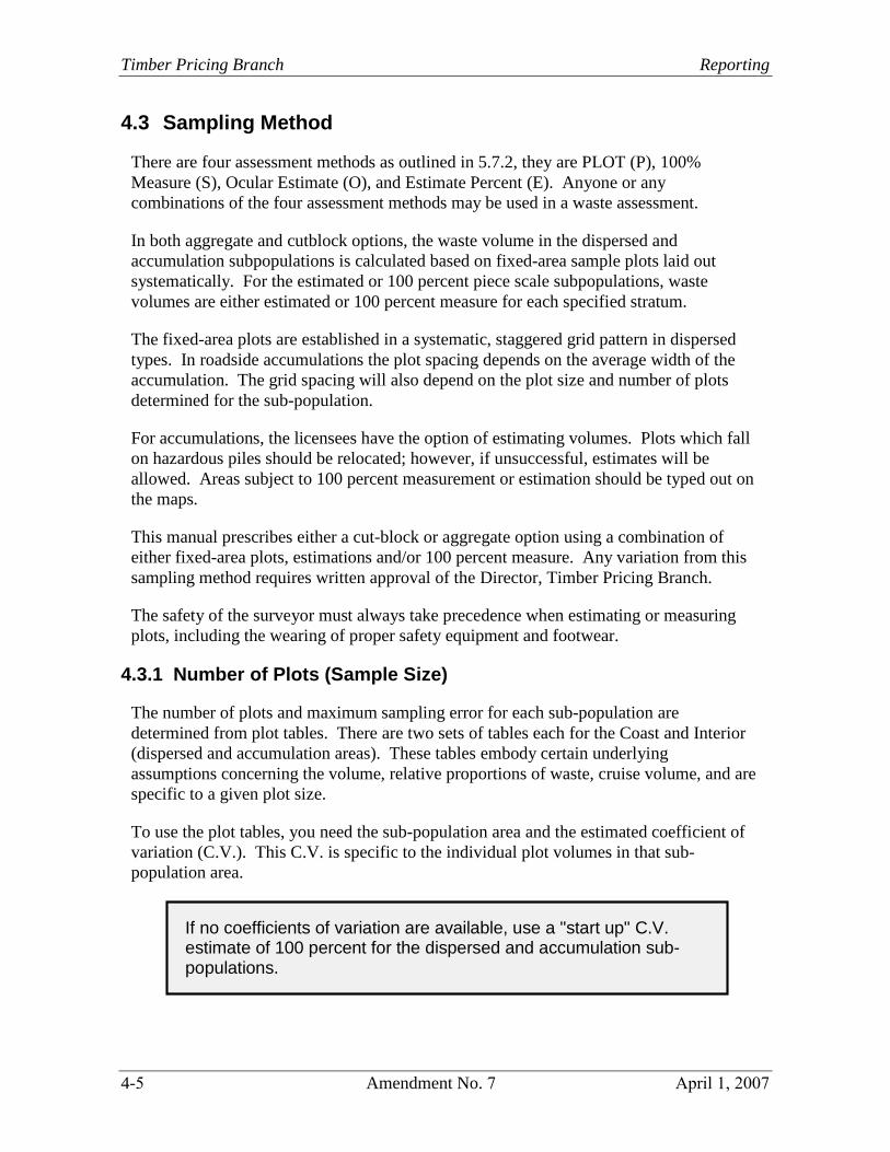
4.3 Sampling Method
There are four assessment methods as outlined in 5.7.2, they are PLOT (P), 100% Measure (S), Ocular Estimate (O), and Estimate Percent (E). Anyone or any combinations of the four assessment methods may be used in a waste assessment.
In both aggregate and cutblock options, the waste volume in the dispersed and accumulation subpopulations is calculated based on fixed-area sample plots laid out systematically. For the estimated or 100 percent piece scale subpopulations, waste volumes are either estimated or 100 percent measure for each specified stratum.
The fixed-area plots are established in a systematic, staggered grid pattern in dispersed types. In roadside accumulations the plot spacing depends on the average width of the accumulation. The grid spacing will also depend on the plot size and number of plots determined for the sub-population.
For accumulations, the licensees have the option of estimating volumes. Plots which fall on hazardous piles should be relocated; however, if unsuccessful, estimates will be allowed. Areas subject to 100 percent measurement or estimation should be typed out on the maps.
This manual prescribes either a cut-block or aggregate option using a combination of either fixed-area plots, estimations and/or 100 percent measure. Any variation from this sampling method requires written approval of the Director, Timber Pricing Branch.
The safety of the surveyor must always take precedence when estimating or measuring plots, including the wearing of proper safety equipment and footwear.
4.3.1 Number of Plots (Sample Size)
The number of plots and maximum sampling error for each sub-population are determined from plot tables. There are two sets of tables each for the Coast and Interior (dispersed and accumulation areas). These tables embody certain underlying assumptions concerning the volume, relative proportions of waste, cruise volume, and are specific to a given plot size.
To use the plot tables, you need the sub-population area and the estimated coefficient of variation (C.V.). This C.V. is specific to the individual plot volumes in that sub- population area.
If no coefficients of variation are available, use a "start up" C.V. estimate of 100 percent for the dispersed and accumulation sub- populations.

Provincial Logging Residue & Waste Measurement Procedures Manual FLNRO
April 1, 2007 Amendment No. 13 4-6
Subsequent estimates can be based on actual survey statistics. For the aggregate option, sampling proceeds as each cutblock is logged or becomes available.
4.3.2 Procedure to Determine the Number of Plots
Determine the minimum number of plots required for each sub-population as follows:
1. Determine the sub-population area (sum of stratum areas in the dispersed oraccumulation sub-population).
2. Estimate the sub-population coefficient of variation, or use start up values.
3. From the appropriate dispersed or accumulation plot table, read the minimum numberof plots required from the body of the table.
4. Read the maximum sampling error from the right-hand column of the table.
5. The minimum number of plots per stratum is 2, based on the sub-population area.
6. For the aggregate option, the number of plots for an individual block will be the resultof the hectare to plot ratio for all blocks in the aggregate divided into the area of theblock and rounded up to the nearest whole number, but the minimum of 2 plots perstratum still applies on each block.
For example:
If on the aggregate option you have a hectare to plot ratio of 6.2:1 and the area on oneof the blocks is 41.5 ha, divide 41.5 by 6.2 to get 6.7; round up to 7 plots. If thenumber of plots before rounding is less than two, then at least two plots per stratummust be established on that block.
4.3.3 Grid Spacing
Follow Section 4.3.2 to determine the number of plots required.
For the cutblock option, the number of plots required for each block is taken directly from the appropriate plot table.
For the Aggregate option, the number of plots required for each block is calculated by dividing the gross area of the block by the hectare to plot ratio for the Aggregate, rounding to the nearest whole number.
For both the Cutblock and Aggregate options, the minimum number of plots per cutblock is 2, and the grid spacing is determined for each block.

Timber Pricing Branch Reporting
4-7 Amendment No. 7 April 1, 2007
Refer to the Grid Spacing Worksheet (Table 4-1). The grid spacing is calculated from the formula of SQR (10 000 X ha/plots) where SQR means "take the square root of", and should be rounded down to the next 5 m.
If necessary, grid spacing is reduced or increased, in 10 m increments, to fit the required number of plots within the cutblock boundaries.

Provincial Logging Residue & Waste Measurement Procedures Manual FLNRO
April 1, 2007 Amendment No. 7 4-8
4.4 Plot Layout
4.4.1 Dispersed
Plots for dispersed types are to be located on a systematic, staggered grid. The steps required are as follows:
1. Using the hectares and an estimate of C.V. specific to the reporting unit, look up theminimum number of plots required in either Table 4-2 (Coast) or Table 4-4 (Interior).
2. Compute the grid spacing distance (GSD) using the grid spacing worksheet(Table 4-1).
3. Locate the POC where the main road enters the cutblock, and establish the baseline inthe cardinal direction which most closely parallels the contours. The POC forhelicopter blocks is the most south-westerly point on the block.
4. Obtain the Starting Point Interval Factor (SPIF) from the forest district staff. TheSPIF (must be in effect for the month in which primary logging for the cutblock iscompleted), multiplied by the GSD will determine the horizontal distance from thePOC to the mapped location of the initial strip (IS). (SPIF will be randomlydetermined by Ministry of Forests, Lands and Natural Resource Operations staff toeither be 1/4, 1/2, 3/4 or other fractions of GSD.).
5. Map the initial strip (IS) at the SPIF distance along and at right angles to the baselinefrom the POC.
6. Map all remaining strips at the full GSD along the baseline in both directions fromthe IS. Strips are mapped at right angles to the baseline.
7. Number the Strips:
a. on blocks with North/South baselines number the strips sequentially from Southto North, and
b. on blocks with East/West baselines number the strips sequentially from West toEast.
8. On odd numbered strips, locate the first two plots at one half the GSD along the stripin both directions from the baseline. Locate the remaining plots at full GSD along thestrip.
9. On even numbered strips, locate one plot at the intersection of the strip and thebaseline, and all remaining plots at full GSD along the strip.
10. Number the plots. Each plot in a given block should have a unique number.

Timber Pricing Branch Reporting
4-9 Amendment No. 7 April 1, 2007
Figure 4-2 Strip and Plots Placement.

Provincial Logging Residue & Waste Measurement Procedures Manual FLNRO
April 1, 2007 Amendment No. 7 4-10
4.4.2 Roadside Accumulations
For grapple yarding roadside accumulations, the number of plots required is based on the total area of the roadside accumulations. This area is calculated by measuring the length, along the road of "one-sided" and/or for "two-sided" accumulations. The length is then multiplied by an average width for the accumulation (usually but not restricted to 10 m).
The procedures are as follows:
One-sided or a mixture of one and two-sided accumulations Two-sided Accumulations
1. Start from the POC.2. Measure the length of the one-sided
accumulation; and the length of the two-sided accumulations multiplied by two.
3. Add the one-sided and two-sidedaccumulations together.
1. Start from the POC.2. Measure the length of the
accumulations x 2.
3. Add the widths of the accumulations onboth sides of the road together.
4. Calculate the area of the stratum as follows:Area (ha) = (length x width) / 10,000.
5. Look up the number of plots required from Table 3 (Coast) or Table 5 (Interior).6. Calculate the grid spacing distance (GSD) as follows:
Grid Spacing = length / number of plots required. Example: Total length of one-sided accumulation = 1500 m Total length of two-sided accumulation = 750 m x 2 = 1500 m 1500 m + 1500 m = 3000 m Area = 3000 m x 10 m = 3 ha = 15 plots (at 100% CV on the Coast) Grid Spacing Distance = 3000 / 15 = 200 m
Example: Total length of roadside accumulation = 3000 m x 2 = 6000 Width of roadside accumulation = 20 m (10 m on each side of the road) Area = 6000 m x 10 m = 6 ha = 16 plots (at 100% CV on the Coast) Grid Spacing Distance = 6000 / 16 = 375 m
Laying Out of the Plots
1. Start from the POC and on the right hand side of the road.
2. Using the Starting Point Interval Factor (SPIF) for the month, establish the first plotat one-quarter of the GSD, one-half of the GSD or three-quarters of the GSD alongthe road.
3. For one-sided or a mixture of one and two-sided accumulations, locate a full size ploton the right side of the road. For two-sided accumulations, locate a full size plot oneach side of the road.
4. Break chain the end of each accumulation and resume chaining at the beginning ofthe next accumulation until each GSD is covered.

Timber Pricing Branch Reporting
4-11 Amendment No. 7 April 1, 2007
5. Always stay to the right hand side of the road in the direction of travel when layingout the plots. When coming to a spur, go up the spur on the right hand side. At theend of the spur, turn around and come down on the right hand side.
6. For two sided accumulations when an odd number of plots are required, establish thelast plot on one side of the road. If the last digit of the cutting permit is odd, establishit on the right hand side. If the last digit of the cutting permit is even, establish it onthe left hand side.
Roadside accumulations must be marked on the map so the layout can be audited. When on-site stratification is done, it must be done on a non-bias basis.
4.4.3 Spot Accumulations
Spot accumulations include high-lead, spar, or tower landings, as well as skidder, helicopter landings.
Again, the number of plots is found from Table 4-3 (Coast) or 4-5 (Interior), and the minimum number of plots per stratum is two.
The method for selecting the first spot accumulation is to use the date of the month when the surveyor first arrives on site to do the survey.
Example 1:
31 piles requiring 6 plots, surveyed on the 23rd of the month 31 / 6 = 5.17 Survey every 5th pile
Select the following piles: #23, #28, #2, #7, #12, #17
Example 2:
11 piles requiring 3 plots, surveyed on the 30th
11 / 3 = 3.67 Survey every 4th pile
30 - 11 = 19; 19 - 11 = 8
Select the following piles: #8, #1, #5.
Provincial Logging Residue & Waste Measurement Procedures Manual FLNRO
April 1, 2007 Amendment No. 7 4-12
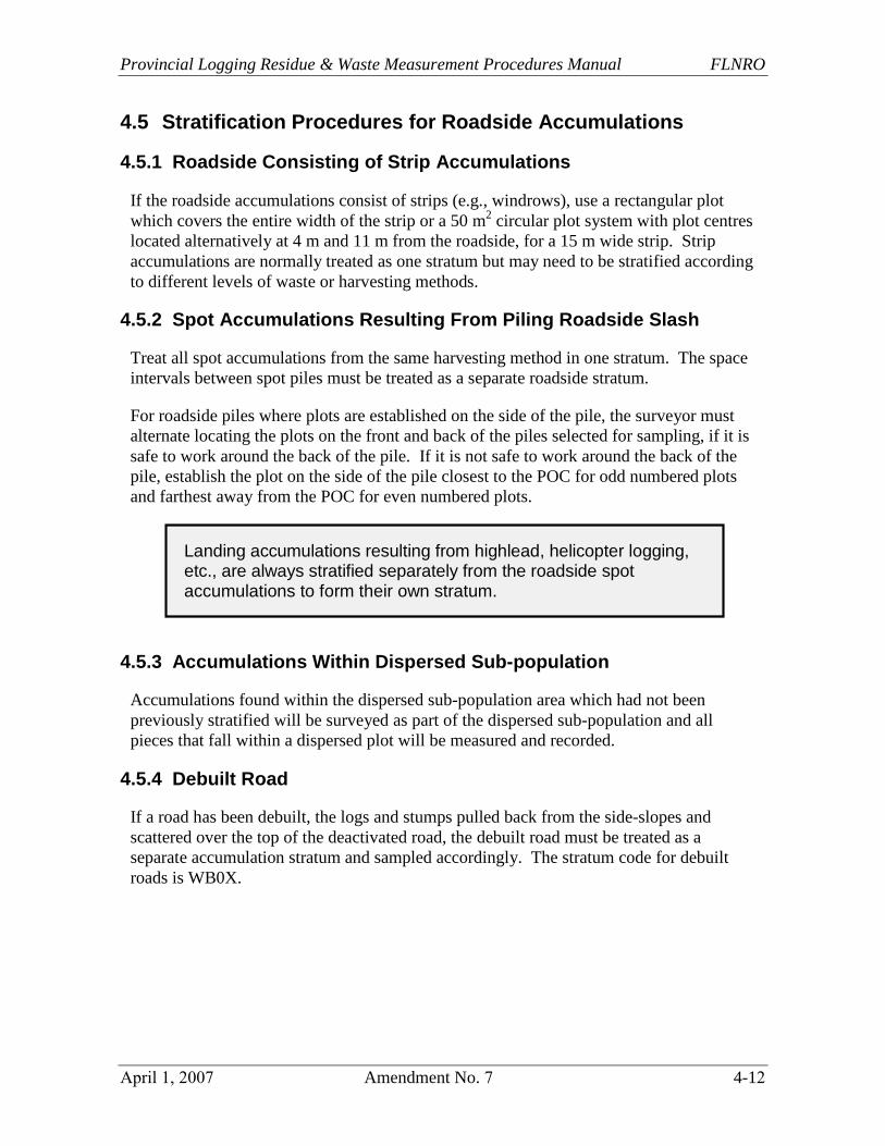
4.5 Stratification Procedures for Roadside Accumulations
4.5.1 Roadside Consisting of Strip Accumulations
If the roadside accumulations consist of strips (e.g., windrows), use a rectangular plot which covers the entire width of the strip or a 50 m2 circular plot system with plot centres located alternatively at 4 m and 11 m from the roadside, for a 15 m wide strip. Strip accumulations are normally treated as one stratum but may need to be stratified according to different levels of waste or harvesting methods.
4.5.2 Spot Accumulations Resulting From Piling Roadside Slash
Treat all spot accumulations from the same harvesting method in one stratum. The space intervals between spot piles must be treated as a separate roadside stratum.
For roadside piles where plots are established on the side of the pile, the surveyor must alternate locating the plots on the front and back of the piles selected for sampling, if it is safe to work around the back of the pile. If it is not safe to work around the back of the pile, establish the plot on the side of the pile closest to the POC for odd numbered plots and farthest away from the POC for even numbered plots.
4.5.3 Accumulations Within Dispersed Sub-population
Accumulations found within the dispersed sub-population area which had not been previously stratified will be surveyed as part of the dispersed sub-population and all pieces that fall within a dispersed plot will be measured and recorded.
4.5.4 Debuilt Road
If a road has been debuilt, the logs and stumps pulled back from the side-slopes and scattered over the top of the deactivated road, the debuilt road must be treated as a separate accumulation stratum and sampled accordingly. The stratum code for debuilt roads is WB0X.
Landing accumulations resulting from highlead, helicopter logging, etc., are always stratified separately from the roadside spot accumulations to form their own stratum.

Timber Pricing Branch Reporting
4-13 Amendment No. 7 April 1, 2007
Table 4-1 Grid Spacing (GS) Worksheet
LICENSEE: Date:
Provincial Logging Residue & Waste Measurement Procedures Manual FLNRO
April 1, 2007 Amendment No. 7 4-14
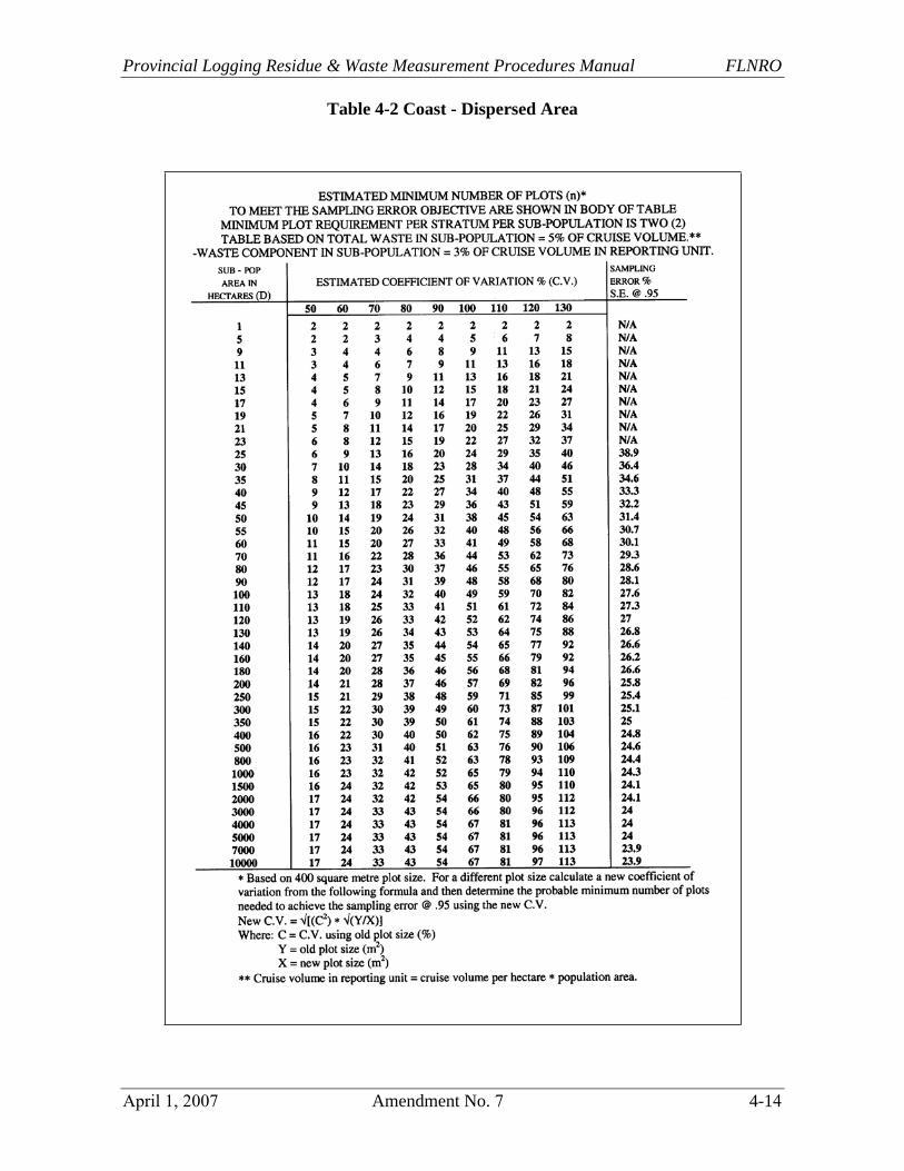
Table 4-2 Coast - Dispersed Area

Timber Pricing Branch Reporting
4-15 Amendment No. 7 April 1, 2007
Table 4-3 Coast - Accumulation Area

Provincial Logging Residue & Waste Measurement Procedures Manual FLNRO
April 1, 2007 Amendment No. 7 4-16
Table 4-4 Interior - Dispersed Area

Timber Pricing Branch Reporting
4-17 Amendment No. 7 April 1, 2007
Table 4-5 Interior - Accumulation Area

Provincial Logging Residue & Waste Measurement Procedures Manual FLNRO
April 1, 2007 Amendment No. 7 4-18
4.6 Road Rights-of-Way
4.6.1 Reporting
Waste assessments are required on road rights-of-way. Licensees must ensure the waste reported on the road rights-of-way is attributed to the correct timber mark or road permit mark. If a road belongs to a Master Road Permit, then the Master Road Permit mark shall be used.
4.6.2 Procedures
The road right-of-way is the access road leading into the cutblock from the closest previously logged cutblock or the preceding road junction with the main road. There are two surveying options:
1. No plot sampling is required. The area of the road right-of-way area (from edge ofthe travelled surface to edge of the timber) is included with the dispersed sub-population area of the cutblock.
2. Sample with plots (usually 50 m2) in a separate roadside stratum. The stratum codeto be used is OT0X.
The procedure for locating the plots is to start from the POC for the cutblock (where the road enters the cutblock) and put in rectangular plots covering the width of the area between the edge of the road and the edge of the timber using the right hand rule.
Timber Pricing Branch Reporting
4-19 Amendment No. 7 April 1, 2007
4.7 Partial Cutting (Variable Retention) Cutblocks
Partial cutting (variable retention) cutblocks contain leave trees in groups (over 0.25 ha in size is termed group retention) and/or as dispersed individual trees or small groups of a few trees (dispersed retention).
It is important that a proper map of the cutblock which shows leave areas and corridors be obtained and used as the Block Survey Plan.
For full surveys, proper stratification of the cutblock is required. Leave areas and corridors should be stratified out. Any stratum that has trees removed must be sampled.
New stratum codes for variable retention cutblocks have been created, and they are “G” for group retention, and “D” for dispersed retention. The use of smaller than 400 m2 plot size is permitted for these strata. If a smaller plot size is used, the C.V. must be recalculated and adjusted using the formula indicated in the bottom of the plot tables.