Embed Size (px)
Citation preview

LI Yuan; HE Zizhang - 3D Indoor Navigation, 44th ISOCARP Congress 2008
1
3D Indoor Navigation: a Framework of Combining BIM with 3D GIS
1 Introduction
Navigation, also called as finding one’s way, whether in real or electronic worlds, is a complex
human activity (Burnett, Smith & May 2001). In recent years, Navigation has become a very
active research area, especially in emergency response when an increasing number of
disasters—such as fire, collapse, poison gas leakage, bombing, tsunami, etc.—are frequently
reported with huge loss of life and assets(LI & ZHU 2008; Zhu, Li & Tor 2008). In such a
condition, the significance of navigation is to reduce the number of injuries and deaths in
hazards, by planning the possible evacuation alternatives in different hazard occurrence
processes.
There are many kinds of network-constrained navigation types, such as car navigation,
pedestrian navigation, multi-modal navigation, etc. The successful navigation of those types
depends mainly on the accurate geometry and semantics of network and the information
about vehicle/pedestrian. The complex geometric information of network can be quickly and
accurately depicted with the development of 3D data capturing technologies, such as Three
Line Scanner (TLS) for the road network (Shi, Nakagawa & Shibasaki 2004). Advancements
in computing, communications and map technologies have led to the development of GPS
systems, mainly used to track the trajectory of the moving objects (car/people) .
However, the research of another type of important navigation, namely 3D indoor navigation
is very limited. The reasons can be listed as follows.
� First of all, the needs for such a 3D indoor navigation are not very appealing in the past
time when most of the buildings are low-rising with simple inner structure. Nowadays,
various high-rising buildings are continuously constructed, especially for the public
buildings such as school, airport, shopping mall, hospital.
� The second reason is data shortage. Using 3D digital indoor map databases is very
fundamental for 3D indoor navigation. Currently, interiors of buildings are often
represented as two-dimensional spaces with attributes attached to them. Most of the
navigation programs use primarily 2D plans for visualization and communication(Meijers,
Zlatanova & Preifer 2005). In architecture industry, digital building models have been
usually in form of CAD models, which only contain geometric information but lost
abundant of semantic information like material of floors, openings of doors, etc.
� The third reason is the limitations of the 3D system platform and related analytical
functions. The current navigation is primarily implemented under the framework of
Geographic Information System in a 2D environment—lacks the effective and
comprehensive consideration of multidimensional and dynamic navigation information.
The supports of automatically generation of network topological structure for indoor
environment are still immature; as a result, the effects of 3D indoor navigation are actually
far from expectation.

LI Yuan; HE Zizhang - 3D Indoor Navigation, 44th ISOCARP Congress 2008
2
Successful 3D indoor navigation depends on: accurate and updated geometry and semantics
of building; correct indoor positioning; flexible navigation routes considering human
characteristics; information about threats and building accessibility, etc. The developments in
the building-design field have resulted with the emergency of an industry standard Building
Information Model (BIM), being capable of restoring both geometric and semantic information.
3D Geographic Information System (3D GIS), known as an ideal tool for representing 3D
geometry, semantic as well as topology, has been gradually utilized in many disciplines.
Recent studies demonstrated that it is possible to transfer 3D geometric and semantic
information from BIM into a 3D GIS environment(Isikdag 2006). The next step, proposed in
this paper, is to extend the research and to explore a framework of 3D GIS-based, BIM
information-supported, topologic analysis-oriented indoor navigation.
The remainder of this paper is organized as follows. Section 2 introduces the functional
requirement for 3D indoor navigation. Section 3 discusses the information from Building
Information Model (BIM). Section 4 covers the topological elements involved in navigation.
Section 5 analyzes the prototype and implementation issues. Finally, concluding remarks are
presented in Section 6.
2 Functional requirements for 3D indoor navigation
The basic routing and navigation capabilities on a roadmap are extremely fundamental for any
time-critical applications (TCA), such as location-based service (LBS), intelligent
transportation system (ITS) and emergency response (ER). The general functional
requirements for navigation are multidimensional, covering three levels. Level 1 is space level,
including microscopic sub-level, mesoscopic sub-level and macroscopic sub-level. Level 2 is
information level, containing six sub-levels, namely temporal information, spatial information,
content information, data type information, data format information and navigation control
information. Level 3 is service level, requiring four sub-levels, namely accuracy, rapidness,
adaptability and convenience.
Level 1: Space Level
� For microscopic sub-level, the research space is focused on 3D, for example, 3D
indoor or 3D lane-based navigation.
� For mesoscopic sub-level, the space is 2.5D, where the research considers the
generalized traffic volume in different directions of each street or multi-model
navigation among road network, sub-way network, etc.
� For macroscopic sub-level, only road space and non-road space have been
classified, the research aims at the street level. The traditional digital urban map was
mainly represented at this level.
Level 2: Information Level
� For temporal information, it includes historical, online and predicted information.

LI Yuan; HE Zizhang - 3D Indoor Navigation, 44th ISOCARP Congress 2008
3
� For spatial information, the inputting information may be o-dimensional,
1-dimensionl, 2-dimensional and 3-dimensional, which represents point, linear, area
and volume object individually.
� Content information means what kinds of objects or events are to be considered into
routing and navigation. The content information may include road network structure,
the vehicle/pedestrian location, event location, disaster location, etc.
� Data type information refers to words, pictures, models, voices, figures, etc.
� Data format information may come from DXF, SHP, 3DS, E00, GML, etc.
� Navigation control information consists of the restriction rules at turns, speed limits at
corridor, types of passing (uni- or bi-directional), etc.
Level 3: Service Level
� Accuracy means the route is provided in a right way and is reliable. Since the in-built
environment is very complicated, especially in emergency situation when lots of
events can be occurred, a rational routing algorithm should be adopted in order to
deal with the uncertainty and dynamic factors.
� Rapidness refers to the quick calculation of route and the quick representation for the
route. Because of navigation is a kind of time-critical application, the task should be
guaranteed by sound network calculation methods and suitable data dispatching
strategies.
� Adaptability means that the navigation behavior should satisfy different kinds of
users, for example, the evacuated people, the rescue staff, the emergency manager.
� Convenience means the various output modes, for example, voice, 3D graph, image
schema, etc.
3D indoor navigation belongs to microscopic sub-level. The information to support 3D indoor
navigation discussed in this paper mainly come from BIM model, which covers both 3D
geometry and semantics with temporal constraints. The contents of the information to support
3D indoor navigation should include the plan map of each floor, semantic description of each
building component, positional reports of pedestrian, exits position of the building, etc.
Navigation control information for 3D indoor navigation should include the topologic element
for network analysis and geometric elements for route presentation. Basically, topologic
elements defines the nodes and links, which represent the room space and corridor space (or
granting polygon such as doors, exits or windows) respectively. Geometric elements define
the visualization components, and these components can be photorealistic or symbolic.
Because of the huge data volume in the 3D GIS environment, it is impossible to load all the
components simultaneous. Besides, the navigation environment is user-focused, that is to say,
only the building components that around the user should be visualized. 3D indoor navigation
requires accurate evacuation route by considering all kinds of evacuation situation, such as
reason for moving. Take earthquake as example, the elevator cannot be taken into
consideration for the vertically travelable link; in fire disaster, if a door has been blocked, a
window can be takes as a travelable link to corridor. Accuracy also connects to the mode of
movement and even time of day. The age, the health condition of the user will affect the
choosing of a route. For a shopping mall, some section will be temporally closed and in such
situation, the route is also different with usual. Rapidness is also important for indoor

LI Yuan; HE Zizhang - 3D Indoor Navigation, 44th ISOCARP Congress 2008
4
navigation because it is tightly linked with time-critical application. Adaptability for 3D indoor
navigation has some special meaning. First, different people have different ways for knowing
the indoor environment. For the staffs who work in the building, the main guiding marks (such
as emergency exits, stair, corridor, and hall) are sufficient for evacuation. But for tourist, they
have no experience for the inner structure; they don’t know the exact place of emergency
exits and the distance from them. In such condition, more detailed landmark should be given
in order to enhance their understanding for the environment. Second, different time calls for
different ways of navigation. In night time lots of building component cannot be seen in the
dark, however special objects are illuminated at night. Therefore, the illuminated objects are
far more important than the landmark in daytime for 3D indoor navigation at night.
Convenience for 3D indoor navigation needs all kinds of presentation modes for navigation
information, including voice, graph, 3D model, etc. Because most of the 3D indoor navigation
application is user-focused, at the same time the mobile technique has been mature enough
to support the instant transmission for 3D scenario, therefore it is possible to provide visual
map to single user via mobile, also called as mobile navigation. In this paper, the main focus
is on 3D navigation map instead of voice navigation.
The traditional indoor navigation has two main characteristics: 1) the main task is to find the
nearest POI (from the user lactation to destination); 2) it is based on geometric location
modeling. Such navigation architecture is not intelligent because it omits the consideration of
user profiles and the rich semantic information within buildings. The architecture for 3D indoor
navigation should be human-centered, semantic-based and intelligent, based on ontological
knowledge representation and hybrid location modeling. Such architecture for the
semantic-based 3D indoor navigation is depicted as Figure 1. There are five important parts in
the architecture, namely building blueprints, indoor navigation ontology, context awareness,
3D indoor network, BIM model. By considering the geographic characteristics of the building
blueprints, indoor navigation ontology and context awareness, 3D indoor network model is
automatically generated, followed by the best route computing and semantic links with BIM
model.
Figure 1: Architecture for BIM Information-supported, Semantic-based Indoor Navigation

LI Yuan; HE Zizhang - 3D Indoor Navigation, 44th ISOCARP Congress 2008
5
Two key issues within the architecture will be further discussed in this paper, i.e., information
from BIM and topological elements for network analysis.
3 Information from BIM
BIM, Building Information Modeling, is the next generation of CAD for the building industry.
BIM means working within a 3D model, via an intelligent database, that contains all
information for the following:
� Design decision making
� Production of accurate construction documents
� Prediction of performance factors (i.e. energy consumption, load calculations, etc.);
� Cost-estimating, and design scenario planning
� Construction planning.
The key to BIM is the “I” in the middle: Information. BIM is centered on the development of a
single project database that contains complete project data, both graphical and non-graphical.
That includes all architectural and structural information as well as electrical and mechanical
systems and other “real-world” data. The most important characteristics insides BIM models,
different with commonly-used CAD models, are from two aspects: 3D information and
semantic information. The 3D information will be automatically derived from Building
Information Models without any extra efforts to build a 3D model. That is to say, flexible 3D
models and 3D scenarios can be automatically derived from the BIM model according to our
dynamical needs. The rich semantic information contained within BIM like thickness, material,
direction of opening, height, distance to facilities, etc. will be also inherited from the BIM
models and readily available for use.
However, for the specific purpose of indoor navigation, two kinds of information should be
highlightening.
1) The building footprint of each floor within BIM.
2) Navigation-oriented semantic information within BIM
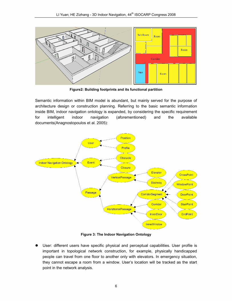
The inner structure for a complex building (such as big mall) is often complicated, and there
are many small rooms inside each separated unit. From the functional perspective, in order to
facilitate the derivation of the inner graph structure, the first step is to partition the building
footprint of each floor into different kinds. An important kind is corridor, which is functioned as
horizontal traversable links among rooms in the same floor. Rooms can be virtually linked with
the corridor via doors or even windows. Room may also include sub rooms, which can be only
linked with the corridor throught a room space. Stair is a kind of unique space, functioned as
vertical traversable links of each floor. Stairs can be also virtually linked with the corridor via
its exits.
LI Yuan; HE Zizhang - 3D Indoor Navigation, 44th ISOCARP Congress 2008
6
Figure2: Building footprints and its functional partition
Semantic information within BIM model is abundant, but mainly served for the purpose of
architecture design or construction planning. Referring to the basic semantic information
inside BIM, indoor navigation ontology is expanded, by considering the specific requirement
for intelligent indoor navigation (aforementioned) and the available
documents(Anagnostopoulos et al. 2005):
Figure 3: The Indoor Navigation Ontology
� User: different users have specific physical and perceptual capabilities. User profile is
important in topological network construction, for example, physically handicapped
people can travel from one floor to another only with elevators. In emergency situation,
they cannot escape a room from a window. User’s location will be tracked as the start
point in the network analysis.

LI Yuan; HE Zizhang - 3D Indoor Navigation, 44th ISOCARP Congress 2008
7
� Event: the concept of event is proposed to facilitate modeling anything that prevents the
passage of the user. Obstacle means the physical objects whose dimensions (width and
height) block a corridor. It will unexpected occur in emergency situation when a wall
collapsed. Closure refers to a closed door or non operating elevator, which need special
equipment (such as door keys) to make it traversable or need to wait for the right time to
go through.
� Passage: it includes vertical passage and horizontal passage. Vertical passage connects
corridors in different floor, such as elevator or stairway. Horizontal passage is comprised
of corridor segment and inner door or inner window. Several corridor segments are
integrated as a corridor. Inner door or inner window plays a supplementary role for
corridor segment, in order to connect the neighboring room via a door or window.
According to the functional difference inside a corridor segment, the node can be divided
into five kinds: CrossPoint, WindowPoint, DoorPoint, StairPoint and EndPoint.
4 Topological Elements for Indoor Navigation
A good topological representation (graph) is the first step to a good navigation within a
building. There are one or more numbers associated with each edge or node of a graph, and
these numbers might represent distances, costs, reliabilities, times, or other relevant
parameters(Evans & Minieka 1992) . For representing the inner topological structure of a
building, some abstract methods should be first defined, for example, what is the minimum
topological element for a good graph representation of a building? How to connect semantic
information into the derivation processes of a graph? Which algorithm is more suitable for
automatically generating the graph?
Conceptually, the complicated inner spatial relations between 3D entities (such as room) is
represented by Node-Relation structure with the support of Poincare Duality theory, which
treats a 3D entity as a topological node and the shared face as a topological link (Lee 2001).
This strategy is acceptable when every two neighboring entities are logically connected by an
entrance/exist, for example, there is a door or window between the two entities.
Based on the Node-relation structure, the whole topological element inside a building can be
further defined, but it needs the support of semantic modeling. Meijers et al (2005) presented
a semantic model representing 3D structuring of interiors to be used for an intelligent
computation of evacuation routes. The model consist of two levels (polygon and section),
which take into account the possibilities to move through buildings. In presented approach,
the graph considers only end section (only with one entrance/exit), granting polygon and
connector section (with more than one entrance exit). The process for semantic modeling for
a topological element contains three rules: 1) an end section maps always to a node; 2) a
granting polygon maps always to an edge; 3) a connector section maps to a graph. However,
these classifications should be well-balanced by its application domains. For example, a
one-door room can be treated as an end section in normal indoor navigation but it may
change as a connector section in emergency indoor navigation, because it is possible for a
people escaping out into its neighboring room from a window. As thus, the extra topological

LI Yuan; HE Zizhang - 3D Indoor Navigation, 44th ISOCARP Congress 2008
8
elements, such as InnerDoor and InnerWindow should be added into the link element.
Another important topological element is the introduce of “Master Node” (Lee 2004). The
concept of “Master Node” facilitates the multi-scale topological analysis and geo-visualization
for indoor navigation.
Figure 4: Topological Representation and Graph Derivation for Indoor Navigation
A practical algorithm that generates the skeleton structure for polygon features have been
broadly discussed in Computer Graphics fields. Lee (2007) proposes a simplified medial axis
transformation algorithm, namely Straight Medial Axis Transformation (S-MAT) for
representing the geometric element of a corridor. The next step is to break the corridor into
corridor segment with the consideration of the semantic such as door point, window point and
stair point. As such, new topological element, such as DoorPoint, WindowPoint and StairPoint
have been created and added into the indoor topological network.
5 Prototype and Future Enhancements
A sample prototype is implemented in a 3D GIS system (VEGGIS), developed by Wuhan
University in China. The basic function cover three aspects: the first is to import BIM model
into 3D GIS system and partition the 3D model into predefined navigation-oriented semantic
model; the second is topology construction with the medial axial transformation algorithm and
topology re-construction with the consideration of indoor navigation ontology; the third is
routing computing with the Dijkstra’s algorithm and 3D representing for the texture-attached
LI Yuan; HE Zizhang - 3D Indoor Navigation, 44th ISOCARP Congress 2008
9
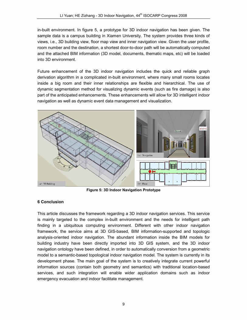
in-built environment. In figure 5, a prototype for 3D indoor navigation has been given. The
sample data is a campus building in Xiamen University. The system provides three kinds of
views, i.e., 3D building view, floor map view and inner navigation view. Given the user profile,
room number and the destination, a shortest door-to-door path will be automatically computed
and the attached BIM information (3D model, documents, thematic maps, etc) will be loaded
into 3D environment.
Future enhancement of the 3D indoor navigation includes the quick and reliable graph
derivation algorithm in a complicated in-built environment, where many small rooms locates
inside a big room and their inner relationships are flexible and hierarchical. The use of
dynamic segmentation method for visualizing dynamic events (such as fire damage) is also
part of the anticipated enhancements. These enhancements will allow for 3D intelligent indoor
navigation as well as dynamic event data management and visualization.
Figure 5: 3D Indoor Navigation Prototype
6 Conclusion
This article discusses the framework regarding a 3D indoor navigation services. This service
is mainly targeted to the complex in-built environment and the needs for intelligent path
finding in a ubiquitous computing environment. Different with other indoor navigation
framework, the service aims at 3D GIS-based, BIM information-supported and topologic
analysis-oriented indoor navigation. The abundant information inside the BIM models for
building industry have been directly imported into 3D GIS system, and the 3D indoor
navigation ontology have been defined, in order to automatically conversion from a geometric
model to a semantic-based topological indoor navigation model. The system is currently in its
development phase. The main goal of the system is to creatively integrate current powerful
information sources (contain both geometry and semantics) with traditional location-based
services, and such integration will enable wider application domains such as indoor
emergency evacuation and indoor facilitate management.

LI Yuan; HE Zizhang - 3D Indoor Navigation, 44th ISOCARP Congress 2008
10
References
Anagnostopoulos, C., Tsetsos, V., Kikiras, P. & Hadjiefthymiades, S. (2005), "OntoNav: A
Semantic Indoor Navigation System", Proc. of the 1st workshop on Semantics in
Mobile Environmnets, MDM'05.
Burnett, G., Smith, D. & May, A. 2001, "Supporting the Navigation Task: Characteristics of
‘Good’ Landmarks", in M.A. Hanson (ed.), Contemporary Ergonomics, Taylor &
Francis, London, pp. 441-446.
Evans, J.R. & Minieka, E. (1992), Optimization Algorithms for Networks and Graphs, New
York: Marcel Dekker, Inc.
Isikdag, U. (2006), Towards the Implementation of Building Information Models in Geospatial
Context, Salford: University of Salford.
Lee, J. (2001), "3D Data Model for Representing Topological Relations of Urban Features",
Proceedings of the 21st Annual ESRI International User Conference, San Diego, CA,
USA.
Lee, J. (2004), "A Spatial Access-Oriented Implementation of a 3-D GIS Topological Data
Model for Urban Entities", GeoInformatica, Vol. 8, No. 3, PP. 237-264.
Lee, J. (2007), "A Three-Dimensional Navigable Data Model to Support Emergency
Response in Microspatial Built-Environments", Association of American Geographers.
Annals of the Association of American Geographers, Vol. 97, No. 3, PP. 512-529.
LI, Y. & ZHU, Q. (2008), "VGE-based Hierarchical Routing and Navigation Method",
International Conference on Developments in Visualization and Virtual Environments
in Geographic Information Science., Kongkong.
Meijers, M., Zlatanova, S. & Preifer, N. (2005), "3D Geoinformation Indoors: Structuring for
Evacuation", Proceedings of Next generation 3D city models, Bonn, Germany.
Shi, Y., Nakagawa, M. & Shibasaki, R. (2004), "Reconstruction of “Next-generation”3D Digital
Road Model from Three Linear Scanner Images", Proceedings of ACRS, Thailand.
Zhu, Q., Li, Y. & Tor, Y.-k. 2008, "Multidimensional and dynamic vehicle emergency routing
algorithm based on 3D GIS", in S. Zlatanova & J. Lee (eds), GI-technology for
Emergency Response, ISPRS Book Series, Taylor & Francis.
Acknowledgement
The work described in this paper is supported by the National Natural Science Foundation of
China(50578136/E0802)and Wuhan University (WKL(07)0301).
Authors:
LI Yuan, HE Zizhang, School of Architecture and Civil Engineering, Xiamen University, Xiamen 361005,
China