Embed Size (px)
Citation preview

20 GEOExPro March 2016 GEOExPro March 2016 22
The ongoing acquisition by PGS of true broadband seismic in the Southern Central Graben of the North Sea can help to develop established plays whilst generating new ideas to revitalise this mature province. Even after several decades of extensive exploration, development and production using conventional seismic, it remains an important hydrocarbon exploration province. Since 2010 PGS has acquired 3D GeoStreamer® data over a large proportion of the Southern Central Graben area. Several of these broadband dual-sensor surveys have been merged to form a large high quality regional dataset CGR2015M, seamlessly covering a significant part (approximately 9,000 km2) of the North Sea Graben Province across the Norwegian, Danish and UK sectors. During the 2015 season, PGS completed the acquisition of two further GeoStreamer surveys north-west and south of the existing coverage, providing an additional 6,000 km2 of coverage over the Tail End Graben in the Danish sector and extending the GeoStreamer coverage towards the East and West Central Grabens to the north. This dataset with enhanced imaging enables an improved regional perspective and understanding whilst revealing the full exploration potential in the greatest detail. The new wave of regional GeoStreamer towed dual-sensor streamer surveys provide the explorationist with the tool to reveal more of the hidden potential within this area thanks to the imaging and Quantitative Interpretation possibilities in determining structural definition, lithology and fluids in both existing and potential plays.
2000 –
2500 –
3000 –
3500 –
4000 –
4500 –
5000 –
Regional west-east seismic section from the Feda Graben in UK waters, through part of the Gertrud Graben in the Danish sector and over the Mandal High and Coffee Soil Fault into the Norwegian Danish Basin. The section highlights the sharp imaging of structures and faults, particularly
at depth, allowing for a better regional geological understanding of the complexity in the area.
3D Broadband Seismic in the Southern Central Graben
Enabling an enhanced regional perspective and revealing new potential plays
PGS GeoStreamer coverage in the Central Graben, North Sea. The black line represents the foldout line. The purple outlines show the most recent area of acquisition (in processing), while the polygons with purple infill show existing coverage. The grey polygon shows planned acquisition. The horizon displayed is the TWT Base Cretaceous Unconformity (BCU), with dark blue/purple colours indicating the deeper parts. Fields are green (oil), red (gas) and orange (condensate). TEG: Tail End Graben; NDB: Norwegian Danish Basin; RFH: Ringkøbing-Fyn High: CSF: Coffee Soil Fault.
PGS
24 GEOExPro March 2016GEOExPro March 2016 23
New Potential in the Southern Central Graben
The Southern Central Graben is a significant oil province and contains important plays at several stratigraphic levels, from the deltaic-shallow marine sandstones of the Middle-Late Jurassic to the Upper Cretaceous – Early Paleogene marine chalks and shallow marine-turbiditic sandstones.
With more than 150 wells in the region, many of the large structures have been drilled and have yielded producing oil fields in the Norwegian sector, such as Valhall and the Ekofisk complex with estimated recoverable volumes of more than 1 Bboe and 6 Bbo respectively. In the Danish and UK sectors several fields, smaller but significant for the province, including South Arne (~269 MMbo), Harald (~204 MMbo) and Affleck (~20 MMbo), are producing.
Analogues to Johan SverdrupOften the key to a new play in an area is to seek analogues of a play concept that has been successful elsewhere. Arguably the most successful play on the Norwegian margin in the last decade has been in the Johan Sverdrup area. In that case, more than a dozen wells had previously been drilled to basement on the Utsira High and found only thin or absent Jurassic-Triassic successions with no hydrocarbons interpreted, and the prevailing industry view was that this large high ‘platform’ area was a barren basement high on the
AVA capabilities of GeoStreamer data coupled with the well control in this mature area should allow the delineation of the lithology and fluids within reservoir intervals, thereby helping to de-risk the area with regards to the location of possible reservoirs, traps and seals.
The figure (left) shows several potential scenarios where hydrocarbons could accumulate around the Mandal High and within the Piggvar Terrace areas. The traps include rotated fault blocks, folding due to local inversion and stratigraphic traps on the flanks of the high.
In well 2/9-3, the Late Jurassic Kimmeridge Clay Formation was proven to be within the upper part of the oil window and wells in the area have also penetrated potential reservoir sandstones in the Middle to Upper Jurassic Bryne Ula Formations. In addition, the Mandal High shows fault/fracture patterns in the metamorphic basement that could act as migration pathways or as a fractured basement reservoir. All of this indicates that there is still remaining hydrocarbon potential in the main Central Graben area.
Illuminating Subtle TrapsMoving further east within the CGR2015M dataset, to where the Coffee Soil Fault separates the Danish Central Graben from the Ringkøbing-Fyn High and the Norwegian Danish Basin, the exploration focus changes from the Jurassic-Cretaceous within the Central Graben to the Paleocene (Siri Fairway) close to the Norwegian-Danish border. Evidence on the seismic data of chaotic geometries with thickness variations in the Paleocene, combined with a general lack of continuous reflectors in the CGR2015M survey, could potentially indicate a sand-rich system. These are interpreted to be related to the intra-Paleocene channel mounds of the Siri Fairway just to the south. The new CGR2015M survey could enable the stratigraphy and traps relating to the Siri Fairway on the platform that is proven in the Danish sector, to be mapped further to the north in the Norwegian sector and extend the exploration potential.
Additionally, a Permian-Carboniferous sub-basin in the Norwegian Danish Basin to the east of the Coffee Soil Fault can now be identified. This basin has been poorly understood using conventional seismic data, but GeoStreamer data has greatly improved the imaging of the deep structure, where rotated fault blocks can be observed, which could represent potential hydrocarbon traps for future exploration targets.
The Permian-Carboniferous basin continues to be exposed to the south in the TEG2013 survey, where the sediment infill is up to 750m thick towards the north (see figure right), truncated against a basement high to the south. The northwards dip of the basin within the TEG2013 survey and the similar geological setting of the basin to that of the CGR2015M survey indicates that it extends from the Tail End Graben along the east side of the Coffee Soil Fault, northwards to the Norwegian Danish Basin, as seen in the CGR2015M survey. Future surveys (see map on page 22) aim to provide the next piece of the puzzle towards unravelling the deep structure in this area.
Within the Permian-Carboniferous sub-basin in the TEG2013 area there is a change in dip and seismic character
JENS BEENFELDT and SIMON BAER, PGS
Is it possible to determine where the future hydrocarbon potential lies or to identify a new play that will ensure continued interest and growth in the Southern Central Graben of the North Sea?
flanks of the main Mesozoic graben. A fresh regional examination of the integrated elements of a play combined with modern seismic imaging provided the keys to open up this now prolific play.
In 2014, the Norwegian exploration industry’s attention was drawn to the South Central Graben area of the CGR2015M GeoStreamer dataset, where Det Norske sought to pursue the same play concept almost 300 km along the basin margin to the south. Well 2/9-5S, located on a terrace to the west of the Mandal High, targeted an Upper Jurassic play and a secondary ’pre-Jurassic’ play in a rotated fault block on the margins of a large fractured basement high. Unfortunately, this new well was dry, with only thin minor sandstone intervals at both Jurassic and pre-Jurassic target levels. Although a disappointing result, the play concept of Middle-Upper Jurassic sandstones being distributed down flank from the Mandal High onto the Piggvar Terrace and possibly further on into the Gertrud Graben are still considered viable targets. Illuminating them, mapping their distribution and characterising potential stratigraphic or structural traps accurately becomes essential for evaluating and de-risking leads or prospects in the area. GeoStreamer’s improved imaging and broader frequency spectrum, including more low frequencies, provides that opportunity and allows the interpreter to confidently map the structural complexity. The AVO/
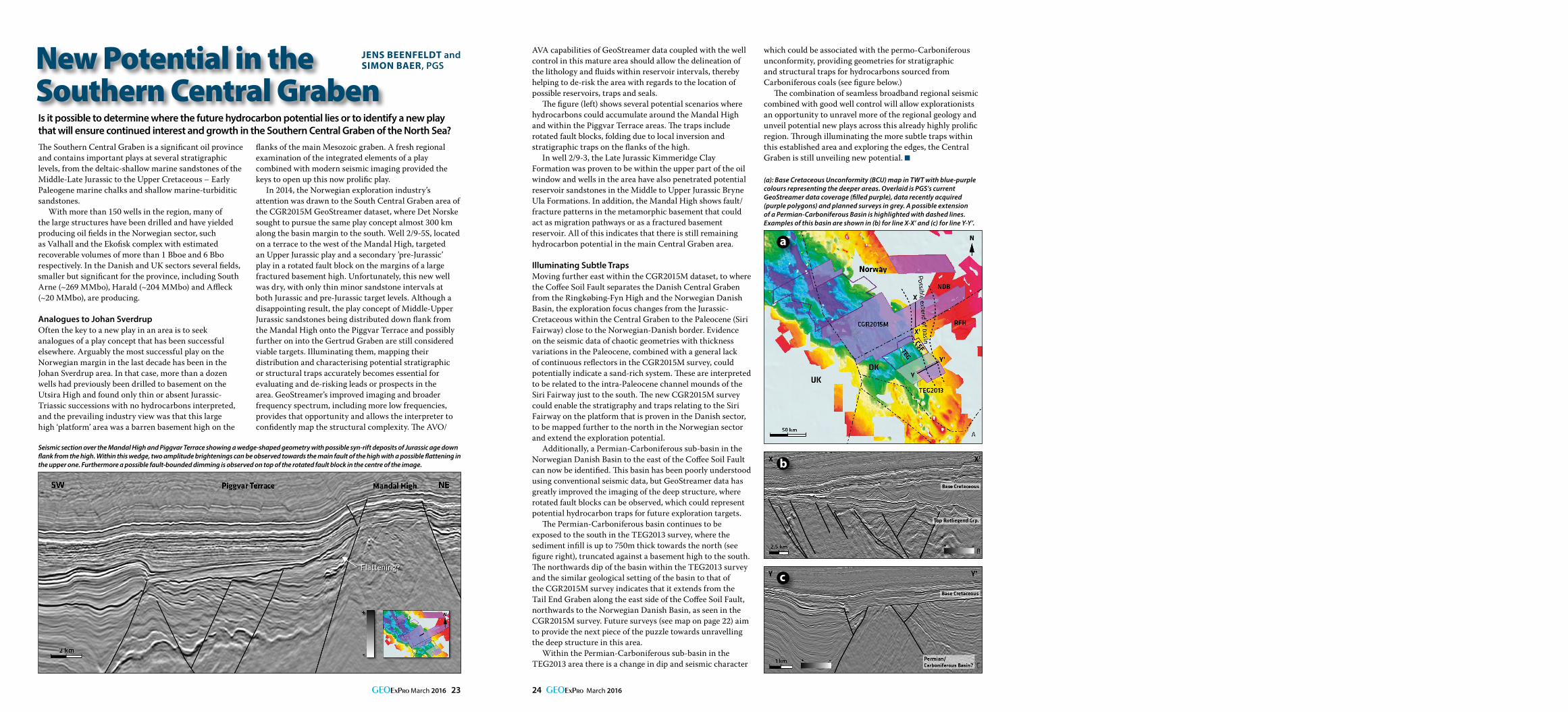
(a): Base Cretaceous Unconformity (BCU) map in TWT with blue-purple colours representing the deeper areas. Overlaid is PGS’s current GeoStreamer data coverage (filled purple), data recently acquired (purple polygons) and planned surveys in grey. A possible extension of a Permian-Carboniferous Basin is highlighted with dashed lines. Examples of this basin are shown in (b) for line X-X’ and (c) for line Y-Y’.
which could be associated with the permo-Carboniferous unconformity, providing geometries for stratigraphic and structural traps for hydrocarbons sourced from Carboniferous coals (see figure below.)
The combination of seamless broadband regional seismic combined with good well control will allow explorationists an opportunity to unravel more of the regional geology and unveil potential new plays across this already highly prolific region. Through illuminating the more subtle traps within this established area and exploring the edges, the Central Graben is still unveiling new potential.
Seismic section over the Mandal High and Piggvar Terrace showing a wedge-shaped geometry with possible syn-rift deposits of Jurassic age down flank from the high. Within this wedge, two amplitude brightenings can be observed towards the main fault of the high with a possible flattening in the upper one. Furthermore a possible fault-bounded dimming is observed on top of the rotated fault block in the centre of the image.
a
b
c