Embed Size (px)
Citation preview

37th EARSeL Symposium
Smart Future with Remote Sensing
Abstract Book

37th EARSeL Symposium Smart Future with Remote Sensing Abstract Book Czech Technical University in Prague 27-30 June 2017
Published for: EARSeL – European Association of Remote Sensing Laboratories Disclaimer: The Editors and the Publishers accept no responsibility for errors or omissions in the text and shall not be liable for any damage to property or persons arising from the use of information
contained herein.
Edited by: doc. Ing. Lena Halounová, CSc.
ISBN 978-80-01-06192-3

EARSeL Symposium, Prague 27-30 June 2017
2
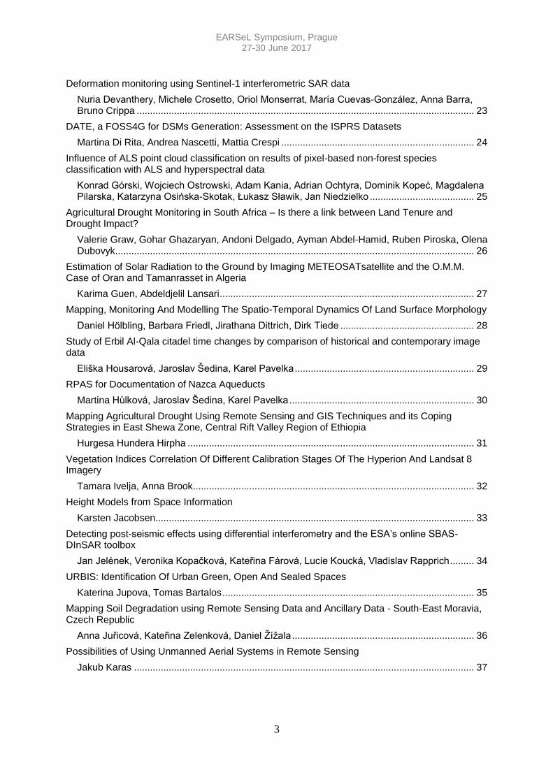
Table of Contents
Studying Relative Age Relationship of Geological Structures and Evolution Using High Resolution Remotely Sensed Images: A Case Study from West Central Sinai, Egypt
Mamdouh Mahmoud Abdeen ....................................................................................................... 7
Investigation of Correlation Between Light Intensity and Increment
Azadeh Abdollahnejad, Dimitrios Panagiotidis, Peter Surový ..................................................... 8
Resolution Enhancement of Incomplete Thermal Data Exploiting Temporal and Spatial Correlation
Paolo Addesso, Maurizio Longo, Rocco Restaino, Gemine Vivone ............................................ 9
Transition Towards Ecologically Friendly Cities Integrating The Third Dimension Into The Concept Of Urban Ecosystem Services
Sadroddin Alavipanah, Dagmar Haase, Tobia Lakes, Salman Qureshi ................................... 10
A GIS based Multi Criteria Analysis: An effective decision-making tool for management Abu Dhabi built environmental performance
Huda khaleefa Alsalmi, Giridhar kolan Reddy ........................................................................... 11
How to Convince the Society for Disaster Management
Orhan Altan ................................................................................................................................ 12
Forest Classification and Individual Tree Height Measurement Using Local Maxima Approaches in a Mixed Coniferous-Deciduous Site in South West Romania
Bogdan Apostol, Adrian Lorent, Marius Petrila, Vladimir Gancz, Ovidiu Badea ....................... 13
Copernicus For Statistics - Pilot Assessments For LC/LU Information In Germany
Stephan Arnold, Sylvia Seissiger ............................................................................................... 14
Assessment of Changes in Diameter of The Borehole And Properties of Rocks According to Well Logging
Adilkhan Baibatsha, Alma Bekbotaeva, Sandugash Satibekova .............................................. 16
Rapid Mapping of Key Vegetative, Agricultural Indices Using Spectral Data
Francesco Beccari...................................................................................................................... 17
Use of remote sensing data for monitoring environmental change in Tunisian Oases
Cherine Ben Khalfallah, Eric Delaitre, Dalel Ouerchefani, Laurent Demagistri, Faiza Khebour-Allouche, Fadila Darragi, Frédérique Seyler .............................................................................. 18
European GNSS and its Synergies with the Earth Observation
Reinhard Blasi ............................................................................................................................ 19
Case-Based Reasoning for Object-Based Remotely Sensed Image Classification
Rabia Sarah Cheriguene, Khelifa Djerriri ................................................................................... 20
Variations in the Light Absorption Coefficients by Phytoplankton in the Black Sea: Environmental Control
Tanya Churilova, Vyacheslav Suslin, Tanya Efimova, Nataliia Moiseeva, Vladimir Mukhanov, Olga Krivenko ............................................................................................................................. 21
The potential of ALOS PALSAR-DEM for landform semiautomatic detection and landslide susceptibility modeling
Nixon Alexander Correa-Muñoz, Carol Andrea Murillo-Feo, Luis Joel Martinez-Martinez ....... 22
EARSeL Symposium, Prague 27-30 June 2017
3
Deformation monitoring using Sentinel-1 interferometric SAR data
Nuria Devanthery, Michele Crosetto, Oriol Monserrat, María Cuevas-González, Anna Barra, Bruno Crippa .............................................................................................................................. 23
DATE, a FOSS4G for DSMs Generation: Assessment on the ISPRS Datasets
Martina Di Rita, Andrea Nascetti, Mattia Crespi ........................................................................ 24
Influence of ALS point cloud classification on results of pixel-based non-forest species classification with ALS and hyperspectral data
Konrad Górski, Wojciech Ostrowski, Adam Kania, Adrian Ochtyra, Dominik Kopeć, Magdalena Pilarska, Katarzyna Osińska-Skotak, Łukasz Sławik, Jan Niedzielko ....................................... 25
Agricultural Drought Monitoring in South Africa – Is there a link between Land Tenure and Drought Impact?
Valerie Graw, Gohar Ghazaryan, Andoni Delgado, Ayman Abdel-Hamid, Ruben Piroska, Olena Dubovyk ...................................................................................................................................... 26
Estimation of Solar Radiation to the Ground by Imaging METEOSATsatellite and the O.M.M. Case of Oran and Tamanrasset in Algeria
Karima Guen, Abdeldjelil Lansari ............................................................................................... 27
Mapping, Monitoring And Modelling The Spatio-Temporal Dynamics Of Land Surface Morphology
Daniel Hölbling, Barbara Friedl, Jirathana Dittrich, Dirk Tiede .................................................. 28
Study of Erbil Al-Qala citadel time changes by comparison of historical and contemporary image data
Eliška Housarová, Jaroslav Šedina, Karel Pavelka ................................................................... 29
RPAS for Documentation of Nazca Aqueducts
Martina Hůlková, Jaroslav Šedina, Karel Pavelka ..................................................................... 30
Mapping Agricultural Drought Using Remote Sensing and GIS Techniques and its Coping Strategies in East Shewa Zone, Central Rift Valley Region of Ethiopia
Hurgesa Hundera Hirpha ........................................................................................................... 31
Vegetation Indices Correlation Of Different Calibration Stages Of The Hyperion And Landsat 8 Imagery
Tamara Ivelja, Anna Brook ......................................................................................................... 32
Height Models from Space Information
Karsten Jacobsen ....................................................................................................................... 33
Detecting post-seismic effects using differential interferometry and the ESA’s online SBAS-DInSAR toolbox
Jan Jelének, Veronika Kopačková, Kateřina Fárová, Lucie Koucká, Vladislav Rapprich ......... 34
URBIS: Identification Of Urban Green, Open And Sealed Spaces
Katerina Jupova, Tomas Bartalos .............................................................................................. 35
Mapping Soil Degradation using Remote Sensing Data and Ancillary Data - South-East Moravia, Czech Republic
Anna Juřicová, Kateřina Zelenková, Daniel Žížala .................................................................... 36
Possibilities of Using Unmanned Aerial Systems in Remote Sensing
Jakub Karas ............................................................................................................................... 37
EARSeL Symposium, Prague 27-30 June 2017
4
Crop Discrimination Analysis Based on Spectral Mixture Analysis Using Hyperspectral Image Data
Yeji Kim, Ahram Song, Yongil Kim ............................................................................................. 38
Estimating the Seasonality of Human Activities from Remotely Sensed Night Light Imagery
Eleni Krikigianni, Chrysovalantis Tsiakos, Christos Chalkias .................................................... 39
Usability of COPERNICUS Data in Remote Sensing Applications
Andrija Krtalic, Ivan Racetin, Ivan Pilas ..................................................................................... 40
The Analysis of the Notecka Forest Reforestation Process after a Fire in 1992
Ewelina Lesisz, Katarzyna Osińska-Skotak ............................................................................... 41
Multi-scale Imaging Spectroscopy and Radiative Transfer in Vegetation Canopies
Zbyněk Malenovský.................................................................................................................... 42
Documentation Of Historical Objects Using Photogrammetry And Reflectance Spectroscopy
Eva Matoušková, Karel Pavelka, Martina Hůlková, Jaroslav Šedina, Eliška Housarová, Aleš Čepek ......................................................................................................................................... 43
Agricultural monitoring with Sentinel-1 & 2 satellites in the context of the CAP in the post 2020 timeframe. – Northern Poland case study.
Magdalena Mleczko, Marek Mróz, Magdalena Fitrzyk, Przemyslaw Slesinski ......................... 44
Sentinel-1 Big Data Analysis with Google Earth Engine for Glacier Surface Velocity Monitoring
Andrea Nascetti, Marco Di Tullio, Nico Emanuelli, Flavia Nocchi, Andrea Camplani, Mattia Crespi ......................................................................................................................................... 45
"Georeferenced (Re)Assessment Of A Reality, The Case Of The XII Century Extra Urbis Romae Towers: The Importance Of Geolocalization, Focusing On Late Middle Age Architectural Remains By 3D Survey Models, GIS Analysis And Web Sharing."
Priscilla Paolini, Lia Barelli, Giorgio Forti, Andrea Menghini, Alessio Ronchi ........................... 46
Quantification of the Greenland Ice Sheet Albedo Changes Between 2000 and 2015 Using the MODIS MCD43A3 Satellite Data Product
Eberhard Parlow, Nicola Möckli ................................................................................................. 47
Examples of different techniques for glaciers motion monitoring using InSAR and RPAS
Karel Pavelka, Jaroslav Šedina, Eva Matoušková, Ivana Hlaváčová ....................................... 48
Real Time Change Detection Tool For Environmental Monitoring
Alin-Ionut Plesoianu, Ionut Cosmin Sandric, Paula Anca, Mihai Doru ...................................... 49
Forest and peat fires monitoring system in Greenpeace
Ksenia Victorovna Polotnyanko, Vilen Lupachik........................................................................ 50
Airborne Thermal Remote Sensing: The Case of the City of Olomouc, Czech Republic
Tomas Pour, Jakub Mirijovsky ................................................................................................... 51
Automatic Lane Marking Extraction From Point Cloud Into Polygon Map Layer
David Procházka, Jaromír Landa, Jana Procházková ............................................................... 52
On the need for a bias assessment of FAPAR ground measurements to validate the Sentinel-2 FAPAR product in a pre-alpine mixed coniferous forest
Birgitta Putzenlechner, Philip Marzahn, Arturo Sanchez-Azofeifa, Ludwig Ralf ....................... 53
Characterization of Salinity in The River Neretva Delta Using Landsat TM5 and in situ Data
Ivan Racetin, Andrija Krtalić, Veljko Srzić .................................................................................. 54
EARSeL Symposium, Prague 27-30 June 2017
5
The Analysis of the Potential of Vegetation Succession Species Identification with the Use of Hyperspectral and LiDAR data
Aleksandra Radecka, Katarzyna Osińska-Skotak, Adam Kania, Dorota Michalska-Hejduk, Wojciech Ostrowski, Konrad Górski ........................................................................................... 55
The Surface Urban Heat Island of Polish City Bialystok
Aleksandra Radecka, Katarzyna Osińska-Skotak ..................................................................... 56
Monitoring of Crop Fields Using Multispectral and Thermal Imagery from UAV
Paulina Lyubenova Raeva, Jaroslav Šedina, Adam Dlesk ....................................................... 57
Image Based Classification of Slums, Built-up and Non-built-up Areas in Kalyan, India
Elena Ranguelova, Monika Kuffer, Karin Pfeffer, Debraj Roy, Micheal Lees ........................... 58
Augmented Reality in Earth Observation Education – Two Examples Based on High Definition Earth Viewing Data
Andreas Rienow, Annette Ortwein, Johannes Schultz, Kilian Staar ......................................... 59
“Move on up!” – Remote Sensing in School Lessons as a Role in the Copernicus Academy of Bonn and Bochum
Andreas Rienow, Frank Thonfeld, Carsten Jürgens .................................................................. 60
Several Quality-Control Contrasts for Confusion Matrices. Application to Forestry
Jose Rodriguez-Avi, Francisco Javier Ariza-López, María Virtudes Alba-Fernández .............. 61
Quality Control Of Classifications With Per-Class Quality Requirements And Limited Inter-Class Mixtures
Jose Rodriguez-Avi, Francisco Javier Ariza-López, María Virtudes Alba-Fernández .............. 62
TFDynamics, an open-source R library for forest dynamics analysis with scarce Landsat data
Fabián Santos ............................................................................................................................ 63
Use of Crowdsourcing in Evaluating Post-Classification Accuracy
Ekrem Saralioglu, Oguz Gungor ................................................................................................ 64
Remotely Sensed Detection of Fog Geo-Ecosystems in the Coastal Chilean-Peruvian Desert
Sebastian Scheckel, Nils Wolf, Camilo del Rio, Alexander Siegmund ...................................... 65
Using RPAS for detection of archaeological objects using multispectral and thermal imaging
Jaroslav Šedina, Eliška Housarová, Paulina Raeva .................................................................. 66
Modified Iterative Error Analysis To Classify Crop Species Using Spectral Similarity Measures
Ahram Song, Yeji Kim, Yongil Kim ............................................................................................. 67
The Contribution of the Earth Observation to the Monitoring of Gas Flaring
Agnieszka Soszynska, Christian Fischer, Eckehard Lorenz, Ralf Reulke ................................ 68
A Method to Estimate the Seasonality Coefficient Based on Night-lights
Demetris Stathakis, Pavlos Baltas ........................................................................................ 69-70
Land Cover / Land Use mapping and dasymetric modelling for improved risk management in compliance with INSPIRE directive
Nathalie Stephenne, Benjamin Beaumont, Eric Hallot, Eléonore Wolff .................................... 71
Identification of mortality patterns in Norway spruce forests using high resolution remotely sensed imagery combined with auxiliary data
Peter Surový, Karel Kuželka, Marek Turčáni, Tomáš Hlásny ................................................... 72

EARSeL Symposium, Prague 27-30 June 2017
6
Quality Assessment of an Extended Interferometric Radar Data Processing Approach
Winhard Tampubolon ................................................................................................................. 73
Automatic Semantic Enrichment Of Big Earth Observation Data For Spatio-Temporal Querying In Image Databases
Dirk Tiede, Andrea Baraldi, Martin Sudmanns, Hannah Augustin, Christian Werner, Sebastian d'Oleire-Oltmanns, Stefan Lang ................................................................................................. 74
Geometry Accuracy of DTM from RGB and Hyperspectral Sensors Embedded In UAV to Monitoring Natural Resources.
Dalva Maria de Castro Vitti, Ademir, Junior Marques, Taina Thomassin Guimarães, Emilie Caroline Koste, Leonardo Campos Inocêncio, Maurício Roberto Veronez, Frederico Fábio Mauad ......................................................................................................................................... 75
Correlation Of The Sky View Factor And Urban Roughness Parameters In Urban Climate Studies
Marzena Wicht, Andreas Wicht ............................................................................................. 76-77
Thermal Unmixing of Surface Temperature Data in an Urban Environment
Andreas Wicki, Eberhard Parlow ............................................................................................... 78
The Urban Surface Energy Balance Seen From the Satellite Perspective
Andreas Wicki, Eberhard Parlow ............................................................................................... 79
The Learning Platform geo:spektiv – Bringing Earth Observation into the Classroom
Nils Wolf, Vera Fuchsgruber, Alexander Siegmund .................................................................. 80
Snow extent: an essential climate variable with high relevance to monitor changes of the Earth
Stefan Wunderle ......................................................................................................................... 81
Detecting and Mapping Of Land Subsidence In Astana City Using Interferometric Synthetic Aperture Radar Techniques
Zhumabek Zhantayev, Asylkhan Bibossynov, Azamat Kaldybayev, Serik Nurakynov ............. 82
SAR Data for River Ice Monitoring – the Role of Frequency and Polarisation
Helena Łoś, Katarzyna Osińska-Skotak, Joanna Pluto-Kossakowska ……………………........83
Change Detection Analysis Combining Aerial and Satellite Data on Urban Walloon Sites
Nathalie Stephenne, Benjamin Beaumont, Eric Hallot, Catherine Collart, Christophe Rasumny
.................................................................................................................................................... 84

EARSeL Symposium, Prague 27-30 June 2017
7
Studying Relative Age Relationship of Geological Structures and Evolution Using High Resolution Remotely Sensed Images: A Case Study from West Central Sinai, Egypt
Mamdouh Mahmoud Abdeen Egypt's National Authority for Remote Sensing and Space Sciences, Egypt
Open source orbital images (e.g. Landsat 8, Orbview 3 and Shuttle Radar Topography Mission (SRTM) have been utilized in mapping geological and structural features of the on-shore Belayim oil field in west central Sinai.
Resolution merge of the 8 visible and shortwave infrared multispectral bands of the Landsat 8 OLI sensor characterized by 30 m spatial resolution and the panchromatic band characterized by 15 m spatial resolution produced a multispectral image of 15 m spatial resolution capable of rock-type discrimination.
The Orbview 3 image has a panchromatic band characterized by 1 m spatial resolution. This band proved to be optimum for delineation of faults. The cross-cut relationships between faults of different orientations were amazingly observed on the image and were verified in the field.
Draping of the SRTM digital elevation model on the merged Landsat multispectral image was used to produce a 3D perspective image capable of visualizing morphostructural features.
The study indicate that the area is characterized by two major anticlines separated by a syncline whose fold axes plunge towards NNW and arranged in a right stepped an echelon pattern. The folds are cut by two sets of faults. The earlier fault set strikes NNW-SSE and dip gently (65-50) towards ENE or WSW, while the later fault set strikes NNE-SSW and dips steeply (80-90) towards WNW or ESE.
EARSeL Symposium, Prague 27-30 June 2017
8
Investigation of Correlation between Light Intensity and Increment
Azadeh Abdollahnejad, Dimitrios Panagiotidis, Peter Surový Czech University of Life Sciences, Czech Republic
Solar radiation is one of the most significant environmental factors that regulate the rate of photosynthesis and consequently growth. Light intensity can vary spatially and temporally. This work is divided into two parts. In the first part the aim was to investigate the effect of the amount of solar radiation during the growth seasons (Spring – Summer) on increment of Pinus Sylvestris L. in temperate forest. For this purpose, we used canopy height model (CHM) using structure from motion (SfM) algorithms in photoscan. The unmanned aerial vehicle (UAV) platform which was used was octocopter SteadiDrone EI8HT RTF embedded with a Sony Alpha 6000 high resolution camera and adjusted focal length 25 mm. Different layers such as diffuse radiation, direct duration, direct radiation etc. were extracted from CHM using ArcGIS. 10.3. Zonal statistics was used in order to extract the spectral data in tree positions and then the correlation between solar radiation layers and productivity was evaluated. At the second part we wanted to test the correlation of light intensity derived from terrestrial laser scanner (TLS) and UAV. Purpose of this assessment was to investigate the possibilities and perspectives of UAV as replacement to the high cost of the laser scanning devices.
EARSeL Symposium, Prague 27-30 June 2017
9
Resolution Enhancement of Incomplete Thermal Data Exploiting Temporal and Spatial Correlation
Paolo Addesso, Maurizio Longo, Rocco Restaino, Gemine Vivone University of Salerno, Italy
Many applications require remotely sensed brightness temperature data acquired with high temporal resolution and high spatial resolution. In this regard, a viable strategy to overtake the physical limitations of spaceborne sensors to achieve images with high spatial and temporal resolutions relies on fusing low temporal resolution / high spatial resolution and high temporal resolution / low spatial resolution data. In this paper, a framework is proposed which combines techniques of temporal smoothing and spatial enhancement. A Bayesian smoother based on the Rauch-Tung-Striebel algorithm and a pansharpening method belonging to the multi-resolution analysis family are exploited for temporal smoothing and spatial sharpening, respectively. The experimental results using real data acquired by the SEVIRI sensor (band IR 10.8) show the ability of the proposed approach to reach better performance than techniques based on either temporal interpolation or spatial sharpening, and the robustness to missing data due to the presence of cloud masses.
EARSeL Symposium, Prague 27-30 June 2017
10
Transition Towards Ecologically Friendly Cities Integrating The Third Dimension Into The Concept Of Urban Ecosystem Services
Sadroddin Alavipanah, Dagmar Haase, Tobia Lakes, Salman Qureshi Humboldt University of Berlin, Germany
Urbanization is an extreme factor of human activity transformation of landscapes. Today more than half of the world population lives in urban areas. Demographic projections show that about 70 % of the world’s population will be urban by 2050.
Urban areas are centers of demand for ecosystem services, which are dependent on nearby and distant resources. Based on an increase of population living in urban areas, concerns about the quality of life in cities will also dramatically increase. In addition, climate change, particularly global warming and heat waves, will become another challenge for human well-being in the urban environment. Therefore, the concept of ecosystem services in urban areas has increasingly drawn attention.
Recent projects studied the spatial configuration of urban environments mainly in two dimensions, with respect to the data used. Publications show a shift in the sub-theme of ecosystem services from concept towards technical approach of adaptation of cities to the changing climate.
Remote sensing data has proved to be a useful for cross-scale ecological research at various spatial, temporal, and spectral scales. Remote sensing provides the detailed land cover/land-use information and urban environment observation with a more complete and uniform sampling. However the current state of the existing publications shows aspects of the third dimension of urban environment–such as height and volume– are absent. Three dimensional studies of urban ecosystem services not only will advance the concept of sustainability in cities, but it is also a step toward developing ecologically friendly cities.
EARSeL Symposium, Prague 27-30 June 2017
11
A GIS based Multi Criteria Analysis: An effective decision-making tool for management Abu Dhabi built environmental performance
Huda khaleefa Alsalmi, Giridhar kolan Reddy Abu Dhabi city Municipality, United Arab Emirates
Evaluating built environmental sustainability and forecasting its future trends have become an essential issue of concern in fast growing cities, its governments and organizations. Geographic Information System (GIS), which is considered a major integration tool for urban analysis, is heavily used as a visual display tool and not fully linked to decision making in fast developing cities such as Abu Dhabi. Sustainability indicators combined with GIS software such as ArcGIS can be used to evaluate and assess city sustainability and its future trend.. GIS through its spatial processing methods can integrate urban sustainability indicators and support detailed analysis of urban development. GIS-based indicators can be valuable tool to describe differences in the city’s quality of life, access to services and identify its trends. They offer valuable information, and to some extent they can enable city planners for better decisions and evaluation of the city development policy.
This study aims to analyse the performance of Abu Dhabi built environmental sustainability using spatial-based sustainability indicators. It also intends to present an effective methodology for spatial analysis of information, and processing of environmental indicators using GIS tools and assists in decision making on current status and planned development against potential adverse environmental impacts.

EARSeL Symposium, Prague 27-30 June 2017
12
How to Convince the Society for Disaster Management
Orhan Altan Ekinoks_ISPRS, Turkey
Scientists can do more to co-produce and deliver scientific knowledge on disasters and disaster risks for policy makers and society by providing robust, evidence-based frameworks and a variety of knowledge products (e.g., concepts, tools, technology, data, advices, training) for social policy engagement, development, and implementation. Growing results related to integrated research on disaster risks should be systematically reviewed through periodic assessments at local, national, regional, and global levels. Following earlier proposals on periodic assessments of disaster risks (Burton 2001; ENHANS 2011; UNISDR 2013; ICSU WG 2014),
THEREFORE;
we call for significant improvements of existing assessment processes by scientific advice on disaster risks to support and catalyse disaster policy development and management across governments. Comprehensive periodic assessments of disaster risks at local to global levels should be undertaken by a high-level, trans-disciplinary body of experts appointed by national governments together with international and inter-governmental scientific organizations dealing with disaster risks.
Was a communique by the Scientists to the International Community and especially to the Policymakers.
On 1 January 2016, the 17 Sustainable Development Goals (SDGs) of the 2030 Agenda for Sustainable Development — adopted by world leaders in September 2015 at an historic UN Summit — officially came into force. Over the next fifteen years, with these new Goals that universally apply to all, countries will mobilize efforts to end all forms of poverty, fight inequalities and tackle climate change, while ensuring that no one is left behind.
While the SDGs are not legally binding, governments are expected to take ownership and establish national frameworks for the achievement of the 17 Goals. Countries have the primary responsibility for follow-up and review of the progress made in implementing the Goals, which will require quality, accessible and timely data collection. Regional follow-up and review will be based on national-level analyses and contribute to follow-up and review at the global level.
So with this presentation we will try to make sure that Policymakers understand the use of Scientific Evidence for their Decision Making progress regarding the Disaster Management efficiently and effectively…
EARSeL Symposium, Prague 27-30 June 2017
13
Forest Classification and Individual Tree Height Measurement Using Local Maxima Approaches in a Mixed Coniferous-Deciduous Site in South West Romania
Bogdan Apostol1, Adrian Lorent1,2, Marius Petrila1, Vladimir Gancz1, Ovidiu Badea1,2 1National Institute for Research and Development in Forestry (INCDS) “Marin Drăcea”, Romania, Romania; 2Transilvania” University of Braşov, Romania
The study aims to investigate the possibility of using Airborne Laser Scanning (ALS) and Unmanned Aerial Vehicles (UAV) based data combined with terrestrial measurements in order to detect coniferous and deciduous groups of trees and to estimate their heights. The case study is located in South West Romania and it refers to the analysis of dendrometric data collected from two mixed plots of one hectare each (100 x 100 m). The main tree species within each plot are Norway spruce (Picea abies) and Beech (Fagus sylvatica). Field Map system, high accuracy GNSS receiver and Vertex inclinometer were used in order to collect the ground truth data within the plots. Airborne laser scanning data were collected using a Light Detection and Ranging (LiDAR) Riegl device. The data thus obtained were processed using specific software (QCoherent LP360 and FUSION) and there was extracted a digital terrain model (DTM), a digital surface model (DSM) and the normalized canopy height model (CHM).Very high spatial resolution images (15 cm) were captured by an UAV (eBee RTK device) equipped with a CanonS110 RGB. Specific software was used to create the orthorectified aerial images. RGB UAV orthoimagery and Object Based Image Analysis (OBIA) were used in order to automatically detect the coniferous and deciduous groups of trees. Specific local maxima algorithms (FUSION software implemented algorithm and eCognition Developer’s software local maxima algorithm) were used together with the ALS derived CHM clipped by the limits of the coniferous and deciduous automatically OBIA identified areas. We obtained an accuracy of 65% for coniferous and 74% for deciduous species respectively by means of OBIA classification. By the use of different local maxima algorithms together with the CHM ALS extracted, an RMSE between 1.11 m and 2.50 was obtained when comparing the field measured coniferous and deciduous tree heights and the corresponding estimated ones.
EARSeL Symposium, Prague 27-30 June 2017
14
Copernicus For Statistics - Pilot Assessments For LC/LU Information In Germany
Stephan Arnold1, Sylvia Seissiger2 1Federal Statistical Office, Germany; 2Federal Agency for Cartography and Geodesy, Germany
In Germany, the national area statistics are based on data from cadastral authorities. The area statistics are then calculated every year and published on the federal level. The European Statistical Office (Eurostat) is responsible for collecting data on land cover (LC) and land use (LU) as per the user needs of the European Commission (EC) and its Directorate-Generals (DGs). For this Land Use / Cover Area Frame Survey (LUCAS), which is executed every 3 years based on a 2x2 km grid-based point sample, Eurostat uses its own LUCAS nomenclature with common class definitions applied across the EU.
Due to different methodological and updating approaches between Eurostat´s LC/LU area estimates (based on LUCAS point sample) and the national statistical data sources, the results on both the European level and national levels are often not comparable. For more consistency of LC/LU statistics between the European and the national level, Eurostat aims at integrating national data sources in the collection of information, asking the EU Member States to contribute with data on LC and LU in form of statistical tables. Through this, the LUCAS nomenclature becomes the mandatory nomenclature also on national level.
To achieve this, a pilot feasibility study was executed in some European countries to assess how to derive the LUCAS classes from existing national data sources. It turned out that, due to the lacking of full comparability, that the European LUCAS classes cannot be derived completely from national land use types. Conversely, not all land use types can be assigned uniquely to one particular LUCAS class, mainly because of the lack of LC information content in certain national land use types. In addition, cadastral data are not updated on a regular cyclic basis. In order to provide LC/LU information remote sensing data are used for the derivation of LUCAS-classes.
COP4STAT_2015plus stands for COPernicus for (4) STATistics and is a cooperation project between the Federal Statistical Office (Statistisches Bundesamt, DESTATIS project lead) and the Federal Agency for Cartography and Geodesy (Bundesamt für Kartographie und Geodäsie, BKG, project partner). The project time span is from 2015-2018 and aims at assessing the possibilities of the use of Copernicus remote sensing products for statistical purposes regarding the extraction of LC and LU information. In particular, LC information derived from Remote sensing datasets will be used when it cannot be obtained from national data sources in a useful and time-referenced manner. The input data are mainly multi-temporal optical Sentinel-2 images from 2015 and 2016. When the temporal coverage of Sentinel-2 is insufficient, as was in the year 2015, a combination of images from Sentinel-2, Landsat 8 and RapidEye satellites can be used
The usability of Copernicus data were assessed for a test site of 7000 km2 in the region of Southern Hesse in Germany. As the first step, LUCAS classes were derived from Landsat 8 and Sentinel-2 satellite data. These results from pixel based image analysis were compared to a reference data set,consisting of a topographic reference vector data (ATKIS Basis DLM), that already was transformed into the required LUCAS-classes using Feature Manipulation Engine. The comparison was done based on a regular 1x1 km grid (using the definition of the INSPIRE geographical grid) to work out relative differences (more than and less than) to the reference data set. In specific regions and for certain classes like settlements height information was included in the classification process. In a third step, the outcomes of remote sensing data analysis would also be compared with the official area statistics on land cover types.

EARSeL Symposium, Prague 27-30 June 2017
15
The final conclusion of the project would be a detailed analysis of the extent to which Copernicus data could be used to provide an additional layer of information on LC/LU, complementary to the official land cover statistics.
EARSeL Symposium, Prague 27-30 June 2017
16
Assessment of Changes in Diameter of The Borehole And Properties of Rocks According to Well Logging
Adilkhan Baibatsha1, Alma Bekbotaeva2, Sandugash Satibekova3 1Kazakh National Research Technical University; 2Kazakh National Research Technical University; 3Kazakh National Research Technical University
The diameter of the exploration borehole varies during drilling from largest to smallest. Diameter depends on the physical and mechanical properties of rocks along which the intersection of geological section of the field. There is measured the diameter of the borehole from the start to the end of the drilling using the caliper method and determine the state of the borehole walls. There rocks with different physical and mechanical properties in section of the wellbore. In the intervals of the well that had strong rocks its diameter changes slightly. A place that folded soft rock, broken up quickly and intensively. This requires the adoption of appropriate measures to prevent the accident. In this regard, the diameter wells estimate changes in the drilling process is an actual problem.
EARSeL Symposium, Prague 27-30 June 2017
17
Rapid Mapping of Key Vegetative, Agricultural Indices Using Spectral Data
Francesco Beccari Headwall Photonics, Inc., United States of America
Agricultural and crop scientists are using hyperspectral and multispectral imaging sensors to collect key data in the visible and near-infrared (VNIR) range from 400-1000nm. Within this range are important vegetative indices that are mathematical quantifications of greenness for every pixel within the field of view. These clear indications of vegetative health can be rapidly converted into images overlaid on Google maps using a Headwall vegetative index viewer called AgView™. In addition to RGB, six conversions are available within AgView, including Chlorophyll content (red-edge vegetative index); Broadband greenness (NDVI); Narrowband greenness (Modified Normalized Difference 705, or mND705); Light-Use Efficiency (Photochemical Reflectance Index, or PRI); Canopy Water Content (Water Band Index, or WBI); Leaf Pigment (Chlorophyll MCARI). Crop scientists will be able to visually see the high-resolution (spectral and spatial) data represented from the imaging sensor, using this information to make important decisions very rapidly.
EARSeL Symposium, Prague 27-30 June 2017
18
Use of remote sensing data for monitoring environmental change in Tunisian Oases
Cherine Ben Khalfallah1, Eric Delaitre2, Dalel Ouerchefani3, Laurent Demagistri4, Faiza Khebour-Allouche5, Fadila Darragi6, Frédérique Seyler7 1University of Montpellier and Faculty of Mathematics, Physics and Naturals, Tunis, Tunisia, France; 2UMR 228 ESPACE-DEV, Institute of Research for Development (IRD) Montpellier, France; 3Institute of Arid Regions Médenine, Tunisia; 4UMR 228 ESPACE-DEV, Institute of Research for Development (IRD) Montpellier, France; 5Agricultural Institute of Chott-Mariem (Sousse) Sousse, Tunisia; 6Faculty of Mathematics, Physics and Naturals, Tunis, Tunisia, France; 7UMR 228 ESPACe-DEV, Institut de recherche pour le développement Montpellier, France
An automated procedure will be proposed to monitor by earth observation the cultivation (oasis agrosystem) between 2000 and 2016 in the arid environment of the southern Tunisia which is subject to land degredation. This long-term analysis is based on images MOD13Q1 (Products: NDVI and EVI) from the MODIS (Moderate Resolution Imaging Spectroradiometer) . The SPOT5 (TAKE 5) images were also used to study changes in NDVI over the period April-September 2015, on the same area.
We use the NDVI time series of MOD13Q1 to monitoring the vegetation cover of irrigated areas. The NDVI time series were analyzed using a statistical method which decompose of three types of curves: one trend line over the entire period, one annual seasonal trend , and one noise curve. Results showed high differences especially in trend lines and less for seasonal curves.
The Take5 experiment on SPOT5 supplies data every 5 days, with a resolution of 10 m. The time series of SPOT5 TAKE5 data are used to show seasonal variations at plot scale. We calculated the averages of images for time series, the standard deviation of image, and for each date, the deviations from the mean value of the series.
Our results allowed the preliminary development 1) of a 15-year time series (MOD13Q1), and 2) de 6 months with another time series (SPOT5 TAKE5) over the Tunisian oases, to support analyses for sustainable development and exploitation of soil and water resource in arid environment.
The method will be implemented in a batch procedure and will able applied to other similar environmental contexts.
These methods will be used to develop the necessary processing to make the best use of Sentinel2 images.
EARSeL Symposium, Prague 27-30 June 2017
19
European GNSS and its Synergies with the Earth Observation
Reinhard Blasi GSA, Czech Republic
The European GNSS Agency (GSA), on behalf of the European Commission, manages Europe's GNSS programmes: EGNOS (European Geostationary Navigation Overlay Service) and Galileo. The GSA is connecting the benefits of space technology to European citizens from all walks of life: from aviation to mapping, maritime to rail, European satellite navigation is changing the way we live and do business.
Already today EGNOS is increasingly used for GNSS-based real time mapping and precision farming solutions by providing free accuracy over Europe for applications where meter accuracy is adequate. Typical examples include GIS and thematic mapping for small and medium municipalities, forestry and park management as well as surveying of utility infrastructures or tractor guidance in precision farming. Most of GNSS receivers used for mapping are now EGNOS ready and the EGNOS signal is free of charge.
Getting ready for Galileo full capability, already now users can benefit from multi-constellations following the Initial Services Declaration in December 2016. Galileo brings end-users advantages such as easier mitigation of multi-path errors, better availability, continuity, reliability and improved geometry, and better results in harsh environment such as urban canyons and under tree canopy. Along the Galileo Open Signal with single or dual frequency (E1, E5) Galileo will offer a Commercial Service (CS) dedicated to high precision applications. CS High Accuracy (CS-HA) will deliver PPP (Precise Point Positioning) corrections across the globe directly via the Galileo satellites on the E6 channel for high accuracy applications with a precision comparable to RTK.
E-GNSS can be used jointly with Copernicus, the other EU space flagship programme, related to Earth Observation.
The use of both systems stimulates synergies and thus multiply the benefits. The open data policy of Copernicus, European GNSS, and the unique value added of these combined data create new services and applications or complement existing. Such synergies are already visible in various applications such as Variable Rate Application (VRA), Integrated Farm Management (IFM), crop insurance, forest management, yield mapping, water management, control of subsidies within CAP (Common Agriculture Policy).
EARSeL Symposium, Prague 27-30 June 2017
20
Case-Based Reasoning for Object-Based Remotely Sensed Image Classification
Rabia Sarah Cheriguene, Khelifa Djerriri Centre des Techniques Spatiales, Arzew, Algeria
Recent developments in remote sensing made it possible to obtain imagery of a very high spatial resolution (VHSR), which presents a big challenge to pixel-based image analysis approaches especially classification. Thus the new object-based image analysis (OBIA) was proposed as an alternative approach.
The object-based image classification suggests a three-staged approach. Initially, pixels are merged into objects, which then will be characterized by computing various spectral, textural and spatial attributes and finally, objects are assigned to different land-cover classes.
OBIA has gained prominence in the field of remote sensing over the last decade; however the problem of parameter selection still remains as a major issue. To overcome such problem we propose the Case-Based Reasoning (CBR) approach, which is the process of solving new cases based on the solutions of similar past cases.
In this research we used a dataset of 80 VHSR QuickBird images. The images were segmented using the Fractal Net Evolution Approach (FNEA) multiscale segmentation by varying its parameters: Scale, color/shape, compactness/smoothness and band weights. The resulting segments were characterized using spectral and textural attributes. Finally, the classification process was performed using supervised K-Nearst Neighbors (KNN) classifier and evaluated by kappa statistic. On the other hand an image categorization based on histogram similarity using X-means algorithm was done. Our proposed CBR consists in the idea of that “Images belong to the same group should have optimal classification performances using similar sets of segmentation parameters”.
The performed experiments showed that similar images present similar classification behaviors. Therefore starting from reference images as case base, new unclassified images can be adequately segmented and classified by only computing the histogram similarity to the stored reference cases, which is the backbone of the Case-Based Reasoning. This feature was evaluated through the computing of Root Mean Square Error and the Standard Euclidian Norm within different image clusters.
EARSeL Symposium, Prague 27-30 June 2017
21
Variations in the Light Absorption Coefficients by Phytoplankton in the Black Sea: Environmental Control
Tanya Churilova1, Vyacheslav Suslin2, Tanya Efimova1, Nataliia Moiseeva1, Vladimir Mukhanov1, Olga Krivenko1 1Kovalevsky Institute of Marine Biological Research of RAS, Russian Federation; 2Marine Hydrophysical Institute of RAS, Russian Federation
For construction of the 3-D structure of downwelling radiance, photosynthesis rate based on satellite information the parameterization of light absorption by all optically active in water components is required. Relationship between chlorophyll a concentration (Chl-a) and phytoplankton light absorption coefficients (a_ph (λ)) is necessary for modelling light field and primary production profile based on remote sensing information on water leaving radiance spectrum. Results of bio-optical measurements curried out in the Black Sea from 2005 to 2016 were used: (a) to get parameterization of the link between a_ph (λ) and Chl-a; (b) to reveal differences in coefficients of this parameterization between seasons and layers of the euphotic zone; (c) to assess key environmental factors driving the change in light absorbing capacity of phytoplankton and shift dominating taxons/species of phytoplankton community.
It was shown that adaptation of phytoplankton community to seasonal or depth-dependent environmental conditions was accompanied by changes in intracellular pigment composition and concentration, light absorption spectra shape and Chl-a specific coefficients and in shift in dominating taxons/species. For upper mixed layer (UML) relationship between a_ph (λ) and Chl-a were parameterized and significant seasonal differences in coefficients of this parameterization (in fact, differences in Chl-a specific coefficients) were revealed. These differences were related to changes in intracellular pigment composition and concentration due to adaptation to the seasonally different environment condition in UML – mainly light intensity. In warm period of year an euphotic zone was divided into two quasi-isolated layers by seasonal thermocline (TC). For the deeper layer (below TC) parameterization of the link between a_ph (λ) and Chl-a differed from that for UML. Below the TC phytoplankton existed under different conditions (temperature, nutrient availability and light) in comparison with UML. Below the TC spectral shape of the a_ph (λ) differed from UML by pronounced local maximum at ~ 550 nm corresponding to the absorption band of phycobiliproteins (contained in cyanobacteria). Spectral features of irradiance (blue-green) penetrating down to the euphotic zone bottom matched well to this local maximum in a_ph (λ), which resulted in increasing (up to 25%) of absorption efficiency of blue-green light ambient near the euphotic zone bottom. High capacity of cyanobacteria in absorbance the blue-green light was likely to lead to competitive growth rate in comparison with the other taxons, which resulted in cyanobacteria domination in phytoplankton community. Cyanobacteria contributed to total biomass up to 50-60% at depths with 1 – 0.1% PAR.
Assimilation of the phytoplankton light absorption parameterizations in the regional models will provide correct assessment of vertical profiles of downwelling radiance and photosynthesis rate in the Black Sea based on satellite data because seasonal variability in environmental conditions in euphotic zone and relevant changes in bio-optical properties will be taken into account.
EARSeL Symposium, Prague 27-30 June 2017
22
The potential of ALOS PALSAR-DEM for landform semiautomatic detection and landslide susceptibility modeling.
Nixon Alexander Correa-Muñoz1, Carol Andrea Murillo-Feo2, Luis Joel Martinez-Martinez2 1Universidad del Cauca, Colombia; 2Universidad Nacional de Colombia
In this study, we demonstrated the potential of methods derived from geomorphometry and regression models to evaluate landslide susceptibility in a study area located in the southern Colombia (South America). Since we adopted a morphometric point of view, the process was as follows: First, we carried out an ASTER and ALOS PALSAR DEM’s accuracy assessment (SRTM 3 arc second, SRTM 1 arc second) by using control points, obtained by GPS in static mode over a road network in the study area, and implementing Kriging prediction and errors assessment procedures within the Demanal module of BLUH software. As a result of the vertical error assessment, we selected the ALOS PALSAR-DEM (VRMS =5.8 m) to derivate terrain parameters with algorithms available at SAGA software. Then, the Principal Component Analysis was applied by selecting variables with low collinearity. Then we obtained a classification of twelve landforms using fuzzy k-means algorithm. This classification was compared to a geomorphological map by using the multinomial logistic regression method in R software, which gave a Kappa matching index of about 60%. Next, we got a landslide susceptibility mapping which took, as a dependent variable, a mask with unstable and stable cells from a landslide inventory provided by the Colombian Geological Service. The independent morphometric variables were those describing the topographic wetness index, the convergence index and landform classification. By using binary logistic regression, we found the propensity, of the study area, to be adversely affected by landslides. Finally, the results were contrasted with a spatial prediction model of debris flow called Modified Single Flow Direction (MSF) (Huggel et al, 2003) which explained the avalanches which occur frequently on the study area.
EARSeL Symposium, Prague 27-30 June 2017
23
Deformation monitoring using Sentinel-1 interferometric SAR data
Nuria Devanthery1, Michele Crosetto1, Oriol Monserrat1, María Cuevas-González1, Anna Barra1, Bruno Crippa2 1Remote Sensing Department, CTTC, Spain; 2Earth Sciences Department, University of Milan, Italy
The paper will describe the data processing and analysis procedures implemented by the authors to analyse Sentinel-1 interferometric data for deformation monitoring applications and will illustrate the results and potential of the procedure.
Sentinel-1 interferometric SAR data offer a set of unique characteristics, which confer them a great potential in terms of deformation monitoring. These characteristics include a wide area coverage of the Interferometric Wide Swath mode; the 12-day revisiting cycle of Sentinel-1A (6 days with Sentinel-1B); the reduced orbital tube; the high image coherence; the acquisition in background mode; and the free of charge data availability. Two complementary approaches are used to exploit these images, based on the Differential Interferometric SAR (DInSAR) and the Persistent Scatterer Interferometry (PSI) techniques, which potential is widely documented in the literature. A simplified PSI method and a full PSI approach are used. The simplified approach exploits temporally consecutive interferograms. The main steps of the procedure are: i) Given a stack of N complex SAR images, generate the N-1 consecutive multi-look interferograms, ii) Perform a 2D phase unwrapping of the N-1 multi-look interferograms, using the Minimum Cost Flow method, iii) Directly integrate the interferometric phases, to obtain temporally ordered phases in correspondence to the image acquisition dates, iv) Estimation of the atmospheric phase screen component and removal, v) Derivation of deformation time series by transforming the phases into displacements, vi) Data geocoding. The inputs of the full PSI approach include a stack of N co-registered SAR images, the amplitude dispersion (DA) and M wrapped interferograms, with M>>N. The main processing steps are: i) Generate M redundant multi-look interferograms, ii) Perform the so-called 2+1D phase unwrapping, which involves a spatial 2D phase unwrapping using the Minimum Cost Flow method and a 1D phase unwrapping performed pixel wise over the M interferograms. This step is able to detect and correct the errors generated during the 2D phase unwrapping stage, and provides tools to control the quality of the derived time series, iii) Estimation of the atmospheric component and removal, iv) Deformation velocity and residual topographic error (RTE) estimation over a set of PSs using the method of the periodogram, v) RTE removal, vi) Final iteration of the 2+1D phase unwrapping, where the final deformation time series are generated, vii) Data geocoding.
The procedures have demonstrated to be of great interest to monitor urban deformations, which have been tested in the metropolitan area of Barcelona using high resolution TSX data and medium resolution Sentinel-1 data. Sentinel-1 data also have been used to monitor subsidences, landslides and deformations related to seismical activity, among other applications. Some examples related to the most interesting applications will be shown.
EARSeL Symposium, Prague 27-30 June 2017
24
DATE, a FOSS4G for DSMs Generation: Assessment on the ISPRS Datasets
Martina Di Rita, Andrea Nascetti, Mattia Crespi Geodesy and Geomatics Division, DICEA, University of Rome “La Sapienza”, Rome, Italy
Digital Automatic Terrain Extractor (DATE) is a FOSS4G developed at Geodesy and Geomatics Division, University of Rome “La Sapienza”. Conceived as an OSSIM (Open Source Software Image Map) plug-in, its development started within the 2014 Google Summer of Code, having as early purpose a fully automatic DSMs generation from stereo high resolution optical satellite imagery acquired by the most common sensors. Nowadays, it is also able to handle multi-view acquisitions and SAR imagery.
The implemented tool is based on a hybrid procedure, whereby photogrammetric and computer vision algorithms are mixed in order to exploit the advantages of both techniques. The epipolar geometry achievement is carried out in the object space thanks to an images ground projection, and it is based on a roto-translation transformation model for Ground quasi-Epipolar Images (GrEI) generation and on a coarse-to-fine pyramidal scheme adopted. The GrEI are the core of this original strategy for DSMs generation from satellite imagery, able to return a reliable and accurate solution. The strategy for the epipolar resampling for satellite imagery, relies on a preliminary ground projection using an a-priori DSM (such as SRTM, a coarse and freely available global DSM), thanks to which the search space for the successive dense matching is significantly restricted. The final DSM at each pyramidal level is the input for the next pyramidal level, acting as the a-priori DSM. In this way, at lower resolution it is possible to detect larger structures whereas at higher resolution small details are progressively added to the already obtained DSM.
The International Society for Photogrammetry and Remote Sensing (ISPRS), in order to assess the accuracy and reliability of current methods for DSMs generation from images acquired by different platforms, provides benchmark datasets with several stereo images from high and very high resolution satellite sensors, together with ground truth data. The Worldview-1 and Cartosat-1 datasets from the ISPRS Matching Benchmark and the ZY-3 dataset are used in this research, in order to test DATE. The analysed regions are, as far as concerns the Worldview-1 and Cartosat-1 datasets, in Catalonia, Spain, and include three test areas, covering city areas, rural areas and forests in flat and medium undulated terrain as well as steep mountainous terrain. As regards the ZY-3 dataset, it consists of a triplet and it covers the Sainte-Maxime area in France.
The developed strategy, already tested both with optical and SAR satellite imagery on various datasets, allows to achieve accurate results in an efficient way also with this optical stereo dataset.
EARSeL Symposium, Prague 27-30 June 2017
25
Influence of ALS point cloud classification on results of pixel-based non-forest species classification with ALS and hyperspectral data
Konrad Górski1, Wojciech Ostrowski1, Adam Kania2, Adrian Ochtyra3, Dominik Kopeć4, Magdalena Pilarska1, Katarzyna Osińska-Skotak1, Łukasz Sławik2,3, Jan Niedzielko2 1Warsaw University of Technology, Poland; 2MGGP Aero, Poland; 3University of Warsaw, Poland; 4University of Łódź, Poland
This article discusses the application of ALS (Airborne Laser Scanning) data in a research project concerning the monitoring of Natura 2000 non-forest natural habitats. The control and effective management of these areas is an important task aimed at the conservation of proper quantitative and qualitative relations between naturally occurring flora species. It is crucial to effectively detect habitats and protect them against harmful succession and penetration by invasive or expansive species. The applicability of a wide range of remote sensing data, including ALS, creates an opportunity to develop automated multiple-area monitoring methods which could offer teams of botanists considerable practical support in their work. In our project, ALS was used as a source of data for the generation of rasters representing selected point cloud parameters. These rasters are one of the essential data sets in the habitat classification process. In addition to ALS data, hyperspectral mosaics and their derivative products are used.
The process of generating ALS data-based rasters relies largely on prior point cloud classification. Cloud classification errors are usually associated with DTM/DSM errors. Although such an association is correct, flora classification and the method of dividing species into classes also play a key role in the case in question. The experiment was conducted with an aim of investigating the impact of the classification method for source ALS point clouds on the results of the final non-forest habitat classification. Four different point cloud classification methods were applied in the experiment: Axelsson's algorithm (in TerraSolid), Robust Interpolation (in OPALS), method implemented in BCAL Tools, and Terrasolid classification with manual correction (standard ALS data processing procedure). Selected data sets were used to generate groups of rasters representing the statistical parameters of cloud points. The parameters were computed on the basis of geometric relationships between points in selected classes. Subsequently, each of the prepared ALS raster sets was used together with hyperspectral data rasters in a separate non-forest habitat classification process. The obtained results enabled statistical as well as expert assessment of the severity of differences, with the latter delivered by botanists familiar the test sites.
The preliminary results of the experiment showed that there were substantial differences in classification results. In addition to that, the tests conducted for the project have confirmed that the application of ALS data has a measurable, positive impact on remote sensing tasks connected with habitat or species classification.
EARSeL Symposium, Prague 27-30 June 2017
26
Agricultural Drought Monitoring in South Africa – Is there a link between Land Tenure and Drought Impact?
Valerie Graw, Gohar Ghazaryan, Andoni Delgado, Ayman Abdel-Hamid, Ruben Piroska, Olena Dubovyk Center for Remote Sensing of Land Surfaces (ZFL), Germany
Drought and land degradation both describe global problems threatening food security and causing environmental, societal and economic problems. South Africa has been hit by drought events several times during the last decade including the year 2015/2016 which was reported as an exceptional drought year. The country is dominated by two land tenure systems: commercial large-scale farming and communal small-scale farming. Communal land is characterized by subsistence farming which makes farmer highly depend on land for their living. Agricultural drought and its impact is monitored in Eastern Cape, the second largest province of South Africa, between 2000 and 2016 including calculation of the Vegetation Condition Index (VCI) based on MODIS Enhanced Vegetation Index (EVI) with 250m resolution, the Standard Precipitation Index (SPI) for each quaternary catchment and trends in vegetation productivity based on EVI trend analysis. While communal land is often reported to be higher degraded our analysis shows mainly decreasing trends on commercial land while most communal land is stable or even improves. Correlations between VCI and SPI over the growing season during the observation period moreover identified areas of degradation and improvement with low correlations (R² < 0.1) which leads to the assumption that external and socio-economic impacts play key roles in these areas. By detecting the start of a drought in each class on the other hand communal land is highlighted as the more vulnerable system in the event of a drought. The research strengthens discussion on Land Degradation Neutrality (LDN) targeting Sustainable Development Goal 15.3 discussing the maintaining of land and preventing further land degradation. The presentation will further highlight linkages of drought hazard assessment based on remote sensing with socio-economic drivers.
EARSeL Symposium, Prague 27-30 June 2017
27
Estimation of Solar Radiation to the Ground by Imaging METEOSATsatellite and the O.M.M. Case of Oran and Tamanrasset in Algeria
Karima Guen, Abdeldjelil Lansari Centre for Space Techniques, Algeria
The goal of this paper is the implementation of a methodology of estimating the global solar irradiation periods and on the other hand the realization of illuminated cards through the Météosat image of the visible channel and the analytical model of the global illumination recommended by the World Organization of the Meteorology (WMO). A correlative study was realized between both kinds of results obtained from the Meteosat satellite imaging and from the empirical model of the WMO combined with station data.
Two estimation methods of radiation have been developed; the first one consists of using the visible channel of Météosat-5 satellite image combined with stations data.
The second method is analytical and uses the calculation model of the sun rays developed by the World Organization of the Meteorology (OMM).
Concerning both methods of estimation of the radiation developed, the first one consisted of the exploitation of the visible channel of Météosat-5 satellite image combined station data.
The second method based on an analytical illumination model witch support the use of the calculation of the sun rays model developed by the WMO.
This model depends on 02 parameters: the solar height characterizing Spatiotemporal and the confusion factor of Link defining the state of the atmosphere, The obtained result is then the establishment of the hourly cards of radiation on the ground of Oran and Tamanrasset Regions in Algeria from the application of the results of regression obtained after crossing of the series of stations data, METEOSAT satellite images of the visible channel and the global illumination of the WMO model.
EARSeL Symposium, Prague 27-30 June 2017
28
Mapping, Monitoring And Modelling The Spatio-Temporal Dynamics Of Land Surface Morphology
Daniel Hölbling, Barbara Friedl, Jirathana Dittrich, Dirk Tiede Department of Geoinformatics - Z_GIS, University of Salzburg, Austria
Traditional methods for the monitoring of land surface morphology (e.g. geotechnical instruments, geodetic techniques) are cost-intensive, time consuming and limited regarding spatial and temporal coverage. The increasing availability of remote sensing data allows for the comprehensive mapping of geomorphological features and the continuous monitoring of surface morphology changes at high spatial and temporal resolutions. Just as the spatial and temporal resolution of remote sensing data steadily increases, so do the demands for extracting timely and relevant geospatial (change) information in an automated manner. Within the project MORPH, funded by the Austrian Science Fund FWF, novel methods for mapping, monitoring and modelling spatial-temporal dynamics of surface morphology are developed by an integrated analysis of various remote sensing data (optical, SAR, and derived DEM products). We focus on the investigation of landslides and volcanic deposits in two study areas in southern Iceland, Hekla and Öræfajökull, which are highly dynamic in their geomorphic evolution and are characterized by progressive mass displacements and surface deformation. One major objective is the development of an efficient object-based image analysis (OBIA) method for the multi-scale mapping of slope instabilities and volcanic deposits that is transferable across various remote sensing data. Automated methods for object-based time series analysis are developed for monitoring spatio-temporal changes of land surface morphology, integrating surface displacements and deformations measured by SAR Interferometry. To gain added value from the analysis of different remote sensing data a flexible digital vector/raster data model, which allows for the integration of data/analysis results at multiple scales for spatio-temporal modelling of land surface trends and dynamics, is implemented. First results that show the combined use of information derived from SAR data (e.g. coherence, intensity) and optical imagery for landslide mapping in the Öræfajökull area are presented. Novel approaches for the analysis and visualization of spatial change patterns and for hotspot mapping are introduced to produce aggregated and meaningful added-value results. From mapping to monitoring to modelling – this concept, based on an integrated use of various remote sensing data, allows for the provision of results with high information content. Existing mapping approaches can be complemented, and new insights on spatio-temporal changes of the environment will be achieved. Monitoring surface changes can contribute to a better understanding of mass-transport systems, to detect related environmental variability and to assess natural hazards. Hence, project results could be supportive for hazard and risk analysis by identifying hotspots of erosion/deposition or landslide-affected areas. It is expected that knowledge on landscape evolution will be improved.
EARSeL Symposium, Prague 27-30 June 2017
29
Study of Erbil Al-Qala citadel time changes by comparison of historical and contemporary image data
Eliška Housarová, Jaroslav Šedina, Karel Pavelka Faculty of Civil Engineering of the Czech Technical University in Prague, Czech Republic
The Erbil Al-Qala citadel is located on a distinct hill in the foothills on the north of Iraq, in Kurdistan. The citadel is historical city centre of present rapidly growing Erbil, which is the capital city of autonomous region of Kurdistan. As a valuable historical monument and the symbol of Kurdish autonomy, the citadel has been inscribed on the World Heritage List since 21 June 2014. The earliest evidence for occupation of the citadel mound dates to the 5th millennium BC, and possibly even earlier. It appears for the first time in historical sources in the Ebla tablets around 2,300 BC. The buildings on top of the knoll stretch over a roughly oval area of 430 by 340 metres. The Erbil citadel dates back thousands of years to the first settlers of Erbil. Over the millennia, the Erbil citadel has taken different dispositions, each generation or civilisation built new structures there. The resulting shape is a large, oval hill, and is properly referred to as a “tell” which means a large mound created by many generations building one on top of another. Many religions, ethnicities, empires and people have inhabited Erbil since the earliest evidence of settlement, dating back to 5000 BC. The Erbil citadel passed through Sumerian, Assyrian, Sassanid, Mongol, Christian and Ottoman hands. There are historical aerial photographs of Erbil citadel made by Bradford in 1951. These unique images are taken as stereoscopic image pair configuration. A digital model and historical orthophoto have been created from this data set. The coordinates of control points used for model georeferencing were taken by Karel Pavelka from the Laboratory of photogrammetry, FCE CTU in Prague in 2006 during Czech scientific and professional expedition to the Kurdistan. Based on measurements from this expedition, a basic map of the citadel has been created based on modern VHR satellite data and field measurements. Historical Bradford´s images were processed in Agisoft PhotoScan software. The second data sets are satellite images taken by Ikonos (2003), QuickBird (2005) and Pleiades (2014) satellites. Using Ikonos and QuickBird data only a photoplan has been created, in case of Pleiades stereoscopic data were used for digital model and orthophoto creation. Created orthophotos and digital models of the citadel were mutually compared. The result is a map of missing objects that were destroyed during second half of the 20th century. For example, in the 1950s, the Ottoman-era gate was demolished as it was deemed unsafe. In 1960, over 60 houses, a mosque and a school were demolished to make way for a straight road connecting the southern gate with the northern gate. Results based on image data processing from our long-term project dealing with Kurdish historical monuments represent the main content of the proposed article.
EARSeL Symposium, Prague 27-30 June 2017
30
RPAS for Documentation of Nazca Aqueducts
Martina Hůlková, Jaroslav Šedina, Karel Pavelka Faculty of Civil Engineering, CTU in Prague, Czech Republic
There are many aqueduct systems, so called “puquios”, hidden in the dry landscape around the city of Nazca famous for the Nazca lines. The origin of the aqueducts is uncertain, according to some theories they were built by pre-Hispanic civilization, but others doubt that. However, there is no doubt that they were constructed to provide water to the people living in the dry landscape along Peruvian coastline, where the lack of water is typical phenomenon. These systems usually consist of underground canals or open trenches, basins and funnel-shaped holes, which provided access to the water in the tunnels. Some of these systems are still in use and provide fresh drinking water or water for irrigation of fertile fields in the neighbourhood. Those which are not in use are in a bad condition and it is a matter of time when they will disappear forever.
The aim of observations acquired in 2016 was to document aqueduct systems on five sites in Nazca region. The selected sample describes various types of the systems - aqueducts in both good and bad condition, open trenches, systems with circular or rectangular-shaped access holes. The sites were documented by Remotely Piloted Aircraft System (RPAS) carrying digital camera (RGB camera and NIR camera) – the wing system eBee. Differential GPS was used for positioning of ground control points. The resolution of acquired images reach up to 4cm. Acquired data were used for orthophoto and digital terrain model generation. Orthophotos created from NIR images were used to search for unknown structures near aqueducts based on vegetation indices. The outputs help to document the variety in construction of these systems and better understanding of their function before many of them disappear forever.
EARSeL Symposium, Prague 27-30 June 2017
31
Mapping Agricultural Drought Using Remote Sensing and GIS Techniques and its Coping Strategies in East Shewa Zone, Central Rift Valley Region of Ethiopia
Hurgesa Hundera Hirpha Arsi University and University of South Africa, Ethiopia
Agricultural drought in developing countries like Ethiopia is very disastrous causing population displacement, food shortage, loss of life and reduction of agricultural output. In order to monitor agricultural drought risk, GIS and remote sensing have a significant role which paves the way for development of drought coping strategies. This research was conducted in East Shewa Zone of Oromia Region of Ethiopia with the objective of mapping agricultural drought risk using GIS and remote sensing. The research also aimed at identification of major drought coping strategies practiced in the study area. To achieve the objectives, satellite remote sensing data from http://www.vito-eodata.be/ and socioeconomic data from communities were utilized in this research. In this regard, key informant interviews and focus group discussions were employed to identify drought coping strategies. Based on the result of drought risk map, 5.1% of the study area are under extreme drought risk, 31.9% severe drought, 27.1% moderate drought and 32.5% are under mild drought. Thus, it is only the remaining 3% of the East Shewa Zone that are not vulnerable to drought. The study also identified the major drought coping strategies being practiced in the study area like receiving food, water, edible oil, and other food supplements by the government and NGOs. In addition, reducing food intake, petty trading, hoarse cart and daily labor, selling charcoal and dried cow dung were also the coping strategies employed during drought years by the affected communities. It is thus recommended that detailed investigation of drought risk assessment in necessary using long term SPOT NDVI data sets from Copernicus product. Moreover, establishment of formal early warning information centers particularly for rainfall distributions would boost the application of different drought coping strategies to mitigate impacts of droughts.
EARSeL Symposium, Prague 27-30 June 2017
32
Vegetation Indices Correlation Of Different Calibration Stages Of The Hyperion And Landsat 8 Imagery
Tamara Ivelja1, Anna Brook2 1Zagreb University of Applied Sciences, Croatia; 2University of Haifa, Israel
This paper presents the analysis of two types of remote sensing data; hyperspectral Hyperion (EC-1) and multispectral LANDSAT 8 (OLI). The main aim is to assess the influences of at-sensor radiometric re-calibration and atmospheric correction on Vegetation Indices (VI) performances by estimating its values and credibility. The proposed examination is corresponding to different spectral resolution, as well as bands wavelengths and its distance between the band center and the edge of the band (FWHM).
On the selected data sets preprocessing and processing procedures were applied. In the preprocessing stage, the Hyperion at-sensor DN data is first radiometrically calibrated by a standard protocol EO-1 User Guide v. 2.3 (Beck, 2003). Next stage is radiometric re-calibration and atmospheric correction via Supervised Vicarious Calibration (SVC) method (Brook and Ben-Dor, 2011). The SVC method is based on a mission-by-mission approach of the data of interest. Data quality is evaluated before and during the calibration procedure and involves multiple stages of correction depending on the quality of the analyzed data. While for LANDSAT imagery a simpler calibration procedure was applied using coefficients reported in its inherent MTL file.
Following processing procedures included calculation of the three commonly used VIs; Enhanced Vegetation Index (EVI), Normalized Difference Vegetation Index (NDVI) and Simple Ration Index (SRI). Aforementioned VIs were calculated for every correction stage of both calibration procedures. The VIs values were normalized for further comparison.
Determining how much different data type VIs results are affected by the atmosphere and sensors radiometric performance was done by applying spatial correlation analysis. Also, for comparison, structural similarity index (SSIM) was applied. The procedure was done for all normalized VIs that were derived in all calibration stages in order to assess in what scope the calibration procedures and steps are needed to have reliable results.
Beck, R., 2003. EO-1 user guide v. 2.3. Department of Geography University of Cincinnati.
Brook, A. and Dor, E.B., 2011. Supervised vicarious calibration (SVC) of hyperspectral remote-sensing data. Remote Sensing of Environment, 115(6), pp.1543-1555.
EARSeL Symposium, Prague 27-30 June 2017
33
Height Models from Space Information
Karsten Jacobsen Leibniz University Hannover, Germany
Digital height models (DHM) are a basic component for geo information systems. The quality of DHM is described by accuracy and morphologic details. Morphologic details are dominated by point spacing, but it is more complicate. Very small point spacing can be reached with aerial images or LiDAR, but both methods are expensive and usually limited in covered area. Today space images have an overlapping of ground resolution with aerial images. Geometric height problems of space stereo models based on standard orientation by bias corrected rational polynomial coefficients (RPC) are shown. Especially bias correction by affine transformation may lead to a tilt of height models with limited influence to the accuracy numbers, but with not acceptable systematic errors. In addition to a tilt, satellite attitude problems may deform the height models. Even if such problems are registered by gyros, the third order RPC cannot express higher frequency deviations. The first information about systematic orientation errors is included in the y-parallaxes of the intersections for determination of height models. Especially WorldView-2 shows high frequent systematic y-parallaxes with amplitude of 0.1m up to 0.2m in object space. A similar influence of satellite jitter, but with a lower frequency can be seen at Ziyuan-3 y-parallaxes. The object coordinates are not so much influenced by y-parallaxes, but if we have y-parallax problems, the same can be expected for the x-parallax and this directly determines object heights.
For a determination of height model deformations reference height models are required; here free of charge available nearly worldwide height models can be used. The ALOS World 3D with 30m point spacing (AW3D30) has the highest accuracy of the free available DHM, nevertheless in some areas gaps exist. Also the SRTM DHM has a satisfying accuracy, even if it is not as accurate as AW3D30 and the data source from year 2000 is older. ASTER GDEM cannot be recommended; it is not as accurate and has larger systematic discrepancies. Of course with the commercial WorldDEM, based on TanDEM-X, with 10m instead of one arcsec (~30m) point spacing, more morphologic details are available, in addition it is more accurate as the free of charge height models. The WorldDEM accuracy shows a dependency upon the height error map (HEM) and the number of coverage from different orbits - both are delivered together with the DSM as quality information.
All these height models are digital surface models (DSM) with the height of the visible surface. Only ACE2 GDEM, sponsored by ESA and generated by De Montfort University, shall be a DTM based on SRTM 3 arcsec version, improved by radar altimeter data, but it has not been done well, leading to loss of accuracy in non-forest areas and only to stripes of corrected data in forest.
In forest area all height models have larger standard deviations mainly due to different canopy definition. Reference LiDAR DSM defines the canopy quite different as aerial stereo imagery with 20cm GSD, also being different to DSM using space imagery or Interferometric Synthetic Aperture Radar (InSAR). All height models have a lower accuracy for inclined terrain, requiring an accuracy specification as function of tangent of terrain inclination or below an inclination threshold as e.g. 10% or 20%. That means a comparison of height models only can be done outside forest areas and for satisfying terrain inclination as e.g. 10% due to different percentage of stronger inclined terrain in different test areas.
EARSeL Symposium, Prague 27-30 June 2017
34
Detecting post-seismic effects using differential interferometry and the ESA’s online SBAS-DInSAR toolbox
Jan Jelének, Veronika Kopačková, Kateřina Fárová, Lucie Koucká, Vladislav Rapprich Czech Geological Survey, Czech Republic
Study focused on investigation of post-seismic tectonic and volcanic activities connected with the earthquakes which occurred on 24th January 2016 west of the lake Hawasa, Ethiopia (MW 4,3) and the earthquake which occurred on 14th November 2016 near Kaikoura, South Island, New Zealand (MW 7,8). Differential radar interferometry (DInSAR) was employed to identify post-seismic phenomena such as fault activation, uplift-subsidence effects and opening of ground cracks. We tested freely accessible SBAS-DInSAR tools - the G-POD platform (ESA) and especially SBAS Sentinel-1 GEP Prototype - which was used for generating differential interferograms. The toolbox takes advantage of access to ESA´s database of historical radar images from ERS, ENVISAT and Sentinel-1 satellites. Radar scenes were chosen in order to measure the differences before and after the earthquakes. Coherence values, perpendicular baseline as well as temporal baseline were carefully assessed in order to obtain interferograms of highest quality. In case of East African Rift, differential interferograms were compared with mapped faults in the field and a new fault, which was activated by the earthquake, was detected using the time series of differential interferograms. In addition, temporal variations in the uplift-subsidence of the Corbetti volcano were analyzed in connection with the mentioned earthquake event. New Zealand´s Kaikoura earthquake caused several phenomena across the northern part of the South Island, such as big landslides or significant uplift along the Marlborough Fault Zone. Differential interferometry helped to estimate total uplifted/subsided land mass as well as spatial distribution of uplift/subsidence. Presented results showed that the differential interferometry and the freely accessible tool SBAS-DInSAR can bring new information that can’t be gathered by any other means with implications for structural geology as well as for seismic- and volcanic-related analysis and makes it much more efficient than ever before.
EARSeL Symposium, Prague 27-30 June 2017
35
URBIS: Identification Of Urban Green, Open And Sealed Spaces
Katerina Jupova, Tomas Bartalos GISAT, Czech Republic
The EC funded project URBIS (ICT PSP 2014–17) explores the potential of the European Open Data - in particular those prepared in the frame of Copernicus Land Monitoring Service – for the purpose of monitoring of phenomena associated with sustainable development of the cities and regions. The content of the project portfolio has been defined based on initial survey of users´ requirements, in combination with the assessment of the source datasets and analytical methods feasibility. Through this, three core topics, on which the research is focused, were defined. First, the attention is put on potential development sites, i.e. urban land without current use, second, the urban and sub-urban green areas are explored, and third, the urban land distribution and dynamics are targeted. There is a conviction, that an integrated approach in urban and regional planning, targeting all these three issues, can strongly support the sustainable development of European landscape in the long term perspective. A methodology has been developed in URBIS, which integrates thematic information about land use, coming from Copernicus Urban Atlas layer, with land cover classification, gathered from Copernicus SPOT5 satellite imageries through automatic image analytical methods. As a result, two main raster products are prepared: First, the URBIS Green and Open Space Layer, with 2,5m pixel size, which should serve for monitoring of the Green Infrastructure and its connectivity, as well as for identification of potential development sites (vacant land and gaps in urban structures). Second, the URBIS Enhanced Imperviousness Layer, in 5m pixel size, which should serve for monitoring of sealed areas, is produced. Automatic classification methods, combined with GIS proximity analysis, and contextual object analytical methods, are exploited in order to obtain these products. Based on these basic layers, various indicators are calculated, for the description of the properties of green areas and sealed surfaces inside analytical units of different sizes and levels – from functional urban blocks, followed by sub-city districts, up to entire functional urban areas. These indicators include e.g. percentage of green or sealed area, green area per capita, population density or urban sprawl rate, but also those describing spatial distribution of the green or sealed surfaces, like green area connectivity or fragmentation of the landscape by artificial surfaces. At last, thematic subsets from this portfolio are prepared, specifically focusing six different topics related with sustainable development of the city region. For each topic, a dedicated interactive visualization is set in the online analytical platform, which enables the user to explore data layers, as well as to perform his own interactive analysis and benchmarking.
EARSeL Symposium, Prague 27-30 June 2017
36
Mapping Soil Degradation using Remote Sensing Data and Ancillary Data - South-East Moravia, Czech Republic
Anna Juřicová1, Kateřina Zelenková1, Daniel Žížala1,2 1Research Institute for Soil and Water Conservation, Czech Republic; 2Czech University of Life Sciences, Czech Republic
Soil erosion represents one of the most serious land degradation problems in Europe, which significantly affects soil functions, production of agricultural crops and the quality of water resources. Over the last decades, estimation of soil erosion using empirical models has long been an active research topic. Nevertheless, their application over large areas is still a challenge due to data availability and quality. Satellite remote sensing can contribute through providing spatial data to better assessments. Successful monitoring can be realized with the integration of ancillary data and remote sensing products within a GIS environment. This study presents a comprehensive approach that integrates products derived from satellite remote sensing and GIS modelling techniques which was adopted to identify spatial pattern of erosion and quantify the amount of soil erosion rate. The study was performed at agricultural land in chernozems area in the South-East Moravia. This region has been estimated as the region with the highest degradation risk by erosion in the Czech Republic. Areas affected by erosion has been detected on the regional scale using satellite multispectral and superspectral data classification. Classification of the data from following satellite and sensors has been performed: Sentinel-2A (MSI), Landsat 8 (OLI), TERRA (ASTER) and Spot 5 (HRG_MS). Additionally, aerial survey orthoimages have been implemented for the visual interpretation and refinement. At local scale, airborne hyperspectral data analysis and the spatially distributed WATEM/SEDEM model have been used to amount of soil erosion rate including identification the most critical parts of the study area.
In the selected region have been identified 8104 land parcels with arable land and a total area of 81 907 hectares. In total 20 557 hectares of heavily eroded areas have been located in these parcels, representing 25,1 % of the arable land in the area of interest. Final layer of eroded areas has been validated using the set of testing data gained in the field. Classification resulted with overall accuracy of 88,2 %, producer´s accuracy of 96,6 % and user´s accuracy of 80 %. As the most critical parts of the area have been identified the shoulder and the steepest-slope positions. The total soil erosion has been reached 30 t.ha-1.yr-1 and integrated results of individual erosion processes (water and tillage) and their interactions. Final and complete layer of spatial pattern of erosion includes relevant information for setting up soil protection measures and management leading to sustainable development without increasing the degradation of already heavily affected soils in the region. This study shows that these methods can be suitable for detection and visualization eroded areas and the satellite and aerial optical data can be used for soil degradation mapping. In the future the improvement of these methods can be expected when new sensors with better spectral resolution are available, e.g. new hyperspectral satellites as EnMAP.

EARSeL Symposium, Prague 27-30 June 2017
37
Possibilities of Using Unmanned Aerial Systems in Remote Sensing
Jakub Karas Upvision, Czech Republic
Unmanned aerial systems brings a new dimension to the possibility of using remote sensing and complement other remote sensing methods. Availability and speed deployment of these technologies enables new kinds of outputs and mapping in high detail.
EARSeL Symposium, Prague 27-30 June 2017
38
Crop Discrimination Analysis Based on Spectral Mixture Analysis Using Hyperspectral Image Data
Yeji Kim, Ahram Song, Yongil Kim Seoul National University, Korea, Republic of (South Korea)
As remote sensing data can be acquired from different sensors mounted on various platforms, such as satellites, piloted aircrafts, unmanned aerial vehicles and ground scanners, many researchers and industrials focuses on applications of remote sensing data, including precision agriculture. Remote sensing techniques are the key method of agricultural area to control extensive crop fields and track the crop conditions in changing environments. Among the remote sensing data, hyperspectral image data provides fine spectral resolutions in visible, near infrared, and shortwave infrared wavelength region and can offer abundant spectral information of crops to discriminate crop types, which have similar spectral information on multispectral image data with four bands in VNIR ranges. For this reason, vegetation analysis including disease detection and forest classification was performed using hyperspectral data in past studies, but it is limited to the hyperspectral data with low-spatial-resolution. In this study, we discriminated crop types using hyperspectral image data collected by a ground scanner for precision agriculture. The ground scanner data was collected by SPECIM ground hyperspectral scanner camera, and radiometric calibration was performed using reflectance references. Endmember extraction results using existing spectral mixture analysis techniques, which are vertex component analysis and N-FINDR, were evaluated, and selected spectral mixture analysis technique was optimized to distinguish spectral information of individual crops. The crop discrimination result was evaluated for its accuracy, and this study presents the application of hyperspectral scanner data for mapping crop types in agricultural area for precision agriculture.
EARSeL Symposium, Prague 27-30 June 2017
39
Estimating the Seasonality of Human Activities from Remotely Sensed Night Light Imagery
Eleni Krikigianni, Chrysovalantis Tsiakos, Christos Chalkias Harokopeio University, Greece
The depiction of human settlements and activities on a global scale and periodically with traditional sources is a challenging process. Although the characteristics of urban areas can be derived from high spatial resolution satellite images the creation of global maps on an annual basis is not feasible taking into account both data collection and analysis. Nighttime images provide a continuous, relatively accurate, affordable and direct way to identify human activities and their spatial characteristics. Various studies have been published, highlighting the applicability of DMSP/OLS in monitoring spatial variations and temporal changes in an annual basis since 1992. However, its coarse spatial (2.7km) and radiometric resolution (6-bit quantization) in combination with the lack of on-board calibration, the over-glow around urban areas, the saturation in the urban core and the poor geolocation, puts barriers in its applicability in certain research areas and/or in the accuracy of the results. The Suomi National Polar-orbiting Partnership (S-NPP) satellite’s Visible Infrared Imaging Radiometer Suite (VIIRS) Day/Night Band (DNB) sensor retains important capabilities in the context of detecting and characterizing anthropogenic light sources. The availability of monthly radiometrically calibrated VIIRS DNB composites with higher spatial resolution (750m) and digitization range (14-bit) over DMSP/OLS generates better results regarding the detection of temporal changes and trends in various phenomena. This study examines the seasonal changes in the brightness of night lights, as well as their correlation with human activities in EU regions. Specifically, the focus lies in the analysis of touristic activities and the investigation of the suitability of DNB as a proxy variable for this domain.

EARSeL Symposium, Prague 27-30 June 2017
40
Usability of COPERNICUS Data in Remote Sensing Applications
Andrija Krtalic1, Ivan Racetin2, Ivan Pilas3 1Faculty of Geodesy University of Zagreb, Croatia; 2Faculty of Civil Engineering, Architecture and Geodesy; University of Split; Croatia; 3Croatian Forest Research Institute, Zagreb
Copernicus is a European Union Programme that was designed to provide service in delivering free and openly accessible data about Earth surface through satellite and in-situ observations. Copernicus provides images of a set of the Sentinel families and contributing missions. Copernicus also collects and provides information from the ground (in-situ data). Copernicus services are available worldwide today. Although the images of the satellite system are characterized by rough resolution (which limits the application of more precise analysis), they can be a good source of information and data that may provide a better observation of certain objects or phenomena of interest on the scene to experts and help them in decision making. This paper presents the analysis of the possibility to use satellite images of Sentinel system. The results of Sentinel system image analysis have been compared with the analysis results and processing of Landsat satellite images (that are also public and free). The information and data obtained as the results of interpretation and processing of Sentinel and Landsat satellite systems images can be used by experts in various fields of human activity as a support in making decision. The fields of human activity covered by the research presented in this paper are the following: forestry and agronomy; humanitarian demining; monitoring of natural and man-made disasters (floods, fires, environmental pollution). The results obtained by means of interpretation and processing of Sentinel and Landsat satellite images have been analysed and interpreted. The interpretation of the results has been made visually, statistically and then presented by means of confusion matrix. Some channels (images) of the Sentinel 2 satellite system have better surface resolution than all multispectral channels of the Landsat satellite system. However, the channels of Landsat satellite system have better surface resolution than some channels of the Sentinel 2 satellite system. In both cases, it is the surface resolution of 10 m and higher. Hence, it will not be possible to identify certain objects and phenomena of interest on the scene, but only to detect them with a certain level of confidence. Due to the mentioned fact, the processing has also been made that included the channels of both systems. The bands have been also mutually sharpened. Further research is planned to be carried out within the scope of future concrete project tasks in order to define the procedures more thoroughly that are intended for solving specific problems based on the conclusion obtained from performed research.
EARSeL Symposium, Prague 27-30 June 2017
41
The Analysis of the Notecka Forest Reforestation Process after a Fire in 1992
Ewelina Lesisz, Katarzyna Osińska-Skotak Warsaw University of Technology, Faculty of Geodesy and Cartography, Poland
Compared to other European countries,, Poland has an average forest fire risk, but more than 80% of forest areas in Poland are characterized by potentially large or medium fire hazards. This is mainly due to the habitat-tree conditions. In Poland, coniferous species dominate. They cover the poorest habitats of the forest. Pine monocultures, which favour the accumulation of dry biomass, are an intensifying factor for fire hazards.
Notecka Forest is a vast forest complex (137,000 hectares) located in the north-western part of Poland, in the Wielkopolska and Lubuskie voivodships, in the Warta and Noteć rivers bifurcation. It is characterized by poor species composition of forest stands (97% of habitats are fresh coniferous forest and fresh mixed coniferous forest), dominated by 70-year-old pines which represent 95% of the stand forest from artificial plantings of the 19th century. A significant part of the Notecka Forest is subject to forest management processes but some fragments are protected due to their high landscapes or nature values.
In 1992, a series of forest fires took place in Poland. The fire of Notecka Forest in June 1992 was a second largest forest fire in post-war Poland. During eight hours burned almost 6,000 hectares of forest and tens of buildings. The cause of the fire was the spark caused by the brake blocking the train passing. Forest restoration process began in the spring of 1993 and lasted three years. In order to reduce the risk of fire, more deciduous trees were planted, reducing the pine share from 99% to 74%.
The aim of the study was to analyze the dynamics of reforestation process of the Notecka Forest after a fire in 1992 based on multi-temporal analysis of LANDSAT satellite images from 1990 to 2015. In the first step, using the NBR (Normalized Burn Ratio) and NDVI (Normalized Difference Vegetation Index) indices, the burned area boundaries were determined and the damage to the trees stand was assessed. Next, the variability of the NDVI index was analyzed to determine the dynamics of the renewal of the Notecka Forest stands. The analysis were carried out in individual habitat types, which allowed for assessment of forest renewal dynamics depending on the habitat type. It was found that in the more affluent and moist habitats the regeneration dynamics of forest stands was higher. On these habitats, the impact of initial damage on the speed of forest regeneration has not been observed. As a result of the comparative analysis of the development of pine – the dominant species of Notecka Forest – it was found that after 20 years they have reached full growth. Quick reforestation work of Notecka Forest caused the negative effects of the 1992 fire have been minimized (e.g. soil erosion). Partial reconstruction of the tree stand (introduction of birch) reduced the risk of fire.
EARSeL Symposium, Prague 27-30 June 2017
42
Multi-scale Imaging Spectroscopy and Radiative Transfer in Vegetation Canopies
Zbyněk Malenovský Global Change Research Institute CAS, Czech Republic
Correct interpretation and validation of present and future space-borne imaging spectroscopy observations (e.g. the Copernicus operational mission Sentinel-2, the future German hyperspectral mission EnMAP or the planned ESA 8th Earth Explorer mission FLEX) requires a full understanding of the radiance signal reflected and/or emitted by vegetation at various scales. Spatial and spectral interpretation of visible and near infrared light, reflected and/or emitted to the space by vegetation canopies, can be facilitated by physical scaling field-to-airborne-to-space measurements using a landscape radiative transfer modelling.
At the CzechGlobe institute we are currently developing a conceptual framework for estimation and validation of Sentinel-2 satellite products, particularly leaf chlorophyll content and leaf area index, for European forest ecosystems dominated by spruce (Picea abies) and beech (Fagus sylvatica) trees. The estimation is based on machine learning inversion of extensive forest spectral signatures, which were scaled from leaf up to the canopy level with the Discrete Anisotropic Radiative Transfer (DART). The validation of products was attempted through a multi-scale approach, where maps retrieved from high spatial resolution airborne imaging spectroscopy data are first verified with ground measurements and then compared per pixel for quantitative and spatial similarity with maps obtained from Sentinel-2 imagery.
The DART model was recently extended to simulate also emissions of solar induced chlorophyll fluorescence (SIF) of vegetation canopies. Although there is a general expectation that most of the SIF signal observed at canopy level originates from sunlit foliage, it is not the case in spatially heterogeneous canopies. DART capability to simulate interactions of photons with detailed threedimensional representation of each leaf provides an excellent virtual tool to investigate not only partitioning of SIF contributions originating from sun and shade adapted foliage, but also sensitivity of the top-of-canopy SIF on leaf size, angularity, spatial distribution and density of leaves (clumping) in vertical and horizontal dimensions. Such sensitivity analyses offer a unique insight in formation of SIF by canopy structures and allow causal understanding of the SIF signal, which will be acquired by the future ESA FLEX fluorescence mission.
EARSeL Symposium, Prague 27-30 June 2017
43
Documentation Of Historical Objects Using Photogrammetry And Reflectance Spectroscopy
Eva Matoušková, Karel Pavelka, Martina Hůlková, Jaroslav Šedina, Eliška Housarová, Aleš Čepek CTU in Prague, Czech Technical University in Prague, Czech Republic
Documentation and analysis of historical objects is a very important issue, it provides key information not only for conservation and restoration works, but also for other specialists that help to save the object of interest for future generations. Non-invasive analysis is very useful in this case since it does no harm to the investigated piece of art. This paper presents non-invasive technologies, that are performed at the Department of Geomatics, Faculty of Civil Engineering, Czech Technical University in Prague in order to preserve the objects state of art. Photogrammetry is a method that uses photographic images to retrieve an information out of the object of interest. This method is very complex and can be performed in various ways depending on the used hardware and the information desired. Reflectance Spectroscopic methods are based on an assumption that amount light reflected from objects varies with wavelength and these signatures are unique and material dependent. Information gained can be in the form of so-called spectral curve when a single point is analysed or in the form of a data cube when an entire area is documented. Using these methods several historical paintings were explored with the aim to seek their underdrawings that show authors first sketches, but unexpected information have been revealed. A single point reflectance spectroscopy have been used for historical plaster documentation. In order to analyse the data new spectral library containing most common materials used for plaster creation in the Central Europe and an open source software has been developed.
EARSeL Symposium, Prague 27-30 June 2017
44
Agricultural monitoring with Sentinel-1 & 2 satellites in the context of the CAP in the post 2020 timeframe. – Northern Poland case study.
Magdalena Mleczko1, Marek Mróz1, Magdalena Fitrzyk2, Przemyslaw Slesinski1 1University of Warmia and Mazury in Olsztyn, Poland; 2ESA ESRIN, Frascati Italy
Agricultural crops mapping based on remote sensing techniques is a yearly task in many European countries. The main aims of this task are agricultural statistics, the control of area-based subsidies and crop yield assessment. Generally the multispectral and multitemporal images taken in visible and infrared regions are sufficient for crops classification and mapping in southern countries due to smaller cloud cover than in northern part of the continent. In order to avoid this obstacle the use of SAR (Synthetic Aperture Radar) technology has been proposed since many years due to its all-weather imaging capability. The recent modifications of the Common Agricultural Policy (CAP) of the EU pay special attention to the modernization and simplification of the CAP, particularly introducing a range of monitoring aspects including the “greening measures” of the CAP. The problem of wide and efficient use of SAR data for operational agricultural crops mapping is the cost of data for high resolution systems like TerraSAR-X (X band) or Radarsat-2 (C band). Former SAR systems like ERS-1/2 and ENVISAT/ASAR had to coarse geometric resolution for mapping small parcels. Nowadays after successful launch in 2014 two ESA’s Sentinel-1 A/B satellites equipped with SAR sensor working in C-band at vertical (VV) and cross (VH) polarization the users have at their disposal huge archives of radar data available at no costs. The authors of this paper present the results of crops mapping using long time series of Sentinel-1 A/B imageries acquired over northern Poland in Wide Swath Interferometric Mode. Temporal changes of radar backscattering from soils and vegetated parcels have been then used as the “spectral” signatures of particular crops. Besides of power of backscattered signal the polarimetric behaviour of scattered wave was also exploited through the Shannon Entropy transformation. This method of SAR data processing reveals the mechanisms of wave scattering and the level of randomness of the phase after the dispersed reflection of wave on the surface. These mechanisms depend on the roughness of the surface resulting from soil roughness, the presence of the vegetation cover and water content in soil and plants (dielectric properties). The exploitation of polarimetric features together with backscattered power permitted to distinguish maize and potatoes from cereals and grasslands on large areas with the high level of confidence. The Sentinel-2 images are considered in the methodology only as a tool of checking and validation of the monitoring results achieved with S-1 SAR long time series.
EARSeL Symposium, Prague 27-30 June 2017
45
Sentinel-1 Big Data Analysis with Google Earth Engine for Glacier Surface Velocity Monitoring
Andrea Nascetti, Marco Di Tullio, Nico Emanuelli, Flavia Nocchi, Andrea Camplani, Mattia Crespi Geodesy and Geomatics Division, DICEA, University of Rome “La Sapienza”, Rome, Italy
Glaciers are a natural global resource and one of the principal climate change indicator at global and local scale, being influenced by temperature and snow precipitation changes. Among the parameters used for glacier monitoring, the glaciers surface velocity is an important element, since it influences the events connected to glaciers changes (mass balance, hydro balance, glaciers stability, landscape erosion). The surface glacier velocity can be measured using both in-situ survey and remote sensing techniques. Although the in-situ surveys are accurate and have the advantage of allowing ice-flow monitoring at a high temporal resolution, it is difficult to cover wide and not accessible areas. On the other hand, satellite imagery enable the continuous monitoring of wide areas and provide information independent from logistic constraints.
Thanks to Copernicus program, Sentinel-1 imagery are available under a free access policy with very short revisit time (down to 6 days with the launch of the Sentinel-1B satellite) and the high amplitude resolution (up to 5 m), supplying huge amount of data for spatial and temporal studies. Therefore, it is necessary to change the processing way from the standard procedure ‘bring data to users’ to the opposite ‘bring users to data’ moving towards the Big Data paradigm also for the analysis of satellite and geospatial data. As a matter of fact, the users can directly upload algorithms to the dedicated infrastructure removing the required time for data transfer and allowing the development of innovative applications.
The leading idea of this work is to continuously retrieve glaciers surface velocity using Sentinel-1 SAR amplitude data and exploiting the potentialities of the Google Earth Engine (GEE). GEE has been recently released by Google as ‘a platform for petabyte-scale scientific analysis and visualization of geospatial datasets’. The archive includes more than thirty years of historical imagery and scientific datasets, daily updated and expanded; overall, GEE contains over two petabytes of geospatial data instantly available for analysis. The algorithm of SAR off-set tracking developed at the Geodesy and Geomatics Division of the University of Rome “La Sapienza” has been integrated in a cloud based platform that automatically processes large stacks of Sentinel-1 data to retrieve glacier surface velocity field time series.
Several results related to relevant glaciers (i.e. Baltoro (Karakoram), San Rafael and San Quintin (Chile), Aletsch (Switzerland)) have been compared with the corresponding velocity fields of the Global Land Ice Velocity Extraction from Landsat 8 (GoLIVE) data set, available in the National Snow & Ice Data Center (https://nsidc.org/data/golive).
EARSeL Symposium, Prague 27-30 June 2017
46
"Georeferenced (Re)Assessment Of A Reality, The Case Of The XII Century Extra Urbis Romae Towers: The Importance Of Geolocalization, Focusing On Late Middle Age Architectural Remains By 3D Survey Models, GIS Analysis And Web Sharing."
Priscilla Paolini1, Lia Barelli1, Giorgio Forti2, Andrea Menghini3, Alessio Ronchi4 1SAPIENZA University-Rome, Italy; 2ESRIITALIA-Rome, Italy; 3SAPIENZA University-CdLM in Architecture(Restauration)-Rome, Italy; 4SAPIENZA University-LMCU in Architecture-Rome, Italy
The “incasalamento” phenomenon (a Jean Coste theme) as part of the Rome city social expansion, dated from the XII until the XIII century, is intended as the construction of farmhouses (casali) realized by the Curia, noble families and wealthy merchants, to exploit their properties. This was at that time of crisis the consequence of the disappearing of any stable human residence in the countryside, leading to the following delimitation of land in new vast tracts, solely dedicated to cattle grazing and cereals cultivation. Nowadays the tower, as the last find of these fortified properties surviving to destruction over time, stands still in our territory as visible witness through the ages, thanks maybe to its architectural type and therefore structural strength, maintaining a continuous role as an historic example of social management, as agricultural and productive property organization. The aggressive actual process of urbanization surrounding the downtown area of the “eternal city”, from outside the Aurelian walls ahead, risks to definitely cancel these late Middle Age finds, whose vertical presence is distinctive of the roman country landscape, as frequently depicted by several Grand Tour voyagers. About these monuments, since the XIX century, there has been a wide action of general cataloguing and studying, thus creating an atlas of the situation on large scale, while nobody still provided to study any tower singularly, related to its position on the area, considering its shape and dimensions, documenting its construction methods, employed materials and state of conservation. This is the premise of our project, planned by a team of academics of the Department of History, Representation and Restauration of Architecture from the Sapienza University in Rome (IT), that aimed to realize the tridimensional survey models of each tower, georeferenced and textured, by the integration of 3d laser scanning, aerial (UAV) and terrestrial photogrammetry, topography and GPS technologies; thus including a specific digital form, interactive and archived on a web-cloud, to be fulfilled with the total 2D and 3D data of each surveyed architectural element. The need of maintaining the relation of any single building to its territorial belongings will be preserved by its integration into a 2D and 3D GIS (ArcGIS Pro), including and layering after georeferencing, all maps, ortophoto and documents of pertinence. That will be the place for spatial analyzing and comparing, for making queries, measuring distances and simulate line of sight extension or checking eventual alignments, such allowing to make any new considerations about. The 3D survey models will be published then, as imported on a WebGIS Cloud Platform, so to be easily shared and consulted through specific services or dedicated apps.
EARSeL Symposium, Prague 27-30 June 2017
47
Quantification of the Greenland Ice Sheet Albedo Changes Between 2000 and 2015 Using the MODIS MCD43A3 Satellite Data Product
Eberhard Parlow, Nicola Möckli University Basel, Switzerland
The cryosphere, consisting of snow, river and lake ice, sea ice, glaciers, ice shelves, ice sheets and frozen ground in most parts of the Earth is in a state of rapid change. This has some significant implications, as the cryosphere is not only sensitive to climate but also plays a major role in the Earth`s climate system. The cryosphere has strong influences on the surface energy budget, sea level, surface gas exchange, primary productivity and the water cycle. As the components of the cryosphere are very sensitive to temperature changes, it provides one of the most obvious signs for climate change.
The fifth IPCC Report from 2014 points out that modelling global sea level has significantly improved compared to IPCC Fourth Assessment Report published in 2007, but that significant challenges in representing the dynamics of the Greenland and Antarctic Ice Sheets remain. With increasing global warming, some physical and ecological systems are at risk of abrupt and possibly irreversible changes. According to the IPCC Fifth Assessment Report from 2014, risks associated with such tipping points are moderate between 0 and 1°C additional warming, since there are signs that Arctic ecosystems are already experiencing irreversible regime shifts. Risks increase at an increasing rate under an additional warming of 1 to 2°C and become high above 3°C, due to the potential for large and irreversible sea level rise that results from ice sheet loss. The report states that for sustained warming above a threshold of around 0.5°C (low confidence) but less than around 3.5°C (medium confidence) compared to pre-industrial values, near-complete loss of the Greenland Ice Sheet would occur over a millennium or more. Melt water from the Greenland Ice Sheet alone has the potential to rise the global sea level by 7 meters.
In this paper MODIS albedo product MCD43A3 has been used to analyse changes of the albedo of the Greenland ice sheet for the late spring to early autumn period (DOY 121 – DOY 241) and for the years from 2000 - 2015. The following questions were addressed:
- How did the visible and shortwave albedo change between 2000 and 2015?
- Did the change occur all over the ice shield or just in specific regions?
- Are changes dependent on seasonality?
- Is there an elevation above sea level which is not prone to albedo change?
Looking at the whole Greenland Ice Sheet, satellite data between May 1 and August 29 show a change in albedo values between +3.51 % and -2.19 % for both VIS and NIR for the 16-year time period that was investigated. Overall, the largest decline in albedo was found along the ablation zone at the west coast. This is an area where gradual surface slopes permit wide ablation areas. The south-eastern margin of Greenland is subject to slower changes compared to the other marginal areas.
EARSeL Symposium, Prague 27-30 June 2017
48
Examples of different techniques for glaciers motion monitoring using InSAR and RPAS
Karel Pavelka, Jaroslav Šedina, Eva Matoušková, Ivana Hlaváčová Czech Technical University in Prague, FCE, Czech Republic
Since 2002, German low-cost scientific expeditions to Greenland have been performed with the main aim of geodetic survey of continental glacier height. The last small expedition was carried out in 2015. On this expedition, new method for glacier moving monitoring based on small RPAS (Remotely Piloted Aircraft System often called UAV or drone) measurements and InSAR technology was used. The RPAS measurements were focused on the technology testing for the moving glacier face monitoring. Two time overflights of the famous Egi glacier face were acquired by RPAS equipped with NIR camera. The RPAS project goal was to compare both data sets (consisting of overlapped photos) taken after a several hour time interval. From each dataset a Digital Surface Model (DSM) has been calculated and both DSM´s were subtracted. Based on the fact that rock surrounding glacier face is stable a small ice movement has been detected. The second part of the experiment deals with monitoring inland glacier movements using SAR technology based on programmed TerraSAR-X data; four small corner reflectors were placed and tested in specific arctic conditions. It was an implementation of project conducted by the DLR (Gesellschaft für Anwendungen Raumfahrt) consisting of corner radar reflectors installation for the TerraSAR-X satellite and the pre-programmed satellite measurements of selected locations. In the area of interest (near the Egi glacier, north of the Ilulissat city), four metal corner reflectors were installed and oriented for the ascending track. Two reflectors were installed on the bedrock (they are assumed to be stable) and two of them were installed on ice. All the reflectors were geodetically measured with high accuracy using GNSS. The project aim was to verify possibilities in glacier movement monitoring from radar satellites using the classical method with the temporal resolution and InSAR technology. Satellite measurements were carried out in September 2015. The InSAR technology gives inconclusive results, but some movements were detected. Small and cheap corner reflectors of our production have proven to be suitable. Project experience and expertise are the content of the present article.
EARSeL Symposium, Prague 27-30 June 2017
49
Real Time Change Detection Tool For Environmental Monitoring
Alin-Ionut Plesoianu1,2, Ionut Cosmin Sandric1,2, Paula Anca2, Mihai Doru3 1University of Bucharest, Faculty of Geography; 2ESRI Romania, Romania; 3University of Agricultural Sciences and Veterinary Medicine Bucharest - Faculty of Land Reclamation and Environmental Engineering
ESA and NASA missions offers systematic and continuous Earth observation imagery, bringing significant contributions to land observation services while also having numerous environmental applications in quantifying land change, ecosystem dynamics, pollution, etc. Although datasets have open access, the problem lies in the accessibility and processing efficiency, giving that a high volume of data is required to access and use in the analyses. Also, the temporal resolution has significantly increased in the last 5 years with the launch of the new satellites like Landsat 8 and Sentinel-2 leading to a high number images for a very short time interval. Further, certain applications require specific processing workflows that uses an important number of intermediary files, high disk usage and storage space. Thus, we present a workflow for the automatic processing of Sentinel-2, Landsat and MODIS imagery in an integrated GIS and remote sensing environment - the ArcGIS Platform. The tools are based on the capabilities of the ArcGIS mosaic dataset geospatial raster data model, which allows dynamic data loading, fast rendering, and on-the-fly processing. The mosaic dataset references the local paths of image rasters and builds a footprint table for the mosaic in the geodatabase, thus only cataloging collections of images, without duplicating data on the disk. Image products available from MODIS or generated from Landsat and Sentinel-2, like the following 9 spectral indices (NDVI, NDWI, OSAVI, GEMI, GARI, ARVI, ARVI2, EVI, MCARI2), are automatically created on-the-fly, without the need to store intermediate raster data. A tool for automatic change detection was developed, that applies a function chain based on the image difference method on spectral index for two distinct time intervals. The tools are capable of multi-scale analyses, at local, regional or continental scale with little impact in the processing time.
EARSeL Symposium, Prague 27-30 June 2017
50
Forest and peat fires monitoring system in Greenpeace
Ksenia Victorovna Polotnyanko, Vilen Lupachik Greenpeace Russia / Global Mapping Hub
Forest fires danger lies in its rapid and spontaneous spread, which is difficult to combat, and the consequences are long-term restoration of flora and fauna in the territory where it happened, damage to the ecological and economic condition of the region, physical and psychological health of people, influencing the climate change releasing tons of Carbon. Usually forest fires start from grassland or peat fires caused by humans. Official information on wildlife fires scale in Russia still is not available and reliable.
Greenpeace Russia has been fighting with problem of catastrophic forest, grassland, peat fires in Russia for many years (systematically after summer 2010) – involving volunteers groups into firefighting, providing trainings for protected areas representatives, changing federal legislation. One of our main results is an official ban of dry grass burning at the end of 2015 year. We also observe the changing of mindsets of official firefighting services, federal, regional and municipal authorities and citizens in last years. One of key element of this work is developed system of forest and peat fires monitoring employing remote sensing data and GIS tools that naturally integrated into campaigning work and publicly available. Modis, VIIRS, Landsat, Sentinel-2 images and products on their base are source for analyzing fires causes, inflicted damage and forecasting development. After two spring seasons of grass fires (2016-2017) we decided to compare satellite data about quantity of fires in 2016 and 2017 years with average annual values and created an interactive map of forest fires with numerous charts which clearly demonstrate the dynamics of forest fires in regions of Russian Federation (http://www.greenpeace.org/russia/ru/news/2017/fires-map/?&utm_source=GPR-OS&utm_campaign=Forest&utm_medium=GPRwebsite&utm_term=gpru). For peat fires an application was created that provides an automatically way of detecting fires in near-real time by force of Google Engine using satellite imagery and thermo spots data. That is additional tool for firefighting volunteers decision making.
EARSeL Symposium, Prague 27-30 June 2017
51
Airborne Thermal Remote Sensing: The Case of the City of Olomouc, Czech Republic
Tomas Pour, Jakub Mirijovsky Palacký University in Olomouc, Czech Republic
Advancements in the airborne thermal remote sensing over past few decades have been enormous. The progress was mainly caused by the improvement of thermal sensor spatial resolution which in combination with low flying aeroplane results in very high or extremely high spatial resolution of about, or even under, one metre. The acquisition of high-quality images caused a growth in popularity of thermal remote sensing in general and specifically for the applications in urban climatology such as urban heat island studies, urban heat flux modelling and smog dispersion modelling.
The aim of this work was to create a thermal mosaic of the city of Olomouc, Czech Republic. The whole process from the initial calibration to the final product is described. The first stage contains the calibration of the camera, preparation of the flight campaign, choosing the area of interest and the flight times and the actual flight campaign accompanied by the ground truth measurements. In the second stage, we have been dealing with radiometric, geometric, atmospheric and emissivity corrections and the process of thermal mosaic creation.
The calibration of the camera is usually performed by the producer or distributor because of the need of high level laboratory equipment. However, the camera used for this case study – FLIR Tau2 – enables also custom calibration. The area of interest was the city of Olomouc, a 100-thousand inhabitant city located in the central-eastern part of the Czech Republic. It was chosen mainly because of the ability to acquire many auxiliary data to refine the results. Ground truth measurement data were taken at close-range by another FLIR camera – E60. The atmospheric and radiometric corrections were performed via modelling as well as using the ground truth measurements.
The final products are two thermograms of the city of Olomouc from 10th July 2016. The first time-window was in the morning before sunrise, the second after the noon when the surfaces are heated up the most and the temperature difference between the day and night is the largest. The spatial resolution of both images ranges from 0.9 to 1.2 metres per square pixel edge. The final product shows the kinetic temperature of the surfaces.
EARSeL Symposium, Prague 27-30 June 2017
52
Automatic Lane Marking Extraction From Point Cloud Into Polygon Map Layer
David Procházka1, Jaromír Landa1, Jana Procházková2 1Department of Informatics, Faculty of Business and Economics, Mendel University in Brno, Zemedelska 1, 61300, Brno, Czech Republic; 2Institute of Mathematics, Faculty of Mechanical Engineering, Brno University of Technology, Technicka 2, 616 69, Brno, Czech Republic
Optimization of road networks is a common concern worldwide, primarily for safety purposes. Because the extent of these networks is substantial, automation of their inventory is highly desirable. This paper concentrates on the road inventory process that is necessary for regular maintenance. The key part of our road marking detection and reconstruction is based on spanning tree usage. The spanning trees are obtained from alpha shapes of the detected road markings. Application of the spanning trees enables the reliable identification of the road markings and precise reconstruction of the of their contours even with noisy data. Our method processes the point cloud data obtained from LiDAR measurements, and provides a common vector layer with road line polygons. Such a vector layer is stored in a common file format ESRI Shapefile supported by the majority of geographical information systems, thus producing an output that can be conveniently used for decision-making based on the road inventory process. Our key advantage is the ability to reconstruct the precise shapes of the road lane markings. The reconstructed shapes can be used for the visualization as well as for analytic purposes.
Our approach is very reliable as shown in the results. We used two different testing areas. The first tested area is located in the Brno city centre in the Czech Republic, particularly in the vicinity of the Mendel Square. It comprises common streets and squares. The roads contain multiple road lanes for cars as well as separate lanes for trams and trolleybuses. The second tested area is the country round near Semice town in the Czech Republic. The true positive rate of detection is in all cases above 92 %. Therefore, we are able to detect correctly vast majority of road lane markings.
EARSeL Symposium, Prague 27-30 June 2017
53
On the need for a bias assessment of FAPAR ground measurements to validate the Sentinel-2 FAPAR product in a pre-alpine mixed coniferous forest
Birgitta Putzenlechner1, Philip Marzahn1, Arturo Sanchez-Azofeifa2, Ludwig Ralf1 1Department of Geography, Ludwig-Maximilians-Universität München, Germany; 2Earth and Atmospheric Sciences Department, University of Alberta, Edmonton, Canada
The fraction of photosynthetic active radiation (FAPAR) is an essential climate variable as it links photosynthetic active radiation (PAR) to the absorption by plants. Spatially distributed FAPAR derived from satellite data is used for modeling global plant productivity and carbon balances. However, studies have reported discrepancies of FAPAR products (e.g., Tao et al. 2015), especially in forests, thereby stressing the need for ground data. Studies based on radiative transfer modeling have revealed diurnal and seasonal bias of FAPAR observations, depending on sampling strategy and environmental conditions (Widlowski 2010). While ESA's Sentinel-2 (S2) sensor with its decametric spatial resolution now offers the potential to monitor vegetation dynamics on the scale of single forest stands, there is still a lack of direct FAPAR ground observations and associated uncertainty information as needed for validation. The purpose of this study is to provide uncertainty estimates of two-flux FAPAR observations and evaluate the generic S2 FAPAR product. Differences are discussed based on the results of a bias assessment considering the influence of solar zenith angle and diffuse radiation, the influence of colored autumn leaves and snow covered forest ground.
Therefore, permanent synchronized PAR measurements have been carried out between 2015 and 2017 at Graswang TERENO monitoring site, Southern Germany, within a mixed coniferous forest. From the ratio of transmitted PAR obtained from 16 PAR sensors (covering an area of 0.2 ha) and incoming PAR measured outside the forest, a two-flux FAPAR estimate is available every 10 min. Between 2016 and 2017, cloud-free S2 images (10 m resolution) were selected and atmospherically corrected (L2A-processor, S2 toolbox); FAPAR was calculated using the biophysical processor of the S2 toolbox (Weiss and Baret 2016).
FAPAR ground measurements exhibit seasonal variability (0.85 to 0.95 +/- 0.04), following the phenology of beech trees which is also found in the S2 FAPAR product. Both daily averages and instantaneous FAPAR at the time of satellite overpass show discrepancies which exceed the target accuracy of 10 % set by GCOS (2011). However, apart from different FAPAR definitions (total FAPAR vs. green FAPAR for S2 algorithm; S2 FAPAR corresponding to daily integrated values) and the generic nature of the algorithm, uncertainties of the ground measurements need to be considered. Assessable biases, such as the underestimation of two-flux FAPAR during snow events (due to changes in background brightness) and the overestimation of FAPAR under high solar zenith angles under clear sky conditions, also known from radiative transfer modeling (Widlowski 2010), need to be considered. Thereby, the experiences gained from the field observations contribute to a bias assessment of ground measurements as demanded for developing validation protocols for recent and future satellite products.
EARSeL Symposium, Prague 27-30 June 2017
54
Characterization of Salinity in The River Neretva Delta Using Landsat TM5 and in situ Data
Ivan Racetin1, Andrija Krtalić2, Veljko Srzić1 1University of Split, Faculty of Civil Engineering, Architecture and Geodesy, Croatia; 2University of Zagreb, Faculty of Geodesy, Croatia
Salinization greatly affects the ecosystems, crop production and the economy. Source of salinity can be generally categorized as primary or naturally occurring and secondary or human induced salinity. Primary salinity stems from atmospheric effects on the rocks containing primary minerals for thousands of years, discharged ions are then combined in various salts which are later naturally distributed to remote geographical areas. Improper management of natural resources which results in soil and water salt build-up applies to secondary salinity.
The area being analyzed in this paper is the alluvial river Neretva delta. Today, this area is used for intensive agricultural production of fruits and vegetables, from which citrus orchards are being most present. Agronomic production in the river Neretva delta poses substantial economic importance at a local and a national level as well. Lately, the sustainability of this production has become threatened by the increase in the salinity of groundwater and surface waters. Climate, hydrological and hydrogeological processes, including the engineering structures dictate the salinity fluctuation in the delta. There are two main directions of salt water penetration in the river Neretva delta: sea water intrusion through the riverbed and from deep underground layers where groundwater is already salinized because of direct connection with the sea through porous aquifer. Intensive agriculture demands high water levels, particularly in semi-arid climate, which then culminates with the rising of salty groundwater table. Furthermore, drop in quality of water used for irrigation due to reduced precipitation and extensive use of fertilizers and herbicides add to the total salinity in the river Neretva delta.
Soil or water salinity is often depicted by measurements of electrical conductivity which is expressed in deciSiemens per meter (dS/m). This paper describes the interrelationship between in situ measurements of electrical conductivity in open watercourses with Landsat TM5 data in the period between May 2009 and October 2011. Water electrical conductivity was measured once per month on the 13 locations mostly placed in the melioration canals and near the pumping stations. Satellite data was firstly corrected for radiometric and atmospheric effects, afterwards the intensity, salinity, and vegetation indices were calculated. A total of 37 satellite images were analyzed in this study, where 23 of them are placed in the path 30 and row 188, while remaining 14 are placed in the same path but in the row 187 of the Worldwide Reference System. These images needed to be analyzed separately since pixel footprint of Landsat TM5 equals to 900 square meters. Pixel misalignment between these two groups of images and spectral mixing of classes at the pixel level, resulted in considerable differences in spectra at a given point for the two substantial images from different rows. In near vicinity of in situ sampling points, pixels classified as cultivated and uncultivated areas were selected. Correlation analysis of the original Landsat bands, their ratios and spectral indices with the electrical conductivity values was performed and accomplished correlation values were discussed.
EARSeL Symposium, Prague 27-30 June 2017
55
The Analysis of the Potential of Vegetation Succession Species Identification with the Use of Hyperspectral and LiDAR data
Aleksandra Radecka1, Katarzyna Osińska-Skotak1, Adam Kania3, Dorota Michalska-Hejduk2, Wojciech Ostrowski1, Konrad Górski1 1Warsaw University of Technology, Poland; 2University of Lodz, Poland; 3MGGP Aero Sp. z o.o.
Poland as a member of European Union is obliged to monitor the state of preservation of habitats and vegetation species on Nature 2000 sites. Methods used to monitor the habitats and identify main threads are nowadays based on an expert’s evaluation made during the field trip. The main shortcomings of this approach are subjectivity and lack of spatial continuity of the research – the monitoring is conducted on selected parts of the study area.
Taking into account a high potential of remote sensing technology, as well as, the availability of airborne sensors and platforms it seems sound to work out the procedures aiming at optimizing the methods of Nature 2000 habitats’ preservation state monitoring. Advantages of the proposed solution, as opposed to the traditional approach, include the spatial continuity of the research and also objectivity and credibility of the gathered information.
A scientific project called HabitARS (Habitats Airborne Remote Sensing) is a response for the presented needs. It’s main goal is to prepare a methodology of Nature 2000 habitats’ preservation state assessment, as well as, identifying the scale and spatial extent of three processes – vegetation succession, invasive species and desiccation – being the main threats to the mentioned preservation.
The study described in the paper concerns the first of the indicated topics – succession. The main goal was to assess the usefulness of different remote sensor derived products for the analysis of the potential of trees and shrubs’ species identification.
The research was conducted on Ostoja Olsztynsko-Mirowska – an area located in the south part of Poland, partially belonging to Natura 2000 network of protected areas on the basis of Habitats Directive. The terrain experiences a high level of secondary vegetation succession and can be characterized by the presence of diverse vegetation succession species.
Two types of remote sensor data were used in the presented study – hyperspectral imagery and ALS point clouds. The data was acquired with simultaneous scanning from the same aerial platform to achieve low registration error and facilitate data fusion. It was processed to obtain informative products: vegetation indices, MNF (Minimum Noise Fraction) bands, PCA (Principal Component Analysis) bands and LiDAR indices – resulting in 313 features. Close to the date of the flight (10-13.09.2016) botanical field measurements were done (29-30.09.2016) which later, after initial processing, served as reference data. With the use of the described products a set of tests was conducted. They aimed at providing a comparison of the effectiveness of succession species classification. In each test different raster data set, selected either manually or automatically, was analysed by the Random Forest classifier.
The results indicate that airborne remote sensor data pixel-based classification can serve as a powerful tool for species identification what was proven by high Cohen Kappa value obtained – 0.92, expressing the overall accuracy of all 18 species classified. Individual class accuracies (F1 scores) for 9 succession species ranged from 35% for common dogwood and 77% for hawthorn to 95% for Scots pine and 94% for Silver birch. Satisfactory results were achieved by using multisource data and automatic feature selection – recursive feature elimination algorithm based on Random Forest classifier’s estimation of variable importances selected 39 best performing out of 313 candidate features (22 hyperspectral and 17 LiDAR).
The research was partly supported by the project HabitatARS (BIOSTRATEG2/297915/3/NCBR/2016) The innovative approach supporting monitoring of non-forest Natura 2000 habitats, using remote sensing methods financed by The National Centre for Research and Development.
EARSeL Symposium, Prague 27-30 June 2017
56
The Surface Urban Heat Island of Polish City Bialystok
Aleksandra Radecka, Katarzyna Osińska-Skotak Warsaw University of Technology, Poland
Temperature is a meteorological parameter forming the climate. It is also one of thermal bioclimatic stimuli, next to humidity and wind, which impacts human well-being. Threat to health situations can be caused, among others, by very high temperatures connected with heat waves. The phenomenon is said to be especially dangerous for city dwellers because of certain urban environment’s features like large amount of high heat capacity artificial surfaces, weak wind circulation and little area of greenery. The difference between temperature of a city and it’s outskirts is called Urban Heat Island (UHI) when referring to air temperature and Surface Urban Heat Island (SUHI) when it concerns surface temperature.
The presented research is a case-study of SUHI phenomenon which occurred in one of Polish cities – Bialystok during two periods of very high air temperature – 5.08.1994 8:37 GMT (30.9°C) and 6.08.2015 9:25 GMT (32.5°C). The study focused on estimating the intensity and spatial extent of the city’s surface urban heat island, as well as, determining causes of parameters’ differences observed between two analysed dates.
The research area was Bialystok – the city with a population of 300 000 inhabitants, located in the northeastern part of Poland, characterized by temperate climate. Analyses being described in the paper were conducted on an area of 20x20 km with 102 km2 Bialystok lying in the centre.
The presented study was prepared with the use of satellite imagery acquired by Landsats 5 and 8. After preprocessing of the data, NDVI-based land surface emissivity estimation and atmospheric correction, two main parameters characterizing SUHI were calculated – it’s intensity and spatial extent. First of the mentioned was calculated as a difference between mean surface temperature of Bialystok and the outskirts. The SUHI’s spatial extent was delineated by comparing the surface temperature of every pixel covering Bialystok with the mean outskirts’ surface temperature. The resulting values were divided into ranges being multiples of 3°C what enabled to define different SUHI’s spatial extent intensity levels.
The results indicate that Bialystok experienced the phenomenon being described on both of the analysed dates. The intensity of two SUHIs can be valued as moderate – it was 1 and 1.5°C in 1994 and 2015 respectively, what are the scores comparable to results obtained for other large Polish cities. Moreover, a majority of city’s area was within the extent of SUHI. The highest intensity levels characterized urbanised parts of Bialystok and bare soils. Between 1994 and 2015 an increase in SUHI’s spatial extend and it’s intensity was observed on some parts of the city. The changes can be accounted for diverse land transformations which occurred within the city and in it’s surroundings, mainly urban development, forest cut down and planting, water coastline variations and seasonal changes of arable land.
EARSeL Symposium, Prague 27-30 June 2017
57
Monitoring of Crop Fields Using Multispectral and Thermal Imagery from UAV
Paulina Lyubenova Raeva, Jaroslav Šedina, Adam Dlesk Czech Technical University in Prague, Czech Republic
In the following paper an application of Unmanned Aerial Vehicles (UAV) for precision agriculture will be presented. For the past decade UAV proved to be applicable in many spheres. With the growing number of world‘s population and the fast industrial development, scientists must seek for better techniques and solutions to preserve the environment and moreover to increase the potential of agriculture. One of the methods proposed to monitor vegetation is by multispectral and thermal imagery in combination with UAV.
The field of interest to be monitored is situated in the west part of the Czech Republic. It is located in the area of the village Vysoké Sedliště close to the city of Plána. There are two main crops being cultivated in the area of interest - corn and rye. The surrounding territory is mostly covered with grass. It was also a part of the study in order to analyze water-stressed parts and what might be the cause of it. That is why the surrounding plots were taken into account as well.
A multispectral and a thermal flight have been done at the beginning of each month since March 2016 till August 2016.
The images are captured by the senseFly fixed-wing drone eBee using a multispectral camera multiSPEC 4C with red, green, red edge, nir bands and a thermal camera thermoMAP.
The resolution of the multispectral and thermal images were respectively 15cm and 20cm. The photos of each flight were around 300 multispectral and 5500 thermal images. The high number of the thermal images is due to the short image sequence and the 90% overlap.
For the photogrammetric processing the software Pix4D has been chosen. The processing consisted of creating orthophotos, digital surface models, reflectance maps and index maps for each flight.
The selected index for the crops analysis is the Normalized Difference Vegetation Index -NDVI.
The NDVI analysis were made in 3 groups for each crop depending on the classification method. Three types of classification were examined as to determine the most appropriate one for the certain project.
EARSeL Symposium, Prague 27-30 June 2017
58
Image Based Classification of Slums, Built-up and Non-built-up Areas in Kalyan, India
Elena Ranguelova1, Monika Kuffer2, Karin Pfeffer3, Debraj Roy4, Micheal Lees4,5 1Netherlands eScience Center, Netherlands, The; 2Faculty ITC, University of Twente, Netherlands; 3Faculty of Social and Behavioural Sciencies, University of Amsterdam; 4Faculty of Science, University of Amsterdam; 5ITMO University, St. Petersburg, Russia
Currently about one third of the urban population in Asia, home to half of the world's urban population, resides in deprived habitats - also referred to as slums (1). The population in South Asia is increasing rapidly and the cities are growing at a fast pace. This rate of change combined with the city sizes makes traditional municipal poverty maps quickly outdated. The new generation of very high resolution remote sensing data provides possibilities to acquire information on the location, morphology and dynamics of slums. Such image data can show various physical properties of the urban landscape, which will help delineate slums from formal built-up and non-built-up neighbourhoods. Despite numerous studies proposing image based methods for mapping urban structures, the task of delineating slum areas remains very challenging. Moreover, there is no general agreement about the most suitable method (2).
This work analyses a standard computer vision method for image-based classification of slum and non-slum areas in Kalyan, India. The available data is a 2006 pan-sharpened QuickBird RGB (8193 x 8194 pixel) image with 0.6m resolution. To delineate precisely the deprived areas, the task was defined as image segmentation via pixel-level classification to one of three classes: Slum, Built-Up or Non-Built-Up using the Bag of Visual Words (BoVW) framework (3). After cropping the bounding box of the urban area of interest, we generated slum ground truth data using slum boundaries acquired from the municipality with manual addition of missing slum polygons. We have also manually delineated the areas for the other two classes. We have defined visual words (VW) as the centres of 50 Speeded-Up Robust Features (SURF) clusters, (4). For each pixel, an image window of size 80 x 80m centred around it was constructed and the SURF features were computed from automatically detected salient image points. Then, the histograms of occurrences of these 50 VW were computed and a multi-class Support Vector Machine (SVM) was used for classifying the centre pixel of the image window. For each of the three classes 10,000 windows were randomly selected using the ground truth. The SVM classifier has been trained on 30% of the windows and the remaining 70% were used for testing. The final image segmentation has been obtained by classification of every 5th pixel followed by a majority filtering assigning class to all remaining pixels.
The performance measures of the employed classification method for the 3 classes are summarized in Table 1. Note that all classes have been predicted with similar accuracy confirming the generality of the proposed method for any type of learned class. Figure 1 illustrates the pixel-level segmentation result for a sub-area of the Kalyan image and the corresponding ground truth.
Although still noisy, the three classes have been successfully delineated with semantically meaningful class labels. In some areas, the segmentation has been correct while the ground truth was imprecise due to the rough manual labelling (e.g. in some vegetation areas of the Non-Built-Up class).
We have proposed a generic image features based framework for segmentation of a satellite image into pre-defined classes. It has been successfully applied for the 3 classes of pixel-level segmentation of a QuickBird tile of Kalyan, India, with the purpose of delineating slums from the other urban or non-urban areas.
EARSeL Symposium, Prague 27-30 June 2017
59
Augmented Reality in Earth Observation Education – Two Examples Based on High Definition Earth Viewing Data
Andreas Rienow1, Annette Ortwein1, Johannes Schultz1, Kilian Staar2 1Ruhr-University Bochum, Germany; 2University of Bonn, Germany
“What beauty. I saw clouds and their light shadows on the distant dear Earth…. The water looked like darkish, slightly gleaming spots…. When I watched the horizon, I saw the abrupt, contrasting transition from the earth's light-colored surface to the absolutely black sky.” Juri Gagarin, the first man in Space, used these words, when he could caught the first sight of the Earth appearing as a blue island in a black Sea of nothing. The NASA mission “High Definition Earth Viewing” (HDEV) and the European partner project “KEPLER ISS” enable the public to share Gagarin’s first views of our Planet. Four cameras attached to the Columbus Laboratory of the International Space Station (ISS) observe the Earth in three different perspectives since 2014. In cooperation with NASA, the Universities of Bonn and Bochum aim to integrate the fascinating views from above in everyday school lessons. By focusing on STEM curricular topics like deforestation (Geography), statistical mean (Mathematics), and Rayleigh scattering (Physics) interactive teaching materials mediate the background information and foster methodological competences at once. The presentation introduces two examples of m-learning approaches for earth observation education in schools making use of augmented reality (AR). The learning unit “The Eye of the Cyclone” addresses the formation and path of Philippine typhoon Maysak. Based on a traditional work sheet, the isobaric maps come alive when viewed through the smartphone’s camera. A diagram of the typhoon’s secret interior mechanics turns into a video of typhoon Maysak as seen from the ISS on 31st of March 2015, holding additional information on its unique specifications. The second learning unit deals with the extermination of the Aral Sea. A paper with a simple aerial photograph of the Aral Sea is augmented with a Landsat TM time series depicting the pattern of its up-drying and the transformation of the region from Aral Sea to Aralkum Desert. The App enables pupils to measure the size of extinction by combining the time series with pen and paper. Before those interactive parts are explored, background information is presented in both work sheets by means of written scientific learning materials. Thus, fostering the reading competence, the pupils’ understanding on the topic is assessed by several tasks on the work sheet’s final page. The oral presentation explains how the haptic experience of writing the solutions on a sheet of paper makes the knowledge paperbound and “real”, literally lifting pens & papers into space.

EARSeL Symposium, Prague 27-30 June 2017
60
“Move on up!” – Remote Sensing in School Lessons as a Role in the Copernicus Academy of Bonn and Bochum
Andreas Rienow1, Frank Thonfeld2, Carsten Jürgens1 1Ruhr-University Bochum, Germany; 2University of Bonn, Germany
"Man must rise above the Earth – to the top of the atmosphere and beyond – for only thus will he fully understand the world in which he lives". Following the quote of the Greek philosopher Socrates, the bird’s eye perspective of satellites enables mankind to explore the spatial patterns of our Earth detached from the limited scope of the human eye. High-technology sensors extend the perception possibilities to the global and the invisible. In order to get young people in touch with the benefits of remote sensing, the University of Bonn realized the educational, non-profit project “FIS – Remote Sensing in School Lessons” from 2006 to 2015. Since 2017, the project is granted a succeeding phase in cooperation with the Universities of Bonn and Bochum while funded by the German Aerospace Center. The presentation will introduce the Geomatics Outreach Action Liaison (GOAL) of Bonn and Bochum focusing on its roles and responsibilities within the Copernicus Academy Network of the European Commission. Consequently, it describes the implementation of the final project phase of FIS. It will be explained how new ground for integrating remote sensing in school lessons will be broken and how the future utilisation of its outcomes will be prepared. Here, augmented reality and the development of miniature massive open online courses will play an important role as activating the dedication of students for earth observation mediation. In the light of the Copernicus services, it will be explained how Sentinel-based teaching units can be developed in order to communicate the knowledge and the handling of natural and man-made phenomena in times of global change. The goal of the Copernicus Academy Network is to link educational and research institutions such as universities and private or non-profit organizations to develop and provide training material about earth observation-based data and information services.
EARSeL Symposium, Prague 27-30 June 2017
61
Several Quality-Control Contrasts for Confusion Matrices. Application to Forestry
Jose Rodriguez-Avi, Francisco Javier Ariza-López, María Virtudes Alba-Fernández Universidad de Jaén, Spain
The confusion matrix has been adopted, both the “de facto” and the “de jure”, as the standard way to report on the thematic accuracy of any remotely sensed data product. A confusion matrix appears in a natural way when we want to compare two different classifications into categories.
When assessing differences using confusion matrices, quantitative comparisons can be achieved using statistical hypothesis testing. Usual approach implies a Binomial scenery and the consideration of the matrix as a whole, by the addition of all well-classified elements in whatever category. Nevertheless, this first approach presents several disadvantages and restrictions. For this reason, some modifications and new contrasts are proposed, a comparison between all the proposals is presented through a Montecarlo simulation procedure, and the power of each test is obtained. Finally, some examples, applied to Forestry but also to some other fields are presented.
EARSeL Symposium, Prague 27-30 June 2017
62
Quality Control Of Classifications With Per-Class Quality Requirements And Limited Inter-Class Mixtures
Jose Rodriguez-Avi, Francisco Javier Ariza-López, María Virtudes Alba-Fernández Universidad de Jaén, Spain
The confusion matrix is a standard way to report on the thematic accuracy of any remotely sensed data product. When assessing differences (e.g. between works, sources, dates, etc.) using confusion matrices, quantitative comparisons can be achieved using statistical hypothesis testing. If we consider independence and randomness in the sampling procedure, an approach is to see the whole matrix as one realization of a multinomial distribution. Nevertheless, in this case, not all values of a multinomial with parameter n are possible. We present here a proposal of test based on multinomial distributions for each column. For each case, a unilateral, exact test is developed and a global decision can be adopted saving any Type I error specification. Finally, several application examples are developed.
EARSeL Symposium, Prague 27-30 June 2017
63
TFDynamics, an open-source R library for forest dynamics analysis with scarce Landsat data
Fabián Santos Center for Remote Sensing of Land Surfaces (ZFL) - University of Bonn, Germany
The assessment of forest dynamics in tropical zones using optical remote sensing data has been a challenging task, mainly because cloud cover reduce data quality and quantity; and per-scene analysis is preferred when few cloud free images are available. However, this approach ignores the enormous potential that open archives and source tools have nowadays for developing enhanced methodologies. Efforts in this direction have been demonstrated, however, depending in most cases on property software, multiple toolboxes, large datasets or expert knowledge for their implementation. Here, we propose an open source R library called TFDynamics for integration in a unique software, all these tools for analyzing forest dynamics using scarce Landsat data. Our approach uses Landsat surface reflectance products for calculating different vegetation indices and data transformation bands. Then, applying a normalization procedure, image derivatives are composited for their stacking as time series and classification using a random forest algorithm. In a last step, temporal filtering harmonizes classification outputs and with a post-classification change detection algorithm, change events are finally detected, enhancing deforestation and forest regrowth patterns. Validation is also part of TFDynamics, therefore we include routines for visualizing time series of high-resolution imagery that support accuracy assessment of classification outputs from TFDynamics. The software is highly customizable, as time series intervals can be adjusted, land cover types selected, and parameters required for classification are flexible as they can be combined with other remote sensing sources or spatial information datasets. This allows the use of TFDynamics not only for forest dynamics analysis but also for other long-term processes (desertification, flooding, etc.), however, this is not analyzed in this presentation. As our focus is the application of TFDynamics in the Andean Amazon, we apply it to the Upper Napo Watershed, an area located in the Amazon region of Ecuador where cloud cover, high topographic relief, landscape diversity and scale forest disturbances introduce a challenging scenario for forest dynamics analysis.
EARSeL Symposium, Prague 27-30 June 2017
64
Use of Crowdsourcing in Evaluating Post-Classification Accuracy
Ekrem Saralioglu, Oguz Gungor Karadeniz Technical University, Turkey
Crowdsourcing is used to solve a specific problem with crowd of people. The crowdsourcing action is often focused on researching strategies to reduce the time, cost and effort required to build the data. In addition, under the right time and conditions, the groups are relatively smarter than the most intelligent person in them and can make the right decisions. We used crowdsourcing in this study to determine the post-classification accuracy assessment. Our goal is to observe whether crowds are suitable for this task and detect post-classification accuracy easily. To achieve this goal, first we classified the WorldView-2 multispectral image using the Support Vector Machine (SVM) method and we selected 1000 random sample points on this image to calculate classification accuracy by conventional method. Then, we created a crowdsourcing interface as a web platform to be used by multiple online users. Randomly selected 20 points on original multispectral image, class names and class IDs were sent 50 different users to make them determine class names of each pixel. Class values were entered for the 1000 points. Next, these users entered the class values for the 20 randomly selected points again. This process was repeated once again, as it would be three times in total. Finaly,the classes of points were then determined by means of a majority rule.
Results came from all users were evaluated to determine the final post classification accuracy. Preliminary results show that crowdsourcing offers quick and more reliable post classification accuracy assessment for high spatial resolution multispectral images.
EARSeL Symposium, Prague 27-30 June 2017
65
Remotely Sensed Detection of Fog Geo-Ecosystems in the Coastal Chilean-Peruvian Desert
Sebastian Scheckel1, Nils Wolf1, Camilo del Rio3, Alexander Siegmund1,2 1Department of Geography – Research Group of Earth Observation (rgeo), Heidelberg University of Education; 2Heidelberg Center for Environment, Institute of Geography, Heidelberg University; 3Instituto de Geografía, Pontificia Universidad Católica de Chile
The Chilean-Peruvian coastal desert located between 8 and 28 degrees of southern latitude is with partially less than 1 mm yearly precipitation one of the most extreme geo-ecosystems worldwide. Plant growth is limited to so-called fog oasis, where fog mist condenses on the surface of highly specialist plants like Tillandsia spp. Hence, their entire water demand is mainly covered by periodically occurring coastal fog. On this background, the presentation shows the potential of a multiscale remote sensing approach for the monitoring and analysis of distribution patterns of fog geo-ecosystems (locally also known as Loma-formation). Consequently, the results will be used as a bio-indicator of climatic change.
As first step, an inventory of the vegetation in the entire study area is evaluated by visual interpretation as well as image recognition techniques applied to imagery provided by Google Earth and WorldView-3 imagery. The results are used to select study sites where detailed investigations are carried out. At this scale, unmanned aircraft systems (UAS) are utilized on selected test sites for the generation of orthophotomosaics and digital surface models with a resolution range between 3 and 10 cm. From these products, the quantification of physiognomic-structural features (e.g. degree of coverage, horizontal and periodical patterns) and a detailed coverage of the Tillandsia vegetation can be derived. For this purpose, object based image analysis modelling techniques are developed. In cooperation with the Institute of Biodiversity and Plant Systematics, endemic Tillandsia landbeckii will be examined regarding vitality and genetic diversity. The relationship between the distribution of the Loma-formation and fog (occurrence, frequency, and intensity) will be analyzed via a correlation of measured field data, which are collected by standard fog collectors and additional climatic sensors.
To establish a supra-regional extrapolation of the degree of vegetation coverage as well as structural features the approach will be up-scaled to very high resolution, multispectral WorldView-3 imagery. The products derived from the UAS missions serve as reference and are used for the calibration and validation of the classification of the WorldView-3 data. Hence, the described approach involves multiple scale levels. First the vegetation coverage is mainly detected via satellite imagery. From these observations, test sites where selected for a detailed investigation of parameters of the vegetation structure. Finally, these findings will be up-scaled to the entire study area.
This presentation shows the integrative approach of several remote sensing products with multi-scales hierarchy. In addition, in-situ observations are integrated to the procedure. Thus, a better understanding of the interaction between atmosphere and biosphere in the Chilean-Peruvian coastal desert can be gained. The findings are the scaffolding for the protection of ecosystems and endemic species.
EARSeL Symposium, Prague 27-30 June 2017
66
Using RPAS for detection of archaeological objects using multispectral and thermal imaging
Jaroslav Šedina, Eliška Housarová, Paulina Raeva Faculty of Civil Engineering, Czech Technical University in Prague, Czech Republic
The studied locality is an archaeological site found near the village of Ctiněves, located in the district of Litoměřice in the Czech Republic. The archaeological site is the burial ground of Knovíz culture and it is significant for its range. There are about 500 urn graves at this burial ground, and it is one of the largest burial grounds of Knovíz culture in the Czech Republic. This area was explored by the archeologist by Dr. Sklenář of the National Museum in 1969. The Knovíz culture dates back to the years 1300 to 1050 BC (Before Christ )and belongs to Urnfield culture. Urnfield cultures buried their dead into the urn graves. Inside an urn grave was usually a clay urn in which the ashes of the dead ancestors were deposited. This archaeological site was imaged by the RPAS in 2016 and 2017. This area was depicted in 2016 using VIS (RGB), NIR (NIRGB), NIR (NIRRG), multispectral cameras, and thermal cameras. This area was only imaged by the multispectral camera and the thermal camera in 2017. This paper examines the effect of winter and spring developments on vegetation that provides indications that help in the detection of urn graves. Another researched effect was how the crops influenced the possibility of detection of urn graves on the archaeological site. 2016 was very warm in the winter and spring. On the contrary, the snow cover stayed for a long time in 2017. In 2016, the grain was cultivated on the archaeological site, but the oilseed rape was grown here in 2017. In addition to the urn graves, there is also a tumulus on the archaeological site. All the objects were included in the thematic map of the archaeological site.
EARSeL Symposium, Prague 27-30 June 2017
67
Modified Iterative Error Analysis To Classify Crop Species Using Spectral Similarity Measures
Ahram Song1, Yeji Kim2, Yongil Kim3 1Seoul National University, Korea, Republic of (South Korea); 2Seoul National University, Korea, Republic of (South Korea); 3Seoul National University, Korea, Republic of (South Korea)
Iterative error analysis (IEA) is a popular endmember extraction method that uses spectral angle mapping to calculate spectral angles between spectral vectors. However, discriminating similar species is difficult because SAM does not consider positive and negative correlations. To improve IEA for effective application to crop classification, various spectral similarity measures other than SAM have been applied to IEA. In this study, a CASI image was used, and the similarity values between endmembers were calculated. The PSD of crops generated from SIDSCA were higher than that generated from others , which indicates that SIDSCA has a higher probability of classifying crop species. The CASI image was classified using endmembers extracted from modified IEA algorithms and a minimum distance classifier. The classification accuracy of the modified IEA with SAM, spectral correlation angle, spectral information divergence, and SIDSCA were 85.45%, 85.56%, 87.07%, and 88.14%, respectively. The modified IEA with SIDSCA could classify crop species more effectively than the original IEA.
EARSeL Symposium, Prague 27-30 June 2017
68
The Contribution of the Earth Observation to the Monitoring of Gas Flaring
Agnieszka Soszynska, Christian Fischer, Eckehard Lorenz, Ralf Reulke German Aerospace Centre, Germany
Global climate changes, which can be observed in the last years, cause a challenge for the society by bringing up new risks of natural hazards and changing natural conditions. One of the important drivers for climate change is the emission of the greenhouse gases to the atmosphere, coming from e.g. industrial sites for conventional energy production, such as oil refineries.
During the production of crude oil, natural gas is also being extracted as a side product. Flaring is the cheapest way to dispose of this gas. There are several alternative ways to process it, in order to avoid wasting resources and preventing atmospheric pollution, but nevertheless, they all require investments in infrastructure and are rather unprofitable. Thus, the amount of the flared gas remains high and constitutes a significant problem for the natural environment and climate.
Gathering information about gas flaring, e.g. the amount of the gas burned in a specific region of interest, is a complex challenge. Quantification of gas flares in terms of greenhouse gases (GHG) emissions depends on many factors. This comprises not only technical parameter, but also the public availability of needed information. This is especially a hindering aspect in the countries, where such information is not published. Therefore, for the purpose of monitoring, an objective, independent and reliable data source is required. Satellite imagery is very well suited for this task – it can be collected almost permanently, independent of different political and economic institutions, worldwide.
Monitoring and mapping of gas flaring have been first introduced to the remote sensing community by Croft in 1978. Recent development of thermal sensor systems, especially with higher spatial resolution, covering wavelengths of the electromagnetic spectrum in the longwave- (LWIR) and in the midwave-infrared (MWIR) opened new possibilities. Especially the NOAA Visible/Infrared Imager Radiometer Suite (VIIRS) and the Sentinel-3 sensor systems can provide necessary information. Nevertheless, until now, there is only one data-base, which is dedicated to collect information on gas flaring, based on VIIRS data, initiated by the World Bank.
The German Aerospace Center (DLR) initiated the mission FireBIRD, in order to provide sensor systems that are specially designed for hot-spot recognition and analysis of high-temperature events. The mission consists of two small satellites TET-1 (Technologie Erprobungsträger, eng. OOV: On-Orbit Verification) and BIROS (Berlin InfraRed Optical System), both collect data in the MWIR and LWIR thermal spectrum. Higher data level products include a fire-mask; information on fire area, temperature and calculated fire radiated power (FRP).
First investigations on mapping gas flare are presented. The presented study compares the existing data-base on gas flaring, analyses the features of the sensors used and gives an overview on the further needs in this field.
EARSeL Symposium, Prague 27-30 June 2017
69
A Method to Estimate the Seasonality Coefficient Based on Night-lights
Demetris Stathakis, Pavlos Baltas University of Thessaly, Department of Planning and Regional Development
The seasonality coefficient is introduced as a quantity that shows how much the population of a given month changes with respect to the reference population of March, for a particular place. For coastal areas in the Mediterranean, the population of March is taken as the reference in the sense that during that month tourism is in its lowest activity. Therefore March is the month when the population is closer to the resident population, as measured by censuses. In effect, the seasonality coefficient is a way to estimate the additional seasonal population that is hosted in each area, during the touristic season. The seasonal population is important to a wide range of applications including planning, epidemiology, security, energy efficiency (Roman and Stokes 2015) etc. Seasonal population is also linked to the concept of carrying capacity defined as the point were a place becomes insufficient to meet, without degradation, the needs of both residence and seasonal population (Coccossis and Parpairis, 2000).
The actual measurement of the seasonality coefficient is based on night-light values. The main information source to base the proposed estimates of seasonal population are the night-lights as recorded by the Visible Infrared Imaging Radiometer Suite (VIIRS), Day/Night Band (DNB) sensor on-board the SUOMI satellites. VIIRS is the successor of the previously used Defense Meteorological Satellite Program (DMSP) Operational Linescan System (OLS) sensor. The main advantage of VIIRS compared to the OLS is the improved spectral resolution that overcomes the saturation problem of OLS. The term saturation describes the situation when the sensor records the maxim permissible value while the observed value is actually higher. Night-lights have been widely used to monitor urbanization due to the fact that they strongly correlate with population and GDP (Stathakis et al. 2015).
Based on VIIRS the Sum of Lights (SoL) index, adopted from Elvidge et al. (2014) is used as
SoL = Σ(DNi), for DN > 2 (1)
where DNi are the digital number values of night-lights within a specific region.
The quantity ‘seasonality coefficient’ is then calculated as
S_obs = SoL_m / SoL_March (2)
with m in [1, 12] being each month of the year.
Greece is selected as the specific country for method validation. It receives major flows of tourists, particularly during the summer. The annual amount of tourists is approximately 23.5 million, roughly two times its resident population. At the same time, tourism accounts for almost one-fifth of the national GDP. The SoL per month is calculated for each available year and then the mean value is also calculated to stabilize the results. The seasonality coefficient sref based on the census data for some of the islands is also calcuated Different seasonal patterns are evident in terms of how spread the season is as well as how rapid the season goes from one level to the other.
The results have been compared to national statistics for selected islands (where input/output population flows can be measured quite accurately) and are strongly correlated (Pearson's correlation 0.85). Hellenic National Statistical Authority statistics have been used as reference for the validation of the analysis. This is the source for the resident population (2011 census) as well as for the monthly counts of arrivals to the islands by air. Arrivals by sea, aggregated in trimesters, were obtained from the Hellenic Civil Aviation Authority. The month with the highest seasonal coefficient is mapped.
In conclusion, the results show that it is possible to use the proposed method to derive monthly estimates based on night-lights observed from space at fine-scale spatial units.
Acknowledgement
EARSeL Symposium, Prague 27-30 June 2017
70
VIIRS composites are a product generated by the Earth Observation Group, NOAA National Geophysical Data Center. This research was funded by the Fulbright Foundation – Greece and by the Hellenic National Scholarships Foundation (IKY).
References
Coccossis H. and A. Parpairis, 2000, Tourism and the environment: Some observations of the concept of carrying capacity, Tourism and the Environment, Springer Netherlands, vol. 6, pp. 91-105.
Elvidge C., Hsu F.-C., Baugh K., and T. Gosh, 2014, National trends in satellite-observed lighting 1992-2012, in Global Urban Monitoring and Assessment through earth observation, Edited by Q. Weng, CRC Press, pp. 97 – 120.
Román, M. O., and E. C. Stokes, 2015, Holidays in lights: Tracking cultural patterns in demand for energy services, Earth’s Future, vol. 3, pp. 182–205.
Stathakis D., V. Tselios and I. Faraslis, 2015, Urbanization in European regions based on night lights, Remote Sensing Applications: Society and Environment, vol. 2, pp. 26–34.

EARSeL Symposium, Prague 27-30 June 2017
71
Land Cover / Land Use mapping and dasymetric modelling for improved risk management in compliance with INSPIRE directive
Nathalie Stephenne1, Benjamin Beaumont1,2, Eric Hallot1, Eléonore Wolff2 1ISSeP, Institut Scientifique de Service Public, 200 rue du Chéra, 4000 Liège, Belgium; 2Institut de Gestion de l’Environnement et d’Aménagement du Territoire, Université Libre de Bruxelles, CP130/03 ULB/IGEAT, av. F. Roosevelt, 50, 1050 Bruxelles, Belgium
Urbanization induces health and environmental risk-related challenges. One of the key challenges in urbanization refers to the matching between expected population growth and space availability. In the context of steady urban population growth and increased risk to these populations due to climate change, cities need to develop management strategies to understand, measure, map and mitigate the challenges and the risks. This article deals with the use of geodata, spatial analysis and remote sensing to develop land-cover / land-use mapping methods but also population density maps. These maps are not only essential in the risk analysis, whether in the assessment of hazards or in the exposure of the population, but they also meet the requirements of the European directive INSPIRE and therefore the obligations of the administration.
City authorities always need comprehensive, user-driven and holistic visions of their fast changing urban territory to address the population growth challenge. In Wallonia, there are no reliable and frequently updated Land Cover and Land Use maps (LULC). The SmartPop project presented in this paper aims at developing a methodology for updating the 2007 LULC map of Wallonia with aerial orthophotographs, very high resolution satellite PLEIADES, LiDAR and various geospatial datasets which are available over the Walloon region. Population density map disaggregating demographic figures on the Walloon LULC map by dasymetric methods will feed risk models. This paper presents the results of the project on the city of Liège and discusses the perspectives for future research development in Land Use mapping and integration of EO data in dasymetric mapping algorithm.
EARSeL Symposium, Prague 27-30 June 2017
72
Identification of mortality patterns in Norway spruce forests using high resolution remotely sensed imagery combined with auxiliary data
Peter Surový, Karel Kuželka, Marek Turčáni, Tomáš Hlásny Czech University of Life Sciences Prague, Czech Republic
Biotic agents (including bark beetles, fungal pathogens and diseases) represent a serious threat to production security of Norway spruce forests in the Czech Republic. Prediction of vulnerable forest stands and regions is therefore of significant interest for forest owners and managers. In this work we used airborne remotely sensed imagery from regular nationwide mapping in 2012 and 2014 for detection of individual dead trees and their spread during this period. The data are used to evaluate spatial and temporal trends in tree mortality, which can be used to inform forest protection decisions and extend our understanding of ecology of Norway spruce forests in Central Europe.
Methodology
The research area is located in the north-eastern part of the Czech Republic in altitude from 260 to 740 m a.s.l. Most of the region is covered with spruce man-made forests, suffering from strong dieback caused mostly by biotic factors. Size of the investigated area and highly elevated mortality rate allowed us to use airborne imagery for spatial analyses of trends and patterns in dead tree emergence.
The imagery was processed by specialists in digital image analysis standardized, who searched for the spectrally contrasting tree crown which could be indicative of dead trees. The identification was mostly based on discoloration of canopy, being manifested by yellow or white-gray color. The operators marked the position of each such tree in common spatial system (S-JTSK). Only those forest stands, which were indicated in forest management plans as dominated by spruce were used for the analysis.
Results and future work
We used autocorrelation spatial analysis with Moran index, which showed clear aggregation characteristics. Subsequently, the data were overlaid with altitude, slope, exposition, stand (e.g. mixture with other species) and soil characteristics to evaluate the effect of such variables on the spread of tree mortality.
We found weak correlation of mortality with slope and exposition; specifically, steeper slopes and southern expositions showed higher mortality rates (not statistically significant though). We did not find significant influence of species mixture on mortality rates, what is not consistent with finding from other environments. Higher mortality rates were found in nutrient rich soils and gleisoil. The future research will be focused on the extension of the presented regression model as well as on the use of imagery acquired using the unmanned aerial vehicles.
EARSeL Symposium, Prague 27-30 June 2017
73
Quality Assessment of an Extended Interferometric Radar Data Processing Approach
Winhard Tampubolon University of Bundeswehr Munich, Germany
Radar data acquisition is a reliable technology to provide base data for topographical mapping. Its flexibility and weather independency make radar data more attractive in comparison with traditional airborne data acquisition. This advantages emplace radar data acquisition as an alternative method for many applications including Large Scale Topographical Mapping (LSTM). LSTM i.e. larger or equal than 1:10.000 map scale is one of the prominent priority tasks to be finished in an accelerated way especially in the developing countries such as Indonesia.
The available TerraSAR-X Add on Digital Elevation Model X (TanDEM-X) Intermediate Digital Elevation Model (IDEM) from German Aerospace Center (DLR) as one useful global scientific data set however still complies with High Resolution Terrain Information (HRTI) Level 3 only. The accuracy of the end product of pairwise bi-static TanDEM-X data can be improved by some potential measures such as incorporation of Ground Control Points (GCPs) within the interferometric data processing. It is expected that the corresponding end product can fulfill HRTI Level 4 specification.
From this point, we focus on the step of phase to elevation model with three main parameters i.e. height reference, absolute phase offset and baseline. Those three parameters are considered to be essential within the Digital Surface Model (DSM) generation process. Therefore it is necessary to find the optimal solution within aforementioned model. In this paper we use a linearized model, as discussed in section 2.4, to process the bi-static TanDEM-X datasets and investigate how this improves the accuracy of the generated DSM.
As interferometric radar data processing relies on accurate GCP data we use Indonesian Geospatial Reference System (SRGI) for our investigations. Also, we use baseline and phase offset information from TanDEM-X metadata. Subsequently, the DSM generated using Sentinel Application Platform (SNAP) desktop, is the main product used for LSTM. This product has to be assessed using check points derived from conventional airborne data acquisition using RCD-30 metric camera and the accuracy is compared with the accuracy of the IDEM. Summarized, this paper aims on an improvement of the DSM generation by adjusting main parameters through our linearized model.
EARSeL Symposium, Prague 27-30 June 2017
74
Automatic Semantic Enrichment Of Big Earth Observation Data For Spatio-Temporal Querying In Image Databases
Dirk Tiede1, Andrea Baraldi1,2, Martin Sudmanns1, Hannah Augustin1, Christian Werner1, Sebastian d'Oleire-Oltmanns1, Stefan Lang1 1Department of Geoinformatics - Z_GIS, University of Salzburg, Austria; 2Department of Agricultural and Food Sciences, University of Naples Federico II, Portici, Italy
Big earth observation (EO) data is a challenge for efficient and intelligent analysis, storage and distribution. While the main challenge for other big data domains is the sheer amount of data, satellite data requires conversion into information to unfold their potential as a source of relevant, multi-temporal, geo-information. Current EO image retrieval is based solely on simple, text-based metadata (e.g. acquisition time, target geographic area, cloud cover estimates) without the possibility of higher semantic content-based image querying or spatio-temporal image content extraction. To date, no operational semantic content-based image retrieval (SCBIR) systems for EO-data exist based on fully-automated, semantic enrichment of satellite imagery up to (human understandable) basic land cover classes. Such semantic enrichment facilitates complex and context-sensitive queries and exploitation of long time-series of remotely sensed data with an acceptable performance for big data applications.
Within the research project SemEO (Semantic enrichment of optical EO data to enhance spatio-temporal querying capabilities), conceptual strategies and technical framework conditions are investigated to develop and improve a novel, semantic querying system for content-based image retrieval from multi-source big earth data.
The project aims to:
(1) semantically enrich optical EO data to a level of basic land cover classes based on a convergence of evidence approach;
(2) investigate spatio-temporal modelling and querying techniques in semantically enriched EO databases using encoded ontologies; and
(3) review and test the usability and scalability of array databases and specific implemented data models (data cubes) for spatio-temporal queries in big image databases.
SemEO’s current research status will be reported, showcasing the first results of how human users are able to query big EO data on a higher semantic level for different use cases implemented in an integrated EO data online processing environment, e.g.:
- cloud-free semantic content based image retrieval of user defined AOIs
- near-real time flood risk analysis, based on time-series analysis of all available Landsat 8 data for an area in Somalia
- land cover change detection through time, based on a dense Sentinel-2 time-series
EARSeL Symposium, Prague 27-30 June 2017
75
Geometry Accuracy of DTM from RGB and Hyperspectral Sensors Embedded In UAV to Monitoring Natural Resources.
Dalva Maria de Castro Vitti1, Ademir, Junior Marques1, Taina Thomassin Guimarães2, Emilie Caroline Koste3, Leonardo Campos Inocêncio3, Maurício Roberto Veronez3, Frederico Fábio Mauad2 1Faculty of Technology of Jahu; 2University of São Paulo; 3Unisinos University
Photogrammetry with sensors embedded in Unmanned Aerial Vehicles (UAV) represents an alternative for updating cadastral information and to monitoring natural resources. For this sensoring the minimum scale required by the managing bodies is 1:10.000. The geometric accuracy is a key point to ensure that the digital terrain model (DTM) based on image, like Structure from Motion (SfM), can be integrated to models build from conventional techniques like the aerial and orbital photogrammetry, and GNSS survey, as examples. The improvement in geometric quality of 3D models is achieved through georeferencing the dense cloud point using soil control points obtained from a more precise technique. Whilst the accuracy checking is done by checkpoints that are compared to their homologous obtained from a more precise source, the main patterns of positional accuracy checking are based on assumptions that the discrepancies of E (longitude), N (latitude) and h (height or elevation), met the requirements of independency, normality and randomness, and that the standard deviation and the root-mean Square Error (RMSE) are the main statistical measures of quality. To evaluate the 3D geometric quality of DTM originated from photogrammetry with UAV and SfM, a flow of statistical tests was applied to a DTM generated from RGB images collected with a CANON ELPH 110HS camera, and a DTM generated from images of the Sequoia hyperspectral sensor, both shipped on the Senseefly EBeeST800 UAV in flights over the the University of the Rio dos Sinos Valley’s lake in the city of São Leopoldo, Rio Grande do Sul, Brazil. The GSD (ground simple distance) of both DTMs was 0.15m. We collected 31 control points with differential GNSS RTK in the lake perimeter. The a priori error estimated for the discrepancies in the EN position was 0.50m and in for the DTM it was 1.30m. The discrepancies were considered atypical, with values greater than 3 times the a priori error. The discrepancies EN and h fulfilled the previous hypotheses of independence verified in the semivariograms analysis and in the randomness median-based sequence test. Besides, according to the Shapiro-Wilk test, the horizontal and elevation discrepancies did not fulfill the normal distribution function, where p-value for EN was 0.012 and p-value for h was 0.016. The products of the RGB CANON sensor showed standard deviations of 0.345m for the horizontal positions, 0.970m for the elevations and 1.030m for the DTM, and RMSE of 0.514m for the horizontal positions, 1.066m for the elevations and 1.180m for the DTM. The products generated from the sequoia sensor, presented standard deviations of 0.182m for the horizontal positions, 0.246m for the elevations and 0.306m for the DTM, and the RMSEs were 0.375m for the horizontal positions, 0.494m for the elevations and 0.621m for the DTM. As the discrepancies did not present a normal distribution, we can affirm that according to Chebishevy's Theorem, 90% of the 3D population discrepancies have precision equal to 0.617 ∓ 3.253m e 0.544 ∓ 0.967m for the CANON and Sequoia sensors. U-test (Mann-Whitney) was applied in the control point in both sensors and it showed that for Sequoia+SfM there is no significant difference from the points extracted from the DTM in relation to the diferential GNSS-RTK considering reliability 95%. However, this was not confirmed for the DTM generated from CANON+SfM. The DTM from the Sequoia+SfM meets the scale 1:5000, whilst the DTM from the CANON+SfM meets the scale 1:10000. In view of these results, we conclude that DTM produced from photogrammetry with UAV meet the main legal demands at the scale required by the management bodies to register and monitor natural resources.
EARSeL Symposium, Prague 27-30 June 2017
76
Correlation Of The Sky View Factor And Urban Roughness Parameters In Urban Climate Studies
Marzena Wicht1, Andreas Wicht2 1Warsaw University of Technology, Poland; 2GfK Geomarketing, Germany
Urban agglomerations around the world suffer from many social and environmental challenges as a result of population’s and socioeconomics’ development. An urban inhabitant is on average exposed to low air quality, vehicular emissions or insufficient access to the green areas. The Urban Heat Island (UHI) occurs in many cities and results from anthropogenically disturbed Urban Heat Budget [1]– car exhausts, heating / cooling of the buildings, industrial processes and the metabolic heat release by people – influencing our outdoor thermal comfort. The information on ‘hot spots’, where the energy and water balance is obscured, might give a new insight for the policy makers during the urban planning process. The Sky View Factor (SVF) and Urban Roughness Parameters mapping offers the possibility to identify such problematic areas.
This study investigates the SVF and Urban Roughness Parameters correlation, which results in yet better understanding of urban morphology. The SVF, according to [2], is defined as the ratio of the radiation received by a planar surface and the radiation emitted by the entire hemispheric environment. There are several methods [3] to establish SFV: (1) to compute the height/width ratio in; (2) to evaluate (manually or computer aided) fish-eye photographs; (3) to estimate the GPS signals and (4) to calculate SFV by utilizing a 3D building database. One of the most important roughness parameters include zero-plane displacement height zd - a height, at which wind speed decreases to zero due to obstacles in its way - and roughness length z0 – which affects the magnitude of turbulence and the fluxes of varies quantities above the urban canopy layer. We calculate both of these characteristics based on the 3D building database obtained from airborne laser scanning (LiDAR) and satellite remote sensing data, which have been confirmed by many other studies [4-5] as a reliable data source. We also include a normalised digital surface model (DSM), which includes all potential obstacles, not only the cadastral database. This LiDAR product is available for most developed countries, therefore, the proposed method can be utilised in many areas across the world.
We chose Warsaw as our case study area, as roughness parameters were previously investigated for this area. The 3D building database was obtained from the planning office (state of 2011) and was updated by the latest LiDAR campaign. The investigation of these two urban morphology characteristics has led to observing a relevant correlation. The results enabled us to determine particularly problematic areas, where the air flow and the long-wave radiation heat loss might be obstructed due to the existent development. We observed some unexpected areas (significantly high roughness correlating with very high SVF) and after detailed, manual analysis, we concluded that these occurred due to the calculation approach of the proposed method.
Many studies have shown a significant relationship between surface temperature, sky view factor and roughness parameters. However, the correlation between SVF, zd and z0 requires further investigation. This study proposes new insights into urban climate studies and might yield useful results for city policy makers.
[1] Chrysoulakis, N., Marconcini, M., Gastellu-Etchegorry, J. P., Grimmond, C. S. B., Feigenwinter, C., Lindberg, F., & Landier, L. (2016, October). Anthropogenic heat flux estimation from space: results of the first phase of the URBANFLUXES project. In SPIE Remote Sensing (pp. 100080C-100080C). International Society for Optics and Photonics.
[2] Watson, I. D., & Johnson, G. T. (1987). Graphical estimation of sky view‐factors in urban environments. Journal of Climatology, 7(2), 193-197.
[3] Svensson, M. K. (2004). Sky view factor analysis–implications for urban air temperature differences. Meteorological applications, 11(3), 201-211.

EARSeL Symposium, Prague 27-30 June 2017
77
[4] Gál, T. M., & Unger, J. (2016). Calculation of sky view factor and roughness parameters in a medium sized city. ACTA CLIMATOLOGICA ET CHOROLOGICA.
[5] Chen, Y. C., Chen, C. Y., Matzarakis, A., Liu, J. K., & Lin, T. P. (2016). Modeling of mean radiant temperature based on comparison of airborne remote sensing data with surface measured data. Atmospheric Research, 174, 151-159.
EARSeL Symposium, Prague 27-30 June 2017
78
Thermal Unmixing of Surface Temperature Data in an Urban Environment
Andreas Wicki, Eberhard Parlow University Basel, Switzerland
Heat stress dynamics in cities, especially during strong heat waves, are one of the major subjects in future urban planning due to increasing urbanization worldwide and the general global temperature rise. Analyses of climatological data have shown a tendency of usually longer lasting macro weather situations since the mid-20th century in Central Europe. Global climate change is expected to increase the number and intensity of extreme heat wave events in the near future significantly. Therefore, knowledge about the distribution of urban heat islands within a city is very beneficial for urban planning. For instance during extreme heat waves, the development and knowledge of urban cooling islands could be a lifesaver for many elderly and vulnerable people. Remote sensing data with thermal infrared (TIR) sensors offer the unique possibility of spatially distributed data and large data sets for all seasons of the year, including day- and night-time analysis, to get a better understanding how the thermal dynamics of an urban environment are distributed. So far, for the city of Basel 32 high quality Landsat 8 scenes are available since 2013, which enable comprehensive statistical analysis. In this study, land surface temperature (LST) is generated using Landsat 8 TIR imagery applying advanced atmospheric corrections. Thereby, NCEP reanalysis data updated with in-situ ground truth data were used through a radiative transfer model and adapted to the topography. The emissivity was estimated by applying an approach developed for agricultural surfaces, which was adjusted to urban and water surfaces using spectral indices. The data are combined with a land use/land cover (LULC) map and evaluated using administrative residential units. The observed dependence of LST on LULC is analysed using a thermal unmixing approach based on a multiple linear regression model, which allows quantifying the gradual influence of different LULC types on the LST precisely. Thereby, the percentage of LULC, modeled daily solar irradiance sum, albedo and vegetation cover served as the predictors for LST. The model was run for every individual satellite scene revealing seasonally variable coefficients for each predictor. Statistical measures guaranteed high significance for every individual run, but also individually insignificant predictors, which are explained through inhomogeneity within individual LULC classes. Seasonal variations due to different solar irradiance and vegetation cover are indicating a higher dependence of LST on LULC during the warmer summer months and an increasing influence of the topography and albedo during the colder seasons. As a spin-off application, the thermal unmixing approach allows creating predicted LST images, which can be used to fill data gaps like in SLC-off Landsat 7 ETM+ data or analyse water stress of plants due to irregularities within the residual LST image.
EARSeL Symposium, Prague 27-30 June 2017
79
The Urban Surface Energy Balance Seen From the Satellite Perspective
Andreas Wicki, Eberhard Parlow University Basel, Switzerland
The use of radiation measurement devices to estimate the surface energy budget was well elaborated in the recent past. Many scientist have therefore investigated the radiation balance on a point base with high temporal frequency and high accuracy. Remote sensing data enable the adaption of this experience to a spatially distributed 2D environment. The four components of the radiation budget are the incoming solar radiant energy (SWd), the reflected solar energy (SWu), the terrestrial longwave infrared emission (LWu) and the atmospheric downward radiance (LWd). The components are used to estimate the net radiation budget (Q*) as follows: Q* = SWd – SWu + LWd – LWu. The term SWu can be substituted by α*SWd, with α as the broadband albedo estimated from satellite data in the visible (VIS), near infrared (NIR) and shortwave infrared (SWIR) range. The SWd radiance is modeled by using a topographic map including slope, aspect and height above sea level of the investigation are. Applying the solar azimuth and zenith angle for a specific day of the year and a specific time of the day, the shortwave irradiance can be estimated spatially based on the geographic location. The modeled SWd was adjusted using in-situ measurements. The determination of the terrestrial longwave emitted radiance is done using atmospherically corrected land surface temperature (LST) and emissivity data, based on an advanced approach that was adapted to the investigation area through spectral indices. Thereafter, the energy flux is generated by using the Planck’s law. The LWd radiance is not directly measurable from remote sensing data. Using radiative transfer models, the decreasing LWd radiance with increasing height can be modeled, corrected using in-situ measurements and adapted to the whole investigation area using a digital elevation model. The above-described method was applied on numerous Landsat 8 data for the years 2013 to 2017 in three different study sites (Basel, Heraklion and London) resulting in seasonally and climatologically variable surface energy budget maps. The results were validated using in-situ measurements at different locations within the investigation areas. Best agreement was found at rural stations, due to high correlation between the measured and modeled albedo (represented by SWu). The urban stations showed usually very high correlation in all components, except SWu due to differences in albedo during times of high solar elevation.
EARSeL Symposium, Prague 27-30 June 2017
80
The Learning Platform geo:spektiv – Bringing Earth Observation into the Classroom
Nils Wolf1, Vera Fuchsgruber1, Alexander Siegmund1,2 1Department of Geography - Research Group for Earth Observation (rgeo), Heidelberg University of Education, Germany; 2Heidelberg Center for the Environment (HCE), Institute for Geography, Heidelberg University, Germany
The project "Learning to understand the Earth - Using modern satellite image technology for earth observation for adolescents" (Space4Geography) presents the web-based learning environment “geo:spektiv” which seeks encouraging and facilitating the application of remote sensing methods in school. In ten learning modules, dealing with key issues of geography education, students from 5th to 13th grade are confronted with geographical problems or questions. Following the approach of problem-based learning, the students work on real situations (e.g. the flooding in Germany, drought in California) using original satellite images. In the course of the modules, they learn about the background of the given issue in separate knowledge units presenting multimodal information (texts, pictures, animations, interactive maps, videos) in an up-to-date web layout. The learning success is assessed in interactive tasks. The difficulty of key contents within the learning modules is automatically adapted to the students’ level based on the score achieved in tasks. With the integrated web-based remote sensing software “BLIF”, the students are then enabled to independently work with original high-resolution satellite images to solve the problem at hand. The necessary analysis steps for these processes are explained on a very basic level to keep the students’ focus on the overarching geographical storyline. After successful module completion, each student receives an individual certificate.
The curricula relevance of the module topics as well as the length of the modules, which equals 90 minutes or one double lesson in Germany, guarantee an easy integration of the learning modules in class. Neither teacher training nor any infrastructure further than a tablet or personal computer with internet access is needed. After registration, teachers are granted access to an internal area where they can manage their classes and supervise their students’ learning progress, score and working time in the learning modules. Each learning module is evaluated by ca. 100 students with an online questionnaire. It focuses on motivational aspects (pre-post-test) as well as general feedback on working with the learning modules.
The presentation will include the overall concept of the learning platform, presentation of one learning module and first evaluation results. The platform is available via www.geospektiv.de.
EARSeL Symposium, Prague 27-30 June 2017
81
Snow extent: an essential climate variable with high relevance to monitor changes of the Earth
Stefan Wunderle University of Bern, Switzerland
Snow is an essential part of the Cryosphere covering an extensive area of the Northern Hemisphere (NH) during wintertime. The annual NH snow cover is observed at its minimum in the beginning of September (2-3 Million Km2) and reaching its seasonal maximum extent of almost 50 Million km2 in January. These considerable differences have a strong influence on the interaction of energy and mass flux between surface and atmosphere. Due to its importance in the climate system the Global Climate Observing System (GCOS) has consequently declared snow extent an essential climate variable (ECV).
Satellite remote sensing offers the potential to monitor the spatial distribution of snow cover on a regular basis (also in remote areas) but the quality of the retrieval depends on the spatial and spectral resolution of the sensor, and on the spectral properties of the snow cover (grain size, depth, impurities, etc.). Furthermore, topography and land cover affect the retrieval quality of the product snow extent. Various algorithms for different types of satellites have been developed and used to get the required information whether a pixel is snow covered or snow free or partly covered by snow.
The talk will show the influence of spectral properties of different snow types for the retrieval accuracy based on satellite data.
The second part of the talk focuses on the generation of long-term snow extent retrieval based on satellite data. The main difficulties of this are to guarantee a consistent and homogeneous time series for different regions of the world. Two sensor systems will be introduced to show the product snow extent as a time series for Europe / European Alps and Lesotho / southern Africa, namely AVHRR (Advanced Very High Resolution Radiometer) and MODIS (Moderate-resolution Imaging Spectroradiometer). Finally, remarkable differences between the products exist covering the Northern Hemisphere, which show the need for additional efforts to compile a snow extent time series with reasonable accuracy for global applications.
EARSeL Symposium, Prague 27-30 June 2017
82
Detecting and Mapping Of Land Subsidence in Astana City Using Interferometric Synthetic Aperture Radar Techniques
Zhumabek Zhantayev1, Asylkhan Bibossynov2, Azamat Kaldybayev3, Serik Nurakynov4 1Institute of Ionosphere; 2Institute of Ionosphere; 3Institute of Ionosphere; 4Kazakh National Research Technical University, Kazakhstan
Synthetic aperture radar (SAR) interferometry is a powerful technology for detection and monitoring of slow ground and building deformations. Using the SAR interferometry method, it is possible to register any displacement of natural and man-made objects on any selected area with resolution up to millimeter. Building deformation has become one of the most important threats to property and lives in many cities worldwide.
In this study, we present the results of monitoring land subsidence in Astana city. We utilized the images from COSMO-SkyMed satellites for the period from June 2011 to April 2015. SBas, PS and PSP-IfSAR methods was used to detect and map land subsidence. Further, we compared the results from different processing methods for same territory.
We concluded that the most high-quality and high-precision results of monitoring the displacements and deformations of buildings and structures based on the results of processing data from a multi-pass interferometric series of COSMO-SkyMed radar images over a four-year period are achieved using the PSP-IfSAR method. The results obtained using SBas and PS methods are showed less point density in the case of a built-up urban area and can be used as an additional information. InSAR techniques were evaluated as appropriate for a systematic monitoring of a subsidence in the cities. It can be used as a complementary technique to levelling measurements.
EARSeL Symposium, Prague 27-30 June 2017
83
SAR Data for River Ice Monitoring – the Role of Frequency and Polarisation
Helena Łoś, Katarzyna Osińska-Skotak, Joanna Pluto-Kossakowska Warsaw University of Technology, Faculty of Geodesy and Cartography, Poland
Although river ice is a natural element of rivers, it can lead to severe problems such as winter floods. So far, the services that monitor river ice condition are based on field observation. For several years however, Earth Observation data have become of a great interest, especially SAR images which allow observing ice and river condition independently from clouds and sunlight. Effective monitoring requires frequent and regular data acquisition, which implies a necessity to combine data registered with different parameters. In this study we assessed the impact of selected SAR data parameters – frequency and number of polarisation channels – into ice types identification. After literature review, we established that comparison between C-band and X-band have not been fully investigated yet. In terms of the channels number quad-pol and dual-pol data were chosen as a subject of the study. We chose sections of the Peace River (Alberta, Canada) and the Vistula (Poland) as study areas, which differ in terms of hydrological and meteorological conditions. That allowed us to determine the impact of selected SAR parameters on different types of river ice.
The result of frequency analysis showed that both bands provide similar information about river ice. The average overall accuracy, calculated based on all datasets registered in each frequency, was high (above 84%) with a difference between C-band and X-band less than 1%. Also, for both frequencies the main issue was misclassification between open water and smooth ice. Difference however occurred on the border of very thin skim ice, detected with X-band and insignificant with C-band data.
In case of polarisation analysis the outcomes were more complex. For homogeneous ice cover that was observed at Vistula (Poland) the overall classification was high for each dataset (above 90%) with a difference about 1% between every combination of polarisation channels. Differences were more significant for complex ice cover (Peace River, Alberta, Canada). We obtained high overall accuracy (82% - 85%) for both quad-pol and dual-pol combinations, with the exception of HH-HV. Its accuracy values were significantly lower (75%), however only that combination of dual-pol data allowed to distinguish between open water and skim ice at the same high level of accuracy as quad-pol data.
Based on the research we conclude that C-band and X-band frequencies can be used interchangeably for the purpose of obtaining general information about river ice and also that all dual-pol data supply equivalent information to the quad-pol data. In case of complex ice cover though, the combination of polarisation channels plays a significant role.
EARSeL Symposium, Prague 27-30 June 2017
84
Change Detection Analysis Combining Aerial and Satellite Data on Urban Walloon Sites
Nathalie Stephenne1, Benjamin Beaumont1, Eric Hallot1, Catherine Collart1, Christophe Rasumny2 1ISSeP, Belgium; 2SPW (Service Public de Wallonie), Belgium
ISSeP is mandated by Walloon authorities to evaluate the opportunities of remote sensing techniques to update their inventory of brownfields/reassigned sites (sites à réaménager or SAR in french) with the data recently made available either by the region or by the Copernicus program. In Wallonia, southern region of Belgium, over 2000 sites are already listed but several thousand are not yet integrated in the inventory. Moreover, several inventories have been carried out and do not show concordant results.
To facilitate the updating of this SAR inventory, ISSeP is developing a methodology that should confirm or reverse the label of the sites in two stages. The first step aims to identify some symptoms of change to prioritize the sites to be verified to update the inventory in order to optimize the costly and fragmented field visits that would remain necessary in the second step.
Thanks to a particularly rich set of geo-data including Earth Observation (EO), this paper tests different change detection techniques and evaluate the added value of integrating Sentinel 2 data. Indeed, this rich data context comprises a complete coverage of the region with Pleiades images in 2013 and 2015. The complete orthophotos coverage is updated annually. A digital terrain model (DTM) and a digital surface model (DSM) were extracted from LiDAR aerial data in 2013/2014 while DSMs are generated from the orthophotos coverages of 2009/2010 and 2012/2013. Nevertheless, steps in preprocessing and co-registration of these different inputs are necessary. The proposed method is tested on a representative sample of sites (small / medium / large) of the Marshall 2.vert plan (Economic redeployment actions implemented by the Walloon Government) already converted and potentially reassigned.
This research compares several techniques of change detection using differences/ratio of images before or after classification, differences in indices (Hecheltjen et al., 2014 ). Integration of existing geodata and expert knowledge (Bouziani et al., 2010 ) helps to detect and label the changes according to categories (greening, destruction of infrastructure, redevelopment inside and around,...) before and after 2013. The choice of input data and change detection methods as well as problems of interpretation or confusion and potential explanations (viewing angle, radiometric correction, mosaicking, scale ...) are discussed in these first tests. The costs-benefits are analyzed in the long term by considering the appropriateness of free Copernicus data on certain identifications and comparing with field techniques. This article presents the data, the method and the first tests carried out in the region of Liège with field validation.