Embed Size (px)
Citation preview
AECOM May, 2013
Charleston Mixed-Use Development Draft Environmental Impact Statement Page 3-1
3.0 ALTERNATIVES TO THE PROPOSED PROJECT
3.1 INTRODUCTION
As stated in the CEQR Technical Manual, CEQR requires that alternatives to a proposed project be identified and evaluated in an EIS, so that the decision-maker may consider whether alternatives exist that would minimize or avoid adverse environmental effects. The CEQR Technical Manual notes that an EIS should consider a range of reasonable alternatives to the project that have the potential to reduce or eliminate a proposed project’s impacts and that are feasible, considering the objectives and capabilities of the project sponsor. If the EIS identifies a feasible alternative that eliminates or reduces significant adverse impacts, the lead agency may consider adopting that alternative as the proposed project. In some cases, this change may permit the agency to issue a negative declaration. The lead agency may also include planning alternatives that may have either similar, or in some cases greater, significant adverse environmental impacts than a proposed project, or may not address all of the goals and objectives of the proposed project. Such alternatives may serve as an analytical tool that demonstrates the environmental consequences of the planning decisions being made. The selection of alternatives to a proposed project is determined by taking into account the nature of the specific project, its stated purpose and need, potential impacts, and the feasibility of potential alternatives. The CEQR Technical Manual notes that there is no prescribed number of alternatives that need to be examined. The only alternative required to be considered is the No-Action alternative, and a lead agency may exercise its discretion in selecting the remaining alternatives to be considered. The alternatives to the Proposed Project evaluated in this chapter were selected in consultation with representatives of City agencies and members of the public during the scoping process. The alternatives to the Proposed Project evaluated in this chapter include:
No-Action Alternative. The No-Action Alternative, analyzed throughout the document as the Future No-Action Condition, consists of normal and anticipated growth patterns by the 2015 and 2020 analysis years of the Proposed Project, along with other separately planned projects within the surrounding area, but does not include the construction of the proposed uses within the Development Area. Under this alternative, the Development Area would remain vacant and covered with vegetation, and Englewood Avenue would not be mapped and constructed. The adjacent Conservation Area, which is part of the overall Project Area, would not be mapped as parkland, and it is expected that no changes or development would occur within this area. Bricktown Way and Tyrellan Avenue within the Project Area would remain unmapped as private roadways serving the Bricktown Centre.
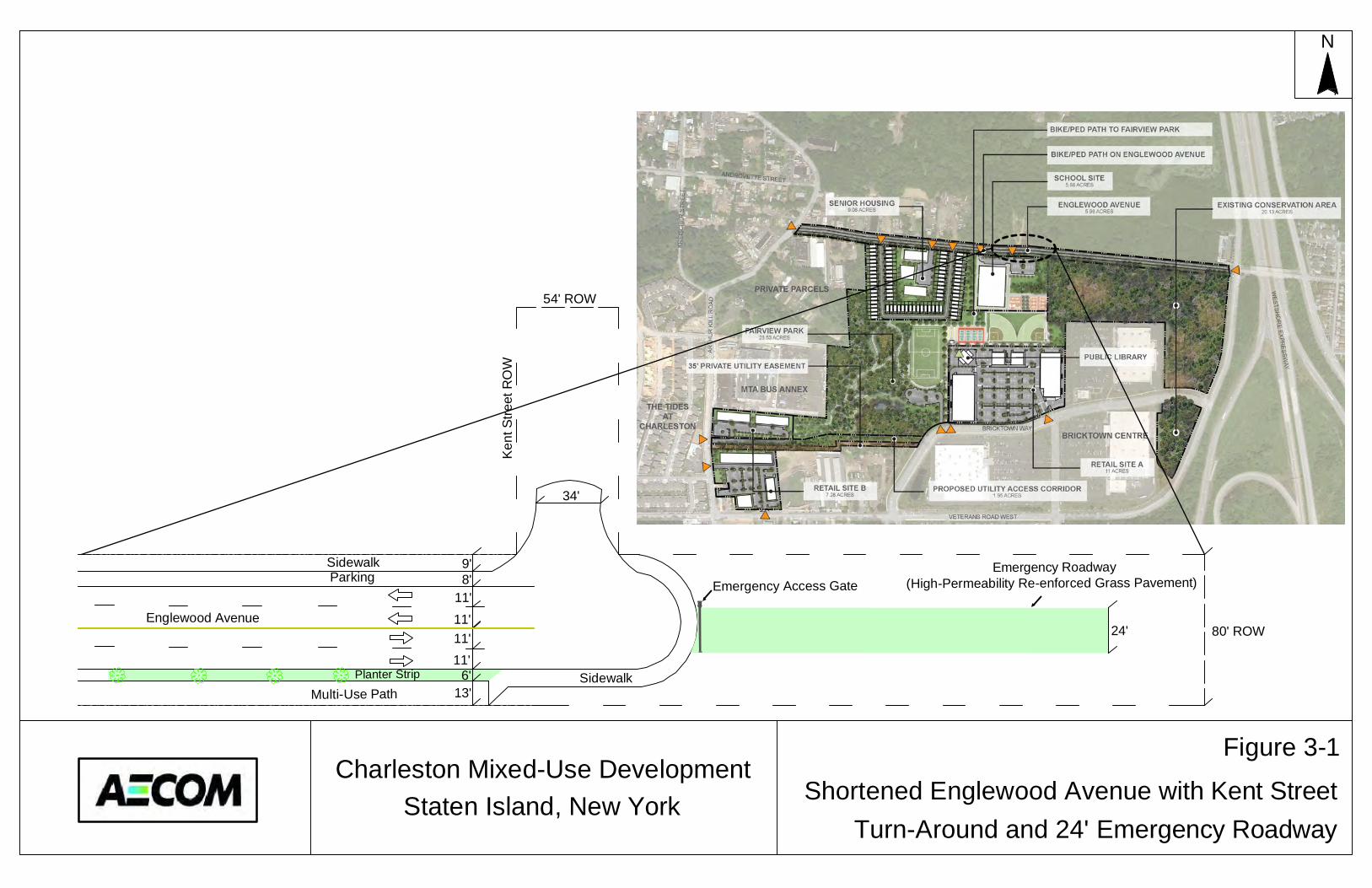
Shortened Englewood Avenue Alternative. This alternative assumes that Englewood Avenue would only be mapped and constructed from Arthur Kill Road east to the existing mapped area of the roadway which currently terminates at the un-built Kent Street. The existing mapped but un-built portion would remain un-built under this alternative, and Englewood Avenue would end at the un-built Kent Street just east of the northeast corner of the proposed school site, as shown in Figure 3-1. Conceptual plans for this alternative roadway call for its eastern terminus to include a turn-around meeting NYC Fire Department requirements for emergency access and a limited access single-lane emergency roadway extending east to Veterans Road West.
N
Englewood Avenue
Emergency Access Gate
SidewalkParking
Multi-Use PathPlanter Strip
Emergency Roadway(High-Permeability Re-enforced Grass Pavement)
Sidewalk
Charleston Mixed-Use DevelopmentStaten Island, New York Shortened Englewood Avenue with Kent Street
Turn-Around and 24' Emergency Roadway
9'8'
11'11'11'11'
6'13'
34'
24' 80' ROW
Figure 3-1
Ken
t Stre
et R
OW
54' ROW
AECOM May, 2013
Charleston Mixed-Use Development Draft Environmental Impact Statement Page 3-2
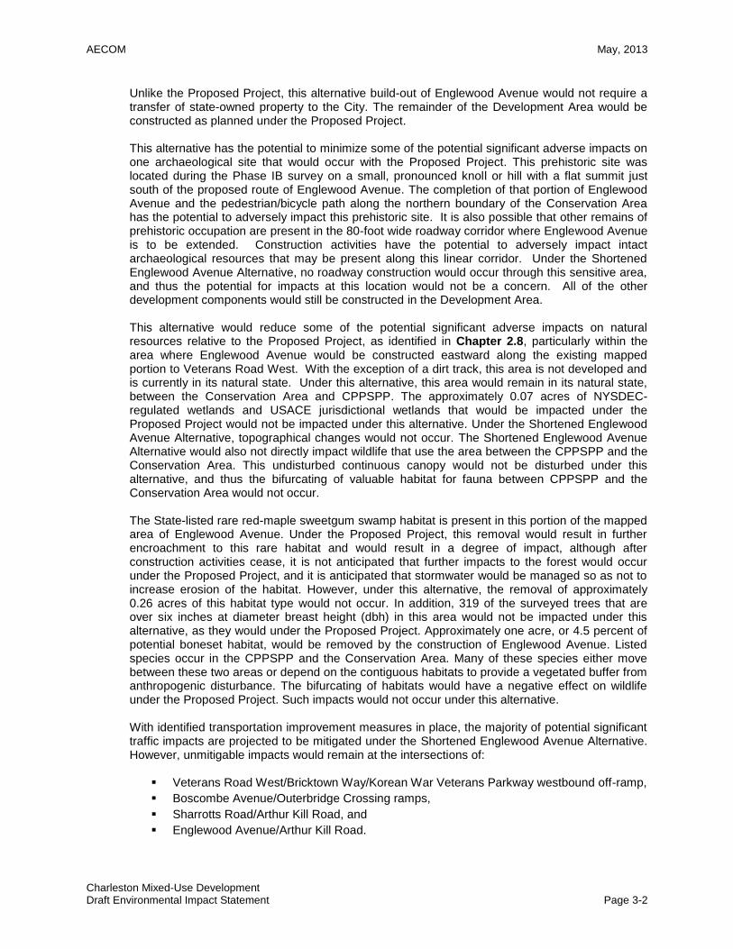
Unlike the Proposed Project, this alternative build-out of Englewood Avenue would not require a transfer of state-owned property to the City. The remainder of the Development Area would be constructed as planned under the Proposed Project.
This alternative has the potential to minimize some of the potential significant adverse impacts on one archaeological site that would occur with the Proposed Project. This prehistoric site was located during the Phase IB survey on a small, pronounced knoll or hill with a flat summit just south of the proposed route of Englewood Avenue. The completion of that portion of Englewood Avenue and the pedestrian/bicycle path along the northern boundary of the Conservation Area has the potential to adversely impact this prehistoric site. It is also possible that other remains of prehistoric occupation are present in the 80-foot wide roadway corridor where Englewood Avenue is to be extended. Construction activities have the potential to adversely impact intact archaeological resources that may be present along this linear corridor. Under the Shortened Englewood Avenue Alternative, no roadway construction would occur through this sensitive area, and thus the potential for impacts at this location would not be a concern. All of the other development components would still be constructed in the Development Area. This alternative would reduce some of the potential significant adverse impacts on natural resources relative to the Proposed Project, as identified in Chapter 2.8, particularly within the area where Englewood Avenue would be constructed eastward along the existing mapped portion to Veterans Road West. With the exception of a dirt track, this area is not developed and is currently in its natural state. Under this alternative, this area would remain in its natural state, between the Conservation Area and CPPSPP. The approximately 0.07 acres of NYSDEC-regulated wetlands and USACE jurisdictional wetlands that would be impacted under the Proposed Project would not be impacted under this alternative. Under the Shortened Englewood Avenue Alternative, topographical changes would not occur. The Shortened Englewood Avenue Alternative would also not directly impact wildlife that use the area between the CPPSPP and the Conservation Area. This undisturbed continuous canopy would not be disturbed under this alternative, and thus the bifurcating of valuable habitat for fauna between CPPSPP and the Conservation Area would not occur. The State-listed rare red-maple sweetgum swamp habitat is present in this portion of the mapped area of Englewood Avenue. Under the Proposed Project, this removal would result in further encroachment to this rare habitat and would result in a degree of impact, although after construction activities cease, it is not anticipated that further impacts to the forest would occur under the Proposed Project, and it is anticipated that stormwater would be managed so as not to increase erosion of the habitat. However, under this alternative, the removal of approximately 0.26 acres of this habitat type would not occur. In addition, 319 of the surveyed trees that are over six inches at diameter breast height (dbh) in this area would not be impacted under this alternative, as they would under the Proposed Project. Approximately one acre, or 4.5 percent of potential boneset habitat, would be removed by the construction of Englewood Avenue. Listed species occur in the CPPSPP and the Conservation Area. Many of these species either move between these two areas or depend on the contiguous habitats to provide a vegetated buffer from anthropogenic disturbance. The bifurcating of habitats would have a negative effect on wildlife under the Proposed Project. Such impacts would not occur under this alternative.
With identified transportation improvement measures in place, the majority of potential significant traffic impacts are projected to be mitigated under the Shortened Englewood Avenue Alternative. However, unmitigable impacts would remain at the intersections of:
Veterans Road West/Bricktown Way/Korean War Veterans Parkway westbound off-ramp,
Boscombe Avenue/Outerbridge Crossing ramps,
Sharrotts Road/Arthur Kill Road, and
Englewood Avenue/Arthur Kill Road.
AECOM May, 2013
Charleston Mixed-Use Development Draft Environmental Impact Statement Page 3-3
Under the Shortened Englewood Avenue Alternative, traffic impacts were identified at five signalized intersections and one unsignalized intersection during the weekday AM peak hour, at seven signalized intersections during the weekday MD peak hour, at nine signalized intersections and one unsignalized intersection during the weekday PM peak hour, and at 11 signalized intersections and one unsignalized intersection during the Saturday MD peak hour. Under the Proposed Project, traffic impacts were identified at six signalized intersections and the same unsignalized intersection during the weekday AM peak hour, at eight signalized intersections during the weekday MD peak hour, at 11 signalized intersections and one unsignalized intersection during the weekday PM peak hour, and at 11 signalized intersections and the same unsignalized intersection during the Saturday MD peak hour. Those improvement measures identified for the Proposed Project would generally be the same as under this alternative, but more unmitigable significant traffic impacts would remain under this Alternative than under the Proposed Project.
40-Foot Wide Englewood Avenue Alternative. This alternative assumes that Englewood Avenue would be mapped and constructed from Arthur Kill Road east to Veterans Road West; however, east of the presently mapped but un-built Kent Street, the roadway and sidewalk areas would be constructed to a total width of 40 feet, as shown in Figure 3-2, instead of the current 80-foot wide scenario under the Proposed Project. Unlike the Proposed Project, this alternative build-out of this eastern portion of Englewood Avenue would require less state-owned property to be transferred to the City. The remainder of the Development Area would be constructed as planned under the Proposed Project. The 40-foot Wide Englewood Avenue Alternative would not alter the findings for the majority of the technical areas discussed for the Proposed Project, with the exception of the technical areas of Historic and Cultural Resources, Natural Resources, Water and Sewer Infrastructure, Transportation, and Construction, which are further discussed below. This alternative has the potential to minimize some of the potential significant adverse impacts on one archaeological site that would occur with the Proposed Project. Construction activities associated with the completion of the Englewood Avenue extension and construction of the pedestrian/bicycle path likely include cutting, filling, grading, paving, and installation of public services and utility lines. All these activities have the potential to adversely impact intact archaeological resources that may be present along this linear corridor. Under this 40-foot wide alternative for Englewood Avenue, roadway construction would be limited in width, and thus the potential for impacts at this location would be lower than under the Proposed Project. All of the other development components would still be constructed on the Development Area. This alternative would reduce some of the potential significant adverse impacts on natural resources relative to the Proposed Project, within the area where Englewood Avenue is proposed to be extended eastward along the existing mapped portion to Veterans Road West. This area is not developed and is currently in its natural state with trees and wetlands. The development of Englewood Avenue under the 80-foot wide concept plan would impact approximately 0.07 acres of NYSDEC-regulated wetlands and USACE jurisdictional wetlands. Under this alternative’s 40-foot wide roadway, the impacts would be reduced to approximately 0.05 acres. Actions to mitigate the impacts to these regulated and jurisdictional wetlands under this alternative would still be required by regulatory agencies. This alternative would still directly impact wildlife that use the area between the CPPSPP and the Conservation Area. Thus the impacts to wildlife within the adjacent Conservation Area and CPPSPP under this alternative would be the same as the Proposed Project. Under this alternative, approximately 170 surveyed trees over a six-inch dbh would be removed, as compared to the expected 319 surveyed trees under the 80-foot wide roadway of the Proposed Project. The implementation of this alternative would also remove approximately 0.22 acres of red-maple sweetgum swamp, as compared to 0.26 acres under the Proposed Project. However, all of the other noted potential significant adverse impacts to Natural
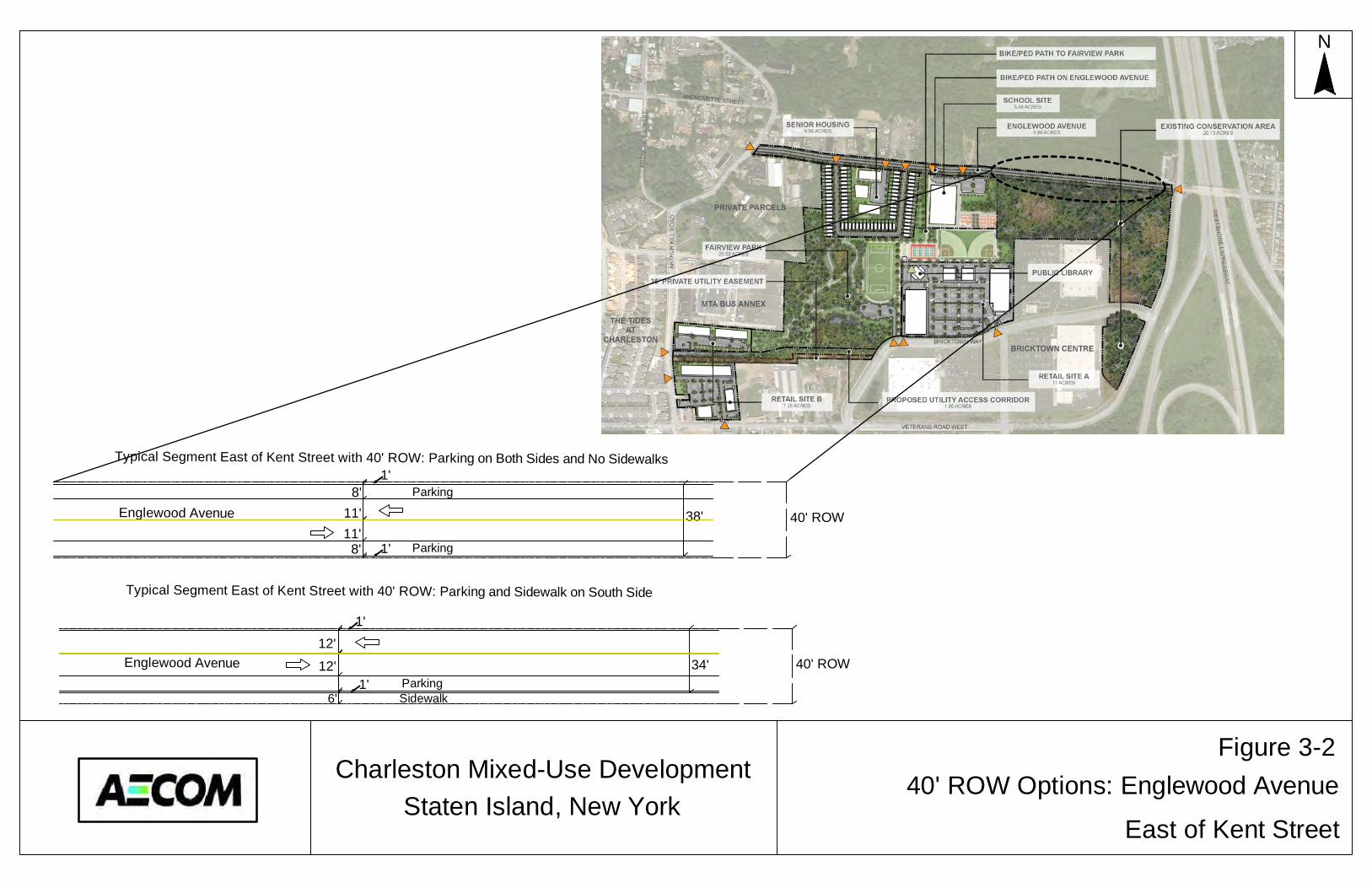
Parking
Typical Segment East of Kent Street with 40' ROW: Parking on Both Sides and No Sidewalks
40' ROWEnglewood Avenue
Typical Segment East of Kent Street with 40' ROW: Parking and Sidewalk on South Side
Englewood AvenueParkingSidewalk
N
Staten Island, New York40' ROW Options: Englewood Avenue
East of Kent Street
Charleston Mixed-Use Development
8'11'11'
8'
12'
12'
1'
1'6'
38'
1'
1'
Figure 3-2
40' ROW34'
Parking

AECOM May, 2013
Charleston Mixed-Use Development Draft Environmental Impact Statement Page 3-4
Resources in the remainder of the Development Area would remain and not change under this alternative. The findings for transportation from the analysis for the Proposed Project would not change under this alternative. Under this alternative, this section of the 40-foot wide Englewood Avenue would contain one travel lane in each direction, as compared to two travel lanes under the Proposed Project. This type of 40-foot wide roadway segment can accommodate expected future traffic volumes, including existing traffic diverting to this new roadway segment and trips generated by the Proposed Project’s school and senior housing sites accessed from Englewood Avenue. To ensure a conservative approach, the traffic analysis of the Proposed Project presented in Chapter 2.13 conservatively assumed only one travel lane in each direction on the eastbound approach of the Englewood Avenue/Veterans Road West intersection. Those analyses demonstrate that the projected future traffic volumes heading east from the Project Area on Englewood Avenue or west from Veterans Road West toward the Project Area could be accommodated with acceptable traffic operations at the Englewood Avenue/Veterans Road West intersection. No significant adverse impacts would occur under this alternative, provided the same transportation improvement measures as discussed in Chapter 4.0 were implemented.
Under both the Proposed Project and the 40-Foot Wide Englewood Avenue Alternative, traffic impacts were identified at five signalized intersections and one unsignalized intersection during the weekday AM peak hour, at six signalized intersections during the weekday MD peak hour, at 11 signalized intersections and one unsignalized intersection during the weekday PM peak hour, and at 10 signalized intersections and one unsignalized intersection during the Saturday MD peak hour. Those improvement measures identified for the Proposed Project to mitigate these impacts would be the same under this Alternative.
Arthur Kill Access Road Alternative. This alternative assumes that an east-west access road would be constructed along the planned 50-foot wide, 1.95-acre utility corridor from Arthur Kill Road through Retail Site “B” and eastward to a connection with Bricktown Way near the southeast corner of Fairview Park, as shown in Figure 3-3. Under the Proposed Project, the utility corridor would remain in its general natural state and the roadway would not be constructed. Under this alternative, the access road would be constructed. The remainder of the Development Area would be constructed as planned under the Proposed Project, including Englewood Avenue and its full east-west mapping and construction from Arthur Kill Road to Veterans Road West, as well as the public mapping of privately owned Bricktown Way and Tyrellan Avenue. This alternative has the potential for greater impacts on historic and cultural resources than the Proposed Project. Although all of the development components would still be constructed on the retail, park, senior housing and school sites, this alternative includes the additional construction of the access road from Arthur Kill Road through Retail Site “B” to Bricktown Way. Construction within this portion of the Project Area has the potential to disturb or destroy one prehistoric archaeological site, resulting in potential adverse impacts to archaeological resources. At this site (Block 7487, Lot 100), the areas for this access road runs just north of the existing 35-foot-wide sanitary sewer easement that runs from Bricktown Way to Arthur Kill Road. A portion of the access road corridor in the eastern half of Block 7487 and bordering on Bricktown Centre appears to have been included in the JMA 1999 Phase IB survey area. However, the western half of Block 7487, including the access road corridor has not been previously surveyed. It is possible that remains of prehistoric occupation are present on this parcel. It is possible that intact prehistoric resources are located in this corridor. The construction of the access road under this alternative could disturb or destroy any such resources in this area. Further research on the potential presence of such resources and designs for this connecting roadway during planning stages would determine whether such impacts would occur and potential ways to avoid or minimize them.
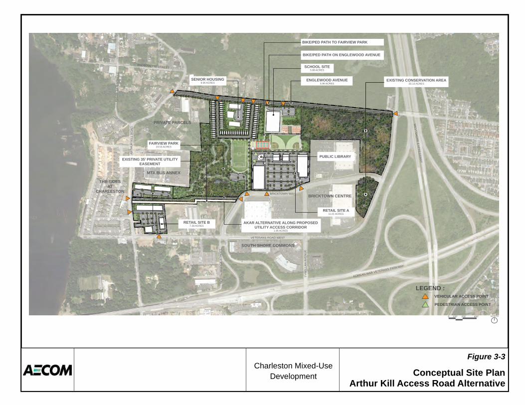
Figure 3-3Charleston Mixed-Use
Development Conceptual Site PlanArthur Kill Access Road Alternative
AKAR ALTERNATIVE ALONG PROPOSED UTILITY ACCESS CORRIDOR
1.95 ACRES
ENGLEWOOD AVENUE5.96 ACRES
BIKE/PED PATH ON ENGLEWOOD AVENUE
SCHOOL SITE5.88 ACRES
SENIOR HOUSING9.06 ACRES
EXISTING CONSERVATION AREA20.13 ACRES
BRICKTOWN CENTRE
SOUTH SHORE COMMONS
MTA BUS ANNEX
THE TIDES AT
CHARLESTON
PRIVATE PARCELS
RETAIL SITE A11.01 ACRES
RETAIL SITE B 7.28 ACRES
WESTSH
OR
E EXPRESSW
AY
VETERANS ROAD WEST
BRICKTOWN WAY
DA
OR LLI
K R
UHT
RA
EU
NE
VA N
ALLE
RYT
TE
ERT
S E
GDI
RB
HTR
ON
KR
EIS
CH
ER
STR
EE
T
ANDROVETTE STREET
KOREAN WAR VETERANS PARKWAY
100’ 200’ 400’0 NORTH
FAIRVIEW PARK23.53 ACRES
EXISTING 35’ PRIVATE UTILITY EASEMENT
PEDESTRIAN ACCESS POINT
LEGEND :VEHICULAR ACCESS POINT
PUBLIC LIBRARY
BIKE/PED PATH TO FAIRVIEW PARK
AECOM May, 2013
Charleston Mixed-Use Development Draft Environmental Impact Statement Page 3-5
This alternative would also alter existing natural resources within this area for the access road. This area is vacant and covered with low-level vegetation, within the Successional Old Field-Variant 1 mapped ecological community (see Chapter 2.8). Only seven additional trees with a breast-height diameter of six inches or more would be removed if this access road were constructed. Construction of the Arthur Kill Access Road would eliminate approximately 2.5 acres or 11.4 percent of the open area habitat presently found within the Development Area, which is a boneset habitat, and grading a cut/fill actions necessary to establish roadway surface and grade would result in changes in topography. However, if the utility easement corridor is modified and the Arthur Kill Access Road developed under this alternative, it is anticipated that an additional 0.067 acres of U.S. Army Corps of Engineers (USACE) regulated wetlands would be impacted, consisting of Wetlands H (0.035 ac), HA (0.006 ac), NB, (0.009 ac) and NW (0.017), which would require additional mitigation by the USACE. Wetlands H, HA, NB, and NW are all emergent wetlands (see Chapter 2.8).
This alternative would not significantly alter the findings for water and sewer infrastructure from the analysis provided for the Proposed Project. Additional stormwater runoff from the roadway’s impervious surfaces would occur, as this area would contain the access roadway with a reasonable worst case of up to approximately 84,770 square feet of new pavement for the access road in the 1.95-acre utility corridor area. This would have to be addressed in the overall drainage plans for the Project Area. With identified transportation improvement measures in place, all potential significant traffic impacts are projected to be mitigated under the Arthur Kill Access Road Alternative, with the exception of those noted at the intersections of:
Veterans Road West/Bricktown Way/Korean War Veterans Parkway westbound off-ramp;
Boscombe Avenue/Outerbridge Crossing ramps; and
Sharrotts Road/Arthur Kill Road.
Under the Arthur Kill Access Road Alternative, traffic impacts were identified at six signalized intersections and one unsignalized intersection during the weekday AM peak hour, at eight signalized intersections during the weekday MD peak hour, at 11 signalized intersections and one unsignalized intersection during the weekday PM peak hour, and at 11 signalized intersections and one unsignalized intersection during the Saturday MD peak hour. Under the Proposed Project, traffic impacts were identified at the same six signalized intersections and the same unsignalized intersection during the weekday AM peak hour, at the same eight signalized intersections during the weekday MD peak hour, at the same 11 signalized intersections and the same unsignalized intersection during the weekday PM peak hour, and at the same 11 signalized intersections and the same unsignalized intersection during the Saturday MD peak hour. Those improvement measures identified for the Proposed Project would generally be the same under this alternative, with some additional timing changes (at the intersections of Veterans Road West/Bricktown Way-Korean War Veterans Parkway Off-Ramp and Allentown Lane-Veterans Road West/Arthur Kill Road) under the Proposed Project that would not be required under this alternative.
AECOM May, 2013
Charleston Mixed-Use Development Draft Environmental Impact Statement Page 3-6
3.2 NO-ACTION ALTERNATIVE
The No-Action Alternative, required to be considered under CEQR guidelines, demonstrates environmental conditions that would exist if the Proposed Project were not implemented. Essentially equivalent to the analysis of the future without the project, or the Future No-Action Condition, the No-Action Alternative provides a baseline for the evaluation of each type of potential impact associated with the proposed project. The No-Action Alternative, analyzed throughout the document as the Future No-Action Condition, consists of normal and anticipated growth patterns by the 2015 and 2020 analysis years of the Proposed Project, as well as any other separately planned projects within the surrounding area, but does not include the construction of the proposed uses within the Development Area. Under this alternative, the Development Area would remain vacant and covered with vegetation, and Englewood Avenue would not be mapped and constructed. While the adjacent Conservation Area, which is part of the overall Project Area, would not be mapped as parkland, it is expected that no changes or development within the Conservation Area would occur. The No-Action Alternative uses existing conditions as a baseline and adds to it changes known or expected to be in place by the 2015 and 2020 analysis years. For many technical areas, the No-Action Alternative incorporates known development projects that are likely to be built by the analysis years. This includes development currently under construction or which can be reasonably anticipated due to the current level of planning and public approvals. The Future No-Action Condition analyses for some technical areas, such as traffic, use a background growth factor to account for a general level of growth expected in the future. Such growth factors (e.g., an annual percentage increase in background traffic volumes) may also be used in the absence of known development projects. The No-Action Alternative analyses must also consider other future changes that will affect the environmental setting. These could include technology changes (such as advances in vehicle pollution control and roadway improvements), changes to City policies (such as zoning regulations), or changes in public policy. Land Use, Zoning and Public Policy Under the No-Action Alternative, the Project Area is expected to remain in its existing vacant condition. No other projected or potential development is planned or considered likely to occur in the Project Area by the 2015 analysis year or 2020 analysis year of the Proposed Project. Under the No-Action Alternative, the Project Area would also not be rezoned from M1-1, and the existing zoning district would remain. The No-Action Alternative would not further the goals of the City’s WRP or Working West Shore 2030. It is expected that the City will continue to refine polices and guidelines over the next several years related to sustainability with PlaNYC 2030; however, as the area would remain vacant, new development compatible with the PlanNYC’s sustainability would not occur. It is also expected that the City will continue to refine polices and guidelines over the next several years related to the goals and objectives of Working West Shore 2030, the guiding document and framework to improve the area’s infrastructure and create jobs while managing the area’s growth and preserving its open spaces. The City has already committed to short-term initiatives, as described in the West Shore 2030 Three-Year Work Plan. It is expected that several of these initiatives would be completed or underway by the 2015 and 2020 study years. However, creation of the proposed mixed-use residential, commercial and recreational development, which is called for in this plan’s three-year action plan, would not occur under the No-Action Alternative. Socioeconomic Conditions As noted above, under the No-Action Alternative, the Project Area is expected to remain in its existing vacant condition through the 2015 and 2020 analysis years. No new jobs would be created in the Development Area, and the economic goals of the Working West Shore 2030 related to the Proposed Project would not be met. The projected generation of over 700 new jobs under the Proposed Project

AECOM May, 2013
Charleston Mixed-Use Development Draft Environmental Impact Statement Page 3-7
would not occur under the No-Action Alternative. The Proposed Project would not result in any significant adverse socioeconomic impacts, nor would any occur under the No-Action Alternative. Community Facilities and Services Under the No-Action Alternative, the Development Area would not be redeveloped and the area would remain vacant. No changes to police and fire services, health care, libraries, educational facilities or child care services would occur as a result of the No-Action Alternative, as the Development Area would remain vacant, and thus no impacts would occur. No impacts were projected either under the Proposed Project. However, under the No-Action Alternative, the proposed school and public library that would be developed under the Proposed Project would not be constructed. Open Space Under the No-Action Alternative, the Development Area would not be redeveloped and the area would remain vacant. No new public open space would be created within the Development Area. While the existing 20-acre Conservation Area would remain undeveloped, it would not be mapped as new parkland, and the existing 23-acre portion of the Development Area planned for Fairview Park would remain in its natural vegetative state, used by area residents as unofficial passive open space. Under the Proposed Project, approximately 43 acres of new parkland would be mapped. This 43-acres of new parkland includes the mapping of the existing 20-acre Conversation Area and the mapping and construction of the proposed 23-acre Fairview Park with approximately 7.5 acres of new active open space and approximately 15.5 acres of passive open space. The new mapped parkland would result in a net improvement in open space conditions in the study area. The Proposed Project would create additional open space demands in the area due to new residential and commercial uses which would not occur under the No-Action Alternative. However, after accounting for this, less overall open space would be available for area residents under the No-Action Alternative, as the proposed 23-acre Fairview Park would not be constructed. Neither the Proposed Project nor the No-Action Alternative is projected to result in any indirect adverse open space impacts. Shadows Under the No-Action Alternative, no new development or buildings would be constructed on sites within the Development Area, and as such, no new net incremental shadows would be cast. However, under the Proposed Project, no impacts on the nearby sensitive open space resources (the Conservation Area and CPPSPP) were identified by the analysis years of 2015 or 2020. Historic and Cultural Resources Under the No-Action Alternative, it is projected that no major changes would occur on the Project Area site. Remaining vacant, it is anticipated that there would be no new threats to the archaeological sites present. It is anticipated that buried archaeological resources would remain in situ. However, the threat of vandalism, or unauthorized digging, is ever-present, and the situation is not likely to change. In comparison, the Proposed Project includes identified adverse impacts to prehistoric resources within the Development Area. By the year 2015 the proposed development activities would potentially disturb or destroy portions of one archaeological site located on Retail Site “A.” Construction in the remainder of the Project Area by the year 2020 has the potential to disturb or destroy portions of several more historic or prehistoric archaeological site located within the remaining sections of the Project Area that were identified through prior archaeological survey work or that may exist in areas not previously studied. Urban Design and Visual Resources Under the No-Action Alternative, the Development Area would remain vacant and Englewood Avenue would not be constructed. Therefore, changes related to urban design and visual resources would not

AECOM May, 2013
Charleston Mixed-Use Development Draft Environmental Impact Statement Page 3-8
occur. The Proposed Project includes changes to the urban design and visual context in the area, with the mapping and construction of new streets and development of new buildings; however, no significant adverse impacts were identified. Natural Resources Under the No-Action Alternative, the Development Area is expected to remain in its existing vacant condition. No other projected or potential development is planned or considered likely to occur in the Development Area by the 2015 or 2020 analysis years. As such, conditions related to natural resources would not change over existing conditions, and no impacts would occur. In comparison, the Proposed Project includes identified adverse impacts to wetlands and habitats within the Development Area, which would not occur under the No-Action Alternative. Under the Proposed Project, the developments from the 2015 analysis year would remove or alter approximately 5 acres of habitat for flora and fauna in the area, and would impact 538 of the surveyed trees. Two endangered and one threatened plant species were also observed within the proposed areas of the 2015 year developments. The removal of a group of plants of one of these species would be viewed as a significant impact by regulatory agencies. Implementation of developments under the 2020 year analysis would impact approximately 0.30 acres of wetland habitats, none of which would be determined to be jurisdictional, and remove approximately 1,156 of the surveyed trees. The construction of Englewood Avenue would result in substantial direct impacts to wildlife that uses the CPPSPP and the Conservation Area. These impacts would not occur under the No-Action Alternative. Hazardous Materials Under the No-Action Alternative, the Project Area is expected to remain in its existing vacant condition. No other development is planned or considered likely to occur in the Project Area by the 2015 or 2020 analysis years of the proposed Charleston Mixed-Use Development. As such, conditions related to hazardous materials would not change over existing conditions, and no impacts would occur. No such impacts were identified as part of the Proposed Project. Water and Sewer Infrastructure Under the No-Action Alternative, the Development Area is expected to remain in its existing vacant condition. No other projected development is planned or considered likely to occur in the Development Area by the 2015 or 2020 analysis years. Therefore, total water, wastewater and stormwater generation in the Development Area and the area for the construction of Englewood Avenue under the No-Action Alternative would be similar to existing conditions. Under the Proposed Project, the Development Area would require new potable water and generate additional sanitary and stormwater waste. Under the Proposed Project, development by the year 2015 would generate a water supply demand of approximately 86,100 gpd and wastewater generation of approximately 50,400 gpd, while development by the year 2020 would generate a water supply demand of approximately 189,400 gpd and wastewater generation of approximately 121,400 gpd. Under the Proposed Project, the 3,964,450 square-foot Project Area would have a total of 716,552 square feet of impervious surface area by the 2015 analysis year, while by the year 2020, the 3,964,450 square-foot Project Area would have a total of 1,607,269 square feet of impervious surface area. Currently, the vacant and undeveloped portion of the Project Area is approximately 95 percent (3,772,786 square feet) covered in permeable grass/softscape, and the only impermeable surfaces in the Project Area under existing conditions are the paved Bricktown Way and Tyrellan Avenue, which account for five percent (191,664 square feet) of the total Project Area. These conditions would remain under the No-Action Alternative. Consequently, stormwater runoff under the Proposed Project, which would require management, would be greater than under the No-Action Alternative. The increased sanitary and stormwater sewage demands due to the Proposed Project would require revisions to applicable NYCDEP Drainage Plans for the affected watersheds. However, no impacts were identified under the Proposed Project.
AECOM May, 2013
Charleston Mixed-Use Development Draft Environmental Impact Statement Page 3-9
Solid Waste and Sanitation Services Under the No-Action Alternative, the Development Area is expected to remain in its existing vacant condition. No other projected development is planned or considered likely to occur in the Development Area by the 2015 or 2020 analysis years, and total solid waste generation in the Project Area under the No-Action Alternative is expected to remain at zero. Under the Proposed Project, the Development Area would generate new solid waste from buildings constructed in the area. The proposed development of the park, Retail Site “A” and the library by 2015 would create an incremental solid waste generation of approximately 39,002 pounds (19.5 tons) of solid waste per week, while by the year 2020, the Proposed Project would generate incremental solid waste at a rate of 69,080 pounds (approximately 34.5 tons) per week (of this amount, about 4.9 tons per week would be handled by DSNY, and private carters would handle about 29.6 tons per week). However, no impacts were identified under the Proposed Project. Energy Under the No-Action Alternative, total energy consumption in the Development Area is expected to remain at zero, as the Development Area would remain vacant. Under the Proposed Project, the Development Area would require energy to power the proposed buildings on the development sites. Under the Proposed Project, development the year 2015 would create an incremental energy demand for approximately 45,939,000 thousand BTUs in annual energy use, while by the year 2020, the Proposed Project would create a total incremental energy demand for approximately 127,729,601 thousand BTUs in annual energy use. However, no impacts were identified under the Proposed Project. Transportation As further discussed in Chapter 2.13, the Future No-Action condition traffic analysis identifies how the study area’s transportation system is projected to operate in the future without the Proposed Project, and includes anticipated future increases in background traffic volumes for the 2015 and 2020 analysis years. With these increases under the No-Action Alternative, by the year 2015 ten of the 24 study area intersections are projected to have one or more congested movements in one or more of the analyzed peak hours. Under the No-Action Alternative by the year 2020, 11 of the 24 study area intersections are projected to have one or more congested movements in one or more of the analyzed peak hours. Under the Proposed Project (by the year 2020), 16 of the 24 study area intersections are projected to have one or more congested movements in one or more of the analyzed peak hours. Detailed comparisons of future traffic conditions under the Proposed Project and the No-Action alternatives are presented in Section 2.13.4 of Chapter 2.13. Air Quality
Under the No-Action Alternative, no development would occur in the Development Area, and thus no new stationary sources would be constructed. Air Quality emissions from mobile sources would be similar to, but slightly higher due to natural traffic growth, when compared to emission levels under existing conditions. While the Proposed Project would result in increases in stationary and mobile source emissions, no significant adverse impacts were identified. Greenhouse Gas Emissions Under the No-Action Alternative, the Development Area is expected to remain in its existing vacant condition, as is the area for the construction of Englewood Avenue. No other projected development is planned or considered likely to occur in the Project Area by the 2015 or 2020 analysis years. Therefore, the generation of greenhouse gas (GHG) emissions in the Project Area under the No-Action Alternative is expected to remain at zero, as no operations occur on the area and no vehicle trips are generated to/from the Project Area. Under the Proposed Project, new GHG emissions would be generated; however, significant adverse impacts were not identified.

AECOM May, 2013
Charleston Mixed-Use Development Draft Environmental Impact Statement Page 3-10
Noise
Under the No-Action Alternative, no development would occur in the Development Area or the area for the construction of Englewood Avenue. The noise levels from mobile sources on surrounding roadways would be similar to, but slightly higher due to natural traffic growth, when compared to noise levels under existing conditions. Under the Proposed Project, noise levels would be further increased from additional vehicular traffic; however, significant adverse impacts were not identified. Public Health
Under the No-Action Alternative, no construction activities would occur within the Development or Project Areas, and no impacts to hazardous materials, air quality and other public health concerns would thus occur. No such impacts were identified under the Proposed Project. Neighborhood Character
Under the No-Action Alternative, the character of the neighborhood is not expected to substantially change. Existing conditions in the Development Area would remain, and no impacts would occur. Under the Proposed Project, the character of the neighborhood would be altered with the proposed residential, educational, recreational and retail developments under the 2015 and 2020 year analysis; however, no significant adverse impacts to neighborhood character due to the Proposed Project were identified. Construction
Under the No-Action Alternative, no construction activities would occur within the Development Area or the area for the construction of Englewood Avenue, and thus no impacts would occur. Under the Proposed Project, the Development Area would witness construction over several years on the retail, park, senior housing, and school sites, along with the construction of Englewood Avenue, removing natural resources on these sites and potentially destroying prehistoric resources, none of which would occur under the No-Action Alternative.

AECOM May, 2013
Charleston Mixed-Use Development Draft Environmental Impact Statement Page 3-11
3.3 SHORTENED ENGLEWOOD AVENUE ALTERNATIVE
This alternative assumes that Englewood Avenue would only be mapped and constructed from Arthur Kill Road eastward to the existing mapped area of the roadway which currently terminates near the un-built Kent Street. The existing mapped but un-built portion would remain un-built under this alternative, and Englewood Avenue would end at the un-built Kent Street just east of the northeast corner of the proposed school site, as shown in previous Figure 3-1. At its eastern terminus, under the preliminary concept plans for this alternative shown in Figure 3-1, Englewood Avenue would include a turn-around meeting NYC Fire Department requirements for emergency access, and potentially a 24-foot wide limited access single-lane emergency roadway, extending east to Veterans Road West. The remainder of the Development Area would be constructed as planned under the Proposed Project. Under the Proposed Project, Englewood Avenue would be fully mapped and constructed by 2020 within an approximately 80-foot wide right-of-way across the northern border of the Project Area from Veterans Road West on the east to Arthur Kill Road on the west. This fully-constructed Englewood Avenue, which would include bicycle and pedestrian facilities, would be approximately 3,265 feet in length and would occupy approximately 5.9 acres. Under the Shortened Englewood Avenue Alternative, the reconstructed portion of Englewood Avenue, from Arthur Kill Road to Kent Street, would extent approximately 1,800 feet and occupy approximately 3.25 acres. Within the existing 80-foot wide mapped portion of Englewood Avenue from Kent Street to Veterans Road West, approximately 45 feet of the 80-foot mapped right-of-way roadway bed, extending for approximately 1,488 feet westward from Veterans Road West, is owned by the State of New York. In order to construct Englewood Avenue to the full existing mapped width of 80 feet, a transfer of ownership of this area from the State to the City is required. There is no current acquisition agreement with the State. Under this alternative, the transfer of ownership would not be required, as a full-width roadway would not be extended eastward to Veterans Road West over the State-owned property. Land Use, Zoning and Public Policy Under this alternative, while proposed land uses within the Development Area would be the same as under the Proposed Project, the eastern portion of Englewood Avenue would not be constructed, and that section of the corridor area would remain in its current and natural state, with wetlands and other trees not disturbed (see Chapter 2.8). Zoning changes and their effects would be the same under this alternative as they would be under the Proposed Project. In addition, public policies discussed in Chapter 2.1 would continue to be effect under this alternative. Socioeconomic Conditions This alternative would not alter the findings for socioeconomic conditions from the analysis of the Proposed Project provided in Chapter 2.2. All of the development components would still be constructed on the retail, park, senior housing and school sites. This alternative would not result in any significant adverse impacts to socioeconomic conditions. Community Facilities and Services The findings of the community facility and services analysis for the Proposed Project provided in Chapter 2.3 would not change under this alternative. All of the development components would still be constructed on the retail, park, senior housing and school sites, and screening thresholds requiring further study would still not be exceeded. This alternative would not result in any significant adverse impacts to community facilities or services.
AECOM May, 2013
Charleston Mixed-Use Development Draft Environmental Impact Statement Page 3-12
Open Space The findings of the open space analysis for the Proposed Project as provided in Chapter 2.4 would also apply to this alternative. All of the development components would still be constructed on the retail, park, senior housing and school sites, and the analysis shows that the components would not result in any direct or indirect impacts to open spaces. This alternative would not result in any significant adverse impacts to open spaces. As Englewood Avenue would not be constructed between the Conservation Area to the south and CPPSPP to the north, this corridor would remain in its current and natural state with wetlands and other trees not disturbed (see Chapter 2.8). Shadows The findings of the shadow analysis for the Proposed Project provided in Chapter 2.5 would also apply to this alternative. All of the development components would still be constructed on the retail, park, senior housing and school sites, and shadows cast from the buildings expected on those sites would not reach the Conservation Area or CPPSPP. Thus, further shadow impact assessment would not be warranted. This alternative would not result in any significant adverse shadow impacts. Historic and Cultural Resources This alternative has the potential to minimize some of the potential significant adverse impacts on one archaeological site that would occur with the Proposed Project. As previously noted in Chapter 2.6, construction within this portion of the Project Area by 2020 has the potential to disturb or destroy one prehistoric archaeological site that was identified through prior archaeological survey work, resulting in potential significant adverse impacts to archaeological resources. At Site A7-MCB-1 (NYS Site A08501.002767), this prehistoric site was located during the Phase IB survey on a small, pronounced knoll or hill with a flat summit just south of the proposed route of Englewood Avenue. The site, which covers an area of approximately 65 feet by 25 feet, is considered to be archaeologically significant. The completion of that portion of Englewood Avenue and the pedestrian/bicycle path along the northern boundary of the Conservation Area has the potential to adversely impact this prehistoric site. It is also possible that other remains of prehistoric occupation are present in the 80-foot wide roadway corridor where Englewood Avenue is to be extended. Construction activities associated with the completion of the Englewood Avenue extension and construction of the pedestrian/bicycle path likely include cutting, filling, grading, paving, and installation of public services and utility lines. All these activities have the potential to adversely impact intact archaeological resources that may be present along this linear corridor. Under the Shortened Englewood Avenue Alternative, no roadway construction would occur through this sensitive area, and thus the potential for impacts at this location would not be a concern. All of the other development components would still be constructed in the Development Area. Urban Design and Visual Resources The majority of the findings of the urban design and visual resource analysis for the Proposed Project provided in Chapter 2.7 would not change under this alternative. All of the development components would still be constructed on the retail, park, senior housing and school sites, at the current build scenarios (footprints, heights, etc.). No additional buildings would be constructed under this alternative. However, under this alternative, the existing view corridor down Englewood Avenue (looking eastward from Arthur Kill Road) would remain its current state, and views would continue to end at the existing natural areas that would not be removed under the Proposed Project. This alternative would not result in any significant adverse impacts to urban design and visual resources. Natural Resources This alternative would reduce some of the potential significant adverse impacts on natural resources relative to the Proposed Project, as identified in Chapter 2.8, particularly within the area where Englewood Avenue would be constructed eastward along the existing mapped portion to Veterans Road West. With the exception of a dirt track, this area is not developed and is currently in its natural state.
AECOM May, 2013
Charleston Mixed-Use Development Draft Environmental Impact Statement Page 3-13
Under this alternative, this area would remain in its natural state, between the Conservation Area and CPPSPP. The approximately 0.07 acres of NYSDEC-regulated wetlands and USACE jurisdictional wetlands that would be impacted under the Proposed Project would not be impacted under this alternative. Under the Proposed Project, for the construction of Englewood Avenue, the current topography may require substantial earthmoving activities in certain segments to create a road embankment capable of supporting the proposed city street, and the future contractor would need to comply with a sediment and erosion control plan during the construction activities. Under the Shortened Englewood Avenue Alternative, such topographical changes would not occur. The Shortened Englewood Avenue Alternative would also not directly impact wildlife that use the area between the CPPSPP and the Conservation Area. The existing dirt track that separates the CPPSPP from the Conservation Area does not present an impediment to fauna transiting between the parcels, and the canopies of the trees in both parcels intermingle in some locations, which provide an undisturbed continuous canopy. The CPPSPP is a NYSDEC Bird Conservation Area, and bird species, including listed species that live in the CPPSPP, likely transit past this corridor to the Conservation Area for usage of the habitat there. This undisturbed continuous canopy would not be disturbed under this alternative, and thus the bifurcating of valuable habitat for fauna between CPPSPP and the Conservation Area would not occur. The State-listed rare red-maple sweetgum swamp habitat is present in this portion of the mapped area of Englewood Avenue. Under the Proposed Project, this removal would result in further encroachment to this rare habitat and would result in a degree of impact, although after construction activities cease, it is not anticipated that further impacts to the forest would occur under the Proposed Project, and it is anticipated that stormwater would be managed so as not to increase erosion of the habitat. However, under this alternative, the removal of approximately 0.26 acres of this habitat type would not occur. In addition, 319 of the surveyed trees that are over six inches at diameter breast height (dbh) in this area would not be impacted under this alternative, as they would under the Proposed Project. Approximately one acre, or 4.5 percent of potential boneset habitat, would be removed by the construction of Englewood Avenue. Listed species occur in the CPPSPP and the Conservation Area. Many of these species either move between these two areas or depend on the contiguous habitats to provide a vegetated buffer from anthropogenic disturbance. The bifurcating of habitats would have a negative effect on wildlife under the Proposed Project. Such impacts would not occur under this alternative. However, all of the other noted potential significant adverse impacts to Natural Resources in the remainder of the Development Area as discussed in Chapter 2.8 would remain and not change under this alternative. Hazardous Materials The findings of the hazardous materials analysis for the Proposed Project as provided in Chapter 2.9 would not change under this alternative. All of the other development components would still be constructed on the retail, park, senior housing and school sites. As with the Proposed Project, any development proposed for the area would be developed in accordance with applicable regulations and commitments and would result in no significant adverse soil and groundwater impacts. This would not change if construction activities did not commence within this corridor under this alternative. Water and Sewer Infrastructure The findings of the water and sewer infrastructure analysis for the Proposed Project provided in Chapter 2.10 would not be significantly changed under this alternative. All of the other development components would still be constructed on the retail, park, senior housing and school sites, which are the components that would require potable water and generate sanitary sewer waste. Stormwater runoff from Englewood Avenue would be reduced, as approximately 117,200 square feet of impervious surface would not be
AECOM May, 2013
Charleston Mixed-Use Development Draft Environmental Impact Statement Page 3-14
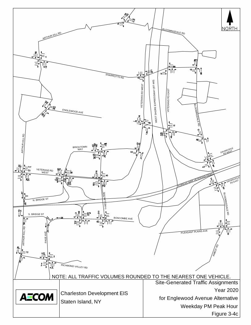
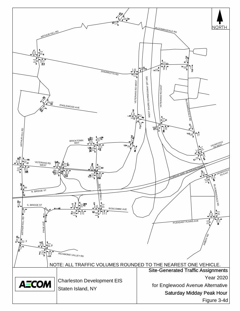
constructed, resulting in potential refinements in the amendments to the NYCDEP drainage plan for this area (see Chapter 2.10 for further details). Solid Waste and Sanitation Services The findings for solid waste and sanitation services from the analysis for the Proposed Project provided in Chapter 2.11 would not change under this alternative. All of the other development components would still be constructed on the retail, park, senior housing and school sites, which are the components that would generate solid waste. It is possible that under this alternative less construction waste would be generated. This alternative would not result in any significant adverse solid waste impacts. Energy This finding for energy from the analysis for the Proposed Project provided in Chapter 2.12 would not change under this alternative. All of the other development components would still be constructed on the retail, park, senior housing and school sites, which are the components that would require energy to be provided to the respective new buildings. This alternative would not result in any significant adverse energy impacts. Transportation The Shortened Englewood Avenue Alternative involves improving Englewood Avenue only to its current eastern terminus, east of Arthur Kill Road and to the end of the existing mapped portion of the roadway, in year 2020. Under this alternative, Englewood Avenue would not be fully constructed between Arthur Kill Road and Veterans Road West, as planned under the Proposed Project. Under this alternative roadway configuration, the proposed school and senior housing development would be accessible to vehicular traffic only from Arthur Kill road via Englewood Avenue. The primary traffic implication of this alternative is that Englewood Avenue would not serve “through” traffic between Arthur Kill Road and Veterans Road West. The potential traffic impacts associated with this alternative were assessed by reassigning the year 2020 project-generated vehicle trips (see Chapter 2.13) during each of the four analysis peak hours (i.e., weekday AM, weekday midday, weekday PM, and Saturday midday) in accordance with the access scheme under this alternative, as described above. The projected diversion of portions of the east-west traffic using Sharrotts Road to the full-length Englewood Avenue under the Proposed Project would also not occur under this alternative. A complete traffic analysis was performed for all study area intersections for this alternative. Figures 3-4a through 3-4d illustrate the peak hour site-generated trip assignments at all study intersections under this alternative in the 2020 analysis year. These site-generated trip assignments were then added to the corresponding Future No-Action traffic volumes in the 2020 analysis year to arrive at the total traffic volumes under the Shortened Englewood Avenue Alternative, shown in Figures 3-4e through 3-4h for the four traffic analysis periods. Table 3-1 presents the corresponding traffic operations analysis results for the study intersections under this alternative. As shown in Table 3-1, this alternative is projected to result in the following potential significant traffic impacts:
Allentown Lane-Veterans Road West/Arthur Kill Road:
Weekday AM peak hour – Delay on the southbound approach is projected to increase from 20.1 seconds per vehicle (LOS “C”) under Future No-Action conditions to 228.1 seconds per vehicle (LOS “F”) under the Shortened Englewood Avenue Alternative.
Weekday midday peak hour – Delay for the westbound right-turn lane is projected to increase from 27.6 seconds per vehicle (LOS “C”) under Future No-Action conditions to 68.6 seconds per vehicle (LOS “E”) under the Shortened Englewood Avenue Alternative. Delay on the southbound approach is projected to increase from 26.7 seconds per

Charleston Development EISStaten Island, NY
AR
THU
R K
ILL
RD
WEST
KOREAN WAR VETERANS PKWY
SHARROTTS RD
PA
GE
AV
E
AR
THU
R K
ILL
RD
WE
ST
SH
OR
E E
XPR
ES
SW
AY
(RT
440)
BOSCOMBE AVE
VE
T ER
AN
S R
D W
ES
T
ARTHUR KILL RD
RICHMOND VALLEY RD
N. BRIDGE ST
S. BRIDGE ST
TYR
ELL
AN A
VE
WAY
AM
BO
Y R
D
PLEASANT PLAINS AVE
BLO
OM
ING
DA
LE R
D
VE
T ER
AN
S R
D E
AS
T
RD EAST
RD WEST
BLOOMINGDALE RD
DRUMGOOLE
DRUMGOOLEBRICKTOWN
VETERANS RD
BLO
OM
ING
DALE
RD
ENGLEWOOD AVE
Site-Generated Traffic AssignmentsYear 2020
for Englewood Avenue Alternative
Figure 3-4a
NOTE: ALL TRAFFIC VOLUMES ROUNDED TO THE NEAREST ONE VEHICLE.
Weekday AM Peak Hour

Charleston Development EISStaten Island, NY
AR
THU
R K
ILL
RD
WEST
KOREAN WAR VETERANS PKWY
SHARROTTS RD
PA
GE
AV
E
AR
THU
R K
ILL
RD
WE
ST
SH
OR
E E
XPR
ES
SW
AY
(RT
440)
BOSCOMBE AVE
VE
T ER
AN
S R
D W
ES
T
ARTHUR KILL RD
RICHMOND VALLEY RD
N. BRIDGE ST
S. BRIDGE ST
TYR
ELL
AN A
VE
WAY
AM
BO
Y R
D
PLEASANT PLAINS AVE
BLO
OM
ING
DA
LE R
D
VE
T ER
AN
S R
D E
AS
T
RD EAST
RD WEST
BLOOMINGDALE RD
DRUMGOOLE
DRUMGOOLEBRICKTOWN
VETERANS RD
BLO
OM
ING
DALE
RD
ENGLEWOOD AVE
Site-Generated Traffic AssignmentsYear 2020
for Englewood Avenue Alternative
Figure 3-4b
NOTE: ALL TRAFFIC VOLUMES ROUNDED TO THE NEAREST ONE VEHICLE.
Weekday Midday Peak Hour
Charleston Development EISStaten Island, NY
AR
THU
R K
ILL
RD
WEST
KOREAN WAR VETERANS PKWY
SHARROTTS RD
PA
GE
AV
E
AR
THU
R K
ILL
RD
WE
ST
SH
OR
E E
XPR
ES
SW
AY
(RT
440)
BOSCOMBE AVE
VE
T ER
AN
S R
D W
ES
T
ARTHUR KILL RD
RICHMOND VALLEY RD
N. BRIDGE ST
S. BRIDGE ST
TYR
ELL
AN A
VE
WAY
AM
BO
Y R
D
PLEASANT PLAINS AVE
BLO
OM
ING
DA
LE R
D
VE
T ER
AN
S R
D E
AS
T
RD EAST
RD WEST
BLOOMINGDALE RD
DRUMGOOLE
DRUMGOOLEBRICKTOWN
VETERANS RD
BLO
OM
ING
DALE
RD
ENGLEWOOD AVE
Site-Generated Traffic AssignmentsYear 2020
for Englewood Avenue Alternative
Figure 3-4c
NOTE: ALL TRAFFIC VOLUMES ROUNDED TO THE NEAREST ONE VEHICLE.
Weekday PM Peak Hour
Charleston Development EISStaten Island, NY
AR
THU
R K
ILL
RD
WEST
KOREAN WAR VETERANS PKWY
SHARROTTS RD
PA
GE
AV
E
AR
THU
R K
ILL
RD
WE
ST
SH
OR
E E
XPR
ES
SW
AY
(RT
440)
BOSCOMBE AVE
VE
T ER
AN
S R
D W
ES
T
ARTHUR KILL RD
RICHMOND VALLEY RD
N. BRIDGE ST
S. BRIDGE ST
TYR
ELL
AN A
VE
WAY
AM
BO
Y R
D
PLEASANT PLAINS AVE
BLO
OM
ING
DA
LE R
D
VE
T ER
AN
S R
D E
AS
T
RD EAST
RD WEST
BLOOMINGDALE RD
DRUMGOOLE
DRUMGOOLEBRICKTOWN
VETERANS RD
BLO
OM
ING
DALE
RD
ENGLEWOOD AVE
Site-Generated Traffic AssignmentsSite-Generated Traffic AssignmentsYear 2020
for Englewood Avenue Alternative
Figure 3-4d
NOTE: ALL TRAFFIC VOLUMES ROUNDED TO THE NEAREST ONE VEHICLE.
Saturday Midday Peak HourSaturday Midday Peak Hour

Charleston Development EISStaten Island, NY
AR
THU
R K
ILL
RD
WEST
KOREAN WAR VETERANS PKWY
SHARROTTS RD
PA
GE
AV
E
AR
THU
R K
ILL
RD
WE
ST
SH
OR
E E
XPR
ES
SW
AY
(RT
440)
BOSCOMBE AVE
VE
T ER
AN
S R
D W
ES
T
ARTHUR KILL RD
RICHMOND VALLEY RD
N. BRIDGE ST
S. BRIDGE ST
TYR
ELL
AN A
VE
WAY
AM
BO
Y R
D
PLEASANT PLAINS AVE
BLO
OM
ING
DA
LE R
D
VE
T ER
AN
S R
D E
AS
T
RD EAST
RD WEST
BLOOMINGDALE RD
DRUMGOOLE
DRUMGOOLEBRICKTOWN
VETERANS RD
BLO
OM
ING
DALE
RD
ENGLEWOOD AVE
Year 2020 With-Action ConditionTraffic Volumes
for Englewood Avenue Alternative
Figure 3-4eWeekday AM Peak Hour

Charleston Development EISStaten Island, NY
AR
THU
R K
ILL
RD
WEST
KOREAN WAR VETERANS PKWY
SHARROTTS RD
PA
GE
AV
E
AR
THU
R K
ILL
RD
WE
ST
SH
OR
E E
XPR
ES
SW
AY
(RT
440)
BOSCOMBE AVE
VE
T ER
AN
S R
D W
ES
T
ARTHUR KILL RD
RICHMOND VALLEY RD
N. BRIDGE ST
S. BRIDGE ST
TYR
ELL
AN A
VE
WAY
AM
BO
Y R
D
PLEASANT PLAINS AVE
BLO
OM
ING
DA
LE R
D
VE
T ER
AN
S R
D E
AS
T
RD EAST
RD WEST
BLOOMINGDALE RD
DRUMGOOLE
DRUMGOOLEBRICKTOWN
VETERANS RD
BLO
OM
ING
DALE
RD
ENGLEWOOD AVE
Year 2020 With-Action ConditionTraffic Volumes
for Englewood Avenue Alternative
Figure 3-4fWeekday Midday Peak Hour
Charleston Development EISStaten Island, NY
AR
THU
R K
ILL
RD
WEST
KOREAN WAR VETERANS PKWY
SHARROTTS RD
PA
GE
AV
E
AR
THU
R K
ILL
RD
WE
ST
SH
OR
E E
XPR
ES
SW
AY
(RT
440)
BOSCOMBE AVE
VE
T ER
AN
S R
D W
ES
T
ARTHUR KILL RD
RICHMOND VALLEY RD
N. BRIDGE ST
S. BRIDGE ST
TYR
ELL
AN A
VE
WAY
AM
BO
Y R
D
PLEASANT PLAINS AVE
BLO
OM
ING
DA
LE R
D
VE
T ER
AN
S R
D E
AS
T
RD EAST
RD WEST
BLOOMINGDALE RD
DRUMGOOLE
DRUMGOOLEBRICKTOWN
VETERANS RD
BLO
OM
ING
DALE
RD
ENGLEWOOD AVE
Year 2020 With-Action ConditionTraffic Volumes
for Englewood Avenue Alternative
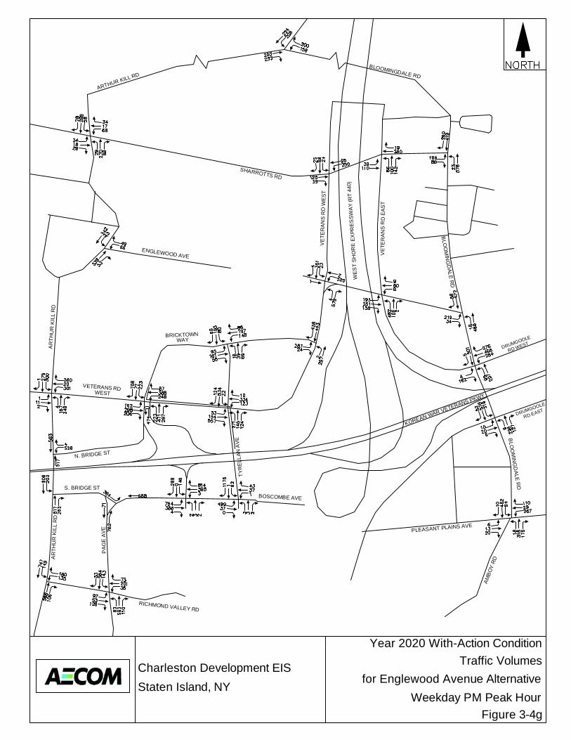
Figure 3-4gWeekday PM Peak Hour
Charleston Development EISStaten Island, NY
AR
THU
R K
ILL
RD
WEST
KOREAN WAR VETERANS PKWY
SHARROTTS RD
PA
GE
AV
E
AR
THU
R K
ILL
RD
WE
ST
SH
OR
E E
XPR
ES
SW
AY
(RT
440)
BOSCOMBE AVE
VE
T ER
AN
S R
D W
ES
T
ARTHUR KILL RD
RICHMOND VALLEY RD
N. BRIDGE ST
S. BRIDGE ST
TYR
ELL
AN A
VE
WAY
AM
BO
Y R
D
PLEASANT PLAINS AVE
BLO
OM
ING
DA
LE R
D
VE
T ER
AN
S R
D E
AS
T
RD EAST
RD WEST
BLOOMINGDALE RD
DRUMGOOLE
DRUMGOOLEBRICKTOWN
VETERANS RD
BLO
OM
ING
DALE
RD
ENGLEWOOD AVE
Year 2020 With-Action ConditionTraffic Volumes
for EnglewoodAvenue Alternative
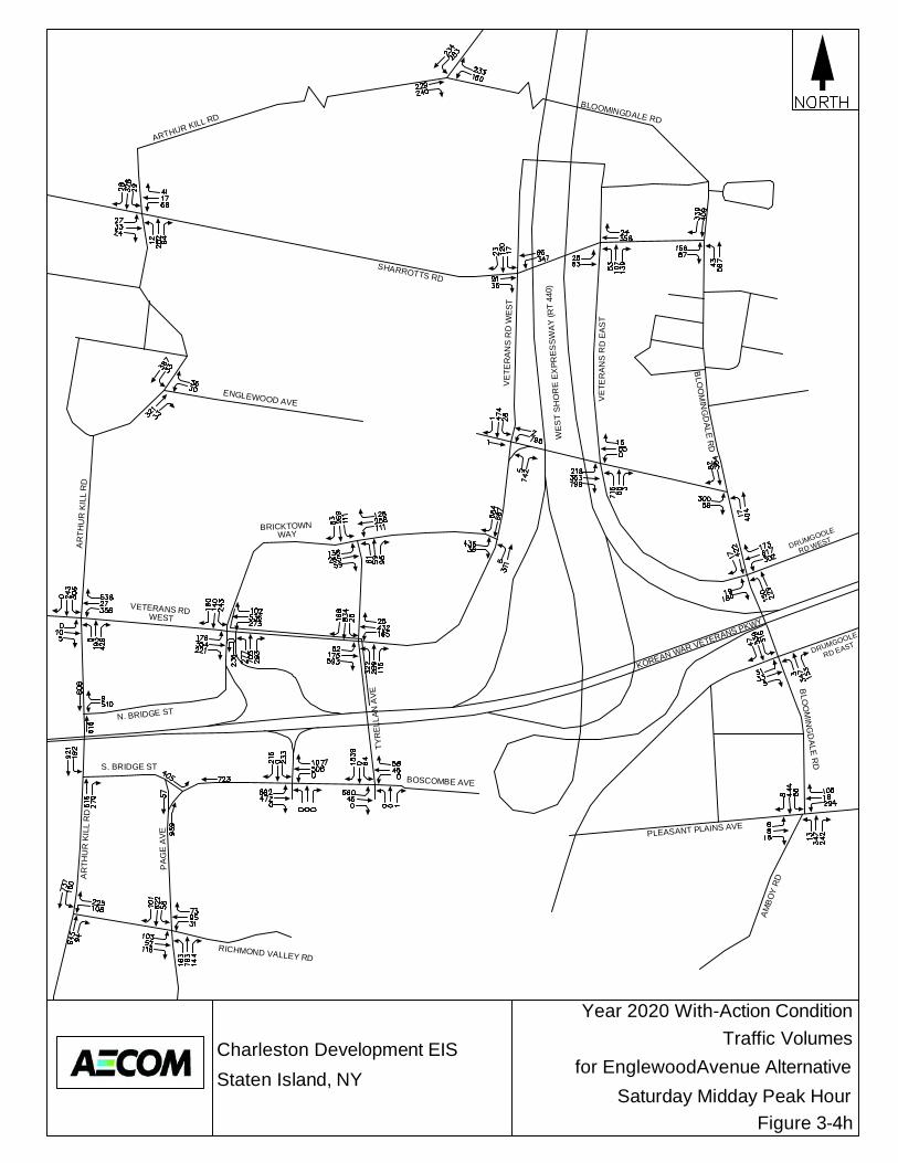
Figure 3-4hSaturday Midday Peak Hour
AECOM May, 2013
Charleston Mixed-Use Development Draft Environmental Impact Statement Page 3-15
vehicle (LOS “C”) under Future No-Action conditions to 140.3 seconds per vehicle (LOS “F”) under the Shortened Englewood Avenue Alternative.
Weekday PM peak hour – Delay on the southbound approach is projected to increase from 113.5 seconds per vehicle (LOS “F”) under Future No-Action conditions to 353.8 seconds per vehicle (LOS “F”) under the Shortened Englewood Avenue Alternative. Saturday midday peak hour – Delay for the westbound right-turn lane is projected to increase from 23.3 seconds per vehicle (LOS “C”) under Future No-Action conditions to 78.6 seconds per vehicle (LOS “E”) under the Shortened Englewood Avenue Alternative. Delay on the southbound approach is projected to increase from 81.6 seconds per vehicle (LOS “F”) under Future No-Action conditions to 414.1 seconds per vehicle (LOS “F”) under the Shortened Englewood Avenue Alternative.
Richmond Valley Road/Arthur Kill Road:
Weekday AM peak hour – Delay on the southbound approach is projected to increase from 13.5 seconds per vehicle (LOS “B”) under Future No-Action conditions to 37.7 seconds per vehicle (LOS “D”) under The Shortened Englewood Avenue Alternative.
Weekday midday peak hour – Delay on the southbound approach is projected to increase from 87.9 seconds per vehicle (LOS “F”) under Future No-Action conditions to 132.1 seconds per vehicle (LOS “F”) under The Shortened Englewood Avenue Alternative.
Weekday PM peak hour – Delay on the westbound approach is projected to increase from 46.6 seconds per vehicle (LOS “D”) under Future No-Action conditions to 52.6 seconds per vehicle (LOS “D”) under The Shortened Englewood Avenue Alternative. Delay on the southbound approach is projected to increase from 202.6 seconds per vehicle (LOS “F”) under Future No-Action conditions to 269.0 seconds per vehicle (LOS “F”) under The Shortened Englewood Avenue Alternative.
Saturday midday peak hour – Delay on the southbound approach is projected to increase from 184.7 seconds per vehicle (LOS “F”) under Future No-Action conditions to 251.7 seconds per vehicle (LOS “F”) under The Shortened Englewood Avenue Alternative.
Veterans Road West/Bricktown Way/Korean War Veterans Parkway westbound off-ramp:
Weekday AM peak hour – Delay for the westbound left-turn lane is projected to increase from 80.0 seconds per vehicle (LOS “F”) under Future No-Action conditions to 127.8 seconds per vehicle (LOS “F”) under The Shortened Englewood Avenue Alternative.
Weekday midday peak hour – Delay for the eastbound left-turn lane is projected to increase from 36.3 seconds per vehicle (LOS “D”) under Future No-Action conditions to 128.8 seconds per vehicle (LOS “F”) under The Shortened Englewood Avenue Alternative. Delay for the westbound left-turn lane is projected to increase from 62.9 seconds per vehicle (LOS “E”) under Future No-Action conditions to 354.7 seconds per vehicle (LOS “F”) under The Shortened Englewood Avenue Alternative. Delay for the northbound approach is projected to increase from 35.5 seconds per vehicle (LOS “D”) under Future No-Action conditions to 94.8 seconds per vehicle (LOS “F”) under the Shortened Englewood Avenue Alternative.
Weekday PM peak hour – Delay for the eastbound left-turn lane is projected to increase from 29.7 seconds per vehicle (LOS “C”) under Future No-Action conditions to 58.8 seconds per vehicle (LOS “E”) under the Shortened Englewood Avenue Alternative. Delay for the northbound approach is projected to increase from 34.3 seconds per vehicle (LOS “C”) under Future No-Action conditions to 81.7 seconds per vehicle (LOS “F”) under the Shortened Englewood Avenue Alternative.
Saturday midday peak hour – Delay for the eastbound left-turn lane is projected to increase from 39.5 seconds per vehicle (LOS “D”) under Future No-Action conditions to 320.7 seconds per vehicle (LOS “F”) under the Shortened Englewood Avenue Alternative. Delay for the eastbound through/right-turn lane is projected to increase from 29.4 seconds per vehicle (LOS “C”) under Future No-Action conditions to 50.4 seconds per vehicle (LOS “D”) under the Shortened Englewood Avenue Alternative. Delay for the

AECOM May, 2013
Charleston Mixed-Use Development Draft Environmental Impact Statement Page 3-16
westbound left-turn lane is projected to increase from 210.9 seconds per vehicle (LOS “F”) under Future No-Action conditions to 1,146.0 seconds per vehicle (LOS “F”) under the Shortened Englewood Avenue Alternative. Delay for the northbound approach is projected to increase from 54.0 seconds per vehicle (LOS “D”) under Future No-Action conditions to 248.3 seconds per vehicle (LOS “F”) under the Shortened Englewood Avenue Alternative. Delay for the southbound through/right-turn lane is projected to increase from 40.6 seconds per vehicle (LOS “D”) under Future No-Action conditions to 77.5 seconds per vehicle (LOS “E”) under the Shortened Englewood Avenue Alternative.
Veterans Road West/Tyrellan Avenue:
Weekday midday peak hour – Delay for northbound left-turn movements is projected to increase from 78.8 seconds per vehicle (LOS “E”) under Future No-Action conditions to 338.3 seconds per vehicle (LOS “F”) under the Shortened Englewood Avenue Alternative.
Weekday PM peak hour – Delay for westbound left-turn movements is projected to increase from 28.9 seconds per vehicle (LOS “C”) under Future No-Action conditions to 47.3 seconds per vehicle (LOS “D”) under the Shortened Englewood Avenue Alternative. Delay for northbound left-turn movements is projected to increase from 31.9 seconds per vehicle (LOS “C”) under Future No-Action conditions to 119.9 seconds per vehicle (LOS “F”) under the Shortened Englewood Avenue Alternative.
Saturday midday peak hour – Delay for westbound left-turn movements is projected to increase from 53.8 seconds per vehicle (LOS “D”) under Future No-Action conditions to 165.4 seconds per vehicle (LOS “F”) under the Shortened Englewood Avenue Alternative. Delay for northbound left-turn movements is projected to increase from 168.5 seconds per vehicle (LOS “F”) under Future No-Action conditions to 802.7 seconds per vehicle (LOS “F”) under the Shortened Englewood Avenue Alternative.
Boscombe Avenue/Outerbridge Crossing Ramps:
Weekday AM peak hour – Delay in the eastbound left-turn lane is projected to increase from 53.5 seconds per vehicle (LOS “D”) under Future No-Action conditions to 91.7 seconds per vehicle (LOS “F”) under the Shortened Englewood Avenue Alternative. Delay in the westbound right-turn lane is projected to increase from 41.6 seconds per vehicle (LOS “D”) under Future No-Action conditions to 68.1 seconds per vehicle (LOS “E”) under the Shortened Englewood Avenue Alternative.
Weekday midday peak hour – Delay in the westbound through/left-turn lane is projected to increase from 66.4 seconds per vehicle (LOS “E”) under Future No-Action conditions to 81.7 seconds per vehicle (LOS “F”) under the Shortened Englewood Avenue Alternative. Delay in the westbound right-turn lane is projected to increase from 103.1 seconds per vehicle (LOS “F”) under Future No-Action conditions to 442.4 seconds per vehicle (LOS “F”) under the Shortened Englewood Avenue Alternative.
Weekday PM peak hour – Delay in the eastbound left-turn lane is projected to increase from 53.5 seconds per vehicle (LOS “D”) under Future No-Action conditions to 73.8 seconds per vehicle (LOS “E”) under the Shortened Englewood Avenue Alternative. Delay in the westbound right-turn lane is projected to increase from 107.4 seconds per vehicle (LOS “F”) under Future No-Action conditions to 362.5 seconds per vehicle (LOS “F”) under the Shortened Englewood Avenue Alternative. Delay in the southbound left-turn lane is projected to increase from 55.8 seconds per vehicle (LOS “E”) under Future No-Action conditions to 77.3 seconds per vehicle (LOS “E”) under the Shortened Englewood Avenue Alternative.
Saturday midday peak hour – Delay in the eastbound left-turn lane is projected to increase from 35.7 seconds per vehicle (LOS “D”) under Future No-Action conditions to 50.3 seconds per vehicle (LOS “D”) under the Shortened Englewood Avenue Alternative. Delay in the westbound through/left-turn lane is projected to increase from 76.2 seconds per vehicle (LOS “E”) under Future No-Action conditions to 116.7 seconds per vehicle (LOS “F”) under the Shortened Englewood Avenue Alternative. Delay in the westbound right-turn lane is projected to increase from 286.0 seconds per vehicle (LOS “F”) under
AECOM May, 2013
Charleston Mixed-Use Development Draft Environmental Impact Statement Page 3-17
Future No-Action conditions to 722.4 seconds per vehicle (LOS “F”) under the Shortened Englewood Avenue Alternative.
Boscombe Avenue/Tyrellan Avenue:
Weekday midday peak hour – Delay in the southbound right-turn lane is projected to increase from 50.8 seconds per vehicle (LOS “D”) under Future No-Action conditions to 268.1 seconds per vehicle (LOS “F”) under the Shortened Englewood Avenue Alternative.
Weekday PM peak hour – Delay in the southbound right-turn lane is projected to increase from 59.7 seconds per vehicle (LOS “E”) under Future No-Action conditions to 270.4 seconds per vehicle (LOS “F”) under the Shortened Englewood Avenue Alternative.
Saturday midday peak hour – Delay in the southbound right-turn lane is projected to increase from 156.3 seconds per vehicle (LOS “F”) under Future No-Action conditions to 470.2 seconds per vehicle (LOS “F”) under the Shortened Englewood Avenue Alternative.
Englewood Avenue/Veterans Road West:
Saturday midday peak hour – Delay in the westbound left-turn lane is projected to increase from 45.2 seconds per vehicle (LOS “D”) under Future No-Action conditions to 78.4 seconds per vehicle (LOS “E”) under the Shortened Englewood Avenue Alternative.
Englewood Avenue/Veterans Road East:
Saturday midday peak hour – Delay in the eastbound through/left-turn lane is projected to increase from 94.5 seconds per vehicle (LOS “F”) under Future No-Action conditions to 201.8 seconds per vehicle (LOS “F”) under the Shortened Englewood Avenue Alternative.
Veterans Road East-Drumgoole Road West/Bloomingdale Road:
Weekday midday peak hour – Delay in the eastbound right-turn lane is projected to increase from 35.3 seconds per vehicle (LOS “D”) under Future No-Action conditions to 55.9 seconds per vehicle (LOS “E”) under the Shortened Englewood Avenue Alternative. Delay in the northbound left-turn lane is projected to increase from 23.7 seconds per vehicle (LOS “C”) under Future No-Action conditions to 46.4 seconds per vehicle (LOS “D”) under the Shortened Englewood Avenue Alternative.
Weekday PM peak hour – Delay in the eastbound right-turn lane is projected to increase from 33.1 seconds per vehicle (LOS “C”) under Future No-Action conditions to 45.3 seconds per vehicle (LOS “D”) under the Shortened Englewood Avenue Alternative. Delay in the northbound left-turn lane is projected to increase from 27.1 seconds per vehicle (LOS “C”) under Future No-Action conditions to 68.1 seconds per vehicle (LOS “E”) under the Shortened Englewood Avenue Alternative.
Saturday midday peak hour – Delay in the eastbound right-turn lane is projected to increase from 43.3 seconds per vehicle (LOS “D”) under Future No-Action conditions to 126.0 seconds per vehicle (LOS “F”) under the Shortened Englewood Avenue Alternative. Delay in the northbound left-turn lane is projected to increase from 36.4 seconds per vehicle (LOS “D”) under Future No-Action conditions to 150.3 seconds per vehicle (LOS “F”) under the Shortened Englewood Avenue Alternative.
Pleasant Plains Avenue-Amboy Road/Bloomingdale Road:
Weekday AM peak hour – Delay on the southbound approach is projected to increase from 64.8 seconds per vehicle (LOS “E”) under Future No-Action conditions to 84.3 seconds per vehicle (LOS “F”) under the Shortened Englewood Avenue Alternative.
Weekday PM peak hour – Delay on the southbound approach is projected to increase from 30.9 seconds per vehicle (LOS “C”) under Future No-Action conditions to 49.7 seconds per vehicle (LOS “D”) under the Shortened Englewood Avenue Alternative.
Saturday midday peak hour – Delay on the southbound approach is projected to increase from 30.6 seconds per vehicle (LOS “C”) under Future No-Action conditions to 47.6 seconds per vehicle (LOS “D”) under the Shortened Englewood Avenue Alternative.
AECOM May, 2013
Charleston Mixed-Use Development Draft Environmental Impact Statement Page 3-18
Arthur Kill Road/Bloomingdale Road:
Weekday PM peak hour – Delay on the westbound approach is projected to increase from 19.5 seconds per vehicle (LOS “B”) under Future No-Action conditions to 96.8 seconds per vehicle (LOS “F”) under the Shortened Englewood Avenue Alternative. Delay on the northbound approach is projected to increase from 27.9 seconds per vehicle (LOS “C”) under Future No-Action conditions to 53.7 seconds per vehicle (LOS “D”) under the Shortened Englewood Avenue Alternative.
Saturday midday peak hour – Delay on the westbound approach is projected to increase from 22.8 seconds per vehicle (LOS “C”) under Future No-Action conditions to 188.4 seconds per vehicle (LOS “F”) under the Shortened Englewood Avenue Alternative.
Sharrotts Road/Arthur Kill Road:
Weekday PM peak hour – Delay on the eastbound approach is projected to increase from 20.7 seconds per vehicle (LOS “C”) under Future No-Action conditions to 38.7 seconds per vehicle (LOS “E”) under the Shortened Englewood Avenue Alternative.
Saturday midday peak hour – Delay on the eastbound approach is projected to increase from 24.5 seconds per vehicle (LOS “C”) under Future No-Action conditions to 36.1 seconds per vehicle (LOS “E”) under the Shortened Englewood Avenue Alternative. Delay on the westbound approach is projected to increase from 24.2 seconds per vehicle (LOS “C”) under Future No-Action conditions to 39.6 seconds per vehicle (LOS “E”) under the Shortened Englewood Avenue Alternative.
Englewood Avenue/Arthur Kill Road:
Weekday AM peak hour – Delay on the westbound approach is projected to increase from 10.8 seconds per vehicle (LOS “B”) under Future No-Action conditions to 150.0 seconds per vehicle (LOS “F”) under the Shortened Englewood Avenue Alternative.
Transportation improvement measures were then investigated to identify those that mitigate the potential significant traffic impacts identified above. The following transportation system improvement measures would be required to mitigate the potential significant traffic impacts under this alternative:
Allentown Lane-Veterans Road West/Arthur Kill Road: Restripe the northbound approach to accommodate one 12 foot shared through/left-turn
lane and one 12 foot exclusive right-turn lane.
Restripe the southbound approach to accommodate one 10 foot exclusive left-turn lane and one 11 foot shared through/right-turn lane.
During the weekday midday peak hour, reallocate three seconds of green time from the north-south phase to the east-west phase.
During the Saturday midday peak hour, reallocate three seconds of green time from the north-south phase to the east-west phase.
Richmond Valley Road/Arthur Kill Road:
Restripe the southbound approach to accommodate one 10 foot exclusive through lane and one 10 foot exclusive left-turn lane.
During the weekday PM peak hour, reallocate one second of green time from the north-south phase to the westbound phase.
Veterans Road West/Bricktown Way/Korean War Veterans Parkway westbound off-ramp:
During the weekday AM peak hour, reallocate three seconds of green time from the southbound phase to the east-west phase.
With the improvements described above in place, significant traffic impacts at this intersection are projected to remain for:
Eastbound left-turn movements during the weekday midday, weekday PM, and Saturday midday peak hours;
The eastbound through/right-turn lane during the Saturday midday peak hour;
Westbound left-turn movements during the weekday midday and Saturday midday peak hours; and
AECOM May, 2013
Charleston Mixed-Use Development Draft Environmental Impact Statement Page 3-19
The northbound approach during the weekday midday, weekday PM, and Saturday midday peak hours.
Veterans Road West/Tyrellan Avenue:
Eliminate a portion of the raised median on the southbound and eastbound approaches to accommodate one exclusive left-turn lane on each approach.
During the weekday midday peak hour, modify the signal phasing to create a lagging northbound phase and reallocate 12 seconds from the north-south phase to the lagging northbound phase.
During the weekday PM peak hour, modify the signal phasing to create a lagging northbound phase and reallocate 19 seconds from the north-south phase to the lagging northbound phase.
During the Saturday midday peak hour, modify the signal phasing to accommodate a lagging westbound phase and three phases for northbound and southbound movements: a southbound leading phase, a concurrent north-south phase, and a lagging northbound phase. Allocate 11 seconds to the westbound lagging phase, 18 seconds to the southbound leading phase, 17 seconds to the concurrent north-south phase, and 16 seconds to the lagging northbound phase.
Boscombe Avenue/Outerbridge Crossing Ramps:
Modify the traffic signal hardware to provide for a westbound right-turn overlap phase to operate concurrently with the north-south phase.
During the Saturday midday peak hour, reallocate two seconds of green time from the southbound phase to the east-west phase.
With the improvements described above in place, potential significant traffic impacts at this intersection are projected to remain for:
Eastbound left-turn movements during the weekday AM and weekday PM peak hours;
The westbound through/left-turn lane during the weekday midday peak hour;
Westbound right-turn movements during the weekday AM, weekday midday, and weekday PM peak hours; and
Southbound left-turn movements during the weekday PM peak hour.
Boscombe Avenue/Tyrellan Avenue:
Modify the traffic signal hardware to provide for a southbound right-turn overlap phase to operate concurrently with a new eastbound-only lagging phase.
During the weekday midday peak hour, reallocate 17 seconds of green time from the east-west phase to the lagging eastbound phase with the southbound right-turn overlap.
During the weekday PM peak hour, reallocate 16 seconds of green time from the east-west phase to the lagging eastbound phase with the southbound right-turn overlap.
During the Saturday midday peak hour, reallocate 19 seconds of green time from the east-west phase to the lagging eastbound phase with the southbound right-turn overlap.
Englewood Avenue/Veterans Road West:
During the Saturday midday peak hour, reallocate three seconds of green time from the north-south phase to the east-west phase.
Englewood Avenue/Veterans Road East:
During the Saturday midday peak hour, reallocate five seconds of green time from the northbound phase to the east-west phase.
AECOM May, 2013
Charleston Mixed-Use Development Draft Environmental Impact Statement Page 3-20
Veterans Road East-Drumgoole Road West/Bloomingdale Road:
Prohibit on-street parking on the west side of Bloomingdale Road between Veterans Road East and Churchill Avenue, and restripe the southbound approach to accommodate one 12-foot through lane and one 12-foot through/right-turn lane.
During the weekday midday peak hour, reallocate one second of green time from the north-south phase to the eastbound phase.
During the weekday PM peak hour, reallocate one second of green time from the northbound phase to the eastbound phase.
During the Saturday midday peak hour, reallocate three seconds of green time from the north-south phase to the eastbound phase.
Pleasant Plains Avenue-Amboy Road/Bloomingdale Road:
During the weekday AM peak hour, reallocate three seconds of green time from the east-west phase to the north-south phase.
During the weekday PM peak hour, reallocate one second of green time from the east-west phase to the north-south phase.
During the Saturday midday peak hour, reallocate one second of green time from the east-west phase to the north-south phase.
Arthur Kill Road/Bloomingdale Road:
Restripe the westbound approach to accommodate one 11 foot exclusive left-turn lane and one 11-foot exclusive through lane.
During the weekday PM peak hour, reallocate 17 seconds of green time from the east-west phase to create a 15-second lagging westbound phase, and add two seconds of green time to the northbound phase.
During the Saturday midday peak hour, reallocate 17 seconds of green time from the east-west phase to create a lagging westbound phase.
Sharrotts Road/Arthur Kill Road:
Under this alternative, the project is projected to result in unmitigable impacts on the eastbound approach at this stop-controlled intersection during the weekday PM peak hour, and on the eastbound and westbound approaches during the Saturday midday peak hour, according to CEQR criteria. It should be noted that the delays at this intersection are projected to exceed the CEQR threshold of mid-LOS “D” by 8.8 seconds on the eastbound approach during the weekday PM peak hour, and by 6.2 seconds and 9.7 seconds on the eastbound and westbound approaches, respectively, during the Saturday midday peak hour. Furthermore, all approaches at the intersection will operate under capacity with delays corresponding to LOS “E” or better—which represents an acceptable operational level for an unsignalized intersection—during all four peak hours analyzed. Therefore, no mitigation measures are proposed at this intersection for the potential significant traffic impacts identified during the weekday PM and Saturday midday peak hours, and unmitigable impacts will remain during these two peak hours under this alternative.
Englewood Avenue/Arthur Kill Road:
Restripe the westbound approach to accommodate one exclusive left-turn lane and one exclusive right-turn lane.
Restripe the northbound approach to accommodate one exclusive through lane and one exclusive right-turn lane.
Restripe the southbound approach to accommodate one exclusive left-turn lane and one exclusive through lane.
With this improvement, an unmitigable traffic impact of 25.4 seconds beyond the allowable CEQR delay threshold of mid-LOS “D” (i.e., 30 seconds per vehicle) remains for the overall westbound approach during the weekday AM peak hour. Westbound left-turns from this approach are projected to operate under capacity with average delays corresponding to LOS “F” (55.3 seconds vehicle) during the weekday AM peak hour. The overall westbound approach is projected to operate under capacity with average delays
AECOM May, 2013
Charleston Mixed-Use Development Draft Environmental Impact Statement Page 3-21
corresponding to LOS “D” (32.6 seconds/vehicle), which exceeds the allowable CEQR delay increment for the approach by 2.7 seconds/vehicle.
Table 3-2 presents the corresponding traffic operations analysis results with the transportation improvements identified above in place under the Shortened Englewood Avenue Alternative. With these transportation improvement measures in place, the majority of potential significant traffic impacts are projected to be mitigated under this alternative. However, unmitigable impacts would remain at the intersections of:
Veterans Road West/Bricktown Way/Korean War Veterans Parkway westbound off-ramp,
Boscombe Avenue/Outerbridge Crossing ramps,
Sharrotts Road/Arthur Kill Road, and
Englewood Avenue/Arthur Kill Road.
Level-of-service comparisons of the Shortened Englewood Avenue Alternative, along with the other alternatives in this chapter, are provided in Table 3-3 for the 2020 year. Impact comparisons between all the alternatives are provided in Table 3-4, and comparisons with mitigation measures are provided in Table 3-5. Under the Shortened Englewood Avenue Alternative, traffic impacts were identified at five signalized intersections and one unsignalized intersection during the weekday AM peak hour, at seven signalized intersections during the weekday MD peak hour, at nine signalized intersections and one unsignalized intersection during the weekday PM peak hour, and at 11 signalized intersections and one unsignalized intersection during the Saturday MD peak hour. Under the Proposed Project, traffic impacts were identified at six signalized intersections and the same unsignalized intersection during the weekday AM peak hour, at eight signalized intersections during the weekday MD peak hour, at 11 signalized intersections and one unsignalized intersection during the weekday PM peak hour, and at 11 signalized intersections and the same unsignalized intersection during the Saturday MD peak hour. Those improvement measures identified for the Proposed Project would generally be the same as under this Alternative, but more unmitigable significant traffic impacts would remain under this Alternative than under the Proposed Project.
As discussed in Chapter 2.13, a plan by NYSDOT to improve the southbound West Shore Expressway (WSE) ramp system and adjacent surface street intersections just north of the Project Area would potentially increase volumes at three Study Area intersections:
Veterans Road West/Englewood Avenue
Bricktown Way/Veterans Road West
Arthur Kill Road/Bloomingdale Road
The potential changes in traffic volumes and levels of service due to the proposed WSE ramps will be analyzed for the FEIS when sufficient information about this ramp improvement program is available. Until results from those studies are available, it is conservatively assumed that at these three intersections a worsening of already identified significant traffic impacts and/or the creation of additional significant impacts would potentially occur in one or more peak hour in 2015 and 2020 due to increased traffic volumes associated with these ramp improvements. Those potential impacts would also occur under the Shortened Englewood Avenue Alternative.
Air Quality
This alternative would not alter the findings of the stationary source air quality analysis for the Proposed Project provided in Chapter 2.14. All of the other development components would still be constructed on the retail, park, senior housing and school sites Stationary source impacts under this alternative would remain the same as under the Proposed Project, and no significant adverse stationary source air quality impacts would occur.
AECOM May, 2013
Charleston Mixed-Use Development Draft Environmental Impact Statement Page 3-22
Under this alternative, mobile source impacts within the studied off-site roadway network would change at several locations as discussed above in the traffic section for this alternative. The levels and changes under this alternative, as compared to the Future With-Action condition, in LOS, total volume, and net incremental volume at each analyzed intersection are summarized in Tables 3-6 and 3-7. This alternative would result in a change in traffic patterns around the Development Area and several intersections would experience an increase in congestion (i.e., worse LOS condition) and traffic volume. However, based on Table 3-6, the selection of the worst-case intersections that would be subject to the CO microscale analysis under this alternative would be the same as under the Future With-Action Condition, based on: 1) worst-case LOS condition; and 2) overall highest traffic volume. According to Table 3-7, the maximum increase in traffic volume at any of these four intersections selected for CO microscale analysis would be 140 during the worst-case Saturday period at the Intersection of Veterans Road West / North Bridge Street-Bricktown Way. Such an increase is less than 5 percent of total intersection volume and would result in negligible differences in microscale CO concentration levels, as compared to those predicted for the Proposed Project. Since the predicted CO levels for the Proposed Project are well below the CO NAAQS, this alternative would not result in significant adverse air quality impacts from mobile source operations. Greenhouse Gas Emissions
The findings for greenhouse gas emissions from the analysis for the Proposed Project provided in Chapter 2.15 would not be significantly changed under this alternative. All of the other development components would still be constructed on the retail, park, senior housing and school sites, which are the components that would generate greenhouse gasses. Under this alternative, it is possible that slightly less greenhouse gas emissions during construction would be generated, as no construction activities for the roadway would occur within this corridor area, which would remain in its current natural state. Noise
The noise analysis findings for this alternative would not differ from those of the noise analysis under the Proposed Project as provided in Chapter 2.16. All of the other development components would still be constructed on the retail, park, senior housing and school sites Stationary source impacts under this alternative would remain the same as under the Proposed Project, and no significant adverse stationary source noise impacts would occur. Mobile source impacts would be slightly different as compared to the Future With-Action Condition, given the small fractional change in traffic volume at each studied intersection (see Table 2.20-6 previously provided). It is anticipated that the change in mid-block traffic volume within the studied roadway network would also be small, resulting in an equally small change in noise relative to the level projected under the Future With-Action condition. Therefore, the conclusion that 3-dBA or greater incremental noise would only occur at two noise monitoring locations under the Proposed Project, Sites #4 and #7 (see Chapter 2.16), would be the same under this alternative. The same PCE method applied at Site #4 under the Future With-Action Condition was used to project incremental noise along Englewood Avenue under this alternative. This site would be impacted by this alternative as Arthur Kill Road to Englewood Avenue would be the only access to and from the school and senior house site. The projected increase in noise at Site #4, under this alternative, is 9 dBA (as compared to 7 dBA under the Future With-Action Condition). However, the noise level would still be below the 65 dBA absolute impact threshold level, and the potential for a significant noise impact would not occur. Public Health
The findings for public health from the analysis for the Proposed Project provided in Chapter 2.17 would not change under this alternative. All of the other development components would still be constructed on the retail, park, senior housing and school sites. The Proposed Project would not result in unmitigated significant adverse impacts in technical areas such as air quality, hazardous materials, or noise. Further, the Proposed Project would not introduce any unusual circumstances that have potential public health
AECOM May, 2013
Charleston Mixed-Use Development Draft Environmental Impact Statement Page 3-23
consequences related to other issues. Therefore, a detailed public health assessment was not warranted as significant adverse impacts to public health are not expected to occur. This alternative would not alter this conclusion. Neighborhood Character
This alternative would not alter the findings for neighborhood character from the analysis for the Proposed Project provided in Chapter 2.18. Neighborhood character is considered to be an amalgam of the various elements that give a neighborhood its distinct personality. As previously discussed in this section, this alternative would not result in any new significant adverse impacts to those components that make up neighborhood character. In fact, under this alternative, some of the potential adverse impacts to natural resources and historic/cultural resources would no longer be of concern, as this alternative would keep areas in the eastern portion of the Englewood Avenue corridor in their current natural state, where potential archaeological and natural resources may be present. Construction
This alternative would not alter the findings for construction from the analysis for the Proposed Project provided in Chapter 2.19. All of the other development components would still be constructed on the retail, park, senior housing and school sites. It is possible that, under this alternative, less construction waste would be created, and less construction truck and other trips would be generated.
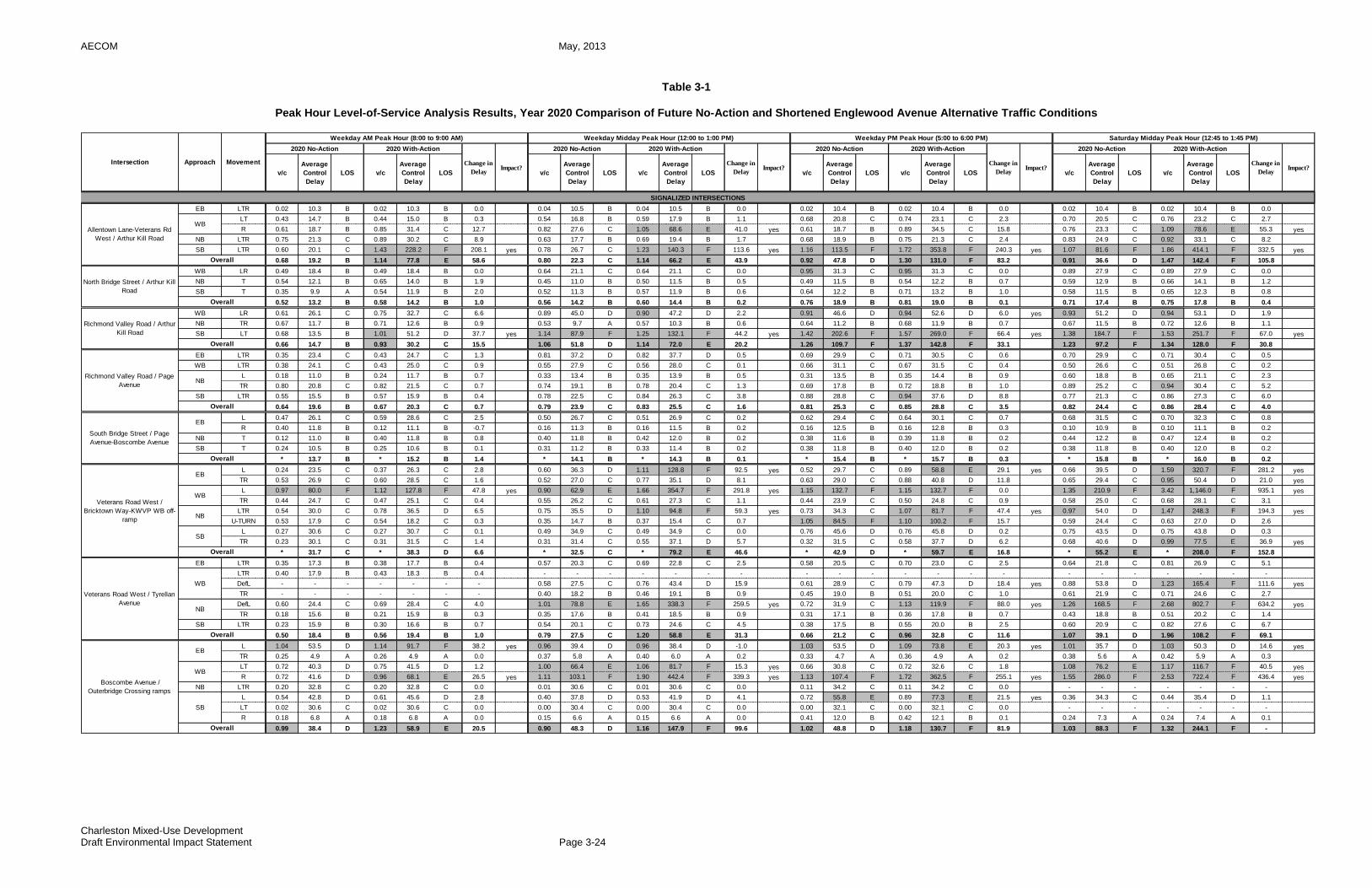
AECOM May, 2013
Charleston Mixed-Use Development Draft Environmental Impact Statement Page 3-24
Table 3-1
Peak Hour Level-of-Service Analysis Results, Year 2020 Comparison of Future No-Action and Shortened Englewood Avenue Alternative Traffic Conditions
EB LTR 0.02 10.3 B 0.02 10.3 B 0.0 0.04 10.5 B 0.04 10.5 B 0.0 0.02 10.4 B 0.02 10.4 B 0.0 0.02 10.4 B 0.02 10.4 B 0.0
LT 0.43 14.7 B 0.44 15.0 B 0.3 0.54 16.8 B 0.59 17.9 B 1.1 0.68 20.8 C 0.74 23.1 C 2.3 0.70 20.5 C 0.76 23.2 C 2.7
R 0.61 18.7 B 0.85 31.4 C 12.7 0.82 27.6 C 1.05 68.6 E 41.0 yes 0.61 18.7 B 0.89 34.5 C 15.8 0.76 23.3 C 1.09 78.6 E 55.3 yes
NB LTR 0.75 21.3 C 0.89 30.2 C 8.9 0.63 17.7 B 0.69 19.4 B 1.7 0.68 18.9 B 0.75 21.3 C 2.4 0.83 24.9 C 0.92 33.1 C 8.2
SB LTR 0.60 20.1 C 1.43 228.2 F 208.1 yes 0.78 26.7 C 1.23 140.3 F 113.6 yes 1.16 113.5 F 1.72 353.8 F 240.3 yes 1.07 81.6 F 1.86 414.1 F 332.5 yes
0.68 19.2 B 1.14 77.8 E 58.6 0.80 22.3 C 1.14 66.2 E 43.9 0.92 47.8 D 1.30 131.0 F 83.2 0.91 36.6 D 1.47 142.4 F 105.8
WB LR 0.49 18.4 B 0.49 18.4 B 0.0 0.64 21.1 C 0.64 21.1 C 0.0 0.95 31.3 C 0.95 31.3 C 0.0 0.89 27.9 C 0.89 27.9 C 0.0
NB T 0.54 12.1 B 0.65 14.0 B 1.9 0.45 11.0 B 0.50 11.5 B 0.5 0.49 11.5 B 0.54 12.2 B 0.7 0.59 12.9 B 0.66 14.1 B 1.2
SB T 0.35 9.9 A 0.54 11.9 B 2.0 0.52 11.3 B 0.57 11.9 B 0.6 0.64 12.2 B 0.71 13.2 B 1.0 0.58 11.5 B 0.65 12.3 B 0.8
0.52 13.2 B 0.58 14.2 B 1.0 0.56 14.2 B 0.60 14.4 B 0.2 0.76 18.9 B 0.81 19.0 B 0.1 0.71 17.4 B 0.75 17.8 B 0.4
WB LR 0.61 26.1 C 0.75 32.7 C 6.6 0.89 45.0 D 0.90 47.2 D 2.2 0.91 46.6 D 0.94 52.6 D 6.0 yes 0.93 51.2 D 0.94 53.1 D 1.9
NB TR 0.67 11.7 B 0.71 12.6 B 0.9 0.53 9.7 A 0.57 10.3 B 0.6 0.64 11.2 B 0.68 11.9 B 0.7 0.67 11.5 B 0.72 12.6 B 1.1
SB LT 0.68 13.5 B 1.01 51.2 D 37.7 yes 1.14 87.9 F 1.25 132.1 F 44.2 yes 1.42 202.6 F 1.57 269.0 F 66.4 yes 1.38 184.7 F 1.53 251.7 F 67.0 yes
0.66 14.7 B 0.93 30.2 C 15.5 1.06 51.8 D 1.14 72.0 E 20.2 1.26 109.7 F 1.37 142.8 F 33.1 1.23 97.2 F 1.34 128.0 F 30.8
EB LTR 0.35 23.4 C 0.43 24.7 C 1.3 0.81 37.2 D 0.82 37.7 D 0.5 0.69 29.9 C 0.71 30.5 C 0.6 0.70 29.9 C 0.71 30.4 C 0.5
WB LTR 0.38 24.1 C 0.43 25.0 C 0.9 0.55 27.9 C 0.56 28.0 C 0.1 0.66 31.1 C 0.67 31.5 C 0.4 0.50 26.6 C 0.51 26.8 C 0.2
L 0.18 11.0 B 0.24 11.7 B 0.7 0.33 13.4 B 0.35 13.9 B 0.5 0.31 13.5 B 0.35 14.4 B 0.9 0.60 18.8 B 0.65 21.1 C 2.3
TR 0.80 20.8 C 0.82 21.5 C 0.7 0.74 19.1 B 0.78 20.4 C 1.3 0.69 17.8 B 0.72 18.8 B 1.0 0.89 25.2 C 0.94 30.4 C 5.2
SB LTR 0.55 15.5 B 0.57 15.9 B 0.4 0.78 22.5 C 0.84 26.3 C 3.8 0.88 28.8 C 0.94 37.6 D 8.8 0.77 21.3 C 0.86 27.3 C 6.0
0.64 19.6 B 0.67 20.3 C 0.7 0.79 23.9 C 0.83 25.5 C 1.6 0.81 25.3 C 0.85 28.8 C 3.5 0.82 24.4 C 0.86 28.4 C 4.0
L 0.47 26.1 C 0.59 28.6 C 2.5 0.50 26.7 C 0.51 26.9 C 0.2 0.62 29.4 C 0.64 30.1 C 0.7 0.68 31.5 C 0.70 32.3 C 0.8
R 0.40 11.8 B 0.12 11.1 B -0.7 0.16 11.3 B 0.16 11.5 B 0.2 0.16 12.5 B 0.16 12.8 B 0.3 0.10 10.9 B 0.10 11.1 B 0.2
NB T 0.12 11.0 B 0.40 11.8 B 0.8 0.40 11.8 B 0.42 12.0 B 0.2 0.38 11.6 B 0.39 11.8 B 0.2 0.44 12.2 B 0.47 12.4 B 0.2
SB T 0.24 10.5 B 0.25 10.6 B 0.1 0.31 11.2 B 0.33 11.4 B 0.2 0.38 11.8 B 0.40 12.0 B 0.2 0.38 11.8 B 0.40 12.0 B 0.2
* 13.7 B * 15.2 B 1.4 * 14.1 B * 14.3 B 0.1 * 15.4 B * 15.7 B 0.3 * 15.8 B * 16.0 B 0.2
L 0.24 23.5 C 0.37 26.3 C 2.8 0.60 36.3 D 1.11 128.8 F 92.5 yes 0.52 29.7 C 0.89 58.8 E 29.1 yes 0.66 39.5 D 1.59 320.7 F 281.2 yes
TR 0.53 26.9 C 0.60 28.5 C 1.6 0.52 27.0 C 0.77 35.1 D 8.1 0.63 29.0 C 0.88 40.8 D 11.8 0.65 29.4 C 0.95 50.4 D 21.0 yes
L 0.97 80.0 F 1.12 127.8 F 47.8 yes 0.90 62.9 E 1.66 354.7 F 291.8 yes 1.15 132.7 F 1.15 132.7 F 0.0 1.35 210.9 F 3.42 1,146.0 F 935.1 yes
TR 0.44 24.7 C 0.47 25.1 C 0.4 0.55 26.2 C 0.61 27.3 C 1.1 0.44 23.9 C 0.50 24.8 C 0.9 0.58 25.0 C 0.68 28.1 C 3.1
LTR 0.54 30.0 C 0.78 36.5 D 6.5 0.75 35.5 D 1.10 94.8 F 59.3 yes 0.73 34.3 C 1.07 81.7 F 47.4 yes 0.97 54.0 D 1.47 248.3 F 194.3 yes
U-TURN 0.53 17.9 C 0.54 18.2 C 0.3 0.35 14.7 B 0.37 15.4 C 0.7 1.05 84.5 F 1.10 100.2 F 15.7 0.59 24.4 C 0.63 27.0 D 2.6
L 0.27 30.6 C 0.27 30.7 C 0.1 0.49 34.9 C 0.49 34.9 C 0.0 0.76 45.6 D 0.76 45.8 D 0.2 0.75 43.5 D 0.75 43.8 D 0.3
TR 0.23 30.1 C 0.31 31.5 C 1.4 0.31 31.4 C 0.55 37.1 D 5.7 0.32 31.5 C 0.58 37.7 D 6.2 0.68 40.6 D 0.99 77.5 E 36.9 yes
* 31.7 C * 38.3 D 6.6 * 32.5 C * 79.2 E 46.6 * 42.9 D * 59.7 E 16.8 * 55.2 E * 208.0 F 152.8
EB LTR 0.35 17.3 B 0.38 17.7 B 0.4 0.57 20.3 C 0.69 22.8 C 2.5 0.58 20.5 C 0.70 23.0 C 2.5 0.64 21.8 C 0.81 26.9 C 5.1
LTR 0.40 17.9 B 0.43 18.3 B 0.4 - - - - - - - - - - - - - - - - - - - - -
DefL - - - - - - - 0.58 27.5 C 0.76 43.4 D 15.9 0.61 28.9 C 0.79 47.3 D 18.4 yes 0.88 53.8 D 1.23 165.4 F 111.6 yes
TR - - - - - - - 0.40 18.2 B 0.46 19.1 B 0.9 0.45 19.0 B 0.51 20.0 C 1.0 0.61 21.9 C 0.71 24.6 C 2.7
DefL 0.60 24.4 C 0.69 28.4 C 4.0 1.01 78.8 E 1.65 338.3 F 259.5 yes 0.72 31.9 C 1.13 119.9 F 88.0 yes 1.26 168.5 F 2.68 802.7 F 634.2 yes
TR 0.18 15.6 B 0.21 15.9 B 0.3 0.35 17.6 B 0.41 18.5 B 0.9 0.31 17.1 B 0.36 17.8 B 0.7 0.43 18.8 B 0.51 20.2 C 1.4
SB LTR 0.23 15.9 B 0.30 16.6 B 0.7 0.54 20.1 C 0.73 24.6 C 4.5 0.38 17.5 B 0.55 20.0 B 2.5 0.60 20.9 C 0.82 27.6 C 6.7
0.50 18.4 B 0.56 19.4 B 1.0 0.79 27.5 C 1.20 58.8 E 31.3 0.66 21.2 C 0.96 32.8 C 11.6 1.07 39.1 D 1.96 108.2 F 69.1
L 1.04 53.5 D 1.14 91.7 F 38.2 yes 0.96 39.4 D 0.96 38.4 D -1.0 1.03 53.5 D 1.09 73.8 E 20.3 yes 1.01 35.7 D 1.03 50.3 D 14.6 yes
TR 0.25 4.9 A 0.26 4.9 A 0.0 0.37 5.8 A 0.40 6.0 A 0.2 0.33 4.7 A 0.36 4.9 A 0.2 0.38 5.6 A 0.42 5.9 A 0.3
LT 0.72 40.3 D 0.75 41.5 D 1.2 1.00 66.4 E 1.06 81.7 F 15.3 yes 0.66 30.8 C 0.72 32.6 C 1.8 1.08 76.2 E 1.17 116.7 F 40.5 yes
R 0.72 41.6 D 0.96 68.1 E 26.5 yes 1.11 103.1 F 1.90 442.4 F 339.3 yes 1.13 107.4 F 1.72 362.5 F 255.1 yes 1.55 286.0 F 2.53 722.4 F 436.4 yes
NB LTR 0.20 32.8 C 0.20 32.8 C 0.0 0.01 30.6 C 0.01 30.6 C 0.0 0.11 34.2 C 0.11 34.2 C 0.0 - - - - - - -
L 0.54 42.8 D 0.61 45.6 D 2.8 0.40 37.8 D 0.53 41.9 D 4.1 0.72 55.8 E 0.89 77.3 E 21.5 yes 0.36 34.3 C 0.44 35.4 D 1.1
LT 0.02 30.6 C 0.02 30.6 C 0.0 0.00 30.4 C 0.00 30.4 C 0.0 0.00 32.1 C 0.00 32.1 C 0.0 - - - - - - -
R 0.18 6.8 A 0.18 6.8 A 0.0 0.15 6.6 A 0.15 6.6 A 0.0 0.41 12.0 B 0.42 12.1 B 0.1 0.24 7.3 A 0.24 7.4 A 0.1
0.99 38.4 D 1.23 58.9 E 20.5 0.90 48.3 D 1.16 147.9 F 99.6 1.02 48.8 D 1.18 130.7 F 81.9 1.03 88.3 F 1.32 244.1 F -
Veterans Road West / Tyrellan
AvenueNB
Overall
Boscombe Avenue /
Outerbridge Crossing ramps
EB
WB
SB
Overall
WB
South Bridge Street / Page
Avenue-Boscombe Avenue
EB
Overall
Veterans Road West /
Bricktown Way-KWVP WB off-
ramp
EB
WB
NB
SB
Overall
Richmond Valley Road / Arthur
Kill Road
Overall
Richmond Valley Road / Page
AvenueNB
Overall
SIGNALIZED INTERSECTIONS
Allentown Lane-Veterans Rd
West / Arthur Kill Road
WB
Overall
North Bridge Street / Arthur Kill
Road
Overall
v/c
Average
Control
Delay
LOS
Average
Control
Delay
LOS v/c
Average
Control
Delay
LOS v/c
Change in
DelayImpact?
2020 No-Action 2020 With-Action
Change in
DelayImpact?
Average
Control
Delay
LOS
2020 No-Action 2020 With-Action
v/c
Average
Control
Delay
LOS v/c v/c
Average
Control
Delay
LOS
Intersection Approach Movement
Weekday AM Peak Hour (8:00 to 9:00 AM) Weekday Midday Peak Hour (12:00 to 1:00 PM) Weekday PM Peak Hour (5:00 to 6:00 PM) Saturday Midday Peak Hour (12:45 to 1:45 PM)
2020 No-Action 2020 With-Action
Change in
DelayImpact?
v/c
Average
Control
Delay
LOS v/c
Average
Control
Delay
LOS
2020 No-Action 2020 With-Action
Change in
DelayImpact?
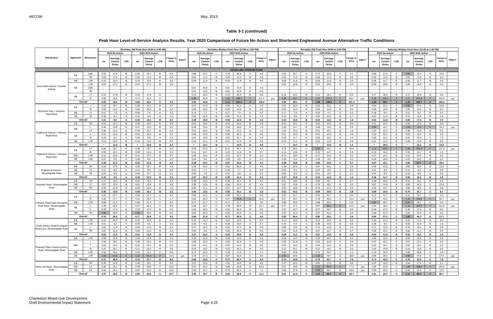
AECOM May, 2013
Charleston Mixed-Use Development Draft Environmental Impact Statement Page 3-25
Table 3-1 (continued)
Peak Hour Level-of-Service Analysis Results, Year 2020 Comparison of Future No-Action and Shortened Englewood Avenue Alternative Traffic Conditions
DefL 0.52 17.8 B 0.56 18.7 B 0.9 0.68 22.2 C 0.78 26.8 C 4.6 0.65 20.7 C 0.74 23.8 C 3.1 0.80 27.6 C 0.93 41.2 D 13.6
TR 0.03 11.5 B 0.03 11.5 B 0.0 0.04 11.5 B 0.04 11.5 B 0.0 0.04 11.5 B 0.04 11.5 B 0.0 0.05 11.6 B 0.05 11.6 B 0.0
WB LTR 0.10 12.0 B 0.10 12.0 B 0.0 0.09 11.9 B 0.09 11.9 B 0.0 0.05 11.6 B 0.05 11.6 B 0.0 0.06 11.7 B 0.06 11.7 B 0.0
LTR 0.07 17.4 B 0.07 17.4 B 0.0 - - - - - - - 0.01 16.9 B 0.01 16.9 B 0.0 0.00 16.8 B 0.00 16.8 B 0.0
DefL - - - - - - - 0.01 16.9 B 0.01 16.9 B 0.0 - - - - - - - - - - - - - -
TR - - - - - - - 0.01 16.9 B 0.01 16.9 B 0.0 - - - - - - - - - - - - - -
LT 0.10 17.8 B 0.10 17.8 B - 0.15 18.3 B 0.15 18.3 B 0.0 0.12 18.1 B 0.12 18.1 B 0.0 0.17 18.5 B 0.17 18.5 B 0.0
R 0.55 24.8 C 0.74 31.0 C - 0.95 50.8 D 1.52 268.1 F 217.3 yes 0.99 59.7 E 1.52 270.4 F 210.7 yes 1.26 156.3 F 1.97 470.2 F 313.9 yes
0.53 19.0 B 0.64 22.2 C 3.2 0.80 32.8 C 1.11 151.2 F 118.4 0.80 38.1 D 1.08 159.5 F 121.4 1.00 88.2 F 1.39 282.7 F 194.5
L 0.19 15.7 B 0.25 16.4 B 0.7 0.37 17.8 B 0.56 21.1 C 3.3 0.41 18.3 B 0.60 22.1 C 3.8 0.64 22.4 C 0.90 37.0 D 14.6
R 0.00 14.0 B 0.00 14.0 B 0.0 0.05 14.4 B 0.05 14.4 B 0.0 0.04 14.4 B 0.04 14.4 B 0.0 0.06 14.5 B 0.06 14.5 B 0.0
NB LT 0.07 7.3 A 0.08 7.4 A 0.1 0.14 7.7 A 0.17 7.9 A 0.2 0.17 7.9 A 0.20 8.1 A 0.2 0.18 8.0 A 0.21 8.2 A 0.2
SB TR 0.38 9.1 A 0.42 9.4 A 0.3 0.52 10.2 B 0.62 11.3 B 1.1 0.42 9.5 A 0.50 10.2 B 0.7 0.62 11.0 B 0.74 12.6 B 1.6
0.31 9.6 A 0.35 10.0 B 0.4 0.46 10.9 B 0.59 12.5 B 1.6 0.41 10.6 B 0.54 12.2 B 1.6 0.63 12.8 B 0.80 17.3 B 4.5
EB TR 0.01 10.2 B 0.00 10.2 B 0.0 0.01 10.2 B 0.01 10.2 B 0.0 0.01 10.2 B 0.00 10.2 B 0.0 0.01 10.2 B 0.00 10.2 B 0.0
L 0.44 14.8 B 0.47 15.3 B 0.5 0.49 15.5 B 0.54 16.5 B 1.0 0.43 14.7 B 0.49 15.5 B 0.8 0.96 45.2 D 1.08 78.4 E 33.2 yes
LT 0.46 15.3 B 0.49 15.7 B 0.4 0.51 16.0 B 0.56 17.1 B 1.1 0.45 15.1 B 0.51 16.1 B 1.0 0.34 13.4 B 0.38 13.9 B 0.5
L 0.01 10.3 B 0.01 10.3 B 0.0 0.00 10.2 B 0.00 10.2 B 0.0 0.01 10.3 B 0.01 10.3 B 0.0 0.02 10.4 B 0.02 10.4 B 0.0
R 0.20 9.3 A 0.25 9.6 A 0.3 0.41 10.9 B 0.55 12.7 B 1.8 0.49 11.7 B 0.63 14.1 B 2.4 0.63 14.1 B 0.81 21.3 C 7.2
SB LTR 0.13 10.9 B 0.15 11.0 B 0.1 0.16 11.1 B 0.21 11.4 B 0.3 0.16 11.1 B 0.20 11.4 B 0.3 0.21 11.4 B 0.28 11.9 B 0.5
* 12.6 B * 12.8 B 0.2 * 13.1 B * 14.0 B 0.9 * 12.7 B * 13.9 B 1.2 * 26.6 C * 41.2 D 14.5
LT 0.34 16.1 B 0.38 16.7 B 0.6 0.58 20.3 C 0.72 24.7 C 4.4 0.78 28.2 C 0.94 44.2 D 16.0 1.12 94.5 F 1.38 201.8 F 107.3 yes
R 0.05 13.1 B 0.08 13.4 B 0.3 0.12 13.7 B 0.20 14.4 B 0.7 0.13 13.8 B 0.22 14.7 B 0.9 0.18 14.2 B 0.32 15.7 B 1.5
WB LTR 0.11 13.6 B 0.12 13.7 B 0.1 0.09 13.4 B 0.12 13.7 B 0.3 0.14 13.9 B 0.17 14.1 B 0.2 0.17 14.1 B 0.21 14.6 B 0.5
NB LTR 0.27 9.5 A 0.28 9.6 A 0.1 0.26 9.4 A 0.28 9.5 A 0.1 0.26 9.4 A 0.28 9.5 A 0.1 0.34 10.0 A 0.37 10.2 B 0.2
0.30 11.3 B 0.32 11.6 B 0.3 0.39 13.3 B 0.47 15.4 B 2.1 0.48 16.8 B 0.56 23.5 C 6.7 0.67 43.1 D 0.80 87.7 F 44.6
EB LR 0.19 17.9 B 0.26 18.7 B 0.8 0.39 20.4 C 0.61 25.0 C 4.6 0.38 20.3 C 0.57 24.1 C 3.8 0.56 23.6 C 0.83 35.4 D 11.8
NB LT 0.41 8.5 A 0.41 8.5 A 0.0 0.32 7.7 A 0.32 7.7 A 0.0 0.52 9.5 A 0.52 9.5 A 0.0 0.41 8.4 A 0.41 8.4 A 0.0
SB TR 0.54 9.6 A 0.54 9.7 A 0.1 0.35 7.9 A 0.37 8.0 A 0.1 0.50 9.3 A 0.51 9.4 A 0.1 0.41 8.3 A 0.43 8.6 A 0.3
0.43 9.9 A 0.45 10.2 B 0.3 0.37 10.2 B 0.45 12.4 B 2.2 0.47 10.8 B 0.53 12.2 B 1.4 0.46 11.7 B 0.56 16.2 B 4.5
EB LR 0.27 16.0 B 0.53 19.9 B 3.9 0.28 16.0 B 0.30 16.1 B 0.1 0.51 19.0 B 0.55 19.7 B 0.7 0.48 18.6 B 0.52 19.2 B 0.6
NB LT 0.57 13.0 B 0.61 13.8 B 0.8 0.55 12.6 B 0.66 15.0 B 2.4 0.67 14.6 B 0.78 18.1 B 3.5 0.67 14.8 B 0.89 26.4 C 11.6
SB TR 0.50 11.8 B 0.63 14.0 B 2.2 0.45 11.1 B 0.57 12.7 B 1.6 0.64 13.9 B 0.76 17.2 B 3.3 0.63 13.7 B 0.80 18.5 B 4.8
0.45 12.9 B 0.59 15.1 B 2.2 0.44 12.5 B 0.52 14.1 B 1.6 0.61 15.2 B 0.69 18.0 B 2.8 0.59 15.0 B 0.74 21.7 C 6.7
L 0.02 22.7 C 0.02 22.7 C 0.0 0.06 23.1 C 0.06 23.1 C 0.0 0.02 22.7 C 0.02 22.7 C 0.0 0.12 23.7 C 0.12 23.7 C 0.0
R 0.34 27.7 C 0.41 29.4 C 1.7 0.63 35.3 D 0.87 55.9 E 20.6 yes 0.57 33.1 C 0.78 45.3 D 12.2 yes 0.79 43.3 D 1.15 126.0 F 82.7 yes
WB LTR 0.69 21.4 C 0.69 21.4 C 0.0 0.71 21.7 C 0.71 21.7 C 0.0 0.88 25.0 C 0.88 25.0 C 0.0 0.94 28.7 C 0.94 28.7 C 0.0
L 0.39 24.2 C 0.57 34.1 C 9.9 0.44 23.7 C 0.78 46.4 D 22.7 yes 0.47 27.1 C 0.87 68.1 E 41.0 yes 0.64 36.4 D 1.18 150.3 F 113.9 yes
T 0.39 17.2 B 0.39 17.2 B 0.0 0.32 16.3 B 0.32 16.3 B 0.0 0.37 16.7 B 0.37 16.7 B 0.0 0.40 17.2 B 0.40 17.2 B 0.0
SB TR 0.99 36.5 D 0.99 36.5 D 0.0 0.62 20.3 C 0.62 20.3 C 0.0 0.87 31.4 C 0.87 31.4 C 0.0 0.69 21.4 C 0.69 21.4 C 0.0
0.76 26.4 C 0.77 26.8 C 0.4 0.66 21.9 C 0.77 25.9 C 4.0 0.82 26.4 C 0.86 29.4 C 3.0 0.80 27.2 C 1.09 44.3 D 17.1
EB LTR 0.16 16.9 B 0.16 16.9 B 0.0 0.10 16.3 B 0.10 16.3 B 0.0 0.13 16.5 B 0.13 16.5 B 0.0 0.20 17.3 B 0.20 17.3 B 0.0
NB LTR 0.41 9.2 A 0.44 9.5 A 0.3 0.43 9.3 A 0.49 10.0 A 0.7 0.44 9.4 A 0.49 10.0 B 0.6 0.49 9.9 A 0.56 10.9 B 1.0
L 0.61 11.9 B 0.63 12.3 B 0.4 0.47 10.4 B 0.50 11.2 B 0.8 0.66 13.1 B 0.70 14.6 B 1.5 0.71 15.6 B 0.79 19.4 B 3.8
TR 0.67 11.6 B 0.69 11.9 B 0.3 0.50 9.8 A 0.55 10.4 B 0.6 0.62 11.0 B 0.67 11.7 B 0.7 0.56 10.2 B 0.62 11.1 B 0.9
0.50 11.3 B 0.51 11.6 B 0.3 0.37 10.0 A 0.40 10.6 B 0.6 0.48 11.2 B 0.51 12.0 B 0.8 0.54 11.8 B 0.59 13.2 B 1.4
EB LTR 0.09 14.8 B 0.09 14.8 B 0.0 0.06 14.5 B 0.06 14.5 B 0.0 0.09 14.7 B 0.09 14.7 B 0.0 0.06 14.5 B 0.06 14.5 B 0.0
L 0.36 18.2 B 0.36 18.2 B 0.0 0.58 22.4 C 0.58 22.4 C 0.0 0.55 21.8 C 0.55 21.8 C 0.0 0.57 22.1 C 0.57 22.1 C 0.0
T 0.02 14.1 B 0.02 14.1 B 0.0 0.04 14.2 B 0.04 14.2 B 0.0 0.04 14.2 B 0.04 14.2 B 0.0 0.02 14.1 B 0.02 14.1 B 0.0
R 0.21 16.1 B 0.21 16.1 B 0.0 0.22 16.2 B 0.22 16.2 B 0.0 0.22 16.1 B 0.22 16.1 B 0.0 0.20 15.9 B 0.20 15.9 B 0.0
NB LTR 0.52 20.5 C 0.55 21.1 C 0.6 0.71 24.3 C 0.78 27.0 C 2.7 0.69 23.6 C 0.75 25.7 C 2.1 0.79 25.9 C 0.88 30.8 C 4.9
SB LTR 1.08 64.8 E 1.13 84.3 F 19.5 yes 0.78 27.4 C 0.87 33.0 C 5.6 0.93 30.9 C 1.03 49.7 D 18.8 yes 0.86 30.6 C 0.99 47.6 D 17.0 yes
0.72 38.9 D 0.74 47.7 D 8.8 0.68 23.8 C 0.72 26.7 C 2.9 0.74 24.9 C 0.79 32.7 C 7.8 0.71 25.5 C 0.78 33.3 C 7.8
EB TR 0.35 14.6 B 0.39 15.1 B 0.5 0.37 14.9 B 0.41 15.5 B 0.6 0.47 16.2 B 0.52 17.0 B 0.8 0.47 16.3 B 0.54 17.4 B 1.1
WB LT 0.36 15.1 B 0.78 28.9 C 13.8 0.43 16.3 B 0.89 39.6 D 23.3 0.57 19.5 B 1.11 96.8 F 77.3 yes 0.65 22.8 C 1.34 188.4 F 165.6 yes
NB LR 0.60 26.1 C 0.87 41.0 D 14.9 0.56 25.1 C 0.75 32.2 C 7.1 0.66 27.9 C 0.96 53.7 D 25.8 yes 0.55 25.0 C 0.83 37.5 D 12.5
0.47 18.8 B 0.82 29.5 C 10.7 0.49 18.7 B 0.83 29.8 C 11.1 0.61 21.0 C 1.04 56.7 E 35.7 0.61 20.7 C 1.11 86.4 F 65.7
Arthur Kill Road / Bloomingdale
Road
Overall
South Service Road-Drumgoole
Road East / Bloomingdale Road SB
Overall
Pleasant Plains Avenue-Amboy
Road / Bloomingdale Road
WB
Overall
Englewood Avenue /
Bloomingdale Road
Overall
Sharrotts Road / Bloomingdale
Road
Overall
Veterans Road East-Drumgoole
Road West / Bloomingdale
Road
EB
NB
Overall
Englewood Avenue / Veterans
Road West
WB
NB
Overall
Englewood Avenue / Veterans
Road East
EB
Overall
Boscombe Avenue / Tyrellan
Avenue
EB
NB
SB
Overall
Bricktown Way / Veterans
Road West
EB
Overall
SIGNALIZED INTERSECTIONS
v/c
Average
Control
Delay
LOS
Average
Control
Delay
LOS v/c
Average
Control
Delay
LOS v/c
Change in
DelayImpact?
2020 No-Action 2020 With-Action
Change in
DelayImpact?
Average
Control
Delay
LOS
2020 No-Action 2020 With-Action
v/c
Average
Control
Delay
LOS v/c v/c
Average
Control
Delay
LOS
Intersection Approach Movement
Weekday AM Peak Hour (8:00 to 9:00 AM) Weekday Midday Peak Hour (12:00 to 1:00 PM) Weekday PM Peak Hour (5:00 to 6:00 PM) Saturday Midday Peak Hour (12:45 to 1:45 PM)
2020 No-Action 2020 With-Action
Change in
DelayImpact?
v/c
Average
Control
Delay
LOS v/c
Average
Control
Delay
LOS
2020 No-Action 2020 With-Action
Change in
DelayImpact?
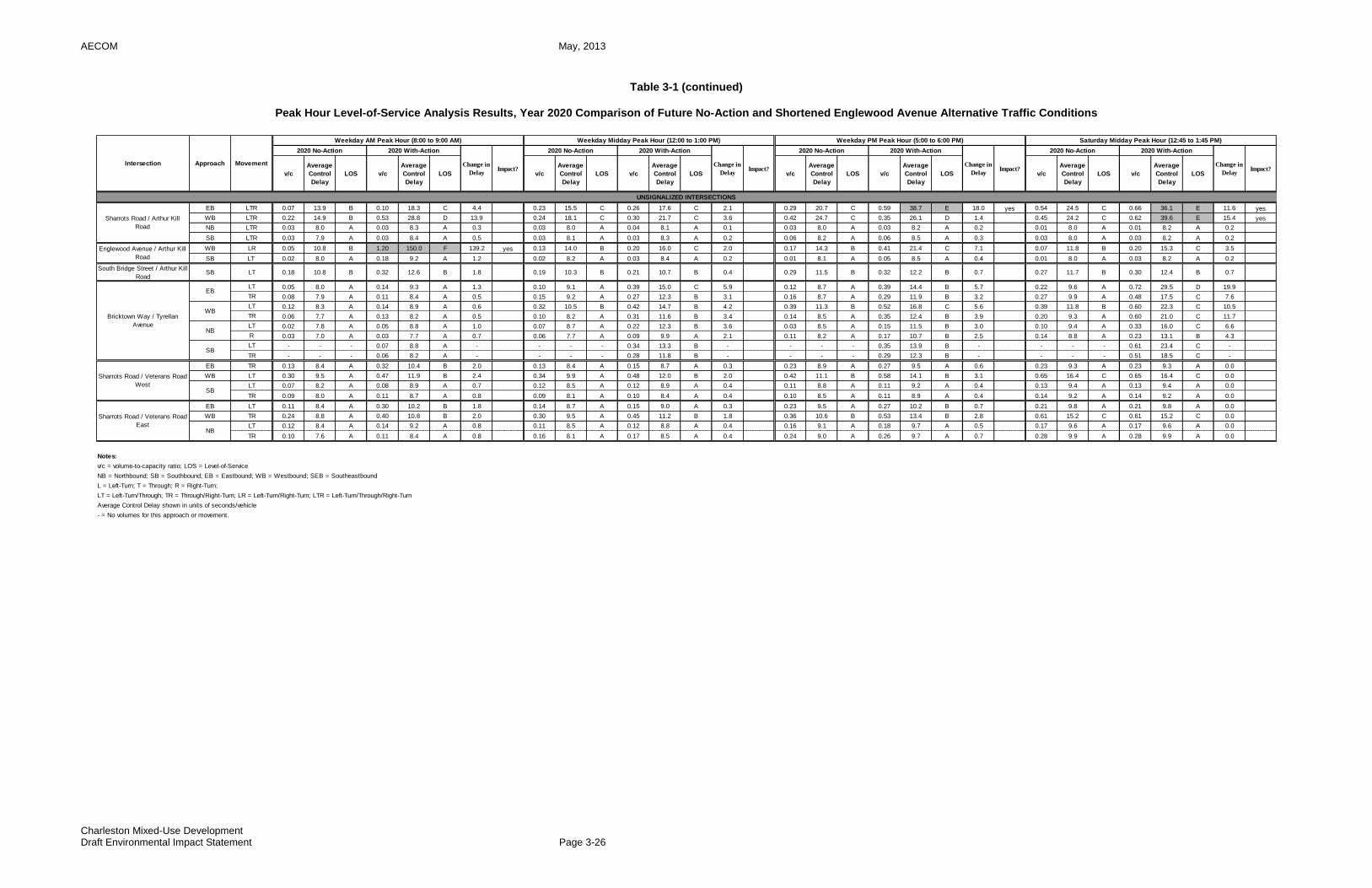
AECOM May, 2013
Charleston Mixed-Use Development Draft Environmental Impact Statement Page 3-26
Table 3-1 (continued)
Peak Hour Level-of-Service Analysis Results, Year 2020 Comparison of Future No-Action and Shortened Englewood Avenue Alternative Traffic Conditions
EB LTR 0.07 13.9 B 0.10 18.3 C 4.4 0.23 15.5 C 0.26 17.6 C 2.1 0.29 20.7 C 0.59 38.7 E 18.0 yes 0.54 24.5 C 0.66 36.1 E 11.6 yes
WB LTR 0.22 14.9 B 0.53 28.8 D 13.9 0.24 18.1 C 0.30 21.7 C 3.6 0.42 24.7 C 0.35 26.1 D 1.4 0.45 24.2 C 0.62 39.6 E 15.4 yes
NB LTR 0.03 8.0 A 0.03 8.3 A 0.3 0.03 8.0 A 0.04 8.1 A 0.1 0.03 8.0 A 0.03 8.2 A 0.2 0.01 8.0 A 0.01 8.2 A 0.2
SB LTR 0.03 7.9 A 0.03 8.4 A 0.5 0.03 8.1 A 0.03 8.3 A 0.2 0.06 8.2 A 0.06 8.5 A 0.3 0.03 8.0 A 0.03 8.2 A 0.2
WB LR 0.05 10.8 B 1.20 150.0 F 139.2 yes 0.13 14.0 B 0.20 16.0 C 2.0 0.17 14.3 B 0.41 21.4 C 7.1 0.07 11.8 B 0.20 15.3 C 3.5
SB LT 0.02 8.0 A 0.18 9.2 A 1.2 0.02 8.2 A 0.03 8.4 A 0.2 0.01 8.1 A 0.05 8.5 A 0.4 0.01 8.0 A 0.03 8.2 A 0.2
South Bridge Street / Arthur Kill
RoadSB LT 0.18 10.8 B 0.32 12.6 B 1.8 0.19 10.3 B 0.21 10.7 B 0.4 0.29 11.5 B 0.32 12.2 B 0.7 0.27 11.7 B 0.30 12.4 B 0.7
LT 0.05 8.0 A 0.14 9.3 A 1.3 0.10 9.1 A 0.39 15.0 C 5.9 0.12 8.7 A 0.39 14.4 B 5.7 0.22 9.6 A 0.72 29.5 D 19.9
TR 0.08 7.9 A 0.11 8.4 A 0.5 0.15 9.2 A 0.27 12.3 B 3.1 0.16 8.7 A 0.29 11.9 B 3.2 0.27 9.9 A 0.48 17.5 C 7.6
LT 0.12 8.3 A 0.14 8.9 A 0.6 0.32 10.5 B 0.42 14.7 B 4.2 0.39 11.3 B 0.52 16.8 C 5.6 0.39 11.8 B 0.60 22.3 C 10.5
TR 0.06 7.7 A 0.13 8.2 A 0.5 0.10 8.2 A 0.31 11.6 B 3.4 0.14 8.5 A 0.35 12.4 B 3.9 0.20 9.3 A 0.60 21.0 C 11.7
LT 0.02 7.8 A 0.05 8.8 A 1.0 0.07 8.7 A 0.22 12.3 B 3.6 0.03 8.5 A 0.15 11.5 B 3.0 0.10 9.4 A 0.33 16.0 C 6.6
R 0.03 7.0 A 0.03 7.7 A 0.7 0.06 7.7 A 0.09 9.9 A 2.1 0.11 8.2 A 0.17 10.7 B 2.5 0.14 8.8 A 0.23 13.1 B 4.3
LT - - - 0.07 8.8 A - - - - 0.34 13.3 B - - - - 0.35 13.9 B - - - - 0.61 23.4 C -
TR - - - 0.06 8.2 A - - - - 0.28 11.8 B - - - - 0.29 12.3 B - - - - 0.51 18.5 C -
EB TR 0.13 8.4 A 0.32 10.4 B 2.0 0.13 8.4 A 0.15 8.7 A 0.3 0.23 8.9 A 0.27 9.5 A 0.6 0.23 9.3 A 0.23 9.3 A 0.0
WB LT 0.30 9.5 A 0.47 11.9 B 2.4 0.34 9.9 A 0.48 12.0 B 2.0 0.42 11.1 B 0.58 14.1 B 3.1 0.65 16.4 C 0.65 16.4 C 0.0
LT 0.07 8.2 A 0.08 8.9 A 0.7 0.12 8.5 A 0.12 8.9 A 0.4 0.11 8.8 A 0.11 9.2 A 0.4 0.13 9.4 A 0.13 9.4 A 0.0
TR 0.09 8.0 A 0.11 8.7 A 0.8 0.09 8.1 A 0.10 8.4 A 0.4 0.10 8.5 A 0.11 8.9 A 0.4 0.14 9.2 A 0.14 9.2 A 0.0
EB LT 0.11 8.4 A 0.30 10.2 B 1.8 0.14 8.7 A 0.15 9.0 A 0.3 0.23 9.5 A 0.27 10.2 B 0.7 0.21 9.8 A 0.21 9.8 A 0.0
WB TR 0.24 8.8 A 0.40 10.8 B 2.0 0.30 9.5 A 0.45 11.2 B 1.8 0.36 10.6 B 0.53 13.4 B 2.8 0.61 15.2 C 0.61 15.2 C 0.0
LT 0.12 8.4 A 0.14 9.2 A 0.8 0.11 8.5 A 0.12 8.8 A 0.4 0.16 9.1 A 0.18 9.7 A 0.5 0.17 9.6 A 0.17 9.6 A 0.0
TR 0.10 7.6 A 0.11 8.4 A 0.8 0.16 8.1 A 0.17 8.5 A 0.4 0.24 9.0 A 0.26 9.7 A 0.7 0.28 9.9 A 0.28 9.9 A 0.0
Notes:
v/c = volume-to-capacity ratio; LOS = Level-of-Service
NB = Northbound; SB = Southbound; EB = Eastbound; WB = Westbound; SEB = Southeastbound
L = Left-Turn; T = Through; R = Right-Turn;
LT = Left-Turn/Through; TR = Through/Right-Turn; LR = Left-Turn/Right-Turn; LTR = Left-Turn/Through/Right-Turn
Average Control Delay shown in units of seconds/vehicle
- = No volumes for this approach or movement.
Sharrots Road / Veterans Road
EastNB
Bricktown Way / Tyrellan
Avenue
EB
WB
NB
SB
Sharrots Road / Veterans Road
WestSB
UNSIGNALIZED INTERSECTIONS
Sharrots Road / Arthur Kill
Road
Englewood Avenue / Arthur Kill
Road
v/c
Average
Control
Delay
LOS
Average
Control
Delay
LOS v/c
Average
Control
Delay
LOS v/c
Change in
DelayImpact?
2020 No-Action 2020 With-Action
Change in
DelayImpact?
Average
Control
Delay
LOS
2020 No-Action 2020 With-Action
v/c
Average
Control
Delay
LOS v/c v/c
Average
Control
Delay
LOS
Intersection Approach Movement
Weekday AM Peak Hour (8:00 to 9:00 AM) Weekday Midday Peak Hour (12:00 to 1:00 PM) Weekday PM Peak Hour (5:00 to 6:00 PM) Saturday Midday Peak Hour (12:45 to 1:45 PM)
2020 No-Action 2020 With-Action
Change in
DelayImpact?
v/c
Average
Control
Delay
LOS v/c
Average
Control
Delay
LOS
2020 No-Action 2020 With-Action
Change in
DelayImpact?
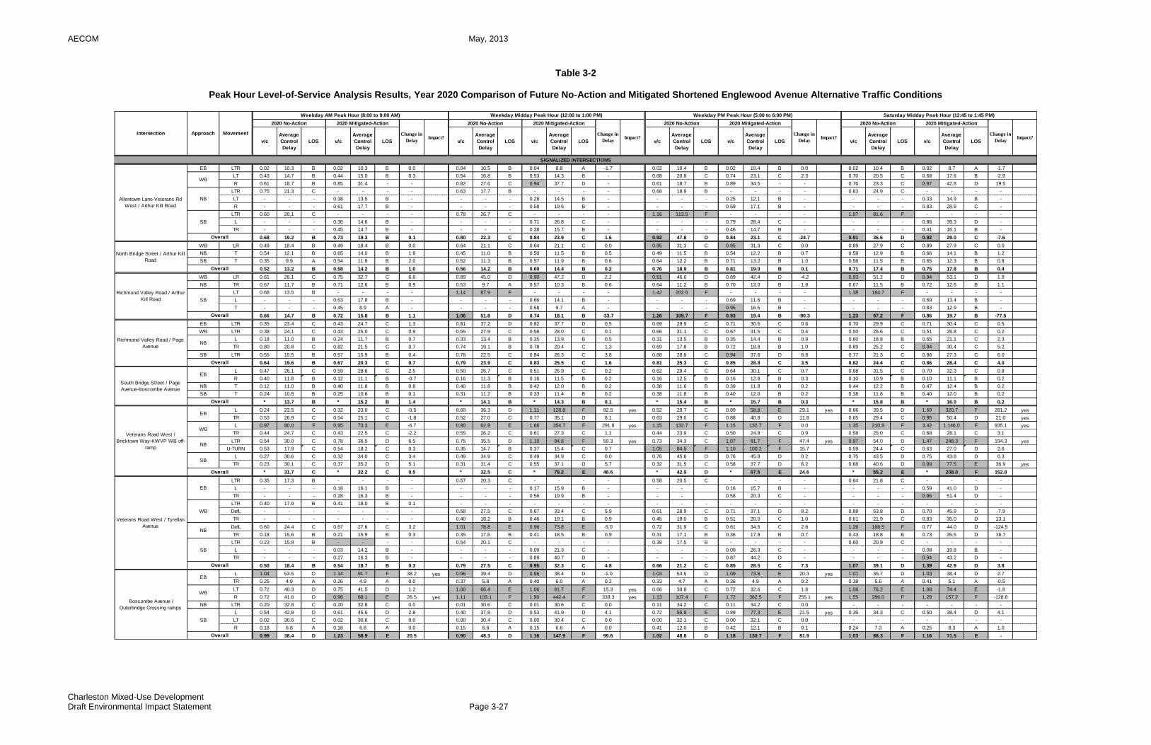
AECOM May, 2013
Charleston Mixed-Use Development Draft Environmental Impact Statement Page 3-27
Table 3-2
Peak Hour Level-of-Service Analysis Results, Year 2020 Comparison of Future No-Action and Mitigated Shortened Englewood Avenue Alternative Traffic Conditions
EB LTR 0.02 10.3 B 0.02 10.3 B 0.0 0.04 10.5 B 0.04 8.8 A -1.7 0.02 10.4 B 0.02 10.4 B 0.0 0.02 10.4 B 0.02 8.7 A -1.7
LT 0.43 14.7 B 0.44 15.0 B 0.3 0.54 16.8 B 0.53 14.3 B - 0.68 20.8 C 0.74 23.1 C 2.3 0.70 20.5 C 0.68 17.6 B -2.9
R 0.61 18.7 B 0.85 31.4 - - 0.82 27.6 C 0.94 37.7 D - 0.61 18.7 B 0.89 34.5 - - 0.76 23.3 C 0.97 42.8 D 19.5
LTR 0.75 21.3 C - - - - 0.63 17.7 B - - - - 0.68 18.9 B - - - - 0.83 24.9 C - - - -
LT - - - 0.38 13.5 B - - - - 0.28 14.5 B - - - - 0.25 12.1 B - - - - 0.33 14.9 B -
R - - - 0.61 17.7 B - - - - 0.58 19.6 B - - - - 0.59 17.1 B - - - - 0.83 28.9 C -
LTR 0.60 20.1 C - - - - 0.78 26.7 C - - - - 1.16 113.5 F - - - - 1.07 81.6 F - - - -
L - - - 0.36 14.6 B - - - - 0.71 26.8 C - - - - 0.79 28.4 C - - - - 0.86 39.3 D -
TR - - - 0.45 14.7 B - - - - 0.38 15.7 B - - - - 0.46 14.7 B - - - - 0.41 16.1 B -
0.68 19.2 B 0.73 19.3 B 0.1 0.80 22.3 C 0.84 23.9 C 1.6 0.92 47.8 D 0.84 23.1 C -24.7 0.91 36.6 D 0.92 29.0 C -7.6
WB LR 0.49 18.4 B 0.49 18.4 B 0.0 0.64 21.1 C 0.64 21.1 C 0.0 0.95 31.3 C 0.95 31.3 C 0.0 0.89 27.9 C 0.89 27.9 C 0.0
NB T 0.54 12.1 B 0.65 14.0 B 1.9 0.45 11.0 B 0.50 11.5 B 0.5 0.49 11.5 B 0.54 12.2 B 0.7 0.59 12.9 B 0.66 14.1 B 1.2
SB T 0.35 9.9 A 0.54 11.9 B 2.0 0.52 11.3 B 0.57 11.9 B 0.6 0.64 12.2 B 0.71 13.2 B 1.0 0.58 11.5 B 0.65 12.3 B 0.8
0.52 13.2 B 0.58 14.2 B 1.0 0.56 14.2 B 0.60 14.4 B 0.2 0.76 18.9 B 0.81 19.0 B 0.1 0.71 17.4 B 0.75 17.8 B 0.4
WB LR 0.61 26.1 C 0.75 32.7 C 6.6 0.89 45.0 D 0.90 47.2 D 2.2 0.91 46.6 D 0.89 42.4 D -4.2 0.93 51.2 D 0.94 53.1 D 1.9
NB TR 0.67 11.7 B 0.71 12.6 B 0.9 0.53 9.7 A 0.57 10.3 B 0.6 0.64 11.2 B 0.70 13.0 B 1.8 0.67 11.5 B 0.72 12.6 B 1.1
LT 0.68 13.5 B - - - - 1.14 87.9 F - - - - 1.42 202.6 F - - - - 1.38 184.7 F - - - -
L - - - 0.63 17.8 B - - - - 0.66 14.1 B - - - - 0.69 11.6 B - - - - 0.69 13.4 B -
T - - - 0.45 8.9 A - - - - 0.58 9.7 A - - - - 0.95 16.5 B - - - - 0.83 12.9 B -
0.66 14.7 B 0.72 15.8 B 1.1 1.06 51.8 D 0.74 18.1 B -33.7 1.26 109.7 F 0.93 19.4 B -90.3 1.23 97.2 F 0.86 19.7 B -77.5
EB LTR 0.35 23.4 C 0.43 24.7 C 1.3 0.81 37.2 D 0.82 37.7 D 0.5 0.69 29.9 C 0.71 30.5 C 0.6 0.70 29.9 C 0.71 30.4 C 0.5
WB LTR 0.38 24.1 C 0.43 25.0 C 0.9 0.55 27.9 C 0.56 28.0 C 0.1 0.66 31.1 C 0.67 31.5 C 0.4 0.50 26.6 C 0.51 26.8 C 0.2
L 0.18 11.0 B 0.24 11.7 B 0.7 0.33 13.4 B 0.35 13.9 B 0.5 0.31 13.5 B 0.35 14.4 B 0.9 0.60 18.8 B 0.65 21.1 C 2.3
TR 0.80 20.8 C 0.82 21.5 C 0.7 0.74 19.1 B 0.78 20.4 C 1.3 0.69 17.8 B 0.72 18.8 B 1.0 0.89 25.2 C 0.94 30.4 C 5.2
SB LTR 0.55 15.5 B 0.57 15.9 B 0.4 0.78 22.5 C 0.84 26.3 C 3.8 0.88 28.8 C 0.94 37.6 D 8.8 0.77 21.3 C 0.86 27.3 C 6.0
0.64 19.6 B 0.67 20.3 C 0.7 0.79 23.9 C 0.83 25.5 C 1.6 0.81 25.3 C 0.85 28.8 C 3.5 0.82 24.4 C 0.86 28.4 C 4.0
L 0.47 26.1 C 0.59 28.6 C 2.5 0.50 26.7 C 0.51 26.9 C 0.2 0.62 29.4 C 0.64 30.1 C 0.7 0.68 31.5 C 0.70 32.3 C 0.8
R 0.40 11.8 B 0.12 11.1 B -0.7 0.16 11.3 B 0.16 11.5 B 0.2 0.16 12.5 B 0.16 12.8 B 0.3 0.10 10.9 B 0.10 11.1 B 0.2
NB T 0.12 11.0 B 0.40 11.8 B 0.8 0.40 11.8 B 0.42 12.0 B 0.2 0.38 11.6 B 0.39 11.8 B 0.2 0.44 12.2 B 0.47 12.4 B 0.2
SB T 0.24 10.5 B 0.25 10.6 B 0.1 0.31 11.2 B 0.33 11.4 B 0.2 0.38 11.8 B 0.40 12.0 B 0.2 0.38 11.8 B 0.40 12.0 B 0.2
* 13.7 B * 15.2 B 1.4 * 14.1 B * 14.3 B 0.1 * 15.4 B * 15.7 B 0.3 * 15.8 B * 16.0 B 0.2
L 0.24 23.5 C 0.32 23.0 C -0.5 0.60 36.3 D 1.11 128.8 F 92.5 yes 0.52 29.7 C 0.89 58.8 E 29.1 yes 0.66 39.5 D 1.59 320.7 F 281.2 yes
TR 0.53 26.9 C 0.54 25.1 C -1.8 0.52 27.0 C 0.77 35.1 D 8.1 0.63 29.0 C 0.88 40.8 D 11.8 0.65 29.4 C 0.95 50.4 D 21.0 yes
L 0.97 80.0 F 0.95 73.3 E -6.7 0.90 62.9 E 1.66 354.7 F 291.8 yes 1.15 132.7 F 1.15 132.7 F 0.0 1.35 210.9 F 3.42 1,146.0 F 935.1 yes
TR 0.44 24.7 C 0.43 22.5 C -2.2 0.55 26.2 C 0.61 27.3 C 1.1 0.44 23.9 C 0.50 24.8 C 0.9 0.58 25.0 C 0.68 28.1 C 3.1
LTR 0.54 30.0 C 0.78 36.5 D 6.5 0.75 35.5 D 1.10 94.8 F 59.3 yes 0.73 34.3 C 1.07 81.7 F 47.4 yes 0.97 54.0 D 1.47 248.3 F 194.3 yes
U-TURN 0.53 17.9 C 0.54 18.2 C 0.3 0.35 14.7 B 0.37 15.4 C 0.7 1.05 84.5 F 1.10 100.2 F 15.7 0.59 24.4 C 0.63 27.0 D 2.6
L 0.27 30.6 C 0.32 34.0 C 3.4 0.49 34.9 C 0.49 34.9 C 0.0 0.76 45.6 D 0.76 45.8 D 0.2 0.75 43.5 D 0.75 43.8 D 0.3
TR 0.23 30.1 C 0.37 35.2 D 5.1 0.31 31.4 C 0.55 37.1 D 5.7 0.32 31.5 C 0.58 37.7 D 6.2 0.68 40.6 D 0.99 77.5 E 36.9 yes
* 31.7 C * 32.2 C 0.5 * 32.5 C * 79.2 E 46.6 * 42.9 D * 67.5 E 24.6 * 55.2 E * 208.0 F 152.8
LTR 0.35 17.3 B - - - - 0.57 20.3 C - - - - 0.58 20.5 C - - - - 0.64 21.8 C - - - -
L - - - 0.18 16.1 B - - - - 0.17 15.9 B - - - 0.16 15.7 B - - - - 0.59 41.0 D -
TR - - - 0.28 16.3 B - - - - 0.56 19.9 B - - - 0.58 20.3 C - - - - 0.96 51.4 D -
LTR 0.40 17.9 B 0.41 18.0 B 0.1 - - - - - - - - - - - - - - - - - - - - -
DefL - - - - - - - 0.58 27.5 C 0.67 33.4 C 5.9 0.61 28.9 C 0.71 37.1 D 8.2 0.88 53.8 D 0.70 45.9 D -7.9
TR - - - - - - - 0.40 18.2 B 0.46 19.1 B 0.9 0.45 19.0 B 0.51 20.0 C 1.0 0.61 21.9 C 0.83 35.0 D 13.1
DefL 0.60 24.4 C 0.67 27.6 C 3.2 1.01 78.8 E 0.96 73.8 E -5.0 0.72 31.9 C 0.61 34.5 C 2.6 1.26 168.5 F 0.77 44.0 D -124.5
TR 0.18 15.6 B 0.21 15.9 B 0.3 0.35 17.6 B 0.41 18.5 B 0.9 0.31 17.1 B 0.36 17.8 B 0.7 0.43 18.8 B 0.73 35.5 D 16.7
LTR 0.23 15.9 B - - - - 0.54 20.1 C - - - - 0.38 17.5 B - - - - 0.60 20.9 C - - - -
L - - - 0.03 14.2 B - - - - 0.09 21.3 C - - - - 0.09 26.3 C - - - - 0.08 19.8 B -
TR - - - 0.27 16.3 B - - - - 0.89 40.7 D - - - - 0.87 44.2 D - - - - 0.94 43.2 D -
0.50 18.4 B 0.54 18.7 B 0.3 0.79 27.5 C 0.95 32.3 C 4.8 0.66 21.2 C 0.85 28.5 C 7.3 1.07 39.1 D 1.39 42.9 D 3.8
L 1.04 53.5 D 1.14 91.7 F 38.2 yes 0.96 39.4 D 0.96 38.4 D -1.0 1.03 53.5 D 1.09 73.8 E 20.3 yes 1.01 35.7 D 1.03 38.4 D 2.7
TR 0.25 4.9 A 0.26 4.9 A 0.0 0.37 5.8 A 0.40 6.0 A 0.2 0.33 4.7 A 0.36 4.9 A 0.2 0.38 5.6 A 0.41 5.1 A -0.5
LT 0.72 40.3 D 0.75 41.5 D 1.2 1.00 66.4 E 1.06 81.7 F 15.3 yes 0.66 30.8 C 0.72 32.6 C 1.8 1.08 76.2 E 1.08 74.4 E -1.8
R 0.72 41.6 D 0.96 68.1 E 26.5 yes 1.11 103.1 F 1.90 442.4 F 339.3 yes 1.13 107.4 F 1.72 362.5 F 255.1 yes 1.55 286.0 F 1.29 157.2 F -128.8
NB LTR 0.20 32.8 C 0.20 32.8 C 0.0 0.01 30.6 C 0.01 30.6 C 0.0 0.11 34.2 C 0.11 34.2 C 0.0 - - - - - - -
L 0.54 42.8 D 0.61 45.6 D 2.8 0.40 37.8 D 0.53 41.9 D 4.1 0.72 55.8 E 0.89 77.3 E 21.5 yes 0.36 34.3 C 0.50 38.4 D 4.1
LT 0.02 30.6 C 0.02 30.6 C 0.0 0.00 30.4 C 0.00 30.4 C 0.0 0.00 32.1 C 0.00 32.1 C 0.0 - - - - - - -
R 0.18 6.8 A 0.18 6.8 A 0.0 0.15 6.6 A 0.15 6.6 A 0.0 0.41 12.0 B 0.42 12.1 B 0.1 0.24 7.3 A 0.25 8.3 A 1.0
0.99 38.4 D 1.23 58.9 E 20.5 0.90 48.3 D 1.16 147.9 F 99.6 1.02 48.8 D 1.18 130.7 F 81.9 1.03 88.3 F 1.16 71.5 E -
SB
Intersection Approach Movement
Weekday AM Peak Hour (8:00 to 9:00 AM) Weekday Midday Peak Hour (12:00 to 1:00 PM) Weekday PM Peak Hour (5:00 to 6:00 PM) Saturday Midday Peak Hour (12:45 to 1:45 PM)
2020 No-Action 2020 Mitigated-Action
Change in
DelayImpact?
v/c
Average
Control
Delay
LOS v/c
Average
Control
Delay
LOS
Change in
DelayImpact?
2020 No-Action 2020 Mitigated-Action
Change in
DelayImpact?
Average
Control
Delay
LOS
2020 No-Action 2020 Mitigated-Action
Change in
DelayImpact?
2020 No-Action 2020 Mitigated-Action
SIGNALIZED INTERSECTIONS
Overall
v/c
Average
Control
Delay
LOS v/c
Average
Control
Delay
LOS
Average
Control
Delay
LOS v/c
Average
Control
Delay
LOS v/cv/c
Average
Control
Delay
LOS v/c
NB
WB
Allentown Lane-Veterans Rd
West / Arthur Kill Road
SB
Overall
North Bridge Street / Arthur Kill
Road
Richmond Valley Road / Arthur
Kill Road
WB
Veterans Road West / Tyrellan
Avenue
WB
NB
SB
EB
Overall
Richmond Valley Road / Page
Avenue
NB
Overall
Boscombe Avenue /
Outerbridge Crossing ramps
EB
SB
Overall
NB
Overall
South Bridge Street / Page
Avenue-Boscombe Avenue
Overall
Veterans Road West /
Bricktown Way-KWVP WB off-
ramp
WB
Overall
EB
EB
SB

AECOM May, 2013
Charleston Mixed-Use Development Draft Environmental Impact Statement Page 3-28
Table 3-2 (continued)
Peak Hour Level-of-Service Analysis Results, Year 2020 Comparison of Future No-Action and Mitigated Shortened Englewood Avenue Alternative Traffic Conditions
DefL 0.52 17.8 B 0.56 18.7 B 0.9 0.68 22.2 C 0.68 22.8 C 0.6 0.65 20.7 C 0.66 21.6 C 0.9 0.80 27.6 C 0.81 28.5 C 0.9
TR 0.03 11.5 B 0.03 11.5 B 0.0 0.04 11.5 B 0.04 11.5 B 0.0 0.04 11.5 B 0.04 11.5 B 0.0 0.05 11.6 B 0.05 11.6 B 0.0
WB LTR 0.10 12.0 B 0.10 12.0 B 0.0 0.09 11.9 B 0.14 22.6 C 10.7 0.05 11.6 B 0.07 21.3 C 9.7 0.06 11.7 B 0.10 23.7 C 12.0
LTR 0.07 17.4 B 0.07 17.4 B 0.0 - - - - - - - 0.01 16.9 B 0.01 16.9 B 0.0 0.00 16.8 B 0.00 16.8 B 0.0
DefL - - - - - - - 0.01 16.9 B 0.01 16.9 B 0.0 - - - - - - - - - - - - - -
TR - - - - - - - 0.01 16.9 B 0.01 16.9 B 0.0 - - - - - - - - - - - - - -
LT 0.10 17.8 B 0.10 17.8 B - 0.15 18.3 B 0.15 18.3 B 0.0 0.12 18.1 B 0.12 18.1 B 0.0 0.17 18.5 B 0.17 18.5 B 0.0
R 0.55 24.8 C 0.74 31.0 C - 0.95 50.8 D 1.02 53.2 D 2.4 0.99 59.7 E 1.05 61.3 E 1.6 1.26 156.3 F 1.28 150.7 F -5.6
0.53 19.0 B 0.64 22.2 C 3.2 0.80 32.8 C 1.01 38.2 D 5.4 0.80 38.1 D 1.03 43.1 D 5.0 1.00 88.2 F 1.19 97.1 F 8.9
L 0.19 15.7 B 0.25 16.4 B 0.7 0.37 17.8 B 0.56 21.1 C 3.3 0.41 18.3 B 0.60 22.1 C 3.8 0.64 22.4 C 0.90 37.0 D 14.6
R 0.00 14.0 B 0.00 14.0 B 0.0 0.05 14.4 B 0.05 14.4 B 0.0 0.04 14.4 B 0.04 14.4 B 0.0 0.06 14.5 B 0.06 14.5 B 0.0
NB LT 0.07 7.3 A 0.08 7.4 A 0.1 0.14 7.7 A 0.17 7.9 A 0.2 0.17 7.9 A 0.20 8.1 A 0.2 0.18 8.0 A 0.21 8.2 A 0.2
SB TR 0.38 9.1 A 0.42 9.4 A 0.3 0.52 10.2 B 0.62 11.3 B 1.1 0.42 9.5 A 0.50 10.2 B 0.7 0.62 11.0 B 0.74 12.6 B 1.6
0.31 9.6 A 0.35 10.0 A 0.4 0.46 10.9 B 0.59 12.5 B 1.6 0.41 10.6 B 0.54 12.2 B 1.6 0.63 12.8 B 0.80 17.3 B 4.5
EB TR 0.01 10.2 B 0.00 10.2 B 0.0 0.01 10.2 B 0.01 10.2 B 0.0 0.01 10.2 B 0.00 10.2 B 0.0 0.01 10.2 B 0.00 8.5 A -1.7
L 0.44 14.8 B 0.47 15.3 B 0.5 0.49 15.5 B 0.54 16.5 B 1.0 0.43 14.7 B 0.49 15.5 B 0.8 0.96 45.2 D 0.97 42.5 D -2.7
LT 0.46 15.3 B 0.49 15.7 B 0.4 0.51 16.0 B 0.56 17.1 B 1.1 0.45 15.1 B 0.51 16.1 B 1.0 0.34 13.4 B 0.34 11.5 B -1.9
L 0.01 10.3 B 0.01 10.3 B 0.0 0.00 10.2 B 0.00 10.2 B 0.0 0.01 10.3 B 0.01 10.3 B 0.0 0.02 10.4 B 0.02 12.3 B 1.9
R 0.20 9.3 A 0.25 9.6 A 0.3 0.41 10.9 B 0.55 12.7 B 1.8 0.49 11.7 B 0.63 14.1 B 2.4 0.63 14.1 B 0.81 21.3 C 7.2
SB LTR 0.13 10.9 B 0.15 11.0 B 0.1 0.16 11.1 B 0.21 11.4 B 0.3 0.16 11.1 B 0.20 11.4 B 0.3 0.21 11.4 B 0.32 14.1 B 2.7
* 12.6 B * 12.8 B 0.2 * 13.1 B * 14.0 B 0.9 * 12.7 B * 13.9 B 1.2 * 26.6 C * 27.7 C 1.1
LT 0.34 16.1 B 0.38 16.7 B 0.6 0.58 20.3 C 0.72 24.7 C 4.4 0.78 28.2 C 0.94 44.2 D 16.0 1.12 94.5 F 1.10 81.6 F -12.9
R 0.05 13.1 B 0.08 13.4 B 0.3 0.12 13.7 B 0.20 14.4 B 0.7 0.13 13.8 B 0.22 14.7 B 0.9 0.18 14.2 B 0.26 11.7 B -2.5
WB LTR 0.11 13.6 B 0.12 13.7 B 0.1 0.09 13.4 B 0.12 13.7 B 0.3 0.14 13.9 B 0.17 14.1 B 0.2 0.17 14.1 B 0.17 11.0 B -3.1
NB LTR 0.27 9.5 A 0.28 9.6 A 0.1 0.26 9.4 A 0.28 9.5 A 0.1 0.26 9.4 A 0.28 9.5 A 0.1 0.34 10.0 A 0.45 13.9 B 3.9
0.30 11.3 B 0.32 11.6 B 0.3 0.39 13.3 B 0.47 15.4 B 2.1 0.48 16.8 B 0.56 23.5 C 6.7 0.67 43.1 D 0.79 40.6 D -2.5
EB LR 0.19 17.9 B 0.26 18.7 B 0.8 0.39 20.4 C 0.61 25.0 C 4.6 0.38 20.3 C 0.57 24.1 C 3.8 0.56 23.6 C 0.83 35.4 D 11.8
NB LT 0.41 8.5 A 0.41 8.5 A 0.0 0.32 7.7 A 0.32 7.7 A 0.0 0.52 9.5 A 0.52 9.5 A 0.0 0.41 8.4 A 0.41 8.4 A 0.0
SB TR 0.54 9.6 A 0.54 9.7 A 0.1 0.35 7.9 A 0.37 8.0 A 0.1 0.50 9.3 A 0.51 9.4 A 0.1 0.41 8.3 A 0.43 8.6 A 0.3
0.43 9.9 A 0.45 10.2 B 0.3 0.37 10.2 B 0.45 12.4 B 2.2 0.47 10.8 B 0.53 12.2 B 1.4 0.46 11.7 B 0.56 16.2 B 4.5
EB LR 0.27 16.0 B 0.53 19.9 B 3.9 0.28 16.0 B 0.30 16.1 B 0.1 0.51 19.0 B 0.55 19.7 B 0.7 0.48 18.6 B 0.52 19.2 B 0.6
NB LT 0.57 13.0 B 0.61 13.8 B 0.8 0.55 12.6 B 0.66 15.0 B 2.4 0.67 14.6 B 0.78 18.1 B 3.5 0.67 14.8 B 0.89 26.4 C 11.6
SB TR 0.50 11.8 B 0.63 14.0 B 2.2 0.45 11.1 B 0.57 12.7 B 1.6 0.64 13.9 B 0.76 17.2 B 3.3 0.63 13.7 B 0.80 18.5 B 4.8
0.45 12.9 B 0.59 15.1 B 2.2 0.44 12.5 B 0.52 14.1 B 1.6 0.61 15.2 B 0.69 18.0 B 2.8 0.59 15.0 B 0.74 21.7 C 6.7
L 0.02 22.7 C 0.02 22.7 C 0.0 0.06 23.1 C 0.05 22.2 C -0.9 0.02 22.7 C 0.02 21.8 C -0.9 0.12 23.7 C 0.09 20.7 C -3.0
R 0.34 27.7 C 0.41 29.4 C 1.7 0.63 35.3 D 0.77 42.1 D 6.8 0.57 33.1 C 0.69 36.7 D 3.6 0.79 43.3 D 0.84 41.4 D -1.9
WB LTR 0.69 21.4 C 0.69 21.4 C 0.0 0.71 21.7 C 0.71 21.7 C 0.0 0.88 25.0 C 0.88 25.0 C 0.0 0.94 28.7 C 0.94 28.7 C 0.0
L 0.39 24.2 C 0.37 20.5 C -3.7 0.44 23.7 C 0.46 21.7 C -2.0 0.47 27.1 C 0.51 24.9 C -2.2 0.64 36.4 D 0.74 38.4 D 2.0
T 0.39 17.2 B 0.39 17.2 B 0.0 0.32 16.3 B 0.34 17.2 B 0.9 0.37 16.7 B 0.38 17.7 B 1.0 0.40 17.2 B 0.47 20.5 C 3.3
SB TR 0.99 36.5 D 0.59 17.2 B -19.3 0.62 20.3 C 0.39 16.8 B -3.5 0.87 31.4 C 0.54 18.5 B -12.9 0.69 21.4 C 0.48 19.1 B -2.3
0.76 26.4 C 0.60 19.9 B -6.5 0.66 21.9 C 0.62 22.2 C 0.3 0.82 26.4 C 0.70 23.5 C -2.9 0.80 27.2 C 0.84 27.8 C 0.6
EB LTR 0.16 16.9 B 0.16 16.9 B 0.0 0.10 16.3 B 0.10 16.3 B 0.0 0.13 16.5 B 0.13 16.5 B 0.0 0.20 17.3 B 0.20 17.3 B 0.0
NB LTR 0.41 9.2 A 0.44 9.5 A 0.3 0.43 9.3 A 0.49 10.0 A 0.7 0.44 9.4 A 0.49 10.0 B 0.6 0.49 9.9 A 0.56 10.9 B 1.0
L 0.61 11.9 B 0.63 12.3 B 0.4 0.47 10.4 B 0.50 11.2 B 0.8 0.66 13.1 B 0.70 14.6 B 1.5 0.71 15.6 B 0.79 19.4 B 3.8
TR 0.67 11.6 B 0.69 11.9 B 0.3 0.50 9.8 A 0.55 10.4 B 0.6 0.62 11.0 B 0.67 11.7 B 0.7 0.56 10.2 B 0.62 11.1 B 0.9
0.50 11.3 B 0.51 11.6 B 0.3 0.37 10.0 A 0.40 10.6 B 0.6 0.48 11.2 B 0.51 12.0 B 0.8 0.54 11.8 B 0.59 13.2 B 1.4
EB LTR 0.09 14.8 B 0.10 16.6 B 1.8 0.06 14.5 B 0.06 14.5 B 0.0 0.09 14.7 B 0.09 15.3 B 0.6 0.06 14.5 B 0.07 15.1 B 0.6
L 0.36 18.2 B 0.39 20.7 C 2.5 0.58 22.4 C 0.58 22.4 C 0.0 0.55 21.8 C 0.56 22.9 C 1.1 0.57 22.1 C 0.58 23.2 C 1.1
T 0.02 14.1 B 0.03 15.8 B 1.7 0.04 14.2 B 0.04 14.2 B 0.0 0.04 14.2 B 0.04 14.8 B 0.6 0.02 14.1 B 0.03 14.7 B 0.6
R 0.21 16.1 B 0.22 18.1 B 2.0 0.22 16.2 B 0.22 16.2 B 0.0 0.22 16.1 B 0.22 16.8 B 0.7 0.20 15.9 B 0.20 16.5 B 0.6
NB LTR 0.52 20.5 C 0.51 18.4 B -2.1 0.71 24.3 C 0.78 27.0 C 2.7 0.69 23.6 C 0.74 24.3 C 0.7 0.79 25.9 C 0.86 28.6 C 2.7
SB LTR 1.08 64.8 E 1.02 40.7 D -24.1 0.78 27.4 C 0.87 33.0 C 5.6 0.93 30.9 C 0.99 38.9 D 8.0 0.86 30.6 C 0.95 39.3 D 8.7
0.72 38.9 D 0.73 28.4 C -10.5 0.68 23.8 C 0.72 26.7 C 2.9 0.74 24.9 C 0.78 28.5 C 3.6 0.71 25.5 C 0.77 29.9 C 4.4
EB TR 0.35 14.6 B 0.39 15.1 B 0.5 0.37 14.9 B 0.41 15.5 B 0.6 0.47 16.2 B 0.77 35.4 D 19.2 0.47 16.3 B 0.81 37.0 D 20.7
LT 0.36 15.1 B - - - - 0.43 16.3 B - - - - 0.57 19.5 B - - - - 0.65 22.8 C - - - -
L - - - 0.51 20.0 C - - - - 0.60 23.4 C - - - - 0.67 39.4 D - - - - 0.78 44.7 D -
T - - - 0.30 14.1 B - - - - 0.31 14.4 B - - - - 0.33 15.7 B - - - - 0.30 14.1 B -
NB LR 0.60 26.1 C 0.87 41.0 D 14.9 0.56 25.1 C 0.75 32.2 C 7.1 0.66 27.9 C 0.90 43.2 D 15.3 0.55 25.0 C 0.83 37.5 D 12.5
0.47 18.8 B 0.67 25.3 C 6.5 0.49 18.7 B 0.67 22.2 C 3.5 0.61 21.0 C 0.87 35.3 D 14.3 0.61 20.7 C 0.86 34.9 C 14.2
WB
Intersection Approach Movement
Weekday AM Peak Hour (8:00 to 9:00 AM) Weekday Midday Peak Hour (12:00 to 1:00 PM) Weekday PM Peak Hour (5:00 to 6:00 PM) Saturday Midday Peak Hour (12:45 to 1:45 PM)
2020 No-Action 2020 Mitigated-Action
Change in
DelayImpact?
v/c
Average
Control
Delay
LOS v/c
Average
Control
Delay
LOS
Change in
DelayImpact?
2020 No-Action 2020 Mitigated-Action
Change in
DelayImpact?
Average
Control
Delay
LOS
2020 No-Action 2020 Mitigated-Action
Change in
DelayImpact?
2020 No-Action 2020 Mitigated-Action
SIGNALIZED INTERSECTIONS
v/c
Average
Control
Delay
LOS v/c
Average
Control
Delay
LOS
Average
Control
Delay
LOS v/c
Average
Control
Delay
LOS v/cv/c
Average
Control
Delay
LOS v/c
Arthur Kill Road / Bloomingdale
Road
Overall
Veterans Road East-Drumgoole
Road West / Bloomingdale
Road
EB
NB
Englewood Avenue / Veterans
Road West
WB
Overall
Sharrotts Road / Bloomingdale
Road
Overall
NB
Overall
South Service Road-Drumgoole
Road East / Bloomingdale Road SB
Overall
Pleasant Plains Avenue-Amboy
Road / Bloomingdale Road
Boscombe Avenue / Tyrellan
Avenue
EB
WB
Overall
Englewood Avenue / Veterans
Road East
EB
Overall
Englewood Avenue /
Bloomingdale Road
Overall
NB
SB
Overall
Bricktown Way / Veterans
Road West
EB
Overall
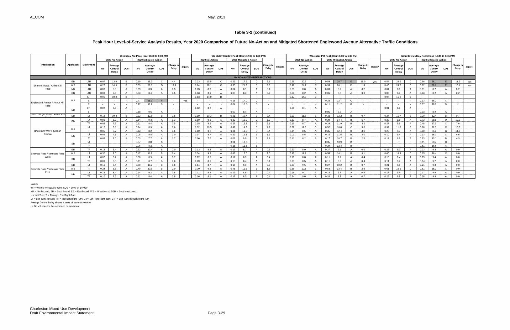
AECOM May, 2013
Charleston Mixed-Use Development Draft Environmental Impact Statement Page 3-29
Table 3-2 (continued)
Peak Hour Level-of-Service Analysis Results, Year 2020 Comparison of Future No-Action and Mitigated Shortened Englewood Avenue Alternative Traffic Conditions
EB LTR 0.07 13.9 B 0.10 18.3 C 4.4 0.23 15.5 C 0.26 17.6 C 2.1 0.29 20.7 C 0.59 38.7 E 18.0 yes 0.54 24.5 C 0.66 36.1 E 11.6 yes
WB LTR 0.22 14.9 B 0.53 28.8 D 13.9 0.24 18.1 C 0.30 21.7 C 3.6 0.42 24.7 C 0.35 26.1 D 1.4 0.45 24.2 C 0.62 39.6 E 15.4 yes
NB LTR 0.03 8.0 A 0.03 8.3 A 0.3 0.03 8.0 A 0.04 8.1 A 0.1 0.03 8.0 A 0.03 8.2 A 0.2 0.01 8.0 A 0.01 8.2 A 0.2
SB LTR 0.03 7.9 A 0.03 8.4 A 0.5 0.03 8.1 A 0.03 8.3 A 0.2 0.06 8.2 A 0.06 8.5 A 0.3 0.03 8.0 A 0.03 8.2 A 0.2
LR 0.05 10.8 B - - - - 0.13 14.0 B - - - - 0.17 14.3 B - - - - 0.07 11.8 B - - - -
L - - - 0.77 55.3 F - yes - - - 0.16 17.0 C - - - - 0.28 22.7 C - - - - 0.13 18.1 C -
R - - - 0.27 11.2 B - - - - 0.04 10.5 B - - - - 0.11 11.2 B - - - - 0.07 10.6 B -
LT 0.02 8.0 A - - - - 0.02 8.2 A - - - - 0.01 8.1 A - - - - 0.01 8.0 A - - - -
L - - - 0.18 9.6 A - - - - 0.03 8.4 A - - - - 0.05 8.5 A - - - - 0.03 8.2 A -South Bridge Street / Arthur Kill
RoadSB LT 0.18 10.8 B 0.32 12.6 B 1.8 0.19 10.3 B 0.21 10.7 B 0.4 0.29 11.5 B 0.32 12.2 B 0.7 0.27 11.7 B 0.30 12.4 B 0.7
LT 0.05 8.0 A 0.14 9.3 A 1.3 0.10 9.1 A 0.39 15.0 C 5.9 0.12 8.7 A 0.39 14.4 B 5.7 0.22 9.6 A 0.72 29.5 D 19.9
TR 0.08 7.9 A 0.11 8.4 A 0.5 0.15 9.2 A 0.27 12.3 B 3.1 0.16 8.7 A 0.29 11.9 B 3.2 0.27 9.9 A 0.48 17.5 C 7.6
LT 0.12 8.3 A 0.14 8.9 A 0.6 0.32 10.5 B 0.42 14.7 B 4.2 0.39 11.3 B 0.52 16.8 C 5.6 0.39 11.8 B 0.60 22.3 C 10.5
TR 0.06 7.7 A 0.13 8.2 A 0.5 0.10 8.2 A 0.31 11.6 B 3.4 0.14 8.5 A 0.35 12.4 B 3.9 0.20 9.3 A 0.60 21.0 C 11.7
LT 0.02 7.8 A 0.05 8.8 A 1.0 0.07 8.7 A 0.22 12.3 B 3.6 0.03 8.5 A 0.15 11.5 B 3.0 0.10 9.4 A 0.33 16.0 C 6.6
R 0.03 7.0 A 0.03 7.7 A 0.7 0.06 7.7 A 0.09 9.9 A 2.1 0.11 8.2 A 0.17 10.7 B 2.5 0.14 8.8 A 0.23 13.1 B 4.3
LT - - - 0.07 8.8 A - - - - 0.34 13.3 B - - - - 0.35 13.9 B - - - - 0.61 23.4 C -
TR - - - 0.06 8.2 A - - - - 0.28 11.8 B - - - - 0.29 12.3 B - - - - 0.51 18.5 C -
EB TR 0.13 8.4 A 0.32 10.4 B 2.0 0.13 8.4 A 0.15 8.7 A 0.3 0.23 8.9 A 0.27 9.5 A 0.6 0.23 9.3 A 0.23 9.3 A 0.0
WB LT 0.30 9.5 A 0.47 11.9 B 2.4 0.34 9.9 A 0.48 12.0 B 2.0 0.42 11.1 B 0.58 14.1 B 3.1 0.65 16.4 C 0.65 16.4 C 0.0
LT 0.07 8.2 A 0.08 8.9 A 0.7 0.12 8.5 A 0.12 8.9 A 0.4 0.11 8.8 A 0.11 9.2 A 0.4 0.13 9.4 A 0.13 9.4 A 0.0
TR 0.09 8.0 A 0.11 8.7 A 0.8 0.09 8.1 A 0.10 8.4 A 0.4 0.10 8.5 A 0.11 8.9 A 0.4 0.14 9.2 A 0.14 9.2 A 0.0
EB LT 0.11 8.4 A 0.30 10.2 B 1.8 0.14 8.7 A 0.15 9.0 A 0.3 0.23 9.5 A 0.27 10.2 B 0.7 0.21 9.8 A 0.21 9.8 A 0.0
WB TR 0.24 8.8 A 0.40 10.8 B 2.0 0.30 9.5 A 0.45 11.2 B 1.8 0.36 10.6 B 0.53 13.4 B 2.8 0.61 15.2 C 0.61 15.2 C 0.0
LT 0.12 8.4 A 0.14 9.2 A 0.8 0.11 8.5 A 0.12 8.8 A 0.4 0.16 9.1 A 0.18 9.7 A 0.5 0.17 9.6 A 0.17 9.6 A 0.0
TR 0.10 7.6 A 0.11 8.4 A 0.8 0.16 8.1 A 0.17 8.5 A 0.4 0.24 9.0 A 0.26 9.7 A 0.7 0.28 9.9 A 0.28 9.9 A 0.0
Notes:
v/c = volume-to-capacity ratio; LOS = Level-of-Service
NB = Northbound; SB = Southbound; EB = Eastbound; WB = Westbound; SEB = Southeastbound
L = Left-Turn; T = Through; R = Right-Turn;
LT = Left-Turn/Through; TR = Through/Right-Turn; LR = Left-Turn/Right-Turn; LTR = Left-Turn/Through/Right-Turn
Average Control Delay shown in units of seconds/vehicle
- = No volumes for this approach or movement.
Intersection Approach Movement
Weekday AM Peak Hour (8:00 to 9:00 AM) Weekday Midday Peak Hour (12:00 to 1:00 PM) Weekday PM Peak Hour (5:00 to 6:00 PM) Saturday Midday Peak Hour (12:45 to 1:45 PM)
2020 No-Action 2020 Mitigated-Action
Change in
DelayImpact?
v/c
Average
Control
Delay
LOS v/c
Average
Control
Delay
LOS
Change in
DelayImpact?
2020 No-Action 2020 Mitigated-Action
Change in
DelayImpact?
Average
Control
Delay
LOS
2020 No-Action 2020 Mitigated-Action
Change in
DelayImpact?
2020 No-Action 2020 Mitigated-Action
v/c
Average
Control
Delay
LOS v/c
Average
Control
Delay
LOS
Average
Control
Delay
LOS v/c
Average
Control
Delay
LOS v/cv/c
Average
Control
Delay
LOS v/c
Sharrots Road / Veterans Road
EastNB
UNSIGNALIZED INTERSECTIONS
Sharrots Road / Arthur Kill
Road
Bricktown Way / Tyrellan
Avenue
EB
Sharrots Road / Veterans Road
WestSB
WB
Englewood Avenue / Arthur Kill
Road
SB
NB
SB
WB

AECOM May, 2013
Charleston Mixed-Use Development Draft Environmental Impact Statement Page 3-30
Table 3-3
Comparison of Peak Hour Level-of-Service Analysis Results for the Year 2020 Traffic Conditions Between Alternatives and the Proposed Project
No-
Action
With-
Action
No-
Action
Alt.
Englew
ood
Avenue
Alt.
Englew
ood
Avenue
40' ROW
Alt.
Arthur
Kill
Access
Road
Alt.
No-
Action
With-
Action
No-
Action
Alt.
Englew
ood
Avenue
Alt.
Englew
ood
Avenue
40' ROW
Alt.
Arthur
Kill
Access
Road
Alt.
No-
Action
With-
Action
No-
Action
Alt.
Englew
ood
Avenue
Alt.
Englew
ood
Avenue
40' ROW
Alt.
Arthur
Kill
Access
Road
Alt.
No-
Action
With-
Action
No-
Action
Alt.
Englew
ood
Avenue
Alt.
Englew
ood
Avenue
40' ROW
Alt.
Arthur
Kill
Access
Road
Alt.
Allentown Lane-Veterans Rd West / Arthur Kill
RoadB D B E D C C D C E D D D F D F F F D F D F F F
North Bridge Street / Arthur Kill Road B B B B B B B B B B B B B B B B B B B B B B B B
Richmond Valley Road / Arthur Kill Road B B B C B B D E D E E E F F F F F F F F F F F F
Richmond Valley Road / Page Avenue B B B C B B C C C C C C C C C F C C C C C C C C
South Bridge Street / Page Avenue-Boscombe
AvenueB B B B B B B B B B B B B B B B B B B B B B B B
Veterans Road West / Bricktown Way-KWVP
westbound off-rampC D C D D D C E C E E E D E D E E E E F E F F F
Veterans Road West / Tyrellan Avenue B B B B B B C E C E E E C C C C C C D F D F F F
Boscombe Avenue / Outerbridge Crossing
rampsD D D E D D D F D F F F D F D F F F F F F F F F
Boscombe Avenue / Tyrellan Avenue B C B C C C C F C F F F D F D F F F F F F F F F
Bricktown Way / Veterans Road West A A A B A A B B B B B B B B B B B B B B B B B B
Englewood Avenue / Veterans Road West B D B B D D B D B B D D B C B B C C C F C D F F
Englewood Avenue / Veterans Road East B B B B B B B B B B B B B C B C C C D F D F F F
Englewood Avenue / Bloomingdale Road A B A B B B B B B B B B B B B B B B B B B B B B
Sharrotts Road / Bloomingdale Road B B B B B B B B B B B B B B B B B B B C B C C C
Veterans Road East-Drumgoole Road West /
Bloomingdale RoadC C C C C C C C C C C C C C C C C C C D C D D D
South Service Road-Drumgoole Road East /
Bloomingdale RoadB B B B B B A B A B B B B B B B B B B B B B B B
Pleasant Plains Avenue-Amboy Road /
Bloomingdale RoadD E D D E E C C C C C C C C C C C C C C C C C C
Arthur Kill Road / Bloomingdale Road B C B C C C B C B C C C B E B E E E C F C F F F
Sharrots Road / Arthur Kill Road B C B D C C C C C C C C C D C E D D C D C E D D
Englewood Avenue / Arthur Kill Road B E B F E E B C B C C C B D B C D D C D C C D D
South Bridge Street / Arthur Kill Road B B B B B B B B B B B B B B B B B B B B B B B B
Bricktown Way / Tyrellan Avenue A A A A A A B C B C C C B C B C C C B D B D D D
Sharrots Road / Veterans Road West A B A B B B A B A B B B B B B B B B B C B C C C
Sharrots Road / Veterans Road East A A A B A A A B A B B B B B B B B B B B B C B B
Notes:
1) For signalized intersections, the overall LOS for intersection as a whole is shown.
2) For unsignalized intersections, the LOS for the critical movement (i.e., the stop-controlled movement with the highest delay) is shown.
Weekday PM Peak Hour Saturday Midday Peak Hour
UNSIGNALIZED INTERSECTIONS: CRITICAL MOVEMENT LOS2
SIGNALIZED INTERSECTIONS: OVERALL INTERSECTION LOS1
Intersection
(8:00 to 9:00 AM) (12:00 to 1:00 PM) (5:00 to 6:00 PM) (12:45 to 1:45 PM)
Weekday AM Peak Hour Weekday Midday Peak Hour
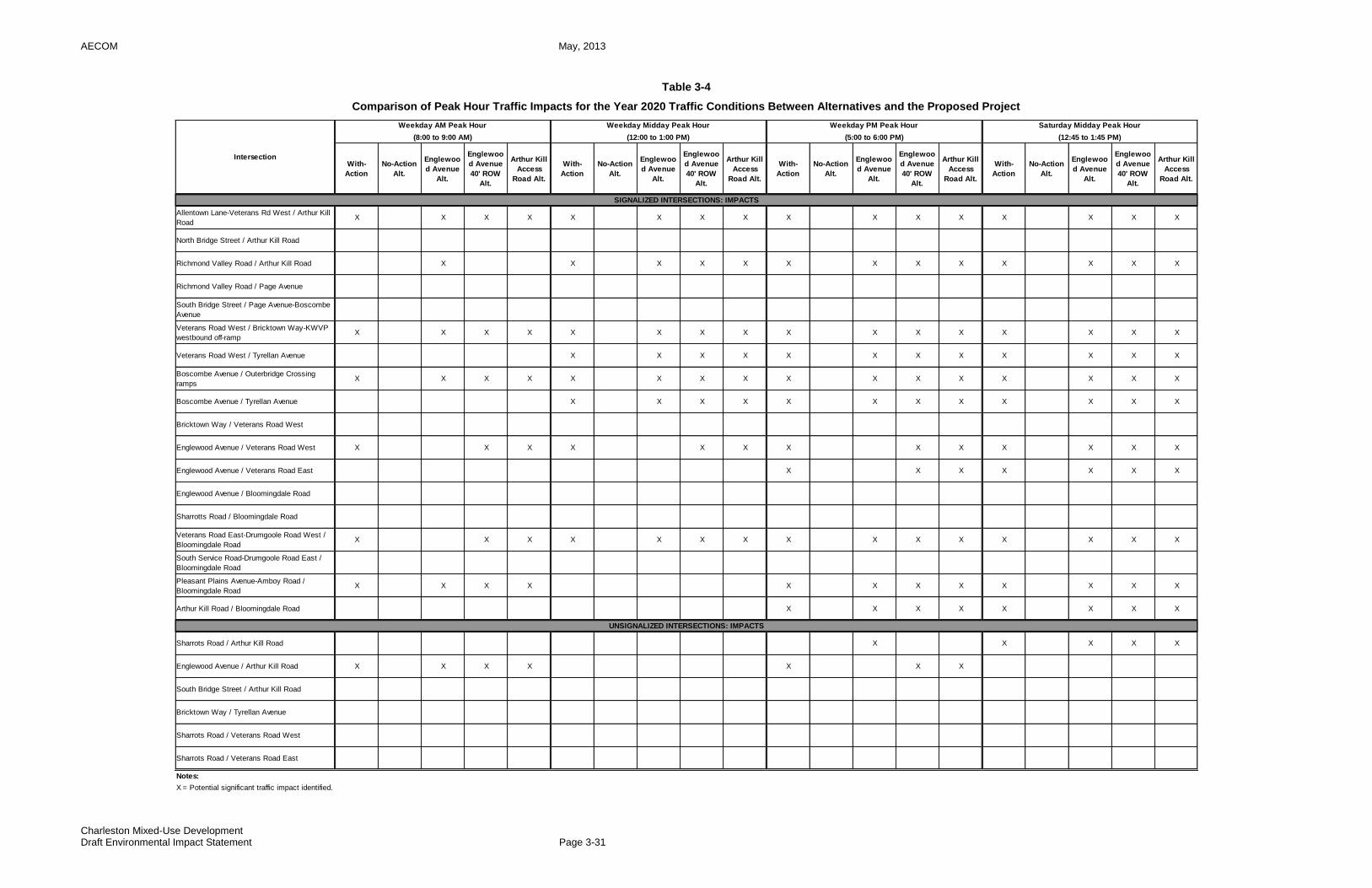
AECOM May, 2013
Charleston Mixed-Use Development Draft Environmental Impact Statement Page 3-31
Table 3-4
Comparison of Peak Hour Traffic Impacts for the Year 2020 Traffic Conditions Between Alternatives and the Proposed Project
With-
Action
No-Action
Alt.
Englewoo
d Avenue
Alt.
Englewoo
d Avenue
40' ROW
Alt.
Arthur Kill
Access
Road Alt.
With-
Action
No-Action
Alt.
Englewoo
d Avenue
Alt.
Englewoo
d Avenue
40' ROW
Alt.
Arthur Kill
Access
Road Alt.
With-
Action
No-Action
Alt.
Englewoo
d Avenue
Alt.
Englewoo
d Avenue
40' ROW
Alt.
Arthur Kill
Access
Road Alt.
With-
Action
No-Action
Alt.
Englewoo
d Avenue
Alt.
Englewoo
d Avenue
40' ROW
Alt.
Arthur Kill
Access
Road Alt.
Allentown Lane-Veterans Rd West / Arthur Kill
RoadX X X X X X X X X X X X X X X X
North Bridge Street / Arthur Kill Road
Richmond Valley Road / Arthur Kill Road X X X X X X X X X X X X X
Richmond Valley Road / Page Avenue
South Bridge Street / Page Avenue-Boscombe
Avenue
Veterans Road West / Bricktown Way-KWVP
westbound off-rampX X X X X X X X X X X X X X X X
Veterans Road West / Tyrellan Avenue X X X X X X X X X X X X
Boscombe Avenue / Outerbridge Crossing
rampsX X X X X X X X X X X X X X X X
Boscombe Avenue / Tyrellan Avenue X X X X X X X X X X X X
Bricktown Way / Veterans Road West
Englewood Avenue / Veterans Road West X X X X X X X X X X X X X
Englewood Avenue / Veterans Road East X X X X X X X
Englewood Avenue / Bloomingdale Road
Sharrotts Road / Bloomingdale Road
Veterans Road East-Drumgoole Road West /
Bloomingdale RoadX X X X X X X X X X X X X X X
South Service Road-Drumgoole Road East /
Bloomingdale Road
Pleasant Plains Avenue-Amboy Road /
Bloomingdale RoadX X X X X X X X X X X X
Arthur Kill Road / Bloomingdale Road X X X X X X X X
Sharrots Road / Arthur Kill Road X X X X X
Englewood Avenue / Arthur Kill Road X X X X X X X
South Bridge Street / Arthur Kill Road
Bricktown Way / Tyrellan Avenue
Sharrots Road / Veterans Road West
Sharrots Road / Veterans Road East
Notes:
X = Potential significant traffic impact identified.
SIGNALIZED INTERSECTIONS: IMPACTS
UNSIGNALIZED INTERSECTIONS: IMPACTS
Weekday AM Peak Hour Weekday Midday Peak Hour Weekday PM Peak Hour Saturday Midday Peak Hour
Intersection
(8:00 to 9:00 AM) (12:00 to 1:00 PM) (5:00 to 6:00 PM) (12:45 to 1:45 PM)
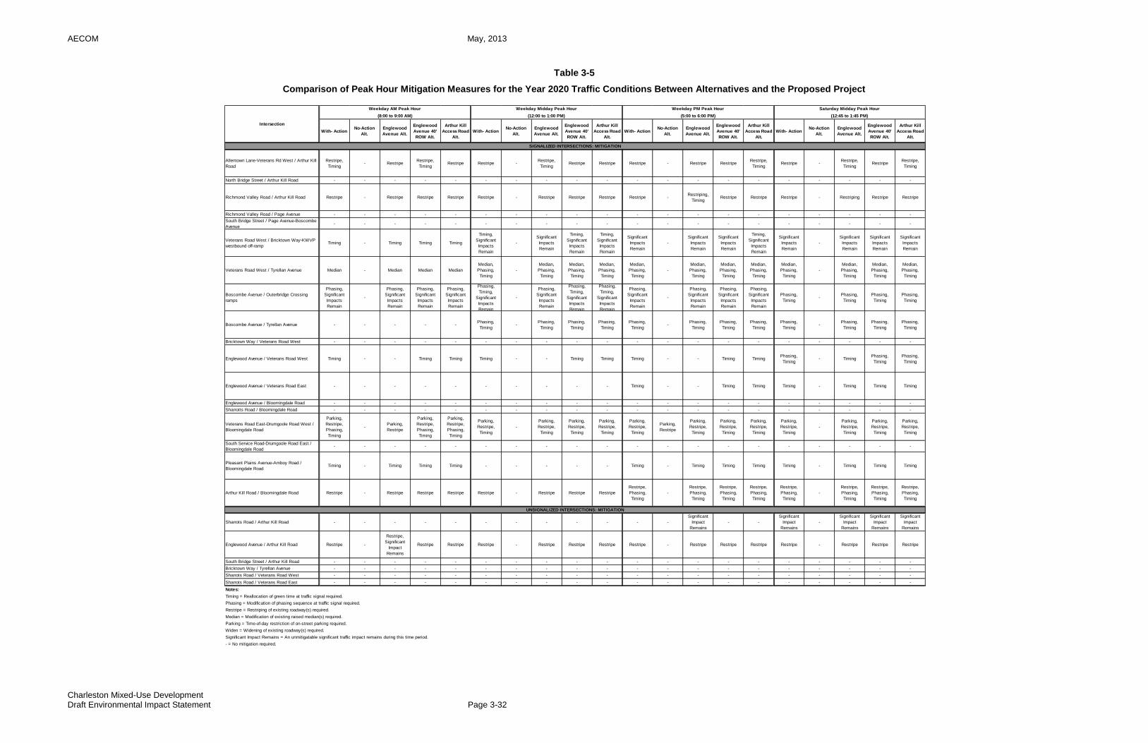
AECOM May, 2013
Charleston Mixed-Use Development Draft Environmental Impact Statement Page 3-32
Table 3-5
Comparison of Peak Hour Mitigation Measures for the Year 2020 Traffic Conditions Between Alternatives and the Proposed Project
With- ActionNo-Action
Alt.
Englewood
Avenue Alt.
Englewood
Avenue 40'
ROW Alt.
Arthur Kill
Access Road
Alt.
With- ActionNo-Action
Alt.
Englewood
Avenue Alt.
Englewood
Avenue 40'
ROW Alt.
Arthur Kill
Access Road
Alt.
With- ActionNo-Action
Alt.
Englewood
Avenue Alt.
Englewood
Avenue 40'
ROW Alt.
Arthur Kill
Access Road
Alt.
With- ActionNo-Action
Alt.
Englewood
Avenue Alt.
Englewood
Avenue 40'
ROW Alt.
Arthur Kill
Access Road
Alt.
Allentown Lane-Veterans Rd West / Arthur Kill
Road
Restripe,
Timing- Restripe
Restripe,
TimingRestripe Restripe -
Restripe,
TimingRestripe Restripe Restripe - Restripe Restripe
Restripe,
TimingRestripe -
Restripe,
TimingRestripe
Restripe,
Timing
North Bridge Street / Arthur Kill Road - - - - - - - - - - - - - - - - - - - -
Richmond Valley Road / Arthur Kill Road Restripe - Restripe Restripe Restripe Restripe - Restripe Restripe Restripe Restripe -Restriping,
TimingRestripe Restripe Restripe - Restriping Restripe Restripe
Richmond Valley Road / Page Avenue - - - - - - - - - - - - - - - - - - - -
South Bridge Street / Page Avenue-Boscombe
Avenue- - - - - - - - - - - - - - - - - - - -
Veterans Road West / Bricktown Way-KWVP
westbound off-rampTiming - Timing Timing Timing
Timing,
Significant
Impacts
Remain
-
Significant
Impacts
Remain
Timing,
Significant
Impacts
Remain
Timing,
Significant
Impacts
Remain
Significant
Impacts
Remain
-
Significant
Impacts
Remain
Significant
Impacts
Remain
Timing,
Significant
Impacts
Remain
Significant
Impacts
Remain
-
Significant
Impacts
Remain
Significant
Impacts
Remain
Significant
Impacts
Remain
Veterans Road West / Tyrellan Avenue Median - Median Median Median
Median,
Phasing,
Timing
-
Median,
Phasing,
Timing
Median,
Phasing,
Timing
Median,
Phasing,
Timing
Median,
Phasing,
Timing
-
Median,
Phasing,
Timing
Median,
Phasing,
Timing
Median,
Phasing,
Timing
Median,
Phasing,
Timing
-
Median,
Phasing,
Timing
Median,
Phasing,
Timing
Median,
Phasing,
Timing
Boscombe Avenue / Outerbridge Crossing
ramps
Phasing,
Significant
Impacts
Remain
-
Phasing,
Significant
Impacts
Remain
Phasing,
Significant
Impacts
Remain
Phasing,
Significant
Impacts
Remain
Phasing,
Timing,
Significant
Impacts
Remain
-
Phasing,
Significant
Impacts
Remain
Phasing,
Timing,
Significant
Impacts
Remain
Phasing,
Timing,
Significant
Impacts
Remain
Phasing,
Significant
Impacts
Remain
-
Phasing,
Significant
Impacts
Remain
Phasing,
Significant
Impacts
Remain
Phasing,
Significant
Impacts
Remain
Phasing,
Timing-
Phasing,
Timing
Phasing,
Timing
Phasing,
Timing
Boscombe Avenue / Tyrellan Avenue - - - - -Phasing,
Timing-
Phasing,
Timing
Phasing,
Timing
Phasing,
Timing
Phasing,
Timing-
Phasing,
Timing
Phasing,
Timing
Phasing,
Timing
Phasing,
Timing-
Phasing,
Timing
Phasing,
Timing
Phasing,
Timing
Bricktown Way / Veterans Road West - - - - - - - - - - - - - - - - - - - -
Englewood Avenue / Veterans Road West Timing - - Timing Timing Timing - - Timing Timing Timing - - Timing TimingPhasing,
Timing- Timing
Phasing,
Timing
Phasing,
Timing
Englewood Avenue / Veterans Road East - - - - - - - - - - Timing - - Timing Timing Timing - Timing Timing Timing
Englewood Avenue / Bloomingdale Road - - - - - - - - - - - - - - - - - - - -
Sharrotts Road / Bloomingdale Road - - - - - - - - - - - - - - - - - - - -
Veterans Road East-Drumgoole Road West /
Bloomingdale Road
Parking,
Restripe,
Phasing,
Timing
-Parking,
Restripe
Parking,
Restripe,
Phasing,
Timing
Parking,
Restripe,
Phasing,
Timing
Parking,
Restripe,
Timing
-
Parking,
Restripe,
Timing
Parking,
Restripe,
Timing
Parking,
Restripe,
Timing
Parking,
Restripe,
Timing
Parking,
Restripe
Parking,
Restripe,
Timing
Parking,
Restripe,
Timing
Parking,
Restripe,
Timing
Parking,
Restripe,
Timing
-
Parking,
Restripe,
Timing
Parking,
Restripe,
Timing
Parking,
Restripe,
Timing
South Service Road-Drumgoole Road East /
Bloomingdale Road- - - - - - - - - - - - - - - - - - - -
Pleasant Plains Avenue-Amboy Road /
Bloomingdale RoadTiming - Timing Timing Timing - - - - - Timing - Timing Timing Timing Timing - Timing Timing Timing
Arthur Kill Road / Bloomingdale Road Restripe - Restripe Restripe Restripe Restripe - Restripe Restripe Restripe
Restripe,
Phasing,
Timing
-
Restripe,
Phasing,
Timing
Restripe,
Phasing,
Timing
Restripe,
Phasing,
Timing
Restripe,
Phasing,
Timing
-
Restripe,
Phasing,
Timing
Restripe,
Phasing,
Timing
Restripe,
Phasing,
Timing
Sharrots Road / Arthur Kill Road - - - - - - - - - - - -
Significant
Impact
Remains
- -
Significant
Impact
Remains
-
Significant
Impact
Remains
Significant
Impact
Remains
Significant
Impact
Remains
Englewood Avenue / Arthur Kill Road Restripe -
Restripe,
Significant
Impact
Remains
Restripe Restripe Restripe - Restripe Restripe Restripe Restripe - Restripe Restripe Restripe Restripe - Restripe Restripe Restripe
South Bridge Street / Arthur Kill Road - - - - - - - - - - - - - - - - - - - -
Bricktown Way / Tyrellan Avenue - - - - - - - - - - - - - - - - - - - -
Sharrots Road / Veterans Road West - - - - - - - - - - - - - - - - - - - -
Sharrots Road / Veterans Road East - - - - - - - - - - - - - - - - - - - -
Notes:
Timing = Reallocation of green time at traffic signal required.
Phasing = Modification of phasing sequence at traffic signal required.
Restripe = Restriping of existing roadway(s) required.
Median = Modification of existing raised median(s) required.
Parking = Time-of-day restriction of on-street parking required.
Widen = Widening of existing roadway(s) required.
Significant Impact Remains = An unmitigatable significant traffic impact remains during this time period.
- = No mitigation required.
SIGNALIZED INTERSECTIONS: MITIGATION
UNSIGNALIZED INTERSECTIONS: MITIGATION
Intersection
Weekday AM Peak Hour Weekday Midday Peak Hour Weekday PM Peak Hour Saturday Midday Peak Hour
(8:00 to 9:00 AM) (12:00 to 1:00 PM) (5:00 to 6:00 PM) (12:45 to 1:45 PM)
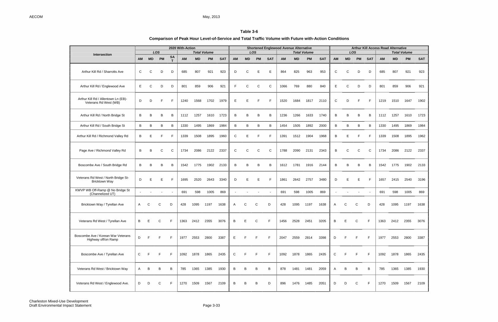
AECOM May, 2013
Charleston Mixed-Use Development Draft Environmental Impact Statement Page 3-33
Table 3-6
Comparison of Peak Hour Level-of-Service and Total Traffic Volume with Future with-Action Conditions
Intersection
2020 With-Action Shortened Englewood Avenue Alternative Arthur Kill Access Road Alternative
LOS Total Volume LOS Total Volume LOS Total Volume
AM MD PM SAT
AM MD PM SAT AM MD PM SAT AM MD PM SAT AM MD PM SAT AM MD PM SAT
Arthur Kill Rd / Sharrotts Ave C C D D 685 807 921 923 D C E E 864 825 963 953 C C D D 685 807 921 923
Arthur Kill Rd / Englewood Ave E C D D 801 859 906 921 F C C C 1066 769 880 840 E C D D 801 859 906 921
Arthur Kill Rd / Allentown Ln (EB)-Veterans Rd West (WB)
D D F F 1240 1568 1702 1979 E E F F 1520 1684 1817 2110 C D F F 1219 1510 1647 1902
Arthur Kill Rd / North Bridge St B B B B 1112 1257 1610 1723 B B B B 1236 1266 1633 1740 B B B B 1112 1257 1610 1723
Arthur Kill Rd / South Bridge St B B B B 1330 1495 1869 1984 B B B B 1454 1505 1892 2000 B B B B 1330 1495 1869 1984
Arthur Kill Rd / Richmond Valley Rd B E F F 1339 1508 1895 1960 C E F F 1391 1512 1904 1968 B E F F 1339 1508 1895 1962
Page Ave / Richmond Valley Rd B B C C 1734 2086 2122 2337 C C C C 1788 2090 2131 2343 B C C C 1734 2086 2122 2337
Boscombe Ave / South Bridge Rd B B B B 1542 1775 1902 2133 B B B B 1612 1781 1916 2144 B B B B 1542 1775 1902 2133
Veterans Rd West / North Bridge St-Bricktown Way
D E E F 1695 2520 2643 3340 D E E F 1861 2642 2757 3480 D E E F 1657 2415 2540 3196
KWVP WB Off-Ramp @ No Bridge St (Channelized UT)
- - - - 691 598 1005 869 - - - - 691 598 1005 869 - - - - 691 598 1005 869
Bricktown Way / Tyrellan Ave A C C D 428 1095 1197 1638 A C C D 428 1095 1197 1638 A C C D 428 1095 1197 1638
Veterans Rd West / Tyrellan Ave B E C F 1363 2412 2355 3076 B E C F 1456 2528 2451 3205 B E C F 1363 2412 2355 3076
Boscombe Ave / Korean War Veterans Highway off/on Ramp
D F F F 1977 2553 2800 3387 E F F F 2047 2559 2814 3398 D F F F 1977 2553 2800 3387
Boscombe Ave / Tyrellan Ave C F F F 1092 1878 1865 2435 C F F F 1092 1878 1865 2435 C F F F 1092 1878 1865 2435
Veterans Rd West / Bricktown Way A B B B 785 1365 1385 1930 B B B B 878 1481 1481 2059 A B B B 785 1365 1385 1930
Veterans Rd West / Englewood Ave. D D C F 1270 1509 1567 2109 B B B D 896 1476 1485 2051 D D C F 1270 1509 1567 2109

AECOM May, 2013
Charleston Mixed-Use Development Draft Environmental Impact Statement Page 3-34
Intersection
2020 With-Action Shortened Englewood Avenue Alternative Arthur Kill Access Road Alternative
LOS Total Volume LOS Total Volume LOS Total Volume
AM MD PM SAT
AM MD PM SAT AM MD PM SAT AM MD PM SAT AM MD PM SAT AM MD PM SAT
Sharrotts Rd / SB West Shore Pkwy SR (Veterans Rd W)
B B B C 439 504 621 682 B B B C 574 512 646 699 B B B C 439 504 621 682
Sharrotts Rd / NB West Shore Pkwy SR (Veteran Rd E)
A B B B 440 548 731 773 B B B C 575 556 756 789 A B B B 440 548 731 773
Veterans Rd East / Englewood Rd B B C F 1088 1233 1316 1699 B B C F 757 1209 1249 1654 B B C F 1088 1233 1316 1699
Bloomingdale Rd / Englewood Ave B B B B 1106 941 1296 1261 B B B B 971 933 1271 1244 B B B B 1106 941 1296 1261
Sharrotts Rd / Bloomingdale Rd B B B C 1159 1159 1550 1611 B B B C 1159 1159 1550 1610 B B B C 1159 1159 1550 1611
Bloomingdale Rd / Drumgoole Rd West C C C D 1831 1672 2046 2139 C C C D 1635 1656 2004 2111 C C C D 1831 1672 2046 2139
Bloomingdale Rd / Drumgoole Rd East B B B B 1328 1170 1438 1493 B B B B 1204 1160 1415 1476 B B B B 1328 1170 1438 1493
Bloomingdale Rd / Amboy Rd (WB)-Pleasant Plains Ave (EB)
E C C C 1192 1396 1519 1598 D C C C 1138 1392 1510 1592 E C C C 1192 1396 1519 1598
Bloomingdale Rd / Arthur Kill Rd C C E F 1184 1171 1248 1379 C C E F 1184 1171 1248 1379 C C E F 1184 1171 1248 1379
Note: Intersections bolded indicate those intersections that would witness different traffic volumes and air quality emissions under this alternative than under the Proposed Project.

AECOM May, 2013
Charleston Mixed-Use Development Draft Environmental Impact Statement Page 3-35
Table 3-7
Differences in Peak Hour Level-of-Service and Incremental Traffic Volume as Compared to Future with-Action Conditions
Intersection
Shortened Englewood Avenue Alternative Arthur Kill Access Road Alternative
Change in LOS Change in Total Volume Change in LOS Change in Total Volume
AM MD PM SAT AM MD PM SAT AM MD PM SAT AM MD PM SAT
Arthur Kill Rd / Sharrotts Ave C->D no
change D->E D->E 179 18 42 30
no change
no change
no change
no change
0 0 0 0
Arthur Kill Rd / Englewood Ave E->F no
change D->C D->C 265 -90 -26 -81
no change
no change
no change
no change
0 0 0 0
Arthur Kill Rd / Allentown Ln (EB)-Veterans Rd West (WB)
D->E D->E No
change No
change 280 116 115 131 D->C
no change
no change
no change
-21 -58 -55 -77
Arthur Kill Rd / North Bridge St no
change no
change no
change no
change 124 9 23 17
no change
no change
no change
no change
0 0 0 0
Arthur Kill Rd / South Bridge St no
change no
change no
change no
change 124 10 23 16
no change
no change
no change
no change
0 0 0 0
Arthur Kill Rd / Richmond Valley Rd B->C no
change no
change no
change 52 4 9 8
no change
no change
no change
no change
0 0 0 2
Page Ave / Richmond Valley Rd B->C B->C C->F no
change 54 4 9 6
no change
B->C no
change no
change 0 0 0 0
Boscombe Ave / South Bridge Rd no
change no
change no
change no
change 70 6 14 11
no change
no change
no change
no change
0 0 0 0
Veterans Rd West / North Bridge St-Bricktown Way
no change
no change
no change
no change
166 122 114 140 no
change no
change no
change no
change -38 -105 -103 -144
KWVP WB Off-Ramp @ No Bridge St (Channelized UT)
no change
no change
no change
no change
0 0 0 0 no
change no
change no
change no
change 0 0 0 0
Bricktown Way / Tyrellan Ave no
change no
change no
change no
change 0 0 0 0
no change
no change
no change
no change
0 0 0 0
Veterans Rd West / Tyrellan Ave no
change no
change no
change no
change 93 116 96 129
no change
no change
no change
no change
0 0 0 0
Boscombe Ave / Korean War Veterans Highway off/on Ramp
D->E no
change no
change no
change 70 6 14 11
no change
no change
no change
no change
0 0 0 0
Boscombe Ave / Tyrellan Ave no
change no
change no
change no
change 0 0 0 0
no change
no change
no change
no change
0 0 0 0
Veterans Rd West / Bricktown Way A->B no
change no
change no
change 93 116 96 129
no change
no change
no change
no change
0 0 0 0
Veterans Rd West / Englewood Rd D->B D->B C->B F->D -374 -33 -82 -58 no
change no
change no
change no
change 0 0 0 0

AECOM May, 2013
Charleston Mixed-Use Development Draft Environmental Impact Statement Page 3-36
Intersection
Shortened Englewood Avenue Alternative Arthur Kill Access Road Alternative
Change in LOS Change in Total Volume Change in LOS Change in Total Volume
AM MD PM SAT AM MD PM SAT AM MD PM SAT AM MD PM SAT
Sharrotts Rd / SB West Shore Pkwy SR (Veterans Rd W)
no change
no change
no change
no change
135 8 25 17 no
change no
change no
change no
change 0 0 0 0
Sharrotts Rd / NB West Shore Pkwy SR (Veteran Rd E)
A->B no
change no
change B->C 135 8 25 16
no change
no change
no change
no change
0 0 0 0
Veterans Rd East / Englewood Rd no
change no
change no
change no
change -331 -24 -67 -45
no change
no change
no change
no change
0 0 0 0
Bloomingdale Rd / Englewood Ave no
change no
change no
change no
change -135 -8 -25 -17
no change
no change
no change
no change
0 0 0 0
Sharrotts Rd / Bloomingdale Rd no
change no
change no
change no
change 0 0 0 -1
no change
no change
no change
no change
0 0 0 0
Bloomingdale Rd / Drumgoole Rd West no
change no
change no
change no
change -196 -16 -42 -28
no change
no change
no change
no change
0 0 0 0
Bloomingdale Rd / Drumgoole Rd East no
change no
change no
change no
change -124 -10 -23 -17
no change
no change
no change
no change
0 0 0 0
Bloomingdale Rd / Amboy Rd (WB)-Pleasant Plains Ave (EB)
E->D no
change no
change no
change -54 -4 -9 -6
no change
no change
no change
no change
0 0 0 0
Bloomingdale Rd / Arthur Kill Rd no
change no
change no
change no
change 0 0 0 0
no change
no change
no change
no change
0 0 0 0
Note: Intersections bolded indicate those intersections that would witness different traffic volumes and air quality emissions under this alternative than under the Proposed Project.

AECOM May, 2013
Charleston Mixed-Use Development Draft Environmental Impact Statement Page 3-37
PAGE LEFT BLANK
AECOM May, 2013
Charleston Mixed-Use Development Draft Environmental Impact Statement Page 3-38
3.4 40-FOOT WIDE ENGLEWOOD AVENUE ALTERNATIVE
By the year 2020, under the Proposed Project, Englewood Avenue would be fully mapped and constructed within an approximately 80-foot wide right-of-way across the northern border of the Project Area from Veterans Road West on the east to Arthur Kill Road on the west. Under the Proposed Project, the fully-constructed length of Englewood Avenue, which would include bicycle and pedestrian facilities, would be approximately 3,265 feet (approximately 5.9 acres). This alternative assumes that Englewood Avenue would be mapped and constructed as proposed from Arthur Kill Road east to Veterans Road West. However, east of its current terminus at the un-built Kent Street, Englewood Avenue would taper down to a 40-foot wide roadway, as shown in Figure 3-2 previously provided. This portion of the proposed Englewood Avenue, extending approximately 1,465 feet west from Kent Street to Veterans Road West, is already mapped to a width of 80 feet. However, under this alternative, the constructed roadway would occupy only 40 feet of the mapped 80-foot width, with one travel lane provided in each direction, compared to two travel lanes under the Proposed Project. The remaining approximately 1,800 feet of Englewood Avenue west of Kent Street that would be mapped and constructed to 80 feet in width as part of the Proposed Project would remain the same under this alternative. Within the existing 80-foot wide mapped portion of Englewood Avenue, an area of approximately 45 feet deep of the mapped roadway bed, extending for approximately 1,488 feet westward from Veterans Road West, is owned by the State of New York. In order to construct Englewood Avenue to the full existing mapped width of 80 feet, a transfer of ownership of this area from the State to the City is required. There is no current acquisition agreement with the State. Due to its reduced width, this alternative build-out of Englewood Avenue would require less state-owned property to be transferred to the City than would be required under the Proposed Project. The remainder of the proposed developments would be constructed as planned under the Proposed Project. The proposed retail stores, park, senior housing and school would still be constructed by the 2015 and 2020 analysis years within the Development Area. The 40-foot Wide Englewood Avenue Alternative would not alter the findings for the majority of the technical areas discussed for the Proposed Project, with the exception of the technical areas of Historic and Cultural Resources, Natural Resources, Water and Sewer Infrastructure, Transportation, and Construction, which are further discussed below. Historic and Cultural Resources This alternative has the potential to minimize some of the potential significant adverse impacts on one archaeological site that would occur with the Proposed Project. As previously noted in Chapter 2.6, construction within this portion of the Project Area by 2020 has the potential to disturb or destroy one prehistoric archaeological site that was identified through prior archaeological survey work, resulting in potential adverse impacts to archaeological resources. At Site A7-MCB-1 (NYS Site A08501.002767), this prehistoric site was located during the Phase IB survey on a small, pronounced knoll or hill with a flat summit just south of the proposed route of Englewood Avenue. The site, which covers an area of approximately 65 feet by 25 feet, is considered to be archaeologically significant. The completion of that portion of Englewood Avenue and the pedestrian/bicycle path along the northern boundary of the Conservation Area has the potential to adversely impact this prehistoric site. It is also possible that other remains of prehistoric occupation are present in the 80-foot wide roadway corridor where Englewood Avenue is to be extended. Construction activities associated with the completion of the Englewood Avenue extension and construction of the pedestrian/bicycle path likely include cutting, filling, grading, paving, and installation of public services and utility lines. All these activities have the potential to adversely impact intact archaeological resources that may be present along this linear corridor. Under this 40-foot wide alternative for Englewood Avenue, roadway construction would be limited in width, and
AECOM May, 2013
Charleston Mixed-Use Development Draft Environmental Impact Statement Page 3-39
thus the potential for impacts at this location would be lower than under the Proposed Project. All of the other development components would still be constructed on the Development Area. Natural Resources This alternative would reduce some of the potential significant adverse impacts on natural resources relative to the Proposed Project, as identified in Chapter 2.8, within the area where Englewood Avenue is proposed to be extended eastward along the existing mapped portion to Veterans Road West. This area is not developed and is currently in its natural state with trees and wetlands. The development of Englewood Avenue under the 80-foot wide concept plan would impact approximately 0.07 acres of NYSDEC-regulated wetlands and USACE jurisdictional wetlands. Under this alternative of a 40-foot wide roadway, the impacts would be reduced to approximately 0.05 acres. Actions to mitigate the impacts to these regulated and jurisdictional wetlands under this alternative would still be required by regulatory agencies. This alternative would still directly impact wildlife that use the area between the CPPSPP and the Conservation Area, as the 40-foot wide roadway would serve as an impediment to fauna transiting between the parcels, as it would under the Proposed Project and 80-foot wide roadway. Thus the impacts wildlife to the adjacent Conservation Area and CPPSPP under this alternative would be the same as the Proposed Project. Under this alternative, approximately 170 surveyed trees over a six-inch diameter breast height (dbh) would be removed, as compared to the expected 319 surveyed trees under the 80-foot wide roadway of the Proposed Project. The implementation of this alternative would also remove approximately 0.22 acres of red-maple sweetgum swamp, as compared to 0.26 acres under the Proposed Project. However, all of the other noted potential significant adverse impacts to Natural Resources in the remainder of the Development Area would remain and not change under this alternative. Water and Sewer Infrastructure The findings of the water and sewer infrastructure analysis for the Proposed Project provided in Chapter 2.10 would not be significantly changed under this alternative. All of the other development components would still be constructed on the retail, park, senior housing and school sites, which are the components that would require potable water and generate sanitary sewer waste. Stormwater runoff from Englewood Avenue would be reduced, as the construction of the 40-foot wide Englewood Avenue would generate less stormwater run-off from impervious surfaces than an 80-foot wide roadway, resulting in potential refinements in the amendments to the NYCDEP drainage plan for this area (see Chapter 2.10 for further details). Transportation The findings for transportation from the analysis for the Proposed Project provided in Chapter 2.13 would not change under this alternative. All of the Proposed Project’s other components would still be constructed on the retail, park, senior housing and school sites. Under this alternative, this section of the 40-foot wide Englewood Avenue would contain one travel lane in each direction, as compared to two travel lanes under the Proposed Project. However, significant adverse impacts to vehicular traffic are not expected regardless of whether or not this alternative occurs. This type of 40-foot wide roadway segment can accommodate expected future traffic volumes, including existing traffic diverting to this new roadway segment and trips generated by the Proposed Project’s school and senior housing sites accessed from Englewood Avenue. To ensure a conservative approach, the traffic analysis of the Proposed Project presented in Chapter 2.13 conservatively assumed only one travel lane in each direction on the eastbound approach of the Englewood Avenue/Veterans Road West intersection. Those analyses demonstrate that the projected future traffic volumes heading east from the Project Area on Englewood Avenue or west from Veterans Road West toward the Project Area could be accommodated with acceptable traffic operations at the Englewood Avenue/Veterans Road West intersection. No significant
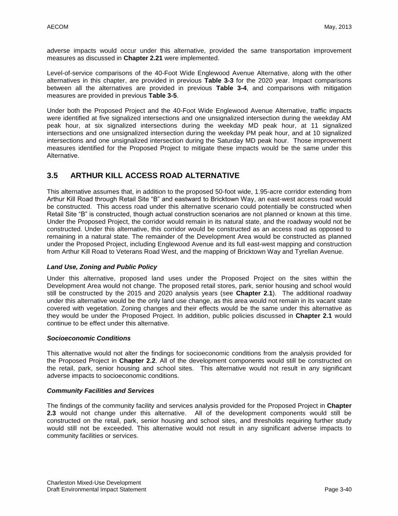
AECOM May, 2013
Charleston Mixed-Use Development Draft Environmental Impact Statement Page 3-40
adverse impacts would occur under this alternative, provided the same transportation improvement measures as discussed in Chapter 2.21 were implemented. Level-of-service comparisons of the 40-Foot Wide Englewood Avenue Alternative, along with the other alternatives in this chapter, are provided in previous Table 3-3 for the 2020 year. Impact comparisons between all the alternatives are provided in previous Table 3-4, and comparisons with mitigation measures are provided in previous Table 3-5. Under both the Proposed Project and the 40-Foot Wide Englewood Avenue Alternative, traffic impacts were identified at five signalized intersections and one unsignalized intersection during the weekday AM peak hour, at six signalized intersections during the weekday MD peak hour, at 11 signalized intersections and one unsignalized intersection during the weekday PM peak hour, and at 10 signalized intersections and one unsignalized intersection during the Saturday MD peak hour. Those improvement measures identified for the Proposed Project to mitigate these impacts would be the same under this Alternative.
3.5 ARTHUR KILL ACCESS ROAD ALTERNATIVE
This alternative assumes that, in addition to the proposed 50-foot wide, 1.95-acre corridor extending from Arthur Kill Road through Retail Site “B” and eastward to Bricktown Way, an east-west access road would be constructed. This access road under this alternative scenario could potentially be constructed when Retail Site “B” is constructed, though actual construction scenarios are not planned or known at this time. Under the Proposed Project, the corridor would remain in its natural state, and the roadway would not be constructed. Under this alternative, this corridor would be constructed as an access road as opposed to remaining in a natural state. The remainder of the Development Area would be constructed as planned under the Proposed Project, including Englewood Avenue and its full east-west mapping and construction from Arthur Kill Road to Veterans Road West, and the mapping of Bricktown Way and Tyrellan Avenue.
Land Use, Zoning and Public Policy
Under this alternative, proposed land uses under the Proposed Project on the sites within the Development Area would not change. The proposed retail stores, park, senior housing and school would still be constructed by the 2015 and 2020 analysis years (see Chapter 2.1). The additional roadway under this alternative would be the only land use change, as this area would not remain in its vacant state covered with vegetation. Zoning changes and their effects would be the same under this alternative as they would be under the Proposed Project. In addition, public policies discussed in Chapter 2.1 would continue to be effect under this alternative. Socioeconomic Conditions This alternative would not alter the findings for socioeconomic conditions from the analysis provided for the Proposed Project in Chapter 2.2. All of the development components would still be constructed on the retail, park, senior housing and school sites. This alternative would not result in any significant adverse impacts to socioeconomic conditions. Community Facilities and Services The findings of the community facility and services analysis provided for the Proposed Project in Chapter 2.3 would not change under this alternative. All of the development components would still be constructed on the retail, park, senior housing and school sites, and thresholds requiring further study would still not be exceeded. This alternative would not result in any significant adverse impacts to community facilities or services.
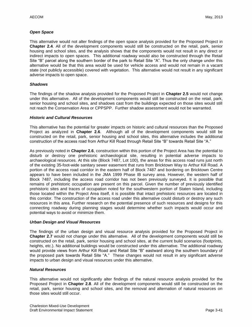
AECOM May, 2013
Charleston Mixed-Use Development Draft Environmental Impact Statement Page 3-41
Open Space This alternative would not alter findings of the open space analysis provided for the Proposed Project in Chapter 2.4. All of the development components would still be constructed on the retail, park, senior housing and school sites, and the analysis shows that the components would not result in any direct or indirect impacts to open spaces. This additional roadway would also be constructed through the Retail Site “B” parcel along the southern border of the park to Retail Site “A”. Thus the only change under this alternative would be that this area would be used for vehicle access and would not remain in a vacant state (not publicly accessible) covered with vegetation. This alternative would not result in any significant adverse impacts to open space. Shadows The findings of the shadow analysis provided for the Proposed Project in Chapter 2.5 would not change under this alternative. All of the development components would still be constructed on the retail, park, senior housing and school sites, and shadows cast from the buildings expected on those sites would still not reach the Conservation Area or CPPSPP. Further shadow assessment would not be warranted. Historic and Cultural Resources This alternative has the potential for greater impacts on historic and cultural resources than the Proposed Project as analyzed in Chapter 2.6. Although all of the development components would still be constructed on the retail, park, senior housing and school sites, this alternative includes the additional construction of the access road from Arthur Kill Road through Retail Site “B” towards Retail Site “A.” As previously noted in Chapter 2.6, construction within this portion of the Project Area has the potential to disturb or destroy one prehistoric archaeological site, resulting in potential adverse impacts to archaeological resources. At this site (Block 7487, Lot 100), the areas for this access road runs just north of the existing 35-foot-wide sanitary sewer easement that runs from Bricktown Way to Arthur Kill Road. A portion of the access road corridor in the eastern half of Block 7487 and bordering on Bricktown Centre appears to have been included in the JMA 1999 Phase IB survey area. However, the western half of Block 7487, including the access road corridor has not been previously surveyed. It is possible that remains of prehistoric occupation are present on this parcel. Given the number of previously identified prehistoric sites and traces of occupation noted for the southwestern portion of Staten Island, including those located within the Project Area itself, it is possible that intact prehistoric resources are located in this corridor. The construction of the access road under this alternative could disturb or destroy any such resources in this area. Further research on the potential presence of such resources and designs for this connecting roadway during planning stages would determine whether such impacts would occur and potential ways to avoid or minimize them. Urban Design and Visual Resources The findings of the urban design and visual resource analysis provided for the Proposed Project in Chapter 2.7 would not change under this alternative. All of the development components would still be constructed on the retail, park, senior housing and school sites, at the current build scenarios (footprints, heights, etc.). No additional buildings would be constructed under this alternative. The additional roadway would provide views from Arthur Kill Road and Retail Site “B” eastward along the southern boundary of the proposed park towards Retail Site “A.” These changes would not result in any significant adverse impacts to urban design and visual resources under this alternative. Natural Resources This alternative would not significantly alter findings of the natural resource analysis provided for the Proposed Project in Chapter 2.8. All of the development components would still be constructed on the retail, park, senior housing and school sites, and the removal and alternation of natural resources on those sites would still occur.
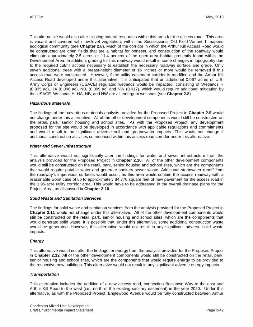
AECOM May, 2013
Charleston Mixed-Use Development Draft Environmental Impact Statement Page 3-42
This alternative would also alter existing natural resources within this area for the access road. This area is vacant and covered with low-level vegetation, within the Successional Old Field-Variant 1 mapped ecological community (see Chapter 2.8). Much of the corridor in which the Arthur Kill Access Road would be constructed are open fields that are a habitat for boneset, and construction of the roadway would eliminate approximately 2.5 acres or 11.4 percent of the open area habitat presently found within the Development Area. In addition, grading for this roadway would result in some changes in topography due to the required cut/fill actions necessary to establish the necessary roadway surface and grade. Only seven additional trees with a breast-height diameter of six inches or more would be removed if this access road were constructed. However, if the utility easement corridor is modified and the Arthur Kill Access Road developed under this alternative, it is anticipated that an additional 0.067 acres of U.S. Army Corps of Engineers (USACE) regulated wetlands would be impacted, consisting of Wetlands H (0.035 ac), HA (0.006 ac), NB, (0.009 ac) and NW (0.017), which would require additional mitigation by the USACE. Wetlands H, HA, NB, and NW are all emergent wetlands (see Chapter 2.8). Hazardous Materials The findings of the hazardous materials analysis provided for the Proposed Project in Chapter 2.9 would not change under this alternative. All of the other development components would still be constructed on the retail, park, senior housing and school sites. As with the Proposed Project, any development proposed for the site would be developed in accordance with applicable regulations and commitments and would result in no significant adverse soil and groundwater impacts. This would not change if additional construction activities commenced within this access road corridor under this alternative. Water and Sewer Infrastructure This alternative would not significantly alter the findings for water and sewer infrastructure from the analysis provided for the Proposed Project in Chapter 2.10. All of the other development components would still be constructed on the retail, park, senior housing and school sites, which are the components that would require potable water and generate sanitary sewer waste. Additional stormwater runoff from the roadway’s impervious surfaces would occur, as this area would contain the access roadway with a reasonable worst case of up to approximately 84,770 square feet of new pavement for the access road in the 1.95-acre utility corridor area. This would have to be addressed in the overall drainage plans for the Project Area, as discussed in Chapter 2.10. Solid Waste and Sanitation Services The findings for solid waste and sanitation services from the analysis provided for the Proposed Project in Chapter 2.11 would not change under this alternative. All of the other development components would still be constructed on the retail, park, senior housing and school sites, which are the components that would generate solid waste. It is possible that, under this alternative, some additional construction waste would be generated. However, this alternative would not result in any significant adverse solid waste impacts. Energy This alternative would not alter the findings for energy from the analysis provided for the Proposed Project in Chapter 2.12. All of the other development components would still be constructed on the retail, park, senior housing and school sites, which are the components that would require energy to be provided to the respective new buildings. This alternative would not result in any significant adverse energy impacts. Transportation This alternative includes the addition of a new access road, connecting Bricktown Way to the east and Arthur Kill Road to the west (i.e., north of the existing sanitary easement) in the year 2020. Under this alternative, as with the Proposed Project, Englewood Avenue would be fully constructed between Arthur

AECOM May, 2013
Charleston Mixed-Use Development Draft Environmental Impact Statement Page 3-43
Kill Road and Veterans Road West in 2020. The presence of the new access road would allow motorists traveling to and from Retail Site “A” and Fairview Park to bypass segments of Veterans Road West and Bricktown Way and access those areas directly via this additional new access road. The potential traffic impacts associated with this alternative were assessed by reassigning the year 2020 site-generated vehicle trips (see Chapter 2.13) during each of the four analysis peak hours (i.e., weekday AM, weekday midday, weekday PM, and Saturday midday) in accordance with the access scheme described above. In addition to this reassignment, a reassignment of background traffic along Englewood Avenue was also conducted (i.e., same as under the Proposed Project) to estimate the traffic diversions that would be expected to occur as a result of Englewood Avenue being extended east to connect to Veterans Road West. A complete traffic analysis was performed for all study intersections for the Arthur Kill Access Road Alternative. Figures 3-5a through 3-5d illustrate the peak hour site-generated trip assignments under this alternative in the 2020 analysis year. These site-generated trip assignments were then added to the corresponding Future No-Action traffic volumes in the 2020 analysis year to arrive at the total Future With-Action traffic volumes for this alternative, shown in Figures 3-5e through 3-5h. Table 3-8 presents the corresponding traffic operations analysis results for the study intersections under this alternative. As shown in Table 3-8, this alternative is projected to result in the following potential significant traffic impacts:
Allentown Lane-Veterans Road West/Arthur Kill Road:
Weekday AM peak hour – Delay on the southbound approach is projected to increase from 20.1 seconds per vehicle (LOS “C”) under Future No-Action conditions to 58.8 seconds per vehicle (LOS “E”) under the Arthur Kill Access Road Alternative.
Weekday midday peak hour – Delay on the southbound approach is projected to increase from 26.7 seconds per vehicle (LOS “C”) under Future No-Action conditions to 89.9 seconds per vehicle (LOS “F”) under the Arthur Kill Access Road Alternative.
Weekday PM peak hour – Delay on the southbound approach is projected to increase from 113.5 seconds per vehicle (LOS “F”) under Future No-Action conditions to 274.1 seconds per vehicle (LOS “F”) under the Arthur Kill Access Road Alternative.
Saturday midday peak hour – Delay on the southbound approach is projected to increase from 81.6 seconds per vehicle (LOS “F”) under Future No-Action conditions to 308.1 seconds per vehicle (LOS “F”) under the Arthur Kill Access Road Alternative.
Richmond Valley Road/Arthur Kill Road (same as under the Proposed Project):
Weekday midday peak hour – Delay for the southbound approach is projected to increase from 87.9 seconds per vehicle (LOS “F”) under Future No-Action conditions to 128.8 seconds per vehicle (LOS “F”) under the Arthur Kill Access Road Alternative.
Weekday PM peak hour – Delay for the westbound approach is projected to increase from 202.6 seconds per vehicle (LOS “F”) under Future No-Action conditions to 257.9 seconds per vehicle (LOS “F”) under the Arthur Kill Access Road Alternative.
Saturday midday peak hour – Delay for the westbound approach is projected to increase from 184.7 seconds per vehicle (LOS “F”) under Future No-Action conditions to 251.7 seconds per vehicle (LOS “F”) under the Arthur Kill Access Road Alternative.
Veterans Road West/Bricktown Way/Korean War Veterans Parkway westbound off-ramp:
Weekday AM peak hour – Delay for the westbound left-turn lane is projected to increase from 80.0 seconds per vehicle (LOS “F”) under Future No-Action conditions to 111.4 seconds per vehicle (LOS “F”) under the Arthur Kill Access Road Alternative.
Weekday midday peak hour – Delay for the westbound left-turn lane is projected to increase from 62.9 seconds per vehicle (LOS “E”) under Future No-Action conditions to 262.2 seconds per vehicle (LOS “F”) under the Arthur Kill Access Road Alternative.
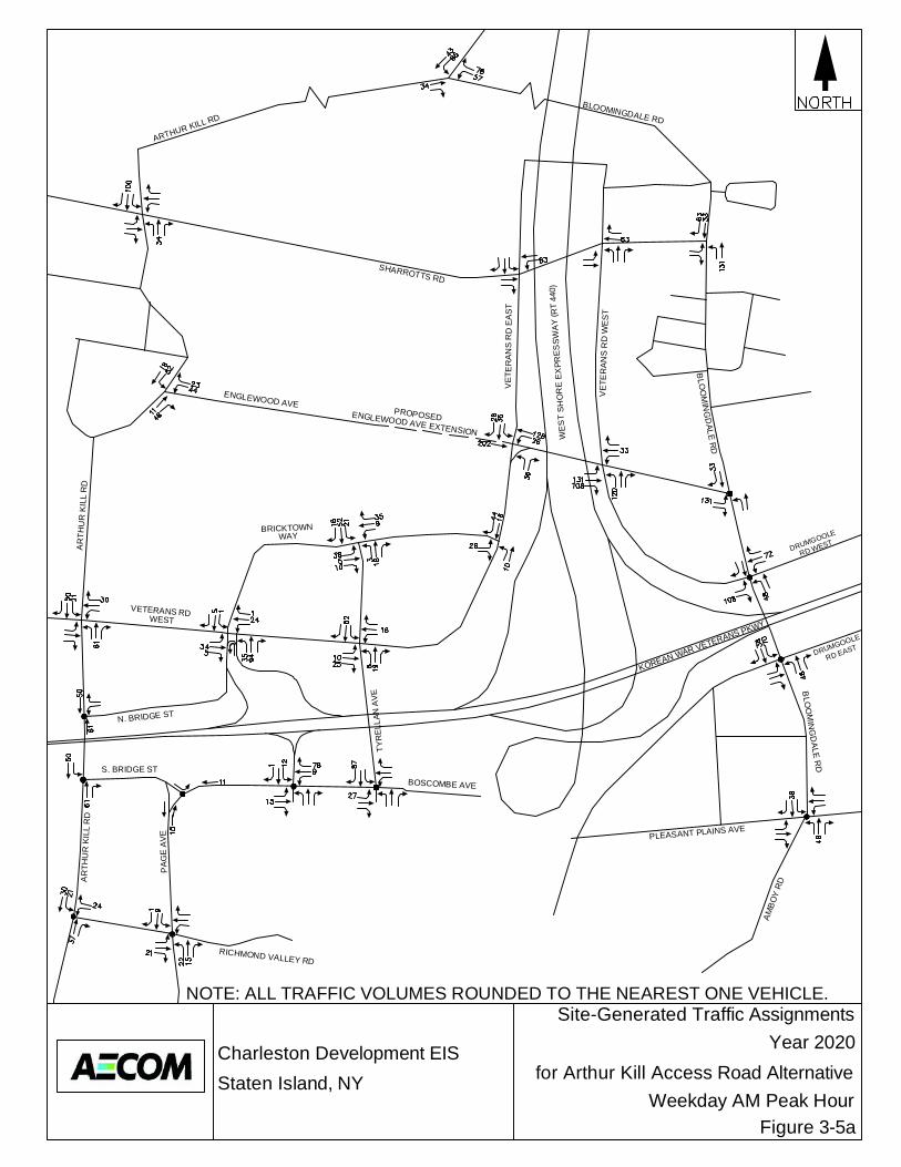
Charleston Development EISStaten Island, NY
ENGLEWOOD AVE EXTENSION
AR
THU
R K
ILL
RD
WEST
KOREAN WAR VETERANS PKWY
SHARROTTS RD
PA
GE
AV
E
AR
THU
R K
ILL
RD
WE
ST
SH
OR
E E
XPR
ES
SW
AY
(RT
440)
BOSCOMBE AVE
VE
T ER
AN
S R
D W
ES
T
ARTHUR KILL RD
RICHMOND VALLEY RD
PROPOSED
N. BRIDGE ST
S. BRIDGE ST
TYR
ELL
AN A
VE
WAY
AM
BO
Y R
D
PLEASANT PLAINS AVE
BLO
OM
ING
DA
LE R
D
VE
T ER
AN
S R
D E
AS
T
RD EAST
RD WEST
BLOOMINGDALE RD
DRUMGOOLE
DRUMGOOLEBRICKTOWN
VETERANS RD
BLO
OM
ING
DALE
RD
ENGLEWOOD AVE
Site-Generated Traffic AssignmentsYear 2020
for Arthur Kill Access Road Alternative
Figure 3-5a
NOTE: ALL TRAFFIC VOLUMES ROUNDED TO THE NEAREST ONE VEHICLE.
Weekday AM Peak Hour
Charleston Development EISStaten Island, NY
ENGLEWOOD AVE EXTENSION
AR
THU
R K
ILL
RD
WEST
KOREAN WAR VETERANS PKWY
SHARROTTS RD
PA
GE
AV
E
AR
THU
R K
ILL
RD
WE
ST
SH
OR
E E
XPR
ES
SW
AY
(RT
440)
BOSCOMBE AVE
VE
T ER
AN
S R
D W
ES
T
ARTHUR KILL RD
RICHMOND VALLEY RD
PROPOSED
N. BRIDGE ST
S. BRIDGE ST
TYR
ELL
AN A
VE
WAY
AM
BO
Y R
D
PLEASANT PLAINS AVE
BLO
OM
ING
DA
LE R
D
VE
T ER
AN
S R
D E
AS
T
RD EAST
RD WEST
BLOOMINGDALE RD
DRUMGOOLE
DRUMGOOLEBRICKTOWN
VETERANS RD
BLO
OM
ING
DALE
RD
ENGLEWOOD AVE
Site-Generated Traffic AssignmentsYear 2020
for Arthur Kill Access Road Alternative
Figure 3-5b
NOTE: ALL TRAFFIC VOLUMES ROUNDED TO THE NEAREST ONE VEHICLE.
Weekday Midday Peak Hour

Charleston Development EISStaten Island, NY
ENGLEWOOD AVE EXTENSION
AR
THU
R K
ILL
RD
WEST
KOREAN WAR VETERANS PKWY
SHARROTTS RD
PA
GE
AV
E
AR
THU
R K
ILL
RD
WE
ST
SH
OR
E E
XPR
ES
SW
AY
(RT
440)
BOSCOMBE AVE
VE
T ER
AN
S R
D W
ES
T
ARTHUR KILL RD
RICHMOND VALLEY RD
PROPOSED
N. BRIDGE ST
S. BRIDGE ST
TYR
ELL
AN A
VE
WAY
AM
BO
Y R
D
PLEASANT PLAINS AVE
BLO
OM
ING
DA
LE R
D
VE
T ER
AN
S R
D E
AS
T
RD EAST
RD WEST
BLOOMINGDALE RD
DRUMGOOLE
DRUMGOOLEBRICKTOWN
VETERANS RD
BLO
OM
ING
DALE
RD
ENGLEWOOD AVE
Site-Generated Traffic AssignmentsYear 2020
for Arthur Kill Access Road Alternative
Figure 3-5c
NOTE: ALL TRAFFIC VOLUMES ROUNDED TO THE NEAREST ONE VEHICLE.
Weekday PM Peak Hour
Charleston Development EISStaten Island, NY
ENGLEWOOD AVE EXTENSION
AR
THU
R K
ILL
RD
WEST
KOREAN WAR VETERANS PKWY
SHARROTTS RD
PA
GE
AV
E
AR
THU
R K
ILL
RD
WE
ST
SH
OR
E E
XPR
ES
SW
AY
(RT
440)
BOSCOMBE AVE
VE
T ER
AN
S R
D W
ES
T
ARTHUR KILL RD
RICHMOND VALLEY RD
PROPOSED
N. BRIDGE ST
S. BRIDGE ST
TYR
ELL
AN A
VE
WAY
AM
BO
Y R
D
PLEASANT PLAINS AVE
BLO
OM
ING
DA
LE R
D
VE
T ER
AN
S R
D E
AS
T
RD EAST
RD WEST
BLOOMINGDALE RD
DRUMGOOLE
DRUMGOOLEBRICKTOWN
VETERANS RD
BLO
OM
ING
DALE
RD
ENGLEWOOD AVE
Site-Generated Traffic AssignmentsSite-Generated Traffic AssignmentsYear 2020
for Arthur Kill Access Road Alternative
Figure 3-5d
NOTE: ALL TRAFFIC VOLUMES ROUNDED TO THE NEAREST ONE VEHICLE.
Saturday Midday Peak HourSaturday Midday Peak Hour
Charleston Development EISStaten Island, NY
ENGLEWOOD AVE EXTENSION
AR
THU
R K
ILL
RD
WEST
KOREAN WAR VETERANS PKWY
SHARROTTS RD
PA
GE
AV
E
AR
THU
R K
ILL
RD
WE
ST
SH
OR
E E
XPR
ES
SW
AY
(RT
440)
BOSCOMBE AVE
VE
T ER
AN
S R
D W
ES
T
ARTHUR KILL RD
RICHMOND VALLEY RD
PROPOSED
N. BRIDGE ST
S. BRIDGE ST
TYR
ELL
AN A
VE
WAY
AM
BO
Y R
D
PLEASANT PLAINS AVE
BLO
OM
ING
DA
LE R
D
VE
T ER
AN
S R
D E
AS
T
RD EAST
RD WEST
BLOOMINGDALE RD
DRUMGOOLE
DRUMGOOLEBRICKTOWN
VETERANS RD
BLO
OM
ING
DALE
RD
ENGLEWOOD AVE
Year 2020 With-Action ConditionTraffic Volumes
for Arthur Kill Access Road Alternative
Figure 3-5eWeekday AM Peak Hour
Charleston Development EISStaten Island, NY
ENGLEWOOD AVE EXTENSION
AR
THU
R K
ILL
RD
WEST
KOREAN WAR VETERANS PKWY
SHARROTTS RD
PA
GE
AV
E
AR
THU
R K
ILL
RD
WE
ST
SH
OR
E E
XPR
ES
SW
AY
(RT
440)
BOSCOMBE AVE
VE
T ER
AN
S R
D W
ES
T
ARTHUR KILL RD
RICHMOND VALLEY RD
PROPOSED
N. BRIDGE ST
S. BRIDGE ST
TYR
ELL
AN A
VE
WAY
AM
BO
Y R
D
PLEASANT PLAINS AVE
BLO
OM
ING
DA
LE R
D
VE
T ER
AN
S R
D E
AS
T
RD EAST
RD WEST
BLOOMINGDALE RD
DRUMGOOLE
DRUMGOOLEBRICKTOWN
VETERANS RD
BLO
OM
ING
DALE
RD
ENGLEWOOD AVE
Year 2020 With-Action ConditionTraffic Volumes
for Arthur Kill Access Road Alternative
Figure 3-5fWeekday Midday Peak Hour

Charleston Development EISStaten Island, NY
ENGLEWOOD AVE EXTENSION
AR
THU
R K
ILL
RD
WEST
KOREAN WAR VETERANS PKWY
SHARROTTS RD
PA
GE
AV
E
AR
THU
R K
ILL
RD
WE
ST
SH
OR
E E
XPR
ES
SW
AY
(RT
440)
BOSCOMBE AVE
VE
T ER
AN
S R
D W
ES
T
ARTHUR KILL RD
RICHMOND VALLEY RD
PROPOSED
N. BRIDGE ST
S. BRIDGE ST
TYR
ELL
AN A
VE
WAY
AM
BO
Y R
D
PLEASANT PLAINS AVE
BLO
OM
ING
DA
LE R
D
VE
T ER
AN
S R
D E
AS
T
RD EAST
RD WEST
BLOOMINGDALE RD
DRUMGOOLE
DRUMGOOLEBRICKTOWN
VETERANS RD
BLO
OM
ING
DALE
RD
ENGLEWOOD AVE
Year 2020 With-Action ConditionTraffic Volumes
for Arthur Kill Access Road Alternative
Figure 3-5gWeekday PM Peak Hour

Charleston Development EISStaten Island, NY
ENGLEWOOD AVE EXTENSION
AR
THU
R K
ILL
RD
WEST
KOREAN WAR VETERANS PKWY
SHARROTTS RD
PA
GE
AV
E
AR
THU
R K
ILL
RD
WE
ST
SH
OR
E E
XPR
ES
SW
AY
(RT
440)
BOSCOMBE AVE
VE
T ER
AN
S R
D W
ES
T
ARTHUR KILL RD
RICHMOND VALLEY RD
PROPOSED
N. BRIDGE ST
S. BRIDGE ST
TYR
ELL
AN A
VE
WAY
AM
BO
Y R
D
PLEASANT PLAINS AVE
BLO
OM
ING
DA
LE R
D
VE
T ER
AN
S R
D E
AS
T
RD EAST
RD WEST
BLOOMINGDALE RD
DRUMGOOLE
DRUMGOOLEBRICKTOWN
VETERANS RD
BLO
OM
ING
DALE
RD
ENGLEWOOD AVE
Year 2020 With-Action ConditionTraffic Volumes
for Arthur Kill Access Road Alternative
Figure 3-5hSaturday Midday Peak Hour
AECOM May, 2013
Charleston Mixed-Use Development Draft Environmental Impact Statement Page 3-44
Delay for the northbound approach is projected to increase from 35.5 seconds per vehicle (LOS “D”) under Future No-Action conditions to 92.0 seconds per vehicle (LOS “F”) under the Arthur Kill Access Road Alternative.
Weekday PM peak hour – Delay for the northbound approach is projected to increase from 34.3 seconds per vehicle (LOS “C”) under Future No-Action conditions to 74.8 seconds per vehicle (LOS “E”) under the Arthur Kill Access Road Alternative.
Saturday midday peak hour – Delay for the westbound left-turn lane is projected to increase from 210.9 seconds per vehicle (LOS “F”) under Future No-Action conditions to 921.8 seconds per vehicle (LOS “F”) under the Arthur Kill Access Road Alternative. Delay for the northbound approach is projected to increase from 54.0 seconds per vehicle (LOS “D”) under Future No-Action conditions to 242.8 seconds per vehicle (LOS “F”) under the Arthur Kill Access Road Alternative.
Veterans Road West/Tyrellan Avenue (same as under the Proposed Project):
Weekday midday peak hour – Delay for northbound left-turn movements is projected to increase from 78.8 seconds per vehicle (LOS “E”) under Future No-Action conditions to 338.3 seconds per vehicle (LOS “F”) under the Arthur Kill Access Road Alternative.
Weekday PM peak hour – Delay for northbound left-turn movements is projected to increase from 31.9 seconds per vehicle (LOS “C”) under Future No-Action conditions to 119.9 seconds per vehicle (LOS “F”) under the Arthur Kill Access Road Alternative.
Saturday midday peak hour – Delay for westbound left-turn movements is projected to increase from 53.8 seconds per vehicle (LOS “D”) under Future No-Action conditions to 129.1 seconds per vehicle (LOS “F”) under the Arthur Kill Access Road Alternative. Delay for northbound left-turn movements is projected to increase from 168.5 seconds per vehicle (LOS “F”) under Future No-Action conditions to 802.7 seconds per vehicle (LOS “F”) under the Arthur Kill Access Road Alternative.
Boscombe Avenue/Outerbridge Crossing Ramps (same as under the Proposed Project):
Weekday AM peak hour – Delay in the westbound right-turn lane is projected to increase from 41.6 seconds per vehicle (LOS “D”) under Future No-Action conditions to 68.1 seconds per vehicle (LOS “E”) under the Arthur Kill Access Road Alternative.
Weekday midday peak hour – Delay in the westbound through/left-turn lane is projected to increase from 66.4 seconds per vehicle (LOS “E”) under Future No-Action conditions to 81.7 seconds per vehicle (LOS “F”) under the Arthur Kill Access Road Alternative. Delay in the westbound right-turn lane is projected to increase from 103.1 seconds per vehicle (LOS “F”) under Future No-Action conditions to 442.4 seconds per vehicle (LOS “F”) under the Arthur Kill Access Road Alternative.
Weekday PM peak hour – Delay in the eastbound left-turn lane is projected to increase from 53.5 seconds per vehicle (LOS “D”) under Future No-Action conditions to 66.5 seconds per vehicle (LOS “E”) under the Arthur Kill Access Road Alternative. Delay in the westbound right-turn lane is projected to increase from 107.4 seconds per vehicle (LOS “F”) under Future No-Action conditions to 362.5 seconds per vehicle (LOS “F”) under the Arthur Kill Access Road Alternative. Delay in the southbound left-turn lane is projected to increase from 55.8 seconds per vehicle (LOS “E”) under Future No-Action conditions to 77.3 seconds per vehicle (LOS “E”) under the Arthur Kill Access Road Alternative.
Saturday midday peak hour – Delay in the eastbound left-turn lane is projected to increase from 35.7 seconds per vehicle (LOS “D”) under Future No-Action conditions to 46.5 seconds per vehicle (LOS “D”) under the Arthur Kill Access Road Alternative. Delay in the westbound through/left-turn lane is projected to increase from 76.2 seconds per vehicle (LOS “E”) under Future No-Action conditions to 116.7 seconds per vehicle (LOS “F”) under the Arthur Kill Access Road Alternative. Delay in the westbound right-turn lane is projected to increase from 286.0 seconds per vehicle (LOS “F”) under Future No-
AECOM May, 2013
Charleston Mixed-Use Development Draft Environmental Impact Statement Page 3-45
Action conditions to 772.4 seconds per vehicle (LOS “F”) under the Arthur Kill Access Road Alternative.
Boscombe Avenue/Tyrellan Avenue (same as under the Proposed Project):
Weekday midday peak hour – Delay in the southbound right-turn lane is projected to increase from 50.8 seconds per vehicle (LOS “D”) under Future No-Action conditions to 268.1 seconds per vehicle (LOS “F”) under the Arthur Kill Access Road Alternative.
Weekday PM peak hour – Delay in the southbound right-turn lane is projected to increase from 59.7 seconds per vehicle (LOS “E”) under Future No-Action conditions to 270.4 seconds per vehicle (LOS “F”) under the Arthur Kill Access Road Alternative.
Saturday midday peak hour – Delay in the southbound right-turn lane is projected to increase from 156.3 seconds per vehicle (LOS “F”) under Future No-Action conditions to 470.2 seconds per vehicle (LOS “F”) under the Arthur Kill Access Road Alternative.
Englewood Avenue/Veterans Road West (same as under the Proposed Project):
Weekday AM peak hour – Delay in the westbound left-turn lane is projected to increase from 14.8 seconds per vehicle (LOS “B”) under Future No-Action conditions to 132.2 seconds per vehicle (LOS “F”) under Future With-Action conditions.
Weekday midday peak hour – Delay in the westbound left-turn lane is projected to increase from 15.5 seconds per vehicle (LOS “B”) under Future No-Action conditions to 92.8 seconds per vehicle (LOS “F”) under Future With-Action conditions.
Weekday PM peak hour – Delay in the westbound left-turn lane is projected to increase from 14.7 seconds per vehicle (LOS “B”) under Future No-Action conditions to 63.1 seconds per vehicle (LOS “E”) under Future With-Action conditions.
Saturday midday peak hour – Delay in the westbound left-turn lane is projected to increase from 45.2 seconds per vehicle (LOS “D”) under Future No-Action conditions to 218.0 seconds per vehicle (LOS “F”) under Future With-Action conditions.
Englewood Avenue/Veterans Road East (same as under the Proposed Project):
Weekday PM peak hour – Delay in the eastbound through/left-turn lane is projected to increase from 28.2 seconds per vehicle (LOS “C”) under Future No-Action conditions to 51.6 seconds per vehicle (LOS “D”) under the Arthur Kill Access Road Alternative.
Saturday midday peak hour – Delay in the eastbound through/left-turn lane is projected to increase from 94.5 seconds per vehicle (LOS “F”) under Future No-Action conditions to 219.3 seconds per vehicle (LOS “F”) under the Arthur Kill Access Road Alternative.
Veterans Road East-Drumgoole Road West/Bloomingdale Road (same as under the Proposed Project):
Weekday AM peak hour – Delay in the eastbound right-turn lane is projected to increase from 27.7 seconds per vehicle (LOS “C”) under Future No-Action conditions to 79.6 seconds per vehicle (LOS “E”) under the Arthur Kill Access Road Alternative. Delay in the northbound left-turn lane is projected to increase from 24.2 seconds per vehicle (LOS “C”) under Future No-Action conditions to 63.0 seconds per vehicle (LOS “E”) under the Arthur Kill Access Road Alternative.
Weekday midday peak hour – Delay in the eastbound right-turn lane is projected to increase from 35.3 seconds per vehicle (LOS “D”) under Future No-Action conditions to 64.2 seconds per vehicle (LOS “E”) under the Arthur Kill Access Road Alternative. Delay in the northbound left-turn lane is projected to increase from 23.7 seconds per vehicle (LOS “C”) under Future No-Action conditions to 47.9 seconds per vehicle (LOS “D”) under the Arthur Kill Access Road Alternative.
Weekday PM peak hour – Delay in the eastbound right-turn lane is projected to increase from 33.1 seconds per vehicle (LOS “C”) under Future No-Action conditions to 54.5 seconds per vehicle (LOS “D”) under the Arthur Kill Access Road Alternative. Delay in the northbound left-turn lane is projected to increase from 27.1 seconds per vehicle (LOS
AECOM May, 2013
Charleston Mixed-Use Development Draft Environmental Impact Statement Page 3-46
“C”) under Future No-Action conditions to 76.2 seconds per vehicle (LOS “E”) under the Arthur Kill Access Road Alternative.
Saturday midday peak hour – Delay in the eastbound right-turn lane is projected to increase from 43.3 seconds per vehicle (LOS “D”) under Future No-Action conditions to 159.0 seconds per vehicle (LOS “F”) under the Arthur Kill Access Road Alternative. Delay in the northbound left-turn lane is projected to increase from 36.4 seconds per vehicle (LOS “D”) under Future No-Action conditions to 158.2 seconds per vehicle (LOS “F”) under the Arthur Kill Access Road Alternative.
Pleasant Plains Avenue-Amboy Road/Bloomingdale Road (same as under the Proposed Project):
Weekday AM peak hour – Delay on the southbound approach is projected to increase from 64.8 seconds per vehicle (LOS “E”) under Future No-Action conditions to 120.0 seconds per vehicle (LOS “F”) under the Arthur Kill Access Road Alternative.
Weekday PM peak hour – Delay on the southbound approach is projected to increase from 30.9 seconds per vehicle (LOS “C”) under Future No-Action conditions to 52.8 seconds per vehicle (LOS “D”) under the Arthur Kill Access Road Alternative.
Saturday midday peak hour – Delay on the southbound approach is projected to increase from 30.6 seconds per vehicle (LOS “C”) under Future No-Action conditions to 49.6 seconds per vehicle (LOS “D”) under the Arthur Kill Access Road Alternative.
Arthur Kill Road/Bloomingdale Road (same as under the Proposed Project):
Weekday PM peak hour – Delay on the westbound approach is projected to increase from 19.5 seconds per vehicle (LOS “B”) under Future No-Action conditions to 96.8 seconds per vehicle (LOS “F”) under Future With-Action conditions. Delay on the northbound approach is projected to increase from 27.9 seconds per vehicle (LOS “C”) under Future No-Action conditions to 53.7 seconds per vehicle (LOS “D”) under Future With-Action conditions.
Saturday midday peak hour – Delay on the westbound approach is projected to increase from 22.8 seconds per vehicle (LOS “C”) under Future No-Action conditions to 188.4 seconds per vehicle (LOS “F”) under Future With-Action conditions.
Sharrotts Road/Arthur Kill Road (same as under the Proposed Project):
Saturday midday peak hour – Delay on the eastbound approach is projected to increase from 24.5 seconds per vehicle (LOS “C”) under Future No-Action conditions to 34.9 seconds per vehicle (LOS “D”) under the Arthur Kill Access Road Alternative. Delay on the westbound approach is projected to increase from 24.2 seconds per vehicle (LOS “C”) under Future No-Action conditions to 30.2 seconds per vehicle (LOS “D”) under the Arthur Kill Access Road Alternative.
Englewood Avenue/Arthur Kill Road (same as under the Proposed Project):
Weekday AM peak hour – Delay on the westbound approach is projected to increase from 10.8 seconds per vehicle (LOS “B”) under Future No-Action conditions to 40.7 seconds per vehicle (LOS “E”) under the Arthur Kill Access Road Alternative.
Weekday PM peak hour – Delay on the westbound approach is projected to increase from 14.3 seconds per vehicle (LOS “B”) under Future No-Action conditions to 33.8 seconds per vehicle (LOS “D”) under the Arthur Kill Access Road Alternative.
Transportation improvement measures were then investigated to identify those that mitigate the potential significant traffic impacts identified above. The following transportation system improvement measures would be required to mitigate the potential significant traffic impacts under this alternative:
Allentown Lane-Veterans Road West/Arthur Kill Road:
Restripe the northbound approach to accommodate one 10 foot exclusive left-turn lane and one 11-foot shared through/right-turn lane.
AECOM May, 2013
Charleston Mixed-Use Development Draft Environmental Impact Statement Page 3-47
During the weekday PM peak hour, reallocate two seconds of green time from the east-west phase to the north-south phase.
During the Saturday midday peak hour, reallocate three seconds of green time from the east-west phase to the north-south phase.
Richmond Valley Road/Arthur Kill Road (same as under the Proposed Project):
Restripe the southbound approach to accommodate one 10 foot through lane and one 10 foot exclusive left-turn lane.
Veterans Road West/Bricktown Way/Korean War Veterans Parkway westbound off-ramp:
During the weekday AM peak hour, reallocate two seconds of green time from the southbound phase to the east-west phase.
During the weekday midday peak hour, reallocate four seconds of green time from the southbound phase to the northbound phase.
During the weekday PM peak hour, reallocate one second of green time from the southbound phase to the northbound phase.
With the improvements described above in place, potential significant traffic impacts at this intersection are projected to remain for:
Westbound left-turn movements during the weekday midday and Saturday midday peak hours; and
The northbound approach during the weekday midday, weekday PM, and Saturday midday peak hours.
Veterans Road West/Tyrellan Avenue (same as under the Proposed Project):
Eliminate a portion of the raised median on the southbound and eastbound approaches to accommodate one exclusive left-turn lane on each approach.
During the weekday midday, weekday PM, and Saturday midday peak hours, modify the signal phasing to create a lagging westbound phase, and three phases for northbound and southbound movements: a southbound leading phase, a concurrent north-south phase, and a lagging northbound phase.
During the weekday midday peak hour, allocate 10 seconds to the westbound lagging phase, 16 seconds to the southbound leading phase, 17 seconds to the concurrent north-south phase, and 19 seconds to the lagging northbound phase.
During the weekday PM peak hour, allocate 10 seconds to the westbound lagging phase, 16 seconds to the southbound leading phase, 17 seconds to the concurrent north-south phase, and 19 seconds to the lagging northbound phase.
During the Saturday midday peak hour, allocate 11 seconds to the westbound lagging phase, 18 seconds to the southbound leading phase, 17 seconds to the concurrent north-south phase, and 16 seconds to the lagging northbound phase.
Boscombe Avenue/Outerbridge Crossing Ramps (same as under the Proposed Project):
Modify the traffic signal hardware to provide for a westbound right-turn overlap phase to operate concurrently with the north-south phase.
During the weekday midday peak hour, reallocate one second of green time from the north-south phase to the east-west phase.
During the Saturday midday peak hour, reallocate two seconds of green time from the southbound phase to the east-west phase.
With the improvements described above in place, potential significant traffic impacts at this intersection are projected to remain for:
Westbound right-turn movements during the weekday AM, weekday midday, and weekday PM peak hours; and
Eastbound left-turn and southbound left-turn movements during the weekday PM peak hour.
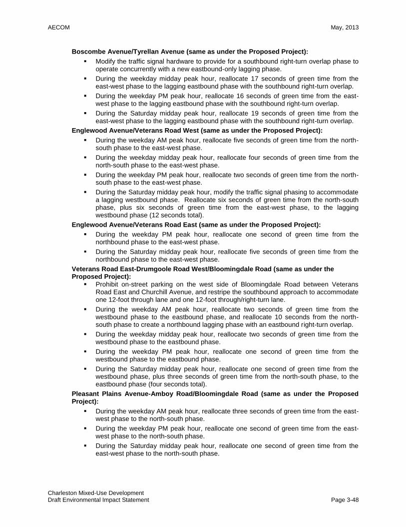
AECOM May, 2013
Charleston Mixed-Use Development Draft Environmental Impact Statement Page 3-48
Boscombe Avenue/Tyrellan Avenue (same as under the Proposed Project):
Modify the traffic signal hardware to provide for a southbound right-turn overlap phase to operate concurrently with a new eastbound-only lagging phase.
During the weekday midday peak hour, reallocate 17 seconds of green time from the east-west phase to the lagging eastbound phase with the southbound right-turn overlap.
During the weekday PM peak hour, reallocate 16 seconds of green time from the east-west phase to the lagging eastbound phase with the southbound right-turn overlap.
During the Saturday midday peak hour, reallocate 19 seconds of green time from the east-west phase to the lagging eastbound phase with the southbound right-turn overlap.
Englewood Avenue/Veterans Road West (same as under the Proposed Project):
During the weekday AM peak hour, reallocate five seconds of green time from the north-south phase to the east-west phase.
During the weekday midday peak hour, reallocate four seconds of green time from the north-south phase to the east-west phase.
During the weekday PM peak hour, reallocate two seconds of green time from the north-south phase to the east-west phase.
During the Saturday midday peak hour, modify the traffic signal phasing to accommodate a lagging westbound phase. Reallocate six seconds of green time from the north-south phase, plus six seconds of green time from the east-west phase, to the lagging westbound phase (12 seconds total).
Englewood Avenue/Veterans Road East (same as under the Proposed Project):
During the weekday PM peak hour, reallocate one second of green time from the northbound phase to the east-west phase.
During the Saturday midday peak hour, reallocate five seconds of green time from the northbound phase to the east-west phase.
Veterans Road East-Drumgoole Road West/Bloomingdale Road (same as under the Proposed Project):
Prohibit on-street parking on the west side of Bloomingdale Road between Veterans Road East and Churchill Avenue, and restripe the southbound approach to accommodate one 12-foot through lane and one 12-foot through/right-turn lane.
During the weekday AM peak hour, reallocate two seconds of green time from the westbound phase to the eastbound phase, and reallocate 10 seconds from the north-south phase to create a northbound lagging phase with an eastbound right-turn overlap.
During the weekday midday peak hour, reallocate two seconds of green time from the westbound phase to the eastbound phase.
During the weekday PM peak hour, reallocate one second of green time from the westbound phase to the eastbound phase.
During the Saturday midday peak hour, reallocate one second of green time from the westbound phase, plus three seconds of green time from the north-south phase, to the eastbound phase (four seconds total).
Pleasant Plains Avenue-Amboy Road/Bloomingdale Road (same as under the Proposed Project):
During the weekday AM peak hour, reallocate three seconds of green time from the east-west phase to the north-south phase.
During the weekday PM peak hour, reallocate one second of green time from the east-west phase to the north-south phase.
During the Saturday midday peak hour, reallocate one second of green time from the east-west phase to the north-south phase.

AECOM May, 2013
Charleston Mixed-Use Development Draft Environmental Impact Statement Page 3-49
Arthur Kill Road/Bloomingdale Road (same as under the Proposed Project):
Restripe the westbound approach to accommodate one 11-foot exclusive left-turn lane and one 11-foot exclusive through lane.
During the weekday PM peak hour, reallocate 13 seconds of green time from the east-west phase to create a 10-second lagging westbound phase, and add three seconds of green time to the northbound phase.
During the Saturday midday peak hour, reallocate 17 seconds of green time from the east-west phase to create a lagging westbound phase.
Sharrotts Road/Arthur Kill Road (same as under the Proposed Project):
Under this alternative, the project is projected to result in unmitigable impacts on the eastbound and westbound approaches at this stop-controlled intersection during the Saturday midday peak hour, according to CEQR criteria. It should be noted that the delays at this intersection are projected to exceed the CEQR threshold of mid-LOS “D” by only 5.0 seconds on the stop-controlled eastbound approach, and by only 0.3 seconds on the stop-controlled westbound approach, and only during the Saturday midday peak hour. Furthermore, all approaches at the intersection will operate under capacity with delays corresponding to LOS “D” or better—which represents an acceptable operational level for an unsignalized intersection—during all four peak hours analyzed. Therefore, no mitigation measures are proposed at this intersection for the potential significant traffic impact identified during the Saturday midday peak hour, and an unmitigable impact will remain during that hour.
Englewood Avenue/Arthur Kill Road (same as under the Proposed Project):
Restripe the westbound approach to accommodate one exclusive left-turn lane and one exclusive right-turn lane.
Table 3-9 presents the corresponding traffic operations analysis results for the study intersections with the transportation improvements identified above in place under this alternative. With these transportation improvement measures in place, all potential significant traffic impacts are projected to be mitigated under the Arthur Kill Access Road Alternative, with the exception of those noted at the intersections of:
Veterans Road West/Bricktown Way/Korean War Veterans Parkway westbound off-ramp;
Boscombe Avenue/Outerbridge Crossing ramps; and
Sharrotts Road/Arthur Kill Road.
Level-of-service comparisons of the Arthur Kill Access Road Alternative along with the other alternatives in this chapter, are provided in previous Table 3-3 for the 2020 year. Impact comparisons between all the alternatives are provided in previous Table 3-4, and comparisons with mitigation measures are provided in previous Table 3-5. Under the Arthur Kill Access Road Alternative, traffic impacts were identified at six signalized intersections and one unsignalized intersection during the weekday AM peak hour, at eight signalized intersections during the weekday MD peak hour, at 11 signalized intersections and one unsignalized intersection during the weekday PM peak hour, and at 11 signalized intersections and one unsignalized intersection during the Saturday MD peak hour. Under the Proposed Project, traffic impacts were identified at the same six signalized intersections and the same unsignalized intersection during the weekday AM peak hour, at the same eight signalized intersections during the weekday MD peak hour, at the same 11 signalized intersections and the same unsignalized intersection during the weekday PM peak hour, and at the same 11 signalized intersections and the same unsignalized intersection during the Saturday MD peak hour. Those improvement measures identified for the Proposed Project would generally be the same under this alternative, with some additional timing changes (at the intersections of Veterans Road West/Bricktown Way-Korean War Veterans Parkway Off-Ramp and Allentown Lane-

AECOM May, 2013
Charleston Mixed-Use Development Draft Environmental Impact Statement Page 3-50
Veterans Road West/Arthur Kill Road) under the Proposed Project that would not be required under this alternative.
As discussed in Chapter 2.13, a plan by NYSDOT to improve the southbound West Shore Expressway (WSE) ramp system and adjacent surface street intersections just north of the Project Area would potentially increase volumes at three Study Area intersections:
Veterans Road West/Englewood Avenue
Bricktown Way/Veterans Road West
Arthur Kill Road/Bloomingdale Road
The potential changes in traffic volumes and levels of service due to the proposed WSE ramps will be analyzed for the FEIS when sufficient information about this ramp improvement program is available. Until results from those studies are available, it is conservatively assumed that at these three intersections a worsening of already identified significant traffic impacts and/or the creation of additional significant impacts would potentially occur in one or more peak hour in 2015 and 2020 due to increased traffic volumes associated with these ramp improvements. Those potential impacts would also occur under the Arthur Kill Access Road Alternative.
Air Quality This alternative would not alter the findings of the stationary source air quality analysis for the Proposed Project provided in Chapter 2.14. All of the other development components would still be constructed on the retail, park, senior housing and school sites Stationary source impacts under this alternative would remain the same as under the Proposed Project, and no significant adverse stationary source air quality impacts would occur. Mobile source impacts on the analyzed off-site roadway network would essentially remain the same as compared to the Future With-Action Condition, given the minimal change in traffic patterns around the Development Area. Tables 2.20-6 and 2.20-7, previously shown, summarize the changes under this alternative as compared to the Future With-Action Condition in LOS, total volume, and net incremental volume at each analyzed intersection. Therefore, this alternative would not result in significant adverse air quality impacts from mobile source operations. Greenhouse Gas Emissions This alternative would not significantly alter the findings for greenhouse gas emissions from the analysis for the Proposed Project provided in Chapter 2.15. All of the other development components would still be constructed on the retail, park, senior housing and school sites, which are the components that would generate greenhouse gasses. Under this alternative, it is possible that slightly more greenhouse gas emissions during construction would be generated, as construction activities for this additional access roadway would occur within this utility corridor area, which would no longer remain in its current natural state. However, significant adverse impacts are not expected. Noise The findings of the stationary source noise analysis for the Proposed Project provided in Chapter 2.16 would not be altered under this alternative. All of the other development components would still be constructed on the retail, park, senior housing and school sites Stationary source impacts under this alternative would remain the same as under the Proposed Project, and no significant adverse stationary source noise impacts would occur. Under this alternative, mobile source impacts within the studied off-site roadway network would essentially remain the same as compared to the Future With-Action Condition, given the minimal change in traffic patterns around the area. Therefore this alternative would not result in significant adverse noise impacts from mobile source operations.
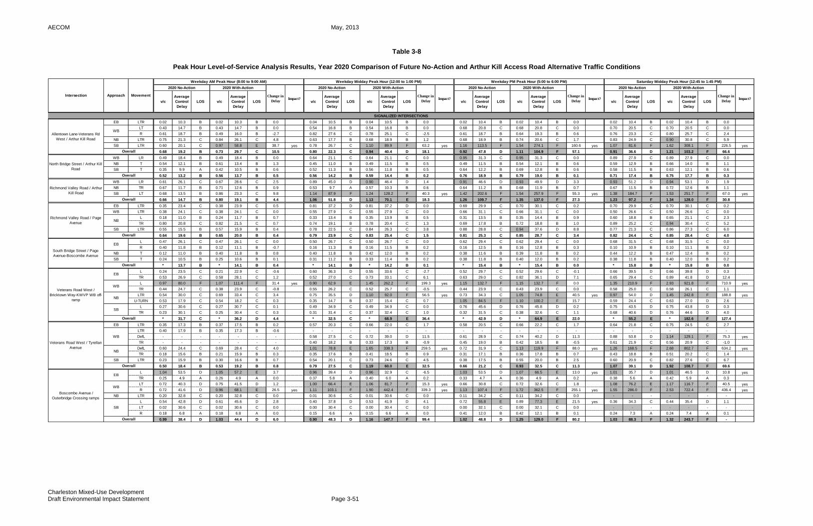
AECOM May, 2013
Charleston Mixed-Use Development Draft Environmental Impact Statement Page 3-51
Table 3-8
Peak Hour Level-of-Service Analysis Results, Year 2020 Comparison of Future No-Action and Arthur Kill Access Road Alternative Traffic Conditions
EB LTR 0.02 10.3 B 0.02 10.3 B 0.0 0.04 10.5 B 0.04 10.5 B 0.0 0.02 10.4 B 0.02 10.4 B 0.0 0.02 10.4 B 0.02 10.4 B 0.0
LT 0.43 14.7 B 0.43 14.7 B 0.0 0.54 16.8 B 0.54 16.8 B 0.0 0.68 20.8 C 0.68 20.8 C 0.0 0.70 20.5 C 0.70 20.5 C 0.0
R 0.61 18.7 B 0.49 16.0 B -2.7 0.82 27.6 C 0.78 25.1 C -2.5 0.61 18.7 B 0.64 19.3 B 0.6 0.76 23.3 C 0.80 25.7 C 2.4
NB LTR 0.75 21.3 C 0.84 26.1 C 4.8 0.63 17.7 B 0.68 18.9 B 1.2 0.68 18.9 B 0.74 20.6 C 1.7 0.83 24.9 C 0.90 30.8 C 5.9
SB LTR 0.60 20.1 C 0.97 58.8 E 38.7 yes 0.78 26.7 C 1.10 89.9 F 63.2 yes 1.16 113.5 F 1.54 274.1 F 160.6 yes 1.07 81.6 F 1.62 308.1 F 226.5 yes
0.68 19.2 B 0.73 29.7 C 10.5 0.80 22.3 C 0.94 40.4 D 18.1 0.92 47.8 D 1.11 104.9 F 57.1 0.91 36.6 D 1.21 103.2 F 66.6
WB LR 0.49 18.4 B 0.49 18.4 B 0.0 0.64 21.1 C 0.64 21.1 C 0.0 0.95 31.3 C 0.95 31.3 C 0.0 0.89 27.9 C 0.89 27.9 C 0.0
NB T 0.54 12.1 B 0.61 13.4 B 1.3 0.45 11.0 B 0.49 11.5 B 0.5 0.49 11.5 B 0.54 12.1 B 0.6 0.59 12.9 B 0.66 14.0 B 1.1
SB T 0.35 9.9 A 0.42 10.5 B 0.6 0.52 11.3 B 0.56 11.8 B 0.5 0.64 12.2 B 0.69 12.8 B 0.6 0.58 11.5 B 0.63 12.1 B 0.6
0.52 13.2 B 0.56 13.7 B 0.5 0.56 14.2 B 0.59 14.4 B 0.2 0.76 18.9 B 0.79 19.0 B 0.1 0.71 17.4 B 0.75 17.7 B 0.3
WB LR 0.61 26.1 C 0.67 28.6 C 2.5 0.89 45.0 D 0.90 46.4 D 1.4 0.91 46.6 D 0.93 49.9 D 3.3 0.93 51.2 D 0.94 53.1 D 1.9
NB TR 0.67 11.7 B 0.71 12.6 B 0.9 0.53 9.7 A 0.57 10.3 B 0.6 0.64 11.2 B 0.68 11.9 B 0.7 0.67 11.5 B 0.72 12.6 B 1.1
SB LT 0.68 13.5 B 0.86 23.3 C 9.8 1.14 87.9 F 1.24 128.2 F 40.3 yes 1.42 202.6 F 1.54 257.9 F 55.3 yes 1.38 184.7 F 1.53 251.7 F 67.0 yes
0.66 14.7 B 0.80 19.1 B 4.4 1.06 51.8 D 1.13 70.1 E 18.3 1.26 109.7 F 1.35 137.0 F 27.3 1.23 97.2 F 1.34 128.0 F 30.8
EB LTR 0.35 23.4 C 0.38 23.9 C 0.5 0.81 37.2 D 0.81 37.2 D 0.0 0.69 29.9 C 0.70 30.1 C 0.2 0.70 29.9 C 0.70 30.1 C 0.2
WB LTR 0.38 24.1 C 0.38 24.1 C 0.0 0.55 27.9 C 0.55 27.9 C 0.0 0.66 31.1 C 0.66 31.1 C 0.0 0.50 26.6 C 0.50 26.6 C 0.0
L 0.18 11.0 B 0.24 11.7 B 0.7 0.33 13.4 B 0.35 13.9 B 0.5 0.31 13.5 B 0.35 14.4 B 0.9 0.60 18.8 B 0.65 21.1 C 2.3
TR 0.80 20.8 C 0.82 21.5 C 0.7 0.74 19.1 B 0.78 20.4 C 1.3 0.69 17.8 B 0.72 18.8 B 1.0 0.89 25.2 C 0.94 30.4 C 5.2
SB LTR 0.55 15.5 B 0.57 15.9 B 0.4 0.78 22.5 C 0.84 26.3 C 3.8 0.88 28.8 C 0.94 37.6 D 8.8 0.77 21.3 C 0.86 27.3 C 6.0
0.64 19.6 B 0.65 20.0 B 0.4 0.79 23.9 C 0.83 25.4 C 1.5 0.81 25.3 C 0.85 28.7 C 3.4 0.82 24.4 C 0.85 28.4 C 4.0
L 0.47 26.1 C 0.47 26.1 C 0.0 0.50 26.7 C 0.50 26.7 C 0.0 0.62 29.4 C 0.62 29.4 C 0.0 0.68 31.5 C 0.68 31.5 C 0.0
R 0.40 11.8 B 0.12 11.1 B -0.7 0.16 11.3 B 0.16 11.5 B 0.2 0.16 12.5 B 0.16 12.8 B 0.3 0.10 10.9 B 0.10 11.1 B 0.2
NB T 0.12 11.0 B 0.40 11.8 B 0.8 0.40 11.8 B 0.42 12.0 B 0.2 0.38 11.6 B 0.39 11.8 B 0.2 0.44 12.2 B 0.47 12.4 B 0.2
SB T 0.24 10.5 B 0.25 10.6 B 0.1 0.31 11.2 B 0.33 11.4 B 0.2 0.38 11.8 B 0.40 12.0 B 0.2 0.38 11.8 B 0.40 12.0 B 0.2
* 13.7 B * 14.1 B 0.4 * 14.1 B * 14.2 B 0.1 * 15.4 B * 15.4 B 0.0 * 15.8 B * 15.8 B 0.0
L 0.24 23.5 C 0.21 22.9 C -0.6 0.60 36.3 D 0.55 33.6 C -2.7 0.52 29.7 C 0.52 29.6 C -0.1 0.66 39.5 D 0.66 39.8 D 0.3
TR 0.53 26.9 C 0.58 28.1 C 1.2 0.52 27.0 C 0.73 33.1 C 6.1 0.63 29.0 C 0.82 36.1 D 7.1 0.65 29.4 C 0.89 41.8 D 12.4
L 0.97 80.0 F 1.07 111.4 F 31.4 yes 0.90 62.9 E 1.45 262.2 F 199.3 yes 1.15 132.7 F 1.15 132.7 F 0.0 1.35 210.9 F 2.93 921.8 F 710.9 yes
TR 0.44 24.7 C 0.38 23.9 C -0.8 0.55 26.2 C 0.52 25.7 C -0.5 0.44 23.9 C 0.43 23.9 C 0.0 0.58 25.0 C 0.58 26.1 C 1.1
LTR 0.54 30.0 C 0.69 33.4 C 3.4 0.75 35.5 D 1.10 92.0 F 56.5 yes 0.73 34.3 C 1.05 74.8 E 40.5 yes 0.97 54.0 D 1.45 242.8 F 188.8 yes
U-TURN 0.53 17.9 C 0.54 18.2 C 0.3 0.35 14.7 B 0.37 15.4 C 0.7 1.05 84.5 F 1.10 100.2 F 15.7 0.59 24.4 C 0.63 27.0 D 2.6
L 0.27 30.6 C 0.27 30.7 C 0.1 0.49 34.9 C 0.49 34.9 C 0.0 0.76 45.6 D 0.76 45.8 D 0.2 0.75 43.5 D 0.75 43.8 D 0.3
TR 0.23 30.1 C 0.25 30.4 C 0.3 0.31 31.4 C 0.37 32.4 C 1.0 0.32 31.5 C 0.38 32.6 C 1.1 0.68 40.6 D 0.76 44.6 D 4.0
* 31.7 C * 36.2 D 4.4 * 32.5 C * 68.9 E 36.4 * 42.9 D * 64.9 E 22.0 * 55.2 E * 182.6 F 127.4
EB LTR 0.35 17.3 B 0.37 17.5 B 0.2 0.57 20.3 C 0.66 22.0 C 1.7 0.58 20.5 C 0.66 22.2 C 1.7 0.64 21.8 C 0.75 24.5 C 2.7
LTR 0.40 17.9 B 0.35 17.3 B -0.6 - - - - - - - - - - - - - - - - - - - - -
DefL - - - - - - - 0.58 27.5 C 0.72 39.0 D 11.5 0.61 28.9 C 0.74 40.2 D 11.3 0.88 53.8 D 1.14 129.1 F 75.3 yes
TR - - - - - - - 0.40 18.2 B 0.33 17.3 B -0.9 0.45 19.0 B 0.42 18.5 B -0.5 0.61 21.9 C 0.56 20.9 C -1.0
DefL 0.60 24.4 C 0.69 28.4 C 4.0 1.01 78.8 E 1.65 338.3 F 259.5 yes 0.72 31.9 C 1.13 119.9 F 88.0 yes 1.26 168.5 F 2.68 802.7 F 634.2 yes
TR 0.18 15.6 B 0.21 15.9 B 0.3 0.35 17.6 B 0.41 18.5 B 0.9 0.31 17.1 B 0.36 17.8 B 0.7 0.43 18.8 B 0.51 20.2 C 1.4
SB LTR 0.23 15.9 B 0.30 16.6 B 0.7 0.54 20.1 C 0.73 24.6 C 4.5 0.38 17.5 B 0.55 20.0 B 2.5 0.60 20.9 C 0.82 27.6 C 6.7
0.50 18.4 B 0.53 19.2 B 0.8 0.79 27.5 C 1.19 60.0 E 32.5 0.66 21.2 C 0.93 32.5 C 11.3 1.07 39.1 D 1.92 108.7 F 69.6
L 1.04 53.5 D 1.05 57.2 E 3.7 0.96 39.4 D 0.96 32.9 C -6.5 1.03 53.5 D 1.07 66.5 E 13.0 yes 1.01 35.7 D 1.01 46.5 D 10.8 yes
TR 0.25 4.9 A 0.26 4.9 A 0.0 0.37 5.8 A 0.40 6.0 A 0.2 0.33 4.7 A 0.36 4.9 A 0.2 0.38 5.6 A 0.42 5.9 A 0.3
LT 0.72 40.3 D 0.75 41.5 D 1.2 1.00 66.4 E 1.06 81.7 F 15.3 yes 0.66 30.8 C 0.72 32.6 C 1.8 1.08 76.2 E 1.17 116.7 F 40.5 yes
R 0.72 41.6 D 0.96 68.1 E 26.5 yes 1.11 103.1 F 1.90 442.4 F 339.3 yes 1.13 107.4 F 1.72 362.5 F 255.1 yes 1.55 286.0 F 2.53 722.4 F 436.4 yes
NB LTR 0.20 32.8 C 0.20 32.8 C 0.0 0.01 30.6 C 0.01 30.6 C 0.0 0.11 34.2 C 0.11 34.2 C 0.0 - - - - - - -
L 0.54 42.8 D 0.61 45.6 D 2.8 0.40 37.8 D 0.53 41.9 D 4.1 0.72 55.8 E 0.89 77.3 E 21.5 yes 0.36 34.3 C 0.44 35.4 D 1.1
LT 0.02 30.6 C 0.02 30.6 C 0.0 0.00 30.4 C 0.00 30.4 C 0.0 0.00 32.1 C 0.00 32.1 C 0.0 - - - - - - -
R 0.18 6.8 A 0.18 6.8 A 0.0 0.15 6.6 A 0.15 6.6 A 0.0 0.41 12.0 B 0.42 12.1 B 0.1 0.24 7.3 A 0.24 7.4 A 0.1
0.99 38.4 D 1.03 44.4 D 6.0 0.90 48.3 D 1.16 147.7 F 99.4 1.02 48.8 D 1.25 129.0 F 80.2 1.03 88.3 F 1.32 243.7 F -
Intersection Approach Movement
Weekday AM Peak Hour (8:00 to 9:00 AM) Weekday Midday Peak Hour (12:00 to 1:00 PM) Weekday PM Peak Hour (5:00 to 6:00 PM) Saturday Midday Peak Hour (12:45 to 1:45 PM)
2020 No-Action 2020 With-Action
Change in
DelayImpact?
v/c
Average
Control
Delay
LOS v/c
Average
Control
Delay
LOS
2020 No-Action 2020 With-Action
Change in
DelayImpact?
2020 No-Action 2020 With-Action
v/c
Average
Control
Delay
LOS v/c v/c
Average
Control
Delay
LOS v/c
Average
Control
Delay
LOS
Average
Control
Delay
LOS v/c
Average
Control
Delay
LOS v/c
Change in
DelayImpact?
2020 No-Action 2020 With-Action
Change in
DelayImpact?
Average
Control
Delay
LOS
Richmond Valley Road / Arthur
Kill Road
Overall
Richmond Valley Road / Page
AvenueNB
Overall
SIGNALIZED INTERSECTIONS
Allentown Lane-Veterans Rd
West / Arthur Kill Road
WB
Overall
North Bridge Street / Arthur Kill
Road
Overall
South Bridge Street / Page
Avenue-Boscombe Avenue
EB
Overall
Veterans Road West /
Bricktown Way-KWVP WB off-
ramp
EB
WB
NB
SB
Overall
Veterans Road West / Tyrellan
AvenueNB
Overall
Boscombe Avenue /
Outerbridge Crossing ramps
EB
WB
SB
Overall
WB
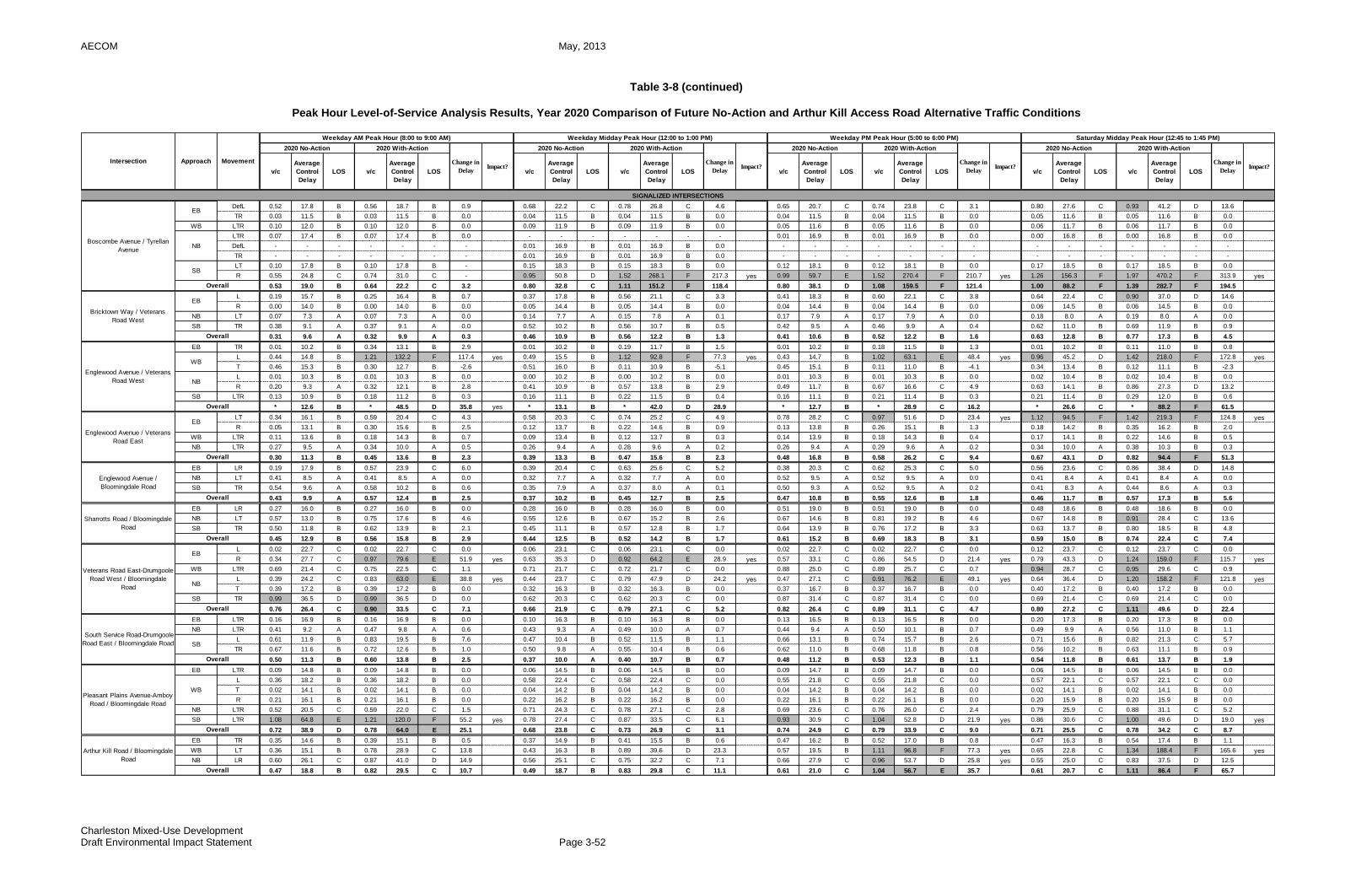
AECOM May, 2013
Charleston Mixed-Use Development Draft Environmental Impact Statement Page 3-52
Table 3-8 (continued)
Peak Hour Level-of-Service Analysis Results, Year 2020 Comparison of Future No-Action and Arthur Kill Access Road Alternative Traffic Conditions
DefL 0.52 17.8 B 0.56 18.7 B 0.9 0.68 22.2 C 0.78 26.8 C 4.6 0.65 20.7 C 0.74 23.8 C 3.1 0.80 27.6 C 0.93 41.2 D 13.6
TR 0.03 11.5 B 0.03 11.5 B 0.0 0.04 11.5 B 0.04 11.5 B 0.0 0.04 11.5 B 0.04 11.5 B 0.0 0.05 11.6 B 0.05 11.6 B 0.0
WB LTR 0.10 12.0 B 0.10 12.0 B 0.0 0.09 11.9 B 0.09 11.9 B 0.0 0.05 11.6 B 0.05 11.6 B 0.0 0.06 11.7 B 0.06 11.7 B 0.0
LTR 0.07 17.4 B 0.07 17.4 B 0.0 - - - - - - - 0.01 16.9 B 0.01 16.9 B 0.0 0.00 16.8 B 0.00 16.8 B 0.0
DefL - - - - - - - 0.01 16.9 B 0.01 16.9 B 0.0 - - - - - - - - - - - - - -
TR - - - - - - - 0.01 16.9 B 0.01 16.9 B 0.0 - - - - - - - - - - - - - -
LT 0.10 17.8 B 0.10 17.8 B - 0.15 18.3 B 0.15 18.3 B 0.0 0.12 18.1 B 0.12 18.1 B 0.0 0.17 18.5 B 0.17 18.5 B 0.0
R 0.55 24.8 C 0.74 31.0 C - 0.95 50.8 D 1.52 268.1 F 217.3 yes 0.99 59.7 E 1.52 270.4 F 210.7 yes 1.26 156.3 F 1.97 470.2 F 313.9 yes
0.53 19.0 B 0.64 22.2 C 3.2 0.80 32.8 C 1.11 151.2 F 118.4 0.80 38.1 D 1.08 159.5 F 121.4 1.00 88.2 F 1.39 282.7 F 194.5
L 0.19 15.7 B 0.25 16.4 B 0.7 0.37 17.8 B 0.56 21.1 C 3.3 0.41 18.3 B 0.60 22.1 C 3.8 0.64 22.4 C 0.90 37.0 D 14.6
R 0.00 14.0 B 0.00 14.0 B 0.0 0.05 14.4 B 0.05 14.4 B 0.0 0.04 14.4 B 0.04 14.4 B 0.0 0.06 14.5 B 0.06 14.5 B 0.0
NB LT 0.07 7.3 A 0.07 7.3 A 0.0 0.14 7.7 A 0.15 7.8 A 0.1 0.17 7.9 A 0.17 7.9 A 0.0 0.18 8.0 A 0.19 8.0 A 0.0
SB TR 0.38 9.1 A 0.37 9.1 A 0.0 0.52 10.2 B 0.56 10.7 B 0.5 0.42 9.5 A 0.46 9.9 A 0.4 0.62 11.0 B 0.69 11.9 B 0.9
0.31 9.6 A 0.32 9.9 A 0.3 0.46 10.9 B 0.56 12.2 B 1.3 0.41 10.6 B 0.52 12.2 B 1.6 0.63 12.8 B 0.77 17.3 B 4.5
EB TR 0.01 10.2 B 0.34 13.1 B 2.9 0.01 10.2 B 0.19 11.7 B 1.5 0.01 10.2 B 0.18 11.5 B 1.3 0.01 10.2 B 0.11 11.0 B 0.8
L 0.44 14.8 B 1.21 132.2 F 117.4 yes 0.49 15.5 B 1.12 92.8 F 77.3 yes 0.43 14.7 B 1.02 63.1 E 48.4 yes 0.96 45.2 D 1.42 218.0 F 172.8 yes
T 0.46 15.3 B 0.30 12.7 B -2.6 0.51 16.0 B 0.11 10.9 B -5.1 0.45 15.1 B 0.11 11.0 B -4.1 0.34 13.4 B 0.12 11.1 B -2.3
L 0.01 10.3 B 0.01 10.3 B 0.0 0.00 10.2 B 0.00 10.2 B 0.0 0.01 10.3 B 0.01 10.3 B 0.0 0.02 10.4 B 0.02 10.4 B 0.0
R 0.20 9.3 A 0.32 12.1 B 2.8 0.41 10.9 B 0.57 13.8 B 2.9 0.49 11.7 B 0.67 16.6 C 4.9 0.63 14.1 B 0.86 27.3 D 13.2
SB LTR 0.13 10.9 B 0.18 11.2 B 0.3 0.16 11.1 B 0.22 11.5 B 0.4 0.16 11.1 B 0.21 11.4 B 0.3 0.21 11.4 B 0.29 12.0 B 0.6
* 12.6 B * 48.5 D 35.8 yes * 13.1 B * 42.0 D 28.9 * 12.7 B * 28.9 C 16.2 * 26.6 C * 88.2 F 61.5
LT 0.34 16.1 B 0.59 20.4 C 4.3 0.58 20.3 C 0.74 25.2 C 4.9 0.78 28.2 C 0.97 51.6 D 23.4 yes 1.12 94.5 F 1.42 219.3 F 124.8 yes
R 0.05 13.1 B 0.30 15.6 B 2.5 0.12 13.7 B 0.22 14.6 B 0.9 0.13 13.8 B 0.26 15.1 B 1.3 0.18 14.2 B 0.35 16.2 B 2.0
WB LTR 0.11 13.6 B 0.18 14.3 B 0.7 0.09 13.4 B 0.12 13.7 B 0.3 0.14 13.9 B 0.18 14.3 B 0.4 0.17 14.1 B 0.22 14.6 B 0.5
NB LTR 0.27 9.5 A 0.34 10.0 A 0.5 0.26 9.4 A 0.28 9.6 A 0.2 0.26 9.4 A 0.29 9.6 A 0.2 0.34 10.0 A 0.38 10.3 B 0.3
0.30 11.3 B 0.45 13.6 B 2.3 0.39 13.3 B 0.47 15.6 B 2.3 0.48 16.8 B 0.58 26.2 C 9.4 0.67 43.1 D 0.82 94.4 F 51.3
EB LR 0.19 17.9 B 0.57 23.9 C 6.0 0.39 20.4 C 0.63 25.6 C 5.2 0.38 20.3 C 0.62 25.3 C 5.0 0.56 23.6 C 0.86 38.4 D 14.8
NB LT 0.41 8.5 A 0.41 8.5 A 0.0 0.32 7.7 A 0.32 7.7 A 0.0 0.52 9.5 A 0.52 9.5 A 0.0 0.41 8.4 A 0.41 8.4 A 0.0
SB TR 0.54 9.6 A 0.58 10.2 B 0.6 0.35 7.9 A 0.37 8.0 A 0.1 0.50 9.3 A 0.52 9.5 A 0.2 0.41 8.3 A 0.44 8.6 A 0.3
0.43 9.9 A 0.57 12.4 B 2.5 0.37 10.2 B 0.45 12.7 B 2.5 0.47 10.8 B 0.55 12.6 B 1.8 0.46 11.7 B 0.57 17.3 B 5.6
EB LR 0.27 16.0 B 0.27 16.0 B 0.0 0.28 16.0 B 0.28 16.0 B 0.0 0.51 19.0 B 0.51 19.0 B 0.0 0.48 18.6 B 0.48 18.6 B 0.0
NB LT 0.57 13.0 B 0.75 17.6 B 4.6 0.55 12.6 B 0.67 15.2 B 2.6 0.67 14.6 B 0.81 19.2 B 4.6 0.67 14.8 B 0.91 28.4 C 13.6
SB TR 0.50 11.8 B 0.62 13.9 B 2.1 0.45 11.1 B 0.57 12.8 B 1.7 0.64 13.9 B 0.76 17.2 B 3.3 0.63 13.7 B 0.80 18.5 B 4.8
0.45 12.9 B 0.56 15.8 B 2.9 0.44 12.5 B 0.52 14.2 B 1.7 0.61 15.2 B 0.69 18.3 B 3.1 0.59 15.0 B 0.74 22.4 C 7.4
L 0.02 22.7 C 0.02 22.7 C 0.0 0.06 23.1 C 0.06 23.1 C 0.0 0.02 22.7 C 0.02 22.7 C 0.0 0.12 23.7 C 0.12 23.7 C 0.0
R 0.34 27.7 C 0.97 79.6 E 51.9 yes 0.63 35.3 D 0.92 64.2 E 28.9 yes 0.57 33.1 C 0.86 54.5 D 21.4 yes 0.79 43.3 D 1.24 159.0 F 115.7 yes
WB LTR 0.69 21.4 C 0.75 22.5 C 1.1 0.71 21.7 C 0.72 21.7 C 0.0 0.88 25.0 C 0.89 25.7 C 0.7 0.94 28.7 C 0.95 29.6 C 0.9
L 0.39 24.2 C 0.83 63.0 E 38.8 yes 0.44 23.7 C 0.79 47.9 D 24.2 yes 0.47 27.1 C 0.91 76.2 E 49.1 yes 0.64 36.4 D 1.20 158.2 F 121.8 yes
T 0.39 17.2 B 0.39 17.2 B 0.0 0.32 16.3 B 0.32 16.3 B 0.0 0.37 16.7 B 0.37 16.7 B 0.0 0.40 17.2 B 0.40 17.2 B 0.0
SB TR 0.99 36.5 D 0.99 36.5 D 0.0 0.62 20.3 C 0.62 20.3 C 0.0 0.87 31.4 C 0.87 31.4 C 0.0 0.69 21.4 C 0.69 21.4 C 0.0
0.76 26.4 C 0.90 33.5 C 7.1 0.66 21.9 C 0.79 27.1 C 5.2 0.82 26.4 C 0.89 31.1 C 4.7 0.80 27.2 C 1.11 49.6 D 22.4
EB LTR 0.16 16.9 B 0.16 16.9 B 0.0 0.10 16.3 B 0.10 16.3 B 0.0 0.13 16.5 B 0.13 16.5 B 0.0 0.20 17.3 B 0.20 17.3 B 0.0
NB LTR 0.41 9.2 A 0.47 9.8 A 0.6 0.43 9.3 A 0.49 10.0 A 0.7 0.44 9.4 A 0.50 10.1 B 0.7 0.49 9.9 A 0.56 11.0 B 1.1
L 0.61 11.9 B 0.83 19.5 B 7.6 0.47 10.4 B 0.52 11.5 B 1.1 0.66 13.1 B 0.74 15.7 B 2.6 0.71 15.6 B 0.82 21.3 C 5.7
TR 0.67 11.6 B 0.72 12.6 B 1.0 0.50 9.8 A 0.55 10.4 B 0.6 0.62 11.0 B 0.68 11.8 B 0.8 0.56 10.2 B 0.63 11.1 B 0.9
0.50 11.3 B 0.60 13.8 B 2.5 0.37 10.0 A 0.40 10.7 B 0.7 0.48 11.2 B 0.53 12.3 B 1.1 0.54 11.8 B 0.61 13.7 B 1.9
EB LTR 0.09 14.8 B 0.09 14.8 B 0.0 0.06 14.5 B 0.06 14.5 B 0.0 0.09 14.7 B 0.09 14.7 B 0.0 0.06 14.5 B 0.06 14.5 B 0.0
L 0.36 18.2 B 0.36 18.2 B 0.0 0.58 22.4 C 0.58 22.4 C 0.0 0.55 21.8 C 0.55 21.8 C 0.0 0.57 22.1 C 0.57 22.1 C 0.0
T 0.02 14.1 B 0.02 14.1 B 0.0 0.04 14.2 B 0.04 14.2 B 0.0 0.04 14.2 B 0.04 14.2 B 0.0 0.02 14.1 B 0.02 14.1 B 0.0
R 0.21 16.1 B 0.21 16.1 B 0.0 0.22 16.2 B 0.22 16.2 B 0.0 0.22 16.1 B 0.22 16.1 B 0.0 0.20 15.9 B 0.20 15.9 B 0.0
NB LTR 0.52 20.5 C 0.59 22.0 C 1.5 0.71 24.3 C 0.78 27.1 C 2.8 0.69 23.6 C 0.76 26.0 C 2.4 0.79 25.9 C 0.88 31.1 C 5.2
SB LTR 1.08 64.8 E 1.21 120.0 F 55.2 yes 0.78 27.4 C 0.87 33.5 C 6.1 0.93 30.9 C 1.04 52.8 D 21.9 yes 0.86 30.6 C 1.00 49.6 D 19.0 yes
0.72 38.9 D 0.78 64.0 E 25.1 0.68 23.8 C 0.73 26.9 C 3.1 0.74 24.9 C 0.79 33.9 C 9.0 0.71 25.5 C 0.78 34.2 C 8.7
EB TR 0.35 14.6 B 0.39 15.1 B 0.5 0.37 14.9 B 0.41 15.5 B 0.6 0.47 16.2 B 0.52 17.0 B 0.8 0.47 16.3 B 0.54 17.4 B 1.1
WB LT 0.36 15.1 B 0.78 28.9 C 13.8 0.43 16.3 B 0.89 39.6 D 23.3 0.57 19.5 B 1.11 96.8 F 77.3 yes 0.65 22.8 C 1.34 188.4 F 165.6 yes
NB LR 0.60 26.1 C 0.87 41.0 D 14.9 0.56 25.1 C 0.75 32.2 C 7.1 0.66 27.9 C 0.96 53.7 D 25.8 yes 0.55 25.0 C 0.83 37.5 D 12.5
0.47 18.8 B 0.82 29.5 C 10.7 0.49 18.7 B 0.83 29.8 C 11.1 0.61 21.0 C 1.04 56.7 E 35.7 0.61 20.7 C 1.11 86.4 F 65.7
Intersection Approach Movement
Weekday AM Peak Hour (8:00 to 9:00 AM) Weekday Midday Peak Hour (12:00 to 1:00 PM) Weekday PM Peak Hour (5:00 to 6:00 PM) Saturday Midday Peak Hour (12:45 to 1:45 PM)
2020 No-Action 2020 With-Action
Change in
DelayImpact?
v/c
Average
Control
Delay
LOS v/c
Average
Control
Delay
LOS
2020 No-Action 2020 With-Action
Change in
DelayImpact?
2020 No-Action 2020 With-Action
v/c
Average
Control
Delay
LOS v/c v/c
Average
Control
Delay
LOS v/c
Average
Control
Delay
LOS
Average
Control
Delay
LOS v/c
Average
Control
Delay
LOS v/c
Change in
DelayImpact?
2020 No-Action 2020 With-Action
Change in
DelayImpact?
Average
Control
Delay
LOS
SIGNALIZED INTERSECTIONS
Boscombe Avenue / Tyrellan
Avenue
EB
NB
SB
Overall
Bricktown Way / Veterans
Road West
EB
Overall
Englewood Avenue /
Bloomingdale Road
Overall
Sharrotts Road / Bloomingdale
Road
Overall
Veterans Road East-Drumgoole
Road West / Bloomingdale
Road
EB
NB
Overall
Englewood Avenue / Veterans
Road West
WB
NB
Overall
Englewood Avenue / Veterans
Road East
EB
Overall
Arthur Kill Road / Bloomingdale
Road
Overall
South Service Road-Drumgoole
Road East / Bloomingdale Road SB
Overall
Pleasant Plains Avenue-Amboy
Road / Bloomingdale Road
WB
Overall
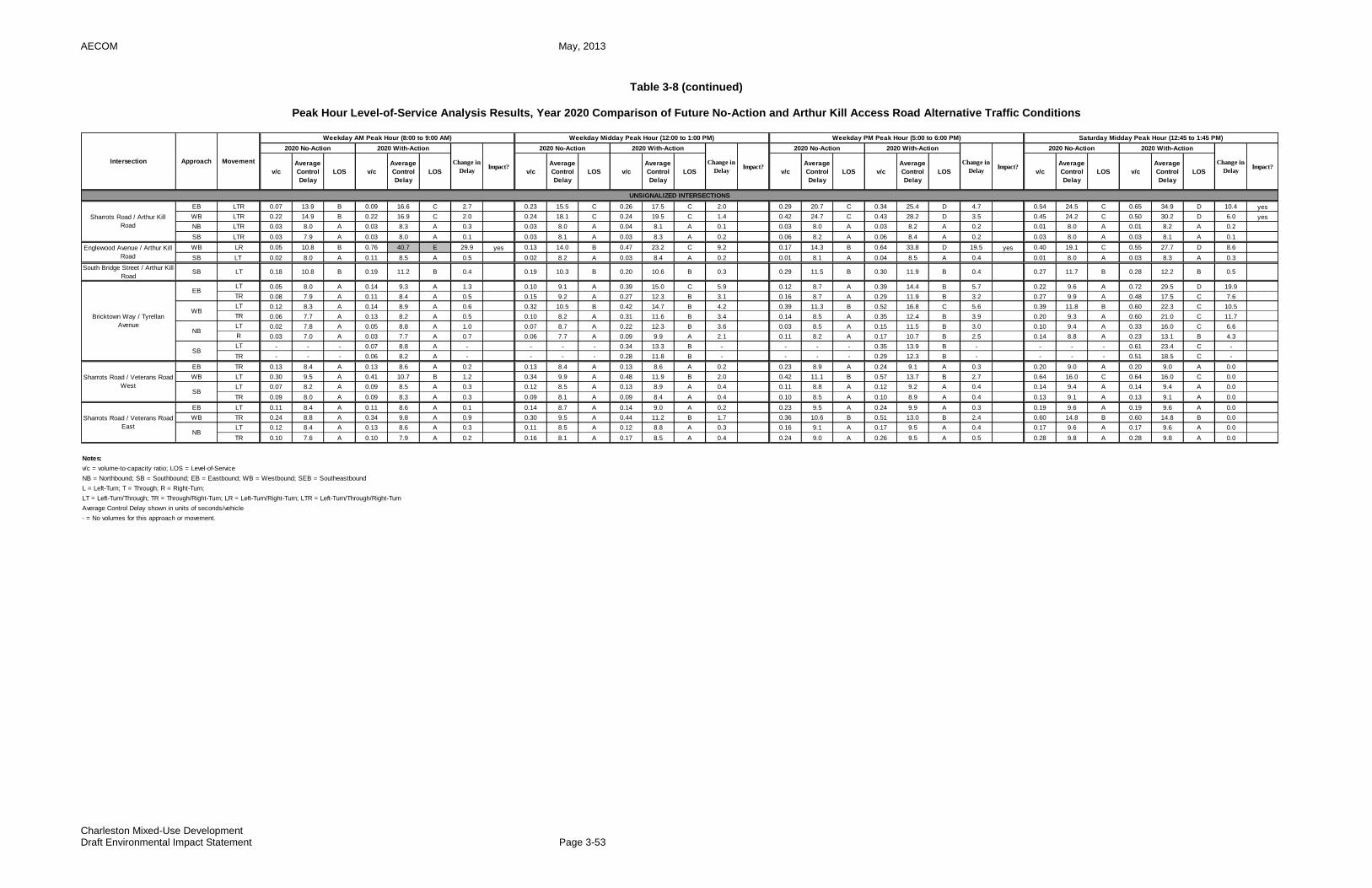
AECOM May, 2013
Charleston Mixed-Use Development Draft Environmental Impact Statement Page 3-53
Table 3-8 (continued)
Peak Hour Level-of-Service Analysis Results, Year 2020 Comparison of Future No-Action and Arthur Kill Access Road Alternative Traffic Conditions
EB LTR 0.07 13.9 B 0.09 16.6 C 2.7 0.23 15.5 C 0.26 17.5 C 2.0 0.29 20.7 C 0.34 25.4 D 4.7 0.54 24.5 C 0.65 34.9 D 10.4 yes
WB LTR 0.22 14.9 B 0.22 16.9 C 2.0 0.24 18.1 C 0.24 19.5 C 1.4 0.42 24.7 C 0.43 28.2 D 3.5 0.45 24.2 C 0.50 30.2 D 6.0 yes
NB LTR 0.03 8.0 A 0.03 8.3 A 0.3 0.03 8.0 A 0.04 8.1 A 0.1 0.03 8.0 A 0.03 8.2 A 0.2 0.01 8.0 A 0.01 8.2 A 0.2
SB LTR 0.03 7.9 A 0.03 8.0 A 0.1 0.03 8.1 A 0.03 8.3 A 0.2 0.06 8.2 A 0.06 8.4 A 0.2 0.03 8.0 A 0.03 8.1 A 0.1
WB LR 0.05 10.8 B 0.76 40.7 E 29.9 yes 0.13 14.0 B 0.47 23.2 C 9.2 0.17 14.3 B 0.64 33.8 D 19.5 yes 0.40 19.1 C 0.55 27.7 D 8.6
SB LT 0.02 8.0 A 0.11 8.5 A 0.5 0.02 8.2 A 0.03 8.4 A 0.2 0.01 8.1 A 0.04 8.5 A 0.4 0.01 8.0 A 0.03 8.3 A 0.3
South Bridge Street / Arthur Kill
RoadSB LT 0.18 10.8 B 0.19 11.2 B 0.4 0.19 10.3 B 0.20 10.6 B 0.3 0.29 11.5 B 0.30 11.9 B 0.4 0.27 11.7 B 0.28 12.2 B 0.5
LT 0.05 8.0 A 0.14 9.3 A 1.3 0.10 9.1 A 0.39 15.0 C 5.9 0.12 8.7 A 0.39 14.4 B 5.7 0.22 9.6 A 0.72 29.5 D 19.9
TR 0.08 7.9 A 0.11 8.4 A 0.5 0.15 9.2 A 0.27 12.3 B 3.1 0.16 8.7 A 0.29 11.9 B 3.2 0.27 9.9 A 0.48 17.5 C 7.6
LT 0.12 8.3 A 0.14 8.9 A 0.6 0.32 10.5 B 0.42 14.7 B 4.2 0.39 11.3 B 0.52 16.8 C 5.6 0.39 11.8 B 0.60 22.3 C 10.5
TR 0.06 7.7 A 0.13 8.2 A 0.5 0.10 8.2 A 0.31 11.6 B 3.4 0.14 8.5 A 0.35 12.4 B 3.9 0.20 9.3 A 0.60 21.0 C 11.7
LT 0.02 7.8 A 0.05 8.8 A 1.0 0.07 8.7 A 0.22 12.3 B 3.6 0.03 8.5 A 0.15 11.5 B 3.0 0.10 9.4 A 0.33 16.0 C 6.6
R 0.03 7.0 A 0.03 7.7 A 0.7 0.06 7.7 A 0.09 9.9 A 2.1 0.11 8.2 A 0.17 10.7 B 2.5 0.14 8.8 A 0.23 13.1 B 4.3
LT - - - 0.07 8.8 A - - - - 0.34 13.3 B - - - - 0.35 13.9 B - - - - 0.61 23.4 C -
TR - - - 0.06 8.2 A - - - - 0.28 11.8 B - - - - 0.29 12.3 B - - - - 0.51 18.5 C -
EB TR 0.13 8.4 A 0.13 8.6 A 0.2 0.13 8.4 A 0.13 8.6 A 0.2 0.23 8.9 A 0.24 9.1 A 0.3 0.20 9.0 A 0.20 9.0 A 0.0
WB LT 0.30 9.5 A 0.41 10.7 B 1.2 0.34 9.9 A 0.48 11.9 B 2.0 0.42 11.1 B 0.57 13.7 B 2.7 0.64 16.0 C 0.64 16.0 C 0.0
LT 0.07 8.2 A 0.09 8.5 A 0.3 0.12 8.5 A 0.13 8.9 A 0.4 0.11 8.8 A 0.12 9.2 A 0.4 0.14 9.4 A 0.14 9.4 A 0.0
TR 0.09 8.0 A 0.09 8.3 A 0.3 0.09 8.1 A 0.09 8.4 A 0.4 0.10 8.5 A 0.10 8.9 A 0.4 0.13 9.1 A 0.13 9.1 A 0.0
EB LT 0.11 8.4 A 0.11 8.6 A 0.1 0.14 8.7 A 0.14 9.0 A 0.2 0.23 9.5 A 0.24 9.9 A 0.3 0.19 9.6 A 0.19 9.6 A 0.0
WB TR 0.24 8.8 A 0.34 9.8 A 0.9 0.30 9.5 A 0.44 11.2 B 1.7 0.36 10.6 B 0.51 13.0 B 2.4 0.60 14.8 B 0.60 14.8 B 0.0
LT 0.12 8.4 A 0.13 8.6 A 0.3 0.11 8.5 A 0.12 8.8 A 0.3 0.16 9.1 A 0.17 9.5 A 0.4 0.17 9.6 A 0.17 9.6 A 0.0
TR 0.10 7.6 A 0.10 7.9 A 0.2 0.16 8.1 A 0.17 8.5 A 0.4 0.24 9.0 A 0.26 9.5 A 0.5 0.28 9.8 A 0.28 9.8 A 0.0
Notes:
v/c = volume-to-capacity ratio; LOS = Level-of-Service
NB = Northbound; SB = Southbound; EB = Eastbound; WB = Westbound; SEB = Southeastbound
L = Left-Turn; T = Through; R = Right-Turn;
LT = Left-Turn/Through; TR = Through/Right-Turn; LR = Left-Turn/Right-Turn; LTR = Left-Turn/Through/Right-Turn
Average Control Delay shown in units of seconds/vehicle
- = No volumes for this approach or movement.
Intersection Approach Movement
Weekday AM Peak Hour (8:00 to 9:00 AM) Weekday Midday Peak Hour (12:00 to 1:00 PM) Weekday PM Peak Hour (5:00 to 6:00 PM) Saturday Midday Peak Hour (12:45 to 1:45 PM)
2020 No-Action 2020 With-Action
Change in
DelayImpact?
v/c
Average
Control
Delay
LOS v/c
Average
Control
Delay
LOS
2020 No-Action 2020 With-Action
Change in
DelayImpact?
2020 No-Action 2020 With-Action
v/c
Average
Control
Delay
LOS v/c v/c
Average
Control
Delay
LOS v/c
Average
Control
Delay
LOS
Average
Control
Delay
LOS v/c
Average
Control
Delay
LOS v/c
Change in
DelayImpact?
2020 No-Action 2020 With-Action
Change in
DelayImpact?
Average
Control
Delay
LOS
UNSIGNALIZED INTERSECTIONS
Sharrots Road / Arthur Kill
Road
Englewood Avenue / Arthur Kill
Road
Sharrots Road / Veterans Road
EastNB
Bricktown Way / Tyrellan
Avenue
EB
WB
NB
SB
Sharrots Road / Veterans Road
WestSB
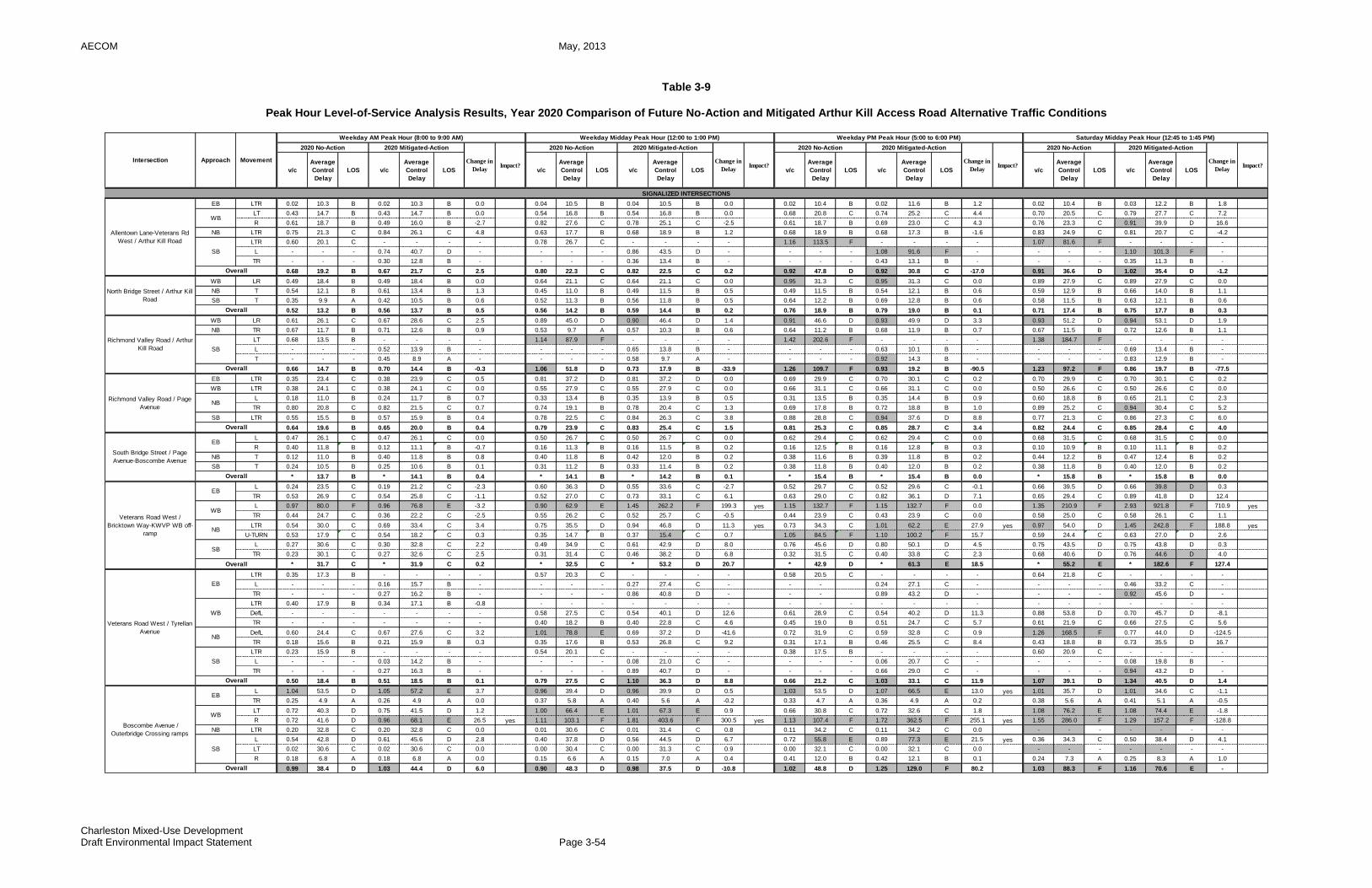
AECOM May, 2013
Charleston Mixed-Use Development Draft Environmental Impact Statement Page 3-54
Table 3-9
Peak Hour Level-of-Service Analysis Results, Year 2020 Comparison of Future No-Action and Mitigated Arthur Kill Access Road Alternative Traffic Conditions
EB LTR 0.02 10.3 B 0.02 10.3 B 0.0 0.04 10.5 B 0.04 10.5 B 0.0 0.02 10.4 B 0.02 11.6 B 1.2 0.02 10.4 B 0.03 12.2 B 1.8
LT 0.43 14.7 B 0.43 14.7 B 0.0 0.54 16.8 B 0.54 16.8 B 0.0 0.68 20.8 C 0.74 25.2 C 4.4 0.70 20.5 C 0.79 27.7 C 7.2
R 0.61 18.7 B 0.49 16.0 B -2.7 0.82 27.6 C 0.78 25.1 C -2.5 0.61 18.7 B 0.69 23.0 C 4.3 0.76 23.3 C 0.91 39.9 D 16.6
NB LTR 0.75 21.3 C 0.84 26.1 C 4.8 0.63 17.7 B 0.68 18.9 B 1.2 0.68 18.9 B 0.68 17.3 B -1.6 0.83 24.9 C 0.81 20.7 C -4.2
LTR 0.60 20.1 C - - - - 0.78 26.7 C - - - - 1.16 113.5 F - - - - 1.07 81.6 F - - - -
L - - - 0.74 40.7 D - - - - 0.86 43.5 D - - - - 1.08 91.6 F - - - - 1.10 101.3 F -
TR - - - 0.30 12.8 B - - - - 0.36 13.4 B - - - - 0.43 13.1 B - - - - 0.35 11.3 B -
0.68 19.2 B 0.67 21.7 C 2.5 0.80 22.3 C 0.82 22.5 C 0.2 0.92 47.8 D 0.92 30.8 C -17.0 0.91 36.6 D 1.02 35.4 D -1.2
WB LR 0.49 18.4 B 0.49 18.4 B 0.0 0.64 21.1 C 0.64 21.1 C 0.0 0.95 31.3 C 0.95 31.3 C 0.0 0.89 27.9 C 0.89 27.9 C 0.0
NB T 0.54 12.1 B 0.61 13.4 B 1.3 0.45 11.0 B 0.49 11.5 B 0.5 0.49 11.5 B 0.54 12.1 B 0.6 0.59 12.9 B 0.66 14.0 B 1.1
SB T 0.35 9.9 A 0.42 10.5 B 0.6 0.52 11.3 B 0.56 11.8 B 0.5 0.64 12.2 B 0.69 12.8 B 0.6 0.58 11.5 B 0.63 12.1 B 0.6
0.52 13.2 B 0.56 13.7 B 0.5 0.56 14.2 B 0.59 14.4 B 0.2 0.76 18.9 B 0.79 19.0 B 0.1 0.71 17.4 B 0.75 17.7 B 0.3
WB LR 0.61 26.1 C 0.67 28.6 C 2.5 0.89 45.0 D 0.90 46.4 D 1.4 0.91 46.6 D 0.93 49.9 D 3.3 0.93 51.2 D 0.94 53.1 D 1.9
NB TR 0.67 11.7 B 0.71 12.6 B 0.9 0.53 9.7 A 0.57 10.3 B 0.6 0.64 11.2 B 0.68 11.9 B 0.7 0.67 11.5 B 0.72 12.6 B 1.1
LT 0.68 13.5 B - - - - 1.14 87.9 F - - - - 1.42 202.6 F - - - - 1.38 184.7 F - - - -
L - - - 0.52 13.9 B - - - - 0.65 13.8 B - - - - 0.63 10.1 B - - - - 0.69 13.4 B -
T - - - 0.45 8.9 A - - - - 0.58 9.7 A - - - - 0.92 14.3 B - - - - 0.83 12.9 B -
0.66 14.7 B 0.70 14.4 B -0.3 1.06 51.8 D 0.73 17.9 B -33.9 1.26 109.7 F 0.93 19.2 B -90.5 1.23 97.2 F 0.86 19.7 B -77.5
EB LTR 0.35 23.4 C 0.38 23.9 C 0.5 0.81 37.2 D 0.81 37.2 D 0.0 0.69 29.9 C 0.70 30.1 C 0.2 0.70 29.9 C 0.70 30.1 C 0.2
WB LTR 0.38 24.1 C 0.38 24.1 C 0.0 0.55 27.9 C 0.55 27.9 C 0.0 0.66 31.1 C 0.66 31.1 C 0.0 0.50 26.6 C 0.50 26.6 C 0.0
L 0.18 11.0 B 0.24 11.7 B 0.7 0.33 13.4 B 0.35 13.9 B 0.5 0.31 13.5 B 0.35 14.4 B 0.9 0.60 18.8 B 0.65 21.1 C 2.3
TR 0.80 20.8 C 0.82 21.5 C 0.7 0.74 19.1 B 0.78 20.4 C 1.3 0.69 17.8 B 0.72 18.8 B 1.0 0.89 25.2 C 0.94 30.4 C 5.2
SB LTR 0.55 15.5 B 0.57 15.9 B 0.4 0.78 22.5 C 0.84 26.3 C 3.8 0.88 28.8 C 0.94 37.6 D 8.8 0.77 21.3 C 0.86 27.3 C 6.0
0.64 19.6 B 0.65 20.0 B 0.4 0.79 23.9 C 0.83 25.4 C 1.5 0.81 25.3 C 0.85 28.7 C 3.4 0.82 24.4 C 0.85 28.4 C 4.0
L 0.47 26.1 C 0.47 26.1 C 0.0 0.50 26.7 C 0.50 26.7 C 0.0 0.62 29.4 C 0.62 29.4 C 0.0 0.68 31.5 C 0.68 31.5 C 0.0
R 0.40 11.8 B 0.12 11.1 B -0.7 0.16 11.3 B 0.16 11.5 B 0.2 0.16 12.5 B 0.16 12.8 B 0.3 0.10 10.9 B 0.10 11.1 B 0.2
NB T 0.12 11.0 B 0.40 11.8 B 0.8 0.40 11.8 B 0.42 12.0 B 0.2 0.38 11.6 B 0.39 11.8 B 0.2 0.44 12.2 B 0.47 12.4 B 0.2
SB T 0.24 10.5 B 0.25 10.6 B 0.1 0.31 11.2 B 0.33 11.4 B 0.2 0.38 11.8 B 0.40 12.0 B 0.2 0.38 11.8 B 0.40 12.0 B 0.2
* 13.7 B * 14.1 B 0.4 * 14.1 B * 14.2 B 0.1 * 15.4 B * 15.4 B 0.0 * 15.8 B * 15.8 B 0.0
L 0.24 23.5 C 0.19 21.2 C -2.3 0.60 36.3 D 0.55 33.6 C -2.7 0.52 29.7 C 0.52 29.6 C -0.1 0.66 39.5 D 0.66 39.8 D 0.3
TR 0.53 26.9 C 0.54 25.8 C -1.1 0.52 27.0 C 0.73 33.1 C 6.1 0.63 29.0 C 0.82 36.1 D 7.1 0.65 29.4 C 0.89 41.8 D 12.4
L 0.97 80.0 F 0.96 76.8 E -3.2 0.90 62.9 E 1.45 262.2 F 199.3 yes 1.15 132.7 F 1.15 132.7 F 0.0 1.35 210.9 F 2.93 921.8 F 710.9 yes
TR 0.44 24.7 C 0.36 22.2 C -2.5 0.55 26.2 C 0.52 25.7 C -0.5 0.44 23.9 C 0.43 23.9 C 0.0 0.58 25.0 C 0.58 26.1 C 1.1
LTR 0.54 30.0 C 0.69 33.4 C 3.4 0.75 35.5 D 0.94 46.8 D 11.3 yes 0.73 34.3 C 1.01 62.2 E 27.9 yes 0.97 54.0 D 1.45 242.8 F 188.8 yes
U-TURN 0.53 17.9 C 0.54 18.2 C 0.3 0.35 14.7 B 0.37 15.4 C 0.7 1.05 84.5 F 1.10 100.2 F 15.7 0.59 24.4 C 0.63 27.0 D 2.6
L 0.27 30.6 C 0.30 32.8 C 2.2 0.49 34.9 C 0.61 42.9 D 8.0 0.76 45.6 D 0.80 50.1 D 4.5 0.75 43.5 D 0.75 43.8 D 0.3
TR 0.23 30.1 C 0.27 32.6 C 2.5 0.31 31.4 C 0.46 38.2 D 6.8 0.32 31.5 C 0.40 33.8 C 2.3 0.68 40.6 D 0.76 44.6 D 4.0
* 31.7 C * 31.9 C 0.2 * 32.5 C * 53.2 D 20.7 * 42.9 D * 61.3 E 18.5 * 55.2 E * 182.6 F 127.4
LTR 0.35 17.3 B - - - - 0.57 20.3 C - - - - 0.58 20.5 C - - - - 0.64 21.8 C - - - -
L - - - 0.16 15.7 B - - - - 0.27 27.4 C - - - 0.24 27.1 C - - - - 0.46 33.2 C -
TR - - - 0.27 16.2 B - - - - 0.86 40.8 D - - - 0.89 43.2 D - - - - 0.92 45.6 D -
LTR 0.40 17.9 B 0.34 17.1 B -0.8 - - - - - - - - - - - - - - - - - - - - -
DefL - - - - - - - 0.58 27.5 C 0.54 40.1 D 12.6 0.61 28.9 C 0.54 40.2 D 11.3 0.88 53.8 D 0.70 45.7 D -8.1
TR - - - - - - - 0.40 18.2 B 0.40 22.8 C 4.6 0.45 19.0 B 0.51 24.7 C 5.7 0.61 21.9 C 0.66 27.5 C 5.6
DefL 0.60 24.4 C 0.67 27.6 C 3.2 1.01 78.8 E 0.69 37.2 D -41.6 0.72 31.9 C 0.59 32.8 C 0.9 1.26 168.5 F 0.77 44.0 D -124.5
TR 0.18 15.6 B 0.21 15.9 B 0.3 0.35 17.6 B 0.53 26.8 C 9.2 0.31 17.1 B 0.46 25.5 C 8.4 0.43 18.8 B 0.73 35.5 D 16.7
LTR 0.23 15.9 B - - - - 0.54 20.1 C - - - - 0.38 17.5 B - - - - 0.60 20.9 C - - - -
L - - - 0.03 14.2 B - - - - 0.08 21.0 C - - - - 0.06 20.7 C - - - - 0.08 19.8 B -
TR - - - 0.27 16.3 B - - - - 0.89 40.7 D - - - - 0.66 29.0 C - - - - 0.94 43.2 D -
0.50 18.4 B 0.51 18.5 B 0.1 0.79 27.5 C 1.10 36.3 D 8.8 0.66 21.2 C 1.03 33.1 C 11.9 1.07 39.1 D 1.34 40.5 D 1.4
L 1.04 53.5 D 1.05 57.2 E 3.7 0.96 39.4 D 0.96 39.9 D 0.5 1.03 53.5 D 1.07 66.5 E 13.0 yes 1.01 35.7 D 1.01 34.6 C -1.1
TR 0.25 4.9 A 0.26 4.9 A 0.0 0.37 5.8 A 0.40 5.6 A -0.2 0.33 4.7 A 0.36 4.9 A 0.2 0.38 5.6 A 0.41 5.1 A -0.5
LT 0.72 40.3 D 0.75 41.5 D 1.2 1.00 66.4 E 1.01 67.3 E 0.9 0.66 30.8 C 0.72 32.6 C 1.8 1.08 76.2 E 1.08 74.4 E -1.8
R 0.72 41.6 D 0.96 68.1 E 26.5 yes 1.11 103.1 F 1.81 403.6 F 300.5 yes 1.13 107.4 F 1.72 362.5 F 255.1 yes 1.55 286.0 F 1.29 157.2 F -128.8
NB LTR 0.20 32.8 C 0.20 32.8 C 0.0 0.01 30.6 C 0.01 31.4 C 0.8 0.11 34.2 C 0.11 34.2 C 0.0 - - - - - - -
L 0.54 42.8 D 0.61 45.6 D 2.8 0.40 37.8 D 0.56 44.5 D 6.7 0.72 55.8 E 0.89 77.3 E 21.5 yes 0.36 34.3 C 0.50 38.4 D 4.1
LT 0.02 30.6 C 0.02 30.6 C 0.0 0.00 30.4 C 0.00 31.3 C 0.9 0.00 32.1 C 0.00 32.1 C 0.0 - - - - - - -
R 0.18 6.8 A 0.18 6.8 A 0.0 0.15 6.6 A 0.15 7.0 A 0.4 0.41 12.0 B 0.42 12.1 B 0.1 0.24 7.3 A 0.25 8.3 A 1.0
0.99 38.4 D 1.03 44.4 D 6.0 0.90 48.3 D 0.98 37.5 D -10.8 1.02 48.8 D 1.25 129.0 F 80.2 1.03 88.3 F 1.16 70.6 E -
Overall
EB
EB
SB
Richmond Valley Road / Arthur
Kill Road
WB
Veterans Road West / Tyrellan
Avenue
WB
NB
SB
EB
Overall
Richmond Valley Road / Page
Avenue
NB
Overall
Boscombe Avenue /
Outerbridge Crossing ramps
EB
SB
Overall
NB
Overall
South Bridge Street / Page
Avenue-Boscombe Avenue
Overall
Veterans Road West /
Bricktown Way-KWVP WB off-
ramp
WB
SIGNALIZED INTERSECTIONS
Overall
v/c
Average
Control
Delay
LOS v/c
Average
Control
Delay
LOS
Average
Control
Delay
LOS v/c
Average
Control
Delay
LOS v/cv/c
Average
Control
Delay
LOS v/c
WB
Allentown Lane-Veterans Rd
West / Arthur Kill Road
Overall
North Bridge Street / Arthur Kill
Road
Change in
DelayImpact?
2020 No-Action 2020 Mitigated-Action
Impact?Average
Control
Delay
LOS
2020 No-Action 2020 Mitigated-Action
Change in
DelayImpact?
2020 No-Action 2020 Mitigated-Action
SB
SB
Intersection Approach Movement
Weekday AM Peak Hour (8:00 to 9:00 AM) Weekday Midday Peak Hour (12:00 to 1:00 PM) Weekday PM Peak Hour (5:00 to 6:00 PM) Saturday Midday Peak Hour (12:45 to 1:45 PM)
2020 No-Action 2020 Mitigated-Action
Change in
DelayImpact?
v/c
Average
Control
Delay
LOS v/c
Average
Control
Delay
LOS
Change in
Delay
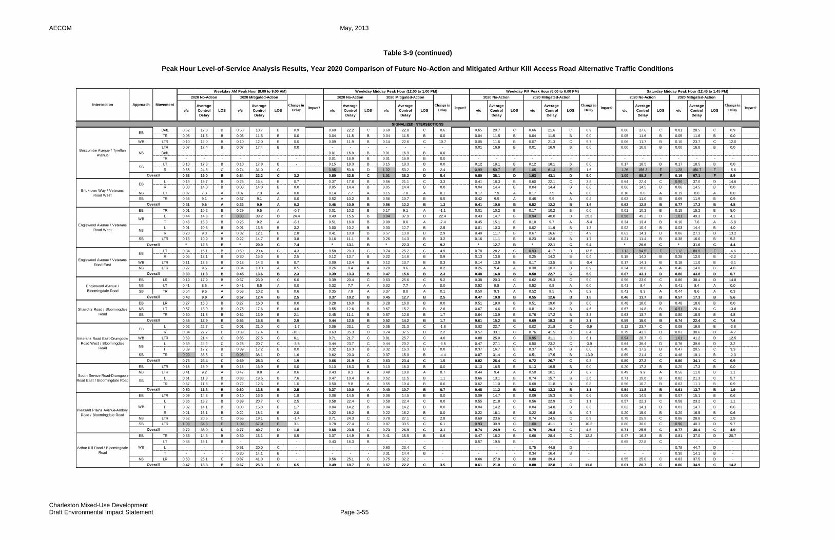
AECOM May, 2013
Charleston Mixed-Use Development Draft Environmental Impact Statement Page 3-55
Table 3-9 (continued)
Peak Hour Level-of-Service Analysis Results, Year 2020 Comparison of Future No-Action and Mitigated Arthur Kill Access Road Alternative Traffic Conditions
DefL 0.52 17.8 B 0.56 18.7 B 0.9 0.68 22.2 C 0.68 22.8 C 0.6 0.65 20.7 C 0.66 21.6 C 0.9 0.80 27.6 C 0.81 28.5 C 0.9
TR 0.03 11.5 B 0.03 11.5 B 0.0 0.04 11.5 B 0.04 11.5 B 0.0 0.04 11.5 B 0.04 11.5 B 0.0 0.05 11.6 B 0.05 11.6 B 0.0
WB LTR 0.10 12.0 B 0.10 12.0 B 0.0 0.09 11.9 B 0.14 22.6 C 10.7 0.05 11.6 B 0.07 21.3 C 9.7 0.06 11.7 B 0.10 23.7 C 12.0
LTR 0.07 17.4 B 0.07 17.4 B 0.0 - - - - - - - 0.01 16.9 B 0.01 16.9 B 0.0 0.00 16.8 B 0.00 16.8 B 0.0
DefL - - - - - - - 0.01 16.9 B 0.01 16.9 B 0.0 - - - - - - - - - - - - - -
TR - - - - - - - 0.01 16.9 B 0.01 16.9 B 0.0 - - - - - - - - - - - - - -
LT 0.10 17.8 B 0.10 17.8 B - 0.15 18.3 B 0.15 18.3 B 0.0 0.12 18.1 B 0.12 18.1 B 0.0 0.17 18.5 B 0.17 18.5 B 0.0
R 0.55 24.8 C 0.74 31.0 C - 0.95 50.8 D 1.02 53.2 D 2.4 0.99 59.7 E 1.05 61.3 E 1.6 1.26 156.3 F 1.28 150.7 F -5.6
0.53 19.0 B 0.64 22.2 C 3.2 0.80 32.8 C 1.01 38.2 D 5.4 0.80 38.1 D 1.03 43.1 D 5.0 1.00 88.2 F 0.19 97.1 F 8.9
L 0.19 15.7 B 0.25 16.4 B 0.7 0.37 17.8 B 0.56 21.1 C 3.3 0.41 18.3 B 0.60 22.1 C 3.8 0.64 22.4 C 0.90 37.0 D 14.6
R 0.00 14.0 B 0.00 14.0 B 0.0 0.05 14.4 B 0.05 14.4 B 0.0 0.04 14.4 B 0.04 14.4 B 0.0 0.06 14.5 B 0.06 14.5 B 0.0
NB LT 0.07 7.3 A 0.07 7.3 A 0.0 0.14 7.7 A 0.15 7.8 A 0.1 0.17 7.9 A 0.17 7.9 A 0.0 0.18 8.0 A 0.19 8.0 A 0.0
SB TR 0.38 9.1 A 0.37 9.1 A 0.0 0.52 10.2 B 0.56 10.7 B 0.5 0.42 9.5 A 0.46 9.9 A 0.4 0.62 11.0 B 0.69 11.9 B 0.9
0.31 9.6 A 0.32 9.9 A 0.3 0.46 10.9 B 0.56 12.2 B 1.3 0.41 10.6 B 0.52 12.2 B 1.6 0.63 12.8 B 0.77 17.3 B 4.5
EB TR 0.01 10.2 B 0.29 9.5 A -0.7 0.01 10.2 B 0.17 9.1 A -1.1 0.01 10.2 B 0.17 10.2 B 0.0 0.01 10.2 B 0.15 15.2 B 5.0
L 0.44 14.8 B 0.93 39.2 D 24.4 0.49 15.5 B 0.94 37.9 D 22.4 0.43 14.7 B 0.94 40.0 D 25.3 0.96 45.2 D 1.01 49.3 D 4.1
T 0.46 15.3 B 0.25 9.2 A -6.1 0.51 16.0 B 0.09 8.6 A -7.4 0.45 15.1 B 0.10 9.7 A -5.4 0.34 13.4 B 0.10 7.6 A -5.8
L 0.01 10.3 B 0.01 13.5 B 3.2 0.00 10.2 B 0.00 12.7 B 2.5 0.01 10.3 B 0.02 11.6 B 1.3 0.02 10.4 B 0.03 14.4 B 4.0
R 0.20 9.3 A 0.32 12.1 B 2.8 0.41 10.9 B 0.57 13.8 B 2.9 0.49 11.7 B 0.67 16.6 C 4.9 0.63 14.1 B 0.86 27.3 D 13.2
SB LTR 0.13 10.9 B 0.22 14.7 B 3.8 0.16 11.1 B 0.26 14.3 B 3.2 0.16 11.1 B 0.23 12.8 B 1.7 0.21 11.4 B 0.38 16.6 B 5.2
* 12.6 B * 20.0 C 7.4 * 13.1 B * 22.3 C 9.2 * 12.7 B * 22.1 C 9.4 * 26.6 C * 31.0 C 4.4
LT 0.34 16.1 B 0.59 20.4 C 4.3 0.58 20.3 C 0.74 25.2 C 4.9 0.78 28.2 C 0.93 41.7 D 13.5 1.12 94.5 F 1.12 89.9 F -4.6
R 0.05 13.1 B 0.30 15.6 B 2.5 0.12 13.7 B 0.22 14.6 B 0.9 0.13 13.8 B 0.25 14.2 B 0.4 0.18 14.2 B 0.28 12.0 B -2.2
WB LTR 0.11 13.6 B 0.18 14.3 B 0.7 0.09 13.4 B 0.12 13.7 B 0.3 0.14 13.9 B 0.17 13.5 B -0.4 0.17 14.1 B 0.18 11.0 B -3.1
NB LTR 0.27 9.5 A 0.34 10.0 A 0.5 0.26 9.4 A 0.28 9.6 A 0.2 0.26 9.4 A 0.30 10.3 B 0.9 0.34 10.0 A 0.46 14.0 B 4.0
0.30 11.3 B 0.45 13.6 B 2.3 0.39 13.3 B 0.47 15.6 B 2.3 0.48 16.8 B 0.58 22.7 C 5.9 0.67 43.1 D 0.80 43.8 D 0.7
EB LR 0.19 17.9 B 0.57 23.9 C 6.0 0.39 20.4 C 0.63 25.6 C 5.2 0.38 20.3 C 0.62 25.3 C 5.0 0.56 23.6 C 0.86 38.4 D 14.8
NB LT 0.41 8.5 A 0.41 8.5 A 0.0 0.32 7.7 A 0.32 7.7 A 0.0 0.52 9.5 A 0.52 9.5 A 0.0 0.41 8.4 A 0.41 8.4 A 0.0
SB TR 0.54 9.6 A 0.58 10.2 B 0.6 0.35 7.9 A 0.37 8.0 A 0.1 0.50 9.3 A 0.52 9.5 A 0.2 0.41 8.3 A 0.44 8.6 A 0.3
0.43 9.9 A 0.57 12.4 B 2.5 0.37 10.2 B 0.45 12.7 B 2.5 0.47 10.8 B 0.55 12.6 B 1.8 0.46 11.7 B 0.57 17.3 B 5.6
EB LR 0.27 16.0 B 0.27 16.0 B 0.0 0.28 16.0 B 0.28 16.0 B 0.0 0.51 19.0 B 0.51 19.0 B 0.0 0.48 18.6 B 0.48 18.6 B 0.0
NB LT 0.57 13.0 B 0.75 17.6 B 4.6 0.55 12.6 B 0.67 15.2 B 2.6 0.67 14.6 B 0.81 19.2 B 4.6 0.67 14.8 B 0.91 28.4 C 13.6
SB TR 0.50 11.8 B 0.62 13.9 B 2.1 0.45 11.1 B 0.57 12.8 B 1.7 0.64 13.9 B 0.76 17.2 B 3.3 0.63 13.7 B 0.80 18.5 B 4.8
0.45 12.9 B 0.56 15.8 B 2.9 0.44 12.5 B 0.52 14.2 B 1.7 0.61 15.2 B 0.69 18.3 B 3.1 0.59 15.0 B 0.74 22.4 C 7.4
L 0.02 22.7 C 0.01 21.0 C -1.7 0.06 23.1 C 0.05 21.3 C -1.8 0.02 22.7 C 0.02 21.8 C -0.9 0.12 23.7 C 0.08 19.9 B -3.8
R 0.34 27.7 C 0.39 17.4 B -10.3 0.63 35.3 D 0.74 37.5 D 2.2 0.57 33.1 C 0.76 41.5 D 8.4 0.79 43.3 D 0.83 38.6 D -4.7
WB LTR 0.69 21.4 C 0.85 27.5 C 6.1 0.71 21.7 C 0.81 25.7 C 4.0 0.88 25.0 C 0.95 31.1 C 6.1 0.94 28.7 C 1.01 41.2 D 12.5
L 0.39 24.2 C 0.25 20.7 C -3.5 0.44 23.7 C 0.44 20.2 C -3.5 0.47 27.1 C 0.50 23.2 C -3.9 0.64 36.4 D 0.76 39.6 D 3.2
T 0.39 17.2 B 0.39 17.2 B 0.0 0.32 16.3 B 0.32 16.3 B 0.0 0.37 16.7 B 0.37 16.7 B 0.0 0.40 17.2 B 0.47 20.5 C 3.3
SB TR 0.99 36.5 D 0.98 38.1 D 1.6 0.62 20.3 C 0.37 15.9 B -4.4 0.87 31.4 C 0.51 17.5 B -13.9 0.69 21.4 C 0.48 19.1 B -2.3
0.76 26.4 C 0.69 28.3 C 1.9 0.66 21.9 C 0.63 23.4 C 1.5 0.82 26.4 C 0.72 26.7 C 0.3 0.80 27.2 C 0.86 34.1 C 6.9
EB LTR 0.16 16.9 B 0.16 16.9 B 0.0 0.10 16.3 B 0.10 16.3 B 0.0 0.13 16.5 B 0.13 16.5 B 0.0 0.20 17.3 B 0.20 17.3 B 0.0
NB LTR 0.41 9.2 A 0.47 9.8 A 0.6 0.43 9.3 A 0.49 10.0 A 0.7 0.44 9.4 A 0.50 10.1 B 0.7 0.49 9.9 A 0.56 11.0 B 1.1
L 0.61 11.9 B 0.83 19.5 B 7.6 0.47 10.4 B 0.52 11.5 B 1.1 0.66 13.1 B 0.74 15.7 B 2.6 0.71 15.6 B 0.82 21.3 C 5.7
TR 0.67 11.6 B 0.72 12.6 B 1.0 0.50 9.8 A 0.55 10.4 B 0.6 0.62 11.0 B 0.68 11.8 B 0.8 0.56 10.2 B 0.63 11.1 B 0.9
0.50 11.3 B 0.60 13.8 B 2.5 0.37 10.0 A 0.40 10.7 B 0.7 0.48 11.2 B 0.53 12.3 B 1.1 0.54 11.8 B 0.61 13.7 B 1.9
EB LTR 0.09 14.8 B 0.10 16.6 B 1.8 0.06 14.5 B 0.06 14.5 B 0.0 0.09 14.7 B 0.09 15.3 B 0.6 0.06 14.5 B 0.07 15.1 B 0.6
L 0.36 18.2 B 0.39 20.7 C 2.5 0.58 22.4 C 0.58 22.4 C 0.0 0.55 21.8 C 0.56 22.9 C 1.1 0.57 22.1 C 0.58 23.2 C 1.1
T 0.02 14.1 B 0.03 15.8 B 1.7 0.04 14.2 B 0.04 14.2 B 0.0 0.04 14.2 B 0.04 14.8 B 0.6 0.02 14.1 B 0.03 14.7 B 0.6
R 0.21 16.1 B 0.22 18.1 B 2.0 0.22 16.2 B 0.22 16.2 B 0.0 0.22 16.1 B 0.22 16.8 B 0.7 0.20 15.9 B 0.20 16.5 B 0.6
NB LTR 0.52 20.5 C 0.55 19.1 B -1.4 0.71 24.3 C 0.78 27.1 C 2.8 0.69 23.6 C 0.74 24.5 C 0.9 0.79 25.9 C 0.86 28.8 C 2.9
SB LTR 1.08 64.8 E 1.09 67.9 E 3.1 0.78 27.4 C 0.87 33.5 C 6.1 0.93 30.9 C 1.00 41.1 D 10.2 0.86 30.6 C 0.96 40.3 D 9.7
0.72 38.9 D 0.77 40.7 D 1.8 0.68 23.8 C 0.73 26.9 C 3.1 0.74 24.9 C 0.79 29.4 C 4.5 0.71 25.5 C 0.77 30.4 C 4.9
EB TR 0.35 14.6 B 0.39 15.1 B 0.5 0.37 14.9 B 0.41 15.5 B 0.6 0.47 16.2 B 0.68 28.4 C 12.2 0.47 16.3 B 0.81 37.0 D 20.7
LT 0.36 15.1 B - - - - 0.43 16.3 B - - - - 0.57 19.5 B - - - - 0.65 22.8 C - - - -
L - - - 0.51 20.0 C - - - - 0.60 23.4 C - - - - 0.75 44.8 D - - - - 0.78 44.7 D -
T - - - 0.30 14.1 B - - - - 0.31 14.4 B - - - - 0.34 16.4 B - - - - 0.30 14.1 B -
NB LR 0.60 26.1 C 0.87 41.0 D - 0.56 25.1 C 0.75 32.2 - - 0.66 27.9 C 0.88 39.4 - - 0.55 25.0 C 0.83 37.5 D -
0.47 18.8 B 0.67 25.3 C 6.5 0.49 18.7 B 0.67 22.2 C 3.5 0.61 21.0 C 0.88 32.8 C 11.8 0.61 20.7 C 0.86 34.9 C 14.2
Pleasant Plains Avenue-Amboy
Road / Bloomingdale Road
WB
Overall
Englewood Avenue / Veterans
Road East
EB
Overall
Englewood Avenue /
Bloomingdale Road
Overall
NB
SB
Overall
Bricktown Way / Veterans
Road West
EB
Overall
Boscombe Avenue / Tyrellan
Avenue
EB
Arthur Kill Road / Bloomingdale
Road
Overall
Veterans Road East-Drumgoole
Road West / Bloomingdale
Road
EB
NB
Englewood Avenue / Veterans
Road West
WB
Overall
Sharrotts Road / Bloomingdale
Road
Overall
NB
Overall
South Service Road-Drumgoole
Road East / Bloomingdale Road SB
Overall
SIGNALIZED INTERSECTIONS
v/c
Average
Control
Delay
LOS v/c
Average
Control
Delay
LOS
Average
Control
Delay
LOS v/c
Average
Control
Delay
LOS v/cv/c
Average
Control
Delay
LOS v/c
Change in
DelayImpact?
2020 No-Action 2020 Mitigated-Action
Impact?Average
Control
Delay
LOS
2020 No-Action 2020 Mitigated-Action
Change in
DelayImpact?
2020 No-Action 2020 Mitigated-Action
WB
Intersection Approach Movement
Weekday AM Peak Hour (8:00 to 9:00 AM) Weekday Midday Peak Hour (12:00 to 1:00 PM) Weekday PM Peak Hour (5:00 to 6:00 PM) Saturday Midday Peak Hour (12:45 to 1:45 PM)
2020 No-Action 2020 Mitigated-Action
Change in
DelayImpact?
v/c
Average
Control
Delay
LOS v/c
Average
Control
Delay
LOS
Change in
Delay

AECOM May, 2013
Charleston Mixed-Use Development Draft Environmental Impact Statement Page 3-56
Table 3-9 (continued)
Peak Hour Level-of-Service Analysis Results, Year 2020 Comparison of Future No-Action and Mitigated Arthur Kill Access Road Alternative Traffic Conditions
EB LTR 0.07 13.9 B 0.09 16.6 C 2.7 0.23 15.5 C 0.26 17.5 C 2.0 0.29 20.7 C 0.34 25.4 D 4.7 0.54 24.5 C 0.65 34.9 D 10.4 yes
WB LTR 0.22 14.9 B 0.22 16.9 C 2.0 0.24 18.1 C 0.24 19.5 C 1.4 0.42 24.7 C 0.43 28.2 D 3.5 0.45 24.2 C 0.50 30.2 D 6.0 yes
NB LTR 0.03 8.0 A 0.03 8.3 A 0.3 0.03 8.0 A 0.04 8.1 A 0.1 0.03 8.0 A 0.03 8.2 A 0.2 0.01 8.0 A 0.01 8.2 A 0.2
SB LTR 0.03 7.9 A 0.03 8.0 A 0.1 0.03 8.1 A 0.03 8.3 A 0.2 0.06 8.2 A 0.06 8.4 A 0.2 0.03 8.0 A 0.03 8.1 A 0.1
LR 0.05 10.8 B - - - - 0.13 14.0 B - - - - 0.17 14.3 B - - - - 0.40 19.1 C - - - -
L - - - 0.63 33.9 D - - - - 0.45 23.2 C - - - - 0.57 32.8 D - - - - 0.50 27.7 D -
R - - - 0.08 10.3 B - - - - 0.03 10.6 B - - - - 0.07 11.3 B - - - - 0.04 10.6 B -
SB LT 0.02 8.0 A 0.11 8.5 A 0.5 0.02 8.2 A 0.03 8.4 A 0.2 0.01 8.1 A 0.04 8.5 A 0.4 0.01 8.0 A 0.03 8.3 A 0.3
South Bridge Street / Arthur Kill
RoadSB LT 0.18 10.8 B 0.19 11.2 B 0.4 0.19 10.3 B 0.20 10.6 B 0.3 0.29 11.5 B 0.30 11.9 B 0.4 0.27 11.7 B 0.28 12.2 B 0.5
LT 0.05 8.0 A 0.14 9.3 A 1.3 0.10 9.1 A 0.39 15.0 C 5.9 0.12 8.7 A 0.39 14.4 B 5.7 0.22 9.6 A 0.72 29.5 D 19.9
TR 0.08 7.9 A 0.11 8.4 A 0.5 0.15 9.2 A 0.27 12.3 B 3.1 0.16 8.7 A 0.29 11.9 B 3.2 0.27 9.9 A 0.48 17.5 C 7.6
LT 0.12 8.3 A 0.14 8.9 A 0.6 0.32 10.5 B 0.42 14.7 B 4.2 0.39 11.3 B 0.52 16.8 C 5.6 0.39 11.8 B 0.60 22.3 C 10.5
TR 0.06 7.7 A 0.13 8.2 A 0.5 0.10 8.2 A 0.31 11.6 B 3.4 0.14 8.5 A 0.35 12.4 B 3.9 0.20 9.3 A 0.60 21.0 C 11.7
LT 0.02 7.8 A 0.05 8.8 A 1.0 0.07 8.7 A 0.22 12.3 B 3.6 0.03 8.5 A 0.15 11.5 B 3.0 0.10 9.4 A 0.33 16.0 C 6.6
R 0.03 7.0 A 0.03 7.7 A 0.7 0.06 7.7 A 0.09 9.9 A 2.1 0.11 8.2 A 0.17 10.7 B 2.5 0.14 8.8 A 0.23 13.1 B 4.3
LT - - - 0.07 8.8 A - - - - 0.34 13.3 B - - - - 0.35 13.9 B - - - - 0.61 23.4 C -
TR - - - 0.06 8.2 A - - - - 0.28 11.8 B - - - - 0.29 12.3 B - - - - 0.51 18.5 C -
EB TR 0.13 8.4 A 0.13 8.6 A 0.2 0.13 8.4 A 0.13 8.6 A 0.2 0.23 8.9 A 0.24 9.1 A 0.3 0.20 9.0 A 0.20 9.0 A 0.0
WB LT 0.30 9.5 A 0.41 10.7 B 1.2 0.34 9.9 A 0.48 11.9 B 2.0 0.42 11.1 B 0.57 13.7 B 2.7 0.64 16.0 C 0.64 16.0 C 0.0
LT 0.07 8.2 A 0.09 8.5 A 0.3 0.12 8.5 A 0.13 8.9 A 0.4 0.11 8.8 A 0.12 9.2 A 0.4 0.14 9.4 A 0.14 9.4 A 0.0
TR 0.09 8.0 A 0.09 8.3 A 0.3 0.09 8.1 A 0.09 8.4 A 0.4 0.10 8.5 A 0.10 8.9 A 0.4 0.13 9.1 A 0.13 9.1 A 0.0
EB LT 0.11 8.4 A 0.11 8.6 A 0.1 0.14 8.7 A 0.14 9.0 A 0.2 0.23 9.5 A 0.24 9.9 A 0.3 0.19 9.6 A 0.19 9.6 A 0.0
WB TR 0.24 8.8 A 0.34 9.8 A 0.9 0.30 9.5 A 0.44 11.2 B 1.7 0.36 10.6 B 0.51 13.0 B 2.4 0.60 14.8 B 0.60 14.8 B 0.0
LT 0.12 8.4 A 0.13 8.6 A 0.3 0.11 8.5 A 0.12 8.8 A 0.3 0.16 9.1 A 0.17 9.5 A 0.4 0.17 9.6 A 0.17 9.6 A 0.0
TR 0.10 7.6 A 0.10 7.9 A 0.2 0.16 8.1 A 0.17 8.5 A 0.4 0.24 9.0 A 0.26 9.5 A 0.5 0.28 9.8 A 0.28 9.8 A 0.0
Notes:
v/c = volume-to-capacity ratio; LOS = Level-of-Service
NB = Northbound; SB = Southbound; EB = Eastbound; WB = Westbound; SEB = Southeastbound
L = Left-Turn; T = Through; R = Right-Turn;
LT = Left-Turn/Through; TR = Through/Right-Turn; LR = Left-Turn/Right-Turn; LTR = Left-Turn/Through/Right-Turn
Average Control Delay shown in units of seconds/vehicle
- = No volumes for this approach or movement.
NB
SB
WB
WB
Sharrots Road / Veterans Road
EastNB
UNSIGNALIZED INTERSECTIONS
Sharrots Road / Arthur Kill
Road
Englewood Avenue / Arthur Kill
Road
Bricktown Way / Tyrellan
Avenue
EB
Sharrots Road / Veterans Road
WestSB
v/c
Average
Control
Delay
LOS v/c
Average
Control
Delay
LOS
Average
Control
Delay
LOS v/c
Average
Control
Delay
LOS v/cv/c
Average
Control
Delay
LOS v/c
Change in
DelayImpact?
2020 No-Action 2020 Mitigated-Action
Impact?Average
Control
Delay
LOS
2020 No-Action 2020 Mitigated-Action
Change in
DelayImpact?
2020 No-Action 2020 Mitigated-Action
Intersection Approach Movement
Weekday AM Peak Hour (8:00 to 9:00 AM) Weekday Midday Peak Hour (12:00 to 1:00 PM) Weekday PM Peak Hour (5:00 to 6:00 PM) Saturday Midday Peak Hour (12:45 to 1:45 PM)
2020 No-Action 2020 Mitigated-Action
Change in
DelayImpact?
v/c
Average
Control
Delay
LOS v/c
Average
Control
Delay
LOS
Change in
Delay
AECOM May, 2013
Charleston Mixed-Use Development Draft Environmental Impact Statement Page 3-57
Public Health The findings for public health from the analysis provided for the Proposed Project in Chapter 2.17 would not change under this alternative. All of the other development components would still be constructed on the retail, park, senior housing and school sites. The Proposed Project would not result in unmitigated significant adverse impacts in technical areas such as air quality, hazardous materials, or noise. Further, the Proposed Project would not introduce any unusual circumstances that have potential public health consequences related to other issues. Therefore, a detailed public health assessment was not warranted and significant adverse impacts to public health are not expected to occur. This alternative would not alter this conclusion. Neighborhood Character This alternative would not alter the findings for neighborhood character from the analysis provided for the Proposed Project in Chapter 2.18. As previously discussed in this section, this alternative would not result in any new significant adverse impacts to those components that make up neighborhood character. The only changes would be the new roadway land use and new views along the access roadway, which would carry additional vehicular traffic between Retail Site “A” and Bricktown Way to/from Retail Site “B” and Arthur Kill Road. Construction
The findings from the construction analysis provided for the Proposed Project in Chapter 2.19 would not be significantly changed under this alternative. All of the other development components would still be constructed on the retail, park, senior housing and school sites. It is possible that, under this alternative, slightly more construction waste and more construction truck and other trips would be generated if this access road were constructed. It is expected that the construction of the additional access road would be completed in less than 12 months. This access road, under this alternative scenario, could potentially be constructed when Retail Site “B” is constructed, though actual construction scenarios are not planned or known at this time.