Embed Size (px)
Citation preview

27th May 2020

i
EXPLANATORY NOTE
The following informal compilation reproduces paragraphs from the United Nations
General Assembly (UNGA) documentation in the A/AC.105/ series on the annual meetings of
the International Committee on Global Navigation Satellite Systems (ICG), held since 2006,
in which decisions and recommendations undertaken by ICG and its Providers’ Forum are
reflected. When necessary, the compilation is to be read with the UNGA annual reports.
References are provided to the full text of the respective reports, including links to electronic
copies thereof.
The Terms of reference of ICG and its Providers’ Forum, the workplan of the Providers’
Forum and the list of State Members of the United Nations and governmental,
intergovernmental and non-governmental organizations participating in ICG are contained in
annexes I through IV. A template for sharing information between service providers and the
list of the meetings of ICG are contained in annexes V and VI. The list of publications is
contained in annex VII. The statement of the Providers’ Forum concerning ICG is contained in
annex VIII. The summary of discussions concerning the “Future of ICG” is contained in annex
IX, and the Mission Statement and Vision Statement of ICG are contained in annexes X and
XI respectively.
Documents are available in all official languages of the United Nations and can be
downloaded from the ICG information portal at www.unoosa.org or directly at:
http://www.unoosa.org/oosa/en/ourwork/icg/icg.html

ii
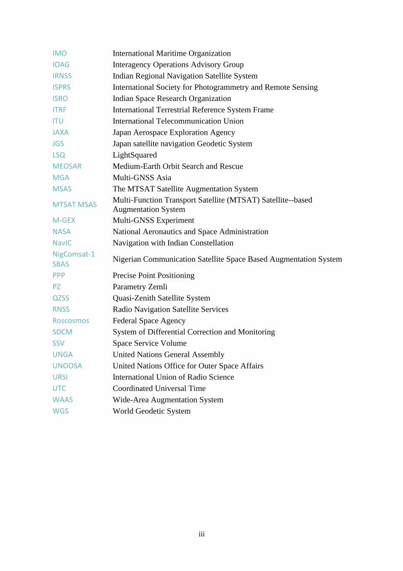
LIST OF ACRONYMS
AIN Arab Institute of Navigation
APSCO The Asia-Pacific Space Cooperation Organization
ARAIM Advanced Receiver Autonomous Integrity Monitoring
BIPM International Bureau of Weights and Measures
BDS BeiDou Navigation Satellite System
CGS China Geodetic Coordinate System
CGSIC Civil Global Positioning System (GPS) Service Interface Committee
CNSS Compass/BeiDou Navigation Satellite System
COSPAR Committee on Space Research
COSPAS-SARSAT
International Satellite System for Search and Rescue
CSNC China Satellite Navigation Conference
EGNOS European Geostationary Navigation Overlay Service
EIAST Emirates Institution for Advanced Science and Technology
ESA European Space Agency
ESPI European Space Policy Institute
EUPOS European Position Determination System
EUREF Reference Frame Sub-Commission for Europe
FAI World Air Sports Federation
FCC Federal Communications Commission
FIG International Federation of Surveyors
GAGAN GPS-aided GEO-augmented Navigation System
Galileo European Global Navigation Satellite System
GEO Geosynchronous orbit
GLONASS Global Navigation Satellite System
GNSS Global Navigation Satellite Systems
GPS Global Positioning System
ETRS European Terrestrial Reference System
IADC Inter-Agency Space Debris Coordination Committee
IAG International Association of Geodesy
IAIN International Association of Institutes of Navigation
ICA International Cartographic Association
ICAO International Civil Aviation Organization
ICG International Committee on Global Navigation Satellite Systems
IDM Interference detection and mitigation
IERS International Earth Rotation and Reference Systems Service
IGMA International GNSS Monitoring and Assessment
iGMAS International GNSS Monitoring and Assessment Service
IGS International GNSS Service
iii
IMO International Maritime Organization
IOAG Interagency Operations Advisory Group
IRNSS Indian Regional Navigation Satellite System
ISPRS International Society for Photogrammetry and Remote Sensing
ISRO Indian Space Research Organization
ITRF International Terrestrial Reference System Frame
ITU International Telecommunication Union
JAXA Japan Aerospace Exploration Agency
JGS Japan satellite navigation Geodetic System
LSQ LightSquared
MEOSAR Medium-Earth Orbit Search and Rescue
MGA Multi-GNSS Asia
MSAS The MTSAT Satellite Augmentation System
MTSAT MSAS Multi-Function Transport Satellite (MTSAT) Satellite--based
Augmentation System
M-GEX Multi-GNSS Experiment
NASA National Aeronautics and Space Administration
NavIC Navigation with Indian Constellation
NigComsat-1 SBAS
Nigerian Communication Satellite Space Based Augmentation System
PPP Precise Point Positioning
PZ Parametry Zemli
QZSS Quasi-Zenith Satellite System
RNSS Radio Navigation Satellite Services
Roscosmos Federal Space Agency
SDCM System of Differential Correction and Monitoring
SSV Space Service Volume
UNGA United Nations General Assembly
UNOOSA United Nations Office for Outer Space Affairs
URSI International Union of Radio Science
UTC Coordinated Universal Time
WAAS Wide-Area Augmentation System
WGS World Geodetic System

iv
CONTENTS
Explanatory Note ..................................................................................................................................... i
List of acronyms ..................................................................................................................................... ii
Contents ................................................................................................................................................. iv
1. Background ..................................................................................................................................... 1
2. Extracts from conclusions of the Providers’ Forum meetings ........................................................ 2
3. Extracts from the Joint Statements adopted at the ICG meetings, including the ICG
recommendations and decisions............................................................................................................ 16
4. Extracts from the WorkIng Group Reports ................................................................................... 21
4.1. Working Group S on systems, signals and services (formerly Working Group A on
compatibility and interoperability).................................................................................................... 21
4.2. Working Group B on enhancement of GNSS performance, new services and capabilities
(formerly Working Group B on enhancement of the performance of GNSS services) .................... 25
4.3. Working Group C on information dissemination and capacity building .............................. 30
4.4. Working Group D on reference frames, timing and applications ......................................... 33
Annex I: Terms of Reference of the International Committee on Global Navigation Satellite Systems
.............................................................................................................................................................. 37
Annex II: Terms of Reference of the International Committee on Global Navigation Satellite Systems
Providers’ Forum .................................................................................................................................. 41
Annex III: Workplan of the Providers’ Forum ..................................................................................... 44
Appendix: Providers’ Forum principles of compatibility and interoperability and their further
definition ........................................................................................................................................... 46
Annex IV: List of States Members of the United Nations and governmental, intergovernmental and
non-governmental organizations participating in International Committee on Global Navigation
Satellite Systems ................................................................................................................................... 47
Annex V: Template for sharing information between service providers .............................................. 49
Annex VI: Meetings of the International Committee on Global Navigation Satellite Systems ............ 50
Annex VII: Publications – Information material .................................................................................. 52
Annex VIII: Statement of the Providers’ Forum concerning the International Committee on Global
Navigation Satellite Systems ................................................................................................................ 55
Annex IX: Summary of discussions concerning the “Future of the International Committee on Global
Navigation Satellite Systems” ............................................................................................................... 56
Annex X: Mission Statement of the International Committee on Global Navigation Satellite Systems
.............................................................................................................................................................. 60
Annex XI: Vision Statement of the International Committee on Global Navigation Satellite Systems
.............................................................................................................................................................. 61

1
1. BACKGROUND
At the fourth meeting of the Providers’ Forum held in 2009 in conjunction with the
fourth meeting of the International Committee on Global Navigation Satellite Systems (ICG)
in Saint Petersburg, Russian Federation, it was agreed that the Providers’ Forum would develop
a document consolidating decisions and conclusions reflected in the reports of past meetings
of the ICG and its Providers’ Forum.
ICG, established under the umbrella of the United Nations in 2005, is meeting annually
to promote the enhancement of and universal access to space-based positioning, navigation and
timing systems and their compatibility and interoperability.
The ICG Providers’ Forum, comprising the United States, the Russian Federation, the
European Union, China, India and Japan, was established in the second meeting of ICG in 2007
in India. The Providers’ Forum adopted its Terms of Reference and a work plan at the third
meeting of ICG in 2008 in the United States.
In compliance with the work plan of ICG, as adopted in the first meeting of ICG
organized by the Office for Outer Space Affairs in Vienna in 2006, ICG organizes its work
through four working groups focusing on (a) systems, signals and services (formerly
compatibility and interoperability) co-led by the Russian Federation and the United States of
America; (b) enhancement of performance of GNSS services co-led by China, India and the
European Space Agency (ESA); (c) information dissemination and capacity building led by the
Office for Outer Space Affairs; and (d) reference frames, timing and applications co-led by the
International Association of Geodesy (IAG), the International Federation of Surveyors (FIG)
and the International GNSS Service (IGS).
To support the work of ICG, the United Nations Office for Outer Space Affairs was
designated as the Executive Secretariat of ICG.

2
2. EXTRACTS FROM CONCLUSIONS OF THE PROVIDERS’ FORUM MEETINGS
Service provision from current and planned global navigation satellite systems
2007: [A/AC.105/901, chapter IV, para. 38]
Information exchanged at the Providers’ Forum revealed that all current and future
providers were committed to their plans to deploy and/or modernize their respective global and
regional satellite navigation systems having the following important characteristics:
a) Service to users was provided or would be provided from all systems in radiofrequency spectrum bands internationally allocated for radio-navigation satellite services (RNSS) in L-band (960-1300 MHz and 1559-1610 MHz). Two systems would also broadcast a navigation signal in S-band (2491.005 ± 8.25 MHz). The band 5000-5030 MHz could be used in the future by one or more systems;
b) All systems were broadcasting or would broadcast an open service using one or more signals provided to users free of direct user charges;
c) Many systems also broadcast authorized services specifically designed to meet the needs of authorized users in support of governmental functions.
2007: [A/AC.105/901, chapter IV, para. 39]
Participants in the Providers' Forum also agreed that:
a) Transparency in the provision of open services was desirable and required the open publication and dissemination of signal and system characteristics, in due time, required to allow manufacturers to design and develop global navigation satellite systems (GNSS) receivers on a non-discriminatory basis;
b) Discussions should emphasize that cooperation regarding global navigation satellite systems (GNSS) infrastructure (space and ground control/monitoring segments) for open services was desirable in order to permit open, free commercial competition in receiver and applications markets;
c) System providers should strive to monitor the performance of their open signals and provide timely updates to users regarding critical performance characteristics such as timing accuracy, positioning accuracy and service availability;
d) The protection of RNSS spectrum was vital to GNSS service provision. Therefore, adequate spectrum protection through domestic and international regulation should be pursued. In addition, steps to detect and mitigate interference to GNSS worldwide should be pursued;
e) Physical separation of operational satellite constellations and end-of-life disposal orbits should also be examined;
f) The concept of service guarantees should also be examined.

3
Promotion of compatibility and interoperability1
2010: [A/AC.105/982, chapter IV, para. 32, section A.1, item 2]
The current definition of interoperability appears not to need any further modification
based on a survey conducted by Working Group A. Based on the results of a compatibility
workshop held on 7 June 2010, it was also noted that the current definition of compatibility
does not require modification either.
Open service information dissemination
2010: [A/AC.105/982, chapter IV, para. 32, section A.2, item 5]
In the framework of the US-funded GNSS Evolutionary Architecture Study the use of
dual frequency and advanced receiver autonomous integrity monitoring was recommended in
order to get benefits for aviation. Some important performance parameters were being
investigated for possible inclusion in future performance standards. It was also recommended
that other service providers consider including those parameters in developing their
performance standards, once the definitions had been finalized.
It was proposed that other system providers should consider using the GPS Standard
Positioning Service Performance Standard as a template for developing their own performance
standard.
2012: [A/AC.105/1035, chapter IV, para. 33, section A.2, item 1]
The representatives of the European Union and the United States of America made a
presentation on their joint efforts in the area of using multiple GNSS constellations for
advanced receiver autonomous integrity monitoring (ARAIM) and requested from the
Providers service commitments to expand the use of multiple constellations.
The United States requested that the Providers’ Forum members complete the templates
developed to document the space service volume characteristics of the Provider systems.
2013: [A/AC.105/1059, chapter IV, para. 38, section A.2, items 2 - 3]
The United States presented an update to the GNSS space service volume concept. The
United States continued to encourage the development of an interoperable space service
volume to enable improved capabilities. The presentation highlighted some of the advantages
of creating an interoperable global space service volume, including improvements to space
weather predictions and lunar navigation. A template had already been distributed through
Working Group B for assistance in that effort.
The European Union provided an update on the Galileo in-orbit validation, which is the
validation before system deployment. It reported two successful in-orbit validation satellite
launches and highlighted that they were well on their way to achieving full operational
1 The definitions of compatibility and interoperability are listed under Appendix of Annex III
4
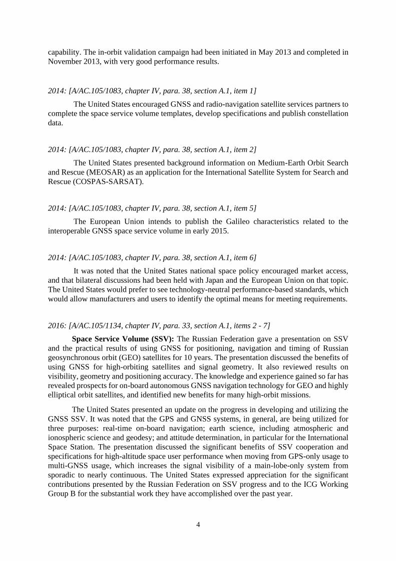
capability. The in-orbit validation campaign had been initiated in May 2013 and completed in
November 2013, with very good performance results.
2014: [A/AC.105/1083, chapter IV, para. 38, section A.1, item 1]
The United States encouraged GNSS and radio-navigation satellite services partners to
complete the space service volume templates, develop specifications and publish constellation
data.
2014: [A/AC.105/1083, chapter IV, para. 38, section A.1, item 2]
The United States presented background information on Medium-Earth Orbit Search
and Rescue (MEOSAR) as an application for the International Satellite System for Search and
Rescue (COSPAS-SARSAT).
2014: [A/AC.105/1083, chapter IV, para. 38, section A.1, item 5]
The European Union intends to publish the Galileo characteristics related to the
interoperable GNSS space service volume in early 2015.
2014: [A/AC.105/1083, chapter IV, para. 38, section A.1, item 6]
It was noted that the United States national space policy encouraged market access,
and that bilateral discussions had been held with Japan and the European Union on that topic.
The United States would prefer to see technology-neutral performance-based standards, which
would allow manufacturers and users to identify the optimal means for meeting requirements.
2016: [A/AC.105/1134, chapter IV, para. 33, section A.1, items 2 - 7]
Space Service Volume (SSV): The Russian Federation gave a presentation on SSV
and the practical results of using GNSS for positioning, navigation and timing of Russian
geosynchronous orbit (GEO) satellites for 10 years. The presentation discussed the benefits of
using GNSS for high-orbiting satellites and signal geometry. It also reviewed results on
visibility, geometry and positioning accuracy. The knowledge and experience gained so far has
revealed prospects for on-board autonomous GNSS navigation technology for GEO and highly
elliptical orbit satellites, and identified new benefits for many high-orbit missions.
The United States presented an update on the progress in developing and utilizing the
GNSS SSV. It was noted that the GPS and GNSS systems, in general, are being utilized for
three purposes: real-time on-board navigation; earth science, including atmospheric and
ionospheric science and geodesy; and attitude determination, in particular for the International
Space Station. The presentation discussed the significant benefits of SSV cooperation and
specifications for high-altitude space user performance when moving from GPS-only usage to
multi-GNSS usage, which increases the signal visibility of a main-lobe-only system from
sporadic to nearly continuous. The United States expressed appreciation for the significant
contributions presented by the Russian Federation on SSV progress and to the ICG Working
Group B for the substantial work they have accomplished over the past year.

5
Global positioning system time offset issue: The United States presented an update
on the January 2016 Coordinated Universal Time (UTC) time offset anomaly to GPS. It was
noted that software updates were implemented to resolve the core upload issue, with future
software updates planned to further reduce the risk of a reoccurrence. The Institute of
Navigation paper (available at www.gps.gov/systems/gps/performance) discusses the impacts
to receivers. It was explained that this software issue is not unique to GPS. Monitoring systems
can reduce the impact on users.
Space debris: The Russian Federation gave a presentation on space debris in GNSS
operational orbits. The presentation discussed the population and density of catalogued objects
in GNSS orbits and the results of an analysis of long-term orbital evolution of GNSS satellites,
specifically looking at the intersection of orbits of different GNSS satellites. GLONASS
mitigation measures were described and compliance with the Committee on the Peaceful Uses
of Outer Space and Inter-agency Space Debris Coordination Committee Space Debris
Mitigation Guidelines was noted. A recommendation was made for providers to monitor
discussions related to debris mitigation in medium Earth orbit by linking with experts working
in those international organizations.
International GNSS Monitoring and Assessment System update: China presented
an update on the International GNSS Monitoring and Assessment System (iGMAS), and
explained that the objectives are to establish a global tracking network and to monitor
operational status and key indicators for all GNSS. The system has an open architecture and
other international monitoring centres and GNSS tracking stations are invited to participate.
Most of the system construction has been completed, with 18 tracking stations around the
world, and routine service is now underway. Information distribution of the system is now
available in Chinese and English through a website (http://124.205.50.178) and an application
that can be downloaded for mobile use.
Adjacent band compatibility: The United States presented an update on the adjacent
band compatibility study that resulted from a proposal by a private company in 2011 to
broadcast terrestrial mobile telecommunication signals adjacent to the GNSS L1 frequency
band in the United States. The testing in 2011 showed impact to virtually all GPS receivers.
The goal of the study is to determine the power levels that can be tolerated in the adjacent
radiofrequency bands. Radiated testing in an anechoic chamber was completed in 2016, as were
lab testing and antenna characterization. Eighty GPS and GNSS receivers were tested, which
included the following six categories: general aviation (non-certified), general
location/navigation, “high precision and networks”, timing, space-based and cellular. An
overview of the preliminary results was presented.
2017: [A/AC.105/1158, chapter IV, section A.1 (a), para. 32]
Adjacent-band compatibility: The United States presented an update on the adjacent-
band compatibility study that resulted from a proposal by a United States private company
made in 2011 to broadcast, in the United States, terrestrial mobile telecommunication signals
adjacent to the radio-navigation satellite services (RNSS) L1 frequency band. The goal of the
study was to determine the power levels that can be tolerated in the adjacent radiofrequency
bands. The presentation focused on the GNSS protection criteria recommended by the United
States National Space-Based Positioning, Navigation and Timing Advisory Board, including
the 1 dB carrier-to-noise degradation as a GNSS receiver interference protection criterion. In
order to determine appropriate interference tolerance masks at the GNSS receiver antenna

6
input, radiated testing in an anechoic chamber was completed in 2016 using 80 civil
GPS/GNSS receivers that included the following six categories: general aviation (non-
certified), general location/navigation, high-precision and networks, timing, space-based, and
cellular. The impact regions of a 1 dB or greater carrier-to-noise degradation that would be
caused by the potential deployment of terrestrial mobile and base stations was computed for
different network deployment scenarios. The results demonstrated that high-precision receivers
could experience a degradation of 1 dB beyond 10 km based on macro-urban deployment with
loss of lock on all GNSS satellites within 1 km of the interfering transmitter. The results
highlighted that the distance from the GNSS receiver to the transmitter was a key factor, as
were the transmitter density and inter-site distance associated with the network deployment.
2017: [A/AC.105/1158, chapter IV, section A.1 (b), paras. 35 – 37 and 39]
Medium Earth Orbit Search and Rescue system update: The United States
presented an update on the progress made with the implementation of the Medium Earth Orbit
Search and Rescue (MEOSAR) system. MEOSAR implementation was currently at its initial
operating capability, with 20 experimental S-band payloads and 7 operational L-band payloads.
MEOSAR offered near-instantaneous beacon detection, while satellite systems in low-Earth
and geosynchronous orbits could experience a delay in signal acquisition, processing, and
transmission to the ground.
Currently there were three space-segment MEOSAR providers: GPS, Galileo, and
GLONASS. The future inclusion of the BDS search-and-rescue payload into COSPAS-
SARSAT was acknowledged. The next step would be to amend the terms of reference of the
correspondence working group on the space segment of MEOSAR to encourage China to
participate.
COSPAS-SARSAT acknowledged that discussions about downlinks needed to
continue within the programme to ensure that beam collision was mitigated, as all four
providers would need to share two downlink bands (1,544.0–1,544.2 MHz and 1,544.8–1,545.0
MHz).
The European Union expressed its concerns about potential interference between
MEOSAR downlinks in the 1,544–1,545 MHz band. The European Union recognized that the
substantive discussion was conducted in COSPAS-SARSAT groups, but given the urgency, it
encouraged the GNSS providers, as a matter of priority, to fully engage in those technical
discussions, consider all options to prevent interference, and then, in due course, report back
to ICG on the progress made.
2017: [A/AC.105/1158, chapter IV, section A.1 (c), paras. 40 – 42]
Update on space service volume: The United States presented an update on the
progress made in developing and utilizing a GNSS SSV and on the benefits of SSV to the
domains of real-time on-board navigation, Earth sciences, launch vehicle range operations,
attitude determination and time synchronization.
The benefits of using GNSS for real-time navigation in SSV are improved real-time
navigation performance, quicker trajectory manoeuvre recovery, a reduced need for expensive
on-board clocks, increased satellite autonomy and better performance for missions in highly
elliptical orbit, geosynchronous orbit and beyond.

7
The speaker gave examples of GNSS being used for the positioning, navigation and
timing of satellites, including meteorological satellites of Japan, the United States and the
European Union, in geosynchronous and highly elliptical orbits.
2017: [A/AC.105/1158, chapter IV, section A.1 (e), para. 51]
Application activities relating to global navigation satellite systems under the Belt
and Road Initiative: BDS provided regional services and covered 30 countries included in the
Belt and Road Initiative. Between 2015 and 2016, five BDS-3 testing satellites had been
launched, while new technologies and concepts for BDS-3 had been validated and tested. BDS-
3 would include a nominal 30-satellite constellation. The first pair of BDS-3 satellites had
successfully been launched on 5 November 2017.
2018: [A/AC.105/1191, chapter IV, section A.1 (a), paras. 42-44]
BeiDou Navigation Satellite System featured service: China presented BDS-3
featured service. BDS-3 will provide two basic services, regional navigation satellite systems
and SBAS. In addition, BDS-3 will provide three featured services, international search and
rescue service, short message communication (SMC) service (regional and global), and precise
point positioning (PPP) service.
The BeiDou search and rescue service meets the international standard, and has a return
link function, which provides a useful enhancement to that rescue service. The B2b signal is
used to broadcast confirmation messages and other messages associated with search and rescue
to users. The three inclined geosynchronous orbit satellites and the 24 medium Earth orbit
satellites have the return link function.
BDS-3 regional SMC service has a two-way link, including an uplink on L band, and
a downlink on S band. It plays an important role in safety-of-life applications. BDS-3 also
deploys SMC service globally through crosslinks.
2018: [A/AC.105/1191, chapter IV, section A.1 (b), paras. 48, 50 and 51]
Update on the space service volume: The United States presented updates to the space
service volume (SSV) effort by NASA and ICG Working Group B. Space-based uses of the
Global Positioning System (GPS) and other GNSS include real-time on-board navigation,
Earth sciences, launch vehicles range operations, attitude determination and timing
synchronization. Working Group B is actively improving capabilities of GNSS use in SSV by
furthering compatibility and interoperability. Both missions conducted in the range from low
Earth orbit to geosynchronous equatorial orbit and missions conducted beyond the space
service volume (from geosynchronous equatorial orbit to lunar distance) can benefit from real-
time navigation using GNSS.
The United States team presented results of the Antenna Characterization Experiment,
which provided the first reconstruction of the full GPS antenna gain patterns from flight
observations. This supports the priority task of measuring and publishing GNSS antenna gain
patterns to support understanding of SSV and use of GNSS in mission simulations. Another
important update pertaining to data collection is that an additional apogee-raising manoeuvre

8
is planned for the Magnetospheric Multiscale mission in February 2019 up to 29 Earth radii —
the equivalent of half the lunar distance — which will produce data for presentation at the
fourteenth meeting of ICG.
Recent international outreach efforts include actively engaging in ICG Working Group
B to publish the SSV booklet for the thirteenth meeting of ICG and continuing work on the
accompanying SSV video scheduled for release in the first half of 2019. The United States is
very interested in continuing international collaboration, including supporting the international
team on outreach and panel sessions. Ongoing international activities include a NASA lunar
GPS visibility simulation, which demonstrates that current SSV-capable receivers can support
navigation and timing at lunar distances, engagement in use of GNSS on board the planned
Lunar Orbital Platform-Gateway, and alignment with and support for the International Space
Exploration Coordination Group’s Global Exploration Roadmap.
2019: [A/AC.105/1217, chapter IV, section A.1, para. 31 (a)]
Update on the International GNSS Monitoring and Assessment System and a
preliminary assessment of multi-GNSS performance: China presented an update on its
International GNSS Monitoring and Assessment System (iGMAS), including results and the
enhancement of iGMAS by implementing new receivers to process all GNSS open signals. In
addition, it was reported that iGMAS preliminary performance evaluation of multi-GNSS
showed that use of multi-GNSS had obvious advantages in terms of position dilution of
precision and convergence time for PPP. It was also reported that the routine assessment
showed that BDS-3 had better performance than BDS-2.
Service performance monitoring
2010: [A/AC.105/982, chapter IV, para. 32, section A.3, item 7]
It was suggested that a workshop on interference detection and mitigation be organized
or multi-disciplinary ICG task force be established to make progress on the topic.
2012: [A/AC.105/1035, chapter IV, para. 33, section A.2, item 3]
China provided information on the status and progress of the International GNSS
Monitoring Assessment System (iGMAS). It was noted that iGMAS would support various
multi-GNSS monitoring activities such as cooperating with the International Global Navigation
Satellite System Service Multi-GNSS Experiment (M-GEX) by sharing stations, data and
geodetic receivers. China requested that more countries and organizations participate in future
iGMAS activities.
2013: [A/AC.105/1059, chapter IV, para. 38, section A.3, item 4]
The United States made a presentation on GNSS civil performance monitoring,
explaining that such monitoring provided benefits to both providers and users and supported
the ICG principle of transparency. The Civil Monitoring Performance Specification addressed
current civil GPS signals by specifying metrics that address performance measures based on

9
the GPS performance standard.
2014: [A/AC.105/1083, chapter IV, para. 38, section A.2, item 7]
China noted two recommendations that had been proposed to Working Groups A, B
and D: the first was for the establishment of an information portal for international GNSS
monitoring and assessment, and the second was for the international GNSS monitoring and
assessment task force to hold a workshop in 2015.
2016: [A/AC.105/1134, chapter IV, para. 33, section A.2, item 8]
The United States gave a presentation on the GPS service performance standard
assessment. The 2013 GPS performance standard report has been published and is available
online (see www.gps.gov/systems/gps/performance). The 2014 and 2015 reports are being
finalized and will be available in 2017. These reports measure GPS performance against the
GPS standard positioning service performance standard parameters. Other GNSS providers are
encouraged to make available similar reports for their systems.
Report on a multi GNSS demonstration project
2010: [A/AC.105/982, chapter IV, para. 32, section B.1, item 8]
It was proposed that ICG become more involved in the multi-GNSS demonstration
project by frequently producing reports and inviting the co-chairs of Working Group A2 and
Working Group D3 to be members of the steering committee of the project.
2011: [A/AC.105/1000, chapter IV, para. 36, section B.1, item 9]
The representative of Japan presented a report on the progress of the multi-GNSS
demonstration project. It was noted that the Japan Aerospace Exploration Agency (JAXA)
received 11 applications as a result of a call for hosting JAXA receivers. Six organizations
were now investigating participation in the network with their own receivers. It was also noted
that a new call for joint experiments would be issued in the middle of September 2011.
2012: [A/AC.105/1035, chapter IV, paragraph 33, section B.1, item 5]
The representative of Japan reported that there were currently 17 participating
organizations and 8 joint experiments.
2 Working Group A on Compatibility and Interoperability is co-led by the United States of America and the
Russian Federation 3 Working Group D on Reference Frames, Timing and Applications is co-led by the International Association of
Geodesy (IAG), International Federation of Surveyors (FIG), and International GNSS Service (IGS)

10
2013: [A/AC.105/1059, chapter IV, para. 38, section B.1, item 6]
The secretariat of Multi-GNSS Asia provided an update on the activities taking place.
The three main activities were (a) the establishment of a multi-GNSS monitoring network, (b)
working groups to conduct experiments and (c) the Asia-Oceania Regional Workshop on
GNSS.
2014: [A/AC.105/1083, chapter IV, para. 38, section A.3, item 8]
The Secretariat of Multi-GNSS Asia informed that two experiments had been endorsed
by the Multi-GNSS Asia steering committee, and the formation of a new working group on
capacity-building had been proposed.
2015: [A/AC.105/1104, chapter IV, para. 38, section A.1, item 1]
Japan, as the secretariat of Multi-GNSS Asia, noted that 89 multi-GNSS monitoring
network stations were currently in operation. It also explained that 24 proposals had been
endorsed by Multi-GNSS Asia and were in progress.
2016: [A/AC.105/1134, chapter IV, para. 33, section A.3, item 9]
Japan provided an update on the multi-GNSS demonstration project in the
Asia/Oceania region. There are three components to the project: the establishment of
monitoring networks, application demonstrations and regional workshops. Currently there are
99 multi-GNSS monitoring network stations in operation. Multi-GNSS Asia (MGA) is an
organization that promotes the project with 53 participating organizations. MGA discussed
possible updates to its workplan enhancing the linkage with ICG.
2017: [A/AC.105/1158, chapter IV, section A.1(g), para. 55]
Japan provided an update on the multi-GNSS demonstration project in the
Asia/Oceania region. Multi-GNSS Asia (MGA) is an organization that promotes the project
with 57 participating organizations from 20 countries. The goals for 2018 and beyond are:
strengthen the user community, working towards an open innovation hub; align more closely
with ICG to support the regional implementation of its recommendations; transfer secretariat
responsibilities from the Japan Aerospace Exploration Agency (JAXA) to the Institute of
Positioning, Navigation and Timing, Japan; strengthen the role of local partners in MGA
conferences; and develop a theme-based conference and membership structure.
2018: [A/AC.105/1191, chapter IV, section A.5, para.56 and 58]
Japan provided an update on the Multi-GNSS Asia (MGA) activities that took place in
2018. MGA was actively supporting capacity-building for GNSS utilization for the Asia-
Oceania region. It promotes GNSS technology through webinars, lectures and projects.
Participants in the Providers’ Forum were encouraged to contact the co-chair (Japan) if they
were interested in acting as a resource for the webinars.

11
MGA priorities for 2018 and 2019 include strengthening the user community for an
open innovation hub, aligning more closely with ICG and encouraging a stronger role for local
partners in MGA conferences.
Spectrum protection: interference detection and mitigation
2011: [A/AC.105/1000, chapter IV, para. 36, section A.3, items 3, 5 – 7]
The representative of the United States provided information on the status of the United
States domestic regulatory process related to conditional Federal Communications
Commission (FCC) approval for LightSquared (LSQ) operations in the bands directly below
and slightly above the radio-navigation satellite services (RNSS) L-1 allocation. FCC final
approval was contingent upon determination that use of global positioning systems and global
navigation satellite systems (GNSS) services were not adversely impacted by the planned LSQ
operations. The FCC process was ongoing, and no determination had been made at that time.
Testing of LSQ equipment was conducted for the purpose of evaluating the impacts of those
operations on GPS use. It was further noted that the matter of ancillary mobile-satellite service
operations adjacent to the RNSS band might be considered by the World Radiocommunication
Conference to be held in 2012 and might be addressed through the ITU working party process.
The Providers’ Forum noted that ITU referred to those operations as “complimentary ground
component”.
The representative of the European Union noted that similar operations had been
studied in Europe and found to be disruptive to other mobile satellite service operations and
had thus been discarded as an implementation option.
The representative of Japan noted that input had been provided to FCC, stating the
concerns of Japan regarding the operation. It was also noted that the official position of the
Asia-Pacific Telecommunity was to oppose any action favourable to the complementary
ground component that might be considered at the World Radiocommunication Conference to
be held in 2012.
The representative of China noted that with the establishment of new systems and the
increase of new frequency bands and applications of new services, more and more space
systems would face spectrum protection issues of that kind. It was envisioned that this might
lead to additional overlapping of frequency bands and more interference between systems.
Since GNSS was a service-oriented system aimed at serving all humankind, this issue
warranted significant attention throughout the world. The BeiDou system, as a member of the
GNSS systems, would like to join with others in the discussion of the issue of spectrum
protection.
2013: [A/AC.105/1059, chapter IV, para. 38, section A.4, item 5]
The United States was currently working on a GPS adjacent-band capability assessment
to draft new GPS spectrum interference standards. The purpose was to determine GPS
spectrum-protection criteria to inform future proposals for non-space commercial uses of the
adjacent bands. The United States wanted to be proactive in protecting GPS from interference.
The United States also reported on efforts taking place in the ITU Joint Task Group 4-5-6-7 in
preparation for the World Radiocommunication Conference. The Task Group was evaluating
12
additional spectrum allocations for mobile broadband services, and the United States was
working to protect GNSS spectrum bands from outside interference as a result of any changes
to spectrum allocations. It was noted that the next Joint Task Group meeting would be held in
Geneva from 20 to 28 February 2014, and the United States encouraged other entities to
participate actively in activities leading to the final recommendations to the World
Radiocommunication Conference, where the spectrum allocation changes would be finalized.
ICG information centres
2011: [A/AC.105/1000, chapter IV, para. 36, section B.2, item 10]
The Providers’ Forum took note of the establishment of the International Committee on
Global Navigation Satellite Systems (ICG) information centres at the regional centres for space
science and technology education, affiliated to the United Nations, which were utilized as hubs
for training and dissemination of information on global applications of GNSS. The Providers’
Forum also noted that China offered to make available an information centre at the Beihang
University in Beijing.
2013: [A/AC.105/1059, chapter IV, para. 38, section B.2, item 7]
The executive secretariat of the International Committee on Global Navigation Satellite
Systems reported that the United Nations-affiliated regional centres on space science and
technology education would implement the postgraduate course on GNSS from November
2013 to December 2014, using the Global Navigation Satellite Systems Education Curriculum
(ST/SPACE/59). The improvement of the ICG information portal would continue to be
discussed in Working Group C, on information dissemination and capacity-building.
2014: [A/AC.105/1083, chapter IV, para. 38, section A.4, item 10]
The first nine-month postgraduate course on GNSS had been completed at the African
Regional Centre for Space Science and Technology – in French language held in Rabat.
2014: [A/AC.105/1083, chapter IV, para. 38, section A.4, item 11]
The ICG information portal was being redesigned by the Office for Outer Space Affairs
and would include the addition of a webpage for ICG members, associate members and
observers.
2015: [A/AC.105/1104, chapter IV, para. 38, section A.2, item 4]
The ICG information portal was being redesigned by the Office for Outer Space Affairs:
www.unoosa.org/oosa/en/ourwork/icg/icg.html

13
Future structure of ICG
2011: [A/AC.105/1000, chapter IV, para. 36, section B.6, item 18]
The Providers’ Forum agreed that, as proposed by the co-chair, an agenda item entitled
“Future role and work of ICG and its Providers’ Forum” should be considered at the next
meeting of the Providers’ Forum and that specific proposals might be made at that time.
2013: [A/AC.105/1059, chapter IV, para. 36, section B.3, items 8 - 9]
The discussion was based upon previous Providers’ Forum meetings. The co-chairs
reviewed two related papers: the summary of discussions concerning the future of ICG and the
paper on the meeting with the associate members and observers that took place at the Seventh
Meeting of ICG. The summary of discussions will be presented to ICG for adoption.
The co-chairs made a presentation on the way forward to increase user contributions to
ICG. Several questions were identified regarding users and their relationship to ICG. The
Providers’ Forum agreed that the establishment of a users’ forum would be premature, but
noted that further discussion on ways to bring user input into ICG should continue.
Statement of the Providers’ Forum
2012: [A/AC.105/1035, chapter IV, para. 33, Section B.5, item 11]
The Providers agreed upon a statement highlighting key achievements of ICG and the
Providers’ Forum, to be annexed to the ICG report (see Annex VIII).
Selection of the co-chairs of the Providers’ Forum
2013: [A/AC.105/1059, chapter IV, para. 38, Section B.4, items 11 - 12]
The Russian Federation made a presentation proposing ideas to consider for the
selection of future co-chairs. It also suggested updating the Providers’ Forum terms of
reference (see Annex II).
China made a presentation on the selection of co-chairs. The proposal would allow each
provider to co-chair on a two-year rotational basis, and established a schedule for the next
several years. The providers agreed to the schedule through 2017 and in the coming months
would confirm the remaining schedule through 2019.
Other matters
2014: [A/AC.105/1083, chapter IV, para. 38, section B, item 14]
The United States proposed debris mitigation in middle-Earth orbit and GNSS market
access as topics for discussion by the providers. The providers agreed to consider that proposal
at their next meeting, based on further information to be provided by the United States.
14
2014: [A/AC.105/1083, chapter IV, para. 38, section B, item 15]
The providers agreed to add to the agenda of the Providers’ Forum an item on review
of progress in the implementation of the recommendations of the ICG Working Groups.
2015: [A/AC.105/1104, chapter IV, para. 38, section B.1, items 6 - 8]
Orbital debris: The United States presented guidelines on orbital debris, which
included the United States Government Orbital Debris Mitigation Standard Practices,
Department of Defense Instruction 3100.12, Air Force Instruction 91-217 and the Inter-Agency
Space Debris Coordination Committee (IADC) Space Debris Mitigation Guidelines, which
defined three disposal options and were applicable to United States government missions.
It was noted that that the United States had conducted a study on the GPS-IIF satellites
and determined that the collision probability over 500 years for each of the 12 GPS-IIF
satellites was less than 0.001. The United States was also in the process of conducting a study
looking at the effects on the future medium-Earth orbit debris environment of two different
strategies: delaying eccentricity growth, which was the current GPS practice; and accelerating
eccentricity growth, a briefing on the results of which would be provided to IADC.
It was also noted that both the Italian Space Agency and the European Space Agency
were doing work in that area and conducting additional studies, and it was suggested that the
topic be further discussed at future Providers’ Forum meetings.
Global navigation satellite system space service volume: The United States
presented an update to the GNSS space service volume concept. The objective from the United
States perspective was to expand the GPS space service volume into a multi-GNSS space
service volume; further improvements could be obtained by increasing the availability of
satellite signals in the space service volume, in most cases by utilizing the side lobes. There
was great interest in ensuring the consistency of definitions so that they were common across
all providers, which would help to create a unified analysis.
The presentation explained that space service volume specifications were crucial for
providing navigation solutions in low-Earth orbit, medium-Earth orbit and highly elliptical
orbit. The National Aeronautics and Space Administration (NASA) of the United States had
issued a request for information for spaceborne receivers in order to better understand receiver
technology currently available. Public input was welcome until the end of December 2015.
International GNSS monitoring and assessment project status and updates: China
presented an update on its international GNSS monitoring and assessment project, explaining
that the objectives were to establish a global tracking network and to monitor operational status
and key indicators for all GNSS. The project had been operational on a trial basis since July
2014, providing users with raw observation data, basic products and monitoring and assessment
information. The schedule included three stages until the end of 2020. There were currently
eight completed monitor stations within China, as well as four international stations outside
China. Three data centres and eight analysis centres had also been completed, and the
operations and control centre was located in Beijing.
United States space weather strategy: The United States gave a presentation
describing aspects of the United States national space weather strategy, which had been
released to the public on 29 October 2015. The strategy had been developed to address societal
and economic impacts in the event of a severe space weather event. The Space Weather

15
Operations Research and Mitigation task force, consisting of 20 United States government
departments and agencies, had responsibility for carrying out the six high-level goals outlined
in the strategy. The United States noted that goal 6 called for increased international
cooperation on space weather. Following the presentation, the European Union commented
that they were looking at space situational awareness, which included both debris mitigation
and space weather, and that they might report on the issue at a future Providers’ Forum meeting.
2016: [A/AC.105/1134, chapter IV, para. 33, section B.1, item 1]
The providers agreed to the schedule through 2019, and it was noted that co-chairs will
be provided by the following members: China and Japan will co-chair the 2018 Providers’
Forum meeting, and China and India will co-chair the 2019 meeting. The terms of reference
will be modified accordingly.
2017: [A/AC.105/1158, chapter IV, section B.1, para. 57]
The ICG executive secretariat noted that the workplan of the Providers’ Forum
contained references to the “working group on compatibility and interoperability” and
suggested that the workplan be updated to reflect the name change, at the tenth meeting of ICG,
in 2015, to Working Group on Systems, Signals and Services. The co-chairs of the Working
Group agreed to modify the workplan accordingly.
2018: [A/AC.105/1191, chapter IV, section B.1, para.61 and 62]
The providers agreed to adopt the changes to the workplan4 that were reviewed and
discussed at the twentieth meeting of the Providers’ Forum held in June 2018 in Vienna.
The United States suggested including in the workplan a reference to the Medium Earth
Orbit Search and Rescue system, since that had been discussed at previous meetings of the
Providers’ Forum. The providers agreed to discuss this at the next meeting of the Providers’
Forum, with proposed language that would be adopted at the fourteenth meeting of ICG.
2019: [A/AC.105/1217, chapter IV, section B.1, para.37]
The Providers’ Forum discussed and agreed on proposed changes to its terms of
reference, as reflected in the latest version (ICG/PF/TOR/2016). They included the suggestion
to add “Navigation with Indian Constellation (NavIC) or Indian Regional Navigation Satellite
System (IRNSS)” to the list of members contained in the terms of reference of ICG.
4 Template for sharing information between service providers is contained in annex IV attached to this document

16
3. EXTRACTS FROM THE JOINT STATEMENTS ADOPTED AT THE ICG MEETINGS, INCLUDING THE ICG RECOMMENDATIONS AND DECISIONS
ICG Information Centres
2008: [A/AC.105/928, chapter III, para. 23, item 5]
The regional centres5 on space science and technology education, affiliated to the
United Nations would act as ICG information centres.
Report on Current and Planned Global and Regional Navigation Satellite Systems and Satellite-based Augmentation Systems
2010: [A/AC.105/982, chapter III, para. 30, item 5]
ICG noted the achievements of the ICG Providers’ Forum, as reflected in the
publication entitled “Current and Planned Global and Regional Navigation Satellite Systems
and Satellite-based Augmentation Systems” (ST/SPACE/506).
10 years of achievement of the United Nations on Global Navigation Satellite Systems
2012: [A/AC.105/1035, chapter II, para. 23]
ICG noted the achievements of providers and users of positioning, navigation and
timing services in promoting GNSS, as reflected in the publication “10 years of achievement
of the United Nations on Global Navigation Satellite Systems” (ST/SPACE/557).
Members, Associate Members and Observers of the International Committee on Global Navigation Satellite Systems
2012: [A/AC.105/1035, chapter II, para. 26]
Members, associate members and observers of ICG had held a meeting during the
Seventh Meeting. It was noted that continued discussions were needed regarding the effective
functioning of ICG and its current format in order to maximize the benefit for all GNSS users.
5 The regional centres are located in Morocco and Nigeria for Africa, in Brazil and Mexico for Latin America and
the Caribbean, in India and China, for Asia and the Pacific, and in Jordan for Western Asia:
http://www.unoosa.org/oosa/en/SAP/centres/index.html 6 See the report at http://www.unoosa.org/pdf/publications/icg_ebook.pdf 7 See the report at: http://www.unoosa.org/pdf/icg/2011/11-85461_ICG-ST-55_eBook.pdf

17
2013: [A/AC.105/1059, chapter II, para. 31]
ICG heard statements by the representatives of the Arab Institute of Navigation (AIN)
and the European Space Policy Institute (ESPI) on their organizations’ plans for implementing
GNSS applications and granted the organizations the status of observer.
2014: [A/AC.105/1083, chapter III, para. 37, item 2]
The Asia-Pacific Space Cooperation Organization (APSCO) was recognized by ICG as
a new observer.
2018: [A/AC.105/1191, chapter III, para. 38, item 3]
Australia was recognized by ICG as a new member, and the International Association
of Institutes of Navigation was recognized as a new associate member.
2019: [A/AC.105/1217, chapter III, para. 28, item 3]
New Zealand was recognized by ICG as a new member.
Principle of Transparency for Open Service
2009: [A/AC.105/948, chapter II, para. 21]
The ICG endorsed the recommendation that, consistent with the principle of
transparency, every GNSS provider should publish documentation containing signal and
system information, the policies of provision and the minimum levels of performance offered
by its open service.
Tenth Meeting of the ICG in 2015
2013: [A/AC.105/1059, chapter II, para. 23]
In preparation for its Tenth Meeting, to be held in 2015, ICG recommended that a list
of accomplishments within ICG be prepared, which would include the excerpts document and
inputs from the working groups and ICG members, associate members and observers.
Joint Meeting with the Providers and ICG members, associate members and observers
2013: [A/AC.105/1059, chapter II, para. 24]
ICG agreed that a joint meeting with the providers and ICG members, associate
members and observers should be introduced as a regular item on the agenda of the ICG annual
meetings in order to report on the status of the recommendations and to exchange views on the

18
providers’ response to input from the user communities. ICG noted that that item could serve
as a way to gain insight into users’ needs and requirements, and to get information on how
services are performing. It was also noted that the ICG outreach activities would increase the
visibility of ICG.
Interaction with the International Civil Aviation Organization (ICAO) and the International Maritime Organization (IMO)
2013: [A/AC.105/1059, chapter II, para. 25]
ICG agreed that, taking into account the roles and functions of GNSS service providers
and intergovernmental bodies, such as the International Civil Aviation Organization (ICAO)
and the International Maritime Organization (IMO), an effort should be made to encourage
their participation in the ICG meetings.
Future role and work of ICG and its Providers’ Forum
2013: [A/AC.105/1059, chapter II, para. 26]
ICG took note with appreciation of the paper summarizing discussions concerning the
future of ICG, which had been submitted by the co-chairs of the Providers’ Forum. Its purpose
was to provide a number of possible options and modalities that could strengthen the
effectiveness of ICG in the future. It was agreed that that summary would serve as a basis for
assessing the progress made by ICG. (see Annex VIII).
Mission Statement of the ICG
2013: [A/AC.105/1059, chapter II, para. 36, item 5]
ICG considered the future scope of its work and organizational structure, and ways and
means to enhance user input and the visibility of ICG, and other proposals to increase the
effective implementation of its recommendations. In this regard, ICG adopted a mission
statement, contained in annex X.
Vision Statement of the ICG
2014: [A/AC.105/1083, chapter III, para. 37, item 17]
ICG adopted a Vision Statement, which is contained in annex XI of the present
document.
Continuation of the United Nations experts’ meetings on GNSS and its applications
2014: [A/AC.105/1083, chapter II, para. 24]

19
ICG noted that the continuation of the United Nations experts’ meetings on GNSS and
its applications in the future would ensure that a forum for ongoing dialogue and feedback was
possible between users and system providers in order to enhance positioning, navigation and
timing services worldwide.
10th anniversary booklet
2014: [A/AC.105/1083, chapter II, para. 27]
In preparation for its tenth meeting, to be held in 2015, ICG noted that the 10th
anniversary booklet would include key information about ICG membership, presenting the role
of members and the benefits of participation in ICG.
Joint Working Group session
2015: [A/AC.105/1104, chapter III, para. 22 - 25]
ICG noted that the joint working group session had discussed the implementation status
of recommendations made at previous meetings related to: (a) the international GNSS
monitoring assessment; (b) the template for GNSS space service volume; and (c) the working
groups’ workplans and potential revisions thereto.
The working groups discussed cross-cutting issues relating to the international GNSS
monitoring assessment, highlighting the work performed by the task force. It was noted that
utilizing existing resources such as IGS and the providers’ monitoring and assessment systems,
which might include signal quality monitoring, could maximize benefits in the early stages of
the international GNSS monitoring assessment road map.
In the course of the discussion on matters related to GNSS space service volume, the
advantages of an interoperable GNSS space service volume for the space user community were
highlighted. It was noted that GNSS service providers had already provided their space service
volume characterizations to be included into the space service volume booklet.
The view was expressed that, in order to develop unified GNSS space service volume
analysis, ICG should develop standard definitions of minimum number of satellites and
constellation geometry.
2016: [A/AC.105/1134, chapter II, para. 21 - 24]
The joint working group session was organized in the form of presentations and
discussions on the following topics: (a) open service information-sharing; (b) service
performance monitoring; and (c) international GNSS monitoring and assessment (IGMA).
The presentations given at the joint session included the following: “Future plans and
international GNSS monitoring and assessment further development” by the representative of
the Russian Federation; “Monitoring and assessment algorithms on GNSS” and “GNSS signal
in space quality evaluation and monitoring” by the representatives of China. A report on the
IGMA task force was also presented.

20
The IGMA-IGS joint trial project was aimed at creating an authoritative IGMA system
to benchmark the performance of available GNSS. It was noted that the Project would be
implemented in phases. In the initial phase, a limited set of service parameters, such as post-
processing, system-level performance monitoring for each single constellation would be
monitored. Subsequent phases would strive for real-time processing, user-level performance
monitoring and a combined product and assessment function.
The Working Group on Systems, Signals and Services had been discussing spectrum
protection and interference detection and mitigation for over 10 years and collected a large
amount of information about this subject. However, the discussions and information collected
had been limited to ICG participants, especially spectrum experts and industry representatives
from GNSS providers. It was therefore recommended that a call for participation in the ICG
spectrum protection and interference detection and mitigation activities be presented to the
Scientific and Technical Subcommittee on the Committee on the Peaceful Uses of Outer Space
in 2017.
Economic benefits of utilizing GNSS
2015: [A/AC.105/1104, chapter III, para. 29]
ICG noted that the Working Group on Information Dissemination and Capacity-
building would elaborate on various studies on the economic benefits of utilizing GNSS for the
purpose of dissemination to current and future GNSS users.

21
4. EXTRACTS FROM THE WORKING GROUP REPORTS
4.1. Working Group S on systems, signals and services (formerly Working Group
A on compatibility and interoperability)
2010: [A/AC.105/982, chapter III, para. 30, item 6]
Working Group A called on interested members to focus on proposals for addressing
interference detection and mitigation, and to draft a plan for consideration by ICG.
2011: [A/AC.105/1000, chapter III, para. 32, item 5]
Working Group A on compatibility and interoperability addressed all four areas of its
current workplan through an intersessional meeting held in June 2011 at the United Nations
Office at Vienna and the two days of presentations and discussions conducted during the Sixth
Meeting of ICG. Interference detection and mitigation, and open service provision and
performance monitoring by multi-GNSS networks were the major areas of focus, leading to
three of the working group’s four recommendations. The session on multi-GNSS monitoring
and the session on interoperability were held jointly with Working Groups B and D, resulting
in constructive dialogue with those working groups and an agreed plan of practical steps,
including the establishment of a subgroup to collectively investigate international GNSS
monitoring and assessment.
2012: [A/AC.105/1035, chapter III, para. 31, item 6]
Working Group A on compatibility and interoperability had addressed all four areas of
its current workplan at an intersessional meeting held on 23-27 July 2012, in conjunction with
the International Global Navigation Satellite System Service workshop held in Olsztyn,
Poland, in 2012, and additional presentations and discussions had been conducted during the
Seventh Meeting of ICG. The compatibility and international GNSS monitoring and
assessment subgroups of Working Group A also provided, at the intersessional meeting, reports
that formed the basis for recommendations on spectrum protection and open service
performance monitoring. Working Group A organized and completed the first ICG interference
detection and mitigation workshop, held in Vienna on 7 and 8 June 2012, and reported on the
conclusions at the Seventh Meeting of ICG, including a recommendation to conduct additional
workshops.
2013: [A/AC.105/1059, chapter III, para. 36, item 7]
Working Group A, on compatibility and interoperability, addressed all four areas of its
current workplan during its intersessional meeting held in Vienna from 11 to 13 June 2013 and
during the Eighth Meeting of ICG. The compatibility and international GNSS monitoring and
assessment subgroups of Working Group A provided reports at the intersessional meeting that
formed the basis for recommendations on spectrum protection, open service performance and
the monitoring of open services. Recommendations were also presented to ICG related to
22
interoperability and interference detection and mitigation. In addition to the intersessional
meeting, Working Group A organized and completed the second ICG interference detection
and mitigation workshop and the first interoperability workshop, held in Honolulu, United
States, from 19 to 22 April 2013, and reported the conclusions to the working group. The next
interference detection and mitigation workshop will take place on 20 May 2014, immediately
preceding the China Satellite Navigation Conference, to be held in Nanjing, China, from 21 to
23 May 2014. Two regional interoperability workshops involving users and manufacturers
from China and the Russian Federation, as well as members of the interoperability task force,
will be held, one in Moscow in conjunction with the Moscow Satellite Navigation Forum, on
23 and 24 April 2014, and the other in Nanjing in conjunction with the China Satellite
Navigation Conference. A meeting of the International GNSS Monitoring and Assessment
subgroup is planned for 22 to 26 June 2014 in Pasadena, United States in conjunction with the
twentieth anniversary International Global Navigation Satellite System Service workshop, and
the 2014 intersessional meeting is tentatively scheduled for 16 to 18 July at ITU, in Geneva.
2014: [A/AC.105/1083, chapter III, para. 37, items 6, 7 and 8]
Beginning at its intersessional meeting held in Geneva and hosted by ITU, and
continuing during the ninth meeting of ICG, Working Group A, on compatibility and
interoperability, addressed all four areas of its current workplan. The compatibility and
performance standard subgroup reported on the status of ongoing work in those areas and
updated its recommendation on compatibility between international mobile
telecommunications and the radio determination satellite service and radio navigation satellite
services spectrum. In addition to the intersessional meeting, the newly formed interference
detection task force organized and completed the third ICG interference detection and
mitigation workshop at ITU. That event and the subsequent deliberations led to three
recommendations on interference detection and mitigation capabilities and the conduct of the
United Nations workshops on spectrum protection and interference detection and mitigation to
be organized by the Office for Outer Space Affairs on a regional basis.
The international GNSS monitoring and assessment task force also presented two
recommendations to the Working Group, based on three meetings that had been held in 2014,
including a proposal to hold an international GNSS monitoring and assessment workshop in
Xi’an, China, immediately preceding the sixth China Satellite Navigation Conference, to be
held in 2015.
Finally, the interoperability task force reported on three workshops held in China, Japan
and the Russian Federation, where inputs from industry and users on the subject of multi-GNSS
interoperability had continued to be collected and analysed. The task force will continue its
work in 2015, to include an interoperability workshop in Europe, leading to potential
recommendations for consideration by the Working Group and the Committee at the tenth
meeting of ICG.
2015: [A/AC.105/1104, chapter III, para. 36, items 6 and 7]
The compatibility and performance standard subgroup decided to continue addressing
the need for worldwide GNSS spectrum protection through a recommendation to providers and
user community member States to promote the implementation of protection measures for
GNSS operations in their nations and/or regions as well as other parts of the world.

23
Deliberations within the Working Group had led to a recommendation to the Committee on the
Peaceful Uses of Outer Space to establish a multi-year agenda item focused on national efforts
to protect the radio navigation satellite services spectrum and pursue GNSS interference
detection and mitigation in member States.
The international GNSS monitoring and assessment task force conducted several
meetings in 2015. The task force intended to initiate a joint trial project with IGS that would
demonstrate a global GNSS monitoring and assessment capability after the completion of
several preliminary items. The task force, under a restructuring and revised workplan
completed by the group, would become the interoperability and service standards subgroup,
with the international GNSS monitoring and assessment task force continuing under its
auspices, as well as the ongoing work on open service performance standards. The existing
compatibility and performance standards subgroup, which had been renamed the compatibility
and spectrum subgroup, would also have responsibility for the interference detection and
mitigation task force. The approved new workplan included a new area of possible work
focused on system-of-systems operations, pending the assignment of tasks by the Providers’
Forum. The new structure compromised the work of the Working Group, which had been
renamed Working Group on Systems, Signals and Services.
2016: [A/AC.105/1134, chapter III, para. 31, items 6 and 7]
The Working Group on Systems, Signals and Services (Working Group S) completed
its first year of activities using its updated organizational structure approved by ICG at its Tenth
Meeting. That structure included a subgroup on compatibility and spectrum protection and a
subgroup on interoperability and service standards. The compatibility and spectrum protection
subgroup decided to continue addressing the need for worldwide GNSS spectrum protection
through an updated recommendation for ICG member administrations to encourage the
protection of radio navigation satellite service (RNSS) spectrum from unwanted emissions.
Efforts to encourage reporting on domestic RNSS spectrum protection through the Scientific
and Technical Subcommittee of the Committee on the Peaceful Uses of Outer Space will also
continue, and an experts seminar on GNSS spectrum will be held on 13 and 14 December 2016,
in conjunction with a United Nations regional workshop on GNSS, which will be held from 12
to 16 December 2016, in Kathmandu. The interference detection and mitigation (IDM) task
force working under the subgroup organized and completed the fifth ICG-IDM workshop in
Changsha, China, in May 2016. The sixth workshop focusing on both network-based and
sensor-based (crowdsourcing) IDM capabilities will be held in May 2017, in conjunction with
the Baška GNSS Conference in Baška, Croatia.
The subgroup on interoperability and service standards held a meeting in Vienna in
June 2016 to discuss follow-up work on performance standards and interoperability. The
discussions on interoperability based on previous system provider workshops resulted in two
recommendations, one related to open service signal patents and the second related to system
time aspects of interoperability among multiple GNSS. The IGMA task force conducted several
meetings in 2016 and initiated a joint trial project with IGS to demonstrate a global GNSS
monitoring and assessment capability, by monitoring a limited set of GNSS parameters. A
related recommendation to conduct an IGMA workshop in conjunction with the 2017 China
Satellite Navigation Conference (CSNC) in Shanghai, China, was adopted by ICG. Finally, the
working group briefly discussed a new area of possible future work included in its workplan
focused on system-of-systems operations such as orbital debris mitigation and orbit

24
deconfliction, taking note of a presentation made in the Providers’ Forum by the Russian
Federation.
2017: [A/AC.105/1158, chapter III, para. 28, items 7 and 8]
The Working Group on Systems, Signals and Services (Working Group S) completed
its 2016–2017 activities under its organizational structure and workplan that were adopted, at
the tenth meeting of ICG, held in Boulder, United States, in 2015. That structure included a
subgroup on compatibility and spectrum protection and a subgroup on interoperability and
service standards. The subgroup on compatibility and spectrum protection decided to continue
addressing the need for worldwide GNSS spectrum protection through a recommendation for
ICG members to encourage national regulators to protect the radio navigation satellite service
spectrum from unwanted emissions. The Working Group continued its outreach and education
efforts on spectrum protection by holding an expert seminar on the GNSS spectrum in
Kathmandu in December 2016, in conjunction with the United Nations/Nepal workshop on the
applications of GNSS. The interference detection and mitigation (IDM) task force working
under the subgroup organized and completed a sixth workshop on IDM in Baška, Croatia, in
May 2017. That workshop resulted in a recommendation to work with the Third Generation
Partnership Project process and organization on measures to implement crowd sourcing
through mobile phones as a way to detect GNSS interference. The task force also agreed to
hold a seventh workshop on IDM in conjunction with the GNSS conference to be held in Baška
in May 2018.
The subgroup on interoperability and service standards held a meeting in Paris in July
2017, in conjunction with the 2017 International GNSS Service (IGS) workshop, to discuss
follow-up work on performance standards and interoperability. The subgroup also organized a
workshop held during the same week, focused on GNSS system time. The discussions at the
workshop were productive, but there was a clear need for further discussions on this topic. The
Working Group therefore recommended a second workshop on system time in 2018, to be
coordinated with Working Group D. In 2017, the international GNSS monitoring and
assessment (IGMA) task force conducted several meetings and a workshop on IGMA, held in
Shanghai, China, in May. The work focused on carrying out joint trial project activity with IGS
to demonstrate a global GNSS monitoring and assessment capability for a limited set of GNSS
parameters. A workshop on performance standards and IGMA will be hosted by the European
GNSS Agency at the Galileo Reference Centre in Noordwijk, Netherlands, in 2018. Finally,
the Working Group briefly discussed system-of-systems operations, with briefings on orbital
debris mitigation for GNSS constellations. The Working Group agreed to continue these
discussions, working with experts from each GNSS provider. All Working Group activities
will be addressed at one or more intersessional meetings in advance of the thirteenth meeting
of ICG.
2018: [A/AC.105/1191, chapter III, para.38, items 6 and 7]
The Working Group on Systems, Signals and Services (Working Group S), through its
subgroups and task forces, advanced all aspects of its workplan in the intersessional period
between the twelfth and thirteenth meetings of ICG. Through intersessional coordination that
included a meeting of the subgroup held in Vienna in June 2018, progress in encouraging
national regulators to use relevant ITU protection criteria for GNSS was assessed, and the

25
compatibility of search and rescue downlink broadcasts by GNSS in the L band was added to
the scope of the subgroup’s work, as cooperation with the International Satellite System for
Search and Rescue (Cospas-Sarsat) programme was envisaged, and taking into account the role
of ITU and national administrations.
The subgroup on interoperability and service standards held two workshops during the
intersessional period. The first workshop, held in Noordwijk, Netherlands, in July 2018,
focused on open service performance standards and international GNSS monitoring and
assessment. A dedicated team of experts working under the auspices of the subgroup was able
to complete a document defining guidelines for developing open service performance
standards, completing work that has been under way since 2012. Working Group S
recommended that those guidelines be formally adopted by ICG. The subgroup also organized
a second workshop focused on GNSS system time, as recommended at the twelfth meeting of
ICG; that workshop was held in Vienna in June 2018 in conjunction with ICG Working Group
D. The workshop and subsequent deliberations by the Working Group resulted in immediate
actions related to assessing two concepts proposed by the European Space Agency (ESA) and
consideration of future actions. These will be further discussed at a third workshop on multi-
GNSS time interoperability. The Working Group also plans to join Working Groups B and D
in conducting a workshop focused on precise point positioning services in 2019.
2019: [A/AC.105/1217, chapter III, para. 28, items 7 and 8]
Working Group S recommended the establishment of a task force on PPP
interoperability, which was adopted by ICG. The task force will be co-chaired by Australia,
the European Union and Japan and will prepare a workshop in 2020 to continue the
discussions and address the issues raised at the 2019 workshop.
The Working Group also highlighted the need for consultation with the Inter-Agency
Space Debris Coordination Committee regarding implementation of the recommendation from
the thirteenth meeting of ICG to study the issue of debris mitigation practices relevant to the
medium Earth orbit and inclined geosynchronous orbit orbital regimes used for GNSS.
4.2. Working Group B on enhancement of GNSS performance, new services and
capabilities (formerly Working Group B on enhancement of the performance
of GNSS services)8
2010: [A/AC.105/982, chapter III, para. 30, item 7]
A new item on techniques for radio-frequency interference mitigation and detection in
the GNSS bands was added to the workplan9.
8 Working Group B is co-led by India, China (since 2015, the 10th meeting of the ICG, Colorado, United States)
and the European Space Agency 9 The revised workplan of the Working Group B is available at:
http://www.unoosa.org/pdf/icg/2010/ICG5/wgB/icg-wgb2010.pdf

26
2011: [A/AC.105/1000, chapter III, para. 32, item 6]
Working Group B on enhancement of the performance of GNSS services discussed,
among other things, the dissemination of disaster information. It was noted that satellite
navigation systems might provide essential contributions, but the service concept still needed
further elaboration. Therefore, a new item on monitoring and examining techniques supporting
disaster management via satellite navigation was added to the Working Group’s workplan. In
addition, the existing actions in the current workplan were confirmed and were reflected by the
Working Group members in their presentations, and good progress was shown in various areas,
including indoor positioning, signal authentication, precise positioning, transportation,
maritime and space applications. Since more and more application-related issues were
introduced and discussed within Working Group B, it was agreed to form a dedicated subgroup
on applications.
2012: [A/AC.105/1035, chapter III, para. 31, item 7]
Working Group B on enhancement of the performance of GNSS services discussed the
benefits of an interoperable GNSS space service volume. All Working Group participants
believed that a fully interoperable GNSS space service volume would result in significant
benefits for future space users as it would allow for a performance that no single system could
provide on its own. Concepts for ensuring the integrity of signal coverage in maritime areas by
exploiting the arising multiplicity of new satellite navigation signals were discussed, and the
significance of multipath-resistant navigation signals for good ranging performance was
confirmed. The value of multi-GNSS application demonstrations was noted.
2013: [A/AC.105/1059, chapter III, para. 36, item 8]
Working Group B, on the enhancement of GNSS service performance, made
significant progress in establishing an interoperable GNSS space service volume during the
Eighth Meeting of ICG through significant advance work, presentations at the Meeting and
additional robust contributions from the administrations of China and the Russian Federation.
The Working Group further discussed the benefits of an interoperable GNSS space service
volume. All Working Group B participants believed that a fully interoperable GNSS space
service volume would result in significant benefits for future space users, as it would allow
performance that no single system could provide on its own. The Working Group will continue
to work within ICG towards an interoperable GNSS space service volume.
2014: [A/AC.105/1083, chapter III, para. 37, items 9, 10 and 11]
Working Group B, on the enhancement of GNSS service performance, made progress
in establishing an interoperable GNSS space service volume. Space service volume-relevant
characteristics were presented by Global Positioning System, Global Navigation Satellite
System (GLONASS), BeiDou navigation satellite system and Quazi-Zenith Satellite System.
Galileo aims to release its space service volume-related characteristics in the first quarter of
2015. Members of Working Group B will develop a booklet on interoperable GNSS space
service volume and will continue to work towards an interoperable GNSS space service
volume. The Working Group members acknowledged the benefits of signals broadcast from
satellites in non-nominal orbit or from satellites not part of the operational constellation for a

27
wide range of users, including space service volume users.
Alongside the issue of space service volume, the Working Group continued to work
according to its workplan. Good-quality ionospheric error compensation models were
identified in order to provide single frequency users with better accuracy. Results obtained
from one of those, the NeQuick Galileo model, which had demonstrated good performance,
were discussed. Following the recommendation of the eighth meeting of ICG, the discussion
continued on the Time To First Fix estimation methodology, leading to the identification of
additional figures of merit. Interference mitigation techniques at the antenna level and at the
digital signal processing level were discussed and the importance of investigating interference
mitigation techniques at the user level was confirmed.
The application subgroup of Working Group B held dedicated meetings and continued
monitoring application needs. The findings were being summarized in a report. The way
forward to the tenth meeting of ICG for the Working Group and its application subgroup was
defined.
2015: [A/AC.105/1104, chapter III, para. 36, items 8 - 11]
The Working Group on enhancement of GNSS service performance made important
progress in establishing an interoperable GNSS space service volume. All service providers
recognized the importance of GNSS for space missions. Characteristics to establish an
interoperable GNSS space service volume were given by all six providers. ICG appreciated the
efforts made by all service providers to establish these characteristics. Members of the Working
Group would continue to develop a booklet on interoperable GNSS space service volume for
presentation at the next Providers’ Forum and conduct the necessary simulations as a joint
effort.
The Working Group reviewed the progress made in analysing the benefits of the
NeQuick Galileo ionospheric model for single frequency users based on the assessment made
by different service providers. Promising results had been obtained with the model. Space users
in low-Earth orbit could also benefit from it.
The members of the Working Group acknowledged the benefits of ranging signals
broadcast from Galileo satellites in eccentric, non-nominal medium-Earth orbit for position,
velocity and time applications and scientific demonstrations. Information was provided
regarding progress made on the use of the Global Navigation Satellite System for geodetic
applications showing similar performance to other GNSS. It was noted that high-precision
applications benefited from satellite-based augmentation system geosynchronous satellite
(GEO) ranging if sufficient quality ephemeris data for the GEO satellite was provided. The
group confirmed that wide band signals would minimize multipath error and could significantly
improve accuracy for users.
The application subgroup continued its work and presented an application catalogue.
The findings of the group will be summarized in a report for the Eleventh Meeting of ICG in
2016. The Working Group reviewed and updated its workplan. The updated workplan
continued to address future integrity solutions, the monitoring of application developer needs
and atmospheric correction models. In addition, new areas of work related to space service
volume and space weather and remote sensing communities were introduced. China was
appointed as the third co-chair of the Working Group to support the follow-up of the updated
workplan.

28
2016: [A/AC.105/1134, chapter III, para. 36, items 8 - 12]
The Working Group on the Enhancement of GNSS Performance, New Services and
Capabilities (Working Group B) is progressing significantly in establishing an interoperable
GNSS space service volume (SSV). Joint simulations conducted by the group provided clear
evidence that for space users at an altitude close to the geostationary orbit or higher, no single
constellation can provide a sufficient level of GNSS signal availability. Exploiting the
interoperability between all systems allows achievement of GNSS signal availability very close
to 100 per cent. Members of the Working Group will conduct outreach activities on the
interoperable GNSS SSV, including the publication of an ICG SSV booklet, conference
sessions and papers, together with supporting illustrative video material. Future areas of work
in relation to the interoperable GNSS SSV are identified. All service providers are involved in
the SSV activities.
Search and rescue services will be implemented by Galileo, the Global Navigation
Satellite Systems (GLONASS) and the Global Positioning System, according to the
International Satellite System for Search and Rescue standards. Assessments are ongoing
regarding the future evolution of BeiDou search and rescue functions.
In relation to new services and capabilities, feedback is provided on scientific
experiments exploiting high-precision on-board clocks that show the potential to significantly
improve the measurement accuracy of the gravitational red-shift. Future integrity concepts
based on advanced receiver autonomous integrity monitoring will continue to be studied with
the objective of exploiting the interoperability between the different systems for safety-of-life
applications.
Space weather aspects will continue to be addressed, showing improvements that are
achievable by advanced ionospheric modelling and receiver technologies.
The application subgroup of Working Group B continued its work and presented an
application catalogue together with an initial version of an online questionnaire to collect future
user needs. The application subgroup will work with the final objective to issue a report based
on the feedback collected through the online questionnaire.
2017: [A/AC.105/1158, chapter III, para. 28, items 9,11 and 13]
The Working Group on the Enhancement of GNSS Performance, New Services and
Capabilities (Working Group B) is progressing significantly in establishing an interoperable
GNSS space service volume (SSV). Joint simulations conducted by the Working Group for
multiple mission profiles provide clear evidence that, for space users at high altitude, no single
constellation is able on its own to provide a sufficient level of GNSS signal availability.
Exploiting the interoperability between all systems makes it possible to achieve GNSS signal
availability very close to 100 per cent.
The excellent cooperation among all members of the SSV action team enabled it to
prepare a final draft of the SSV booklet, which will be submitted to ICG for distribution to
GNSS providers, so that they can review and endorse the booklet prior to its publication in time
for UNISPACE+50, in June 2018.
Search-and-rescue services are implemented by Galileo and GLONASS and will be
implemented by GPS and BDS in accordance with the standards of the International Satellite
System for Search and Rescue (COSPAS-SARSAT). The Working Group will continue to

29
assess the interoperability specifications at the level of COSPAS-SARSAT in line with the
Working Group’s workplan. Matters of signal-level compatibility of search-and-rescue
downlink signals will be followed up by the compatibility and spectrum subgroup of Working
Group S.
2018: [A/AC.105/1191, chapter III, para. 38, items 9, 11 and 13]
The Working Group on Enhancement of GNSS Performance, New Services and
Capabilities (Working Group B) made significant progress. China, the European Union and the
United States presented results on lunar GNSS analyses and architectural studies. The National
Aeronautics and Space Administration (NASA) of the United States informed the Working
Group about the benefits of combined communications and navigation capabilities for space
users.
On the topic of space weather, the Working Group was briefed by China on the space
weather payloads of the BeiDou Navigation Satellite System (BDS), in particular BDS-2 and
BDS-3. China, India and Japan presented the status of space weather and ionospheric research.
Acknowledging the importance of space weather information for GNSS and space users of
GNSS, the working group encouraged the open exchange of space weather data. The Working
Group agreed that dedicated mechanisms should be investigated to share space weather data in
the international community and disseminate it to potential users in all regions. Next-generation
broadcasting services were one such potential mechanism.
The European Union and Japan jointly presented the common emergency warning
services. The members of the Working Group agreed that there was a need to further discuss
the emergency warning service within the Working Group. For this purpose, a correspondence
group to propose a common format for early warning services will be set up.
2019: [A/AC.105/1217, chapter III, para. 28, items 10 and 17]
The space user subgroup informed the Working Group on the progress made since the
thirteenth meeting of ICG, when the subgroup was established. The subgroup made major
progress related to the updates for the next envisaged release of the GNSS space service volume
(SSV) booklet, in line with its workplan for the period 2019–2020. The finalization of a video,
produced to explain the basic concept of the GNSS SSV to the general public, was expected in
the first quarter of 2020. It was envisaged that the name of that subgroup would be finalized in
that same period. New activities had also been identified, including discussions on the need for
user guidelines or standards for space usage of GNSS and the identification of space user needs
related to timing aspects. The subgroup also proposed a recommendation related to the release
of the GNSS transmit antenna patterns or equivalent representative modelling information,
including the side lobes, by all GNSS service providers, in order to fully exploit the potential
of GNSS for space users, including missions to the Moon and beyond.
The Working Group expressed its appreciation for the variety of the contributions and
noted the growing importance of the scientific use of GNSS. In addition, the Working Group
agreed to organize the joint session held with Working Groups S and D on the topics of PPP
and timing interoperability.

30
4.3. Working Group C on information dissemination and capacity building10
2010: [A/AC.105/982, chapter III, para. 30, item 8]
Working Group C reiterated the importance of deploying instruments for the
International Space Weather Initiative, and applying GNSS in support of sustainable
development.
Working Group C also called for the support to be provided in developing a GNSS
curriculum.
2011: [A/AC.105/1000, chapter III, para. 32, item 7]
Working Group C on information dissemination and capacity-building addressed
further aspects of its workplan, including training for capacity-building in developing
countries; promoting the use of GNSS technologies as tools for scientific applications; the
International Space Weather Initiative; and regional workshops on applications of GNSS. A
new item on education and training programs on GNSS was added to its workplan.
2011: [A/AC.105/1000, chapter III, para. 31, item 8]
Working Group C on information dissemination and capacity-building addressed
education and training programmes related to GNSS for purposes of building capacity in
developing countries through the regional centres for space science and technology education,
affiliated to the United Nations, and centres of excellence, such as the international centre for
GNSS science, technology and education at the Beihang University of China. It was noted that
those centres, acting as information centres for ICG, might grow into a network of centres and
provide a major springboard for the transfer and enhancement of skills and knowledge in GNSS
research and applications. A new item on information dissemination, including materials for
publication on the web, was introduced in the Working Group’s workplan.
2013: [A/AC.105/1059, chapter III, para. 36, item 9]
Working Group C, on information dissemination and capacity-building, focused on the
available capacity-building opportunities and the status of operations of the United Nations-
affiliated regional centres for space science and technology education and centres of
excellence, such as the Russian Education Centre led by the Federal Space Agency of the
Russian Federation, the Beihang University of China and the Geospatial and Space Technology
Consortium for Innovative Social Services of Japan. In that context, Working Group C noted
that providing additional new GNSS education opportunities at different levels would be the
best way to cover the different needs in the GNSS field in order to maximize the benefits of
the use of GNSS to support sustainable development, particularly in developing nations. The
Working Group recommended that new technical knowledge generated by ICG should be
effectively communicated to the public, the GNSS-related scientific research community and
10 Working Group C is led by the United Nations Office for Outer Space Affairs

31
industry at large, through the ICG information portal and through the use of existing electronic
infrastructure and brochures. The Working Group noted that EIAST would also provide
capacity-building and contribute to information dissemination on the use of GNSS and its
applications.
2014: [A/AC.105/1083, chapter III, para. 37, items 12 and 13]
Recognizing the present status of GNSS and the prospects for the continued
development of a wide variety of applications critical to science, commerce and infrastructure,
Working Group C, on information dissemination and capacity-building, recommended that
more workshops and training courses should continue to be held on specific areas of interest to
end users. The Working Group encouraged knowledge transfer via e-learning systems using
existing web-based distance learning programmes, as well as communication and outreach to
the wider community through the regional centres for space science and technology education,
affiliated to the United Nations, which also acted as information centres for ICG.
To improve cooperation between the existing and/or developing user information
centres of the providers, Working Group C recommended that all the provider and GNSS user
information centres consider the development and adoption of a process for referring enquiries
to each other, where appropriate.
2015: [A/AC.105/1104, chapter III, para. 36, items 12 and 13]
Noting the benefits of increased cooperation and support among providers’ service
centres and the United Nations-affiliated regional centres for space science and technology
education, the Working Group on Information Dissemination and Capacity-building proposed
the expansion of knowledge-sharing by means of engaging in faculty and student exchange
programmes and providing textbooks and teaching materials.
In addition, the Working Group recommended that the ICG members consider the value
of national and regional positioning, navigation and timing advisory committees and share their
findings at future ICG meetings, when available. It also recommended that providers and GNSS
user information centres continue to develop and adopt a process for referring enquiries to each
other, where appropriate.
2016: [A/AC.105/1134, chapter III, para. 36, items 13 and 14]
The Working Group on Information Dissemination and Capacity-Building (Working
Group C) reviewed the implementation status and follow-up to its recommendations and noted
the continuous progress made in 2016 by the Working Group with the support of the Office for
Outer Space Affairs in the promotion of the use of GNSS. Additional work carried out by the
Office in support of ICG activities, including regional GNSS workshops, have been carried out
satisfactorily.
Working Group C emphasized that regional centres for space science and technology
education, which are affiliated to the United Nations and also serve as information centres for
ICG and its Providers’ Forum, have been working towards the establishment of a network of
institutions involved or interested in GNSS. With the support of GNSS providers, they have

32
also identified new applications that could be developed in the regions on the basis of GNSS
services.
2017: [A/AC.105/1158, chapter III, para. 28, items 16 and 17]
The Working Group on Information Dissemination and Capacity-building (Working
Group C) considered educational programmes and activities carried out by the Russian Space
Systems company, the Moscow State University of Geodesy and Cartography, the Moscow
Timiryazev Agricultural Academy, the BeiDou Belt and Road School of Beihang University,
the Tokyo University of Marine Science and Technology, the University of Tokyo and the
Regional Centre for Space Science and Technology Education in Asia and the Pacific, affiliated
to the United Nations, to promote the use of GNSS capabilities, particularly in developing
countries.
The Working Group emphasized that ICG should join forces with educational
institutions to strengthen and deliver targeted capacity-building and technical advisory
activities with the goal of sharing ideas and expertise regarding GNSS technology and its
applications, particularly encouraging the participation of women and young professionals. In
addition, further research on the definition of a capacity-building and workforce index should
be undertaken. In order to avoid duplication of efforts in sharing available educational
materials, support for an open data-sharing policy and real-time data accessibility should be
taken into account.
2018: [A/AC.105/1191, chapter III, para. 38, item 15]
The Working Group on Information Dissemination and Capacity-building (Working
Group C) considered educational programmes and activities carried out by FIG, the Istituto
Superiore Mario Boella (ISMB/LINKS), Beihang University, the BeiDou International
Exchange and Training Centre, the Civil Global Positioning System Service Interface
Committee (CGSIC), the University of Tokyo, Tokyo University of Marine Science and
Technology, the Russian Federation, the European Commission and the United Nations-
affiliated regional centres for space science and technology education located in India, China,
Morocco and Nigeria, in promoting the use of GNSS capabilities, particularly in developing
countries.
2019: [A/AC.105/1217, chapter III, para. 28, item 20]
The Working Group noted that a communication framework for the sharing of short-
term training opportunities should be developed, enabling efficient use of programmes
provided by the regional centres for space science and technology education, affiliated to the
United Nations and other institutions. By virtue of the experience in conducting short-term
training courses, the Regional Centre for Space Science and Technology Education for Asia
and the Pacific in India could take a leading role in organizing such courses.

33
4.4. Working Group D on reference frames, timing and applications
2010: [A/AC.105/982, chapter III, para. 30, item 9]
The agreement was reached by system providers to liaise with relevant international
bodies to ensure that receiver output formats for future GNSS signals would be unambiguously
defined.
2011: [A/AC.105/1000, chapter III, para. 32, item 8]
Working group D on reference frames, timing and applications completed development
of templates describing the geodetic and timing references for the navigation satellite systems
currently represented in ICG. The Working Group also proposed that the templates be
published on the ICG information portal. ICG also welcomed progress in work by the
International Bureau of Weights and Measures towards production of “Rapid Coordinated
Universal Time (UTC)” as a more immediately accessible time reference that could be used to
better harmonize the UTC broadcast by each GNSS. The Working Group recommended that
interested system providers supply data from their respective monitor stations for inclusion in
regular processing with the International GNSS Service (IGS) network of reference stations.
Such inclusion is aimed at improving the alignment of the various GNSS reference frames with
each other and with the International Terrestrial Reference Frame.
An important new development was the endorsement by ICG of the IGS
Multi-GNSS Experiment, which follows on from the previous endorsement by ICG of the
multi-GNSS campaign in Asia and Oceania.
2011: [A/AC.105/1000, chapter II, para. 22]
Working group D on reference frames, timing and applications reiterated its
recommendation that it would be important to involve an official representative of the
European Union in its discussions and deliberations.
2011: [A/AC.105/1000, chapter III, para. 31, item 9]
Working Group D on reference frames, timing and applications noted significant
continued progress on the geodetic and timing references for GNSS providers currently
represented in ICG. Specific progress was noted in the alignment of the China Geodetic
Coordinate System 2012 (CGS-2012) for BeiDou, the Japan satellite navigation Geodetic
System 2010 (JGS-2010) for the Quasi-Zenith Satellite System (QZSS), the Parametry Zemli
1990 (PZ-90) geodetic datum for the Global Navigation Satellite System (GLONASS) of the
Russian Federation and the World Geodetic System 1984 (WGS-84) for global positioning
systems to the latest realization of the International Terrestrial Reference System in the form
of ITRF-2008. The Working Group also made recommendations in relation to developments
in the recognition of the International Terrestrial Reference System and Coordinated Universal
Time (UTC). A notable development was the progress on a pilot service by the International
Bureau of Weights and Measures and associated timing laboratories to produce “Rapid UTC”.

34
2013: [A/AC.105/1059, chapter III, para. 36, item 10]
Working Group D11, on reference frames, timing and applications, noted significant
continued progress on the geodetic and timing references for the GNSS currently represented
in ICG. Specific progress was noted in (a) the refinement of the alignments of GNSS-associated
reference frames to the latest realization of the International Terrestrial Reference System
(ITRF2008), and (b) on timing references in relation to rapid Coordinated Universal Time
(UTCr), the BIPM publication and GNSS time offsets. Working Group D had contributed and
would continue to contribute significantly to the ICG international GNSS monitoring and
assessment initiative. The Working Group also made five recommendations: one in relation to
the assessment of the level of reference frame alignments to the International Terrestrial
Reference Frame and four on timing issues related to: the work of the proposed redefinition of
UTC; the official provision of UTCr by BIPM; the BIPM publication; and the monitoring of
offsets between GNSS times.
2014: [A/AC.105/1083, chapter III, para. 37, items 14, 15 and 16]
Working Group D, on reference frames, timing and applications, apprised ICG of
developments within the Economic and Social Council to establish the Committee of Experts
on Global Geospatial Information Management, and within the Working Group on Global
Geodetic Reference Frame. The Committee of Experts had noted that the services derived from
GNSS technology provide a framework for all geospatial activity, as a key enabler of spatial
data interoperability, disaster mitigation and sustainable development. The co-chairs of
Working Group D were involved in the Working Group on Global Geodetic Reference Frame,
and suggested that ICG and the United Nations Initiative on Global Geospatial Information
Management explore close cooperation.
Working Group D noted significant continued progress on the geodetic and timing
references for GNSS currently represented in ICG. Specific progress was noted in the
refinement of the alignments of GNSS-associated reference frames to the latest realization of
the International Terrestrial Reference (ITRF) System, in the form of ITRF2008, and in timing
references in relation to rapid Coordinated Universal Time, International Bureau of Weights
and Measures publications and GNSS time offsets.
Working Group D had contributed and would continue to contribute to the international
GNSS monitoring and assessment initiative. The Group also made two recommendations: one
in relation to the United Nations Initiative on Global Geospatial Information Management
initiative regarding a General Assembly resolution on the global geodetic reference frame, and
one on the possible provision by GNSS providers of satellite data that would improve orbit
modelling and accuracy.
2015: [A/AC.105/1104, chapter III, para. 36, items 14 - 16]
The Working Group on Reference Frames, Timing and Applications apprised ICG of
General Assembly resolution 69/266 on the global geodetic reference frame for sustainable
development. The Committee of Experts on Global Geospatial Information Management had
11 See the report at: http://www.unoosa.org/pdf/icg/2013/icg-8/wg/ICG_WGD_2013_report.pdf

35
endorsed the establishment of a working group on the global geodetic reference frame, whose
task was to develop a “road map” for its realization. The co-chairs of the working group were
engaged in the global geodetic reference frame working group.
The Working Group noted that significant progress had been made on the geodetic and
timing references for the GNSS currently represented in ICG, with the refinement of (a) the
alignments of GNSS associated reference frames to the latest realization of the International
Terrestrial Reference Frame (ITRF2008) and (b) timing references in relation to rapid
Coordinated Universal Time. The Working Group reported on several developments at BIPM,
including updates on its Circular T, Coordinated Universal Time and the revision of the
definition of Coordinated Universal Time being discussed at World Radiocommunication
Conference 2015. The Working Group informed ICG of progress in the computations of the
new ITRF2014. ITRF2014 would be a significant improvement over the current ITRF2008.
The Working Group had contributed to the international GNSS monitoring assessment
initiative as one of the co-chairs of the international GNSS monitoring assessment task force.
Since the Ninth Meeting of ICG, the work of the task force had focused on the definition of the
parameters to be monitored. Considerable progress had been made at the Tenth Meeting of
ICG, with the recommendation to launch a joint ICG-IGS trial project. The Working Group
had undertaken to review its workplan and define new tasks in the lead-up to the Eleventh
Meeting of ICG in 2016, paying particular attention to issues related to precise/scientific
applications of GNSS.
2016: [A/AC.105/1134, chapter III, para. 36, items 15 – 17]
The Working Group on Reference Frames, Timing and Applications (Working Group
D) noted significant continued progress on geodetic and timing references by GNSS providers.
Specific progress was noted in (a) the availability of the new release of the International
Terrestrial Reference Frame (ITRF2014) and the significant contribution of GNSS data; (b) the
refinement of the alignments of GNSS-associated reference frames to the ITRF; and (c) the
information on the GNSS timing references, the publications of the International Bureau of
Weights and Measures and the intercomparisons of GNSS time offsets.
Working Group D has contributed and will continue to contribute to the IGMA
initiative, in particular through the IGMA trial project and the joint IGS-IGMA call for
participation.
Working Group D noted a lack of progress on two specific recommendations, number
12 and 23: one in relation to the provision to IGS of GNSS data of tracking stations of
providers, and one on the possible provision by GNSS providers of satellite data that would
help improve orbit modelling and accuracy. GNSS providers, represented in the Working
Group, are solicited to follow up the implementation of the recommendations.
2017: [A/AC.105/1158, chapter III, para. 28, items 19 and 20]
The Working Group on Reference Frames, Timing and Applications (Working Group
D) noted significant progress on geodetic and timing references by GNSS providers, including:
(a) the recent establishment of the subcommittee on geodesy by the Committee of Experts on
Global Geospatial Information Management as part of the work under the United Nations
Initiative on Global Geospatial Information Management; (b) the evaluation of the quality of

36
the new release of the International Terrestrial Reference Frame (ITRF2014) and the significant
contribution of GNSS data; (c) the refinement of the alignments of GNSS reference frames to
ITRF, and (d) the information on the GNSS timing references and the comparisons of GNSS
time offsets. There is a need to update some of the geodetic and timing templates.
The Working Group noted that the issue of sustainability of the geodetic infrastructure
of globally distributed laser ranging, Doppler Orbitography and Radiopositioning Integrated
by Satellite (DORIS), very-long-baseline interferometry (VLBI) and GNSS tracking stations
is central to the subcommittee on geodesy.
2018: [A/AC.105/1191, chapter III, para. 38, item 18]
The Working Group on Reference Frames, Timing and Applications (Working Group
D) took note of the significant progress on geodetic and timing references by GNSS providers.
Specific progress in the following areas was noted: the refinement of the alignment of GNSS
reference frames to the International Terrestrial Reference Frame (ITRF); and information on
GNSS timing references and the inter-comparison of GNSS time offsets. The working group
noted that the templates on geodetic and timing references should be updated by the GNSS
providers to reflect the changes.
2019: [A/AC.105/1217, chapter III, para. 28, items 22, 29 and 30]
It was noted that the work of ICG and the Working Group had resulted in significant
progress in the realization of GNSS reference frames, and especially with regard to their
alignment to ITRF. This progress included deformation of the terrestrial scale. As this work
progressed into a high accuracy positioning community service, participants were encouraged
to consider how to address potential issues of reference frame interoperability.
The chairs of Working Groups C and D recognized the synergies that existed between
the activities of the two working groups in the fields of GNSS, geodesy and reference frames.
The two working groups therefore both agreed to continue to work together and contribute to
capacity building in the field of GNSS and the utilization of GNSS in geodesy and reference
frames.
The Working Group held a joint meeting with the Working Groups B and S to discuss
the Interoperability of GNSS PPP services. The discussions in the joint meeting highlighted the
importance of harmonizing key aspects of system-provided PPP services, which subsequently
led to a recommendation to establish a task force under the interoperability subgroup of
Working Group S.

37
ANNEX I: TERMS OF REFERENCE OF THE INTERNATIONAL COMMITTEE ON GLOBAL NAVIGATION SATELLITE SYSTEMS
ICG/TOR/2019
Terms of Reference12
of the International Committee on Global Navigation Satellite Systems
A. Background
1. Global navigation satellite systems (GNSS) have evolved from an early period of limited programmes to a point where a number of systems and their augmentations are operating or planned. In the future, a number of international and national programmes will operate simultaneously and support a broad range of interdisciplinary and international activities. Discussions taking place at national, regional and international levels have underscored the value of GNSS for a variety of applications. The emergence of new GNSS and regional augmentations has focused attention on the need for the coordination of programme plans among current and future operators in order to enhance the utility of GNSS services.
2. The representatives of GNSS core system providers, GNSS augmentation providers and the international organizations primarily associated with the use of GNSS and representatives of international projects in developing countries,
Aware of the overlap of GNSS mission objectives and of the interdisciplinary applications of GNSS services,
Recognizing the advantages of ongoing communication and cooperation among operators and users of GNSS and their augmentations,
Recognizing the need to protect the investment of the current user base of GNSS services through the continuation of existing services,
Aware that the complexity and cost of user equipment should be reduced whenever possible,
Convinced that GNSS providers should pursue greater compatibility and interoperability among all current and future systems in terms of spectrum, signal structures, time and geodetic reference standards to the maximum extent possible,
Desiring to promote the international growth and potential benefits of GNSS,
Noting that General Assembly resolution 59/2 (paragraph 11) invites GNSS and augmentation providers to consider establishing an international committee on GNSS in order to maximize the benefits of the use and applications of GNSS to support sustainable development,
12 The Section C, Participants (Members, Associate Members and Observers), item 4 (a) was modified
(highlighted in Bold Italic) as proposed and adopted at the fourteenth meeting of ICG.

38
Have agreed to establish on the basis of these non-binding terms of reference, the ICG for the purpose of promoting the use and application of GNSS on a global basis.
B. Objectives
3. The objectives of the ICG are to:
a) Benefit users of GNSS services through consultations among members of the ICG;
b) Encourage coordination among providers of GNSS core systems and augmentations in order to ensure greater compatibility and interoperability;
c) Encourage and promote the introduction and utilization of satellite positioning, navigation and timing services, particularly in the developing countries through assistance with the integration of GNSS services into their infrastructures;
d) Assist both the members of the ICG and the international user community by, inter alia, serving as the focal point for international information exchange related to GNSS activities, respecting the roles and functions of GNSS service providers and intergovernmental bodies such as the International Telecommunication Union (ITU), the International Civil Aviation Organization (ICAO) and the International Maritime Organization (IMO);
e) Better address future user needs in the GNSS development plans and applications; and
f) Report periodically on its activities to the Committee on the Peaceful Uses of Outer Space.
These objectives will be accomplished by an indicative workplan of the ICG.
C. Participants (Members, Associate Members and Observers)
4. The International Committee will be open to States Members of the United Nations, international organizations or international entities that are responsible for GNSS and their augmentations operating under governmental authority or involved in implementing or promoting GNSS services and applications. There will be three categories of participants in the Committee: Members, Associate Members and Observers.
a) Members:
Current and future core system providers, including China (Compass/BeiDou Navigation Satellite System (CNSS)), the European Union (European Satellite Navigation System (Galileo)), the Russian Federation (Global Navigation Satellite System (GLONASS)) and the United States of America (Global Positioning System (GPS));
States Members of the United Nations with an active programme in implementing or promoting a wide range of GNSS services and applications (Australia, Italy, Malaysia, New Zealand, United Arab Emirates);
Current and future space-based regional or augmentation system providers including, for example, the European Space Agency (European Geostationary Navigation Overlay Service ((EGNOS)), India (Navigation with Indian Constellation (NavIC) or Indian Regional Navigation System (INRSS) and

39
GPS Aided Geostationary (GEO) Augmented Navigation System (GAGAN)), Japan (Multi-functional Transport Satellite (MTSAT) Satellite-based Augmentation System (MSAS) and Quasi-Zenith Satellite Space Based Augmentation System (QZSS)), Nigeria (Nigerian Communication Satellite Space Based Augmentation System (NigComsat-1 SBAS)), the Russian Federation (Wide-area System of Differential Corrections and Monitoring (SDCM) and the United States (Wide-area Augmentation System (WAAS));
b) Associate Members:
International and regional organizations and associations dealing with GNSS services and applications, including the Office for Outer Space Affairs of the United Nations Secretariat, the Civil GPS Service Interface Committee (CGSIC), the European Position Determination System (EUPOS), the Fédération Aéronautique Internationale (FAI), the Fédération internationale des géomètres (FIG), the International Association of Institutes of Navigation (IAIN), the International Association of Geodesy (IAG), the International Association of Geodesy Reference Frame SubCommission for Europe (EUREF), the International Cartographic Association (ICA), the International GNSS Service (IGS, formerly International GPS Service), the International Earth Rotation and Reference Systems Service (IERS) and the International Society for Photogrammetry and Remote Sensing (ISPRS).
c) Observers:
The Arab Institute of Navigation (AIN), the Asia-Pacific Space Cooperation Organization (APSCO), the Committee on Space Research (COSPAR), the Bureau international des poids et mesures (BIPM), the European Space Policy Institute (ESPI), the International Telecommunication Union (ITU), the Interagency Operations Advisory Group (IOAG) and the Union radioscientifique internationale (URSI).
5. The ICG will make decisions by consensus of the Members. Associate Members and Observers will provide advice, monitor the work of the ICG participate in working groups established in accordance with paragraph 8 below, participate in activities identified in the workplan of the ICG and report back to their own organizations. Members and Associate Members may host meetings of the ICG and chair and participate in working groups and host or provide support to the executive secretariat that supports the ICG. The admission of new Members, Associate Members and Observers will be with the consensus of the Members of the ICG.
D. Procedures of work, structure and organization
6. The structure of the ICG consists of a chairperson, a plenary session of the Committee, an executive secretariat and working groups. The chair will rotate on an annual basis among the Members and Associate Members.
7. The ICG will convene at least once every year in plenary session. Meetings of the ICG will be organized by the designated host. Each Member, Associate Member and Observer should designate its principal and its point of contact. Any change to the principals and/or points of contact should be communicated to the chairperson of the ICG through the executive secretariat. Interim planning meetings may be required and can be organized as needed by the executive secretariat.
8. The ICG may establish, as mutually agreed and on an ad hoc basis, working

40
groups to investigate specific areas of interest, cooperation and coordination and to report at subsequent plenary sessions. The chairpersons of such groups shall report at each plenary session on accomplishments and future plans. Continuation of each working group requires confirmation at each plenary session by the Members.
9. All recommendations of the ICG or its working groups will be decided on the basis of consensus of its Members, do not create legal obligations, and will be acted upon at the discretion of each Member, Associate Member and Observer. Recommendations should not be disseminated outside the ICG or its participants until careful deliberations have been conducted in plenary, and full consensus is reached.
10. The ICG may revise these terms of reference on the basis of proposals made by Members or Associate Members and adopted by consensus of the Members.
11. The ICG may revise the workplan on the basis of proposals made by Members, Associate Members and Observers and adopted by consensus of the Members.
12. Members, Associate Members and Observers will fund their own participation in the activities of the ICG, including the working groups. Requirements for financial support to the executive secretariat (in-kind or direct funding) will be determined by the Members and Associate Members of the ICG.

41
ANNEX II: TERMS OF REFERENCE OF THE INTERNATIONAL COMMITTEE ON GLOBAL NAVIGATION SATELLITE SYSTEMS PROVIDERS’ FORUM
ICG/PF/TOR/2019
Terms of Reference13
of the International Committee on Global Navigation Satellite Systems
Providers’ Forum
A. Background
1. The International Committee on Global Navigation Satellite Systems (ICG) was established on a voluntary basis as an informal body to promote cooperation, on matters of mutual interest related to civil satellite-based positioning, navigation, timing and value-added services, as well as the compatibility and interoperability of global navigation satellite systems, while increasing their use to support sustainable development, particularly in developing countries.
2. In response to a recommended action in the ICG workplan, providers of global and regional navigation satellite systems and satellite-based augmentation systems proposed establishing a Providers’ Forum to enhance compatibility and interoperability among current and future systems. The first Providers’ Forum meeting, co-chaired by the United States of America and India, was held on September 2007, immediately preceding the second meeting of the ICG. China, India, Japan, the Russian Federation and the United States, as well as the European Union, were present at the meeting.
B. Objectives
3. The objectives of the Providers’ Forum are to:
a) Promote compatibility and interoperability among current and future global and regional navigation satellite systems by exchanging detailed information about planned or operating systems and the policies and procedures that govern their service provision, consistent with the template for information sharing among providers that was circulated prior to the first meeting;
b) Act as a mechanism to continue discussions on important issues addressed by the ICG that require focused inputs from system providers.
4. The Providers’ Forum is not a policymaking body, but provides a means to promote discussion among system providers based on agreed guidelines for provision of open services, including transparency, cooperation, performance monitoring and spectrum protection; and agreed principles for ensuring
13 The Section B, Objectives, item 3 (a), the Section C, Membership, items 5, 5(b) and 6, the Section D, Procedures
of work, structure and organization , item 7 were modified (highlighted in Bold Italic) as proposed and adopted
at the twenty-third meeting of the Providers’ Forum held in conjunction with the fourteenth meeting of the ICG.

42
compatibility and interoperability among systems.
C. Membership
5. The Providers’ Forum will be open to States Members of the United Nations that are or will be global or regional navigation satellite systems (GNSS) providers. Current members and their respective systems are as follows:
a) China: Compass/BeiDou Navigation Satellite System (CNSS);
b) India: Navigation with Indian Constellation (NavIC) or Global Positioning System and Geostationary (GEO) Augmented Navigation System (GAGAN) and Indian Regional Navigation Satellite System (IRNSS);
c) Japan: Quasi-Zenith Satellite System (QZSS) and Multi-functional Transport Satellite (MTSAT) Satellite-based Augmentation System (MSAS);
d) Russian Federation: Global Navigation Satellite System (GLONASS) and Wide-area System of Differential Corrections and Monitoring (SDCM);
e) United States: Global Positioning System (GPS) and Wide-area Augmentation System (WAAS);
f) European Union: European Satellite Navigation System (Galileo) and European Geostationary Navigation Overlay Service (EGNOS).
6. Additional Member States who are or will become global or regional navigation satellite system providers may be invited to join the Providers’ Forum upon consensus of the current members.
D. Procedures of work, structure and organization
7. On the basis of consensus, the Chairs of the Providers Forum will rotate among its members, with each Chair serving a two year overlapping term. Through 2022, chairs will be provided by the following members:
a) 2019: China and India
b) 2020: India and the European Union
c) 2021: The European Union and the United States
d) 2022: The United States and host/or the Russian Federation
8. The Providers’ Forum will convene once every year in conjunction with the ICG annual meeting and more often if needed. Actions and recommendations developed by working groups of ICG that could impact the compatibility and interoperability, system development and operations, and/or service provision policies and procedures of providers of GNSS will be of particular interest to the Providers’ Forum. Therefore, the results of Providers’ Forum deliberations and consensus decisions on these and other issues will be reported to ICG as appropriate and when possible, at the next scheduled plenary session of ICG immediately following a Providers’ Forum meeting.
9. The meetings of the Providers’ Forum will be organized by the chair and designated host, with support from the Executive Secretariat. Each member should designate its principal and additional points of contact.
10. Any recommendations resulting from Providers’ Forum meetings will be decided on the basis of consensus of its members.

43
11. Members will fund their own participation in the activities of the Providers’ Forum. Financial support (in-kind or direct funding) to the Executive Secretariat that is above and beyond the annual budget of the Office for Outer Space Affairs or existing funds provided for ICG secretariat services will be provided by members on a voluntary basis.
12. The Providers’ Forum may revise these terms of reference on the basis of proposals made by members and adopted by consensus.

44
ANNEX III: WORKPLAN OF THE PROVIDERS’ FORUM
ICG/PF/WP/2018
Workplan of the Providers’ Forum
In order to accomplish the objectives of the Providers’ Forum as described in the terms of
reference, the members of the Providers’ Forum have agreed to pursue the following actions.
Promotion of compatibility and interoperability
1. The principles of compatibility and interoperability and their definition were adopted at the first meeting of the Providers’ Forum, held in Bangalore, India, in 2007 (A/AC.105/901). At the third meeting of the Providers’ Forum, held in Pasadena, California, United States of America, in 2008, these principles and their definition were updated (see appendix). The Providers’ Forum will continue to refine these principles of compatibility and interoperability and their definition.
2. The providers will actively support the actions of the International Committee on Global Navigation Systems (ICG) Working Group on Systems, Signals and Services, which is focused on achieving compatibility and interoperability among the global navigation satellite systems (GNSS). This may include sponsoring and participating in workshops and meetings designed to solicit input from GNSS users. It may also require elaboration on an approach for quantitative evaluation.
3. The providers will draft individual reports on their respective planned or operat ing systems and the policies and procedures that govern their service provision, consistent with the template for information sharing:
(a) The reports will be consolidated and maintained by the ICG Executive Secretariat on behalf of the providers and updates will be provided at least annually in preparation for each major meeting of ICG;
(b) The reports will emphasize each provider’s current and planned efforts to ensure compatibility and interoperability among the global, regional and augmentation system components of the global system of navigation satellite systems.
Open service information dissemination
4. Consistent with the principle of transparency in the provision of open services, each individual provider will strive to publish and disseminate all signal and system information necessary to allow manufacturers to design and develop GNSS receivers on a non-discriminatory basis.
5. Based on individual publication of open service signal information, the Providers’ Forum will consider templates for sharing and disseminating information as developed by the ICG Working Group on Systems, Signals and Services.

45
Service performance monitoring
6. Providers will consider the development and discussion of proposals to widely monitor the performance of their open signals and provide timely updates to users regarding critical performance characteristics such as timing accuracy, positioning accuracy and service availability.
7. These discussions should focus on potential cooperation in the development of the necessary ground infrastructure to monitor signal and service performance for open services, recognizing that the actual implementation of this infrastructure is subject to the budgetary limitations of each system provider, and the completion of provider-to-provider agreements as necessary and appropriate.
Spectrum protection: interference detection and mitigation
8. The Providers’ Forum will pursue the protection of radio-navigation satellite services (RNSS) spectrum through appropriate domestic and international regulation. When necessary and appropriate, providers will share their views on RNSS spectrum issues and related agenda items under consideration by the International Telecommunication Union and its working parties.
9. In addition, the Providers’ Forum will pursue the development of a strategy to detect and mitigate interference in GNSS worldwide by supporting the efforts of the ICG Working Group on Systems, Signals and Services in this regard. This could lead to concrete proposals for detecting interference.
10. This workplan will be reviewed on an annual basis and revised as necessary in order to address important issues that require the attention and focus of system providers.

46
Appendix: Providers’ Forum principles of compatibility and interoperability and
their further definition ICG/PF/WP/SEP2009
Providers’ Forum principles of compatibility and interoperability and their
further definition
Global and regional system providers agreed that at a minimum, all global navigation satellite systems (GNSS) signals and services must be compatible. To the maximum extent possible, open signals and services should also be interoperable, in order to maximize benefit to all GNSS users. For many applications, common carrier frequencies are essential to interoperability and commonality of other signal characteristics is desirable. In some cases, carrier frequency diversity may be preferable to improve performance. The Providers’ Forum will continue to investigate the benefits of carrier frequency commonality and diversity, as well as of compatibility and interoperability, as these latter terms are defined below:
(a) Interoperability refers to the ability of global and regional navigation satellite systems and augmentations and the services they provide to be used together to provide better capabilities at the user level than would be achieved by relying solely on the open signals of one system:
(i) Interoperability allows navigation with signals from different systems with minimal additional receiver cost or complexity;
(ii) Multiple constellations broadcasting interoperable open signals will result in improved observed geometry, increasing end-user accuracy everywhere and improving service availability in environments where satellite visibility is often obscured;
(iii) Geodetic reference frames realization and system time steerage standards should adhere to existing international standards to the maximum extent practical;
(iv) Any additional solutions to improve interoperability should be encouraged.
(b) Compatibility refers to the ability of global and regional navigation satellite systems and augmentations to be used separately or together without causing unacceptable interference and/or other harm to an individual system and/or service:
(i) The International Telecommunication Union (ITU) provides a framework for discussions on radiofrequency compatibility. Radiofrequency compatibility should involve thorough consideration of detailed technical factors, including effects on receiver noise floor and cross-correlation between interfering and desired signals;
(ii) Compatibility should also respect spectral separation between each system’s authorized service signals and other systems’ signals. Recognizing that some signal overlap may be unavoidable, discussions among providers concerned will establish the framework for determining a mutually acceptable solution;
(iii) Any additional solutions to improve compatibility should be encouraged.

47
ANNEX IV: LIST OF STATES MEMBERS OF THE UNITED NATIONS AND GOVERNMENTAL, INTERGOVERNMENTAL AND NON-GOVERNMENTAL ORGANIZATIONS PARTICIPATING IN INTERNATIONAL COMMITTEE ON GLOBAL NAVIGATION SATELLITE SYSTEMS
List of States Members of the United Nations and governmental, intergovernmental and non-governmental organizations participating in
International Committee on Global Navigation Satellite Systems
Australia
China
India
Italy
Japan
Malaysia
New Zealand
Nigeria
Russian Federation
United Arab Emirates
United States of America
European Union
Arab Institute of Navigation (AIN)
Asia-Pacific Space Cooperation Organization (APSCO)
Civil Global Positioning System Service Interface Committee (CGSIC)
Committee on Space Research (COSPAR)
European Space Agency (ESA)
European Space Policy Institute (ESPI)
Fédération Aéronautique Internationale (FAI)
Interagency Operations Advisory Group (IOAG)
International Association of Geodesy (IAG)
International Association of Geodesy Reference Frame Sub-Commission for Europe (EUREF)
International Association of Institutes of Navigation (IAIN)
International Bureau of Weights and Measures (BIPM)

48
International Cartographic Association (ICA)
International Earth Rotation and Reference Systems Service (IERS)
International Federation of Surveyors (FIG)
International Global Navigation Satellite System Service (IGS)
International Society for Photogrammetry and Remote Sensing (ISPRS)
International Steering Committee of the European Position Determination System (EUPOS)
International Telecommunication Union (ITU)
International Union of Radio Science (URSI)
United Nations Office for Outer Space Affairs (OOSA)

49
ANNEX V: TEMPLATE FOR SHARING INFORMATION BETWEEN SERVICE PROVIDERS
Template for sharing information between service providers14
I. System description:
A. Space segment: technical parameters such as altitude and inclination or geosynchronous orbit (GEO) slot position. As appropriate, it could also address satellite disposal procedures and orbit information, to establish a baseline for ensuring deconfliction with other constellations;
B. Ground segment;
C. Signals: current and planned signals;
D. Performance: performance standards versus actual performance;
E. Timetable for system deployment and operation.
II. Services provided and provision policies.
III. Perspective on compatibility and interoperability:
A. Definition of compatibility and interoperability;
B. Efforts to ensure radiofrequency compatibility through bilateral and multilateral venues;
C. Efforts to pursue interoperability through bilateral and multilateral venues.
IV. Global navigation satellite system (GNSS) spectrum protection activities:
A. National-level radio-navigation satellite system (RNSS) spectrum regulation/management procedures;
B. Views on International Telecommunication Union (ITU) RNSS spectrum issues or agenda items of the World Radiocommunication Conference, as appropriate or necessary;
C. RNSS interference detection and mitigation plans and procedures.
V. Participation in the International Committee on Global Navigation Satellite Systems:
A. Discussion of the service providers’ involvement in the working groups and workplan activities of the Committee;
B. Views on future areas of focus and activities of the Committee as appropriate.
14 Available in all official languages of the United Nations at the ICG Information Portal:
http://www.unoosa.org/oosa/en/SAP/gnss/icg/providersforum.html

50
ANNEX VI: MEETINGS OF THE INTERNATIONAL COMMITTEE ON GLOBAL NAVIGATION SATELLITE SYSTEMS
Meetings of the International Committee on Global Navigation Satellite Systems
Meeting Dates Venue Document Symbol15
First Meeting of the International Committee on Global Navigation Satellite Systems
1 - 2 November 2006
United Nations Office for Outer Space Affairs (UNOOSA), Vienna, Austria
A/AC.105/879
Second Meeting of the International Committee on Global Navigation Satellite Systems
5 - 7 September 2007
Indian Space Research Organization (ISRO), Bangalore, India
A.AC.105/901
Third Meeting of the International Committee on Global Navigation Satellite Systems
8 - 12 December 2008
United States State Department and the Jet Propulsion Laboratory (JPL), Pasadena, United States of America
A/AC.105/928
Fourth Meeting of the International Committee on Global Navigation Satellite Systems
14 - 18 September 2009
Federal Space Agency (ROSCOSMOS), Saint-Petersburg, Russian Federation
A/AC.105/948
Fifth Meeting of the International Committee on Global Navigation Satellite Systems
18 - 22 October 2010
Italy and the European Commission, Turin, Italy
A/AC.105/982
Sixth Meeting of the International Committee on Global Navigation Satellite Systems
5 - 9 September 2011
Government of Japan, Tokyo, Japan
A/AC.105/1000
Seventh Meeting of the International Committee on Global Navigation Satellite Systems
5 – 9 November 2012
Government of China, Beijing, China
A/AC.105/1035
15 Documents in all official languages of the United Nations and available from the ICG Information Portal at
www.unoosa.org or directly at: http://www.unoosa.org/oosa/en/ourwork/icg/documents/105.html

51
Eighth Meeting of the International Committee on Global Navigation Satellite Systems
9 – 14 November 2013
Government of Dubai, Dubai, United Arab Emirates
A/AC.105/1059
Ninth Meeting of the International Committee on Global Navigation Satellite Systems
10 – 14 November 2014
European Union, Prague, Czech Republic
A/AC.105/1083
Tenth Meeting of the International Committee on Global Navigation Satellite Systems
1 – 6 November 2015
Government of the United States, Boulder, Colorado, United States of America
A/AC.105/1104
Eleventh Meeting of the International Committee on Global Navigation Satellite Systems
6 – 10 November 2016
Government of the Russian Federation, Sochi, Russian Federation
A/AC.105/1134
Twelfth meeting of the International Committee on Global Navigation Satellite Systems
2 – 6 December 2017
Government of Japan, Kyoto, Japan
A/AC.105/1158
Thirteenth meeting of the International Committee on Global Navigation Satellite Systems
4 – 8 November 2018
Government of China, Xi’an, China
A/AC.105/1191
Fourteenth meeting of the International Committee on Global Navigation Satellite Systems
8–12 December 2019
Government of India, Bengaluru, India
A/AC.105/1217

52
ANNEX VII: PUBLICATIONS – INFORMATION MATERIAL
Publications – Information material
Year Title/Document Symbol
Description/Languages Cover page16
2007 Brochure on the International Committee on Global Navigation Satellite Systems (ICG)
The International Committee on Global Navigation Satellite Systems (ICG): a forum to discuss Global Navigation Satellite Systems (GNSS) to benefit people around the world.
Available in the following languages: Arabic, Chinese, English, French, Russian, Spanish
2010 Current and Planned Global and Regional Navigation Satellite Systems and Satellite-based Augmentations Systems (ST/SPACE/50)
Report prepared on behalf of the International Committee on Global Navigation Satellite Systems (ICG), based on reports submitted by the members of the ICG Providers' Forum on planned or existing global navigation satellite systems and on relevant policies and procedures.
Available in the following languages: English
2011 10 Years of Achievement of the United Nations on Global Navigation Satellite Systems (ST/SPACE/55)
This publication describes achievements of providers and users of positioning, navigation, and timing services, under the umbrella of the United Nations, in promoting Global Navigation Satellite Systems (GNSS) over the past 10 years.
Available in the following languages: English
16 The ICG publications are available from the ICG Information Portal at: www.unoosa.org or directly at:
http://www.unoosa.org/oosa/en/ourwork/icg/documents/publications.html

53
2012 Education Curriculum on Global Navigation Satellite Systems (GNSS) (ST/SPACE/59)
The GNSS education curriculum was developed by taking into account GNSS course outlines as used at the university level in a number of developing and industrialized countries. The incorporation of elements of GNSS science and technology into university-level education curricula served a dual purpose: (a) it could enable countries to take advantage of the benefits inherent in the new technologies, which, in many cases, are spin-offs from science and technology; or (b) to introduce the concepts of high technology in a non-esoteric fashion and help create national capacities in science and technology in general.
Available in the following languages: Arabic, English, French, Spanish
2016 International Committee on Global Navigation Satellite Systems: The Way Forward – 10 Years of Achievement, 2005 – 2015 (ST/SPACE/67)
The purpose of this publication is to provide the GNSS user community and manufacturers of GNSS receivers with a clear and consistent description of the global and regional navigation satellite systems and satellite-based augmentation systems that are currently operating and that will operate in the future. This publication also provides key facts about international and regional organizations and associations dealing with GNSS services and applications, including the United Nations Office for Outer Space Affairs, and the role of those organizations and associations in ICG as associate members and observers.
Available in the following languages: English
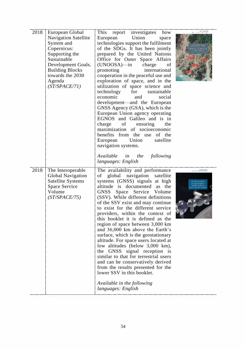
54
2018 European Global Navigation Satellite System and Copernicus: Supporting the Sustainable Development Goals. Building Blocks towards the 2030 Agenda (ST/SPACE/71)
This report investigates how European Union space technologies support the fulfilment of the SDGs. It has been jointly prepared by the United Nations Office for Outer Space Affairs (UNOOSA)—in charge of promoting international cooperation in the peaceful use and exploration of space, and in the utilization of space science and technology for sustainable economic and social development—and the European GNSS Agency (GSA), which is the European Union agency operating EGNOS and Galileo and is in charge of ensuring the maximization of socioeconomic benefits from the use of the European Union satellite navigation systems.
Available in the following languages: English
2018 The Interoperable Global Navigation Satellite Systems Space Service Volume (ST/SPACE/75)
The availability and performance of global navigation satellite systems (GNSS) signals at high altitude is documented as the GNSS Space Service Volume (SSV). While different definitions of the SSV exist and may continue to exist for the different service providers, within the context of this booklet it is defined as the region of space between 3,000 km and 36,000 km above the Earth’s surface, which is the geostationary altitude. For space users located at low altitudes (below 3,000 km), the GNSS signal reception is similar to that for terrestrial users and can be conservatively derived from the results presented for the lower SSV in this booklet.
Available in the following languages: English

55
ANNEX VIII: STATEMENT OF THE PROVIDERS’ FORUM CONCERNING THE INTERNATIONAL COMMITTEE ON GLOBAL NAVIGATION SATELLITE SYSTEMS
Statement of the Providers’ Forum concerning the
International Committee on Global Navigation Satellite Systems
On 6 November 2012, at its Ninth Meeting, in Beijing, the Provider’s Forum
adopted the following statement:
The International Committee on Global Navigation Satellite Systems (ICG)
was established in 2005 and has steadily developed into an important platform for the
system providers, the user communities, observers and interested United Nations
Member States to exchange views and information concerning the field of satellite
navigation. ICG has taken a leading role internationally to promote collaboration in the
utilization of global navigation satellite systems (GNSS) services for a range of
commercial, scientific and technological applications. Specific areas of interest to ICG
and its working groups include compatibility and interoperability, service performance
and service performance enhancement, timing and geodetic reference frames, education
and training, and global applications.
The Providers’ Forum was established in 2007, at the Second Meeting of ICG.
Since then, each of the global and regional system providers has hosted a meeting of
ICG, achieving an important milestone in demonstrating the commitment of the
Providers to the goals and objectives of ICG. This commitment serves as a foundation to
enhance collaboration and to increase global awareness of GNSS.
During its series of meetings, in particular, at its Ninth Meeting, held in
conjunction with the Seventh Meeting of ICG in Beijing on 4-9 November 2012, the
Providers’ Forum considers user recommendations, works cooperatively to enable better
service, supports the protection of the radio navigation satellite services (RNSS)
spectrum, considers activities that promote GNSS awareness and education, and
considers proposals to enhance service performance and performance monitoring and
assessment.
The Providers’ Forum promotes compatibility and interoperability among
current and future global and regional space-based systems by exchanging detailed
information about planned or operating systems and the policies and procedures that
govern their service provision. More importantly, the Providers’ Forum is a mechanism
to continue discussions on important issues addressed by ICG that require focused inputs
from system providers.
In its Ninth Meeting, the Providers’ Forum considered the future role of ICG
and agreed to keep that item on its agenda.

56
ANNEX IX: SUMMARY OF DISCUSSIONS CONCERNING THE “FUTURE OF THE INTERNATIONAL COMMITTEE ON GLOBAL NAVIGATION SATELLITE SYSTEMS”
Summary of discussions concerning the
“Future of the International Committee on Global Navigation Satellite Systems”
At the seventh meeting of the Providers' Forum held in conjunction with the sixth meeting of the International Committee on Global Navigation Satellite Systems (ICG), in Tokyo, Japan, 5 – 9 September 2011, the topic of the future of ICG was raised and discussed. This included a discussion on: the efficiency of the working groups, the designation of working group chairs, possible establishment of a Users' Forum, the status of recommendations and conclusions made by the Providers’ Forum and ICG, and the future of the ICG Secretariat. The Providers’ Forum agreed to adopt a proposal by the co-chairs to add an agenda item to the next Providers’ Forum meeting on the “Future role and work of ICG and its Providers’ Forum”, and that specific proposals could be made at that time. Furthermore, the co-chairs proposed to include an agenda item at the United Nations International Meeting on the applications of global navigation satellite systems (GNSS), in Vienna, Austria, 12 -16 December 2011, giving experts an opportunity to exchange views on an informal basis regarding the future work of the ICG and its Providers’ Forum.
During the United Nations International Meeting on GNSS held 12 -16 December 2011 in Vienna, Austria, a small group of experts met and brainstormed ideas related to the future of the ICG. At the conclusion of the meeting, a presentation was put together summarizing the discussion and different options that were raised. This summary was not exhaustive but meant to capture the essence of what was discussed and pave the way for further discussion at the eighth meeting of the Providers’ Forum on 4 June 2012 in Vienna, Austria.
Discussion on the future of the ICG continued during the first planning and organizational meeting for the seventh meeting of the ICG, held on 13 February 2012 in Vienna, Austria. A presentation entitled "Key considerations on the future of the ICG" was given by the United States of America, which was based on the summary of the December 2011 informal meeting. The topics were classified into top priorities, organizational issues, and questions to be addressed. Since time was limited, the providers decided to convene the next discussion in conjunction with China’s Satellite Navigation Conference 15 – 19 May 2012, in Guangzhou, China.
The informal meeting of the Providers’ Forum was held on 17 May 2012 on the margins of the Third China Satellite Navigation Conference (CSNC2012) in Guangzhou, China. The discussion of the "Key considerations on the future of the ICG" was continued. To facilitate further discussion, a table was created on "Key considerations on the future of the ICG". The issues of the nature of working groups versus study groups, the designation of working group chairs, and the Users' Forum were identified and discussed.
At the eighth meeting of the Providers' Forum held on 4 June 2012 in Vienna, Austria, the future role and work of the ICG and its Providers’ Forum was discussed as

57
an agenda item. A report of the informal meeting of the Providers’ Forum held in May 2012 on the margins of CSNC2012, was presented by the co-chairs of the Providers’ Forum. A summary of the other meetings was also noted and a list of issues/questions for prioritization was presented. During this meeting, the providers discussed and reviewed the issues/questions and organized them into the following three categories: (1) currently under consideration (easy to implement); (2) further consideration will be given; (3) more in-depth study to be conducted.
The following issues/questions were categorized as “under consideration and easy to implement”:
1. The ICG, as a platform for open discussions and information exchange, is a great success. It provides a better understanding of general trends in user needs, applications and GNSS development. Informally the providers and the represented users take findings into account in their plans and programs, to improve performance, compatibility and interoperability. Communication among system providers has been improved by the Providers' Forum;
2. Some ICG recommendations aimed at providers have already become principles, such as compatibility, interoperability and transparency in the provision of open services;
3. Recommendations to organizations outside the ICG should be targeted to specific actors and include specific actions;
4. Ensuring that the ICG is properly structured will require a review of:
- Procedure for selection of chairs or co-chairs; - Terms of Reference of the Providers’ Forum in relation to current working
groups; - Maintenance of permanent working groups or ad hoc working groups; - Procedures for plenary and intersessional meetings; - Executive Secretariat;
5. The number of user communities represented at the ICG should be increased;
6. Compatibility efforts should be separated from interoperability efforts;
7. The number of working groups should be limited;
8. Retaining the existing working groups structure, meetings could still be organized differently to maximize problem solving;
9. Working groups could be required to develop recommendations prior to ICG meetings rather than during ICG meetings.
The questions about the establishment of a Users’ Forum, which includes its role within the ICG, its structure, its membership, its terms of reference, and its methods of work, were put forward for consideration at the Providers’ Forum meeting, 5 – 9 November 2012 in Beijing, China. It was noted that the main objective of the Users’ Forum would be to discuss common problems, and provide feedback to the providers on what could be done to increase the efficiency of GNSS applications in the multi -GNSS environment. It was also noted that the ICG members/associate members and observers should be contacted and informed to be prepared to lead discussions about the Users’ Forum and to present their views and recommendations.
The view was expressed that to ensure the working groups achieve progress and meet their milestones, a permanent chair is needed for some working groups. Also it is

58
often useful, and perhaps inevitable, to establish a sub-group (study group and task force) under a working group to develop proposals to solve particular problems.
The eighth meeting of Providers' Forum also noted that consideration should be given to the staff capacity of the ICG Executive Secretariat, assisting with the planning and organization of the meetings of the ICG and Providers’ Forum, and its working groups in the future structure of the ICG.
An agenda item on the future role of the ICG provoked a healthy discussion at the Ninth meeting of the Providers’ Forum, held 5 – 9 November 2012 in Beijing, in conjunction with the seventh meeting of ICG. During this meeting, the Providers’ Forum agreed to the following conclusions:
1. The function of the Office for Outer Space Affairs as the Executive Secretariat should continue for now;
2. General consensus that there would be benefit to having a Users’ Forum. The details of how it would be integrated need to be discussed and considered before a final decision is made;
3. No changes to the working groups should be made at this time;
4. Discussion on selection of Providers’ Forum co-chairs will occur at the next Providers’ Forum meeting.
In conjunction with the seventh meeting of ICG, a meeting of the members, associate members and observers took place. During this meeting, a presentation was made by the co-chair of the Providers’ Forum, summarizing the ideas discussed by the providers over the past year, concerning the future of the ICG. The intent was to obtain feedback on some of the ideas being discussed by the providers. The members, associate members and observers offered the following comments:
1. Suggestion for ICG to include an agenda item during the plenary session for providers to comment on the status of past recommendations;
2. Associate members and observers agreed to help share information on the value of ICG in the various organizations;
3. Recommendation for ICG to adopt a User’s Forum (or other terminology) as a way for users to have input in the ICG:
a. Would consist of international non-governmental (NGO)’s (that would currently qualify as associate members);
b. Would support increasing awareness and adoption of GNSS, and help users address problems in fully exploiting GNSS across a broad range of users and in all nations;
c. Would enable users to help lobby on issues of concern to the GNSS community.
At the planning meeting for the tenth Providers’ Forum meeting, held 18 February 2013 in Vienna, Austria, the participants continued discussions about a Users’ Forum, noting that the process of establishing such a group should not be complicated. It was emphasized that all user groups should be well represented by the Users’ Forum. It was also suggested that developing a Mission Statement for the ICG would be helpful in identifying how the Users’ Forum fits in the construct of the ICG.

59
The tenth meeting of the Providers’ Forum was held on 10 June 2013 in Vienna, Austria. At that meeting, a draft Mission Statement was introduced, and recommended for review and consideration at the eighth meeting of the ICG, 9 – 14 November 2013 in Dubai, United Arab Emirates. A view was expressed that ICG was trying to consider many issues in a limited period of time (one week during the ICG annual meeting), and that not enough work was being accomplished outside of the meetings. One suggestion was offered for the ICG Executive Secretariat and/or ICG points of contact to keep track of the ICG recommendations. Another idea that was floated is for the ICG host country to send a person to Vienna, the year prior to the annual ICG meeting, to work with the Secretariat on preparation activities for the upcoming meeting.
The Users’ Forum was also discussed. It was suggested that the providers focus on getting user input in order to better understand the users’ needs and requirements. It was agreed that it is important to hear input from the users and associate members specifically about what they are doing to collect user requirements, and to get input from associate members on how the ICG is helping them accomplish their mission. The providers therefore agreed to change the agenda for the eighth meeting of the ICG to include a second plenary session in place of the second Providers’ Forum session, to allow for this discussion.
A discussion and decision on the selection of future Providers’ Forum co-chairs was postponed until the eleventh meeting of the Providers Forum, in conjunction with the eighth meeting of the ICG in Dubai, 9-14 November 2013.
At the eleventh meeting of the Providers’ Forum held in Dubai, on 9, 11 and 13 November 2013, the providers agreed to co-chair the Providers' Forum meetings on a 2-year rotational basis, and established a schedule for the next several years through 2017 and will confirm the remaining schedule through 2019 in the coming months.
The ICG adopted a Mission Statement contained in the Annex to this summary.

60
ANNEX X: MISSION STATEMENT OF THE INTERNATIONAL COMMITTEE ON GLOBAL NAVIGATION SATELLITE SYSTEMS
Mission Statement of
the International Committee on Global Navigation Satellite Systems
The International Committee on Global Navigation Satellite Systems (ICG), established in 2005 under the umbrella of the United Nations, promotes voluntary cooperation on matters of mutual interest related to civil satellite-based positioning, navigation, timing and value-added services. ICG contributes to the sustainable development of the world. Among the core missions of ICG are to encourage coordination among providers of global navigation satellite systems (GNSS), regional systems and augmentations in order to ensure greater compatibility, interoperability and transparency, and to promote the introduction and utilization of those services and their future enhancements, including in developing countries, through assistance, if necessary, with the integration into their infrastructures. ICG also serves to assist GNSS users with their development plans and applications by encouraging coordination and serving as a focal point for international information exchange.

61
ANNEX XI: VISION STATEMENT OF THE INTERNATIONAL COMMITTEE ON GLOBAL NAVIGATION SATELLITE SYSTEMS
Vision Statement of
the International Committee on Global Navigation Satellite Systems
The International Committee on Global Navigation Satellite Systems strives to encourage and facilitate compatibility, interoperability and transparency between all the satellite navigation systems, to promote and protect the use of their open service applications and thereby to benefit the global community. Our vision is to ensure the best satellite-based positioning, navigation and timing for peaceful uses for everybody, anywhere, any time.