Embed Size (px)
Citation preview
Cambridge Secondary 2
SYLLABUSCambridge O Level Geography
2217
For examination in June and November 2015

Cambridge International Examinations retains the copyright on all its publications. Registered Centres are permitted to copy material from this booklet for their own internal use. However, we cannot give permission to Centres to photocopy any material that is acknowledged to a third party even for internal use within a Centre.
® IGCSE is the registered trademark of Cambridge International Examinations
© Cambridge International Examinations 2013
Changes to syllabus for 2015
This syllabus has been updated, but there are no significant changes.
Contents
1. Introduction .................................................................................................................... 21.1 Why choose Cambridge?1.2 Why choose Cambridge O Level?1.3 Why choose Cambridge O Level Geography?1.4 How can I find out more?
2. Teacher support .............................................................................................................. 52.1 Support materials2.2 Resource lists2.3 Training
3. Assessment at a glance ................................................................................................. 6
4. Syllabus aims and assessment objectives ...................................................................... 84.1 Aims4.2 Assessment objectives
5. Syllabus content ........................................................................................................... 10Curriculum themesResources Case studies Theme 1: Population and settlementTheme 2: The natural environmentTheme 3: Economic development and the use of resourcesTheme 4: Geographical Investigation and Skills
6. Glossary of command words ........................................................................................ 26
7. Other information ......................................................................................................... 28
Introduction
2 Cambridge O Level Geography 2217. Syllabus for examination in 2015.
1. Introduction
1.1 Why choose Cambridge?RecognitionCambridge International Examinations is the world’s largest provider of international education programmes and qualifications for learners aged 5 to 19. We are part of Cambridge Assessment, a department of the University of Cambridge, trusted for excellence in education. Our qualifications are recognised by the world’s universities and employers.
Cambridge O Level is internationally recognised by schools, universities and employers as equivalent in demand to Cambridge IGCSE® (International General Certificate of Secondary Education). Learn more at www.cie.org.uk/recognition
Excellence in educationOur mission is to deliver world-class international education through the provision of high-quality curricula, assessment and services.
More than 9000 schools are part of our Cambridge learning community. We support teachers in over 160 countries who offer their learners an international education based on our curricula and leading to our qualifications. Every year, thousands of learners use Cambridge qualifications to gain places at universities around the world.
Our syllabuses are reviewed and updated regularly so that they reflect the latest thinking of international experts and practitioners and take account of the different national contexts in which they are taught.
Cambridge programmes and qualifications are designed to support learners in becoming:
• confident in working with information and ideas – their own and those of others
• responsible for themselves, responsive to and respectful of others
• reflective as learners, developing their ability to learn
• innovative and equipped for new and future challenges
• engaged intellectually and socially, ready to make a difference.
Support for teachers A wide range of materials and resources is available to support teachers and learners in Cambridge schools. Resources suit a variety of teaching methods in different international contexts. Through subject discussion forums and training, teachers can access the expert advice they need for teaching our qualifications. More details can be found in Section 2 of this syllabus and at www.cie.org.uk/teachers
Support for exams officers Exams officers can trust in reliable, efficient administration of exams entries and excellent personal support from our customer services. Learn more at www.cie.org.uk/examsofficers

Introduction
3Cambridge O Level Geography 2217. Syllabus for examination in 2015.
Not-for-profit, part of the University of CambridgeWe are a not-for-profit organisation where the needs of the teachers and learners are at the core of what we do. We continually invest in educational research and respond to feedback from our customers in order to improve our qualifications, products and services.
Our systems for managing the provision of international qualifications and education programmes for learners aged 5 to 19 are certified as meeting the internationally recognised standard for quality management, ISO 9001:2008. Learn more at www.cie.org.uk/ISO9001
1.2 Why choose Cambridge O Level?Cambridge O Levels have been designed for an international audience and are sensitive to the needs of different countries. These qualifications are designed for students whose first language may not be English and this is acknowledged throughout the examination process. The Cambridge O Level syllabus also allows teaching to be placed in a localised context, making it relevant in varying regions.
Our aim is to balance knowledge, understanding and skills in our programmes and qualifications to enable candidates to become effective learners and to provide a solid foundation for their continuing educational journey.
Through our professional development courses and our support materials for Cambridge O Levels, we provide the tools to enable teachers to prepare students to the best of their ability and work with us in the pursuit of excellence in education.
Cambridge O Levels are considered to be an excellent preparation for Cambridge International AS and A Levels, the Cambridge AICE (Advanced International Certificate of Education) Group Award, Cambridge Pre-U, and other education programmes, such as the US Advanced Placement program and the International Baccalaureate Diploma programme. Learn more about Cambridge O Levels at www.cie.org.uk/cambridgesecondary2
Guided learning hoursCambridge O Level syllabuses are designed on the assumption that candidates have about 130 guided learning hours per subject over the duration of the course, but this is for guidance only. The number of hours required to gain the qualification may vary according to local curricular practice and the learners’ prior experience of the subject.
1.3 Why choose Cambridge O Level Geography?Cambridge O Levels are established qualifications that keep pace with educational developments and trends. The Cambridge O Level curriculum places emphasis on broad and balanced study across a wide range of subject areas. The curriculum is structured so that candidates attain both practical skills and theoretical knowledge.
Cambridge O Level Geography is recognised by universities and employers throughout the world as proof of geographical knowledge and understanding. Successful Cambridge O Level Geography candidates develop lifelong skills, including:
• An understanding of the impacts which both physical and human geography can have and the processes which affect their development.
Introduction
4 Cambridge O Level Geography 2217. Syllabus for examination in 2015.
• A sense of place and an understanding of relative location on a local, regional and global scale.
• The ability to use and understand geographical data and information.
• An understanding of communities and cultures around the world, and how they are impacted and constrained by different environments.
Prior learningWe recommend that candidates who are beginning this course should have previously studied Geography.
ProgressionCambridge O Level Certificates are general qualifications that enable candidates to progress either directly to employment, or to proceed to further qualifications.
Candidates who are awarded grades C to A* in Cambridge O Level Geography are well prepared to follow courses leading to Cambridge International AS and A Level Geography, or the equivalent.
1.4 How can I find out more?If you are already a Cambridge schoolYou can make entries for this qualification through your usual channels. If you have any questions, please contact us at [email protected]
If you are not yet a Cambridge schoolLearn about the benefits of becoming a Cambridge school at www.cie.org.uk/startcambridge. Email us at [email protected] to find out how your organisation can register to become a Cambridge school.
Teacher support
5Cambridge O Level Geography 2217. Syllabus for examination in 2015.
2. Teacher support
2.1 Support materialsCambridge syllabuses, past question papers and examiner reports to cover the last examination series are on the Syllabus and Support Materials DVD, which we send to all Cambridge schools.
You can also go to our public website at www.cie.org.uk/olevel to download current and future syllabuses together with specimen papers or past question papers and examiner reports from one series.
For teachers at registered Cambridge schools a range of additional support materials for specific syllabuses is available online. For Teacher Support go to http://teachers.cie.org.uk (username and password required).
2.2 Resource listsWe work with publishers providing a range of resources for our syllabuses including textbooks, websites, CDs etc. Any endorsed, recommended and suggested resources are listed on both our public website and on Teacher Support.
The resource lists can be filtered to show all resources or just those which are endorsed or recommended by Cambridge. Resources endorsed by Cambridge go through a detailed quality assurance process and are written to align closely with the Cambridge syllabus they support.
2.3 TrainingWe offer a range of support activities for teachers to ensure they have the relevant knowledge and skills to deliver our qualifications. See www.cie.org.uk/events for further information.
Assessment at a glance
6 Cambridge O Level Geography 2217. Syllabus for examination in 2015.
3. Assessment at a glance
All candidates take both Paper 1 and Paper 2
Paper 1: Geographical Themes 1 hour 45 minutes
Candidates answer three questions each worth 25 marks.The paper has three sections and each section will be based on Themes 1, 2, or 3. Candidates must answer one question from each section.Section A: Two questions on Theme 1, Population and settlementSection B: Two questions on Theme 2, The natural environment Section C: Two questions on Theme 3, Economic development and the use of resources
Questions are structured with gradients of difficulty, are resource-based and involve problem-solving and free-response writing. 75 marks
Weighting: 50%
Paper 2: Investigation and Skills 2 hours 15 minutes
The paper has two sections. Candidates answer all the questions in Section A and one question from two in Section B.
Section A (60 marks): The questions are mainly skills-based and test the candidate’s ability to handle various ways of depicting geographical information. The questions are neutral in that they do not require specific information of place. Candidates can demonstrate skills of analysis and interpretation, and the application of graphical and other techniques as appropriate. One question is specifically based on a large-scale (1:25 000 or 1:50 000) topographical map of a tropical area such as Zimbabwe, the Caribbean or Mauritius, and includes a full key.
Section B (30 marks): The questions involve an appreciation from a theoretical standpoint of a range of techniques used in a variety of fieldwork studies. Questions test the methodology of the following data collection enquiry skills: (a) questionnaires; (b) observation: (c) counts (such as pedestrian and traffic); (d) measurement techniques (appropriate to river, beach and weather studies).
Questions may involve the development of suitable hypotheses appropriate to specific topics, linked to relevant geographical knowledge and understanding. Methods used to process and to present data will also be tested, using both cartographical and statistical techniques. An ability to analyse data collected and to formulate conclusions will also be examined in this paper. 90 marks
Weighting: 50%
Paper 1 is answered on a separate paper/answer booklet and Paper 2 is answered on a combined question paper and answer booklet, where candidates answer in the spaces provided.
Centres should note:
(i) that candidates are not allowed to use atlases for the written papers,
(ii) all measurements on the written papers will be metric,
(iii) the twenty-four hour clock is used.
Assessment at a glance
7Cambridge O Level Geography 2217. Syllabus for examination in 2015.
AvailabilityThis syllabus is examined in the May/June examination series and the October/November examination series.
Detailed timetables are available from www.cie.org.uk/examsofficers
This syllabus is available to private candidates.
Cambridge O levels are available to Centres in Administrative Zones 3, 4 and 5. Centres in Administrative Zones 1, 2 or 6 wishing to enter candidates for Cambridge O Level examinations should contact Cambridge Customer Services.
Combining this with other syllabusesCandidates can combine this syllabus in an examination series with any other Cambridge syllabus, except:
• syllabuses with the same title at the same level
• 0460 Cambridge IGCSE Geography
• 2223 Cambridge O Level Geography for Southern Africa
• 2230 Cambridge O Level Geography for Brunei
Please note that Cambridge O Level, Cambridge IGCSE and Cambridge International Level 1/Level 2 Certificate syllabuses are at the same level.
Syllabus aims and assessment objectives
8 Cambridge O Level Geography 2217. Syllabus for examination in 2015.
4. Syllabus aims and assessment objectives
4.1 AimsThe syllabus aims are to encourage candidates to develop:
• a sense of place and an understanding of relative location on a local, regional and global scale;
• an awareness of the characteristics and distribution of a selection of contrasting physical and human environments;
• an understanding of some of the processes affecting the development of such environments;
• an understanding of the spatial effects of the ways in which people interact with each other and with their environments;
• an understanding of different communities and cultures throughout the world and an awareness of the contrasting opportunities and constraints presented by different environments.
4.2 Assessment objectivesThe three assessment objectives in Geography are:
AO1 Knowledge with understanding
AO2 Skills and analysis
AO3 Judgement and decision making
AO1 Knowledge with UnderstandingCandidates should be able to demonstrate an understanding of:
1. the wide range of processes, including human actions, contributing to the development of
(a) physical, economic, social, political and cultural environments and their associated effects on the landscapes;
(b) spatial patterns and interactions which are important within such environments;
2. the inter-relationships between people’s activities and the total environment and an ability to seek explanations for them;
3. the importance of scale (whether local, regional or global) and the time at which spatial distributions and the working of systems are considered;
4. the changes which occur through time in places, landscapes and spatial distribution.
AO2 Skills and AnalysisCandidates should be able to:
5. analyse and interpret geographical data;
6. use and apply geographical knowledge and understanding to maps and in verbal, numerical, diagrammatic, pictorial, photographic and graphical form;
7. use geographical data to recognise patterns in such data and to deduce relationships;
8. select and show understanding of techniques for observing and collecting data;
9. select and use techniques for organising and presenting data.

Syllabus aims and assessment objectives
9Cambridge O Level Geography 2217. Syllabus for examination in 2015.
AO3 Judgement and Decision MakingThrough their geographical training candidates should be able to:
10. reason, make judgements (including evaluation and conclusions) which demonstrate, where appropriate
(a) a sensitivity to, and a concern for, landscape and the environment and the need for sustainable development;
(b) an aesthetic and environmental appreciation of the earth including its people, places, landscapes, natural processes and phenomena;
(c) an appreciation of the attitudes, values and beliefs of others in cultural, economic, environmental, political and social issues which have a geographical dimension;
(d) an awareness of the contrasting opportunities and constraints of people living in different places and under different physical and human conditions;
(e) a willingness to review their own attitudes in the light of new knowledge and experiences.
11. recognise the role of decision-making within a geographical context as affected by:
(a) the physical and human contexts in which decisions are made;
(b) the values and perceptions of groups or individuals;
(c) the choices available to decision-makers and the influences and constraints within which they operate;
(d) the increasing level of global interdependence.
Specification GridThe relationship between the assessment objectives and components of the scheme of assessment, showing the percentage of the marks on each paper for each Assessment Objective.
Paper Assessment Objective
AO1
Knowledge with Understanding
AO2
Skills and Analysis
AO3
Judgement and Decision making
1 48% 30% 22%
2 10% 75% 15%

Syllabus content
10 Cambridge O Level Geography 2217. Syllabus for examination in 2015.
5. Syllabus content
Curriculum themesThe curriculum is divided into four themes which have been designed to develop an understanding of both the natural and human environment.
1. Population and settlement
2. The natural environment
3. Economic development and the use of resources
4. Geographical investigation and skills
Resources Questions in all written papers are resource based. The resources offered may be photographic, map extracts, drawings, diagrams, graphs, text extracts, statistics and tables of data.
Resource materials are selected from various world areas in order to match the aims of an international syllabus and examination. As a result, candidates may be dealing with world areas with which they are not familiar. Candidates will be expected to know the location of the continents but the resources used in questions do not require specific regional knowledge. Questions will provide sufficient information to enable candidates to answer them without specific regional knowledge. The resources used in the examination will assist candidates in analysis and interpretation.
The resource materials are designed to prompt candidates to relate general principles they have studied to the particular examples given.
Case studies The curriculum gives teachers the opportunity to select case studies to illustrate the themes. Specified illustrations of case studies have not been included in the syllabus. This is to provide teachers with complete freedom in selecting appropriate specific examples to illustrate the content of the three themes.
Further information on case studies is included in the Amplification sections of the syllabus.
For each part of the syllabus or topic a brief outline is provided, followed by Amplification which details what the candidates should be able to do on completion of that topic.
Syllabus content
11Cambridge O Level Geography 2217. Syllabus for examination in 2015.
Theme 1: Population and settlement1.1 Population dynamicsCandidates should be able to:
• Describe the growth of the world’s population and associated problems and show an understanding of the causes and consequences of over-population and under-population.
• Identify and suggest reasons for contrasting patterns of population growth in different parts of the world, as influenced by migration, birth rate and death rate, especially the impact of HIV/AIDS.
• Describe the consequences (benefits and problems) of different patterns of population growth.
• Identify and suggest reasons for different types of population structure as shown by age/sex pyramids.
• Describe the factors influencing the density and distribution of population and population migration.
Amplification for 1.1 – Population dynamics
Candidates should be able to:
• Describe and suggest reasons for the rapid increase in the world’s population in recent times, ‘the population explosion’.
• Define the main factors influencing population growth – birth rate, death rate and migration.
• Describe the relationship between population growth and resources and explain why problems may result in some areas such as over-population and under-population.
• Identify and suggest reasons for contrasting patterns of population growth in different world areas as influenced by differences in birth rate, death rate and migration. Factors affecting these influences should be considered such as differences in social, economic and other factors, e.g., government policies and their impact upon birth rates, differences in health care, social and other factors influencing death rates, especially the impact of HIV/AIDS. These factors should be illustrated by reference to selected examples.
• Describe the consequences (benefits and problems) of different patterns of population growth. Consideration should be given to variations in the size and nature of dependent populations and standards of living.
• Identify and suggest reasons for different types of population structure as shown by age-sex pyramids. Candidates should be able to describe population pyramids and relate them to the different stages of the Demographic Transition Model.
• Identify the major influences on population density and population distribution. Reference should be made to physical, economic and human factors.
• Describe and suggest reasons for population movements. Reference should be made to internal movements such as rural-urban migration as well as to international movements both voluntary and involuntary.
Throughout their study of population, candidates should make use of statistics, diagrams and maps.
Syllabus content
12 Cambridge O Level Geography 2217. Syllabus for examination in 2015.
1.2 SettlementCandidates should be able to:
• Describe and explain the factors influencing the size, development and function of urban and rural settlements and their spheres of influence.
• Describe and give reasons for the characteristics of land-use zones of urban areas in less economically developed countries and more economically developed countries (LEDCs and MEDCs).
• Describe the problems of urban areas in LEDCs and MEDCs, their causes and possible solutions.
• Describe the effects on the environment resulting from urbanisation and possible solutions to reduce this impact.
Amplification for 1.2 – Settlement
Candidates should be able to:
• Describe the patterns of rural settlements – dispersed, linear, nucleated.
• Explain how physical factors (relief, soil, water supply) and other factors such as accessibility, agricultural land-use, influence the sites and patterns of rural settlements.
• Describe and explain the factors which may influence the size, growth and functions of rural and urban settlements.
• Describe and suggest reasons for the hierarchy of settlements and services.
• Describe and explain the internal structure (morphology) of towns and cites to include the Central Business District (CBD), residential areas, industrial areas, the provision of open spaces and transport routes. Differences in the patterns of urban structures in cities of the developing and developed countries of the world should be identified.
• Describe and explain the land-use zones of towns and cities to include the Central Business District (CBD), residential areas, industrial areas, the provision of open spaces and transport routes. Differences in the patterns of urban structure in cities of LEDCs and MEDCs should be identified.
• Describe problems associated with the growth of urban areas such as congestion in the CBD, housing shortages, traffic congestion, squatter settlements. Suggested solutions to overcome these problems should be illustrated by reference to selected examples.
• Describe the effects of urbanisation on the environment – pollution (air, water, visual and noise), the results of urban sprawl on surrounding areas, the growth of out-of-town urban activities – shopping areas, sports facilities etc.
Settlement studies offer opportunities for developing survey map skills, photograph interpretation, geographical investigations etc.
Syllabus content
13Cambridge O Level Geography 2217. Syllabus for examination in 2015.
Theme 2: The natural environment2.1 Plate tectonicsCandidates should be able to:
• Describe the distribution of earthquakes, volcanoes and fold mountains in relation to plate margins.
• Describe the causes and effects of earthquakes and volcanic eruptions.
Amplification for 2.1 – Plate tectonics
Candidates should be able to:
• Describe the general distribution of fold mountains, volcanoes and earthquake zones and explain how this distribution is related to movements at plate boundaries.
• Show a basic understanding of plate tectonics, describing the global pattern of plates, their structure, and be aware of plate movements and their effects – plates moving away from each other (sea floor spreading), plates moving towards each other (subduction) and plates sliding past each other.
• Demonstrate an understanding of the main features of volcanoes (and their eruptions) and earthquakes.
2.2 Landforms and landscape processesCandidates should be able to:
• Describe weathering, river and marine processes.
• Describe and explain the landforms associated with these processes.
Amplification for 2.2 – Landforms and landscape processes
Weathering
Candidates should be able to:
• Recognise that weathering involves the breakdown of rock in situ, and as such should be distinguished from erosion.
• Describe what is meant by different types of weathering – physical/mechanical freeze-thaw action, exfoliation), chemical (carbonation, oxidation) and biological.
• Explain the main factors influencing the type and rate of weathering – climate and rock features (mineral composition, grain size of the rock, presence of lines of weakness). The influence of climate on the rate of weathering could be illustrated with reference to simple explanation as to why weathering is more rapid in humid tropical regions of the world than in temperate regions.

Syllabus content
14 Cambridge O Level Geography 2217. Syllabus for examination in 2015.
River processes
Candidates should be able to:
• Demonstrate an understanding of the work of a river in eroding, transporting and depositing. Reference should be made to the erosional processes of hydraulic action, corrasion, corrosion (solution) and attrition. River transport should include the processes of traction, saltation, suspension and solution. Reasons why and where in a river’s course deposition takes place should be studied. It should be realised that the effectiveness of the river processes concerned will vary according to the volume and velocity of the running water and the nature of the load (boulders, pebbles, sand and silt) which in turn will be affected by the bed-rock along the course of the river.
• Describe and explain the landforms associated with these processes.
A study should be made of the following
• Forms of river valleys – long profile and shape in cross section, rapids, waterfalls, potholes, meanders, oxbow lakes, deltas, levées and flood plains.
Marine processes
Candidates should be able to:
• Demonstrate an understanding of wave processes in eroding a coastline and re-sorting and depositing materials removed through erosion. Candidates should understand the types of waves (constructive and destructive) and the components of waves, swash and backwash. The erosional processes of wave action should include an understanding of corrasion, hydraulic action, corrosion and attrition. Transport of material along a coastline should be appreciated; onshore and offshore movements, together with an understanding of movement along a coastline (longshore drift). The action of wind in shaping coastal sand dunes should also be understood.
• Describe and explain the landforms associated with these processes.
• Describe the conditions required for the development of coral reefs.
• Describe fringing and barrier reefs and atolls.
A study should be made of the following coastal landforms
• Cliffs, wave-cut platforms, caves, arches, stacks, bay and headland coastlines, beaches, spits and bars, coastal sand dunes and marsh.
In studying landforms, use should be made of photographs, survey maps and field studies, where possible.
Syllabus content
15Cambridge O Level Geography 2217. Syllabus for examination in 2015.
2.3 Weather, climate and natural vegetationCandidates should be able to:
• Describe the methods of collecting and measuring meteorological data.
• Describe and explain the characteristics of the climate and natural vegetation of two ecosystems:
• tropical rainforest
• tropical desert.
• Describe and explain the relationship between the climate and natural vegetation in these two ecosystems.
Amplification for 2.3 – Weather, climate and natural vegetation
Weather
Candidates should be able to:
• Draw, describe and explain the use and siting of the following instruments at a weather station: rain-gauge, maximum-minimum thermometer, wet and dry bulb thermometer (hygrometer), barometer, anemometer and wind vane.
• Make calculations using information from these instruments.
• Have an awareness of simple digital instruments which can be used for weather observation.
• Describe and explain the characteristics, siting and use made of a Stevenson screen.
• Describe the main types of cloud and be able to estimate the extent of cloud cover.
Climate
Candidates should be able to:
• Describe and explain the main characteristics of the climate in the regions listed in the syllabus (tropical rainforest, tropical desert): temperature – mean temperature of the hottest month, mean temperature of the coolest month, therefore the annual range; – rainfall the amount and seasonal distribution; other climate features – wind, cloud, humidity, etc. Factors influencing these characteristics should be noted such as latitude, pressure systems and the winds to which they give rise, distance from the sea, altitude and ocean currents. Candidates should be familiar with climatic graphs showing the main characteristics of temperature and rainfall of the climates in the regions listed.
Ecosystems
Candidates should be able to:
• Describe the characteristics and distribution of the two ecosystems (tropical rainforest, tropical desert).
• Explain the relationship of each type of natural vegetation and climate.
Weather studies should involve the use of simple weather instruments where possible. Weather data offer many opportunities for data handling and presentation.

Syllabus content
16 Cambridge O Level Geography 2217. Syllabus for examination in 2015.
2.4 The inter-relationship of physical and human geographyCandidates should be able to:
• Demonstrate the interaction between the natural environment and human activities, with reference to natural hazards, landscape processes, climate and the two named ecosystems.
Amplification for 2.4 – The inter-relationship of physical and human geography
Candidates should be able to:
• Demonstrate an understanding that the natural environment presents hazards and offers opportunities for human activities. Reference could be made for example to the hazards posed by volcanic eruptions, earthquakes, tropical storms, flooding and drought.
• Use could be made of the study of contemporary examples to illustrate. This information would provide candidates with valuable case study information. Such examples could form resource material given in examination questions when candidates might be expected to illustrate inter-relationships between the natural environment and human activities from the data presented. Reference to the opportunities and problems posed for people could be incorporated when studies are made of the natural environment, for example the advantages and difficulties offered by river flood plains and deltas. The impact of human activities on the two named ecosystems should be considered.
Syllabus content
17Cambridge O Level Geography 2217. Syllabus for examination in 2015.
Theme 3: Economic development and the use of resources3.1 Agricultural systemsCandidates should be able to:
• Describe and identify the influence of inputs (natural and human) on the processes and outputs (products) of each of the following agricultural systems:
• a large-scale system of commercial farming,
• small-scale subsistence farming.
• Recognise the causes and effects of shortage of food and describe possible solutions to this problem.
Amplification for 3.1 – Agricultural systems
Candidates should be able to:
• Describe in general terms the main features of an agricultural system: inputs, processes and outputs.
• Describe the influence of natural and human inputs on the processes and outputs of examples of the agricultural systems listed in the syllabus (a large-scale system of commercial farming, small-scale subsistence farming). Studies should include natural inputs (relief, climate and soil) and human inputs (economic, social and sometimes political). Their combined influences on the scale of production, methods of organisation and the products of each system should be studied. Reference may be made to an example such as plantation agriculture or extensive commercial cereal farming or extensive livestock production etc, to illustrate a large-scale system of commercial farming. Examples such as intensive subsistence rice cultivation or shifting cultivation etc, could profitably illustrate a system of small-scale subsistence farming. Other illustrations might be selected rather than the above. In each case reference should be made to a detailed case study.
• Recognise the causes and effects of food shortages. Shortages of food may be related to natural problems such as soil exhaustion, drought, floods, tropical cyclones, pests, disease etc. There should be an awareness of the effects of these natural problems on selected areas mainly in LEDCs. Economic and political factors and their effects upon food shortages should be noted, for example low capital investment, poor distribution/transport difficulties, wars etc. The effects of food shortages in encouraging food aid and measures such as those of the ‘Green Revolution’ to produce more food should also be considered.
Syllabus content
18 Cambridge O Level Geography 2217. Syllabus for examination in 2015.
3.2 Industrial systemsCandidates should be able to:
• Classify industries into primary, secondary and tertiary.
• Describe and explain how the proportions employed in primary, secondary and tertiary industries differ in LEDCs and MEDCs and may change with time and level of development.
• Describe and identify the influence of inputs on the processes and outputs (products and waste) of industrial systems.
• Describe and explain the factors influencing the distribution and location of high technology industries and one other manufacturing/processing industry. Distribution should be studied on a global/national scale. Study should also be made of particular zones and/or industrial plants with respect to location and site factors.
Amplification for 3.2 – Industrial systems
Candidates should be able to
• Classify industries into primary, secondary and tertiary and be able to give illustrations of each. Describe and explain how the proportions employed in each sector changes with respect to the level of development, including Newly Industrialised Countries (NICs).
• Demonstrate an understanding of an industrial system: inputs, processes and outputs (products and waste). Specific illustrations of high technology industries should be studied along with one other processing/manufacturing industry.
• Describe how a variety of factors must be considered when seeking the location for high technology industries and the selected industry.
3.3 Leisure activities and tourismCandidates should be able to:
• Describe and account for the growth of leisure facilities and tourism in relation to the main attractions of the physical and human landscape.
• Assess the benefits and disadvantages of tourism to receiving areas.
Amplification for 3.3 – Leisure activities and tourism
Candidates should be able to:
• Describe and explain the growth of leisure facilities and tourism in relation to the main attractions of the physical and human landscape in an area or areas selected for study.
• Demonstrate an understanding that the effects of a growth in tourism are generally positive and that careful management is needed if problems are to be avoided. Reference could be made to advantages accruing from tourism such as growth in income, an increase in foreign exchange, employment opportunities, the development of infrastructure and facilities which may be used by the local population, the encouragement of other developments to take place in an area, cultural advantages etc. Disadvantages might include seasonal unemployment, under-use of facilities at certain times of the year, increased congestion, pollution, a shortage of services, e.g. water supplies, social/cultural problems, damage to the physical landscape etc. A selected sample study should be used to illustrate both the benefits and disadvantages associated with the growth of tourism.
Syllabus content
19Cambridge O Level Geography 2217. Syllabus for examination in 2015.
3.4 Energy and water resourcesCandidates should be able to:
• Describe the significance of fuelwood, non-renewable fossil fuels (coal, oil, natural gas) and renewable energy supplies (geothermal, wind, running water, solar, biogas).
• Describe the factors influencing the development and siting of power stations (thermal, hydro-electric power, nuclear).
• Describe the uses, provision, management and competition for water resources.
Amplification for 3.4 – Energy and water resources
Candidates should be able to:
• Describe the significance of fuelwood in LEDCs and of non-renewable fossil fuels in terms of their availability in certain areas and in terms of the contribution made by coal, oil, natural gas and wood in supplying vast amounts of energy.
• Describe the growing significance of renewable energy supplies (geothermal, wind, running water, solar, biogas) to reduce dependence upon fossil fuels, to alleviate the world’s energy crisis, and to offer opportunities for the development of alternative energy sources.
• Describe the factors influencing the siting of different types of electrical power stations with reference to those listed in the syllabus (thermal, hydro-electric power, nuclear).
• Describe the uses made of water for agriculture, domestic and industrial demand. Candidates should also recognise that in certain areas there are water shortages which impact upon the local people and the potential for development. This leads to competition for the use of the available water resources and requires careful management.
All these aspects would benefit from the selection of appropriate case studies.
Syllabus content
20 Cambridge O Level Geography 2217. Syllabus for examination in 2015.
3.5 Environmental risks and benefits: resource conservation and management
Candidates should be able to:
• Describe how human activities (agriculture, mining and quarrying, energy production, manufacturing industries, transport and tourism) may improve the quality of life and/or pose threats to the environment:
• soil erosion;
• global warming;
• pollution (water, air, noise, visual).
• Demonstrate the need for sustainable development, resource conservation and management in different environments
• Identify areas at risk and describe any attempts to maintain, conserve or improve the quality of the environment.
Amplification for 3.5 – Environmental risks and benefits: resource conservation and management
Candidates should be able to
• Demonstrate the need for sustainable development, resource conservation and management in different environments. It is not intended that candidates should be familiar with a wide variety of illustrations here. Rather by the use of well selected case studies, possibly integrated with the study of other concepts referred to above, candidates become familiar with general principles and can illustrate from these examples.
• Identify and describe the benefits associated with the development of agriculture, mining and quarrying, energy production, manufacturing industries, transport and tourism. This could be incorporated with the studies outlined above (3.1–3.4).
• Describe how these developments may also pose threats to the environment when natural ecosystems are interfered with, including soil erosion, global warming effect and pollution (air, water, noise and visual).
• Identify areas at risk from these threats to the environment and describe attempts made to maintain, conserve or improve the quality of the environment.
Syllabus content
21Cambridge O Level Geography 2217. Syllabus for examination in 2015.
Theme 4: Geographical Investigation and SkillsThe content in Theme 4 should be integrated within the other three themes for teaching purposes. In the examination, candidates will be set a series of tasks on issues relating to one or more of syllabus themes:
1. Population and settlement
2. The natural environment
3. Economic development and the use of resources.
Equipment
It is essential that candidates have the following equipment with them in the examination room: a pencil, rubber, ruler and a protractor.
They should also have access to a sheet of plain paper for measuring distances or for assisting with cross sections on the large scale topographic map.
4.1 Geographical skills
• The geographical skills identified below will be assessed in Section A of Paper 2. Some of the skills may also be assessed in the interpretation and analysis of resources used in Paper 1.
Amplification for 4.1 – Geographical Investigation and Skills
Mapwork
One question, worth 20 marks, will be based on a topographical map.
The large-scale maps chosen for examination purpose will be on a scale of either 1:25 000 or 1:50 000 and will always contain a full key. The maps will be of a tropical area such as Zimbabwe, the Caribbean or Mauritius.
Candidates should recognise that one third of the marks available on this paper are awarded to the mapwork question and, therefore, it is essential that they become proficient in map reading and interpretation skills to enable them to describe and analyse topographical maps.
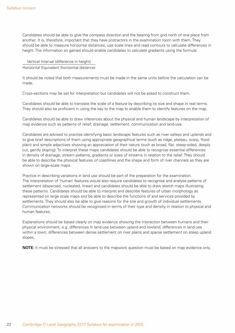
Candidates should be able to use a co-ordinate reference system and be able to give and to read four figure and six figure grid references to locate places. To give the six figure grid reference, first of all identify the grid square, in this case 4665. The third figure is obtained by dividing the space between grid lines 46 and 47 into ten equal parts. Similarly the sixth figure is obtained by a similar division of the gap between northings 65 and 66. This would result in a grid reference of 463654 for the dot. It should be noted that the first tenth is 0 and the last tenth is 9 in the divided grid square.
46 47
4665
66
65
66
0
0
1
2
3
4
5
6
7
8
9
1 2 3 4 5 6 7 8 947
1st Reading (EASTINGS)
2nd Reading(NORTHINGS)
Syllabus content
22 Cambridge O Level Geography 2217. Syllabus for examination in 2015.
Candidates should be able to give the compass direction and the bearing from grid north of one place from another. It is, therefore, important that they have protractors in the examination room with them. They should be able to measure horizontal distances, use scale lines and read contours to calculate differences in height. The information so gained should enable candidates to calculate gradients using the formula:
Vertical Interval (difference in height)
Horizontal Equivalent (horizontal distance)
It should be noted that both measurements must be made in the same units before the calculation can be made.
Cross-sections may be set for interpretation but candidates will not be asked to construct them.
Candidates should be able to translate the scale of a feature by describing its size and shape in real terms. They should also be proficient in using the key to the map to enable them to identify features on the map.
Candidates should be able to draw inferences about the physical and human landscape by interpretation of map evidence such as patterns of relief, drainage, settlement, communication and land-use.
Candidates are advised to practise identifying basic landscape features such as river valleys and uplands and to give brief descriptions of them using appropriate geographical terms (such as ridge, plateau, scarp, flood plain) and simple adjectives showing an appreciation of their nature (such as broad, flat, steep-sided, deeply cut, gently sloping). To interpret these maps candidates should be able to recognise essential differences in density of drainage, stream patterns, gradients or sizes of streams in relation to the relief. They should be able to describe the physical features of coastlines and the shape and form of river channels as they are shown on large-scale maps.
Practice in describing variations in land use should be part of the preparation for the examination. The interpretation of ‘human’ features would also require candidates to recognise and analyse patterns of settlement (dispersed, nucleated, linear) and candidates should be able to draw sketch maps illustrating these patterns. Candidates should be able to interpret and describe features of urban morphology as represented on large scale maps and be able to describe the functions of and services provided by settlements. They should also be able to give reasons for the site and growth of individual settlements. Communication networks should be recognised in terms of their type and density in relation to physical and human features.
Explanations should be based clearly on map evidence showing the interaction between humans and their physical environment, e.g. differences in land-use between upland and lowland, differences in land-use within a town, differences between dense settlement on river plains and sparse settlement on steep upland slopes.
NOTE: It must be stressed that all answers to the mapwork question must be based on map evidence only.
Syllabus content
23Cambridge O Level Geography 2217. Syllabus for examination in 2015.
Maps, Diagrams, Graphs, Tables of Data, Written Material
Questions will be set using some or all of these resources. They should be regarded as important ways of representing geographical data. They may be used to illustrate a basic principle and it is essential that candidates should be directed towards their interpretation. For example, a population pyramid may be used to illustrate the age and sex structure of a country. With such a resource, a candidate may be required to describe the broad features of the population structure to show comparisons and contrasts between the male and female populations, the working and non-working population and the young and old age groups.
Maps based on global and other scales may be used and candidates may be asked to identify and describe significant features of the human and physical landscape on them – e.g. population distribution, population movements, transport networks, settlement layout, relief and drainage. Candidates may be asked to recognise patterns and deduce relationships.
Candidates will be expected to be able to extract specified geographical information from simple graphs, diagrams, tables of data and written material. Pie graphs may be used and candidates may be asked to describe variations and identify trends in information from two-dimensional graphs or more complex graphs. Graphs may show, for example, temperature, birth rate, death rate, energy, rainfall distribution, river discharge.
Candidates may be required to plot information on graphs when axes and scales are provided.
Data tables may provide information on physical phenomena, on economic activities, on population/settlement, on agricultural and manufacturing output and candidates may be asked to describe and analyse features and trends from the data provided. They may also be asked to suggest an appropriate form of graphical representation for the data provided.
Written material may be extracts from books, periodicals and newspapers and candidates will be expected to show an understanding of the material presented.
Photographic and Pictorial Material (including Field Sketches)
Oblique photographs will be used. Candidates should be able to describe human and physical landscapes (landforms, natural vegetation, land-use and settlement) and geographical phenomena from photographs. Simple descriptions only will be required.
Candidates may be expected to add specified detail on maps or other material provided thereby applying geographical knowledge and understanding. Candidates may also be asked to use supporting material in conjunction with large-scale maps to identify, describe and analyse features and thereby recognise patterns and deduce trends.
Syllabus content
24 Cambridge O Level Geography 2217. Syllabus for examination in 2015.
4.2 Geographical investigationsQuestions to be included in Section B of Paper 2 will involve an appreciation from a theoretical standpoint of the range of techniques appropriate to a variety of field work studies associated with this level of examination.
In this context relevant aspects of Assessment Objective D, Investigation, are significant. Questions will test the methodology used in the application of the following types of enquiry skills in field work:
(a) questionnaires;
(b) observation;
(c) counts such as pedestrian and traffic counts;
(d) measurement techniques appropriate to river, beach and weather studies (Syllabus Theme 2.1 and 2.2).
Methods used to process and to present data obtained by these enquiry skills will also be tested. These methods will include both cartographical techniques and statistical techniques. Enquiry skills and presentation skills are to be studied against the background of the range of other aspects involved in field work. Questions may involve the aims of particular studies and in this context will include, for example, the development of suitable hypotheses appropriate to specific topics. An ability to analyse data collected and to formulate conclusions, as required by Assessment Objectives B and C, will be examined in this section.
Candidates should be made aware of the general requirements for Section B of Paper 2. Some practical experience, however limited, of coursework methodology is preferable in preparation for this paper. One approach is to introduce the appropriate enquiry skills and techniques relevant to Section B of Paper 2 after the teaching of a specific topic for Paper 1 from one of the syllabus themes. For example after the river topic (Theme 2.1) time could be spent discussing how rivers could be measured, the plotting of depth data and the calculation of cross sectional area and discharge. The skill required for questionnaires, counts and observations may be introduced in a variety of topics where practical for the Centre.
References should be made to the range of aspects involved in coursework assignments, such as:
(i) formulating aims and hypotheses
(ii) using enquiry skills to collect data
(iii) presentation techniques to display data
(iv) making analyses of data and
(v) the formulation of conclusions.
Amplification for 4.2 – Geographical InvestigationFormulating aims and hypotheses
Candidates should be familiar with hypotheses as statements that form the basis of coursework assignments. The hypotheses may investigate a geographical concept, e.g. ‘A CBD has the highest concentration of comparison shops’. Collecting relevant data, analysis and drawing conclusions using the data as evidence can test these.
Syllabus content
25Cambridge O Level Geography 2217. Syllabus for examination in 2015.
Enquiry skills to collect data
Questions on this paper will test knowledge and application of the methodology used in the following range of data collection enquiry skills.
• Questionnaires – Questionnaires can be oral or written to gain information from an individual or a group of individuals. Suitable themes in the syllabus where questionnaires may be appropriately studied include spheres of influence, use of services, shopping habits, a farm study, a factory or industrial study, leisure activities, tourism, or attitudes of the public to developments associated with resource development. Consideration should be given to factors influencing the successful design of questionnaires, e.g. layout, format of questions, the appropriate wording of questions and the number of questions. The practical considerations of conducting a questionnaire, e.g. the sampling methods, pilot survey, and location of survey should also be discussed.
• Observation – Examples of using observations as an enquiry skill to collect data include the recording of land use in an urban area or observations of river or coastal features. Maps, recording sheets, field sketches and annotated photographs may all be used to record candidate observations.
• Counts – Pedestrian and traffic counts are two significant examples of this enquiry skill. Appropriate methods for recording the counts should be discussed, including the layout of recording sheets, instructions and the necessary information required to identify the sheet following the count (i.e. time, date, location and name of recorder).
• Measurement – When recording measurements, due consideration should be given to planning the layout of the recording sheet, the location of instruments and the sampling methods adopted to provide reliable data. Knowledge of the equipment used in measurement is required such as the quadrat, the clinometer and the pebbleometer or callipers. Candidates should be familiar with river measurements of channel width, depth, speed of flow and the size and shape of bedload; beach studies of beach profile, the size and shape of pebbles and the movement of beach material and weather study instruments closely linked to Theme 2.2.
Data presentation techniques
A knowledge of the illustrative techniques to present data across the topics for Paper 4 is required. This should include, various types of graphs, maps and diagrams for example line graphs, bar graphs, divided bar graphs, histograms, flow diagrams, wind rose graphs, isoline maps and scattergraphs.
Analysis
Candidates should be able to describe the patterns in data presented in graphs and tables of results. Reference to relevant geographical knowledge and understanding is often required in the interpretation of the data. Practice of this skill will improve success in Paper 4 questions.
Formation of Conclusions
Using the evidence from the data, candidates should be able to make judgements on the validity of the original hypothesis or aims of the assignment. Reference is also required of the reliability of the collected data and a critical evaluation of the chosen data collection methods.
Glossary of command words
26 Cambridge O Level Geography 2217. Syllabus for examination in 2015.
6. Glossary of command words
It is hoped that this glossary of command words used in the Geography Papers (and which is relevant only to Geography) will prove helpful to candidates as a guide, i.e. it is neither exhaustive nor definitive. Command words are those words in a question that tell the candidate what they have to do. The glossary has been deliberately kept brief with respect to the descriptions of meanings. Candidates should appreciate that the meaning of a term must depend in part on its context.
Annotate Add labels of notes or short comments, usually to a diagram, map or photograph to describe or explain.
Calculate Work out a numerical answer. In general, working should be shown, especially where two or more steps are involved.
Compare Write about what is similar and different about two things. For a comparison, two elements or themes are required. Two separate descriptions do not make a comparison.
Complete To add the remaining detail or details required.
Contrast Write about the differences between two things.
Define or State the meaning of or What is meant by
Give the meaning or definition of a word or phrase.
Describe Write what something is like or where it is. Describe may be used for questions about resources in the question paper (describe the trend of a graph, the location of a settlement on a map, etc.). It may also be used when you need to describe something from memory (describe a meander, etc.).
It is often coupled with other command words such as Name and describe (name the feature and say what it is like), Describe and explain (say what it is like and give reasons for).
Devise or Plan Presentation of a particular feature such as a form or questionnaire to meet a specific requirement or requirements.
Draw Make a sketch of. Often coupled with a labelled diagram (draw a diagram/illustration with written notes to identify its features).
Explain or Account for or Give reasons for
Write about why something occurs or happens.
Giving your views or Comment on
Say what you think about something.
How In what way? To what extent? By what means/method? May be coupled with Show how (prove how, demonstrate how).
Identify Pick out something from information you have been given.
Illustrating your answer
Account for by using specific examples or diagrams. Often coupled with by a labelled diagram.
Glossary of command words
27Cambridge O Level Geography 2217. Syllabus for examination in 2015.
Insert or Label Placing specific names or details to an illustrative technique in response to a particular requirement.
Justify Say why you chose something or why you think in a certain way.
List Identify and name a number of features to meet a particular purpose.
Locate Find where something is placed or state where something is found or mark it on a map or diagram.
Measure Implies that the quantity concerned can be directly obtained from a suitable measuring instrument.
Name To state or specify or identify. To give the word or words by which a specific feature is known or to give examples which illustrate a particular feature.
Predict Use your own knowledge and understanding, probably along with information provided to state what might happen next.
Refer to or With reference to
Write an answer which uses some of the ideas provided in map/ photograph/diagram, etc. or other additional material such as a case study.
State Set down in brief detail. To refer to an aspect of a particular feature by a short statement or by words or by a single word.
Study Look carefully at (usually one of the Figures in the question paper).
Suggest Set down your ideas on or knowledge of. Often coupled with why (requires a statement or an explanatory statement referring to a particular feature or features).
Use or Using the information provided
Base your answer on the information.
With the help of information in
Write an answer which uses some of the information provided as well as additional material.
What Used to form a question concerned with selective ideas/details/factors.
What differences are shown between A and B
Use comparative statements to describe the changes involved as A changes to B. Factual descriptions of A and B are not required.
Where At what place? To what place? From what place?
Why For what cause or reason?
Other information
28 Cambridge O Level Geography 2217. Syllabus for examination in 2015.
7. Other information
Equality and inclusionCambridge International Examinations has taken great care in the preparation of this syllabus and assessment materials to avoid bias of any kind. To comply with the UK Equality Act (2010), Cambridge has designed this qualification with the aim of avoiding direct and indirect discrimination.
The standard assessment arrangements may present unnecessary barriers for candidates with disabilities or learning difficulties. Arrangements can be put in place for these candidates to enable them to access the assessments and receive recognition of their attainment. Access arrangements will not be agreed if they give candidates an unfair advantage over others or if they compromise the standards being assessed.
Candidates who are unable to access the assessment of any component may be eligible to receive an award based on the parts of the assessment they have taken.
Information on access arrangements is found in the Cambridge Handbook which can be downloaded from the website www.cie.org.uk
LanguageThis syllabus and the associated assessment materials are available in English only.
Grading and reportingCambridge O Level results are shown by one of the grades A*, A, B, C, D or E, indicating the standard achieved, A* being the highest and E the lowest. ‘Ungraded’ indicates that the candidate’s performance fell short of the standard required for grade E. ‘Ungraded’ will be reported on the statement of results but not on the certificate. The letters Q (result pending); X (no results) and Y (to be issued) may also appear on the statement of results but not on the certificate.
Entry codesTo ma intain the security of our examinations we produce question papers for different areas of the world, known as ‘administrative zones’. Where the component entry code has two digits, the first digit is the component number given in the syllabus. The second digit is the location code, specific to an administrative zone. Information about entry codes, examination timetables and administrative instructions can be found in the Cambridge Guide to Making Entries.

*6557045314*
Cambridge International Examinations1 Hills Road, Cambridge, CB1 2EU, United KingdomTel: +44 (0)1223 553554 Fax: +44 (0)1223 553558Email: [email protected] www.cie.org.uk
® IGCSE is the registered trademark of Cambridge International Examinations
© Cambridge International Examinations 2013