Embed Size (px)
DESCRIPTION
L2B Street Concept Plan
Citation preview

Lake2Bay Street concept pLan

Lake2Bay Street Concept Planpage 2Chapter I
This page intentionally left blank.

Lake2Bay Street Concept Plan page 3Chapter I
Copyright November 2015, Seattle Parks Foundation
Made possible through contributions from:
AmazonBill & Melinda Gates Foundation The Office of Economic DevelopmentThe Space Needle CorporationVulcan
Design Team:
Landscape Architect, Team Lead: Walker MacyArts Planner: Jill Anholt StudioTraffic Planning: Heifron Civil Engineer: Magnusson Klemencic AssociatesCost Consulting: C&N ConsultantsFinance and Economics: Berk Consulting
Table of Contents .......................................................................3Forward ........................................................................................5
Chapter 1: Introduction ..................................................................7Guiding Principles ......................................................................8Context & Opportunities ...........................................................9
Chapter 2: Design Strategies .......................................................15Paving .........................................................................................18Planting ......................................................................................19Pedestrian Lighting ..................................................................20Art ................................................................................................21Wayfinding .................................................................................22Stormwater ...............................................................................23Water Re-Use .............................................................................24
Chapter 3: Street Plans .................................................................27Design Segments Guide ..........................................................28Terry Avenue N ..........................................................................30Thomas Street. .........................................................................32Broad Street at Seattle Center ...............................................38Broad Street at Denny Way and 3rd Ave ..............................48Broad Street Terraces ..............................................................52Alaskan Way ..............................................................................64
Chapter 4: Art Plan ........................................................................73Existing Artworks ......................................................................76Opportunities ............................................................................77Summary of Artwork Implementation .................................86
Chapter 5: Implementation .........................................................89
Table of Contents

Lake2Bay Street Concept Planpage 4Chapter I
Virginia AndersonLesley BainThatcher Bailey Maria BarrientosDonald ByrdMartha ChowMaud DaudonRob DunlopGene DuvernoyAndy Fife Hilary FranzPhil FujiLindy GaylordLisa GraumlichBrian HawksfordAda HealyKen JohnsenTodd LeberJan Levy
Markham McIntyreSusan McLaughlinNorma MillerRobert Nellams Paulo Nunes-UenoMark OstrowTracy RobinsonJohn Schoettler Greg SmithKelly TweeddaleMaggie WalkerAmy WhiteJane Zalutsky
Thatcher Bailey Richard BeckermanLyle BicknellJill CraryJim GoodspeedTom GraffBrian Hawksford Ada Healy Katie IdziorekPatty Isacson SabeeSusan McLaughlinNorma MillerRobert Nellams Cory SbarbaroJohn Schoettler Jon ScholesRon SevartMaggie WalkerJeff Wright
Steering Committee Planning Group
Lake2Bay Street Concept Plan page 5Chapter I
This Conceptual Design for the Lake2Bay Corridor presents a once-in-a-lifetime opportunity to connect some of our region’s most significant public spaces and cultural assets, including the new Central Waterfront, the Olympic Sculpture Park, Seattle Center, the Space Needle, EMP Museum, Pacific Science Center, Denny Park, MOHAI, and Lake Union Park. Developing a pedestrian-friendly pathway of beautiful, green streets between Lake Union and Elliott Bay will catalyze extensive improvements to the public realm through four adjacent neighborhoods. It will also leverage planned and potential capital investments at Seattle Center to create one of the great public spaces in the country. While the Lake2Bay effort is focused on four north downtown neighborhoods, it also connects in significant ways to the work of other citizen groups working to enhance public realm connections—along our central waterfront, along the Duwamish River, and through the center city. In addition, the Lake2Bay Corridor provides—at long last—a critical missing link in our regional trails network.
Foreward
With Seattle’s growth and development moving at a blazing pace, now is the time to codify this city-defining connection between our city’s most iconic public spaces.
We recognize the implementation of the entire plan is contingent upon completion of an array of other City projects and it will ultimately become a reality only with the hard work, dedication, vision and funding by a combination of both public and private sources but City adoption of this plan is the crucial first step. We are extremely grateful for the many people who have contributed their time, energy and good thinking to advance this Lake2Bay Street Concept Plan. As an ad hoc group of civic leaders and community advocates who have come together over the last two and a half years, this plan is truly an example of collective action at work. And we would not be where we are today without the extraordinary support of the Bill & Melinda Gates Foundation, the Stim Bullitt Park Excellence Fund, the Seattle Parks Foundation, the Seattle Office of Economic Development, Amazon, Vulcan, the Space Needle Corporation, and the Richard Nelson Ryan Foundation.
Finally, this project owes a special debt of gratitude to Council Member Sally Bagshaw, whose early and visionary leadership inspired us all. Norma Miller, Co-ChairThatcher Bailey, Co-ChairJane Zalutsky, Project Director

This page intentionally left blank.

Lake2Bay Street Concept Plan page 7Chapter I
Chapter 1: INtrODUCtION

Lake2Bay Street Concept Planpage 8Chapter I
Lake2Bay is a 2-mile long corridor that links the Central Waterfront, Belltown, Uptown, the Denny Triangle and South Lake Union. It is a collection of streets and sidewalks, parks, and public spaces that cuts across the urban landscape, visually and functionally connecting the fresh water body of Lake Union with the salt water of Elliott Bay – hence: Lake to Bay.
This corridor encompasses some of the City’s most iconic public spaces and cultural assets, with Seattle Center at its heart. It links a widely diverse pattern of shifting street grids, structures, and green spaces. Much of this corridor is also experiencing significant private redevelopment, yet development of the public realm is largely occurring in a fragmented, uncoordinated manner.
Lake2Bay offers an opportunity to use investments by the City and State in transportation projects to transform sectors of the city that have been dominated by vehicular movement into a place that accommodates people who are walking, using bicycles, and taking transit. The planning of Lake2Bay has been shaped by an overall mobility plan which has emerged out of recent and dramatic changes to the City’s street and highway system. This has opened up many possibilities for the redesign of streetscapes and public spaces.
Lake2Bay also provides an opportunity to create a cultural corridor, linking established arts venues with a clearer, more coherent and
continuous venue in which to see and participate in the arts – both temporary and permanent. Finally, a fundamental concept of Lake2Bay is to leverage current and future market activity and create public-private partnerships to guide its implementation.
Lake2Bay crosses areas that are in various stages of transformation. Some portions will take many years to see significant change, while others are now changing or will be changing very soon. Lake2Bay can give structure to these changes as they occur over time, offering a lively armature around which to direct public and private investments. Lake2Bay presents an organizing structure to have these disparate elements come together as a whole.
This initiative is not about creating a continuous, uniform setting but rather allowing different parts to emerge that reflect their timing, their history, and their character and embodying the touch of many minds and hands. The intention is to establish a linear outdoor living room - an essential piece of green infrastructure that supports the densification and connectedness of the City. Lake2Bay will help make Seattle’s neighborhoods and civic destinations more welcoming, lively, diverse, and sociable.
Guiding Principles

Lake2Bay Street Concept Plan page 9Chapter I
Context & Opportunities
City Icons and Open Space History Arts & Culture
Lake2Bay connects some of Seattle’s most important icons and open spaces, including the Waterfront, the Olympic Scultpure Park, Seattle Center and the Space Needle, Denny Park, and Lake Union Park. As such, Lake2Bay does not aim to compete with these landmarks, but aims to be the glue that ties them and their neighborhoods together. Importantly, Lake2Bay also aims to reconnect these landmarks to the City - with the coming completion of projects such as the 99 Tunnel and removal of the Viaduct, there is an opportunity to fully integrate these sites into the City and wrest them from their placement on a vehicle-dominated periphery. Lake2Bay will provide an elegant green link that provides a wonderful means of experiencing the City’s destinations on foot.
Lake2Bay is a walk through the City’s history, which brings a richly experiential and varied nature to different areas of the project. This history includes elements that could be featured in artist-designed interpretive works, such as the historic Duwamish trail and major infrastructure projects such as the Denny re-grade. Railroad tracks and numerous brick warehouses reflect the industrial history of the waterfront and South Lake Union. The historic architectural components have inspired the creation of streetscape characters in these areas that are fine grained, pedestrian oriented and rich in material texture - a contemporary response appropriate to their surroundings.
The Lake2Bay corridor already contains an incredibly diverse and significant set of public art pieces, ranging from installations on privately owned developments in South Lake Union to 20th Century scultpures at Seattle Center and more contemporary and site specific installations at the SAM Olympic Sculpture Park. Lake2Bay capitalizes on this cultural corridor in the making by providing an Arts Plan to supplement these pieces and help make connections between them. The focus of the Arts Plan is on site specific, temporary and interactive installations that extend the depth of the arts and culture experience along Lake2Bay.

Lake2Bay Street Concept Planpage 10Chapter I
A New ConnectionExisting Conditions
Context & Opportunities
of the 99 Tunnel, with the new north portal located at Harrison Street, will allow the South Lake Union street grid to connect across to Seattle Center.
Lake2Bay builds on the Broad Street Mobility Plan developed by He�ron Transportation. He�ron’s plan notes that tra�ic on Broad Street has already decreased as a result of permanently closing Broad Street east of 5th Avenue N. This could allow some reconfiguration of key intersections in the near-term. Major changes in tra�ic flow along the Broad Street corridor will occur as various phases of the Alaskan Way Viaduct Replacement project are complete. Capacity reductions on the segment west of 1st Avenue will be possible a�er Elliott Way is constructed and Alaskan Way is no longer needed as a detour route. The re-route of buses
from 3rd Avenue directly to Denny (instead of Broad Street) will reduce bus tra�ic on Broad Street. Finally, completion of the grid crossings of Aurora Avenue N that are part of the North Surface Street project will allow additional changes to the east segment of Broad Street if John Street can be better utilized by vehicle tra�ic. As less of the street space is needed to accommodate vehicle flows, more space can be reclaimed and repurposed to create a signature Seattle experience connecting the public spaces and natural resources along the Lake2Bay Connector route.
The pedestrian, bike and linear green space that Lake2Bay o�ers is made possible by other significant infrastructure and transit projects in Seattle. These projects include the removal of the Alaskan Way Viaduct, the new SR 99 Tunnel and North Surface Street Project, Mercer Street Boulevard, and the closure of Broad Street between 5th Ave N and Mercer. All of these projects will significantly alter tra�ic patterns in the City and allow surface streets along the Lake2Bay route to be narrowed and partially appropriated for other uses.
First, the removal of the Alaskan Way Viaduct will be followed by the construction of the Central Waterfront, providing a fantastic destination at the south end of the Lake2Bay route. The associated reconstruction

Lake2Bay Street Concept Plan page 11Chapter I
Neighborhood Connections Open Space Access
Context & Opportunities
Visitor Infrastructure
Lake2Bay winds through or alongside multiple neighborhoods. It has the potential of serving as “connective fabric,” co-joining adjacent areas as it threads its way through the northern reaches of the center city. This suggests a need for both location-specific elements that speak to each location as well as a limited palette of elements that could help tie the entire corridor together. Lake2Bay will increase the livability of Seattle’s urban neighborhoods, and act as an economic driver that links these neighborhoods together. More than just a re-configured street, Lake2Bay will provide a key piece of green infrastructure that supports the recent increase in density in South Lake Union, Uptown Triangle, and the growth that is likely coming to Uptown.
Lake2Bay o�ers a continuous connection between a number of significant open spaces within the City. At the north end, Lake Union Park is anchored by Lake Union Park, with the Museum of History and Industry (MOHAI), the Center for Wooden Boats, and a future Native American interpretive center. This park has gradually become a center of civic life for the South Lake Union neighborhood. Lake2Bay also comes within a few hundred feet of Seattle’s first city park – Denny Park. In the center of the corridor, the grounds of Seattle Center and the Space Needle form a major gathering place and the potential for a civic-scaled entry appropriate for its rapidly urbanizing surrounds. Where Broad intersects with Alaskan Way, Lake2Bay o�ers an expanded streetside entry plaza for the Olympic Sculpture Park. Finally, Alaskan Way connects with the various public spaces that will emerge from the Central Waterfront Plan. The corridor also connects pedestrians and cyclists to a network of existing regional trails, including the Burke Gilman Trail and Elliott Bay Waterfront Trail.
This sector of Seattle serves as a host to many destinations and events for people visiting the city – both from the region and from elsewhere in the country and the world. There are multiple points of access, including Pier 66 with numerous cruise ships and the regularly scheduled Victoria Clipper from the west, the monorail and streets from the downtown core to the south, and the freeway and streetcar from the east. People arriving via all of these means touch Lake2Bay and have a need for information, interpretation, orientation, and directions. Unfortunately Seattle does not do a very good job of explaining itself to visitors who are ba�led by the constantly shi�ing street grid system, and dearth of signage. Redeveloped as a pedestrian-focused greenway, Lake2Bay will help visitors discover and orient themselves in the City by providing a clear, legible path that connects major desintations.

Lake2Bay Street Concept Planpage 12Chapter I
Context & Opportunities
Bike Connections
The City’s Bicycle Master Plan recommends an extensive network of routes and lanes serving most parts of the city. The growing bike share system is gaining acceptance by both residents and visitors and greatly expands people’s reach into different areas of the City. Commuter and recreational bicycle use has also been steadily increasing over the years, and Lake2Bay contributes to safe cycling by providing dedicated bike lanes that offer links to major new and planned bike lanes such as 2nd Avenue, Dexter and 9th Avenue, as well as the Chesiahud Loop Trail, Elliott Bay Waterfront Trail, and Central Waterfront. This increasing demand for safer and more appealing bicycle movement is recognized by Lake2Bay and provides additional impetus for lane closures and other street improvements.
In the examination of the City’s current bike master plan, a gap in the system became evident: east-west connections are few and far
between. Lake2Bay seized on the opportunity to connect the several blocks on Broad Street between Fifth Ave N and Third Ave in order to provide a continuous east-west connection for cyclists moving across town.
The Lake2Bay bike plan includes a dedicated, two-way cycle track on Alaskan Way that will continue directly north from the Central Waterfront. Broad Street, with the connection desribed above, offers a continuous dedicated bike lane in the eastbound direction, linking the Elliot Bay waterfront all the way to 5th Avenue. A westbound lane on Broad Street may be studied by the City in the future, but is not included at this time. Lake2Bay recommends that it be studied in conjunction with Seattle Center’s Parking Study, future Broad Street Green Concept Plan, and SDOT’s next bike master plan update, which is expected to examine a number of east-west connections in the area. Thomas Street has an
adopted Green Street Plan, which includes dedicated bike lanes between 5th Avenue and Aurora, and a slow, green street character from Aurora to Terry Avenue. Lake2Bay also recommends that Thomas Street be treated as a Neighborhood Greenway with a slow speed limit and other traffic calming measures. Terry Avenue is easily bikable but only in the northbound direction since the street is one-way. For that reason, Lake2Bay supports temporary closures of Terry Avenue on weekends which would complete the Lake2Bay connection for cyclists.

Lake2Bay Street Concept Plan page 13Chapter I
Context & Opportunities
Unifying Streets & Transit Plans Nodes
Lake2Bay is a highly varied collection of neighborhoods, streets, civic facilities, and public spaces. At various points along the Lake2Bay corridor, there are points where people from different neighborhoods, converge, arrive at destinations, or change direction. These places are nodes that are distinct and should be marked in unique ways. Each of these nodes warrants a site-specific set of interventions so that places along the Lake2Bay corridor are perceived as intriguing, ever-changing, and rooted in a sense of history. In the Lake2Bay plan, many of these nodes are the location of site specific art installations and wayfinding. These nodes can also be thought of as focal points around which a whole array of future investments can occur.
SDOT has already adopted a number of street concept plans, some of which intersect with or overlap Lake2Bay. This will ensure that Lake2Bay is part of a city-wide system of safer streets that serve pedestrians, vehicles and cyclists alike. The City and Metro also have a number of plans to improve transit service in the Lake2Bay area. Third Avenue will be modified to become an improved bus corridor with special paving, furnishings and planting. The re-routing of buses from Third Avenue directly onto Denny will allow the triangle at Denny to be greatly expanded and redesigned. The monorail will continue to provide transport to and from the Seattle Center grounds and there is a concept being developed to improve the streetscape all along Fifth Avenue. Denny Avenue, Thomas Street, and Terry Avenue N all have adopted Street Concept Plans, and the Port is currently working with SDOT to reconfigure Alaskan Way for Cruise Ship functions.

Lake2Bay Street Concept Planpage 14Chapter II
This page intentionally left blank.

Lake2Bay Street Concept Plan page 15Chapter II
Chapter 2: DeSIGN StrateGIeS

Lake2Bay Street Concept Planpage 16Chapter II
Typical Existing Street Condition
Lake2Bay Proposed Street Condition
At its heart, Lake2Bay aims to transform streets that are dominated by vehicles and wide expanses of asphalt into narrow streets with generous, occupiable pedestrian zones. The proportion of streetscape to roadway is the single most important design strategy for Lake2Bay, and in general – the total width of streetscape zones should be at least as wide as the roadway itself. All streets in the Lake2Bay corridor should also include some combination of the following:
• Active plazas or gathering areas
• Wide planting zones between roadways and sidewalks
• Street trees (mostly deciduous)
• Benches or other seating in publically accessible areas
• Bike Lanes, marked in cyan blue paint
• Pedestrian scrambles or uniquely marked crosswalks
DeSIGN FrameworkPedestrian Focus

Lake2Bay Street Concept Plan page 17Chapter II
Within the Lake2Bay framework, each street segment should have its own unique character that is appropriate for local neighborhood context and conditions. A deliberate decision has been made to vary the design treatment from street to street because scale, adjacencies, and building typology vary greatly along the corridor.
Terry Ave North - “Lakeside Landing”Terry Street includes historic brick buildings that were part of the light industry linked to Lake Union. These buildings have been incorporated into new development, along with a very successful, pedestrian dominated streetscape. The proportion of sidewalk and planting areas to the road, as well as the high quality of materials and pedestrian amentities, make Terry Avenue a strong precendent for other streets on the Lake2Bay corridor.
Thomas Street - “Powerline”Thomas Street is nicknamed “Powerline” in reference to the presence of Seattle City Light Substation at its western end, as well as to the fact that the street will become a powerful economic engine connecting Seattle Center to South Lake Union. Like Terry Avenue North, Thomas Street includes historic brick buildings and is redeveloping rapidly. The Lake2Bay plans for Thomas Street augment the City’s 2013 adopted Thomas Street Concept Plan by elevating the finishes and design strategies on Thomas St. to be suitable for a City wide connector.
Broad St at Seattle Center - “The Center”This segment of Lake2Bay is extremely significant in that it forms a civic gateway to Seattle Center - it is literally and figuratively “The Center” of the entire plan. The streetscape on these two blocks of Broad Street is designed to be the seam that connects Seattle Center back to the City itself.
Broad Street between Alaskan Way and 3rd Ave - “The Terraces”Broad Street between Alaskan Way and 3rd Avenue is dominated by a steep slope with minimal street activation and few front doors. It is a critical part of the Lake2Bay corridor and needs substantial re-design in
order to make it a pedestrian friendly and enticing place. This segment of Lake2BAy also lacks the rich sense of history and architectural context found elsewhere on the corridor. For that reason, the landscape must do double-duty in establishing a strong sense of place.
Alaskan Way - “Bayside”The buildings and sweeping waterfront views along Alaskan Way are large in scale, and the street design must make a strong connection to the Central Waterfront. Design strategies for Alaskan Way provide strong simple pedestrian and bike connections that celebrate the fundamental experience of being on Elliott Bay.
The following systems of related design elements will vary in character from street to street and are further defined in this chapter:
• Paving
• Planting
• Furnishings
• Lighting
• Wayfinding
• Stormwater
• Water Re-Use
• Art
Sense of Place

Lake2Bay Street Concept Planpage 18Chapter II
BayLake
Lake2Bay incorporates both concrete sidewalks with standard 2’x2’ scoring, as well as concrete unit paving or granite paving to highlight special locations along the corridor. Because Lake2Bay aims to respond to and help preseve some of the City’s historic character, and because it aims to be a richly experiential streetscape that connects major City icons, the project deserves a system of paving that distinguishes the corridor from the surrounding street grid. Pavers provide a sense of pedestrian scale and texture to Lake2Bay. Their color, scale and pattern responds to the character and context of each street. Specific paving specifications for each street segment follow in Chapter 3.
Alaskan WayBroad StBroad St @ Seattle CenterThomas StTerry Ave
waterfront destinationevent spacesurban neighborhood
Paving

Lake2Bay Street Concept Plan page 19Chapter II
BayLake
Planting is an essential component of Lake2Bay and will help provide respite for walkers and bikers, reduce the heat island e�ect, and form the basis of a linear green park for some of the City’s most densely developed neighborhoods. Planting should be lush and more natural in character on either end of the corridor, near Lake Union Park and Elliott Bay. At Seattle Center, planting should contribute to the civic scale and iconic urban transformation that is desired. With the exception of plaza areas, most segments of the corridor include lush groundplane and shrub level planting to provide a bu�er for pedestrians from the street and to define occupiable spaces along the street. Specific planting recommendations for each street segment follow in Chapter 3.
Alaskan WayBroad St TerracesBroad St @ Seattle CenterThomas StTerry Ave
waterfront destinationevent spacesurban neighborhood
Planting

Lake2Bay Street Concept Planpage 20Chapter II
BayLake
Due to the complexities of incorporating new light standards in the City, Lake2Bay aims to use a combination of SDOT and City Light approved standards along with unique fixtures on Broad St. and supplemental accent lighting as described below. Terry Avenue North and Thomas Street incorporate standard fixtures as the primary lighting components. Unique, columnar lighting is specified for Broad Street because this streetscape forms a civic entry to Seattle Center and must also lead people to and from the waterfront. Any new lighting installed on Alaskan Way should be in keeping with Central Waterfront standards.
Central Waterfront fixtures to be considered as appropriate
Broad St TerracesBroad St @ Seattle CenterThomas StTerry Ave
waterfront destinationevent spacesurban neighborhood
Cyan or cool toned accent lighting is used to add character and identity along the Lake2Bay corridor. Small in-grade LED lights exist on Terry Avenue North, and help signify a lively, pedestrian oriented street and also serve to highlight the streetcar stations. The same lights can be used elsewhere at Lake2Bay in di�erent ways - for example, at Seattle Center these type of lights shoud be installed to help direct people into the Center. Blue accent lighting may also be integrated into seatwalls and benches at Seattle Center and the Broad Street Terraces.
Accent lighting on Thomas Street is particularly important - catenary lights are proposed to help create a pedestrian-oriented space, potentially a “restaurant row”, and may be continued on Thomas Street into the heart of Seattle Center in order to connect the Center’s festival and food stand corridor to the City.
Accent lighting on Alaskan Way should be low budget and informal - glow-in-the dark road paint or tra�ic markers could be used to help add visual interest and serve a functional use.
Specific lighting recommendations for each street segment follow in Chapter 3.
Pedestrian Pole Lighting
Alaskan Way
Accent Lighting
Pole Mounted Lighting
Pedestrian Lighting

Lake2Bay Street Concept Plan page 21Chapter II
BayLake
Example - Temporary Installation Example - Permanent InstallationLake2Bay’s art plan is outlined in detail in Chapter 4. The art plan focuses on temporary and site specific installations at a range of budgets, in order to activate the Lake2Bay corridor, instill curiosity and provide elements of surprise, and to provide opportunities for younger and less established artists to contribute. Lake2Bay links numerous carefully curated art collections, and for that reason, other art within the streetscape is intended to be playful, whimsical and complementary to the existing scultpural pieces.
Alaskan WayBroad St TerracesBroad St @ Seattle CenterThomas StTerry Ave
Art

Lake2Bay Street Concept Planpage 22Chapter II
The experience of being on Lake2Bay should provide a strong enough and unique enough character that it is naturally the way people choose to traverse these neighborhoods. Lake2Bay also proposes that a subtle system of wayfinding - a cyan blue color - be used on bike lanes, accent lighting, and wayfinding systems to help tie the corridor together.
Signage is still needed to help orient people and provide specific direction, but it should be modest and should not compete for attention. With this in mind, the project utilizes the standard “pointer” poles that exist elsewhere in the City. These poles may be powdercoated in the Lake2Bay signature cyan blue color, and a metal wind vane-style “Lake2Bay” component can also be incorporated. Pointer poles should be located at key intersections shown on the diagram to the right.
C M Y K
54 0 31 0
Wayfinding

Lake2Bay Street Concept Plan page 23Chapter II
Pennoyer street stormwater design. Portland, OR. Walker Macy
The Lake2Bay Trail is located within a combined sewer system which routes stormwater and sanitary sewer to the West Point Treatment Plant. Regional combined sewer overflow issues with this basin provide opportunities to implement highly visible, district-scale, low impact stormwater management strategies. Stormwater code requirements for this corridor are limited to On-site Stormwater Management (formerly “Green Stormwater Infrastructure to the Maximum Extent Feasible”) for the full corridor, and Peak Flow Control for sections of the corridor east of First Avenue only. As of May 2015, parcel and roadway projects west of First Avenue will not require peak flow control due to su�icient capacity in that portion of the system. To meet stormwater code requirements, Lake2Bay is proposing curb extensions with bioretention planters, amended soils and silva cell treatments in planting zones, retention and/or planting of new trees, runo� dispersal, and permeable pavements. Holistic stormwater management can be attained via a number of these best management practices (BMPs) as suited to the particular corridor of Thomas Street, Broad Street, and Alaskan Way.
Water quality treatment is not required per code, however, many of the following proposed BMPs have the additional benefit of pollutant and sediment removal as responsible stormwater solutions helping to return the corridor to a more natural hydrologic condition.
Stormwater

Lake2Bay Street Concept Planpage 24Chapter II
Goodwill Job Training cistern and overflow gardens, Seattle, Mithun & SvR. Image from svrdesign.com
Water is a precious resource that is currently misused along the Lake2Bay corridor. The Corridor o�ers an opportunity to conserve water by connecting adjacent open spaces to adjacent developments. Despite e�orts to reduce Combined Sewer Overflow they continue to be a problem in Seattle neighborhoods. In the next decade the city and county will build more than 40 million gallons of additional combined sewer storage in its neighborhoods to ease the CSO issues. Because of this high cost to manage the combined sewers, Seattle maintains the 2nd highest combined water/sewer rate in the United States second only to Atlanta. Additionally the State of Washington has declared a drought emergency with a majority of the State’s water resources unable to meet the high demand for water. Along Lake2Bay 15 million gallons of water each year is consumed in the adjacent parks and open spaces along the corridor and adjacent private development will use more than 70 million gallons of water each year. All of which could be supplied by a more thoughtful approach to managing our water resources. Reclaimed water from captured rainwater runo�, treated greywater and black water from adjacent developments can all be harvested and shared along the corridor. L2B has begun to lay the groundwork for this water co-op implementation by beginning this dialogue with SDOT and SPU and by proposing segments of gravity lines be placed and capped at key intersections for neighboring developments to share water resources. While this could be implemented throughout the corridor, the Thomas Street Section is the focus for this Eco-District opportunity given the number of developments in the current pipeline.
Water Re-Use

Lake2Bay Street Concept Plan page 25Chapter II
This page intentionally left blank.

This page intentionally left blank.

Lake2Bay Street Concept Plan page 27Chapter III
Chapter 3: Street planS

Lake2Bay Street Concept Planpage 28Chapter III
Specific design strategies and elements are defined for each of the following street segments in this chapter.
Terry Avenue North
Thomas Street
Broad Street at Seattle Center
Broad Street at Denny Way and 3rd Avenue
Broad Street Terraces
Alaskan Way
Broa
d St
reet
at
Seat
tle C
ente
r
Broa
d St
reet
at
Denn
y & 3
rd
Broa
d St
reet
Terra
ces
Alaskan Way
Thomas Street
Terr
y A
ve N
Elliott Bay
Lake Union
N
Lake2Bay Design Segments

Lake2Bay Street Concept Plan page 29Chapter III
Terry Avenue North
Broad Street and 3rd Avenue Gateway Alaskan Way
Broad Street Terraces
Broad Street at Seattle Center
Thomas Street
Elliott Bay
Lake Union

Lake2Bay Street Concept Planpage 30Chapter III
Project Location and ExtentsKey Map
Terry Ave N
Mer
cer
St
Val
ley
StWestlake Ave N
Boren Ave N
Rep
ublic
an S
t
Har
riso
n St
Thom
as S
t
Lake Union Park
In design
Recently completed development
N
N
Most of the public spaces and pedestrian amenities have been built along Terry in recent years. More will be installed in association with the few remaining development sites – two on the north end and one on the south end. Terry has been designed to calm tra�ic, as well as accommodate the streetcar. The low speed of tra�ic essentially encourages people on foot to walk and linger. Numerous outdoor cafes spill onto the sidewalks and adjacent plazas and gardens extend the public realm into private development. Terry also leads directly in to Lake Union Park and so it extends a verdant, park-like setting southward into the neighborhood. Terry o�ers views north to the Lake from certain locations. And from the intersection with Thomas, o�ers a dramatic view of the Space Needle. There are great opportunities for adding art into two locations. At the southeast corner of Terry and Thomas, the building owned by Seattle
Opera could lend itself to a large graphic expression, such as a static mural, a dynamic light/image projection, or the backdrop of a stage for impromptu performances. Terry could also be closed on weekends for strolling, bike riding and festivals.
Terry Avenue North

Lake2Bay Street Concept Plan page 31Chapter III
trolley
Existing Conditions
Valley St intersection is a key connection to Lake Union
Park
Future development flanks roadway between Mercer St
and Valley St
Terry Avenue streetscape
Terry Avenue incorporates new development, art and
historic character
As-Built Typical Street Section
Terry Avenue North

Lake2Bay Street Concept Planpage 32Chapter III
Key Map Project Location and Extents
Thomas Street
Dex
ter
Ave
N
Aur
ara
Ave
/ 9
9 Harrison St
In design
Recently completed development
Broa
d St
John St
8th
Ave
N
Terr
y A
ve N
9th
Ave
N
Wes
tlake
Ave
N
Denny Park
Seattle Center
N N
Thomas Street between Terry Avenue and 5th Ave. is a critical portion of Lake2Bay. Once the SR-99 tunnel is complete, the South Lake Union street grid will connect to the Uptown Triangle and to Seattle Center. Thomas St. has been identified as a Green Street in the City’s plans, and is the most important pedestrian connection between South Lake Union’s growing economy and Seattle Center. Thomas St. is nicknamed “the Powerline” in the Lake2Bay Plans in reference to the powerful economic exchange that is possible between the Center and South Lake Union, and in reference to the City Light Substation that is a prominent industrial fixture along this corridor.
Lake2Bay uses the City’s adopted 2013 “Thomas Green St. Concept Plan” as a basis for roadway design and lane width, bike lanes, and width of pedestrian / planting zones. In addition, Lake2Bay proposes material and
lighting components that go beyond the basics of the adopted plan in the interest of elevating Thomas St. as a key portion of the Lake2Bay corridor. Thomas Street should be more than just a “green” pedestrian connection – for its true potential to be realized, it must be enriched by as much ground level retail and restaurant activity as possible, and the “grain” and material character of the support should encourage pedestrian use of this street as an outdoor living room. The City would ideally incentivize small scale (1000-2000 SF) retail spaces on the first floor.
Many projects along Thomas St. are already in permitting or development, so the City must move quickly in order to capitalize on potential synergies between public and private development. Certain items need to be coordinated as a City project, such as removing parking from the south side of the street, re-striping, and establishing the new curb line.
Thomas Street

Lake2Bay Street Concept Plan page 33Chapter III
Recent redevelopment and street car tracks at east end.
Connection to Denny Park at 8th Ave (planned woonerf
behind).
Connection to Seattle Center is currently severed
by Aurora / 99.
Seattle City Light Substation and with Seattle Center
approaching 5th Ave.
Existing Typical Street Section
Proposed Lane Changes
Thomas Street

Lake2Bay Street Concept Planpage 34Chapter III
existing curb
landscape/ amenity zone
landscape/ amenity zone
5’ 10’0
Pedestrian
Landscape
Roadway
Dedicated Bike Lane
Street Design Fundamentals
Neighborhood Greenway StandardsLake2Bay supports the implementation of Neighborhood Greenway Standards on Thomas Street, which is currently the only designated east west bike route in this area. The speed limit on the street should be 20 MPH, and the street should include tra�ic calming measures such as speed bumps or speed tables, as well as stop signs or tra�ic signals at all intersections.
Travel LanesThomas St. will be limited to one travel lane in each direction, per the adopted plan. Curbs may need to be moved on both sides of the street in order to achieve the desired street and streetscape proportions.
BicyclesIn South Lake Union, bicyclists will travel in line with slow moving tra�ic per the adopted plan. In the Uptown Triangle between 5th Avenue and Dexter, dedicated bike lanes are provided in both directions per the adopted plan.
Parking and LoadingParking is allowed on the north side of the street only per the adopted plan. In order to achieve a critical mass of pedestrian and planted area, Lake2Bay suggests that the City limit parking and loading areas to half of each block, on the north side of the street. Parking is allowed on all side streets.
Sidewalks and Planting/ Amenity ZonesStreetscape widths are consistent with the adopted plan, and on the south side are to be a minimum of 12’ wide with 6’ minimum clear walking zone and 6’ wide tree planting/ amenity zone. Sidewalks on the north side of the street are to be approximately 30’-32’ wide, with 4’ wide frontage zones, 10’ clear sidewalk zones and 16’ wide planting / plaza zones. Cafes and restaurants should be encouraged to use plaza areas across the sidewalk, in addition to the frontage zone, for outdoor seating.
StormwaterStormwater filtration should be incorporated wherever possible, using the methods outlined in the overview and the street-specific diagrams in this chapter. Run-o� from the road should be directed into planting areas on the north side of the street to cleanse and slow its release. Run-o� may also be directed into below grade storage and treatment areas at tree pits using Silva Cells and large volumes of soils, and/or soils designed for water retention.
South Lake Union Proposed Concept Section A-a
Thomas Street

Lake2Bay Street Concept Plan page 35Chapter III
Proposed Typical Plan, between Dexter Ave and Westlake Ave North
Unique paving and catenary lights should continue froom Dexter Ave to 5th Ave where possible.
Biodetention planting strip
2” curb typ.
Existing curb
Trees in grates or plantingareas. Use Silva Cells or structural soil to allow for large, contiguous soil volumesConcrete unit pavers at building entrances and cafe/retail spillout zones, extended across drive lanes
2’x2’ concrete paving with sawcut joints
Catenary lighting suspended by poles
Sidewalk cafe spill-out zones
OFFICE OR RESIDENTIAL INFILL DEVELOPMENT WITH GROUND
FLOOR RETAIL
OFFICE OR RESIDENTIAL INFILL DEVELOPMENT WITH GROUND
FLOOR RETAIL
A
a
Thomas Street
alle
y
10’ 30’0
N
Thomas Street

Lake2Bay Street Concept Planpage 36Chapter III
Design Elements
Overall StrategyUrban canopy trees with striking fall color. Native or adapted underplantings appropriate for biofiltration. Examples:• Red maple, Acer rubrum spp.• Redosier dogwood, Cornus sericea• Salal, Gaultheria shalon
Benches• Geometric concrete benches with warm
accents, material color and tone compatible with feature paving
• Built in custom seatwalls set within planting and amenity zones
PLANTING PAVING LIGHTING SITE FURNISHINGS
Street Trees• Trees in grates or planted areas• Effective maintenance to heighten canopy
and maximize dappled light• Use of Silva Cells or structural soil to allow
for large, contiguous soil volumes
Pedestrian Spill-out Zones• Concrete unit pavers at cafe/retail spill-out
zones • Concrete unit pavers should continue across
the street at key locations such as primary buiding entrances or dense retail areas
• 4”x8” running or stacked bond in warm tone pattern that corresponds to the character of Terry Ave N. and adjacent historic architecture
Pedestrian Lighting • Stand-alone pedestrian lamps consistent
with the Thomas Green Street concept Plan and installed fixtures on Terry Ave N.
Accent Lighting • Catenary lighting affixed to pedestrian
lighting poles
Overall strategy in keeping with adopted “Thomas Green Street Concept Plan, Summer 2013,” where possible.
Sidewalks• Concrete sidewalk with 2’x2’ sawcut joints,
interruped at locations where conrete unit pavers extend across the sidewalk
Movable Tables and Chairs• Movable furnishings are encouraged in
frontage zones and streetside cafe spill-out zones
Thomas Street

Lake2Bay Street Concept Plan page 37Chapter III
Concept Rendering on Thomas showing catenary light and art installations, approaching 5th Avenue.
Thomas Street

Lake2Bay Street Concept Planpage 38Chapter III
Project Location and Extents
Broad Street
Thomas Street
John Street
Denny Way
Seattle Center
EMPMuseum
3rd
Ave
5th A
ve
4th A
ve
Broad Street
NN
In design
Recently completed development
Key Map
The Broad Street streetscape at Seattle Center is envisioned as a large civic space that can accommodate larger numbers of pedestrians, as well as events and art installations of various scales. The space should first and foremost create an active and exciting entrance that welcomes pedestrians into Seattle Center and establishes the Broad St. side of Seattle Center as the Center’s “downtown face”. The design also intends to separate pedestrian and vehicular tra�ic, by distributing pedestrians along the entire edge of Broad St. Green and creating welcoming entry ways into Seattle Center. Two important nodes at either end – the 3rd and Denny Triangle and the 5th Ave. pedestrian scramble – are designed to serve as gateways and e�ective extensions of the Seattle Center plaza.
A primary goal of Lake2Bay is to pull new pedestrian tra�ic from the Waterfront and from Belltown. In keeping with that goal, trees, paving, and built in benches are aligned to be parallel with 4th Avenue – e�ectively creating view corridors to the Space Needle when arriving from these neighborhoods. This strategy creates a visually permeable edge that should be linked to new pathways leading into the Center, to a new front door to the Science Center on the Broad St. Green, and to improved connections between the various Seattle Center institutions. Indeed, this space gathers up and orients people to a number of the large, high-profile, unique destinations at the center: the Space Needle, the EMP, the Chihuly Museum, and the Science Center.
New development is expected to transform the south side of Broad St. between 3rd and 5th Avenues in the future. The south side of the street should utilize the same unique paving and trees that are proposed for the plaza to the north, in order to unify the street and connect Seattle Center to its neighborhood.
Broad Street at Seattle Center (between 3rd Ave and 5th Ave)

Lake2Bay Street Concept Plan page 39Chapter III
P
Broad Street at 5th Ave. - Monorail and missing
connection to EMP Museum.
Pedestrian / Vehicle conflicts at intersection of 4th, John,
and Broad Street.
Broad Street Green and Olympic Illiad
Sculpture.
Obscured connections to Seattle Center, from
intersection of Denny and Broad Street.
Existing Typical Street Section Between 3rd & 4th
Existing Typical Street Section Between 4th & 5th
Proposed Lane Changes
Broad Street at Seattle Center
Lake2Bay Street Concept Planpage 40Chapter III
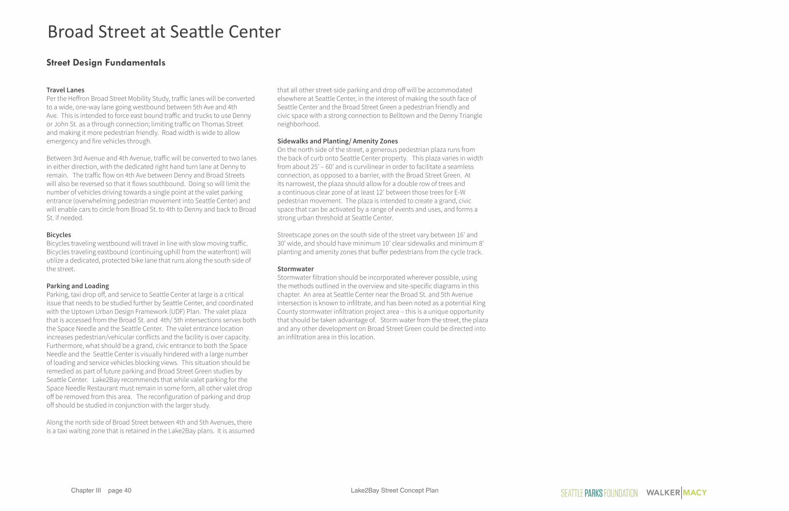
Street Design Fundamentals
Travel LanesPer the Heffron Broad Street Mobility Study, traffic lanes will be converted to a wide, one-way lane going westbound between 5th Ave and 4th Ave. This is intended to force east bound traffic and trucks to use Denny or John St. as a through connection; limiting traffic on Thomas Street and making it more pedestrian friendly. Road width is wide to allow emergency and fire vehicles through.
Between 3rd Avenue and 4th Avenue, traffic will be converted to two lanes in either direction, with the dedicated right hand turn lane at Denny to remain. The traffic flow on 4th Ave between Denny and Broad Streets will also be reversed so that it flows southbound. Doing so will limit the number of vehicles driving towards a single point at the valet parking entrance (overwhelming pedestrian movement into Seattle Center) and will enable cars to circle from Broad St. to 4th to Denny and back to Broad St. if needed.
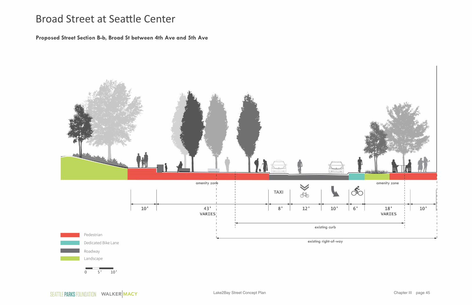
BicyclesBicycles traveling westbound will travel in line with slow moving traffic. Bicycles traveling eastbound (continuing uphill from the waterfront) will utilize a dedicated, protected bike lane that runs along the south side of the street.
Parking and LoadingParking, taxi drop off, and service to Seattle Center at large is a critical issue that needs to be studied further by Seattle Center, and coordinated with the Uptown Urban Design Framework (UDF) Plan. The valet plaza that is accessed from the Broad St. and 4th/ 5th intersections serves both the Space Needle and the Seattle Center. The valet entrance location increases pedestrian/vehicular conflicts and the facility is over capacity. Furthermore, what should be a grand, civic entrance to both the Space Needle and the Seattle Center is visually hindered with a large number of loading and service vehicles blocking views. This situation should be remedied as part of future parking and Broad Street Green studies by Seattle Center. Lake2Bay recommends that while valet parking for the Space Needle Restaurant must remain in some form, all other valet drop off be removed from this area. The reconfiguration of parking and drop off should be studied in conjunction with the larger study.
Along the north side of Broad Street between 4th and 5th Avenues, there is a taxi waiting zone that is retained in the Lake2Bay plans. It is assumed
that all other street-side parking and drop off will be accommodated elsewhere at Seattle Center, in the interest of making the south face of Seattle Center and the Broad Street Green a pedestrian friendly and civic space with a strong connection to Belltown and the Denny Triangle neighborhood.
Sidewalks and Planting/ Amenity ZonesOn the north side of the street, a generous pedestrian plaza runs from the back of curb onto Seattle Center property. This plaza varies in width from about 25’ – 60’ and is curvilinear in order to facilitate a seamless connection, as opposed to a barrier, with the Broad Street Green. At its narrowest, the plaza should allow for a double row of trees and a continuous clear zone of at least 12’ between those trees for E-W pedestrian movement. The plaza is intended to create a grand, civic space that can be activated by a range of events and uses, and forms a strong urban threshold at Seattle Center.
Streetscape zones on the south side of the street vary between 16’ and 30’ wide, and should have minimum 10’ clear sidewalks and minimum 8’ planting and amenity zones that buffer pedestrians from the cycle track.
StormwaterStormwater filtration should be incorporated wherever possible, using the methods outlined in the overview and site-specific diagrams in this chapter. An area at Seattle Center near the Broad St. and 5th Avenue intersection is known to infiltrate, and has been noted as a potential King County stormwater infiltration project area – this is a unique opportunity that should be taken advantage of. Storm water from the street, the plaza and any other development on Broad Street Green could be directed into an infiltration area in this location.
Broad Street at Seattle Center

Lake2Bay Street Concept Plan page 41Chapter III
NEW ENTRY/ PAVILIONPACIFIC SCIENCE
CENTERSPACE
NEEDLE
EMP MUSEUM
CHIHULY MUSEUM
**
* *
Special Considerations
The transformation of Broad Street should welcome pedestrians coming from the Waterfront, Belltown, and South Lake Union into the Seattle Center. Two gateway plazas are proposed: one at the intersection of Broad Street/ Denny / Third Ave. and one at the intersection of Broad St. / Thomas St. / Fi¤h Ave. These gateways will be linked by a continuous
civic plaza forming a new active front door to Seattle Center. Direct pathways and improved sight lines will pull people from the sidewalk into the Pacific Science Center, Space Needle, Chihuly Museum and EMP Museum. A new front door or entry pavilion on the south face of the Science Center will help activate the Broad Street Green and make it a
welcoming gateway. Direct connections between the cultural institutions on the Broad Street Green should also be encouraged.
MULTI-USE/ ACTIVE OPEN SPACE
GATEWAY PLAZA
GATEWAY PLAZA
Broad Street at Seattle Center
Lake2Bay Street Concept Planpage 42Chapter III
Concept Plan
New entry path
Dedicated bike lane eastbound
Taxi and bus drop-o� zone
Plaza Crossingwith pedestrian scramble
Planted bioretention medians
Seat walls, that disappear into grade
Path connecting EMP and other Institutions
Columnar Trees aligned with 4th Ave
New Science Center Entry and/or Food Pavilion
KEY REDEVELOPMENT OPPORTUNITY
FUTURECONDOMINIUMS
WELLSFARGO
FISHER PLAZA
KOMO PLAZA MCDONALDS
PACIFIC SCIENCE CENTER
SPACE NEEDLE
EMP MUSEUM
CHIHULY GARDEN
John Street
Thomas Street
Denny Way
3rd
Ave
5th A
ve4th
Ave
Broad Street
Plaza Crossingwith pedestrian scramble
50’ 100’0
N
A
a
B
b
Broad Street at Seattle CenterBroad Street at Seattle Center

Lake2Bay Street Concept Plan page 43Chapter III
John Street
Thomas Street
Denny Way
3rd
Ave
5th A
ve4th
Ave
Broad Street
50’ 100’0
N
Special Considerations
Key Adjacent PropertiesThe underdeveloped block between Broad Street, Denny Way and 4th Avenue is a prime opportunity for redevelopment. The City should partner or incentivize mixed-use development in this location that helps support Broad Street at Seattle Center as a strong, civic space. The development should be activated by ground floor restaurant and retail
FUTURE REDEVELOPMENTGARAGE BELOW
uses, particularly on Broad Street and 4th Avenue. Hotel, residences, and mixed income housing would all be suitable uses for the floors above. A below grade garage could park up to 75 cars per level, and could be used to support valet and other parking needs for the Space Needle and Seattle Center.
The block on Thomas St. between 5th and 6th Avenues is also a prime re-development opportunity. The City should consider incentives that would allow this block to develop in a way that would support Seattle Center functions, and add eyes on the street to the neighborhood.
Broad Street at Seattle CenterBroad Street at Seattle Center

Lake2Bay Street Concept Planpage 44Chapter III
existing curb
existing right-of-way
amenity zonecontinuous plaza at Broad Street Green
5’ 10’0
Pedestrian
Landscape
Roadway
Dedicated Bike Lane
Proposed Street Section A-a, Broad St between Denny Way and 4th Ave
Broad Street at Seattle Center
Lake2Bay Street Concept Plan page 45Chapter III
existing curb
existing right-of-way
amenity zoneamenity zone
5’ 10’0
Pedestrian
Landscape
Roadway
Dedicated Bike Lane
Proposed Street Section B-b, Broad St between 4th Ave and 5th Ave
Broad Street at Seattle Center

Lake2Bay Street Concept Planpage 46Chapter III
Design Elements
TreesDeciduous with Upright Habits and Fall Color, and Tolerance for Urban Conditions• Carpinus betula, American Hornbeam• Use of Silva Cells in paved areas or structural
soil to allow for large, contiguous soil volumes Sidwalks (south side of Broad Street only)• Concrete with 2’x2’ sawcut joints
Pedestrian Lighting • Modular columnar light system that can be
adapted to serve as pathway lighting, vertical markers.
• Example: Hess City Elements.
Accent Lighting • Bench and/or wall underlighting in Lake2Bay
signature cyan tones.
Benches or Seatwalls• Large, linear concrete benches with recessed
base for light housing, compatible with pavers in scale and alignment
PLANTING PAVING LIGHTING SITE FURNISHINGS Seattle Center Plaza• Large scale, cool toned granite pavers, 12’x48’
in size• Pavers should be aligned parallet to 4th
Avenue
Broad Street at Seattle Center

Lake2Bay Street Concept Plan page 47Chapter III
Concept Rendering of Broad Street Plaza between Denny and 4th Ave showing clear connections into Seattle Center
Broad Street at Seattle Center

Lake2Bay Street Concept Planpage 48Chapter III
Cycle share station on west edge of plaza. This should be relocated in the near vicinity, but not in the triangle.
The triangle could provide a physical and visual gateway to Seattle Center.
Adjacent lane on 3rd Ave is currently pedestrian only.
The triangle offers water views down Denny Way and 3rd Avenue.
Proposed Lane Changes / Expansion of Triangle
Broad Street at Denny Way and 3rd Avenue

Lake2Bay Street Concept Plan page 49Chapter III
Denny Way
Seattle Center
Cisco
Future Apartments
3rd
Ave
Broad Street
25’ 50’0
N
The Third Avenue Triangle should be transformed so that it feels like the first point of arrival to Seattle Center for anyone coming up the hill on Broad. In its current condition, the triangle is cluttered with numerous furnishings, small planters and trees, and aging infrastructure. The Lake2Bay proposal treats the 3rd Avenue Triangle as an extension of the civic plaza and streetscape planned for Seattle Center itself. The triangle should share the same pavers, oriented at a diagonal, and should remain as uncluttered and visually open as possible. It is intended to be a place that people move through, but do not linger in. A significant piece of artwork should be commissioned to help create a connection between the Olympic Scultpure Park and Seattle Center. This artwork may take on a science or technology theme in reference to its location by the Pacific Science Center, and should be visually interesting for vehicles and pedestrians. Guidelines for the artwork are discussed more fully in Chapter 4. A slightly elevated planting area occupies the northern portion of the triangle (bu�ering pedestrians from tra�ic on 3rd Ave and Denny) and should be composed of 2-3’ monocultural perennials or grasses that are low maintenance and provide year-round interest. The planted area may also be used to treat stormwater run-o� from the road.
Curb alignment of the Triangle should respond to the Broad Street Mobility Plan, as well as to the new bus lane route which will turn le¤ from Third Ave. onto Denny Way at a new signal. Because the south edge of the triangle will be positioned further south than its current location, crosswalks can also be moved further south and will be safer and more visible to cars than they are now. In the interest of keeping the space as open as possible, the existing bikeshare facility should be relocated to a nearby street.
Existing Curb Extents
Broad Street at Denny Way and 3rd Avenue

Lake2Bay Street Concept Planpage 50Chapter III
Concept Rendering showing redesign of the Third Avenue Triangle and connection to Seattle Center
Broad Street at Denny Way and 3rd Avenue

Lake2Bay Street Concept Plan page 51Chapter III
This page intentionally left blank.
Lake2Bay Street Concept Planpage 52Chapter III
Project Location and Extents
Broad Street
Ala
skan
Way
Clay Street
Denny Way
Olympic Sculpture Park
Waterfront Trail
Seattle Center
2nd
Ave
1st A
ve
Wes
tern
Ave
Ellio
tt A
ve
3rd
Ave
N N
Key Map
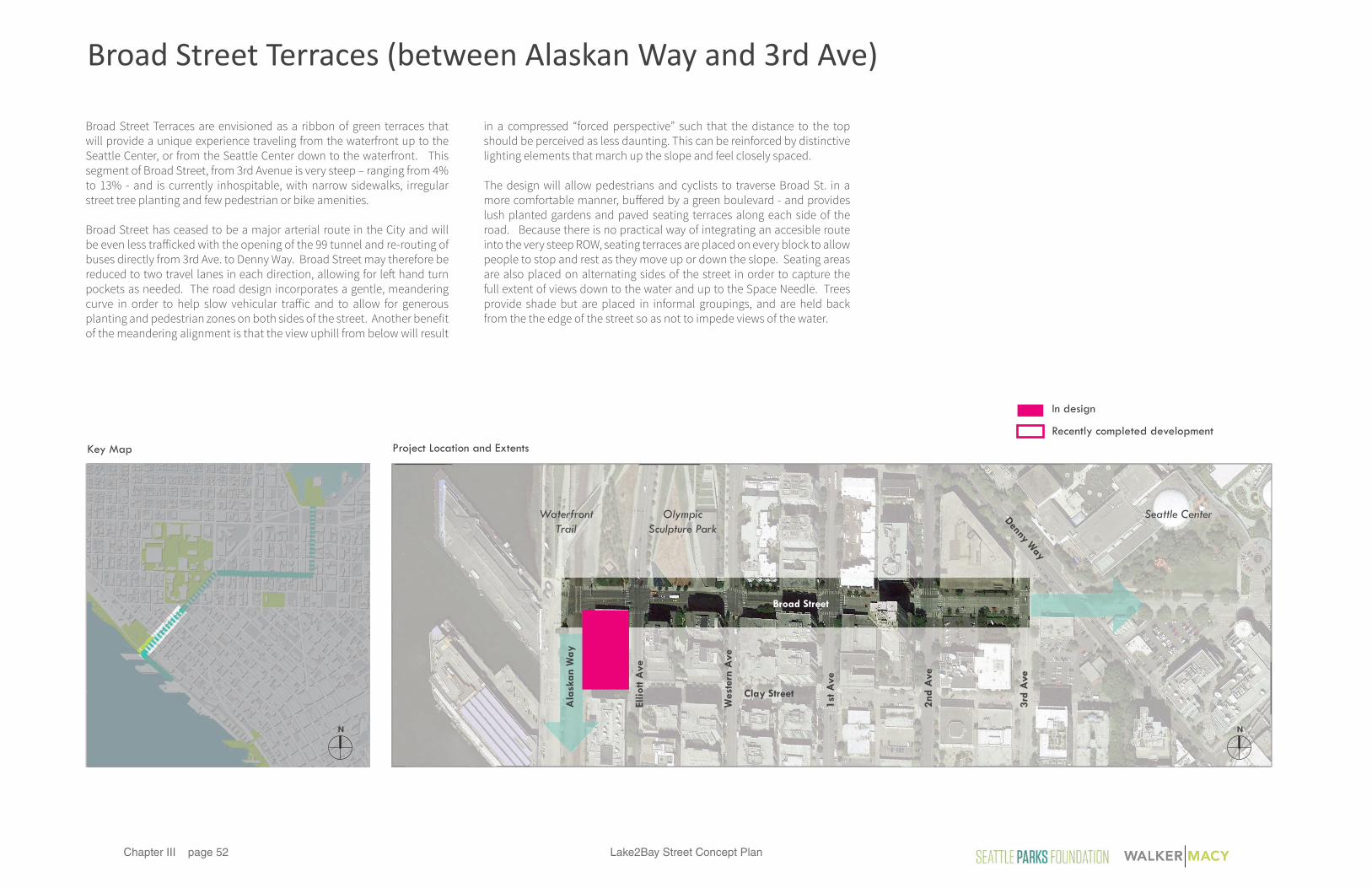
Broad Street Terraces are envisioned as a ribbon of green terraces that will provide a unique experience traveling from the waterfront up to the Seattle Center, or from the Seattle Center down to the waterfront. This segment of Broad Street, from 3rd Avenue is very steep – ranging from 4% to 13% - and is currently inhospitable, with narrow sidewalks, irregular street tree planting and few pedestrian or bike amenities.
Broad Street has ceased to be a major arterial route in the City and will be even less tra�icked with the opening of the 99 tunnel and re-routing of buses directly from 3rd Ave. to Denny Way. Broad Street may therefore be reduced to two travel lanes in each direction, allowing for le¤ hand turn pockets as needed. The road design incorporates a gentle, meandering curve in order to help slow vehicular tra�ic and to allow for generous planting and pedestrian zones on both sides of the street. Another benefit of the meandering alignment is that the view uphill from below will result
in a compressed “forced perspective” such that the distance to the top should be perceived as less daunting. This can be reinforced by distinctive lighting elements that march up the slope and feel closely spaced.
The design will allow pedestrians and cyclists to traverse Broad St. in a more comfortable manner, bu�ered by a green boulevard - and provides lush planted gardens and paved seating terraces along each side of the road. Because there is no practical way of integrating an accesible route into the very steep ROW, seating terraces are placed on every block to allow people to stop and rest as they move up or down the slope. Seating areas are also placed on alternating sides of the street in order to capture the full extent of views down to the water and up to the Space Needle. Trees provide shade but are placed in informal groupings, and are held back from the the edge of the street so as not to impede views of the water.
In design
Recently completed development
Broad Street Terraces (between Alaskan Way and 3rd Ave)

Lake2Bay Street Concept Plan page 53Chapter III
Broad Street Terraces
Greatly Expanded Pedestrian Realm Bike Lanes Gardens and Stormwater Infiltration Viewing Terraces for Seating, Art & Increased Accessibility Iconic Lighting / Hillclimb Markers
Existing Conditions
Wide berth and water views begin at 3rd Avenue.
Steep slopes and heavily shaded on south side.
Adjacent to Olympic Sculpture Park.
Key junction and visibilty connection between Elliott Bay waterfront and the Seattle Center.
Existing Typical Street Section
Proposed Lane Changes
Broad Street Terraces

Lake2Bay Street Concept Planpage 54Chapter III
Street Design Fundamentals
Lane ChannelizationBroad St. between Alaskan Way and 3rd Ave. will be converted to one lane in each direction, with left turn lanes at the Elliott Way intersection. This is made possible by the re-routing of bus lanes from 3rd Ave directly to Denny, and by the fact that Broad St. has ceased to be an arterial route in the City. Curb lines on both sides of the street will need to be relocated to achieve the curvilinear form of the road.
BicyclesCyclists riding uphill will be provided with a dedicated, protected lane at grade with the roadway. Cyclists traveling downhill will ride in a sharrow, in-line with traffic. This has currently been deemed the safest approach given the frequent alley and service way crossings, as well as questions about the safety and viability of a dedicated bike lane along Seattle Center to the north. With that in mind, Lake2Bay supports dedicated bike lanes for all ages wherever possible, and a premise of the Lake2Bay plan is that dedicated east-west bike lanes in this region of the City should be a part of the City’s bike masterplan. The addition of a dedicated westbound bike lane on Broad Street should be evaluated as part of SDOT’s next update to the bike masterplan, in conjunction with the 2016 Seattle Center Parking Study. If a westbound bike lane is incorporated onto Broad Street in the future, the space needed should be taken from traffic lanes and buffer zones so as not to reduce pedestrian and planted areas too much.
Parking and LoadingParking is located on the north-south side streets that run parallel to the grade where it is easier and safer to park. There are no bus loading zones along this stretch of Broad St. as most loading occurs on the north-south streets or from the alleys.
Sidewalks and Planting/ Amenity ZonesSidewalks should be 10’ minimum and are buffered from the street by planting on both sides which vary in width from 2’ to 16’, in response to the curvilinear street. Hardscape terraces set within these planting areas provide small seating areas with views of the water and/or the Space Needle, and also act as platforms for temporary art exhibits.
StormwaterStormwater filtration should be incorporated wherever possible, using the methods outlined in the overview and site-specific diagrams in this chapter. In general, run-off from the road should be directed into the planting areas, via curb cuts, so that it can be cleansed, slowed down, and released back into the combined storm-sewer system. The terraced landscape provides an opportunity to express the flow of stormwater on its way downhill.
Broad Street Terraces

Lake2Bay Street Concept Plan page 55Chapter III
Proposed Street Concept Plan
Seattle Center
One
Way
One
Way
One
Way
One
Way
Denny Way
Olympic Sculpture Park
2nd
Ave
Broad Street
1st
Ave
Wes
tern
Ave
Ellio
tt A
ve
Ala
ska
n W
ay
3rd
Ave
Elliott BayWaterfront Trail
Old Spaghetti Factory /
Redevelopment in design
60’ 120’0
N
Pedestrian & Frontage Zone
Existing Curb Extents
Proposed Typical Plan ExtentsSee Alaskan Way at Broad Street Detail Plan
Amenity Zone
Dedicated Bike Lane
Planted Stormwater Conveyence Bu�er
Broad Street Terraces

Lake2Bay Street Concept Planpage 56Chapter III
Broad Street
Clay Street
Eagle Street
Denny Way
Olympic Sculpture Park
2nd
Ave
1st A
ve
Wes
tern
Ave
Ellio
tt A
ve
3rd
Ave
N
Not to Scale
Business & Park Entrances*
*Note: There are no truck loading zones on Broad Street
Alleys and Driveways
Bus Stops
Street Parking
Business & Park Entrances*
*Note: There are no truck loading zones on Broad Street
Alleys and Driveways
Bus Stops
Street Parking
Special Considerations
Parking, Loading and FrontagesBroad Street between 3rd Avenue and Alaskan Way includes a few intersecting alleyways as well as service entrances. On-street parking and building entrances are predominantly located on the side streets, which are more level and easier to utilize in these ways. There are no on-street loading areas on Broad Street.
Existing ConditionsSpecial Considerations
Broad Street Terraces

Lake2Bay Street Concept Plan page 57Chapter III
N
Seattle Center
One
Way
One
Way
One
Way
One
Way
Elliott BayWaterfront Trail
Denny Way
Olympic Sculpture Park
2nd
Ave
Broad Street
1st
Ave
Wes
tern
Ave
Ellio
tt A
ve
Ala
ska
n W
ay
3rd
Ave
Clay Street
Eagle Street
One
Way
Broad Street
60’ 120’0
N
Business & Park Entrances*
*Note: There are no truck loading zones on Broad Street
Alleys and Driveways
Bus Stops
Street Parking
Special Considerations
Parking, Loading and FrontagesThe proposed plan for Broad Street eliminates parallel parking from the steep slope.
Proposed Conditions
Broad Street Terraces

Lake2Bay Street Concept Planpage 58Chapter III
Proposed Typical Plan
Terraced stormwater treatment gardens
Retaining seat wallsTerraces with unique paving and seating Existing curb
Street Trees
Dedicated Uphill Bike Lane Planted bu�er
alle
y
Broad Street
2’x2’ concrete paving with sawcut joints
15’ 30’0
A
a
Broad Street Terraces

Lake2Bay Street Concept Plan page 59Chapter III
existing curb
amenity zone amenity zone
5’ 10’0Pedestrian
Landscape
Roadway
Dedicated Bike Lane
Proposed Street Section A-a
Broad Street Terraces

Lake2Bay Street Concept Planpage 60Chapter III
Design Elements
Long-TermNative woodland species similar to Olympic sculputre park birch forest. Examples:• Paper Birch, Betula papyrifera• Huckleberry, Vaccinium spp.• Salal, Gaultheria shalon• Ferns - Blechnum spicant or sim. Pedestrian Terraces
• Concrete sidewalk with 2’x2’ sawcut joints
Pedestrian Lighting • Modular columnar light system that can be
adapted to serve as pathway lighting, vertical markers.
• Example: Hess City Elements.
Accent Lighting • Bench and/or wall underlighting in Lake2Bay
signature cyan tones.
Benches• Geometric concrete benches with recessed
base for light housing, compatible with terrace seat wall look and material
Seat Walls• Smooth finish concrete terrace retaining walls
Rotating / Short-Term• Curated gardens and art installations
Street Trees• Trees in grates and planting areas • Fine foliage deciduous species and effective
maintenance to maximize views and sunlight
• Use of Silva Cells in paved areas or structural soil to allow for large, contiguous soil volumes
PLANTING PAVING LIGHTING SITE FURNISHINGS Sidewalks• Concrete unit pavers in pedestrian terraces• 4”x8” running or stacked bond in cool tones
Broad Street Terraces

Lake2Bay Street Concept Plan page 61Chapter III
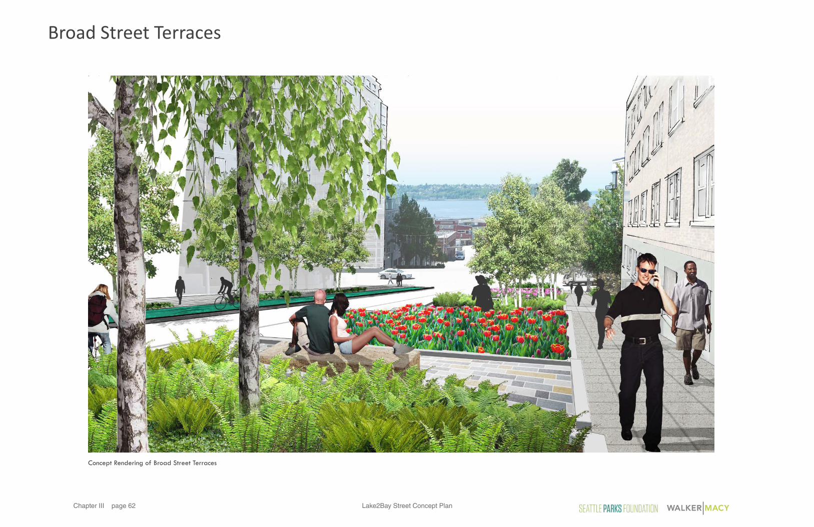
Concept Rendering of Broad Street Terraces
Broad Street Terraces
Lake2Bay Street Concept Planpage 62Chapter III
Concept Rendering of Broad Street Terraces
Broad Street Terraces

Lake2Bay Street Concept Plan page 63Chapter III
This page intentionally left blank.

Lake2Bay Street Concept Planpage 64Chapter III
Project Location and Extents
Alaskan Way
Broa
d St
Elliott Ave
Olympic Sculpture Park
Waterfront Trail
Pier 62/63Pier 66Cruise Terminal
Port of SeattleClipper Terminal
Central Waterfront
Wal
l St
Vin
e St
Ced
ar S
t
Cla
y St
Batte
ry S
t
Bell
St
Leno
ra S
t
Blan
char
d St
NN
Key Map
Lake2Bay includes the segment of Alaskan Way north of Piers 62/63, but provides specific street and sidwalk design recommendations only for the area from Vine Street north to the Broad Street intersection. It is assumed that the general guidelines described here will be developed more fully by SDOT, with the Port and Central Waterfront, at a later date.
Alaskan Way is an unusual situation in that – unlike the segment to the south – the seawall will not be reconstructed in the near future, but will need to be totally rebuilt within the next decade or two. (There is no current funding source available.) Because future seawall construction phasing may occupy all of the right-of-way, it would not be prudent to build permanent, expensive capital improvements in this stretch. Nonetheless, it is possible to install a number of elements that could both extend the character of the waterfront public space as well as enliven this otherwise bleak area. Some enhancements need to be done in the interim as leaving it in the current state would be a missed opportunity.
Connections for people on foot and on bicycles should take priority and become part of a continuous, legible system that extends north from the
Central Waterfront. A key component of this system is the continuation of a waterside, two-way cycle track from Piers 62/63 to the Olympic Sculpture Park and waterfront trail.
Finally, the Port of Seattle is planning to reconfigure the street and sidewalks outside the Cruise Ship Terminal in order to provide safer and more ample space for the loading and unloading of the passenger ships. Space is needed for taxis, buses, autos as well as staging areas for luggage and equipment – both arriving and departing. The frequency of cruise ships in that location has been increasing and the confusing street setting needs to be better organized. Because the Port will likely require a widened roadway for a stretch of two blocks, their plans depend on a multi-use trail that could be installed in place of the former streetcar tracks. The City should continue this trail to the south and the north.
Because finishes planned for Alaskan Way are relatively simple and un-embellished, it will be important to activate Alaskan Way with art throughout the interim condition. The walls of some of the larger, older industrial structures could be enlivened through intense color, creative
lighting, or the projection of images. Creative, artist designed pedestrian crossings from Belltown at Vine, Bell, and Lenora could help establish connections to neighborhood green streets. And serial or sequential artwork, as outlined in the art plan, could help draw visitors from the waterfront to the Sculpture Park and beyond.
Alaskan Way
Lake2Bay Street Concept Plan page 65Chapter III
Existing Conditions
North end connection with Olympic Sculpture Park, waterfront trail and Seattle Center
Historic buildings and RR tracks provide character and unique spaces
Cruise Ship and Victoria Clipper Loading require flexible traffic patterns
Waterfront views and bicycle traffic
Proposed Lane Changes
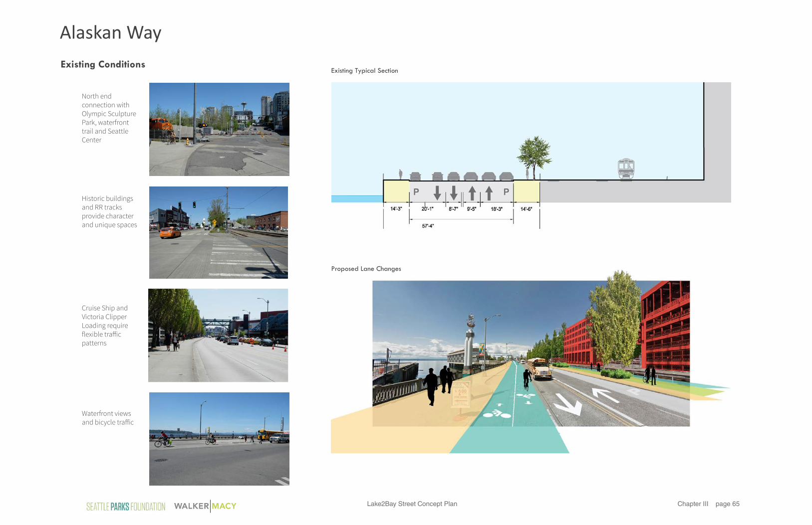
Existing Typical Section
Alaskan Way

Lake2Bay Street Concept Planpage 66Chapter III
Lane ChannelizationWith the completion of the Elliott Way Connector, Alaskan Way will cease to be a major arterial route in the City. Traffic volumes are expected to drop substantially, although Alaskan Way will still serve as an Over dimension Freight Route. Alaskan Way can be reduced to 2 lanes in each direction, with turn left hand turn lanes at specific locations such as Wall Street.
Alaskan Way is also designed to accommodate unique loading needs at the Clipper Ship and Cruise Ship Terminals. The Clipper departs regularly throughout the week, and for that reason, a dedicated taxi drop-off lane with a protected passenger zone between Clay and Vine Streets is provided. The passenger zone should be separated from the cycle track with a physical barrier, so that pedestrian crossings occur at carefully marked areas.
Cruise ships depart less regularly, but require substantial increase in road capacity, passenger drop off and loading, and truck staging areas on the days when cruise ships are in the port. A widened road will be provided between Wall and Bell Streets to accommodate cruise ship loading and staging. This section of road is expected to be managed in a flexible manner so that it functions on non-cruise days as a two way street with a waterfront cycle track and angled parking on the east side. On cruise ship loading days, traffic cones could be set up to indicate a bus drop off lane, bus by-pass lane, two lanes of traffic, and parallel parking for truck staging on the east hand side. As noted previously, SDOT and the Port are expected to work out the details of the road design and management of this section.
The system defined above can be accommodated by retaining the west-side curb in most locations if desired, in order to limit cost. However, if budgets allow, the City may wish to consider the relocation of the west-side curb in order to gain additional pedestrian space on the waterfront side of the street.
BicyclesThe City’s 2014 adopted Bike Master Plan shows cycle track on Alaskan Way. Because the Central Waterfront will provide a two-way cycle track along the water, the City has a strong interest in maintaining the legibility of the system and continuing the 2-way cycle track to the north. Doing so will allow cyclists to make a seamless connection to the trail at the base of the Sculpture Park and Myrtle Edwards Park.
There are recognized but manageable challenges associated with a waterfront cycle track that relate to cruise ship and clipper ship loading. To accommodate the large flux of people during cruise ship arrival and departure; it is recommended that cyclists be re-directed to cross at Bell Street and use the planned multi-use trail. At the Clipper Ship loading zone, which involves smaller numbers of people but more frequent loading times, a dedicated taxi and vehicular drop off zone is provided. This zone will be separated from the cycle track with a railing. Pedestrians crossing the cycle track will do so at controlled locations in specific, marked locations along the cycle track.
Parking and LoadingParking quantities are intended to remain the same, but should be relocated to the north side of Alaskan Way in order to provide an uncluttered visual experience along the waterfront. Necessary loading areas, vehicular access to parking and service on the piers, and ADA parking should remain.
Sidewalks and Planting/ Amenity ZonesSidewalks and planting/ amenity zones will be defined by future SDOT and/or Central Waterfront planning. Pedestrian amenities – in particular, furnishing and wayfinding systems used on the Central Waterfront – could be added in some locations to improve the sense of connection to the Central Waterfront.
A multi-use trail is proposed on the north side of Alaskan Way, in the location of the current decommissioned trolley tracks. This multi-use trail may be used by pedestrians and cyclists alike. It provides a unique experience along the tracks, part of Seattle’s industrial heritage, and also enables cyclists to avoid passenger loading areas on cruise days. The multi-use trail should be 10’ wide minimum, and should be separated from the RR tracks by a fence and planting strip.
StormwaterStormwater treatment is not required on Alaskan Way, but would still be of value to the City. In the area between Vine Street and Broad Street, there is a generous planting zone on the north side of the street that presents a clear opportunity for stormwater detention. This area could potentially treat some of the runoff from Broad Street and Alaskan Way will help prevent the flow of road run-off directly into the Bay.
Street Design Fundamentals
Alaskan Way

Lake2Bay Street Concept Plan page 67Chapter III
Cla
y St
reet
Broa
d S
tree
t
Elliott Ave
Alaskan Way
mutli-use trail
mutli-use trail
cycle track
OlympicSculpture Park
Elliott Bay
OlympicSculpture Park Birch Grove
Port Sevice Entrance
Pier 70
Aqua Restaurant
Paddy Coyne’s Pub
Old Spaghetti Factory / Redevelopment in design parking lot
RR crossing gates
RR tra�ic signal bridge
Approx. BNSF franchise agreement boundary
RR utilities
RR tra�ic signal bridge
Elliott Bay Waterfront Trail
RR crossing gates
RR tra�ic signal bridge
Existing tra�ic light poles
Barrier / fence
50’25’0
N
See Broad Street Terraces Plan
Matc
hlin
e, s
ee A
lask
an
Way
Cla
y to
Vin
e
Alaskan Way at Broad Street
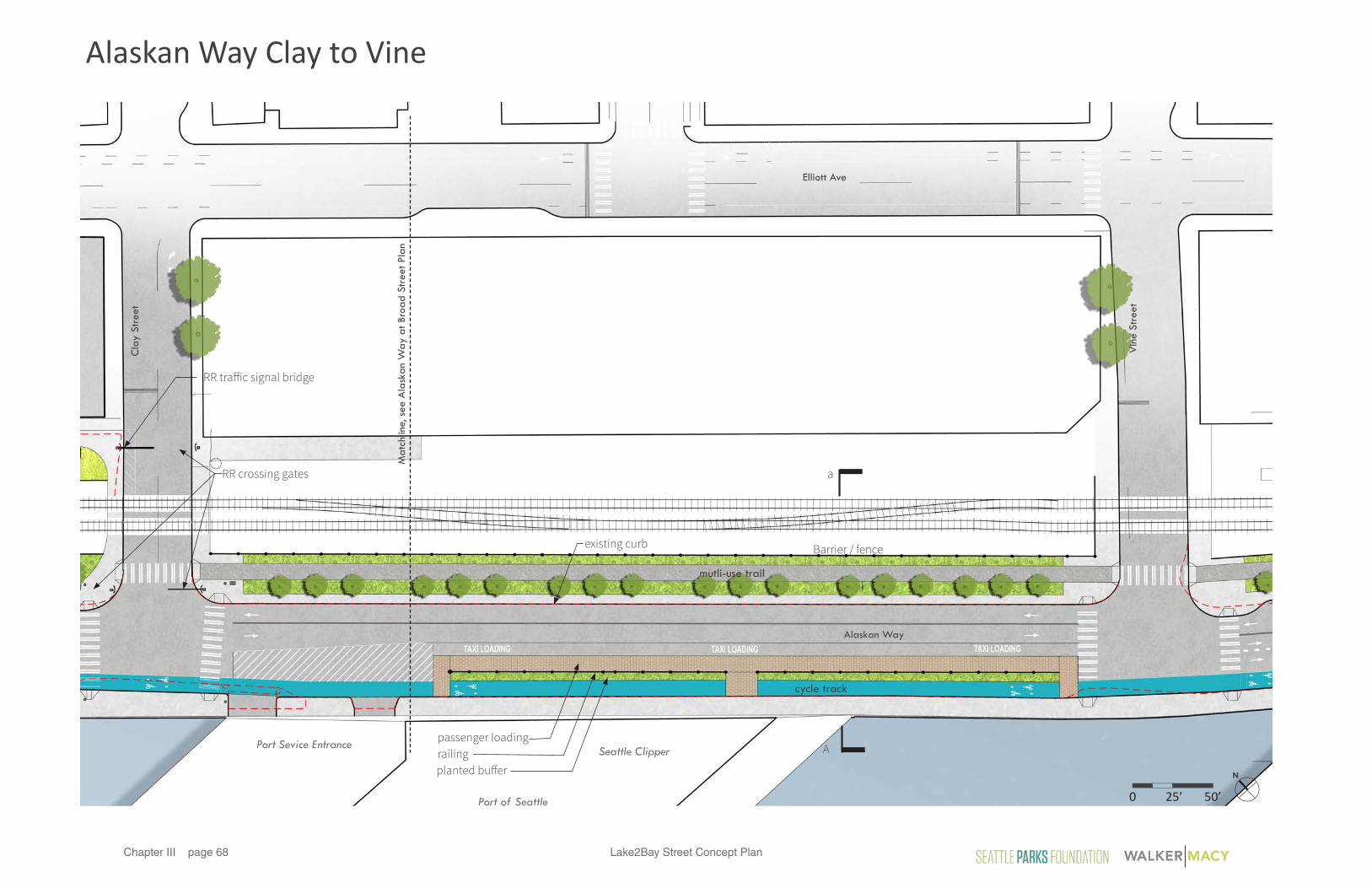
Lake2Bay Street Concept Planpage 68Chapter III
Cla
y St
reet
Vin
e St
reet
Alaskan Way
Port Sevice Entrance
RR crossing gates
existing curb
RR tra�ic signal bridge
Elliott Ave
Port of Seattle
Seattle Clipperpassenger loading
planted bu�errailing
mutli-use trail
cycle track
Barrier / fence
50’25’0
N
Matc
hlin
e, s
ee A
lask
an
Way
at Br
oad
Str
eet Pl
an
A
a
Alaskan Way Clay to Vine

Lake2Bay Street Concept Plan page 69Chapter III
Section A - Clipper Loading Zone
Port of SeattleClipper Terminal
Pedestrian Unloading
TaxiQueue
Multi-UseTrail
Existing Curb
5’ 10’0
Pedestrian
Landscape
Roadway
Dedicated Bike Lane
Alaskan Way

Lake2Bay Street Concept Planpage 70Chapter III
Design Elements
Overall StrategySmall groupings of trees in planting areas with wet meadows appropriate for biodetention. Tree placement should frame views and allow for open expanses.
Examples:• Douglas Fir, Incense Cedar, Serviceberry,
Pacific Dogwood, Sumac• Lupine, Lupinus spp.• Indian Paintbrush, Castilleja miniata• Huckleberry, Vaccinium ovatum• Beargrass, Xerophylum tenax
Pedestrian Zones• Maintain existing concrete paving and curbs
where possible, especially along west side of road.
• New concrete sidewalk should be installed with large scale rectangular sawcut joints (i.e. 2’x6’) - in reference to typical boardwalk / waterfront scale
Pedestrian Lighting • Maintain existing street and pedestrian lights
where possible. • New fixtures should follow Central Waterfront
plan guidelines.
Accent Lighting • Surface mounted traffic markers or glow-
in-the dark paint along cycle track and in roadway, in Lake2Bay signature cyan tones
Benches• Central Waterfront style furnishings should be
incorporated in select locations.
PLANTING PAVING LIGHTING SITE FURNISHINGS
Overall strategy is to limit extent and cost of improvements for the interim condition, while maintaining continuity with the Centeral Waterfront character. See “Main Corridor North of Union” document from September 18th, 2014 Design Commission presentation.
Alaskan Way

Lake2Bay Street Concept Plan page 71Chapter III
This page intentionally left blank.

This page intentionally le� blank.

Lake2Bay Street Concept Plan page 73Chapter IV
Chapter 4: art pLaN

Lake2Bay Street Concept Planpage 74Chapter IV Jill Anholt Studio
This page intentionally left blank.

Lake2Bay Street Concept Plan page 75Chapter IVJill Anholt Studio
September 2015
Jill Anholt Studio#230 - 3 West 3rd Avenue Vancouver BC V5Y 3T8 [email protected] / www.jillanholt.ca
Lake2Bay Art Opportunities

Lake2Bay Street Concept Planpage 76Chapter IV Jill Anholt Studio
EchoJaume Plensa 2014
Father and SonLouise Bourgeoise
Neukom VivariumMark Dion 2006
Seattle Cloud CoverTeresita Fernandez 2006
PlaceholdersClaudia Fitch 2007
Keys to the CityInvisible Creature 2012
Cabin CornersJenny Heishman 2010
Articulated StartEric Eley 2011
Broad Street FacilityCarolyn Law 1985
A�er All, Life is ChangeDick Weiss 2008
Black LightningRonals Bladen 1985
Olympic IliadAlexander Liberman 1984
MoongatesDoris Chase 1999
Second Avenue ProjectKurt Kiefer 1996
Beacon, Cloud + TotoJamie Walker 2010
MosesTony Smith 1975
Thomas Street
Mercer Street
5th
Ave
N
Denny Way
Terr
y Av
e N
Broad Stre
et
1Ping Pong PlazaBuster Simpson 2004
4ConvergenceAnn Gardener 2010
3 5
6
2
7
8
8
9
9
Grass BladesJohn Fleming 2003
Honor PoleR. L. Williams 2012
10 11
10
11
13
13
12
12
14
18
14
15
15
16
16
17 19 20
Plan of Existing Artworks
L2B Existing Artworks
1718
19
20
1
4
3
2
567

Lake2Bay Street Concept Plan page 77Chapter IVJill Anholt Studio
1
2
9
3
7
45
6
8
Plan of Potential Art Opportunities Precedents From Other Cities
Terry Ave N at Valley St:Gateway/Terminus
Terry Ave N at Thomas St:Cultural Anchor
8th Ave & Thomas St:Denny Park Connection
City Lights on Thomas St:Fence Artwork
5th Ave & Broad St: Monorail Gateway
Seattle Center Greenspace: Interactive Artwork
Denny Triangle: Science Centre Island
(a,b,c) Broad St: Slope Perspective, Sequence, Light-based markers
(a,b,c, d) Alaskan Way:Fence Sequence, Projection, Crosswalks
Serial Works Across Corridor (location TBD): Interpretive Artworks
1
3
5
7
9
2
4
6
8
Executive Summary
Lake2Bay’s ambition is to create a public space that imbues a sense of place and community for the area between the water-front and Lake Union.
This art plan recognizes the collection of large-scale, signature artworks and cultural destinations that currently exist in locations along the Lake2Bay corridor. It seeks to enhance the experience of art through the addition of works that are interactive and engag-ing at di¥erent scales and of varying duration. The series of art-works proposed in this plan, both temporary and permanent, will serve to link together these existing cultural works and venues to transform the length of the Lake2Bay corridor into a new cultural destination within Seattle.
A series of short-term, low-cost strategies are suggested in this plan that can be implemented immediately to build momentum and reinforce for the public, the long term vision of the opportunities inherent in connecting Lake Union to the Bay in the future. Other opportunities, linked to developments and capital improvements expected along the corridor have implementation time-lines that will occur in the coming months and years. Some opportunities are years away, functioning as integrated elements within the final built public realm of the Lake2Bay corridor. Through partnerships and collaborations, the art will help to give an overall identity to the project that links neighborhoods, parks and cultural centers along the spine to each other.
All artworks proposed in this plan draw on the authenticity of the existing fabric of urban life that exists along the corridor. The works seek to enhance, illuminate and connect the unique character of the surrounding communities in a variety of di¥erent ways.
Introduction to Opportunities
10

Lake2Bay Street Concept Planpage 78Chapter IV Jill Anholt Studio
Budget Range: $25,000 - $40,000
Initiation: Pre Construction
21 Terry Ave N & Valley St: Gateway Artwork
Budget Range: $20,000-$25,000 (Mural)
$10,000-20,000 (Lighting / sound work)
Initiation: Pre Construction
ContextThe intersection at Terry Avenue N and Valley Street marks the terminus of the route and directs views over the park and Lake Union. From the other direction, the intersection marks the connection and forms a gateway between Lake Union and the city.
Art Opportunity Description
A two-dimensional artwork painted directly onto the street surface has the ability to become a large impact, highly visible work that identifies the importance of the location to pedestrians, giving them the priority of movement, and slowing down tra¥ic. The purpose of the artwork is to visu-ally connect the urban environment to Lake Union and to the area’s history and transformation in recent years.The surface mural should be painted with large, bold de-signs that accommodate the grand scale of the intersection and communicate to tra¥ic that there is pedestrian activ-ity. Themes related to water, marine history and/or ecology could be explored in this work.
DurationWorks proposed are temporary and near-term. A painted surface work will generally last for 3-5 years with a ghosted image of the work enduring for up to 10 years. The artwork should be conceived in three sections as it is anticipated that the middle section will be the first to be removed and replaced by a plaza with the new development that spans Terry Street. The Terry Ave./Mercer St. and Terry Ave Valley St. intersections could periodically be repainted to be more permanent.
Implementation PotentialThere is potential for MOHAI / SDOT sponsorships.
Figure 1: Street View Location for Art
Figure 2: Sky Painting, John Fleming 2014, Redmond, WAFigure 3: Street Mural #5, LangBaumann 2010, SwitzerlandFigure 4: Lost O, Roadsworth 2007, Ashford, England
Sky painting’s geometric forms are drawn from giant tree rings radiating from trees saved on the site. They remind people of what was there, the “paradise lost”. Roadsworth’s flock of birds were also politically motived - he painted the painted the road in preparation for the Tour de France as a political statement to demand more bike lanes in the city.
Figure 5: Street View Location for Art
Art Opportunity DescriptionThe north and east facades of the Seattle Opera building can provide a canvas for a two-dimensional artwork that to enliven the site and relate to the hidden content and cre-ative content within the building.
Other temporary artworks that interact directly with the public using light, sound or other theatrical media could provide a further artistic opportunity that relates to the hid-den potential of this site.
With the creation of this work(s), there is potential for this location to becomes established as a cultural anchor along the Lake2Bay route. Future development of this site might result in a permanent cultural venue being integrated within the new building.
DurationWorks proposed are temporary and near-term, i.e. two to five years until the building is developed.
Implementation PotentialThe mural and/or interactive work could be funded by a De-partment of Neighbourhoods ‘small and simple’ grant, or by a corporate sponsor such as Amazon.
ContextThe building at the south-east corner of Terry Avenue and Thomas Street is currently being used as a warehouse for the Seattle Opera. As an unprepossessing building with large flat, unadorned surfaces, the building provides the po-tential for an artistic canvas that can anchor and mark the change in direction of the Lake2Bay route as well as iden-tifying this area as a space of cultural value within Seattle.
Figure 6: XYZ Axis Mural, Matt W Moore 2011, Cincinnati OH Figure 7: Lime Light, Sans Facon 2010, 6 cities across UK+USA
XYZ is a mural created by an artist who was originally a street artist. Limelight was done by replacing two street lights with theatre spotlights to transform the street into a stage and the passers-by into performers.
Terry Ave N at Thomas St:Cultural Anchor
Precedents Precedents

Lake2Bay Street Concept Plan page 79Chapter IVJill Anholt Studio
Budget Range: $100,000 - $150,000 (Permanent)
$10,000-20,000 (Temporary)
Initiation: Pre + Post Construction
Budget Range: $50,000 - $75,000 (Permanent pole and projector)
$5,000 - $10,000 (Temporary, light-based works)
Initiation: Pre + Post Construction
3 4
Figure 8: Street View Location for Art
ContextDenny Park is Seattle’s oldest urban park and is located one block south of the Lake2Bay Corridor at Thomas Street. An artwork along 8th Avenue N will draw attention to this civic park, instill a sense of safety, and encourage residents, pass-ersby and workers to visit this important space in the city.
Artwork Opportunity DescriptionAn ephemeral, light-based artwork could mark Denny Park as a safe place and as a cultural destination. Either existing or introduced vegetation could be used as a sculptural ele-ment or a canvas for lighting or projection that would lead people along 8th Avenue towards the park.
DurationWorks proposed are temporary. A pole could be installed as a permanent element with a weather-protected, remotely programmable projector. Light-based artworks could be commissioned seasonally or be connected to civic events planned for the neighborhood during the year.
Implementation PotentialThis location could potentially become a one-time site of SDOT’s Art Interruption Program which occurs on green streets. There is also potential for an Amazon, SDOT or Parks Department sponsorship.
8th Ave & Thomas St: Denny Park Connection
Figure 9: Luminous Conjunctions, Dan Corson 2008, Lauderdale, FL Figure 10: Crossed Circuits, Tony Oursler 2013, Sao Paulo, Brazil
(Above) Luminous Conjunctions, an interactive lighting project utilizes “security lighting funds”. Lighting on the trees is triggered by human movement. (Below) Artist, Tony Oursler, projects faces onto trees to create a sense of discovery and mystery in the urban environment.
Figure 11: Street View Location for Art
ContextSeattle City Light is the public utility that provides electri-cal power to Seattle and parts of its metropolitan area. The Broad Street Substation, located along Thomas Street, is a prominent civic infrastructure project. Currently contained by a long concrete wall, most equipment is blocked o¥ to public viewing. Introducing an artwork here would reinforce the public nature and essential function of this utility.
Art Opportunity DescriptionThe enclosure of the substation could be utilized as a plat-form for changing, two-dimensional artworks that would enliven the street and educate the public on the impor-tance of the substation in providing the city with energy and power.
Options include an artist-created work or a community project facilitated by an artist that layers over the existing structure. Alternatively, the fence could be replaced with a permanent, artist-designed enclosure. Power equipment itself could be enlivened using color or light, via an agree-ment with Seattle City Light.
Nearby, the Denny Street Substation is undergoing renewal. Its agenda includes integrated artworks and ongoing per-formances. This presents an example for future expansion of the cultural expression of the Broad Street Substation.
DurationReplacement of the fence by an artist-designed fence to re-place the existing one would be a permanent. If the current or newly designed enclosure is used as a platform for tem-porary works, they could be commissioned seasonally or a few times per year.
Implementation PotentialCity Light capital projects could result in a per-centage for art sum that could be applied to this project.
Figure 12: Lighthouse, Ail Hwang + Hae-Ryan Jeon 2014, Chung-Ki Park, GermanyFigure 13: Ballston Substation Fencing, Ben Fehrmann 2012, Arlington, VAFigure 14: Emoji Energy, Volta Studio 2013, Philadelphia, PA
(Above) Art students transform the electric tower into a ‘stained glass lighthouse’.(Middle) The artist-designed wooden slat fence simultaneously reveals and hides the substation behind. Dominion Virgin Power covered the cost of the project.(Below) Volta Studio partnered with the Asian Youth Arts Initiative to create a modular artwork that wraps around the Callowhill Substation in Philadelphia.
Seattle City Light: Broad Street Substation Fence Artwork
Precedents
Precedents

Lake2Bay Street Concept Planpage 80Chapter IV Jill Anholt Studio
Budget Range: $15,000 - $25,000 (Annually / per competition)
Initiation: Pre + Post Construction
Budget Range: $100,000 - $200,000 (Permanent)
$25,000 - 40,000.00 (Temporary)
Initiation: Pre + Post Construction
65
Figure 15: Street View Location for Art
ContextThe overhead monorail track turns from 5th at Seattle Cen-ter into the intersection of Broad St. and Thomas St. The el-evated track produces a de facto gateway that pedestrians pass through.
Art Opportunity DescriptionThe monorail guide way and support structures overhead are presently uninteresting but have the potential to be-come a memorable and vibrant passage. The the underside of the monorail track and/or the support columns could be enhanced with light and/or a colourful surface treatment. It would also be possible to suspend light-based or other artworks from the underside of the track where they would be visible to pedestrians passing through.
Duration Works proposed could be temporary (in place for a few months) or could be permanent if maintained regularly.
Implementation PotentialThere is potential for a Monorail/Seattle Center/corporate sponsor.
Figure 16: Watertable Neon Art Installation, Steele + Tomczak 2012, Toronto ONFigure 17: Beautiful Bridge #1, LangBaumann 2011, Buenos Aires ARFigure 18: SODO, Merge Conceptual Design, Spokane WA
In the first two examples, a simple coat of paint has transformed overhead concrete structures into striking beacons of color. The bottom right design uses the idea of catenary lighting to humanize the enormous structure.
5th Ave & Broad St: Monorail Gateway
ContextThe space along Broad Street at Seattle Centre is currently an open lawn with a series of notable, signature artworks from previous decades. Likewise, the buildings in this area are also large and iconic. The pedestrian experience at the edge of the Center is narrow and secondary to that of the car but will soon be transformed.
Art Opportunity DescriptionWith the current streetscape re-design, it is anticipated that the public realm outside the entrance to Seattle Center will be expanded and enhanced.
Rather than competing with the iconic works and buildings in the area, introducing human-scale, interactive artworks will create a playful environment and invite group and indi-viduals participation and engagement.
It is also possible that yearly design-build competitions could be organized to create temporary public space and/or interactive seating installations in the space.
DurationTemporary works, like design/build competitions, could be run yearly and could occur in the near-term as part of the design. Permanent works could also be part of the new public realm design.
Implementation PotentialFestival, Parking Day, or other road closure events on the north side of the street o¥er opportunities to introduce play-based artworks.
Figure 20: Musical Swings, Daily Tous Les Jours, Montreal QC Figure 21: Poprocks, Robson Redux Design Competition 2012, Vancouver BCFigure 22: Spun, Heatherwick Studio 2010, Milan Salone, Italy
(Above) Musical Swings is an interactive, public artwork of a series of swings. They feature illuminated seats that trigger audible tones that harmonize as people swing. As more people join, the act of swinging turns into an improvised melody.(Middle) Robson Redux is an annual design-build competition in Vancouver for the design of an interactive, temporary public space. A portion of the road is closed o¥ to vehicles through out the summer months.(Below) Spinning tops placed in a public space provide a strange and interesting opportunity for social interaction.
Seattle Center Broad Street Green: Interactive Play-Based Artwork
Figure 19: Walker Macy Perspective and Street View Location for Art
Precedents Precedents
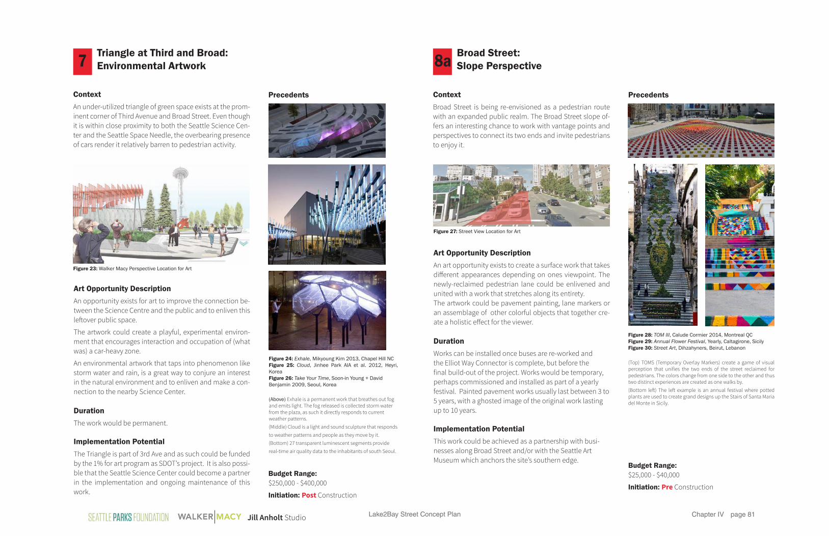
Lake2Bay Street Concept Plan page 81Chapter IVJill Anholt Studio
8a7
Budget Range: $25,000 - $40,000
Initiation: Pre Construction
Budget Range: $250,000 - $400,000
Initiation: Post Construction
Figure 23: Walker Macy Perspective Location for Art
ContextAn under-utilized triangle of green space exists at the prom-inent corner of Third Avenue and Broad Street. Even though it is within close proximity to both the Seattle Science Cen-ter and the Seattle Space Needle, the overbearing presence of cars render it relatively barren to pedestrian activity.
Art Opportunity DescriptionAn opportunity exists for art to improve the connection be-tween the Science Centre and the public and to enliven this le®over public space.
The artwork could create a playful, experimental environ-ment that encourages interaction and occupation of (what was) a car-heavy zone.
An environmental artwork that taps into phenomenon like storm water and rain, is a great way to conjure an interest in the natural environment and to enliven and make a con-nection to the nearby Science Center.
DurationThe work would be permanent.
Implementation PotentialThe Triangle is part of 3rd Ave and as such could be funded by the 1% for art program as SDOT’s project. It is also possi-ble that the Seattle Science Center could become a partner in the implementation and ongoing maintenance of this work.
Figure 24: Exhale, Mikyoung Kim 2013, Chapel Hill NCFigure 25: Cloud, Jinhee Park AIA et al. 2012, Heyri, KoreaFigure 26: Take Your Time, Soon-in Young + David Benjamin 2009, Seoul, Korea
(Above) Exhale is a permanent work that breathes out fog and emits light. The fog released is collected storm water from the plaza, as such it directly responds to current weather patterns.(Middle) Cloud is a light and sound sculpture that responds to weather patterns and people as they move by it. (Bottom) 27 transparent luminescent segments provide real-time air quality data to the inhabitants of south Seoul.
Triangle at Third and Broad: Environmental Artwork
Figure 27: Street View Location for Art
ContextBroad Street is being re-envisioned as a pedestrian route with an expanded public realm. The Broad Street slope of-fers an interesting chance to work with vantage points and perspectives to connect its two ends and invite pedestrians to enjoy it.
Art Opportunity DescriptionAn art opportunity exists to create a surface work that takes di¥erent appearances depending on ones viewpoint. The newly-reclaimed pedestrian lane could be enlivened and united with a work that stretches along its entirety. The artwork could be pavement painting, lane markers or an assemblage of other colorful objects that together cre-ate a holistic e¥ect for the viewer.
DurationWorks can be installed once buses are re-worked and the Elliot Way Connector is complete, but before the final build-out of the project. Works would be temporary, perhaps commissioned and installed as part of a yearly festival. Painted pavement works usually last between 3 to 5 years, with a ghosted image of the original work lasting up to 10 years.
Implementation PotentialThis work could be achieved as a partnership with busi-nesses along Broad Street and/or with the Seattle Art Museum which anchors the site’s southern edge.
Figure 28: TOM III, Calude Cormier 2014, Montreal QCFigure 29: Annual Flower Festival, Yearly, Caltagirone, SicilyFigure 30: Street Art, Dihzahyners, Beirut, Lebanon
(Top) TOMS (Temporary Overlay Markers) create a game of visual perception that unifies the two ends of the street reclaimed for pedestrians. The colors change from one side to the other and thus two distinct experiences are created as one walks by. (Bottom le®) The le® example is an annual festival where potted plants are used to create grand designs up the Stairs of Santa Maria del Monte in Sicily.
Broad Street: Slope Perspective
Precedents Precedents

Lake2Bay Street Concept Planpage 82Chapter IV Jill Anholt Studio
Budget Range: $15,000 - $30,000 (Per temporary installation)
Initiation: Post Construction
8b
Figure 31: Walker Macy Perspective Location for Art
Figure 35: Street View Location for Art
ContextThe newly-reclaimed public realm on the hill up Broad Street will feature a series of planters and terrace areas that provide relief for pedestrians as they trek up or down the large slope.
Art Opportunity DescriptionSimilar to the International Garden Festival in Quebec (de-signs shown to the right), an annual competition could be held to create intriguing designs for the terraced spaces. Teams could be awarded a plot based on a conceptual de-sign proposal. These sculptural gardens would provide a sense of continuity from the Olympic Sculpture Park to Se-attle Center. A ‘Friends of -’ group could also work to install rotating garden planting exhibits.
DurationWorks would be temporary, perhaps commissioned and installed as part of the yearly summer festival.
Implementation PotentialThe Seattle Art Museum would be a logical partner, because such a scheme would be an opportunity for them to expand their program to include temporary works. These works would create a strong link to Mark Dion’s work at edge of sculpture park (for location, see point 19 on page 1). Other potential partnerships for selected gardens could include the adjacent condominiums or the Northwest Flower and Garden Show.
International Garden Festival Built Entries AboveFigure 32: Oursins, NIPpaysage, 2011, Montreal, QCFigure 33: Afterburn, Civilian Projects, 2012, Montreal, QCFigure 34: HAHA! SPMB, 2011, Montreal, QC
Hosted on a site adjacent to the historic gardens by Elsie Redford, the festival builds a bridge between the past and the modernity of the present and it facilitates a dialogue of conservation, tradition and innovation. It attracts hundreds of applications from designers across Canada and the world and continues to inspire and impress.
Figure 35: Solar Trees, Ross Lovegrove, 2007, Vienna, AustriaFigure 36: Grand Canal Plaza, Martha Schwartz, 2007, Dublin, Ireland
Ross Lovegrove’s solar-powered lighting elements bring a sense of optimism to a gray urban environment and remind us of a greener future. The lights at the Grand Canal Plaza are an interesting and dynamic element both during the day and at night.
Broad Street: Garden Works
Budget Range: $100,000 - $400,000 (Estimated artist design fees, light fabrication and installation costs part of construction budget)
Initiation: Post Construction
8c Broad Street: Light-Based Markers
ContextThe Broad Street promenade will be a prominent route, visible from the water, Alaskan way as well as from Seat-tle Center. A series of repeating works will help to knit this route together and mark it as a pedestrian-oriented, cul-tural destination for Seattle.
Art Opportunity DescriptionA series of repeating light based markers could be installed at intervals along Broad Street from the water to Seattle Center. The works would be integrated into the newly ex-panded public realm, giving the route identity and making it feel lively and safe
DurationWorks would be permanent, designed by an artist working collaboratively with the design team.
Implementation PotentialThese pieces would most logically be funded via the 1% for Art Program, as part of capital investment on Broad Street re-construction.
Precedents Precedents

Lake2Bay Street Concept Plan page 83Chapter IVJill Anholt Studio
Budget Range: $50,000 - $75,000 (Permanent pole and projector)
$5,000 - $10,000 (Temporary light based works)
Initiation: Pre Construction
9b
Budget Range: $15,000 - $25,000
Initiation: Pre Construction
9a
Figure 36: Street View Location for Art
ContextAlaskan Way is a street of movement. Trains, cars, and a growing number of pedestrians use it to traverses along Seattle’s waterfront. It also supports arrivals & drop-o¥s at the cruise ship and clipper ship zones. A primary goal of Lake2Bay is to draw people that arrive via boat up to the Olympic Sculpture Park and Seattle Center.
Art Opportunity Description
A linear temporary work integrated into the existing railing along the waterfront would help to unify this edge of the Lake2Bay Corridor and emphasize the connection from the Central Waterfront to the Olympic Sculpture Park.
The artwork could be made with relatively low cost ma-terials that could bring color, imagery and surprise to this currently unremarkable element that runs nearly the entire length of Alaskan way. The relationship of viewer position and movement could activate the experience of the work in a variety of engaging ways.
DurationWorks would be temporary - railing works would last for 2-3 years, depending upon application material.
Implementation PotentialSAM, the Port, and Friends of the Waterfront are all poten-tial sponsors.
Figure 37: Street Art, Zebrating, GermanyFigure 38: Mirror Fence, Alyson Shotz 2014, Los Angeles, CA
Above is an artwork by gra¥iti duo, Zebrating, that paint designs on railings and other vertical elements. Using rules of trigonometry, they paint images only visible at precise angles. From every other vantage point, they remain hidden. Installed in Socrates Sculpture Park, Mirror Fence changes its appearance with the seasons. It explores the juxtaposition between being a barrier and simultaneously introducing a new dimension to the space.
Alaskan Way:Railing Sequence
Figure 39: Street View Location for Art
Figure 40: Bright Nights, NYCDOT Urban Art Program; New York City, USA Figure 41: Trouve BOB, Numix; Montreal, QC
Bright Nights is a curated program of digital artworks that celebrate the projected image and draw attention to the iconic architecture of the Manhattan Bridge .Trouve BOB is a big, animated game (accessed on mobile) projected on 7 buildings in Quartier des Spectacles in Montreal. Just one simple rule: find BOB, hidden in 7 acid and psychedelic worlds, between a bunch of crazy and mad characters.
Context
Until an improved pedestrian route is established along Alaskan Way, the primary audience here are people travel-ing in cars and trains. This speed of travel o¥ers an inter-esting artistic opportunity for works that can be perceived from a moving vehicle. A large number of industrial the buildings, many of which are not occupied at night, could provide a large scale canvas for changing projection art-works along Alaskan Way.
Art Opportunity Description
An opportunity exists for artists to create projection or light-based works onto the surfaces of industrial buildings along Alaskan way. The works could be image-based or interac-tive works that are activated by car or train movement past them.
Duration
Works would be temporary, however permanent infrastruc-ture should be installed to support them. A series of light poles with weather protected coverings for the projectors would need to be installed along Alaskan Way along with controls and a digital interface that would allow for their re-mote programming inside a nearby building.
Implementation Potential
SAM, the Port, and Friends of the Waterfront are all poten-tial sponsors as well as private building owners.
Alaskan Way:Surface Projection
Precedents Precedents

Lake2Bay Street Concept Planpage 84Chapter IV Jill Anholt Studio
Budget Range: $15,000 - $25,000 (for all 3 crosswalks)
Initiation: Pre and Post Construction
9d
Budget Range: TBD (Artist fees for design collaboration: permanent)
$15,000 - $25,000 (Temporary enhancements )
Initiation: Pre or Post Construction
9c
Figure 42: Street View Location for Art
Figure 43: Pioneer Overpass, Space2Place + EOSLightmedia 2011; Surrey, BCFigure 44, 45: Blossom Hill, Vicki Scuri 2012; San Jose, CA
Blossom Hill materializes a fondly-remembered past of cherry orchards in this multi-ethnic neighborhood.Pioneer Overpass connects Surrey to a new park and provides the city with a well-lit entrance. The lighting is programmed seasonally and for special occasions.
ContextBell Street is connected to the water with an elevated pedes-trian bridge. This bridge also sits near the end of the Lake-2Bay Corridor. The overhead structure has the potential to become the Corridor’s gateway and a prominent beacon that draws people from the Central Waterfront northward.
Art Opportunity DescriptionAn opportunity exists for an artist to enhance the pedes-
trian bridge structure. This could become a permanent work where the structure itself is re-imagined, or the exist-ing bridge could be revitalized and enhanced with a surface or lighting application. Both sides of the pedestrian bridge and its under-belly could be considered for artistic enhance-ment. An artist could also explore the experience of passing through the overpass itself as an artistic opportunity.
DurationWorks could either be permanent (artist collaborates with architect or engineer on a redesign of the entire structure) or temporary. The temporary work would last between 3-5 years if it is a surface treatment. If the work is more ephemeral, such as a light-based work, it could be com-missioned seasonally.
Implementation PotentialThis opportunity could potentially be taken on by Friends of the Waterfront or potentially by the owners of the overpass. The other possibility for implementation of this project is a percentage for art funding associated with the full build out of Alaskan Way.
Alaskan Way:Pedestrian Overpass
Figure 46: Plan View Location for Art: Vine, Bell, and Lenora Street Intersections.
Figure 47,48: Various Crosswalks, Roadsworth; Montreal, QCFigure 49: Street Painting #5, Langbaumann, Vercorin, Switzerland
Roadsworth is a street artist based in Montreal. He primarily does artworks integrated into the existing infrastructure and signage. In addition to enhancing dull surfaces, his artwork is politically motivated and addresses issues like bike lane shortages and polluted storm water. This street painting by LangBaumann strikingly collides old and new. It highlights the connection between all the houses in the tiny, Swiss village.
Context
Alaskan Way has long been a psychological barrier between the city and the waterfront. The development of the Central Waterfront and associated reductions in tra¥ic along the route will lead to a much more pedestrian-friendly connec-tion in the future.
Art Opportunity Description
An opportunity exists to mark a number of important con-nections from Belltown to the Waterfront; Vine Street, Bell Street and Lenora Street have been identified as important connectors.
A collection of artworks that highlight pedestrian cross-walks in an interesting way would mark these intersections as key connectors to the city. Artworks could draw upon the particular characteristics of the immediate context or be playful, whimsical or provocative.
A single artist should be commissioned to conceive of works for all three crosswalks so that they can be thematically or conceptually related to each other, furthering the sense of continuity of the Lake2Bay corridor.
Duration
Works would be temporary, lasting 3 to 5 years, but a “ghost image” of the work could last up to 10 years.
Implementation Potential
SDOT or DON could be interested in adopting this project.
Alaskan Way:Pedestrian Connection
Precedents Precedents

Lake2Bay Street Concept Plan page 85Chapter IVJill Anholt Studio
Budget Range: $100-000 - $150,000
Initiation: Post Construction
10 Serial Works: Interpretive Artworks
ContextThe connection between Lake Union and Elliott Bay has deep historical roots. A Duwamish village at the south end of Lake Union was once connected by a westward trail through a meadow to Elliott Bay where Native Americans maintained fishing encampments. Later, parts of the corri-dor became places of industry and manufacturing for Seat-tle, the site of the Worlds Fair in 1962, along with the more recent development of buildings supporting the high-tech industry.
Art Opportunity DescriptionAn opportunity exists to create a series of interpretive art-works at various nodes along the Lake2Bay corridor that acknowledge the area’s rich layers of history.
The series of works should be related to one another for-mally and/or conceptually, yet each could tell a di¥erent story about a particular place along the route.
Rather than installing didactic text panels, a collaboration between an artist and a communication designer could produce works that interweave storytelling and artwork into a meaningful and multi-layered experience.
Duration: This would be a permanent artwork opportunity.
Implementation Potential
1% for Art or other grant. MOHAI or SAM are potential partners.
Figure 50: Aerial View - Location for Art TBD
Figure 51: Moose Jaw Trail, Jill Anholt Studio, 2013, Saskatoon SKFigure 52: Regard, Rebecca Lowry, 2012, Los Angeles, CA
(Above) Moose Jaw Trail hosts a series of interpretive artworks that celebrate and commemorate the journey to Saskatoon on wagon. A collaboration between an artist and communications designer produced these works that combine story-telling with sculpture. (Below) Rebecca Lowry creates artworks in unlikely places. She creates poetry out of infrastructure an brings moments of unanticipated meditation to the streets of LA.
Precedents

Lake2Bay Street Concept Planpage 86Chapter IV Jill Anholt Studio
Summary of Artwork Implementation
NotesThe following chart shows proposed art projects with suggested budget
ranges and initiation dates, time lines as well as proposed locations and
potential partnerships.
Project # Budget Initiation Location Potential Sponsors/Partners
1 $25 – 40,000 Pre-Construction In ROW MOHAI or SDOT
2 Pre-Construction On Adjacent Property “Small and Simple” or Corporate
3 Pre + Post Construction In ROW
4 Pre + Post Construction On Adjacent Property Seattle City Lights
5t Ave & Broad St: Monorail Gateway 5 Pre + Post Construction In ROW Monorail, Seattle Centre, or Corporate
6 Pre + Post Construction In ROW To Be Determined
7 $250 – 400,000 Post-Construction In ROW
Broad St: Slope Perspective 8a $25 – 40,000 Pre-Construction In ROW Businesses along Broad Street or SAM
Broad St: Garden Works 8b $15 – 30,000 Post-Construction In ROW
Broad St: Light-Based Markers 8c $100 – 400,000 Post-Construction In ROW 1% for Art Program
Alaskan Way: Railing Sequence 9a $15 – 30,000 Pre-Construction In ROW
Alaskan Way: Surface Projection 9b Pre-Construction On Adjacent Property
Alaskan Way: Pedestrian Overpass 9c Pre or Post Construction In ROW
Alaskan Way: Pedestrian Connection 9d Pre + Post Construction In ROW SDOT or Department of Neighborhoods
Terry Ave N & Valley St: Gateway ArtworkTerry Ave N at Thomas St: Cultural Anchor
$10 - 20,000 (Light/Sound) $20 - 25,000 (Mural)
8th Ave & Thomas St: Denny Park Connection
$5 - 10,000 (Temporary) $50 – 75,000 (Permanent)
Potential Amazon, SDOT, or Parks Department
Seattle City Light: Broad Street Substation Fence Art
$10 - 20,000 (Temporary) $100 – 150,000 (Permanent)$25 – 40,000 (Temporary) $100 – 200,000 (Permanent)
Seattle Center Broad St: Interactive Play-Based Artwork
$15 - 25,000 (Anually/Per Competition)
Triangle at Third & Broad: Environmental Artwork
1% for Art Program, SDOT Project, or Seattle Center
SAM, Adjacent Condominiums, or Northwest Flower and Garden Show
SAM, the Port, or Friends of the Waterfront
$5 – 10,000 (Temporary) $50 – 75,000 (Permanent)
SAM, the Port, Friends of the Waterfront, or Private Building Owners
$15 – 25,000 (Temporary) TBD (Permanent)
Friends of the Waterfront, owners of the overpass, or 1% for art
$15 – 25,000 (for all 3 crosswalks)

Lake2Bay Street Concept Plan page 87Chapter IVJill Anholt Studio
This page intentionally le® blank.

This page intentionally left blank.
Lake2Bay Street Concept Plan page 89Chapter V
Chapter 5: IMpLeMeNtatION
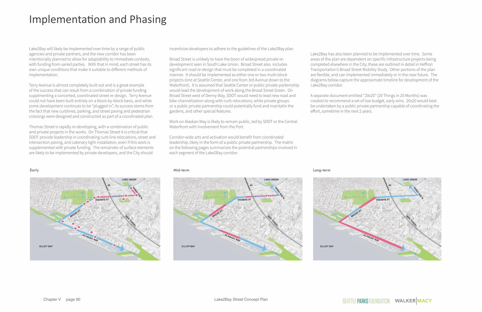
Lake2Bay Street Concept Planpage 90Chapter V
Lake2Bay will likely be implemented over time by a range of public agencies and private partners, and the new corridor has been intentionally planned to allow for adaptability to immediate contexts, with funding from varied parties. With that in mind, each street has its own unique conditions that make it suitable to di�erent methods of implementation.
Terry Avenue is almost completely built out and is a great example of the success that can result from a combination of private funding supplmenting a concerted, coordinated street re-design. Terry Avenue could not have been built entirely on a block-by-block basis, and while some development continues to be “plugged in”, its success stems from the fact that new curblines, parking, and street paving and pedestrian crossings were designed and constructed as part of a coordinated plan.
Thomas Street is rapidly re-developing, with a combination of public and private projects in the works. On Thomas Street it is critical that SDOT provide leadership in coordinating curb line relocations, street and intersection paving, and catenary light installation, even if this work is supplemented with private funding. The remainder of surface elements are likely to be implemented by private developers, and the City should
incentivize developers to adhere to the guidelines of the Lake2Bay plan.
Broad Street is unlikely to have the boon of widespread private re-development seen in South Lake Union. Broad Street also includes significant road re-design that must be completed in a coordinated manner. It should be implemented as either one or two multi-block projects (one at Seattle Center, and one from 3rd Avenue down to the Waterfront). It is assumed that Seattle Center or public private-parternship would lead the development of work along the Broad Street Green. On Broad Street west of Denny Way, SDOT would need to lead new road and bike channelization along with curb relocations, while private groups or a public private partnership could potentially fund and maintatin the gardens, and other special features.
Work on Alaskan Way is likely to remain public, led by SDOT or the Central Waterfront with involvement from the Port.
Corridor-wide arts and activation would benefit from coordinated leadership, likely in the form of a public private partnership. The matrix on the following pages summarizes the potential partnerships involved in each segment of the Lake2Bay corridor.
Lake2Bay has also been planned to be implemented over time. Some areas of the plan are dependent on specific infrastructure projects being completed elsewhere in the City; these are outlined in detail in He�ron Transportation’s Broad Street Mobility Study. Other portions of the plan are flexible, and can implemented immediately or in the near future. The diagrams below capture the approximate timeline for development of the Lake2Bay corridor.
A separate document entitled “20x20” (20 Things in 20 Months) was created to recommend a set of low budget, early wins. 20x20 would best be undertaken by a public private partnership capable of coordinating the e�ort, sometime in the next 2 years.
Early Mid-term Long-term
Implementation and Phasing

Lake2Bay Street Concept Plan page 91Chapter V
Implementation Matrix
Lake2Bay DRAFT Implementation Summary
Lake2Bay Project Current StatusProperty Ownership/
Jursidiction City Design Review Potential Funding &
Implementation PartnersMaintenance & Management Project Cost Construction Timeframe
Arts and Activation Plan Lake2Bay Plan SDOT Seattle Center Seattle Parks Dept. Seattle Monorail Seattle City Light Port of Seattle Private Property Owners
SDOT, DPD Public-Private Partnership to raise capital, apply for grants, issue Arts RFPs, and provide logistical support and coordination with agencies and property owners
varies 2016-2018 Focus Some ongoing effort associated with permanent pieces or long term programming
Office of Arts & Culture BIA/ BIDOffice of Arts & Culture
Water Re-Use Lake2Bay Plan 3rd Party Private Utility SDOT Private Property Owners Seattle Center Seattle Parks Dept
to be determined Coalition of Private Owners 3rd Party Private Utility Office of Sustainability
Concurrent with private development on Thomas and Broad
Stormwater Features Lake2Bay Plan SDOT Private Property Owners
SDOT SPU
SPU Private Property Owners
SPU Concurrent with each project segment
Terry Avenue SDOT Private Property Owners
SDOT SPU
SDOT Private Property Owners
- 2015-2016
Thomas Street SDOT Private Property Owners Seattle City Light WSDOT
SDOT DPD
SDOT Private Property Owners Public Private Partnership to help fund capital cost and maintenance of unique features
$9.1M 2016 and ongoing
BIA/ BID
Broad Street at Seattle Center Lake2Bay Plan SDOT SDOT SDOT SDOT $10M 2018 or laternorth and south sides of street Seattle Center
Private Property OwnersSeattle Center DPD
Seattle Center Seattle Center Foundation Seattle Parks Foundation or Public-Private Partnership to help fund capital cost or champion project
after completion of WSDOT Surface Street Projects connecting John St. to Aurora
BIA/ BID
Lake2Bay Plan SDOT SDOT SDOT SDOT TBD 2018 or latergateway to Seattle Center DPD Office of Arts & Culture
Private Donor or DeveloperSPU Office of Arts & Culture BIA
after completion of WSDOT Surface Street Projects connecting John St. to Aurora
Broad Street Terraces Lake2Bay Plan SDOT SDOT SDOT SDOT $8.2M 2018 or laterPrivate Property Owners DPD Seattle Art Museum (OSP)
Public-Private Partnership - to help fund capital cost and support ongoing maintenance / arts programming BIA/ BID
after completion of 3rd Ave. bus re-route and Elliott Way Connector
Alaskan Way SDOT SDOT SDOT SPU Port of Seattle Central Waterfront
$9.8M 2018 or later after completion of Elliott Way Connector
Public Private Partnership to support policy level decisions only BIA/ BID
Lake2Bay Plan Related Port Planning efforts in progress
Many private and public development projects in progress; some construction adhering to 2013 Adopted Thomas Green Street Plan
Mostly complete, construction adheres to 2005 Adopted Terry Avenue Street Concept Plan
3rd Avenue Triangle
SDOT SPU Port of Seattle Central Waterfront BIA
SDOT SPU Seattle City Light Private Property Owners BIA
Seattle Center SPU Private Property Owners Public Private Partnership BIA
SPU Private Property Owners Seattle Art Museum (OSP) Public Private Partnership BIA
3rd Party Private Utility Private Property Owners
$1.3M (not including permanent artwork associated with capital projects)
to be determined based on extent and type of system
included in project segments below
SDOT Private Property Owners BIA

Lake2Bay Street Concept Planpage 92Chapter V
Implementation Matrix continued
Lake2Bay DRAFT Implementation Summary
Lake2Bay Project Current StatusProperty Ownership/
Jursidiction City Design Review Potential Funding &
Implementation PartnersMaintenance & Management Project Cost Construction Timeframe
Arts and Activation Plan Lake2Bay Plan SDOT Seattle Center Seattle Parks Dept. Seattle Monorail Seattle City Light Port of Seattle Private Property Owners
SDOT, DPD Public-Private Partnership to raise capital, apply for grants, issue Arts RFPs, and provide logistical support and coordination with agencies and property owners
varies 2016-2018 Focus Some ongoing effort associated with permanent pieces or long term programming
Office of Arts & Culture BIA/ BIDOffice of Arts & Culture
Water Re-Use Lake2Bay Plan 3rd Party Private Utility SDOT Private Property Owners Seattle Center Seattle Parks Dept
to be determined Coalition of Private Owners 3rd Party Private Utility Office of Sustainability
Concurrent with private development on Thomas and Broad
Stormwater Features Lake2Bay Plan SDOT Private Property Owners
SDOT SPU
SPU Private Property Owners
SPU Concurrent with each project segment
Terry Avenue SDOT Private Property Owners
SDOT SPU
SDOT Private Property Owners
- 2015-2016
Thomas Street SDOT Private Property Owners Seattle City Light WSDOT
SDOT DPD
SDOT Private Property Owners Public Private Partnership to help fund capital cost and maintenance of unique features
$9.1M 2016 and ongoing
BIA/ BID
Broad Street at Seattle Center Lake2Bay Plan SDOT SDOT SDOT SDOT $10M 2018 or laternorth and south sides of street Seattle Center
Private Property OwnersSeattle Center DPD
Seattle Center Seattle Center Foundation Seattle Parks Foundation or Public-Private Partnership to help fund capital cost or champion project
after completion of WSDOT Surface Street Projects connecting John St. to Aurora
BIA/ BID
Lake2Bay Plan SDOT SDOT SDOT SDOT TBD 2018 or latergateway to Seattle Center DPD Office of Arts & Culture
Private Donor or DeveloperSPU Office of Arts & Culture BIA
after completion of WSDOT Surface Street Projects connecting John St. to Aurora
Broad Street Terraces Lake2Bay Plan SDOT SDOT SDOT SDOT $8.2M 2018 or laterPrivate Property Owners DPD Seattle Art Museum (OSP)
Public-Private Partnership - to help fund capital cost and support ongoing maintenance / arts programming BIA/ BID
after completion of 3rd Ave. bus re-route and Elliott Way Connector
Alaskan Way SDOT SDOT SDOT SPU Port of Seattle Central Waterfront
$9.8M 2018 or later after completion of Elliott Way Connector
Public Private Partnership to support policy level decisions only BIA/ BID
Lake2Bay Plan Related Port Planning efforts in progress
Many private and public development projects in progress; some construction adhering to 2013 Adopted Thomas Green Street Plan
Mostly complete, construction adheres to 2005 Adopted Terry Avenue Street Concept Plan
3rd Avenue Triangle
SDOT SPU Port of Seattle Central Waterfront BIA
SDOT SPU Seattle City Light Private Property Owners BIA
Seattle Center SPU Private Property Owners Public Private Partnership BIA
SPU Private Property Owners Seattle Art Museum (OSP) Public Private Partnership BIA
3rd Party Private Utility Private Property Owners
$1.3M (not including permanent artwork associated with capital projects)
to be determined based on extent and type of system
included in project segments below
SDOT Private Property Owners BIA

Lake2Bay Street Concept Plan page 93Chapter V
This page intentionally left blank.