Embed Size (px)
DESCRIPTION
Severe Weather Awareness Week 2012 for the ARKLAMISS Region.
Citation preview
1
Mis
sis
sip
pi S
evere
Weath
er
Aw
are
ne
ss W
eek F
eb
ruary
13
-17,
2012
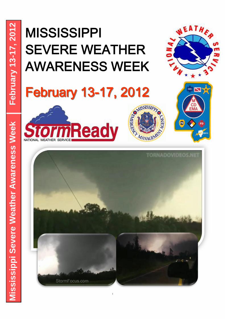
MISSISSIPPI
SEVERE WEATHER
AWARENESS WEEK
February 13February 13--17, 201217, 2012

2
Mississippi Severe Weather Awareness Week Events February 13 - February 17, 2012
Throughout the week, the National Weather Service, will present educational material and conduct a tornado drill to help peo-ple prepare and protect themselves from tornadoes, damaging winds, hail, flash floods, and lightning. Each day of the week focuses on a specific type of severe weather or on the warning and drill system.
Monday, February 13, we will discuss Severe Thunderstorms. Large hail and damaging winds from severe thunder-storms are much more frequent than tornadoes in the south. These straight line winds can reach well over 100 miles an hour and can be devastating.
Tuesday, February 14, draws attention to hazards of Flooding and Flash Floods. Flooding is the #1 cause of weather-related fatalities. Remember…Turn Around Don’t Drown!
Wednesday, February 15, will emphasize Tornado Safety. Over and over again, people survive tornadic weather by knowing weather safety rules and taking appropriate and timely actions. A state-wide tornado drill will be conducted on this day. Schools, businesses and other agencies are encouraged to participate and help everyone learn life saving rules. Thursday will be the alternate drill day if adverse weather is expected on Wednesday.
Thursday, February 16, will focus on lightning, often called the underrated killer. All thunderstorms have lightning and this hazard can be deceptively deadly.
Friday, February 17, will be a day to review the topics covered through the week.
Overview
Thanks for taking the time to read this Severe Weather Awareness Week brochure for the state of Mis-sissippi. When one looks at statistics for the number of tornadoes, strong to violent tornadoes, long track strong to violent tornadoes, and unfortunately tornado fatalities, the state of Mississippi ranks near at the top in every category, especially after the year of 2011. These statistics show a long history of tor-nado impacts across the state. This presents a preparedness challenge to the residents of Mississippi. Unlike the traditional tornado alley of the Great Plains, tornadoes are difficult to spot in Mississippi. Some of the reasons for this are poor visibility in the form of numerous trees in the state, the fact that many tornadoes in Mississippi are rain-wrapped, and that many Mississippi tornadoes occur at night. In addition, many homes and other buildings are not built as well as buildings in other parts of the country. All these factors make it very important that the residents of the Magnolia State have multiple ways to receive severe weather warnings, have a shelter plan in place ahead of time, and take outlooks, watches and warnings seriously. These actions make a contribution to reducing injuries and fatalities. When a tornado warning is issued for your area, be sure and get into a sturdy structure which can pro-vide protection from flying debris. Get to the lowest floor and put as many walls between you and the outside as possible and protect your head. Get out of vehicles and mobile homes.

3
Mississippi SKYWARN®
SKYWARN® is the program developed by the National Weather Service to recruit and train storm spotters. SKYWARN® spotters enhance the National Weather Service's storm detection capabilities by identifying and reporting potentially dangerous weather conditions. The SKY-WARN® program has become an invaluable link in the NWS warning process. Despite all of the sophisticated technology used in a modern NWS office, forecasters still rely on
storm spotters. Doppler radar may indicate that a storm may be producing large hail, damaging winds or even a tornado, but it cannot tell exactly what's happening on the ground underneath the storm. Storm spotters, trained by NWS meteorologists, act as the eyes and ears of the NWS. Their reports, radar data, and other information result in the most timely and accurate warnings possible. SKYWARN® spotters across Mississippi come from all walks of life – law enforcement, fire or emergency management agencies and citizens interested in helping their communities. A large number of storm spotters are amateur radio operators, who volunteer their time and equipment to help the NWS detect and track severe storms. Amateur radio operators, or "hams", will frequently operate radio equipment at the local NWS office, gathering reports from spotters in the field and relaying the data directly to NWS forecasters. SKYWARN® spotters are volunteers – they receive no compensation for their hard work. They do, however, have the satisfaction of knowing that their reports result in better warnings, which save lives. If you are not an amateur radio operator and still want to report information directly to the NWS, you can participate in the on-line spotter program. Go to http://www.srh.noaa.gov/StormReport/SubmitReport.php?site=jan for the Jackson area. Fill the last three letters in as meg for Memphis, lix for Slidell, and mob for Mobile. Who is Eligible? The NWS encourages anyone with an interest in public service and access to communication, such HAM radio, to join the SKYWARN® program. Volunteers include police and fire personnel, dispatchers, EMS workers, public utility workers and other concerned private citizens. Individuals affiliated with hospitals, schools, churches, nursing homes or who have a responsibility for protecting others are also encouraged to become a spotter. How Can I Get Involved? You can participate in the SKYWARN® program in your area by attending a storm spotter training class to become a trained spotter. Each of the training sessions is free, lasts around two hours and covers the following concepts: Here are links to Jackson, MS and surrounding National Weather Service office storm spotter training pages. WFO Jackson, MS: http://www.srh.noaa.gov/jan/?n=spotter_train_schd WFO Memphis, TN: http://www.srh.noaa.gov/meg/?n=skywarn_meetings WFO Mobile, AL: http://www.srh.noaa.gov/mob/?n=spotter_training WFO Slidell, LA: http://www.srh.noaa.gov/lix/?n=skywrnpg2
Please contact one of the National Weather Service Offices listed below if you need more information about an upcoming SKYWARN® class. Jackson...............................Steve Wilkinson...............................(601) 939-2786 Memphis, TN........................Jim Branda……...............................(901) 544-0411 Mobile, AL….........................Jeff Garmon….…............................(251)-633-6443 Slidell, LA.............................Frank Revitte...................................(985) 649-0357
Basics of thunderstorm development
Fundamentals of storm structure
Identifying potential severe weather features
Information to report
How to report information
Basic severe weather safety
4
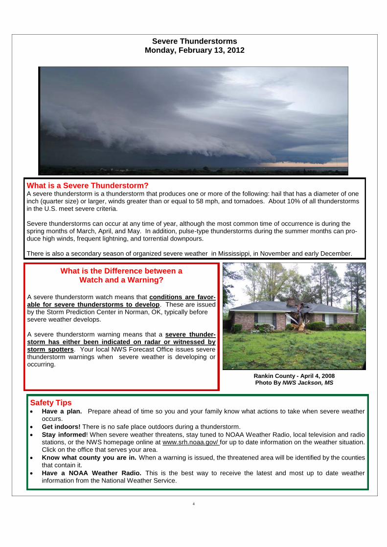
What is a Severe Thunderstorm? A severe thunderstorm is a thunderstorm that produces one or more of the following: hail that has a diameter of one inch (quarter size) or larger, winds greater than or equal to 58 mph, and tornadoes. About 10% of all thunderstorms in the U.S. meet severe criteria. Severe thunderstorms can occur at any time of year, although the most common time of occurrence is during the spring months of March, April, and May. In addition, pulse-type thunderstorms during the summer months can pro-duce high winds, frequent lightning, and torrential downpours. There is also a secondary season of organized severe weather in Mississippi, in November and early December.
Safety Tips Have a plan. Prepare ahead of time so you and your family know what actions to take when severe weather
occurs.
Get indoors! There is no safe place outdoors during a thunderstorm.
Stay informed! When severe weather threatens, stay tuned to NOAA Weather Radio, local television and radio stations, or the NWS homepage online at www.srh.noaa.gov/ for up to date information on the weather situation. Click on the office that serves your area.
Know what county you are in. When a warning is issued, the threatened area will be identified by the counties that contain it.
Have a NOAA Weather Radio. This is the best way to receive the latest and most up to date weather information from the National Weather Service.
What is the Difference between a Watch and a Warning?
A severe thunderstorm watch means that conditions are favor-able for severe thunderstorms to develop. These are issued by the Storm Prediction Center in Norman, OK, typically before severe weather develops. A severe thunderstorm warning means that a severe thunder-storm has either been indicated on radar or witnessed by storm spotters. Your local NWS Forecast Office issues severe thunderstorm warnings when severe weather is developing or occurring.
Severe Thunderstorms Monday, February 13, 2012
Rankin County - April 4, 2008 Photo By NWS Jackson, MS

5
Severe Thunderstorms Monday, February 13, 2012
Hail
How Is Hail Formed? Hail is formed when water droplets are drawn into an area of strong upward moving air, known as an up-draft, of a storm. Once the water droplets are trans-ported above the freezing level, they combine with tiny airborne particles, such as dirt, salt, volcanic ash, etc., and freeze on contact, forming tiny ice par-ticles. These ice particles are light enough that they remain suspended in the cloud, where they undergo processes that allow them to combine with other supercooled water droplets and grow into hail stones. Once the hail stones are heavy enough to overcome the upward force of the updraft, they fall out of the cloud. By definition, hail stones are 5 millimeters or larger, and can inflict significant damage to automobiles, buildings, crops, and even people.
NWS Hail Criteria! As of January 5, 2010, the National Weather Service has changed the severe hail criteria from 3/4 inch to 1 inch. Why the change? There are a couple of reasons. Research has shown that significant damage caused by hail does not occur until the hail diameter reaches one inch (approximately quarter size) or larger. Requests from NWS partners such as emergency managers and the media further prompted the decision to increase the severe hail criteria due to the fact that more frequent severe thunderstorm warnings may act to desensitize the public from their meaningfulness. Such an effect could cause people not to take caution during such a warning, which could lead to unnecessary damage or injury. The change means that severe thunderstorm warnings for hail will be issued less frequently so that a greater emphasis can be placed on more substantial hail threats.
The NWS will issue a Special Weather Statement under the (SPS) header when thunderstorms are expected to produce smaller than quarter sized hail for your county.
For more info visit: http://www.weather.gov/oneinchhail/
Hail Size Estimates Pea……………………..…………………………………1/4 inch Penny…………………………………………..……...….3/4 inch Quarter…………………………………………………..….1 inch Half Dollar………………………………….………..1 1/4 inches Golf Ball……………………………………………...1 3/4 inches Tennis Ball…………………………………..………2 1/2 inches Baseball……………………...………...…..………..2 3/4 inches Grapefruit……………………………….………………..4 inches
1 inch or greater hail reports across MS since 1950

6
Flooding and Flash Flooding are the #1 weather related killer! Tuesday, February 14, 2012
FLASH FLOODING: Flash floods can occur within a few minutes or up to 6 hours after excessive rainfall, a dam or levee failure, or a sudden release of water held by an ice jam or mud slide. Flash floods can wash out roads, destroy buildings and bridges. Because flash floods happen in a short period of time (less than six hours after the causative event) they are more life threatening than other types of flooding. Areas most susceptible to flash flooding are mountainous streams and rivers, urban areas, low-lying areas, storm drains, and culverts. A Flash Flood Warning is issued when flash flooding has been reported or is imminent. It focuses on specific communities, creeks or streams, or other geographic areas where flooding is imminent or occurring.
RIVER FLOODING: This type of flooding is caused by an increased water level in es-tablished watercourses, such as a rivers, creeks, or streams. River flooding is slower to develop than flash flooding (more than 6 hours after the causative event), however, some smaller creeks and streams have a short lag time between the runoff from heavy rain and the onset of flooding. On the other hand, it may take several days for a flood crest to pass downstream points on major rivers such as the Lower Pearl, and Missis-sippi Rivers. The NWS issues River Flood Warnings when rivers are expected to rise above flood stage. Persons in the warned area are advised to take necessary precau-tions immediately. River stages and crest forecasts are given for selected forecast points along with known flood stages for each forecast point. While there is usually more advanced warning time with river floods than with flash floods, persons should be
familiar with the flood prone areas they live and work in, and must know what action to take and where to go if a flood occurs. Advance planning and preparation is essential. FLOOD WATCHES: The NWS issues a Flood Watch when conditions are anticipated that could result in either flooding or flash flooding within a designated area. Persons in the watch area are advised to check flood action plans, keep informed, and be ready to take action if a warning is issued or flooding is observed. FLOOD SAFETY RULES: Follow these tips to stay safe during flood conditions… When a warning is issued get out of areas subject to flooding. These may include dips, low spots, stream beds, drainage ditches and culverts. If caught in low areas during flooding, go to high ground immediately. Avoid already flooded and high velocity flow areas. A rapidly flowing stream or ditch can sweep you off your feet or even carry your car or truck downstream. Never drive through a flooded area as the road bed may be washed away. Play it safe! If you encounter a flooded road - TURN AROUND, DON’T DROWN! Be especially cautious at night when it is harder to recognize flood conditions, and never drive around a barricaded road. Most flood deaths occur at night and when people become trapped in automobiles that stall in areas that are flooded. If your
vehicle stalls, abandon it immediately and seek higher ground. The rising water may engulf the vehicle and the occupants inside. Do not camp or park your vehicle along streams or washes during threatening conditions. When a FLOOD WARNING is issued for your area, act quickly to save yourself. You may only have seconds!

7
Tornadoes Wednesday, February 15, 2012
What is a Tornado? A tornado is a violently rotating column of air that extends from the base of a storm cloud to the ground. Some conditions that are conducive for tornado formation include warm, moist, un-stable air, strong atmospheric winds that increase in speed and change direction with height, and a forcing mechanism to lift the air. When a combination of these factors comes to-gether just right, tornadoes form. The most common time of year for tornado formation in Mississippi is during the spring months of March, April, and May, with a secondary tornado season in November. Additionally, the afternoon and evening hours are the times of day at which most tornadoes occur, as they are the times at which the maximum heating takes place. However, tornadoes can occur at any time of day, and at any point during the year, given the right environment. Many tornadoes occur at night in Mississippi (see below)
Nighttime Tornadoes Pose Greater Danger The NWS would like to draw attention to nighttime torna-does. These tornadoes pose a greater danger than those that occur during the daylight because once most people go to bed, they are no longer connected to the watches or warnings issued by the NWS. Also at night, visibility is reduced and observing a tornado is more difficult. This is elevated during the winter months because it is not the traditional tornado season. Research by Gagan et al. 2010 compared tornado statistics from the Great Plains in the classic “Tornado Alley” to tornadoes in the Deep South or “Dixie Alley.” Researchers found that Dixie Alley had far greater amounts of Killer Strong/Violent Torna-does between 9pm-9am timeframe. Dixie Alley had nearly twice the number of strong/violent tornadoes from Midnight-Noon timeframe than Tornado Alley from 1950-2007.
Having an properly programmed All Hazards NOAA Weather Radio with S.A.M.E. County Coding technology will alarm individuals anytime of day when a severe thunderstorm warning or tornado warning is issued for their county. This device has been credited for saving numerous lives during nocturnal tornado events.
Enhanced Fujita Scale (EF Scale) EF Rating Wind Speeds Potential Damage Threats EF 0 (weak) 65-85 mph Light damage, shallow rooted trees pushed over, some damage to gutters or siding. EF 1 (weak) 86-110 mph Moderate damage, mobile homes overturned, roof surfaces peeled off. EF 2 (strong) 111-135 mph Considerable damage, large trees uprooted or snapped, mobile homes destroyed. EF 3 (strong) 136-165 mph Severe damage, trains overturned, well built homes lose roofs and walls. EF 4 (violent) 166-200 mph Devastating damage, well built homes leveled, cars thrown. EF 5 (extreme) Over 200 mph Incredible damage, well built homes disintegrated, automobile-sized objects thrown
>300ft.
Large tornado striking a transformer near Leaksville, MS on April 15th, 2011 (Tornadovideos.net)
EF-5 Tornado in NE Neshoba County on April 27, 2011 (Tornadovideos.net)
8
A TORNADO DRILL will be conducted Wednesday morning, February 15, 2012, at 9:15 AM Local Time, weather permitting, as part of SEVERE WEATHER AWARE-NESS WEEK in Mississippi. If Wednesday's weather is inclement, the test will be Thursday, February 26, 2012 (same time). The message will be sent under the Weekly Test Product (RWT) disseminated by NOAA Weather Radio only. Many weather radios will alert for this test but some mod-els will just flash a light. If your weather radio, does not give an audible alert at 9:15 am, proceed with your drill anyway. The Weekly Test Product, with the tornado drill message, will be broadcast on all NOAA Weather Radio Transmitters across Mississippi. A Drill such as this gives schools, churches, business offices and plant safety managers across the state a chance to check the readiness of their Severe Weather Safety plans. If your office has a plan already in place, test it to make sure your employees know how to respond properly. If your employees know how the safety procedures work, they can carry them out effectively when the time comes. IF YOUR WORK PLACE, SCHOOL OR CHURCH DOES NOT HAVE A SAFETY PLAN, NOW IS THE TIME TO START ONE!! Developing a safety plan is not difficult. If a plan is easy to operate, it is more likely to be successful when needed. Countless lives are saved each year by planning, preparedness and proper education. The U.S. population has grown in recent years, yet the number of tornado deaths has dimin-ished. This is due to agencies and individuals developing Weather Safety Plans and to people reacting in a prudent manner when severe weather threatens their areas.
YOUR SAFETY AND THAT OF YOUR FAMILY, FRIENDS AND CO-WORKERS DEPENDS ON YOU!!
DRILL DAY Wednesday, February 15, 2012
9:15 Local Time

9
As everyone is aware, this spring was one of the most active in the United States for tornadoes in many years. From early April through early June, there were several major episodes of severe weather and tornadoes over much of the eastern half of the United States, with our region seeing the biggest event on Apr 27. Through mid summer 2011, there was 537 confirmed tornado fatalities nationwide, which is the largest number of tornado related deaths in the U.S. since 1936. Five EF-5 tornadoes have occurred this year, which is the first time that many have occurred in the same year since 1974 when six F5 tornadoes occurred during the April 3-4, 1974 “Super Outbreak.” The only other year in which five F5 tornadoes have occurred in the same year since records have been kept was 1953, which was another particularly violent year for tornadoes with 519 fatalities. The Apr 27 event initially started out as supercell thunder-storms producing large hail and tornadoes across northeast Texas. A squall line developed which moved along and north of I-20 during the late evening of the 26th and the early morning of the 27th. The line was very efficient in producing wind damage as it pushed east. More impressively, this line produced many torna-does and is responsible for 23 of the total tornadoes for this event. Of those 23, 11 were rated as strong (EF2, EF3) torna-does and had fairly long path lengths. The most intense tornado was a 59 mile long EF3 tornado which impacted northern Choc-taw, southeast Webster, western Clay, Chickasaw and Monroe counties. Once this line of storms moved east of the area, there was a break of several hours before supercell thunder-storms redeveloped during the early afternoon hours of the 27th. These storms intensified and by mid-afternoon and began producing significant tornadoes. An additional 9 tornadoes would occur in the area during the afternoon hours. The first tornado of the day was the most intense, becoming the first EF5 tornado in the NWS Jackson service area since 1971. This tornado began on the north side of the city of Philadelphia, and moved northeast across northeast Neshoba, extreme northwest Kemper, ex-treme southeast Winston, and southwest Noxubee counties. The most impressive damage occurred in the rural area where Neshoba, Kemper, and Winston counties meet. Here, the ground was churned up by the tornado to a depth of up to two feet in several swaths. Unfortunately, three people lost their lives in this tornado, and several others were injured. Another violent tornado occurred this same afternoon, an EF4 tornado that started in Smith County near Raleigh, and then moved across Jasper and Clarke counties. This tornado would then continue into southwest Alabama, with a total path length of 123 miles. Seven people were killed and 35 were injured by this tor-nado. In total, 12 people sadly lost their lives in the NWS Jackson service area during this outbreak: 11 deaths were due to tornadoes and 1 due to straight line winds. Seventeen strong or violent tornadoes occurred in about an 18 hour period, including 5 EF3s, 1 EF4 and 1 EF5. Along with the EF5 tornado that occurred in Smithville (NWS Memphis service area), Mississippi became the first state since Kansas in 1991 to have two EF5 tornadoes occur on the same day. Numerous strong and violent tornadoes also occurred across Alabama, Tennessee, and Georgia during this event, and in total 314 people were killed during this tornado outbreak. Additionally, April 2011 set a record for the most tornadoes in any month in Mississippi with 67. The previous record was 44, set during the Rita outbreak of September 2005.
April 27, 2011 Historic Tornado Outbreak
Chad Entremont — NWS Jackson, MS
Fig 1. Violent EF5 Tornado along the Winston/Kemper County line. Photographed by Tornadovideos.net
Fig 2. Various images of tornado damage. The first three are from the EF5, last one is from the EF4.

10
April 2011 will go down in history with the most tornadoes of any month ever recorded with 758 tornadoes. April 27th, now ranks first in the single day total of tornadoes at 200 with the previous record at 128 in April of 1974. 2011 Ranked 4th in number of tornado related fatalities with 550. Not since 1953 had the yearly number of tornado related fatalities reached over 500 persons. 22 tornadoes were EF4 or EF5 in 2011 with the record being 36 in 1974.
135
187
221
341
200
75
31
58
119
91
227
135
0
50
100
150
200
250
300
350
400
Jan Feb Mar Apr May Jun Jul Aug Sep Oct Nov Dec
# o
f T
orn
ad
oe
s
MS Tornadoes 1950-2011
11
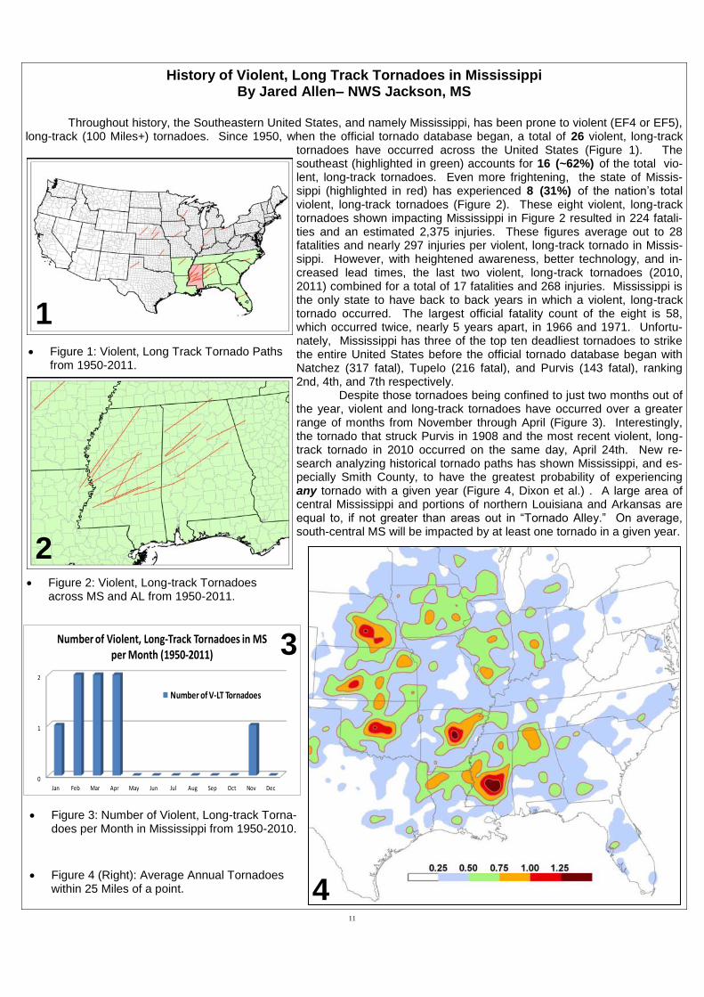
History of Violent, Long Track Tornadoes in Mississippi By Jared Allen– NWS Jackson, MS
Throughout history, the Southeastern United States, and namely Mississippi, has been prone to violent (EF4 or EF5),
long-track (100 Miles+) tornadoes. Since 1950, when the official tornado database began, a total of 26 violent, long-track tornadoes have occurred across the United States (Figure 1). The southeast (highlighted in green) accounts for 16 (~62%) of the total vio-lent, long-track tornadoes. Even more frightening, the state of Missis-sippi (highlighted in red) has experienced 8 (31%) of the nation’s total violent, long-track tornadoes (Figure 2). These eight violent, long-track tornadoes shown impacting Mississippi in Figure 2 resulted in 224 fatali-ties and an estimated 2,375 injuries. These figures average out to 28 fatalities and nearly 297 injuries per violent, long-track tornado in Missis-sippi. However, with heightened awareness, better technology, and in-creased lead times, the last two violent, long-track tornadoes (2010, 2011) combined for a total of 17 fatalities and 268 injuries. Mississippi is the only state to have back to back years in which a violent, long-track tornado occurred. The largest official fatality count of the eight is 58, which occurred twice, nearly 5 years apart, in 1966 and 1971. Unfortu-nately, Mississippi has three of the top ten deadliest tornadoes to strike the entire United States before the official tornado database began with Natchez (317 fatal), Tupelo (216 fatal), and Purvis (143 fatal), ranking 2nd, 4th, and 7th respectively. Despite those tornadoes being confined to just two months out of the year, violent and long-track tornadoes have occurred over a greater range of months from November through April (Figure 3). Interestingly, the tornado that struck Purvis in 1908 and the most recent violent, long-track tornado in 2010 occurred on the same day, April 24th. New re-search analyzing historical tornado paths has shown Mississippi, and es-pecially Smith County, to have the greatest probability of experiencing any tornado with a given year (Figure 4, Dixon et al.) . A large area of central Mississippi and portions of northern Louisiana and Arkansas are equal to, if not greater than areas out in “Tornado Alley.” On average, south-central MS will be impacted by at least one tornado in a given year.
Figure 3: Number of Violent, Long-track Torna-does per Month in Mississippi from 1950-2010.
Figure 1: Violent, Long Track Tornado Paths from 1950-2011.
Figure 4 (Right): Average Annual Tornadoes within 25 Miles of a point.
1
2
4
0
1
2
Jan Feb Mar Apr May Jun Jul Aug Sep Oct Nov Dec
Number of Violent, Long-Track Tornadoes in MS per Month (1950-2011)
Number of V-LT Tornadoes
Figure 2: Violent, Long-track Tornadoes across MS and AL from 1950-2011.
3

12
Tornado Appearance...Not All the Same
Tornado Sirens
Intended for outdoor use and to notify those who are away from TV and other warning systems
Think about this, homes are insulated and have double
pane windows to keep the noise out, why do we then de-
pend on sirens to alert us while we are in our home.
Sirens are just one piece of the
warning notification puzzle
Tornado Emergency
What Does It Mean?
For the NWS Jackson to issue a Tornado Emergency the following criteria need to be met:
1) Report of significant damage or a reliable report (from a trained spotter) of a large tornado on the
ground
2) Radar showing strong indications of a strong/violent tornado (debris ball)
3) Environmental conditions support strong/violent tornadoes and/or PDS tornado watch is in effect
1 Mile Wide EF4 Wedge Tornado near Yazoo City, MS April 24th, 2010. Could be mistaken for a rain shield or low
Looks well-defined and possibly strong tornado, but was only a EF0 tornado that spun up from Hurricane Gustav in Sep-tember 2008 in Franklin County MS.
1 Mile Wide EF3 Wedge Tornado near Scooba, MS April 15th, 2011. this too can be mistaken for low clouds. Be sure to look for rotation.
Skinnier but still strong EF2 Tornado near Possumneck, MS on April 15th, 2011.
13
Lightning The Underrated Killer
Thursday, February 16, 2012
EVERY THUNDERSTORM CONTAINS LIGHTNING. Nationwide in 2010, 30 people were killed by lightning. Since 1959 a stagger-ing 3919 people have lost their lives as a direct result of being struck. In an av-erage year around 25 million lightning strikes are recorded across the United State alone. Worldwide there are around 1800 thunderstorms ongoing at any given time. Lightning is an incredibly powerful electrical discharge, containing up to 100 million volts of electrical charge and capable of reaching 50000 de-grees Fahrenheit. Cloud to Ground Lightning is the result of incredible differ-ences in electrical charge which forms within thunderstorms…as well as be-tween thunderstorms and the earth’s surface. Recent science suggests that ice in thunderstorms is key to creating the massive charge differences which lead to lightning. Thunderstorm updrafts and downdrafts work to separate smaller
ice particles from larger hail stones within the storm. As this happens many of the ice pieces collide resulting in a separa-tion of electrical charge. The higher part of the storm contains primarily positively charged small ice crystals, with negative charged larger chunks of ice down low. As the storm moves across the earth a pool of positively charged particles gathers near the ground. Eventually a brief electrical circuit is created as a negatively charged “step leader” descends from the storm toward the ground and eventually connects to the positive charge on the ground. The extreme heating of the air with lightning causes a rapid expansion of the air around it, leading to thunder. The sound of thunder will travel away from lightning at a speed around 1 mile every 5 seconds. If you can see lightning and hear thunder at your location you are not safe, if you hear thunder within 30 seconds after seeing lightning your life is in immediate danger.
Lightning Safety Rules—Outdoors Seek shelter inside a house, large building or an all metal vehicle with
the windows rolled up (avoid convertibles).
If your hair stands on end and your skin tingles... lightning is about to strike. Take cover immediately!
When boating, head for shore and get into a shelter, or vehicle. If caught in a boat, lie down in the boat with cushions between you and the boat's side and bottom.
AVOID Large trees, hilltops and other high places.
Chain link fences and any other metal fences like those around ball parks and play grounds.
Motorcycles, scooters, golf carts, small metal sheds, bicycles, tractors and farm equipment that does not have an enclosed metal cab.
Lightning Safety Rules - Indoors
Stay away from windows. Avoid telephones and electrical appliances (wires connecting to these devices run outside of the home and act as lightning rods). Don’t wash dishes or take a shower. The pipes will conduct electricity.
Unplug computers and other sensitive electrical devices (time permitting) since surge suppressors may not protect these items if lightning hits close to the home.
Remember, there is no truth to the old myth that “lightning never strikes twice.”
Take time this week to learn or refresh your memory on lightning safety rules. That quick dash out in the open when a thunderstorm is in progress may unnecessarily expose you to the possibility of being struck. It is not worth the risk.
If a person is struck by lightning, there is no residual charge left on the body. The quick application of CPR may maintain vital body functions until medical help can be obtained.
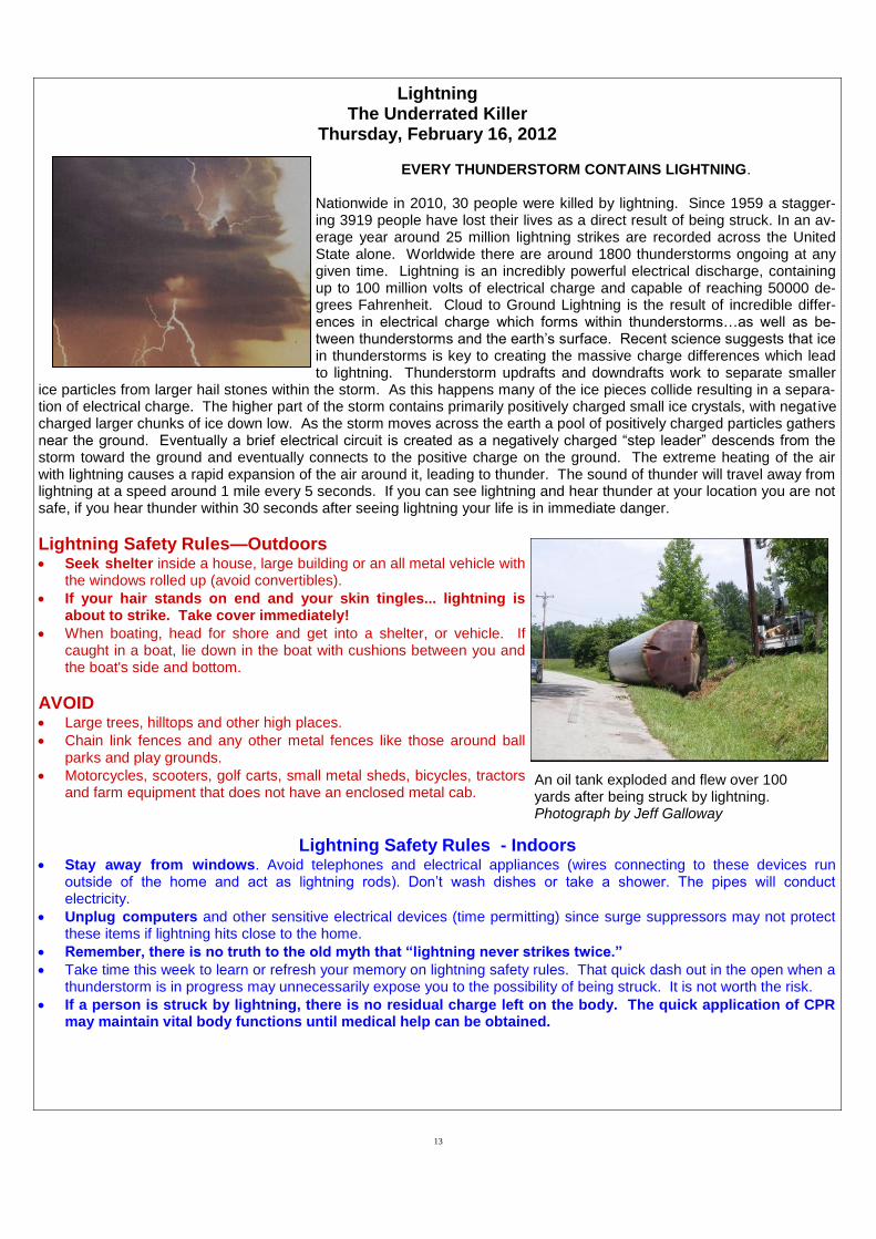
An oil tank exploded and flew over 100 yards after being struck by lightning. Photograph by Jeff Galloway

14
NOAA Weather Radio and Emergency Alert System
The National Weather Service (NWS) utilizes NOAA Weather Radio All-Hazards to broadcast continuous weather information 24 hours a day, every day of the year. This is your direct link in receiving watches and warnings from the NWS. When properly programmed, with options for single or multiple counties, the NOAA weather radio will alert you of a warning for you area, day or night. With battery back-up, the radio will still be able to deliver life-saving information even if the power goes out due to the storms. The NWS Jackson forecast area is served by 11 NOAA Weather Radio (NWR) transmitters with several surrounding transmitters outside the forecast area covering additional counties and parishes. Approximately 95 per-cent of the people in Mississippi are within range of a NWR transmitter (see list of NWR transmitter locations and frequencies in table below). While routine programming offers the latest forecasts, hazardous weather outlooks, current weather conditions, and official climate data, the broadcast cycle is automatically updated and at times interrupted whenever a specific weather watch, warning, or advisory is issued by an NWS Forecast Office. Watches, warnings, advisories and special weather statements are given the highest priority on NWR and are frequently updated with critical weather information. In an emergency, each station will transmit a warning alarm tone in addition to the SAME (Specific Area Message Encoding) tone. Information on the emergency situation then follows. These alert tones, especially the SAME, are capable of activating specially-designed receivers by producing a visual and/or audible alarm. Not all weather band receivers have this capability, but all radios that receive the NWR transmission can receive the emergency broadcasts. The warning alarms and SAME tones are tested each Wednesday, typically between 11AM and Noon, weather permitting. Commercial radio and television stations as well as cable television companies are encouraged to use NOAA Weather Radio in order to rebroadcast pertinent weather information to the general public. NWR is also a major part of the Emergency Alert System (EAS), hence the “All-Hazards” tag, with improved technology to more efficiently process critical weather warning information through commercial broadcast outlets in order to save your life.
Leakesville 162.425
Gulfport 162.400
Oxford 162.550
Inverness 162.425
Ackerman 162.475
Booneville 162.400
Rose Hill 162.550
Jackson 162.400
Bassfield 162.475
Bude 162.550
Carthage 162.500

15
NWS StormReady Program of Mississippi
The National Weather Service (NWS), in partnership with local emergency management, law enforcement, and local government agencies, works to protect the public they serve from the hazards of severe weather through the StormReady program. The StormReady program serves to protect the public through advanced severe weather planning, public educa-tion, and awareness. When the public is better informed of the threats from severe weather – lives are saved. It is the goal of all StormReady participants to maximize the protection of life and property by ensuring that the local public is properly prepared and promptly warned when severe weather is expected or occurring.
The StormReady program has established require-ments that participating agencies must perform that help miti-gate threats from hazardous weather. These tasks include: (1) establishing a 24 hour Warning Point and Emergency Op-erations Center; (2) having multiple ways of receiving severe weather warnings and forecasts to alert the public; (3) creating a system that monitors the weather conditions locally; (4) local means of warning dissemination; and (5) developing a normal hazardous weather plan, including severe weather spotter training and emergency training exercises. These StormReady recommendations were found to increase severe weather awareness and preparedness across areas where they have been implemented. Considering that greater than 90% of de-clared disasters are weather related, it remains imperative that severe weather education in local communities remain a top priority. This will ensure that the public is prepared to protect themselves from the dangers of severe weather. The Storm-Ready program serves as an avenue to accomplish this mis-sion. Several counties, local communities, and major uni-versities across Mississippi have become StormReady since the program’s implementation. In all, 21 counties and 16 cities across the state of Mississippi are StormReady. Three large universities, the University of Southern Mississippi in Hatties-burg, the University of Mississippi in Oxford, and Jackson State University have been recognized as StormReady. Two large government facilities are also Stormready, the Columbus Air Force Base and the John C. Stennis Space Center. The National Weather Service tirelessly promotes this worthwhile program and recruits new participants through its local warning coordination/outreach program. The NWS en-courages any agency interested in becoming a new Storm-Ready participant to contact their local NWS office. For addi-tional information, detailed requirements, and program bene-fits, please visit: http://www.stormready.noaa.gov/. Working together, we all can do our part to protect the citizens of Mis-sissippi from the dangers of hazardous weather.

16
Power Up – Tips from Energizer to Help Weather the Weather
To make sure you have the power you need during and after severe weather, be sure to include a Keep Safe.
Keep Going®
power kit with your other emergency kit materials.
Battery-powered radio or crank radio to keep your family apprised of current weather-related news.
Plenty of extra batteries. (AA, AAA, C, D) provide long-lasting power before, during and after the storm. Lithium
batteries have a long storage life, perform well in extreme temperatures and are perfect for use in LED flashlights and other high-tech devices.
Flashlight for every member of the family. Use flashlights instead of candles when the power goes out.
Battery-powered cell phone charger.
Extra specialty batteries to power critical health devices like hearing aids and blood glucose monitors.
.
For Your Information
This booklet contains materials useful during the Severe Weather Awareness Week campaign and at other times, too. You are invited to contact the National Weather Service, state and county emergency management agencies for interviews and for answers to your questions. National Weather Service personnel and local emergency management are available for weather awareness programs to civic and industrial organizations, schools, hospitals, and others interested in weather safety. Each county in Mississippi is served by a designated National Weather Service Office as identified below:
Information Resources on the World Wide Web For additional resources, the following web sites are available:
NWS Jackson: www.srh.noaa.gov/jan NWS Memphis: www.srh.noaa.gov/meg
NWS New Orleans: www.srh.noaa.gov/lix NWS Mobile: www.srh.noaa.gov/mob
All NWS Offices:
http://www.weather.gov
Please contact one of the Offices listed below if you need more information.
Jackson............................ .Steve Wilkinson…........................(601) 939-2786 Jackson............................. Alan Gerard…............................. (601) 939-2786 Memphis, TN ……………...Jim Belles……………...…….…...(901) 544-0411 Slidell, LA...........................Frank Revitte.............................. (985) 649-0357 Slidell, LA…………………..Ken Graham……………………...(985) 649-0357 Mobile, AL..........................Jeff Garmon..….......................... (251) 633-6443 Mobile, AL..........................Jeffery Cupo............................... (251) 633-6443 Mississippi Emergency Management Agency………………..(866) 519-6362
Legend: Jackson | Memphis, TN| Slidell, LA| Mobile, AL