Embed Size (px)
Citation preview
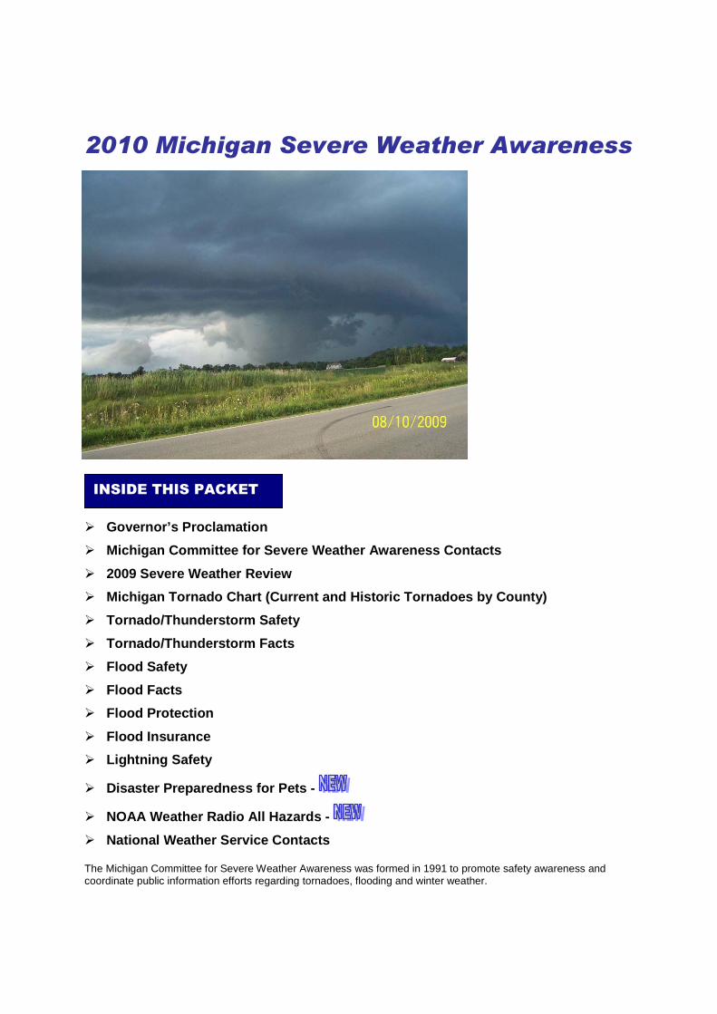
2010 Michigan Severe Weather Awareness
� Governor’s Proclamation
� Michigan Committee for Severe Weather Awareness Contacts
� 2009 Severe Weather Review
� Michigan Tornado Chart (Current and Historic Tornadoes by County)
� Tornado/Thunderstorm Safety
� Tornado/Thunderstorm Facts
� Flood Safety
� Flood Facts
� Flood Protection
� Flood Insurance
� Lightning Safety
� Disaster Preparedness for Pets -
� NOAA Weather Radio All Hazards -
� National Weather Service Contacts
The Michigan Committee for Severe Weather Awareness was formed in 1991 to promote safety awareness and coordinate public information efforts regarding tornadoes, flooding and winter weather.
INSIDE THIS PACKET

Michigan Committee for Severe Weather Awareness April 2010
Mark Walton, Chair National Weather Service 4899 South Complex Drive, S.E. Grand Rapids, MI 49512 616/949-0643, Ext. 493 [email protected] Rich Pollman, Vice Chair National Weather Service 9200 White Lake Road White Lake, MI 48386-1126 248/625-3309, Ext. 726 [email protected] Dana Wolverton, Secretary Michigan Department of State Police 4000 Collins Rd Lansing, MI 48910 517/333-5032 [email protected] Lori Conarton Insurance Institute of Michigan 334 Townsend Lansing, MI 48933 517/371-2880 [email protected] Paul Gross WDIV-TV 4 550 W. Lafayette Detroit, MI 48226-3140 313/222-0444 ext. 318 [email protected] David Chapman MI Earth Science Teachers Association Okemos High School 2800 Jolly Road Okemos, MI 48864 517/706-4886 [email protected]
Mary Stikeleather Lapeer County Emergency Management 2332 W. Genesee Street Lapeer, MI 48446 810/667-0242 [email protected] Kevin Thomason State Farm Insurance P.O. Box 4094 Kalamazoo, MI 49003-4094 269/384-2580 [email protected] Joni Hatch American Red Cross 14600 Beadle Lake Road Battle Creek, MI 49014 269/962-7528 ext. 223 [email protected] Terry Jungel Michigan Sheriffs’ Association 515 N. Capitol Lansing, MI 48933 517/485-3135 [email protected] Les Thomas Michigan Department of Natural Resources and Environment P.O. Box 30458, 525 W. Allegan Lansing, MI 48909-7958 517/335-3448 [email protected] Sue Manente Michigan Department of Community Health P.O. Box 30195, 201 Townsend St. Lansing, MI 48913 517/335-9003 [email protected]
For more information visit www.mcswa.com April 2010
2009 Severe Weather Review
According to the National Weather Service (NWS), Michigan experienced the lightest severe weather
season in 2009 as compared to the modern era of Doppler radar. Despite the lull in severe weather
activity, significant flooding resulted in nearly $77 million in damages and severe thunderstorms were
responsible for one death and approximately $150 million in damages. A total of 93 flooding and flash
flooding events occurred across the state in 2009.
During 2009, approximately 75 percent of severe weather in the state occurred on five days: April 24
and 25, June 19, June 25 and August 9. In the state, there were only 161 distinct severe weather
events in 2009. Only eight of those were recorded in Northern lower and upper Michigan. To put that
number into perspective, in June 2008, there were 415 distinct severe weather events for the state.
Flooding
The year began with significant flooding along the Grand River near the city of Grand Haven as water
backed up rapidly behind ice jams. The U.S. Coast Guard Cutter, Katmai Bay, was dispatched to help
break-up the ice at the mouth of the river allowing water to flow more freely into Lake Michigan.
Unfortunately, more than $3 million in damages occurred in the Grand Haven area.
In June, heavy rain resulted in significant flooding in Allegan, Ionia and Ottawa counties.
Thunderstorms on June 19 dropped 6.8 inches of rain over a five-hour period in portions of Allegan
and Ottawa counties, resulting in washed out roads and flooding of hundreds of homes and
businesses. Flood damage was estimated to be near $40 million for Allegan and Ottawa counties. As
these thunderstorms moved further inland, the intense rainfall generated significant runoff that resulted
in an unprecedented rise in river levels along the Grand River of more than five feet during a 24-hour
period. Subsequent flooding caused more than $10 million of damage to approximately 1,000 vehicles
parked along the river during a concert at the Ionia Fairgrounds. During August 8-9, up to eight inches
of rain fell during a 30-hour period, which resulted in widespread flooding across southern Lapeer
County. A local state of emergency was declared for the county when 19 roads were closed due to
flash flooding and multiple homes and businesses were also flooded. The most significant road
damage occurred on M-53 south of Imlay City where the road was washed out and subsequently
closed for 10 days. Over two dozen homes were damaged due to the flooding with total damages
estimated at $3 million.
Tornadoes
During 2009, three tornadoes touched down in Michigan, which is well below the state’s annual
average of 16 tornadoes. The last time Michigan experienced three or fewer tornadoes in a year, was
nearly 40 years ago in 1970. All three tornadoes in 2009 hit during the evening of June 19, within a
For more information visit www.mcswa.com April 2010
half hour and 30 miles of each other in Allegan and Kalamazoo counties. The first tornado touched
down in Allegan County, damaging trees and structures alike. Along the path of this EF-2 tornado, a
pole barn was destroyed, doors of a garage blown in and a roof was ripped off an unoccupied home.
The other two tornadoes occurred in Kalamazoo County. The first of these was rated an EF-1 and was
on the ground for 1.8 miles, which caused major damage to an outbuilding as well as damaging trees
and utility lines. The second tornado, rated an EF-2, was on the ground for less than one mile and tore
a roof off a ranch-style house and uprooted several trees. No injuries or deaths were reported during
any of the three tornadoes.
Severe Thunderstorms
A strong cold front pushed across lower Michigan during the afternoon and evening hours of April 25
producing several severe thunderstorms. Wind gusts were estimated between 65 and 85 mph with the
strongest storms occurring near the city of Vicksburg in Kalamazoo County and the city of Marshall in
Calhoun County. Tree damage and power outages were prevalent with 80,000 homes and businesses
in Oakland County losing power.
On June 25, a weak, low-pressure system triggered several severe thunderstorms in Southeast
Michigan. More than 80,000 customers lost power in the area with the majority residing in southern
Macomb County.
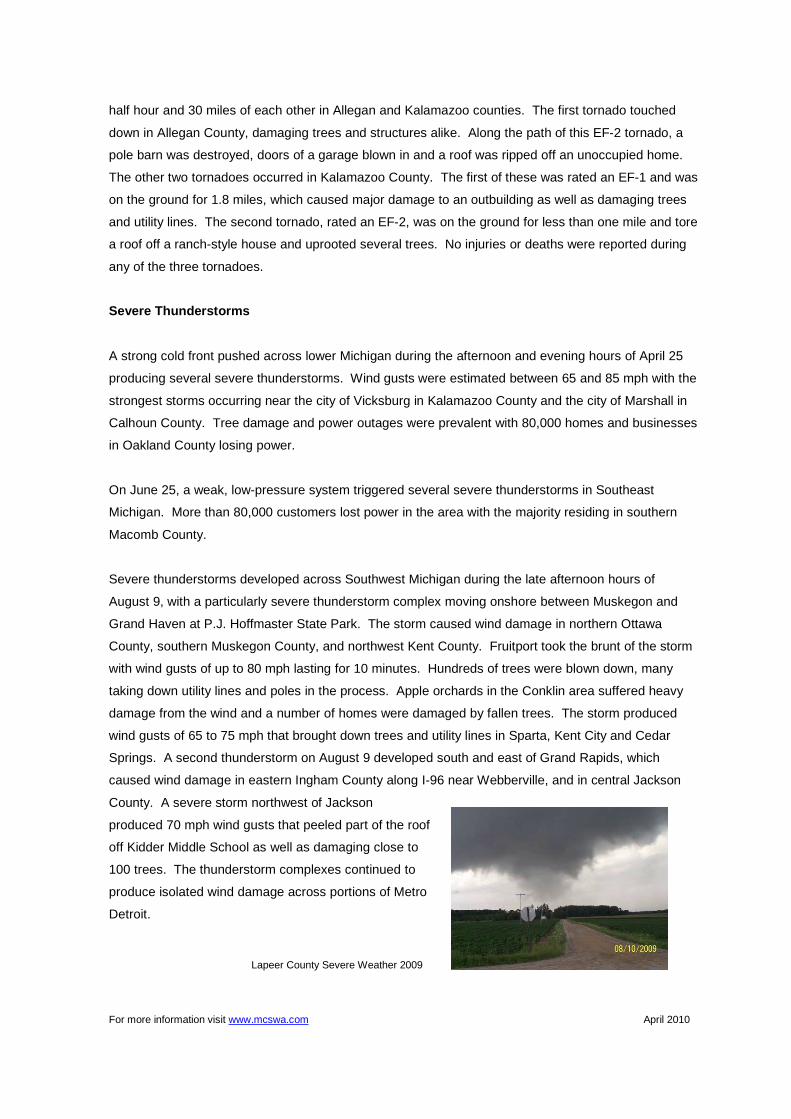
Severe thunderstorms developed across Southwest Michigan during the late afternoon hours of
August 9, with a particularly severe thunderstorm complex moving onshore between Muskegon and
Grand Haven at P.J. Hoffmaster State Park. The storm caused wind damage in northern Ottawa
County, southern Muskegon County, and northwest Kent County. Fruitport took the brunt of the storm
with wind gusts of up to 80 mph lasting for 10 minutes. Hundreds of trees were blown down, many
taking down utility lines and poles in the process. Apple orchards in the Conklin area suffered heavy
damage from the wind and a number of homes were damaged by fallen trees. The storm produced
wind gusts of 65 to 75 mph that brought down trees and utility lines in Sparta, Kent City and Cedar
Springs. A second thunderstorm on August 9 developed south and east of Grand Rapids, which
caused wind damage in eastern Ingham County along I-96 near Webberville, and in central Jackson
County. A severe storm northwest of Jackson
produced 70 mph wind gusts that peeled part of the roof
off Kidder Middle School as well as damaging close to
100 trees. The thunderstorm complexes continued to
produce isolated wind damage across portions of Metro
Detroit.
Lapeer County Severe Weather 2009
For more information visit www.mcswa.com April 2010
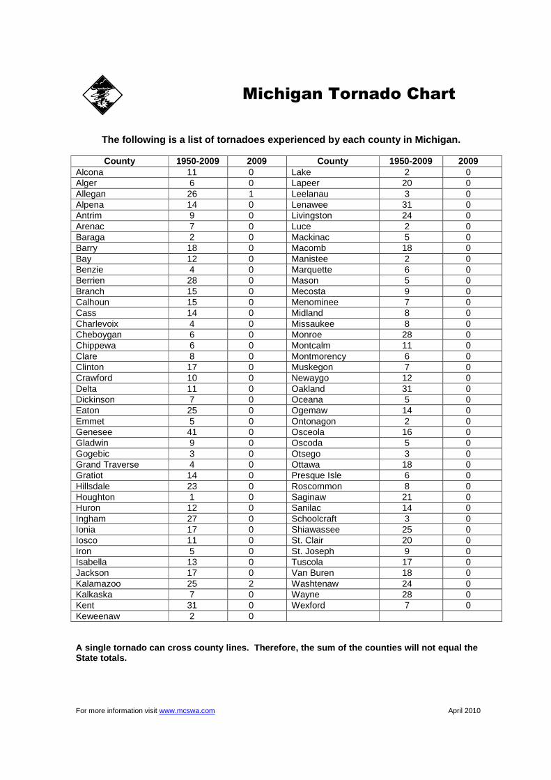
The following is a list of tornadoes experienced by each county in Michigan.
County 1950-2009 2009 County 1950-2009 2009
Alcona 11 0 Lake 2 0 Alger 6 0 Lapeer 20 0 Allegan 26 1 Leelanau 3 0 Alpena 14 0 Lenawee 31 0 Antrim 9 0 Livingston 24 0 Arenac 7 0 Luce 2 0 Baraga 2 0 Mackinac 5 0 Barry 18 0 Macomb 18 0 Bay 12 0 Manistee 2 0 Benzie 4 0 Marquette 6 0 Berrien 28 0 Mason 5 0 Branch 15 0 Mecosta 9 0 Calhoun 15 0 Menominee 7 0 Cass 14 0 Midland 8 0 Charlevoix 4 0 Missaukee 8 0 Cheboygan 6 0 Monroe 28 0 Chippewa 6 0 Montcalm 11 0 Clare 8 0 Montmorency 6 0 Clinton 17 0 Muskegon 7 0 Crawford 10 0 Newaygo 12 0 Delta 11 0 Oakland 31 0 Dickinson 7 0 Oceana 5 0 Eaton 25 0 Ogemaw 14 0 Emmet 5 0 Ontonagon 2 0 Genesee 41 0 Osceola 16 0 Gladwin 9 0 Oscoda 5 0 Gogebic 3 0 Otsego 3 0 Grand Traverse 4 0 Ottawa 18 0 Gratiot 14 0 Presque Isle 6 0 Hillsdale 23 0 Roscommon 8 0 Houghton 1 0 Saginaw 21 0 Huron 12 0 Sanilac 14 0 Ingham 27 0 Schoolcraft 3 0 Ionia 17 0 Shiawassee 25 0 Iosco 11 0 St. Clair 20 0 Iron 5 0 St. Joseph 9 0 Isabella 13 0 Tuscola 17 0 Jackson 17 0 Van Buren 18 0 Kalamazoo 25 2 Washtenaw 24 0 Kalkaska 7 0 Wayne 28 0 Kent 31 0 Wexford 7 0 Keweenaw 2 0 A single tornado can cross county lines. Therefore, the sum of the counties will not equal the State totals.
Michigan Tornado Chart
For more information visit www.mcswa.com April 2010
Preparing for a tornado/thunderstorm: • Plan ahead. Be sure everyone in your household knows where to go and what to do in case of a
tornado warning. • Know the safest location for shelter in your home, workplace and school. Load bearing walls near
the center of the basement or lowest level generally provide the greatest protection. • Know the location of designated shelter areas in local public facilities, such as schools, shopping
centers and other public buildings. • Have emergency supplies on hand, including a battery-operated radio, flashlight and a supply of
fresh batteries, first-aid kit, water and cell phone. • Make an inventory of household furnishings and other possessions. Supplement it with
photographs of each room. Keep in a safe place. What to do when a thunderstorm approaches your area: • Seek safe shelter when you first hear thunder, see dark threatening clouds developing overhead or
lightning. Count the seconds between the time you see lightning and hear the thunder. You should already be in a safe location if that time is less than 30 seconds. Stay inside until 30 minutes after you last hear thunder. Lightning can strike more than 10 miles away from any rainfall!
• When you hear thunder, run to the nearest large building or a fully enclosed vehicle (soft-topped convertibles are not safe). You are not safe anywhere outside.
• If you are boating or swimming, get to land and shelter immediately. • Telephone lines and metal pipes can conduct electricity. Unplug appliances not necessary for
receiving weather information. Use plug-in telephones only in an emergency. What to do when a tornado warning is issued for your area: • Quickly move to shelter in the basement or lowest floor of a permanent structure. • In homes and small buildings go to the basement and get under something sturdy, like a
workbench or stairwell. If no basement is available, go to an interior part of the home on the lowest level. A good rule of thumb is to put as many walls between you and the tornado as possible.
• In schools, hospitals and public places move to designated shelter areas. Interior hallways on the lowest floors are generally best.
• Stay away from windows, doors and outside walls. Broken glass and wind blown projectiles cause more injuries and deaths than collapsed buildings. Protect your head with a pillow, blanket or mattress.
• If you are caught outdoors, seek shelter in a basement, shelter or sturdy building. If you cannot quickly walk to a shelter you should immediately get into a vehicle, buckle your seat belt and try to drive to the closest sturdy shelter.
• If flying debris occurs while you are driving, pull over and park. • As a last resort, stay in the car with the seat belt on. Put your head down below the windows,
covering with your hands and a blanket if possible. • If you can safely get noticeably lower than the level of the roadway, exit your car and lie in that
area, covering your head with your hands. • If you are boating or swimming, get to land and shelter immediately. After a tornado/thunderstorm: • Inspect your property and motor vehicles for damage. Write down the date and list damages for
insurance purposes. Check for electrical problems and gas leaks and report them to the utility company at once.
• Watch out for fallen power lines. Stay out of damaged buildings until you are sure they are safe and will not collapse. Secure your property from further damage or theft.
• Use only approved or chlorinated supplies of drinking water. Check food supplies.
Tornado/Thunderstorm Safety
For more information visit www.mcswa.com April 2010
1. What is a severe thunderstorm?
A severe thunderstorm produces large hail 1 inch in diameter or larger, damaging winds of 58 mph or greater, and/or a tornado.
2. What is a tornado?
It is a column of violently rotating winds extending down from a thunderstorm cloud and touching the surface of the earth.
3. What is the difference between a tornado and a funnel cloud?
A funnel cloud is also a column of violently rotating winds extending down from a thunderstorm; however, it does not touch the earth.
4. How many tornadoes usually occur in Michigan every year?
An average of 16 tornadoes occurs in Michigan each year. From 1950 to 2008, 242 persons have been killed due to tornadoes. During this same time, Michigan has experienced 920 tornadoes.
5. When do tornadoes generally occur?
Most tornadoes occur during the months of May, June, July and August in the late afternoon and evening hours. However, tornadoes can occur anytime of the day or night in almost any month during the year.
6. How fast do tornadoes travel?
Tornadoes generally travel from the southwest and at an average speed of 30 miles per hour. However, some tornadoes have very erratic paths, with speeds approaching 70 mph.
7. How far do tornadoes travel once they touch the ground?
The average Michigan tornado is on the ground for less than 10 minutes and travels a distance of about 5 miles. However, they do not always follow the norm, and have been known to stay on the ground for more than an hour and travel more than 100 miles.
8. What is a tornado watch? What is a severe thunderstorm watch?
A tornado/severe thunderstorm watch is issued whenever conditions exist for severe weather to develop. Watches are usually for large areas about two-thirds the size of Lower Michigan and are usually two-to-six hours long. Watches give you time to plan and prepare.
9. What is a tornado warning? What is a severe thunderstorm warning?
The local National Weather Service (NWS) office issues a tornado warning whenever NWS Doppler Radar indicates a thunderstorm capable of producing a tornado or when a tornado has been sighted by a credible source. A severe thunderstorm warning is issued whenever a severe thunderstorm is observed or NWS Doppler Radar indicates a thunderstorm capable of producing damaging winds or large hail.
Warnings are issued for even smaller areas, such as parts of counties. “Storm-based” warnings began on October 1, 2007. The NWS issues warnings for the threatened area in a shape of a polygon. The “polygon” warnings will only include sections of a county or group of counties, and are usually 30 to 90 minutes in length. You must act immediately when you first hear the warning. If severe weather is reported near you, seek shelter immediately. If not, keep a constant lookout for severe weather and stay near a shelter.
10. How do I find out about a warning if my electricity is already out?
NOAA Weather Radio All Hazards with battery back-up capability is your best source to receive the warning. In some areas, civil emergency sirens may be your first official warning. In addition, if your television or radio has battery back-up capability you may receive NOAA’s National Weather Service warnings from local media.
Tornado/Thunderstorm Facts
For more information visit www.mcswa.com April 2010
Preparing for a flood : • Make an itemized list of personal property well in advance of a flood occurring. Photograph the
interior and exterior of your home. Store the list, photos and documents in a safe place. • Memorize the safest and fastest route to high ground. Assemble a disaster supplies kit
containing: first aid kit, canned food and can opener, bottled water, extra clothing, rubber boots and gloves, NOAA Weather Radio, battery-operated radio, emergency cooking equipment, flashlight and extra batteries.
• If you live in a frequently flooded area, keep sandbags, plastic sheets and lumber on hand to
protect property. Install check valves in building sewer traps to prevent flood water from backing up into the drains of your home.
• Know the elevation of your property in relation to nearby streams and other waterways, and plan
what you will do and where you will go in a flood emergency. When a flood threatens : • If forced to leave your property and time permits, move essential items to safe ground, fill tanks to
keep them from floating away and grease immovable machinery. • Store a supply of drinking water in clean bathtubs and in large containers. • Get out of areas subject to flooding. This includes dips, low spots, floodplains, etc. During a flood : • Avoid areas subject to sudden flooding. • Even six inches of fast moving floodwater can knock you off your feet and a depth of two feet will
float your car! Never try to walk, swim or drive through such swift water. • Do not attempt to drive over a flooded road. STOP! Turn around and go another way. • Keep children from playing in floodwaters or near culverts and storm drains. After a flood : • Boil drinking water before using. If fresh food has come in contact with floodwaters, throw it out. • Seek necessary medical care at the nearest hospital. Food, clothing, shelter and first aid are
available at Red Cross shelters. • Use flashlights, not lanterns or torches, to examine buildings. Flammables may be inside. • Do not handle live electrical equipment in wet areas. Electrical equipment should be checked and
dried before being returned to service. Where can I find additional safety information? Turn Around, Don’t Drown are literally words to live by. This slogan highlights the nationwide flood safety public awareness campaign to help reduce flood-related deaths in the United States. The poster, a Turn Around, Don’t Drown sign, window sticker, FLASH card and a NOAA National Weather Service flood safety brochure are also available online at http://www.nws.noaa.gov/os/water/tadd.
Flood Safety
For more information visit www.mcswa.com April 2010
1. What is a flood and when do most occur?
A flood is the inundation of a normally dry area caused by an increased water level in an established watercourse, such as a river, stream, drainage ditch, or ponding of water at or near the point where the rain fell. Floods can occur anytime during the year. However, many occur seasonally after winter snow melts or heavy spring rains.
2. What are flash floods?
Flash floods occur suddenly, usually within 6 hours of the rain event, and result from heavy localized rainfall or levee failures. Flash floods can begin before the rain stops. Water level on small streams may rise quickly in heavy rainstorms, especially near the headwaters of river basins. Heavy rains can also cause flash flooding in areas where the floodplain has been urbanized.
3. What are other causes of flooding in Michigan?
Ice jams and dam failures can also cause both flooding and flash flooding. 4. Are people killed as a result of floods?
Many people are killed by flash floods when driving or walking on roads and bridges that are covered by water. In fact, flash floods are the number one weather-related killer in the United States. Even six inches of fast-moving flood water can knock you off your feet, and a depth of only two feet of water will float many of today's automobiles. If you are in a car and water starts rising, get out and move to higher ground.
5. What is a flood watch?
A flood watch indicates that flash flooding or flooding is possible within the designated WATCH area -- be alert. It is issued to inform the public and cooperating agencies that current and developing weather conditions are such that there is a threat of flooding, but the occurrence is neither certain nor imminent.
6. What is a flash flood or flood warning?
A flash flood or flood warning indicates that flash flooding or flooding is already occurring or imminent within the designated WARNING area -- take necessary precautions at once. When a flash flood or flood warning is issued for your area, act quickly. Get out of areas subject to flooding and avoid areas where flooding has already occurred.
7. What is a flash flood or flood statement?
A flash flood or flood statement is used for follow-up information regarding a flash flood or flood event.
Flood Facts
For more information visit www.mcswa.com April 2010
Ways to protect your house and property from flooding. Basement flood protection can involve a variety of changes to your house and property—changes that can vary in complexity and cost. You may be able to make some types of changes yourself. Complicated or large scale changes or those that affect the structure of your house or its electrical wiring and plumbing should be carried out only by a professional contractor licensed to work in your state, county, or city. Below are some examples of flood protection. • Install Sewer Backflow Values. In some flood prone areas, flooding can cause sewage from
sanitary sewer lines to back up into houses through drainpipes. Sewage backup not only causes damage, but also creates health hazards. Backflow valves have a variety of designs ranging from simple to complex. This is something that only a licensed plumber or contractor should do.
• Raise or Flood Proof Heating, Ventilating, and Air Conditioning Equipment . In flood prone houses, a good way to protect HVAC equipment is to elevate it above the areas that flood. Another method is to leave the equipment where it is and build a concrete or masonry block flood wall around it.
• Anchor Fuel Tanks. Unanchored fuel tanks can be easily moved by floodwaters. One way to anchor a tank is to attach it to a large concrete slab whose weight is great enough to resist the force of floodwaters. Elevate tanks to a minimum of at least one foot above the base flood elevation (BFE). Floating and/or damaged tanks pose serious threats not only to you, your family, and your house, but also to public safety and the environment.
• Raise Electrical System Components. Any electrical system component, including service panels (fuse and circuit boxes), meters, switches, and outlets, are easily damaged by floodwaters. All components of the electrical system, including the wiring, should be raised at least one foot above the BFE.
• Raise Washers and Driers. Washers and driers can easily be damaged in a flood. In order to prevent this from happening, utilities can be placed on cinder blocks one foot above the BFE.
• Add a sump pump in your basement. Sump pumps can help keep groundwater from entering your home’s interior.
• Cut drywall so that it is one-half to 1-inch off the floor . This is especially important in basements. Concrete floors commonly absorb ground moisture—especially in winter months. That moisture can wick up the wallboard if it’s touching the floor, allowing mold to grow out-of-sight within the walls. (You can hide the gap with wood or rubberized floor trim.)
• Don’t forget to buy flood insurance. Flood insurance provides year-round financial protection and improves your ability to quickly recover when severe storms strike and cause unexpected flooding. Call your local insurance agent or 1-800-720-1090 to reach National Flood Insurance Program specialists.
Flood Protection
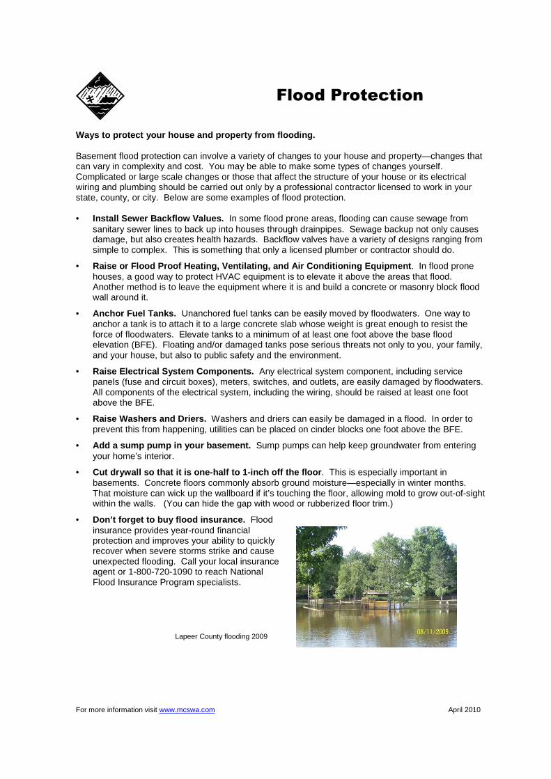
Lapeer County flooding 2009

For more information visit www.mcswa.com April 2010
1 Is flood damage covered by my homeowners insurance?
Flood damage is excluded in nearly all homeowners and renters insurance policies but, if desired, can be purchased as a separate policy.
2 Where do I get flood insurance?
Any licensed property/casualty insurance agent can sell a flood insurance policy. If you experience trouble in locating an agent, contact the National Flood Insurance Progam’s (NFIP) agent referral program at 1-888-CALL FLOOD.
3 Is there a waiting period before my flood insurance policy becomes effective?
There is a 30-day waiting period before a new or modified flood insurance policy becomes effective. 4 Are all flood insurance policies the same?
Flood insurance coverage can be purchased for homes and businesses – separate coverage must be purchased for the building and its contents.
5 Do I need to live in a floodplain to get flood insurance?
You do not need to live in a floodplain to purchase flood insurance – coverage is available to any building located in a community that has qualified for the National Flood Insurance Program. For a listing of Michigan communities participating in the NFIP, you may visit www.fema.gov/fema/csb.shtm.
6 Is water back up in basements covered by a flood insurance policy?
Coverage for water back up in basements (drains/sewers) is excluded from the flood insurance policy.
7 Can I get coverage for water back up in basements?
Although basement water back up is excluded under most homeowners’ insurance policies, coverage can be obtained by purchasing an endorsement. Most insurance companies offer sewer and drain back up as optional coverage. Coverage and limits vary by insurance company, so check with your agent/company about specifics. Some insurers include full coverage for sump pump failure while others specify items that are covered.
8 Are there steps I can take to minimize losses from water back up in basements?
• Never store perishables or valuables in basements that you can’t afford to lose or replace. • Do not store any item near basement drains. • Check storm drain lines to make sure they’re clear of debris, roots, etc. • Grade the property around your home to drain water away from it. • Install gutters and make sure downspouts are extended away from the foundation in order to
carry water away from the basement walls. • Use shelving or store items several inches above the potential water level in order to prevent
loss. • If you do have water seepage following storms, take corrective measures to alleviate problems
in the future.
Flood Insurance
For more information visit www.mcswa.com April 2010
Lightning can provide a spectacular display of light on a dark night, but this awesome show of nature can also cause death and destruction. Lightning is the visible discharge of electrical energy. It is often accompanied by thunder, which is a sonic boom created by the same discharge. If you hear thunder, lightning is a threat, even if the storm seems miles away and the sky is blue. The electrical energy from lightning seeks a path to the ground – your home, the trees in your yard, or even you can be the chosen path! SAFETY TIPS 1. Plan your evacuation and safety measures. At the first sign of lightning or thunder, activate your
emergency plan. Lightning often precedes rain, so do not wait for the rain to begin before suspending activities. No place is absolutely safe from lightning; however, some places are much safer than others. The safest location during lightning activity is a large enclosed building. The second safest location is an enclosed metal topped vehicle, but NOT a convertible, bike, or other topless or soft top vehicle.
2. If outdoors, get inside a suitable shelter IMMEDIATELY ! Your only safe choice is to get to a safe
building or vehicle. If you enjoy outdoor activities and find yourself in a place where you cannot get to a safe vehicle or shelter, outdoor safety tips are available at www.lightningsafety.noaa.gov/outdoors.htm. Although these tips will not prevent you from being hit, they can HELP lessen the odds.
3. If indoors, avoid water, doors and windows, and using the telephone and headsets. Turn off,
unplug, and stay away from appliances, computers, power tools, and TVs. Lightning could strike exterior wires, inducing shocks to inside equipment.
4. Suspend activities for 30 minutes after the last observed lightning or thunder. 5. Injured persons do not carry an electrical charge and can be handled safely. Apply First Aid
procedures to a lightning victim if you are qualified to do so. Call 911 or send for help immediately. 6. Know Your Emergency Telephone Numbers!
For additional information visit NOAA’s lightning safety web site: www.lightningsafety.noaa.gov
Lightning Safety
For more information visit www.mcswa.com April 2010
The following information, prepared by the Humane Society of the United States, will help you become better prepared to care for your pets in a disaster or emergency. Don’t Forget Identification • Your pets should be wearing up-to-date identification at all times. • In addition to your phone, include the phone number of a friend or relative outside of your
immediate area. If your pet is lost, you want to provide a number on the tag that will be answered even if you are away from your home.
Find a Safe Place Ahead of Time • Don’t wait until a disaster strikes to do your research. • Evacuation shelters do not generally accept pets, except for service animals, so plan ahead to
ensure your family and pets will have a safe place to stay. • If you have more than one pet, you may have to prepare to board them separately. Make a list of
boarding facilities and veterinary offices that might be able to shelter animals including 24-hour telephone numbers.
• Ask your local animal shelter if it provides foster care or shelter for pets during an emergency. Shelters have limited resources so this should be your last resort.
• Contact hotels and motels outside of your immediate area to check policies on accepting pets. Ask about any restrictions on number of animals, size and species, as well as whether a “no pet” policy would be waived during an emergency.
• Make a list of pet-friendly places and keep it handy. Call ahead for a reservation as soon as you think you might have to leave your home.
• Check with friends, relatives or others outside of your immediate area. Ask if they would be able to shelter you and/or your animals, if necessary.
If You Evacuate, Take Your Pets • The single most important thing you can do to protect your pets if you evacuate is to take them
with you. If it’s not safe for you to stay in the disaster area, it’s not safe for your pets. • Animals left behind in a disaster can easily be injured, lost or killed. • Animals left inside your home can escape through storm-damaged areas, such as broken
windows. • Animals turned loose to fend for themselves are likely to become victims of exposure, starvation,
predators, contaminated food or water, or accidents. • Do not leave your animals tied or chained outside during a disaster; this can be deadly. • If you leave, even if only for a few hours, take your animals. You have no way of knowing if you
will be allowed back into the area. • Leave early; don’t wait for a mandatory evacuation order. An unnecessary trip is far better than
waiting too long in order to leave safely with your pets. In Case You’re Not Home • An evacuation order may come, or a disaster may strike, when you’re at work or out of the house.
Make arrangements well in advance for a trusted neighbor to take your pets and meet you at a specified location.
• If you arrange for someone to take your pets, be sure the person is comfortable with your pets, knows where your animals are likely to be, knows where your disaster supplies are kept and has a way to access your home.
• If you use a pet sitting service, discuss the possibility of their assistance well in advance.
Pet Preparedness
For more information visit www.mcswa.com April 2010
NOAA Weather Radio All Hazards
NOAA Weather Radio All Hazards is a service provided by the National Weather Service (NWS). It provides continuous broadcasts of the latest weather information and forecasts from your local NWS office. NOAA Weather Radio All Hazards broadcasts important forecast and warning information as quick as possible. With NOAA Weather Radio All Hazards, you will always have access to potentially life-saving emergency information. During severe weather, NWS personnel can interrupt routine weather broadcasts and insert warning messages concerning immediate
threats to life and property. A special alert tone can also be activated that triggers an alerting feature on specifically equipped receivers. In the simplest case, this signal activates audible or visual alarms indicating that an emergency condition exists within the broadcast area of the station. In the most sophisticated alerting system, receivers equipped with Specific Area Message Encoding (SAME) technology allow listeners to choose which counties and for what events their radio will sound an alarm for when official NWS watches and warnings are issued. NOAA Weather Radio All Hazards broadcasts warning and post-event information for all types of hazards, both natural and technological. Working with other federal and local agencies, NOAA Weather Radio is an “all hazards” radio network. This makes NOAA Weather Radio All Hazards the single source for the most comprehensive weather and emergency information available to the public. NOAA Weather Radio All Hazards is the voice of the NWS and is provided as a public service by the U.S. Department of Commerce’s National Oceanic and Atmospheric Administration (NOAA). These life saving receivers, that should be as common as home smoke detectors, can be purchased at many retail stores and through mail order catalogues including Internet web sites that sell electronic merchandise. It provides the timeliest forecast and warning information from your servicing NWS office. This information can save your life! Please take the time to learn more about NOAA Weather Radio All Hazards. More information is available from your local NWS office and through the Internet at the National Weather Service’s NOAA Weather Radio All Hazards web site at www.nws.noaa.gov/nwr.
For more information visit www.mcswa.com April 2010
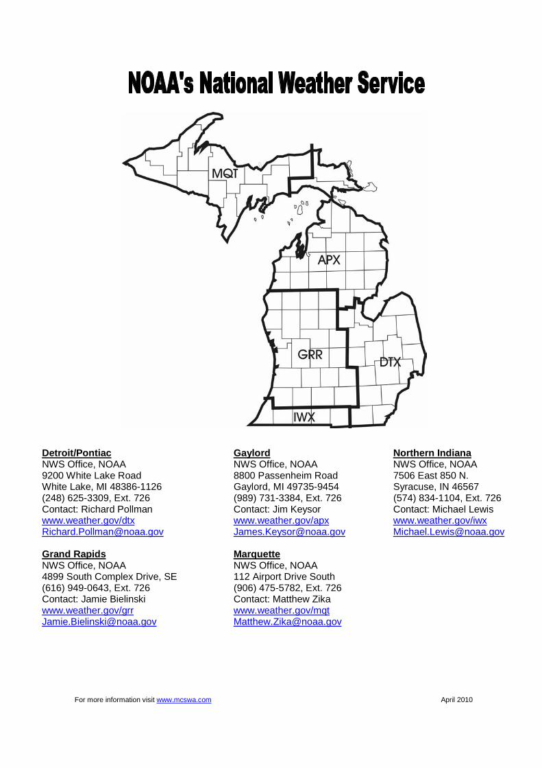
Detroit/Pontiac Gaylord Nort hern Indiana NWS Office, NOAA NWS Office, NOAA NWS Office, NOAA 9200 White Lake Road 8800 Passenheim Road 7506 East 850 N. White Lake, MI 48386-1126 Gaylord, MI 49735-9454 Syracuse, IN 46567 (248) 625-3309, Ext. 726 (989) 731-3384, Ext. 726 (574) 834-1104, Ext. 726 Contact: Richard Pollman Contact: Jim Keysor Contact: Michael Lewis www.weather.gov/dtx www.weather.gov/apx www.weather.gov/iwx [email protected] [email protected] [email protected] Grand Rapids Marquette NWS Office, NOAA NWS Office, NOAA 4899 South Complex Drive, SE 112 Airport Drive South (616) 949-0643, Ext. 726 (906) 475-5782, Ext. 726 Contact: Jamie Bielinski Contact: Matthew Zika www.weather.gov/grr www.weather.gov/mqt [email protected] [email protected]