Embed Size (px)
Citation preview
Lee State Park
Forest Lk
Lk Robinson
Prestw
ood Lk
Great P
ee D
ee Riv
F lat
Crk
Hurricane Br
Seaboard Coast Line RR
Seaboard Coast Line RR
Sea
boar
d C
oast
Lin
e R
R
Seaboard Coast Line RR
Sc Central
RR
Sea
boar
dCoa
st L
ine
RR
Seaboard Coast Line RR
Seab
oard
Coast Line R
R
103
106
111
113
104
108
115
116
102
110
112
114
101
109
105
107
LEE 061
FLORENCE 041
DA
RLING
TO
N 031
LEE 0
61
DA
RLIN
GTO
N
031
F
LORE
NC
E 04
1
MARLBORO 069DA RLINGTON 031CHEST ERFIELD 025
DAR L INGTON 031
LEE 06
1
SUM
TER 0
85
FLORENCE 041
LEE
061
LEE 061
CH
ESTER
FIELD 025
MA
RLB
OR
O 0
69
CH
EST
ERFI
ELD
025
Lydia 43135
NorthHartsville
51145
Lynchburg 43360
McBee 43495
Blenheim 06850
Florence 25810
Quinby 58795
Timmonsville 71980
Patrick 54925
Bishopville 06310
Society Hill 67435
Darlington 18565
Hartsville32560
Lamar 39805
95
20
9520
95
20
Pine
cone
Ln
Easler
Rd
WBobo Newsom
Hwy
Pintail Rd
Sal
ly
Hill
Rd
Runn
ing
Broo
k R
d
Fish
erm
an R
d
Pecan
Grove Rd
Wachovia
Hills Dr
AprilDr
Savanna Rd
E Carolina Ave
Pim FarmsRd
W
indham Town Rd
Mas
on L
n
Swamp Fox Dr
Pond Hollow Rd
Lora nsD
r
Curtis
Dr
Corporation Rd
Grace
Valley Rd
Hone
ydew
Rd
Cen t erville Rd
N Rolling Rd
Va dies Ci r
Blackbear
Rd
Harts
ville
Hwy
Pecan
Dr
Brooks Dr
BelleVue Dr
Penn
Rd
Buc
kRe
ynol
ds R
d
Cott
onflo
wer
Rd
Pine S
t
Mocking birdSt
Blair Rd
Peters Ln
CountyAirport Rd
Blue Mist Dr
Green Street Rd
Copeland Rd
Mahlon
St
Faith
Rd
Oak
Stum
p R
d
Geechie
Dr
Substat
ionRd
Stuc
key B
ottom
R d
S C
harle
ston
Rd
Bellview
Rd
LadysLn
BlueSt
Dovesville Hwy
Owl Cir
Amber Ln
Seminole
Dr
Broo
kwoo
d
Dr
BaysideR
d
N Ch
arle
ston
Rd
Mount O
livet
Rd
Wheeler
Siding Rd
Country Side Dr
D ivinity Rd
Arr owhead Rd
Stud
ebak
er D
r
RussellRd
R osa lee Dr
Bethea Rd
Jac
ks Bran
ch
Rd
Philadelphia St
Kelleybelle
Rd
Clyde Rd
HeyVic
Ln
Burnt Branch Rd
Hill
Cree
k Rd
Cinnamon Creek Rd
Jef fries Creek Rd
Gum Cir
E St Paul Rd
Melw
ood Rd
Blair R d
E Home Ave
Wag
on Rd
Trimble Rd
E Lydia Hwy
Comm
anchee St
Blaz ing Trl
Mou
ntB
erea
Rd
Than
kYo
u Bl
vd
Wilk
inson
Ln
Will
is D
r
Cana
lD
r
Bettys
Dr
Turnpike Rd
Sawye rLn
Mission
Home
Cir
Welling
Far
m R
d
Tom Brooks Dr
Bran
dy D
r
Law
son
Gro
ve R
d
Benny Hill Rd
N Sansbury Rd
HomeAveLo
g C
abin
Rd
Quail Point Rd
Vapor Rd
Timberlake Dr
Halfmile Rd
Abbott Rd
ElissaDr
Meander Dr
Hollybush Rd
Evander Dr
Newber ry
Rd
Resting Place Dr
Middle B
ranch Rd
Oates Hwy
Lide S
prings Rd
Swin
ton
Ln
Hartland Dr
Rasberry Ln
Sant
eeRi
ver
Dr
D
Ave
Misty
Bend Rd
Aaron
Rd
Cherry Grove Rd
M
elvinRd
Club Dr
SouthboroughRd
Kalber D
r
Jeffords Rd
Hibiscus Rd
N Main
St
S Main
St
Persimm
ons Dr
Clyde School Rd
Mill Branch Rd
Pocket Rd
Tobacc
o Rd
New
Hope
well R
d Old Florence Rd
Pit R
d
Gandy Siding Rd
Heathwood D
r
Seve
n Br
idge
s Rd
Geo
r get
own
Rd
Weaver St
Carterville Hwy
N G
over
nor
Willi
ams
Hwy
Mourning Dove Ln
E Jackson St
Turkey
Run Ln
Clara Rd
Gra
ndp
a Rd
Old
M
uldrow
s Mill
Rd
Luke Dr
Fox
Hill C
t
Mainsail Dr
Coachman St
N Springville Rd
Calumet
Rd
Chur
chS
t
Sa
mpit Dr
Flatnose Rd
SandOak Dr
Plaza
Rd
Iseman Rd
CrickintreeLn
Law
son
Rd
Trem
ont
Cir
Lake
Swa
mp
Rd
1stSt
E Main S
t
S R oll ing
Rd
Auburn School Rd
Stillfork
Rd
Turn
ing
Poin
t D
r
Countr y
Manor R
d
Red
Hill
St Rainbow View Rd
Key
wes
t D
r
Blueberry St
Cricket L n
Garden St
Sandbox Rd
Hamm
er R d
Warren
St
Family Rd
E St P
aul Rd
Kers
haw
Rd
DerbyDr
Whit es Cir
Green St
Dudley
Dr
Sandbar
Rd
Ous
l eyd
ale
Rd
Cheraw Hw
y
Kelleytown Rd
Homeplace Rd
W H
orse
Bran
ch Te
r
Mel
ody
Ln
Leis
ure
Ln
Hawk Dr
Woo
d Ch
uck
Dr
Spring
woo
d D
r
Santee
Dr
Wrenfield Rd
Ever
lastin
g Br
anch
Rd
Broken
Bit Rd
Coot
ers C
rossin
g Rd
Nez Perce St
Timberline
Dr
Kelleybr
idge Rd
Woo
dstr
eam
Dr
Newman Swamp Rd
Poss
um T
rot
Rd
Davis S
t
Salt Pepper Ranch Rd
Godbold Dr
Wachovia
Bluff Dr
Hennery R
d
Amew
ood
Rd
Rio
Dr
Henry King
Rd
Rancho Rd
Nar
row
Brid
geRd
Potato House Rd
Long Marsh Rd
PeacockRow Fiel
d M
aste
r D
r
Sherrills Mill Rd
High
Poin
t Rd
Ashl
and
Rd
Underground Branch Rd
Evans Way
Bird
snes
t Rd
Burling
ton
Dr
Dove
field
Rd
Hoffmeyer Rd
E Seven Pines St
Round O Rd
Flat Creek Rd
Drew Dr
Biplan
eDr
Marcus Dr
Marie Rd
New Rd
Rum
me
ll Rd
Coun
try
Club
Rd
Arcadia St
Westover Dr
Belle
Aire St
Tol Rd
Crow
ley
Hill
Rd
Poplar Branc h Ln
Cypress
Bay Rd
Icoe L
n
Icy St
Coun
try
Squi
re R
d
Pee DeeR
CRd
Dove
tail R
d
Lazy Pines Rd
Lamar
Hwy
Leav
ensw
orth
Rd
Cana
l Rd
Rim
Rd
Pear l St
LakeDarpo Rd
Joye R
d
Andrews Mill Rd
Patri
ck H
wy
Trailwood
Dr
W S
even
Pine
s S
t
Deerfield Rd Ran
d
y
Rd
Bay Rd
Woodlawn Dr
Birc
h Dr
Fess
iona
lD
r
Gre
at C
ypre
ss R
d
Rhodes Community Rd
Ridge Rd
Lawf
ord
Rd
Tema Rd
Dewitt Cir
Black Creek Rd
Mineral
Springs Rd
Isgett Rd
Quietude Rd
Hick
sville
Rd
Deer Run
Dr
Syracuse Community Rd
W Freig
ht Rd
Cherrywood Rd
W Lynches River Rd
Harley Cir
Coggeshall Rd
Han
naHy
man
Rd
Chris
tmas
Tree
Rd
Sunset Dr
E Lynches River Rd
Hannah Pond Rd
River Bend Dr
Sparr
owSw
amp
Rd
W Lydia
Hwy
Tolson Rd
PressleyAve
MurrayHill Rd
Cedar Ridge Rd
Sund
ay R
d
FieldPond Rd
Branhams
Airport Rd
Hey Vic Ln
Possu
m
Bay Rd
Gilchrist Rd
Quiet Brook Rd
Lumber Rd
Aubu
rnda
le Dr
Long Branch Rd
Governor Run Dr
High
Hill
Rd
Joja
Rd
W St Paul Rd
April Dr
Merrifield
Dr
P lumfield Rd
HoffmanRd
Mist
ywoo
d Dr
Atki
nson
Fa
rms
Rd
Zion
Rd
S Railroad
Ave
King
ston
Dr
Mai
n St
For k
Rd
BuckholtsCreek Rd
Viclif f
Rd Candy Ln
Point View Dr
Journeys End Rd
Lee State Park Rd
Beav
erdam
Dr
Oleander Dr
Rosenwald Rd
W Smith
Ave
Nursery Rd
Kin g Dr
Pine
fore
st L
n
Askins Rd
MacktonRdRobson
Dr
Dorla R
d
Leisu
re Rd
Lide Springs R
d
Hillcrest Rd
Shaw
Dr
Ow
en Dr
Piano Rd
Whip
poor
will
Rd
Harmony Hall Dr
Shag
gyba
rk
Ln
Bay Branch Rd
Spring
Valley Rd
Bosmith Rd
Bryant St
Mayberry Rd
Cherokee Lady St
Candleberr
y
Dr
Calvary Rd
Ashen Plantation Rd
Hudson St
Cow
Pas
ture
Rd
Horse andBuggy Dr
Danc e Dr
Goods o n Fa
rm R
d
Floyds Rd
Win
ding
Oak
s
Rd
Elmw
ood
Dr
W Horse Branc
h Trl
Back
Woods
DrLaw
Plantation
Rd
E Bobo Newsom Hwy
Sweetbr
iar Rd
Whiteh
all Ln
Hummingbird St
McC
owns Millpond Rd
Hang
ing Tree Rd
Tunnel
Rd
Knot
ty P
ine R
d Lo
afer
s Gl
ory
Rd
E BoboNewsom Hwy
Willow
tree Rd
Sky
Farm
Rd
Mayford Rd
S Sans bury Rd
Pocket S
t
Campbell Branch Rd
Bay Creek Rd
Ande
rson
Far
m R
d
Pisg
ahR
d
Woodduck Rd
Blits gel Dr
Ruby
Rd
Railroad Ave
Sp r out Rd
Lunn Rd
Bonn
ieD
r
Oleander
Dr
Bull Rd
Mineral Springs St
Roblyns
Neck Rd
Bethel Rd
Hidden
CreekRd
Kenilworth
Cir
Honeysuckle Rd
Forest Dr
Gallowaytown Rd
S 5th St
Lakeview Blvd
Bethlehem Rd
W Old Camden Rd Golf Course Rd
N 5th St
West Carolina Ave
Byrdtown Rd
Una Rd
W Washington St
Pine
dale
Dr
Jeffords Rd
Bethea Dr
Jeffords Mill Rd
Mechanicsville Hwy
Snow Hill Rd
N C
ente
r R
d
W Billy Farrow Hwy
Folly Rd
Farm
Lane
Dr
Ebenezer Rd
N Marquis
Hw
y
Powerl
ine Rd
S Mar
quis
Hwy
Harry Byrd Hwy
Wire Rd
NMain
St
Greenfield Rd
Timm
onsv
ille
Hwy
E McIver Rd
Allen Rd
Wesley Chapel Rd
Swift Creek Rd
Cros
s Sw
amp
Rd
E Billy Farrow Hwy
Flinn
s Rd
Be
llyache Branch Rd
E Old Camden Rd
Palmett
o Rd
Country
View Rd
Antioch Rd
Old Millpond Rd
S 4th St
Indian Branch Rd
W Bobo
Newsom Hwy
S Main St
Northcutt Rd
Tomahawk Rd
Society Hill Rd
S Ce
nter
Rd
14th
St
Mont Clare Rd
Rogers Rd
Cashua Ferry
Rd
New
Mar
ket
Rd
Sta
te R
d S
-13
-29
6
State Rd S-13
-346
151
145
151
38
381
102
38
145
34
102
151
102
340
151
381
38
38
102
151
1271
1400
327
327
341
196
912
34
403
51
527
154
34
52
1
1
15
1
52
401
52
15
52
15
1
1
52
76
15
15
301
401
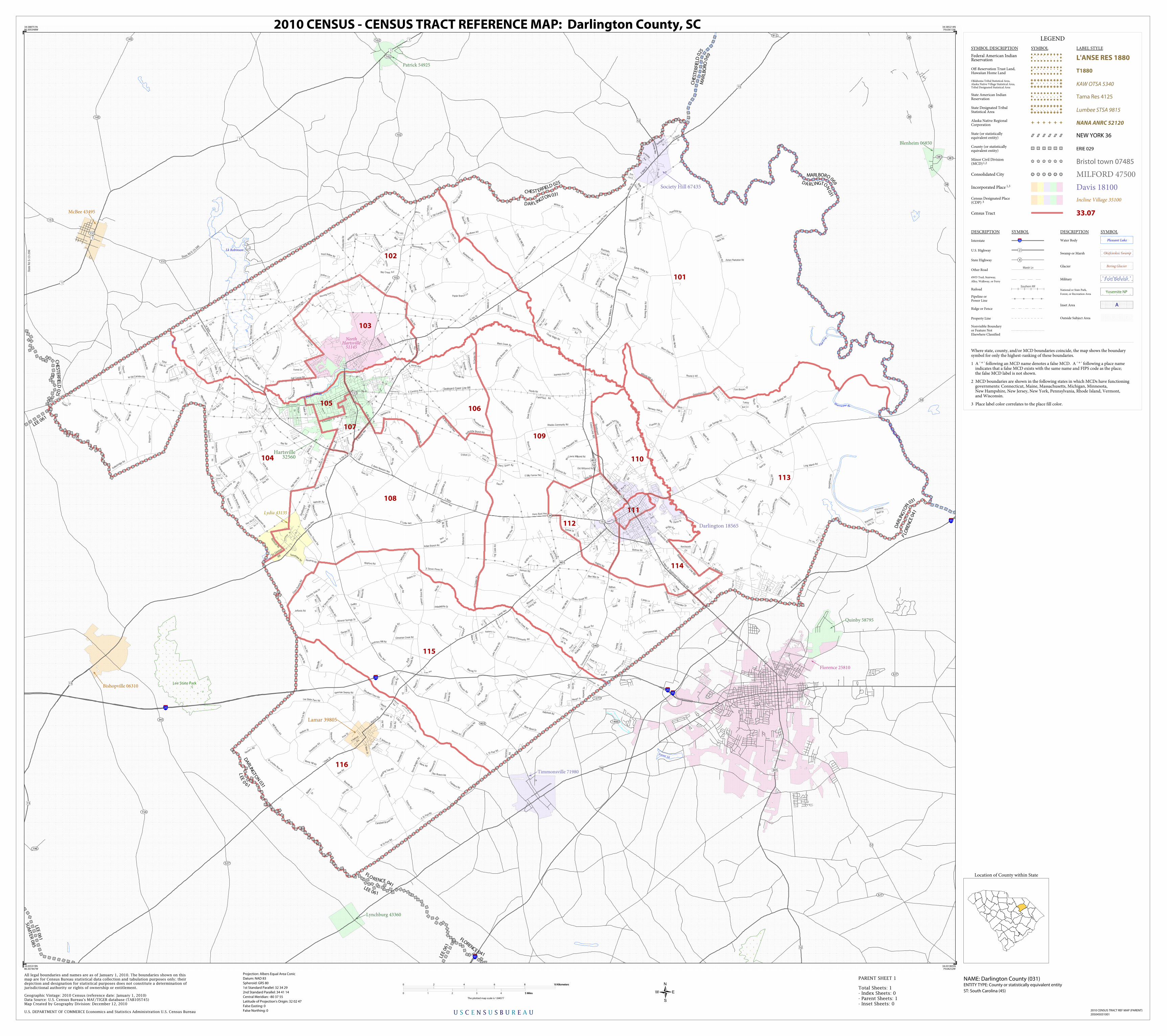
LEGEND
SYMBOL DESCRIPTION SYMBOL LABEL STYLE
Federal American IndianReservation L'ANSE RES 1880
Off-Reservation Trust Land,Hawaiian Home Land T1880
Oklahoma Tribal Statistical Area,Alaska Native Village Statistical Area,Tribal Designated Statistical Area
KAW OTSA 5340
State American IndianReservation Tama Res 4125
State Designated TribalStatistical Area Lumbee STSA 9815
Alaska Native RegionalCorporation NANA ANRC 52120
State (or statisticallyequivalent entity) NEW YORK 36
County (or statisticallyequivalent entity) ERIE 029
Minor Civil Division(MCD)1,2 Bristol town 07485
Consolidated City MILFORD 47500
Incorporated Place 1,3 Davis 18100Census Designated Place(CDP) 3 Incline Village 35100
Census Tract 33.07
DESCRIPTION SYMBOL DESCRIPTION SYMBOL
Interstate 3
U.S. Highway 2
State Highway 4
Other RoadMarsh Ln
4WD Trail, Stairway,
Alley, Walkway, or Ferry
RailoadSouthern RR
Pipeline orPower Line
Ridge or Fence
Property Line
Nonvisible Boundaryor Feature NotElsewhere Classified
Water Body Pleasant Lake
Swamp or Marsh Okefenokee Swamp
Glacier Bering Glacier
Military Fort Belvoir
National or State Park,
Forest, or Recreation AreaYosemite NP
Inset Area A
Outside Subject Area
Where state, county, and/or MCD boundaries coincide, the map shows the boundarysymbol for only the highest-ranking of these boundaries.
1 A ' ° ' following an MCD name denotes a false MCD. A ' ° ' following a place name indicates that a false MCD exists with the same name and FIPS code as the place; the false MCD label is not shown.
2 MCD boundaries are shown in the following states in which MCDs have functioning governments: Connecticut, Maine, Massachusetts, Michigan, Minnesota, New Hampshire, New Jersey, New York, Pennsylvania, Rhode Island, Vermont, and Wisconsin.
3 Place label color correlates to the place fill color.
U S C E N S U S B U R E A U
Location of County within State
34.588751N80.305348W
34.585214N79.63612W
34.031805N79.64252W
34.035319N80.307447W
All legal boundaries and names are as of January 1, 2010. The boundaries shown on thismap are for Census Bureau statistical data collection and tabulation purposes only; theirdepiction and designation for statistical purposes does not constitute a determination ofjurisdictional authority or rights of ownership or entitlement.
U.S. DEPARTMENT OF COMMERCE Economics and Statistics Administration U.S. Census Bureau
Geographic Vintage: 2010 Census (reference date: January 1, 2010)Data Source: U.S. Census Bureau's MAF/TIGER database (TAB10ST45)Map Created by Geography Division: December 12, 2010
ENTITY TYPE: County or statistically equivalent entity
NAME: Darlington County (031) Projection: Albers Equal Area Conic
Datum: NAD 83
Spheroid: GRS 80
1st Standard Parallel: 32 34 29
2nd Standard Parallel: 34 41 14
Central Meridian: -80 37 55
Latitude of Projection's Origin: 32 02 47
False Easting: 0
False Northing: 0
Total Sheets: 1- Index Sheets: 0- Parent Sheets: 1- Inset Sheets: 0
ST: South Carolina (45)
0 2 4 6 8 10 Kilometers10 Kilometers
0 1 2 3 4 5 Miles5 Miles
The plotted map scale is 1:84077
2010 CENSUS - CENSUS TRACT REFERENCE MAP: Darlington County, SC
2010 CENSUS TRACT REF MAP (PARENT)
205045031001
PARENT SHEET 1