Embed Size (px)
Citation preview
Catalogue no. 92-149-GIE
National, Census Divisions and Census Subdivisions Reference Maps, Reference Guide Census year 2006

How to obtain more information For information on the wide range of data available from Statistics Canada, you can contact us by calling one of our toll-free numbers. You can also contact us by e-mail or by visiting our website. National inquiries line 1-800-263-1136 National telecommunications device for the hearing impaired 1-800-363-7629 Depository Services Program inquiries 1-800-700-1033 Fax line for Depository Services Program 1-800-889-9734 E-mail inquiries [email protected] Website www.statcan.ca Information to access the product This product, catalogue no. 92-149-GIE, is available for free. To obtain a single issue, visit our website at www.statcan.ca and select Publications. Standards of service to the public Statistics Canada is committed to serving its clients in a prompt, reliable and courteous manner and in the official language of their choice. To this end, the Agency has developed standards of service that its employees observe in serving its clients. To obtain a copy of these service standards, please contact Statistics Canada toll free at 1-800-263-1136. The service standards are also published on www.statcan.ca under About us > Providing services to Canadians.
Statistics Canada
National, Census Divisions and Census Subdivisions Reference Maps, Reference Guide Census year 2006
Published by authority of the Minister responsible for Statistics Canada © Minister of Industry, 2006 All rights reserved. The content of this electronic publication may be reproduced, in whole or in part, and by any means, without further permission from Statistics Canada, subject to the following conditions: that it be done solely for the purposes of private study, research, criticism, review or newspaper summary, and/or for non-commercial purposes; and that Statistics Canada be fully acknowledged as follows: Source (or “Adapted from”, if appropriate): Statistics Canada, year of publication, name of product, catalogue number, volume and issue numbers, reference period and page(s). Otherwise, no part of this publication may be reproduced, stored in a retrieval system or transmitted in any form, by any means—electronic, mechanical or photocopy—or for any purposes without prior written permission of Licensing Services, Client Services Division, Statistics Canada, Ottawa, Ontario, Canada K1A 0T6. October 2006 Catalogue no. 92-149-GIE ISBN 0-662-44273-3 Frequency: occasional Ottawa Cette publication est disponible en français sur demande (no 92-149-GIF au catalogue). Note of Appreciation Canada owes the success of its statistical system to a long-standing partnership between Statistics Canada, the citizens of Canada, its businesses, governments and other institutions. Accurate and timely statistical information could not be produced without their continued cooperation and goodwill.
National, Census Divisions and Census Subdivisions Reference Maps Reference Guide, 2006 Census
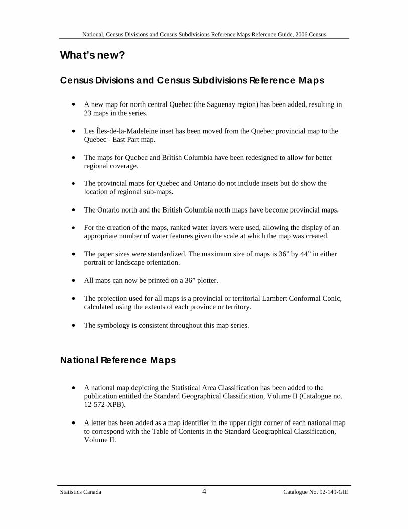
What’s new? Census Divisions and Census Subdivisions Reference Maps
• A new map for north central Quebec (the Saguenay region) has been added, resulting in 23 maps in the series.
• Les Îles-de-la-Madeleine inset has been moved from the Quebec provincial map to the
Quebec - East Part map.
• The maps for Quebec and British Columbia have been redesigned to allow for better regional coverage.
• The provincial maps for Quebec and Ontario do not include insets but do show the
location of regional sub-maps. • The Ontario north and the British Columbia north maps have become provincial maps.
• For the creation of the maps, ranked water layers were used, allowing the display of an
appropriate number of water features given the scale at which the map was created.
• The paper sizes were standardized. The maximum size of maps is 36” by 44” in either portrait or landscape orientation.
• All maps can now be printed on a 36” plotter. • The projection used for all maps is a provincial or territorial Lambert Conformal Conic,
calculated using the extents of each province or territory.
• The symbology is consistent throughout this map series. National Reference Maps
• A national map depicting the Statistical Area Classification has been added to the
publication entitled the Standard Geographical Classification, Volume II (Catalogue no. 12-572-XPB).
• A letter has been added as a map identifier in the upper right corner of each national map
to correspond with the Table of Contents in the Standard Geographical Classification, Volume II.
Statistics Canada 4 Catalogue No. 92-149-GIE
National, Census Divisions and Census Subdivisions Reference Maps Reference Guide, 2006 Census
Table of contents
What’s new? ....................................................................................................................4 Table of contents ............................................................................................................5 1. About this guide..........................................................................................................6 2. Overview ......................................................................................................................7
Introduction......................................................................................................................... 7 Purpose of the product ....................................................................................................... 7
3. About this product ......................................................................................................8 Content ............................................................................................................................... 8 General methodology ......................................................................................................... 8 Reference date ................................................................................................................... 9 Comparison to 2001 Census Divisions and Census Subdivisions Maps........................... 9 Limitations........................................................................................................................... 9 Recommended applications ............................................................................................... 9
4. Data quality................................................................................................................10 Lineage............................................................................................................................. 10 Positional accuracy........................................................................................................... 11 Attribute accuracy............................................................................................................. 11 Logical consistency .......................................................................................................... 12 Completeness................................................................................................................... 12
Appendix A: Glossary...................................................................................................13 Appendix B: Hierarchy of geographic areas ..............................................................20 Unrestricted use licence agreement for Statistics Canada’s 2006 National, Census Divisions and Census Subdivisions Reference Maps...............................................21
Statistics Canada 5 Catalogue No. 92-149-GIE
National, Census Divisions and Census Subdivisions Reference Maps Reference Guide, 2006 Census
1. About this guide This reference guide was prepared to accompany individual province and territory maps from the 2006 Census Divisions and Census Subdivisions (CD/CSD) Reference Map series. The 23 individual provincial and territorial maps depict census subdivisions, census divisions, census metropolitan areas and census agglomerations. An index map is also included to show the area covered by each map. This guide also provides information on five national reference maps showing census divisions, census divisions and economic regions, census metropolitan areas and census agglomerations and Statistical Area Classification. The entire series of maps is available in a single publication, entitled the Standard Geographical Classification, Volume II (Catalogue no. 12-572-XPB). The publication includes an index map, four national maps and 23 maps covering the provinces and territories. This reference guide describes the map content the general methodology used to create the maps and provides information about data quality. Geographic terms and concepts are briefly defined in the glossary of terms in Appendix A. More details can be found in the 2006 Census Dictionary (Catalogue no. 92-566-XWE, available March 2007). Supplementary information is provided in the appendices. This data product is provided ‘as-is,’ and Statistics Canada makes no warranty, either express or implied, including but not limited to, warranties of merchantability and fitness for a particular purpose. In no event will Statistics Canada be liable for any direct, special, indirect, consequential or other damages, however caused.
Statistics Canada 6 Catalogue No. 92-149-GIE
National, Census Divisions and Census Subdivisions Reference Maps Reference Guide, 2006 Census
2. Overview Introduction Census data are disseminated for a variety of geographic areas ranging from the national level down to the highly detailed dissemination block level. Appendix B shows the hierarchy of geographic areas and indicates whether they are administrative or statistical. The administrative hierarchy includes census subdivisions, census divisions and provinces and territories. Statistics Canada established the Standard Geographical Classification (SGC) to organize these three types of geographic areas using a hierarchy of geographic codes. Reference maps depict the boundaries of these geographic areas and help users put census data in a spatial context. The Census Divisions and Census Subdivisions Reference Map series presents census divisions and census subdivisions for all provinces and territories and also displays census metropolitan areas and census agglomerations. The Census Divisions and Census Subdivisions Reference Maps are available separately in portable document format (PDF) or as a "print-on-demand" paper product. In the 10 provinces and three territories that make up Canada, there are 288 census divisions and 5,418 census subdivisions defined as well as 33 census metropolitan areas and 111 census agglomerations for the 2006 Census. As well, the national maps are available in PDF for census divisions, census metropolitan areas and census agglomerations, Statistical Area Classification and census divisions and economic regions. There are 76 economic regions defined for the 2006 Census. All maps are available through catalogue number 12-572-XWE. All 28 of these reference maps have been packaged for sale as a publication entitled Standard Geographical Classification, Volume II. The Standard Geographical Classification publication includes an index map, a census division map, census divisions and economic region map, a census metropolitan area and census agglomeration map, a Statistical Area Classification map and 23 maps covering the provinces and territories. This publication will be available in January 2007. Purpose of the product The National, Census Divisions and Census Subdivisions Reference Maps are published to provide a high level spatial reference for census data, enabling users to locate boundaries and relate census data to actual physical locations.
Statistics Canada 7 Catalogue No. 92-149-GIE
National, Census Divisions and Census Subdivisions Reference Maps Reference Guide, 2006 Census
3. About this product Content The maps in this series include 23 large scale maps by province and territory and five smaller scale overview maps of Canada. The first overview map is an index map that shows the areas covered by each provincial or territorial map. It may be used as a quick reference to determine the correct map number(s) for the area(s) of interest. The second overview map, illustrating the country’s 288 census divisions, presents a numerical and alphabetical list of the census divisions by province or territory. The third overview map shows the location (as dots) of the census metropolitan areas and census agglomerations across Canada. This map is designed to give a general idea of where census metropolitan areas and census agglomerations are situated within a province or territory, with large dots designating census metropolitan areas and smaller dots designating census agglomerations. It also includes a numerical and alphabetical list of the census metropolitan areas and census agglomerations by province or territory. The fourth overview map shows the Statistical Area Classification, consisting of the largest urban centres (33 census metropolitan areas and 111 census agglomerations) and their influence on census subdivisions located outside of these urban centres. Census subdivisions are classified according to the percentage of residents travelling to an urban core to work. The fifth overview map shows the census divisions and economic regions within each province and territory. This is accompanied by a legend which lists the economic regions and their component census divisions in numerical order. The 23 maps for the provinces and territories show census division and census subdivision boundaries. Census divisions are labelled with their code. Census subdivisions are labelled with their name, type and code. These maps include, where applicable, the boundaries and codes for census metropolitan areas and census agglomerations. A list of the census division and census metropolitan area/census agglomeration names and codes (in numerical and alphabetical order) is displayed in the legend. The maps in this series are designed to permit users to identify the general location and boundaries of geographic areas. They are not intended to serve as detailed legal or cadastral representations of the geographic areas shown. General methodology The Census Divisions and Census Subdivisions Reference Maps were generated from digital geographic files using ArcGIS® Version 9.1 geographic information systems (GIS) software produced by Environmental Systems Research Institute (ESRI). The vector base map information (coastlines, rivers, and lakes) was taken from the National Geographic Database (NGD). Water toponymy (river names, lake names, names of bays, oceans, gulfs, straits, seas, islands, etc.) was taken from the Canadian Geographical Names Data Base (CGNDB) maintained by Natural Resources Canada. United States of America political boundaries and state names and other international features were taken from the North American
Statistics Canada 8 Catalogue No. 92-149-GIE
National, Census Divisions and Census Subdivisions Reference Maps Reference Guide, 2006 Census
Atlas, available via the GEOGRATIS website (www.geogratis.ca). The boundary and attribute information was taken from Statistics Canada’s Spatial Data Infrastructure (SDI). For further details about the methodology used to produce the maps, refer to Section 4 on Data quality. Reference date Names, boundaries and other attributes of geographic areas change frequently (for example, municipal amalgamations, annexations, and name and status changes). Since the geographic framework is used for census data collection, the geographic reference date must be set sufficiently in advance of Census Day to permit all changes to be processed in time. Furthermore, notification of these changes is normally not received from the applicable federal and provincial authorities until after the changes have occurred. For these reasons, the 2006 Census reports data according to the geographic areas that are in effect on January 1, 2006, provided that Statistics Canada receives the information on the changes by March 1, 2006. Comparison to 2001 Census Divisions and Census Subdivisions Maps While the look of the maps in this series closely resembles that of the 2001 series, several maps were redesigned to allow for easier label recognition. The maps for the provinces of Quebec and British Columbia were almost completely redesigned for the 2006 series. Locator maps were included on all provinces which required more than one map. Cartographic enhancements to the 2006 series include the use of a ranked hydrographic layer from the National Atlas of Canada reconciled to the 2006 census division/census subdivision boundaries and linked to toponymy from the "Concise Gazetteer of Canada". The use of the ranked hydrographic features means that as the map scales vary, so do the number of hydrographic features, resulting in a more legible map. Limitations The maps should not be used for digitizing purposes or to determine the precise location of boundaries. They are not intended to serve as a detailed legal or cadastral representation of the geographic areas. Recommended applications The maps are designed to enable users to identify the relative location and boundaries of the geographic areas reported in 2006 Census data publications and to visualize the relationships of the geographic areas shown in the geographic hierarchy.
Statistics Canada 9 Catalogue No. 92-149-GIE
National, Census Divisions and Census Subdivisions Reference Maps Reference Guide, 2006 Census
4. Data quality Spatial data quality elements provide information on the fitness-for-use of a spatial database by describing why, when and how the data are created, and how accurate the data are. The elements include an overview describing the purpose and usage, as well as specific quality elements reporting on lineage, positional accuracy, attribute accuracy, logical consistency and completeness. This information is provided to users for all spatial data products disseminated for the census. Lineage Describes the history of the spatial data, including descriptions of the source material from which the data were derived, and the methods of derivation. It also contains the dates of the source material, and all transformations involved in producing the final map products.
Source materials Census division and census subdivision names, types, codes and boundaries are those that were in effect on January 1, 2006 (the geographic reference date of the 2006 Census). Where notification from provincial or territorial authorities was not received or was received after March 1, 2006, the name, type and/or limits of the census division and census subdivision may not correspond with those recognized by provincial or territorial authorities. The vector base map information (coastlines, rivers, and lakes) was taken from the National Geographic Database. Water toponymy (river names, lake names, names of bays, oceans, gulfs, straits, seas and islands) was taken from the Canadian Geographical Names Data Base. U.S.A. political boundaries, state names and other international features were taken from the North American Atlas, available via the GEOGRATIS website. The map projection for all maps is Lambert Conformal Conic with different parameters for each province and territory. The latitude/longitude graticule was generated using ArcGIS® Version 9.1 software. The geographic area boundaries, names, codes, and the relationships among the various geographic levels are found on Statistics Canada’s Spatial Data Infrastructure (SDI). These data for administrative areas are updated intercensally using information from provincial and territorial sources. These data for statistical areas are updated using the results of the previous census, as well as input from users. Method of derivation The Census Divisions and Census Subdivisions Reference Maps were generated from digital geographic files using ArcGIS® Version 9.1, a geographic information system (GIS) software produced by Environmental Systems Research Institute (ESRI). As for hydrography, ranked water layers were used, allowing for display of an appropriate amount of water features given the map scale.
Statistics Canada 10 Catalogue No. 92-149-GIE
National, Census Divisions and Census Subdivisions Reference Maps Reference Guide, 2006 Census
The National Reference Maps were generated from digital geographic files using ArcGIS® Version 9.1, a geographic information system (GIS) software produced by Environmental Systems Research Institute (ESRI).
Positional accuracy Refers to the absolute and relative accuracy of the positions of geographic features. Absolute accuracy is the closeness of the coordinate values in a dataset to values accepted as or being true. Relative accuracy is the closeness of the relative positions of features to their respective relative positions accepted as or being true. Descriptions of positional accuracy include the quality of the final product after all transformations. The Spatial Data Infrastructure is not GPS compliant. However, every possible attempt is made to ensure that the geographic area boundaries maintained in the Spatial Data Infrastructure (SDI) respect the limits of the administrative entities that they represent (e.g. CD and CSD) or on which they are based (e.g. CMA/CA). The positional accuracy of these limits is dependent upon source materials used by Statistics Canada to identify the location of limits. In addition, due to the importance placed on relative positional accuracy, the positional accuracy of other geographic data (e.g. road network data and hydrographic data) that is stored within the Spatial Data Infrastructure is considered when positioning the limits of the geographic areas. Initial text placement of labels for census divisions, census metropolitan areas and census agglomerations and census subdivisions was automated. Interactive editing was then performed to enhance label placement. The national map showing the location of the census metropolitan areas and census agglomerations across Canada was produced using point symbols that were interactively positioned to portray the urban centres’ proximity to major hydrographic features and the Trans-Canada Highway. Attribute accuracy Refers to the accuracy of the quantitative and qualitative information attached to each feature (such as population for an urban area, street name, census subdivision name, type and code). As noted under lineage, the attributes (names, types and codes) for all geographic areas displayed on the maps were sourced from the Spatial Data Infrastructure (SDI). The names and types for administrative geographic areas have been updated from the 2001 Census using source materials from provincial and territorial authorities. River and lake names in the National Geographic Database were sourced from the Canadian Geographical Names Data Base. Names of water features having “pan-Canadian” significance, as identified by the Geographic Names Board of Canada (GNBC), are provided in both official languages.
Statistics Canada 11 Catalogue No. 92-149-GIE
National, Census Divisions and Census Subdivisions Reference Maps Reference Guide, 2006 Census
Logical consistency Describes the fidelity of relationships encoded in the data structure of the digital spatial data.
Internal consistency The geographic area boundaries align to the hydrographical features of the National Geographic Database water layers. The only hydrographical features that do not align to geographic area boundaries are the external features (water falling outside of national limits) derived from generalized layers. Consistency with other products Census reference maps show the location of the geographic areas for which census data are tabulated and disseminated. The main information depicted includes the boundaries, names, types and codes of census geographic areas, and major physical and cultural features such as roads, coastlines, rivers and lakes.
Completeness Refers to the degree to which geographic features, their attributes and their relationships are included or omitted in a dataset. It also includes information on selection criteria, definitions used, and other relevant mapping rules. This series contains all 288 census divisions and 5,418 census subdivisions as well as all 33 census metropolitan areas and 111 census agglomerations as defined in the 2006 Standard Geographical Classification. Names of hydrographic features and names of “pan-Canadian” significance are included if they fit on the map. The base map features selected for display on the national maps include only the major rivers and lakes and the Trans-Canada Highway.
Statistics Canada 12 Catalogue No. 92-149-GIE
National, Census Divisions and Census Subdivisions Reference Maps Reference Guide, 2006 Census
Appendix A: Glossary Adjusted counts Adjusted counts refer to previous census population and dwelling counts that have been adjusted (i.e. recompiled) to reflect current census boundaries (done when a boundary change occurs between two censuses). Block-face A block-face is one side of a street between two consecutive features intersecting that street. The features can be other streets or boundaries of standard geographic areas. Block-faces are used for generating block-face representative points, which in turn are used for geocoding and census data extraction when the street and address information is available. Cartographic boundary files Cartographic boundary files (CBFs) contain the boundaries of standard geographic areas together with the shoreline around Canada. Selected inland lakes and rivers are available as a supplementary layer. Census agricultural region Census agricultural regions (CAR) are composed of groups of adjacent census divisions. In Saskatchewan, census agricultural regions are made up of groups of adjacent census consolidated subdivisions, but these groups do not necessarily respect census division boundaries. Census consolidated subdivision A census consolidated subdivision (CCS) is a group of adjacent census subdivisions. Generally, the smaller, more urban census subdivisions (towns, villages, etc.) are combined with the surrounding larger, more rural census subdivisions in order to create a geographic level between the census subdivision and the census division. Census division Census division (CD) is the general term for provincially legislated areas (such as county, municipalité régionale de comté and regional district) or their equivalents. Census divisions are intermediate geographic areas between the province level and the municipality (census subdivision). Census metropolitan area and census agglomeration A census metropolitan area (CMA) or a census agglomeration (CA) is formed by one or more adjacent municipalities centred on a large urban area (known as the urban core). A CMA must have a total population of at least 100,000 of which 50,000 or more must live in the urban core. A CA must have an urban core population of at least 10,000. To be included in the CMA or CA, other adjacent municipalities must have a high degree of integration with the central urban area, as measured by commuting flows derived from census "place of work" data. If the population of the urban core of a CA declines below 10,000, the CA is retired. However, once an area becomes a CMA, it is retained as a CMA even if the population of its urban core population declines below 50,000. The urban areas that are located in the CMA or CA that are not contiguous to the urban core are called the urban fringe. Rural areas in the CMA or CA are called the rural fringe.
Statistics Canada 13 Catalogue No. 92-149-GIE
National, Census Divisions and Census Subdivisions Reference Maps Reference Guide, 2006 Census
When a CA has an urban core of at least 50,000 based on census population counts, it is subdivided into census tracts. Census tracts are maintained for the CA even if the population of the urban core subsequently falls below 50,000. All CMAs are subdivided into census tracts. Census metropolitan area and census agglomeration influenced zone The census metropolitan area and census agglomeration influenced zone (MIZ) is a concept that geographically differentiates the area of Canada outside census metropolitan areas (CMAs) and census agglomerations (CAs). Census subdivisions outside CMAs and CAs are assigned to one of four categories according to the degree of influence (strong, moderate, weak or no influence) that the CMAs or CAs have on them. Census subdivisions (CSDs) are assigned to a MIZ category based on the percentage of their resident employed labour force that has a place of work in the urban core(s) of CMAs or CAs. CSDs with the same degree of influence tend to be clustered. They form zones around CMAs and CAs which progress through the categories from “strong” to “no” influence as distance from the CMAs and CAs increases. Census subdivision Census subdivision (CSD) is the general term for municipalities (as determined by provincial legislation) or areas treated as municipal equivalents for statistical purposes (for example, Indian reserves, Indian settlements and unorganized territories). Census tract Census tracts (CTs) are small, relatively stable geographic areas that usually have a population of 2,500 to 8,000. They are located in census metropolitan areas (CMAs) and in census agglomerations (CAs) with an urban core population of 50,000 or more in the previous census. A committee of local specialists (for example, planners, educators, and health and social workers) initially delineates CTs in conjunction with Statistics Canada. Once a CMA or CA has been subdivided into census tracts, the census tracts are maintained even if the urban core population subsequently declines below 50,000. Coordinate system A coordinate system is a reference system based on mathematical rules for specifying positions (locations) on the surface of the earth. The coordinate values can be spherical (latitude and longitude) or planar (such as the Universal Transverse Mercator). Cartographic boundary files, road network files, digital boundary files and representative points are disseminated in latitude–longitude coordinates. Datum A datum is a geodetic reference system that specifies the size and shape of the earth, and the base point from which the latitude and longitude of all other points on the earth’s surface are referenced. Designated place A designated place (DPL) is normally a small community or settlement that does not meet the criteria established by Statistics Canada to be a census subdivision (an area with municipal status) or an urban area.
Statistics Canada 14 Catalogue No. 92-149-GIE
National, Census Divisions and Census Subdivisions Reference Maps Reference Guide, 2006 Census
Designated places are created by provinces and territories, in cooperation with Statistics Canada, to provide data for submunicipal areas. Digital boundary files Digital boundary files (DBFs) portray the boundaries used for 2006 Census collection and, therefore, often extend as straight lines into bodies of water. Dissemination area The dissemination area (DA) is a small, relatively stable geographic unit composed of one or more dissemination blocks. It is the smallest standard geographic area for which all census data are disseminated. DAs cover all the territory of Canada. Dissemination block A dissemination block (DB) is an area bounded on all sides by roads and/or boundaries of standard geographic areas. Dissemination blocks cover all the territory of Canada. The dissemination block is the smallest geographic area for which population and dwelling counts are disseminated. Economic region An economic region (ER) is a grouping of complete census divisions (with one exception in Ontario) created as a standard geographic unit for analysis of regional economic activity. Ecumene Ecumene is a term which means inhabited land. It generally refers to land where people have made their permanent home, and to all work areas that are considered occupied and used for agricultural or any other economic purpose. Thus, there can be various types of ecumenes, each having its own unique characteristics (population ecumene, agricultural ecumene, industrial ecumene, etc.). Federal electoral district A federal electoral district (FED) is an area represented by a member of the House of Commons. The federal electoral district boundaries used for the 2006 Census are based on the 2003 Representation Order. Geocoding Geocoding is the process of assigning geographic identifiers (codes) to map features and data records. The resulting geocodes permit data to be linked geographically. Households, postal codes and place of work data are linked to block-face representative points when the street and address information is available; otherwise, they are linked to dissemination block (DB) representative points. In some cases, postal codes and place of work data are linked to dissemination area (DA) representative points when they cannot be linked to DBs, or to census subdivision representative points when they cannot be linked to DAs. Geographic code A geographic code is a number used to uniquely identify and access standard geographic areas for the purposes of data storage, retrieval and display.
Statistics Canada 15 Catalogue No. 92-149-GIE
National, Census Divisions and Census Subdivisions Reference Maps Reference Guide, 2006 Census
Geographic reference date The geographic reference date is a date determined by Statistics Canada for the purpose of finalizing the geographic framework for which census data are collected, tabulated and reported. For the 2006 Census, the geographic reference date is January 1, 2006. Land area Land area is the area in square kilometres of the land-based portions of standard geographic areas. Land area data are unofficial and are provided for the sole purpose of calculating population density. Locality Locality (LOC) refers to the historical place names of former census subdivisions (municipalities), former designated places and former urban areas, as well as to the names of other entities, such as neighbourhoods, post offices, communities and unincorporated places. Map projection A map projection is the process of transforming and representing positions from the earth’s three-dimensional curved surface to a two-dimensional (flat) surface. The process is accomplished by a direct geometric projection or by a mathematically derived transformation. The Lambert Conformal Conic map projection is widely used for general maps of Canada at small scales and is the most common map projection used at Statistics Canada. Place name Place name refers to the set of names that includes current census subdivisions (municipalities), current designated places and current urban areas, as well as the names of localities. Population density Population density is the number of persons per square kilometre. Postal code The postal code is a six-character code defined and maintained by Canada Post Corporation for the purpose of sorting and delivering mail. Province or territory Province and territory refer to the major political units of Canada. From a statistical point of view, province and territory are basic areas for which data are tabulated. Canada is divided into 10 provinces and three territories. Reference map A reference map shows the location of the geographic areas for which census data are tabulated and disseminated. The maps display the boundaries, names and codes of standard geographic areas, as well as major features, such as roads, railroads, coastlines, rivers and lakes. Representative point A representative point is a single point that represents a linear or areal feature. The point is centrally located along the linear feature and centrally located or population weighted within the areal feature.
Statistics Canada 16 Catalogue No. 92-149-GIE
National, Census Divisions and Census Subdivisions Reference Maps Reference Guide, 2006 Census
Representative points are generated for block-faces, dissemination blocks, dissemination areas, census subdivisions, urban areas, and designated places. Households, postal codes and place of work data are linked to block-face representative points when the street and address information is available; otherwise, they are linked to dissemination block (DB) representative points. In some cases, postal codes and place of work data are linked to dissemination area (DA) representative points when they cannot be linked to DBs, or to census subdivision representative points when they cannot be linked to DAs. Road network files The road network files (RNF) provide national coverage of roads as well as attribute information (for example, street names and address ranges for streets with assigned addresses). Rural area Rural areas include all territory lying outside urban areas. Taken together, urban and rural areas cover all of Canada. Rural population includes all population living in the rural fringes of census metropolitan areas (CMAs) and census agglomerations (CAs), as well as population living in rural areas outside CMAs and CAs. Spatial Data Infrastructure The Spatial Data Infrastructure (SDI), formerly known as the National Geographic Base (NGB), is an internal, maintenance database that is not disseminated externally. It contains roads, road names and address ranges from the National Geographic Database (NGD), as well as boundary arcs of standard geographic areas that do not follow roads, all in one integrated line layer. The database also includes a related polygon layer consisting of basic blocks (the smallest polygon units in the database formed by the intersection of all roads and the arcs of geographic areas that do not follow roads), boundary layers of standard geographic areas, and derived attribute tables, as well as reference layers containing physical and cultural features from the NGD (such as hydrography, railroads and power transmission lines). The SDI supports a wide range of census operations, such as the maintenance and delineation of the boundaries of standard geographic areas (including the automated delineation of dissemination blocks, dissemination areas and urban areas), and geocoding. The SDI is also the source for generating many geography products for the 2006 Census, such as cartographic boundary files and road network files. Spatial data quality elements Spatial data quality elements provide information on the fitness for use of a spatial database by describing why, when and how the data are created, and how accurate the data are. The elements include an overview describing the purpose and usage, as well as specific quality elements reporting on lineage, positional accuracy, attribute accuracy, logical consistency and completeness. This information is provided to users for all spatial data products disseminated for the census. Standard Geographical Classification The Standard Geographical Classification (SGC) is Statistics Canada’s official classification for three types of geographic areas: provinces and territories, census divisions (CDs) and census subdivisions (CSDs). The SGC provides unique numeric identification (codes) for these hierarchically related geographic areas.
Statistics Canada 17 Catalogue No. 92-149-GIE
National, Census Divisions and Census Subdivisions Reference Maps Reference Guide, 2006 Census
Statistical Area Classification The Statistical Area Classification (SAC) groups census subdivisions according to whether they are a component of a census metropolitan area, a census agglomeration, a census metropolitan area and census agglomeration influenced zone (strong MIZ, moderate MIZ, weak MIZ or no MIZ), or the territories (Northwest Territories, Yukon Territory and Nunavut). The SAC is used for data dissemination purposes. Thematic map A thematic map shows the spatial distribution of one or more specific data themes for standard geographic areas. The map may be qualitative in nature (e.g., predominant farm types) or quantitative (e.g., percentage population change). Urban area An urban area (UA) has a minimum population concentration of 1,000 persons and a population density of at least 400 persons per square kilometre, based on the current census population count. All territory outside urban areas is classified as rural. Taken together, urban and rural areas cover all of Canada. Urban population includes all population living in the urban cores, secondary urban cores and urban fringes of census metropolitan areas (CMAs) and census agglomerations (CAs), as well as the population living in urban areas outside CMAs and CAs. Urban core, urban fringe and rural fringe Urban core, urban fringe and rural fringe distinguish between central and peripheral urban and rural areas within a census metropolitan area (CMA) or census agglomeration (CA). Urban core is a large urban area around which a CMA or a CA is delineated. The urban core must have a population (based on the previous census) of at least 50,000 persons in the case of a CMA, or at least 10,000 persons in the case of a CA. The urban core of a CA that has been merged with an adjacent CMA or larger CA is called the secondary urban core. Urban fringe includes all small urban areas (with less than 10,000 population) that are located within a CMA or CA but are not contiguous with the urban core of the CMA or CA. Rural fringe is all territory that is located within a CMA or CA but is not classified as an urban core or an urban fringe.
Statistics Canada 18 Catalogue No. 92-149-GIE
National, Census Divisions and Census Subdivisions Reference Maps Reference Guide, 2006 Census
Urban population size group Urban population size group refers to the classification used in standard tabulations where urban areas are distributed according to the following predetermined size groups, based on the current census population. 1,000 to 2,499 2,500 to 4,999 5,000 to 9,999 10,000 to 24,999 25,000 to 49,999 50,000 to 99,999 100,000 to 249,999 250,000 to 499,999 500,000 to 999,999 1,000,000 and over Tabulations are not limited to these predetermined population size groups; the census database has the capability of tabulating data according to any user-defined population size group.
Statistics Canada 19 Catalogue No. 92-149-GIE
National, Census Divisions and Census Subdivisions Reference Maps Reference Guide, 2006 Census
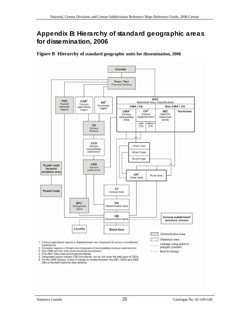
Appendix B: Hierarchy of standard geographic areas for dissemination, 2006 Figure B Hierarchy of standard geographic units for dissemination, 2006
Statistics Canada 20 Catalogue No. 92-149-GIE
National, Census Divisions and Census Subdivisions Reference Maps Reference Guide, 2006 Census
Unrestricted use licence agreement for Statistics Canada’s 2006 National, Census Divisions and Census Subdivisions Reference Maps This is a legal agreement between you, hereinafter referred to as the “Licensee,” and Her Majesty the Queen in Right of Canada (Canada) as represented by the Minister of Industry (Statistics Canada), hereinafter referred to as the “Licensor.” BY ACCESSING, DOWNLOADING, PRINTING OR USING THE DATA, INFORMATION AND MATERIALS BEING PROVIDED WITH, OR ACCESSIBLE PURSUANT TO THIS AGREEMENT, YOU ARE AGREEING TO BE BOUND BY THE TERMS OF THIS AGREEMENT. IF YOU DO NOT AGREE TO THE TERMS OF THIS AGREEMENT, YOU MUST IMMEDIATELY DISPOSE OF ANY SUCH DATA, INFORMATION, MATERIALS AND ANY DERIVED PRODUCTS. I WHEREAS the Licensor is the owner or licensee of intellectual property rights in and to
digital data contained in the database known as 2006 National, Census Divisions and Census Subdivisions Reference Maps;
II AND WHEREAS the Licensee wishes to obtain certain rights to the Data, in accordance with the terms and conditions herein contained;
III AND WHEREAS the Licensor wishes to grant to the Licensee certain rights to the Data, in accordance with the terms and conditions herein contained;
IV AND WHEREAS the Licensor represents that it has full authority to grant the rights desired by the Licensee on the terms and conditions herein contained;
V AND WHEREAS the parties hereto are desirous of entering into a licence agreement on the basis herein set forth, NOW THEREFORE, in consideration of the covenants contained in this Agreement, the parties agree as follows:
1.0 DEFINITIONS 1.1 “Agreement” means this Unrestricted Use Licence Agreement and all schedules annexed
to this agreement, as the same may be amended from time to time in accordance with the provisions hereof.
1.2 “Data” means any original and fixed digital data (i.e. that is transmitted electronically),
metadata, software or documentation licensed pursuant to the terms and conditions of this Agreement.
1.3 “Derived Products” means any product or service created from, or made functional
through, the use of all or part of the Data. 1.4 “Intellectual Property Rights” means any and all intellectual property rights recognized
by the law, including any intellectual property right protected through legislation. 1.5 “Licensor’s Data” means that Data, the Intellectual Property Rights of which vest with
the Licensor
Statistics Canada 21 Catalogue No. 92-149-GIE

National, Census Divisions and Census Subdivisions Reference Maps Reference Guide, 2006 Census
1.6 “Licensor’s Licensed Rights” means those rights conferred upon the Licensor by third parties over the use of Data which is not the Licensor’s Data.
1.7 “Modifications” means any modification, enhancement, translation, update or upgrade of
all or any part of the Data, in any medium. 2.0 INTELLECTUAL PROPERTY RIGHTS 2.1 All title and Intellectual Property Rights in and to the Licensor’s Data shall at all times
remain the property of the Licensor. All title and Intellectual Property Rights in and to the Data that is not the Licensor’s Data are the property of the respective content owners and may be protected by copyright, other intellectual property laws, common law or international treaties.
3.0 LICENCE GRANT 3.1 Subject to this Agreement, the Licensor hereby grants to the Licensee a non-exclusive,
world-wide, non-assignable, royalty-free right and licence to exercise such of the Licensor’s Licensed Rights and such of the Licensor’s Intellectual Property Rights in the Data as is necessary to use, reproduce, extract, modify, translate, further develop, distribute the Data, manufacture or cause to be manufactured and sell or license or cause to be sold or licensed Derived Products, and to sub-licence any or all of such rights, PROVIDED:
(i) all reproductions of the Data shall carry the notices and metadata information set out in section 4 hereof and the provisions contained in sections 5, to be amended in such circumstances by replacing the term “Licensor” as found in the aforementioned provisions with the Licensor’s applied title or any such designation as the Licensor may indicate; and (ii) all distribution of the Data or licensing by the Licensee of Derived Products containing the Data, and any sub-licence by the Licensee of its rights hereunder, shall be evidenced in writing, shall be on the same terms and conditions as contained herein and shall specifically include the provisions contained in sections 4, 5 and 6.2 hereof, to be amended in the circumstances by replacing in such agreements the term “Licensor” as found in the aforementioned provisions with the Licensor’s applied title or any such designation as the Licensor may indicate.
3.2 The Intellectual Property Rights arising from any Modifications or from the manufacture
of Derived Products, effected by or for the Licensee, shall vest in the Licensee or in such person as the Licensee shall decide.
4.0 ACKNOWLEDGEMENT OF SOURCE AND INCORPORATION OF
METADATA 4.1 The Licensee shall include the following notice where any of the Data is contained within
Derived Products, Source: Geography Division, Statistics Canada, 2006 National, Census Divisions and Census Subdivisions Reference Maps, 92-149-XIB
Statistics Canada 22 Catalogue No. 92-149-GIE
The incorporation of data sourced from Statistics Canada within this product shall not be construed as constituting an endorsement by Statistics Canada of such product

National, Census Divisions and Census Subdivisions Reference Maps Reference Guide, 2006 Census
or any other notice deemed appropriate by the Licensor. 4.2 The Licensee shall reproduce, include and maintain the following notice on all
reproductions of the Licensor’s Data produced pursuant to Section 3 above:
Reproduced with the permission of Statistics Canada 4.3 The Licensee shall incorporate in all reproduction and downstream distribution of the
Data all metadata included by the Licensor in the provision of the Data. 5.0 REPRESENTATIONS, WARRANTIES, INDEMNITIES 5.1 The Licensor makes no representation or warranty of any kind with respect to the
accuracy, usefulness, novelty, validity, scope, completeness or currency of the Data, at any time and from time to time, and expressly disclaims any implied warranty of merchantability or fitness for a particular purpose of the Data. The Licensor does not ensure or warrant compatibility with past, current or future versions of computer software to access the Data.
5.2 The Licensee acknowledges having received notice of the disclaimer set out above and
accepts the Data on an “as is” basis, without representations or warranties of any kind. No oral or written information or advice given by the Licensor, at any time or from time to time, shall create or evidence, or be deemed to create or evidence, a contractual representation, warranty or guarantee of any kind.
5.3 The Licensee shall have no recourse against the Licensor, its officers, directors,
employees, authorized agents and contractors, whether by way of any suit or action or other, for any loss, liability, damage or cost that the Licensee may suffer or incur at any time, by reason of the Licensee's possession or use of the Data or arising out of the exercise by the Licensee of its rights hereunder.
5.4 The Licensee shall indemnify the Licensor, its officers, directors, employees, authorized
agents and contractors from all claims whatsoever alleging loss, costs, expenses, damages or injuries (including injuries resulting in death) arising out of the Licensee’s possession or use of the Data or the exercise by the Licensee of its rights hereunder.
5.5 The Licensee’s obligation to indemnify the Licensor, its officers, directors, employees,
authorized agents and contractors, under this Agreement shall not affect or prejudice the Licensor from exercising any other rights under law.
5.6 The provisions of this Article shall survive termination of this Agreement. 6.0 TERMINATION 6.1 This Agreement may be terminated
(i) automatically and without notice, if the Licensee commits or permits a breach of any of its covenants or obligations under this Agreement; (ii) upon written notice of termination by the Licensee at any time, and such termination shall take effect thirty (30) days after the receipt by the Licensor of such notice; or
Statistics Canada 23 Catalogue No. 92-149-GIE
(iii) upon mutual agreement of the parties.

National, Census Divisions and Census Subdivisions Reference Maps Reference Guide, 2006 Census
6.2 Upon termination of this Agreement, for whatever reason, the Licensee’s rights under section 3 shall immediately cease; and all obligations of the Parties which expressly or by their nature survive termination shall continue in full force and effect subsequent to and notwithstanding such termination, until they are fully satisfied or by their nature expire. For greater clarity, but without restricting the generality of the foregoing, the following provisions survive termination of this Agreement:
- section 5 (representations, warranties, indemnities) 6.3 Notwithstanding subsections 6.1 and 6.2 above, the Licensee may continue to use the
Data for the purpose of completing orders of Derived Products made before the termination date of this Agreement
6.4 Notwithstanding the termination of this Agreement, all agreements entered into by the
Licensee in the exercise of its rights under section 3 thereof prior to such termination and all obligations imposed therein shall continue in full force and effect subject to their terms.
7.0 GENERALITIES 7.1 Applicable Law
This Agreement shall be construed and enforced in accordance with, and the rights of the parties shall be governed by, the laws of Ontario and Canada, as applicable.
7.2 Entirety of Agreement
This Agreement hereto constitute the entire agreement between the parties with respect to its subject matter. This Agreement may only be amended in writing, signed by both parties, which expressly states the intention to amend this Agreement.
7.3 Alternate Dispute Resolution
If a dispute arises concerning this Agreement, or if a proposed modification of any term of this Agreement cannot be agreed between the parties, the parties shall attempt to resolve the matter first by negotiation.
If the parties have not succeeded in negotiating a resolution, then they shall jointly submit the dispute to a mutually accepted mediator. If the parties cannot agree on an acceptable mediator, then either party may submit the dispute to binding arbitration.
The arbitral tribunal shall be governed by the UN Commercial Arbitration Code (the “Code”), referred to in the Commercial Arbitration Act, R.S.C 1985, c. C-4.6, and judgment upon the award rendered by the arbitral tribunal may be entered in any court having jurisdiction over the matter.
The arbitral tribunal shall consist of one arbitrator chosen by the parties. Subject to the Code, the parties agree that the award and determination of the arbitral tribunal shall be final and binding on both parties, shall be without right of appeal and shall be the exclusive remedy between the parties regarding any claims, counterclaims, issues or disputes presented to the arbitral tribunal.
Costs
Statistics Canada 24 Catalogue No. 92-149-GIE
The Parties shall bear the costs of the mediation equally, except that each party shall bear its own personal costs of the mediation.
National, Census Divisions and Census Subdivisions Reference Maps Reference Guide, 2006 Census
The costs of the arbitral tribunal’s fees and expenses shall be shared equally by the parties. The parties shall bear their own personal costs except that the losing party shall pay all costs, fees, levies and taxes arising from and necessitated by the enforcement of the arbitral tribunal’s award, including, without limitation, registration, enforcement charges or other judicial levies or costs
7.4 No Joint Venture
The Parties expressly disclaim any intention to create a partnership, joint venture or joint enterprise. The Parties acknowledge and agree that nothing contained in this Agreement nor any acts of any party shall constitute or be deemed to constitute the parties as partners, joint ventures or principal and agent in any way or for any purpose. No Party has the authority to act for, or to assume any obligation or responsibility on behalf of the other Party. The relationship between the Parties is intended to be, and shall at all times be construed as that of licensor and licensee.
7.5 No Waiver
No condoning, excusing or overlooking by the Licensor of any default by the Licensee, at any time or times, in performing or observing any of the Licensee’s obligations hereunder, will operate as a waiver, renunciation, surrender of or otherwise affect the rights of the Licensor in respect of any continuing or subsequent default. No waiver of these rights will be inferred from anything done or omitted by the Licensor, except by an express waiver in writing.
7.6 Order of Precedence
If there is a conflict or ambiguity between this Agreement proper and any schedules thereto, the interpretation consistent with this Agreement proper (taking into consideration the statements in the recitals and headings) shall prevail and apply, notwithstanding any wording to the contrary in the applicable schedule.
7.7 Notices
The Licensor assumes no obligation or liability whatsoever for the provision of updates to the Data or the provision of notices in relation thereto to the Licensee.
ANY USE WHATSOEVER OF THIS DATA PRODUCT SHALL CONSTITUTE YOUR ACCEPTANCE OF THE TERMS OF THIS AGREEMENT. For further information please contact:
Licensing Services Marketing Division, Statistics Canada R.H. Coats Building, 9th floor, section A Ottawa, Ontario K1A 0T6, Canada E-mail: [email protected] Telephone: 613-951-1122 Fax: 613-951-1134
© Statistics Canada, 2006
Statistics Canada 25 Catalogue No. 92-149-GIE