Embed Size (px)
Citation preview

2006 UNIT MANAGEMENT PLAN AMENDMENT
to the
2004 Unit Management Plan
Prepared By:
and
Final Environmental Impact Statement
for
WHITEFACE
Mountain Ski Center
Olympic Regional Development Authority Office of Planning & Construction and Whiteface Mountain Ski Center
July 2006
OLYMPIC: REl-::ilONAL N< w Ynru;
DE:VELL1PMENT AUTHORITY

Whiteface Mountain Ski Center 2006 Unit Management Plan Amendment
to the 2004 Unit Management Plan
and Final Environmental Impact Statement
Prepared by:
The Olympic Regional Development Authority as Lead Agency
2634 Main Street Lake Placid, New York 12946
and Whiteface Mountain Ski Center
Rte. 86 Wilmington, NY 12997
(518) 946-2223 Contact Person: Jay Rand
In Cooperation with The New York State Department of Environmental Conservation
and in consultation with The Adirondack Park Agency
Special thanks to The Vermont Institute of Natural Science
and The Wildlife Conservation Society
Address Comments To: Jay Rand, General Manager Whiteface Mountain Ski Center
Rte. 86 Wilmington, New York, 12997

EXECUTIVE SUMMARY
This 2006 Unit Management Plan (UMP) Amendment addresses trail constrnction above the elevation of 2,800 feet and the Tree Island Pod that were presented as Conceptual Items in the 2004 UMP and expands the scope of three items included and approved in the 2004 UMP.
Trail work above 2,800 feet is of particular concern due to impact on the habitat of the Bicknell's Thrnsh. Over the past three years the Olympic Regional Development Authority (ORDA) and Whiteface Mountain Ski Center staff have worked in partnership with the Vermont Institute for Natural Science, the Wildlife Conservation Society, the New York State Department of Environmental Conservation, the Adirondack Park Agency, the Adirondack Council and Audubon New York on the development of the 'Best Management Practices' for the development and maintenance of ski trails above 2800 feet. The recommendations and processes presented in this amendment are evidence of these efforts and unprecedented achievements in the quest to protect this important species.
The other three items presented in this amendment are actions that target the improvement to existing facilities and the expansion of an action approved in the 2004 UMP. The improvements to the two existing facilities have been presented in the 2004 UMP, but further study has resulted in a change in scope to these items. Improvements to Pump House # 1 are required to further mitigate the impacts of frazzle ice, to allow for necessary modification to the systems hydraulic profile and provide redundancy in the system operations. Improvements to the Easy Acres Lodge are included to provide a safe and efficient learning environment for our children visitors. The inclusion of a new staff access road from the approved Parking Lot #5 to the existing maintenance facility will allow for the appropriate separation of operational and guest services.
This 2006 UMP Amendment refers to and includes portions of the 2004 UMP where no revisions in the UMP text or mapping are required.
'fhe~~i'op'6s~ amendments will continue to ensure the responsible development in harmony with the Adirondack Forest Preserve and the regional economy.

Table of Contents
2006 Unit Management Plan Amendment to the
2004 Unit Management Plan and
Final Environmental Impact Statement
SECTION I - PROPOSED MANAGEMENT ACTIONS A. Project Description
1. Overview - Trail Construction 2. Pump House #1 Improvements 3. Easy Acres Lodge 4. Staff Access Road via Parking Lot #5
SECTION U- POTENTIAL IMPACTS AND MITIGATION MEASURES A. Trail Construction - Potential Impacts to Bicknell's Thrush Habitat
B. Trail Construction - Mitigation Measures Bicknell's Thrush Habitat)VINS Recommendations for Minimization of Project Impacts and measures to be incorporated at Whiteface Mountain for Trail Construction)
C. Potential Impacts and Mitigation Measures to Physical Resources - Trail Construction (other than Bicknell's Habitat), Pump House #1 Improvements, Easy Acres Lodge and Maintenance Access Road via Parking Lot #5.
D. Potential Impacts and Mitigation Measures to Biological Resources - Trail Construction (other than Bicknell's Habitat), Pump House #1 Improvements, Easy Acres Lodge and Maintenance Access Road via Parking Lot #5.
E. Potential Impacts Human Resources
SECTION HI - AL TERNA TES
A. Ski Trail Improvements
R Pump House #1 Improvements
C. Easy Acres Lodge
D. Staff Access Road via Parking Lot #5
SECTION IV-SUMMARY OF UNAVOIDABLE ADVERSE ENVIRONMENTAL IMPACTS
SECTION V - IRRETRIEVABLE AND IRREVERSIBLE COMMITMENT OF RESOURCES
SECTION VI -GROWTH INCLUDING, SECONDARY AND CUMULATIVE IMPACTS
SECTION vn - EFFECTS ON THE USE AND CONSERVATION OF ENERGY
2006 Unit Management Plan Amendment to the
2004 Unit Management Plan and
Final Environmental Impact Statement
List of Figures, Tables and Appendices
SECTION VIII ~ FIGURES Ski Trails • Figure F1, "Tree Island Pod configuration as Proposed in the 2004 UMP"
• Figure F2, "Proposed Trail and Lift Increase"
Pump House #1 • Figure F3, "Pump House #1 Site Plan"
• Figure F4, "Pump House #1 North Elevation"
GI Figure FS, "Pump House #1 West Elevation"
GI Figure F6, "Pump House #1 Plan View"
• Figure F?, "Pump House #1 Hydraulic Profile"
Easy Acres Lodge GI Figure F8, "Proposed Modified Existing Easy Acres Lodge Expansion"
• Figure F9, "Proposed Easy Acres Learning Center - Plan View"
• Figure F1 O,;froposed Easy Acres Learning Center - Elevations"
• Figure F11, "Proposed Overall Layout - Easy Acres Lodge - Renovation & Expansion"
• Figure F12, "Proposed Easy Acres Campus Site Plan"
Staff Access Road via Parking Lot #5
111 Figure F13, "Maintenance Area Access Road - Location Map"
• Figure F14, "Maintenance Area Access Road - Plan View"
• Figure F15, "Maintenance Area Access Road - Profile and Section"

2006 Unit Management Plan Amendment to the
2004 Unit Managen1ent Plan and
Final Environmental I111pact Statement
List of Figures, Tables and Appendices
SECTION IX - TABLES e Table T1, "Proposed Terrain Specifications"
e Table T2, "Summary of Vegetation Impacts - Tree Clearing Estimates for Proposed Management Actions"
e Table T3, "Summary of Approved and Proposed Increases in Building Area for the Easy Acres Campus"
SECTION X - APPENDICES e Appendix A 1, "Schematic Engineer's Report for Proposed Wastewater Disposal System
Improvements - Expansion to "Kids Kampus" Base Lodge Building Whiteface Ski Area"
e Appendix A2, "Generic Storm Water Pollution Prevention Plan"
@ Appendix A3, "2004 UMP Visibility Study"
e Appendix A4, "Pump House #1 and Easy Acres Lodge Visibility Study"
® Appendix A5, "Cooperative Agreement between NYSDEC and ORDA"
e Appendix A6, "Traffic Assessment"
SECTION XI - RESPONSE TO COMMENTS
SECTION XII - WRITTEN COMMENTS
SECTION XIII- ERRATA
I. PROPOSED MANAGEMENT ACTIONS
A. Project Descriptions
1. Overview - Trail Construction:
This action includes creation of the Tree Island Pod (TIP) and Lift M, New Excelsior
- Bypass, New Niagara, Lower Skyward Bypass and New Glades. This
amendment also includes discussion of the construction/maintenance of ski trails
above 2,800 feet that have been previously approved in the 1996 Unit
Management Plan (UMP) or 2001 amendment to the 1996 UMP. This document is
an amendment to the 2004 Whiteface Unit Management Plan Update - Whiteface
Mountain Ski Center Final Generic Environmental Impact Statement 2004-2009
(March 2004), also known as the 2004 Whiteface UMP Update. Page xii and xiii of
the Executive Summary of the 2004 UMP lists the status of ski trails to be
constructed as follows:
a1. "Upper Mountain - (1) The upgrade to occur on the Upper Mountain focuses on the Downhill/FIS trail homologation standards. (2) Trail 3a, Niagara, will be used to connect Upper Skyward (trail 3) to Upper Cloudspin (trail 1 ). (3) A new 9.8 acre expert glade, Trail 5a, will be constructed in the forest between Paron's Run (trail 5), Excelsior (trail 6) connector (trail 10) and Upper Cloud spin (trail 1) - Conceptual only; not a proposed action at this time ....
b1. "Little Whiteface - The addition of an intermediate trail (73/73a) from the summit of Little Whiteface -Approved under June 2001 amendment of 1996 UMP. Portions above 2,800 feet elevation will not occur until after completion of the VINS report and 2004 field study of Bicknell's Thrush ....
c1. "Little Whiteface - Selective widening to Empire (12), Upper MacKenzie (13), Upper Wilderness (15), Upper (18) and Lower Parkway (19) and Upper Thruway (20) - This action was approved in the 1996 UMP. This work is underway. Empire, Upper MacKenzie and part of Upper Wilderness above 2,800 feet elevation will not occur until after completion of the VINS report and 2004 field study on Bicknell's Thrush ....
d1. "Tree Island Pod - This new pod (74 through 83) will be established north of the Summit Quad pod. Situated around a double chair, the trail network will consist of several weaving, intertwined and interconnected narrow (40-80 foot wide) expert trails. - Conceptual only, not a proposed action at this time."
In addition, the New Excelsior- By Pass (trail 6a) was identified in Figure IV-1 of the 2004 Update as a future project and labeled as conceptual only at that time.
Figure F1 .~identifies the Tree Island Pod configuration as proposed in the 2004 UMP.
The project proposed in this amendment was considered part of the long-range
plan for Whiteface Ski Center as evidenced in the language and figure referenced
above from the approved 2004 Whiteface UMP Update. This project is in
compliance with Article XIV, Section 1 of the New York State Constitution and
other applicable laws, including the guidelines established by the Adirondack Park
1-1

State Land Master Plan (SLMP) for management and use of lands designated as
Intensive Use Areas. The trail construction activities proposed in this amendment
bring the total trail mileage at VVhiteface Mountain (WFM) to 24.02 miles, which is
below the constitutionally allowed limit of 25 miles. None of the trails to be
constructed or widened will exceed the maximum width requirements of 200 feet
and no more than 5 miles in aggregate of all trails at the Ski Center exceed of 120
feet wide as allowed by Article XIV, Section 1 of the New York State Constitution.
The number of trees to be cut in relation to the proposed activities is 15, 195 of 3~
inch to 4-inch diameter-at-breast-height (DBH) and 28,45·1 greater than 4 inches
DBH. Table T2, "Summary of Vegetation Impacts - Tree Clearing Estimates
for Proposed Management Actions".
This U~/tP amendment is a tool to present evaluation and assessment of the
project design and site-specific potential impacts within the Intensive Use
Boundaries at Whiteface Mountain Ski Center. Ski trails proposed for approval in
this Amendment are as follows:
Upper Mountain ., The upgrade to occur on the Upper Mountain focuses on the Downhill/FIS
trail homologation standards. The Niagara section of Upper Cloudspin will be widened from 120 feet to 170 feet. There will be no increase in mileage.
e Excelsior By-Pass (trail 6a) will be used as a bypass to a portion of Excelsior. [Increase = 0.057 miles].
" Lower Skyvvard By-Pass (triai 4b) wiii be used as a bypass to a portion of Lower Skyward. [0.11 miles].
Tree Island Pod @ Trails 74, 75, 76, 77, 78 and 79 and new lift [Increase= 3.73 miles]. The
lift is excluded form this mileage as it does not constitute a ski trail.
Ii A new 52-acre expert giade, Traii 80, wiii be constructed in the forest to the east of the Tree Island Pod [Increase= 0.81 miles].
Ski Trails already approved in the 1996 UMP or 2001 amendment to the 1996
UMP that are included for discussion purposes in this amendment are:
* Little Whiteface - The addition of an intermediate trail (73/73a) from the summit of Little Whiteface - Approved under June 2001 amendment of 1996 UMP. Portions above 2,800 feet elevation were not to be constructed until after completion of the VINS report and the 2004 field study of Bicknell's Thrush.
@ Little Whiteface - Selective widening to Empire (12), Upper MacKenzie (13), Upper Wilderness (15), Upper (18) and Lower Parkway (19) and Upper Thruway (20) - This action was approved in the 1996 UMP. This work is underway. Work on Empire, Upper MacKenzie and part of Upper Wilderness above 2,800 feet elevation was not to occur untii after completion of the VINS report and 2004 field study on Bicknell's Thrush.
[-2

The upgraded trail design reflects the desire to provide additional acreage at
critical locations throughout the mountain in order to improve the flow of skier
traffic, segregation of ability levels, and diversity of terrain.
Upgrades to the Upper Mountain are focused on the Downhill/Federation
Internationale de Ski (FIS) trail homologation standards and increasing skier
safety. The Niagara section of Upper Cloudspin needs to be widened for
continued homologation. A by-pass on Excelsior is needed to reduce skier conflict
during peak periods, and the by-pass on Lower Skyward is needed to allow for
better trail diversity. These trails will involve cutting balsam fir, mountain paper
birch, red spruce and mountain ash. Tree counts and species are detailed in Table
T2, 'fl!' "Summary of Vegetation Impacts - Tree Clearing Estimates for Proposed
Management Actions"
The most significant increase in skiable terrain comes from the addition of the
"Tree Island" pod. This pod will provide two expert trails and a new intermediate
trail that will have a connector trail to the new lift or allow skiers to travel to the
base of the mountain. These improvements are necessary to improve the
intermediate skiing experience at WFM. The pod's new intermediate trail system
will allow better distribution of skiers on the mountain. The new pod will be
serviced by a triple lift which will be engineered to maintain a comfortable carrying
capacity on the trail system. The pod's segregation from the existing trail network
is intended to provide an alternative to the traditional ski trail experience yet it
would also be different than the typical glade skiing experience. The main
differences are that the pod would have snowmaking and the trails would be
groomed. Additionally, the pod has been designed to have very low terrain
densities as a result of the capacity of the triple chair lift. The vegetation within the
limits of the Tl P is a combination of hardwoods and softwoods. Tree counts and
species are detailed in Table T2, "Summary of Vegetation Impacts - Tree
Clearing Estimates for Proposed Management Actions.
The new glades have been sited to the east of the Tree Island pod. This will
enhance the natural skiing experience and help maintain low densities of skiers on
I-3
the groomed trials during high attendance times. The new glades are sited in an
area that is primarily hardwoods with a low density of understory.
The attached map, Figure F2, "Proposed Trai! and Lift Increase" details the
areas described above. Additionally, Table T1, "Proposed Terrain
Specifications" provides a complete list of existing and proposed trail mileage and
other trail information and statistics.
f-4
2. Pump House #1 Improvements:
This action includes the work required to continue the mitigation of frazzle ice
impacts, mitigate pump operational problems due to a shortfall in the system's
hydraulic profile, increase water pressure to the pumping system and add
redundancy to the system's operation.
The 2004 Whiteface UMP Update (page xi of the Executive Summary) lists
Snowmaking, Water System Improvements, and PH#1 Water Pressure Increase
as necessary actions. Section IV, Part 7, Snowmaking System Upgrade Plan, f)
Water System Improvement (page IV-50) included the need to review the
challenges with the existing system. The challenges to PH#1 have been dynamic
due to the impact of the weir system and the frazzle ice.
The new proposed work to the existing PH#1 to be approved on the acceptance of
this amendment includes:
• Installation of a new pumping wet well at an elevation required by
the design hydraulic profile of the pumping system and provision of
required separation distances between pumps.
• Installation of a new pumping wet well sized for a finishing band
screen system.
• Installation of a new pumping wet well sized for a fourth pump for
redundancy to ensure operational efficiency.
@ Modifications and additions to the pump house structure that will
accommodate a hoist conveyance system, boiler system, and
upgrades to the motor control system.
@ Increase of the existing pumps' horsepower from 200 hp to 300 hp.
@ Addition of a fourth pump for redundancy to ensure operational
efficiency.
The existing wet well size and depth in Pump House #1 is not in conformance with
the pump manufacturer's minimum requirements for pump separation, offset from
chamber walls and submersed depth. These physical conditions cause vortexing
and cavatation of the pumps. To further compound the problem, the addition of the
new band screens used to mitigate the frazzle ice condition causes hydraulic head
loss, which further negatively affects the water level in the pump chamber. These
I-5

conditions put the operation of the pumps at risk during lower flow conditions and
heavy frazzle ice conditions.
Improving the mitigation measures to combat the effects of the frazzle ice is an
ongoing battle. The introduction of two band screens has been very successful to
date, but the ice still accumulates in the pumping wet well. Therefore, the new
pump chamber shall be designed to house a secondary band screen chamber and
new secondary band screens will be installed. The chamber will be positioned
between the existing screens and the proposed wet well. The media of this
secondary treatment screens will be finer than the two existing screens to ensure a
higher level of filtration.
The snowmakina season is limited <md the emiiornent in P11mn HrnisA #1 i~ -..I . .. - . ·1 - I - . ~ . . - -· ... 1- - - - - - . . . . -
operated under taxing conditions. Under the current conditions if there is a faiiure
in any of the three pumps, the capacity of the pumping operation is reduced by
one-third. This scenario became reality in January 2006. An unprecedented
pressure drop occurred due to heavy ioading of the band screen media, resulting in
a drop in the wet weli water elevation beiow the required elevation to satisfy the
pump suction operation. The result was significant damage to a pump, putting the
operational vvithdravval to 2/3 of the approved vvithdravval capacity during prime
snowmaking conditions. Therefore, it is critical that the improvements to Pump
House #1 include the addition of a fourth pump for redundancy.
Accessibility to the pumps for routine maintenance and for emergency repairs is a
vital component in ensuring the facility's reliability and staff safety. Limiting the
required access into the wet well for operation and maintenance is a critical issue
in mitigating confined space situations. The lack of egress, the dangers associated
with the wet well water depths, the temperatures of the water during the winter
season and the liabilities associated with mechanical equipment, develop a
situation that requires the wet well to be classified as a Confined Space that
requires a Confined Space Permit. In order to mitigate the liabilities associated
with confined space entry the improvements to Pump House #1 will include a hoist
I conveyor system. This hoist I conveyor system will allow staff safe access and
removal of the pumps, while reducing the need to enter a confined space.
I-6
Additionally, the expansion of Pump House #1 will allow for the installation of a hot
water boiler system. Currently a rented portable boiler system is used to provide
heated water for the band screen spray wash operation. The cost and operational
issues associated with the rented portable boiler system and significant propane
usage needs to be eliminated. The expansion of the pump house will allow for the
additional operational space needed to install a permanent boiler system, thus
allowing for the removal of the temporary portable boiler system. Furthermore, the
supply of process water for the spray wash operation will be changed from the
current process of heating 32 degree river water and utilizing closed loop
compressor cooling waters to temper the band screen spray wash system waters.
Currently, the closed loop compressor cooling waters are cooled via an
evaporation tower. The new system will employ a heat exchange that can transfer
the closed loop compressor cooling water energy to the band screen spray wash
system. This process will result in a reduced amount of propane fuel to heat the
band screen spray wash system.
Additional floor space is required for the motor control systems that will be needed
for the increased horsepower for the water withdrawal pumps. It is critical that the
pumps' horsepower be increased to a level that allows the head pressure required
for "Low Energy Snow Guns" at the upper elevations of the mountain. Currently,
Low Energy Snow Guns can only be employed at lower elevations on the
mountain. Low Energy Snow Guns are a vital component in the operational plan
for reduced electrical and diesel fuel consumption.
The location of the new pump chamber is sited to connect to the existing pump
house on the mountain side of the existing structure. During the design of the
existing screen chamber measures were employed to allow a connection to the
screen chamber in a manner that would avoid future work occurring on the river
side of the existing pump house. The pump house siding will be changed to a
rustic style siding with brown-stain.
A site plan, building plan views and elevations have been developed and are
include in this amendment. Refer to Figure F3, "Pump House #1 Site Plan'',
Figure F4, "Pump House #1 North Elevation", Figure F5, "Pump House #1 West
I-7

Elevation", Figure F6, "Pump House #1 Plan View", and Figure F7, "Pump House
#1 Hydraulic Profile".
I-8

3. Easy Acres Lodge:
The approved 2004 UMP included upgrades consisting of construction of a new
6,000 sf building on the Easy Acres campus for the SkiWee/Drop-in and the 1996
UMP included expanding the existing lodge facility to 10,580 sf. The upgrades
approved in the 1996 UMP and 2004 UMP for the Easy Acres Lodge facilities allow
the overall square footage to increase to 16,580 sf. The existing Easy Acres
Lodge will be modified to contain only food service activities. A new kitchen facility
and Americans with Disabilities Act (ADA) compliant restrooms shall be added, and
the existing nursery area shall be converted to cafeteria seating area. The
conversion of the existing building to service solely as a cafeteria will allow for the
most efficient use of resources. This strategy will reduce construction costs and
use of natural resources. The reconfiguration and modifications of the existing
Easy Acres building would increase the existing area from 9, 739 sf to 10,300 sf.
Figure F8, lfF "Proposed Modified Existing Easy Acres Lodge Expansion" provides
a conceptual layout of the proposed facility. These upgrades are within the current
approved and permitted square footage increases.
The Easy Acres main building currently supports ticketing, lesson registration,
nursery, children's assembly area, restrooms, staff lounge and lockers, food
services facilities and a cafeteria. The mixed occupancies complicate New York
State Building Code compliance. The existing arrangement of the buildings
occupancies and access are not ADA compliant. The existing facility does not
allow efficient administration of programs and guest services. In order to ensure a
safe and comfortable visitation by the ski centers guests a new rental, ticketing,
guest services, rentals, nursery and children's learning center shall be constructed.
This center will incorporate a connection to the cafeteria area via an enclosed
hallway.
The new facility would be located between the existing campus structure and the
maintenance garage. The new location would facilitate access from the student
drop-off point to the ski lift and would target keeping all guest services on one level
to better accommodate ADA and children access. A basement level would be
included for staff needs and storage. New construction will include an enclosed
walkway to link the modified existing building to the new learning center. The
enclosed walkway would provide locker space and provide views of the lift and
I-9

outrun areas. The new facility would allow for the removal of the existing temporary
yurt structures and the modular building from the Easy Acres Campus. These
temporary structures will be relocated within the Base Campus area to support the
improvement of 770 sf of locker and ticketing space and 350 sf for additional
offices, storage and conference space for administration, 336 sf of expansion of
employee lockers/lounge space approved in previous UMP's. The temporary
structures will be removed at the completion of the Base Campus improvements.
The proposed maximum square footage footprint of the new structure, including
both the iower and main levels is 37,200 sf; this estimate inciudes the connector
enclosed walkway. The total of developed area for the new building is 19,200 sf.
Table T3,1"° "Summary of Approved and Proposed Increases in Building Area for
the Easy Acres Campus", summarizes the approved and proposed development
space.
Conceptual drawings are provided for the new buildings. The new buildings will
use earth-tone colors in the siding and roofing. Traditional gable style roof system
with moderate overhangs and natural materials will be utilized to the most practical
extent possible. Final design of the Easy Acres Campus buildings may involve
rearrangement of the space utilization plan, including moving food service activities
to the new building and retaining rental, ticketing, guest services, etc in the
existing, to-be expanded building if deemed more suitable. Figure F9,
"Proposed Easy Acres Learning Center- Plan View" and Figure F10, "Proposed
Easy Acres Learning Center Elevations" provide a conceptual layout of the
pmposed facility. Figure F11, "Proposed Overall Layout - Easy Acres Lodge -
Renovation and Expansion" and Figure F12, "Proposed Easy Acres Campus Site
Plan", provide conceptual layouts of the proposed improvements.
The expansion of the facilities at the Easy Acres is targeted toward increasing
visitor comfort and building code compliance consistent with the rate of growth
anticipated in the 2004 UMP submission. The lodges wastewater flows are
seasonal and only reach targeted maximum design flows on Christmas Week,
Martin Luther King Holiday weekend and Presidents Week. The 2004 UMP
presented an increase in the growth of the facilities' SPDES permit from the
existing rate of 1,880 GPO to 5,600 GPO. An engineering review of the proposed
growth rate and current attendances and historical flow data have indicated that
I-10

the amount of 5,600 GPO proposed in the 2004 UMP submission is acceptable for
2006 UMP amendment proposal. An engineering review is included in Appendix
A 1, "Schematic Engineer's Report for Proposed Wastewater Disposal System
Improvements - Expansion to "Kids Kampus" Base Lodge Building Whiteface Ski
Area". The Schematic Engineer's Report is targeted toward development of
wastewater consumption data for the proposed rate of the SPDES permit. The text
in the Schematic Engineer's Report on the treatment of wastewater is based on the
existing seepage pit system. Since seepage pit systems do not embrace the
preferred technology for wastewater treatment, seepage pits are not being
proposed as the wastewater treatment system. Final wastewater treatment design
for the facility will involve:
• Modification of the Whiteface Mountain Ski Area SPDES Permit No. NY 012 8783 for Outfall # 003 to reflect a new treatment type and increased design flow.
• Plan review and approval by the New York State Department of Health Saranac Lake District Health Office.
• The permitting process will be performed in partnership with the DEC and the DOH to ensure that all viable options for environmentally sound treatment are considered.
• Final design of the Easy Acres I will include review of utilization and possible connection to previously approved IST's on the WFM complex." Section I, page 11, Fourth Bullet; Add "Final design of the Easy Acres Individual Sanitary Treatment (IST) will include review of utilization and possible connection to previously approved IST's on the WFM complex.
In addition to the proposed building area the renovations to the Easy Acres
Campus will include new decks and ramp systems to ensure ADA compliance and
guest safety. The new decks and ramp system will total approximately 9,800 sf.
The decks and ramps shall be constructed to allow water to migrate through
separations in the boards and drain to a granular sub-base material. This will allow
water to migrate into the ground and not contribute to additional stormwater runoff.
The area targeted for new construction is primarily a previously developed
impervious area. The area is identified as parking lot, access road and minimal
vegetation area. Portions of previously developed impervious area surrounding the
targeted building site will be reclaimed as vegetation area. Therefore, the building
project will experience no net increase in impervious area. The total measured
I-11

footprint of the improved existing building, the new building and enclosed walkway
and the new deck and ramp systems is estimated at 36,335 sf or 0.83 acres.
I-12
4. Staff Access Road via Parking Lot #5:
Included and approved in the 2004 UMP is Parking Lot #5. The primary objective in
the design and construction of Parking Lot #5 was to accommodate the existing and
future needs of the Easy Acres Campus. In the effort to improve the separation of
guest and operational services a new staff access road via Parking Lot #5 has been
included in this amendment. Relocation of the staff access to the maintenance
facility will allow staff to avoid conflicts with pedestrian traffic at the Easy Acres
Campus. The inclusion of the road construction in the development of Parking Lot
#5 will allow for better cost effective construction and sizing of stormwater controls.
Figures F13, ~"Maintenance Area Access Road - Location Map", Figure F14,
"Maintenance Area Access Road - Plan View" and Figure F15, "Maintenance Area
Access Road - Profile and Section" provide the proposed layout and detail the
access road's profile and cross-section.
I-13

II. POTENTIAL IMPACTS AND MITIGATION MEASURES
This section discusses the potential impacts from the proposed 2006 management
plan amendment actions. Where significant impacts are identified, mitigation
measures are proposed. Site-specific impacts generally relate to natural resource
features such as vegetation, soils visual characteristics and Bicknell's Thrush habitat.
The specific number of trees, type of soil, or extent of viewshed affected is presented
for such impacts. Traffic impacts are referred to in the 2004 UMP, since this analysis
included the impacts of Conceptual Actions. The following topics are considered
here:
A. Trial Construction - Potential Impacts to Bicknell's Thrush Habitat
B. Trail Construction Mitigation Measures to Bicknell's Thrush Habitat (VINS Recommendations for Minimization of Project Impacts and Measures to be incorporated at Whiteface Mountain)
C. Potential Impacts to Physical Resources - Trail Construction (other than Bicknell's Habitat), Pump House and Easy Acres Lodge
D. Potential Impacts to Biological Resources - Trail Construction (other than Bicknell's Habitat), Pump House and Easy Acres Lodge
A. Trail Construction - Potential Impacts to Bicknell's Thrush Habitat
Whiteface Mountain, in conjunction with other peaks over 2,800 feet in the area north
of Lake Placid and Keene, is part of the Northern Adirondack Peaks Important Bird
Area (IBA), as identified by Audubon New York in 2005. Additionally, in 2001
Governor Pataki designated state-owned Adirondack peaks over 2,800 feet as the
Adirondack Sub-alpine Forest Bird Conservation Area (BCA); documentation
regarding which specifically mentions the inclusion of Whiteface Mountain. The
primary reason for the both the IBA and BCA designations is that these peaks
support multiple pairs of breeding Bicknell's Thrush, which is considered one of the
highest priority bird species in the northeastern U.S., in addition to being a state
listed species of special concern. Among Neotropical migrant birds in the
northeastern United States, Bicknell's Thrush (Catharus bicknelli) is ranked as the
species most at risk of extinction, and thus of highest conservation priority (Pashley
et al. 2000, Rimmer et al. 2001 a, 2001 b). Bicknell's Thrush is also one of the least
known breeding species of eastern North America, a fact that has precluded its
formal consideration for federal endangered or threatened status. At both ends of its
II-1

migratory range, the species occupies a restricted, highly fragmented distribution and
faces multiple habitat threats. One identified threat in the northeastern U.S. breeding
range of Bicknell's Thrush is habitat loss and fragmentation from ski area
development. Despite numerous ski area expansion projects in New England and
New York during the past decade, no systematic evaluation of the effects of ski area
development on Bicknell's Thrush has been conducted. (Rimmer et al. 2000; Strong
et al. 2003). A careful assessment of existing information is needed to guide future
ski area development in the region, and to direct planning for site-specific proposals.
The proposed Tree Island Pod expansion project on Whiteface Mountain presents an
opportunity to apply ecological data from two existing ski areas in Vermont. Bicknell's
Thrush is a Species of Special Concern in New York. Its occurrence on Whiteface
Mountain raised concerns that the Tree Island Pod project might cause adverse
effects to the local breeding population. Although the species had not previously
been documented within the Tree isiand Pod expansion area, its known occurrence
nearby, in combination with the area's habitat features and elevational range,
strongly suggested regular occupancy. Site visits by staff of the Wildlife Conservation
Society during June of 2004 confirmed the presence of Bicknell's Thrush in the Tree
Island Pod (Glennon and Karasin 2004). 1
The deveiopment of the Tree isiand Pod, widening of U1e Niagara section of Upper
Cloudspin and the construction of the Excelsior By-Pass and the Lower Skyward By
Pass will involve the removal and disturbance of vegetation. The width of the trail
cutting varies. The Tree Island Pod wil! include narrow and wide sections of trail.
i\iarrow sections of tiails vvill be 40 feet vvide and vvider sections vvill be 110 feet. The
widening of the Niagara section of Upper Cloudspin involves the widening from the
existing 120 feet to 170 feet. This action is required to ensure homologation of the
trail for Downhill/FIS events. The Exceisior By-Pass is proposed with a maximum
width of 75 feet and the Lower Skyward By-Pass is designed with a maximum width
of 65 feet.
The new glades, Trail 80, are located to the east to the Tree Island Pod. These
glades will not be available for skiers until the completion of the Tree Island Pod lift.
The glades will require removal of understory but do not require significant removal
and disturbance of vegetation. The vegetation is primarily hardwood and densities
are ideal for glade skiing.
The removal and disturbance of vegetation during the development of the ski trails
has the potential to result in loss and fragmentation of Bicknell Thrush habitat. To
mitigate impacts a systematic evaluation of the effects of ski area development on
Bicknell's Thrush has been conducted and the recommendations have been included
in the mitigation measures for Bicknell's Thrush Habitat.
1. Evaluating the Use of Vermont Ski Areas by Bicknell's Thrush: Applications for Whiteface Mountain, New York, Vermont Institute of Natural Science, Christopher C. Rimmer, Kent P. McFarland, J. Daniel Lambert, Rosalind B. Renfrew, December 2004
B. Trail Construction - Mitigation Measures to Bicknell's Thrush Habitat (VINS Recommendations for Minimization of Project Impacts and measures to be incorporated at Whiteface Mountain).
The primary resource for the analysis of impacts for trail construction above 2,800
feet is the Vermont Institute of Natural Science (VINS) report titled, "Evaluating the
Use of Vermont Ski Areas by Bicknell's Thrush: Applications for Whiteface Mountain,
New York" (BTAWM). 1 The Executive Summary of the BTAWM states that there
was "no evidence that nest predation rates differed between ski area and natural
forest plots, or that nests in either plot type were more likely to be depredated", and
that "we (VINS) found no significant differences in adult survivorship, nest success,
or breeding productivity of Bickne/l's Thrushes between ski areas and natural
forests." These findings indicate that development of ski trails on Whiteface
Mountain can continue in partnership with sound environmental stewardship. The
BTAWM includes recommendations for minimization of project impacts,
recommendations for post-construction habitat maintenance, recommendations for
project mitigation, recommendations for population monitoring, and introduces
suggestions for opportunities for conservation education. The design and
construction practices for the TIP and all ski trails at WFM will embrace these
aspects of the report. Additionally, WFM will embrace the opportunity to incorporate
the BTAWM mitigation recommendations into the overall environmental stewardship
program for all developed areas of the ski area over 2,800 feet.
Field monitoring by the Wildlife Conservation Society's Adirondack Communities and
Conservation Program (WCS) has taken place for two seasons (summer 2004,
II-3

2005) on developed, proposed to be developed, and not proposed for development
areas of the mountain. Preliminary findings2 show no statistically significant affect of
ski trials on the presence of Bicknell's ThiUsh, although WCS cautions that sample
sizes are small due to the nesting behavior of Bickne!!'s Thrush. VVCS is continuing
its fieldwork for at least one more field season, which will allow for post-construction
monitoring of bird populations. WCS's study at Whiteface Mountain is funded by a
State Wildlife Grant with matching funds provided by ORDA.
The following text addresses the recommendation of the BT.A.WM report in the order
that the recommendations were presented in the BTAWM report
Methods for Avoidance of Project Impacts 1. Timing of Construction Activities
a Tree cutting operations above 2,800 feet in terrain identified as suitable Bicknell's habitat shall be prohibited between the dates of 15 May and 01 August to minimize impacts during the active nesting cyc!e . ,~,dditiona!!y, during these times, a!! other construction activities above 2800 feet in terrain identified as suitable Bicknell habitat shall be reviewed for potential impact. Activities that may case cause negative impact to Bicknell's Thrush will be scheduled for other times.
2. Proposed Location for Tree Island Pod a. The original proposed trail configuration of the TIP identified conflicts with highly
suitable Bicknell Thrush habitat along the west-facing edge of the TIP, where the ridgeline drops abruptly. BT AWM recommended that the trail configuration be moved a minimum of 30 meters eastward to avoid encroaching on this area. This recommendation-Ban be fully embraced; the TIP trail system has been reconfigured to avoid the referenced area.
3. Avoid Trail Construction within Suitable Bickneirs Thrush Habitat a. The TIP trail system configuration has been revised to attempt to avoid areas
where natural disturbance, either chronic or random, may be of suitable habitat for Bicknell's Thrush. These areas include west-facing slopes, ridgelines, fir waves and areas adjacent to fir waves that have been expiored in the field with Department of Environmental Conservation staff and the Wildlife Conservation Society staff. While it is impossible to completely avoid all the above referenced areas and develop a ski trail system that provides suitable carrying capacities and adequate skier safety, all attempts have been made in the layout of the trails and will continue to be made during construction of the trails to minimize negative impact.
b. Widening of existing trails will embrace the same sensitivity as discussed above to areas where natural disturbance, either chronic or random, may be of suitable habitat for Bicknell's Thrush.
c. BTAWM recommends that ski trails should be less than 35-40m (115 feet to 131 feet) in width_ The width of the ski trails at the TIP are 50 feet in areas that have a high probability of Bicknell's habitat and range from 90 to 110 feet in other areas above 2,800 feet. Areas below 2,800 feet have an average trail width of 90 to 120 feet.
Manaaement Goals for Post-Construction Habitat Maintenance 1. Vegetation Management
2 www.wcs.org/adirondackresearch
II-4
a. Ski trail vegetation management will include the feathering of trail edges, usually the wind-exposed side of the trail. This technique will develop a space between the ski trail and trees greater than five (5) meters to include woody vegetation of heights of 0.5-2 meters or more.
b. Regeneration cuts to keep the spruce-fir feathered edge as a dense thicket will be performed as infrequently as possible to maximize Bicknell's Thrush habitat availability and continuity.
c. WFM will partner will Stratton Ski Center for a review of vegetation management techniques that have been administered in Stratton's efforts of Bicknell's Thrush habitat management.
2. Glade Management a. Cleared vegetation on existing Glade trails will not be expanded beyond the current
limits. Existing Glade trails will be kept as narrow as possible. b. Remaining patches of understory will be left in place when possible and minimally
altered as required. c. New Glade disturbance will minimize understory removal. d. The conceptual proposed New Glade area, Trail Sa, which had been sited in an
area that has a high presence of balsam firs, will be moved to a less sensitive area through this amendment. An alternate location has been selected, in an area that doesn't have a high presence of balsam fir and the understory is not identified as potential highly suitable Bicknell's Thrush habitat. The proposed New Glade, Trail 80, has been sited to the east of the proposed Tree Island Pod.
e. Annual maintenance will ensure that some young saplings are retained in order to allow continual recruitment for older age trees.
f. Efforts will continue to prevent all unauthorized glade trail establishment and maintenance, or unauthorized habitat alteration.
3. Island Sizing and Spacing a. Islands will be designed to avoid small sizing. Size will be maximized and number
of islands will be limited to facilitate movement of Bicknell's Thrush among suitable habitat patches and provide increased nesting opportunities.
4. Timing of Vegetation Management a. Timing of vegetation management in areas of Bicknell's Thrush breeding habitat
will be delayed until August 151• after most nesting activity has been completed.
5. Bicknell's Thrush Habitat Management Plan a. A Bicknell's Thrush Habitat Management Plan will be developed and employed at
Whiteface Mountain Ski Center. The management plan will be developed in the same spirit of cooperation as were the mitigation efforts presented in this document. DEC, APA, VINS, Audubon New York and WCS will assist WFM in the development of this plan. The plan will include items such as: GPS Identification, Scheduling, Orientation of Staff, Collaboration with other Ski Areas that have experience in these efforts, Periodic Evaluation and Review, and all other positive means the group determines to have a value at obtaining the program goals.
Recommendations for Project Mitigation 1 . Mapping of Bicknell Thrush Habitat
Habitat for Bicknell's Thrush is inherently patchy and dynamic. Because Bicknell's Thrush respond to natural disturbances that are sometimes ephemeral in nature, it is difficult to accurately predict whether or not Bicknell's Thrush will occupy a given area. Regardless of whether a habitat classification is accomplished by means of satellite imagery or high-resolution aerial photographs, there will still be considerable inaccuracy in estimating the amount of habitat that is actually occupied. For this reason, no attempt was made to precisely measure the amount of occupied Bicknell's habitat in the proposed expansion area. However, relocation of the trail system as per the suggestions of VINS and others, and narrowing of trails in firwaves were made. Figure F2,~ "Proposed Trail and Lift Increase" is attached and details the areas described above.
II-5
2. No Net Loss Mitigation a. No net loss of Bicknell's Thrush habitat will be achieved by the creation of potential
new habitat during the construction of new trail systems. Trail edges will be opened up and/or feathered to allow suitable habitat to grow. The planting of balsam fir seedlings will be targeted in areas that have potential for creating habitat.
b. Ski lift openings will be included in the Bicknell's Thrush Habitat Management Plan. Edges will be feathered to develop new habitat when allowed by NYS Department of Labor ski trail construction regulations.
c. Passive revegetation through natural succession will be embraced on existing trails that become obsolete. This process has begun at Trail #52 "Yellow Brick Road" which is at an elevation above 3,650 feet.
d. Restoration and new traii construction wiii include planting of balsam fir seedlings and saplings.
3. Consolidation of Habitat Islands a. Consolidation of existing small, adjacent habitat fragments (<0.1ha) into single,
large blocks will be targeted as part of the passive revegetation planning. This process has begun at Trail #52 "Yellow Brick Road". The elimination of this trail will allow for the development of a larger potential habitat.
4. Protection of Mitigation Sites a. Sites selected for forest regeneration will be protected with barriers from skier
traffic and accidental passes by mechanized equipment. b. Protection barriers will include conspicuous signage to inform potential users about
the closure and will educate them about its benefits. 5. Habitat Development Standards
a. VINS in the BTAWM recommends that the development of standards to evaluate the success of the habitat restoration efforts is needed. The standards need to include:
= Explicit objectives for restoration e Timeline and measures to objectively determine success • Continuing field surveys to monitor progress • Contingency plan to address any failures in the restoration efforts e Evaluation Standards
Currently there are no standards or explicit protocols to guide restoration of montane forest habitat. ORDA and WFM will continue to partner with the NYSDEC, APA, VINS, Audubon New York and WCS and establish such protocols. Habitat Restoration and Evaluation Standards shall be included in the Bicknell's Thrush Habitat Management Plan to ensure a holistic approach.
6. Hispanio!an Wintering Grounds a. The recommendation for the State of New York to contribute to a fund in the
Dominican Republic to protect forest vegetation is nqt a measure that ORDA is able to authorize or in which it qm participate. j
b. The promotion oi public awareness to the activities/are affecting the Bicknell's Thrush in the Dominican Republic,is an activity in which ORDA is available to participate. ORDA will provide opportunities to non-for-profit groups to host informational and fund-raising events at ORDA venues. Additionally, ORDA will work to include information on the Hispaniolan wintering grounds for the Bicknell's Thrush in the conservation educational opportunities. ORDA and the DEC will work with stakeholder groups to develop a public/private partnership to create a mitigation fund for Bicknell's Thrush wintering habitat on the island of Hispaniola. ORDA and DEC will form part of a steering committee with non-profit 501(c)3 organizations, including: the Adirondack Council, Audubon New York, Cornell Laboratory for Ornithology, the Nature Conservancy, Vermont Institute of Natural Sciences, and the Wildlife Conservation Society to develop interpretative kiosks and other information at the Whiteface ski facilities to promote Bicknell's Thrush habitat conservation. A mitigation fund dedicated to protection actions by Hispaniolan non-profit conservation organizations focusing on the wintering range
II-6
will be established and administered through a non-governmental fiduciary agent, such as the Adirondack Community Trust. The initial mitigation fund will be supplemented by a broad-based approach to securing additional public and private funds for this purpose.
Recommendations for Population Monitoring 1. Sampling Methods
a. After a comprehensive review of available monitoring options expressed in the BTAWM and meetings with VINS and the WCS, it was agreed that a standard point count sampling method would be endorsed. The WCS used this method for the 2004 and 2005 monitoring season (see WCS reports: "Use of Whiteface Mountain by Bicknell's Thrush and other Montane Forest Birds Species" (Glennon and Karasin 2004) and "Use of Whiteface Mountain by Bicknel/'s Thrush and other Montane Forest Birds Species" (Glennon and Karasin 2005)).
2. Monitoring a. The short-term monitoring program includes on-site monitoring by the WCS for an
additional season in 2006. The scope includes standard point count sampling in the areas detailed in the 2004-monitoring season. The intent of the short-term program is to obtain a third season of data collection before disturbance to the TIP area and a season of monitoring after disturbance is incurred. Work in other trail areas detailed in this Amendment may start before the third season of data collection.
b. A long-term monitoring program has not been completely established. It is anticipated that Mountain Bird Watch will continue to be active on Whiteface Mountain and that post construction monitoring will be required to fully document the impact of the TIP project. A Bicknell's Thrush Population Management Plan will be developed for Whiteface Mountain Ski Center. The plans for long-term monitoring of Bicknell's Thrush be integrated into the Bicknell's Thrush Habitat Management Plan, such that habitat evaluation and thrush monitoring be coordinated in an adaptive management framework.
c. The management plan will be developed in the same spirit of cooperation as were the mitigation efforts presented in this document. DEC, APA, VINS, Audubon New York and WCS will assist WFM in the development of this plan.
Opportunities for Conservation Education 1. Development of Informational Displays
a. WFM will develop an informational display to educate visitors about the Bicknell's Thrush and other montane forest bird species.
b. ORDA will develop an informational display that can be used at other venues to educate visitors about the Bicknell's Thrush and other montane forest bird species.
c. DEC will work to help secure funds for kiosks. 2. Public Programs
a. WFM will work with the New York State Department of Environmental Conservation and the Adirondack Park Agency Visitors Interpretation Centers to develop a partnership in developing public programs on montane forest ecology.
3. Summer Field Trips a. WFM has expanded its weekly nature walks to a daily nature walk program for the
summer operating season. 4. Develop Booklets and Brochures Summarizing the Ecology of WFM.
a. The Whiteface Wildlife program was started in 2003 and provides visitors a brochure detailing wildlife on WFM.
b. A web page will be added to the WFM and ORDA web sites. The page will detail the Whiteface Wildlife program and other environmental stewardship efforts.
II-7
C. Potential Impacts and Mitigation Measures to Physical Resources ~ Trail Construction (other than Bickne!l's Habitat), Pump House #1, Easy Acres lodge and Maintenance Access Road via Parking Lot #5.
Topography, Geoiogy and Soiis
Impacts Impacts to soils and slopes associated with the proposed improvements are most
likely to occur in areas of construction of new ski trails and widening of existing trails"
The installation of the wet well at Pump House #1 will require excavation, but no
impact to the river embankment vvil! occur. The construction at the Easy Acres
campus will include excavation and grading. The staff maintenance access road via
Parking Lot #5 to the maintenance garage will be phased with the Parking Lot #5
construction. The majority of the soils mapped on the mountain are shallow to very
deep, coarse textured glacial till soils. Organic soils (Folists) on steep uplands are
generaliy in a complex pattern with the local deep or shallow glacial till soil. There
will not be any extensive areas of folist soil that will be impacted by this project.
Mitigation measures for earthwork operations have been included.
Ski Trail Constr . · n: Trees and other woody vegetation will be removed over a
total area o ~~:1 ac~ In some places, it will be necessary to remove boulders and
to grade, which Will involve cutting and/or filling. These activities will result in
exposure of soils, which will then be susceptible to erosion. Glade Construction shall
involve no earth work operations.
Pump House #1: Excavation and soii disturbance will occur during the expansion of
Pump House #1. The installation of the wet well at Pump House #1 will require
excavation, but no impact to the river embankment will occur. Previous work at the
Pump House took into consideration future needs and provisions were taken to allow
access to the screen chamber from the embankment side of the existing structure.
Earth work activities will result in exposure of soils, which will then be susceptible to
ernsion.
Easy Acres Lodge: The construction at the Easy Acres campus will include
excavation and grading. The nevv building has been sited to reduce excavation at
II-8
undisturbed areas and avoid steep embankments. Earthwork activities will result in
exposure of soils, which will then be susceptible to erosion.
Staff Access Road via Parking Lot #5: The staff maintenance access road via
Parking Lot #5 to the maintenance garage will be phased with the Parking Lot #5
construction. Clearing and grubbing and earthwork grading will be required.
Mitigation measures for earthwork operations have been included.
Mitigation Measures The following measures will be employed to mitigate the potential impacts on soils
and topography during construction:
Ski Trail Construction: Whiteface staff is experienced in ski trail and lift construction,
including erosion control techniques. Erosion control measures will be employed
during ski trail construction. The Tree Island Pod trail system has been surveyed by
WFM staff and GPS data has been obtained to produce a preliminary layout During
final layout the trail will be routed to avoid unnecessary cutting and filling operations.
The Clearing and Grubbing operation will avoid the removal of stumps when
possible; this will allow the root systems to stabilize soils during the revegetation
process.
Pump House #1: The proposed plan for increasing the depth of the wet well will not
involve deepening the existing wet well that is on the edge of the river bank. Instead
a new pump chamber will be installed on the mountain side of the existing structure.
During the design of the existing screen chamber measures were employed to allow
a connection to the screen chamber in a manner that would avoid future work
occurring on the river side of the existing pump house. Avoiding work along the river
bank will significantly reduce the opportunity for sediment to enter the river.
During the execution of the project, improvements to the access route will be
employed to further stabilize the sites resistance to erosion. A new 'soft pave' live
grass mat system will be installed to reduce disturbance from operational traffic.
Erosion control measures will be employed during the pump house improvements.
II-9

Easy Acres Lodge: The proposed plan for the expansion of the Easy Acres Campus
will employ erosion control measures during construction, The areas selected for
new buildings are primarily existing impervious areas such as parking lot and access
roads. Existing "Green Area" eliminated during the construction wi!I be mitigated with
the re-vegetation of existing impervious area. The area estimated to be addressed in
this no net loss mitigation efforts is less than 200 sf.
Maintenance Access Road via Parking Lot #5: The proposed plan to construct a new
access road wii! be phased with the construction of the new Parking Lot #5. The
current Construction Storm Water Pollution Prevention Plan for Parking Lot #5
utilizes Best Management Practices for erosion and sediment control. The current
plan will be amended to reflect the additional recommendation presented in the
document.
Erosion and Sediment Control: Proper administration and execution of erosion and
sediment control is critical in the protection of soil and water resources. WFM staff
will embrace a "Five Point System" to ensure that practices meet or exceed
recommended standards and practices. The "Five Point System" is defined as
follows:
@ Planning @ Phasing ® Programming @ Education @ Review
Planning: Projects will be planned to avoid unnecessary impacts to the surrounding environment. The site will be examined before the design of the improvements starts to allow the designer to develop a design that will be in harmony with the existing site rather than in conflict.
Phasing: Projects will be phased to avoid exposure to unnecessary or prernature ground disturbance. Restoration shall be phased to continue to reduce the total area of exposure. Additionally, restoration plans will include Preliminary Restoration to mitigate and reduce the level of the exposure of areas disturbed during multiple phase of the project.
Programming: Erosion control measures, including "Best Management Practices" (BMP) as filter fabric fences, erosion-control blankets, water bars, wood chipped access roads, stone lined ditches, selective minimal clearing, minimal stump removal, immediate stop-gap mulching and seeding and staked straw· bale filtern will be employed. These BiviP's are specified in the Generic Construction Pollution Prevention Plan in Appendix A2, "Generic Storm Water Pollution Prevention Plan" The generic SWPPP includes standard details of specific BMP produced by the USDA - Natural Resources Conservation Service, details that
II-10

have.be developed and tested on Whiteface Mountain and practices and materialthat have proved to be effective in controlling erosion on steep slopes. The generic SWPPP is not intended to be a submission for the NYSDEC General Permit (GP-02-01) for storm water discharges from construction activities.
The construction Project Manager for the projects will have certification as a Certified Professional Erosion Sediment Control (CPESC). Site staff shall have access to a copy of "New York Contractors Erosion and Sediment Control Field Notebook" prepared by NYSDEC and the USDA-NRCS. These measures will allow for guidance for field-adjustment procedures to be implemented during construction on an as-needed basis.
Because the proposed construction activities are located within the Champlain watershed, which is a TMDL (total maximum daily load) watershed for phosphorus, site assessments and inspection during construction will be administered by a qualified professional in accordance with requirements of the NYS DEC's General Permit GP-02-01. This qualified professional will be responsible for conducting site inspections prior to construction and then during construction once every seven (7)-calendar days and within 24 hours of the end of a storm event of 0.5 inches of greater. Inspections will track the construction process and document the effectiveness of the appropriate erosion and sediment control practices. Since ORDA has staff with CPESC certification this task can be administered by the project's Project Manager. This will allow for increased participation in the control of the measures.
WFM and ORDA staff will work to include turbidity monitoring to better measure performance of devices and operations. CPESC staff will administer the program and use the data for corrective feedback on future designs.
Education: Whiteface staff is experience in ski trail and lift construction, including erosion control techniques. ORDA staff has obtained CPESC certification. CPESC staff will continually provide peer review of implementation and maintenance of control devices. New educational training elements have been developed that will include On-Site Training of Erosion and Sediment Control and Weekly Erosion Control Tailgate Meetings to ensure professional development and awareness.
Review: In order to continue to learn and improve from actual project experiences a Closeout Report will be generated by the CPESC. The report will include an overview of negative and positive experiences during the project and recommendations for improvements. The report will be submitted to the Venue Manager and shall be presented by the CPESC in a workshop forum. These new elements will enable staff to continue to improve operations and reduce environmental impact.
Summary: A Final SWPPP will be developed upon completion of final engineered drawings for the Pump House #1 and Easy Acres Lodge improvements. A Final SWPPP will be developed for the trail construction of the TIP and other trail construction in accordance with the timing provisions of the NYSDEC General Permit. Given the fluid nature of trail construction the plan will be comprehensive in standard details I practices and timing of activities but will include a stringent controls procedure that can adhere to the fluid conditions of ski trail construction. Specifics of the SWPPP such as the "site specific plans" and future schematic design phases are required to be prepared and submitted to NYSDEC under their General Permit GP-02-01, "SPDES General Permit for Stormwater Discharges form Construction Activity" (January 8, 2003). The plans will include erosion and sediment control components and will address stormwater runoff. Appropriate stormwater management practices will also be included in the SWPPPs. This may include sheet flow to wooded areas, water bars, pipe slope drains, etc and, if necessary, structural practices such as sediment basins and detention basins. The goal is to minimize erosion and protect watercourses and wetlands from sediment and other pollutants. Subcatchment areas and all watercourses and any wetlands will be identified in the SWPPPs as well as an assessment of any potentially
II-11

significant changes in peak discharges and stormwater volumes between the pre- and postdevelopment conditions for the areas affected by this plan. In accordance with GP-20-01, these materials will be prepared by a licensed/certified professional and submitted to NYSDEC, as well as, APA for review and approval prior to beginning construction of the pertinent management activity.
II-12

Visual Resources
Impacts
Tree Island Pod The potential visual impacts of the Tree Island Pod were evaluated in the 2004 UMP
in Exhibits, V-1, V-2 and V-3 in Appendix W. These exhibits are included in this
amendment as Appendix 3, ·"° "2004 UMP Visibility Study". The Exhibits contain
nine views of Whiteface Mountain. The ski trails in the Tree Island Pod would not be
visible from six of the nine locations. For the three photographs where a view of the
ski trials would be possible, the approximate location of the Tree Island Pod has
been indicated on the photograph. For all three views, the new trail system would be
adjacent to the existing ski trails and would not result in a significant visual impact.
Using USGS topography, a digital elevation model (DEM) was constructed using the
Tree Island Pod as the target location. The USGS Land Cover Classification was
then overlaid on the topography to account for vegetation (forest cover) view
attenuation affects. A conservative tree height of 40 feet was assumed for areas of
forest cover throughout the study area. The DEM confirmed the local limits of
visibility determined previously from the windshield survey conducted from local
roadways and other public places. Within five miles, views into the site are generally
limited to the Fox Farm/Hardy Kilburn Road area and along NY Route 86 in the
immediate vicinity of the ski area. These areas already have views of the existing
trail system.
Based on the limits of visibility mapping produced with the DEM and land cover
classification, and assuming a driving speed of 45 MPH, the duration of views are
estimated to be relatively short and include existing features already on Whiteface
Mountain. On Hardy Kilburn Road the view is to the west when traveling west; on
Fox Farm Road views are somewhat more in line with the travel direction, which is to
the northwest. The duration is approximately 160 seconds and the direction of the
view is approximately 30 degrees to the west of the direction of travel. Views for
Route 86 are nearly perpendicular to the direction of travel and the durations for the
views traveling northwest and southwest are approximately 40 seconds and 60
seconds respectively. All of the aforementioned views would also include existing ski
trails and most of the duration of the views would also include the Slides area and/or
the observatory on top of Whiteface Mountain. Examples of the landscape
II-13

positioning and approximate extant were illustrated in the figures referenced in the
previous paragraph (Exhibits v-·1, V-2 and V-3).
Additionally, potential views of the conceptual Tree Island Pod ski trails were
evaluated for nearby hiking trails in the Forest Preserve. The digital elevation model
constructed for the area within five miles of the new proposed ski trails included a
viewshed analysis for hiking trails. The viewshed analysis demonstrated that
potential views into the Tree Island Pod from the trails around Owen Pond, Copperas
Pond and Winch Pond would be locked by topography.
The DEM viewshed analysis descrieded above indicated that potential views into the
Tree Island Pod could be possible from the area around Lookout Mountain to the
north. Lookout Mountain is within the same Intensive Use area that contains the Ski
Center. Field work was conducted in this area to investigate potential views. Views
from the summit of Lookout include the Memorial Highway, the observatory, the
upper portion of the Slides area, and the uppermost reaches of the existing ski trails.
Views into the location of the proposed Tree Island Pod are mostly blocked by
vegetation and intervening topography, particularly a southeast sweeping ridge!ine
that obscures the potential view to the conceptual ski trails (V-4). Based on
topographic cross sections between the summit of Lookout Mountain and the Tree
island Pod, it is estimated that, at rr;ost, the upper 1/6th on the ne\1V pod rnight be
visible in a view that currently contains the other features listed above, including
existing ski trails on Whiteface Mountain.
Views towards the mountain area also are available from the Wilmington trail east of
the summit of Lookout Mountain before the trail drops down a steep slope on the
way to iviarbie iviouniain (See V-5 and V-6). However, due to intervening topography
and vegetation, the Tree Island Pod would not be visible from these locations.
Views into the Tree Island Pod would be possible from the summit of Whiteface
Mountain itself. This view encompasses the existing ski trails on the mountain in this
Intensive Use Area.
Since the development of the exhibits presented in the above text, there have been
minor revisions to some portions of the trails in the Tree Island Pod. The size of the
revisions in relationship to the scale of the study viewshed is infinitesimal.
H-14

Base Area - Pump House #1, Easy Acres Lodge and Staff Access Road via Parking Lot #5.
The low elevation of the existing Pump House #1, Easy Acres Lodge improvements
and the addition of the Staff Access Road to Parking Lot #5 preclude them from
being visible from locations removed from the immediate vicinity of the Mountain's
existing base campuses.
Views of the existing Pump House #1 are blocked from Route 86 by the landform
(hills) and vegetation. The proposed addition is located on the embankment side of
the existing pump house. The height of the proposed addition is higher than the
existing structure. The height increase is due to a trolley lift system that will be
installed to provide access to the pumps for maintenance. A height assessment
survey was performed at the location of the new addition location for the Pump
House #1 wet well. APA and DEC staff were present during the height assessment
survey. A red Safety Flag was raised to an elevation of 30'-10" +/-above the
existing finish grade of PH#1. The view was observed and photos were taken from
the surrounding vicinity. Appendix 4,4', Photos 1,2,3 & 4 and descriptions are
included in this report.
Views of the Easy Acres Lodge are currently blocked from Route 86 by the landform
(hills) and vegetation that exist on both sides of the entrance road to Whiteface Ski
Center. The expanded facility will continue to take advantage of these natural
screens. While there will be some minimal removal of vegetation for the construction
of the Easy Acres Lodge expansion, an increased amount of vegetation will be
planted between the new building and the existing maintenance garage. This new
vegetation will screen the maintenance facility from the Easy Acres Lodge and
improve the visual resources of the area. Refer to Appendix 4,4', Photos 5,6,7 & 8
and descriptions.
Views of the Staff Access Road via Parking Lot #5 are blocked from Route 86, the
Base Lodge and the Easy Acres Lodge by the landform (hills) and vegetation. The
addition of the road to the Parking Lot #5 project will allow for improved visual
resources between the Easy Acres Lodge and the existing maintenance facility.
II-15

Mitigation Measures
The improvements in the UMP Amendment represent a consolidation of visual
impacts, as they occur in an area, historically and currently, used for alpine skiing
and other winter sports.
II-16
D. Potential Impacts and Mitigation Measures to Biological Resources - Trail Construction (other than Bicknell's Habitat), Pump House #1 and Easy Acres lodge
Wetlands and Water
Impacts
Wetlands To the greatest extent possible, impacts to wetlands in the Whiteface Mountain Ski
Center Intensive Use Area have been avoided in the planning and design of the
proposed additions and expansions of facilities. There will be no impacts to the West
Branch of the Au Sable River and the wetlands that lie adjacent to it.
Prior to beginning any construction it will be necessary to have qualified scientists
examine the areas to be affected to determine whether wetlands areas are present,
and to precisely delineate any wetland boundaries and stream channelso A licensed
land surveyor will locate and map the delineated wetland boundaries and stream
channels. Maps of the wetlands and stream will then be provided to the Adirondack
Park Agency, the New York State Department of Environmental Conservation and
US Army Corps of Engineers for the purposes of determining whether those
agencies have jurisdiction over the proposed activities.
It appears that the proposed activities may require permits from the APA under
Environmental Conservation law Article 24 regulations governing disturbance of
wetlands.
The stream crossings at the Tree Island Pod have been reduced from the proposed
two crossings in the conceptual proposal to one crossing. The crossing will be
designed with a clear-span bridge system. The bridge system will employ concrete
wing-walls to stabilize the embankment and girders. The impacted area during the
construction phase will be included in the development of the Construction
Stormwater Pollution Prevention Plan.
The expansion of Pump House #1 will occur to the embankment side of the existing
pump house. Provisions were made during previous work at the pump house to
ensure that no further work would occur in the river or along the embankment of the
river.
II-17

Waters No new or increased water withdrawal beyond what was approved in the 1996 UMP
is proposed in this 2006 UMP Amendment. Upgrades to the Pump House #1 's
ability to pump water within the system to various parts of the Mountain and to
include redundancy in the pumping operation are proposed, but these upgrades do
not affect snowmaking water withdrawal from the West Branch of the Au Sable River.
The withdrawal of water from the West Branch of the AuSable River was one of the
management actions approved in the 1996 UMP process. Note that the withdrawal
of water from the river for snowmaking has been ongoing since the 1962-1963 ski
season. A Cooperative Agreement between DEC and ORDA is in place for the
protection of the surface water resources of the West Branch of the AuSable River in
relation to the water to be withdrawn for snowmaking operations at Whiteface.
Minimum flow conditions to be maintained to protect aquatic life were decided during
the preparation of the 1996 UMP. After construction of the steam flow monitoring
device, river flow data was available and was used to verify the parameters for
snowmaking water withdrawal established by the !'JYSDEC. A copy of the current
Cooperative Agreement between NYSDEC and ORDA is provided in Appendix
AS, "Cooperative Agreement between NYSDEC and ORDA".
Trail clearing, excavation and site work for the expansion of Pump House #1, Easy
Acres Campus and the Staff Access Road are all activities that have the potential to
effect water quality. However, implementation of proper sediment and erosion
control practices during the construction, as well as properly controlling runoff
hydrology after construction, are important for protection of water quality.
Mitigation Measures
Construction Phase
Proper administration and execution of erosion and sediment control is critical in the
protection of soil and water resources. WFM staff will embrace a "Five Point
System" to ensure that measures meet or exceed recommended standards and
practices. The "Five Point System" is detailed in Part C of this section, Topography,
Geology and Soils, Mitigation Measures.
II-18

The following measures will be employed to mitigate the potential impacts on
streams and wetlands during construction of the improvements and operation of the
ski center:
Operational Phase
The effects of storm water that may be expected as a result of the actions put forth in
the GEIS for Whiteface Mountain have been assessed by use of the Simple Method.
a. Ski Trails The effects of runoff, as a result of ski trail construction, have been determined by the Simple Method, also known as the SCS Runoff Curve Number (CN) Method. The most important factors that determine CN are the hydrological soil group (HSSG), cover type, treatment, hydrologic condition, and antecedent runoff condition (ARC). In the area of ski trails, the predominant soil type is Typic Cryonumods (extremely bouldery). The general hydrologic soils group is considered CID for this area and has subsequently been used to determine the pre and post Curve Numbers. Comparing the pre ("Woods") and post ("Meadow") CN for the proposed ski trails construction, as put forth in the SCS TR-55 Manual, there is no significant change in the amount of runoff from any sub-catchments where ski trails will be constructed. Considering a C soil type and a "good" woods ecosystem as the existing condition, the CN may increase from 70 to 71 with the proposed ski slopes. Evaluating a D soil type and "good" cover, indicates a change in the CN from 77 to 78. Current assessment methodologies available for storm water analyses cannot accurately differentiate changes in runoff with a CN change of one ( 1). Hence there is no expected change in runoff quantity, and operational phase storm water quantity controls are not necessary.
b. Pump House #1 The expansion of Pump House #1 is minor and will have no calculable affect on storm water runoff. To prevent post construction erosion from building eaves runoff, light stone fill will be placed around the eave line. This will prevent disturbance of erodable soils and will de-energize the velocity of the flow.
c. Easy Acres Lodge Expansion The location sited for the Easy Acres Expansionc$is currently existing building, driveway, parking lot and two small islands of vegetation. The expansion will include the reclamation of existing impervious area for new green space. The project is estimated to have no net increase in impervious area. Final engineering of the facility will conform to the requirements of stormwater run-off controls. To prevent post construction erosion from building eaves runoff, light stone fill will be placed around the eave line. This will prevent disturbance of erodable soils and will de-energize the velocity of the flow.
d. Staff Access Road (Via Parking Lot #5)
II-19

The 2004 UMP included a storm water management report and plan for Parking Lot #5. The introduction of the access road wi!I increase the impen1ious area by 16.5% and 'Nill increase the cleared area by 20.0%. The runoff from the proposed access road will utilize the same detention basins network as proposed for Parking Lot #5 for storm water that sheet flows from the access road to the parking lot. The access road will utilize stone lined ditches on the up-grade side of the road to intercept and divert storm water before it crosses the road, the stoned lined ditch will direct the water to a level spreader. Sheet flow from the down grade portion of the access road, that is not directed to the parking lot, will be intercepted by a drainage swale and diverted to the level spreader.
The design intent, for Parking Lot #5, of limiting the proposed runoff rate to a level less than the existing runoff rate has been met by directing storm water into a detention basin and controlling the rate of release. The quality of the runoff is improved by allowing sediments to settle out in the storm water management area before releasing it. In addition to attenuating the storm water, the outlets of the detention basin has been set at an elevation so that the runoff from the water quality storm is captured and infiltrated. Ail access road sheet flow that is directed to the parking lot will utilize the detention basin,
Vegetation
Impacts
Impacts to vegetation at the Ski Center will result from the expansion of existing ski
trails, construction of new ski trails and construction of the maintenance facility
access road and Easy Acres Lodge improvements. ln order to estimate the impacts
resulting from the ski trails development, biologists collected data on tree density in
those places where trail work is proposed. Belt transects measuring 100 feet long by
10 feet wide were sampled at seventeen ( 17) locations representative of the
vegetation cover-types in which clearing would take place, In each transect, counts
were made of ail trees within two categories: (1) trees measuring 3 to 4 inches DBH
and (2) trees measuring greater than 4 inches DBH. The tree counts vvere provided
in Appendix K of the 2004 UMP. If more than one transect came from a given
vegetation cover-type, the counts from all those transects were added together.
These counts were then used to calculate the tree density in terms of number of
trees per acre for each species encountered.
Estimates for the number of trees of each species to be cut during the construction of
widening of each ski trail were made by multiplying the acreage of proposed clearing
by the measured tree density of the appropriate cover-type.
The estimate for the tree cutting for the maintenance access road and the expansion
of the Easy Acres Campus was developed by a physical survey of the areas.
Whiteface Mountain staff performed a physical survey of the areas and identified all
trees to be impacted by the construction.
The estimates for all tree cutting actions are included in the Table T2,1"
"SUMMARY OF VEG/TAT/ON IMPACTS TREE CLEARING ESTIMATES FOR
MANAGEMENT ACTIONS".
All tree cutting at Whiteface Mountain Ski Center will be in compliance with the
Department of Environmental Conservation's Lands and Forest Policy LF-91-2
entitled 'Cutting Removal or Destruction of Trees and Endangered or Rare Plants' on
Forest Preserve Lands." Trees lawfully cut cannot be removed from the premises in
any manner but can be chipped or used on site by ORDA so long as such method is
consistent with the guidelines of the State Land Master Plan, this UMP, and Article 8
of the Environmental Conservation Law. Virtually all trees that are cut for ski trail
construction and widening and construction of lifts and other amenities will be
chipped and used on-site for construction and erosion projects. Access for the wood
chipper on steeper terrain is limited, so some trees will be buried for use as fill and
erosion control. When practical tree stumps will be left in place to help ensure
stabilization of the soils. Tree cutting at elevations above 2,800 feet that are
identified to be located in potential Bicknell' Thrush habitat will not occur between the
dates of May 1581 and August 1st.
Impacts to rare, threatened or endangered species of plants are extremely unlikely to
occur as a result of the proposed actions. Information provided by the New York
Natural Heritage Program indicates that only one species occurs at low elevations on
the Ski Center, but it is found along the West Branch of the AuSable River, remote
from any proposed action. All of the other known occurrences of such species on
the Ski Center are limited to the uppermost parts of Whiteface Mountain, at
elevations above where rail construction and other projects will take place. No other
action is as close, or closer than, 1,000 feet to the location of any of the rare,
threatened, or endangered species.
II-21

Less than 1 % of the mountain spruce-fir forest would be impacted. However, over
630 acres of this cover-type would remain undisturbed within the Intensive Use area
alone at Whiteface. This impact to the cover-type will not be significant (99+% will
remain undisturbed). An even smaller percentage of this cover-type wou!d be
disturbed in relation to the whole mountain.
Mitigation Measures
The following measures will be employed to mitigate the potential impacts on
vegetation during construction:
• VINS Recommendations for Minimization of Project Impacts as detailed in Section 2, Part B shall be utilized.
~ On!y areas abso!ute!y necessary for construction of ski trails, ski lifts and othei proposed improvements will be cleared of vegetation. A!! other areas wi!I be maintained in a naturai state.
@ Erosion control measures will be used on cleared areas with disturbed soils to avoid affecting adjacent vegetation by erosion or siltation. Erosion-control devices to be used will include filter fabric fences and staked straw bale filters.
• Upon the completion of clearing of new ski trails and ski lift corridors, they will be seeded and mulched to pmmote rapid revegetation. Areas disturbed for any other improvements will also be landscaped and revegetated as soon as practical.
e Plants used to revegetated disturbed areas and planted as part of landscaping will be species that are indigenous to the region.
@ No clear-cutting or trees to develop panoramic views is proposed. Views will be framed or filtered by existing vegetation,
• To some extent, vegetation losses due to new clearing will be compensated by the abandonment and revegetation of traii 52 and a section of trail 5. This will result in revegetation of approximately 0.96 acres \AJithin the occupied by the spruce-fir vegetation cover-type.
fl-22

Fish and Wildlife
Impacts Activities proposed to occur at Whiteface Mountain Ski Center that are anticipated to
have the greatest impact on resident and migratory wildlife that use the site include the
construction of new trails through currently wooded areas and expansion of existing
trails. Construction of new trails and expansion of existing trails will remove portions of
forest communities and replace them with communities dominated by grasses, broad
leveled herbs and new spruce-fir. Localized habitat fragmentation and creation of
habitat edge will occur where new trails are created.
Creation of new trails has the greatest potential for impacting wildlife populations.
Opening the forest by trail construction will favor wildlife adapted to forest edges at the
expense of forest interior species. The forest interior species most likely will emigrate
to nearby suitable habitats. Depending on the population level and carrying capacity
of those nearby habitats, individuals of the immigrant species will be subject to
increased competition and selective compensatory mortality. Conversely, the newly
created forest edge habitat will enable existing populations of forest-edge species and
species of open fields to expand with the potential for a localized increase in
biodiversity.
Mitigation Measures
Impact of trail construction on the Bicknell's Thrush has been of concern with the
continued development of trails above the elevation of 2,800 feet. Part 'B' of this
section has addressed and presented mitigation measures for this particular issue.
II-23
E. Potential Impacts Human Resources
Transportation
Impacts Future traffic volumes were estimated by Creighton Engineering (the 2004 UMP traffic
consultant) by increasing the background traffic volumes on Route 86 and projecting
future traffic growth from the mountain expansion. The Traffic Assessment is provided
in Appendix A6, "Traffic Assessment". It was assumed that the project could be
compieted in 2003. Therefore, a 1 % growth rate was added to the existing traffic
volumes observed at the entrance to the ski mountain. As a result of the management
actions proposed in the 2002 DGEIS, the comfortable carrying capacity (CCC, the
number of skiers that can be accommodated at any given time was expected to
increase from 5,070 to 5,640 an 11 % increase. This increase was also applied to the
traffic volumes observed at the entrance to the ski mountain. The resulting future
traffic forecast represents an increase of approximately 12% in the traffic volumes
observed on February 16, 2002.
Currently, the entrance to the Whiteface Ski Center area operates at a good level of
service during the AM and PM peak hours. With the increase in traffic volumes
evaluated in the 2002 DGEIS, skiers could experience longer delays during the PM
peak hour. Several circulation conflicts exist between Route 86 and the base lodge.
Most significant is the merge of the main entrances and the main access road and the
loading area at the Base Lodge.
accommodated at the Maintenance Area. No increase in visitor parking needs is
foreseen due to the construction of the new lodge at Easy Acres. Visitor parking
associated with the new iodge wiil be accommodated in existing iots and the new
Parking Lot 5, which was approved in the 2004 UMP.
Mitigation Measures The construction of Parking Lot 5 will reduce traffic conflicts at the intersection of the
Base Lodge and the Easy Acres driveway. Guest visiting the Easy Acres campus wi!I
be able to ebtain parking in the vicinity of the cam1
pus and will not be forced to park in
the remote parking lots in the vicinity of the main entrance. Parking Lot 5 wiii
II-24

contribute to the reduction of pedestrian traffic by allow increased parking in lots
serviced by on-site mass transit.
Additional alternatives are described in the Traffic Assessment (see Appendix I), which
may be able to improve circulation. These alternatives may be proposed as action
items in the future.
ECONOMICS
Impacts There are several economic impacts that are directly related to the UMP. These
include: pre-construction spending for professional services such as planning,
architectural, permitting, environmental and legal fees; construction spending related
to labor and supplies for trail development, snowmaking installation and the building of
lodges; spending by new skiers for lift tickets, ski lessons, equipment rental and meal
purchases both on and off the mountain, lodging and entertainment; and payroll
spending for new operations employees.
Construction materials will be sent out for bid and, whenever possible, will be
purchased locally.
Most of the trail work and snowmaking elements will be handled by ORDA workers
whereas lift installations and the construction of the lodge will be contracted to outside
contractors.
The annual operating payroll is expected to increase proportionately due to the
anticipated hiring of additional ski patrollers, ski school instructors, trail groomers,
building maintenance personnel and service workers at the Base and Easy Acres
lodges. The new payroll will in turn generate new spending for rent, mortgages,
groceries, gasoline, personal services, retail and recreation by new workers and their
families throughout the primary and secondary area of impact.
Additional direct and long-term spending will come from the skiers themselves for
ticket purchases, equipment rentals, ski lessons and on-site food purchases. The
National Ski Areas Association reports that the average ski dollar buys the following
II-25

goods and services: 54% on ski lift tickets; 7% on ski lessons; 13% on food and
beverage; 5% on equipment and clothing; 4% on equipment rentals; 6% on summer
serv'ices; 2% on real estate; and 9% on miscellaneous items (NSAA., 1993). Based
upon an average of 1525 potential new skiers per day; projected as a result of UMP
actions, including conceptual actions, a season length of 135 days and an on-site
spending per person average of $59, this new spending is projected at $13. 16 million
per year which represents an increase of about $4 million over existing skier spending.
These revenues will primarily be used to improve overall economic conditions at
Whiteface and ORDA pius support the new payroii requirements for the ski area.
Some money may be contributed to fund continued completion of the UMP actions.
A multiplier effect will occur for revenues that are produced on the mountain and later
spent off the mountain. This traditionally includes short-term (5 years) construction
spending and iong-terrn operational spending as well. Multipliers have been developed
for all industries by the U.S. Department of Commerce. They are used to predict the
direct and indirect economic impacts generated by each spending sector. Direct
economic impacts refer to additional revenues received from the ski area for
construction and from the skiers themselves. indirect impacts include the additional
purchases made by the ski industry from other business to satisfy the additional
den1and, and induced impacts are produced from the nevv spending of persons
employed in the ski industry. Each category of industry (construction, recreation,
lodging) has separate and unique impacts associated with its own business operation
and production.
Generally, each dollar spent in the construction and operational phase generates an
additional dollar of spending, thereby effectively doubling the total economic impact.
Substantial direct off-site economic benefits will occur as a result of the project. These
include the spending that skiers do off the mountain for goods and services such as
food and lodging along the way. It has been estimated through the user survey that
$1.5 million is currently spent by skiers annually on lodging accommodations plus
approximately $0.7 million on food purchases. A multiplier of approximately 6 can be
II-26

applied to these figures resulting in a total of $13.2 million in total economic impact
from off-site skier spending.
Off-season revenue sources are not considered significant and were not included in
this analysis.
II-27


Ill. ALTERNATIVES
A. Ski Trail Improvements The trail configuration presented in this amendment for the Tree Island Pod and the
new Glades area have been significantly revised since the conceptual proposal
included in the 2004 UMP. While the trail improvements reviewed the available
skiable terrain that will conform to the shape of the mountain and the breakdown of
ability levels that are required due current industry demand, the improvements have
included a detailed review of the Bicknell's Thrush habitat. Recommendations for the
trail modifications in the VINS Report were fully embraced to ensure minimal possible
impact to the Bicknell's Thrush habitat.
As much as possible, the natural contours of the terrain are preserved and terrain
modification is minimized. Some of the fine-tuning of trail design occurs during the field
layout that is undertaken prior to construction.
B. Pump House #1 Improvements
The proposed improvements to the wet well for Pump House #1 was selected in order
to avoid work at and around the existing wet well. The alternative to installing a new
wet well would be to deepen and increase the size of the existing wet well. This
alternative would require work to occur on the river side of the pump house with
mobilization of construction equipment into the river. This alternative would have a
substantial amount of negative environmental impact.
C. Easy Acres Lodge Improvements The proposed expansion to the Easy Acres Lodge includes the construction of a new
facility adjacent to the lodge and improvements to the existing building. Alternatives to
this are to demolish of the entire existing lodge and construct a new, larger lodge to
accommodate all future spatial needs.
At this time, renovation of the existing lodge facility's at Easy Acres, along with the
construction of an additional facility, is the preferred alternative as it is the most cost
effective and reduces the environmental impact.
III-1

D. Staff Access Road via Parking Lot #5 The proposed location of the new Staff Access Road via Parking Lot #5 allows for
improvements to guest safety and staff efficiency. Alternatives to this plan would be to
position the new Easy Acres facilities in the ravine to the east of the existing facility or
installing the access road in Parking Lot #4.
Locating the maintenance building access road to Parking Lot #5 will have the least
amount of environmental impact.
The No-Action Aiternative If no action is taken and no improvements are made at the ski center, many skiers will
continue to choose to ski at better-maintained facilities, which provide desired
amenities. Equipment will continue to break down and further deter the skiing
population. A.s the number of skier visits declines, revenue wH! be lost which cou!d
result in personnel layoffs and a continuing downward spiral of the ski center untii it
becomes uneconomical for the facility to remain in operation.
The "No-Action" alternative also implies that no "new" actions are taken (or approved)
in the 2006 UMP amendment. The 2004 UMP is approved and remains in effect and
can continue to be implemented.
III-2
IV. SUMMARY OF UNAVOIDABLE ADVERSE ENVIRONMENTAL IMPACTS
Some environmental impacts of the proposed action can neither be prevented nor
reasonably avoided. This section will describe the unavoidable impacts which may
occur due to construction and implementation of the UMP Amendment actions.
Construction activities will result in dust, odors, fumes, noise, and vibration. A small
amount of traffic will be generated. Removal of vegetation, excavation and grading will
be required to improve ski trail areas, and construct chairlift support structures and
new chairlifts. Implementing sediment and erosion control Best Management
Practices during construction and following construction will greatly reduce the
possibility of any serious erosion problems. Final vegetative growth and grades will
blend with the existing environmental setting.
Increased noise levels during construction of improved facilities cannot be avoided.
Related noise will have significant short-term impact, but little long-term permanent
impact is expected.
Operational activities will cause a minor increase in peak hour traffic and solid waste
disposal needs.
There will be minimal demands on local government offices such as the assessor, tax
collector, and building inspector. The need for fire, police and rescue services will
continue. Medical emergencies will continue to occur, requiring service.
Minor amounts of air pollution and noise will be generated and fuel will be used.
There will be an increase in surface water runoff due to increased impervious areas.
Stormwater management practices designed in accordance with recently adopted
Phase II regulations have been proposed to mitigate potential impacts as much as
possible.
All of these impacts are relatively minor and local in nature. Most do not require
mitigation measures. Section 2 of this amendment describes those mitigation
measures which are required.
IV-I

The mitigation measures presented in this amendment for the protection of the
Bickneii's Thrush and their habitat wiii ensure the protection of the species at
Whiteface Mountain and contribute to the awareness and survival of the species
throughout North America.
IV-2

V. IRRETRIEVABLE AND IRREVERSIBLE COMMITMENT OF RESOURCES
Expansion of recreational use of the land at Whiteface Mountain does not represent a
significant or irretrievable commitment of resources. Should intensive use recreational
facilities and programs ever be abandoned, the area would revert to natural vegetation
and habitat characteristics, which are representative of those in the Forest Preserve in
the Adirondack Park.
Construction of the actions presented in this amendment will result in the permanent
commitment of raw materials including concrete, steel, gravel, and wood for
construction of the permanent structures, in addition to energy resources required to
construct, operate and maintain the recreation area.
Site preparation for the proposed project will impact approximately 35 acres of existing
vegetation and disturb soils on the site. Since no rare, threatened or endangered
species are known to inhabit the site, the removal of this habit is not viewed as
significant. Measures are proposed to mitigate potential impacts to the Bicknell's
Thrush, a Special Concern Species in New York State.
Operation of the proposed project will result in the permanent, irretrievable
commitment of resources such as energy for heating, lighting, and equipment
operations, however, such commitment will be extremely minimal. Adverse impacts on
air, water and socioeconomic resources will not be irreversible or significant.
V-1


VL GROWTH INCLUDING, SECONDARY AND CUMULATIVE IMPACTS
This section identifies the potential off-site impacts that may occur following
improvements to the Whiteface Mountain facility. Growth inducing and secondary
impacts relate to changes in population, land use patterns, and the creation of new
businesses. Cumulative impacts relate to changes from the project plus changes from
other projects in the region.
A review of the period since the 1996 UMP gives an excellent idea of what kind of
economic impacts have occurred in the local region as a result of the recent
improvements at Whiteface Mountain. The total number of visitors per year has
increased, as has the number of season passes sold each year. The increase has had
an entirely positive impact on the local business community and outlying communities.
The additional business realfzed from more skiers translates into jobs for residents and
compounds its value as it moves through the local economy. The salaries from this
employment help stabilize the local economy by offsetting the summer seasonal
employment then layoff syndrome that dominates the service industry in the North
Country area.
Cumulative impacts are also considered a positive factor for the economy. Several
new housing developments are under construction to meet the demand for second
homes. Much of the demand for new housing can be attributed to new people being
exposed to the area through skiing at Whiteface Mountain. The impacts from
residential growth verses tourism growth tend to be more subjective in that they can be
perceived as positive changes for some and negative changes from other points of
view. For example, an overall increase in downtown business revenue most likely also
means more traffic on local roads. Most roads in the North Country, however, are
designed to handle the level generated by the high volume summer seasonal traffic.
Winter business is always welcome and the increased traffic is generally accepted as
a necessary side effect.
Whiteface Mountain has not reached all the goals set in the 1996 UMP document but
is on its way there. The planned improvements set forth in this document will help the
VI-1

ski area attain the stated goal but will not necessarily cause there to be substantially
more skiers, nor a significantly higher amount of impacts.
VJ-2
VIL EFFECTS ON THE USE AND CONSERVATION OF ENERGY
The proposed actions will not cause a major increase in the use of energy, although
the consumption of fossil fuels and power will be required by the project both during its
construction and operational phases.
During construction, the primary expenditure of energy will be the consumption of
fossil fuels to operate construction equipment and to transport construction workers
and materials to the site. This activity will cause a temporary and unavoidable increase
in energy use. Some of the activities involving fuel consumption during the various
construction phases include clearing and grubbing, excavating, grading, and lift and
building construction.
The operation of the facility will also require the consumption of fossil fuels and power.
The use of electric and fossil fuels for improved chairlifts and snowmaking equipment
cannot be avoided. Additionally, new and expanded lodge facilities and services will
necessitate the use of more fuel for heating.
Various lifts will be replaced, upgraded or in some cases eliminated and other lifts will
be added resulting in only nominal new chairlift energy requirements. In order to
improve the snowmaking process and to conserve energy, the improvements to Pump
House #1 are critical. In order for Whiteface to continue to invest in low energy
snowmaking technology water pressure increases are needed.
The improvements proposed for the Whiteface Mountain Ski Center are expected to
result in an increase in the number of skiers traveling to the area. The resulting
automobile traffic could contribute to the consumption of fossil fuels. Shuttle buses
from local communities, overnight accommodations and schools are proposed to be
included. Shuttles will serve to diminish parking and traffic congestion and will reduce
the consumption of fossil fuels.
Normal day-to-day operation will contribute to increased power consumption on a
long-term basis. This consumption, however, will predominately be seasonal in nature.
VII-I

Outside of the structures some outdoor lighting is expected, but will not result in a
substantial use of electricity.
---- --------------------- -------- -- --- --- --
VII-2

Ski Trails
• Figure F1, "Tree Island Pod configuration as Proposed in the 2004 UMP"
• Figure F2, "Proposed Trail and Lift Increase"


TITL.E:
PROPOED 2004 UMP TREE ISLAND POD
Tree Island Pod configuraiton as Proposed in the
2004 UMP DATE:
FEBRUARY 13, 2006
PROPOSED TRAIL A.ND LIFT FIGURE:
Fil

Pump House #1
• Figure F3, "Pump House #1 Site Plan"
• Figure F4, "Pump House #1 North Elevation"
• Figure F5, "Pump House #1 West Elevation"
• Figure F6, "Pump House #1 Plan View"
• Figure FT, "Pump House #1 Hydraulic Profile"

-f ~j------_, 1 l ~
SOFT PAVE SYSTEM ----------
PROJECT LIMITS___,,,~
/X E,XISTING //_\FACILITIES PH_#j/
SCA.LIE: 1 =50
/' -/
$ ~
~ 0 ~ ~
::::> '\['
0 < ~
!J:::; /.----..
0 ~
2006 UMP AMENDMENT
PUMP HOUSE #1
TITLE: DATE:
FEBRUARY 13, :!006
IPH#1-SITIE MA.IP FIGURE:
f3

u II 1 I IT II U U II U I I IT II I I IT II 11 1111 II 1111
II
II 111 IT II 11 lllll
~~~-
HANDRAIL\
I II 11 IJ II II
ITll LilJll lllTI .J 1,IJ, LI .J 1 JJ. LI .J 1 J.ULJ =+Y~~~~
.::; ~i'.:'f.;:,;f {::~'.l~~I(.i~&%\ ;.f X'.'t~tf '):1::;1}
PUMP HOUSE #1 MODIFICATIONS ELEVATION
NTS
NORTH
~
A 2006 UMP
AMENDMENT TRAIL SYSTEMS
NEW BUILDING
NEW BUILDING 30'+/-
PUMP HOUSE #1 NORTH ELEVATION
,TE:
EBRUARY 13, 20
FIGURE:
1'4

EXIST! BUILD!
INTAKE LOG STI
NEW ADDmON STEEL BUILDING
I
IEL WITH 1£
I c::::::i
~ ~
~ tt~
I
;& 11 I I II
I I PUMP TROLLY ~lllli' I 111
I SYSTEM 11 11 11 11 I 11 I I
I II
I I I 11 l I I
II I I 11
11 I Ill II I Iii I I I I I I I
II I I 11 II I ii I I I I ~NEW I II I I J.J..1-"::.r I 11 I I I I 11
UILDJNG
I II I J.1--IJ-" _.,..,.r rl I 11 I I I I I 11 ~-rr I I I !I 11 11 I I I ii I L.J--_,..,....., I I I 11 I 11 1111 I I I I
I 11 11 11 I I I 11 I !1 1 I I 11 I I I II I 11 I I I I I
I 11 I I II 11 11 I I I ii I II 11 I ,I I I 11 I 11 11 I I I
11 II I I I 11 I II I I 11 I I I I I 111 I 11 I I I I I
I
EEL I I II 11 11 I I 11 11
11 I II I 111 111 II I I 11 I I I 11 I
ID
I 11 I I 11 I 11 I I
~ I I
I I 11 I I I 1 I 11 II I I I 11 I 'I 11 I I I I II !I I •
11 I I 111 11 I I I 11 I y I I 11 I I I I I I I I I I I I I I ~ ,i I I I ~
II II I I I
.. ·:: ··.;·41 . EX. SCREEN CHAMBER NE\ol F'INISHING
SCREEN CHAMBER .• ,·. ;
• .. ·• 14'-11" • ..,., 15'-11"
.. 1--
• ··.
•. = ' 11 • : -4 ~ .. .,·. J ;'4:. · .... =~
...... => ·:, . "' ... ., . . .a • •• NE\ol \o/ET\o/ELL I
PUMP HOUSE #1 MODIFICATIONS ELEVATION - \./EST
NTS
~
A 2006 UMP
AMENDMENT TRAIL SYSTEMS
NE\ BUILD 30'+
EW NG /-
PUMP HOUSE #1 WEST ELEVATION
FEBRUARY 13, 2006
FIGURE:
FS

RIVER EDGE
EXISTING STRUCTURE
NEIJ STRUCTURE
EXISTING OUTFALL
\,~-~~ ~TFALL CONN.EC'!\ TO
EXIS.TING
,,._L_ I
PUMP TROLLY SYSTEM
-==i~---!]- ·1
~ilf.:L11 ft Uffl. .. '
EXISTING PUMP HOUSE #1
~
~ ;o
J<----------29' +/'----------}'
PUMP HOUSE #1 MODIFICATIONS PLAN VIE\./
NTS
~
A 2006 UMP
AMENDMENT TRAIL SYSTEMS
RIVER EDGE
EXISTING STRUCTURE
CONNECT TO EXISTING MAIN
12' '+/-
PUMP HOUSE #1 PLAN VIEW
NEIJ STRUCTURE
RUARY 13, 2008
FIGURE:
1'6

II II II
A
=
~I 151 ~' ~I ~1 ~1 01
y,j~ _,, !ZI s~ ~I ~l ~: ~'1 ~I Sb ~ LMl
i~ :SI g;l ~~ ~! ~i
[!'l '-' gl 'io'
• ~ ; ~I ~ ~ •. ii! ~ ~ ) •· ~,. ,---------,,/ ~ ! ·;:; ~ '1 i < i! • I I •• " i :1 ~ I ' i '1 /'.· ..
I '11 :>. ! ' • I % Ii I
'11 / ; i '/,.. l ! • • '• I• I .... M,~~~ 11" I. WATER LEVEL AT 51.4 CFS~ 1201820nV ii ~ ,, 11
\ I I ,, '• I
"" ~·" M "'~:llklli :'';hi !I 8 i I I 1 +""-"- "~ ""' -• I ' l+-,~ I· I I :_1J11lll9!6.8.QO:O.O_lL.QOl\jW'._PeJU!hM!Ell!G_l.l.I...._...._._ -
i h '""""""' ~ ' /, I I " 0 _J_, '• Im. , C; • ii ~... /I fil 1 ?; ' : . " ... re ("'muo ""'
B II
=
UNAUTHORIZED ALTERATION AND/OR ADDITION TO THIS DOCUMENT AND/OR UNAUTHORIZED USE OR REUSE OF THIS DOCUMENT ON A PROJECT OTHER THAN THAT INDICATED ON
CI ITHIS DOCUMENT IS A VIOLATION OF THE NEW YORK STATE EDUCATION LAW AND THE CONTRACT FOR PROFESSIONAL SERVICES AND IS THEREFORE PROHIBITED.
\ 1195.90 i·
SILL ~mtr~oN 0
SCREEN PIT 1192 25 0
~: : I ------ ~~ /. --~ :/ i ·:;:. I //
~3 i (2 I
L..,. 11Q?_?~ PROPO!=:F'n WFT WC'I
~""'~""
4
PROPOSED HYDRAULIC PROFILE
SCALE SCALE
DRAWN DRAWN e LaE~~-~!NE~F~L~!p~:.~rs
DATE DATE
ISSUE I REV. I LOCATION I DATE I AP'D I REMARKS IL DESIGNED DESIGNED
ONE llAlll SI., COBl£SW, ~Y. 1204.I (518) 2.14-4028
II FIGURE NO. F7 II
FILE NO. PROJECT NO.
WFM
1 2 LI 4
I l1A
II
-
II
118
-
c
FILE

Easy Acres lodge
• Figure F8, "Proposed Modified Existing Easy Acres Lodge Expansion"
• Figure F9, "Proposed Easy Acres Learning Center - Plan View"
• Figure F10, "Proposed Easy Acres Learning Center- Elevations"
• Figure F11, "Proposed Overall Layout - Easy Acres Lodge - Renovation & Expansion"
• Figure F12, "Proposed Easy Acres Campus Site Plan"

EXISTING KITCHEN - CONVERSION TO CAFETERIA
!Ji gi {Ji
(],
J! 01
Qi
EXISTING NURSERY - CONVERSION TO CAFETERIA
~------------130' +/
MAIN LEVEL PLAN VIE\./
PROPOSED MODIFIED EASY ACRES LODGE EXPANSION
NOTTO SCALE
FIREPLACE
EXISTING CAFETERIA
FIGURE
F8
55' +/-
'
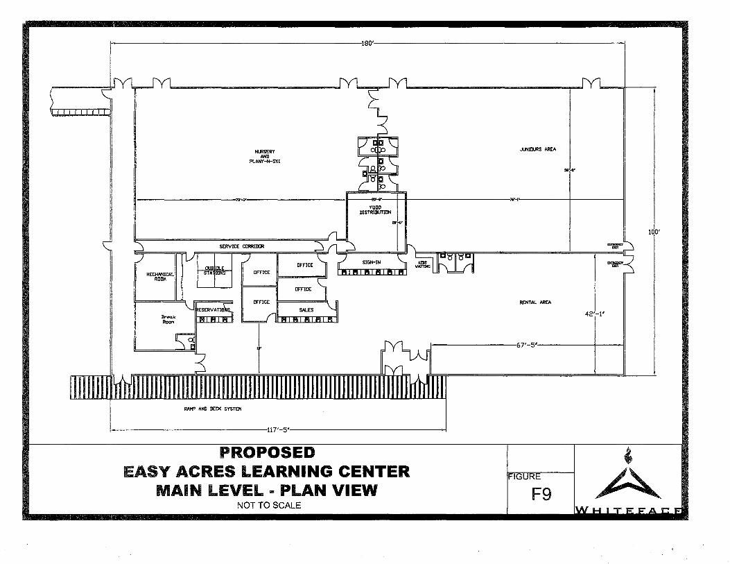
i--~~~~~~~~~~~~~~~~~~~~~~~~~~~~~180'·~~~~~~~~~~~~~~~~~~~~~~~~~~~~~--'
NURSERY AND
PLANY-N-SK!
JUNICURS AREA
56~-8"
I w _.,. 76'-t I
MECHANICAL ROOM
Bl"'ea.k ROOl"I
SERVICE CCRRIDCR
RAMP AND DECK SYSTEM
FCCD DISTRIBUTION
~·
RENTAL AREA
42'-1'
t--~~~~~~~~~167'-5' I
i--~~~~~~~~~~~~~~~~~~~~·117'-5'~~~~~~~~~~~~~~~~~~~~-i
PROPOSED '
100'
EASY ACRES LEARNING CENTER MAIN LEVEL ... PLAN VIEW
FIGURE
F9 A_ NOTTO SCALE
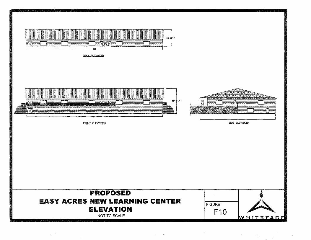
BACK ELEYAT!DN
FRONT ELEYATIDN
PROPOSED EASY ACRES NEW LEARNING CENTER
ELEVATION NOTTO SCALE
1-----------100·-----------< SIDE ELEYATION
' A FIGURE
F10

~ t=.."lm =Tl!i§ ....=...
._
........ -··
t-------67'-'5'~---+---I
...... 11Clftl'IDI
1-------------ur·-'5'-------------l
PROPOSED OVERALL LAYOUT EASY ACRES LODGE
RENOVATIONS AND EXPANSION NOTTO SCALE
M:'\J I ~&DNr: CoaER \elTTH nrd f§rTbdjlkrnrp.t YN !NA)'
FIGURE
F11 ' A

--,
-,,
----" New Addition
'--------1
New Enclosed WalkwaY.
·~'-.
tOK1-dj-s,--Center ' "'-,,
~/-....._,,
'---....,,
,_"-
---...,_ y--\
r---
~
A
~ -, __ /'-. __ /'---./~
New Vegetation "Screening Existing Maintenance Area"
New Vegetation
Existing Parking Lot
;,.-~
2006 UMP AMENDMENT
TRAIL SYSTEMS
PUMP HOUSE #1 WEST ELEVATION
DATE:
Staff Access Road via Parking Lot #5
• Figure F13, "Maintenance Area Access Road - Location Map"
• Figure F14, "Maintenance Area Access Road - Plan View"
• Figure F15, "Maintenance Area Access Road - Profile and Section"
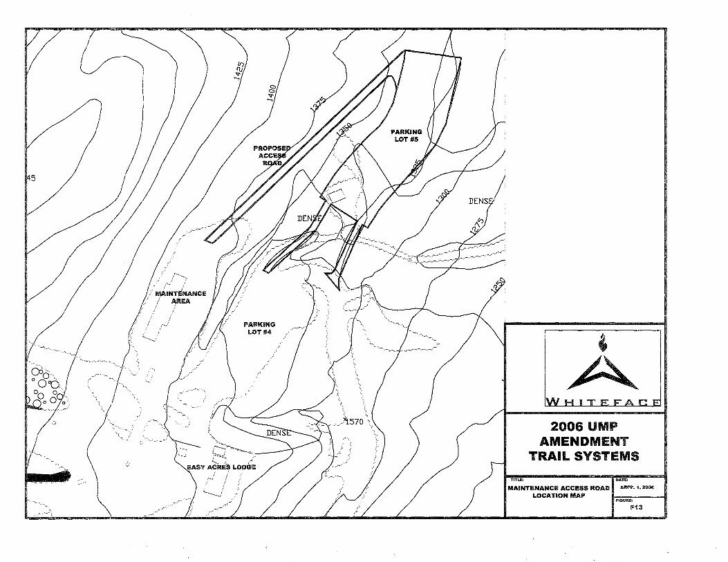
5
.·j} .IV!AINTiNANCE
I AREA i I
I
TITLE:
2006 UMP AMENDMENT
TRAIL SYSTEMS
,TE:
MAINTENANCE ACCESS ROAD H ARPIL 1, 2oos
LOCATION MAP FIGURE:
F13

TITLE:
2006 UMP AMENDMENT
TRAIL SYSTEMS
DENSE
DENSE
DATE:
MAINTENANCE ACCESS ROAD DFEBRUARY 13, 2oos
PLAN VIEW FIGURE:
11"14

!l· d ~ d: £: l!J,:_Q ..... ~· ~ c:f'f §:8 ~ "'
I {J ~I 0+00 0+50
EXISTING GROUND
~1 ~ ~I ~I ~, ~,
~I ~1 ~I ~ ii ii ii i ~ (\I ...,
"' ~ ~ a5 .... "' ~ ~ "' "' "' !:! !:! !:! !:! !:!
!+00 !+50 2+00 2+50 3+00 3+50 4+00 4+50 5+00
SCALE = 1=100 RATIO = 1:1
ACCESS ROAD PROFILE
I ~· I STONE DITCH -- c·-=~~-~ ..... ~ .....- I nL TER rABRIC <AS REQUIRED)
TYPICAL EMBANKMENT ROAD SECTION NTS
~ ~ i ~ ~I "' !:! !:!
5+50 6+00
EMBANKMENT
~I 6+50
~I ~I ii ~I ~I ~I 7+00 7+50 8+00
2006 UMP AMENDMENT
TRAIL SYSTEMS
TITLE: II TITLE:
C! .2 ... , u
~: O! u: .. : 0, -I·
~ ~' d·
Q..1
er.· ... ~I
8+25
MAINTENANCE ACCESS ROAD IFEBRUARY 13, 2oos
PROFILE AND SECTION FIGURE:
F15

Table T1 "Proposed Terrain Specifications"

Map Ref
1 2 3 4
4b 5 6
Ga 7 8 9 10 11
12 13 14 15 16 17 18 19 20 21 22 23 23 23 24 25
25a 26 26 27
27a
28 29 30 31
31a 32 33 34 34 34 35 36
36a 37 38 39 40 41 42 42 43 44 45 46 47 48 49 50 51 52 53 54 55 56 57 58 59 60 61 62 63 64 65 66 67
68 69 70 11 72 73
73a
74 75 76 77 78 79
80
TABLE T1 - "PROPOSED TERRIAN SPECIFICATIONS"
Buffers AVg.
Slope Length Width Appr. Skier Ability Trail/Area Name (ft) (ft) Snowmaking Lift Area (ac) Level
Upper Cloudspin 2600 149 . 8.9 Most Difficult Lower Cloudspin 2500 138 . 7.9 More Difficult Upper Skyward 800 177 . 3.3 Most Difficult Lower Skyward 3800 140 . . 12.2 Most Difficult
New 590 60 . 0.8 Most Difficult Parson's Run 2600 107 * 6.4 More Difficult
Excelsior 5600 85 . 10.9 More Difficult New Excelsior Bypass 300 110 . 0.8 More Difficult
Essex 1000 83 . 1.9 Most Difficult Upper Northway 1000 74 . 1.7 Most Difficult Lower Northway 1700 87 . 3.4 More Difficult
Connector 700 40 * 0.6 More Difficult Approch 1900 65 * 2.8 Most Difficult Empire 1600 60 2.2 Most Difficult
Upper Mackenzie 1000 95 . 2.2 Most Difficult Lower Mackenzie 1400 106 * 3.4 Most Difficult Upper Wilderness 500 105 * 1.2 Most Difficult Lower Wilderness 1400 170 * 5.5 Most Difficult
Mountain Run 2400 180 . . 9.9 Most Difficult Upper Parkway 1800 135 . 5.6 Most Difficult Lower Parkway 2700 122 * . 7.6 More Difficult Upper Thruway 1000 165 . 3.8 Most Difficult Lower Thruway 1400 113 . 3.6 Most Difficult Upper Valley 2000 106 . * 4.9 More Difficult
Lower Valley A 1500 74 * * 2.5 More Difficult Lower Valley B 900 200 * * 4.1 More Difficult Lower Valley C 1700 160 . . 6.2 More Difficult
Burton's 600 30 . 0.4 Most Difficult Broadway 1700 135 . 5.3 More Difficult
Off Broadway 200 Easy Street A 400 10 . 0.1 Easier Easy Street B 1700 135 * 5.3 Easier
Boreen 5600 86 * 11.1 Easier Silver Glade 1425 175 5.7 More Difficult
Danny's Bridge (Terrain Park) 1100 86 . 2.2 Most Difficult
River Run 1000 110 . 2.5 More Difficult Mixing Bowel 800 150 . . 2.8 Easier
Wolf 1800 58 . 2.4 Easier Fox 2500 71 . 4.1 Easier Bear 1700 150 . Most Difficult Dear 950 50 . 1.1 Easier
Silver-Uppper 1000 73 . 1.7 Easier Silver-Lower 1000 90 . 2.1 Easier
Silver-Kampus Kruiser 500 73 . 0.8 Easier Gold 1800 135 . . 5.6 Easier
Bronze 1650 90 . 3.4 Easier New Glade 950 175 3.8 More Difficult Home Run 500 25 . 0.3 Easier
Follies 2400 60 . 3.3 More Difficult Valvehouse Road 300 50 * 0.3 More Difficult
Silver Shoot 700 60 * 1.0 Easier Main Street 400 60 . 0.6 Easier
Runner Up - Upper 400 30 * 0.3 Easier Runner Up - Lower 400 30 * 0.3 Easier
Medalist 1600 50 1.8 Easier Round-a-bout 250 50 * 0.3 Easier
Easy Way 500 25 * 0.3 Easier Upper Boreen 800 40 0.7 More Difficult
Calamity 400 70 * 0.6 More Difficult Ladies Bridge 500 110 * 1.3 More Difficult
Lower Gap 300 110 * 0.8 More Difficult Riva Ridge 500 25 * 0.3 Most Difficult
Cloudspin Cut 400 25 * 0.2 Most Difficult Yellow Brick Road Trial has been abandon and is being re-vegetated Upper Switchback 600 25 * 0.3 More Difficult Lower Switchback 600 25 * 0.3 More Difficult Crossover Loop 600 25 * 0.3 More Difficult
Glen 450 25 0.3 More Difficult Victoria Shoot 250 100 . 0.6 More Difficult Lower Empire 350 80 . 0.6 More Difficult Weber's Way 400 120 * 1.1 More Difficult
moo Road 700 25 . 0.4 More Difficult 2200 Road 300 60 . 0.4 Most Difficult
High Country Glade 1550 150 5.3 Most Difficult Low Road 200 70 0.3 More Difficult Tom Cat 400 38 . 0.3 More Difficult On Ramp 600 25 . 0.3 Most Difficult Wolf Run 550 80 . 1.0 Easier
Summit Express 550 80 * 1.0 More Difficult
Brookside (Terrain Park) 1800 100 . 4.1 Most Difficult Coludsplitter Glade 300 500 * 3.4 Most Difficult
1 Oth Mtn Division Glade 1000 450 10.3 Most Difficult Draper's Drop 1700 130 * 5.1 More Difficult Parkway Exit 200 100 * 0.5 More Difficult
Trail - 73 3500 90 * 7.21 More Difficult Trail - 73a 1150 100 * 2.61 More Difficult
Sub-Total Footage 102865 Sub-Total Ac. 243.01 -SLio;1otal Miieage 19.48
Proposed - Tree Island Pod New Trail 4,182 95 * * 9.1 Most Difficult New Trail 3,967 90 * * 8.2 Most Difficult New Trail 443 90 * * 0.9 More Difficult New Trail 153 55 * 0.2 Most Difficult New Trail 9,261 50 * 10.6 More Difficult New Trail 1,665 85 * 3.2 More Difficult Sub-Total Footage 19,671 Sub-Total Ac. 32.3
Sub-Total 1V111eage 3.73
Proposed - Tree Island Pod Glades 42771 250 63.51 Most Difficult
4,277 0.81
I Total Trial Footage ·--126,813j
I Total Trial Mileage 24.02 I
Sub-Total Ac. 63.51\..
I Approx. Total Acreage 338.81

Table T2 "Summary of Vegetation Impacts -
Tree Clearing Estimates for Proposed Management Actions"
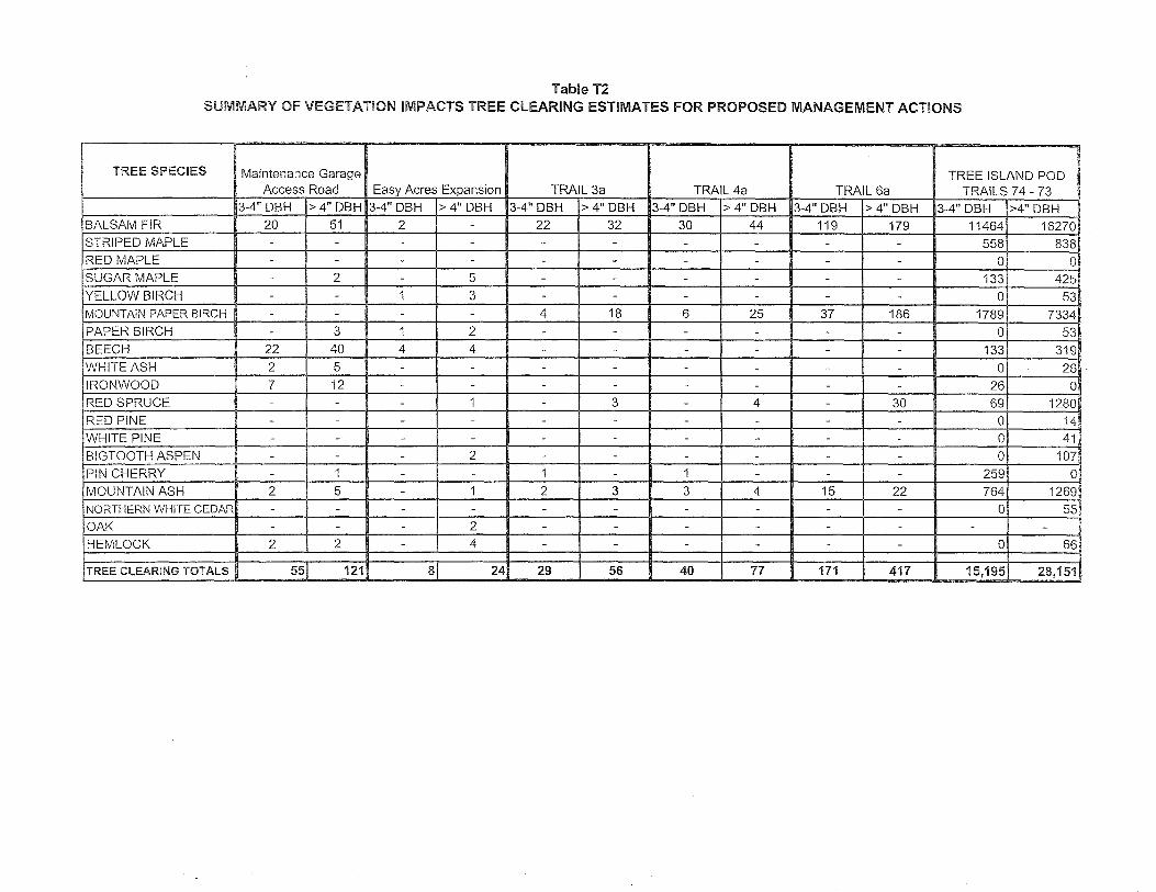
Table T2 SUMMARY OF VEGETATION IMPACTS TREE CLEARING ESTIMATES FOR PROPOSED MANAGEMENT ACTIONS
TREE SPECIES Maintenance Garage TREE ISLAND POD Access Road Easy Acres Expansion TRAIL 3a TRAIL 4a TRAIL 6a TRAILS 7 4 - 73
3-4" DBH > 4" DBH 3-4" DBH > 4" DBH 3-4" DBH > 4" DBH 3-4" DBH > 4" DBH 3-4" DBH > 4" DBH 3-4" DBH >4" DBH BALSAM FIR 20 51 2 - 22 32 30 44 119 179 11464 16270 STRIPED MAPLE - - - - - - - - - - 558 838 RED MAPLE - - - - - - - - - - 0 0 SUGAR MAPLE - 2 - 5 - - - - - - 133 425 YELLOW BIRCH - - 1 3 - - - - - - 0 53 MOUNTAIN PAPER BIRCH - - - - 4 18 6 25 37 186 1789 7334 PAPER BIRCH - 3 1 2 - - - - - - 0 53 BEECH 22 40 4 4 - - - - - - 133 319 WHITE ASH 2 5 - - - - - - - - 0 26 IRONWOOD 7 12 - - - - - - - - 26 0 RED SPRUCE - - - 1 - 3 - 4 - 30 69 1280 RED PINE - - - - - - - - - - 0 14 WHITE PINE - - - - - - - - - - 0 41 BIGTOOTH ASPEN - - - 2 - - - - - - 0 107 PIN CHERRY - 1 - - 1 - 1 - - - 259 0 MOUNTAIN ASH 2 5 - 1 2 3 3 4 15 22 764 1269 NORTHERN WHITE CEDAR - - - - - - - - - - 0 55 OAK - - - 2 - - - - - - - -
HEMLOCK 2 2 - 4 - - - - - - 0 66
TREE CLEARING TOTALS 55 121 8 24 29 56 40 77 171 417 15,195 28,151

Table T3 "Summary of Approved and Proposed Increases in
Building Area for the Easy Acres Campus"

Table T3 Summary of Approved and Proposed Increases
in Building Area for the Easy Acres Campus
Historic Data. Post 1996 UMP Total Approved Building Area= 9,739 sf
1996 UMP Additional Approved Area = 841 sf Total Approved Building Area = 10,580 sf
2004 UMP Additional Approved Area= 6,000 sf Total Approved Building Area = 16,580 sf
Proposed in 2006 UMP Amendment Existing Building Total Current Area= 9,739 sf Total Approved Building Area = 16,580 sf
Proposed Improvements to Existing Building Remove = 822 sf Add = 1,383 sf Total Proposed Improvement to Existing Building Area = 11, 122 sf
Proposed New Building Facility's Proposed New Learning Center Main Level = 18,000 sf Proposed New Learning Center Basement Level = 18,000 sf Proposed New Enclosed Walkway = 1,200 sf
Total Proposed New Building Facility Area= 37,200 sf
Proposed Net Increase in Building Facility Area Total Proposed Improvement to Existing Building Area = 11, 122 sf Total Proposed New Building Facility Area = 37,200 sf
Total Proposed Improvement to Existing Building Area + New Building Facility Area 11,222 sf+ 37,200 = 48,422 sf
Total Proposed Improvement to Existing Building Area+ New Building Facility Area= 48,222 sf
Total Approved Building Area= 16,580 sf
(Total Proposed lmprov. to Ex. Building Area + New Building Facility Area) - (Total Approved Building Area) 48,422 sf- 16,580 = 31,842 sf
Proposed Net Increase in Building Facility Area = 31,842 sf

Appendix A1 "Schematic Engineer's Report for Proposed Wastewater
Disposal ~ystem Improvements - Expansion to "Kids Kampus" Base Lodge Building Whiteface Ski Area"

SCHEMATIC ENGINEER'S REPORT
FOR PROPOSED WASTEWATER TREATMENT & DISPOSAL
SYSTEM IMPROVEMENTS
EXPANSION TO "KIDS KAMPUS" BASE LODGE BUILDING WHITEFACE SKI AREA
PREPARED FOR:
OLYMPIC REGIONAL DEVELOPMENT AUTHORITY
March 10, 2006
PREPARED BY
IV AN ZDRAHAL ASSOCIATES, PLLC ENGINEERING AND PLANNING
959 ROUTE 146 CLIFTON PARK, NY 12065
(518) 383-0769

TABLE OF CONTENTS
PAGE NO. Section
1. Introduction ............................................................................................................... I
2. Background ............................................................................................................... 1
3. Proposed Improvements ............................................................................................ 2
4. Conclusion ................................................................................................................ 3
Appendices
Appendix A: Water Consumption Data
Appendix B: Engineers Report-September 21, 2000
Appendix C: Map - Schematic Plan
ENGINEER'S REPORT Kids Kampus, Whiteface Ski Center
PAGEi March JO, 2006
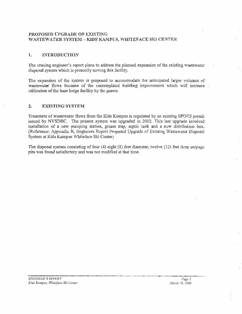
PROPOSED UPGRADE OF EXISTING WASTEWATER SYSTEM - KIDS KAMPUS, WHITEFACE SKI CENTER
1. INTRODUCTION
The ensuing engineer's report plans to address the planned expansion of the existing wastewater disposal system which is presently serving this facility.
The expansion of the system is proposed to accommodate the anticipated larger volumes of wastewater flows because of the contemplated building improvement which will increase utilization of the base lodge facility by the guests.
2. EXISTING SYSTEM
Treatment of wastewater flows from the Kids Kampus is regulated by an existing SPDES permit issued by NYSDEC. The present system was upgraded in 2002. This last upgrade involved installation of a new pumping station, grease trap, septic tank and a new distribution box. (Reference: Appendix B, Engineers Report Proposed Upgrade of Existing Wastewater Disposal System at Kids Kampus Whiteface Ski Center)
The disposal system consisting of four (4) eight (8) feet diameter, twelve (12) feet deep seepage pits was found satisfactory and was not modified at that time.
ENGINEER'S REPORT Kids Kampus, Whiteface Ski Center
Page 1 March I 0, 2006
3. PROPOSED IMPROVEMENTS
Estimated daily :flow -
Whiteface Ski Center is keeping records of water consumption at the Base Lodge and at the Kids Kampus facility. (Reference: Appendix A)
The water consumption at the Kids Kampus facility is due to operation of kitchen/dining areas and toilets. I believe that most of the water used leaves the building as a waste therefore the sizing of a wastewater disposal system utilizing the recorded water consumption can be justified.
As shown in the "Appendix A", recently the highest daily water consumption is February 18 thru February 20, 4600 gallons per day. These demands coincide with one of the busiest days at the ski center.
Considering the highest recorded per day consumption (4600 gallons) and the higher utilization of the present building due to the proposed improvements, I believe that an expansion of the present wastewater disposal system capacity up to the Unit Management Plan (UMP) projected 5,950 gallons per day should be undertaken.
Proposed Improvements
The system upgrade will comply with requirements of NYSDEC for the projected design flow of 5,950 gallons per day. The following improvements will be necessary:
"' Septic Tank - existing 3,000 gallon septic tank capacity will require an increase to 8,000 gallons
111 Grease Trap - existing 1,000 gallon capacity will require an increase to 2,000 gallons. The combined storage capacity (grease trap and septic tank) will be 10,000 gallons
Ill! Pumping Station - The pumping station discharge rate of 66 GPM in its duplex configuration is adequate for the projected daily flow. The pumping units might need to be changed should the discharge head condition will change because of the disposal area design and/or location.
,. Subsurface discharge - the present design capacity of 1950 gallons per day will require an upgrade to the 5,950 gallons per day capacity. The soil characteristics in the area where present seepage pits are located are well suited for a seepage pit type subsurface disposal application.
" Location of the treatment system - the Appendix C map illustrates a schematic plan.
ENGINEER'S REPORT Kids Kampus, Whiteface Ski Center
Page2 March IO, 2006

4, CONCLUSION
Construction of the improvements identified in this report will establish wastewater treatment system in compliance with NYSDEC standards. The expanded treatment capacity will provide environmentally safe treatment of wastewater for a long time into the future.
Respectfully submitted,
IVAN ZDRAHAL ASSOCIATES, PLLC ENGINEERING AND PLANNING
ENGINEER'S REPORT Kids Kampus, Whiteface Ski Center
Page3 March 10, 2006
APPENDIX A
WASTEWATER CONSUMPTION DATA
ENGINEER'S REPORT Kids Kampus, Whiteface Ski Center
Appendix A March 10, 2006
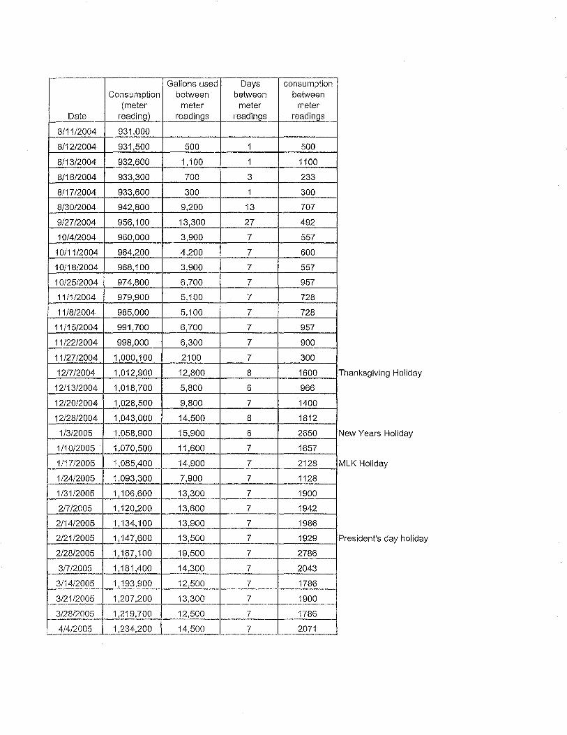
Gallons used Days consumption Consumption between between between
(meter meter meter meter Date reading) readings readings readings
8/11/2004 931,000
8/12/2004 931,500 500 1 500
8/13/2004 932,600 1,100 1 1100
8/16/2004 933,300 700 3 233
8/17/2004 933,600 300 1 300
8/30/2004 942,800 9,200 13 707
9/27/2004 956,100 13,300 27 492
10/4/2004 960,000 3,900 7 557
10/11/2004 964,200 4,200 7 600
10/18/2004 968,100 3,900 7 557
10/25/2004 974,800 6,700 7 957
11/1/2004 979,900 5,100 7 728
11/8/2004 985,000 5,100 7 728
11/15/2004 991,700 6,700 7 957
11/22/2004 998,000 6,300 7 900
11/27/2004 1,000, 100 2100 7 300
12/7/2004 1,012,900 12,800 8 1600 Thanksgiving Holiday
12/13/2004 1,018,700 5,800 6 966
12/20/2004 1,028,500 9,800 7 1400
12/28/2004 1,043,000 14,500 8 1812
1/3/2005 1,058,900 15,900 6 2650 New Years Holiday
1/10/2005 1,070,500 11,600 7 1657
1/17/2005 1,085,400 14,900 7 2128 MLK Holiday
1/24/2005 1,093,300 7,900 7 1128
1 /31/2005 1,106,600 13,300 7 1900
2/7/2005 1, 120,200 13,600 7 1942
2/14/2005 1, 134,100 13,900 7 1986
2/21/2005 1, 147,600 13,500 7 1929 President's day holiday
2/28/2005 1,167,100 19,500 7 2786
3/7/2005 1, 181,400 14,300 7 2043
3/14/2005 1, 193,900 12,500 7 1786
3/21/2005 1,207,200 13,300 7 1900
3/28/2005 1,219,700 12,500 7 1786
4/4/2005 1,234,200 14,500 7 2071

5/16/2005
6/13/2005 Tank Draining, Cleaning, Refilling 7/11/2005
81812005
9/19/2005 1,595,900 361,700 94 3849
10/10/2005 1,601,400 5,500 21 262
11/14/2005 1,602,900 1,500 35 43
12/27/2005 1,616,800 13,900 43 323
1/2/2006 1,644,200 27,400 6 4566 New Years Holiday
1/8/2006 1,668,600 24,400 6 4066
1/9/2006 1,671,400 2,800 1 2800
1/20/2006 1,710,800 39,400 10 3940 MLK Holiday
1/23/2006 1,720,700 9,900 3 3300
1/30/2006 1,732,700 1,200 7 1714
2/13/2006 1,760,100 27,400 13 2108
2/18/2006 1,767,700 7,600 6 1520
2/20/2006 1,776,900 9,200 2 4600 President's day holiday
2/21/2006 1,780,000 3,100 1 3100
2/22/2006 1,782,880 2,880 1 2880
2/23/2006 1,786, 112 3,232 1 3232
2/24/2006 1,789,200 3,088 1 3088
2/25/2006 1,792, 100 2,900 1 2900
2/26/2006 1,794,500 2,400 1 2400
2/27/2006 1,796,900 2,400 1 2400
2/28/2006 1,797,800 900 1 900
3/1/2006 1,799,300 1,500 1 1500
3/2/2006 1,803,600 4,300 1 4300
3/3/2006 1,805,300 1,700 1 1700
3/4/2006 1,807,200 1,900 1 1900
3/5/2006 1,809,200 2,000 1 2000
3/6/2006 1,810,900 1,700 1 1700
3/7/2006 1,812,500 1,600 1 1600
3/8/2006 1,815,011 2,511 1 2511
ENGINEER'S REPORT
APPENDIXB
ENGINEER'S REPORT
PRPOSED UPGRADE OF EXISTING W ASTERW ATER DISPOSAL SYSTEM
AT KIDS KAMPUS WHITEFACE SKI CENTER
DATED: SEPTEMBER 21, 2000
Kids Kampus, Whiteface Ski Center Appendix B
March JO, 2006
ENGINEER'S REPORT
PROPOSED UPGRADE OF EXISTING WASTEWATER DISPOSAL SYSTEM
AT KIDS KAMPUS WHITEFACE SKI CENTER
PREPARED FOR:
OLYMPIC REGIONAL DEVELOPMENT AUTHORITY
September 21, 2000
PREPARED BY
IV AN ZDRAHAL ASSOCIATES, PLLC ENGINEERING AND PLANNING
959 ROUTE 146 CLIFTON PARK, NY 12065
(518) 383-0769
TABLE OF CONTENTS
PAGE NO. Section
1. Introduction ............................................................................................................... 1
2. Background ............................................................................................................... 1
3. Proposed Improvements ............................................................................................ 2
4. Conclusion ................................................................................................................ 3
Appendices
Appendix A: Components of Existing System - Photo Documentation
Appendix B: Design Calculations
Appendix C: Lift Station Components
Appendix D: Project Components Budget Figures
ENGINEER'S REPORT Kids Kampus, Whiteface Ski Center
PAGEi September 21, 2000
PROPOSED UPGRADE OF EXISTING WASTEWATER SYSTEM- KIDS KAMPUS, WHITEFACE SKI CENTER
1. INTRODUCTION
The ensuing engineer's report and the accompanying design plans address the repair and upgrading of the present septic system, which at the present time has a failed septic tank and pumping station.
2. BACKGROUND
Treatment of wastewater flows from the Kids Kampus is regulated by an existing SPDES permit issued by NYSDEC. This pennit allows discharge of 1,880 GPD of wastewater into a subsurface disposal system which consists of four (4) 8'0.D. by 12 feet deep seepage pits. The present absorption capacity of this system is estimated at 1950 GPD based on percolation rate of one minute 30 seconds per inch. 1
In preparation for the prescribed planned upgrade, representatives from the office of Ivan Zdrahal Associates, PLLC, performed a field investigation of the existing system and found the following:
111 Existing fiberglass septic tank is collapsed
111 Existing pumping station is beyond cost effective repair and must be replaced
111 Existing distribution box with deep sump, sedimented and debris on bottom. Bottom may be open to soil.
m Existing seepage pits are in good condition - clean, no visible deposits of any grease or debris.
1 Unit Management Plan, Page 217
ENGINEER'S REPORT Kids Kampus, Whiteface Ski Center
Page 1 September 21, 2000
3. PROPOSED IMPROVEMENTS
The proposed upgrnde of the existing system will include the following:
A. Modify interior plumbing in such a way that waste from food service area flow first into a grease trap.
B. Install new septic tank with adequate capacity to handle present permitted daily flow.
C. Install new lift station consisting of 5' I.D. wet well duplex pumps control panel for alternate operation of the pumping unit.
D. Replace existing distribution box.
The following is a b1ief description of each of the proposed improvements:
Separation of Food Area Wastes
Field review revealed that only minor reworking is needed to achieve this. We feel that this is a desirable component of the future system which will contribute to a long term reliable operation. Grease trap will consist of a 1,000 gallon concrete tank. ·
Septic Tank
Using NYSDEC standards, the required septic tank size for the present permitted flow is 3,000 gallons. Should the Kids Kampus capacity be enlarged as indicated in the Unit Management Plan to 5,600 gallon per day, the septic tank capacity will need to be increased to 8,000 gallons. To accomplish the increase in septic tank capacity to 8,000 gallons, when necessary, a second 5,000 septic tank will be installed in series after the first.
Lift Station
The proposed lift station is designed in such a way to handle present and future flows. Main features of this station are as follows:
ii Duplex Yz HP pumps each capable of pumping 66 GPM at 25 feet of TDH mounted on rails for ease of servicing
111 5 feet inside diameter wetwell
111 Control panel with all components for duplex operation, high level alarm, low level alann, pump seal failure, auto pump alternator, pump run lights, run time meters, thermal overload protection, and heater
Distribution Box Existing distribution box, which consists of balloon masonry units will be replaced with a precast concrete unit.
ENGINEER'S REPORT Kids Kampus, Whiteface Ski Center
Page2 September 21, 2000

4. CONCLUSION
Construction of the above improvements will bring the wastewater disposal system to a good working condition and will be in conformance with NYSDEC standards.
Respectfully submitted,
IV AN ZDRAHAL ASSOCIATES, PLLC ENGINEERING AND PLANNING
ENGINEER'S REPORT Kids Kampus, Whiteface Ski Center
Page 3 September 21, 2000

ENGINEER'S REPORT Kids Kampus, Whiteface Ski Center
APPENDIXC
Map
Schematic Plan
Appendix C March 10, 2006
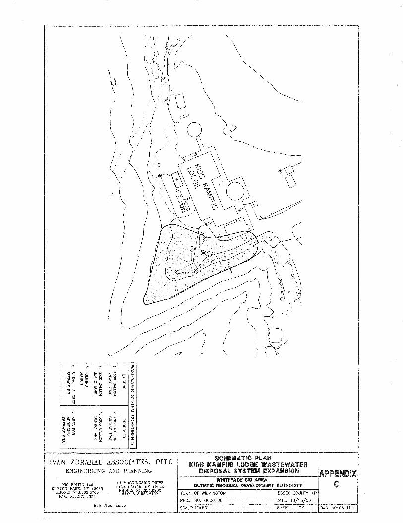
f'> µi YI ,.. ~ VI C» ~~ ~~ "~
Ii "' . "'0
~~ ::! ;;:: ;g g ~g ~ 0 Jl ". z i5 () G)
"'~ ~ "' ;! F .,, "'· ~~ ~o ;u =i .,, z
0 (/) M -< l'1 (/) .,,
iii :-' ,,. t-'
;:::
~{!;!ti (J)(Jl G) ~ 0 MO "'0
.,, 0 CB g :>! ~g ~g e: ;::: es g.,, () G)
.,, "U "' G) 0 0
~~~ ~~ ~~ (/) z 0 fT1
i;j "~ z "'-! (/)
IVAN ZDRAHAL ASSOCIATES, PLLC ENGINEERING AND PLANNING
959 ROUTE 146 CIJFTON PARK, NY 12065
PHONE: 518.383.0769 FAX: 518.371.4356
12 MORNINGSIDE DRIVE iAKE PLACID, NY 12946
PHONE: 518.523.8902 FAX: 518.523.2197
Web Site: IZA.cc
TOWN OF WILMINGTON ESSEX COUNlY, NY
PROJ. NO: 0600700 DATE: 10/13/06 -----SCALE: 1 "=50' SHEET 1 OF 1 DWG. NO: oa-11-1.
'--~~~~~~-~~~-~--------1.....-~-~--~--~--------~----~-----4.-~~------'

Appendix A2 "Generic Storm Water Pollution Prevention Plan"
.OLYMPIC: REGIDNAL -----NEW YORK
DEVELOPMENT AUTHDRITY
GENERIC CONSTRUCTION STORM WATER POLLUTION PREVENTION PLAN
For
WHITEFACE MOUNTAIN SKI CENTER
Prepared in Accordance with New York State Department of Environmental Conservation SPDES General Pennit for Storm Water Discharge from Construction Activities that are Classified as "Associated with Constn1ction Activity", General Permit GP-02-01 and Pending Updates.
Introduction
Prepared by the Olympic Regional Development Authority Office of Planning and Construction
Robert W. Hammond, CPESC Director, Plaiming & Construction
CPESC Certification# 2674
The intent of this document is to outline the procedures and elements for the development of site specific Storm Water Pollution Prevention Plans. Presented are the standard and recognized practices utilized in Construction Storm Water Pollution Prevention Plans. In the Olympic Regional Developments Authority's and Whiteface Mountain Ski Center's continued efforts to provide and develop the most effective Sto1111 Water Pollution Prevention Plans this documents includes new elements that will continue to ensure positive progress in the effort for improved SWPPP development. The new elements included in this document are:
@ Inclusion of site specific practices @ Improved Timing I Control Measures @ Turbidity Monitoring @ Tailgate Meetings ® Closeout Reports

ORDA's CERTIFICATJON SvVPPP for Whiteface Mountain Ski Center
Office of Plannirn' and Construction I certify under penalty of law that this document and all attachments were prepared under my direction or supervision in accordance with a system designed to assure that qualified personnel properly gathered and evaluated the information submitted. Based on my inquiry of the person or persons who manage the system, or those persons directly responsible for gathering the information, the information submitted is, to the best of my lmowledge and belief, true, accurate, and complete. I am aware that there are significant penalties for submitting false information, including the possibility of fine and imprisonment for knowing violations.
Signed:
Name:
Title:
Date:
Venue Manager I certify under penalty oflaw that I understand the terms and conditions of the general National Pollutant Discharge Elimination System (NPDES) pernrit that authorizes the Storm Water discharge associated with industrial activity from the construction activity from constTuction site identified as part of this certification.
Signed:
Name:
Title:
Date:
Project Name:
Project Location:
Project Sponsor:
Project Scope:
Storm Water Management Objectives:
Storm Water Pollution Prevention Plan (SWPPP)
Whiteface Mountain Ski Center Trail Expansion, Pllmp House #1 and Easy Acres Expansion.
Whiteface Mountain Ski Center Town of Wilmington, New York
New York Olympic Regional Development Authority
Whiteface Mountain Ski Center Trail Expansion, Pump House #1 and Easy Acres Expansion.
Final SWPPP shall be prepared in accordance with New York State Department of Envirom11ental Conservation SPDES General Permit for Storm Water Discharge from Construction Activities that are Classified as "Associated with Construction Activity", General Pernut GP-02-01 and Pending Updates.
It is the objective of the final SWPPP plan to provide best practices of sedimentation and erosion contrnl during the development phase and ensure that on completion of the project the activates will not adversely effect the surrounding environment.
During the design of the facility upgrades sig11ificant efforts shall be made to minimize the increase of impervious areas.
Scheduling and restoration shall be a primary practice for the earthwork activates at Whiteface. Limiting the amount of disturbed area to the minimum practical amount shall be targeted.
Site specific practices that have been proven to reduce erosion and utilize resources for control of erosion shall be utilized. Examples of site specific practices include:
., Reduce grubbing activities on ski trnils to allow for cut tr·ees root systems to remain in place .
., Consh11ction of temporary haul roads and permanent access roads from wood chips .
., Recycle of shot-rock for stone lined ditching.
Best management practices as presented and detailed in the Blue Book and DEC technical standards shall be the minimum requirements for the SWPPP. Project drawing be developed and included in the Final SWPPP that includes all necessary details and notes. Situations may arise during the construction operations that may require additional actions to comply with the technical standards for erosion and sediment control as set forth in the "New York Standards and Specifications for Erosion and Sediment Control. The Olympic Regional Development Authority, Office of Planning and Construction shall be notified 48 hours in advance of the start of work and shall monitor the progress of work to ensure that full conformance to the SPDES General Permit.
Storm Water Management:
Timing of Control/Measures:
The discharge of storm water shall not result in discharge of toxic of deleterious substances.
The discharge of storm water shall not result in the discharge of suspended, colloidal or settable solids in amounts that cause substantial visible contrast to natliral conditions or impairer receiving water for their best classified usages.
1. Temporary structural erosion controls shall be installed prior to earthwork as per this plan. Controls such as filter fabric fences, erosion-contt·ol blankets, water bars, wood chipped access roads, stone lined ditches, selective minimal clearing, minimal stump removal, immediate stop-gap mulching and seeding and staked straw bale filters will be employed, in addition to other standard details of specific BMP produced by the USDA- Natural Resources Conservation Service, the NYS DEC and details that have be developed and tested on Whiteface Mountain and practices and material that have proved to be effective in controlling erosion on steep slopes.
2. Seeding and mulching of disturbed areas shall take place as soon as possible. Reseeding will occur in all areas that have not achieved stabilization during the recommended planting season of between May 15 and August 31. Dom1ant seeding clone after this time should only be clone when 2 inch soil temperatures is less than 50 degrees. When it is necessary to stabilize disturbed areas beyond these timeframes, alternative measures will be review. Mulching shall be applied in disturbed areas to reduce wind and runoff erosion as soon as possible after rough grading operations are complete.
3. Erosion blankets shall be installed immediately after finished grades are established and seeding completed with slopes steeper than 3: 1.
4. Copies of Stabilization Inspection forms and Stt·uctural Inspection forms located at the encl of this report shall be completed in full for every inspection performed by the Office of Planning and Construction. Complete inspection forms shall be retained by the Office of Planning and Constt·uction and at the Venue Managers Office.
5. Stn1ctural erosion controls and non-stabilized area shall be inspected by the Office of Plaiming and ConstTuction twice a week and immediately after a rainfall of 0.5 inches.
6. Vegetation stabilization is to be performed within 5 clay after establishing final grades.
7. Temporary erosion contrnl devices will not be removed until the growth of vegetation stabilizes the area served. Vegetation coverage of75% shall be considered stabilized.
8. A construction log shall be maintained and record elates of initiation of construction, implementation of erosion control measures, stabilization, ect.


Maintenance/Inspection Procedures: 1. ORDA will supervise day-to-clay activities on the site. ORDA staff shall
inspect all E&D devices daily and a Certified Professional in Sediment and Erosion Control will inspect the site twice a week and immediately after a rainfall of 0.5 inches.
Monitoring:
Tailgate Meetings:
Closeout Rep01i
Spill Prevention:
2. All measures will be maintained in good working order. If repair is necessary, it will be initiated inm1ediately after discovery.
3. Built up sediment will be removed form silt fences if it ever reaches one-third the height of the strnctural contrnl.
4. Silt fence will be inspected for depth of sediment, tears, etc., to see if the fabric is properly functioning, securely attached to the fence posts, and to see that the fence posts are firmly in the ground.
5. Seeded area shall be inspected for bare spots, washouts, and healthy growth. If necessary, replanting, reseeding, or resoclding will be implemented.
Monitoring quality and condition storm water run-off shall be performed with Turbidity Meters. Regular sampling shall be performed by the CPESC. Records shall be kept and revisions to the BMP shall be made as required to ensure the most effective BMP's.
During earthwork operations that impact large areas, such as ski trails, Tailgate Meetings will be held that focus on Erosion and Sediment Contrnl. Traditionally, Tailgate Meetings are held to focuses on j obsite safety, but in Whiteface's continued efforts to minimize Erosion and Sediment impacts, Tailgate Meetings will include discussions on Erosion and Sediment control devices, impacts and improvements in devices and behaviors.
In order to continue to learn and improve from actual project experiences a Closeout Report will be generated by the CPESC. The report will include an overview of negative and positive experiences during the project and recommendations for improvements. The report will be submitted to the Venue Manager and shall be presented by the CPESC in a workshop forum.
The following are the material management practices that will be used to reduce the risk of spills or other accidental exposures of materials and substances to storm water runoff.
1. Petroleum shall be stored in above ground skid-tanks or in-vehicle (pickup truck) mounted tanks. Any refueling shall occur at least 100 feet from any surface water shoreline or wetland area.
2. Hydraulic oil shall be stored in original containers removed at least 100 feet from any shoreline or yvetland area.
B ousekeeping l. All efforts will be made to store only products required to do the job. This involves fuel for machinery involved in this action.

Product Specific Practices:
Spill Control Practices:
2. Materials stored on site will be stored in a neat, orderly manner in their appropriate containers. Storage of materials is not generally anticipated for this action.
3. Products shall be kept in their original containers with the original manufacturer's label.
4. Manufacturer's recommendations for proper use and disposal will be followed.
Petroleum Products: 1. Constn1ction personnel will be made aware that emergency telephone numbers are located in this SWPPP.
2. NYSDEC shall be immediately contacted in the event of a spill. ORDA shall take appropriate steps to contain the spill including constrncting a dike around the spill and placing absorbent materials over this spill.
3. Fuels, oils and chemicals will be stored in appropriate and tightly capped containers. Containers shall not be disposed of on site.
4. Store fuels, oils, chemicals, materials and equipment away from trees and at least 100 feet from streams, wells, wet areas and other envir01m1entally sensitive sites.
5. Dispose of chemical containers and surplus chemicals off the project site in accordance with label directions.
6. All onsite vehicles will be monitored for leaks and receive regular preventative maintenance to reduce the chance of leakage. Any vehicle leaking fuel or hydraulic fuel will be immediately removed from the site.
Fe1iilizers: 1. Fertilizers shall be stored in original containers and on pallets should the need to store fertilizers occur.
2. When possible local retail supplier shall be utilized for purchase and immediate use of fertilizers on site. Proper delivery scheduling will minimize storage time.
3. Damaged containers will be repaired immediately upon discovery and any released fertilizer recovered to the fullest extent practicable.
Concrete Trucks: 1. Concrete tn1cks will not be allowed to wash out or discharge surplus concrete or drum wash water on the site except in a designated upland area.
1. Manufacturers' recommended methods for spill cleanup will be clearly posted and on site personnel will be made aware of the procedures and the locations of the information and cleanup supplies. Any spill in excess of suspected to be in excess of two gallons will be reported to the NYSDEC Spill Response Unit.
Notification to NYSDEC (1-800-457-7326) must be completed within two hours of the discovery of the spill.
2. Materials and equipment necessary for spill cleanup will be made available to this site. Equipment and materials will include but not limited to absorbent pads, brooms, dust pans, mops, rags, gloves, goggles, kitty litter, sand, sawdust and plastic and metal trash containers specifically for this pmvose.
3. All spills will be cleaned up immediately after discovery.
4. The spill area will be kept will ventilated and personnel will wear appropriate protective clothing to prevent injury from contact with spilled substance.
5. Spills of toxic or hazardous material will be reported to the appropriate State of local government agency, regardless of size.
6. The spill prevention plan will be adjusted to include measures to prevent this type of spill from reoccurring, and how to clean up the spill if there is another one. A description of the spill, what caused it, and the clean up measures will also be included.
7. The construction manager responsible for the day-to-day site operations will be the spill prevention and cleanup coordinator. The manager will designate at least one other site persmmel who will receive spill prevention and cleanup training. These individuals will each be responsible for a particular phase of prevention and cleanup. The names of responsible spill persmmel will be posted in the material storage area.

SPILL RESPONCER REPORT
Within one hour of a spill discovery of less than 2 gallons in volume the following must be notified:
1. Robert Hammond, Director of Planning and Construction: (518) 523-1655 2. Alan Hosler, Director of Safety and Security: (518) 523-1655
Within one hour of a spill discovery greater than 2 gallons in volume the following must be notified:
1. Robert Hammond, Director of Planning and Construction: (518) 523-1655 2. Alan Hosler, Director of Safety and Security: (518) 523-1655 3. NYSDEC Spill Response Hotline: 1-800-457-7362 4. Approved Spill Response Contractors (One of the following):
o Clean Harbours Environmental Services, Glenmont, NY: (518) 434-0149 o OPTEC Environmental Services, Inc., Plattsburgh, NY: (518) 561-8368 o Environmental Products and Services ofVennont: (518) 562-5656
The following inforn1ation will need to be provided: Material Spilled: Approximate Volmne: Location: Distance to nearest downgradient drainageway: Distance to nearest downgradient open water: Temporary control measures in place:

Storm \Vater Pollution Prevention Plan Inspection and Maintenance Report Form
Inspector: ______________ _ Date:
Amount of Last Rainfall Inches ------
Stabilization Measures Area Date Since Last Date of Next Stabilized? Stabilized
Disturbance Disturbance with
Stabilization
Conditions
Required: ______________________________ _
To be perfom1ed by: ______ on or before: _______________ _
Structural Controls
Date: Components: _________________ _
Temporary Sediment Basins Pennanent Sediment Basin -------
Sediment Basins
Depth of Sediment in Basin: _______________________ _ Condition of Basin: -----------------------------Any evidence of overtopping of the embanlm1ent? ______________ _ Conditions of outfall form sediment basin: ------------Maintenance required for sediment basin: ---
To be performed by: on or before -------- --------------
/Perimeter Sediment Basin Constructi=n] I Controls Entrance
-:-a-~~-?a-lri--P~~s~t~--~-------=i---------------+----------~~~------_ Date Inspector


Other Controls Stabilized Construction Entrances
Does much sediment get tracked onto road? Is the gravel clean or is it filled with sediment? Does all traffic use the stabilized entrance to leave the site? -------Is the Culvert beneath the entrance working? _________ _
Maintenance required for stabilized construction entrance:
To be performed by: _________ on or before: ____________ _
Signed:
Name:
Title:
Date:
Storrn \Vater Pollution Prevention Plan Inspection and Maintenance Report Fonn
Changes required to the SWPPP:
Reasons for change:
I ce1iify under penalty of law that this document and all attachments were prepared under my direction or supervision in accordance with a system designed to assure that qualified perso1111el properly gathered and evaluated the information submitted. Based on my inquiry of the person or persons who manage the system, or those persons directly responsible for gathering the information, the information submitted is, to the best of my lmowledge and belief, 1Tue, accurate, and complete. I am aware that there are significant penalties for submitting false information, including the possibility of fine and imprisonment for lmowing violations.
Signed:
Name:
Title:
Date:

Seeding Specifications
Mix Supplies: The Vern1ont Wildflower Farm, 4750 Shelburne Road Shelburne, VT 05482 (802) 985-9455
Common Name Scientific Name Wildflower Species Chicory Cichorium intybus Black-Eyed-Susan Rudbeckia hirta Stiff-Leaf Goldenrod Solidago rigida Bird's-Foot Trefoil Lotus corniculata Queen-Anne's-Lace Daucus carota Common YalTOW Achillea millefolium Evening Primrose Oenothera Ox-Eye Daisy Leucanthemum vulgare Wild Lupine Lupinus perennis New England Aster Aster novae-angliae
Grass Species Sheep Fescue Festuca trachyphyllm Annual Rye Grass Lolium spp.
Total
% by Weight
10% 5.1% 0.3% 16.6% 0.8% 3.6% 3.3% 9.1% 50% 0.8%
66% 33%
Application rate is 60 lbs. Per acre, supplier can advise for hydroseed application.
Pounds
3.00 1.55 0.10 5.00 0.25 1.10 1.00 2.75 15.00 0.25 30 lbs. total
20.00 10.00 30.00 lbs. total
60 lbs.

AppendixA3 "2004 UMP Visibility Study"

•
•
11 ., R K , .. ·,.:~. .,, . ' .. ' . ,,.,
• ., Tree Island Pod View Points
Noles Veget.lbQn ~ IUOde&ed win N S Mlle bOundairy F'<w.,. • .aO tit
....... ,.. --- E ... ~J· ......... ............. "'°'" YO'\ll ... Q
f tle '''"" '~''" l!IOO
North
1:72,000
, .000
1 i nch.~uals 6d~oo fee\2.000 , .. ,

I ~ z c: I ~ :: s
~ l
I
< ~
1. View from Route 86 at the former Paleface Ski Center near Bassett Mountain looking southwest.
Tree Island Pod not visible (Blocked by topography).
Photo #1
3. View from Route 86 on the west branch of the Ausable River bridge looking south in the hamlet of Wilmington.
Tree Island Pod not visible (Blocked by topography).
2. View from Route 86 near Beaver Brook looking southwest.
Tree Island Pod not visible (Blocked by topography).
Photo #2
Photo #3 . ·~-- .~-,....,
~ ~~·
-0 > 0 -0 < 0 ~~~ a r- ~ 'C "-< 'C m > cu ms:: ~ 0 0 ; ~
:E ~>~ c:: CL 'ti 'ti CL ~ m >-..,, (A '< (") 0
:I: ~~iiSH~ii .. (") ;:a :'!
m c: z :::0 , §:~2Ji -m zcm .!=' Ci) c ~ "'O :I: s•; !: zo .,,
3: > ~ mz :I: ~
~)>
~ > z (A -<r
Zz< 11n~
oc ;:am m J ~~ 0 >-m " < (A ~ ~ 3:
m ~11 r
0 3: :::0 > 'ti
mmZ 3: m
ii z<> ...... z
~ -t iii G') N -t !!' .,, :E m ;::.-. )>
c: > ~ I -t ::c I z z 0 ,. ;:a -t J ~

~~- • '
II z c: I "' 1" 0
~
~ "!
I
~
N
4. View from Fairview A venue on Quaker Mountain looking southwest.
Very upper portion of Tree Island Pod is visible in context of existing ski trail.
Photo #4
6. View from Route 86 to the entrance of Whiteface Mountain Ski Center looking west.
View of Tree Island Pod location in context of existing ski area.
Photo #6 ,,
~
i~ ., s: 0 ., s 0 ~ r ~ ~ "'-< ~ m )> "' m 3: ~ 0 ~
:E ~ )>~ a. .,, .,, a. CD s: - "Tl CJ) '< (") 0
:c Wjm~~ .. (")Al ~
m c z ::0 · ·~ :~;H
-m zcm .!=' ~ c =t "O :c zo "O 3: ): ~
mz :c 6
:E> 0 )> z CJ) -<r oo .... Zz<:
!'iii Alm m J 0 )> - m "'<
CJ) ~~3: m r 0
3: ::0 )> .,,
mmZ 3:
z <l> m
N z
i i 0 .... ;;; C) -I ; -o ~ m
;:..- > .- 3: f
c: -I
g )> m ::c I~ z z ~ 0
.... "' Al ! r ~ ,..
Tree Island Pod (Approx. Location)
5. View from Fox Farm looking west.
Very upper portion of Tree Island Pod is visible in context of existing ski slopes.
Photo #5
~~
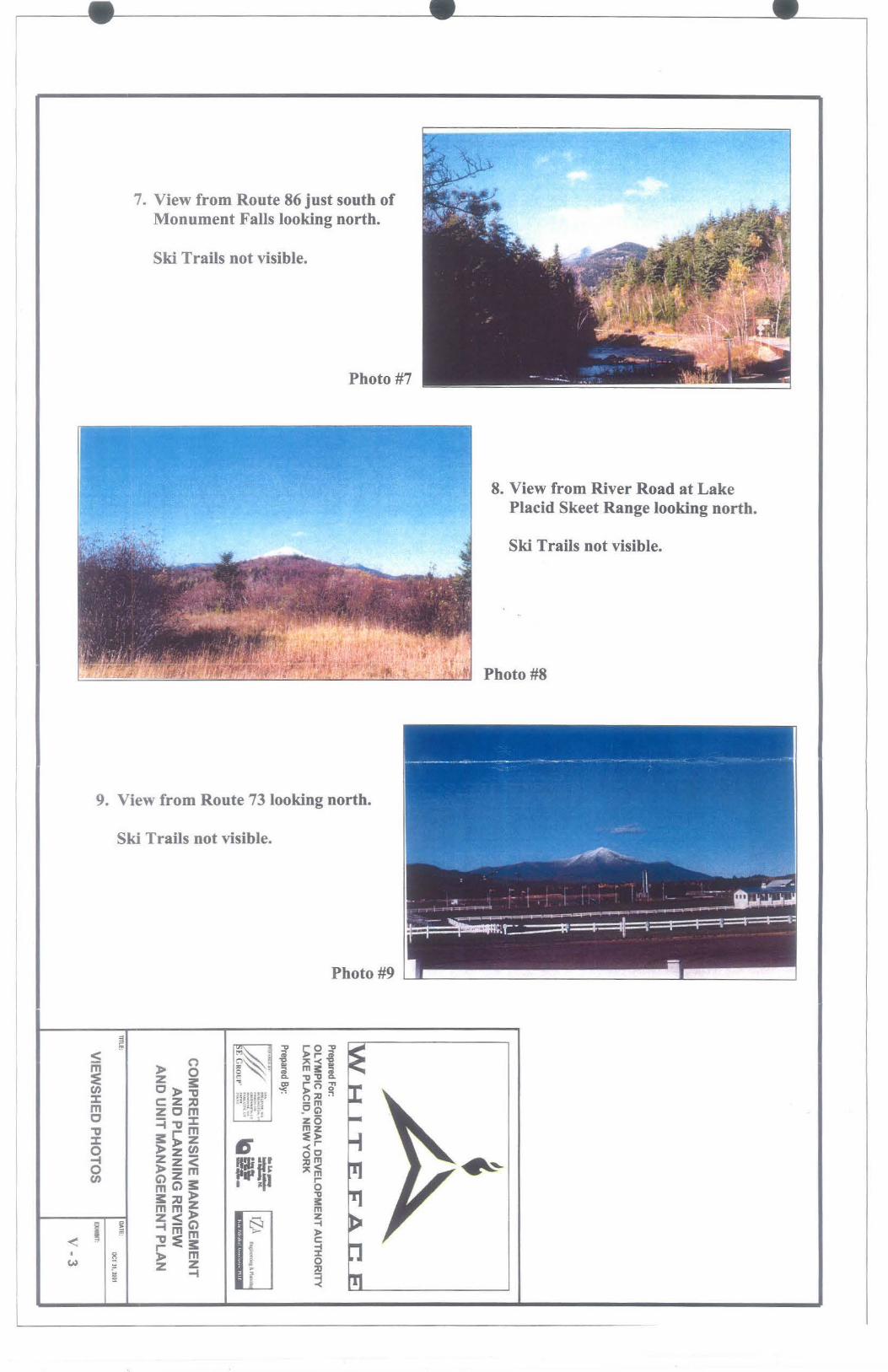
7. View from Route 86 just south of Monument Falls looking north.
Ski Trails not visible.
Photo #7
8. View from River Road at Lake Placid Skeet Range looking north.
Ski Trails not visible.
j_,., -- • ... -_,....,,._, "-r·_,_ .. ,., ... ,. "'" -... ··· · ~·- .. . ; .. ,,._. "r · - ·-··-·· ·~·-· .... .. . -.. ~-·~ ... .it~ Photo #8
9. View from Route 73 looking north.
Ski Trails not visible.
Photo #9 .____ ___ _________ _.__ ____ __J
~ ..,,. • "ti r o "ti < t"l~~ ~ ;;; J> r- iii iii - 0 ~~l 'g ,.. -< 'g - 0 c · a; m3:c;; :e z , ~ c. "OJ!C. CJ) C ::a. m ro"" ::c > ""D ,~ ~-·waf -:c; J> ::o ~ m C: Z :::0 °•~§:~~; g m
Z 0 m ~ = • .,. 0 "' 0
~t' •• .. Ml - ::c . ",. z 0 "tJ ~""Dm mz ::c s:::>z .- ~~ 0 >zcn .., -<o ~ z z < 11· nr ~ m L... J ~ ......-.. ... 0 > z m il'Jir: ,..~ 111 ~ ~ CJ) ~ C> s::: illl 5
s::: :::0 > "O mmZ ~ z<> - z
ii~ ~n;C> t:::--J -i !!! -· m ....... > ~ . ""CJ<, c: r<::a. ~ -i
w 12 > ~ 1 5 i z ~ i !:!! - J ~

•
•
•
SU des Intervening RldaeUue Topography
Southwest view from Lookout Mountain Summit.
Only very upper portion of Tree Island Pod potentially visible.
1251
11•
1175
940 +/-METERS
SECTION VIEW SCAU:: VERT 1:2,509
HOIUZ 1:25, ...
LOCATIONMAP ~ NTS ..
l' I
I /
r
\ . \;
\ .. ;/
/
I
.,.
Whiteface MountaiD Memorial Wgbway
.; ' - -£ of ....
·~ ~tlal Vblblllty ~ ·lf(h,r, ·
. M11t
• • ~1-·
••
' .;.~
Prepared For: OLYMPIC REGIONAL DEVELOPMENT AUTHORITY LAKE PLACID, NEW YORK
Prepared By:
ffilf:
... '"" "'" ' ' .... , ..... "" .. ...... .. . •·n.····· · '""'-" , ..... , ...
COMPREHENSIVE MANAGEMENT AND PLANNING REVIEW
AND UNIT MANAGEMENT PLAN
DATE: MARCH 20, 21>03
VIEWSHED PHOTOS EXlll!IT:
V-4
PROJECT NUllllER: tl043 FILE: ~lace]

•
•
•
Southwest view from Wilmington Trail east of Lookout Mountain summit.
Tree Island Pod not visible.
1225
1200
1175
1,090 +/-METERS
SECTION VIEW SCALE: VERT 1 :2,500
HORIZ l:U,000
LOCATIONMAP ~ NTS ..
d • I
/
I
\
I
\ \
Whiteface Mountain Memorial Wahway
.. . \ l
/
~
Prepared For: OLYMPIC REGIONAL DEVELOPMENT AUTHORITY LAKE PLACID, NEW YORK
Prepared By:
• . >' ,/,,·,,.· ~E GROl:P'
... ... , ,,_ , .. , ..... . -·~~ ........... . ' 11'L I .. l
'"'' ''"~ '-
COMPREHENSIVE MANAGEMENT AND PLANNING REVIEW
AND UNIT MANAGEMENT PLAN
TITLE: DAlE: llAACH 20, 1003
VIEWSHED PHOTOS EXllllllT:
V-5
PROJECT NUllBER: t10i.l FllE: (wtlllofl<*)
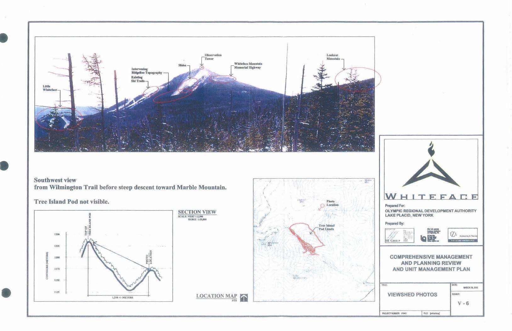
•
•
•
Little Whiteface
Southwest view
htervenlng Rldsellne Topography
E:dltlng Sid Trails
Slides
from Wilmington Trail before steep descent toward Marble Mountain.
Tree Island Pod not visible.
Q
i?
~ ! ~ 01 ..
IZ!t ~mi "'(
1215
! ti
1200
g
! 1175
~ z 0 I.I
1150 .
1125
1,310 +/- METERS
SECTION VIEW SCALE: VERT 1:1,500
HORIZ I :25,000
LOCATION MAP ~ NTS ..
/
I l ,·
\
\ \
I
Photo ,P Location
...
\ I
/ ~
Prepared For: OLYMPIC REGIONAL DEVELOPMENT AUTHORITY LAKE PLACID, NEW YORK
Prepared By:
... ~:.~:~: :. :: · ~ ', • ·• Ha•• .... .. . ,.,. ....
COMPREHENSIVE MANAGEMENT AND PLANNING REVIEW
AND UNIT MANAGEMENT PLAN
mLE: DAlE: llARCH 20, 2003
VIEWSHED PHOTOS EXHIBIT:
V-6
PROJECT HUlllllE'R.: t10U

Appendix:A4 "Pump House #1 and Easy Acres Lodge Visibility Study"
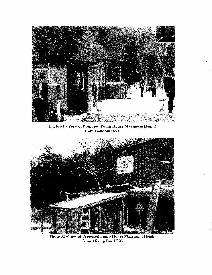
Photo #1 - View of Proposed Pump House Maximum Height from Gondola Deck
Photo #2 -View of Proposed Pump House Maximum Height from Mixing Bowl Lift
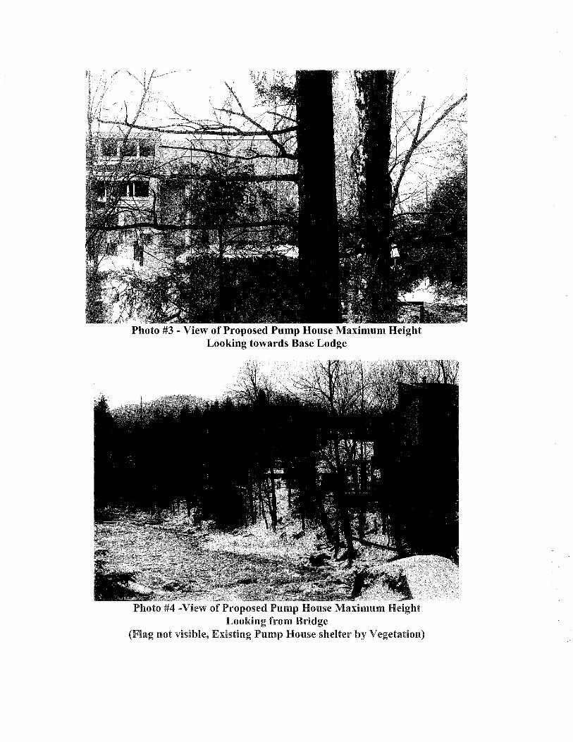
Photo #3 - View of Proposed Pump House Maximum Height Looking towards Base Lodge
Photo #4 -View of Proposed Pump House Maximum Height Looking from Bridge
(Flag not visible, Existing Pump House shelter by Vegetation)

Photo #5 - View of Proposed New Structure Looking towards Existing Facility
Photo# 6 - View of Existing Facility - Portion to be Removed is Highlighted

Photo# 7 - View from Existing Facility - Looking towards Maintenance Facility New Building shall include vegetation to screen Maintenance Facility
Photo# 8 - View from Existing Facility - Looking towards Maintenance Facility New Building will use existing vegetation to develop a Turn Around

Appendix AS "Cooperative Agreement between NYSDEC and ORDA"
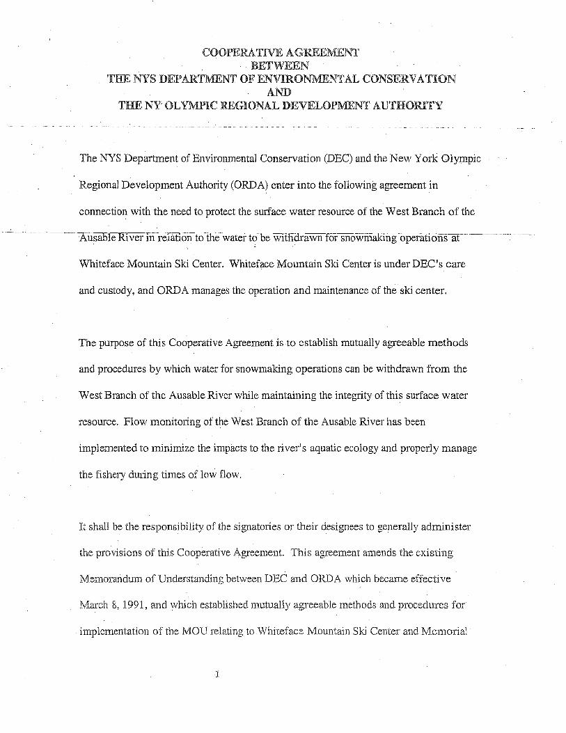
COOPERATIVE AGREEMENT BETWEEN
THE NYS DEPARTMENT OF ENVIRONMENTAL CONSERVATION AND
THE NY OLYMPIC REGIONAL DEVELOPMENT AUTHORITY
The NYS Department of Environmental Conservation (DEC) and the New York Olympic
Regional Development Authority (ORDA) enter into the following agreement in
connection with the need to protect the surf ace water resource of the West Branch of the
Whiteface Mountain Ski Center. Whiteface Mountain Ski Center is under DEC's care
and custody, and ORDA manages the operation and maintenance of the ski center.
The purpose of this Cooperative Agreement is to establish mutually agreeable methods
and procedures by which water for snowmaking operations can be withdrawn from the
West Branch of the Ausable River while maintaining the integrity-of this surface water
resource. Flow monitoring of the West Branch of the Ausable River has been
implemented to minimize the impacts to the river's aquatic ecology and properly manage
the fishery during times of low flow.
It shall be the responsibility of the signatories or their designees to generally administer
the provisions of this Cooperative Agreement. This agreement amends the existing
Memorandum of Understanding between DEC and ORDA which became effective
March 8, 1991, and which established mutually agreeable methods and procedures for
implementation of the MOU relating to Whiteface Mountain Ski Center and Memorial
1
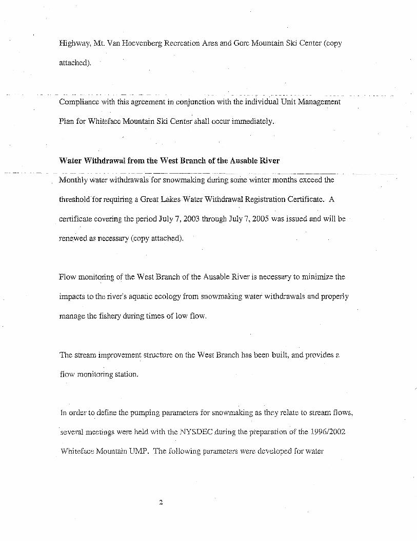
Highway, Mt. Van Hoevenberg Recreation Area and Gore Mountain Ski Center (copy
attached).
Compliance with this agreement in conjunction with the individual Unit Management
Plan for Whiteface Mountain Ski Center shall occur immediately.
Water Withdrawal from the West Branch of the Ausable River
Monthly water withdrawals for snowmaking during some winter months exceed the
threshold· for requiring a Great Lakes Water Withdrawal Registration Certificate.· A
certificate covering the period July 7, 2003 through July 7, 2005 was issued and will be
renewed as necessary (copy attached).
Flow monitoring of the West Branch of the Ausable River is necessary to minimize the
impacts to the river's aquatic ecology from snowmaking water withdrawals and properly
manage the fishery during times of low flow.
The stream improvement structure on the West Branch has been built, and provides a
flow monitoring station.
In order to define the pumping parameters for snowmaking as they relate to stream flows,
several meetings were held with the NYSDEC during the preparation of the 1996/2002
Whiteface Mountain IB\1P. The following parameters were developed for water
2
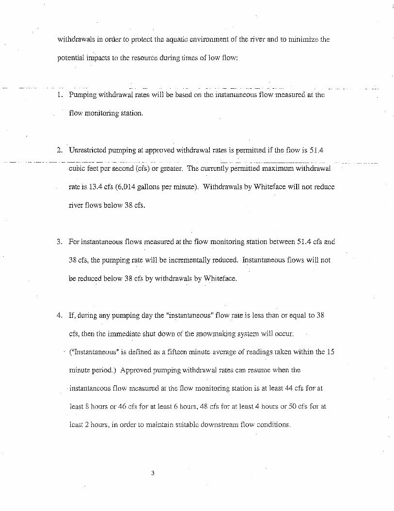
withdrawals in order to protect the aquatic environment of the river and to minimize the
potential impacts to the resource during times of low flow:
1. Pumping withdrawal rates will be based on the instantaneous flow measured at the
flow monitoring station.
2. Unrestricted pumping at approved withdrawal rates is permitted if the flow is 51.4
cubic feet per second (cfs) or greater. The currently permitted maximum withdrawal
rate is 13.4 cfs (6,014 gallons per minute). Withdrawals by Whiteface will not reduce
river flows below 38 cfs.
3. For instantaneous flows measured at the flow monitoring station between 51.4 cfs and
38 cfs, the pumping rate will be incrementally reduced. Instantaneous flows will not
be reduced below 38 cfs by withdrawals by Whiteface.
4. If, during any pumping day the "instantaneous" flow rate is less than or equal to 38
cfs, then the immediate shut down of the snowmaking system will occur.
("Instantaneous" is defined as a fifteen minute average of readings taken within the 15
minute period.) Approved pumping withdrawal rates can resume when the
instantaneous flow measured at the flow monit01ing station is at least 44 cfs for at
least 8 hours or 46 cfs for at least 6 hours, 48 cfs for at least 4 hours or 50 cfs for at
least 2 hours, in order to maintain suitable downstream flow conditions.
3
5. The flow data and pumping data will be provided to the DEC for compliance
monitoring. During the snowmak:ing season, the data will be provided to the DEC
monthly on a routine basis, and more frequently in response to direct requests by DEC
for data from specific dates. The routine submittals will include the daily minimum
river flow for all days and the "Daily Detail" (15 minute flow reports) for days when,
at any time during the day, river flows declined below 52 cfs. ·Records of withdrawals
from the river should also be provided on.days when river flows declined below 52
cfs. The monthly report will be provided to the DEC by five days after the end of the
month.
6. During periods of severe anchor ice formation, data from the two gauges installed in
the flume will be manually compared to determine if backwater effects are altering
the gauge readings. Such comparisons will be done for periods upon request by the
DEC.
7. The flume will be re-calibrated annually, preferably shortly before the start of the
snowmaking season.
8. This Cooperative Agreement will be reviewed annually by DEC Fisheries staff and
ORDA management and can be modified, amended, or canceled at any time upon
mutual agreement of the signatories to this agreement.
4

9. This term of this agreement will be concurrent with the term of the Whiteface
Mountain Ski Center UMP.
5

This Cooperative Agreement will become effective upon its execution by each of
the parties hereto.
Department of Environmental Conservation
Date:
Olympic Regional Development Authority
/~~ By: =~ ... · r:<zL , Ted Blazer, President,c:ED.
Date:
01043/cooperative.agreement
6

Appendix A6 "Traffic Assessment"
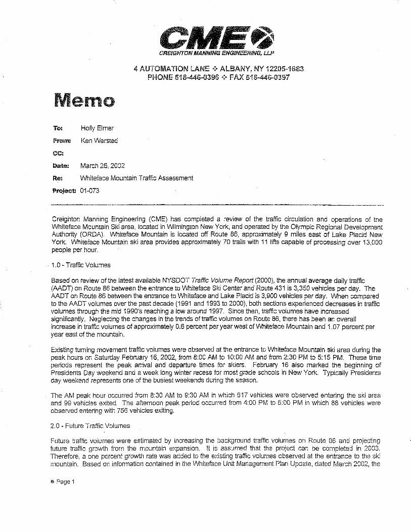
emo To: Holly Elmer
From: Ken Wersted
CC:
Date: March 26, 2002
CREIGHTON MANNING ENGINE/ER/NG, UP
4 AUTOMATION LANE•!• ALBANY, NY 12205-1683 PHONE 518-446..0396 •!•FAX 518-446..0397
Re: Whiteface Mountain Traffic Assessment
Project 01-073
Creighton Manning Engineering (CME) has completed a review of the traffic circulation and operations of the Whiteface Mountain Ski area, located in Wilmington New York, and operated by the Olympic Regional Development Authority (ORDA). Whiteface Mountain is located off Route 86, approximately 9 miles east of Lake Placid New York. Whiteface Mountain ski area provides approximately 70 trails with 11 lifts capable of processing over 13,000 people per hour.
1.0 - Traffic Volumes
Based on review of the latest available NYSDOT Traffic Volume Report (2000), the annual average daily traffic (AADT) on Route 86 between the entrance to Whiteface Ski Center and Route 431 is 3,350 vehicles per day. The AADT on Route 86 between the entrance to Whiteface and Lake Placid is 3,900 vehicles per day. When compared to the AADT volumes over the past decade (1991 and 1993 to 2000), both sections experienced decreases in traffic volumes through the mid 1990's reaching a low around 1997. Since then, traffic volumes have increased significantly. Neglecting the changes in the trends of traffic volumes on Route 86, there has been an overall increase in traffic volumes of approximately 0.6 percent per year west of Whiteface Mountain and 1.07 percent per year east of the mountain.
Existing turning movement traffic volumes were observed at the entrance to Whiteface Mountain ski area during the peak hours on Saturday February 16, 2002, from 8:00 AM to 10:00 AM and from 2:30 PM to 5:15 PM. These time periods represent the peak arrival and departure times for skiers. February 16 also marked the beginning of Presidents Day weekend and a week long winter recess for most grade schools in New York. Typically Presidents day weekend represents one of the busiest weekends during the season.
The AM peak hour occurred from 8:30 AM to 9:30 AM in which 617 vehicles were observed entering the ski area and 99 vehicles exited. The afternoon peak period occurred from 4:00 PM to 5:00 PM in which 88 vehicles were observed entering with 756 vehicles exiting.
2.0 - Future Traffic Volumes
Future traffic volumes were estimated by increasing the background traffic volumes on Route 86 and projecting future traffic growth from the mountain expansion. It is assumed that the project can be completed in 2003. Therefore, a one percent growth rate was added to the existing traffic volumes observed at the entrance to the ski mountain. Based on information contained in the Whiteface Unit Management Plan Update, dated March 2002, the
®Page 1
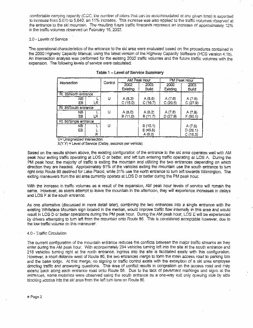
comfortable carrying capacity (CCC, the number of skiers that can be accommodated at any given time) is expected to increase from 5,070 to 5,640, an 11 % increase. This increase was also applied to the traffic volumes observed at the entrance to the ski mountain. The resulting future traffic forecasts represent an increase of approximately 12% in the traffic volumes observed on February 16, 2002.
3.0 - Levels of Service
The operational characteristics of the entrance to the ski area were evaluated based on the procedures contained in the 2000 Highway Capacity Manual, using the latest version of the Highway Capacity Software (HCS version 4.1 b ). An intersection analysis was performed for the existing 2002 traffic volumes and the future traffic volumes with the expansion. The following levels of service were calculated:
Table 1 - Level of Service Summary
Intersection Control AM Peak Hour PM Peak Hour
2002 2003 2002 2003 Existing Build Existing Build
Rt. 86/North entrance NB L u A (8.3) A (8.5) A (7.6) A (7.6) EB LR c (15.0) c (16.7) c (20.5) c (27.9)
Rt. 86/South entrance NB L u A (8.0) A (8.2) A (7.8) A (7.8) EB LR B (11.0) B (11.7) D (27.9) F (50.1)
Rt. 86/Sinqle entrance NB L u B (10.1) A (7.8) EB L E (45.8) D (26.1)
R A (9.0) c (16.3) U= Uns1gnahzed Intersection X(Y.Y) = Level of Service (Delay, seconds per vehicle)
Based on the results shown above, the existing configuration of the entrance to the ski area operates well with AM peak hour exiting traffic operating at LOS C or better, and left tum entering traffic operating at LOS A During the PM peak hour, the majority of traffic is exiting the mountain and utilizing the two entrances depending on which
·direction they are headed. Approximately 61 % of the vehicles exiting the mountain use the south entrance to tum right onto Route 86 destined for Lake Placid, while 31 % use the north entrance to tum left towards Wilmington. The exiting maneuvers from the ski area currently operate at LOS D or better during the PM peak hour.
With the increase in traffic volumes as a result of the expansion, AM peak hour levels of service will remain the same. However, as skiers attempt to leave the mountain in the afternoon, they will experience increases in delays and LOS F at the south entrance.
As one alternative (discussed in more detail later), combining the two entrances into a single entrance with the existing Whiteface Mountain sign located in the median, would improve traffic flow internally in this area and would result in LOS D or better operations during the PM peak hour. During the AM peak hour, LOS E will be experienced by drivers attempting to tum left from the mountain onto Route 86. This is considered acceptable however, due to the low traffic volume on this maneuver.
4.0 - Traffic Circulation
The current configuration of the mountain entrance reduces the conflicts between the major traffic streams as they enter during the AM peak hour. With approximately 294 vehicles turning left into the site at the south entrance and 218 vehicles turning right at the north entrance, ingress into the site is facilitated easily with this configuration. However, a short distance west of Route 86, the two entrances merge to form the main access road to parking lots and the base lodge. At this merge, no signing or traffic control exists with the exception of a ski area employee directing traffic and answering questions. This area of conflict results in congestion on the access road and may extend back along each entrance road onto Route 86. Due to the lack of pavement markings and signs at the entrances, some motorists were observed using the south entrance as a one-way exit only queuing side by side blocking access into the ski area from the left tum lane on Route 86.
®'Page 2
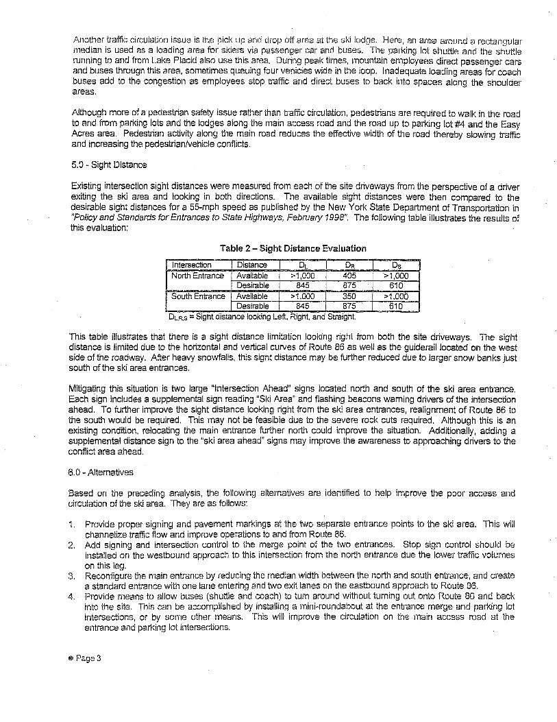
Another traffic circulation issue is th.e pick up and drop off area at the ski lodge. Here, an area around a rectangular median is used as a loading area for skiers via passenger car and buses. The parking lot shuttle and the shuttle running to and from Lake Placid also use this area. During peak times, mountain employees direct passenger cars and buses through this area, sometimes queuing four vehicles wide in the loop. Inadequate loading areas for coach buses add to the congestion as employees stop traffic and direct buses to back into spaces along the shoulder areas.
Although more of a pedestrian safety issue rather than traffic circulation, pedestrians are required to walk in the road to and from parking lots and the lodges along the main access road and the road up to parking lot #4 and the Easy Acres area. Pedestrian activity along the main road reduces the effective width of the road thereby slowing traffic and increasing the pedestrian/vehicle conflicts.
5.0- Sight Distance
Existing intersection sight distances were measured from each of the site driveways from the perspective of a driver exiting the ski area and looking in both directions. The available sight distances were then compared to the desirable sight distances for a 55-mph speed as published by the New York State Department of Transportation in "Policy and Standards for .Entrances to State Highways, February 1998". The following table illustrates the results of this evaluation:
Table 2 - Sight Distance Evaluation
Intersection Distance DL DR Os North Entrance Available >1,000 405 >1,000
Desirable 845 875 610 South Entrance Available >1,000 350 >1,000
Desirable 845 875 610 DLR.S = Sight distance looking Left, Right, and Stra1ghl
Tnis table illustrates that there is a sight distance limitation looking right from both the site driveways. The sight distance is limited due to the horizontal and vertical curves of Route 86 as well as the guiderail located on the west side of the roadway. After heavy snowfalls, this sight distance may be further reduced due to larger snow banks just south of the sk.i area entrances.
Mitigating this situation is two large ulntersection Ahead" signs located north and south of the ski area entrance. Each sign includes a supplemental sign reading "Ski Area" and flashing beacons warning drivers of the intersection ahead. To further improve the sight distance looking right from the ski area entrances, realignment of Route 86 to the south would be required. This may not be feasible due to the severe rock cuts required. Although this is an existing condition, relocating the main entrance further north could improve the situation. Additionally, adding a supplemental distance sign to the "ski area ahead" signs may improve the awareness to approaching drivers to the conflict area ahead. ·
6.0 -Alternatives
Based on the preceding analysis, the following alternatives are identified to help improve the poor access and circulation of the ski area. They are as follows:
1. Provide proper signing and pavement markings at the two separate entrance points to the ski area. This will channelize traffic flow and improve operations to and from Route 86.
2. Add signing and intersection control to the merge point of the two entrances. Stop sign control should be installed on the westbound approach to this intersection from the north entrance due the lower traffic volumes on this leg.
3. Reconfigure the main entrance by reducing the median width between the north and south entrance, and create a standard entrance with one lane entering and two exit lanes on the eastbound approach to Route 86.
4. Provide means to allow buses (shuttle and coach) to tum around without turning out onto Route 86 and back into the site. This can be accomplished by installing a mini~roundabout at the entrance merge and parking lot intersections, or by some other means. This will improve the circulation on the main access road at the entrance and parking lot intersections.
@Page 3
5. Remove pedestrian conflicts along the main access road by providing a 1 O~foot wide sidewalk along one or both sides of the road.
6. Widen the access road (on the downhill side) from the base lodge to Easy Acres to provide approximately 30 feet from the edge of pavement and allow perpendicular parking on this side rather than parallel parking. This will increase the parking capacity along this access road and provide enough shoulder to allow pedestrians to walk and an area for vehicles to back out of a parking space without backing into the roadway completely.
7. Create a bus loading area and/or move the bus parking to lot #2. This will remove the need for buses to access the existing loading area next to the lodge but will require pedestrians to cross the bridge and will displace some vehicles currently using lot #2.
8. Minimize parking in the loading area to handicap vehicles only. This will create additional space for loading but will displace some employee vehicles.
9. Remove parking between the base lodge and the NYSEF building and modify the area to increase the size and performance of the current loading area. This will displace vehicles but could triple the loading area and improve traffic flow significantly.
7.0 ~Conclusions and Recommendations
Currently, the entrance to the Whiteface Ski mountain area operates at good levels of service during the AM and PM peak hours. With the increase in traffic volumes as a result of the expansion, skiers will experience longer delays during the PM peak hour. Several circulation conflicts exist between Route 86 and the base lodge. Most significant is the merge of the main entrances and the main access road and the loading area at the base lodge. Several alternatives have been proposed which will improve circulation, and may be implemented in combination with others or as stand alone projects. However, it is recommended that the configuration of the entrance to the mountain be modified to provide a single access point with separate left and right tum lanes exiting onto Route 86. Additionally, it may not be feasible to increase the available sight distance looking right from the site driveway. Therefore adding a supplemental distance sign is recommended to supplement existing warning of the conflict area ahead for approaching drivers.
\\SERVER\COMPANY\Projects\Oi-073\CME Memo.doc
~ Page4

SEQRA Public rnrnient and H.esponses
Response to Public Conunents This section presents responses to comments made on the 2006 Unit Management Plan Amendment to the 2004 Unit Management Plan and Draft Envirom11ental Impact Statement for Whiteface Mountain Ski Center (May 2006). Comments have been summarized by the original source. Copies of comment letters are included at the end of this section.
Audubon New York, 200 Trilkum La:rae, Albany, NY, Letter of 19 June 2006, Michael F. Burger
Comment 1 The C01m11entor states: In the Executive Summary on page 3 of the UMP Amendment, Audubon New York is inconectly referred to as the "New York Audubon Society." Considering that there is a different organization with a name similar to that, we request that we be identified as "Audubon New York."
Response 1 Executive Summary on page 3 of the UMP Amendment, reads "New York Audubon Society'', this is incorrect and shall read "Audubon New York"
Comment2 The Conunentor states: On page 25, section 5.a., please include Audubon New York as one of the groups that will assist in the development of the Bicknell's Thrush Habitat Management Plan for Whiteface Mountain. Audubon New York has been an active participant in the cooperative process leading up to this UMP Amendment, and we intend to stay involved.
Response 2 Page 25, section 5.a. of the electronic version translates to Section II, page 5 of the hard paper version shall include Audubon New York as one of the groups that will assist in the development of the Bicknell's Thrush Habitat Management Plan for Whiteface Mountain.
Comment3 The Commentor states: On page 26, section 3.a., similar to the comment above, please include Audubon Ne\;v York as one of the partners that will work with ORDA to develop standards for habitat restoration and evaluation. Furthermore, we suggest explicitly stating that these standards that will be developed will be included in the Biclmell's Thrush Habitat Management Plan.
Response 3 Page 26, section 3.a., of the electronic version translates to Section II, page 6 of the hard paper version shall include Audubon Ne\V York as one of the partners that \:vill work with ORDA to develop standards for habitat restoration and evaluation. Section II, page 6
shall include: Flabita1 Restoration and Evaluation Standards shall be included in the Bickncll's Thrusb Habitat Management Plan to ensure a holistic approach.
Comment4 The Commentor states: Regarding long-term monitoring (page 27, section 2.b.), we suggest that plans for long-tem1 monitoring ofBicknell's Thrush be integrated into the Biclmell's Thrush Habitat Management Plan, such that habitat evaluation and tlu-ush monitoring be coordinated in an adaptive management framework. Again, please include Audubon New York as one of the partners who will assist with this effort.
Response 4 Page 27, section 2.b., of the electronic version translates to Section II, page 7, section 2b of the hard paper version shall include that plans for long-tem1 monitoring ofBicknell's Tlu-ush be integrated into the Biclmell's Thrush Habitat Management Plan, such that habitat evaluation and thrush monitoring be coordinated in an adaptive management framework. This effort shall include Audubon New York as one of the partners that will work with ORDA.
Comments The Commentor states: Finally, the UMP Amendment fails to make note of the IBA identification and BCA designation for this area. We suggest that it would be appropriate to include this infonnation somewhere in the document, for example on page 21 and/or in the Executive Sununary.
Response 5 The following text shall be added to the Section II, page 1, paragraph 1: "Whiteface Mountain, in conjunction with other peaks over 2,800 feet in the area nmih of Lake Placid and Keene, is paii of the Northern Adirondack Peaks Important Bird Area (IBA), as identified by Audubon New York in 2005. Additionally, in 2001 Governor Pataki designated state-owned Adirondack peaks over 2,800 feet as the Adirondack Subalpine Forest Bird Conservation Area (BCA); documentation regarding which specifically mentions the inclusion of Whiteface Mountain. The primary reason for the both the IBA and BCA designations is that these peaks support multiple pairs of breeding Bicknell's Thrush, which is considered one of the highest priority bird species in the northeastern U.S., in addition to being a state-listed species of special concern."
University at Albany5 Atmospheric Science Research Center, "VVhiteface Mountain Field Station, Letter of 23 .June 2006, Douglas \Volfe
Comment l The Commentor states: The Draper Lodge Skiing Complex is approaching it's fiftieth anniversary \vith several expansion projects some of which will impact the sub-alpine zones of Whiteface. One of the original designers Mr. Otto Schneibs insisted of two features ... lifts and trails not be oriented along the prevailing wind (sweep) and keep the bulldozers off the bedrock as fresh outcrop exposures may never heal and water run-off
may render unsuitable for use. After fifty years of experience, it sl1ould be apparent what tbe specific methods should be for constructing and maintaining trails and facilities.
Response 1 All modern means and metbods for soil and erosion will be employed. Appendix A2 "Generic Storm -water Pollution Prevention Plan" in the DEIS identifies the program elements.
Comment 2 The Commentor states: Environmental research considerations include concern for cloud water and precipitation runoff eroding effects in these areas of "high" erodeability as evidenced in a number of storm events. A lack of vigilance and maintenance of constructed trails and associated drainage has been a source of erosion problems.
Response 2 All modern means and methods for soil and erosion will be employed. Appendix A2 "Generic Storm Water Pollution Prevention Plan" in the DEIS identifies the program elements. New program elements include new training programs for staff.
Comment3 The Commentor states: Proposals for new trails (TIP) of narrow width are unrealistic as infrastructures, i.e .. lifts, power, snowmaking pipes all demand separation as well as the "snowboarder" factor, a situation /use not addressed in the UMP proposal.
Response 3 Reduced trail sizes in the Tree Island Pod (TIP) are a result of Vvhiteface Mountain and Olympic Regional Development Authority Staff conm1itment to the protection of the Biclmell's Thrush and their habitat. Skiers and snowboarders will have to adjust and adopt behaviors in these areas that will allow the trail systems and the mountain ecosystem to function in harmony.
Comment4 The Commentor states: Some long-tenn ecology/forest monitoring sites also exist around the mountain which may be abolished by new trails.
Response 4 The new trail systems has been mapped using GPS teclmology, the Commentor suggest that there may be an effect on "some long-term ecology/forest monitoring sites". If the Commentor can provide specific location of the long-tem1 ecology/forest monitoring sites the issue can be addressed in a defined manor.
Comn1ent 5 The Commentor states: The cloud rime icing level occurs from 3600' up,vards and can be bazardous to lift operation along with sweep direction.

Response 5 ·whiteface Mountain and Olympic Regional Development Authority Staffl:vill monitor and mitigate all operational hazards.
GO/',RD OF D!P_ECTOF,S
Consi-<111tinc Sicl;11·non-Erisrnff Cl111frnJ1tn
UJkes Arnes
---·-~·Geoffre-y Cnhb R»an h,·, Chair.'
Jvbri~Hi 1-Iciskt:il Chn1i
Juhn TJierwinh V\7iiliL1n1 E. Dc·1vis /; iice De1Busu1
Gbdvs Goldmann Da\'icl l hiiile;·
i)avid 1. J'·iillcr Exccittil't [Ji.recto;
!!"-! NEVV YORK ST;\TE
Audubon Cente1
.~\udtibon Center
Co\'c~ J\0:1cl CJystci 11-··-!
Tel: 51C)-922-321_,c.
P;irl: ,'"", udubon C:1~1-1Lt1
19 June 2006
Jay Rand, General Manager Whiteface Mountain Ski Center Rte. 86 Wilmington, New York 12997
Dear Mr. Rand:
2cH) ·rrilliurn Lane
NY 1 220
Tel: 51
n asny~~
http://ny,audu .urg
Thank you for the opportunity to review and comment on the Whiteface Mountain Ski Center 2006 Unit Management Plan Amendment to the 2004 Unit Management Plan and Draft Environmental Impact Statement (hereafter, the UMP Amendment).
Audubon New York, like our colleagues in the other conservation organizations active in the Adirondack Park, is very suppmiive of the proposed management actions described in the UMP Amendment for ski trail construction and improvement on Whiteface Mountain. Our comments are organized as follows: an introduction explaining the significance of this unit to bird conservation, a brief description of the actions proposed in the UMP Amendment that we support, and finally, some very specific comments about the contents of the UMP Amendment.
Introduction Of paramount interest and concern for Audubon New York is the fact that Whiteface Mountain, in conjunction with other peaks over 2,800 feet in the area no1ih of Lake Placid and Keene, is paii of the Nmihern Adirondack Peaks Impmiant Bird Area (IBA). Additionally, in 2001 Governor Pataki designated state-owned Adirondack peaks over 2,800 feet as the Adirondack Sub-alpine Forest Bird Conservation Area (BCA); documentation regarding: which specifically mentions the inclusion of Whiteface Mountain. The primary reason for the both the IBA and BCA designations is that these peaks suppmi multiple pairs of breeding Bicknell's Thrush, which is considered one of the highest priority bird species in the northeastern U.S., in addition to being a state-] isted species of special concern. Flllihermore, Bicknell' s Thrush is a species for which New York has a special responsibility, because a significant propmiion of its population breeds here. Bicknell's Thrush has a very limited distribution and is restricted to a narrow range of acceptable breeding habitats, including patches of young or stunted spruce-fir forests found at high elevations. The most significant threat to this species, however, is likely the loss of winter habitat on the island of Hispaniola.
Important Bird Areas ofNew York: Habitats FVorth Protecting (Burger and Liner, 2005) states on page 157 that development projects (e.g., expansion of ski slopes) in this IBA with potential to disturb Bicknell's Thrush habitat should be monitored closely. Similarly, the Adirondack Sub-alpine Forest BCA management guidance
summary includes the following vision statement: "Continue to maintain the wilderness quality of the area, while facilitating recreational opportunities in a manner consistent with conservation of the unique bird species present." The BCA document contains additional language directing state agencies to address Bicknell's Thrush and other bird conservation concerns in individual unit management plans. We commend ORDA on their conscientious effort to amend ski trail construction and improvement plans on Whiteface Mountain in accordance with IBA and BCA recommendations. Specifically, we a pleased that ORDA chose to work constructively with the bird conservation community to assess the situation on Whiteface Mountain and to accept recommendations that accommodate the habitat requirements of Bicknell's Thrush.
UMJ> Amendment Actions that Audubon New York Supports The Whiteface Mountain UMP Amendment outlines a number of modifications to the Tree Island Pod and glade ski trail construction plans that resulted from consultation with several partners in the bird conservation community, including Audubon New York. We suppmi the following proposed actions described in the UMP:
1. Prohibiting trail construction activities between 15 May and 1 August, which is the most active pa1i of the nesting season for Bicknell' s Th1·ush.
2. Moving the Tree Island Pod trail a minimum of 30 meters eastward to avoid naturally occurring Bicknell's Thrush habitat.
3. To the extent possible, avoiding Bicknell's Thrush habitat when constructing new or widening existing ski trails.
4. Keeping ski trails above 2,800 feet less than 35-40 meters in width. 5. Feathering the vegetation at the edges of ski trails (including review of this technique at Stratton Mountain
in Vermont). 6. Limiting vegetation clearing and understory removal in glade trails and keeping glades as narrow as
possible. 7. Moving the New Glade trail (formerly Sa, now trail 80) to an area on the mountain with fewer balsam fir
trees and lower value to Bicknell's Thrush. 8. Preventing unauthorized establishment of glade trails. 9. Maximizing the size of and minimizing the number of habitat islands within the trails. 10. Delaying vegetation management until after 1 August. 11. Developing a Bicknell's Thrush Habitat Management Plan in consultation with bird conservation groups to
guide the implementation and maintenance of these proposed actions. 12. Creating potential new Bicknell' s Thrush habitat by feathering the edges of ski lift openings and actively or
passively revegetating trail edges or obsolete trails. 13. Consolidating existing habitat fragments. 14. Promoting public awareness of Bicknell's Thrush as a species of concern in the Adirondacks as well as in
its \Vinter r::inge on Hispaniol8-. 15. Participation by ORDA and DEC on a steering committee to create and administer an international habitat
conservation fund to protect Bicknell 's Thrush winter habitat on Hispaniola. 16. Continuing short-term and baseline monitoring ofBicknell's Thrush in the project area, as well as
establishing a long-term monitoring effmi. 17. Creating a multifaceted educational program focusing on the conservation ofBicknell's Thrush and other
high-elevation birds.
Specific Comments on the UMP Amendment In the Executive Summary on page 3 of the UMP Amendment, Audubon New York is incorrectly referred to as the "New York Audubon Society." Considering that there is a different organization with a name similar to that, we request that we be identified as "Audubon New York."

On page 25, section 5.a., please include Audubon New York as one of the groups that will assist in the development of the Bicknell's Thrush Habitat Management Plan for Whiteface Mountain. Audubon New York has been an active participant in the cooperative process leading up to this UMP Amendment, and we intend to stay involved.
On page 26, section 3 .a., similar to the comment above, please include Audubon New York as one of the paiiners that will work with ORDA to develop standards for habitat restoration and evaluation. Fu1ihermore, we suggest explicitly stating that these standards that will be developed will be included in the Bicknell' s Thrush Habitat Management Plan.
Regarding long-tenn monitoring (page 27, section 2.b.), we suggest that plans for Jong-term monitoring of Bicknell's Thrush be integrated into the Bicknell's Thrush Habitat Management Plan, such that habitat evaluation and thrush monitoring be coordinated in an adaptive management framework. Again, please include Audubon New York as one of the paiiners who will assist with this effo1i.
Finally, the UMP Amendment fails to make note of the IBA identification and BCA designation for this area. We suggest iliat it would be appropriate to include this information somewhere in the document, for example on page 21 and/ or in the Executive Summary.
Summary Comments Audubon New York would like to emphasize the significance of this unit as pa1i of the larger Important Bird Area identified for its suppo1i of breeding Bicknell's Thrush, one of the highest priority birds in the northeastern U.S. The actions outlined in this UMP Amendment make a serious and significant attempt to accommodate Bicknell' s Thrush and its habitat on Whiteface Mountain, in addition to creating an international habitat conservation fund to protect winter habitat on Hispaniola and therefore address the most critical threat to this species. Audubon New York thanks ORDA, as well as the DEC, the Adirondack Park Agency, and the several conservation groups for their willingness to work cooperatively toward a solution that all find suitable. Finally, thanks to Ted Blazer, Bob Hammond, and you, Jay, for your personal commitment to this process and to the conservation of Bicknell 's Thrush. I and others at Audubon New York look forward to working with you to see this through.
Michael F. Burger Director of Bird Conservation
Cc: David Miller, Audub'.m New York Al Caccese, Audubon New York Stu Buchanan, NYS DEC Region 5

Atillosphcric Science." F'.c.'>carch Center
Whitcfocc Mountain Ficlcl SU.llion
UNIVERSITY AT ALBANY STATE UNIVERSITY OF NEW YORK
TO: Mr. Jay Rand, Manager, Whiteface Mt. Ski Center
FROM: Mr. Douglas Wolfe, ASRC Whiteface Station Operations
RE: Comments on UMP Expansion Proposals
Memorial Highway
Wilming10n, New York J 2997
5 J 8/946-2142
Fax: 518/946-7263
The Draper Lodge Skiing Complex is approaching its fiftith anniversary with several expansion projects some of which will impact the sub-alpine zones of Whiteface. One of the original designers,Mr. Otto Schneibs insisted on two features ... lifts and trails not be oriented along the prevailing wind (sweep) and keep the bulldozers off the bedrock as fresh outcrop exposures may never heal and water run-off may render unsuitable for use. After fifty years of experience, it should be apparent what the specific methods should be for constructing and maintaining trails and facilities.
Environmental research considerations include concern for cloud water and precipitation runoff eroding effects in these areas of "high" erodeability as evidenced in a number of storm events. A lack of vigilance and maintainence of constructed trails and associated drainage has been a source of erosion problems. Proposals for new trails (TIP) of narrow width are unrealistic as infrastructure,ie lifts,power,snowmaking pipes all demand separation as well as the'snowboarder' factor, a situation/use not addressed in the UMP proposal. Some long-term ecology/forest monitoring sites also exist around the mountain which may be abolished by new trails. The cloud rime icing level occurs from 360~upwards and can be hazardous to lift operation along with wind sweep direction.
An increase in winter use of the Memorial Highway to access the upper ski area has been noted and adds to the necessity of developing the Unit Management Plan for the Memorial Hlghway.
This written comment supplements the verbal comments made at the public hearing held on Thursday June 8, 2006. Respectfully submitted June 23,2006.

SEQRA Public Comment and Responses
Response to Public Comments This section presents responses to comments made on the 2006 Unit Management Plan Amendment to the 2004 Unit Management Plan and Draft Environmental Impact Statement for Whiteface Mountain Ski Center (May 2006). Comments have been summarized by the original source. Copies of comment letters are included at the end of this section.
Audubon New York, 200 TriHrum Lane, Albany, NY, Letter of 19 June 2006, Michael F. Burger
Comment 1 The Commentor states: In the Executive Summary on page 3 of the UMP Amendment, Audubon New York is incorrectly referred to as the "New York Audubon Society." Considering that there is a different organization with a name similar to that, we request that we be identified as "Audubon New York."
Response 1 Executive Summary on page 3 of the UMP Amendment, reads "New York Audubon Society", this is incorrect and shall read "Audubon New York"
Comment2 The Cornrnentor states: On page 25, section 5.a., please include Audubon New York as one of the groups that will assist in the development of the Bicknell's Thrush Habitat Management Plan for Whiteface Mountain. Audubon New York has been an active participant in the cooperative process leading up to this UMP Amendment, and we intend to stay involved.
Response 2 Page 25, section 5.a. of the electronic version translates to Section II, page 5 of the hard paper version shall include Audubon New York as one of the groups that will assist in the development of the Bicknell's Thrush Habitat Management Plan for Whiteface Mountain.
Comment3 The Cornmentor states: On page 26, section 3.a., similar to the comment above, please include Audubon New York as one of the partners that will work with ORDA to develop standards for habitat restoration and evaluation. Furthermore, we suggest explicitly stating that these standards that will be developed will be included in the Bicknell's Thrush Habitat Management Plan.
Response 3 Page 26, section 3.a., of the electronic version translates to Section II, page 6 of the hard paper version shall include Audubon New York as one of the partners that will work with ORDA to develop standards for habitat restoration and evaluation. Section II, page 6
shall include: Habitat Restoration and Evaluation Standards shall be included in the Bicknell's Thrush Habitat Management Plan to ensure a holistic approach.
Comment4 The Commentor states: Regarding long-tenn monitoring (page 27, section 2.b.), we suggest that plans for long~term monitoring of Bicknell's Thrush be integrated into the Bicknell's Thrush Habitat Management Plan, such that habitat evaluation and thrush monitoring be coordinated in an adaptive management framework. Again, please include Audubon New York as one of the partners who will assist with this effort.
Response 4 Page 27, section 2.b., of the electronic version translates to Section II, page 7, section 2b of the hard paper version shall include that plans for long-term monitoring ofBicknell's Thrush be integrated into the Bicknell' s Thrush Habitat Management Plan, such that habitat evaluation and thrush monitoring be coordinated in an adaptive management framework. This effort shall include Audubon New York as one of the partners that will work with ORDA.
Comments The Commentor states: Finally, the UMP Amendment fails to make note of the IBA identification and BCA designation for this area. We suggest that it would be appropriate to include this information somewhere in the document, for example on page 21 and/or in the Executive Summary.
Response 5 The following text shall be added to the Section II, page 1, paragraph 1: "Whiteface Mountain, in conjunction with other peaks over 2,800 feet in the area north of Lake Placid and Keene, is part of the Northern Adirondack Peaks Important Bird Area (IBA), as identified by Audubon New York in 2005. Additionally, in 2001 Governor Pataki designated state-owned Adirondack peaks over 2,800 feet as the Adirondack Subalpine Forest Bird Conservation Area (BCA); documentation regarding which specifically mentions the inclusion of Whiteface Mountain. The primary reason for the both the IBA and BCA designations is that these peaks support multiple pairs of breeding Biclmell's Thrush, which is considered one of the highest priority bird species in the northeastern U.S., in addition to being a state-listed species of special concern."
University at Albany, Atmospheric Science Research Center, Whiteface Mountain Field Station, Letter of 23 June 2006, Douglas Wolfe
Comment 1 The Commentor states: The Draper Lodge Skiing Complex is approaching it's fiftieth anniversary with several expansion projects some of which will impact the sub-alpine zones of Whiteface. One of the original designers Mr. Otto Schneibs insisted of two features ... lifts and trails not be oriented along the prevailing wind (sweep) and keep the bulldozers off the bedrock as fresh outcrop exposures may never heal and water run-off

may render unsuitable for use. After fifty years of experience, it should be apparent what the specific methods should be for constructing and maintaining trails and facilities.
Response 1 All modem means and methods for soil and erosion will be employed. Appendix A2 "Generic Storm Water Pollution Prevention Plan" in the DEIS identifies the program elements.
Comment 2 The Commentor states: Environmental research considerations include concern for cloud water and precipitation runoff eroding effects in these areas of "high" erodeability as evidenced in a number of storm events. A lack of vigilance and maintenance of constructed trails and associated drainage has been a source of erosion problems.
Response 2 All modem means and methods for soil and erosion will be employed. Appendix A2 "Generic Storm Water Pollution Prevention Plan" in the DEIS identifies the program elements. New program elements include new training programs for staff.
Comment3 The Commentor states: Proposals for new trails (TIP) of narrow width are unrealistic as infrastructures, i.e .. lifts, power, snowmaking pipes all demand separation as well as the "snowboarder" factor, a situation /use not addressed in the UMP proposal.
Response 3 Reduced trail sizes in the Tree Island Pod (TIP) are a result of Whiteface Mountain and Olympic Regional Development Authority Staff commitment to the protection of the Bicknell's Thrush and their habitat. Skiers and snowboarders will have to adjust and adopt behaviors in these areas that will allow the trail systems and the mountain ecosystem to function in harmony.
Comment4 The Commentor states: Some long-term ecology/forest monitoring sites also exist around the mountain which may be abolished by new trails.
Response 4 The new trail systems has been mapped using GPS technology, the Commentor suggest that there may be an effect on "some long-term ecology/forest monitoring sites". If the Commentor can provide specific location of the long-term ecology/forest monitoring sites the issue can be addressed in a defined manor.
Comments The Commentor states: The cloud rime icing level occurs from 3600' upwards and can be hazardous to lift operation along with sweep direction.

Response 5 Whiteface Mountain and Olympic Regional Development Authority Staff will monitor and mitigate all operational hazards.

ERRATA
Revisions This section presents revisions to the May 2006 DEIS.
Revision 1 Table of Contents, List of Figures, Tables and Appendices; Revise: "Section VIIIFigures and Photo" to "Section VIII - Figures"
Revision 2 Section I, page 2, first paragraph; Revise .... total trail mileage at Whiteface Mountain (WFM) to 24.96 miles ... ; Shall be revised to .... total trail mileage at Whiteface Mountain (WFM) to 24.02 miles .. .
Revision 3 Section I, page 10, first paragraph; Add "The new facility would allow for the removal of the existing temporary yurt structures and the modular building from the Easy Acres Campus. These temporary structures will be relocated within the Base Campus area to support the improvement of 770 sf oflocker and ticketing space and 350 sf for additional offices, storage and conference space for administration, 336 sf of expansion of employee lockers/lounge space approved in previous UMP's. The temporary structures will be removed at the completion of the Base Campus improvements"
Revision 4 Section I, page 10, second paragraph; Add "Final design of the Easy Acres Campus buildings may involve rearrangement of the space utilization plan, including moving food service activities to the new building and retaining rental, ticketing, guest services, etc in the existing, to-be expanded building if deemed more suitable."
Revision 5 Section I, page 11, Fourth Bullet; Add "Final design of the Easy Acres I will include review of utilization and possible connection to previously approved IST's on the WFM complex." Section I, page 11, Fourth Bullet; Add "Final design of the Easy Acres Individual Sanitary Treatment (IST) will include review of utilization and possible connection to previously approved IST's on the WFM complex."
Revision 6 Section II, page 4, Remove "Article I"
Revision 8 Section VIII Figures, Ski Trails, Figure F2, Proposed Trail and Lift Increase, Correct "Edge of Existing Trials and Dense Vegetation" to "Edge of Existing Trails and Dense Vegetation".
Revision 9 Section VIII - Figures, Ski Trails, Figure F2, Proposed Trail and Lift Increase, Remove "Potential Wind Monitoring Site"