Embed Size (px)
Citation preview

164405/ArboretumIMP/2-Property.doc 2-1 Property & Context Epsilon Associates, Inc. Arnold Arboretum IMP
2.0 ARBORETUM PROPERTY AND CONTEXT
This chapter describes the Arboretum’s land ownership, grounds, buildings, zoning, and area context in accordance with the BRA Scoping Determination. This discussion includes land leased by Harvard from the City of Boston, Harvard-owned land, and other City-owned land managed by the Arboretum. An overview of the intentions of earlier Arboretum planners is included at the beginning of this chapter; a detailed description of the Weld Hill parcel is provided at the end of the chapter.
2.1 Overview of Olmsted and Sargent Design Intentions
From its inception, the intent and design of the Arnold Arboretum broke with tradition. Although the era of the Arboretum’s establishment was a boon time for public attendance at museums, no university botanic garden or arboretum had yet been planned with the public in mind. In contrast to other established arboreta, the privately-funded Arnold Arboretum was designed for use by both scientists and lay people for the study and enjoyment of botany and horticulture.
The Arboretum was destined to serve an unprecedented dual mission. To meet both the needs of Harvard: to acquire, grow, and curate a comprehensive collection of hardy woody plants for research and education, and those of the City: to serve as a public pleasure ground offering respite and enjoyment to the people of Boston as a part of the City's park system, an exceptional design was needed. Towards these goals, Frederick Law Olmsted, renowned landscape architect and collaborator in the design of New York City’s Central Park, joined with the Arboretum’s first director, Charles Sprague Sargent, to create a plan that balanced the requirements of a scientific plant collection with the topography, existing woodlands, and other natural features of the site.
Physical planning for the Arboretum by Olmsted and Sargent began in 1878, four years prior to the formal lease agreement between Harvard and the City. As described by Ida Hay in her book, Science in the Pleasure Ground, A History of the Arnold Arboretum, (1995), one of the primary design considerations was to create a carriageway system that was well-suited to the site’s significant topography and allowed sufficient areas along its length to display the plant collections in a sequence that would show relationships among the various families and genera of plants by placing related groups in close juxtaposition. This would enhance the educational value of the collections and permit easy botanical comparison. The system they followed, the natural classification system of George Bentham and Joseph Hooker, was widely accepted by British and American botanists of the time. Based on detailed observations, Bentham and Hooker grouped plants into “cohorts” (equivalent to today’s plant families) based on overall similarity; cohorts were then grouped into classes and then into the three major subdivisions of woody plants: dicots, monocots, and gymnosperms. Olmsted and Sargent’s
164405/ArboretumIMP/2-Property.doc 2-2 Property & Context Epsilon Associates, Inc. Arnold Arboretum IMP
plan would also allow some existing large trees and areas of natural woodland to remain and some plant groups to be planted out-of-sequence due to habitat requirements. Olmsted and Sargent used the topography of the site and the roadway system to accommodate the variety of plants that would be displayed. Olmsted created more than 31 circulation studies of the internal roadway system before meeting this goal.
The chosen layout created a roadway system in which visitors entered from the future Arborway and exited on Walter Street near its intersection with Centre Street. As Sargent described his vision in a letter to the Board of Park Commissioners (1880):
…a visitor driving through the Arboretum will be able to obtain a general idea of the arborescent vegetation of the north temperate zone without even leaving his carriage. It is hoped that such an arrangement, while avoiding the stiff and formal lines of the conventional botanic garden, will facilitate the comprehensive study of the collections, both in their scientific and picturesque aspects.
Numerous planting plans were drafted concurrently with the development of the roadway plan. In all, more than 160 drawings exist for the Arboretum, with the final planting plan adopted in summer 1885.
The Arboretum landscape ranks as one of the best preserved 19th-century public landscapes in Boston. The Arboretum is listed in the State and National Registers of Historic Places and is designated a National Historic Landmark by the U.S. Secretary of the Interior. These designations include both the City-owned land under lease to Harvard and land privately owned by Harvard. Additional information on the Arboretum’s history is provided in Chapter 7, including Figure 7-2, which demarcates the original Olmsted/Sargent-designed lands and the boundaries of the National Register nomination.
2.2 Arboretum Land Ownership
Since the initial 1882 Arboretum lease between Harvard and the City of Boston, several areas have been added to the Arboretum grounds, either by additions to the lease or via acquisition by Harvard University. Most of the additional land acquired was incorporated into the overall landscape design and planted with living collections, however some areas were used for other horticultural objectives. Following are descriptions of the existing City-owned land included in the lease and Harvard University-owned land. Figure 2-1, Existing Conditions, identifies Arboretum land ownership as well as other existing Arboretum features.

164405/ArboretumIMP/2-Property.doc 2-3 Property & Context Epsilon Associates, Inc. Arnold Arboretum IMP
2.2.1 City-owned Land Under Lease to Harvard
The City-owned land of the Arboretum grounds consists of approximately 265 acres that are leased to and maintained by the Arnold Arboretum of Harvard University. Paved roadways within the Arboretum are not included in the lease, and their maintenance is the City of Boston’s responsibility.
In the 1882 agreement, the City of Boston leased to Harvard University approximately 167 acres of land, of which 122 acres had been formerly owned by Harvard and 45 acres had been acquired independently by the City. In 1895 the lease was amended to include the Harvard-owned Peters Hill area, which consisted of approximately 68 acres, and a four-acre area near Centre and Walter streets.
In 1996, the 1882 and 1895 lease agreements were expanded by the addition of another 24 acres: 18 acres donated by Harvard University, and 6 acres owned by the City of Boston (previously taken by eminent domain from Harvard). This area was historically called the “South Street tract,” but is now called Bussey Brook Meadow. Collaboration among the Arboretum Park Conservancy (an independent, nonprofit organization), the City of Boston, and the Arnold Arboretum led to this addition of land to the lease. Over time, various property takings for the purpose of widening adjacent roads have diminished the size of the land under lease.
Roles and responsibilities for managing the land under lease for public use and enjoyment are articulated in the lease agreements between Harvard and the City. The actual implementation of these responsibilities has varied through time with changing circumstances. Currently the responsibilities are shared as follows:
The Arnold Arboretum of Harvard University
♦ Stewardship of historic landscape; ♦ Horticultural care; ♦ Grounds maintenance (trash removal, snow and ice removal, path maintenance); and ♦ Visitor services, including interpretation, maps, signage, restrooms. City of Boston
♦ Maintenance of roads and drainage systems; ♦ Maintenance of boundary walls and sidewalks; ♦ Maintenance of site furnishings including benches, water fountains, and gates; and ♦ Security for the public, provided by Park rangers and City police.

164405/ArboretumIMP/2-Property.doc 2-4 Property & Context Epsilon Associates, Inc. Arnold Arboretum IMP
2.2.2 Harvard University-owned Land
In addition to the land within the leasehold, Harvard University privately owns approximately 25 acres of land within or adjacent to the land under lease. Some of this privately-owned land, such as the Leventritt Shrub and Vine Garden, is available to be enjoyed by visitors to the Arboretum.
♦ Dana Greenhouse Parcel -- The Dana Greenhouse parcel is a 5.1-acre property along Centre Street purchased (in parts) by Harvard over a five year period between 1924 and 1927. This area houses the Dana Greenhouse and associated nurseries and work areas, a cold storage building, the Larz Anderson Bonsai Collection, a house (1090 Centre Street), and the three-acre Leventritt Shrub and Vine Garden, which offers an outdoor exhibit displaying outstanding shrub and vine specimens for the New England landscape. The portion of the Dana Greenhouse parcel used for greenhouse, nursery, and maintenance functions serving the Arboretum is closed to the public.
♦ Centre Street Parcel -- Harvard owns a 1.5-acre parcel located at the corner of Centre Street and Walter Street, purchased in 1940 after Centre Street was realigned. The Centre Street parcel has been treated consistent with the original landscape design and supports the collections; it is available to be enjoyed by visitors to the Arboretum.
♦ Weld Hill Parcel -- Harvard owns an approximately 14.2-acre parcel located on Centre Street between Walter and Weld streets; this parcel has also been known historically by Arboretum staff as the Weld-Walter tract and locally by some as “Puddingstone Hill” or “Prouty’s Hill.” Purchased in 1922, and not included in the original Olmsted/Sargent design for the Arboretum grounds, the site has been used for plant accessions, nurseries, and plant breeding experiments. Historically it has been closed to the public.
♦ Bussey Homestead Parcel -- Harvard also owns a 4.7-acre parcel located between the Arboretum and the State Laboratory Institute along South Street. This land was originally part of the Bussey Institution property owned by Harvard. In 1963, the Commonwealth of Massachusetts took more than 10 acres of the Bussey Institution by eminent domain for the laboratories; the remaining acreage was transferred from the Bussey Institution to the Arboretum in 1966. The parcel houses Arboretum collections and is available to be enjoyed by visitors to the Arboretum.
2.2.3 Other City-owned Land under Arboretum Management
Beginning in 1923, the City of Boston asked the Arboretum to maintain the grounds of a small, historic cemetery, the Walter Street Burying Ground, located along the southwest boundary of the Peters Hill tract. In 1946, the City of Boston turned over the cemetery to the “custody and maintenance” of Harvard. The City retains underlying ownership.
164405/ArboretumIMP/2-Property.doc 2-5 Property & Context Epsilon Associates, Inc. Arnold Arboretum IMP
The City of Boston also owns a 1.3-acre parcel near the intersection of Walter and Centre streets which was formerly the roadbed of Centre Street prior to its realignment in the early 1930s. This parcel defines the southern boundary of the 1.5-acre Centre Street parcel owned by Harvard.
2.2.4 Arboretum Land Stewardship
Over the past 100 years, the Arboretum has successfully resisted numerous proposals to use the City-owned land for non-Arboretum purposes. For example, in 1966 a state representative proposed a ski slope for Peters Hill, and in 1969 there was a proposal to build a swimming pool in the Arboretum.
Regarding Harvard-owned land, in 1963 the Commonwealth of Massachusetts took more than 10 acres of Bussey Institution land for the State Laboratory Institute. In 1968, the City of Boston proposed establishing an Occupational Resource Center on a portion of the area that is now called the Bussey Brook Meadow. The land was taken by eminent domain in 1970, however the center was never built. The City returned this land as City-owned land included in the Arboretum lease in 1996, when the Arboretum lease was amended to include the Bussey Brook Meadow area.
Over time, 33 additional acres within the grounds have been made available to the public. With the exception of the Walter Street Burying Ground and the old Centre Street roadbed, all of these acres are, or were, Harvard-owned land, including the Harvard portion of Bussey Brook Meadow (18 acres), the Shrub and Vine Garden (3 acres), the Centre Street parcel (1.5 acres), the Bussey Homestead parcel (4.7 acres), and land that was previously owned by Harvard but taken by the City by eminent domain (6 acres in Bussey Brook Meadow).
2.3 Description of the Grounds
2.3.1 Topography and Natural Features
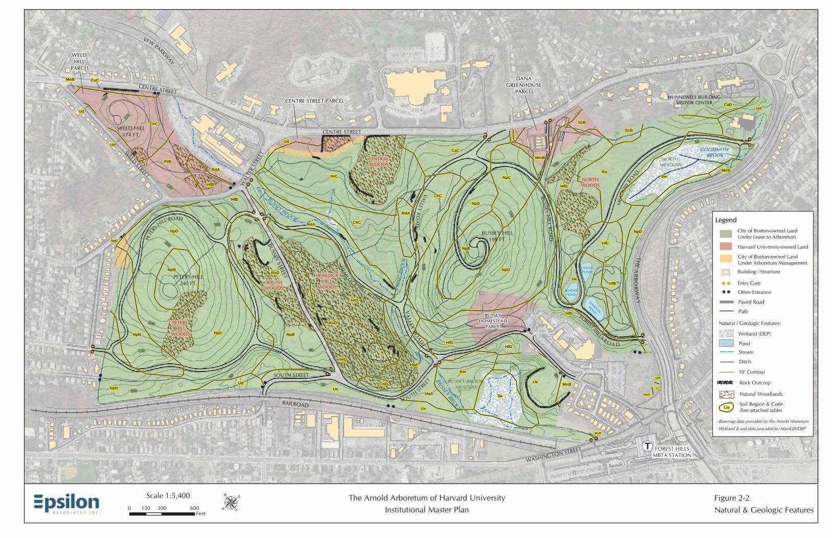
The Arboretum lies within the local geological formation of the glacially-formed Boston Basin. Glacial activity and post-glacial development formed the topography and soils of the grounds, which today drain to the Charles River watershed. Rocky outcrops, many of which are Roxbury conglomerate (known locally as puddingstone), protrude through the land surface in numerous locations. Some of the puddingstone is comprised of Squantum tillite, which may be the only tillite of Late Precambrian age (about 600 million years) exposed in New England as described by J. W. Skehan in his book, Puddingstone, Drumlins, and Ancient Volcanoes (1979). Several areas of the grounds have been quarried in the past. Figure 2-2, Natural/Geologic Features, depicts the topography, soils, rocky outcrops, and other natural features within the Arboretum grounds.
The Arboretum contains four hills -- Bussey Hill (198 feet), Peters Hill (240 feet), Weld Hill (174 feet), and Hemlock Hill (170 feet). The hills are interspersed with three stream valleys,

164405/ArboretumIMP/2-Property.doc 2-6 Property & Context Epsilon Associates, Inc. Arnold Arboretum IMP
including Goldsmith Brook along the Arborway, Spring Brook along the south side of Bussey Hill, and Bussey Brook along the north side of Hemlock Hill. Two large wetlands also exist in the Arboretum: Bussey Brook Meadow east of South Street and North Meadow between Meadow Road and the Arborway. Three ponds, which are now called Faxon Pond, Rehder Pond, and Dawson Pond, were created near the intersection of Forest Hills Road and Meadow Road during the initial design for the Arboretum.
The Arboretum also supports areas of natural woods set aside during the original planning of the Arboretum. The original Olmsted/Sargent landscape design specified the improvement and maintenance of the “natural” woodlands remaining from the time of the Bussey Estate and earlier. These woods were actively thinned and managed to improve them, and in some cases understory trees were planted. Over time Arboretum accessions were planted along their edges, and their extent has diminished. The original woodlands included the North Woods, Meadow Border Woods, Central Woods, Hemlock Hill Woods, and South Woods (see Figure 2-2); the Meadow Border Woods no longer exist.
2.3.2 Living Collections
As described above, Sargent and Olmsted systematically laid out the Arboretum plant collections along the internal road system according to the Bentham and Hooker classification sequence, a 19th-century classification system for the plant kingdom. The design intent of the layout of the collections was to provide the visitor with an experience of viewing increasingly more botanically “complex” plants as the visitor traversed the grounds. While this historical sequence of plant families does not correspond to current scientific understanding of evolutionary relationships among plant groups, the Arboretum continues to maintain the integrity of this historic landscape and its planting scheme, as it provides a representation of the Victorian concept of plant science and the only intact example of Olmsted's design for an arboretum. Figure 2-3 shows the locations of Selected Living Collections.
In an effort to bring together a collection that would represent all north temperate floras, Sargent obtained plants from throughout North America and Europe, and then in the 1890s, initiated field expeditions to eastern Asia. These explorations, led most notably by E. H. Wilson, supplied the hundreds of plants that together with living specimens from North America and Europe form the backbone of the Arboretum's living collections. The Arboretum staff has continued to explore eastern Asia, most recently in 2005 in the second of five planned collecting expeditions to southwest China’s Hendguan Mountain region.
The living collections are recognized as one of the best documented assemblages of woody plants of its kind in the world. In support of the Arboretum’s research mission, the Arboretum seeks to grow three documented accessions for each taxonomic group represented, each obtained from a different location within the plant’s native range. The strength of the collections is in wild-collected and authentic materials of eastern Asian origin with excellent and comprehensive representation of related materials from Europe
164405/ArboretumIMP/2-Property.doc 2-7 Property & Context Epsilon Associates, Inc. Arnold Arboretum IMP
and North America. In addition, special collections of bonsai, dwarf conifers, lilacs (Syringa), crabapples (Malus), and rhododendrons are also maintained. In cooperation with the Center for Plant Conservation, a network of America’s leading botanical institutions, thirteen taxa in the National Resource Collection of endangered American species are grown and maintained at the Arboretum.
The Larz Anderson Bonsai Collection, which is housed in the Bonsai House on the Dana Greenhouse parcel, includes the first bonsai trees brought to the US. The trees in the Larz Anderson Bonsai Collection were imported to the United States by the Honorable Larz Anderson in 1913, when he returned after serving as ambassador to Japan. These historic, dwarfed trees can be viewed mid-April through early November; during the winter the collection is in cold storage and, therefore, not accessible to the public. In 2006, the Arboretum displayed the collection at the New England Flower Show, the sixth time the collection has been shown at the event (the others being in 1916 and 1933 by Larz Anderson and in 1954, 1959, 1987, and 1997 by the Arboretum). This year the Arboretum received the Superlative Award for Trained Plants and a Gold Medal, with the judges noting that “the exhibit exemplifies the fruits of generations of stewardship.”
2.3.3 Roadways and Pathways
The Arboretum’s roads were laid out in a nearly continuous fashion, such that a visitor could traverse the entire grounds by moving from one road to the next. From north to south, this three-mile road system consists of Meadow Road, Forest Hills Road, Bussey Hill Road, Valley Road, Hemlock Hill Road, and Peters Hill Road. These paved roads are not included in the land area leased to Harvard and their maintenance is the City of Boston’s responsibility. The road system was originally designed for horse-drawn carriages and was made with a gravel surface and cobble gutters. Gravel walkways, or sidewalks, were constructed along the roads. The roads and some of the walkways are now paved in asphalt; however, vehicular access is limited to Arboretum vehicles and visitors with special needs.
Over time, an extensive path system independent of the road system also was developed on the grounds of the Arboretum. Today, over seven miles of pathways and two miles of sidewalks wind through the Arboretum providing pedestrian access to the living collections, natural woodlands, streams, meadows, rock outcrops, significant hilltops, and other natural features. Visitors may enter through twelve different gates and nine other entrances, and parking is available at the gates or along the Arborway, Bussey Street, and Walter Street.
In addition, the Arboretum may be conveniently reached via the MBTA Forest Hills commuter rail and Orange Line Station, or by several MBTA bus routes. The Forest Hills MBTA Station is a critical transportation center at the nexus of a wide array of commercial, industrial, residential, and open space uses.

164405/ArboretumIMP/2-Property.doc 2-8 Property & Context Epsilon Associates, Inc. Arnold Arboretum IMP
Figure 2-1 depicts the major roadways and pathways through the Arboretum, as well as the gates that allow public access. Chapter 6 provides additional detail on pedestrian and vehicular circulation at the Arboretum and in the surrounding area.
2.3.4 Views
Several significant views were originally part of the Olmsted/Sargent design for the Arboretum. Views from the two major hilltops within the Arboretum, Bussey Hill and Peters Hill, as well as views of the “hanging woods” on Hemlock Hill, have been maintained since the founding of the Arboretum in the 19th century. Other views within the Arboretum have changed as the collections have matured and changed, however, many of the viewsheds from specific points into and over the collections remain. Figure 2-4 identifies significant views on the Arboretum grounds.
Several areas within the grounds have historically been kept as meadow or mowed lawn without plant accessions, in part to create an internal view. These include the sloped, lawn area to the south of the Hunnewell Building and the lawn area where the former Bussey mansion stood. Views from atop Bussey Hill and Peters Hill have also been maintained free of plant obstructions. In particular, from Bussey Hill one has a view to the Blue Hills to the south. The grounds also include a long vista over the maintained meadow upslope of the Bussey Brook valley, between the Conifer Path and Hemlock Hill Road.
2.3.5 Other Features
In addition to the natural features, collections, roadways, and pathways, the Arboretum contains other features that contribute to the Arboretum’s character:
♦ Gates – Twelve gates provide access into the Arboretum, eight of which were part of the original landscape design;
♦ Boundary Walls – Most of the Arboretum is bordered by historic, stone walls, some of which pre-date the Arboretum and some of which were built as part of the original design;
♦ Buildings – Seven buildings, including the historic, 1892 Hunnewell Building, occupy the Arboretum grounds. These structures are described below in Section 2.4;
♦ Crossings and Culverts – Crossings and culverts exist along the site’s three streams, Bussey Brook, Goldsmith Brook, and Spring Brook; several of these, such as the stone crossing over Goldsmith Brook at the Arborway Gate were part of the original design; and,
♦ Walter Street Burying Ground – This burial ground, located on the southwest side of Peters Hill, contains slate and marble headstones dating to the 18th and 19th centuries, as well as two commemorative plaques.
164405/ArboretumIMP/2-Property.doc 2-9 Property & Context Epsilon Associates, Inc. Arnold Arboretum IMP
2.4 Existing Buildings and Zoning
2.4.1 Existing Buildings
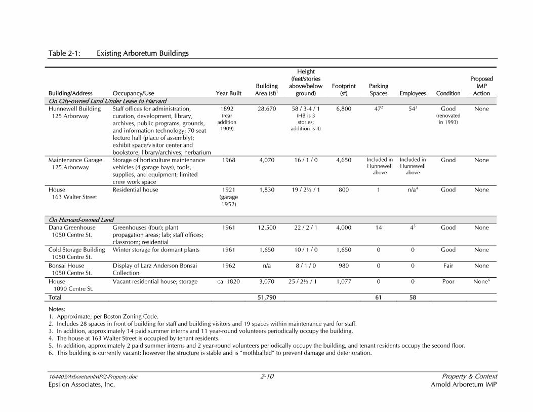
There are currently seven buildings on the Arboretum grounds, three on land under lease and four on Harvard-owned land. All buildings are owned by Harvard, under the management and control of the Arnold Arboretum. Existing Arboretum buildings are described below; Table 2-1 provides additional information.
Buildings on City-owned Land under Lease to Harvard
♦ Hunnewell Building – Constructed in 1892, the Hunnewell Building was designed by the firm of Longfellow, Alden and Harlow. An addition to house the Arboretum’s herbarium was designed by Alexander Wadsworth Longfellow and constructed in 1909. Renovated in 1993, the Hunnewell Building has served as the Arboretum’s center for more than a century;
♦ Maintenance Garage – Constructed in 1968, the maintenance garage serves purely utilitarian functions of maintenance vehicle and equipment storage; and
♦ House at 163 Walter Street – This two-story, brick residential structure, constructed in 1921, is currently in residential use.
Buildings on Harvard University-owned Land
♦ Dana Greenhouse – Constructed in 1961, the Dana Greenhouse is used for on-site plant propagation and nurseries;
♦ Cold Storage Building – This small, 1,650-square-foot structure allows for storage of dormant plants in winter;
♦ Bonsai House – The Bonsai House is a small hexagonal structure that houses the Larz Anderson Bonsai Collection between April and October each year; and
♦ House at 1090 Centre Street – This two-story, wood-frame building, was constructed in 1820 and is also known as the Jabez Lewis Farmhouse. It has been vacant since 1993.
164405/ArboretumIMP/2-Property.doc 2-10 Property & Context Epsilon Associates, Inc. Arnold Arboretum IMP
Table 2-1: Existing Arboretum Buildings
Building/Address Occupancy/Use Year Built Building Area (sf)1
Height (feet/stories
above/below ground)
Footprint (sf)
Parking Spaces Employees Condition
Proposed IMP
Action On City-owned Land Under Lease to Harvard Hunnewell Building 125 Arborway
Staff offices for administration, curation, development, library, archives, public programs, grounds, and information technology; 70-seat lecture hall (place of assembly); exhibit space/visitor center and bookstore; library/archives; herbarium
1892 (rear
addition 1909)
28,670 58 / 3-4 / 1 (HB is 3 stories;
addition is 4)
6,800 472 543 Good (renovated in 1993)
None
Maintenance Garage 125 Arborway
Storage of horticulture maintenance vehicles (4 garage bays), tools, supplies, and equipment; limited crew work space
1968 4,070 16 / 1 / 0 4,650 Included in Hunnewell
above
Included in Hunnewell
above
Good None
House 163 Walter Street
Residential house 1921 (garage 1952)
1,830 19 / 2½ / 1 800 1 n/a4 Good None
On Harvard-owned Land Dana Greenhouse 1050 Centre St.
Greenhouses (four); plant propagation areas; lab; staff offices; classroom; residential
1961 12,500
22 / 2 / 1 4,000 14 45 Good None
Cold Storage Building 1050 Centre St.
Winter storage for dormant plants 1961 1,650
10 / 1 / 0 1,650 0 0 Good None
Bonsai House 1050 Centre St.
Display of Larz Anderson Bonsai Collection
1962 n/a 8 / 1 / 0 980 0 0 Fair None
House 1090 Centre St.
Vacant residential house; storage ca. 1820 3,070
25 / 2½ / 1 1,077 0 0 Poor None6
Total 51,790 61 58
Notes: 1. Approximate; per Boston Zoning Code. 2. Includes 28 spaces in front of building for staff and building visitors and 19 spaces within maintenance yard for staff. 3. In addition, approximately 14 paid summer interns and 11 year-round volunteers periodically occupy the building. 4. The house at 163 Walter Street is occupied by tenant residents. 5. In addition, approximately 2 paid summer interns and 2 year-round volunteers periodically occupy the building, and tenant residents occupy the second floor. 6. This building is currently vacant; however the structure is stable and is “mothballed” to prevent damage and deterioration.
164405/ArboretumIMP/2-Property.doc 2-11 Arboretum Property & Context Epsilon Associates, Inc. Arnold Arboretum IMP
2.4.2 Existing Zoning
The Arboretum land under lease, Harvard’s Dana Greenhouse parcel, and the Centre Street parcel are all located within the Arnold Arboretum Botanical/Zoological Garden Open Space (OS-BZ) zoning subdistrict of the Jamaica Plain Neighborhood District. The description of this subdistrict included in Section 55-14.6 of the Zoning Code provides:
The land … is governed by the terms of certain orders of taking by the Board of Park Commissioners of the City of Boston, by certain agreements between the City of Boston and President and Fellows of Harvard College (including but not limited to certain Indentures), and by rules and regulations issued by the City of Boston Parks Commission with respect to such land. Within the Arnold Arboretum Botanical/Zoological Garden Open Space Subdistrict, no land or structure shall be erected, used, or arranged or designed to be used, in whole or in part, except in accordance with all such takings, agreements, rules, and regulations, as they may be amended from time to time, with respect to such land or Structure, and no Structure shall be erected, used, or arranged or designed to be used, in whole or in part, except as approved by the City of Boston Parks Commission or any successor thereto, in accordance with such takings, agreements, rules, and regulations.
The Weld Hill parcel is located within a Residence S-.3 zoning district, which allows residential development at a density of 0.3 floor area ratio (FAR). The Weld Hill parcel also is included within the Roslindale Interim Planning Overlay District, under Article 27R of the Zoning Code.
The Bussey Homestead parcel is located in a residential (1F-5000) zoning district.
Portions of the Arboretum grounds are also located within the Greenbelt Protection Overlay District (GPOD), which runs along the Arborway, Centre Street, and South Street in the Jamaica Plain Neighborhood District (see Figures 2-5a and 2-5b, Existing Zoning).
2.5 Area Context
Below are descriptions of land use, building heights, and open space in the vicinity of the Arboretum. Transportation conditions and historic resources in the area are presented in Chapters 6 and 7.
2.5.1 Land Use
The Arboretum grounds, located within the Jamaica Plain and Roslindale neighborhoods of the City of Boston, are bordered generally by the Arborway to the northeast, the MBTA railroad right-of-way to the southeast, Centre Street to the northwest, and a residential neighborhood along the southwest perimeter. Figure 2-6 depicts land uses in the vicinity of the Arboretum.

164405/ArboretumIMP/2-Property.doc 2-12 Arboretum Property & Context Epsilon Associates, Inc. Arnold Arboretum IMP
This section of Boston was originally settled as farms and estates of the wealthy in the 18th, 19th and early 20th centuries. Today, the area is characterized by a combination of historic mansions, large and small single-family homes, and multi-family homes constructed in the late 19th and early 20th century, institutions, industrial areas, parks, and parkways. The predominant land uses are residential and institutional, with some commercial and industrial facilities along the MBTA right-of-way south of the Arboretum and a small commercial area along Centre Street south of Weld Street.
Prominent public and private institutions in the immediate vicinity of the Arboretum include the Hebrew SeniorLife facility, located adjacent to the Arboretum at 1200 Centre Street, the Roxbury Home for Aged Women/Sophia Snow House at 1205-1215 Centre Street, the Faulkner Hospital at 1137 Centre Street, and the State Laboratory Institute, or “State Lab,” at 375 South Street. The Franciscan Monastery of Saint Clare also borders the northwest corner of the Arboretum at 920 Centre Street. The surrounding neighborhoods have a plentiful stock of open space and parkways including the Arboretum, Allandale Woods, Jamaica Park (also known as Jamaica Pond for the pond it contains), Franklin Park, Forest Hills Cemetery, the Arborway, and the Jamaicaway, which are described in Section 2.5.2 below.
Schools in the area include the Haley Elementary School, the Manning Elementary School, the Philbrick Elementary School, the Sumner Elementary School, the Irving Middle School, the Young Achievers K-8 School, and the English High School.
2.5.2 Building Heights
As indicated in Figure 2-7, buildings in the immediate vicinity of the Arboretum, which are primarily institutional and residential, range in height from one to eight stories. The largest institutional buildings in the area are located immediately adjacent to the Arboretum grounds including the six-story Hebrew SeniorLife, the seven-story Faulkner Hospital, and the eight-story State Laboratory Institute; in addition, the Sophia Snow House was recently reconstructed at four to five stories. A few commercial and industrial structures located along the MBTA right-of-way east of the Arboretum range from one to three stories. The majority of the residential structures around the Arboretum, predominately constructed in the late 19th and early 20th centuries, are low-rise buildings of one to three stories. The former Adams Nervine Asylum, located just north of the Dana Greenhouse, is now a condominium complex known as the Adams Arboretum Condominiums and consists of several one- to three-story buildings.
2.5.3 Open Space
The Arboretum is an integral part of the Olmsted-designed City of Boston park system now known as the Emerald Necklace, which includes the Back Bay Fens, Riverway, Olmsted Park, Jamaica Park, Arnold Arboretum, and Franklin Park (see Figure 2-8).
164405/ArboretumIMP/2-Property.doc 2-13 Arboretum Property & Context Epsilon Associates, Inc. Arnold Arboretum IMP
The Emerald Necklace park system stretches five miles from the Charles River in Boston to Dorchester and includes over 1,000 acres of parkland. The Arboretum lies between Jamaica Park and Franklin Park.
Residents living in the area surrounding the Arboretum have access not only to the Arboretum but also to some of the largest expanses of open space anywhere in the City (Figure 2-9, Area Open Space). Jamaica Park, enjoyed for its public boating, fishing, and concerts, consists of the 60-acre freshwater Jamaica Pond surrounded by trees, shrubs, and pathways. The 527-acre Franklin Park has six miles of roads and 15 miles of pedestrian and bridle paths. Designed as a country park, the area contains a pond, woodlands, structures, an 18-hole public golf-course, and the Franklin Park Zoo. Jamaica Park, the Arboretum, and Franklin Park are connected by the Jamaicaway and Arborway parkways, lined with sidewalks and large shade trees, essential elements in Olmsted’s park system.
In addition to these large parks associated with the Emerald Necklace, the 250-acre Forest Hills Cemetery east of the Arboretum is also open to the public, and the 90-acre Allandale Woods is an urban wild to the west of the Arboretum. Several playing fields and playgrounds are also interspersed among the residential neighborhoods. Nearby are the regional parks of Stony Brook Reservation (475 acres) and the Blue Hills Reservation (7,000 acres).
2.6 Weld Hill Parcel
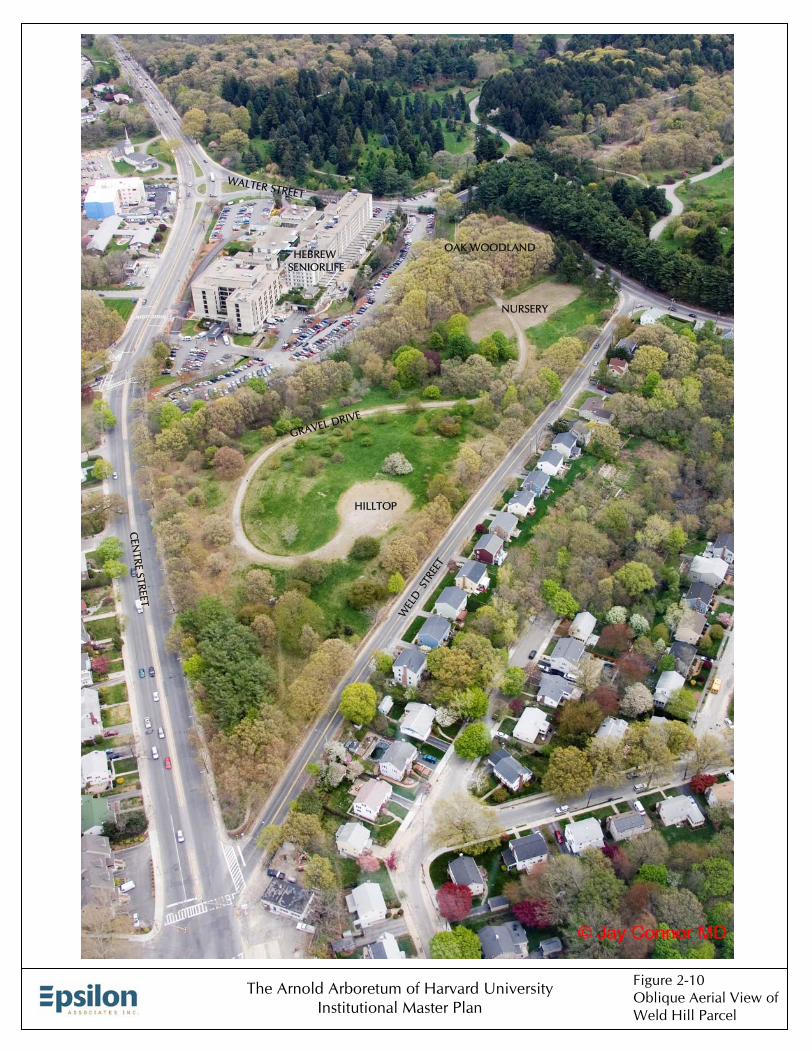
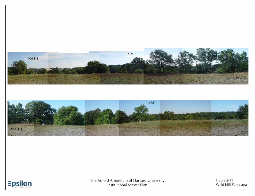
The Weld Hill parcel, located across Walter Street from the Arboretum land under lease, is bounded by the Hebrew SeniorLife facility to the north, Centre Street to the west, Weld Street to the south, and Walter Street to the east (Figure 2-1), with a 10-foot wide Boston Water and Sewer Commission easement roughly bisecting the property (as shown on Figure 5-1) in a north-south direction. Figure 2-10 provides an aerial perspective of the Weld Hill parcel. The parcel is dominated by Weld Hill itself, which offers panoramic views (see Figure 2-11).
2.6.1 Historic Land Use
Purchased by Harvard University in 1922, the Weld Hill parcel historically has been used by the Arboretum for plant accessions, nurseries, and plant breeding experiments. Prior to Harvard’s ownership, the Weld Hill parcel was part of a large farm owned successively by Benjamin Child, William Dudley heirs, Joseph Dudley, Henry Hatch, and Benjamin Lyon.
The Weld Hill parcel is included in a 1934 bird’s-eye view of the Arboretum, and no site improvements appear at that time. Between 1936 and the mid-1980s much of the parcel was planted with tree accessions and mass plantings, with the rest of the parcel covered with woodland of native trees dominated by oaks (Quercus). A nursery was located in the southeast portion of the parcel by 1936, and by the early 1940s the Arboretum had installed mass plantings along Walter and Centre Streets and had created several orchard-like
164405/ArboretumIMP/2-Property.doc 2-14 Arboretum Property & Context Epsilon Associates, Inc. Arnold Arboretum IMP
nurseries in the eastern portion and northwest corner of the parcel. Between 1950 and the early 1980s the majority of the parcel was planted with additional trees with the exception of the native woods in the northeast portion of the parcel.
In 1968, in preparation for the celebration of the Arboretum’s centennial, a number of improvements were made to the Weld Hill parcel. A paved drive was laid out on the site from Walter Street to the top of Weld Hill in a manner consistent with Olmsted design principles of preserving significant natural features and views. In addition, new accessions were planted and more than 1,000 ground cover plants were installed to serve as a demonstration for road bank plantings. Although the improvements and plantings on Weld Hill were always sympathetic with the Olmsted/Sargent design intent of the original grounds, the parcel was acquired after their design was executed and hence not included in the original Olmsted/Sargent plan for the Arboretum. With its mixture of accession plantings, natural woodland, and nurseries, the parcel has had its own character more likened to a working agricultural landscape than the Olmsted/Sargent designed landscape.
2.6.2 Site Context and Adjacencies
The Weld Hill parcel is situated at the southwest end of the Arboretum land under lease, bordered primarily by institutions, residential neighborhoods, and Arboretum grounds. The site has distinctive conditions on all four of its edges. To the north, an expansive parking lot and six-story building dominates the site of the Hebrew SeniorLife facility. Bussey Brook flows through the Hebrew SeniorLife parking lot in a channelized streambed and partly in an underground culvert. On the east edge, Walter Street separates the site from the Arboretum land under lease. Centre Street, a major traffic artery, with residential use on the opposite side of the street, forms the western edge. To the south is a residential neighborhood across Weld Street that has views into the property.
2.6.3 Landform and Drainage
The site is dominated by Weld Hill at the western end of the parcel, which rises some 20 feet above Weld Street to a total elevation of 174 feet. There is a smaller highland at the site’s eastern edge, with a broad sloping plane, that drains to the north. A gentle valley separates the plane from the base of Weld Hill (see Figure 2-12, Weld Hill Elevation, Site Drainage, and Slope Analysis).
Throughout the western portion of the site, bedrock lies approximately 10 feet below grade. The site slopes to the north, and dominant winter winds are from the northwest. Slopes across the site range from 5 percent to 35 percent. Half of the site contains slopes of 12 to 25 percent (see Figure 2-12).

164405/ArboretumIMP/2-Property.doc 2-15 Arboretum Property & Context Epsilon Associates, Inc. Arnold Arboretum IMP
2.6.4 Vegetation
Site vegetation consists generally of meadow bordered by trees, including trees that pre-date the Arboretum’s acquisition of the parcel, naturally-established plants, groups of trees planted by the Arboretum along Walter and Centre Streets, and Arboretum accessions.
A stand of naturally-established mature oaks occurs on the eastern highland (noted above), and a number of large, individual oaks can be found scattered across the property. Most of these large oaks were present at the time the property was acquired, although oaks continue to establish naturally (see Figure 2-13, Vegetation and Circulation Analysis).
Along the northern edge of the site, a band of woods screens views of Hebrew SeniorLife. Mature maple (Acer) accessions interspersed with older cherry (Prunus) and crabapple (Malus) plantings from the 1940s and a mix of volunteer species form a closed canopy in the northwestern portion of the site. Higher up the northern face of Weld Hill, the slope has scattered mature, hardwood accessions.
Along the eastern edge of the site is a mass planting of Carolina hemlock (Tsuga caroliniana), in decline because of an infestation of the wooly adelgid. A mix of species grows along the southern edge of the site including mature oaks, cherries, and junipers (Juniperus). A mass planting of larch (Larix) from the 1930s occurs along Centre Street. Working nursery plots occupy the east end. A mix of maples dominates the broad shallow valley through the center of the site.
2.6.5 Access and Circulation
The Weld Hill parcel is traversed by a gravel (formerly paved) drive from Walter Street to the top of Weld Hill. This curvilinear drive, in keeping with the design of other roadways in the Arboretum, was constructed in 1968 as one of several landscape improvement projects undertaken for the celebration of the Arboretum’s centennial. An overgrown service drive, originally built to provide access to an extensive cherry and crabapple nursery, still remains along the northwest edge of the property, appearing today like a closed canopy allee. Several unsurfaced paths, mown in the summer, form the remainder of the pedestrian network of the site. Access to the site is the old service drive on Centre Street and the existing service entrance on Walter Street. (See Figure 2-13.)
Bordering the western edge of the site is Centre Street, a divided parkway. Along the eastern edge is Walter Street, a major thoroughfare with a high volume of traffic, and to the south is Weld Street, a low-volume residential street. Additional detail on pedestrian and vehicular access and circulation on the Weld Hill parcel is provided in Chapter 6.

164405/ArboretumIMP/2-Property.doc 2-16 Arboretum Property & Context Epsilon Associates, Inc. Arnold Arboretum IMP
2.6.6 Views into Weld Hill Parcel
Views into the Weld Hill parcel exist from the surrounding roadways, sidewalks, and neighborhoods. Figures 2-14 through 2-16 depict views into the Weld Hill parcel from specific locations. The more general views into the site are described here.
♦ VFW Parkway –The view from the VFW Parkway, near its intersection with Centre Street, is across a wide, grassy roadside and the wide expanse of Centre Street to the northwest edge of the site. The property edge here is bordered with a chain link fence, behind which stand large, mature trees, with Weld Hill rising behind. To the north is the tall Hebrew SeniorLife building, separated from the Weld Hill parcel by a parking lot.
♦ Centre Street – From along the two-lane divided Centre Street the view into the site consists of mature, oak street trees along a narrow sidewalk. Along most of the sidewalk a steep, cut bank rises a few feet to the site’s gently sloping, wooded hillside. A large rock outcrop emerges from one section of the cut slope, and close to Weld Street the property edge is densely planted with mature larch trees. One and two-family houses line the west side of Centre Street. The expansive intersection of Centre Street and the VFW Parkway is located in the distance to the north.
♦ Weld Street – A jagged-topped, stone wall borders the parcel along Weld Street. The site’s gravel drive winds its way through the parcel and up to the top of Weld Hill. The single-family residences on the south side of Weld Street have a view of trees and meadows on undulating grounds with the winding gravel drive. The hill and trees on the site block the view of the Hebrew SeniorLife complex from Weld Street.
♦ Weld/Walter Street Intersection – At the intersection of Walter and Weld Streets, the parcel is bounded by stone walls on both streets. Looking into the site from this location the view is of the stone wall, behind which lies a generally flat, open area with the Arboretum nursery. In the distance is another high point covered with natural woodland of mostly oak trees. In the distance to the west is the shallow valley that traverses the site north to south and that is planted with Arboretum accessions, most of which are maples. The incline up Weld Hill is also visible from this street edge.

�� ��
��
��
��
��
����
��
��
����
����
����
����
�� ��
�� ��
����
����
����
���������������
��������������
�������������
�����������������
��� �� ������ �
�����������������
�������� ��
��������
����
�����
������
���������
��
������������
�����
�������������
��T ������������������������������������������������
��������
����������������
�����������������
���������
��
����������� �����
�������������
�������������
������������
�������������
�������������
���������������� ���
���������������� ���
����������� ���
����������� ���
��� ��� ���� ������ ��� ���� ���
���� ���������
� ���
���� ���������
� ���
�������������������������
����������������� �����������
�����������������(UNDER RECONSTRUCTION)
�����������
�!"�������������
�����������
���������������������������
������������������
����������������
����������
������������������
��������������
������������
��������������
��
������������
��������������������������������
������������
�����������
����������� ��� �� ��������������������������
�������������������
������������������
������������������
���������������
���������������
����������������
����������������
�����������������
�����������������
����������������
����������������
�������������������� �������������
�����������������
����
���������������
���������������
������������
������������
���������������
����
���������������
����
������������������������������������������
���������������������������
��������������������������
���������
�����������
��
���������
�������
��������������
�����������
����������
��#������
������������������
�� ������ ��
�����������������������������������
�����������������
������������
������
������
�����������������������
���������������
�����������
��
������������ ����
�������
���
��������
��������
����
��
�����������
�����
�����
��
�� ��� ��
�������
�������
�����
��
������������
����������
��
������
����������
����������
������������
������
$����
����
����$�������
����������������������������
�������������������������������������������������
�������������������
���������
��
�%�
���
�%�
���
�!�
��
��
���
���
���
�%�
��
�%�
���
���
��
!�
%�
��
%�
��
���
���
������������� ��������
�&'()*�$��+&,-&.'��/.0&-&/.,
� �1*��)./20��)3/)*-(4�/5��6)76)0��.&7*),&-8�.,-&-(-&/.62��6,-*)��26.
�962*��:%;��� "�� !���%�
�**-
�-)*64�(&20&.'�<��-)(9-()*
�*-26.0�=���>��?��/.-/()
�.-)8��6-*��
�&-91
�6@/)��6-1�&./)��6-1
��
��������������������������������� �!��������"������!� ������������������� ������#���
�-1*)��.-)6.9*�� ��
�67*0��/60
������#������$
�/22*9-&/.�<��6)0*.��6-1�67*0��&0*A62B
�������&-8�/5��/,-/.$/A.*0��6.0�.0*)��*6,*�-/��)3/)*-(4�6)76)0��.&7*),&-8$/A.*0��6.0�&-8�/5��/,-/.$/A.*0��6.0�.0*)��)3/)*-(4��6.6'*4*.-
�6-*��6)B&.'
�5-*)$�/(),��6-*��6)B&.'����
�/.0
�67*0��6)B&.'��/-
�������������������������
�
������������������
������������� ��������
��
��������
���
��������
������ ��
���
�
��� ����
�������
����
���������
��� ��� ��
���
�������
���
�������������
�
��
�
������������������
��
���������
�
�
�������
��� ��
��������
�����������������������������������������
���
����
�����
��������������
�� ��������������
�����
���
����
����
����
��
��������������
���
�������������
��T ����������� ���������������������� �����������
�����������������
��
����������� �����
�������������
������������
�������������
�������������
���������������
� ���
���������������
� ���
����������� ���
����������� ���
��� ��� ���� ������ ��� ���� ���
���� ���������
� ���
���� ���������
� ���
����������
�����������
����������
��������������
��
����������������������� �����
������ �����
���������� ��� �� �
���������
�����������
��
���������
�������
�����������
����������
��������
�������� ��
�����
�����
��
������
������
������
������
���
���
���
���
������
������
������
������
������
������
����
������
���
���
������ � �
����
����
� �
����
!�!�
������
������
UdUd
CaCCaC
NpCNpC
NpDNpD
NpBNpB
NpDNpD
RdARdA
ChCChC
ChCChC
HfDHfD
UeUe
RmRm
SaSa
UeUe
HfDHfD
RaRa
HfCHfC
UeUeHfBHfB
SwSw
UdUd
HrDHrD
RoDRoD
HrDHrDHaAHaA
ChDChD
HaAHaA
MmBMmB
ScBScB
HfBHfB
PtBPtB
ChCChC
NpDNpD
NpDNpD
NpBNpB
NpBNpB
NpDNpD
RoDRoD
NpBNpB
HfBHfB
CuCCuC
UdUdUeUe
MnBMnB
MmBMmB
UrUr
NpDNpD
NpDNpD
MnBMnB
CaDCaD
RdARdA
����������������
������������! ����������������
MnBMnB
UdUd
RdARdA
NpDNpD
MmBMmB
HfDHfD
HfDHfD
ScBScB
HrCHrC
UdUd
��������������������������
�����������
�����
�����������
�����
�� ��������
�����
�� ��������
�����
��������������������
��������������������
"#$%&��'��()$%(*�+��&,*,#"-�&()$%&.
� �/&��%0,*1��%2,%&)$3�,4��(%5(%1��0"5&%.")6�0.)")$)",0(*� (.)&%��*(0
�-(*&��7�8��� 9�� ������
&&)
������
�)%&(3
�$"*1"0#�:��)%$-)$%&
�&)*(01�;���<
��=��,0),$%
�0)%6��()&��
�")-/
�(5&1��,(1
��
��������������������������������� �!��������"������!� ��#����!������������������ ������$���
�)/&%��0)%(0-&�� ��
�()/
�()$%(*�:��&,*,#"-�&()$%&.7
�,->��$)-%,?����()$%(*��,,1*(01.
�,"*��&#",0�+��,1&;�&&�())(-/&1�)(2*&<
�")6�,4��,.),0',@0&1��(01�01&%��&(.&�),��%2,%&)$3
�(%5(%1��0"5&%.")6',@0&1��(01
�")6�,4��,.),0',@0&1��(01�01&%��%2,%&)$3� (0(#&3&0)
����
�,01

Arboretum Soil Types (see Figure 2-2)
Soil Code Soil Name
CaB Canton Fine Sandy Loam, 3 to 8 percent slopes
CaC Canton Fine Sandy Loam, 8 to 15 percent slopes
CaD Canton fine sandy loam, 15 to 25 percent slopes
ChC Charlton-Hollis-Rock Outcrop Complex, 8 to 15 percent slopes
ChD Charlton-Hollis-Rock Outcrop Complex, 15 to 25 percent slopes
CuC Charlton-Hollis-Urban Land Complex, 3 to 15 percent slopes
HaA Haven Very Fine Sandy Loam,0 to 3 percent slopes
HfB Hinckley Sandy Loam, 3 to 8 percent slopes
HfC Hinckley Sandy Loam, 8 to 15 percent slopes
HfD Hinckley Loamy Sand, 15 to 25 percent slopes
HrC Hollis-Rock Outcrop-Charlton Complex, 3 to 15 percent slopes
HrD Hollis-Rock Outcrop-Charlton Complex, 15 to 35 percent slopes
MmB Merrimac Fine Sandy Loam, 3 to 8 percent slopes
MnB Merrimac-Urban Land Complex, 0 to 8 percent slopes
MnB Merrimac-Urban Land Complex, 0 to 8 percent slopes
NpB Newport Silt Loam, 3 to 8 percent slopes
NpC Newport Silt Loam, 8 to 15 percent slopes
NpD Newport Silt Loam, 15 to 25 percent slopes
NuC Newport-Urban Land Complex, 3 to 15 percent slopes
PtB Pittstown Silt Loam, 2 to 8 percent slopes
Ra Raynham Silt Loam
RdA Ridgebury Fine Sandy Loam, 0 to 3 percent slopes
Rm Rippowam Fine Sandy Loam
RoD Rock Outcrop-Hollis Complex, 3 to 25 percent slopes
Sa Saco Silt Loam
ScB Scio Silt Loam, 3 to 8 percent slopes
Sw Swansea Muck
Ud Udorthents, Loamy
Ue Udorthents, Wet, Substratum
Ur Urban Land

������������������
���
���
�����
���
������
�
���������
�������
��
�����������
������
��
��6��9��8 ��5��4��7
��3
��2��1
��19
��22
��23��21
��25��20��24
��15��16
��18
��14
��17
��13
��11��10
��12
������ ������ ���� ��� �� ������� �
��������������������������������������������������������
������!"#����$���%����������$���& !'& '&&
���� ��
��$����()*+,&&(��$��-�.&&����
������%���/������0
�����������"�����%��������%���������������
����������������"�����%��
�����������"�����%������������������������
������������������������������ !"������������������������������ !"
Selected Living Collections1 Magnolias2 Willows3 Cork Trees4 Maples5 Eleanor Cabot Bradley Collection of Rosaceous Plants6 Lilacs7 Horsechestnuts8 Viburnums9 Birches10 Walnuts11 Elms12 Hickories13 Oaks14 Beeches15 Rhododendrons16 Mountain laurels17 Conifers18 Larches19 Bamboos20 Cherries21 Honey locusts22 Ginkgos23 Hawthorns24 Pears25 Crabapples

��������������
��������������
����� ����������� ������
�� ������� �����
����
�� ������� �����
����
������������ ��
����
������������ ��
����
�������������������� ������ ��
����� ���
�������� ���
��� �
�� ���
��� ���� ���
�������
��T
�������������
���������������
����
����
��
��������������
���
��
����
�� ������������
��������������� �!"�#����$%
� &�����'()���*'��#�+�' ��"�,"�)����,��%�#-��%#�#�#�'�"(��"%#����("�
�!"(��./01�222 �22 022�22
���#
�������
����
��� ���� ���
����� �������� ��� � ���
����������������� ����������������������
��������#-�' ��'%#'��'$��)��"�)��)�����"%��#'���*'��#�+�"�,"�)����,��%�#-�'$��)��"�)��#-�' ��'%#'��'$��)��"�)��)�����*'��#�+��"�"��+��#
����� �!"�#����$

The Arnold Arboretum of Harvard UniversityInstitutional Master Plan
Figure 2-5aExisting Zoning – Jamaica Plain
Source: BRA, 2006
The Arnold Arboretumof Harvard University

The Arnold Arboretum of Harvard UniversityInstitutional Master Plan
Source: BRA, 2006
Figure 2-5bExisting Zoning – Roslindale
The Arnold Arboretumof Harvard University

��� ����������
�����
����
�����
����������������� ��������������������
��������������� �����
����� ������������������������� ��������� ������� �������������
���� �
�� ������ � �����������!����� ����
�"���������!����� ����
�������������!����� ����
!����� �����#$��� ���%
&����� �
'� ���� ���
��(������
'�����)���
� ��������
� �������� ��
*���� �� �
+����
'�������,���� ��" ����� ��� ���������������������
��������� ����������" ����� �'�������,���� ��" ����� ��� ��������������� ����� �
�� ��+" �����&
����� �����
������� ��������������������������������
- .-- /0---��������
� )����/�/�0---/�� )��1�/0---�����

��� Forest Hills
�����
����
�����
���������������� ������������
������� ������������������������������������������� ��������� ��
����������������� ��������������������
������
��� ������������ !���"����
�#$�"����
%�"����
%#$�"����
&�"����
'�"����
(�"����
)���������������*����������������������������������������������������*��������)���������������*����������������������������������
�����+*������,
����������
- $-- !.---��������
�"/� ��! !�.---!���/��0�!.---�����
���� ����������������������������������

The Arnold Arboretum of Harvard UniversityInstitutional Master Plan
Figure 2-8Emerald Necklace Park System

���
���
��� ����������
����
�����
�����
����
�����
�����
�� �����������
������������
�����
�������
��������
����������
����
��������������
�������������
������������
���������������
�����������������������������������������
���������������������
��������������
��
�������� ���
���������� ����������
!����������
�� �������
�������"�
���������������
��������������
���������������������������������
��"�������"��������
�������"�
�"����"�
�� �����"�
��������
������������������
����������"�
�����������������
��
����������������� ���������������������������������������������
�������������������� ��!�
������
�""#�����$� %&'������� ��!�()� ��*��������������!�����������!����
�������
)�������&�������*���+��������+��������������� �������������������*���+��)�������&�������*���+��������������� ������� ���
+����*�������
���������������������������������������
" #"" ,-"""��������
� !����,(,.-""",���!��/�,-#""�����
The Arnold Arboretum of Harvard UniversityInstitutional Master Plan
Figure 2-10Oblique Aerial View of Weld Hill Parcel
CEN
TRE STREET
NURSERY
HEBREW SENIORLIFE
WEL
D S
TREE
T
HILLTOP
GRAVEL DRIVE
WALTER STREET
OAK WOODLAND
The Arnold Arboretum of Harvard UniversityInstitutional Master Plan
Figure 2-11Weld Hill Panorama

The Arnold Arboretum of Harvard UniversityInstitutional Master Plan
Figure 2-12Weld Hill Elevation, Site Drainage & Slope Analysis
Source: Reed Hilderbrand Associates

The Arnold Arboretum of Harvard UniversityInstitutional Master Plan
Figure 2-13Weld Hill Vegetation &Circulation Analysis
Source: Reed Hilderbrand Associates

The Arnold Arboretum of Harvard UniversityInstitutional Master Plan
Figure 2-14 Weld Hill Views 1 and 2
View 1
View 2
Source: The Stubbins Associates
Centre
Stre
et
Weld Street
Centre
Stre
et
Weld Street
Walt
er S
treet

The Arnold Arboretum of Harvard UniversityInstitutional Master Plan
Figure 2-15 Weld Hill Views 3 and 4
View 3
View 4
Centre
Stre
et
Weld Street
Walt
er S
treet
Centre
Stre
et
Weld Street
Walt
er S
treet
Source: The Stubbins Associates

The Arnold Arboretum of Harvard UniversityInstitutional Master Plan
Figure 2-16 Weld Hill Views 5 and 6
View 5
View 6
Source: The Stubbins Associates
Centre
Stre
et
Weld Street
Walt
er S
treet
Weld Street
Walt
er S
treet