Embed Size (px)
Citation preview

| JEP
PESEN
SAN
DERSO
N, IN
C., 2006. A
LL RIGHTS RESERV
ED.
LONDON, U
KEG
KK/LG
WG
ATW
ICK
JEPPESEN
+
CHA
NG
ES:
AIRPORT.BRIEFIN
G
1.4
.TA
XI P
RO
CEDURES
Wingtip clearance for TW
Y L, betw
een intersections with TW
Y R and S is
139’/42.5m.
On TW
Y J East of TW
Y N
, TWY Z and TW
Y Y
ABEA
M Pier 1 and Y
4 to Y3, large A
CFT
must be under tow
.W
hen RWY 08L/26R is in use, parallel TW
Y J M
AX w
ingspan 99’/30m.
TWY L beyond stand 36 to access stands 37 and 38 M
AX w
ingspan 200’/61m.
1.5
.PA
RKIN
G IN
FO
RM
ATIO
N1.5
.1.
GENERA
LA
ll stands except 41 and 43 are nose-in/push-back.
1.5
.2.
STA
ND E
NTRY G
UID
ANCE S
YSTEM
SThe illum
ination of Stand Entry Guidance System
s should indicate that a safety check of the stand has been m
ade by the handling agent prior to the ACFT arrival.
Stands 1 thru 28, 31 thru 38R, 42, 46 thru 54, 56 thru 68, 101 thru 113, 130 thru 136, 140 thru 145, 153, 154, 158 thru 161, 169 thru 180 and 551 thru 554 equipped w
ith Stand Entry G
uidance System.
1.6
.O
THER IN
FO
RM
ATIO
NRW
Y 08L/26R w
ill only be used when RW
Y 08R/26L is tem
porarily non-operational.
20-1P13 N
OV 06
None.
1. G
ENERA
L
Licensed to BR
ITISH A
IRW
AYS PLC
, . Printed from JeppView
disc 23-06.N
otice: After 7.12.2006 0901Z this chart should not be used w
ithout first checking JeppView or N
OTA
Ms.
| JEP
PESEN
SAN
DERSO
N, IN
C., 2006. A
LL RIGHTS RESERV
ED.
LONDON, U
KEG
KK/LG
WG
ATW
ICK
JEPPESEN
+
CHA
NG
ES:
AIRPORT.BRIEFIN
G
2.1
.SPEED R
ESTRIC
TIO
NS
Pilots should typically expect the following speed restrictions to be enforced:
-220 K
T from the holding facility during the interm
ediate approach phase;-
180 KT on base leg/closing heading to the ILS;
-betw
een 180 KT and 160 K
T when first established on the ILS;
and thereafter 160 KT to D
4.0.These speeds are applied for A
TC separation purposes and are m
andatory. In the event of a new
(non-speed related) ATC
clearance being issued (e.g. an instruction to descend on ILS), pilots are not absolved from
a requirement to
maintain a previously allocated speed. A
ll speed restrictions are to be flown as
accurately as possible. ACFT unable to conform
to these speeds should inform A
TC
and state what speeds w
ill be used. In the interests of accurate spacing, pilots are requested to com
ply with speed adjustm
ents as promptly as feasible w
ithin their ow
n operational constraints, advising ATC
if circumstances necessitate a change of
speed for ACFT perform
ance reasons.
Cross Speed Lim
it Point or 3 MIN
before holding faclility at 250 KT or less.
2.2
.NO
ISE A
BA
TEM
ENT P
RO
CEDURES
The following procedures m
ay at any time be departed from
to the extent necessary for avoiding im
mediate danger or for com
plying with A
TC instructions.
Every operator of ACFT using the A
PT shall ensure at all times that A
CFT are
operated in a manner calculated to cause the least disturbance practicable in areas
surrounding the APT.
Maintain an altitude as high as practicable and avoid overflying C
rawley,
East Grinstead, H
orley and Horsham
below 3000' (G
atwick Q
NH) and Lingfield below
2000' (G
atwick Q
NH).
ACFT using the ILS shall not descend below
2000' (Gatw
ick QN
H) before intercepting
GS nor thereafter fly below
it. ACFT approaching w
ithout ILS assistance shall follow
a descent path which w
ill not result in its being at any time low
er than the height of the approach path norm
ally indicated by the PAPI.
Do not join final approach at a height of less than 1710', except propeller driven
ACFT of not m
ore than 5700 KG
S MTW
A w
hich shall not join at a height of less than 1210'.Betw
een 2
330-0
600LT
ACFT shall not join the centerline below
3000' (Gatw
ick QN
H) closer than 10 N
M
from touchdow
n.
An A
CFT approaching to land shall according to its A
TC clearance m
inimise noise
disturbance by the use of continuous descent and low pow
er, low drag operating
procedures (see below).
Where the use is not particable, A
CFT shall m
aintain an altitude as high as possible.
2.3
.CA
T II/
III OPERA
TIO
NS
RWY 08R/26L is approved for C
AT II/III operations, special aircrew
and ACFT
certification required.
20-1P26 O
CT 06
New
page.
2. A
RRIV
AL
Licensed to BR
ITISH A
IRW
AYS PLC
, . Printed from JeppView
disc 23-06.N
otice: After 7.12.2006 0901Z this chart should not be used w
ithout first checking JeppView or N
OTA
Ms.

| JEP
PESEN
SAN
DERSO
N, IN
C., 2006. A
LL RIGHTS RESERV
ED.
LONDON, U
KEG
KK/LG
WG
ATW
ICK
JEPPESEN
+
CHA
NG
ES:
AIRPORT.BRIEFIN
G
2.4
.RW
Y O
PERA
TIO
NS
2.4
.1.
MIN
IMUM
RW
Y O
CCUPA
NCY T
IME
Pilots are reminded that rapid exit from
the RWY enables A
TC to apply the m
inimum
spacing on final approach that w
ill achieve maxim
um RW
Y utilisation and w
ill m
inimise the occurrence of go-arounds.
The preferred exit points for RWY 26L are:
-M
edium/H
eavy ACFT: H
ST FR (Distance from
THR 6027’/1837m
).-
Light/Small A
CFT: H
ST E (Distance from
THR 4334’/1321m
).
Pilots of small and m
edium A
CFT are requested to consider w
hich HST offers the best
opportunity for a safe and expeditious exit from RW
Y in order to reduce delays and
maxim
ise utilisation.
When exiting the RW
Y via H
ST FR the standard routing will be:
To cross the Northern RW
Y w
ithout stopping on the HST and turn RIG
HT onto TW
Y J.
When exiting the RW
Y via H
ST E the standard routing will be:
To turn RIGHT on the N
orthern RWY w
ithout stopping on the HST.
ACFT are not to stop on any H
ST awaiting instructions from
ground movem
ent control.
ACFT do not have to call for clearance to cross RW
Y 26R w
hen exiting RWY 26L as
the RWYs can not be used sim
ultaneously.
2.5
.O
THER IN
FO
RM
ATIO
N2.5
.1.
GENERA
LW
ARN
ING
: In low visibility at N
IGHT the apron and car park floodlighting m
ay be seen before the approach lights on RW
Y 26L and 26R approaches.
Strong southerly/south westerly w
inds can cause building induced turbulence and w
ind shear effects when landing on RW
Y 26L/R.
2.5
.2‘LA
ND A
FTER’ P
RO
CEDURE
Norm
ally, only one ACFT is perm
itted to land or take-off on the RWY-in-use at any
one time. H
owever, w
hen the traffic sequence is two successive landing A
CFT, the
second one may be allow
ed to land before the first one has cleared the RWY-in-use,
providing:-
The RWY is long enough;
-it is during daylight hours;
-the second A
CFT w
ill be able to see the first ACFT clearly and continuously until it
is clear of the RWY;
-the second A
CFT has been w
arned. A
TC w
ill provide this warning by issuing the second A
CFT w
ith the instruction ‘La
nd
afte
r ... (first A
CFT ty
pe)’ in place of the usual instruction ‘C
leared to land’. Responsibility for ensuring adequate separation betw
een the two A
CFT rests w
ith the pilot of the second A
CFT.
2.5
.3.
SPECIA
L LANDIN
G P
RO
CEDURES
Special landing procedures may be in force in conditions hereunder, w
hen the use w
ill be as follows:
-W
hen the RWY-in-use is tem
porarily occupied by other traffic, landing clearance w
ill be issued to an arriving ACFT provided that at the tim
e the ACFT crosses the
THR of the RW
Y-in-use the follow
ing separation distances will exist:
-La
ndin
g fo
llow
ing la
ndin
g - The preceding landing A
CFT w
ill be clear of theRW
Y-in-use or w
ill be at least 2500m/1.35 N
M from
the THR of the RW
Y-in-use.
20-1P36 O
CT 06
New
page.
2. A
RRIV
AL
Licensed to BR
ITISH A
IRW
AYS PLC
, . Printed from JeppView
disc 23-06.N
otice: After 7.12.2006 0901Z this chart should not be used w
ithout first checking JeppView or N
OTA
Ms.
| JEP
PESEN
SAN
DERSO
N, IN
C., 2006. A
LL RIGHTS RESERV
ED.
LONDON, U
KEG
KK/LG
WG
ATW
ICK
JEPPESEN
+
CHA
NG
ES:
AIRPORT.BRIEFIN
G
-La
ndin
g fo
llow
ing d
epartu
re - The departing A
CFT w
ill be airborne and at least 2000m
/1.1 NM
from the TH
R of the RWY-in-use, or if not airborne, w
ill be at least 2500m
/1.35 NM
from the TH
R of the RWY-in-use.
-Reduced separation distances as follow
s will be used w
here both the preceding and succeeding landing A
CFT or both the landing and departing A
CFT are propeller
driven and have a maxim
um total w
eight authorized not exceeding 5700 kg:-La
ndin
g fo
llow
ing la
ndin
g - The preceding A
CFT w
ill be clear of the RWY-
in-use or will be at least 1500m
/0.8 NM
from the TH
R of the RWY-in-use.
-La
ndin
g fo
llow
ing d
epartu
re - The departing A
CFT w
ill be airborne or will be
at least 1500m/0.8 N
M from
the THR of the RW
Y-in-use.
-Conditions of U
seThe procedures w
ill be used by DA
Y o
nly
under the following conditions:
-W
hen 26L/08R is in use;-
When the controller is satisfied that the pilot of the next arriving A
CFT w
ill be able to observe the relevant traffic clearly and continuously;
-W
hen the pilot of the following A
CFT is w
arned;-
When there is no evidence that the braking action m
ay be adversely affected;-
When the controller is able to assess separation visually or by radar derived
information.
When issuing a landing clearance follow
ing the application of these proceduresA
TC w
ill issue the second ACFT w
ith the following instructions:
...... (call s
ign) a
fter la
ndin
g/departin
g...... (A
CFT T
ype) c
leare
d to
land
RW
Y ..... (d
esig
nato
r).
20-1P46 O
CT 06
New
page.
2. A
RRIV
AL
Licensed to BR
ITISH A
IRW
AYS PLC
, . Printed from JeppView
disc 23-06.N
otice: After 7.12.2006 0901Z this chart should not be used w
ithout first checking JeppView or N
OTA
Ms.

| JEP
PESEN
SAN
DERSO
N, IN
C., 2006. A
LL RIGHTS RESERV
ED.
LONDON, U
KEG
KK/LG
WG
ATW
ICK
JEPPESEN
+
CHA
NG
ES:
AIRPORT.BRIEFIN
G
3.1
.STA
RT-U
P, P
USH-B
ACK &
TA
XI P
RO
CEDURES
3.1
.1.
TW
Y G
UID
ANCE S
YSTEM
TO
RW
Y 0
8L/
26R
-W
hen the TWY lighting system
is in use during RWYs 08L and 26R operations,
limited selective sw
itching of green centerline lights is available in conjunction w
ith red STOP B
ARS at RW
Y holding points.
-The RW
Y holding points, in addition to red STO
P BA
RS are marked by m
arker boards and am
ber flashing RWY guard lights.
-Because only lim
ited TWY centerline lights sw
itching is available in conjunction w
ith the use of RWYs 08L and 26R, pilots m
ust exercise extreme caution to
remain on the correct TW
Y route w
hen cleared to the RWY from
a holding position. In certain positions, red flashing RW
Y guard lights, forw
ard of the holding positions, denote the proxim
ity of the RWY itself.
3.1
.2.
GRO
UND H
OLD
ING
AREA
S
3.1
.2.1
.IN
TRO
DUCTIO
ND
eparting ACFT not holding an im
mediate A
TC slot m
ay push-back and hold at designated ground holding area (not to be confused w
ith RWY holding points) on the
APT in a self-m
anoeuvring nose-out configuration ready to take advance of any slot im
provement w
hich may becom
e available. This optimises the use of parking stands,
ground resources and departure slots.
Airlines/H
andling agents should be aware that due to the increased w
orkload placed upon A
TC, these procedures w
ill be subject to the approval of the ATC
Watch
Manager.
3.1
.2.2
.PRO
CEDURES
DELA
YS U
P to 30 MIN
ACFT should plan to push on scheduled tim
e using normal procedures. If the G
round M
ovement C
ontroller permits, A
CFT w
ill normally be allow
ed to leave their stand and absorb the delay at the ground holding area (or elsew
here on the APT, en-route),
with engines running.
DELA
YS FRO
M 31 to 90 M
INUTES
Remote holding is to be requested from
the ATC
Watch M
anager, phone (01293) 601030, approxim
ately 20 minutes in advance of the estim
ated off chocks tim
e by the handling agent. The following inform
ation must be supplied to the
ATC
Watch M
anager:-
ACFT C
allsign-
ACFT Type
-Parking Stand
-Request to M
ove Under O
wn Pow
er or by Tug-
Calculated Take-off Tim
e (CTO
T)
The ATC
Watch M
anager will asses the current situation and give approval, if
appropriate.Requests for rem
ote holding must not be m
ade on operational ATC
frequencies.
TAXI C
LEARA
NCE
ACFT w
ith prior approval to move to a ground holding area w
ill be instructed to contact G
ATW
ICK G
round for push-back/taxi or tow clearance. The G
round M
ovement C
ontroller will determ
ine the ground holding area to be used and will
issue instructions accordingly.
AT TH
E HO
LDIN
G A
REAA
t the ground holding area, pilots will be instructed to m
aintain a listening watch on
the appropriate frequency. Any revisions to the C
TOT w
ill be advised as appropriate. If necessary pilots m
ay request to shut down engines providing the A
PU
is running. Start-up approval and airway clearance shall be requested from
GA
TWIC
K
Delivery stating that the A
CFT is at a ground holding area.
20-1P56 O
CT 06
New
page.
3. D
EPA
RTURE
Licensed to BR
ITISH A
IRW
AYS PLC
, . Printed from JeppView
disc 23-06.N
otice: After 7.12.2006 0901Z this chart should not be used w
ithout first checking JeppView or N
OTA
Ms.
| JEP
PESEN
SAN
DERSO
N, IN
C., 2006. A
LL RIGHTS RESERV
ED.
LONDON, U
KEG
KK/LG
WG
ATW
ICK
JEPPESEN
+
CHA
NG
ES:
AIRPORT.BRIEFIN
G
AVA
ILABILITY
Holding areas m
ay not always be available and their usage is subject to the approval
of the Ground M
ovement C
ontroller (GM
C).
ENG
INE STA
RTA
s engine starting at ground holding areas will not be m
onitored externally by ground staff alternative visual m
onitoring is recomm
ended from w
ithin the ACFT.
3.2
.SPEED R
ESTRIC
TIO
NS
MA
X 250 K
T below FL 100 unless otherw
ise authorized.
3.3
.NO
ISE A
BA
TEM
ENT P
RO
CEDURES
3.3
.1.
GENERA
LThe follow
ing procedures may at any tim
e be departed from to the extent necessary
for avoiding imm
ediate danger or for complying w
ith ATC
instructions.Every operator of A
CFT using the A
PT shall ensure at all times that A
CFT are
operated in a manner calculated to cause the least disturbance practicable in areas
surrounding the APT.
After take-off operate A
CFT so that it is at or above 1210' at 6.5 km
from start of
roll as measured along the departure track and so that it w
ill not cause more than:
-94 dB
A betw
een 0700-2300LT,-
89 dBA
between 2300-2330LT and betw
een 0600-0700LT,-
87 dBA
between 2330-0600LT
at any noise monitoring term
inal. Jet ACFT m
aintain a minim
um clim
b gradient of 243' per N
M (4%
) to at least 3000' to ensure progressively decreasing noise levels at points on the ground under the flight path beyond the m
onitoring terminal.
Noise preferential routing procedures applicable for all jet A
CFT and other A
CFT
with M
TWA
of more than 5700 K
GS (betw
een 0600-2330LT of more than 17000 K
GS
and except any Dash 7 A
CFT) are depicted on London G
atwick SID
charts, and on page 20-4.D
o not overfly Horley and C
rawley.
3.3
.2.
NO
ISE Q
UO
TA
SYSTEM
DURIN
G N
IGHT (2
300-0
700LT
)M
ain restrictions are as follows:
-N
ight Period (2300-0700LT)-
Night Q
uota Period (2330-0600LT)
ACFT m
ovements w
ill score against the quota as follows:
Noise Level B
and (EP
NdB
)Q
UO
TA C
ount
84 - 86.90.25
87 - 89.90.5
90 - 92.91
93 - 95.92
96 - 98.94
99 - 101.98
more than
101.916
20-1P63 N
OV 06
Noise quota system
.
3. D
EPA
RTURE
Licensed to BR
ITISH A
IRW
AYS PLC
, . Printed from JeppView
disc 23-06.N
otice: After 7.12.2006 0901Z this chart should not be used w
ithout first checking JeppView or N
OTA
Ms.
| JEP
PESEN
SAN
DERSO
N, IN
C., 2006. A
LL RIGHTS RESERV
ED.
LONDON, U
KEG
KK/LG
WG
ATW
ICK
JEPPESEN
+
CHA
NG
ES:
AIRPORT.BRIEFIN
G
Operators w
ishing to query the classification of their ACFT send details of the
relevant noise data to:
ACFT C
ertification Departm
entA
ir Worthiness D
ivisionCivil A
viation Authority
2E Aviation H
ouseG
atwick A
PT SouthG
atwick
West Sussex RH
6 0YR
Tel: +44 (0) 1293 573306/3309 during office hours.
In the event that the ACFT C
ertification Departm
ent is uncontactable, the Gatw
ick Flight Evaluation O
ffice may be contacted during norm
al working hours on G
atwick
+44 (0) 1293 504117.
3.4
.RW
Y O
PERA
TIO
NS
3.4
.1.
MIN
IMUM
RW
Y O
CCUPA
NCY T
IME
On receipt of line-up clearance pilots should ensure, com
mensurate w
ith safety and standard operating procedures, that they are able to taxi into the correct position at the hold and line-up on the RW
Y as soon as the preceding A
CFT has com
menced its
take-off roll or landing run.
Whenever possible, cockpit checks should be com
pleted prior to line-up and any checks requiring com
pletion whilst on the RW
Y should be kept to the m
inimum
required. Pilots should ensure that they are able to com
mence the take-off roll
imm
ediately after take-off clearance is issued.
Pilots not able to comply w
ith these requirements should notify A
TC as soon as
possible once transferred to GA
TWIC
K Tow
er frequency.
3.5
.O
THER IN
FO
RM
ATIO
NA
CFT m
ust not comm
ence their take-off run from RW
Y 26R before reaching the
illuminated ‘Start-off Roll’ sign.
20-1P73 N
OV 06
Noise quota system
.
3. D
EPA
RTURE
Licensed to BR
ITISH A
IRW
AYS PLC
, . Printed from JeppView
disc 23-06.N
otice: After 7.12.2006 0901Z this chart should not be used w
ithout first checking JeppView or N
OTA
Ms.
| JEP
PESEN
SAN
DERSO
N, IN
C., 2006. A
LL RIGHTS RESERV
ED.
LONDON, U
KEG
KK/LG
WG
ATW
ICK
JEPPESEN
+
CHA
NG
ES:
AIRPORT.BRIEFIN
G
1.1
.A
TIS
D-A
TIS136.52
1.2
.NO
ISE A
BA
TEM
ENT P
RO
CEDURES
1.2
.1.
GENERA
LThe follow
ing procedures may at any tim
e be departed from to the extent necessary
for avoiding imm
ediate danger or for complying w
ith ATC
instructions.Every operator of A
CFT using the A
PT shall ensure at all times that A
CFT are
operated in a manner calculated to cause the least disturbance practicable in areas
surrounding the APT.
1.2
.2.
REVERSE T
HRUST
Avoid use of reverse thrust after landing betw
een 2330-0600LT except for safety reasons.
1.2
.3.
RUN-U
P T
ESTS
Run-up tests are controlled in accordance with instructions issued by G
atwick A
PT LTD
.
1.2
.4.
NIG
HTTIM
E R
ESTRIC
TIO
NS
Any A
CFT w
hich has a noise classification greater than 95.9 EPNdB
may not be
scheduled to take-off or land between 2330-0600LT.
Any A
CFT w
hich has a noise classification greater than 98.9 EPNdB
may not
-be scheduled to take-off or land betw
een 2300-0700LT,-
take-off between 2300-0700LT, except betw
een 2300-2330LT when
-it w
as scheduled to take-off prior to 2300LT,-
take-off was delayed for reasons beyond control of the A
CFT operator,
-A
PT authority has not given notice to the ACFT operator precluding take-off.
Any A
CFT m
ay not take-off or be scheduled to land between 2300-0700LT w
here the operator of that A
CFT has not provided (prior to its take-off or prior to its scheduled
landing times as appropriate) sufficient inform
ation to enable the APT authority to
verify its noise classification.N
one of the provisions of this notice shall apply to a take-off or landing which is
made in an em
ergency consisting of an imm
ediate danger to life or health, whether
human or anim
al.
1.3
.LO
W V
ISIB
ILITY P
RO
CEDURES (LV
P)
1.3
.1.
GENERA
LPilots w
ill be informed w
hen RWY 08R/26L A
TC Low
Visibility Procedures are in
operation via ATIS or RTF.
When LV
P in operation, all engine runs above idle will not be perm
itted.
1.3
.2.
ARRIV
AL
Exits will be illum
inated and pilots should select the first convenient exit. GM
R (ground m
ovement radar) is available to m
onitor pilot ‘RWY vacated’ reports. W
hen G
MR is not available to A
TC, report of A
CFT vacating RW
Y (Localizer sensitive area)
will be assessed by receipt of pilot report that the A
CFT has passed the last of the
alternate yellow and green centerline lights. These lights denote the extent of the
ILS Localizer sensitive area.
1.3
.3.
DEPA
RTURE
RWY 08R
Entry via CA
T III holding point at H3, J3, J4 or J7.
RWY 26L
Entry via CA
T III holding point at A3 or M
3.
Occasionally, it m
ay be necessary for other departure points to be used due to work
in progress or at the discretion of ATC
.
20-1P3 N
OV 06
Nighttim
e restrictions.
1. G
ENERA
L
Licensed to BR
ITISH A
IRW
AYS PLC
, . Printed from JeppView
disc 23-06.N
otice: After 7.12.2006 0901Z this chart should not be used w
ithout first checking JeppView or N
OTA
Ms.
264^
R304^
D12
D
EG(P)-
106KENET
NIG
ITN51 18.8
W001 10.3
N51 31.2
W001 27.3
103^
161^127^
124^
ASTRA
D17 S
FD
22
26
5
16 16
D33 S
FD
D28 S
FD
SLP
D28 S
FD
SLP
31
196'
EGKK/LG
W
Tra
ns le
vel: B
y A
TC T
rans a
lt: 6000'
GA
TWIC
KLO
NDON, U
K
136.52
20-2.STAR.
N51 03.0 W
000 37.0 N51 27.2 W
000 52.7W
OD
WOODLEY
352 WOD
N50 51.9 W
000 08.8
DMAYFIELD
117.9 MAY
MAY
N51 01.0 E000 07.0
DSEA
FORD
117.0 SFDSF
DN50 45.6 E000 07.3
Apt Elev
Alt S
et: h
Pa
FL70
106^14 N
Mbefo
reNIG
IT
Y 3
UP 2
14
37
PIT
EM
N51 30.3
W002 29.9
.R.
090^
270^M
HA
3000
MA
X 6
000
D5
DN52 21.4 W
001 39.8
113.65 HON
HO
NHONILEY
| JEP
PESEN
SAN
DERSO
N, IN
C., 2002, 2005. A
LL RIGHTS RESERV
ED.
.Eff.17.Mar.
STARs com
pletely revised.
D-A
TIS
156^
321
21
133^
1
DIS
ITN52 06.2
W001 42.7
By ATC
By ATC
By ATC
1
N 859
A 34
UA 34
.R.
KID
LI
ASTRA
1F
ASTRA 2B
139^
26
336^
ASTRA
1H
A 3
4/U
A 3
4
N 8
59
Enro
ute
hold
ing a
t DELBO:
Durin
g p
erio
ds o
f congestio
n in
the L
ondon T
MA tra
ffic fro
m th
e
north
may b
e re
quire
d to
hold
at
DELBO. T
raffic
via
airw
ays
may b
e re
quire
d to
route
from D
ISIT
to D
ELBO.
Tra
ffic v
ia a
irway
may b
ere
quire
d to
route
via
HON to
DELBO.
N51 46.3 W
001 21.7
MSA 2300'
2000'
2200'
090^270^
180^ARP
NO
T TO SC
ALE
CH
AN
GES:
JEPPESEN
4 MA
R 05
ARRIV
ALS
FROM N
ORTH
ASTRA
ONE H
OTEL (A
STRA 1H
)[A
STR1H]
TO BE U
SED W
HEN
MID V
OR U
NSERV
ICEA
BLE
[ASTR
1F]
ASTRA
ONE FO
XTRO
T (ASTRA
1F)ASTRA
TWO BRA
VO (A
STRA 2B)
[ASTR
2B]
DELB
ON51 52.6
W001 16.4
1
WA
RN
IN
GDo n
ot p
roceed b
eyond
ASTRA
with
out A
TC c
leara
nce.
SLP
MAX 2
50 K
T a
t Speed L
imit P
oin
t
SPEED
REST
RIC
TIO
N
DESC
EN
T P
LA
NN
IN
GPilo
ts s
hould
pla
n fo
r possib
le d
escent
cle
ara
nce a
s fo
llows:by K
ENET
AST
RA
1F: F
L140
AST
RA
1H
: FL140
AC
TU
AL D
ESC
EN
T C
LEA
RA
NC
E W
ILL
BE A
S D
IREC
TED
BY
AT
C.
by 1
4 N
M b
efo
re N
IGIT
AST
RA
2B: F
L200
by K
IDLI
FL150
by D
ISIT
,
Licensed to BR
ITISH A
IRW
AYS PLC
, . Printed from JeppView
disc 23-06.N
otice: After 7.12.2006 0901Z this chart should not be used w
ithout first checking JeppView or N
OTA
Ms.
D48
D101
271^
R182^
R265^
R216^
R236^
LON
113.6
LNO
264^
R304^
D12
D59
D18
D52R272^
D41D9
D9
D74
D41
D
D
EG(P)-47
MAA
FL10
0
.Eff.17.Mar.
196'
EGKK/LG
W
Tra
ns le
vel: B
y A
TC T
rans a
lt: 6000'
GA
TWIC
KLO
NDON, U
K
136.52
.STAR.
Apt Elev
Alt S
et: h
Pa
20-2AASTRA
POMPIBEGTO
ELDERN50 39.8 W001 20.2
KATHY
OLGUD
BEWLI
TARAN
N50 45.5W001 48.6
N50 48.3W001 20.5
N50 45.8W000 57.3
N50 51.9W000 08.8
085^
092^
R256^
R288^
076^
108^
091^By ATC
By ATC
By A
TC
056^
036^
27
27 22
ASTRA 2D
ASTRA 1A
23
12
9
180^
360^
D17 SFD
R 8MAA FL150
R 8
FL160
SLP
23
124^
N50 45.0W002 31.1
GIBSO
(SAM D46)
N50 50.1W002 01.1
DMAYFIELD
117.9 MAYMAYN51 01.0 E000 07.0
DSEAFORD
117.0 SFDSFDN50 45.6 E000 07.3
FL70
7
D59/
66
MHA F
L110
MAX F
L150 By
ATC
N50 45.8W001 14.1
10
13
043^
ASTRA 3
C
AVANTN50 49.2
W000 56.3
N50 31.2 W001 20.0(SAM D26)
LUCCON50 41.5W001 06.5(GWC D17)
DGOODWOOD
114.75 GWCGWCN50 51.3 W000 45.4
MHA
FL7
0M
AX F
L110
By A
TC
D113.35 SAMSAM
N50 57.3 W001 20.7
SOUTHAMPTON
N 8
66
0 02 ^
| JEP
PESEN
SAN
DERSO
N, IN
C., 2002, 2004. A
LL RIGHTS RESERV
ED.
16
.R.
090^
270^MHA 3000MAX 6000
D5
None.
D-A
TIS
2300'
2000'
2200'
090^ 270^
180 ^
MSAARP
Do not proceed beyondASTRA
without ATC clearance.
CH
AN
GES:
SLPMAX 250 KT at Speed Limit Point SPEED RESTRICTION
WARNING
JEPPESEN
NOT TO SCALE
DESCENT PLANNING
FL130 by GWCACTUAL DESCENT CLEARANCEWILL BE AS DIRECTED BY ATC.
Pilots should plan for possibledescent clearance as follows:
ARRIV
ALS
FROM SO
UTH
& W
ESTTO
BE USED
WHEN
MID V
OR U
NSERV
ICEA
BLE
[ASTR
1A
]ASTRA
ONE A
LFA (A
STRA 1A
)ASTRA
THREE C
HARLIE (A
STRA 3C
)[A
STR3C]
ASTRA
TWO D
ELTA (A
STRA 2D
)[A
STR2D
]
4 MA
R 05
Licensed to BR
ITISH A
IRW
AYS PLC
, . Printed from JeppView
disc 23-06.N
otice: After 7.12.2006 0901Z this chart should not be used w
ithout first checking JeppView or N
OTA
Ms.

R131^D34
R130^D7
R112^ D18
D24
D
D
D25
D45
D14
119^
R062^
D
DBIGGIN
115.1 BIGBIGN51 19.9 E000 02.1
DETLING
N51 18.2 E000 35.8
117.3 DETDET
TANET
KOPUL
SPEAR
TRIPO
LOGAN
TIMBA
LARCK9
FL70
N50 56.7 E000 15.71
310^
D18/25 292^MAA FL90
N51 42.8 E001 05.0
N50 54.7E000 26.8
16
10
242^
237^
R015
^
R057^
195^
15
17
196^
TIMBA 1H
LUMBA 1H 1
TIMBA 2E
LUMBA 2E 13
SLPD11 DET
11
13
2
196'
EGKK/LG
W
Tra
ns le
vel: B
y A
TC T
rans a
lt: 6000'
GA
TWIC
KLO
NDON, U
K
136.5
2
.STAR.
ATIS
Apt Elev
Alt S
et: h
Pa
20-2B
DOCKHAM
115.3 OCKOCKN51 18.3 W000 26.8
N51 44.9 E001 36.7
23During periods of congestion in
the London TMA traffic may berequired to hold at LOGAN.
DCLACTON
114.55 CLNCLNN51 50.9 E001 08.9
DOCKHAM
115.3 OCKOCKN51 18.3 W000 26.8
DMAYFIELD
117.9 MAYMAYN51 01.0 E000 07.0
(OCK R-131/D34)
( LUMBA)
| JEP
PESEN
SAN
DERSO
N, IN
C., 2002, 2004. A
LL RIGHTS RESERV
ED.
N51 34.6E000 42.0
Y 76
ERING
TEBRA
N51 35.4E001 36.7
N51 29.3E001 36.7
263^
N51 27.0E000 55.5
N51 32.5E001 08.2
18
.R.
L 980 .R.
UY 76
1
090^
270^
MHA 3000MAX 6000
FL70
Holding over M
AY added.
MSA
2300'
2000'
2200'
090^ 270^
180 ^
ARP
1
LUMBAN50 56.7 E000 15.7 311^
LUMBA 2E, LUMBA 1H
CH
AN
GES:
JEPPESEN
ARRIV
ALS
NOT TO SCALE
FROM N
ORTH
Aircraft positioning from EGSS.To be used whenMAY VOR or DME
unserviceable
WHEN
MAY V
OR O
R DME
UNSERV
ICEA
BLE USE
WARNINGDo not proceed beyond
TIMBA/LUMBAwithout ATC clearance.
TIMBA
TWO EC
HO
TIMBA
ONE H
OTEL
(TIMBA
1H)
[TIMB1H]
(TIMBA
2E)[TIM
B2E]
SLP
SPEED RESTRICTIONMAX 250 KT
at Speed Limit Point
DESCENT PLANNING
FL130TIMBA 1H:
TIMBA 2E: FL220
by ATCby TANET
ACTUAL DESCENT CLEARANCEWILL BE AS DIRECTED BY ATC.
Pilots should plan for possibledescent clearance as follows:
by 5 NM beforeERING/TEBRA,
LUMBA
1H[LU
MB1H]
LUMBA
2E[LU
MB2E]
30 JUL 04
Licensed to BR
ITISH A
IRW
AYS PLC
, . Printed from JeppView
disc 23-06.N
otice: After 7.12.2006 0901Z this chart should not be used w
ithout first checking JeppView or N
OTA
Ms.
R131^D34
099^120^
119^
R130^D7
D16
D24
D14
196^
117.3
DETTED
D30
196'
EGKK/LG
W
Tra
ns le
vel: B
y A
TC T
rans a
lt: 6000'
GA
TWIC
KLO
NDON, U
K
136.5
2
.STAR.
ATIS
Apt Elev
Alt S
et: h
Pa
20-2C
DOCKHAM
115.3 OCKOCKN51 18.3 W000 26.8
TIMBA
HASTY
BEXIL
GURLUN50 28.7 E000 58.1
LARCKN50 54.7 E000 26.8
254^
330^
310^
D12 MAYN50 57.2E000 25.0
SLPD19 MAY
SLPD24 MAY
5
12
16
11
12
7
9
FL70
N50 56.7 E000 15.71 TIMBA 1F
LUMBA 1F1
TIM
BA 2
B
LUMBA 2
B1
N50 43.7E000 32.0 N50 42.5
E000 44.2
TIMBA 1GLUMBA 1G 1
D36 MAY
097^TIMBA 1DLUMBA 1D1
23
SLPD5 MAY
R277^
DOCKHAM
115.3 OCKOCKN51 18.3 W000 26.8
DMAYFIELD
117.9 MAYMAYN51 01.0 E000 07.0
MHA FL140
MAX FL190
(OCK D57)
(OCK R-131/D34)
( LUMBA)
2
DSEAFORD
117.0 SFDSFDN50 45.6 E000 07.3
D114.05 LYDLYD
N51 00.0 E000 52.7
DMIDHURST
114.0 MIDMIDN51 03.2 W000 37.5
LYDD
2 By ATC. Not tobe used for flightplanning purposes.
5
| JEP
PESEN
SAN
DERSO
N, IN
C., 2002, 2004. A
LL RIGHTS RESERV
ED.
310^
111^ 12
2
090^
270^
MHA 3000MAX 6000
Holding over M
AY added.
2
1
FL70
MSA
2300'
2000'
2200'
090^ 270^
180 ^
ARP
1
LUMBAN50 56.7 E000 15.7 311^
CH
AN
GES:
JEPPESEN
NOT TO SCALE
LUMBA 2B, LUMBA 1D,LUMBA 1F, LUMBA 1G
DESCENT PLANNING
TIMBA 2B: FL150by ATCTIMBA 1D, 1F, 1G:
by BEXIL
Pilots should plan for possibledescent clearance as follows:
ACTUAL DESCENT CLEARANCEWILL BE AS DIRECTED BY ATC.
SLPMAX 250 KT at Speed Limit Point
SPEED RESTRICTION
To be used whenMAY VOR or DME
unserviceable
WARNINGDo not proceed beyond
TIMBA/LUMBAwithout ATC clearance.
30 JUL 04
ARRIV
ALS
FROM EA
ST, SOUTH
& W
EST
TIMBA
TWO BRA
VO (TIM
BA 2B)
[TIMB2B]
TIMBA
ONE FO
XTRO
T (TIMBA
1F)[TIM
B1F]
TIMBA
ONE G
OLF (TIM
BA 1G
)[TIM
B1G
]
TIMBA
ONE D
ELTA (TIM
BA 1D
)[TIM
B1D
]
WHEN
MAY V
OR O
R DME U
NSERV
ICEA
BLE USE
LUMBA
1F[LU
MB1F], LU
MBA
1G[LU
MB1G
]
LUMBA
2B[LU
MB2B], LU
MBA
1D[LU
MB1D
]
Licensed to BR
ITISH A
IRW
AYS PLC
, . Printed from JeppView
disc 23-06.N
otice: After 7.12.2006 0901Z this chart should not be used w
ithout first checking JeppView or N
OTA
Ms.

263^
205^
193^
R107^
D22
D17
D
D
R336^
D55
D
EG(P)-106
D
5
SLP
D5 M
ID287^
HO
LLY
135^
42
R315^R310^
26
130^ WILLO
1F
WIL
LO 1
H
156^
321
196'
EGKK/LG
W
Tra
ns le
vel: B
y A
TC T
rans a
lt: 6000'
GA
TWIC
KLO
NDON, U
K
136.52
DN52 21.4 W
001 39.8
113.65 HON
HO
N
.STAR.
HONILEY
Apt Ele
vAlt S
et: h
Pa
DBIG
GIN
115.1 BIGB
IGN51 19.9 E000 02.1
DMAYFIELD
117.9 MAY
MAY
N51 01.0 E000 07.0
N50 53.2 W
000 05.7
DMIDHURST
114.0 MID
MID
N51 03.2 W
000 37.5
20-2D
R330^
51
| JEP
PESEN
SAN
DERSO
N, IN
C., 2002, 2005. A
LL RIGHTS RESERV
ED.
D17/22
NIG
ITN51 18.8
W001 10.3
106^Y 3
UP 2
14
37
PIT
EM
N51 30.3
W002 29.9
KENET
N51 31.2
W001 27.3 K
IDLI
N51 46.3
W001 21.7
21
150^
133^
WILLO 3B
1
2
.Eff.17.Mar.
.R.
10
STARs com
pletely revised.
DIS
IT
By ATC
By ATC
By ATC 1
N 859A 34
UA 34
(MID
D75)
.R.
D-A
TIS
N52 06.2 W
001 42.7
14 N
Mbefo
re N
IGIT
HO
LDIN
G O
VER
MA
Y
090^
270^
MHA
3000
MA
X 6
000
D5
By A
TC.
A 3
4/U
A 3
4
N 8
59
Enro
ute
hold
ing a
t DELBO:
Durin
g p
erio
ds o
f congestio
n in
the L
ondon T
MA tra
ffic fro
m th
e
north
may b
e re
quire
d to
hold
at
DELBO. T
raffic
via
airw
ays
may b
e re
quire
d to
route
from D
ISIT
to D
ELBO.
Tra
ffic v
ia a
irway
may b
ere
quire
d to
route
via
HON to
DELBO.
MSA 2300'
2000'
2200'
090^270^
180^
ARP
WILLO
N50 59.1
W000 11.5
17
119^
FL7
0
DELB
O
NO
T TO SC
ALE
CH
AN
GES:
JEPPESEN
ARRIV
ALS
FROM N
ORTH
[WILO
3B]
WILLO
ONE FO
XTRO
T (WILLO
1F)[W
ILO1F]
WILLO
ONE H
OTEL (W
ILLO 1H
)[W
ILO1H]
4 MA
R 05
WILLO
THREE BRA
VO (W
ILLO 3B)
N51 52.6
W001 16.4
SLP
MAX 2
50 K
T a
t Speed L
imit P
oin
t
SPEED
REST
RIC
TIO
N
WA
RN
IN
GDo n
ot p
roceed b
eyond
WIL
LO
with
out A
TC c
leara
nce.D
ESC
EN
T P
LA
NN
IN
GPilo
ts s
hould
pla
n fo
r possib
le d
escent
cle
ara
nce a
s fo
llows:by K
ENET
WILLO
1F: F
L140
WILLO
1H
: FL140
AC
TU
AL D
ESC
EN
T C
LEA
RA
NC
E W
ILL
BE A
S D
IREC
TED
BY
AT
C.
by 1
4 N
M b
efo
re N
IGIT
WILLO
3B: F
L200
by K
IDLI
FL150
by D
ISIT
, refer t
o c
harts 2
0-2 &
20-2A
If M
ID
VO
R u
/s
12
Licensed to BR
ITISH A
IRW
AYS PLC
, . Printed from JeppView
disc 23-06.N
otice: After 7.12.2006 0901Z this chart should not be used w
ithout first checking JeppView or N
OTA
Ms.
R107^ D17
193^
205^
BIG
115.1GIB
D
R265^
R216^
R236^
LON
113.6
LNO
D59
D18
D52R272^
D41D9
D9
D74
D41
D18
R224^
D42
D48
D101
271^
R182 ^
263^
EG(P)-47
.Eff.17.Mar.
196'
EGKK/LG
W
Tra
ns le
vel: B
y A
TC T
rans a
lt: 6000'
GA
TWIC
KLO
NDON, U
K
136.52
.STAR.
Apt Elev
Alt S
et: h
Pa
20-2E
HOLLYN50 53.2W000 05.7
088^25
WILLOW000 11.5
FL70
N50 59.1
287^
POMPIBEGTO
ELDERN50 39.8 W001 20.2
KATHY
OLGUD
BEWLIN50 45.5
W001 48.6
N50 48.3W001 20.5
N50 45.8W000 57.3085^
092^
R256^
R288^
076^
108^
By ATC
By A
TC
056^
036^
27 22
WILLO 1D
WILLO 2A
23
12
9
180^
360^
R 8MAA FL15
0
R 8
FL160
SLP
N50 45.0W002 31.1
GIBSO
(SAM D46)
DSEAFORD
117.0 SFDSFDN50 45.6 E000 07.3
7
D59/
66
MHA F
L110
MAX F
L150 By
ATC
N50 45.8W001 14.1
13
044^
WIL
LO 3
C
AVANTN50 49.2
W000 56.3
N50 31.2 W001 20.0(SAM D26)
LUCCON50 41.5W001 06.5(GWC D17)
DGOODWOOD
114.75 GWCGWCN50 51.3 W000 45.4
MHA
FL7
0M
AX F
L 110
By A
TC
D113.35 SAMSAM
N50 57.3 W001 20.7
SOUTHAMPTON
(MID D22)
DMIDHURST
114.0 MIDMIDN51 03.2 W000 37.5
002^
10
D17/22
| JEP
PESEN
SAN
DERSO
N, IN
C., 2002, 2004. A
LL RIGHTS RESERV
ED.
TARAN
By ATC
27
N50 50.1W002 01.1
DMAYFIELD
117.9 MAYMAYN51 01.0 E000 07.0
N 8
66
.R.
16
MAA
FL10
0
HOLDING OVERMAY
090^
270^
MHA 3000MAX 6000
101
By ATC.
D5
None.
D-A
TIS
MSA
2300'
2000'
2200'
090^ 270^
180 ^
ARP
CH
AN
GES:
JEPPESEN
ARRIV
ALS
NOT TO SCALE
FROM SO
UTH
& W
EST
DESCENT PLANNING
FL130 by GWCACTUAL DESCENT CLEARANCEWILL BE AS DIRECTED BY ATC.
Pilots should plan for possibledescent clearance as follows:
WILLO
TWO A
LFA (W
ILLO 2A
)[W
ILO2A
]WILLO
THREE C
HARLIE (W
ILLO 3C
)[W
ILO3C]
WILLO
ONE D
ELTA (W
ILLO 1D
)[W
ILO1D
]
SLPMAX 250 KT at Speed Limit Point
SPEED RESTRICTION
refer to charts 20-2 & 20-2AIf MID VOR u/s
WARNINGDo not proceed beyond
WILLOwithout ATC clearance.
1
4 MA
R 05
Licensed to BR
ITISH A
IRW
AYS PLC
, . Printed from JeppView
disc 23-06.N
otice: After 7.12.2006 0901Z this chart should not be used w
ithout first checking JeppView or N
OTA
Ms.

129^D8
D15
R261^126^
219^
DBIG
GIN
115.1 BIGB
IGN51 19.9 E000 02.1
DDETLIN
G
N51 18.2 E000 35.8
117.3 DET
DET
D31 D
ET
081^
2
8
260^ D29 D
ET
At or below4000'
ACO
RN
N51 15.3 E000 11.8
14
DN51 09.2 W
000 11.5IW
W(110.9) IW
WGATW
ICK
ILS DME
R113^
293^
N51 09.9 E000 26.0
D18 B
IG
10
2.3
DME
25
5000'
At
6000'
At
.SID.
EGKK/LG
W
Tra
ns le
vel: B
y A
TC T
rans a
lt: 6000'
GA
TWIC
KLO
NDON, U
K
1.
When in
stru
cte
d c
onta
ct
LONDON C
ontro
l.2.
SID
s in
clu
de n
ois
e p
refe
rentia
l route
s (re
fer to
20-4
C).
3.
Apt Elev
202'120.52
LON
DO
NControl
Initia
l clim
b s
traig
ht a
head to
700'.
level u
ntil in
stru
cte
d b
y A
TC.
be is
sued a
fter ta
ke-o
ff by L
ONDON C
ontro
l.5.4.Cru
isin
g le
vels
will
Do n
ot c
limb a
bove S
ID
| JEP
PESEN
SAN
DERSO
N, IN
C., 2002, 2006. A
LL RIGHTS RESERV
ED.
20-3
SIDs B
IG 3P &
3W transferred; chart redraw
n.
MSA 2300'
2000'
2200'
090^270^
180^ARP
To IW
W 2
.3 D
ME, tu
rn R
IGHT, in
terc
ept D
ET R
-261 in
bound b
y D
31 D
ET
to A
CORN, tu
rn R
IGHT, in
terc
ept B
IG R
-126 to
D18 B
IG, tu
rn L
EFT, in
-te
rcept B
IG R
-113 in
bound to
BIG
.
1200'
3000'
75
100
150
200
250
300
243' p
er N
M304
405
608
810
1013
1215
RW
YSID
RO
UT
IN
G
Gnd s
peed-K
T
26L
26R
BIG
7V
BIG
7M
due to
Nois
e A
bate
ment.
CH
AN
GES:
JEPPESEN
17 MA
R 06
BIGGIN SEV
EN M
IKE (BIG
7M)
BIGGIN SEV
EN V
ICTO
R (BIG 7V
)
TO EG
LL & EG
WU O
NLY
MA
X 2
50 K
T B
ELO
W F
L100
UNLE
SSS O
THERW
ISE A
UTHO
RIZ
ED
RWYS 26L/R D
EPARTU
RES
NO
T TO SC
ALE
WA
RN
IN
G -
ST
EPPED
CLIM
B:
Due to
inte
ractio
n w
ith o
ther ro
ute
spilo
ts m
ust e
nsure
stric
t complia
nce
with
the s
pecifie
d c
limb p
rofile
unle
ss c
leare
d b
y A
TC.
Cro
ss N
ois
e M
onito
ring T
erm
inal (re
fer to
20-4
C)
at a
min
imum o
f th
ere
afte
r main
tain
amin
imum c
limb g
radie
nt o
f 243' p
er N
M (4
%)
to
SPEED:
Licensed to BR
ITISH A
IRW
AYS PLC
, . Printed from JeppView
disc 23-06.N
otice: After 7.12.2006 0901Z this chart should not be used w
ithout first checking JeppView or N
OTA
Ms.
118^
149^
D21
167^
178^
D25
N50 50.5 W
000 22.6
BO
GNA
N50 42.1 W
000 15.1
.SID.
EGKK/LG
W
Tra
ns le
vel: B
y A
TC T
rans a
lt: 6000'
GA
TWIC
KLO
NDON, U
K
1.
When in
stru
cte
d c
onta
ct
20-4
C).
3.
Apt Ele
v
202'133.17
Control
20-3A1
Initia
l clim
b s
traig
ht a
head to
700'.
level u
ntil in
stru
cte
d b
y A
TC.
be is
sued a
fter ta
ke-o
ff by L
ONDON C
ontro
l.5.4.
Cru
isin
g le
vels
will
Do n
ot c
limb a
bove S
ID
LONDON C
ontro
l.2.
SID
s in
clu
de n
ois
e p
refe
rentia
l route
s (re
fer to
LON
DO
N
GY
GATW
ICK
365 GY
N51 07.8 W
000 19.0
260^
N51 07.4 W
000 22.2D10.5
MID
D
N51 18.3 W
000 26.8
115.3 OCK
OC
KOCKHAM
D
N51 03.2 W
000 37.5
114.0 MID
MID
MIDHURST D
13 O
CK
At
6000'
D18 O
CK
D23 O
CK
4260^
10
D28 O
CK
55
5 32
DGOODWOOD
114.75 GWC
GW
CN50 51.3 W
000 45.4
3000'
Above
2500'
Above
At
5000'
New
chart.|
JEPPESEN
SAN
DERSO
N, IN
C., 2006. A
LL RIGHTS RESERV
ED.
MSA 2300'
2000'
2200'
090^270^
180^ARP
CH
AN
GES:
JEPPESEN
17 MA
R 06
MA
X 2
50 K
T B
ELO
W F
L100
UNLE
SSS O
THERW
ISE A
UTHO
RIZ
ED
RWYS 26L/R D
EPARTU
RES
RW
YSID
RO
UT
IN
G
26L
26R
BO
GN
A 1
M
BO
GN
A 1
V
75
100
150
200
250
300
243' p
er N
M304
405
608
810
1013
1215
Gnd s
peed-K
T
NO
T TO SC
ALE
AT O
THER TIM
ES SIDS SFD
4M &
4V W
ILL BE USED
ONLY
AVAILA
BLE BETWEEN
0600-2300LT
BOGNA O
NE M
IKE (BO
GNA 1M
)[B
OG
N1M
]BO
GNA O
NE V
ICTO
R (BOGNA 1V
)[B
OG
N1V]
Via
GY, m
ain
tain
260^ tra
ck, a
t D10.5
MID
turn
LEFT, in
terc
ept O
CK
R-1
78 to
D28 O
CK, tu
rn L
EFT, in
terc
ept M
ID R
-149 to
BOGNA.
1200'
3000'
Cro
ss N
ois
e M
onito
ring T
erm
inal (re
fer to
20-4
C) a
t a m
inim
um o
f th
ere
afte
r main
-ta
in a
min
imum c
limb g
radie
nt o
f 243' p
er N
M(4
%) to
due to
Nois
e A
bate
ment.
WA
RN
IN
G -
ST
EPPED
CLIM
B:
Due to
inte
ractio
n w
ith o
ther ro
ute
spilo
ts m
ust e
nsure
stric
t complia
nce
with
the s
pecifie
d c
limb p
rofile
unle
ss c
leare
d b
y A
TC.
SPEED:
Licensed to BR
ITISH A
IRW
AYS PLC
, . Printed from JeppView
disc 23-06.N
otice: After 7.12.2006 0901Z this chart should not be used w
ithout first checking JeppView or N
OTA
Ms.

134^
D39
R273^
D19
123^
N51 10.1 E000 29.1
TUNBY
N51 10.1 E000 19.5
GE
GATW
ICK
338 GE
N51 09.9 W
000 04.1
080^4
N51 10.1
W000 02.5
1080^
14
6093^
At or above5000'
(DET D
13)
D114.95 DVR
DV
RN51 09.8 E001 21.6
DOVER
R113^
293^D33 D
VR
.SID.
EGKK/LG
W
Tra
ns le
vel: B
y A
TC T
rans a
lt: 6000'
GA
TWIC
KLO
NDON, U
K
1.
When in
stru
cte
d c
onta
ct
LONDON C
ontro
l.2.
SID
s in
clu
de n
ois
e p
refe
rentia
l route
s (re
fer to
20-4
C).
3.
Apt Elev
202'120.52
LON
DO
NControl
Initia
l clim
b s
traig
ht a
head to
700'.
level u
ntil in
stru
cte
d b
y A
TC.
be is
sued a
fter ta
ke-o
ff by L
ONDON C
ontro
l.5.4.
Cru
isin
g le
vels
will
Do n
ot c
limb a
bove S
ID
| JEP
PESEN
SAN
DERSO
N, IN
C., 2002, 2006. A
LL RIGHTS RESERV
ED.
20-3A
24
DBIG
GIN
115.1 BIGB
IGN51 19.9 E000 02.1
At
6000'
DDETLIN
G
N51 18.2 E000 35.8
117.3 DET
DET
SIDs transferred.
MSA 2300'
2000'
2200'
090^270^
180^ARP
Via
GE, m
ain
tain
080^ tra
ck, in
terc
ept D
VR R
-273 in
bound to
D33 D
VR,
turn
LEFT, in
terc
ept B
IG R
-113 in
bound to
BIG
.
1200'
3000'
334' p
er N
M (5
.5%) to
Additio
nally
for ru
nway 0
8L m
ain
tain
a m
inim
um
clim
b g
radie
nt o
f400'.
08R
08L
BIG
3W
BIG
3P
due to
Nois
e A
bate
ment.
75
100
150
200
250
300
243' p
er N
M304
405
608
810
1013
1215
RW
YSID
RO
UT
IN
G
Gnd s
peed-K
T
CH
AN
GES:
JEPPESEN
17 MA
R 06
TO EG
LL & EG
WU O
NLY
MA
X 2
50 K
T B
ELO
W F
L100
UNLE
SSS O
THERW
ISE A
UTHO
RIZ
ED
RWYS 08R/L D
EPARTU
RES
NO
T TO SC
ALE
WA
RN
IN
G -
ST
EPPED
CLIM
B:
Due to
inte
ractio
n w
ith o
ther ro
ute
spilo
ts m
ust e
nsure
stric
t complia
nce
with
the s
pecifie
d c
limb p
rofile
unle
ss c
leare
d b
y A
TC.
BIGGIN TH
REE PAPA
(BIG 3P)
BIGGIN TH
REE WHISK
EY (BIG
3W)
334' p
er N
M418
557
835
1114
1392
1671
Cro
ss N
ois
e M
onito
ring T
erm
inal (re
fer to
20-4
C)
at a
min
imum o
f th
ere
afte
r main
tain
amin
imum c
limb g
radie
nt o
f 243' p
er N
M (4
%)
to
SPEED:
Licensed to BR
ITISH A
IRW
AYS PLC
, . Printed from JeppView
disc 23-06.N
otice: After 7.12.2006 0901Z this chart should not be used w
ithout first checking JeppView or N
OTA
Ms.
129^ D8D15 R261^
R280^D44
D32
D
1
1
1
D31 DET
081^
2
8
D29 DET
At or below4000'
ACORNN51 15.3 E000 11.8
DBIGGIN
115.1 BIGBIGN51 19.9 E000 02.1
14
D
N51 09.2 W000 11.5IWW(110.9) IWWGATWICKILS DME
5000'At
100^13
D31 DVR
006^
R186
^
DAGGAN51 49.3 E000 47.7
DDETLING
N51 18.2 E000 35.8
117.3 DETDET
D114.95 DVRDVR
N51 09.8 E001 21.6
DOVER
.SID.
EGKK/LG
W
Tra
ns le
vel: B
y A
TC T
rans a
lt: 6000'
GA
TWIC
KLO
NDON, U
K
1.
When in
stru
cte
d c
onta
ct
LONDON C
ontro
l.2.
SID
s in
clu
de n
ois
e p
refe
rentia
l route
s (re
fer to
20-4
C).
3.
Apt Elev
196'120.52
LON
DO
NControl
20-3B
Initia
l clim
b s
traig
ht a
head to
700'.
level u
ntil in
stru
cte
d b
y A
TC.
be is
sued a
fter ta
ke-o
ff by L
ONDON C
ontro
l.5.4.
Cru
isin
g le
vels
will
Do n
ot c
limb a
bove S
ID
| JEP
PESEN
SAN
DERSO
N, IN
C., 2002, 2005. A
LL RIGHTS RESERV
ED.
.Eff.4.Aug.
015^5
5000'At
At 6000'
D5 DET
085^R265^
27
13
D114.55 CLNCLN
N51 50.9 E001 08.9
CLACTON
N51 13.7 E000 32.7
6
Tracks updated; SIDs RW
Y 08R/L transferred.
260^
2.3
DME
MSA
2300'
2000'
2200'
090^ 270^
180^
ARP
26L
26RCLN 8V
CLN 8M
CH
AN
GES:
JEPPESEN
RWYSID ROUTING
WARNING - STEPPED CLIMB:
22 JUL 05
NOT TO SCALE
75 100 150 200 250 300
243' per NM 304 405 608 810 1013 1215
Gnd speed-KT
Due to interaction with other routes pilots
MA
X 2
50 K
T B
ELO
W F
L100
UNLE
SSS O
THERW
ISE A
UTHO
RIZ
ED
RWYS 26L/R D
EPARTU
RESFO
R POSITIO
NING FLIG
HTS TO
EGGW &
EGSS
FOLLO
W C
LN SID
S TO D
ET, THEN
JOIN
STAR A
BBOT 1E M
AINTA
INING 5000'
CLA
CTO
N EIG
HT M
IKE (C
LN 8M
)CLA
CTO
N EIG
HT V
ICTO
R (CLN
8V)
To IWW 2.3 DME, turn RIGHT, intercept DET R-261inbound by D31 DET to ACORN, turn RIGHT, inter-cept DVR R-280 inbound to D31 DVR, turn LEFT toDET, turn RIGHT, DET R-015 to DAGGA, then to CLN.
must ensure strict compliance with the specified climb profile unless clearedby ATC.
In order to alleviate airspace congestion and improve ATC flexibilitypilots may be offered SIDs TIGER 2M/2V at a late stage of taxiing.If unable to accept inform ATC.
1200'
3000'
Cross Noise Monitoring Terminal (refer to20-4C) at a minimum of thereafter main-tain a minimum climb gradient of 243' per NM(4%) to due to Noise Abatement.
SPEED:
Licensed to BR
ITISH A
IRW
AYS PLC
, . Printed from JeppView
disc 23-06.N
otice: After 7.12.2006 0901Z this chart should not be used w
ithout first checking JeppView or N
OTA
Ms.

R273^
134^
D39
D32
DDAGGAN51 49.3 E000 47.7
N51 10.1 E000 32.3
TUNBYN51 10.1 E000 19.5
DDETLING
N51 18.2 E000 35.8
117.3 DETDET
GEGATWICK
338 GEN51 09.9 W000 04.1
D114.95 DVRDVR
N51 09.8 E001 21.6
DOVER
.SID.
EGKK/LG
W
Tra
ns le
vel: B
y A
TC T
rans a
lt: 6000'
GA
TWIC
KLO
NDON, U
K
1.
When in
stru
cte
d c
onta
ct
LONDON C
ontro
l.2.
SID
s in
clu
de n
ois
e p
refe
rentia
l route
s (re
fer to
20-4
C).
3.
Apt Elev
196'120.52
LON
DO
NControl
20-3C
Initia
l clim
b s
traig
ht a
head to
700'.
level u
ntil in
stru
cte
d b
y A
TC.
be is
sued a
fter ta
ke-o
ff by L
ONDON C
ontro
l.5.4.
Cru
isin
g le
vels
will
Do n
ot c
limb a
bove S
ID
| JEP
PESEN
SAN
DERSO
N, IN
C., 2002, 2005. A
LL RIGHTS RESERV
ED.
.Eff.4.Aug.
DBIGGIN
115.1 BIGBIGN51 19.9 E000 02.1
1080^ 14 8093^
D31 DVR
006^
R186
^9
015^5
5000'At
At 6000'
D5 DET
085^R265^
27
13
D114.55 CLNCLN
N51 50.9 E001 08.9
CLACTON
(DET D13)
5000'At
Tracks updated; SIDs transferred.
080^4
N51 10.1W000 02.5
MSA
2300'
2000'
2200'
090^ 270^
180^
ARP
CH
AN
GES:
JEPPESEN
RWYSID ROUTING
08R
08L
WARNING - STEPPED CLIMB:
22 JUL 05
CLN 5W
CLN 5P
NOT TO SCALE
MA
X 2
50 K
T B
ELO
W F
L100
UNLE
SSS O
THERW
ISE A
UTHO
RIZ
ED
CLA
CTO
N FIV
E PAPA
(CLN
5P)CLA
CTO
N FIV
E WHISK
EY (C
LN 5W
)RW
YS 08R/L D
EPARTU
RESFO
R POSITIO
NING FLIG
HTS TO
EGGW &
EGSS
FOLLO
W C
LN SID
S TO D
ET, THEN
JOIN
STAR A
BBOT 1E M
AINTA
INING 5000'
75 100 150 200 250 300
243' per NM 304 405 608 810 1013 1215
334' per NM 418 557 835 1114 1392 1671
334' per NM (5.5%) to
Additionally for runway 08L maintain a minimumclimb gradient of
Gnd speed-KT
400'.
Due to interaction with other routes pilotsmust ensure strict compliance with the specified climb profile unlesscleared by ATC.
Via GE, maintain 080^ track, intercept DVR R-273inbound to D31 DVR, turn LEFT to DET, turn RIGHT,DET R-015 to DAGGA, then to CLN.
1200'
3000'
Cross Noise Monitoring Terminal (refer to20-4C) at a minimum of thereafter main-tain a minimum climb gradient of 243' per NM(4%) to due to Noise Abatement.
SPEED:
Licensed to BR
ITISH A
IRW
AYS PLC
, . Printed from JeppView
disc 23-06.N
otice: After 7.12.2006 0901Z this chart should not be used w
ithout first checking JeppView or N
OTA
Ms.
129^ D8D15 R261^
234^
225^
212^
D44134^ D1
3
D39
TUNBYN51 10.1 E000 19.5
DDETLING
N51 18.2 E000 35.8
117.3 DETDET
GEGATWICK
338 GEN51 09.9 W000 04.1
D114.95 DVRDVR
N51 09.8 E001 21.6
1
DOVER
D33 DVR
.SID.
EGKK/LG
W
Tra
ns le
vel: B
y A
TC T
rans a
lt: 6000'
GA
TWIC
KLO
NDON, U
K
1.
When in
stru
cte
d c
onta
ct
LONDON C
ontro
l.2.
SID
s in
clu
de n
ois
e p
refe
rentia
l route
s (re
fer to
20-4
C).
3.
Apt Elev
196'120.52
LON
DO
NControl
20-3D
Initia
l clim
b s
traig
ht a
head to
700'.
level u
ntil in
stru
cte
d b
y A
TC.
be is
sued a
fter ta
ke-o
ff by L
ONDON C
ontro
l.5.4.
Cru
isin
g le
vels
will
Do n
ot c
limb a
bove S
ID
| JEP
PESEN
SAN
DERSO
N, IN
C., 2002, 2005. A
LL RIGHTS RESERV
ED.
.Eff.4.Aug.
1
1
D31 DET
081^
2
8
D29 DET
At or below4000'
ACORNN51 15.3 E000 11.8
DBIGGIN
115.1 BIGBIGN51 19.9 E000 02.1
14
DVR 8M, 8V
D
N51 09.2 W000 11.5IWW(110.9) IWWGATWICKILS DME
5000'At
1080^
100^11
14 6 R280^R273^DVR 2P, 2W
093^
At 6000'
At or above5000'
D33 DVR
At 6000'
33
33
Chart reindexed; tracks updated.
080^4
260^
2.3
DME
N51 10.1W000 02.5
MSA
2300'
2000'
2200'
090^ 270^
180^
ARP
CH
AN
GES:
JEPPESEN
75 100 150 200 250 300
243' per NM 304 405 608 810 1013 1215
334' per NM 418 557 835 1114 1392 1671334' per NM (5.5%) to
Additionally for runway 08L maintain a minimumclimb gradient of
RWYSID ROUTING
Gnd speed-KT
400'.
26L
26R
08R
08L
WARNING - STEPPED CLIMB:
22 JUL 05
DVR 2W
DVR 2P
DVR 8V
DVR 8M
Via GE, maintain 080^ track, intercept DVR R-273 inbound to DVR.
To IWW 2.3 DME, turn RIGHT, intercept DET R-261 inbound by D31 DETto ACORN, turn RIGHT, intercept DVR R-280 inbound to DVR.
In order to alleviate airspace congestion and improve ATC flexibility pilots may be offeredSIDs WIZAD 4M/4V at a late stage of taxiing. If unable to accept inform ATC.
Due to interaction with other routes pilots must ensure strictcompliance with the specified climb profile unless cleared by ATC.
DOVER EIG
HT M
IKE (D
VR 8M
)DOVER TW
O PA
PA (D
VR 2P)
MA
X 2
50 K
T B
ELO
W F
L100
UNLE
SSS O
THERW
ISE A
UTHO
RIZ
ED
RWYS 26L, 08R, 26R, 08L
DEPA
RTURES
DOVER EIG
HT V
ICTO
R (DVR 8V
)DOVER TW
O W
HISK
EY (D
VR 2W
)
NOT TO SCALE
1200'
3000'
Cross Noise Monitoring Terminal (refer to20-4C) at a minimum of thereafter main-tain a minimum climb gradient of 243' per NM(4%) to due to Noise Abatement.
SPEED:
Licensed to BR
ITISH A
IRW
AYS PLC
, . Printed from JeppView
disc 23-06.N
otice: After 7.12.2006 0901Z this chart should not be used w
ithout first checking JeppView or N
OTA
Ms.

118^
149^
D21
167^
178^
D25
D22
143^
D53
N50 50.5 W
000 22.6
BO
GNA
N50 42.1 W
000 15.1
.SID.
EGKK/LG
W
Tra
ns le
vel: B
y A
TC T
rans a
lt: 6000'
GA
TWIC
KLO
NDON, U
K
1.
When in
stru
cte
d c
onta
ct
20-4
C).
3.
Apt Ele
v
196'133.17
Control
20-3E
Initia
l clim
b s
traig
ht a
head to
700'.
level u
ntil in
stru
cte
d b
y A
TC.
be is
sued a
fter ta
ke-o
ff by L
ONDON C
ontro
l.5.4.
Cru
isin
g le
vels
will
Do n
ot c
limb a
bove S
ID
| JEP
PESEN
SAN
DERSO
N, IN
C., 2002, 2005. A
LL RIGHTS RESERV
ED.
.Eff.4.Aug.
LONDON C
ontro
l.2.
SID
s in
clu
de n
ois
e p
refe
rentia
l route
s (re
fer to
LON
DO
N
HA
RDY
GY
GATW
ICK
365 GY
N51 07.8 W
000 19.0
260^
N51 07.4 W
000 22.2D10.5
MID
D
N51 18.3 W
000 26.8
115.3 OCK
OC
KOCKHAM
D
N51 03.2 W
000 37.5
114.0 MID
MID
MIDHURST D
13 O
CK
At
6000'
D18 O
CK
D23 O
CK
N50 28.3
E000 29.5
DN50 45.6 E000 07.3
117.0 SFDSF
DSEA
FORD
4
260^
10
D28 O
CK
55
5 32
DGOODWOOD
114.75 GWC
GW
CN50 51.3 W
000 45.4
3000'
Above
2500'
Above
At
5000'
32
Chart reindexed.
MSA 2300'
2000'
2200'
090^270^
180^ARP
CH
AN
GES:
JEPPESEN
22 JUL 05
MA
X 2
50 K
T B
ELO
W F
L100
UNLE
SSS O
THERW
ISE A
UTHO
RIZ
ED
RWYS 26L/R D
EPARTU
RES
RW
YSID
RO
UT
IN
G
26L
26R
HA
RD
Y 5
M
HA
RD
Y 5
V
75
100
150
200
250
300
243' p
er N
M304
405
608
810
1013
1215
Gnd s
peed-K
T
NO
T TO SC
ALE
HARD
Y FIV
E MIKE (H
ARD
Y 5M
)[H
ARD
5M
]HARD
Y FIV
E VICTO
R (HARD
Y 5V
)[H
ARD
5V]
AT O
THER TIM
ES SIDS SFD
4M &
4V W
ILL BE USED
ONLY
AVAILA
BLE BETWEEN
0600-2300LT
WA
RN
IN
G -
ST
EPPED
CLIM
B:
Due to
inte
ractio
n w
ith o
ther ro
ute
s p
ilots
must e
nsure
stric
tcomplia
nce w
ith th
e s
pecifie
d c
limb p
rofile
unle
ss c
leare
d b
y A
TC.
Via
GY, m
ain
tain
260^ tra
ck, a
t D10.5
MID
turn
LEFT, in
terc
ept O
CK
R-1
78 to
D28 O
CK, tu
rn L
EFT, in
terc
ept M
ID R
-149 to
BOGNA, in
ter-
cept G
WC R
-118 to
HARDY.
13 4
1200'
3000'
Cro
ss N
ois
e M
onito
ring T
erm
inal (re
fer to
20-4
C) a
t a m
inim
um o
f th
ere
afte
r main
-ta
in a
min
imum c
limb g
radie
nt o
f 243' p
er N
M(4
%) to
due to
Nois
e A
bate
ment.
SPEED:
Licensed to BR
ITISH A
IRW
AYS PLC
, . Printed from JeppView
disc 23-06.N
otice: After 7.12.2006 0901Z this chart should not be used w
ithout first checking JeppView or N
OTA
Ms.
R070^
R081^
262^
D33
329^
.SID.
EGKK/LG
W
Tra
ns le
vel: B
y A
TC T
rans a
lt: 6000'
GA
TWIC
KLO
NDON, U
K
1.
When in
stru
cte
d c
onta
ct
LONDON C
ontro
l.2.
SID
s in
clu
de n
ois
e p
refe
rentia
l route
s (re
fer to
20-4
C).
3.
Apt Elev
196'134.12
LON
DO
NControl
D
N51 09.2 W000 11.5IGG(110.9) IGGGATWICK
GYGATWICK
365 GYN51 07.8 W000 19.0
261^R06
6^
D10 MID
D
N51 03.2 W000 37.5
114.0 MIDMIDMIDHURST
D26 DET
D36 DET
At 3000'
20-3F
Initia
l clim
b s
traig
ht a
head to
700'.
level u
ntil in
stru
cte
d b
y A
TC.
be is
sued a
fter ta
ke-o
ff by L
ONDON C
ontro
l.5.4.
Cru
isin
g le
vels
will
Do n
ot c
limb a
bove S
ID
ILS DME
| JEP
PESEN
SAN
DERSO
N, IN
C., 2002, 2005. A
LL RIGHTS RESERV
ED.
.Eff.4.Aug.
N51 10.4 W000 31.4
N51 06.7 W000 27.0
10
250^
246^
D43 DET
13
7
At 4000'
D8 MID
8
10
260^080^3000'Above
33
2500'Above
DDETLING
117.3 DETDETN51 18.2 E000 35.8
260^4
At 4000'
KENET 2M, 2V
KENET 3P, 3W
D10 MID
D20 SAM
KENETN51 31.2 W001 27.3
33
39
(113.6 LON R-276/D37)
DGOODWOOD
114.75 GWCGWCN50 51.3 W000 45.4
DSOUTHAMPTON
113.35 SAMSAMN50 57.3 W 001 20.7
2500'AtAt or above
N51 01.1W000 53.0
N51 05.2W000 51.6
Chart reindexed; tracks updated.
8
3DME
MSA
2300'
2000'
2200'
090^ 270^
180^ARP
CH
AN
GES:
JEPPESEN
75 100 150 200 250 300
243' per NM 304 405 608 810 1013 1215
334' per NM 418 557 835 1114 1392 1671
334' per NM (5.5%) to
Additionally for runway 08L maintain a minimumclimb gradient of
RWYSID ROUTING
Gnd speed-KT
NOT TO SCALE
400'.26L
26R
08R
08L
WARNING - STEPPED CLIMB: Due to interaction with other routespilots must ensure strict compliance with the specified climb profileunless cleared by ATC.
22 JUL 05
KENET 2M
KENET 2V
KENET 3P
KENET 3W
Via GY, maintain 260^ track, intercept MIDR-066 inbound to MID, MID R-261 to D10 MID,turn RIGHT, intercept GWC R-329 to KENET.
To IGG 3 DME, turn LEFT, intercept DET R-262,intercept SAM R-070 inbound to D20 SAM, turnRIGHT, intercept GWC R-329 to KENET.
RWYS 26L, 08R, 26R, 08L D
EPARTU
RES
MA
X 2
50 K
T B
ELO
W F
L100
UNLE
SSS O
THERW
ISE A
UTHO
RIZ
ED
KEN
ET TWO M
IKE (K
ENET 2M
)[K
ENE2M
]KEN
ET THREE PA
PA (K
ENET 3P)
[KEN
E3P]
KEN
ET TWO V
ICTO
R (KEN
ET 2V)
[KEN
E2V]
KEN
ET THREE W
HISK
EY (K
ENET 3W
)[K
ENE3
W]
RESTRICTED
TO TRA
FFIC W
ITH D
ESTINATIO
NS IN
UK O
R EIRE
1200'
3000'
Cross Noise Monitoring Terminal (refer to20-4C) at a minimum of thereafter main-tain a minimum climb gradient of 243' per NM(4%) to due to Noise Abatement.
SPEED:
Licensed to BR
ITISH A
IRW
AYS PLC
, . Printed from JeppView
disc 23-06.N
otice: After 7.12.2006 0901Z this chart should not be used w
ithout first checking JeppView or N
OTA
Ms.

129^
179^
R261^D8
D24
D15
ACO
RN
N51 15.3 E000 11.8
.SID.
EGKK/LG
WG
ATW
ICK
LONDON, U
K20-3G
| JEP
PESEN
SAN
DERSO
N, IN
C., 2002, 2005. A
LL RIGHTS RESERV
ED.
.Eff.4.Aug.
1
11
Tra
ns le
vel: B
y A
TC T
rans a
lt: 6000'
1.
When in
stru
cte
d c
onta
ct
LONDON C
ontro
l.2.
SID
s in
clu
de n
ois
e p
refe
rentia
l route
s (re
fer to
20-4
C).
3.
Apt Ele
v
196'120.52
Control
Initia
l clim
b s
traig
ht a
head to
700'.
level u
ntil in
stru
cte
d b
y A
TC.
be is
sued a
fter ta
ke-o
ff by L
ONDON C
ontro
l.5.4.
Cru
isin
g le
vels
will
Do n
ot c
limb a
bove S
ID
LON
DO
N
DBIG
GIN
115.1 BIGB
IGN51 19.9 E000 02.1
D20 D
ET
D10 D
ET
N51 16.3
E000 20.2
D15 LA
M
D115.6 LAM
LAM
N51 38.8 E000 09.1
LAMBO
URN
E
D31 D
ET
At or below4000'
081^
8
D29 D
ET
2
9
11
052^LAM 5P
, 5WLA
M 4
M, 4
V
IWW
IGG3.5 DME
2.3DME
DN51 09.2 W
000 11.5IW
W(110.9) IW
WGATW
ICK
DN51 09.2 W
000 11.5
(110.9) IGG
IGG
ILS DME
5
5
5000'
At
340^
R160^
At
6000'
At
6000'
D10 LA
M
10
11
5
DDETLIN
G
117.3 DET
DET
N51 18.2 E000 35.8
At
5000'
260^080^
Chart reindexed; tracks updated.
MSA 2300'
2000'
2200'
090^270^
180^ARP
CH
AN
GES:
JEPPESEN
22 JUL 05
RW
YSID
RO
UT
IN
G
26L
26R
NO
T TO SC
ALE
WA
RN
IN
G -
ST
EPPED
CLIM
B:
Due to
inte
ractio
n w
ith o
ther ro
ute
s p
ilots
must e
nsure
stric
tcomplia
nce w
ith th
e s
pecifie
d c
limb p
rofile
unle
ss c
leare
d b
y A
TC.
LA
M 4
M
LA
M 4
V
LA
M 5
P
LA
M 5
W
08R
08L
75
100
150
200
250
300
243' p
er N
M304
405
608
810
1013
1215
334' p
er N
M418
557
835
1114
1392
1671
334' p
er N
M (5
.5%) to
Additio
nally
for ru
nway 0
8L m
ain
tain
a m
inim
um
clim
b g
radie
nt o
f
Gnd s
peed-K
T
400'.
To IW
W 2
.3 D
ME, tu
rn R
IGHT, in
terc
ept D
ET R
-261 in
bound b
y D
31 D
ET,
at D
10 D
ET tu
rn L
EFT, in
terc
ept L
AM
R-1
60 in
bound to
LAM
.
To IG
G 3
.5 D
ME, tu
rn L
EFT, 0
52^ tra
ck, in
terc
ept D
ET R
-261 in
bound b
yD20 D
ET, a
t D10 D
ET tu
rn L
EFT, in
terc
ept L
AM
R-1
60 in
bound to
LAM
.
In o
rder to
alle
via
te a
irspace c
ongestio
ns p
ilots
may b
e o
ffere
d S
IDs T
IGER 2
M/2V a
t ala
te s
tage o
f taxiin
g. If u
nable
to a
ccept in
form
ATC.
RWYS 26L, 08R, 26R, 08L D
EPARTU
RESM
AX 2
50 K
T B
ELO
W F
L100
UNLE
SSS O
THERW
ISE A
UTHO
RIZ
ED
LAMBO
URN
E FOUR M
IKE (LA
M 4M
)
LAMBO
URN
E FOUR V
ICTO
R (LAM 4V
)LA
MBO
URN
E FIVE W
HISK
EY (LA
M 5W
)
LAMBO
URN
E FIVE PA
PA (LA
M 5P)
1200'
3000'
Cro
ss N
ois
e M
onito
ring T
erm
inal (re
fer to
20-4
C) a
t a m
inim
um o
f th
ere
afte
r main
-ta
in a
min
imum c
limb g
radie
nt o
f 243' p
er N
M(4
%) to
due to
Nois
e A
bate
ment.
SPEED:
Licensed to BR
ITISH A
IRW
AYS PLC
, . Printed from JeppView
disc 23-06.N
otice: After 7.12.2006 0901Z this chart should not be used w
ithout first checking JeppView or N
OTA
Ms.
320^
100^
246^
286^
N51 07.2 W
000 23.5
.SID.
EGKK/LG
W
Tra
ns le
vel: B
y A
TC T
rans a
lt: 6000'
GA
TWIC
KLO
NDON, U
K
1.
2.
Apt Ele
v
196'118.95
Director
20-3H
level u
ntil in
stru
cte
d b
y A
TC.
5.
4.
Do n
ot c
limb a
bove S
ID
| JEP
PESEN
SAN
DERSO
N, IN
C., 2002, 2005. A
LL RIGHTS RESERV
ED.
.Eff.4.Aug.
GA
TWIC
K
DSEA
FORD
117.0 SFDSF
DN50 45.6 E000 07.3
DMAYFIELD
117.9 MAY
MAY
N51 01.0 E000 07.0
D25 S
FD
D14 S
FD
DN51 09.2 W
000 11.5IW
W(110.9) IW
WGATW
ICK
DN51 09.2 W
000 11.5
(110.9) IGG
IGG
ILS DME
1
11
When in
stru
cte
dconta
ct L
ONDON C
ontro
l or G
ATW
ICK D
irecto
r.SID
s in
-clu
de n
ois
e p
refe
rentia
l route
s (re
fer to
20-4
C).
3.
Initia
lclim
b s
traig
ht a
head to
700'.
Cru
isin
g le
vels
will b
e is
sued
afte
r take-o
ff by L
ONDON C
ontro
l.
Control
134.12
LON
DO
NSFD
8P, 8W:
SFD 4M
, 4V:
080^4260^
260^2 G
YGATW
ICK
365 GY
N51 07.8 W
000 19.0
D6.8
IWW
Above
2500'
7
133^
D
N51 03.2 W
000 37.5
114.0 MID
MID
MIDHURST
At
4000'
R313^ R345^
9
16
3
D16 S
FD
At
6000'
7
7
D7 S
FD
SFD 4
M, 4V
SFD
8P, 8W
4
7
165^
Above
3000'
D17 S
FD
At
6000'
Above
2000'
D21 S
FD
IGG2.5 DME
Above
4000'
Chart reindexed.
MSA 2300'
2000'
2200'
090^270^
180^ARP
CH
AN
GES:
JEPPESEN
22 JUL 05
RW
YSID
RO
UT
IN
G
26L
26R
NO
T TO SC
ALE
WA
RN
IN
G -
ST
EPPED
CLIM
B:
Due to
inte
ractio
n w
ith o
ther ro
ute
s p
ilots
must e
nsure
stric
tcomplia
nce w
ith th
e s
pecifie
d c
limb p
rofile
unle
ss c
leare
d b
y A
TC.
SFD
4M
SFD
4V
Via
GY, m
ain
tain
260^ tra
ck u
ntil c
rossin
g S
FD R
-320 (D
6.8
IWW
), turn
LEFT, in
terc
ept S
FD R
-313 in
bound to
SFD.
To IG
G 2
.5 D
ME, tu
rn R
IGHT, in
terc
ept S
FD R
-345 in
bound to
SFD.
Norm
ally
not a
vaila
ble
betw
een 0
600-2
300LT, a
t these tim
es S
IDs B
OGNA o
r HARDY w
ill be u
sed.
SFD
8P
SFD
8W
08R
08L 75
100
150
200
250
300
243' p
er N
M304
405
608
810
1013
1215
334' p
er N
M418
557
835
1114
1392
1671
334' p
er N
M (5
.5%) to
Additio
nally
for ru
nway 0
8L m
ain
tain
a m
inim
um
clim
b g
radie
nt o
f
Gnd s
peed-K
T
400'.
RWYS 26L, 08R, 26R, 08L D
EPARTU
RESM
AX 2
50 K
T B
ELO
W F
L100
UNLE
SSS O
THERW
ISE A
UTHO
RIZ
ED
SEAFO
RD FO
UR M
IKE (SFD
4M)
SEAFO
RD FO
UR V
ICTO
R (SFD 4V
)SEA
FORD
EIGHT PA
PA (SFD
8P)
SEAFO
RD EIG
HT W
HISK
EY (SFD
8W)
1200'
3000'
Cro
ss N
ois
e M
onito
ring T
erm
inal (re
fer to
20-4
C) a
t a m
inim
um o
f th
ere
afte
r main
-ta
in a
min
imum c
limb g
radie
nt o
f 243' p
er N
M(4
%) to
due to
Nois
e A
bate
ment.
SPEED:
Licensed to BR
ITISH A
IRW
AYS PLC
, . Printed from JeppView
disc 23-06.N
otice: After 7.12.2006 0901Z this chart should not be used w
ithout first checking JeppView or N
OTA
Ms.

262^
D
.SID.
EGKK/LG
W
Tra
ns le
vel: B
y A
TC T
rans a
lt: 6000'
GA
TWIC
KLO
NDON, U
K
1.
When in
stru
cte
d c
onta
ct
LONDON C
ontro
l.2.
SID
s in
clu
de n
ois
e p
refe
rentia
l route
s (re
fer to
20-4
C).
3.
Apt Elev
196'134.12
LON
DO
NControl
D
N51 09.2 W000 11.5IGG(110.9) IGGGATWICK
GYGATWICK
365 GYN51 07.8 W000 19.0
261^R06
6^
D
N51 03.2 W000 37.5
114.0 MIDMIDMIDHURST
D36 DET
At 3000'
20-3J
DSOUTHAMPTON
113.35 SAMSAMN50 57.3 W 001 20.7
Initia
l clim
b s
traig
ht a
head to
700'.
level u
ntil in
stru
cte
d b
y A
TC.
be is
sued a
fter ta
ke-o
ff by L
ONDON C
ontro
l.5.4.
Cru
isin
g le
vels
will
Do n
ot c
limb a
bove S
ID
ILS DME
| JEP
PESEN
SAN
DERSO
N, IN
C., 2002, 2005. A
LL RIGHTS RESERV
ED.
.Eff.4.Aug.
N51 10.4 W000 31.4
N51 06.7 W000 27.0
R070^
R081^
28
250^
246^
D43 DET
33
7
At 4000'
D8 MID
8
10
260^080^
SAM 3P, 3W
3000'Above
SAM 2M, 2V
33
DDETLING
117.3 DETDETN51 18.2 E000 35.8
260^4
At 4000'
D26 DET
2500'AtAt or above
D10 MID
2500'Above
Chart reindexed; tracks updated.
3DME
8
MSA
2300'
2000'
2200'
090^ 270^
180^
ARP
CH
AN
GES:
JEPPESEN
75 100 150 200 250 300
243' per NM 304 405 608 810 1013 1215
334' per NM 418 557 835 1114 1392 1671
334' per NM (5.5%) to
Additionally for runway 08L maintain a minimumclimb gradient of
RWYSID ROUTING
Gnd speed-KT
NOT TO SCALE
400'.
To IGG 3 DME, turn LEFT, intercept DETR-262, intercept SAM R-070 inbound to SAM.
Via GY, maintain 260^ track, intercept MIDR-066 inbound to MID, then to SAM.
SAM 2M 26L
SAM 2V 26R
SAM 3P 08R
SAM 3W 08L
WARNING - STEPPED CLIMB: Due to interaction with other routespilots must ensure strict compliance with the specified climb profileunless cleared by ATC.
SOUTH
AMPTO
N TW
O M
IKE (SA
M 2M
)
SOUTH
AMPTO
N TW
O V
ICTO
R (SAM 2V
)SO
UTH
AMPTO
N TH
REE PAPA
(SAM 3P)
SOUTH
AMPTO
N TH
REE WHISK
EY (SA
M 3W
)RW
YS 26L, 08R, 26R, 08L D
EPARTU
RESM
AX 2
50 K
T B
ELO
W F
L100
UNLE
SSS O
THERW
ISE A
UTHO
RIZ
ED
22 JUL 05
1200'
3000'
Cross Noise Monitoring Terminal (refer to20-4C) at a minimum of thereafter main-tain a minimum climb gradient of 243' per NM(4%) to due to Noise Abatement.
SPEED:
Licensed to BR
ITISH A
IRW
AYS PLC
, . Printed from JeppView
disc 23-06.N
otice: After 7.12.2006 0901Z this chart should not be used w
ithout first checking JeppView or N
OTA
Ms.
D
D
D
.SID.
EGKK/LG
W
Tra
ns le
vel: B
y A
TC T
rans a
lt: 6000'
GA
TWIC
KLO
NDON, U
K
1.
When in
stru
cte
d c
onta
ct
20-4
C).
3.
Apt Ele
v
196'118.95
Director
20-3K
Initia
l clim
b s
traig
ht a
head to
700'.
level u
ntil in
stru
cte
d b
y A
TC.
be is
sued a
fter ta
ke-o
ff by L
ONDON C
ontro
l.5.4.
Cru
isin
g le
vels
will
Do n
ot c
limb a
bove S
ID
| JEP
PESEN
SAN
DERSO
N, IN
C., 2002, 2005. A
LL RIGHTS RESERV
ED.
.Eff.4.Aug.
GA
TWIC
K
DA
GG
AN51 49.3 E000 47.7
TIG
ER
N51 04.0 E000 26.4
DN51 09.2 W
000 11.5IW
W(110.9) IW
WGATW
ICK
DMAYFIELD
117.9 MAY
MAY
N51 01.0 E000 07.0
At
5000' D114.55 C
LNC
LN
N51 50.9 E001 08.9
CLA
CTO
N
DLA
MBO
URN
E
115.6 LAM
LAM
N51 38.8 E000 09.1
ILS DME
D13 M
AY
D9 M
AY
At or above3000'
106^
079^R286^
4
9
7
260^
2.3 DME
At
5000'
13
015^
340^
R195^
R160^
16
39
015^
085^R265^13
32
GATW
ICK D
irecto
r.2.
SID
s in
clu
de n
ois
e p
refe
rentia
l route
s (re
fer to
DDETLIN
G
N51 18.2 E000 35.8
117.3 DET
DET
Chart reindexed; tracks updated.
MSA 2300'
2000'
2200'
090^270^
180^ARP
TIGER TW
O M
IKE (TIG
ER 2M)
[TIGE2
M]
TIGER TW
O V
ICTO
R (TIGER 2V
)[TIG
E2V]
CH
AN
GES:
JEPPESEN
22 JUL 05
MA
X 2
50 K
T B
ELO
W F
L100
UNLE
SSS O
THERW
ISE A
UTHO
RIZ
ED
RWYS 26L/R D
EPARTU
RESNOT TO
BE USED
FOR FLIG
HT PLA
NNING PU
RPOSES
To L
AM
: turn
LEFT, in
terc
ept L
AM
R-1
60 in
bound to
LAM
.
RW
YSID
RO
UT
IN
G
26L
26R
TIG
ER 2
M
TIG
ER 2
V
To IW
W 2
.3 D
ME, tu
rn L
EFT, in
terc
ept M
AY R
-286 in
bound b
y D
13 M
AY
to M
AY, tu
rn L
EFT, M
AY R
-079 to
TIG
ER.
To C
LN: in
terc
ept D
ET R
-195 in
bound to
DET, th
en to
DAGGA, th
en to
CLN.
75
100
150
200
250
300
243' p
er N
M304
405
608
810
1013
1215
Gnd s
peed-K
T
NO
T TO SC
ALE
TIG
ER S
IDs a
re ta
ctic
al ro
utin
gs
allo
cate
d b
y A
TC to
alle
via
te a
ir-space c
ongestio
n.
Pilo
ts u
nable
to a
ccept T
IGER
SID
s w
hen o
ffere
d m
ust in
form
ATC a
nd w
ill be re
allo
cate
d C
LN
or L
AM S
IDs a
s a
ppro
pria
te.
WA
RN
IN
G:Due to
inte
ractio
n w
ith o
ther ro
ute
s d
o n
ot c
limb a
bove
5000'unle
ss c
leare
d b
y A
TC.
1200'
3000'
Cro
ss N
ois
e M
onito
ring T
erm
inal (re
fer to
20-4
C) a
t a m
inim
um o
f th
ere
afte
r main
-ta
in a
min
imum c
limb g
radie
nt o
f 243' p
er N
M(4
%) to
due to
Nois
e A
bate
ment.
SPEED:
Licensed to BR
ITISH A
IRW
AYS PLC
, . Printed from JeppView
disc 23-06.N
otice: After 7.12.2006 0901Z this chart should not be used w
ithout first checking JeppView or N
OTA
Ms.
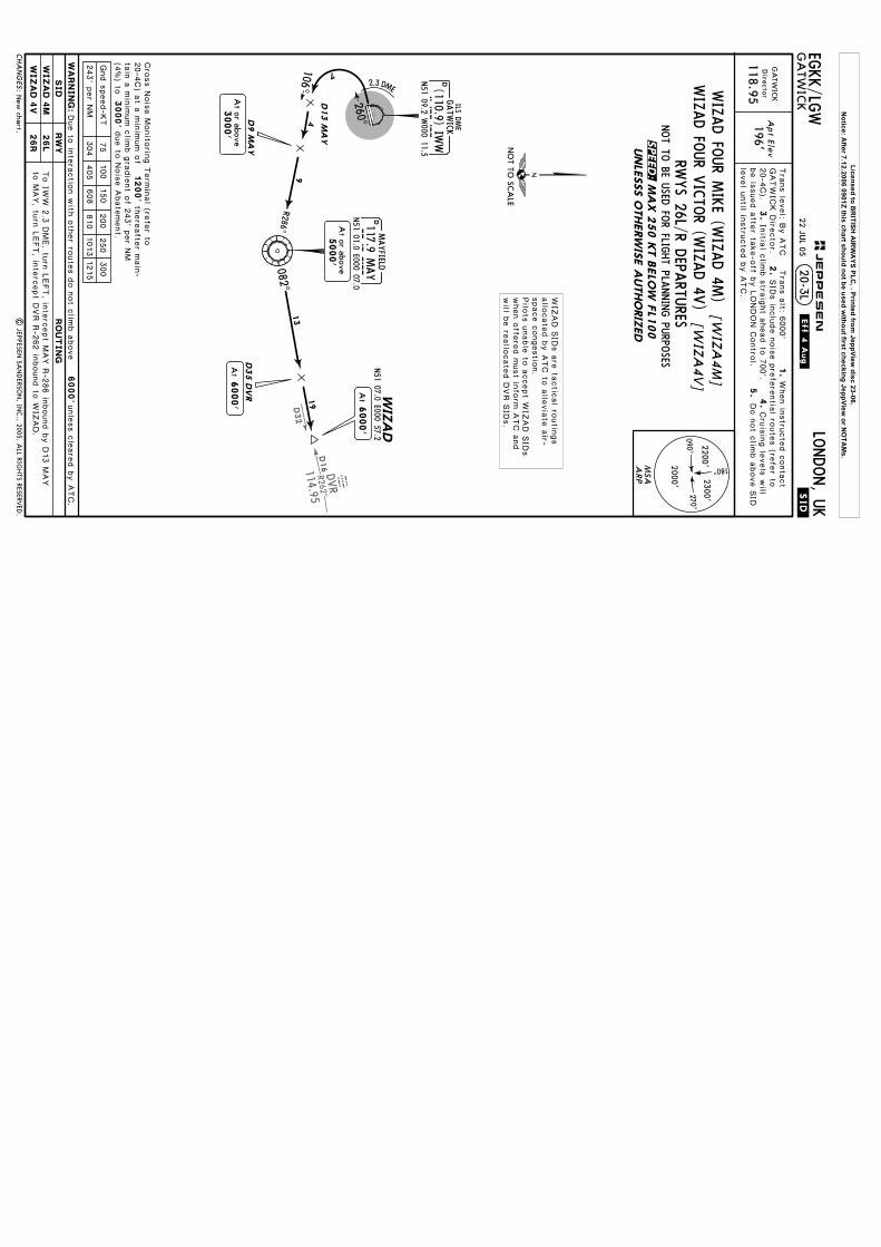
D16R262^DVR
114.95
DVR
D32
.SID.
EGKK/LG
W
Tra
ns le
vel: B
y A
TC T
rans a
lt: 6000'
GA
TWIC
KLO
NDON, U
K
1.
When in
stru
cte
d c
onta
ct
2.
SID
s in
clu
de n
ois
e p
refe
rentia
l route
s (re
fer to
20-4
C).
3.
Apt Ele
v
196'118.95
Director
20-3L
Initia
l clim
b s
traig
ht a
head to
700'.
level u
ntil in
stru
cte
d b
y A
TC.
be is
sued a
fter ta
ke-o
ff by L
ONDON C
ontro
l.5.4.
Cru
isin
g le
vels
will
Do n
ot c
limb a
bove S
ID
.Eff.4.Aug.
GA
TWIC
K
DMAYFIELD
117.9 MAY
MAY
N51 01.0 E000 07.0
D13 M
AY
106^
R286^
4
9
7
N51 07.0 E000 57.2
WIZ
AD
At
6000'
D35 D
VR
At or above5000'
082^13
19
At
6000'
GATW
ICK D
irecto
r.
New
chart.|
JEPPESEN
SAN
DERSO
N, IN
C., 2005. A
LL RIGHTS RESERV
ED.
D9 M
AY
At or above3000'
2.3 DME
260^
DN51 09.2 W
000 11.5IW
W(110.9) IW
WGATW
ICK
ILS DME
MSA 2300'
2000'
2200'
090^270^
180^ARP
CH
AN
GES:
JEPPESEN
22 JUL 05
MA
X 2
50 K
T B
ELO
W F
L100
UNLE
SSS O
THERW
ISE A
UTHO
RIZ
ED
RWYS 26L/R D
EPARTU
RESNOT TO
BE USED
FOR FLIG
HT PLA
NNING PU
RPOSES
RW
YSID
RO
UT
IN
G
26L
26R
WIZA
D 4
M
WIZA
D 4
V
WA
RN
IN
G:
75
100
150
200
250
300
243' p
er N
M304
405
608
810
1013
1215
Gnd s
peed-K
T
NO
T TO SC
ALE
WIZAD FO
UR M
IKE (W
IZAD 4M
)[W
IZA
4M
]WIZAD FO
UR V
ICTO
R (WIZAD 4V
)[W
IZA
4V]
Due to
inte
ractio
n w
ith o
ther ro
ute
s d
o n
ot c
limb a
bove
6000'unle
ss c
leare
d b
y A
TC.
To IW
W 2
.3 D
ME, tu
rn L
EFT, in
terc
ept M
AY R
-286 in
bound b
y D
13 M
AY
to M
AY, tu
rn L
EFT, in
terc
ept D
VR R
-262 in
bound to
WIZ
AD.
WIZ
AD S
IDs a
re ta
ctic
al ro
utin
gs
allo
cate
d b
y A
TC to
alle
via
te a
ir-space c
ongestio
n.
Pilo
ts u
nable
to a
ccept W
IZAD S
IDs
when o
ffere
d m
ust in
form
ATC a
nd
will b
e re
allo
cate
d D
VR S
IDs.
1200'
3000'
Cro
ss N
ois
e M
onito
ring T
erm
inal (re
fer to
20-4
C) a
t a m
inim
um o
f th
ere
afte
r main
-ta
in a
min
imum c
limb g
radie
nt o
f 243' p
er N
M(4
%) to
due to
Nois
e A
bate
ment.
SPEED:
Licensed to BR
ITISH A
IRW
AYS PLC
, . Printed from JeppView
disc 23-06.N
otice: After 7.12.2006 0901Z this chart should not be used w
ithout first checking JeppView or N
OTA
Ms.

Operators applying U
.S. Ops Specs: C
L required below 300m
; approved guidance system required
below 150m
.
Approved
Operators
LVP m
ust b
ein
Forc
e
TAKE-O
FF RUN
AVA
ILABLE
RWY 08R:
RWY 26L:
(15m
)
(15m
)
From rw
y head
int hold posn G1
int hold posn B1
From rw
y head int hold posn A
1, A2, A
3
| JEPPESEN
SAN
DERSO
N, IN
C., 1998, 2006. A
LL RIGHTS RESERV
ED.
TAKE-O
FF
ABCD
RCLM
(DA
Y only)
250m
300m
400m
500m
NIL
(DA
Y only)
1
1
RCLM
(DA
Y only)
RL & C
L
200m
250m
& m
ult. RVR req
125m
150m
LVP m
ust b
e in
Forc
e
or RLor RL
& m
ult. RVR req
150m
200m
RL, CL
HIRL, C
L
All R
wys
Rw
y 0
8R/26L
twy H
int
J4
J3J1
J2 J7
08L08R
TAXIW
AY H
OLD
ING PO
INTS
10,364'(3159m)
9462'(2884m)
9140'(2786m)
10,679'(3255m)
10,164'(3098m)
9495'(2894m)
51-09
FO
R H
OLD
ING
PO
INTS
SEE IN
SET FO
R
PA
RKIN
G P
OSIT
IONS
SEE 2
0-9
A
Stopway
8415'
10,879' 2565m
3316m
243' 74m
Stopway
200' 61m
C1
Y1
Y2
Y3
Y4
M1
M3
A3
A2
A1
B1
P1
N1
J8276' 02^W
H3
J6
G1
G2
H2
H1
J5
Blast fence
51-09
00-10
00-10
00-11
00-11
00-12
00-12
00-13
00-13
6 OCT 06
For A
IRPO
RT B
RIE
FIN
G re
fer to
20-1
P p
ages
Treesup to252'
08R080^
RWY 08R/26L grooved.
1
RVR
46m
151'RV
R9075'9288'
8042'8255'
2766m
2831m
2451m
2516m
226L
08R1
CHA
NG
ES:
N51 08.9 W
000 11.4202'
Apt Elev
LONDON, U
KG
ATW
ICK
2
J
PAPI-R (3.0^) H
ST-CR &
D
.JAR-OPS.
EGKK/LG
W
HIRL C
L HIA
LS-II TDZ
08L080^
ARP
339'
262'
294'
Trees up to 302' south ofand parallel to runw
ay
T1
Q1
CA
RG
OBUILD
ING
PIE
R 1
PIE
R 2
PIE
R 3
NO
RTH
TERM
INA
L
316'TERM
INA
LSO
UTH
MA
INTENA
NCE
AREA
1
MA
INTENA
NCE
AREA
2
PIE
R 4
Control
Tower
26R260^
R1
CA
RG
O A
REA
T
J
Q
Q
Q
Q
R
LL
L
P
PK
N
K
J
Z
L
Elev196'
Elev202'
Elev196'
Elev192'
R
R
J
J
J
ThresholdLA
ND
ING
BEY
ON
DUSA
BLE LEN
GTH
S
WID
THTA
KE-O
FFG
lide Slope
RVR
7359'7047' 2
243m
2148m
148'45m
HIRL H
IALS PA
PI-L (angle 3.0^)
AD
DITIO
NA
L RUN
WA
Y IN
FORM
ATIO
N
E1
D1
RWY
08L26R
Base
Com
pass
20-9
136.52121.95
Tower
121.8124.22
*G
ATW
ICK D
elivery (Cpt)
*G
round
S
JH
GR
G
FR
E
D
CR
C
BBR
Y
AM
K
KA
L
S1
J
HG
RG
287'
ANAS
AE
RA
QA
NA
1000
400200
0 0Feet
Meters
5002000
15002500800
600
26L260^
JEPPESEN
LEGEN
D
Holding point for
RWY 08L/26R only
P1
white light
Synchronized flashing
QB
FR
D-A
TISA
CA
RS:
PIE
R 6
D-A
TISD
CL
HIRL C
L HIA
LS-II TDZ PA
PI-L (3.0^) HST-E &
FR
R
Notes transferred to 20-1P pages.
WEST P
ARK
Licensed to BRITISH AIRWAYS PLC, . Printed from JeppView disc 23-06.
Notice: After 7.12.2006 0901Z this chart should not be used without first checking JeppView or NOTAMs.

| JEPPESEN
SAN
DERSO
N, IN
C., 1998, 2006. A
LL RIGHTS RESERV
ED.
00-10
RLR L
L R
L R
R L
R L
R L
LR
LR
LR
RL
RL
L RL
L
L
RR
RR
L
R L
RL
LR
RL
LR
LR
L
LR
LR
L
RL
LR
LR
LR
LR
LR
LR
LR
LR
RL
R
EW
EW
R L
R L
Blast fence
6 OCT 06
Stands. Notes transferred to 20-1P pages.
LR
R
LR
CHA
NG
ES: T
T1J
JR1
Q1
Q
R
CA
RG
O
Q
Q
Q
R
L
L
P
PK
N
J
Z
L
PIE
R 1
PIE
R 3
J8W
EST P
ARK
NO
RTH
TERM
INA
L
TERM
INA
LSO
UTH
MA
INTENA
NCE
AREA
2
C1
Control
Tower
CA
RG
OA
REA
152
150151
6566
6362616059585756
111112
113101
102
110109
107106
105
R
5453
5251
5049
B1
A3
RWY 08R/26L
RWY 08L/26R
136135
134133
132131
130
145144
143142
141140
161
3233
34 3536
3738
31
67
13
57
9
24
6 1214
1618
2022
2428 25
1917
1513
21
11
10
PIE
R 4
554
553552
551
64
68
M3
CO
ORDIN
ATES
STA
ND N
o.
CO
ORDIN
ATES
STA
ND N
o.
INS C
OO
RDIN
ATES
STA
ND N
o.
CO
ORDIN
ATES
STA
ND N
o.
CO
ORDIN
ATES
A2
M1
A1
Y4
160
P1N
1
46
47
48
51-09.5
51-09.4
51-09.7
51-09.6
51-09.1
51-09.6
51-09.7
51-09.8
51-09.2
INS C
OO
RDIN
ATES
00-11.500-11
00-10.5
51-09.1
LONDON, U
KG
ATW
ICK
171
173
175
S
S1
178
170
172
174
176
177
20-9AJEPPESEN
KA
K
L
CCR
BR
B
A
M
Y
AE
ANAS
169
157158
159
156155
153154
180
RA
QB
QA
R
NA
104
EGKK/LG
W
LEGEN
D
Holding point for
Rwy 08L/26R only
N1
K
23
4143
42
WEST
PA
RK
N51 09.2 W
000 09.8N
51 09.3 W000 09.8
N51 09.2 W
000 09.8N
51 09.3 W000 09.9
N51 09.2 W
000 09.9 N
51 09.3 W000 09.9
N51 09.2 W
000 09.9N
51 09.2 W000 10.0
N51 09.3 W
000 10.0N
51 09.3 W000 09.9
N51 09.4 W
000 09.9N
51 09.4 W000 10.0
N51 09.3 W
000 10.0 N
51 09.4 W000 10.0
N51 09.3 W
000 10.0 N
51 09.4 W000 10.1
N51 09.3 W
000 10.1N
51 09.4 W000 10.1
N51 09.4 W
000 10.2N
51 09.3 W000 10.2
20, 20R 21L, 21, 21R
222324L
24, 24R 25L thru 28R
31L31, 31R
32L, 32, 32R
33L33, 33R
34L thru 35R36L, 36, 36R
37L 3737R
38L, 38, 38R41W
thru 41E42 thru 43E
N51 09.3 W
000 10.1 N
51 09.4 W000 10.2
N51 09.3 W
000 10.2N
51 09.4 W000 10.3
N51 09.3 W
000 10.3 N
51 09.3 W000 10.2
N51 09.3 W
000 10.3N
51 09.4 W000 10.1
N51 09.4 W
000 10.0N
51 09.4 W000 10.1
N51 09.5 W
000 10.2N
51 09.4 W000 10.2
N51 09.5 W
000 10.2N
51 09.6 W000 10.1
N51 09.5 W
000 10.0 N
51 09.6 W000 10.0
N51 09.6 W
000 10.1N
51 09.5 W000 10.0
N51 09.4 W
000 10.3N
51 09.4 W000 10.4
46, 4748L4848R
49L, 49, 49R 50
51L51, 51R
52L, 52, 52R 53L, 53
53R
54L, 54, 54R56L, 56, 56R
57L, 5757R
58L thru 5960L thru 62R63L, 63, 63R64L, 64, 64R65L, 65, 65R
N51 09.6 W
000 10.2N
51 09.5 W000 10.3
N51 09.6 W
000 10.3N
51 09.6 W000 10.2
N51 09.5 W
000 10.3 N
51 09.5 W000 10.4
N51 09.5 W
000 10.5N
51 09.5 W000 10.4
N51 09.5 W
000 10.5 N
51 09.5 W000 10.6
N51 09.5 W
000 10.5N
51 09.5 W000 10.6
N51 09.5 W
000 10.8 N
51 09.6 W000 10.8
N51 09.5 W
000 10.8 N
51 09.6 W000 10.8
N51 09.7 W
000 10.9N
51 09.8 W000 10.9
N51 09.8 W
000 11.0N
51 09.7 W000 11.0
C5, 20
Parking stand
125
N51 09.7 W
000 10.9 N
51 09.7 W000 11.0
N51 09.6 W
000 11.0N
51 09.4 W000 10.6
N51 09.3 W
000 10.6 N
51 09.3 W000 10.7
N51 09.3 W
000 10.8N
51 09.4 W000 10.8
N51 09.4 W
000 10.7N
51 09.4 W000 10.9
N51 09.3 W
000 10.5N
51 09.3 W000 10.6
N51 09.3 W
000 10.7N
51 09.3 W000 10.8
N51 09.2 W
000 10.5 N
51 09.2 W000 10.6
N51 09.2 W
000 10.7N
51 09.2 W000 10.8
N51 09.4 W
000 11.1N
51 09.3 W000 11.1
N51 09.3 W
000 11.2N
51 09.4 W000 11.1
N51 09.4 W
000 11.2N
51 09.4 W000 11.3
N51 09.3 W
000 11.0 N
51 09.2 W000 11.0
N51 09.1 W
000 11.1N
51 09.1 W000 11.3
N51 09.1 W
000 11.2N
51 09.2 W000 11.3
N51 09.2 W
000 11.2N
51 09.2 W000 11.3
N51 09.2 W
000 11.2N
51 09.2 W000 11.3
N51 09.3 W
000 11.2 N
51 09.3 W000 11.3
N51 09.5 W
000 10.7N
51 09.4 W000 10.8
N51 09.5 W
000 10.812345 67910
11, 12
13L13, 13R
14L, 14, 14R 1516 1718
19L, 1919R20L
51-09.8
66L 66, 66R67, 68
101, 102104 thru 106
107, 109
110111L, 111, 111R
112, 113125 130
131, 132133, 134135, 136
140L thru 141
142L, 142, 142R143L thru 144R145L, 145, 145R
150L, 150150R, 151L
151 thru 152R153, 154, 155
156, 157158, 159
160L, 160, 160R
161169170171172 173174175176177
178, 180551, 552
553554
PIE
R 2
PIE
R 6
Licensed to BRITISH AIRWAYS PLC, . Printed from JeppView disc 23-06.
Notice: After 7.12.2006 0901Z this chart should not be used without first checking JeppView or NOTAMs.

20-9B
Chart reindexed.
6 OCT 06
| JEP
PESEN
SAN
DERSO
N, IN
C., 2000, 2006. A
LL RIGHTS RESERV
ED.
EGKK/LG
W
SLOT
737F100
MD
80
767B757
A320
A321
STA
ND E
NTRY G
UID
ANCE S
YSTEM
A. C
ENTERLIN
E G
UID
ANCE S
YSTEM
AG
NIS
-AZIM
UTH G
UID
ANCE F
OR N
OSE-IN
STA
NDS
GENERA
L
A red/green light system
to guide along the stand centerline intended as a "back-up"
to the stand centerline marking. It does not provide a stopping signal.
It consists of a unit emitting red and/or green light signals - m
ounted on the front ofthe piers at pilot eye level - aligned for interpretation by the pilot in the left handseat. The signals are to be interpreted as follow
s:
Turn towards G
REEN.
REDG
REEN
LEFT of centerline.
GREEN
GREEN
Aircraft on
centerline.
GREEN
RED
Turn towards G
REEN.
RIGH
T of centerline.
B. S
TO
PPIN
G G
UID
ANCE
PA
PA
-PA
RA
LLAX A
IRCRA
FT P
ARKIN
G A
ID
CH
AN
GES:
JEPPESEN
LONDON, U
KG
ATW
ICK
Pilot interpreted guidance systems for aircraft parking consist of tw
o separate elements:
CA
UTIO
N: The system
s are aligned with the LEFT hand pilots seat only.
a) Centerline G
uidance -AG
NIS (A
ZIMUTH
GUID
AN
CE FO
R NO
SE-IN STA
ND
S)b) Stopping G
uidance -PAPA
(PARA
LLAX A
IRCRA
FT PARK
ING
AID
),
FLUO
RESCEN
TTU
BEW
hite "STO
P" line
Mirro
r
-Stop arrow-M
irror or
The acft should be aligned on the stand centerline with the aid of A
GN
IS. The pilot in the lefthand seat should then continue to taxi forw
ard with the reference to m
irror. The acft shouldbe brought to a halt w
ith the nosewheel on the relevant stop m
ark.
Sto
p a
rrow
A yellow
painted STOP arrow
is provided on the ground as a stopping guidance on some of the
stands. The pilot in the left hand position must align his position w
ith the yellow STO
P arrowto find the correct parking position.
It consists of a reference board with a horizontal slot running across its center. This board is
supported on a frame projecting from
the face of the pier at pilot eye level. Behind it is a
weatherproof w
hite fluorescent tube mounted vertically and slightly to the right.
Taxiing into the stand, the pilot in the left hand seat will see the fluorescent tube appear to
move along the slot tow
ards the reference marks. C
orrect stopping position is reached, when
the tubular light registers in line with the appropriate aircraft type "
STOP"
mark.
Accuracy of this system
is very much dependent upon the accuracy of the alignm
ent on thestand centerline. It has been set up for interpretation by the pilot occupying the left hand seat.View
ed from the right hand pilot's seat the aircraft w
ill overshoot by 3 to 10 feet/1 to 3mdepending upon acft type.
Licensed to BR
ITISH A
IRW
AYS PLC
, . Printed from JeppView
disc 23-06.N
otice: After 7.12.2006 0901Z this chart should not be used w
ithout first checking JeppView or N
OTA
Ms.
055^
332^SFDDFS117.0
011^
052^
GY
NDB
097^107^ D27
131^
OCK115.3CKO
020^
GY
ND
B
Shoreham
304^SFDDFS117.0
MIDHURST114.0 MID
D(H)M I D
124^
304^
GATWICK365 GYG Y
BRIEFING STRIP TM
21-1LO
NDON, U
KG
ATW
ICK
ILS DME Rw
y 08R
136.52126.82
GA
TWIC
K D
irector (APP/R)
GA
TWIC
K Tow
er
124.22121.8*G
round
LOC
IGG
110.9
Final
Apch C
rs
080^
GS
Refer tochart 21-1A
Refer tochart 21-1A
ILSD
A(H
)A
pt Elev
RW
Y
196'
195'
090^
270^
310^
130^
MAYFIELD117.9 MAYDM A Y
287^
107^
3000
30
00
05 5 10
50-50
51-00
51-10
00-1000-0000-1000-2000-30
646'
965'
Hazard
627'
656'
639'
712'
700' 781'
813'
677'
666'
645'
787'
663'
702'
602'
863'
HazardBeacon
Beacon
ILS DM
E reads zero at rwy 08R displaced threshold.
D12.0 SFD
D17.0 MID
| JEPPESEN
SAN
DERSO
N, IN
C., 1999, 2005. A
LL RIGH
TS RESERVED
.
D17/22 MID
D12/17 SFD
Alt Set: hPa
Rwy Elev: 7 hPa
Trans level: By A
TCTrans alt: 6000'
28 JAN
05EG
KK/LG
W
D-A
TIS
Holding. C
omm
unications.
926'
4000
7.0
4000Leave at4000'
2WILLO
310^
NOT TO SCALE
VALID FOR 90 - 240 KT TAS
FOR FINAL APPROACH SEE 21-1A
INITIAL APPROACH
080^
3000
30006.0
6.0
3000
ASTRAWhen MID VOR u/s
Leave at4000'
2
2
1
287^
22.7 to D18.0 M
AY
Descend in holding to 4000.
ILS DME
080^ 110.9 IGGI G GD8.6IGG
At 3000'D11.0 MID
MIDD5.0
PANS OPS 4CHA
NG
ES:
JEPPESEN
180^
2300'270^
2200'
090^
2000'
MSA
Airport
D5.0 MAY1
2TIMBALUMBA
30005.0277^
D10.0 MIDD18.0 MAY
3000'At
18.03000
Leave MAY holding via track 259^at 3000.
D23.0 MAYD5.0 MID
Licensed to BR
ITISH A
IRW
AYS PLC
, . Printed from JeppView
disc 23-06.N
otice: After 7.12.2006 0901Z this chart should not be used w
ithout first checking JeppView or N
OTA
Ms.

D4.0
IGG
D1.0
IGG
D8.6
IGG
D2.0
IGG
D0.5
IGG
365 GY
G Y
646'
965'
Hazard
627'
666'
602'
Hazard
Beacon
Beacon
MIS
SED A
PCH:
JEPPESEN
BRIEFING STRIP TM
21-1AG
ATW
ICK
LONDON, U
K
136.52126.82
GA
TWIC
K D
irector (APP/R)
GA
TWIC
K Tow
er
124.22121.8
*G
round
LOC
IGG
110.9
Final
Apch C
rs
080^
GS
D4.0
IGG
1525'(1
330')
ILSD
A(H
)
395'(2
00')
Apt Elev
RW
Y
196'
195'
295'(100')
DA
(H)
CA
T II ILSRA
97'
Clim
b STRAIG
HT A
HEA
D (M
AX IA
S 250 KT) to 3000',
then as directed.
D8.6
IGG
D4.0 IG
GD1.0 IG
G
3.00^5.2%
IGG
D2.0
IGG
D0.5
377485
539647
755862
GS Lc
tr
1595'D
4.2
IGG
5
STRAIG
HT-IN
LAN
DIN
G RW
Y08R
DA
(H)2
95'(1
00')
CA
T II ILS
RVR3
00m
RA
97'
ABCD
.JAR-OPS.
Gnd speed-K
ts70
90100
120140
160
MA
X250
KT
3000'
LOC
LOC
0 5
1
1
CAT I/II ILS D
ME Rw
y 08R
at rwy 08R displaced threshold.
| JEPPESEN
SAN
DERSO
N, IN
C., 1999, 2005. A
LL RIGH
TS RESERVED
.
51-10
00-1000-20
00-3000-00
51-05
1. CA
T II ILS: Special Aircrew
& A
cft Certification Required. 2. ILS D
ME reads zero
Alt Set: hPa
Rwy Elev: 7 hPa
Trans level: By A
TCTrans alt: 6000'
28 JAN
05EG
KK/LG
W
D-A
TIS
Com
munications.
Operators applying U
.S. Ops Specs: A
utoland or HG
S required below RV
R 350m.
080^
2000
260^
FO
R IN
ITIA
L APPRO
ACH S
EE 2
1-1
080^ILS D
ME
080^ 1
10.9
IGG
I G G
D4.2
IGG
GATW
ICK
090^270^
180^
2200'2300'
2000'
PANS OPS 4
In the event of complete radio failure see 28-2.
CHA
NG
ES:
MSA
Airport
2.00.5
ABCD
FULL
ALS out
ALS out
MD
A(H
)M
axKts
100
135
180
205
STRAIG
HT-IN
LAN
DIN
G RW
YCIRC
LE-TO-LA
ND
800'800'
1100'1100'
3600m
2400m
1600m
1500m
195'
1600'
GS
GS
565'
4.40.2
080^
1525'
3000'
RW
Y 0
8R
08R
ILS
DA
(H)3
95' (200')
1000m
RVR
LOC (G
S o
ut)
MD
A(H
)720' (5
25')
T CH d isp l
thresh 53'
1.00.5
MA
P at D
0.5 IGG
760'
ALTITU
DE
7.02490'
6.02170'
5.01850'
3.01210'
2.0890'
IGG
DM
ELO
C(G
S o
ut)
(604')
(604')
(904')
(904')
VIS
.JAR-OPS.
1200m
RVR
1600m
RVR
RVR
2000m
RVR1500m
RVR1000m
RVR550m
LOC D
escent Gradient
ILS GS
orPA
PI
8.02810'
4.01530'H
IALS-II
Licensed to BR
ITISH A
IRW
AYS PLC
, . Printed from JeppView
disc 23-06.N
otice: After 7.12.2006 0901Z this chart should not be used w
ithout first checking JeppView or N
OTA
Ms.
D27
276^
131^
OCK115.3 CKO
304^SFDDS
117.0 F
GATW
ICK
338 GE
G E
MAYFIELD
117.9 MAY
DM A Y
310^
130^
117.9 MAY
MAYFIELD
DM A Y
124^
304^
090^
270^
BRIEFING STRIP TM
21-2LO
NDON, U
KG
ATW
ICK
ILS DME Rw
y 26LA
TIS
136.52126.82
GA
TWIC
K D
irector (APP/R)
GA
TWIC
K Tow
er
124.22121.8
*G
round
LOC
IWW
110.9
Final
Apch C
rs
260^
GS
Refer tochart 21-2A
Refer tochart 21-2A
ILSD
A(H
)A
pt Elev
RW
Y
196'
195'
50-50
51-00
51-10
00-1000-20
00-1000-00
Leave MA
Y holding via
D1.5 M
AY at 3000, turn LEFT
to intercept R-005 MA
Y V
OR.
At D
3.0 MA
Y descend to 2000.
2000
Hazard
Beacon
D12.0
SFD
| JEPPESEN
SAN
DERSO
N, IN
C., 1999, 2003. A
LL RIGH
TS RESERVED
.
ILS DM
E reads zero at rwy 26L displaced threshold.
D12/17 SFD
25 APR 03
EGKK/LG
W
Trans alt: 6000'Trans level: B
y ATC
Alt Set: hPa
Rwy Elev: 7 hPa
107^
287^
WILLO
holding. Procedure bearings.
(5805')
05 5 10
MIDHURST
114.0 MID
MID
D(H)
260^
005^
2000
4000 7.0
4000
4000
11.5 1
2
1
8.5
2W
ILLO
310^
044^
TIMBA
LUM
BA
D8.5
MA
Y
D1.5
MA
Y
ILS DM
E
260^ 1
10.9
IWW
I W W
4000
14.1042^
Leave at4000'
2A
STRA
Continue as above
005^
Arriv
al fro
m A
STRA
if MID
VO
R u
/s
NO
T TO SC
ALE
PANS OPS 4CHA
NG
ES:
JEPPESEN
180^
2300'270^
2200'
090^
2000'
1
2D
escend in holding to 4000.
VA
LID FO
R 90 - 240 KT TA
S
FO
R F
INA
L APPRO
ACH S
EE 2
1-2
A
INIT
IAL A
PPRO
ACH
D5.5
IWW
D5.0
MA
Y
Leave at4000'
2000'A
t
MID
D22.0
677'
645'
630'
1007'
787'
774'
823'
663'627'656' 639'
813'
666'
734'
602'
863'
1014'
1035'
MSA
ARP
Licensed to BR
ITISH A
IRW
AYS PLC
, . Printed from JeppView
disc 23-06.N
otice: After 7.12.2006 0901Z this chart should not be used w
ithout first checking JeppView or N
OTA
Ms.

D5.5
IWW
IWW
D1.0
D4.0
IWW
D0.5
IWW
D1.0
IWW
D5.5
IWW
D0.5
IWW
MIS
SED A
PCH:
BRIEFING STRIP TM
21-2AG
ATW
ICK
LONDON, U
K
ATIS
136.52126.82
GA
TWIC
K D
irector (APP/R)
GA
TWIC
K Tow
er
124.22121.8
*G
round
LOC
IWW
110.9
Final
Apch C
rs
260^
GS
1525'(1
330')
ILSD
A(H
)
395'(2
00')
Apt Elev
RW
Y
196'
195'
295'(100')
DA
(H)
CA
T II ILS
Clim
b STRAIG
HT A
HEA
D (M
AX IA
S 250 KT) to 3000',
then as directed.
3.00^5.2%
377485
539647
755862
5
STRAIG
HT-IN
LAN
DIN
G RW
Y26L
DA
(H)2
95'(1
00')
CA
T II ILS
RVR3
00m
ABCD
.JAR-OPS.
Gnd speed-K
ts70
90100
120140
160
MA
X250
KT
3000'
0 5
Operators applying U
.S. Ops Specs: C
AT III authorization required below
RVR 350m
.1
1
CAT I/II ILS D
ME Rw
y 26L
Lctr
RA
100'
RA
100'
820'702'
965'
791'
Hazard
77 1'
602'
Hazard
Beacon
Beacon
51-10
00-1000-20
00-0000-10
51-151014'
at rwy 26L displaced threshold.
| JEPPESEN
SAN
DERSO
N, IN
C., 1999, 2003. A
LL RIGH
TS RESERVED
.
1. CA
T II ILS: Special Aircrew
& A
cft Certification Required. 2. ILS D
ME reads zero
25 APR 03
Trans alt: 6000'Trans level: B
y ATC
Alt Set: hPa
Rwy Elev: 7 hPa
EGKK/LG
W
(5805')
(HA
T)(6
95')
(1015')
(1335')
(1655')
(370')
(1330')(1
325')
(1805')
260^
GATW
ICK
338 GE
2000
080^
G E
FO
R IN
ITIA
L APPRO
ACH S
EE 2
1-2
260^
ILS DM
E
260^ 1
10.9
IWW
I W WLO
C1520'
1.53.0
0.5
565'G
S
2000'
260^
195'
RW
Y 2
6L
Lctr
D4.0
IWW
1525'
GS
TCH displ
thresh 54'
0.5
090^270^
180^
2200'2300'
2000'
PANS OPS 4
In the event of complete radio failure see 28-2.
CHA
NG
ES:
JEPPESEN
ABCD
FULL
ALS out
ALS out
MD
A(H
)M
axKts
100
135
180
205
STRAIG
HT-IN
LAN
DIN
G RW
YCIRC
LE-TO-LA
ND
800'800'
1100'1100'
3600m
2400m
1600m
1500m
26L
ILS
DA
(H)3
95' (200')
1000m
RVR
LOC (G
S o
ut)
MD
A(H
)700' (5
05')
MA
P at D
0.5 IWW
(604')
(604')
(904')
(904')
VIS
.JAR-OPS.
1200m
RVR
1600m
RVR
RVR
2000m
RVR1500m
RVR1000m
RVR550m
LOC D
escent Gradient
ILS GS
or
HIA
LS
PAPI
LOC
(GS o
ut)
ALTITU
DE
3.01210'
4.01530'
5.01850'
2.0890'
IWW
DM
E
See other side.
MSA
ARP
Licensed to BR
ITISH A
IRW
AYS PLC
, . Printed from JeppView
disc 23-06.N
otice: After 7.12.2006 0901Z this chart should not be used w
ithout first checking JeppView or N
OTA
Ms.
055^
332^SFDDFS117.0
011^
052^
GY
NDB
097^107^ D27
131^
OCK115.3CKO
020^
GY
ND
B
Shoreham 117.0DFSSFD
304^
MIDHURST114.0 MIDD
(H)M I D
124^
304^
BRIEFING STRIP TM
26-1LO
NDON, U
KG
ATW
ICK
NDB D
ME Rw
y 08R
136.52126.82
GA
TWIC
K D
irector (APP/R)
GA
TWIC
K Tow
er
124.22121.8
*G
round
LctrFina
lA
pch Crs
080^
Refer tochart 26-1A
MD
A(H
)A
pt Elev
RW
Y
196'
195'
090^
270^
310^
130^
MAYFIELD117.9 MAYDM A Y
287^
107^
3000
30
00
05 5 10
50-50
51-00
51-10
00-1000-0000-1000-2000-30
646'
965'
627'
656'
639'
712'
700' 781'
813'
677'
666'
645'
787'
663'
702'
602'
863'
Hazard
Minim
um A
lt
chart 26-1ARefer to
365 GYG Y
Beacon
GY
365
ILS DM
E reads zero at rwy 08R displaced threshold.
D17.0 MID
D12.0 SFDD12.0 SFD
| JEPPESEN
SAN
DERSO
N, IN
C., 1999, 2005. A
LL RIGH
TS RESERVED
.
D17/22 MID
D12/17 SFD
28 JAN
05EG
KK/LG
W
Alt Set: hPa
Rwy Elev: 7 hPa
Trans level: By A
TCTrans alt: 6000'
D-A
TIS
926'
Holding. C
omm
unications.
4000
7.0
4000Leave at4000'
2WILLO
310^
NOT TO SCALE
VALID FOR 90 - 240 KT TAS
FOR FINAL APPROACH SEE 26-1A
INITIAL APPROACH
080^
3000
30006.0
6.0
3000
ASTRAWhen MID VOR u/s
Leave at4000'
2
2
1
287^
22.7 to D18.0 M
AY
Descend in holding to 4000.
D8.6IGG
At 3000'D11.0 MID
MIDD5.0
PANS OPS 4CHA
NG
ES:
JEPPESEN
180^
2300'270^
2200'
090^
2000'
MSA
Airport
D5.0 MAY1
2TIMBALUMBA
30005.0277^
D10.0 MIDD18.0 MAY
3000'At
18.03000
Leave MAY holding via track 259^at 3000.
D23.0 MAYD5.0 MID
GATWICK
ILS DME
I G G110.9 IGG Licensed to BR
ITISH A
IRW
AYS PLC
, . Printed from JeppView
disc 23-06.N
otice: After 7.12.2006 0901Z this chart should not be used w
ithout first checking JeppView or N
OTA
Ms.

D8.6
IGG
D2.0
IGG
D0.5
IGG
365 G
YG
Y3.73:10
2:282:13
1:511:35
1:23
MIS
SED A
PCH:
BRIEFING STRIP TM
26-1AG
ATW
ICK
LONDON, U
KNDB D
ME Rw
y 08R
136.52126.82
GA
TWIC
K D
irector (APP/R)
GA
TWIC
K Tow
er
124.22121.8
*G
round
LctrFina
lA
pch Crs
080^
1600'(1
405')
MD
A(H
)
760'(5
65')
Apt Elev
RW
Y
196'
195'
Clim
b STRAIG
HT A
HEA
D (M
AX IA
S 250 KT) to 3000',
then as directed.
D8.6
IGG
5.2%
IGG
D2.0
IGG
D0.5
369474
527632
737843
Lctr
Gnd speed-K
ts70
90100
120140
160
MA
X250
KT
3000'
w/o D
ME
with D
ME
MD
A(H
)
720'(5
25')
Minim
um A
ltLc
trG
Y
365
05 5 10
Durin
g d
aylig
ht h
ours
only
With
DM
E:
W/o D
ME:
, acft may be radar vectored to extended
646'
965'
742'
Hazard
627'
666'
602'
Hazard
Beacon
Beacon
1. ILS DM
E reads zero at rwy 08R displaced threshold. 2. A
cft unable to receive DM
E
(IAF)
| JEPPESEN
SAN
DERSO
N, IN
C., 1999, 2005. A
LL RIGH
TS RESERVED
.
advise ATC
.
51-00
51-10
00-1000-20
00-3000-00
D4.2
IGG
D4.2
IGG
28 JAN
05EG
KK/LG
W
Alt Set: hPa
Rwy Elev: 7 hPa
Trans level: By A
TCTrans alt: 6000'
Acft w
ill normally be radar vectored to extended final approach track,
to be at 3000' established by 10NM
before displ thresh.
final approach track to be at 2000' established by 7NM
before displthresh. D
escent point for 5.2% D
esc Grad is D
5.5 IGG
.
Radar vectored acft will be provided w
ith radar range when on extended
final apch track and approaching the descent point for 5.2% D
esc Grad at
9NM
from 3000' or 6N
M from
2000' before displ thresh.
D-A
TIS
080^
2000
260^
FO
R IN
ITIA
L APPRO
ACH S
EE 2
6-1
080^GATW
ICK
090^270^
180^
2200'2300'
2000'
PANS OPS 4
In the event of complete radio failure see 28-2.
CHA
NG
ES:
JEPPESEN
MSA
Airport
2.2
ABCD
ALS out
ALS out
MD
A(H
)M
axKts
100
135
180
205
STRAIG
HT-IN
LAN
DIN
G RW
YCIRC
LE-TO-LA
ND
800'800'
1100'1100'
3600m
2400m
1600m
1500m
195'
1600'
4.4
080^
3000'
RW
Y 0
8R
08R
1000m
RVR
MD
A(H
)760' (5
65')
1.5
760'
ALTITU
DE
7.02490'
6.02170'
5.01850'
4.01530'
3.0IG
G D
ME
(604')
(604')
(904')
(904')
VIS
.JAR-OPS.
1200m
RVR
1600m
RVR
RVR
2000m
RVR1500m
PAPI
8.02810'
w/o D
ME
RVR1000m
1200m
RVR
RVR1600m
RVR1500m
RVR
2000m
with D
ME
MD
A(H
)720' (5
25')
W/o D
ME: Lctr to M
AP
With D
ME: M
AP at D
0.5 IGG
Descent G
radient
0.5
W/o D
ME
ILS DM
E
I G G
110.9 IGG
1210'
080^
080^
2.0890'
HIA
LS-II
Com
munications.
Licensed to BR
ITISH A
IRW
AYS PLC
, . Printed from JeppView
disc 23-06.N
otice: After 7.12.2006 0901Z this chart should not be used w
ithout first checking JeppView or N
OTA
Ms.
05 5 10
28-1EG
KK
Final
Apch C
rsM
inimum
Alt
Apt Elev
RA
DA
RBy A
TCRefer to
Minim
ums
196'
PANS OPS 4
MD
A(H
)See
table below
RVR
RVR
RVR
RVR
RVR
BRIEFING STRIP TM
*G
round
126.82124.22
121.8
RVR
RVR
RVR
RVR
RVR
100
135
180
205
11
1 GA
TWIC
KLO
NDON, U
KSRA
All Rw
ysG
ATW
ICK D
irector (APP/R)
GA
TWIC
K Radar
125.87
GA
TWIC
K Tow
erA
TIS
136.52
RW
Y- See below
MIS
SED A
PCH:C
limb STRA
IGHT A
HEA
D (M
AX IA
S 250 KT) to 3000',
then as directed.
After SRA
08L/26R apch: MD
A(H
) 850'(654').
RVR
RVR
RVR
RVR
RVR
Lighting -Refer toA
irportChart
250MA
X KT
3000'
| JEPPESEN
SAN
DERSO
N, IN
C., 1999, 2002. A
LL RIGH
TS RESERVED
.
51-10
00-1000-20
00-3000-00
51-15
51-05
19 JUL 02
Bearings.
338 GE
GATWICK
365 GY
GATWICK
080^ 110.9 IGG
260^ 110.9 IWW
260^
080^
ILS DM
E
260^
ILS DM
E
080^
20002000
2000
I W W
G E
G Y
I G G
090^
270^
180^
2200'2300'
2000'In the event of com
plete radio failure see 28-2.
CHA
NG
ES:
JEPPESEN
720'
ABCD
MD
A(H
)(5
25')
ALS out
STRAIG
HT-IN
LAN
DIN
G
1200m
1600m
Gnd speed-K
ts70
90
100
120
140
160
1500m
2000m
.JAR-OPS.
Descent G
radient4.9%
347447
496595
695794
1000m
1000m
1400m
1500m
2000m
ALS out
Max
Kts
MD
A(H
)
1100'1100'
1500m
1600m
2400m
3600m
VIS
CIRC
LE-TO-LA
ND
(904')
(904')
800'800' (6
04')
(604')
(5805')
MSA
Airport
SRA
08R
SRA
26L
MD
A(H
)850'(6
55')
SRA
08L/
26R
ALS out
900m
1800m
1500m2
000m
1800m
2000m
SRA 08L/26R: M
AP 2 N
M from
touchdown
TMN
2 to MA
P
SRA 08R/26L: M
AP 1 N
M from
touchdown or1.0
0:510:40
0:360:30
0:260:23
Min
imum
Alt/
NM
SRA
08R
SRA
08L &
26L/
R1300'
1900'
(1105')
(655')
ALL
850'
ACFT C
AT
OCA
(H)
BA
SED O
N ELEV
.RW
Y
(520')
715' 195'08RA
LL
610' (415')
195'26L
08L/26R195'
845'(650')
ALTITU
DE
(HA
T)
RAD
AR FIX
4.03.0
2.05.0
1750'(1555')
1450'(1255')
1150'(955')
850'(655')
4.02.0
5.5 FAF
(1705')
SRA TM
N 2.0 N
M
1. QFE altim
eter setting normally used during final approach. 2. ILS D
ME reads zero at
displaced threshold rwys 08L, 08R and 26L and at 0.5 N
M before displaced threshold
rwy 26R.
Alt Set: hPa
Rwy Elev: 7 hPa
Trans level: By A
TCTrans alt: 6000'
MD
A(H
)610'(4
15')
ALL
820'
77 1'
965'
742'
774'
823'
627'
876'
666'
602'
Hazard
Beacon
1014'
Hazard
Beacon
Licensed to BR
ITISH A
IRW
AYS PLC
, . Printed from JeppView
disc 23-06.N
otice: After 7.12.2006 0901Z this chart should not be used w
ithout first checking JeppView or N
OTA
Ms.

Big
gin
Hill
EG(D
)-132
EG(D
)-133
EG(D
)-133A Fairo
aks
EG(R)-151
GA
TWIC
K
51-00
51-10
51-20
00-1000-20
00-3000-40
00-0000-10
05 5 10 15 20
19 JUL 02
080^
080^ 110.9 IGG
260^
260^ 110.9 IWW
ILS DM
E 08R
ILS DM
E 26L
OCKHA
M
MID
HURST
MA
YFIE
LD BIG
GIN
EPSO
MNDB
GE N
DB
GY N
DB
28-2
VEC
TORIN
G A
REA
MSA
MSA
MSA
MSA
2000'2000'
2200'
2300'
bythe radar controller. D
escent below 2000'
LOSS O
F CO
MM
UN
ICA
TION
PROCED
URE
DURE
MISSED
APPRO
ACH
Rwys
Rwys
08L/
R
26L/
R
PROCE-
Continue visually or by
means of an appropriate
Continue visually or by
means of an appropriate
Procedure to MA
YFIELD
VO
R DM
E.
In the event of complete
radio failure, climb
STRAIG
HT A
HEA
D to D
10.0
In the event of complete
radio failure, climb
STRAIG
HT A
HEA
D to D
10.0
Within the Radar V
ectoring Area 2000' is the
minim
um initial altitude to be allocated
level if higher.
final approach aid.final approach aid.
If not possible proceed to
3000' or at last assigned
If not possible followthe M
issed Approach
IWW
(R-288 MA
Y V
OR for
acft unable to receive IWW
CH
AN
GES:
RAD
AR V
ECTO
RING
AREA
LONDON, U
K
D10.0
IGG
D10.0
IWW
IGG
(R-356 MA
Y V
OR for
acft unable to receive IGG
DM
E), then proceed to
above 3000'.
DM
E), then proceed to
above 3000'.
EGKK
2000'2000'
2000'
2000'
will be given w
ithin the intermediate and final
approach area when on 40^ leg or final approach.
INITIA
L APPRO
ACH
APPRO
ACH
INTERM
EDIA
TE AN
D FIN
AL
MA
YFIELD
VO
R DM
E at
to MA
YFIELD
VO
R DM
E not
to MA
YFIELD
VO
R DM
E not
RAD
AR
VO
R D
ME
VO
R D
ME
VO
R D
ME
VO
R D
ME
837'
820'702'
7 71 '
646'
677'
645'
1007'
965'
742'
787'
774'823'
663'627'
876'666'
602'
840'
Hazard
Beacon
1014'
Hazard
Beacon
JEPPESEN
Bearings.
| JEPPESEN
SAN
DERSO
N, IN
C., 1999, 2002. A
LL RIGHTS RESERV
ED.
Licensed to BR
ITISH A
IRW
AYS PLC
, . Printed from JeppView
disc 23-06.N
otice: After 7.12.2006 0901Z this chart should not be used w
ithout first checking JeppView or N
OTA
Ms.