Embed Size (px)
Citation preview


BIBLIOGRAPHIC REFERENCE Johnston, D., Becker, J., Jolly, G., Potter, S., Wilson, T., Stewart, C., and Cronin, S. 2011. Volcanic Hazards Management at Taranaki Volcano: Information Source Book, GNS Science Report 2011/37 108 p.
D. M. Johnston, GNS Science, PO Box 30368, Lower Hutt J. Becker, GNS Science, PO Box 30368, Lower Hutt G. Jolly, GNS Science, Private Bag 2000, Taupo S. Potter, GNS Science, Private Bag 2000, Taupo T. M. Wilson, University of Canterbury, Private Bag 4800, Christchurch C. Stewart, 37 Harland Street, Brooklyn, Wellington S. Cronin, INR, Massey University, Private Bag 11 222, Palmerston North © Institute of Geological and Nuclear Sciences Limited, 2011 ISSN 1177-2425 ISBN 978-0-478-19861-4


2011
GNS Science Report 2011/37 i
CONTENTS ABSTRACT .......................................................................................................................... III KEYWORDS ......................................................................................................................... III 1.0 INTRODUCTION ........................................................................................................ 1
2.0 GEOLOGICAL SETTING AND ERUPTIVE HISTORY ............................................... 2
3.0 VOLCANO MONITORING .......................................................................................... 3
4.0 VOLCANIC ALERT LEVELS AND AVIATION COLOUR CODES ............................. 6
5.0 WHAT TO EXPECT WHEN VOLCANIC UNREST BEGINS ....................................... 7
6.0 VOLCANIC HAZARDS, IMPACTS AND MITIGATION .............................................. 8
6.1 Tephra ............................................................................................................ 8 6.2 Pyroclastic density currents ...........................................................................20 6.3 Lahars ...........................................................................................................23 6.4 Lava flows .....................................................................................................25 6.5 Sector collapses and debris avalanches ........................................................26 6.6 Volcanic gases ..............................................................................................27 6.7 Earthquakes ..................................................................................................28 6.8 Ground deformation ......................................................................................28 6.9 Lightning and sound pressure waves ............................................................29
7.0 LONGER TERM AND SECONDARY HAZARDS AND IMPACTS ........................... 30
7.1 Fires ..............................................................................................................30 7.2 Tsunami ........................................................................................................30 7.3 Remobilised tephra, lahars and flooding ........................................................30 7.4 Effects of long term unrest and eruptions on the economy ............................31
8.0 PSYCHOSOCIAL IMPACTS OF VOLCANIC UNREST AND ERUPTIONS ............. 33
9.0 MITIGATION OF VOLCANIC HAZARDS DURING NON-ERUPTIVE PERIODS ...... 34
9.1 Land use planning to reduce volcanic risks ...................................................35 9.2 Response planning........................................................................................36 9.3 Resilience and public education ....................................................................36
10.0 POST ERUPTION / RECOVERY .............................................................................. 38
11.0 RECENT RESEARCH .............................................................................................. 39
12.0 GLOSSARY ............................................................................................................. 40
13.0 REFERENCES ......................................................................................................... 44
FIGURES
Figure 1 Volcano hazard management during crisis and non crisis periods. ................................................... 1 Figure 2 Map of Taranaki volcanic centre and surrounding towns. .................................................................. 2 Figure 3 A map of the GeoNet Taranaki Seismic Network (from Sherburn, Scott & Miller, 2010). ................... 5 Figure 4 Volcanic ash particle (scale bar is 100 μm). ....................................................................................... 9 Figure 5 Chemical processes occurring within volcanic plumes. Freshly fallen ash can release soluble
components into surface waters, and is both corrosive and conductive. Figure used with permission of GNS Science. ............................................................................................................ 10
Figure 6 Summary of case studies of volcanic ash impacts on electricity networks (from Wilson et al. 2011). ............................................................................................................................................... 13
Figure 7 Factors influencing flashover potential due to volcanic ash (from Wilson et al. 2009a).................... 14 Figure 8 La Aurora international airport, Guatemala City, following ashfall on 27 May 2010 (photo:
Gustavo Chigna, INSIVUMEH). ....................................................................................................... 18

2011
GNS Science Report 2011/37 ii
Figure 9 A pyroclastic density current flows down the side of Ngauruhoe, 1975. The flow deposits were still 90oC 1½ hours after emplacement (Nairn et al., 1976, cited in Blong, 1984, photo GNS Science). ................................................................................................................................. 21
Figure 10 A cast of the cavity left by a Pompeii victim killed by a pyroclastic flow from the Vesuvius eruption in 79AD. The victim’s hands cover their nose and mouth, demonstrating the suffocating nature of this hazard. Photo by S.Potter. ....................................................................... 22
TABLES Table 1 Volcanic Alert Levels in New Zealand. Taranaki currently uses the ‘reawakening volcanoes’
side of the table. From the Guide to the National Civil Defence Emergency Management Plan (Ministry of Civil Defence and Emergency Management, 2006). ............................................... 6
Table 2 The ICAO Aviation Colour Code ........................................................................................................ 7 Table 3 Attributes that lead to successful community-based programs – from Finnis et al. (2010) ............... 38
APPENDICES
Appendix 1 Auckland Engineering Lifelines group posters ................................................................................. 55 Appendix 2 USGS CO2 gas hazard poster ......................................................................................................... 60 Appendix 3 Volcanic impact study group annual seminar ................................................................................... 62 Appendix 4 Working from the same page: consistent messages for CDEM ....................................................... 69 Appendix 5 Exert from community behaviour-based communication framework: reawakening volcanoes
(2008) p: 4-7 .................................................................................................................................... 84 Appendix 6 Massey University report to TVSAG 2010 on recent research ......................................................... 89 Appendix 7 Taranaki-focused research by volcanic risk solutions ...................................................................... 91

2011
GNS Science Report 2011/37 iii
ABSTRACT
Taranaki volcano has erupted many times in the past 130,000 years, with the most recent eruption in approx. 1854 A.D. Volcanic hazards from Taranaki include tephra falls, pyroclastic density currents, lava flows, lahars, flooding, debris avalanches, sector collapses, lightning and volcanic gases. During volcanic unrest and eruptions, significant earthquakes and ground deformation could also occur. Volcanic hazards can affect areas both near to the vent and in distant locations, and are potentially dangerous to people, property, the economy and infrastructure. In this report each type of hazard is described, along with its impacts and possible mitigation measures. GNS Science monitors Taranaki for volcanic activity through the GeoNet project and is responsible for setting the Volcanic Alert Level and Aviation Colour Code. Volcanic unrest is one of the most difficult situations that the volcanological and emergency management communities will have to deal with, in part because of the potential for adverse social and economic impacts to escalate unnecessarily, unless the event is managed appropriately. Non-eruptive periods provide the best opportunity to develop an understanding of the unrest phenomena and potential eruptive hazards, and the best time to establish educational programmes, funding systems for enhanced emergency response and volcano surveillance and to develop co-ordinated contingency plans. Relevant research is summarised in themed chapters, and a list of further references and recent Taranaki-related research is included.
KEYWORDS
Taranaki, Egmont, volcano, hazard, tephra, emergency management

2011
GNS Science Report 2011/37 1
1.0 INTRODUCTION
Taranaki is a potentially active volcano. The most recent activity is thought to have been in the mid nineteenth century. Although the probability of an eruption is relatively low in any one year, the probability of one occurring in the future is high. The timing of the next eruption cannot yet be determined but its probable effects can be reasonably assessed. Recent eruptions overseas have demonstrated the devastating impacts of volcanic activity on nearby landscapes, communities and the economy. Even the 1995-1996 Ruapehu eruptions, although small by world standards, highlighted the vulnerability of society to minor eruptions. A further consideration is that, more often than not, indications of subsurface volcanic activity, such as increased earthquakes or above-ground gas changes, may not result in an eruption. These “unrest” phenomena may be hazardous in themselves, and cause uncertainty in the population and decision makers (for instance, which areas should be evacuated prior to eruption and when, and what will the impacts be on various local industries). Volcanic crises must be planned for using a comprehensive emergency management approach that links reduction, readiness, response and recovery. A volcanic hazard management approach incorporating the 4 R’s (reduction, readiness, response and recovery) is described in Figure 1. This report provides a review of key information for the effective management of volcanic hazards at Taranaki.
Figure 1 Volcano hazard management during crisis and non crisis periods.

2011
GNS Science Report 2011/37 2
2.0 GEOLOGICAL SETTING AND ERUPTIVE HISTORY
The volcanic history of Taranaki presented in this section is modified from Neall (2003), unless referenced otherwise. Further information and images on the geology of Taranaki can be found in Townsend, Vonk and Kamp’s (2008) geological map and information book. The nearly symmetrical, steep-sided cone of Mt Taranaki (also known as Egmont Volcano) is New Zealand's largest (by volume) andesitic stratovolcano. The area was previously a shallow sea, and was built up with deposited sediments until erupted volcanic material formed the cone and surrounding ringplain of debris avalanche and lahar deposits that extend to the coast. Taranaki Volcanic Centre is located in the west of the North Island at the southern end of a mostly extinct Miocene to Holocene volcanic arc extending to the north along the west coast of Waikato and into the Northland Peninsula. Over time the volcanic activity at Taranaki Volcanic Centre has progressed towards the southeast (Figure 2), beginning with the Sugar Loaf Islands and Paritutu 1.75 million years before present (B.P.) followed by the formation of Kaitake (575,000 years B.P.) and Pouakai (240,000 years B.P.). All of these cones are comprised of andesitic lava flows and are considered extinct (Neall, 1974).
Figure 2 Map of Taranaki volcanic centre and surrounding towns.

2011
GNS Science Report 2011/37 3
Taranaki cone began forming more than 130,000 years B.P., with the building of a proto-cone from which large volcanic avalanche deposits mantle the surrounding ring plain. Deposits from around this time have largely been eroded away or destroyed by subsequent eruptions. Another cone (“meso-Egmont”) had been built by 35,000 years B.P. Further eruptions triggered numerous lahars. A large sector collapse occurred between 30,000 and 27,000 years B.P., creating deposits that now form the hummocky topography between Stratford and Eltham. At 23,000 years B.P. another large debris avalanche was produced by probable sector collapse on the opposite (western) flank. Approximately 20,000 years B.P. the building of what is the current cone began from lava flows, as well as a second small cone being built (Pukeiti). A hot pyroclastic flow occurred 17,000 years B.P. after which the cone was continually built until what can be seen today. From 10,000 years B.P. to 5,000 years B.P. further pyroclastic density currents (hot, fluid flows of gas and tephra) caused lahars. Approximately 3,300 years B.P. Fanthams Peak erupted scoria and lava, and vertical fractures emitted lava forming the Beehives, Skinner Hill and The Dome (Neall, 1971, cited in Neall, 2003; Neall & Alloway, 1993). Only 500 years ago, in 1500 A.D., pyroclastic flows swept down the Stony River catchment on Taranaki’s flank, causing fires in the native bush which swept 3km northwards across the western slopes of the Pouakai Range (Druce, 1970, cited in Neall, 2003). 150 years later a pumice lapilli fall and pyroclastic flows covered Maori villages, inferred from the discovery of Maori ovens (umu) beneath the deposits. In 1755 A.D. small hot avalanches occurred from eruptions at Taranaki. Recent evidence from Platz (2007) suggests that the most recent eruption was between 1839 and 1866 A.D., and potentially in 1854 A.D. In 1998 and 2008, lahars swept down Taranaki’s river valleys due to heavy rain entraining old volcanic deposits (see section 7.3 for more details). A long history of repeated eruptions causing numerous pyroclastic density currents, debris avalanches and lahars shows this volcano is likely to have devastating effects even beyond the cone area in the future.
3.0 VOLCANO MONITORING
The past behaviour of a volcano is understood through geological research. By interpreting deposits and formations from previous eruptions, an understanding of past (and therefore most likely future) eruption characteristics can be gained. In order to understand the current behaviour of a volcano, geophysical (e.g. seismicity and ground deformation) and geochemical (e.g. spring chemistry) phenomena need to be monitored. Volcano monitoring is based on the assumption that movement of magma (molten rock) will occur beneath a volcano before an eruption can start, and that this is detectable using various methods (Sparks, 2003; Scott & Travers, 2009). In New Zealand, volcano monitoring is primarily the responsibility of GNS Science through the GeoNet project, mostly funded by the Earthquake Commission. GeoNet builds and maintains the monitoring networks (Scott et al., 1995). GNS Science staff respond to increased activity by intensifying the campaign of seismic, geodetic (ground movement) and geochemical measurements.

2011
GNS Science Report 2011/37 4
GNS staff regularly visit the volcanoes to collect samples, make observations and maintain technical equipment. Observations can include noting features such as changes in areas of warm ground and the development of new fumaroles and hot springs, which may indicate changes in the state of the volcano. Remotely operated cameras are used to supplement those observations. Earthquakes, ground deformation, and the discharge and chemistry of fluids and gas are monitored (however fluids and gas are not currently monitored at Taranaki) as they are principal indicators of the movement of magma, and increased eruption potential. Data from all disciplines are collected, analysed and cross-referenced to help give an understanding of the behaviour of the volcanoes and an insight into future eruptions. Earthquakes are monitored as they can occur when magma forces its way through the overlying rocks. There are nine permanent seismographs in Taranaki including one borehole seismometer at the North Egmont site. All seismographs have north-south, east-west, and vertical sensors and digital recording and data transmission. Seismic data from Taranaki are continuously transmitted to GeoNet data centres in Taupo and Wellington via three hub sites (Figure 3). At the data centres, earthquakes are detected automatically. Depending on their importance (as determined by their magnitude and likely location), they are analysed within a few minutes, within 24 hours, or within about two weeks. Felt earthquakes are analysed within a few minutes and their size and location information posted to the GeoNet website. Earthquake locations are automatically entered into a database that can be accessed via the GeoNet website (www.geonet.org.nz). Ground deformation is the change in slope and elevation of the landscape that can occur prior to, during or after an eruption. Such ground movement can occur in response to the influx or withdrawal of magma and hydrothermal or magmatic fluids in a volcano. Changes in the amount or rate of ground deformation may signal the start of a new eruptive episode. There are numerous ways to measure such deformation, like precise levelling, tilt measurement and position triangulation. Continuous Global Positioning System (CGPS) measurements provide time-series, high precision data for deformation monitoring. Satellite-based Interferometric Synthetic Aperture Radar (InSAR) is a relatively new technique for measuring ground movements over a wide region. This type of data is now being captured in some areas of New Zealand. On Taranaki, there is currently one permanent GPS station and numerous surveying marks that are measured by GPS periodically (every few years) to establish a baseline for local and regional scale deformation. Gases are usually discharged through gas vents (fumaroles) from which the temperature and composition of these gases can be measured by taking regular samples. As magma rises in the volcano, the temperature of fumaroles may increase, and their chemistry will change. Sometimes the gases emerge under a lake, or interact with groundwater in the volcanic edifice and analysis must take account of compositional changes this could invoke. There are several techniques to monitor gas, including sampling airborne gases from an aircraft and measuring flux through the ground surface. If seismic activity were to increase at Taranaki, the monitoring response would include baseline and repeat measurements of gas output from the summit of the volcano. Changes in the water chemistry of crater lakes and thermal spring waters are used to detect changes in the behaviour of the volcanoes and their associated geothermal systems.

2011
GNS Science Report 2011/37 5
Monitoring specific water parameters such as temperature, pH, conductivity, and concentrations of dissolved gases can provide insight into the processes expected to accompany unrest or renewed volcanic activity. Changes in groundwater, lake levels and rates of stream flow can also give evidence of unrest within a volcano. At Taranaki, there are few hot springs that can be regularly monitored for changes.
Figure 3 A map of the GeoNet Taranaki Seismic Network (from Sherburn, Scott & Miller, 2010).
Seismograph sites are indicated by triangles and labelled by their three or four-letter site codes. NEZ is North Egmont, NWEZ is Newall Road, PKE is Pukeiti, DREZ is Durham Road, MHEZ is Mangahewa, NMEZ is Namu Road, KHEZ is Kahui Hut, PREZ is Palmer Road, and LREZ is Lake Rotokare. Hub sites are shown by red circles. Egmont National Park is shown as a green shaded area. Major roads are shown as grey lines. The inset shows nearby GeoNet seismographs (red dots) that are also used in locating earthquakes in Taranaki.

2011
GNS Science Report 2011/37 6
4.0 VOLCANIC ALERT LEVELS AND AVIATION COLOUR CODES
In New Zealand, the state of activity at each volcano is described using the Volcanic Alert Level system, which ranges from 0 (normal background activity) to 5 (major eruption in progress). Taranaki is currently classified as a reawakening volcano, and uses the right-hand side of the Volcanic Alert Level (VAL) table (Table 1). The Volcanic Alert Level system is defined in the Guide to the National Civil Defence Emergency Management Plan (found on the civildefence.govt.nz publications webpage, in section 19.4.2). The background level of volcanic activity is determined through ongoing monitoring by GNS Science through the GeoNet project. Table 1 Volcanic Alert Levels in New Zealand. Taranaki currently uses the ‘reawakening volcanoes’ side of the table. From the Guide to the National Civil Defence Emergency Management Plan (Ministry of Civil Defence and Emergency Management, 2006).

2011
GNS Science Report 2011/37 7
The Aviation Colour Code (Table 2) is defined in International Civil Aviation Organization (ICAO) documents, and is used by the Civil Aviation Authority (CAA) in New Zealand to manage the aviation industry’s use of airspace during a volcanic eruption, according to the New Zealand Volcanic Ash Advisory System (VAAS) as outlined in Lechner (2009). The VAAS is the local enhancement of the International Airways Volcano Watch System (IAVW). GNS Science, MetService and the Airways Corporation of New Zealand provide input into the VAAS (Scott & Travers, 2009). Table 2 The ICAO Aviation Colour Code
Volcanologists at GNS Science have the responsibility of setting the VAL and Aviation Colour Codes for New Zealand’s active volcanoes. Responding agencies in New Zealand are notified of changes in volcanic activity, including changes to the VAL and Aviation Colour Code, by the dissemination of Volcanic Alert Bulletins which are issued by GNS Science. This information can be used by the responding agencies to help determine decisions and responses. For up to date information on the current status and levels for Taranaki, visit the GeoNet website: http://www.geonet.org.nz/volcano/activity/taranaki-egmont/.
5.0 WHAT TO EXPECT WHEN VOLCANIC UNREST BEGINS
The first measurable changes at a volcano are usually detected by geophysical or geochemical monitoring conducted as part of a volcano surveillance programme, and may not be noticed by members of the public. Unrest indicators can include earthquake swarms, discrete earthquakes, ground surface deformation, changes in heat flow at hot springs, gas output or chemistry, and magnetic and gravity changes. As these develop in intensity the public can soon become aware of the developing unrest. It is not possible, in many cases, to classify the early stages of unrest as purely volcanic (eruption possible) or tectonic (no eruption). As unrest moves from the initial signs into a volcanic crisis (i.e. a potential eruption threat is recognised), then the situation becomes clearer and management options are better defined. Predominantly tectonic processes acting on fault lines can result in ground and subsurface deformation (tectonic strain) and accompanying earthquakes are not necessarily associated with a volcano, except geographically, when they occur close to it.

2011
GNS Science Report 2011/37 8
Volcanic eruption precursors may be caused by the intrusion of new magma (molten rock) into the base of a volcano’s magma reservoir and/or movement of magma outward from a volcano’s magma reservoir into the conduit (plumbing) system below the volcano. This can lead to heating and partial melting of surrounding country rock. These are seismogenic processes which in turn may trigger changes to the fluid and gas chemistry/discharge of geothermal systems. Volcanic unrest is one of the most difficult situations the volcanological and emergency management communities will have to deal with. There is potential for adverse social and economic impacts to escalate unnecessarily, unless the event is managed appropriately. Adverse response to unrest may take the form of the release of inappropriate advice, media speculation, unwarranted emergency declarations and premature cessation of economic activity and community services. A non-volcanic-crisis time provides the best opportunity to develop an understanding of the unrest phenomena, and the best time to establish educational programmes, funding systems for enhanced emergency response and volcano surveillance and to develop co-ordinated contingency plans.
6.0 VOLCANIC HAZARDS, IMPACTS AND MITIGATION
Typically a number of hazards will result from any volcanic eruption. Volcanic hazards include tephra falls, pyroclastic density currents, lava flows, lahars, flooding, debris avalanches, sector collapses, lightning and volcanic gases, as described below. During unrest and eruption, significant earthquakes and ground deformation can also occur. Volcanic hazards can affect areas both near to the vent and in distant locations. A hazard map for Taranaki is in the Taranaki Civil Defence Emergency Management Group Volcanic Strategy (Taranaki Regional Council, 2004), Neall and Alloway (1996) and Townsend, Vonk and Kamp (2008). Volcanic Emergency Management published by the United Nations Disaster Relief Organization and United Nations Educational Scientific and Cultural Organization (UNDRO & UNESCO, 1985) outlines the range of volcanic hazards, and the video/DVD "Understanding Volcanic Hazards" by Maurice Krafft, available to purchase from www.iavcei.org/IAVCEI.htm, is also useful for public education. These resources will increase awareness and knowledge of volcanic hazards and their mitigation. The successful evacuation of thousands of people in danger from the Pinatubo eruption in 1991 was partly attributed to the showing of the video to the public. Volcanic hazards: a sourcebook on the effects of eruptions (Blong, 1984) is a useful source for all aspects of volcanic hazards. 6.1 Tephra
Although pyroclastic density currents, sector collapses, lahars and ballistic blocks and bombs are the most destructive and dangerous volcanic hazards, volcanic ash is by far the most widely distributed eruption product. Ash falls rarely endanger human life directly however threats to public health and disruption to critical infrastructure services, aviation and primary production can lead to significant societal impacts. Even relatively small eruptions can cause widespread disruption, damage and economic loss due to ash fall.

2011
GNS Science Report 2011/37 9
Description of tephra Tephra is a general term for any airborne material erupted from a volcano, except gas (Blong, 1984). Ballistics are larger particles (technically with diameters of over 64 mm), lapilli are 2 to 64 mm in size. In geology, the term ash refers to tephra particles smaller than 2 mm, and should not be confused with combustion products such as wood ash. Ballistics Ballistics are rocks ejected from the volcano vent during explosive activity. Large ballistic projectiles rarely land more than 3 km from a vent, but have been recorded as far away as 11 km (Blong, 1984). They may be either angular and brittle (termed ‘blocks’) or rounded and formed from magma (‘bombs’), and are not affected by the wind speed or direction due to their size. Ballistics can be over 10m in size near the vent. Ash and lapilli Volcanic ash and lapilli are formed by explosive volcanic eruptions. Ash is carried high above an erupting volcano in the ash column and usually widely distributed, however lapilli are not dispersed as far as ash due to their larger size and density. Ash particles are formed when rising magma is violently shattered by expanding magmatic gases, or by explosive magma-water interaction. Particles ejected from a vent are incorporated into an eruption column that can rise tens of kilometres into the atmosphere. Transport and distribution of ash and lapilli is dependent on a number of factors including prevailing wind speed and direction, particle size and density, and eruption column height. Volcanic ash fall deposits can initially be hot close to the volcano but atmospheric cooling is rapid and most ash lands in a near ambient state. Fresh volcanic ash is highly abrasive due to the glass shards, crystals and lithics (rock fragments) volcanic ash is made of (Figure 4). The composition of ash can influence the severity of its impact. The density of individual particles might vary between 700-3200 kg/m3 depending on their glass/mineral composition. This variability along with moisture content determines the thickness of deposited ash required before roof collapse occurs (Spence et al., 2005). Particle morphology and vesicularity (for coarse ash and lapilli) and mineral/glass composition are important factors to consider in evaluating the potential for acidic leachate production and abrasiveness of ash. Freshly deposited volcanic ash is potentially corrosive and electrically conductive (especially when wet) (Witham et al., 2005; Wilson et al., 2011).
Figure 4 Volcanic ash particle (scale bar is 100 μm).

2011
GNS Science Report 2011/37 10
Ash typically has a thin surface coating of readily-soluble salts that can be released into water (Figure 5) making the ash electrically conductive and chemically corrosive. Ash fall may be accompanied by acid rain.
Figure 5 Chemical processes occurring within volcanic plumes. Freshly fallen ash can release
soluble components into surface waters, and is both corrosive and conductive. Figure used with permission of GNS Science.
Hazards, impacts and mitigation
Tephra is a significant hazard which needs to be managed in the long term, both close to the vent and distally, and often over a wide area. Taranaki region may have to deal with tephra from distal volcanoes, such as the Auckland Volcanic Field or Taupo Volcanic Centre, or tephra sourced from the local Mt Taranaki. Ballistics are extremely destructive and can destroy buildings and infrastructure, and present a high risk of death or injury to people near (usually within 3 km) the vent. Ballistics can start fires because of their heat if they land in a forested area or flammable building etc. Evacuation of areas at risk of ballistics is the best protection. Once ballistics have landed and cooled down they will rarely cause any further problems. Ash and lapilli, on the other hand, are rarely a directly life threatening hazard to humans, but have a large effect on infrastructure and agriculture over a wide area, often over a long

2011
GNS Science Report 2011/37 11
period of time, and cause difficulties in maintaining everyday life. The most dangerous hazard resulting from ash fall is the collapse of building roofs due to the weight of the accumulated ash, particularly if it is wet. Airborne ash is an irritant to respiratory systems and eyes, it abrades and clogs machinery (including vehicles, pumps, air conditioning and aircraft) and can block out sunlight, reducing visibility to less than one meter.
Once deposited tephra can cause water pipes to be clogged, electricity transmitters to flashover, rivers to flood due to aggradation, poison animals, crops and waterways and is very hard to get rid of, as described below. Remobilised tephra from wind, vehicle movement and entrainment in water (see sections 6.3 (lahars) and 7.0 (secondary hazards)) can cause repeated issues over months to decades.
Past eruptions illustrate the vulnerability of urban areas receiving only a few mm of ash, usually distant to the eruption vent. This thickness is still sufficient to cause disruption of transportation, electricity, water, sewage and stormwater systems. However most of these systems, if affected only by thin ash fall (<50 mm), can be restored within a few days to weeks after an eruption has ended. Mitigation actions have two basic purposes: 1) preventing or limiting ash entering systems or enclosures; and 2) effective and efficient removal of ash to prevent or reduce damage.
The most effective method to prevent ash-induced damage is to shut down, close off and/or seal off equipment until the ash is removed from the immediate environment. In many cases this is not practical or acceptable. Constant monitoring of ash effects and mitigation procedures is required to achieve the most effective balance between operational requirements and damage limitation. Blong (2000) suggests risk reduction strategies, mainly for tephra.
Public health
The International Volcanic Health Hazard Network (www.ivhhn.org) has produced two booklets for the public and emergency managers titled ‘the health hazards of volcanic ash: a guide for the public’ and ‘guidelines on preparedness before, during and after an ashfall (2008)’ which are available from the IVHHN website (the latter is also on the Taranaki Regional Council Civil Defence publications web page).
Falling ash will act as an irritant affecting eyes, skin, throats and lungs. Eye problems include foreign material in eyes, corneal abrasion and conjunctivitis. Contact lens wearers are advised to leave out their lenses to avoid corneal abrasion. Goggles or eyeglasses can be worn to protect the eyes from fine ash.
Minor skin irritations may affect people exposed to ash over a period of time ("ash rash"), although this is uncommon. Respiratory problems result from the inhalation of fine ash and are more acute in patients with existing respiratory disorders, such as asthma, bronchitis and emphysema (Horwell & Baxter, 2006; Hansell et al., 2006), although even previously healthy individuals can experience chest and throat discomfort. For this reason, residents with existing serious respiratory illnesses should remain indoors, or could be encouraged to self-evacuate if possible before the onset of significant ash fall. Inhaling fine volcanic ash over extended periods of time carries with it the small risk of contracting chronic bronchitis or silicosis. Wearing dust masks (particularly those people involved in clearing up the ash) (see www.ivhhn.org for recommended masks), keeping ash out of buildings (see below) and stopping children from playing in the ash can reduce respiratory impacts.

2011
GNS Science Report 2011/37 12
Secondary hazards on public health should be considered, such as poor visibility and slippery roads when driving; power cuts affecting heating, cooking and life saving medical equipment; electric shock due to wet ash being conductive; contamination of water supplies and water shortages; sewerage facilities not functioning creating sanitation problems; people falling from building roofs when cleaning ash (which has proved fatal for a significant number of people following eruptions); and roof collapse from the weight of ash (see below). Buildings and building services
There has been considerable research into the impact of ashfall on buildings. Generally, a threshold of 150mm is required before roof collapse occurs (Spence et al., 2005), although this is highly dependent on construction type, density of ash and other factors. Other impacts of ashfall can include soiling building interiors, interrupting services (electrical and mechanical) and damage to exterior materials. Ash that penetrates ceiling spaces can be difficult to clean and can cause continued exposure that may last over a period of years. The soluble components in volcanic ash can lead to premature ageing and weakening of exterior materials. The 1995-1996 Ruapehu eruptions deposited a few millimetres of ash on several North Island towns causing minor damage to a small number of roofs. This resulted from a reaction between the ash’s acidic coating and galvanised steel and/or paint. Acrylic paint applied within the past 3-6 months was found to be particularly susceptible to corrosion by this ash. Ash ingress into buildings can occur through open doors and windows, small gaps between roofing iron or tiles, and gaps around closed doors and windows. Fine ash will become embedded into carpets, and is difficult to remove. The highly abrasive and mildly corrosive nature of ash is a threat to mechanical and electrical appliances. Air-conditioning units are vulnerable to ash damage and filter blockage, especially if intakes are horizontal surfaces. However, severe damage may be minimised by shutting down systems, installing extra (or higher grade) filtration, and more frequent servicing. Penetration of ash into electrical systems can lead to short-circuiting and fires. Computers and computing systems are also vulnerable to ash damage. In many cases damage can be avoided by shutdown, sealing or filtration given sufficient lead time before ash falls occur. During the Pinatubo (Philippines) eruption in 1991, 189 of approximately 250 deaths resulted from the collapse of buildings due to ash build-up (Newhall & Punongbayan, 1996). However this number was influenced by the concurrent heavy rain hitting the Philippines and causing the ash to rapidly become very wet and heavy, collapsing buildings before the ash could be cleaned off. Lifelines
A community's infrastructure provides the services and linkages which allow society to function. These services, also known as ‘lifelines’, include electricity generation, transmission and distribution; telecommunication networks; drinking water supplies and reticulation; wastewater disposal; drainage networks and transport networks. Impacts of volcanic ashfalls on these sectors will be briefly described in the following sections. For a more comprehensive coverage, see Wilson et al. (2011). Neall et al.’s (2004) interactive CD-ROM

2011
GNS Science Report 2011/37 13
map browser titled volcanic risk to Taranaki infrastructure, commissioned in part by Taranaki Regional Council may also be of use. Electricity
Modern society has a critical dependence on a reliable supply of electricity. Outages can have significant cascading impacts for other critical infrastructure sectors. Volcanic ashfalls can cause a range of impacts on electrical generation, transmission and distribution networks (Figure 6). The recommended actions for electricity network managers to take in the event of ashfall are described in the Auckland Engineering lifelines group poster, Appendix 1.
Figure 6 Summary of case studies of volcanic ash impacts on electricity networks (from Wilson et
al. 2011).
The main impacts are: (1) supply outages from insulator flashover caused by ash contamination; (2) controlled outages during ash cleaning; (3) line breakage due to ash loading; (4) abrasion and corrosion of exposed equipment; and (5) disruption of generation facilities. Of these, insulator flashover is the most common impact on electrical networks caused by volcanic ashfall. The term ‘flashover’ refers to the unintended electrical discharge around or across insulators. Flashovers can occur when insulator surfaces are covered with a conductive coating. When dry, ash typically has a low conductivity (high resistivity to electrical current), but when wetted, the soluble salts on the surface of the ash particles are mobilised and lower the resistivity. Widespread power outages may occur if the load on the circuit is sufficient to trip the circuit breaker. Many factors influence flashover potential (Figure 7).

2011
GNS Science Report 2011/37 14
Figure 7 Factors influencing flashover potential due to volcanic ash (from Wilson et al. 2009a).
Weather conditions and ash particle size are major determinants of flashover risk. Fine ash has a greater tendency to adhere to line and substation insulators than coarser ash, where it can cause flashover. Dry ash is not conductive, and heavy rains will wash ash from insulators; but light rain or fog conditions are likely to promote ash cohesion and electrical conductivity and cause flashover. Wet ash is also heavier than dry ash, increasing the risk of line breakage or tower/pole collapse. For an overview of the effect of ash on electricity supply systems, including examples from eruptions, refer to Wilson et al. (2009a). Recent relating specifically to Taranaki (Bebbington et al., 2008) forecasts likely critical ash thicknesses for serious impact on substations. Chapman et al. (2007) calculated the average annual probability of 1mm of ash falling on critical points of infrastructure as 0.42%, and up to 0.6% in eastern Taranaki.
Water supplies
There are three main ways in which volcanic ash falls can affect water supplies (Stewart et al., 2009b). Firstly, volcanic ash can physically disrupt or damage water sources and components of water supply, treatment and distribution systems. Secondly, the deposition of ash into surface waters can change its physical and chemical characteristics. And thirdly, following an ash fall, there can be heavy demands placed on water resources for cleanup purposes, and shortages can result if this situation is not managed. While proximal volcanic hazards such as pyroclastic density currents and lahars can be particularly destructive to components of water supply systems, volcanic ash can also cause damage and disruption on a more widespread scale. Ash suspended in water can block intake structures; airborne ash can damage components such as electrically-powered pumps, switchboards, air filters and motors. Groundwater-source systems are generally less vulnerable to ashfall, but airborne ash can damage above ground equipment such as well-head pumps, which are also electrically powered and therefore vulnerable to supply loss. Water supplies can be contaminated by deposition of ash onto uncovered tanks or impounds. The principal toxic element adsorbed onto ash is fluoride (from hydrogen fluoride,

2011
GNS Science Report 2011/37 15
or HF). Drinking water concentrations of fluoride above guideline levels (1.5 mg/L in New Zealand) carry an increased risk of dental fluorosis, and concentrations exceeding 10 mg/L lead to skeletal fluorosis. Other than fluoride toxicity, issues arising from ash deposition into uncovered water supplies are increases in turbidity and pH. Volcanic ash particles suspended in water increase turbidity, which is a critically-important parameter in drinking water treatment. Suspended particles can protect micro-organisms from the effects of disinfection of water supplies and can stimulate bacterial growth. Effective water treatment depends on the control of turbidity. Volcanic ash leachates can be highly acidic, and therefore ash deposition can acidify surface waters. In practice this is unusual because most natural waters (and concrete water tanks) contain sufficient alkalinity to buffer added acidity. However, roof-fed rainwater systems are vulnerable to changes in acidity. This can in turn lead to further problems with plumbosolvency – the dissolution of metals from roofing materials and plumbing fittings. Following an ashfall, there can be heavy demands placed on water resources for cleanup purposes and shortages can result if this situation is not managed. This can compromise key services such as firefighting capacity and can lead to a lack of water for hygiene, sanitation and drinking. The recommended actions for water supply managers to take in the event of ashfall are described in the Auckland Engineering lifelines group poster, appendix 1. In summary, in the event of a volcanic ashfall, particular issues for water supply managers are likely to be monitoring turbidity levels in raw water intakes and if necessary increasing chlorination to compensate for accelerated bacterial growth in higher turbidity conditions; managing water demand; and communicating monitoring results with the public to allay fears of contamination. Impacts on wastewater and stormwater networks
Volcanic ash fall can cause damage and disruption to wastewater systems (both sewage and stormwater). Ash can enter and block pipes and sumps, can cause accelerated wear on motors and pumps, and can cause serious damage to wastewater treatment plants (WWTPs). When volcanic ash falls on impervious surfaces such as roads, car parks or roofs, it can easily be washed into stormwater drains by rainfall, and when water is used for cleanup operations. While stormwater sometimes has its own separate reticulation network, channelling runoff into natural drainages, there is commonly a degree of overlap with sewerage reticulation systems, particularly for older infrastructure. Even if systems are separate, ash can still enter sewer lines by the processes of inflow and infiltration (e.g. through illegal connections such as where roof downpipes are connected directly to sewer lines, cross connections, through household gully traps, around manhole covers or through holes or cracks in pipework). Once ash has entered underground drainage networks, it can form unpumpable masses and be extremely difficult to remove. Consequences can include the failure of equipment such as pumps, and surface flooding. Ash can enter WWTPs both via sewer lines and by falling directly on treatment facilities. Ash-laden sewage that enters a treatment plant may overload equipment and filters designed to trap solid debris at both the pre-treatment and primary treatment stages. In particular,

2011
GNS Science Report 2011/37 16
mechanical pre-screening equipment (such as step, rotating or bar screens) is particularly vulnerable to damage. Ash can abrade moving parts and block screens which can cause motors to fail. Ash that enters primary treatment (sedimentation) tanks is likely to settle and thus increase the volume of raw sludge. Finer grain sizes may not settle and any pumice fragments will float. Any residual fine ash persisting further through the treatment system may reduce the transmissivity of the effluent, which could compromise the effectiveness of disinfection. Ash fall can also be directly deposited on WWTPs. Uncovered equipment, such as open air biological reactors, ponds and clarifiers, is particularly vulnerable. More generally, airborne ash can clog air filtration systems, cause abrasional damage to moving parts of motors and cause arcing and flashover damage to electrical equipment. Heavier ash falls (>150 mm) may collapse long span roofs.
The recommended actions for wastewater managers to take in the event of ashfall are described in the Auckland Engineering lifelines group poster, appendix 1.
Transport networks
Transport networks (road, rail and air) are extremely vulnerable to volcanic ashfall. On roads, airborne ash reduces visibility and even once it has settled, is readily remobilised by vehicle traffic. Ash when wetted may turn to mud, causing traction problems. Fallen ash can obscure road markings. Fine airborne ash causes a range of problems to vehicles such as abrading windscreens, blocking air filters which may cause overheating, and general wear and tear on moving parts in engines. Removing ash from roads can be time-consuming and expensive, although in some cases (e.g. Guatemala City) road clearing has been efficient. Rail networks are generally less vulnerable to volcanic ash than road networks, with disruptions mainly caused by poor visibility and breathing problems for train crews. Electric rail systems, however, would be vulnerable due to power loss. Trains will also stir up fallen ash which can affect residents close to railway tracks. Ash will affect rail engines in a similar fashion to car engines. Light rain on fallen ash may also lead to short-circuiting of signal equipment, which was identified as a problem during the Mount St Helens ashfall (Warrick et al., 1981).
Case study: Yakima, Washington On 18 May 1980, Mt St Helens volcano erupted. The city of Yakima (population 50,000), located 140 km to the east, received about 10mm of sand-sized ash. By the next day, about 15 times the normal amount of solid matter was being removed from the pre-treatment processes at Yakima’s WWTP. This was despite Yakima having just five percent combined stormwater and sewage lines. Ash was also observed in the raw sludge in the primary clarifiers. Throughout the day, it was evident that the facility was suffering damage as vibrations were occurring in the grit classifier and the gear box of the mechanically-cleaned bar screen. Pumping difficulties were experienced and sludge lines became blocked. By the third day, the passage of ash through the plant had stripped filter beds bare and the comminutor failed. On 21 May, the City Manager announced a decision to bypass the treatment plant and discharge sewage (after chlorination) directly to the Yakima River. The total damage to the treatment plant was estimated to be $US4 million (1980 value).

2011
GNS Science Report 2011/37 17
Air transportation is extremely vulnerable to volcanic ash. Severe impacts can result from aircraft-ash encounters, as temperatures are reached high enough to melt ash in jet engines. Drifting volcanic ash can affect large volumes of airspace, commonly resulting in widespread interruption to services since ash cannot be detected by aircraft radar (such as in Europe due to the Eyjafjallajökull (Iceland) eruption in 2010 and across the southern hemisphere due to the erupting Chilean volcano in early 2011). This was the main cause of flight disruptions during the 1995-1996 Ruapehu eruptions. Extensive night shutdown is often required as a precaution in times of possible ash presence. With worldwide air traffic planned to double over the next decade, and with future aircraft being bigger and with fewer engines, the vulnerability will continue to increase. In May 2010, Pacaya volcano erupted in Guatemala. Guatemala City’s international airport (La Aurora) received its first warning of impending ash fall at 6:30 pm on 27 May 2010. The airport was officially closed at 7:23 pm the same evening, and re-opened at 1:18 pm on 1 June (Airport Manager, Direccion General de Aeronautica Civil (DGAC)). Approximately 2-3 cm of coarse (sand-sized) basaltic ash fell on La Aurora airport (Figure 8). The main reason for the airport closure was to allow for cleanup of the airport, rather than because of airborne ash hazards to aircraft. The personnel requirements for the cleanup were 30 staff from DGAC plus an additional 500 staff loaned by the army and air force. A staged cleanup of the runway and apron involved firstly using bulldozers to scrape ash into piles, where it was then shovelled into trucks both manually and using Bobcat loaders, followed by cleaning with street sweepers and finally cleaning with compressed air. The new bituminous runway surface (which cost $US1.7 million in December 2009) was destroyed by abrasion damage. Markings on the runway and apron were also severely damaged and had to be completely repainted before the airport could re-open. An estimated 56,000 m3 of ash was removed from the runway and apron. Loss of income to businesses based at the airport was estimated to be $US250,000. The airport buildings were also damaged by the ash fall. Gutters and downpipes were clogged with ash and caused leaks in the ceiling which were continuing four months later, and the paint coating on the roof suffered abrasion damage.
The recommended actions for airport and roading managers to take in the event of ashfall are described in the Auckland Engineering lifelines group poster, appendix 1.

2011
GNS Science Report 2011/37 18
Figure 8 La Aurora international airport, Guatemala City, following ashfall on 27 May 2010 (photo:
Gustavo Chigna, INSIVUMEH).
Communications
Communication networks can be severely disrupted around an erupting volcano. Such disruptions may result from interference to radio transmission due to atmospheric conditions, overloading of telephone systems due to increased demand, direct damage to communications facilities, and indirect impacts resulting from disruption to electricity supplies, transportation or maintenance workers. Large quantities of electrically-charged ash can be generated in an eruption column. This phenomenon is known to cause interference to radio waves. However radio and telephone communications may continue to function around an erupting volcano and in areas receiving ash falls (e.g. Mount St Helens 1980, Pinatubo 1991 and Ruapehu 1995-1996). Most modern telephone exchanges require air-conditioning units to keep electronic switching gear below critical temperatures. Exchanges with external air-conditioning units are thus vulnerable to over-heating if these units fail or are switched off (due to ash falls), even if the exchange itself is sealed. Any ash entering telephone exchanges can cause abrasion, corrosion and/or conductivity damage to electrical and mechanical systems. Some exchanges are specially sealed to keep out corrosive geothermal gases (eg. in Taupo and Rotorua). For more information on the effect of ash on communication systems, refer to Wilson et al. (2009a). Impacts on animals
Ash fall is unlikely to immediately kill animals except when deposition rates are exceptionally high, however ash cover on pastures may result in lack of feed for animals, and they can be poisoned from eating ash. Following ash falls from Ruapehu in 1995 and 1996 farmers

2011
GNS Science Report 2011/37 19
noted that animals were readily put off their feed by ash deposits of around 2-5 mm thickness. Fluoride toxicity has been a problem associated with ashfalls in Iceland, Chile and New Zealand. In New Zealand, as a result of the deposition of less than 5 mm of ashfall on the Rangitaiki Plain (Taupo) during the 1995 Ruapehu eruption, approximately 2000 ewes and lambs (2.5% of the area's sheep population) were killed as a result of eating ash-affected pastures. Autopsies of the dead animals suggested fluorine poisoning or pregnancy toxaemia was the cause of death. The Department of Conservation also reported the death of a number of wild deer in the Kaimanawa ranges, downwind from Ruapehu, following the two largest October 1995 eruptions (possibly up to 5% of the sika deer population). Information for the rural and primary industry sector following ashfall is available in the Ministry of Agriculture and Forestry publication Volcanic eruption: impacts and hazard mitigation for New Zealand’s primary production industries (2009), available on the Taranaki Regional Council Civil Defence publications web page (http://www.trc.govt.nz/civil-defence-emergency-management-2/). For moderately large eruptions, the physical impacts of ash have more implications than the chemical impacts in terms of animal well-being, including the functioning of water supplies on farms. Open irrigation channels and drinking water ponds, as well as electrical equipment (such as for groundwater pumps) can become clogged with ash or shorted out, inhibiting the ability to supply farm animals with water. For further details, see Wilson et al. (2009b). Impacts on plants
Damage to vegetation depends on ash thickness and composition. Crop damage will result from burial which can kill or damage plants depending on the thickness of the ash and time of year. Ash adhered to healthy crops, especially fruit, may make processing uneconomical due to a need to clean individual pieces (e.g. the manufacture of juice from ash-covered oranges near Etna in 2002). Acid rain caused by the volcanic eruption can kill crops, grass and other vegetation as seen in Vanuatu and Costa Rica. Degradation of the organic fraction of soils may result from ash fall reducing the productive potential of the area. However, small amounts of ash may improve soils. A positive impact of the 1995 - 1996 Ruapehu ash falls was to temporarily reduce the sulphur fertilizer requirement for all sheep, beef and dairy farmers within the ash fall area. Fruit and vegetables which have been covered in ash are usually safe to eat once washed with clean water. Impacts on surface waters
The impact of ashfall on surface waters depends on a number of factors including: thickness of the deposits; grain-size distribution; nature of the substrate (i.e. slope angle); degree of vegetation cover; and climate, in particular the intensity of precipitation. There are two main classes of impact: (1) hydrologic effects such as run-off, flash-like stream discharges and higher flood peaks, due to enhanced surface run-off and reduced infiltration rates in catchments, and (2) erosion, remobilisation and re-sedimentation processes, which are directly linked to the hydrologic effects.

2011
GNS Science Report 2011/37 20
The infilling and blockage of river valleys by pyroclastic flow deposits will trigger a more complex response than outlined above. Run-off can pond to form small temporary lakes in depressions on the flow deposit's surface or where drainage was blocked by natural barriers of pyroclastic material. Sudden releases of water from these lakes following the collapse of their dams will create floods downstream. Upstream erosion of pyroclastic valley fills by headward migrating channels may liberate large volumes of low-density material which causes downstream sedimentation over large areas for periods of decades. This is a well-documented, long-term effect of the 1991 Pinatubo eruption (Newhall & Punongbayan, 1996). In New Zealand, much of the Heretaunga Plains are covered by 4 - 8 m of pumice sands and gravels underlying Hastings and Havelock North derived from the Taupo eruption 1800 years ago. Aquatic life is very susceptible to changes in water conditions such as increased acidity, turbidity, temperature and concentrations of soluble elements. Minor fish kills were also reported in ash-affected rivers after the 1995 Ruapehu eruption but were insignificant in terms of the total population. Minor disturbance to the 1995 trout spawning migration was observed but the Tongariro River fishery generally remained in good condition. Fresh-water fish are not as capable of recolonising highly perturbed areas as some other biota, as evident from the lasting negative effects of the 1800 year B.P. eruption of Taupo on the native fish distribution in the North Island. Cleaning up ash
Ash should be lightly watered to minimise remobilisation and excessive exposure, and then removed by shovelling. Care should be taken to not overwater, which causes excessive loading and the danger of roof collapse. Drains should be protected from ash so pipes, pumps, filters and wastewater treatment plants are not clogged, and residents instructed on protecting these facilities. Water shortages in populated areas can cause issues due to ash clean up – hazard mitigation plans already in place for droughts could be utilised - see Appendix 1 for more details. Moen and McLucas (1981) describe ash properties and its possible uses, and Warrick et al. (1981) detail the experiences of communities affected by ash from Mount St Helen’s 1980 eruption, including problems and solutions. Tephra summary
Tephra can cause widespread disruption during a volcanic eruption, however it is rarely life threatening. Larger blocks and tephra bombs fall close to the vent and are not influenced by the weather, whilst finer ash and lapilli are dispersed according to the wind speed and direction. Tephra can poison plants, aquatic life and animals, and can cause buildings and roofs to collapse if the deposit thickness or weight is sufficient. Weather conditions can influence the effect of tephra on electrical systems, and tephra disrupts communication, transportation and other infrastructure and lifelines. The cleanup process is often long and expensive, however lessons from past experiences both in New Zealand and overseas can be utilised for tephra mitigation. 6.2 Pyroclastic density currents
Description
Pyroclastic density currents (PDCs, including flows, blasts, and surges) are rapidly expanding hot gas clouds which flow downhill (Figure 9), transporting boulders, rocks and

2011
GNS Science Report 2011/37 21
particles until the flow loses mobility, and are extremely dangerous. PDCs can travel at speeds of up to 900 km/h, and cause total destruction in the areas they cover. They are one of the most destructive and deadly manifestations of volcanic activity. PDCs are usually very hot (at least several hundred degrees Centigrade, and up to 1000o), can start fires, melt plastic and glass and burn and suffocate victims (Blong, 1984). In large eruptions they can travel tens of kilometres. Lethal pressure waves can precede PDCs. Pyroclastic flows are formed when there is not enough eruptive force to keep the particles buoyant, so gravitational column collapse occurs and the hot cloud flows downhill, mostly following topographical lows (unless the flow is very large and fast). Pyroclastic surges have a lower concentration of particles and are not as constrained by topography. They move laterally from the vent and can be hot or cold. Blasts result from the collapse of part of a volcano, such as at Mt St Helens in 1980. These are extremely dangerous due to their very high speed, heat and energy and they do not tend to follow topographic lows. No pyroclastic blast deposits have been identified at Taranaki, but they may have occurred, or may occur in the future (Neall & Alloway, 1993). Pyroclastic flows and surges have been produced by many past eruptions from Taranaki (Proctor et al., 2010), where they have travelled up to 15 km from the summit area.
Figure 9 A pyroclastic density current flows down the side of Ngauruhoe, 1975. The flow deposits were still 90oC 1½ hours after emplacement (Nairn et al., 1976, cited in Blong, 1984, photo GNS Science).
Hazard and impacts
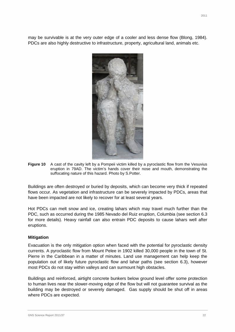
People caught in the direct path of a PDC are most unlikely to survive and any survivors have a high probability of receiving severe injuries (Baxter, 1990; Hansell et al., 2006). The intense heat and lack of oxygen in a PDC burns and suffocates victims (Figure 10) for a few minutes. Entrained rocks and boulders can also cause lethal injuries as well as collapse of buildings. Fires started by the flows are an additional hazard. The only part of a PDC which
2011
GNS Science Report 2011/37 22
may be survivable is at the very outer edge of a cooler and less dense flow (Blong, 1984). PDCs are also highly destructive to infrastructure, property, agricultural land, animals etc.
Figure 10 A cast of the cavity left by a Pompeii victim killed by a pyroclastic flow from the Vesuvius eruption in 79AD. The victim’s hands cover their nose and mouth, demonstrating the suffocating nature of this hazard. Photo by S.Potter.
Buildings are often destroyed or buried by deposits, which can become very thick if repeated flows occur. As vegetation and infrastructure can be severely impacted by PDCs, areas that have been impacted are not likely to recover for at least several years. Hot PDCs can melt snow and ice, creating lahars which may travel much further than the PDC, such as occurred during the 1985 Nevado del Ruiz eruption, Columbia (see section 6.3 for more details). Heavy rainfall can also entrain PDC deposits to cause lahars well after eruptions.
Mitigation
Evacuation is the only mitigation option when faced with the potential for pyroclastic density currents. A pyroclastic flow from Mount Pelee in 1902 killed 30,000 people in the town of St. Pierre in the Caribbean in a matter of minutes. Land use management can help keep the population out of likely future pyroclastic flow and lahar paths (see section 6.3), however most PDCs do not stay within valleys and can surmount high obstacles. Buildings and reinforced, airtight concrete bunkers below ground level offer some protection to human lives near the slower-moving edge of the flow but will not guarantee survival as the building may be destroyed or severely damaged. Gas supply should be shut off in areas where PDCs are expected.

2011
GNS Science Report 2011/37 23
6.3 Lahars
Description
Lahars are a rapidly flowing mixture of water and predominantly volcanic debris. They behave differently to normal streamflow due to their density and high sediment load, resembling wet concrete. Lahars can range from extremely mobile, low concentration, hot flows to highly concentrated flows which can transport large boulders, to turbid cold streams. Lahars can be caused by the following events (Blong, 1984): · melting of snow and ice by hot eruption products, such as pyroclastic and lava flows, or
hydrothermal (steam) explosions · hot, low density and fluid pyroclastic flows merging with stream water · eruption through a crater lake · heavy rain on eruptive products (this can occur for a long time after eruptive activity has
ceased) · collapse of crater lake impoundment (such as at Crater Lake, Mt Ruapehu in 1953 and
2007) · initiated by earthquakes. Due to their fluidity, lahars travel down valleys and flood plains, but if they have sufficient momentum they can overtop river banks and obstacles. They can have extremely high volumes, depending on the source of incorporated water (i.e. rainfall intensity, amount of snow on the volcano, size of existing crater lakes etc.) and channel-sediment bulking, and can travel long distances. Lahars have travelled over 320 km from source (such as at Cotopaxi volcano, Ecuador in 1877; Neall & Alloway, 1993), at speeds of up to 180 km/h on steep slopes (such as upper Taranaki), and 20 – 40 km/h on lower gradients. They are usually slower moving than pyroclastic flows, but can have a longer run-out distance. Lahars can be hot, but are most commonly warm or cold. They can be highly erosive (usually near the source) as well as depositing large quantities of material, filling stream channels and causing flooding issues. Lahars can be a deadly recurring hazard long after eruptions have stopped, such as at Pinatubo in the Philippines (Newhall & Punongbayan, 1996), from the entrainment of eruptive deposits during heavy rainfall. Lahars at Taranaki have been very common events in the past, as demonstrated by their numerous deposits (e.g. Zernack et al., 2009b).The majority of pre-historic lahars have travelled towards the west, and this is the most likely future direction due to the western crater wall having been breached. However lahars in any radial direction from Taranaki are possible. The river gorges and channels within Egmont National Park are the highest risk zones from lahars, as well as the towns of New Plymouth at Waiwhakaiho River, Okato, Kaponga, and Waitara (refer to Neall and Alloway, 1995 for further lahar hazard zone information for Taranaki). Krivan (2005) has quantified the risk of bridge infrastructure damage for the South Taranaki region from potential lahars. Hazard and impacts
People caught in the path of a lahar have a high risk of death from severe crush injuries, drowning and/or asphyxiation. Lahars can cause destruction of buildings, infrastructure, vehicles and vegetation caught in their path, due to the immense force and concentration of particles, including boulders over 4m in diameter. Depending on their bulk densities and flow

2011
GNS Science Report 2011/37 24
velocities, lahars may either destroy structures, or simply bury them in place. The build-up of lahar deposits, particularly in lower gradient waterways can cause flooding in nearby areas, and alteration of the channel routes. Thick layers of silt and rocks are deposited during the lahar, potentially covering farmland, crops, infrastructure and/or urban areas. Erosion by lahars can undermine bridge supports, buildings and other structures that are situated close to river edges, causing them to collapse, for example, as occurred at Tangiwai (Whangaehu River), eastern Ruapehu in 1953. A major danger with lahars is the great distance they can travel away from the volcano source. They travel far enough away that no natural warnings of the eruption which caused the lahar have reached the inhabitants, i.e. seeing the cloud, hearing the explosions or feeling the earthquakes. The town of Armero, Colombia was hit by a large lahar in 1985 following an eruption of the nearby Nevado del Ruiz volcano. Whilst officials would have had sufficient time to evacuate had the scientific warnings of the impending lahar been heeded, the population and officials’ uncertainty about the existence of the hazard, as well as lack of prior planning, decision making and communication problems, resulted in 22,000 deaths (Voight, 1996).
Mitigation
Land use planning and zonation is the most effective way to mitigate the risk of lahars as their fluid nature can allow likely paths to be predetermined. Refer to section 9.1 (land use planning) for more details. Evacuation of areas within lahar hazard zones during an eruption and instructing the public to remain out of dangerous channel areas is strongly recommended. During a lahar, the safest areas are on hills and ridges, away from bends in the channel in case the flows have enough momentum to overtop the bank. People have survived lahars by climbing onto the roofs of houses which have remained intact despite inundation by the lahar. A number of hazard reduction methods have been utilised for lahars. Drainage systems for crater lakes and other topographically high lakes in the path of lahars (such as Spirit Lake, near Mount St. Helens) can keep lahar source volumes and discharge under control. Engineered channels, levees or dikes and retention basins can reduce vulnerability to lahar hazards. The difficulties with using levees include potential channel migration (especially on lower gradients) causing the flow to be retained on the wrong side of the levee, as seen at Pinatubo after the 1991 eruption. Due to the typically very high bulk density of lahars, the materials used to build the levee (i.e. sandbags, boulders, mesh wire filled with rocks) can end up being entrained and causing more damage, so concrete levees appear to be most effective. There is a bund at the Whangaehu River near Mt Ruapehu to stop lahars originating from the Crater Lake from spreading into neighbouring catchments, however the full effectiveness has not been tested. Revegetation of tephra slopes can reduce the frequency and magnitude of lahar development. This can be difficult as tephra can form an impermeable crust, increasing runoff and inhibiting seedling growth, although aerial seed drops have been tried overseas in the past (Blong, 2000). Deposits less than approximately 200mm thick can be ploughed and mixed with top soil. Warning systems for lahars can be put in place. Various technologies, such as tripwire sensors, acoustic flow monitoring systems, sirens, water level gauges and cameras can give adequate warning time to evacuate high risk areas as a lahar approaches, however these systems must be accompanied by educational programmes to achieve the desired response.

2011
GNS Science Report 2011/37 25
The Eastern Ruapehu Lahar Warning System (ERLAWS) in Tongariro National Park is an example of a lahar warning system. This system was set up in 2001-2 in response to the threat of a collapse of a natural tephra dam built during the 1995-6 eruption of Ruapehu (Keys, 2009). ERLAWS consists of a series of acoustic flow monitors (AFMs), trip wires and cameras linked to a central server computer. Thresholds were set on the AFM data to alert a number of key stakeholders (e.g., Department of Conservation, Police, Genesis Energy). Traffic signals were in place at vulnerable parts of the Desert Road, as were automatic gates at Tangiwai bridge on the Whangaehu River. In March 2007, the tephra dam was breached, at-risk rail and road crossings were closed and the event passed without casualties. Most of ERLAWS is still in place and may provide an alert of future eruption related lahars. 6.4 Lava flows
Description
When magma emerges from the volcano as a non-explosive flow, it is termed a lava flow. There are three types of lava flow morphologies which occur: pahoehoe, a’a and block lava. Pahoehoe are ropy, smooth flows from basaltic volcanoes, and can travel long distances and create lava tubes, such as at Rangitoto and Hawaii. If Pahoehoe emerges underwater it can be in the form of submarine pillow lava. The a’a are thicker flows from more viscous (mostly basaltic) lava, with coarse surfaces, sometimes identified at distant parts of pahoehoe flows. Block lavas are more commonly associated with andesitic volcanoes, such as Taranaki, and are similar to a’a flows, but have larger, polygonal blocks on the surface. Block lavas can be quite thick but do not tend to travel very fast or far – Taranaki’s lava flows have rarely travelled more than 4 km from the source. The temperature of lava at andesitic volcanoes has been measured as high as 1000oC. The distance lava travels depends on the viscosity of the lava (influenced primarily by the silica content – less siliceous lavas (i.e. basalt) flow much further than highly siliceous lavas (i.e. rhyolitic)) output rates, duration of eruption, volume erupted, steepness of the slope, topography and obstructions in the flow path. Future lava flows at Taranaki would be expected to move at a speed of ca. 5 km/hr on steeper slopes, or 1km/hr over longer distances (Neall & Alloway, 1993). Neall (2003) shows the distribution of lava flows from past eruptions at Taranaki. Hazard and impacts Lava flows seldom threaten human life because of their predominantly slow rate of movement, their travel down topographic lows on usually predictable paths, and the relatively short distances they travel. They are, however, destructive to property. Lava flows will ignite and bury obstacles, causing total destruction of buildings, roads, vegetation and other infrastructure in their path. Fires are a significant secondary hazard from lava flows (see section 7.1). Lava flows cool very slowly, as the surface “skin” retains the heat – flows can be hot for years after deposition.
Of the few people that have died from lava flows worldwide in the past, the causes are varied, and usually occurred as a result of onlookers getting too close. Unusually fast moving lava flows have claimed lives at basaltic volcanoes, and others have died when their escape route was blocked by tongues of lava, trapping them (e.g. at Vesuvius, 1872; Blong, 1984). Interactions between lava and water or ice (i.e. on contact with lakes, the sea, water tanks

2011
GNS Science Report 2011/37 26
and cisterns etc.) can cause explosions, killing and injuring people. The steep fronts of thicker flows may become unstable and collapse, causing small pyroclastic flows and hot avalanches. Lava flows, however, result in a very small number of deaths and injuries compared to other volcanic hazards, considering their frequency of occurrence.
Lava flow emplacement onto or beneath snow and ice can create lahars – see section 6.3 for lahar hazard information. Post eruption land use possibilities will be significantly altered on a new lava flow. Mitigation A number of mitigation methods have been applied to lava flows overseas in the past. Water sprayed on the surface of a lava flow can cool it sufficiently to stop or slow its forward movement. In Heimaey, Iceland, a lava flow threatened the towns harbour in 1973. 32,400 tonnes of seawater per hour was pumped onto the lava surface, cooling the flow front and saving the harbour. Walls have been built to divert lava flows overseas in the past, with varying degrees of success. A description of necessary wall characteristics is given by Blong (1984, p. 198). Explosives and dropping concrete blocks have been used to attempt to divert lava flows in Hawaii and Etna (Italy). Significantly cheaper than these attempts to stop a lava flow from causing property damage is utilising land use zoning. As lava follows topographical lows, and rarely would exceed the national park boundary at Taranaki, areas at risk could be predetermined and development in these areas restricted. 6.5 Sector collapses and debris avalanches
Description Large-scale sector collapses and debris avalanches are rare but very hazardous volcanic events. They occur when a significant proportion of a volcanic cone becomes unstable. These large-scale landslides can be triggered by a variety of mechanisms including high intensity earthquakes or intrusions of magma (e.g. prior to the 1980 eruption of Mount St Helens). Initially, the landslide will move as a large block or series of blocks, but as momentum increases or fluids are incorporated into the flow (e.g. rivers or groundwater), the flow can become laharic. Debris avalanches will destroy everything in their path by lateral impact and burial. If the trigger is intruding magma, sector collapses can suddenly decrease the confining pressure on the magma causing a pyroclastic blast (e.g. Mount St Helens in 1980) (see section 6.2, pyroclastic density currents). Sector collapses have occurred frequently at Taranaki in the past, some of which have been magmatically triggered (Alloway et al., 2005). Former Taranaki cones have collapsed to the northeast, southeast and west, travelling over 40 km in distance, reaching beyond the current Taranaki coastline. More than 3.5 km3 of material has been involved in each event (Neall & Alloway, 1995). The hummocky topography near Stratford is the result of a sector collapse. The steep-sided nature of Taranaki, high annual rainfall, and the geological record suggest that large scale flank instabilities will continue to threaten the areas around Taranaki (Neall & Alloway, 1995).

2011
GNS Science Report 2011/37 27
Hazard and impacts
The hazard from sector collapse is similar to lahar, but is likely to be more extensive. Everything will be destroyed in the path of a sector collapse or debris avalanche due to the lateral impact and burial of buildings and infrastructure, and it is lethal to people and animals.
Mitigation
As they can occur with little or no warning and can travel at high speeds, prior evacuation is the only safe option for areas that might be affected if a debris avalanche is anticipated. Land use zonation restricting development in high risk areas would also be beneficial. 6.6 Volcanic gases
Description
Emissions of volcanic gases occur during eruptions, but are also common events between eruption episodes at many volcanoes and geothermal areas where they may be vented from the main crater, from fumarole fields or diffusely through soil (Hansell et al., 2006). Volcanic gases include carbon monoxide, carbon dioxide, sulphur dioxide, hydrochloric acid, hydrofluoric acid, hydrogen sulphide and radon (Parfitt and Wilson, 2008). Volcanic fog (or VOG) is a haze of acidic aerosols, which occurs frequently at Hawaii, mainly originating from Kilauea and affecting downwind areas. Volcanic gases are a potentially fatal hazard. Hazard and impacts
Documented health effects include asphyxiation due to the accumulation of carbon dioxide (which is denser than air) in topographic lows; deaths from hydrogen sulphide poisoning, primarily in geothermal areas; and respiratory effects (and occasionally deaths) from exposure to acidic sulphate aerosols formed from sulphur dioxide. Volcanic gases can be an irritant up to 5km from the vent (Blong, 1984), causing discomfort and difficulties in breathing. Some gases mix with atmospheric water, producing acid rain, which can fall hundreds of kilometers from the gas source. Acid rain affects vegetation, building roofs (which can contaminate drinking water), aquatic life and can burn people. Wind tends to disperse gases to a point where they are at low concentrations and therefore are no longer hazardous. For a comprehensive review of health hazards from volcanic gases, refer to Hansell and Oppenheimer (2004) and www.ivhhn.org (guidelines/gas pdf). In Rotorua, about 14 people have been killed by gas poisoning. This is due to the geothermal nature of this region, and having buildings and hot pools sited over hot water bores etc. These deaths have mostly been attributed to asphyxiation by gases in low-lying, confined spaces such as geothermal spa pools, telecommunication trenches and workshop pits. Gas has also killed a number of people (and trees) at Mammoth Mountain, near Long Valley volcano in California (Appendix 2). Approximately 1700 people were killed by volcanic gas in Cameroon in 1986, when a build-up of carbon dioxide was released suddenly from Lake Nyos and flowed down the slopes to a nearby town (Baxter et al.,1989). Mitigation
Mitigation of the volcanic gas hazard is similar to that for tephra, however face masks need to provide protection for toxic gases as well as tephra, and ideally cover eyes as well. During a volcanic gas hazard event, basements and other low lying, sealed areas may have to have

2011
GNS Science Report 2011/37 28
restricted access or be entered with caution. Gas emission concentrations can be monitored at the vent to provide early warning, and equipment can be installed in at-risk areas to monitor local gas concentrations if necessary. 6.7 Earthquakes
Description
Earthquakes precede and accompany most, if not all volcanic eruptions. Johnston (1997) describes volcanic earthquakes as “generated by the movement of magma, the formation of cracks in rocks through which the magma moves, gas explosions in the conduit and readjustment of the volcanic edifice to magmatic pressures. Volcanic earthquakes rarely exceed magnitude 5 (Richter scale) and are usually limited to a relatively small area around the volcano, but buildings within this zone may be subject to shaking damage”. Earthquakes can also occur during unrest episodes which don’t result in an eruption. They can occur in swarms, or can be isolated events, affecting usually only localised areas. Fault lines and cracks can be formed on the ground surface, potentially causing damage or destruction of buildings and underground services. Regional tectonic earthquakes are hazardous due to surface rupture and ground-shaking. A list of historically significant earthquakes in the Taranaki region is given in Townsend et al. (2008). Hazard and impacts
Volcanogenic earthquakes largely have the same impacts as tectonic earthquakes. Ground shaking can cause building, structure and infrastructure damage or collapse, endangering lives and disrupting networks. Earthquakes during eruptions have caused deaths at other volcanoes due to building collapse (or partial collapse). Brick chimneys collapsing can fall through building roofs, the rupturing of gas lines and electrical circuits may lead to a fire, and broken water pipes can cause flooding. Liquifaction (the upwelling of water and silt from ground shaking, as occurred in Christchurch during the 2010/11 earthquakes) can occur in areas with sand and gravel substrates, especially near low gradient waterways, if the earthquakes are of sufficient magnitude. Hull and Dellow (1993) provide an overview of the seismic risk in Taranaki, and the GeoNet website details historical earthquakes and the seismic monitoring system. Mitigation
Seismic building codes are in place in New Zealand to protect structures against earthquake damage. Reinforcing chimneys, securing furniture, bracing structures and other seismic protection methods are recommended for areas surrounding volcanoes. Incorporating known fault lines into land use planning is also recommended. 6.8 Ground deformation
Description
Deformation (ground movement) at volcanic centres can occur as a result of magma moving beneath the ground surface, before, during and after eruptions. Deformation can cause

2011
GNS Science Report 2011/37 29
damage to structures and infrastructure but is not directly life threatening. The ground near volcanoes can be deformed during unrest episodes which don’t result in an eruption. The deformation can range from metres of rapid uplift, to slow subsidence over a wide area, and includes fissures (large cracks). At Taranaki volcano, deformation is likely to be confined to the cone. Hazard and impacts
The most adverse effect of ground deformation is the potential disruption to underground infrastructure in affected areas, such as gas, water, electricity and communication networks due to pipe breakages. Buildings and bridges can be structurally damaged and roads cracked. Uplift and subsidence can cause flooding through altered water courses or subsidence below the water table or sea level. While deformation in populated areas around Taranaki is unlikely due to the distance from the vent, it cannot be ruled out as a potential hazard. Mitigation
There is very little which can be done to mitigate the effects of ground deformation. Depending on the form of ground deformation existing plans for landslides and flooding could be consulted, and areas deemed as dangerous evacuated and cordoned off. Gas, water and electricity pipelines in affected areas could be disconnected to eliminate leakages and fires. Structures and infrastructure on areas of ground deformation should be regularly checked for safety.
6.9 Lightning and sound pressure waves
Description
Erupting volcanoes can produce many atmospheric effects, ranging from spectacular sunsets to sound pressure waves and electrical discharges. Sound pressure waves have been heard over 4000 km from source (such as during the 1883 eruption of Krakatau) (Blong, 1984), and were heard in the Hawke’s Bay during the 1995/6 Ruapehu eruption. The noise of a pressure wave can be influenced by the wind direction. Atmospheric shock waves are caused by the sudden and localised increase in pressure by the outburst of large quantities of steam and other gases. They can cause physical damage to buildings, and occurred during the 1974 eruption of Ngauruhoe (Blong, 1984; Nairn, 1976).
Spectacular lightning displays can be seen in the eruption column, cloud and eruptive source, in a range of styles and directions, often with high frequency. Discharges to earth around the volcano cause a hazard to life and property.
Hazard and impacts
Lightning has contributed to a small number of deaths and injuries during eruptions, on occasion striking people cleaning ash off roofs.
There have been no recorded deaths as a result of atmospheric pressure waves, however a degree of discomfort has been noted from the noise, including severe earaches over 10 km from the source and temporary deafness. Injuries due to air shock waves breaking windows have been recorded.

2011
GNS Science Report 2011/37 30
Mitigation
The hazard of lightning can be mitigated the same way as during an electrical storm – shelter in a depression away from isolated trees or metallic objects such as wire fences which can conduct current from a ground strike some distance away. Stay out of water for similar reasons and avoid projecting above the surrounding landscape. Indoors, seek shelter in a metal-framed building or one with a lightning rod, stay away from windows, the plumbing system, the wiring system and the telephone (Blong, 1984). During air shock waves, it is recommended to stay away from windows. Ear plugs/muffs could be used to dampen sound pressure waves.
7.0 LONGER TERM AND SECONDARY HAZARDS AND IMPACTS
7.1 Fires
Fires can be caused by hot ballistics falling into forests, buildings or other flammable objects; lava flows, pyroclastic density currents, lightning or seismicity disrupting gas and electricity lines; and ash shorting electrical structures. In addition the likely breakdown of infrastructure during an eruption or unrest may cause problems for fire fighters, such as broken water pipes, bridges and damaged roads, and ash in the air causing difficulties in running machinery such as pumps, helicopters and vehicles.
7.2 Tsunami
Sector collapse and seismicity can cause tsunami along the Taranaki coastline. These tsunami are expected to behave in a similar way as tsunami from other sources, and thus should be dealt with using plans already in place. The risk of tsunami is judged to be at the lower end of the probability scale during a volcanic event at Taranaki. 7.3 Remobilised tephra, lahars and flooding
Tephra needs to be collected and removed from urban areas and roads. Further eruptions depositing more ash and requiring repeated cleanups can be extremely expensive. When the ash is dry, wind and vehicle movement creates clouds of fine ash which penetrates buildings and vehicles, causing great difficulties in containment. Accumulating tephra needs to be frequently removed from roofs to avoid collapse, cleaned off electrical infrastructure, and kept out of sewers and wastewater systems. Tephra can have long term effects on agriculture, depending on the thickness of the deposit. See section 6.1 for more details on tephra impacts and mitigation. Detailed studies of tephra and volcaniclastic sediment around Taranaki demonstrate that tephra from future eruptions will be eroded and transported from Taranaki’s flanks by rivers, aggrading river channels and causing re-routing of waterways, and consequential flooding. It is considered likely that periods of heavy rain will cause accelerated runoff, and mixed with deposited ash can cause devastating lahars, months or even years after the eruption. Secondary lahars have occurred at Taranaki at least three times in the past 15 years. A lahar in 1998 was formed in the Waiaua River from the collapse of an old lava flow front (debris avalanche) during heavy rain (Neall, 2003). The maximum entrained clast sizes were up to

2011
GNS Science Report 2011/37 31
6m, the event resulted in a permanently changed drainage pattern and the inundation of sediment in a catchment used for the community of Opunake’s potable water supply (Neall, 2011). The April 2008 events occurred after heavy rainfall (60mm in a 2 hour period and up to 309mm in a 24 hour period) triggered flooding in two catchments on the flanks of Taranaki (Little Maketawa Stream and Maero Stream) (Neall, 2011; Neall et al., 2008). The flood waters became hyperconcentrated and eroded previously deposited tephra, incorporating it and transporting boulders up to 3.3m in size. One of the two flows overtopped a 6m high bank, destroying a 2.7 ha area of forest, and in the other flow vegetation was eroded up to 7m above the river bed (Neall et al., 2008). Calculated velocities for these two flows are from 10 – 16 ±2ms-1, with maximum discharges from 600 – 1500 ±300 m3s-1 (Neall, 2011). Lahars have occurred around Pinatubo volcano in the Philippines for many years since the 1991 eruption from heavy rain mixing with old tephra deposits (Newhall and Punongbayan, 1996), providing an example of an ongoing hazard to be managed. See section 6.3 for more details on lahars. Broken water pipes may also lead to flooding – existing hazard mitigation plans could be used for this. 7.4 Effects of long term unrest and eruptions on the economy
There is an extensive literature illustrating the widespread economic consequences of natural disasters (Cochrane, 2004). Normally, these effects result from a one-off destruction of capital stock and the subsequent disruption to business activity. In marked contrast, volcanic unrest and eruptions have different impacts that are, in many respects, potentially more difficult to mitigate. Specifically, the economic effects of volcanic unrest tend to be manifest mainly through increased business uncertainty and may persist for considerable periods of time (years to decades). This is of concern because it is known that one of the determinants of economic growth or sustainability is confidence in the outlook for future economic activity. This is illustrated by the very close correlation between measures of business confidence and future rates of economic growth and investment activity. By increasing business uncertainty, periods of unrest may result in losses of confidence and shifts in risk perception by consumers, business operators and investors. At a local level these adverse effects are likely to show up in a number of indicators. The most obvious is a downturn in demand for goods and services. A slight economic impact was noted in Taupo in late 1964 during caldera unrest at Taupo volcano, when a decline in visitor numbers to the district was reported and some business owners noted a flow-on effect to lower business activity (Johnston et al., 2002). Another example of these effects was the mass cancellation of tourist bookings at Mammoth Lakes that followed initial newspaper and radio reports of the possibility of an eruption at Long Valley caldera (USA) in the summer of 1982 (Bernknopf et al., 1990) as a result of caldera unrest. Aldridge (2006) has modelled the economic losses likely in the Taranaki region due to the impact of a volcanic eruption. Increased risk perceptions may see falls in asset values, which may also result in capital investment decisions being postponed or cancelled. In theory, markets should accurately incorporate known risks into prices. However, low probability-high loss events like earthquakes and volcanic eruptions may be different in their effects on markets. Specifically, events that increase awareness of risks might alter behaviour and prices. The magnitude of effects on local business is highly variable (Johnston et al., 2002). Their size depends on:

2011
GNS Science Report 2011/37 32
· The size of the threat and scales of uncertainty (i.e. extent of knowledge about the degree of risk and the likely duration of the unrest). These in turn depend on the amount and quality of the information available to local businesses, investors and consumers.
· The type of businesses affected. The nature of unrest means that recreational/tourism businesses tend to be most sensitive since in these sectors it is generally easy for demand to switch elsewhere.
· The underlying strength of the businesses and communities affected. Here the concerns are factors such as pre-existing debt levels and trends in business activity. One lesson from the literature on natural disasters is that they tend to exacerbate pre-existing economic trends (e.g. Mader and Blair, 1987).
· Scale of economic activity at threat. Obviously regions with relatively large local economies face a larger threat than do others. Also, the overall scale of the economic effects depends on the degree of backward and forward linkages the region has into the wider economy (Cochrane, 2004).
· The “flexibility” of the local business sector, i.e. the extent to which they are able to work around problems, their degree of diversification and their ability to reassure investors and consumers.
A key determinant of the economic effects of such events is their impact on insurance markets. One risk with on-going unrest is that it may lead to changes in premiums or the cancellation of policies. Certainly this was the case in Rabaul (PNG) where Lowenstein (1988) notes that there were “massive” increases in insurance premiums and loss of cover against volcanic and seismic risk. These insurance effects persisted through the crisis and flowed into a lack of finance from lending institutions for sustaining business activity and new developments. Also, during the 1995-1996 Ruapehu eruption some insurers cancelled coverage in the region (either by activating their “7 days notice” clause or simply not renewing cover). If periods of unrest are significant and long lasting they may have effects even beyond the local economy. One concern is the potential flow on into higher fiscal costs, e.g. emergency expenditures, increased welfare payments, etc. In Rabaul, for instance, one of the most significant economic effects was the large amount of unbudgeted expenditure on emergency preparedness (Lowenstein, 1988). There is also the potential for misreporting by the international media. This occurred during the Auckland electricity crisis, the 1995/6 Ruapehu eruptions and historical volcanic unrest at Taupo caldera. These media effects may exacerbate offshore investor unease with the danger being that investor reactions are out of proportion to the size of the risks. De Bondt and Thaler (1985; 1987) provide evidence of these sorts of overreactions. Impacts of earthquakes and eruptions on oil and gas production and distribution infrastructure
As described in Hull (1996), the exploration and exploitation of hydrocarbons in the Taranaki region has involved large investments in infrastructure such as production plants, pipelines and storage facilities. These facilities are vulnerable in the event of volcanic unrest or eruptions and earthquakes. Large earthquakes at Taranaki, including the November 1974 M6.0 Opunake earthquake close to the site of the Maui A Platform, have produced shaking

2011
GNS Science Report 2011/37 33
intensities of MM8 locally over the last 150 years (Hull, 1996; Townsend et al., 2008). Combined with the hazard of volcanic eruptions, the oil and gas production industry at Taranaki faces significant impacts from future natural hazard events.
Surface faulting, ground shaking, inundation by ashfall and lahar debris are hazards worthy of consideration in assessing risk to existing facilities and the siting of future plant and equipment. Production facility structures are vulnerable to the effects of volcanic and earthquake hazards, particularly underground pipelines due to ground shaking and deformation, buildings and structures from ash roof loading or if they are in the path of pyroclastic density currents, debris avalanches or lahars, and ash fall effecting electrical circuits and clogging pipelines. Further information, including the earthquake and eruption history of Taranaki, active fault locations and specific volcanic hazard impacts on production facilities are detailed in Hull (1996) and the Taranaki geological map by Townsend et al. (2008). Up-to-date geological information is also available from the GeoNet and GNS Science (active fault database) websites (www.geonet.org.nz; www.gns.cri.nz). The formation of robust mitigation plans for volcanic hazards is recommended to be developed with production companies.
Ian Chapman has recently recommenced Masterate research at Massey University on volcanic risk assessment for the energy distribution sector of Taranaki.
8.0 PSYCHOSOCIAL IMPACTS OF VOLCANIC UNREST AND ERUPTIONS
Types of psychosocial impacts on residents hit by a natural disaster include (Blong, 1984): · psychosomatic problems (e.g. vomiting, headaches, rashes), · bereavement and separation · social stress (e.g. divorce, alcoholism) · long term effects from physical trauma (e.g. effects of paralysis, blindness) · psychological problems (e.g. depression, nightmares, hysteria). Increased levels of anxiety and stress can stem from factors such as relocation, uncertainty about the future, living with other families in close quarters and disrupted routines. This stress can lead to marital problems, child and spouse abuse, and drug and alcohol abuse. These effects may not arise for some time (i.e. months) after the event is over (Blong, 1984). Programmes to lower the levels of stress from a natural hazard event, provide support and advice can be run. For example, Federated Farmers and The Rural Support Trusts have helped the rural community during natural hazard events such as the 2004 Manawatu floods, droughts in the Waikato region and the 2010/11 Canterbury earthquakes. Residents helping eachother after an event can help build their sense of control, and help them feel they are useful and able to help, as well as provide support or a listening ear for others effected. For example, the Student Army and Farmy Army volunteers helped urban residents clean up from the Canterbury earthquakes of 2010/11.

2011
GNS Science Report 2011/37 34
9.0 MITIGATION OF VOLCANIC HAZARDS DURING NON-ERUPTIVE PERIODS
Most volcanoes have long intervals between damaging eruptions, ranging from years to many centuries. The management of volcanic hazards can therefore be divided into four distinct time frames. Non-eruptive rest times represent the normal situation and afford the best opportunity to develop mitigation strategies and prepare society for an eruption. The time around an eruption crisis can be divided into three periods: pre-eruption, eruption and post-eruption (or recovery). The requirement to mitigate natural hazards in New Zealand is covered by the Resource Management Act (1991) which seeks to provide a structure for natural hazard management that focuses responsibilities and requires effective means of control to be adopted. Implementation of this mitigation is carried out by regional and territorial authorities through regional policy statements, regional plans, district plans and resource consents. The Regional Policy Statements and regional/district plans of volcanic areas should recognize explicitly that parts of these regions are susceptible to hazards associated with future volcanic eruptions. Such zones, e.g. those close to potential vents and/or on vulnerable flood plains, need to be identified. The Civil Defence Emergency Management (CDEM) Act 2002 and the associated National Strategy establishes a vision for a “Resilient New Zealand – strong communities understanding and managing their hazards” and calls for increased community awareness, understanding and participation in CDEM; reduced risk from hazards; an enhanced national capability to manage emergencies and recover from disasters. For New Zealand to achieve these goals the CDEM sector requires a sound research base that addresses the spectrum from understanding the physical phenomena of natural hazards to an understanding of the impacts of these hazards from a social, economic and cultural perspective. Once the vulnerability has been assessed mitigation strategies can be developed. Three types of approaches can be used: · Policy and management measures that reduce the likelihood of damage and/or failure. · Engineering design measures that reduce vulnerability. · Preparedness and response planning to deal with consequences of the event. The development of interagency communication in periods of volcanic quiescence is an important part of hazard response and recovery mitigation. This can improve knowledge of roles and responsibilities amongst agencies and foster relationships that can be utilised when required. Transmitting consistent messages to the public is essential to dispel confusion and avoid mistrust of the authorities. Appendix 4 contains the working from the same page consistent messaging information for the CDEM sector to use in preparation, response and recovery to a volcanic event. Information needs to be managed carefully during a crisis, and involves actions such as dampening rumours, working with the media, publishing information resources and issuing warnings. Appendix 5 provides a communication framework to aid these actions, and describes factors influencing the community’s response to the warnings and situation.

2011
GNS Science Report 2011/37 35
9.1 Land use planning to reduce volcanic risks
While some volcanic hazards cannot easily be planned for in a land-use sense (e.g. pyroclastic flows), others can. For example lahars are strongly controlled by topography and most likely flow paths can be incorporated in hazard or planning maps. As a consequence of recognising lahar hazard zones around Taranaki, these could be designated as areas of low density development, as has taken place in Pierce County in the USA (Becker et al., 2010). While a hazard like ash fall cannot be mapped definitively on to land-use planning maps as it is controlled by wind direction, other options such as volcanic risk oriented urban design (e.g. pitched rooflines) could be employed instead, and applied as standards within a district plan. Land use planning can also contribute to ensuring effective evacuation during a volcanic event. New road layouts could be designed to ensure that evacuation is quick and effective. Policies and methods within the New Plymouth District Plan (2010) already reflect some aspects of land use planning for volcanic hazards. In particular the plan identifies “Volcanic Hazard Areas” on land use planning maps (primarily in lahar zones) and suggests that activities in this zone should avoid or mitigate the adverse effects of natural hazards, and has a rule that “hazardous facilities in a volcanic hazard area will be subject to greater scrutiny” (Becker et al., 2010). Few other plans across New Zealand specifically address volcanic hazards in such a way. See Robertson (2007) for a Taranaki case study for volcanic land-use planning. The range of options that could be applied by land use planners within plans and policy statements include (Becker et al., 2010): · Avoiding new development in high volcanic risk areas, especially in localities that are not
already developed.
· Restricting development or permitting only low density development in already developed hazardous areas to minimise the number of people residing in volcanic hazard areas.
· Using volcanic hazard-specific criteria for assessing consents in volcanic hazard areas. For example a local authority may require that for a consent to be granted in a rural area subject to volcanic hazards, the water supply must be able to be covered in the event of ash fall.
· Siting and where necessary relocating key facilities and critical infrastructure out of hazardous areas;
· Incorporating specific urban design measures to mitigate volcanic impacts;
· Taking proactive steps to ascertain how to dispose of volcanic debris after an eruption (e.g. Johnston et al., 2009); and
· Planning for other land use recovery aspects. In a general sense this requires considering what the effects of an eruption might be, how the use of land could be improved after an event, and what steps might be taken before an event to ensure such improvements can be made (Becker et al., 2008).
Finally to ensure effective risk reduction, land use planning should be integrated with other emergency readiness and response activities (Saunders et al., 2007). Land use planners need to work closely with emergency managers (and other relevant professions) to ensure

2011
GNS Science Report 2011/37 36
that agreement is reached over roles and responsibilities, and that both civil defence and emergency management plans incorporate a full range of risk reduction measures. Integration should also occur between districts and regions so that there is geographic consistency over the treatment of volcanic risk. 9.2 Response planning
Pre-planning of response measures can reduce the severity of volcanic hazard impacts. Mitigation, planning and preparation measures should include: · Conduct a vulnerability analysis of equipment and facilities to determine which would be
the most affected and which are adequately protected.
· Identify appropriate methods of protecting vulnerable equipment and facilities.
· Develop a priority list of facilities that must be kept operative versus those that can be shut-down during and after ash falls.
· Identify effective and efficient ash-removal methods for equipment and facilities.
· Establish plans to implement ash mitigation measures containing procedures for: warning and notifying of potential ash falls, reducing or shutting down operations, accelerated maintenance and ash clean-up operations.
· Preparing the community to deal with hazards by utilising resources – for example the IVHHN Guidelines on preparedness before, during and after an ashfall (2008) pamphlet, available on the Taranaki Regional Council Civil Defence web page.
· Develop and test robust, connected response, communication and mitigation plans, including early warning systems (part of which is the Taranaki seismic monitoring network) in an integrated warning system model.
To guide the development of effective response plans amongst agencies and organisations a self-assessment survey or ‘tool’ has been developed (appendix 3). The aim of this tool is to assess levels of preparedness to respond to a volcanic event and help define the nature of specific volcanic contingency plans over and above general emergency response provisions. 9.3 Resilience and public education
Building resilience in a community can be considered in a range of contexts. Firstly, providing a safe physical environment through good building design (e.g. resilience to the impacts of hazards such as earthquake shaking) is of fundamental importance. Secondly, providing information about hazards, their impacts and self-protective actions that can be taken to reduce risk, is vital in encouraging public preparedness and in reducing social and physical impacts. Thirdly, resilience should also be considered in a wider context, where other factors such as community development, engagement and participation play an important role in building adaptive capacity to disasters. In many countries, including New Zealand, substantial funds are expended annually on risk communication programmes to promote hazard preparedness. However, research frequently shows that despite such programmes the majority of the public do not carry out self-protective measures recommended by emergency management authorities during non-crisis times. This questions the value of many public education initiatives. Many initiatives

2011
GNS Science Report 2011/37 37
tend to focus only on increasing awareness and knowledge about hazards, but do not address other factors which influence adaptive capacity and resilience. Knowledge and understanding of hazards is still an important part of the equation, but is only one aspect of many factors that influence preparation, appropriate response during a crisis (e.g., evacuation and warning compliance) and resilience overall. We should ensure that factors beyond knowledge and understanding are incorporated into educational programmes. A significant issue for public education with respect to preparedness is motivation and intention to prepare. Individuals first need to become motivated to confront the hazardous aspects of their environment, and then form intentions to actually make preparations. It is important to understand the beliefs and attitudes that underpin people’s responses to risk so that intervention strategies can be targeted to enhance motivation and intentions, and address any biases that may be present. To facilitate motivation and intention to prepare, strategies are needed that emphasise the salience of hazard issues for community members. Contemporary research has highlighted that improved preparedness is likely to accrue from enhancing community members’ beliefs in the feasibility of mitigating hazard effects through personal actions (i.e. to counter beliefs that hazards have totally catastrophic effects, also known as ‘action coping’) and enhancing beliefs in personal competency to implement these activities (i.e. self-efficacy). Changing these factors requires a mix of public education, social policy, training, and empowerment strategies. Trust is also another important facet in converting preparedness intentions to actions. If people have trust in an information source, they are more likely to adopt protective measures. Finally, the design of hazard education programmes should be integrated with community development initiatives and will be more effective than stand alone, one off programmes (Finnis et al. 2010). School education programmes need to be one of the centrepieces of a sustained, community-based effort (Ronan & Johnston 2005). Common attributes that lead to successful public education programmes are shown in Table 3.

2011
GNS Science Report 2011/37 38
Table 3 Attributes that lead to successful community-based programs – from Finnis et al. (2010)
Attributes
Understand the community – Initiatives should be designed at a community level. Research into the community (e.g. demographics, local issues, needs) should be undertaken and the community should be consulted on the plan of action before a program is implemented.
Work with established groups – In many cases there is no need to repeat previous efforts. Tying in projects or working with groups that are already active in the community is an efficient way to implement a program because there is local knowledge, established partnerships and existing community participation.
Targeting vulnerable populations – Assisting vulnerable populations to prepare is a cost-effective exercise as these groups tend to be the largest drain on resources in a disaster.
Program facilitator – Nearly every programme attributes some of its success to having a designated program facilitator or co-ordinator. There needs to be at least one person whose sole task is to oversee the project and/or facilitate activities and communication amongst the community, stakeholders, funders, and others involved.
Dependable funding – Successful long-term programs require a dependable source of funding. Several programs described started with short-term funding from one source and with proven success, obtained larger grants and/or longer-term funding. Programs may benefit from having numerous small grants lined up to share costs and to maintain input from smaller stakeholders.
Simple, achievable projects – The first project undertaken in a community should be something simple and achievable to attract interest and support. Even though a larger project may be more beneficial or appear more impressive, community and stakeholder trust and support will be lost if it does not come to fruition.
Project diversification – The community may sometimes choose to undertake a project that seems irrelevant to the issue or cause. However, if addressing this concern is important to the community, then undertaking the project will foster partnerships and community interest in further projects.
Exposure – Initiatives should have continuous exposure in communities to attract and maintain interest and participation of the public, volunteers and stakeholders.
Evaluation – Not all programs are evaluated, with many (rightly) claiming success through a project’s completion, a change being noticed or satisfaction from staff and the community. An empirical evaluation, however, not only can provide documented evidence to prospective stakeholders and participants but also can help identify ways of making the program more efficient or successful or give a measure for comparison to other similar projects.
10.0 POST ERUPTION / RECOVERY
The social and economic impacts of a volcanic eruption are determined not only by direct physical consequences but also by the interaction of psychological, social, cultural and institutional processes that can both amplify and attenuate the public response. Community recovery therefore should be viewed as a social process. The cost of recovery goes beyond the cost of physical repairs and includes the provision of long-term community support services. The time required for a community to recover from a volcanic eruption depends on the extent of the impacts and the amount of assistance available. The effects of eruptions can continue for long periods of time. For example, lahars may continue to affect areas for years following an eruption as material is washed off the volcano. In the recovery process, solutions that were scientifically and technically sound in principle were not necessarily politically and socially acceptable in practice.

2011
GNS Science Report 2011/37 39
Recovery planning must consider the following: · Who is responsible for planning and implementation of the recovery? · The importance of inter-organisational co-operation at all stages of a recovery. · A broad approach to recovery so that opportunities for land-use change or rebuilding of
safer structures are considered. · The need for community involvement. · The availability of internal and external resources and the ability to gain access to them.
11.0 RECENT RESEARCH
Cronin and Neall (2004) describe the ongoing and planned research at Massey University around 2004. Appendix 6 describes the current research by Massey University, as outlined in the Taranaki Volcanic Science Advisory Group (TVSAG) meeting, 2010. Appendix 7 lists recent research by Massey University, including publications, presentations and ongoing research. The Geology of the Taranaki Area book and map was published by GNS Science and contains up-to-date information on hazards, active fault locations and geology (Townsend et al., 2008).

2011
GNS Science Report 2011/37 40
12.0 GLOSSARY
A'a Hawaiian word used to describe a lava flow with a rough, angular surface.
Andesite Volcanic rock (or lava) containing 54 to 62% silica and moderate amounts of iron and magnesium.
Ash Fine particles of pulverized rock (tephra) erupted from the vent of a volcano. Particles smaller than 2 mm in diameter are termed as ash, and may be solid or molten when first erupted.
Ashfall Volcanic ash that has fallen through the air from an eruption cloud.
Avalanche A large mass of material or mixtures of material falling or sliding rapidly under the force of gravity. Avalanches often are classified by their content, such as snow, ice, soil, or rock avalanches. A mixture of these materials is a debris avalanche.
Ballistic Large tephra particles with diameters of over 64mm. Includes blocks and bombs.
Ballistic projectile A block or bomb explosively ejected from the vent that is not carried upwards by the eruption column.
Basalt Volcanic rock (or lava) containing less silica than andesite, commonly producing more effusive, runny lava.
Base surge Volcanic density current pulse that moves laterally outwards formed of a dilute, turbulent mixture of hot gas (steam), water and solid ejecta.
Block Angular chunk of solid rock ejected during an eruption, with diameters of over 64 mm.
Bomb Fragment of molten or semi-molten rock, with a diameter of over 64 mm. Because of their plastic condition, bombs are often modified in shape during their flight or upon impact.
CO Carbon monoxide
CO2 Carbon dioxide
Conduit A passage followed by magma within a volcano. Country Rocks The existing rock intruded by and surrounding an igneous
intrusion (magma).
Crater A commonly circular depression formed by either explosion or collapse at a volcanic vent, from which volcanic material is ejected.
Dacite Fine-grained rock intermediate in composition between andesite and basalt.
Debris Avalanche A rapid and unusually sudden sliding or flow of unsorted rock and other material (such as fragmented cold and hot volcanic rock, water, snow/ice and trees).
Debris Flow A mixture of water-saturated rock and debris that flows downwards under the force of gravity.

2011
GNS Science Report 2011/37 41
Dome A steep-sided mass of viscous lava extruded from a volcanic vent. Its surface is often rough and blocky as a result of fragmentation of the cooler, outer crust during growth of the dome.
Ejecta Material that is thrown out by a volcano, including tephra.
Eruption Column The cloud of gases, steam and tephra rising from a crater or other vent, driven by thermal convection and gas pressure. If it is of sufficient volume and velocity, this column may reach many kilometers into the stratosphere, where winds may carry it long distances. Eruption columns can collapse and form pyroclastic density currents.
Eruptive Vent The opening through which volcanic material is emitted.
Extinct Volcano A volcano that is not presently erupting and is not likely to do so for a very long time in the future.
Extrusion The emission of magmatic material at the earth's surface. Also, the structure or form produced by the process (e.g. lava flow, volcanic dome).
Fault Fracture or zone of fractures along which displacement takes place or has taken place in the past.
Fissures Elongated fractures or cracks on the slopes of a volcano. Fissures can host eruptions, which typically consist of runny lava flows and fountains, but pyroclastics (tephra) may also be ejected.
Flank Eruption An eruption from the side of a volcano (in contrast to a summit eruption.)
Fumarole A vent or hole through which steam and other gases emit.
Harmonic Tremor A continuous release of seismic energy typically associated with the underground movement of magma. It contrasts distinctly with the sudden release and rapid decrease of seismic energy associated with the more common type of earthquake caused by slippage along a fault.
Hydrothermal eruption Explosion driven by the transformation of hot groundwater to steam.
Igneous The type of rocks formed during volcanic activity, both above and below the ground surface.
Ignimbrite The rock formed by the widespread deposition and consolidation of hot pyroclastic flows. The term was originally applied only to densely welded deposits but now includes non-welded deposits.
Intensity A measure of the effects of an earthquake at a particular place. Intensity depends not only on the magnitude of the earthquake, but also on the distance from the epicenter and the local geology.
Intrusion The process of emplacement of magma in pre-existing rock. Also, the term refers to the igneous rock mass so formed within the surrounding rock.

2011
GNS Science Report 2011/37 42
Lahar A flow of water-saturated, typically dense volcanic material, resembling a flow of wet concrete. Lahars usually follow topographical lows, however may overtop banks. They may be unaccompanied by an eruption by remobilisation of volcanic material.
Lapilli Literally, "little stones." Round to angular erupted rock fragments (tephra) measuring 2 to 64 mm in size in diameter, which may be ejected in either a solid or molten state.
Lava Magma which has reached the surface through a volcanic eruption. The term is most commonly applied to the flowing rock that emits from a crater or fissure, however it also refers to cooled and solidified rock formed this way. Lava varies in viscosity (runniness and therefore speed of movement), chemistry and temperature.
Lava Dome Mass of sticky lava, that has built a dome-shaped pile at a vent.
Lithic Particle of previously formed rock.
Magma Molten rock beneath the surface of the earth.
Magma Chamber The subterranean area containing the molten magma beneath a volcano.
Mantle The zone of the earth below the earth’s crust and above the core.
Nuees Ardentes A French term applied to a highly heated mass of gas-charged ash which is expelled with explosive force and moves at high speed down the volcano.
Pahoehoe A Hawaiian term for lava with a smooth, billowy, or ropy surface.
Phreatic Eruption An explosion caused when water and heated volcanic rocks interact to produce a violent expulsion of steam and pulverized rocks. Magma is not involved.
Phreatomagmatic An explosive volcanic eruption that results from the interaction of surface or subsurface water and magma.
Pillow lava Interconnected, sack-like bodies (resembling pillows) of lava formed underwater.
Ppm parts per million
Pumice Light-coloured, frothy volcanic rock, formed by the expansion of gas in erupting, sticky lava during an eruption. Pumice commonly floats on water and can travel further than other rocks of a similar size during an eruption due to their low density.
Pyroclastic Erupted material which starts out hot (pyro) and consists of fragmented rock (clastic) material formed by a volcanic explosion.
Pyroclastic Flow A turbulent mixture of hot gases and unsorted pyroclastic material that can move at high speed (up to 900 km an hour.) down the sides of the volcano. A type of pyroclastic density current, which usually follow topographical lows. Generated by the collapse or partial collapse of an eruption column.
Quaternary The period of Earth's history from about 2 million years ago to the present; also, the rocks and deposits of that age.

2011
GNS Science Report 2011/37 43
Rhyolite Volcanic rock, light coloured, with a high silica content.
Scoria A pyroclast that is irregular in form and generally very vesicular. It is usually heavier, darker, and more crystalline than pumice.
Seismograph An instrument that records seismic waves (earthquakes).
Seismologist Scientists who study seismicity (earthquakes).
Silica A chemical combination of silicon and oxygen.
SO2 Sulphur dioxide (gas)
Stratigraphic The study of rock strata, especially of their distribution, deposition, and age.
Stratovolcano A volcano composed of both lava flows and pyroclastic material.
Subduction Zone The zone of convergence of two tectonic plates, one of which usually overrides the other.
Surge A cloud of gas and suspended pyroclastic material that moves radially outward at high velocity from the base of a vertical eruption column accompanying a volcanic eruption.
Tephra Solid materials of all types and sizes that are erupted from a crater or volcanic vent and travelling through the air.
Tilt The angle between the slope of a part of a volcano and some reference. The reference may be the slope of the volcano at some previous time.
Tremor Low amplitude, continuous earthquake activity often associated with magma movement.
Tsunami A great sea wave produced by a submarine earthquake, volcanic eruption, or large landslide.
Vent The opening at the earth's surface through which volcanic materials emit, or emitted in the past.
Vesicle A small air pocket or cavity formed in volcanic rock during solidification.
Viscosity A measure of resistance to flow in a liquid (water has low viscosity while honey has a higher viscosity.)
Volcano A vent in the surface of the Earth through which magma and associated gases erupt, and the form or structure that is produced by the ejected material.
Information sourced from the Oregon State University website

2011
GNS Science Report 2011/37 44
13.0 REFERENCES
(Taranaki-specific references in bold)
Aldridge, C. L. (2006). Economic risk assessment of Mount Egmont: the potential economic implications of a volcanic eruption in Taranaki: a thesis presented in partial fulfilment of the requirements for the degree of Masters of Applied Economics, Massey University, Palmerston North, New Zealand.
Alloway, B. V., Fyfe, R., and Neall, V. E. (1990). Further evidence of early Maori occupation on the flanks of Egmont Volcano. Archaeology in New Zealand 33: 40 - 48.
Alloway, B. V., Lowe, D. J., Chan, R. P. K., Eden, D. N., and Froggatt, P. C. (1994). Stratigraphy and chronology of a c. 4000 year old distal silicic tephra from Taupo Volcanic Centre, New Zealand. NZ Journal of Geology and Geophysics 37: 37-47.
Alloway, B. V., McComb, P., Neall, V. E., Vucetich, C. G., Gibb, J. G., Sherburn, S., Stirling, M. (2005). Stratigraphy, age and correlation of voluminous debris avalanche events from an ancestral Egmont Volcano: Implications for coastal plain construction and regional hazard assessment. Journal of the Royal Society of New Zealand - Wanganui Special Volume 35 (1 & 2): 229-267.
Alloway, B. V., Neall, V. E., and Vucetich, C. G. (1995). Late Quaternary tephrostratigraphy of northeast and central Taranaki, New Zealand. Journal of the Royal Society of New Zealand 25: 385-458.
Arnold, H. C. (1959). The Sugar Loaf instrusions near New Plymouth. New Zealand Journal of Geology and Geophysics 2: 735-745.
Baxter, P. J. (1990). Medical effects of volcanic eruptions. Bulletin of Volcanology 52: 532-544.
Baxter P. J., Kapila M., Mfonfu D. (1989). Lake Nyos disaster, Cameroon, 1986: the medical effects of large scale emission of carbon dioxide? British Medical Journal 298 (6685): 1437.
Bayley, S. (2004). Living with volcanoes: the Taranaki story. Tephra, 21:18-23.
Bebbington, M. (2007). Identifying volcanic regimes using hidden Markov models. Geophysical Journal International 171: 921-942.
Bebbington, M. S. (2010). Trends and clustering in the onsets of volcanic eruptions. Journal of Geophysical Research 115, B01203. doi: 10.1029/2009JB006581.
Bebbington, M., Cronin, S. J., Chapman, I. and Turner, M. B. (2008) Quantifying volcanic ashfall hazard to electricity infrastructure. Journal of Volcanology and Geothermal Research 177: 1055-1062.
Bebbington, M., Turner, M. and Cronin, S. (2006). Merging lake cores: towards an integrated Holocene eruptive record of Mt Taranaki. p. 2 IN: Stewart, B.; Wallace, C.; Lecointre, J.; Reyners, M.E. (eds) Geological Society of New Zealand, New Zealand Geophysical Society Joint Conference: geosciences '06 - our planet, our future: Massey University, Palmerston North, 4-7 December 2006: programme and abstracts. Lower Hutt: Geological Society of New Zealand. Geological Society of New Zealand miscellaneous publication 122A.
2011
GNS Science Report 2011/37 45
Becker, J., Saunders, W., Hopkins, L., Wright, K., Kerr, J. (2008). Pre-event recovery planning for land-use in New Zealand: An updated methodology. GNS Science Report 2008/11. 39 p.
Becker, J. S., Saunders, W. S. A., Robertson, C. M., Leonard, G. S., Johnston, D. M. (2010). A synthesis of challenges and opportunities for reducing volcanic risk through land use planning in New Zealand. Australasian Journal of Disaster and Trauma Studies (1).
Bernknopf, R.L., Brookshire, D.S., and Thayer, M.A. (1990), Earthquake and volcano hazard notices: an economic evaluation of changes in risk perception. Journal of Environmental Economics and Management 18: 35-49
Blong, R. J. (1984). Volcanic hazards: a sourcebook on the effects of eruptions. Australia: Academic Press, Inc.
Blong, R. J. (2000). Volcanic hazards and risk management. In Sigurdsson, H. et al. (2000). Encyclopedia of volcanoes: Academic press: 1215-1227.
Chapman, I. R., Bebbington, M., Cronin, S. J. and Turner, M. B. (2007). Vulnerability analysis of the power-distribution infrastructure in western North Island of New Zealand to ashfall from Mt Taranaki/Egmont. p. 137-138 (abstract 22-O-13). IN: Abstracts volume: Cities on Volcanoes 5 conference: Shimabara, Japan, November 19-23, 2007. Shimabara, Japan: Volcanological Society of Japan. http://www.eri.u-tokyo.ac.jp/nakada/cov5_hp/documents/abstract_e.pdf
Cochrane, H. (2004). Economic loss: myth and measurement. Disaster Prevention and Management 13(4):290-296
Cronin, S. J. and Neall, V. E. (2004) Understanding the Volcanic Risk. Tephra 27: 26-31.
Cronin, S. J., Stewart, B., Neall, V., Platz, T. and Gaylord, D. (2003). The AD1040 to present Maero eruptive period of Egmont Volcano, Taranaki, New Zealand. P. 43. In: Mortimer, N., Lee, D. (eds) Geological Society of New Zealand Inc 2003 annual conference, 1-4 December, University of Otago, Dunedin: programme and abstracts. [Dunedin]: Geological Society of New Zealand miscellaneous publication 116A.
De Bondt, W. and Thaler, R. (1985), Does the stockmarket overreact? Journal of Finance 40: 793-805.
De Bondt, W. and Thaler, R. (1987), Further evidence on investor overreaction and stockmarket sensitivity. Journal of Finance 42: 557-581
Downey, W. S., Kellett, R. J., Smith, I. E. M., Price, R. C. and Stewart, R. B. (1994). New palaeomagnetic evidence for the recent eruptive activity of Mt. Taranaki, New Zealand. Journal of Volcanology and Geothermal Research 60: 15-27.
Druce, A. P. (1966). Tree ring dating of recent volcanic ash and lapilli, Mt Egmont. New Zealand Journal of Botany 4: 3-41.
Finnis, K. K., Johnston, D. M., Ronan, K. R., White, J. D. (2010). Hazard perceptions and preparedness of Taranaki Youth. Disaster Prevention and Management, 19(2): 175-184.
GNS Science reports to Taranaki Regional Council on seismic activity in Taranaki in August each year (e.g. Sherburn et al., 2010).

2011
GNS Science Report 2011/37 46
Gow, A. J. (1968). Petrographic and petrochemical studies of Mt Egmont andesites. New Zealand Journal of Geology and Geophysics 11: 166-190.
Grant-Taylor, T. L. (1964). Volcanic history of western Taranaki. New Zealand Journal of Geology and Geophysics 7: 78-86.
Gruender, K. (2006). Petrography and mineral chemistry of a xenolith suite from Mt Taranaki, New Zealand: insights into the sub-volcanic lithosphere of an arc. Diplomarbeit (MSc thesis), Department of Geology and Mineralogy, University of Mainz, Germany and Institute of Natural Resources, Massey University.
Gruender, K., Stewart R. B. and Foley, S. (2010). Xenoliths from the sub-volcanic lithosphere of Mt Taranaki, New Zealand. Journal of Volcanology and Geothermal Research 190: 192-202.
Hansell, A. L. and Oppenheimer, C. (2004). Health hazards from volcanic gases: a systematic literature review. Archives of Environmental Health: An International Journal, 59(12): 628.
Hansell, A. L., Horwell, C. J. and Oppenheimer, C. (2006). The health hazards of volcanoes and geothermal areas. Occupational and Environmental Medicine 63(2): 149-156.
Hill, D. (2001). The sleeper wakes. Puffin, Auckland, New Zealand. ISBN: 0141313242 (Young adult novel on a reawakening Mt Taranaki.)
Horwell, C. J. and Baxter, P. J. (2006). The respiratory health hazards of volcanic ash: a review for volcanic risk mitigation. Bulletin of Volcanology 69: 1-24. DOI 10.1007/s00445-006-0052-y.
Hull, A. G. (1996). Earthquake and volcanic hazards in Taranaki: potential threats to oil and gas production and distribution infrastructure. In 1996 New Zealand Petroleum Conference proceedings. Wellington, Ministry of Commerce: 261-271.
Hull, A. G. and Dellow, G. D. (1993). Earthquake hazards in the Taranaki Region. Institute of Geological & Nuclear Sciences Client Report 1993/3.
Institution of Professional Engineers New Zealand, Proceedings of Technical Groups 35 (1): 49-56.
International Volcanic Health Hazard Network (2008). Guidelines on preparedness before, during and after an ashfall. www.ivhhn.org and www.trc.govt.nz/civil-defence-emergency-management-2/.
Johnston, D. M. (1997). Physical and social impacts of past and future volcanic eruptions in New Zealand. PhD thesis, Massey University, Palmerston North, 288 p.
Johnston, D. M. and Houghton, B. (1995). Living with volcanoes. Tephra 14: 22-28.
Johnston, D., Dolan, L., Saunders, W., van Schalkwyk, R., Killeen, C., Cousins, J., Glavovic, B., Becker, J., McIntyre, I., Brown, C. (2009). Disposal of debris following urban earthquakes: guiding the development of comprehensive pre-event plans. GNS Science Report 2009/33.
Johnston, D. M., Houghton, B. F., Neall, V. E., Ronan, K. R. and Paton, D. (2000). Impacts of the 1945 and 1995-1996 Ruapehu eruptions, New Zealand: an example of increasing societal vulnerability. Geological Society of America bulletin 112: 720-726.

2011
GNS Science Report 2011/37 47
Johnston, D. M., Leonard, G. S. and Manville, V. R. (2004). Impacts and mitigation options. Tephra 21: 38-45.
Johnston, D. M., Scott, B. J., Houghton, B., Paton, D., Dowrick, D. J., Villamor, P., et al. (2002). Social and economic consequences of historic caldera unrest at the Taupo volcano, New Zealand and the management of future episodes of unrest. Bulletin of the New Zealand Society for Earthquake Engineering, 35(4), 215-230.
Keys, H.J.R. (2009). Lessons from the warning system and management for Ruapehu’s Crater Lake breakout event of 18 March 2007. In Dams – Operating in a Regulated Environment. Symposium of NZ Society on Large Dams, Wellington 18 August 2009.
Krivan, K.J. (2005). Quantifying the risk of bridge infrastructure to damage from future lahars in South Taranaki District. BSc (Hons) thesis, Institute of Natural Resources, Massey University.
Lechner, P. (2009). Living with volcanic ash episodes in civil aviation: the International Airways Volcano Watch (IAVW) and the New Zealand Volcanic Ash Advisory System (VAAS). www.caa.govt.nz
Lecointre, J., Hodgson, K., Neall, V. and Cronin, S. (2004). Lahar-triggering mechanisms and hazard at Ruapehu Volcano, New Zealand. Natural Hazards 31: 85-109.
Locke, C. A. and Cassidy, J. (1997). Egmont Volcano, New Zealand: three-dimensional structure and its implications for evolution. Journal of Volcanology and Geothermal Research 76: 149-161.
Locke, C. A., Cassidy, J. and MacDonald, A. (1993). Three-dimensional structure of relict stratovolcanoes in Taranaki, New Zealand: evidence from gravity data. Journal of Volcanology and Geothermal Research 59: 121-130.
Lowenstein, P.L. (1988). The Rabaul seismo-deformation crisis of 1983-85: monitoring, emergency planning and interaction with authorities, the media and the public. Proceedings of the Kagoshima International Conference on Volcanoes, Kagoshima, Japan, 580-582.
Mader, G.G., and Blair, M.L. (1987), Living With a Volcanic Threat: response to volcanic hazards, Long Valley, California. Portola Valley, California: William Sprangle, 105 p.
Martin, B. J. (1999). Likely impacts within the Taranaki Region of future eruptions from Mt Taranaki. Unpublished MSc thesis, University of Auckland.
McGlone, M. S., Neall, V. E. and Clarkson, B. D. (1988). The effect of recent volcanic events and climatic changes on the vegetation of Mt Egmont (Mt Taranaki), New Zealand. New Zealand Journal of Botany, 26: 123-144.
McGuire, W. J. and Kilburn, C. R. J. (1997). Forecasting volcanic events: some contemporary issues. Geologische Rundschau, 86(2), 439-445.
Ministry of Agriculture and Forestry (2009). Volcanic eruption: impacts and hazard mitigation for New Zealand’s primary production industries. Available on the Taranaki Regional Council Civil Defence publications web page (http://www.trc.govt.nz/civil-defence-emergency-management-2/).
Ministry of Civil Defence and Emergency Management (2006). The guide to the National Civil Defence Emergency Management Plan 2006.

2011
GNS Science Report 2011/37 48
Moen, W. S. and McLucas, G. B. (1981). Mount St. Helens ash - properties and possible uses. No. 24: Washington Department of Natural Resources, Division of Geology and Earth Resources.
Nairn, I. A. (1976). Atmospheric shock waves and condensation clouds from Ngauruhoe explosive eruptions. Nature, 259(5540), 190-192.
Neall, V. E. (1971). Volcanic domes and lineations in Egmont National Park. New Zealand Journal of Geology and Geophysics, 14: 71-81.
Neall, V. E. (1972). Tephrochronology and tephrostratigraphy of western Taranaki (N108-109), New Zealand. New Zealand Journal of Geology and Geophysics 15: 507-557.
Neall, V. E. (1974). The Volcanic history of Taranaki. Egmont National Park Board.
Neall, V. E. (1975). Climate-controlled tephra redeposition on Pouakai ring plain, Taranaki, New Zealand. New Zealand Journal of Geology and Geophysics, 18: 317-326.
Neall, V. E. (1976). Lahars as major geological hazards. Bulletin of the International Association of Engineering Geologists, 14: 233-240.
Neall, V. E. (1979). Sheets P19, P20 & P21 New Plymouth, Egmont and Manaia. Geological map of New Zealand 1: 50,000. Lower Hutt, New Zealand Geological Survey. 3 sheets + 1 booklet.
Neall, V. E. (1982). Volcanic hazard map of Mount Egmont 1: 100 000. DSIR, Wellington.
Neall, V. E. (1996). Hydrological disasters associated with volcanoes. In Singh, V.P. (ed.), Hydrology of disasters. Kluwer Academic Publishers, London, p. 395-425.
Neall, V. E. (2003). The volcanic history of Taranaki. Institute of Natural Resources, Massey University, Palmerston North.
Neall, V. E. (2011). Rain-triggered debris flows (lahars) on Mt Taranaki/Mt Egmont, New Zealand. Presentation at the International Union for Quaternary Research conference, Bern, Switzerland July 2011.
Neall, V. E. and Alloway, B. V. (1991). Volcanic hazards at Egmont volcano. Ministry of Civil Defence Volcanic Hazards Information Series No. 1, 39 p.
Neall, V. E. and Alloway, B. V. (1993). Volcanic hazards at Egmont Volcano. Ministry of Civil Defence Volcanic Hazards Information Series No. 1. (2nd Edition).
Neall, V. E. and Alloway, B. V. (1995). Volcanic hazard map of Taranaki 1:100,000. Massey University Soil Science Department Occasional Report 12, Massey University, Palmerston North.
Neall, V. E. and Alloway, B. V. (1996). Volcanic Hazard Map of Western Taranaki. Massey University, Department of Soil Science Occasional Report 12.
Neall, V. E. and Alloway, B. V. (2004). Quaternary Geological Map of Taranaki, New Zealand, 1:100,000. Institute of Natural Resources – Massey University, Soil & Earth Sciences Occasional Publication 4.
Neall, V.E., Doyle, E.E., Procter, J.N., Stewart, R.B., 2008: The 2008 rain-triggered lahars on Mt. Taranaki/Mt Egmont. Abstract in: Wysoczanski R., (ed), Geological Society of New Zealand Miscellaneous Publication 124A. pp 233.

2011
GNS Science Report 2011/37 49
Neall, V. E., Procter, J. N., Cronin, S. J., Lecointre, J. A. and Zernack, A. V. (2004). Volcanic Risk to Taranaki Infrastructure. Interactive CD-ROM Map Browser. Commissioned by the Natural Gas Corporation of NZ, Shell-Todd Oil Services, Taranaki Regional Council, New Plymouth District Council, South Taranaki District Council, Stratford District Council.
Neall, V. E., Stewart, R. B. and Smith, I. E. M. (1986). History and petrology of the Taranaki volcanoes. Royal Society of New Zealand Bulletin, 23: 167-184.
New Plymouth District Council (2010). New Plymouth District Plan, Updated June 2010. Website: http://www.newplymouthnz.com.
Newhall, C. G. and Punongbayan, R. S. (1996). Fire and mud: eruptions and lahars of Mount Pinatubo, Philippines. University of Washington Press.
Newnham, R. and Alloway, B. V. (2004). A terrestrial record of Last Interglacial climate preserved by voluminous debris avalanche inundation in Taranaki, Western North Island, New Zealand. Journal of Quaternary Science 19: 299-314.
Oliver, R. L. (1945). An ancient Maori oven on Mount Egmont. Journal of the Polynesian Society, 40: 73-79.
Parfitt, E. A. and Wilson, L. (2008). Fundamentals of physical volcanology. Blackwell Publishing, Oxford, U.K.
Patterson, D. (1987). Future volcanic activity in Taranaki: likely impacts and effect. Taranaki United Council Publication.
Peterson, D. W. (1996). Mitigation measures and preparedness plans for volcanic emergencies. In R. Scarpa & R. I. Tilling (Eds.), Monitoring and mitigation of volcano hazards. (pp. 701-718): Springer-Verlag Berlin Heidelberg.
Platz, T. (2007). Aspects of Dome-forming Eruptions from Andesitic Volcanoes through the Maero Eruptive Period (1000 yrs B.P. to Present) Activity at Mt. Taranaki, New Zealand. PhD Thesis, Institute of Natural Resources, Massey University.
Platz, T., Cronin, S. J., Cashman, K. V., Stewart, R. B. and Smith, I. E. M. (2007). Transitions from effusive to explosive phases in andesite eruptions – a case-study from the AD1655 eruption of Mt. Taranaki, New Zealand. Journal of Volcanology and Geothermal Research 161: 15-34.
Platz, T., Cronin, S. J., Procter, J. N., Neall, V. E. and Foley, S. in review: Non-explosive, dome-forming eruptions at Mt. Taranaki, New Zealand. Submitted to Geomorphology.
Platz, T., Cronin, S. J., Stewart, R. B., Smith, I. E. M. and Foley, S. F. (2006). Magma changes during ascent and its impact on eruptive style: a study from Mt. Taranaki andesites, New Zealand. Geophysical Research Abstracts, Vol. 8, 00514.

2011
GNS Science Report 2011/37 50
Price, R., Zernack, A., Smith, I., Gamble, J., Stewart, B. (2007). Mantle source compositions for the basaltic component in North Island andesitic volcanoes: a lithospheric source for Taranaki andesites? p. 134 IN: Mortimer, N.; Wallace, L.M. (eds) Geological Society of New Zealand & New Zealand Geophysical Society Joint Annual Conference : launching International Year of Planet Earth, 26-29 November 2007, Tauranga: programme and abstracts. Lower Hutt: Geological Society of New Zealand. Geological Society of New Zealand miscellaneous publication 123A.
Procter, J. N (2009). Towards improving volcanic mass flow hazard assessment at New Zealand stratovolcanoes. PhD Thesis, Institute of Natural Resources, Massey University.
Procter, J. N., Cronin, S. J., Platz, T., Patra, A., Dalbey, K., Sheridan, M., Neall, V. (2010). Mapping block-and-ash flow hazards based on Titan 2D simulations: a case study from Mt. Taranaki, NZ. Natural Hazards, 53 (3): 483-501. DOI 10.1007/s11069-009-9440-x
Procter, J. N., Cronin, S. J., Zernack, A., Neall, V. E. (2009). Landscape and sedimentary response to catastrophic debris avalanches, Western Taranaki, New Zealand. Sedimentary Geology 220: 271-287.
Robertson, C. M. (2007). Integrating science into land use planning for volcanic hazards: a case study on Mount Taranaki. Bachelor Resource and Environmental Planning (Hons) thesis. Institute of Natural Resources and School of People, Environment and Planning, Massey University.
Ronan, K.R., Johnston, D.M. (2005). Promoting community resilience in disasters: the role for schools, youth, and families. New York: Springer. 210 p.
Rosenthal, A. (2005). Mapping and characterisation of the eastern Fanthams Peak lavas, Egmont Volcano, Taranaki, New Zealand. Dipl. Kartierung (Major mapping thesis), Department of Geology and Mineralogy, University of Mainz, Germany and Institute of Natural Resources, Massey University.
Saunders, W. S. A., Forsyth, P. J., Johnston, D. M., & Becker, J. S. (2007). Strengthening linkages between land use planning and emergency management in New Zealand. Australian Journal of Emergency Management. 22(1): 36-43.
Scarpa, R. and Tilling, R. I. (Eds.) (1996). Monitoring and mitigation of volcano hazards. New York: Springer-Verlag Berlin Heidelberg.
Scott, B. J. and Travers, J. (2009). Volcano monitoring in NZ and links to SW Pacific via the Wellington VAAC. Natural Hazards 51(2): 263-273. DOI 10.1007/s11069-009-9354-7
Scott, B. J., Houghton, B. F. and Wilson, C. J. N. (1995). Surveillance of New Zealand’s volcanoes. Tephra, 14: 12-17.
Sherburn, S. and White, R. S. (2006). Tectonics of the Taranaki region, New Zealand: earthquake focal mechanisms and stress axes. New Zealand Journal of Geology and Geophysics, 49: 269-279.
Sherburn, S., Scott, B. J. and Miller, C. A. (2010). Taranaki Seismicity: July 2009 to June 2010, GNS Science Consultancy Report 2010/190. 15p.
Sherburn, S., White, R.S. and Chadwick, M.P. (2006). Three-dimensional tomographic imaging of the Taranaki volcanoes, New Zealand. Geophysical journal international, 166(2): 957-969.

2011
GNS Science Report 2011/37 51
Sigurdsson, H., Houghton, B. F., McNutt, S. R., Rymer, H. and Stix, J. (2000). Encyclopedia of volcanoes: Academic press.
Sorey, M. L. et al. (2000). Invisible CO gas killing trees at Mammoth Mountain, California (No. 172-96 version 2.0). Menlo Park, CA: U.S. Geological Survey and U.S. Department of the Interior. http://wrgis.wr.usgs.gov/fact-sheet/fs172-96/fs172-96.pdf
Sparks, R. S. J. (2003). Forecasting volcanic eruptions. Earth and Planetary Science Letters, 210: 1-15.
Spence, R. J. S., Kelman, I., Baxter, P. J., Zuccaro, G., and Petrazzuoli, S. (2005). Residential building and occupant vulnerability to tephra fall, Natural Hazards and Earth System Sciences, 5: 477-494. DOI 10.5194/nhess-5-477-2005.
Stewart, C., Pizzolon, L., Wilson, T., Leonard, G., Johnston, D. and Cronin, S. (2009a). Can volcanic ash poison water supplies? Integrated Environmental Assessment and Management 5(3): 713-716.
Stewart, C., Wilson, T. M., Leonard, G. S., Johnston, D. M., Cronin, S. J. and Cole, J. W. (2009b). Volcanic hazards and water supplies. In Water Shortages: Social, Environmental and Economic Impacts. Nova Publishers, Hauppage, New York.
Stewart, R. B., Price, R. C. and Smith, I. E. (1996). Evolution of high-K arc magma, Egmont volcano, Taranaki, New Zealand: evidence from mineral chemistry. Journal of Volcanology and Geothermal Research, 74: 275-292.
Stewart, R. B., Zernack, A., Procter, J. and Alloway, B. (2006). Fieldtrip 5 Taranaki. In Lecointre, J., Stewart, B., Wallace, C. (eds). Geological Society of New Zealand, New Zealand Geophysical Society Joint Conference, 4-7 December 2006, Massey University, Palmerston North: field trip guides. Geological Society of New Zealand miscellaneous publication 122B supplement.
Stirling, M. W., McVerry, G. H. and Berryman, K. R. (2002). A new seismic hazard model for New Zealand. Bulletin of the Seismological Society of America, 92: 1878-1903.
Taranaki Regional Council (2003). Taranaki – our place, our future; Report on the state of the environment of the Taranaki region – 2003.
Taranaki Regional Council (2004). Taranaki Civil Defence Emergency Management Group Volcanic Strategy 2004. Taranaki Regional Council.
The Economist (1996). Time to wet investors’ appetites, 24 February, p.92.
Tilling, R. I. (1989). Volcanic hazards and their mitigation: progress and problems. Reviews of Geophysics, 27(2): 237-269.
Townsend, D. B., Vonk, A. and Kamp, P. J. J. (comps) (2008). Geology of the Taranaki area: scale 1:250,000 geological map 7. 77p. +1 folded map.
Turner, M. B. (2003). Vulcanian explosions from Egmont Volcano (Taranaki) between 2200 and 1800 years B.P. p. 149 IN: Mortimer, N.; Lee, D. (eds) Geological Society of New Zealand Inc 2003 annual conference, 1-4 December, University of Otago, Dunedin : programme & abstracts. [Dunedin]: Geological Society of New Zealand. Geological Society of New Zealand miscellaneous publication 116A.
Turner, M. (2004). The Curtis ridge eruption sequence, Mt. Taranaki, New Zealand. BSc(hons), Institute of Natural Resources, Massey University.

2011
GNS Science Report 2011/37 52
Turner, M. B. (2008). Eruption cycles and magmatic processes at a reawakening volcano, Mt. Taranaki, New Zealand. PhD Thesis, Institute of Natural Resources, Massey University.
Turner, M., Bebbington, M., Cronin, S. J., Stewart, R. B. (2009). Merging eruption datasets: towards an integrated Holocene eruptive record of Mt Taranaki, New Zealand. Bulletin of Volcanology 71: 903-918.
Turner, M. B., Cronin, S. J., Bebbington, M. S. and Platz, T. (2008). Developing probabilistic eruption forecasts for dormant volcanoes: a case study from Mt Taranaki, New Zealand. Bulletin of volcanology, 70(4): 507-515; doi 10.1007/s00445-007-0151-4.
Turner, M. B., Cronin, S. J., Bebbington, M. S., Smith, I. E. M. and Stewart, R. B., in review. Andesitic Tephrochronology: Construction of a Pyroclastic Eruption Record for Mt. Taranaki, New Zealand. Submitted to Quaternary International.
Turner, M. B., Cronin, S. J., Bebbington, M., Smith, I. E. M. and Stewart, R. B., in press. Relating magma composition with eruption variability at andesitic volcanoes. A case study from Mt. Taranaki, New Zealand. Geological Society of America Bulletin, doi: 10.1130/B30367.1
Turner, M. B., Cronin, S. J., Smith, I. E., Stewart, R. B. and Neall, V. E. (2008). Eruption episodes and magma recharge events in andesitic systems: Mt Taranaki, New Zealand. Journal of volcanology and geothermal research, 177(4): 1063-1076.
UNDRO & UNESCO (1985). Volcanic Emergency Management. New York: United Nations.
USGS (2000). Volcanic air pollution – a hazard in Hawai’i. United States Geological Survey Fact Sheet 169-97.
Voight, B. (1996). The management of volcano emergencies: Nevado del Ruiz. In R. Scarpa & R. I. Tilling (Eds.), Monitoring and mitigation of volcano hazards, pp. 719-769. Springer-Verlag Berlin Heidelberg.
Warrick, R. A., Anderson, J., Downing, T., Lyons, J., Ressler, J., Warrick, M., et al. (1981). Four communities under ash: After Mount St. Helens. Institute of Behavioral Science, University of Colorado.
Wilson, T., Daly, M., & Johnston, D. (2009a). Review of Impacts of Volcanic Ash on Electricity Distribution Systems, Broadcasting and Communication Networks. Auckland Engineering Lifelines Group. Auckland Regional Council Technical Publication No. 051, 79p. Available from http://www.aelg.org.nz/reports/volcanic-ash-impacts.cfm.
Wilson, T. M., Stewart, C., Cole, J. W., Johnston, D. M. and Cronin, S. J. (2009b). Vulnerability of farm water supplies to volcanic ash. GNS Science Report 2009/01 151 p.
Wilson, T. M., Stewart, C., Sword-Daniels, V., Leonard, G. S., Johnston, D. M, Cole, J. W., Wardman, J., Wilson, G. and Barnard, S. T. (2011). Volcanic ash impacts on critical infrastructure. Physics and Chemistry of the Earth (in press).
Witham, C. S., Oppenheimer, C. and Horwell, C. J. (2005). Volcanic ash leachates: a review and recommendations for sampling methods. Journal of Volcanology and Geothermal Research 141: 299-326.
Zernack, A. V. (2009). Long-term evolution of stratovolcano systems, a case study from Mt Taranaki. PhD Thesis, Institute of Natural Resources, Massey University.

2011
GNS Science Report 2011/37 53
Zernack, A. V., Cronin, S. J., Neall, V. E. and Procter, J. N., in press. A medial to distal volcaniclastic record of an andesitic stratovolcano: detailed stratigraphy of the ringplain succession of south-west Taranaki, New Zealand. International Journal of Earth Sciences (Geologishe Rundschau), doi: 10.1007/s00531-010-0610-6.
Zernack, A. V., Price, R., Stewart, R. B. and Cronin, S. J. (2009a). Hot zone development beneath a long-lived andesite stratovolcano: magmatic evolution of Mt Taranaki, NZ. p. 231 IN: Barrell, D.J.A.; Tulloch, A.J. (eds) Geological Society of New Zealand & New Zealand Geophysical Society Joint Annual Conference, Oamaru, 23-27 November 2009 : programme and abstracts. Wellington: Geological Society of New Zealand. Geological Society of New Zealand miscellaneous publication 128A.
Zernack, A., Procter, J. N., Cronin, S. J. (2009b). Sedimentary signatures of cyclic growth and destruction of stratovolcanoes: a case study from Mt. Taranaki, New Zealand. Sedimentary Geology 220: 288-305.

2011
GNS Science Report 2011/37 54
APPENDICES

2011
GNS Science Report 2011/37 55
APPENDIX 1 AUCKLAND ENGINEERING LIFELINES GROUP POSTERS Also available from: http://www.aelg.org.nz/reports/volcanic-ash-impacts.cfm

2011
GNS Science Report 2011/37 56
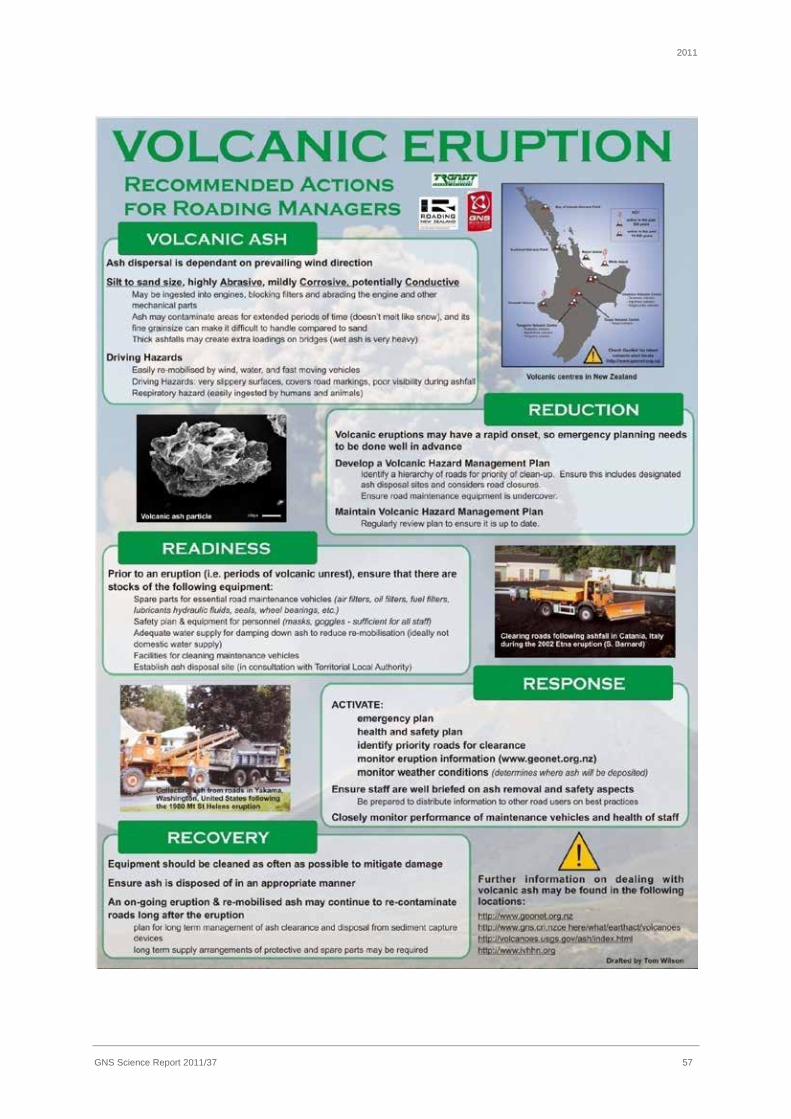
2011
GNS Science Report 2011/37 57

2011
GNS Science Report 2011/37 58

2011
GNS Science Report 2011/37 59

2011
GNS Science Report 2011/37 60
APPENDIX 2 USGS CO2 GAS HAZARD POSTER
From Sorey et al. (2000): http://wrgis.wr.usgs.gov/fact-sheet/fs172-96/fs172-96.pdf

2011
GNS Science Report 2011/37 61

2011
GNS Science Report 2011/37 62
APPENDIX 3 VOLCANIC IMPACT STUDY GROUP ANNUAL SEMINAR
CONTINGENCY PLANNING FOR A VOLCANIC ERUPTION A self-assessment tool
Introduction This self-assessment survey or ‘tool’ was first trialed at the 7 November 2007 VISG Annual Seminar. In addition to assisting businesses assess their level of preparedness to respond to a volcanic eruption, one of the objectives of the facilitated session was to explore the nature of specific volcanic contingency plans over and above general emergency response provisions.
Awareness of exposure to volcanic risk Please rate your organisation’s level of awareness in relation to volcanic risk by rating the following questions from one to three, one being the lowest and three being the highest.
Risk Exposure Awareness
Examples 1. Not performed
2. Partially performed
3. Performed fully
Vulnerability assessment for volcanic threat undertaken
Identified:
· the volcanic hazard zone · parts of your business that
could be affected by the impact and/or ashfall
· evacuation issues for HR
Characteristic vulnerabilities to volcanic eruption identified
· operating in an ash environment
· having PPE · risk of power failure · risk of restricted water
supplies · risk of loss of
communications · loss of transport links · disruption to supply chain · product contamination · reduction in staff due to self
evacuation
Specific vulnerabilities to volcanic eruption identified
· ability to corrode plant and machinery network parts
· sufficient essential supplies held outside of affected area
· data centre air-conditioning systems
Insurance requirements identified based on risk assessments
· loss of profit and built environment policies

2011
GNS Science Report 2011/37 63
Scope of current response and contingency plans On the following pages the self-assessment sheets identify the various elements required for use in emergency response planning. They are organised under the category headings of:
· Management Systems and Organisational Roles
· Information Management
· Resource Management
· Development Training and Simulation
· Key Response Actions
Tick one box alongside each element to indicate whether your organisation’s current provisions:
(a) are not in place for general emergencies or are currently under development;
(b) are in place for general emergencies only;
(c) need to be adapted to cover a volcanic emergency; or
(d) are in place to address volcanic emergencies.
Please identify and comment on the issues that your organisation and sector faces under each category heading, and possible solutions to any problems identified.
Note that the emphasis in this initial assessment is on whether or not the provisions are in place, rather than the adequacy of those provisions. It is intended that future iterations of this assessment would pick up on this latter aspect, and in the process of doing so would provide an ongoing benchmarking facility.
Other information of relevance which should be included in a plan
There are other items that should be included in response and contingency plans that are not specifically addressed in these assessment sheets. These include:
· Network maps
· Vulnerability assessments
· Mechanisms for evaluation and review of response/ contingency plans following events and exercises

2011
GNS Science Report 2011/37 64
(a) Provisions not in place or under development
(b) Current provisions in place for a general emergency only
(c) Provisions need to be adapted to cover a volcanic emergency
(d) Specific volcanic provisions in place
(e) Not applicable
1. Management Systems and Organisational Roles
The command and control structure is defined
q q q q q
For example: · Incident Manager role filled · Media spokesperson
The roles and responsibilities of the various organisational units and between organisations is outlined
q q q q q For example: · Roles/responsibilities are often unclear which leads to duplication or gaps · Mature organizations should look for these grey spots and clarify. This
can often occur in organizations that have multiple contact points with customers, how do you ensure consistent and timely messaging?
· Ash removal and disposal – your role or contractors role? – would contractor do it for you?
Internal communication processes are defined
q q q q q For example: · have alternative communication methods when systems aren’t
operational or staff are at home · Can be difficult when there are multiple offices
Decision making processes at organisation and inter-organisation levels are outlined
q q q q q For example: · have people with delegated authority outside of Taranaki · Have people with ‘emergency’ delegated authority to ensure that
operations can continue
The location of the emergency co-ordination centre(s) is defined and appropriate
q q q q q For example: · Have a site which has the appropriate resources e.g. systems, emergency
kits (food etc) · Have a site that is not in a Taranaki risk zone
The operational interface with CDEM is defined and understood
q q q q q For example: · Contact details are up to date · Identify reliable sources of information that can inform decision making. · Processes and capacity to deal with surge in information and activity –
where can you bring them in from? · Have an alternative coordination point that is not in a Taranaki risk
zone?
IT system locations are appropriate, and able to be managed remotely
q q q q q For example: · Building could be unharmed as most designed to high standards, however
you may not be able to access it either due to evacuation or ash issues · Is the equipment protected against damage (shaking, ash etc)

2011
GNS Science Report 2011/37 65
(a) Provisions not in place or under development
(b) Current provisions in place for a general emergency only
(c) Provisions need to be adapted to cover a volcanic emergency
(d) Specific volcanic provisions in place
(e) Not applicable
Network management locations are appropriate and able to be managed remotely
q q q q q For example: · Building could be unharmed as most designed to high standards, however
you may not be able to access it either due to evacuation or ash issues
Security arrangements cover emergency situations
q q q q q For example: · Most provided by contractors, would they be able to continue service?
Contractor’s know and have the ability to carry out their operational responsibilities during an emergency
q q q q q For example: · They are embedded in the organizations Business Continuity Management
(BCM) programme · Have a robust BCM programme of their own
What are the issues that need to be addressed with respect to management systems and organisational roles?

2011
GNS Science Report 2011/37 66
(a) Provisions not in place or under development
(b) Current provisions in place for a general emergency only
(c) Provisions need to be adapted to cover a volcanic emergency
(d) Specific volcanic provisions in place
(e) Not applicable
2. Information Management
Warnings and relevant agencies & community implications are outlined
q q q q q For example: · Belong to, and understand the local warning systems. · Subscribe to and understand the GNS Scientific Alert Levels and what they mean to
you, your staff and your organization
Situational assessment procedures are defined
q q q q q
Information receiving, collation and distributing information is outlined
q q q q q For example: · Volume of information is hard to manage in events · Level of trained staff required to manage information for large scale events, in
primary command centre and outside Taranaki?
Procedures for providing public information is defined
q q q q q For example: · Media training for senior management · Identify spokesperson · Do staff know what they are and aren’t allowed to say?
Internal and external reporting procedures are outlined
q q q q q For example: · Everyone wants information (Media, CDEM, Board, staff, customers), how do you get
it to them effectively and in a timely manner? · Do you have capacity for this large demand
What are the issues that need to be addressed with respect to information management?

2011
GNS Science Report 2011/37 67
(a) Provisions not in place or under development
(b) Current provisions in place for a general emergency only
(c) Provisions need to be adapted to cover a volcanic emergency
(d) Specific volcanic provisions in place
(e) Not applicable
3. Resource Management
Human resource analysis & co-ordination is defined
q q q q q For example: · Organisation is not fully dependent on Taranaki based staff to provide service · Key person dependencies identified and mitigated
Administration procedures are outlined q q q q q
Financial procedures are outlined
q q q q q For example: · Financial delegations are also held outside of Taranaki
Sources of external assistance is considered
q q q q q For example: · Key contractor/supplier offices outside of the affected areas · CDEM
Evacuation and shelter procedures for staff
q q q q q For example: · Do you have shelter procedures for staff and customers
Interdependencies with suppliers/contractors understood and managed
q q q q q For example: · Are suppliers or there critical stocks in impact zone? · Will they still be able to deliver? I.e. will they have had to evacuate? · Do you have contractual obligations to ensure supply and what are the out clauses? · Do they have a contingency plan and does it include getting key assets out of the area?
E.g. Generator’s · Can they meet your needs from other locations?
Resources for emergency repair are held in appropriate locations and amounts
q q q q q For example: · Have you thought through the repair process and the effect of ashfall on all
equipment/people required to do it i.e. car air and oil filters (engineers recommend changing 4 hourly to protect against engine failure)
· Do you have spares in required capacities or an action to increase stocks when a threat is imminent?
Resources for emergency response are held in appropriate locations and amounts
q q q q q
For example: · Do you have or know where to get specific ash removal and disposal equipment?
Health and medical (incl. Hazmat considerations
q q q q q For example: · Masks, goggles and gloves – N95 mask required, same as bird flu. As eruptions can
last for months to years need to think through carefully stock levels required as some require changing every 3 – 38 hours depending on model. Supply issues are likely to occur with heavy demand therefore need to be prepared.
· H&S act still applies - do you know how to evaluate whether a site is safe for staff to enter?
· Do you have a volcanic Health & Safety risk assessment? · Do your managers know how to recognize signs of volcanic related health effects?
What are the issues that need to be addressed with respect to resource management?

2011
GNS Science Report 2011/37 68
(a) Provisions not in place or under development
(b) Current provisions in place for a general emergency only
(c) Provisions need to be adapted to cover a volcanic emergency
(d) Specific volcanic provisions in place
(e) Not applicable
4. Development Training and Simulation
Provisions for training (operational, tactical and strategic response)
q q q q q For example: · Alternate management centre staff fully trained · Do staff know how to evaluate Health & Safety of site? · Do staff know how to remove and dispose of ash
Provisions for undertaking simulations/ exercises
q q q q q For example: · Includes natural hazard type events
Provisions for undertaking a training needs analysis
q q q q q For example: · Does this include volcanic specific skills
What are the issues that need to be addressed with respect to training and simulation?
5. Key Response Actions
Activation and mobilisation procedures are specified, communicated and redundant
q q q q q
For example: · Activation procedures can be performed outside of Taranaki Hazard area?
Key response actions are outlined
q q q q q For example: · During warning stages as well as when it is imminent e.g have outlined what the
organization would do if told there was going to be a volcanic eruption in say one to three months time. Have thought through process of whether company would invest in moving/protecting any critical at risk infrastructure?
· Procedures for protecting your equipment are known and documented where possible
Response priorities are defined and in line with CDEM
q q q q q
What are the issues that need to be addressed with respect to key response actions?

2011
GNS Science Report 2011/37 69
APPENDIX 4 WORKING FROM THE SAME PAGE: CONSISTENT MESSAGES FOR CDEM

2011
GNS Science Report 2011/37 70

2011
GNS Science Report 2011/37 71

2011
GNS Science Report 2011/37 72

2011
GNS Science Report 2011/37 73

2011
GNS Science Report 2011/37 74

2011
GNS Science Report 2011/37 75

2011
GNS Science Report 2011/37 76

2011
GNS Science Report 2011/37 77

2011
GNS Science Report 2011/37 78

2011
GNS Science Report 2011/37 79

2011
GNS Science Report 2011/37 80

2011
GNS Science Report 2011/37 81

2011
GNS Science Report 2011/37 82

2011
GNS Science Report 2011/37 83

2011
GNS Science Report 2011/37 84
APPENDIX 5 EXERT FROM COMMUNITY BEHAVIOUR-BASED COMMUNICATION FRAMEWORK: REAWAKENING VOLCANOES (2008) P: 4-7

2011
GNS Science Report 2011/37 85
Constructing a warning message

2011
GNS Science Report 2011/37 86

2011
GNS Science Report 2011/37 87
Further Reading Auckland Volcanic Contingency Plan
Auckland CDEM Group Plan (including Group Functional Plan P2: Public Information Management, and Group Functional Plan P4: Mass Evacuation)
National CDEM Plan, and Guide to the National CDEM Plan
Public Information Management: Information for the CDEM Sector [IS9/07]
Aguirre, B.E., 2004. Homeland security warnings: lessons learned and unlearned. International Journal of Mass Emergencies and Disasters, 22: 103-115.
Drabek, T.E., 1994. Disaster Evacuation and the Tourist Industry, University of Colorado, Institute of Behavioral Science, Program on Environment and Behavior, Boulder.
Drabek, T.E., 1996. Disaster Evacuation Behavior: Tourists and other Transients, University of Colorado, institute of Behavioral Science, Program on Environment and Behavior, Boulder.
Greene, M., Perry, R. W., Lindell, M. 1981. The March, 1980 eruptions of Mt. St. Helens: Citizen perceptions of volcano hazard. Disasters 5(1): 49-66.
Johnston, D.M., Houghton, B.F., Neall, V.E., Ronan, K.R., Paton, D. 2000. Impacts of the 1945 and 1995-1996 Ruapehu eruptions, New Zealand: an example of increasing societal vulnerability. Geological Society of America Bulletin 112:720-726.
Mileti, D. S., Sorensen, J. H. 1990. Communication of Emergency Public Warnings: a social science perspective and state-of-the-art assessment. Oak Ridge Laboratory ORNL-6609.
2011
GNS Science Report 2011/37 88
Paton, D. and Johnston, D., 2001. Disaster and communities: vulnerability, resilience and preparedness. Disaster Prevention and Management, 10(270-277).
Paton, D., Millar, M., Johnston, D. 2001. Community resilience to volcanic hazard consequences. Natural Hazards 24: 157-169.
Paton, D., Smith, L.M. and Johnston, D. 2000. Volcanic hazards: Risk perception and preparedness. New Zealand Journal of Psychology, 84-88.
Perry, R.W., Lindell, M.K. 1990. Living with Mount St. Helens: human adjustment to volcano hazards. Washington University Press, Pullman, Washington, 205 p.
Ronan, K. R., Paton, D. Johnston, D. M., Houghton, B. F. 2000. Managing societal uncertainty in volcanic hazards: A multidisciplinary approach. Disaster Prevention and Management 9: 339-349.
Saarinen, T.F., Sell, J.L. 1985. Warnings and Response to the Mount St Helens Eruption. State University of New York Press, Albany, 240p.
Showalter, P.S. 1993. Prognostication of doom: an earthquake prediction's effect on four small communities. International Journal of Mass Emergencies and Disasters 11(3): 279-292.
Slovic, P. 1993. Perceived risk, trust and democracy. Risk Analysis 13: 675-682.
Sorensen, J.H., 2000. Hazard warning systems: review of 20 years of progress. Natural Hazards Review, 1: 119-125.
Vogt, B.M., Sorensen, J.H. 1994. Risk communications and the chemical stockpile emergency planning program. Oak Ridge National Laboratory ORNL-6824, 174 p.

2011
GNS Science Report 2011/37 89
APPENDIX 6 MASSEY UNIVERSITY REPORT TO TVSAG 2010 ON RECENT RESEARCH
Report to TVSAG of research activities completed and underway in the 2010-11 reporting year by Massey University. Professor Shane Cronin Professor Vince Neall Institute of Natural Resources, Massey University, Private Bag 11 222, Palmerston North, New Zealand
1. Funding under the “Living with Volcanic Risk” FRST programme to Massey University has now been transferred into the New Zealand Natural Hazards Research Platform, a consortium of GNS, NIWA, OPUS along with Massey, Canterbury, and Auckland Universities. This should ensure stability of ongoing related geohazard research of applicability to the Taranaki region and integrate volcanic research with other natural hazard research programmes.
2. A new Natural Hazard Platform project will work over the next 18 mths to develop a
probabilistic hazard model to rate the relative chances for catchments around Mt Taranaki to be affected by future mass flows from eruption events. This will help to plan more effectively for future eruption scenarios.
3. An additional new Natural Hazard Platform project will focus on missing data in
volcanic records and develop a more robust means of forecasting eruption hazard at Mt. Taranaki.
4. The five original PhD theses on Mt Taranaki and environs have now been completed
on aspects of volcanology and hazard, resulting in graduations of Drs. Thomas Platz, Michael Turner, Anke Zernack, Tom Wilson (coupled with U. Canterbury) and Jonathan Procter. Along with ongoing publications of the outcomes of these studies, the next PhD studies have begun with Ms Natalia Pardo examining the characteristics of the largest possible eruptions expected from Mt Taranaki and Dr Armando Rodado studying new statistical methods to improve eruption forecasts from the volcano.
5. A visiting scientist from Italy (Mateo Roteo) will carry out a comparative study with us
on Debris avalanches in Taranaki with those at the very similar Colima volcano in Mexico. Colima is currently in a long-term dome-growth eruption phase and is an excellent modern analogue to Mt Taranaki.
6. We are participating with Landcare Research Ltd. to carry out a study of the long-
term erosion rates and processes in the upper Stony River catchment. This will be completed during the reporting year ahead.
7. New field sites will be sought this year for further coring in swamps and lakes for Mt
Taranaki volcanic ash layers. Areas to be concentrated on include, Tariki, and other areas NE of the volcano.
8. From last-year’s core sites in Eltham and Ohakune a longer record of Mt Taranaki
volcanism has been developed, including 60 volcanic ash layers found in the distal

2011
GNS Science Report 2011/37 90
site of Ohakune that will help us develop wide-spread hazard estimates for future eruptions.
9. An study of the potential regional and extra-regional economic impacts of volcanism at Mt Taranaki (based of four low-impact scenarios) is will be completed in the coming year.
10. Further concentration on sediment monitoring and debris flow monitoring in the Stony
River catchment will be carried out this year in conjuction with the TRC hydrology team, involving seismographs and acoustic flow monitors.
11. Modelling of volcanic ash fall dynamics will be carried out for past Mt. Taranaki
explosive eruptions, particularly using the AD1655 Burrell eruption as an example.
12. Agricultural impacts of volcanic eruptions are being studied as part of an ongoing research programme in collaboration with Dr Tom Wilson, including papers on pasture regeneration after ashfall and strategies for re-sowing pastures after ash/lahar impacts to be published in the next 6 months.
13. Further student projects include a study on past Taranaki climates by Rob Tinkler, on
the integration of volcanic hazard information into Sth Taranaki District planning by Laura Clemens and on the impacts of volcanism on the energy distribution infrastructure of Taranaki by Ian Chapman (a resumption of studies).

2011
GNS Science Report 2011/37 91
APPENDIX 7 TARANAKI-FOCUSED RESEARCH BY VOLCANIC RISK SOLUTIONS
Information from FRST Evidence Portfolio: a review of the Living with Volcanic Risk programme Starting in 2004, the Living with Volcanic Risk programme has focused on building new knowledge to quantify and effectively mitigate the volcanic hazards faced by communities and industries vulnerable to the major andesitic volcanoes of the North Island of New Zealand. The research in this programme was based around several areas of unique research strength, including the following that are relevant to Taranaki:
1. Probabilistic hazard forecasting and time-varying volcanic hazards. Beginning with development of high-precision dated records of volcanism at Mt Taranaki, a new probabilistic forecast for explosive volcanism at the centre was developed and improved in two iterations with recognition of differing styles of activity and with integration of records of volcanism from multiple sites. This has led to application in developing probabilistic forecasts for ash fall impact on key energy-distribution infrastructure sites in the Taranaki region. In addition, this work has led to the realisation that a steady-state variation in the hazard rate or eruption frequency occurs at Mt Taranaki, which can be related to regular variations in magma chemistry and may indicate periodic replenishment of mid-crustal level magma feeding systems for the volcano. This has important implications for developing time-variable hazard forecasts for the volcano, since the position in the cycle of magma-replenishment and related eruption frequency must be taken into account. Notably, the timing of the largest eruptions of the volcano appears to be predictable on the basis of this new knowledge.
2. Modelling, sedimentology and geophysical measurement of volcanic mass flows. In three related research threads, (1) numerical mass-flow models have been developed in conjunction with partners at SUNY Buffalo USA for application to a range of flow types at NZ volcanoes, along with the development of (2) new tools and techniques to measure the physical properties of moving mass flows and provide warnings of them and (3) sedimentological models for the full range of mass flows from NZ volcanoes. Although much of this work has been centred around Mt Ruapehu in the anticipation, and subsequent analysis, of the 18 March 2007 lahar, we also examined volcanic mass flows at Mt Taranaki (see Output list). Sedimentological studies have focused on the properties of pyroclastic flows lahars and debris avalanche dynamics at Mt Taranaki. These sedimentological studies, and the geophysical measurements on moving lahars at other centres, have been incorporated into redevelopment of the Titan2D numerical flow model, along with our research of the model’s application to a new generation of forward-looking hazard evaluation tools and probabilistic hazard forecasts for pyroclastic flows, lahars and debris avalanches at Mt Taranaki and other NZ volcanoes.
3. Development of integrated petrological/physical understanding of volcanic eruptions. The team has investigated the processes driving sudden explosive/effusive eruption transitions at Mt Taranaki; the magmatic plumbing, rise rates, evolution processes and eruption-driving mechanisms at Mt Taranaki; and eruption magnitude/style

2011
GNS Science Report 2011/37 92
constraints. These data have been the basis for developing realistic eruption scenarios for volcanic emergency management planning exercises.
4. Development of economic impact forecasts and mitigation planning for volcanism. Using new eruption magnitude, style and probabilistic impact results, input-output modelling of economic impacts of volcanism on the Taranaki region has been completed for a range of probable scenarios. In addition, an initial energy-sector analysis was completed and is now being followed up by a specific risk analysis for the energy-distribution infrastructure in partnership with Powerco (Masterate project of I. Chapman). Complementing this, a roading and services analysis was completed for South Taranaki and research has been carried out into the processes of prioritising hazards for CDEM groups, with further work into the hindrances of adopting volcanic hazards information into District and Regional-level land use planning. In collaboration with University of Canterbury and GNS Science/Joint Centre for Disaster Research, further research has gone into volcanic impacts on agriculture.
Research highlight 1 Research in area 1 is highlighted in the following publication:
Turner, M.B., Cronin, S.J., Bebbington, M., Platz, T., 2008: Developing a probabilistic eruption forecast for dormant volcanoes; a case study from Mt Taranaki, New Zealand. Bulletin of Volcanology 70: 507-515.
Why is this output important? This is the first attempt at developing a comprehensive and robust probabilistic forecast for eruptions at a New Zealand volcano. The work demonstrates one of our key unique team strengths in volcano statistics and the step-change needed to: (1) obtain sufficiently detailed records of volcanism for Mt. Taranaki; and (2) pioneer a new statistical tool for volcanic eruption forecasting. From this we have developed probabilistic hazard forecasts, infrastructure impact assessments and a new understanding of how andesitic magmatic systems function and vary over time. Description The paper provides the first probabilistic hazard forecast for explosive eruptions from Mt Taranaki, based on the compilation of a record of 103 volcanic events of the volcano over the last c. 10 000 years. The eruption data were gathered from cores within a lake near New Plymouth as well on the volcano’s flank. Collection of many new radiocarbon dates and statistical age-depth calculations for non-dated ash-layers allowed the most comprehensive ever chronology to be established for Holocene eruptions at the volcano. Monte-Carlo analysis of the age (+error) dataset allowed the selection of a mixture of Weibull distributions to best describe the complex distribution of interval times between eruptions. From these distributions a probabilistic forecast was made that, for example, shows an up to 49% chance of explosive eruption from Mt Taranaki over the next 50 years. Significance This output represents the foundational scientific advance we needed for comprehensive hazard forecasting at NZ andesitic volcanoes. In particular, it was the step required for completion of a suite of further outputs that: (1) quantify probabilistic forecasts for differing types of eruptions at a volcanic centre and view overall time-varying behaviour at andesitic volcanic systems (Turner et al., 2008, Geology); (2) produce expanded comprehensive forecasts of volcanic eruption at Mt Taranaki using multi-site information (Turner et al., 2009,

2011
GNS Science Report 2011/37 93
Bull. Volcanol.); and (3) allow spatio-temporal probabilistic assessment of volcanic ash fall impacts to important lifelines infrastructure elements and major industries in the Taranaki region (Bebbington et al., 2008, JVGR) and provide ash fall forecasts for Auckland (Bebbington et al., 2006, AELG Volcanic Impact Studies Group; Cronin et al., 2007, IUGG, Italy). In addition, this work served as the foundation for building the first time-varying mechanistic models of volcanic-eruption frequency that are based on variations in magma supply, magma geochemistry and petrology (Turner, 2008, PhD Thesis; Platz et al., 2007, JVGR). The new models from Mt Taranaki will be the standard for comparison to a wide number of andesitic volcanoes worldwide, but more particularly to our ongoing research on Mts. Ruapehu and Tongariro/Ngauruhoe. The significance of this work is highlighted by Cronin being invited as a Keynote speaker in Mexico (2009), a country which is plagued by several Taranaki-like volcanoes. Research highlight 2 Research that exemplifies area 2 is highlighted in the following:
Procter, J.N., Cronin, S.J., Platz, T., Patra, A., Dalbey, K., Sheridan, M., Neall, V.E., 2010: Mapping Block-and-ash flow (BAF) hazards based on Titan2D simulations: a case study from Mt Taranaki, NZ. Natural Hazards 53: 483-501.
Why is this output important? This output represents one of our signature capabilities in mass flow hazard simulation and mapping, and is one result of our long-term international collaboration with SUNY Buffalo, USA. It represents the first New Zealand attempt at developing probabilistic hazard maps for volcanic mass flows using digital representations of modern terrain and adapting one of the best computational flow models used globally, Titan2D. The importance of this output is twofold: (1) lessons learned have allowed further development and refinement of the evolving Titan2D code by our colleagues in Buffalo, and (2) it demonstrates a technique for defining hazards that supersedes stochastic approaches based on mapping past mass flows on old (and now irrelevant) terrains. Description The paper describes a method to solve one of the greatest uncertainties around hazard assessment at andesitic volcanoes, namely forecasting the distribution, inundation, run-out length and emplacement times for a range of mass flows. It is one of a series of our works that describe how dynamic numerical modelling tools can be applied to current and future hazard assessment issues, with the ability to update the models depending on changes in terrain and eruption/source conditions. Collapses of hot or cold debris down NW Mt. Taranaki is anticipated as one of the most acute initial hazards from this volcano, with a range of possible source conditions and volumes. We demonstrate how a range in these, along with model parameters concerning flow rheology, can be integrated into a probabilistic hazard “layer” for emergency management, infrastructure hazards assessment and land use planning within a Geographic Information System (GIS). Significance With this work we extend from our initial development of CD-ROMs with GIS-Viewers that displayed visualisations of traditional hazard map data and analysis of infrastructure/lifeline vulnerabilities and “hot spot” points requiring priority attention (Neall et al., 2004: Commissioned by TRC). The nominated output applies forward-viewing simulation tools within a GIS environment and represents a significant philosophical paradigm shift in mass flow hazard assessment. Traditional approaches arbitrarily derived hazard zones from the mapped inundation areas of past mass-flows. These data are prone to significant error

2011
GNS Science Report 2011/37 94
through imperfect deposit preservation and exposure, a lack of long-term records for repeated events, and the mapped distributions reflect only past terrains. The stretch we demonstrate is that by using digital representations of modern terrain along with constraints of flow magnitudes and rheology from geological data, numerical models show a more robust and probabilistic forecast of mass flow inundation from one or several overlapping scenarios. This work has fed into ongoing approaches for forecasting many types of volcanic mass flow hazard including: before the 2007 lahar at Ruapehu (Cronin et al., 2005, DOC; conference papers by Procter et al. and Cronin et al.); of lahars and debris avalanches at Taranaki (Procter et al., 2009); and of pyroclastic flows at Ngauruhoe (Martelli, 2007, MSc (Hons) thesis). Research highlight 3 The team have links with regional and district councils, advisory groups and other users of the research. This is well illustrated in the Taranaki region: Members of the team (S. Cronin, V. Neall, B. Stewart and UoA co-worker I. Smith) contribute annually to the Taranaki Volcano Science Advisory Group meetings. The VRS team have also developed eruption scenarios for Mt Taranaki that have been used to run exercises and lead development of new emergency management plans in the Taranaki CDEM group area. Fears of a landslide and collapse were raised by Taranaki Daily News and other media outlets in March/April 06 which led to requests for us to develop computational simulations and a hazard map for the Department of Conservation and the Taranaki Regional Council to plan for eventual hazard from such collapses (Cronin, S.J., 2006: Report on Mt. Taranaki summit stability. Commissioned by Taranaki Conservation Board and Taranaki Regional Council). Research results from the programme have also been adopted for emergency planning of groups such as the Taranaki District Health Board. In addition, the team produced an interactive CD-ROM map browser that displays the risk to infrastructure in the Taranaki region of a volcanic event from Mt Taranaki. The CD-ROM used a GIS interface and included full briefing notes. This CD-ROM was commissioned by the Natural Gas Corporation of NZ, Shell-Todd Oil Services, Taranaki Regional Council, New Plymouth District Council, South Taranaki District Council and Stratford District Council. Several updates of these CD materials have been issued to these users during the course of the Living with Volcanic Risk programme. Current/Recent Activities The Living with Volcanic Risk programme funding is now a part of the New Zealand Natural Hazards Research Platform. Massey’s research in the platform is ongoing in the 4 areas of expertise outlined above, and involves research around Mt Taranaki in each of the areas. In particular, work continues on the potential regional and extra-regional economic impacts of volcanism at Mt Taranaki (in association with Market Economics Ltd). Two short-term research projects were awarded to members of the Volcanic Risk Solutions team in 2010. The first of these is examining how the degree of completeness of a volcano’s observed eruption record can be evaluated, and aims to develop a method that will allow us to fit hazard models in such a way that they are robust in spite of the possible missing observations. This will allow more robust means of forecasting volcanic eruption hazards at Mt Taranaki, as well as other volcanic centres. The second project is focussed on developing a probabilistic hazard model to rate the relative chances for catchments around Mt Taranaki to be affected by future mass flows from eruption events. We have collaborated with Landcare Research in an analysis of erosion monitoring in the Upper Stony river catchment. The report was completed in September 2010. A PhD student from Mexico (Matteo Rotovato) visited us in Mar-Apr 2011 to carry out a comparative study on debris avalanches in Taranaki with those at the very similar Colima volcano in Mexico. Colima is currently in a long-term dome-growth eruption phase and is an excellent modern analogue to Mt Taranaki.

2011
GNS Science Report 2011/37 95
Three further manuscripts are in progress: on Taranaki collapse forecasting; geomorphology and sedimentology patterns in relation to volcanism and climate change; and a study on the older volcanism of Mt Taranaki. It is expected that all of these will be submitted by the end of the year. Student projects related to Taranaki Completed Honours, Diploma and Masterate Students Robertson, C.M., 2007: Integrating science into land use planning for volcanic hazards: a case study on Mount Taranaki. Bachelor Resource and Environmental Planning (Hons) thesis. Institute of Natural Resources and School of People, Environment and Planning, Massey University.
Aldridge, C., 2006: Economic loss modelling for volcanic eruption impacts in the Taranaki Region, New Zealand, MA thesis, School of Applied Economics, Massey University.
Gruender, K., 2006: Petrography and mineral chemistry of a xenolith suite from Mt Taranaki, New Zealand: insights into the sub-volcanic lithosphere of an arc. Diplomarbeit (MSc thesis), Department of Geology and Mineralogy, University of Mainz, Germany and Institute of Natural Resources, Massey University.
Krivan, K.J., 2005: Quantifying the risk of bridge infrastructure to damage from future lahars in South Taranaki District. BSc (Hons) thesis, Institute of Natural Resources, Massey University.
Rosenthal, A., 2005: Mapping and characterisation of the eastern Fanthams Peak lavas, Egmont Volcano, Taranaki, New Zealand. Dipl. Kartierung (Major mapping thesis), Department of Geology and Mineralogy, University of Mainz, Germany and Institute of Natural Resources, Massey University.
Birks, D.L. 2004. Advances in understanding the volcanic history of the south-western flank of Egmont Volcano, Taranaki, New Zealand. MSc, Institute of Natural Resources, Massey University.
Turner, M., 2004. The Curtis ridge eruption sequence, Mt. Taranaki, New Zealand. BSc(hons), Institute of Natural Resources, Massey University.
Current Honours, Diploma and Masterate Students I. Chapman: A volcanic risk assessment for the energy distribution sector of Taranaki. MPhil Emergency Management. Recently resumed studies.
Completed Doctoral Students Procter, J.N., 2009: Towards Improving Volcanic Mass Flow Hazard Assessment at New Zealand Stratovolcanoes. PhD Thesis, Institute of Natural Resources, Massey University.
Zernack, A., 2009: Long-term evolution of stratovolcano systems, a case study from Mt Taranaki. PhD Thesis, Institute of Natural Resources, Massey University.
Turner, M.B., 2008: Eruption cycles and magmatic processes at a reawakening volcano, Mt. Taranaki, New Zealand. PhD Thesis, Institute of Natural Resources, Massey University.
Platz, T., 2007: Aspects of Dome-forming Eruptions from Andesitic Volcanoes through the Maero Eruptive Period (1000 yrs B.P. to Present) Activity at Mt. Taranaki, New Zealand. PhD Thesis, Institute of Natural Resources, Massey University.

2011
GNS Science Report 2011/37 96
Current Doctoral Students N. Pardo: Defining the Maximum Likely Eruption event for Andesitic Volcanoes in New Zealand.
R Tinkler: A High Resolution, Multiproxy Record of Late Quaternary Climatic and Environmental Change in Eastern Taranaki, New Zealand.
R. Green: Estimation of Time-Varying Volcanic Hazard.
Publications / Outputs related to Taranaki Journal Articles In Review
Platz, T., Cronin, S.J., Procter, J.N., Neall, V.E., Foley, S. in review: Non-explosive, dome-forming eruptions at Mt. Taranaki, New Zealand. Submitted to Geomorphology.
Turner, M.B., Cronin, S.J., Bebbington, M.S., Smith, I.E.M., Stewart, R.B., in review: Andesitic Tephrochronology: Construction of a Pyroclastic Eruption Record for Mt. Taranaki, New Zealand. Submitted to Quaternary International.
2011
Turner, M.B., Cronin, S.J., Bebbington, M., Smith, I.E.M., Stewart, R.B., in press: Relating magma composition with eruption variability at andesitic volcanoes. A case study from Mt. Taranaki, New Zealand. Geological Society of America Bulletin, doi: 10.1130/B30367.1
Zernack, A.V., Cronin, S.J., Neall, V.E., Procter, J.N., in press: A medial to distal volcaniclastic record of an andesitic stratovolcano: detailed stratigraphy of the ringplain succession of south-west Taranaki, New Zealand. International Journal of Earth Sciences (Geologishe Rundschau), doi: 10.1007/s00531-010-0610-6.
2010
Bebbington, M.S., 2010: Trends and clustering in the onsets of volcanic eruptions. Journal of Geophysical Research 115, B01203. doi: 10.1029/2009JB006581.
Gruender, K., Stewart R.B, Foley, S., 2010: Xenoliths from the sub-volcanic lithosphere of Mt Taranaki, New Zealand. Journal of Volcanology and Geothermal Research 190: 192-202.
Procter, J.N., Cronin, S.J., Platz, T., Patra, A., Dalbey, K., Sheridan, M., Neall, V.E., 2010: Mapping Block-and-ash flow (BAF) hazards based on Titan2D simulations: a case study from Mt Taranaki, NZ. Natural Hazards 53: 483-501.
2009
Procter, J.N., Cronin, S.J., Zernack, A., Neall, V.E., 2009: Landscape and sedimentary response to catastrophic debris avalanches, Western Taranaki, New Zealand. Sedimentary Geology 220: 271-287.
Turner, M., Bebbington, M., Cronin, S.J., Stewart, R.B., 2009: Merging Eruption Datasets: Towards an Integrated Holocene Eruptive Record of Mt Taranaki, New Zealand. Bulletin of Volcanology 71: 903-918.
Zernack, A., Procter, J.N., Cronin, S.J., 2009: Sedimentary signatures of cyclic growth and destruction of stratovolcanoes: a case study from Mt. Taranaki, New Zealand. In: Németh, K., Manville, V., Kano, K. (Editors) Source to sink: from volcanic eruptions to volcaniclastic deposits on the Pacific Rim. Sedimentary Geology 220: 288-305.

2011
GNS Science Report 2011/37 97
2008
Bebbington, M., 2008: Incorporating the eruptive history in a stochastic model for volcanic eruptions. Journal of Volcanology and Geothermal Research 175: 325-333.
Bebbington, M., Cronin, S.J., Chapman, I., Turner, M.B., 2008: Quantifying volcanic ashfall hazard to electricity infrastructure. Journal of Volcanology and Geothermal Research 177: 1055-1062.
Turner, M.B., Cronin, S.J., Bebbington, M., Platz, T., 2008: Developing a probabilistic eruption forecast for dormant volcanoes; a case study from Mt Taranaki, New Zealand. Bulletin of Volcanology 70: 507-515. Turner, M.B., Cronin, S.J., Smith, I.E.M., Bebbington, M., Stewart, R.B., 2008: Using titanomagnetite textures to elucidate volcanic eruption histories. Geology 36: 31-34.
Turner, M.B., Cronin, S.J., Smith, I.E.M., Stewart, R.B., Neall, V.E., 2008: Eruption episodes and magma recharge events in andesitic systems; Mt Taranaki, New Zealand. Journal of Volcanology and Geothermal Research 177: 1063-1076.
2007
Bebbington, M., 2007: Identifying volcanic regimes using hidden Markov models. Geophysical Journal International 171: 921-942.
Platz, T., Cronin, S.J., Cashman, K.V., Stewart, R.B., Smith, I.E.M., 2007: Transitions from effusive to explosive phases in andesite eruptions – a case-study from the AD1655 eruption of Mt. Taranaki, New Zealand. Journal of Volcanology and Geothermal Research 161: 15-34.
Platz, T., Cronin, S.J., Smith, I.E., Turner, M.B. Stewart, R.B., 2007: Improving the reliability of microprobe-based analyses of andesitic glass for tephra correlation, Holocene 17: 573-583.
2005
Alloway, B., McComb, P., Neall, V.E., Vucetich, C., Gibb, J., Sherburn, S., Stirling, M., 2005: Stratigraphy, age and correlation of voluminous debris-avalanche events from an ancestral Egmont Volcano: implications for coastal plain construction and regional hazard assessment. Journal of the Royal Society of New Zealand 35: 229-267.
Conference presentations 2010
Procter, J.N., Cronin, S.J., Zernack, A.V., 2010: Emplacement of the Opua Debris Avalanche Deposit from Mt Taranaki, New Zealand: Titan2D simulation compared to sedimentology and GIS analysis. Geophysical Research Abstracts, Vol. 12, EGU2010-7588 [EGU General Assembly 2010, Vienna, Austria].
Stewart, R.B., Gruender, K., 2010: Andesites at Mt. Taranaki, New Zealand: assembly of melts and crystals in an arc volcano. Abstract in: Zaharia, L., Kis, A., Topa, B., Papp, G., Weiszburg, T.G., (eds), ACTA Mineralogica-Petrographica Abstract Series, Volume 6: 20th General Meeting of the International Mineralogical Association, August, 2010 Budapest, Hungary, p 540.
Turner, M.B., Bebbington, M.S., Cronin, S.J., 2010: Merging Eruption Datasets: Building Integrated Eruptive Records and Realistic Eruption Forecasts. In: In: International Field Conference and Workshop on Tephrochronology, Volcanism and Human Activity: Active Tephra, Kyushu, Japan, May 2010.

2011
GNS Science Report 2011/37 98
2009
Cronin, S.J., Turner, M.B., Bebbington, M., 2009: Building a geochemically-constrained time-varying eruption hazard forecasting model for an andesitic volcano: Mt Taranaki, New Zealand. In: 11th International Meeting - Volcán de Colima, February 2009, Colima, Mexico
2008
Bebbington, M., Turner, M., Cronin, S.J., 2008: Merging Pre-Historical Eruption Datasets: Methods and Lessons for Stochastic Models. In: Conference Proceedings, International Association of Volcanology and Chemistry of the Earth´s Interior 2008 General Assembly, Reykjavík, Iceland. pp 44.
Neall, V.E., Doyle, E.E., Procter, J.N., Stewart, R.B., 2008: The 2008 rain-triggered lahars on Mt. Taranaki/Mt Egmont. Abstract in: Wysoczanski R., (ed), Geological Society of New Zealand Miscellaneous Publication 124A. pp 233.
Neall, V.E., Procter, J.N., 2008: The Taranaki Volcanic Hazards Map & its application to Emergency Management. In: 7th Annual Integrated Emergency Management Conference, Wellington. 26-27 February 2008.
Stewart, R.B., Gruender, K., 2008: Probing the sub-volcanic depths – the nature of the subvolcanic crust and crust-mantle boundary in Taranaki. Abstract in: Wysoczanski R., (ed), Geological Society of New Zealand Miscellaneous Publication 124A. pp 168.
Stewart, R.B., Turner, M., Smith, I.E.M., Cronin, S.J., 2008: Variable magmatic and eruptive cycles at arc volcanoes; Taranaki (New Zealand) and Lopevi (Vanuatu). Geochimica et Cosmochimica Acta, 72: A901-A901 Suppl. 1 Turner, M., Cronin, S.J., Bebbington, M., Stewart, R.B., Smith, I.E.M., 2008: Identifying Cyclic Eruption and Magmatic Processes at Andesitic Volcanoes: A Case Study from Mt Taranaki, New Zealand. In: Conference Proceedings, International Association of Volcanology and Chemistry of the Earth´s Interior 2008 General Assembly, Reykjavík, Iceland. pp 67.
Turner, M.B., Bebbington, M., Cronin, S.J., 2008: Identifying cyclic eruption frequency by hidden Markov models: Implications for probabilistic hazard forecasts. Abstract in: Wysoczanski R., (ed), Geological Society of New Zealand Miscellaneous Publication 124A. pp 123.
Zernack, A., Procter, J.N., Cronin, S.J., Stewart, R.B., Price, R., 2008: Cyclic growth and destruction of stratovolcanoes: A case study from Mt. Taranaki, New Zealand. In: Conference Proceedings, International Association of Volcanology and Chemistry of the Earth´s Interior 2008 General Assembly, Reykjavík, Iceland. pp 50.
2007
Chapman, I.R., Bebbington, M., Cronin, S.J., Turner, M.B., 2007: Vulnerability analysis of the power-distribution infrastructure in western North Island of New Zealand to ashfall from Mt Taranaki/Egmont. In: Abstracts Volume, Cities on Volcanoes 5, Shimabara, Japan. Volcanological Society of Japan. pp 137-138.
Cronin, S.J., Turner, M.B., Bebbington, M., Smith, I.E.M., 2007: High-precision eruption records for hazard assessment at reawakening volcanoes. In: Proceedings of the International Union of Geology and Geodesy 14th General Assembly, Perugia, Italy, July 2007. VS008: 6779.
Platz, T., Cronin, S.J., Procter, J.N., Stewart, R.B., 2007: Post-eruption dome collapses, a potentially unexpected hazard source. In: Proceedings of the International Union of Geology and Geodesy 14th General Assembly, Perugia, Italy, July 2007. VS001: 6631.

2011
GNS Science Report 2011/37 99
Price, R., Zernack, A., Smith, I.E.M., Gamble J. and Stewart, R.B., 2007: Mantle source compositions for the basaltic component in North Island andesite volcanoes – a lithospheric source for Taranaki andesites? Abstract in: Mortimer, N., Wallace, L., (eds), Geological Society of New Zealand Miscellaneous Publication 123A. pp 134.
Turner, M.B., Stewart, R.B., Cronin, S.J., Smith, I.E.M., Bebbington, M., 2007: Cyclic magma evolution and associated eruption episodes of andesitic stratovolcanoes: a case study from Mt Taranaki, NZ. Abstract in: Mortimer, N., Wallace, L., (eds), Geological Society of New Zealand Miscellaneous Publication 123A. pp. 171.
Zernack, A., Procter, J.N., Cronin, S.J., 2007: Revised stratigraphy of the ring-plain succession surrounding Mt. Taranaki. Abstract in: Mortimer, N., Wallace, L., (eds), Geological Society of New Zealand Miscellaneous Publication 123A. pp. 186.
2006
Bebbington, M., Turner, M., Cronin, S.J., 2006: Merging lake cores: towards an integrated Holocene eruptive record of Mt Taranaki. Abstract in: Stewart, B., Wallace, C., Lecointre, J., Reyners, M., (eds) Geological Society of NZ Misc. Publ. 122A. pp 19.
Chapman, I., Cronin, S.J., Procter, J.N., 2006: Preliminary results from a GIS-based utility infrastructure volcanic risk evaluation in Taranaki. Abstract in: Stewart, B., Wallace, C., Lecointre, J., Reyners, M., (eds) Geological Society of NZ Misc. Publ. 122A. pp 98.
Cronin, S.J., Platz, T., Procter, J.N., Stewart, B., 2006: Depositional facies and sedimentary variability in the deposits of dome-generated block-and-ash flows. Abstract O-148 in: 17th International sedimentological congress Abstracts, Fukuoka, Japan, Vol. A, pp. 198.
Gruender, K., Stewart R.B., Foley, S., 2006: Xenoliths from the Sub-volcanic Lithosphere of Mt Taranaki, New Zealand. Abstract in: Stewart, B., Wallace, C., Lecointre, J., Reyners, M., (eds) Geological Society of NZ Misc. Publ. 122A. pp 47.
Neall, V.E., Krivan, K., Procter, J.N., Lecointre, J., Cronin, S.J., 2006: Towards ascertaining volcanic risk to infrastructure in Taranaki, New Zealand. In: Abstracts Volume, Fourth Conference, Cities on Volcanoes IAVCEI, Quito, Ecuador, Instituto Geofisico de la Escuela Politecnica Nacional, Quito, Ecuador. pp 135-136.
Platz, T., Cronin, S.J., Cashman, K.V., Stewart, R.B., 2006: Diversity of clast types and their implications for conduit processes. EOS Trans. AGU 87(52), Fall Meet. Suppl., Abstract V23C-0630.
Platz, T., Cronin, S.J., Stewart, R.B., Smith, I.E.M., Foley, S.F., 2006: Magma changes during ascent and its impact on eruptive style: a study from Mt. Taranaki andesites, New Zealand. Geophysical Research Abstracts, Vol. 8, 00514.
Procter, J.N., Cronin, S.J., Patra, A., Dalbey, K., Sheridan, M., Platz, T., 2006: Utilising TITAN2D to forecast dome collapse flow (BAFs) hazards from Mount Taranaki. In: Abstracts Volume, Fourth Conference, Cities on Volcanoes IAVCEI, Quito, Ecuador, Instituto Geofisico de la Escuela Politecnica Nacional, Quito, Ecuador. pp 45.
Procter, J.N., Platz, T., Cronin, S.J., 2006: A remnant summit lava dome and its influence on future eruptive hazards. Geophysical Research Abstracts, Vol. 8, 10211.
Procter, J.N., Zernack, A., Cronin, S., 2006: Contrasting rheologies within volcanic flow deposits of the western ringplain of Mt. Taranaki, New Zealand. Abstract P-236 in: 17th International sedimentological congress Abstracts, Fukuoka, Japan, Vol. B, pp 287.
Procter, J.N., Zernack, A., Cronin, S.J., 2006: Contrasting rheologies represented by volcanic flow deposits west of Mt. Taranaki, New Zealand. Abstract in: Stewart, B., Wallace, C., Lecointre, J., Reyners, M., (eds) Geological Society of NZ Misc. Publ. 122A. pp 67.

2011
GNS Science Report 2011/37 100
Stewart, R.B., Zernack, A., Price, R.C., 2006: Slab or crust-K2O enrichment at Egmont volcano, New Zealand. Geochimica et Cosmochimica Acta 70: A614-A614 Suppl. S.
Turner, M., Cronin, S.J., Bebbington, M., Stewart, B., Neall, V., Smith, I., 2006: Working toward a high-precision record of Mt Taranaki eruptions and ashfalls, New Zealand. In: Abstracts Volume, Fourth Conference, Cities on Volcanoes IAVCEI, Quito, Ecuador, Instituto Geofisico de la Escuela Politecnica Nacional, Quito, Ecuador. pp 76.
Turner, M.B., Cronin, S.J., Smith, I.E.M., 2006: Identifying eruption types and implicit hazards from distal tephra deposits. Abstract in: Stewart, B., Wallace, C., Lecointre, J., Reyners, M., Geological Society of NZ Misc. Publ. 122A. pp., 91.
Zernack, A., Procter, J.N., Cronin, S.J., 2006: Sedimentary signatures of cyclic growth and destruction of stratovolcanoes: a case study at Mt. Taranaki, N.Z. Abstract O-141 in: 17th International sedimentological congress Abstracts, Fukuoka, Japan, Vol. A, pp. 191.
Zernack, A., Stewart, R. B. and Price, R. C. (2006). Slab or crust-K2O enrichment at Mt Taranaki, New Zealand. Abstract in: Stewart, B., Wallace, C., Lecointre, J., Reyners, M., (eds) Geological Society of NZ Misc. Publ. 122A. pp 115.
Zernack, A.V., Procter, J.N., Cronin, S.J., 2006: Cyclic volcaniclastic sedimentation at Mt. Taranaki, NZ – A history of growth and destruction. Abstract in: Stewart, B., Wallace, C., Lecointre, J., Reyners, M., (eds) Geological Society of NZ Misc. Publ. 122A. pp 96-97.
2005
Platz, T., Cronin, S.J., Cashman, K., Stewart, R., 2005: What does the colour of pumice tell us? In: Pettinga, J., Wandres, M., (eds) Geological Society of New Zealand Misc. Publ. 119A. pp. 68-69.
Platz, T., Cronin, S.J., Stewart, R., Smith, I.E.M., Foley, S., 2005: Explosive vs. Effusive – the Jekyll and Hyde nature of Taranaki andesites. In: Pettinga, J., Wandres, M., (eds) Geological Society of New Zealand Misc. Publ. 119A. pp. 69.
Procter, J.N., Cronin, S.J., Patra, A., Dalbey, K., Sheridan, M., Platz, T., 2005: Forecasting hazards from Mount Taranaki using Titan2D. In: Pettinga, J., Wandres, M., (eds) Geological Society of New Zealand Misc. Publ. 119A. pp. 71.
Turner, M., Cronin, S.J., Bebbington, M., Stewart, R.B., Neall, V.E., Smith, I.E.M., 2005: Working toward a high-precision record of Mt Taranaki eruptions and ash falls, New Zealand. In: Pettinga, J., Wandres, M., (eds) Geological Society of New Zealand Misc. Publ. 119A. pp. 90-91.
Zernack, A., Procter, J.N., Cronin, S.J., 2005: Cyclic growth and destruction of stratovolcanoes. Geological Society of NZ, 50th Annual Conference, Kaikoura. In: Pettinga, J., Wandres, M., (eds) Geological Society of New Zealand Misc. Publ. 119A. pp. 99.
2004
Neall, V.E., Birks, D., 2004: Understanding the pre-1000 year B.P. Volcanic diamictons in Egmont National Park. In: Manville, V., Tilyard, D., (eds) Geological Society of New Zealand Miscellaneous Publication 117A. pp. 72.
Platz, T., Cronin, S.J., Cashman, K., 2004: Estimates of the volatile concentrations of an explosively erupted magma from Egmont volcano. In: Manville, V., Tilyard, D., (eds) Geological Society of New Zealand Miscellaneous Publication 117A. pp. 81.
Platz, T., Cronin, S.J., Cashman, K., Wright, H., 2004: The AD1655 sub-plinian eruption of Egmont volcano – insights from the porosity and permeability of proximal ejecta. In: Manville, V., Tilyard, D., (eds) Geological Society of New Zealand Miscellaneous Publication 117A. pp. 80.

2011
GNS Science Report 2011/37 101
Platz, T., Cronin, S.J., Smith, I.E.M., Foley, S.F, Neall, V.E., Stewart, R.B., 2004: Glass chemistry as a tool of tephra correlation: a new statistical approach on <1000year old tephra deposits on Egmont Volcano, New Zealand. In: McPhie, J and McGoldrick, P (eds) Dynamic Earth: Past, Present and Future. Abstracts 73, Geological Society of Australia: 284.
Procter, J.N., Cronin, S.J., Sheridan, M., Neall, V., 2004: Simulating volcanic mass-flows from Mt. Taranaki; initial implications for hazard forecasting. In: Manville, V., Tilyard, D., (eds) Geological Society of New Zealand Miscellaneous Publication 117A. pp. 82.
Turner, M., Cronin, S.J., Neall, V.E., Stewart, R.B., Smith, I.E.M., 2004: Fingerprinting Egmont eruptives – implications for constructing a magnitude/frequency eruptive spectrum. In: Manville, V., Tilyard, D., (eds) Geological Society of New Zealand Miscellaneous Publication 117A. pp. 110.
Turner. M., Cronin, S.J, Neall, V.E, Stewart, B., Smith, I., 2004: Looking below the iceberg’s tip – minor eruptions and hazard assessment on stratovolcanoes. Abstract 12b_pf_021 in: Proceedings of the International Association of Volcanology and Chemistry of the Earth´s Interior 2004 General Assembly, Pucon, Chile.
Zernack, A., Cronin, S.J, Price, R., Stewart, R.B., 2004: What was Mt. Taranaki c. 120000 years ago? In: Manville, V., Tilyard, D., (eds) Geological Society of New Zealand Miscellaneous Publication 117A. pp. 122.
End-user related outputs 2010
Betts, H., Procter, J., Neall, V., 2010: Erosion monitoring in the upper Stony River catchment, Egmont National Park, Taranaki. Commissioned by Taranaki Regional Council.
2009
Cronin, S.J., 2009: Anticipating the impacts of the next eruption of Mt Taranaki. Plenary talk and panel member for the Taranaki District Health Board Workshop on volcanic hazard emergency management, 24 March 2009, New Plymouth.
2008
Cronin, S.J., 2008: Promises and underlying risks of engineering mitigation structures for protection from volcanic flows. Public talk hosted by the Taranaki Regional Council, New Plymouth, 20 September 2008.
Cronin, S.J., Procter, J.N., 2008: Scientific injects, images, maps and scenario document for “Exercise Billow”. Commissioned by Taranaki Regional Council.
Neall, V.E., 2008: The 2008 debris flows of Mt Taranaki. Public talk hosted by the Taranaki Regional Council, New Plymouth, 20 September 2008.
Wilson, T.M., Cole, J.W., Cronin, S.J., Johnston, D.M., Stewart, C., 2008: Agricultural Recovery from an Explosive Volcanic Eruption. Taranaki Civil Defence and Emergency Management Group – Rural Advisory Group. New Plymouth, 19 February 2008.
2007
Bebbington, M., Procter, J.N., Turner, M., Zernack, A., Chapman, I., Stewart, R.B., Neall, V., Wilson T., 2007: Various presentations at the Taranaki Volcanic Hazards Workshop for civil defence stakeholders organised by the Taranaki Regional Council, New Plymouth, 20 September 2007.
Cronin, S.J., 2007: Will it bang, bubble or fizz? Progress in understanding the types of volcanic eruptions of Mt Taranaki. Evening public seminar at the Taranaki Volcanic Hazards Workshop, New Plymouth, 20 September 2007.

2011
GNS Science Report 2011/37 102
Neall, V.E., Procter, J.N., 2007: Presentation on the geological history of the Maunga and its implications for civil defence and Iwi to Te Kahui o Rauru Nga Ruahine Iwi Authority, Te Runanga O Ngati Ruanui & Taranaki Runanga in Taranaki, June 2007.
2006
Bebbington, M., Turner, M., Cronin, S.J., 2006. Towards a probabilistic forecast for tephra eruptions from Taranaki volcano. Presentation to the Auckland Engineering Lifelines Group, Volcanic Impact Studies Group Seminar, Auckland, 24 November 2006.
Cronin, S.J., 2006: Report on Mt. Taranaki summit stability. Commissioned by Taranaki Conservation Board and Taranaki Regional Council.
Procter, J.N., Neall, V.E., Cronin, S.J., 2006: Towards Ascertaining Volcanic Risk and Scenario Modelling in Taranaki New Zealand. 7th New Zealand Natural Hazard Management Conference, Christchurch 23-24 August 2006.
Zernack, A.V., 2006: A history of Growth and Collapse of Mt Taranaki. Public Lecture at Puke-Ariki, New Plymouth, 27 October 2006.
2005
Lecointre, J.A., Neall, V., 2005: Taranaki Awakens! An emergency management eruption scenario for Taranaki Civil Defence and Emergency Management based on eruptions at Egmont volcano in the last 1000 years. Report to the Taranaki Regional Council, 11pp. Commissioned by Taranaki Regional Council.
Platz, T, 2005: The Burrell Lapillus Eruption in 1655 AD: The Switch from an Effusive to an Explosive Eruption. Public Lecture at Puke-Ariki, New Plymouth, 14 December 2005.
Turner, M.B. 2005: Working Toward a High-Precision Record of Mt Taranaki Eruptions Public Lecture at Puke-Ariki, New Plymouth, 14 December 2005.
2004
Neall, V.E., Procter, J.N., Cronin, S.J., Lecointre, J.A., Zernack, A.V., 2004: Volcanic Risk to Taranaki Infrastructure. Interactive CD-ROM Map Browser. Commissioned by the Natural Gas Corporation of NZ, Shell-Todd Oil Services, Taranaki Regional Council, New Plymouth District Council, South Taranaki District Council, Stratford District Council.

1 Fairway Drive
Avalon
PO Box 30368
Lower Hutt
New Zealand
T +64-4-570 1444
F +64-4-570 4600
Dunedin Research Centre
764 Cumberland Street
Private Bag 1930
Dunedin
New Zealand
T +64-3-477 4050
F +64-3-477 5232
Wairakei Research Centre
114 Karetoto Road
Wairakei
Private Bag 2000, Taupo
New Zealand
T +64-7-374 8211
F +64-7-374 8199
National Isotope Centre
30 Gracefield Road
PO Box 31312
Lower Hutt
New Zealand
T +64-4-570 1444
F +64-4-570 4657
Principal Location
www.gns.cri.nz
Other Locations